1msc, bmr(pt) phd, msc, bphe michelle m. porter, … maintenance of mobility, defined as “the...
TRANSCRIPT

1
Monitoring mobility in older adults using global positioning system (GPS) watches
and accelerometers: a feasibility study
Sandra C. Webber1, Michelle M. Porter
1,2
1Department of Physiology, Faculty of Medicine, and
2Faculty of Kinesiology and
Recreation Management, University of Manitoba, Winnipeg, MB, Canada
1MSc, BMR(PT)
2PhD, MSc, BPHE
Address correspondence to:
Michelle M. Porter, PhD
Faculty of Kinesiology and Recreation Management
University of Manitoba
207 Max Bell Centre
Winnipeg, MB
Canada R3T 2N2
Telephone: (204) 474-8795
Fax: (204) 261-4802
E-mail: [email protected]
Running head: Monitoring mobility with GPS
Keywords: active living, physical activity, aging, walking, driving, community mobility
Page 1 of 26 Journal of Aging and Physical Activity © Human Kinetics, Inc.

2
This exploratory study examined the feasibility of using Garmin global positioning
system (GPS) watches and Actigraph accelerometers to monitor walking and other
aspects of community mobility in older adults. After initially determining accuracy at
slow walking speeds, 20 older adults (74.4 ± 4.2 yr) wore the devices for one day. Steps,
distances and speeds (on foot and in vehicle) were determined. GPS data acquisition
varied from 43 minutes to over 12 hours, with 55% of participants having more than 8
hours between initial and final data collection points. When GPS data were acquired
without interruptions, detailed mobility information was obtained regarding the timing,
distances covered and speeds reached during trips away from home. Although GPS and
accelerometry technology offer promise for monitoring community mobility patterns,
new GPS solutions are required to allow for data collection over an extended period of
time between indoor and outdoor environments.
Page 2 of 26Journal of Aging and Physical Activity © Human Kinetics, Inc.

3
Maintenance of mobility, defined as “the extent of movement within a person’s
environment” (Stalvey, Owsley, Sloane, & Ball, 1999), is fundamental to active aging,
allowing older adults to continue to participate in dynamic and independent lives (World
Health Organization, 2007). Mobility can be conceptualized as a continuum from being
confined to bed (immobile) to being capable of traveling to distant locations (Patla &
Shumway-Cook, 1999; Stalvey et al., 1999). Research has demonstrated that the ability to
move about effectively in one’s home and community surroundings is a strong and early
predictor of physical disability in older adults (Fried, Bandeen-Roche, Chaves, &
Johnson, 2000; Hirvensalo, Rantanen, & Heikkinen, 2000). The ability to walk at least
short distances reduces the risk of mortality, cardiovascular disease and mobility
limitation (Chang et al., 2004; Newman et al., 2006).
Maintaining or improving walking ability is a consistent aim of rehabilitation for
all older adults. In addition to being able to get around the neighborhood on foot, older
adults rely heavily on being able to drive and/or access public transportation to continue
to be mobile within the community (Dickerson et al., 2007). For those capable of
functioning on the higher end of the mobility spectrum, it is impossible in the clinical
situation to replicate the environmental demands that exist in specific community settings
(Patla et al., 1999). Evaluations of interventions designed to enhance mobility success
can only be ascertained through assessments that occur within community environments.
Questionnaires have been developed to attempt to measure mobility in community-
dwelling older adults. Various instruments have been designed to attempt to measure life
space, or the spatial extent of travel within one’s environment (Baker, Bodner, & Allman,
2003; May, Nayak, & Isaacs, 1985; Stalvey et al., 1999; Tinetti & Ginter, 1990). As well,
Page 3 of 26 Journal of Aging and Physical Activity © Human Kinetics, Inc.

4
the Environmental Analysis of Mobility Questionnaire (EAMQ) was developed by
Shumway-Cook et al. as a self-report mechanism to measure community mobility
disability (Shumway-Cook et al., 2003; Shumway-Cook et al., 2005). Both the EAMQ
and the life space tools attempt to consider the many environmental factors (e.g. walking
speed and distance requirements, terrain characteristics, weather conditions) and
intrapersonal aspects (e.g. functional motor ability, cognitive status) that influence
mobility. Although these questionnaires cover many aspects important to mobility,
specific information regarding individual trips within the community is not attained. For
this reason, as well as the fact that questionnaires place a high degree of burden on
participants, we were interested in determining whether existing physical activity
monitors and Global Positioning System (GPS) technology might be useful in describing
community mobility in older adults.
Accelerometers and pedometers have typically been used to quantify physical
activity (see review by Tudor Locke and Myers, 2001). They provide objective measures
of steps taken per day and estimates of energy expended during walking. Accelerometer
activity counts have been used to categorize physical activity intensity, estimate caloric
expenditure, and estimate walking speed (Barnett & Cerin, 2006; Hendelman, Miller,
Baggett, Debold, & Freedson, 2000; Pober, Staudenmayer, Raphael, & Freedson, 2006).
Although accelerometers have also been used at the wrist and ankle, placement at the hip
ensures that they are relatively insensitive to upper body movement and primarily
sensitive to capturing information related to walking (Hendelman et al., 2000). Because
accelerometers are more sensitive to step detection at slower walking speeds than
pedometers, their use has been recommended for quantifying walking in older adults
Page 4 of 26Journal of Aging and Physical Activity © Human Kinetics, Inc.

5
(Culhane, O'Connor, Lyons, & Lyons, 2005; Le Masurier & Tudor-Locke, 2003).
Accelerometers can provide step counts within user-defined time frames (e.g. every
minute) and are capable of storing data for many consecutive days without requiring
interaction between the wearer and the device (Trost, McIver, & Pate, 2005). However,
data gathered with an accelerometer is limited to step or activity counts and does not
provide information about mobility in different environments. For example, without
additional information it is impossible to determine where the steps were taken (e.g.,
indoors or outdoors, in the home, or in the community).
Satellite-based GPS technology, however, offers potential advantages for studying
movement in the community which may involve outdoor walking as well as the use of
various forms of transportation (Elgethun, Yost, Fitzpatrick, Nyerges, & Fenske, 2007;
Le Faucheur et al., 2007; Phillips, Hall, Esmen, Lynch, & Johnson, 2001; Rodriguez,
Brown, & Troped, 2005). GPS receivers provide information about location, speed of
movement and elevations encountered and may be used to validate physical activity
diaries (Rodriguez et al., 2005) and estimate free-living walking capacity (Le Faucheur et
al., 2007; Le Faucheur et al., 2008). However, GPS reception is frequently interrupted in
urban canyons, under heavy tree canopy, and inside or proximal to large buildings
(Elgethun, Fenske, Yost, & Palcisko, 2003; Phillips et al., 2001; Rodriguez et al., 2005).
Receiver interference also occurs in proximity to power substations and microwave ovens
(Elgethun et al., 2003). For these reasons another monitor should be used in conjunction
with GPS to ensure detection of indoor mobility. Although a few studies have utilized
GPS devices and accelerometers in combination to identify types and locations of
outdoor physical activities (Rodriguez et al., 2005; Troped et al., 2008) they have not
Page 5 of 26 Journal of Aging and Physical Activity © Human Kinetics, Inc.

6
been used together in older adults. The purpose of this exploratory study was to
determine the feasibility of using GPS watches and accelerometers in combination to
gather information about walking and other forms of transportation over the course of a
day to see whether these technologies may ultimately be useful for measuring community
mobility patterns in older adults.
Methods
Participants
A convenience sample of 20 older adults (68-88 years of age) was recruited to
participate in this study. Based on previous studies (Elgethun et al., 2003; Elgethun et al.,
2007 ; Phillips et al., 2001; Rodriguez et al., 2005), this sample size was thought to be
adequate to provide information regarding a variety of mobility levels and patterns of
movement within different locations. All participants lived independently in the
community (five in houses and fifteen in apartments); four used walking aids; and on
average they reported about two current health problems. All participants provided
written consent. Ethical approval was granted by the Education / Nursing Research Ethics
Board at the University of Manitoba, Winnipeg, MB, Canada.
Equipment
Garmin Forerunner 205 GPS watches (53.3 x 17.8 x 68.6 mm, 77g, Garmin International
Inc., Olathe, Kansas) were set to “Smart Recording” mode resulting in variable recording
frequencies and up to 10 hours of data collection. ActiGraph model 7164 dual-mode
uniaxial accelerometers (50.8 x 38.1 x 15.2 mm, 37.5g, ActiGraph, LLC, Pensacola, FL)
were initialized to record in one minute epochs and were worn centered over the right
Page 6 of 26Journal of Aging and Physical Activity © Human Kinetics, Inc.

7
thigh in a fitted pouch attached to a belt around the waist. All accelerometers were
calibrated by the manufacturer prior to being used in the study.
Accuracy tests
Accuracy of the GPS watch average speed determination and accelerometer step counts
were assessed simultaneously with paced outdoor walking tests conducted by research
staff (set distances 200 or 400m at 0.45 m·s-1, 0.67 m·s
-1, 0.89 m·s
-1, 1.33 m·s
-1, 1.67 m·s
-1
and 2.08 m·s-1). The error associated with GPS watch average walking speed and
calculated walking speed (known distance/time) was very low (coefficients of variation
(CV) of the measurement errors were 0.8%, 1.5%, 2.0%, 0.7%, 1.4% and 1.3% for the
respective speeds listed above). These results are consistent with those previously
reported for other Garmin units (Barnett et al., 2006; Le Faucheur et al., 2007). Although
ActiGraph accelerometer step counts have been shown to be accurate at speeds as low as
0.9 m·s-1 under controlled conditions (Le Masurier et al., 2003; Le Masurier, Lee, &
Tudor-Locke, 2004), studies have also found they significantly underestimate steps at
speeds only slightly lower (Esliger et al., 2007; Storti et al., 2008). Our results
demonstrated that Actigraph step counts were associated with very low error rates at
speeds above 0.90 m·s-1 (CV = 1.1%, 0.3%, and 0.8% for speeds ranging from 0.90 –
1.33 m·s-1, 1.34 – 1.67 m·s
-1, and 1.68 – 2.09 m·s
-1 respectively), but they performed very
poorly at lower speeds (CV = 32.7%, 34.7%, and 7.4% for speeds <0.45 m·s-1, 0.46 –
0.67 m·s-1, and 0.68 – 0.89 m·s
-1).
Protocol
At a mutually convenient time, study staff delivered a Garmin GPS watch (battery fully
charged) and an ActiGraph accelerometer to the participant and provided very basic
Page 7 of 26 Journal of Aging and Physical Activity © Human Kinetics, Inc.

8
information about how to wear the equipment the following day as they went about their
usual routine. Participants were shown how to position the accelerometer on the belt
around their waist, how to power on the watch and to start the stopwatch to enable GPS
data collection. They were given no further instruction regarding the operation of the
equipment and were told to disregard any messages that might appear on the face of the
watch during the course of the day. The accelerometers were pre-programmed to start
recording at 4:30 a.m. After wearing the devices for one day, participants completed a
short questionnaire regarding their experiences with the equipment and listed trips taken
away from home (by time of day and type of transportation).
Data processing and analysis
GPS data were uploaded to MotionBased software (Sausalito, CA) and saved in formats
appropriate for Google Earth™ (Google, Inc., Mountain View, CA) and SigmaStat
(Version 3.10, Systat Software Inc., San Jose, CA). Google Earth™ mapping service was
used to define activity that took place at home or away from home. When time gaps in
GPS data collection were identified in the spreadsheet, corresponding locations (pre and
post gap) were determined on the maps.
ActiGraph Analysis Software was used to determine steps per minute from the
cycle counts recorded on the accelerometer. Steps per day were determined in SigmaStat.
Accelerometer data were time-matched with GPS data. Outdoor walking distances were
identified in the GPS data for time periods that coincided with accelerometer activity.
GPS data were also scanned to determine periods of vehicle travel (speed >3 m·s-1 for > 1
minute) and distances traveled by vehicle. Data were checked for overlap between
Page 8 of 26Journal of Aging and Physical Activity © Human Kinetics, Inc.

9
periods of accelerometer activity and vehicle travel and steps detected during these
periods were subtracted from the daily totals.
Results
GPS data
Overall, some GPS information was successfully recorded for 18 of the 20 participants
(Table 1). The average total duration of GPS data capture was 7.7 ± 4.1 hours, with 55%
of subjects successfully acquiring some data for more than 8 hours (range from 43
minutes to 12 hours and 19 minutes). Google Earth™ maps provided detailed
information about participants’ walking and driving routes. Representative GPS data
have been included in Figure 1. The Google Earth™ map depicts one subject driving to a
golf course, walking the 9-hole course and driving away (Panel A). Speed of movement
(in vehicle and on foot) is displayed in Panel B. Letters a and c correspond to speeds
associated with periods of driving and letter b corresponds to speeds associated with time
spent walking on the golf course. Figure 2 (Panel A) depicts a magnified view of
movement on the southeast hole on the golf course. Panel B displays speed of movement
and steps/minute for each minute spent on the hole. Locations coinciding with brief
periods of reduced movement speed between the tee-box and the green are denoted as #1
to #4 which may correspond with separate golf shots and the resultant reduced speed that
accompanied preparing to hit the golf ball. The steps accumulated over each minute are
plotted at the end of each minute (e.g., step number plotted at 13:36 represents the sum of
steps taken between 13:35 and 13:36).
Page 9 of 26 Journal of Aging and Physical Activity © Human Kinetics, Inc.

10
Although it was possible for the GPS unit to acquire a signal when some subjects
were inside some buildings (which was presumably dependent on the subject’s location,
type of building construction and the number of windows), the signal was frequently lost
when subjects went indoors. Delays in GPS data acquisition were encountered at start-up
(turning the GPS watch on indoors resulted in “cold”, indoor starts) and when
participants left buildings.
Data from the eight older adults who acquired more than 10 hours of GPS data
(GPS watch start time to stop time) were analyzed to investigate the variable data
recording rate that resulted from using the “Smart Recording” setting on the Garmin
watch. For these eight participants, 97% of successive data points were recorded within
one minute of each other. Analysis of these data points demonstrated that the average
duration between GPS data points was 10.35 ± 1.58 s. Median times between data points
varied between 6-8 s, a frequency similar to that used in other GPS data acquisition
studies (Phillips et al., 2001; Rodriguez et al., 2005).
Accelerometer data
Accelerometer data indicated that participants’ step counts ranged from 3564 – 23,888
steps per day (10,012 ± 5026) with the duration of the longest walk for each subject
(occurring indoors or outdoors) ranging from 8 – 53 minutes (26.2 ± 13.9 minutes).
Time-matched GPS and accelerometer data
Average walking speed was determined for participants who walked for greater than 10
minutes consecutively outdoors when accelerometer and GPS data were successfully
captured simultaneously. Average walking speed for the 11 participants who met these
criteria was 1.27 ± 0.32 m·s-1 (range 0.76 to 1.72 m·s
-1). Analysis of the periods of vehicle
Page 10 of 26Journal of Aging and Physical Activity © Human Kinetics, Inc.

11
travel (determined by velocity threshold) indicated that accelerometers recorded 793 ±
1205 steps erroneously while participants traveled in vehicles.
Questionnaires
All participants rated the GPS watch and accelerometer easy to use and reported that they
wore the equipment for the full day. As well, all reported that the accelerometer was
comfortable to wear on a belt. Nineteen of twenty rated the GPS watch comfortable to
wear. On the questionnaires, no participants reported any concerns with using the
equipment or with having their mobility tracked. Although there are many issues
emerging relating to the ethics of using GPS to track human movement, concerns largely
focus on situations in which the monitor is in a position of power over the person being
monitored (e.g., parents monitoring children, law enforcement officials monitoring
criminals, and caregivers monitoring people with dementia) (Michael, McNamee, &
Michael, 2006). In describing the methods of data collection to our subjects, we made it
clear that we would potentially be able to monitor their location and speed throughout the
entire day.
Discussion
GPS receivers, which are capable of providing information about how often people leave
their homes, when they leave their homes, where they travel, how they travel (on foot or
in vehicle), and how quickly they move offer promise for ultimately being able to
objectively monitor community mobility in older adults. They collect detailed
information about individual trips away from home that cannot be attained with existing
questionnaires. However, results from this study indicate that advances in technology are
Page 11 of 26 Journal of Aging and Physical Activity © Human Kinetics, Inc.

12
required before it will be possible to gather complete data over the course of many days
which may then be used to describe an older adult’s mobility patterns.
Previous studies have demonstrated that GPS devices function well when used
during discrete (20 to 45 minute) outdoor bouts, such as walking (Le Faucheur et al.,
2007; Le Faucheur et al., 2008; Troped et al., 2008), cycling, in-line skating or in vehicle
(Troped et al., 2008). For example, GPS receivers have successfully been used to
measure outdoor walking capacity (in terms of distances walked and duration of walk and
rest periods) in older adults with peripheral arterial disease (Le Faucheur et al., 2008). As
well, it would be anticipated that GPS devices would function well and return detailed
information about extended bouts of outdoor activity (e.g., golfing, orienteering).
However, difficulties have been encountered in GPS studies that have attempted
to monitor people’s movements and locations over much longer periods of time and
between indoor and outdoor positions. Rodriguez et al. (2005) attempted to use spatial
data from GPS units to complement physical activity measures detected by
accelerometers. Bouts of physical activity that were easily identified on the accelerometer
data were time-matched to the GPS data to determine and classify the location of physical
activity bouts (e.g. indoors, outdoors, and location relative to street and land use). In this
3-day study of 35 young adults, 11 participants had incomplete GPS data. In another
study, conducted by Phillips et al. (2001), GPS units were used to track 25 participants’
locations to assess potential environmental exposure over a 24 hour period (Phillips et al.,
2001). Data were captured for only 30% of the total monitoring time and 14 participants
had less than 8 hours of data. Many of their waist-worn GPS units suffered apparent
battery failure. In our study, with a newer device, GPS information was collected for over
Page 12 of 26Journal of Aging and Physical Activity © Human Kinetics, Inc.

13
8 hours in 55% of participants. However, within this time frame, a number of participants
experienced gaps in GPS signal acquisition which may be representative of a lost signal
related to prolonged indoor time or could represent failure of the GPS unit to collect
information related to outdoor movement. It is known that some participants experienced
significant delays in satellite lock-in upon initially starting the watches if they
presumably remained indoors for a long period of time after waking in the morning (see
Table 1, subjects #2, #10, and #18) and this may also have occurred mid-day after exiting
buildings. Other problems related to premature battery failure and accidental bumping of
the buttons on the face of the watch may also have contributed to lost data.
Despite the problems with GPS data acquisition, the use of GPS technology
provides the opportunity to collect much more detailed and relevant information about
mobility in community environments (e.g. where an individual walks, how quickly he/she
must cross a street, what degree of incline is encountered) as compared to step or activity
counts monitored by accelerometers or pedometers. As is evident in Figure 2, Panel B,
GPS information gathered as an individual walks provides much more detailed
information about the experience compared to step counts measured by an accelerometer.
When using this equipment with older adults, it is also important to consider the fact that
accelerometer accuracy may be compromised by age-related changes in mechanical gait
parameters (e.g., slower, shuffling gait or changes related to use of a walking aid) that
influence acceleration in a vertical plane. GPS measurements of speed and displacement
would not be sensitive to these changes.
Using both GPS devices and accelerometers together provides the most complete
information about mobility in community environments. Because the potential for
Page 13 of 26 Journal of Aging and Physical Activity © Human Kinetics, Inc.

14
incomplete GPS data acquisition exists, especially when mobility is monitored over
longer periods of time, using accelerometers in combination with GPS devices provides
the assurance that at least some form of mobility information will be acquired even when
the satellite signal is not available. For example, because GPS units do not function well
indoors, the addition of accelerometers provides the opportunity to acquire information
about the number and timing of steps taken within one’s home and other buildings. From
this, it is at least possible to know when an individual was mobile or stationary during
their time indoors. This same functionality is also provided if the individual is outdoors
and the GPS signal is lost (e.g., in an urban canyon).
Although accelerometers are more sensitive than mechanical pedometers (Le
Masurier et al., 2003; Le Masurier et al., 2004) and their use has been recommended in
the older population (Marsh, Vance, Frederick, Hesselmann, & Rejeski, 2007), the
greater sensitivity of the device can result in false step recordings while traveling in a
vehicle. When GPS receivers are used in conjunction with accelerometers, periods of
vehicle travel can be identified and erroneous step or activity counts can be removed
from the data. As well, using a GPS device in combination with an accelerometer allows
for detection of outdoor gait velocities below the threshold for accelerometer use (0.86
m·s-1), which occurs frequently in frail older people (Lindemann et al., 2007).
There are many different hand-held and watch or phone-based GPS receivers
available on the market today. Performance characteristics vary depending on sampling
frequency, lock-in time to acquire/reacquire the GPS signal, battery life, size, weight,
method of wearing the device, and cost. Because most of these devices have not been
developed for research purposes, no systematic comparison of performance features
Page 14 of 26Journal of Aging and Physical Activity © Human Kinetics, Inc.

15
among GPS units has been done. Many of the published studies to date that have used
GPS to track human movement required subjects to wear relatively large, cumbersome
devices. GPS data recorders have been attached on the belt along with external battery
packs and antennae fixed on the shoulder (Phillips et al., 2001). Alternatively, GPS data
recorders, batteries and antennae have been sewn into vests and bib overalls for children
to wear (Elgethun, et al., 2003). Other studies have positioned the GPS devices within a
small backpack with the antenna attached to a shoulder strap (Le Faucheur et al., 2008;
Troped et al., 2008). GPS watches were chosen for use in this study because of their
relatively small size, light weight and unobtrusive nature. Garmin GPS watches were
designed to be used by athletes to track distances and speeds during outdoor workouts.
Despite the 10 hour battery life, they are not intended to be used for extended periods of
time with wearers moving between indoor and outdoor locations without stopping to
allow the watch to lock-in to satellites each time the user goes outdoors. To minimize
influences on normal everyday mobility, it was decided that subjects should not be
instructed to allow time for satellite lock-in upon going outdoors during the day. This
procedure likely resulted in lost data in some instances and explains the relatively
frequent occurrence of gaps in GPS data collection. As well, battery life could have been
maximized by discontinuing GPS data collection when indoors and restarting upon going
outdoors. However, it was felt that this would have added unreasonable burden to the
participants, and they might not have remembered to restart the watch when returning
outdoors, which also would have resulted in missing data.
In future studies subjects could be given more detailed instructions about using
the GPS watch in order to gain more complete GPS data. For example, subjects could be
Page 15 of 26 Journal of Aging and Physical Activity © Human Kinetics, Inc.

16
told to stand stationary for 2-3 minutes to ensure satellite lock-in every time they exit a
building or emerge from an area consisting of tall buildings or substantial tree cover. GPS
devices could be turned off when subjects go indoors to try to prolong battery life and
maximize data collection. In this case, of course, it would be essential to use another
mobility monitoring device such as an accelerometer to be able to gain some information
about relative movement inside buildings. However, researchers must be aware that
putting these requirements on individuals may in fact influence participants’ mobility
patterns (in terms of the number and duration of trips taken from home), and/or result in
missing data (e.g., if people do not remember to turn the devices back on after they have
been turned off).
In conclusion, while combined GPS and accelerometer technologies have been
used successfully to gather detailed information about discrete bouts of outdoor activity
(physical endeavors as well as driving), the same success has not been realized in studies
that have attempted to monitor functional everyday human movement over an extended
period of time. Although these technologies offer the potential to accurately monitor
community mobility patterns in older adults, some issues still need to be addressed before
this is realized.
Acknowledgments
Support was provided by the Canadian Institutes of Health Research (Institute of Aging
Mobility in Aging Grant and a fellowship). We acknowledge Heather Ash and Satoru
Nakagawa for technical assistance, and Dr. Verena Menec for the accelerometers.
Page 16 of 26Journal of Aging and Physical Activity © Human Kinetics, Inc.

17
References
Baker, P.S., Bodner, E.V., & Allman, R.M. (2003). Measuring life-space mobility in
community-dwelling older adults. Journal of the American Geriatrics Society,
51(11), 1610-1614.
Barnett, A. & Cerin, E. (2006). Individual calibration for estimating free-living walking
speed using the MTI monitor. Medicine and Science in Sports and Exercise, 38(4),
761-767.
Chang, M., Cohen-Mansfield, J., Ferrucci, L., Leveille, S., Volpato, S., de Rekeneire, N.
et al. (2004). Incidence of loss of ability to walk 400 meters in a functionally
limited older population. Journal of the American Geriatrics Society, 52(12),
2094-2098.
Culhane, K.M., O'Connor, M., Lyons, D., & Lyons, G.M. (2005). Accelerometers in
rehabilitation medicine for older adults. Age and Ageing, 34(6), 556-560.
Dickerson, A.E., Molnar, L.J., Eby, D.W., Adler, G., Bedard, M., Berg-Weger, M. et al.
(2007). Transportation and aging: a research agenda for advancing safe mobility.
Gerontologist, 47(5), 578-590.
Elgethun, K., Fenske, R.A., Yost, M.G., & Palcisko, G.J. (2003). Time-location analysis
for exposure assessment studies of children using a novel global positioning
system instrument. Environmental Health Perspectives, 111(1), 115-122.
Page 17 of 26 Journal of Aging and Physical Activity © Human Kinetics, Inc.

18
Elgethun, K., Yost, M.G., Fitzpatrick, C.T., Nyerges, T.L., & Fenske, R.A. (2007).
Comparison of global positioning system (GPS) tracking and parent-report diaries
to characterize children's time-location patterns. Journal of Exposure Science and
Environmental Epidemiology, 17(2), 196-206.
Esliger, D.W., Probert, A., Gorber, S.C., Bryan, S., Laviolette, M., & Tremblay, M.S.
(2007). Validity of the Actical accelerometer step-count function. Medicine and
Science in Sports and Exercise, 39(7), 1200-1204.
Fried, L.P., Bandeen-Roche, K., Chaves, P.H., & Johnson, B.A. (2000). Preclinical
mobility disability predicts incident mobility disability in older women. Journal
of Gerontology: Medical Sciences, 55(1), M43-M52.
Hendelman, D., Miller, K., Baggett, C., Debold, E., & Freedson, P. (2000). Validity of
accelerometry for the assessment of moderate intensity physical activity in the
field. Medicine and Science in Sports and Exercise, 32(9 Suppl), S442-S449.
Hirvensalo, M., Rantanen, T., & Heikkinen, E. (2000). Mobility difficulties and physical
activity as predictors of mortality and loss of independence in the community-
living older population. Journal of the American Geriatrics Society, 48(5), 493-
498.
Le Faucheur A., Abraham, P., Jaquinandi, V., Bouye, P., Saumet, J.L., & Noury-Desvaux,
B. (2008). Measurement of walking distance and speed in patients with peripheral
arterial disease: a novel method using a global positioning system. Circulation,
117(7), 897-904.
Page 18 of 26Journal of Aging and Physical Activity © Human Kinetics, Inc.

19
Le Faucheur A., Abraham, P., Jaquinandi, V., Bouye, P., Saumet, J.L., & Noury-Desvaux,
B. (2007). Study of human outdoor walking with a low-cost GPS and simple
spreadsheet analysis. Medicine and Science in Sports and Exercise, 39(9), 1570-
1578.
Le Masurier, G.C., Lee, S.M., & Tudor-Locke, C. (2004). Motion sensor accuracy under
controlled and free-living conditions. Medicine and Science in Sports and
Exercise, 36(5), 905-910.
Le Masurier, G.C. & Tudor-Locke, C. (2003). Comparison of pedometer and
accelerometer accuracy under controlled conditions. Medicine and Science in
Sports and Exercise, 35(5), 867-871.
Lindemann, U., Najafi, B., Zijlstra, W., Hauer, K., Muche, R., Becker, C. et al. (2007).
Distance to achieve steady state walking speed in frail elderly persons. Gait &
Posture, 27(1), 91-96.
Marsh, A.P., Vance, R.M., Frederick, T.L., Hesselmann, S.A., & Rejeski, W.J. (2007).
Objective assessment of activity in older adults at risk for mobility disability.
Medicine and Science in Sports and Exercise, 39(6), 1020-1026.
May, D., Nayak, U.S., & Isaacs, B. (1985). The life-space diary: a measure of mobility in
old people at home. International Rehabilitation Medicine, 7(4), 182-186.
Michael, K., McNamee, A., & Michael, M.G. (2006). The emerging ethics of
humancentric GPS tracking and monitoring. Proceedings of the International
Conference on Mobile Business, Denmark, 34. Full article retrieved September 16,
Page 19 of 26 Journal of Aging and Physical Activity © Human Kinetics, Inc.

20
2008 from University of Wollongong, Faculty of Informatics Web site:
http://ro.uow.edu.au/infopapers/385
Newman, A.B., Simonsick, E.M., Naydeck, B.L., Boudreau, R.M., Kritchevsky, S.B.,
Nevitt, M.C. et al. (2006). Association of long-distance corridor walk
performance with mortality, cardiovascular disease, mobility limitation, and
disability. Journal of the American Medical Association, 295(17), 2018-2026.
Patla, A.E. & Shumway-Cook, A. (1999). Dimensions of mobility: defining the
complexity and difficulty associated with community mobility. Journal of Aging
and Physical Activity, 7(1), 7-19.
Phillips, M.L., Hall, T.A., Esmen, N.A., Lynch, R., & Johnson, D.L. (2001). Use of
global positioning system technology to track subject's location during
environmental exposure sampling. Journal of Exposure Analysis and
Environmental Epidemiology, 11(3), 207-215.
Pober, D.M., Staudenmayer, J., Raphael, C., & Freedson, P.S. (2006). Development of
novel techniques to classify physical activity mode using accelerometers.
Medicine and Science in Sports and Exercise, 38(9), 1626-1634.
Rodriguez, D.A., Brown, A.L., & Troped, P.J. (2005). Portable global positioning units to
complement accelerometry-based physical activity monitors. Medicine and
Science in Sports and Exercise, 37(11 Suppl), S572-S581.
Page 20 of 26Journal of Aging and Physical Activity © Human Kinetics, Inc.

21
Shumway-Cook, A., Patla, A., Stewart, A., Ferrucci, L., Ciol, M.A., & Guralnik, J.M.
(2003). Environmental components of mobility disability in community-living
older persons. Journal of the American Geriatrics Society, 51(3), 393-398.
Shumway-Cook, A., Patla, A., Stewart, A. L., Ferrucci, L., Ciol, M.A., & Guralnik, J.M.
(2005). Assessing environmentally determined mobility disability: self-report
versus observed community mobility. Journal of the American Geriatrics Society,
53(4), 700-704.
Stalvey, B.T., Owsley, C., Sloane, M.E., & Ball, K. (1999). The life space questionnaire:
a measure of the extent of mobility of older adults. Journal of Applied
Gerontology, 18(4), 460-478.
Storti, K.L., Pettee, K.K., Brach, J.S., Talkowski, J.B., Richardson, C.R., & Kriska, A.M.
(2008). Gait speed and step-count monitor accuracy in community-dwelling older
adults. Medicine and Science in Sports and Exercise, 40(1), 59-64.
Terrier, P. & Schutz, Y. (2005). How useful is satellite positioning system (GPS) to track
gait parameters? A review. Journal of NeuroEngineering and Rehabilitation, 2,
28-38.
Tinetti, M.E. & Ginter, S.F. (1990). The nursing home life-space diameter. A measure of
extent and frequency of mobility among nursing home residents. Journal of the
American Geriatrics Society, 38(12), 1311-1315.
Page 21 of 26 Journal of Aging and Physical Activity © Human Kinetics, Inc.

22
Troped, P.J., Oliveira, M.S., Matthews, C.E., Cromley, E.K., Melly, S.J., & Craig, B.A.
(2008). Prediction of activity mode with global positioning system and
accelerometer data. Medicine and Science in Sports and Exercise, 40(5), 972-978.
Trost, S.G., McIver, K.L., & Pate, R.R. (2005). Conducting accelerometer-based activity
assessments in field-based research. Medicine and Science in Sports and Exercise,
37(11 Suppl), S531-S543.
World Health Organization (2007). Global age-friendly cities: a guide. Geneva,
Switzerland: WHO Press.
Page 22 of 26Journal of Aging and Physical Activity © Human Kinetics, Inc.

23
FIGURE LEGENDS:
FIGURE 1- Google Earth™ map (A) and speed (B) data obtained from part of the GPS
data for one subject. Letters a and c correspond to driving to and from the golf course and
letter b to walking the 9-hole course. Satellite image courtesy of DigitalGlobe.
Figure 2 - Google Earth™ map (A) and speed/steps (B) data obtained from the southeast
hole on the golf course. Numbers 1 to 4 represent brief periods of reduced speed which
may coincide with individual shots on the hole. Steps/min. are plotted for each minute
(connected by the dotted line). Satellite image courtesy of DigitalGlobe.
Page 23 of 26 Journal of Aging and Physical Activity © Human Kinetics, Inc.

TABLE 1. Details of GPS data capture for 20 older participants over one day.
Subject Delay in GPS capture after watch
turned on (minutes)
Duration between initial and final GPS
data acquisition (hours)
1 79.88 10.07
2 319.68 1.12
3 9.93 2.02
4 5.42 11.65
5 No GPS data No GPS data
6 67.33 10.55
7 3.17 12.32
8 11.87 11.50
9 0 0.72
10 307.88 2.88
11 54.67 3.38
12 18.98 11.65
13 12.98 7.63
14 No GPS data No GPS data
15 Unknown 9.93
16 18.10 4.46
17 37.28 8.58
18 182.18 8.22
19 64.46 10.53
20 67.00 10.67
Page 24 of 26Journal of Aging and Physical Activity © Human Kinetics, Inc.
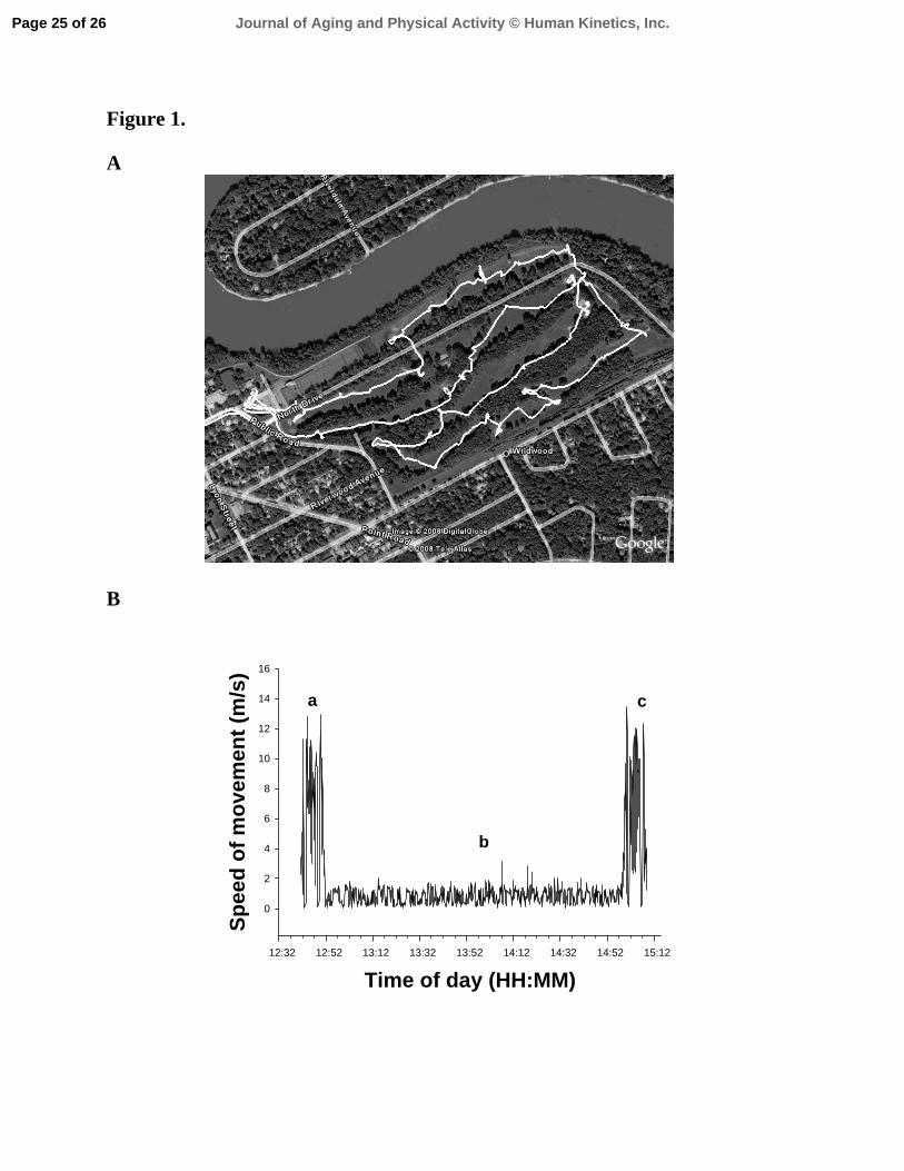
Figure 1. A
B
Time of day (HH:MM) 12:32 12:52 13:12 13:32 13:52 14:12 14:32 14:52 15:12
Spee
d of
mov
emen
t (m
/s)
0
2
4
6
8
10
12
14
16
a
b
c
Page 25 of 26 Journal of Aging and Physical Activity © Human Kinetics, Inc.

Figure 2.
A
B
Time of day (HH:MM) 13:32 13:34 13:36 13:38 13:40
Spee
d of
mov
emen
t (m
/s)
0.0
0.5
1.0
1.5
2.0
Step
s/m
in. (
#)
20
40
60
80
100
120
Tee-box 1 2
3
4 Green
Page 26 of 26Journal of Aging and Physical Activity © Human Kinetics, Inc.