1966 - periodicals - california highways and...
TRANSCRIPT

next month
In San Diego during its October1965 meeting, the HighwayCommission adopted a route forextension of State Highway 190 fromits present terminus atQuaking Aspen Meadow acrossthe southern Sierra to Haiwee Passat the Tulare-Inyo county line.
During a photographicreconnaissance of this route lastsummer, Chief PhotographerWilliam Chaneymade color and black-and-whitephotographs of the country the newroute passes through. A selectionof these photos will be includedin the March—April issue.
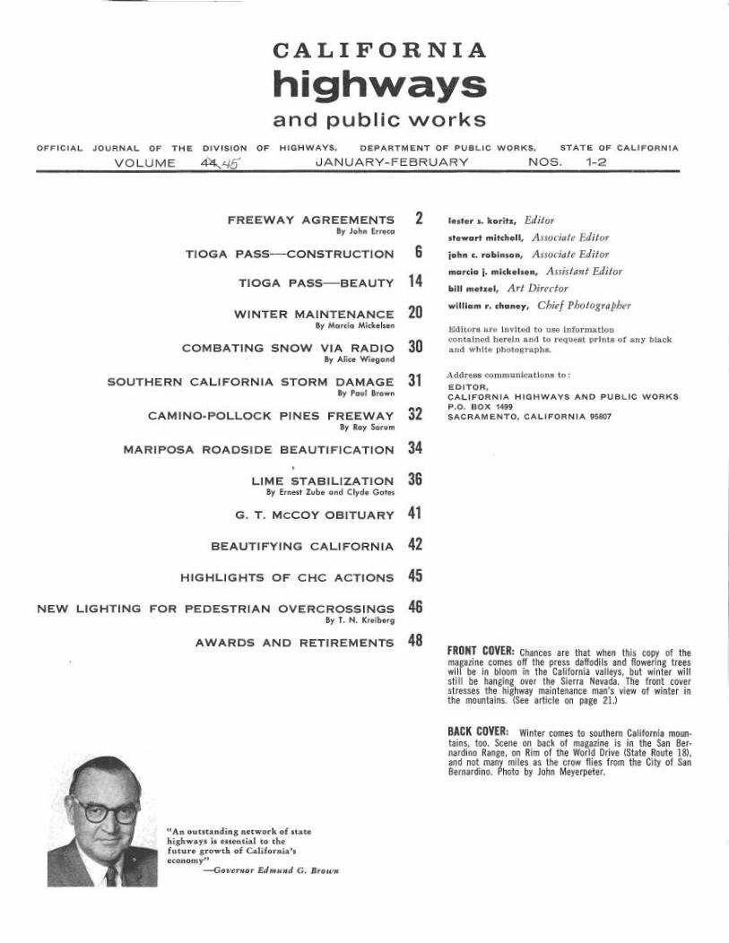
CALIFORNIA
highwaysand public works
OFFICIAL JOURNAL OF THE DIVISION OF HIGHWAYS, DERARTMENT OF PUBLIC WORKS, STATE OF CALIFORNIA
VOLUME 4~~/,j JANUARY–FEBRUARY NOS. 1-2
FREEWAY AGREEMENTS ZBy John Erreca
TIOGA PASS—CONSTRUCTION 6
TIOGA PASS—BEAUTY ~4
WINTER MAINTENANCE ZOBy Marcia Mickelsen
COMBATING SNOW VIA RAD10 3OBy Alice Wiegand
SOUTHERN CALIFORNIA STORM DAMAGE 3~By Paul Brown
CAMINO-POLLOCK PINES FREEWAY ~2By Ray Sorum
MARIPOSA ROADSIDE BEAUTIFICATION 34
LIME STABILIZATION 36By ErnesT Zube and Clyde Gates
G. T. MCCOY OBITUARY 4~
BEAUTIFIf'ING CALIFORNIA 42
HIGHLIGHTS OF CHC ACTIONS 45
NEW LIGHTING FOR PEDESTRIAN OVERCROSSINGS 46By T. N. Kreiberg
AWARDS AND RETIREM'ENTfi 4S
°tAn outstanding network of statehighways is essential to thefuture growth of California'seconomy"
—Governor Edmund G. Brown
lesfer s. koritz, EClitor
srewart mitchell, Associate Editor
john c. robinson, Assoczate Editor
marcia j. mickelsen, Assistant Editor
bill metzel, Art Director
William r. Chaney, Chief Photograj~he~~
Editors are invited to use informationcontained herein and to request prints of any blackand white photographs.
Address communications to
EDITOR,CALIFORNIA HIGHWAYS AND PUBLIC WORKS
P.O. BOX 1499
SACRAMENTO, CALIFORNIA 95507
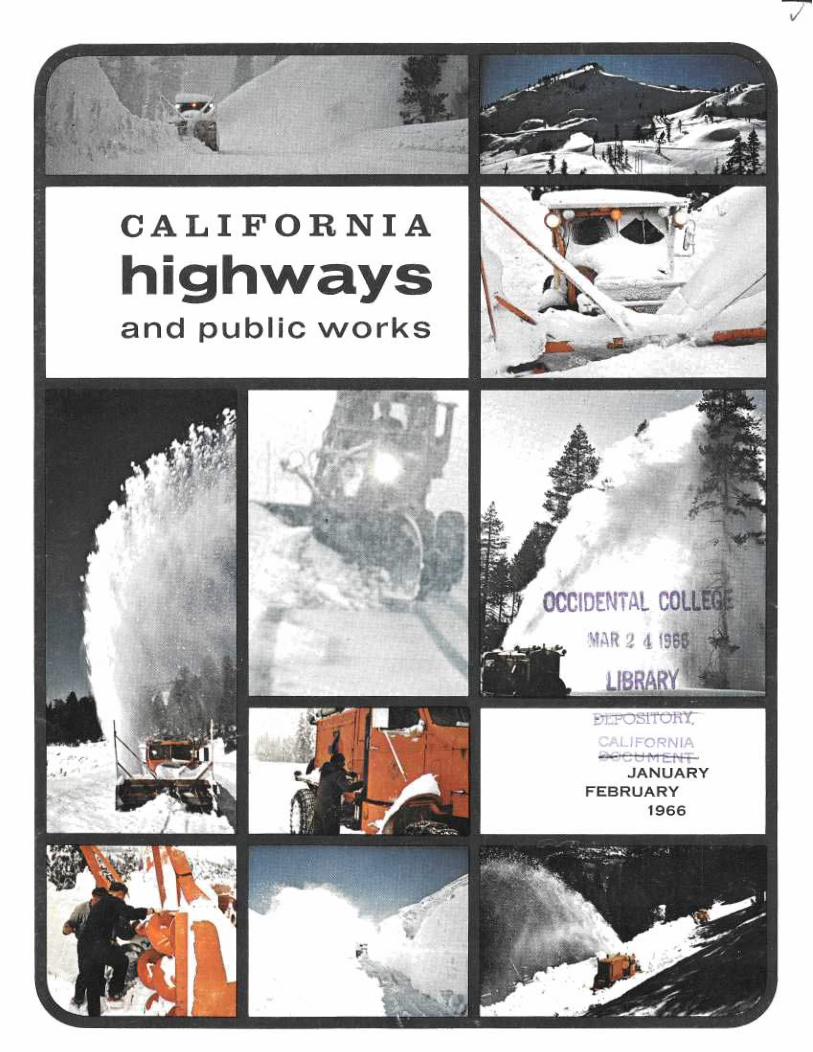
FRONT COVER: Chances are that when this copy of themagazine comes off the press daffodils and flowering treeswill be in bloom in the California valleys, but winter willstill be hanging over the Sierra Nevada. The front coverstresses the highway maintenance man's view of winter inthe mountains. (See article on page 21.)
BACK COVER: Winter comes to southern California moun-tains, too. Scene on back of magazine is in the San Ber-nardino Range, on Rim of the World Drive (State Route 18),and not many miles as the crow flies from the City of SanBernardino. Photo by John Meyerpeter.

~1t one timehandshake and now a
complex instrzement of planning
FEEAYA~RLEI~~IE1~TSFormal freeway agree-
ments, signed, sealed and at-tested, are a must today; noCalifornia freeway is com-plete without one.But these pacts between the
state and cities or countieshave not always had their iscrossed and their is dotted someticulously.Back in 1895, when com-
missioners of the then Bureauof Highways traveled thestate in buckboards, a meet-ing of state and local mindson a road matter was oftensealed with just a handshake.Those forerunners of to-
day's Highway Commissionand Division of Highwaysclippety-clopped about thestate, consulting with super-visors and city councilmenabout road locations, andsetting many of the patternsthat are still in use today—including local public hear-
ings at which everybody canblow off steam.Their surveys and consul-
tations led to recommenda-tions for a state highway net-work so good that most ofits routes are in the system tothis day.
Fifteen years were to passbefore their roads began to bebuilt, and then there was only$18 million available for about$36 million worth of work.But the cities and countiestook up a lot of the slack;counties by providing right-of-way and bridges, and citiesby simply taking over the jobwithin their own boundaries.The habit of cooperation
built up over these 70 years,now formalized almost into aritual, still exists, as theLeague of California Citiesand the County SupervisorsAssociation periodically af-firm.
But today the cost of hig~h-way projects is counted in themillions instead of the thou-sands, highway and traffic en-gineering are more complex,_and right-of-way and plan-ning problems more involved,to say nothing of the suddenchanges brought about bey un-foreseen new industrial orcommercial enterprises in ourvigorous economy.So today it seems advisable
to all parties concerned tohave these things down onpaper so that there is no ques-tion what everybody agreedto during the long period be-tween the time a route isadopted and the time con-struction begins.The freeway agreement
document—detailed on a map—becomes a reference for anyventure, private or public,with plans to build or developanything on any kind of
BY
JOHN
ERRECA

property near a future free-way. And sometimes not sonear.In other words, a planning
guide. Basically the agree-ment is that when the stateis ready to build, the cityor county will cooperate byclosing the streets and roadsit is necessary to close inorder to build the freeway.
Actually it establisheswhere access to the freewaywill be provided by inter-changes, which streets orroads will be closed or car-ried over or under the free-way, the location of frontageroads to carry local traffic tointerchange points, and howstreets or roads may be relo-cated or extended to main-tain traffic circulation in rela-tion to the freeway.The authority of the high-
way people to act as thestate's agent is spelled out inthe Streets and' HighwaysCode of the California Stat-utes, which is periodicallyamended and refined by theLegislature.The law says that a free-
way cannot close off any citystreet or county road withoutthe agreement of the city orcounty and that no city streetor county road can be con-nected to a freeway withoutthe agreement of the state.The law does not say that
a freeway cannot be builtwithout a freeway agreement,and it would be at least theo-retically possible to build onedespite the opposition of localgoverment as long as it didnot close off local streets.But the long-established
practice of consulting withlocal people has led the de-partment to adopt a policythat no freeway will be built
without the agreement oflocal government.The same code of laws also
says where highways must be-gin, where they must end,and sometimes through whichpoints they must pass. Withinthese limits, however, it doesnot say around which hill theroad must go, or throughwhose barn, or on which sideof the valley.This is the province of the
Highway Commission, whichdetermines the road's courseby majority vote after all theevidence is in.However, in order for the
State Highway Engineer to beable to recommend one align-ment over another, his rep-resentatives will have beenworking with- local planningand engineering staffs andpublic officials for months oryears before a route is adopt-ed or a freeway agreementsigned.Once the commission has
adopted the alignment, it is upto the Division of Highwaysto negotiate the freewayagreement.Much more often than not,
all sides having been keptinformed at all stages, nomysteries remain about theterrain features, buildings,schools and other controlsthat led the commission toadopt the line it did, and thefreeway agreement moves ina routine manner throughlocal and state staff proce-dures to final approval..A resolution of the city
council or county board ex-presses official approval forthe community, and the Di-rector of Public Works signsit for the state.Delays in signing the agree-
ment are sometimes occa-
sinned by planning or engi-neering differences that havebeen at issue from the begin-ning, with all parties negotiat-ing right down to the wire.
Occasionally they areprompted by a strong localurge to deny that any suchlengthy exchange of informa-tion took place; to assuagethe disappointed with theconsolation that their tivoescame as a complete surprise,sprung by a far-off and ras-cally state bureaucracy.In this "Who struck John?"
a standard gambit is to viewwith alarm any state purchaseof right-of-way before -thelocal government has signedthe freeway agreement. Thismakes good copy about whois forcing whose hand.The fact is .that the state
will not buy property beforethe agreement is signed, ex-cept under the following twoconditions (bearing in mindthat the route itself has beenadopted, regardless of wheth-er the details have beenworked out)(1) Where some home-
owner in a genuine hardshipcase (a death in the- family,orders to Schenectady or Sai-gon) has to get rid of hishouse and can't sell it to any-body but the state becausenobody else will buy in thefreeway's path.(2) Where a property
owner intends to build a facil-ity the state will have to payhandsomely for at some timein the future. (A current caseof this kind is one where cityand state agree that they willneed a certain piece of prop-ertyfor ahighway, but wherethe property owner has achance to put up and lease a$500,000 building. The formal
Traveling by buckboard, as highway commissioners did in 1895, provided incentive for building good state highways.

~~p
4E9@NO
INT ER&TATE !!IG%~s4ti
U.S. uIGwWAr
STATE NION WAY
Dlf►~RfIOM L[O(MD
TAI►3 ►Elt DAY
'~ INTRp ZONE ~ 162,000 (le%)
~:o a a ~ u e. s s~..a~a>resrn .a air uu i~, nsaux~e+wa
City street closures are clearlydefined in freeway agree-
m ents as are frontage roadsleadifig to interchanges.
Traffic projections show where most carswill want to go. How to get them there istempered by how not to disrupt a community.
The Highway Commission, seatedon dais, considers positionsof all interested local citizensbefore adopting a route line.

freeway agreement is manymonths off, but if the Divi-sion of Highways wants tosave the taxpayers the $500,-000, it must act soon.)The long process leading to
a freeway agreement beginswhen state highway engineersapply to local planners for in-formation about local masterplans, projected land use pat-terns, present and futuretransportation facilities, andprojected population figures,and, in turn, explain whatthey have learned about "traf-fic desires."(Desire line is traffic engi-
neer shorthand for where the
bulk of the people are driv-
ing from and where they
want to drive to. It is usually
shorter and more direct than
the way they actually have to
go, and, when it is indicatedon a map, it is often taken to
be that mythical straight-lineroute engineers are supposedalways to build if they can getaway with it.
(It is actually a referenceline which is almost alwaysmodified by the presence ofsuch things as schools, parks,hospitals, office building andso forth that the freewaymust go around or over orunder. The search is essen-tially for the route that willdisrupt the community theleast and be the most eco-nomical, while not strayingtoo far from the theoreticalline that satisfies the needsand desires of those who drivecars—which these days is~Sractically everybody.)The state engineers are re-
quired to notify and consult along list of federal, state andlocal agencies about thingslike transit, water, redevelop-ment and public housing, fishand game, parks and conser-vation. They also work withhighway advisory committees,chambers of commerce, busi-nessmen's associations, andcivic improvement clubs.During the preliminaries, a
lot' of alternate lines willbe looked over. As studiesprogress some of these willbe dropped from contentionwhen some practical impossi-bility shows up (such as a
line that would, indeed, missa corner of the golf course,but would take out thecounty hospital in order todo it).No final engineering is
completed at this stage, butthe same basic engineeringyardsticks will be applied toall the surviving alternates forpurposes of comparing costs,community effects, trafficservice and so on.The highway district con-
ducting the studies will sendits information to headquar-ters in Sacramento for reviewand approval. Then the ap-proved studies will be ex-plained to the city or countyplanning and engineering peo-ple and to local officials, andafter this to the general pub-lic in the traditional publichearing and in informal in-formation meetings.
These will be simple illus-trated explanations of whatthe engineers have learnedabout -the various possibleroutes, with no opinion ex-pressed about which one theythink is superior.A report on the public hear-
ing, together with statementsby local public officials, pub-lic correspondence sparked bythe hearing, and a completetranscript of the proceedingswill be sent to Sacramentowhere the State Highway En-gineer and his staff will studythe material and the HighwayEngineer will recommend tothe commission the alternatehe considers best.The commission then: (a)
notifies the city or countythat it intends to adopt a free-way route connecting pointsA and B, (b) sends along theState Highway Engineer'smap showing how he pro-poses to accomplish this con-nection, and (c) asks if thecity or county believes an-other public hearing wouldbe in the public interest.
Usually the reply is "No,"and the commission, if itagrees with the engineer'srecommendation, goes aheadand adopts the route. Wherethe city or county asks for afurther hearing before adop-
tion, the commission is re-
quired by law to hold one.When the commission has
acted, state people can getdown to the business of draft-ing the specifics of a freewayagreement to propose to thecouncil or board. It may be infairly broad terms to beginwith, because the freewaymay not be built for severalyears. It is always subject tomodification by mutual agree-ment and in fact is oftenmodified as new trafficchanges take place and con-struction -time approaches.
During this time the close
association of local and state
people will continue with
local planners looking out for
the traffic requirements of
new firehouses, schools, shop-
ping centers, industrial parks
and subdivisions; and state
people keeping an eye on all
these things plus the protec-
tion of the smooth flow ofthrough traffic against too
many ramps and interchanges
too closely spaced.The need to have a freeway
agreement implies the need tohave a city or county plan,
and this has acted both as aspur to local planning and as
a way to lend state help inthis direction.A professor of city plan-
ning, T. J. Kent, of the Uni-versity of California, hassaid:"I also feel quite certain
that the constructive hard-driving postwar program ofthe California State Divisionof Highways to provide free-ways in and around the citiesof the state will be seen inretrospect, as one of themajor explanations for the es-tablishment of effective localplanning programs and thepreparation and use of gen-eral plans by our city andcounty governments duringthe. decade of tie 1950's."So what started out as a
friendly okay and a hand-shake over who would oil theroad, or feed the hayburnersthat pulled the scraper, hasevolved into an invaluable in-strument of city and countyas well as of statewide plan-ning.

,r.~
~f > ̀flr
.' ~.r' ~ ~ fro~,
'~~~ -.
,~"" r~ f ~ ~ _ /~O
y1_ ~,i
b~l
,~~ d"* f~~s~- , - ~
~,.mow,,,, ` . m~". ,a.+ ' ~ ~' ~:
-.rte ~.~' ~ ~ +• ~ y ~ :+sip. . ,.~ .st. '~-'F':
'`_'^.----•--~nsu,. '~ p ,
~;.:~r ~ ~'~' ~ ,s~ r'' '+ ~ ~ " ~ t" ,~ .
. ~ ..,,r
-,
° . ~f ~*r•. ~ i ~ ~ ° •fir,.. ~A ~ ~~ r r ~~~ , ~~~ ~ d~~
p~~/ ~r `/ ,~,~~'~~'i % ,` ,~',r~`~,y MP ~~ " ~,~f • ~ ~~ ~ ~ a4~'L~ S Fry ~y`' ~ 't
,~/~!y' h 8 y
~ ' ~` ,~ ~ r l~:~ t ~ ';w
~ h
'L. i~ 6t.
., t .:
f^r v. #'~ 3 ,, y+ ~ x r '~
whereroadbuzlders
meettherugged
west
What has been one of California's most frightening roads,the eastern entrance to Yosemite National Park via Tioga Pass, isundergoing extensive modernization all the way from the parkgate down to the valley floor gust outside of Lee Vining. At a cost
of more than five and a half million dollars, three separate contractshave been let on State Sign Route 120 here to widen and
improve this road, particularly along the high, shier cliffs of LeeVining Creek Canyon. When call three contracts are completed,
possibly in late 1966, the grade and alignment will have beensubstantially bettered, and the switchbacks which have been so
difficult for some drivers will have been eliminated.
6
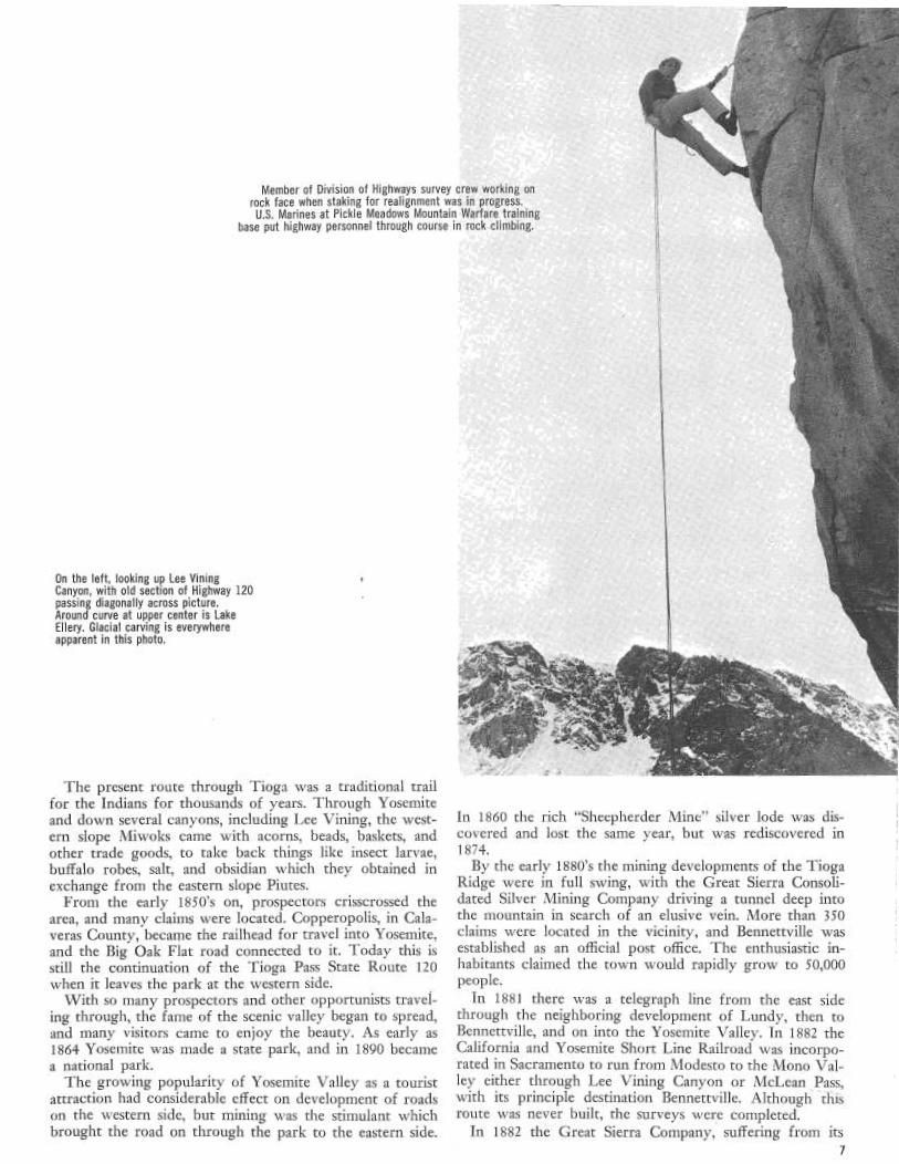
Member of Division of Highways survey crew working onrock face when staking for realignment was in progress.U.S. Marines at Pickle Meadows Mountain Warfare training
base put highway personnel through course in rock climbing.
On the left, looking up Lee ViningCanyon, with old section of Highway 120passing diagonally across picture.Around curve at upper center is LakeEllery. Glacial carving is everywhereapparent in this photo.
The present route through Tioga was a traditional trail
for the Indians for thousands of years. Through Yosemite
and down several canyons, including Lee Vining, the west-
ern slope Miwoks came with acorns, beads, baskets, and
other trade goods, to take back things like insect larvae,
buffalo robes, salt, and obsidian which they obtained in
exchange from the eastern slope Piutes.From the early 1850's on, prospectors crisscrossed the
area, and many claims were located. Copperopolis, in Cala-
veras County, became the railhead for travel into Yosemite,
and the Big Oak Flat road connected to it. Today this is
still the continuation of the Tioga Pass State Route 120
when it leaves the park at the western side.
With so many prospectors and other opportunists travel-
ing through, the fame of the scenic valley began to spread,
and many visitors came to enjoy the beauty. As early as
1864 Yosemite was made a state park, and in 1890 became
a national park.The growing popularity of Yosemite Valley as a tourist
attraction had considerable effect on development of roadson the western side, but mining was the stimulant whichbrought the road on through the park to the eastern side.
...~ ~.~; ~`~~ : °<~..
In 1860 the rich "Sheepherder Mine" silver lode was dis-
covered and lost the same year, but was rediscovered in
1874.By the early 1880's the mining developments of the Tioga
Ridge were in full swing, with the Great Sierra Consoli-
dated Silver Mining Company driving a tunnel deep into
the mountain in search of an elusive vein. More than 350claims were located in the vicinity, and Bennettville wasestablished as an official post office. The enthusiastic in-habitants claimed the town would rapidly grow to 50,000people.In 1881 there was a telegraph line from the east side
through the neighboring development of Lundy, then toBennettville, and on into the Yosemite Valley. In 1882 theCalifornia and Yosemite Short Line Railroad was incorpo-rated in Sacramento to run from Modesto to the Mono Val-ley either through Lee Vining Canyon or McLean Pass,with its principle destination Bennettville. Although thisroute was never built, the surveys •ere completed.
In 1882 the Great Sierra Company, suffering from its7
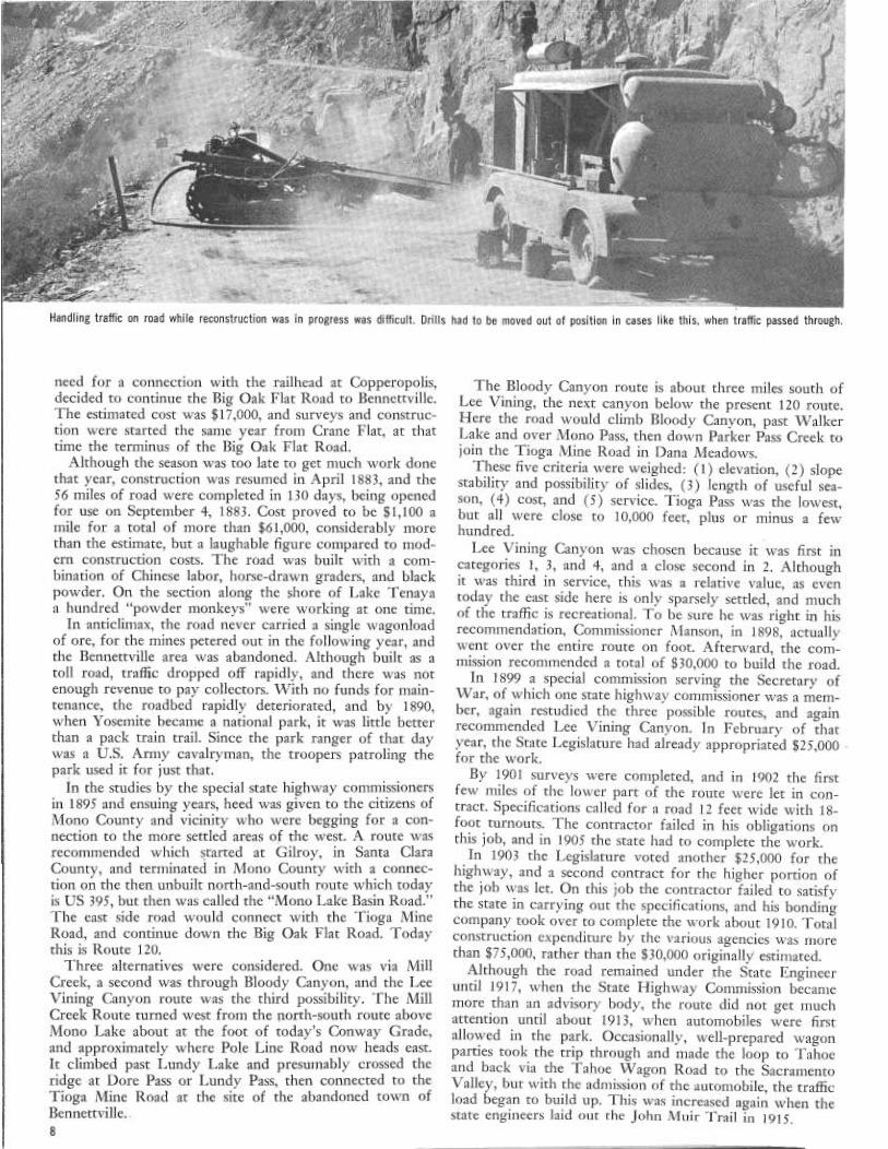
Handling traffic on road while reconstruction was in progress was difficult. Drills had to be moved out of position in cases like this, when traffic passed through.
need for a connection with the railhead at Copperopolis,decided to continue the Big Oak Flat Road to Bennettville.The estimated cost was $17,000, and surveys and construc-tion were started the same year from Crane Flat, at thattime the terminus of the Big Oak Flat Road.
Although the season was too late to get much work donethat year, construction was resumed in April 1883, and the56 miles of road were completed in 130 days, being openedfor use on September 4, 1883. Cost proved to be $1,100 amile for a total of more than $61,000, considerably morethan the estimate, but a laughable figure compared to mod-ern construction costs. The road was built with a com-bination of Chinese labor, horse-drawn graders, and blackpowder. On the section along the shore of Lake Tenayaa hundred "powder monkeys" were working at one time.In anticlimax, the road never carried a single wagonload
of ore, for the mines petered out in the following year, andthe Bennettville area was abandoned. Although built as atoll road, traffic dropped off rapidly, and there was notenough revenue to pay collectors. With no funds for main-tenance, the roadbed rapidly deteriorated, and by 1890,when Yosemite became a national park, it was little betterthan a pack train trail. Since the park ranger of that daywas a U.S. Army cavalryman, the troopers patroling thepark used it for just that.In the studies by the special state highway commissioners
in 1895 and ensuing years, heed was given to the citizens ofMono County and vicinity who were begging fora con-nection to the more settled areas of the west. A route wasrecommended which started at Gilroy, in Santa ClaraCounty, and terminated in Mono County with a connec-tion on the then unbuilt north-and-south route which todayis US 395, but then was called the "Mono Lake Basin Road."The east side road would connect with the Tioga MineRoad, and continue down the dig Oak Flat Road. Todaythis is Route 120.Three alternatives were considered. One was via Mill
Creek, a second was through Bloody Canyon, and the LeeVining Canyon route was the third possibility. The MillCreek Route turned west from the north-south route aboveMono Lake about at the foot of today's Conway Grade,and approximately where Pole Line Road now heads east.It climbed past Lundy Lake and presumably crossed theridge at Dore Pass or Lundy Pass, then connected to theTioga Mine Road at the site of the abandoned town ofBennettville..
The Bloody Canyon route is about three miles south ofLee Vining, the next canyon below the present 120 route.Here the road would climb Bloody Canyon, past WalkerLake and over Mono Pass, then down Parker Pass Creek tojoin the Tioga Mine Road in Dana Meadows.These five criteria were weighed: (1) elevation, (2) slope
stability and possibility of slides, (3) length of useful sea-son, (4) cost, and (5) service. Tioga Pass was the lowest,but all were close to 10,000 feet, plus or minus a fewhundred.Lee Vining Canyon was chosen because it was first in
categories 1, 3, and 4, and a close second in 2. Althoughit was third in service, this was a relative value, as eventoday the east side here is only sparsely settled, and muchof the traffic is recreational. To be sure he was right in hisrecommendation, Commissioner Manson, in 1898, actuallywent over the entire route on foot. Afterward, the com-mission recommended a total of $30,000 to build the road.In 1899 a special commission serving the Secretary of
War, of which one state highway commissioner was a mem-ber, again restudied the three possible routes, and againrecommended Lee Vining Canyon. In February of thatyear, the State Legislature had already appropriated $25,000for the work.By 1901 surveys were completed, and in 1902 the first
few miles of the lower part of the route were let in con-tract. Specifications called for a road 12 feet wide with 18-foot turnouts. The contractor failed in his obligations onthis job, and in 1905 the state had to complete the work.In 1903 the Legislature voted another $25,000 for the
highway, and a second contract for the higher portion ofthe job was let. On this job the contractor failed to satisfythe state in carrying out the specifications, and his bondingcompany took over to complete the work about 1910. Totalconstruction expenditure by the various agencies was rnorethan $75,000, rather than the $30,000 originally estirnated.Although the road remained under the State Engineer
until 1917, when the State Highway Commission becamemore than an advisory body, the route did not get muchattention until about 1913, when automobiles were firstallowed in the park. Occasionally, well-prepared wagonparties took the trip through and made the loop to Tahoeand back via the Tahoe Wagon Road to the SacramentoValley, but with the admission of the automobile, the trafficload began to build up. This was increased again when thestate engineers laid out the John Muir Trail in 1915.

Lower end of Lee Vining Canyon with ElephantHead in upper center. Photo was made just beforeblast. Affice complex is right center where dustis seen.
Same view as on left, about a minute after blast. View of old section of Route 120 just after ElephantDust has cleared su~ciently so notch blasted for Head shot. Small amount of rock on road from blast
new right-of-way can be seen. directly above shows excellent control of the shot.
By the close of World War I, there was great pressure
for a better route into the park—an "all-year highway" up
the Merced Canyon directly into the Yosemite Valley Floor.
The Yosemite Valley Highway Association put 200,000 cer-
tificates on sale at $5 each to raise $1 million which would
he matched by $700,000 state and federal money to build
the road. The certificates were to be purchased by each of
the state's 477,450 registered motorists (in 1919), in returnfor which each subscriber would receive a season's pass to
Yosemite.
In 1926, when Governor Friend William Richardson dedi-
cated this route at its opening, the fund actually shad reached
the sum of $112,000, but construction to El Portal at the
park entrance had cost $1,200,000! Where the old routes hadclimbed close to 6,000 feet, suffering serious snow difficultiesin winter, the new "water-level" route stayed below 3,000feet, with snowfall negligible. The commission hoped tohave enough money to pave the new road the following year.
The National Park Service in the meantime had taken
over the old Tioga Mine Road, and it still was the main
thoroughfare through the park. Some improvements were
made, but funds were short, and the old route continued to
serve, although it unnerved many of the drivers of the 20's,
30's, and 40's who, with the improvements in road design,
had become somewhat less adventurous than those of the
first decade.
In the late 1930's, with minimum funds, the state made
some improvements nn the eastern end of the route, and
repaired the Big Oak Flat Road, which it had taken over in
1915. The Wawona Road was also in the state system by
now, so that the park had three routes feeding into it fromthe west, with only a single substandard route to carry trafficthrough the park. Actually, only a small percentage of thetraffic goes beyond the valley floor, but it was not unusual,
when drivers unaccustomed to mountain roads continuedthrough, for them to freeze at the wheel on the descent fromthe pass, causing considerable delay on the narrow right-
of-way.In recent years the National Park Service, with Mission
66 funds, has realigned and modernized the old road in thepark, bypassing much of the Tioga Mine Road route. Thecurrent state jobs on the eastern section will now make itpossible to travel all the way through the park on a modernhighway.
After leaving US 395, on the first six miles of the climb
to the pass, the road ascends from 7,400 feet on the valley
floor to 9,600 feet at Lake Ellery. At a few places the grade
goes to 7 percent and once or twice to 8 percent, but, gen-
erally speaking, the new alignment produced by the designteam gives an overall grade of slightly under 6 percent.However, Tioga Pass will always be a high mountain route,and probably never will be kept open in winter.Of the three contracts which will bring this eastern portion
up to modern standards, the first and completed one wasperhaps the most difficult because of its height and the greatamount of rock work 'required. This job, started in 1963,could not be completed until late autumn last year, and,due to early storms, it was for a while touch and go whetherit would be completed then.
Above Lake Ellery a three-mile section which continues
to the park gate rises only an additional 341 feet, and here
a second contract has been let for widening and realignment.
This project' includes a cooperatively financed agreement
for also widening the entrance to the park.
The terrain here is fairly level and little blasting was neces-
sary. However, -much of the construction is over glacial
moraine, with some of the soil being fine powder created
by rocks being ground against each other. Since there is a
great amount of subsurface water, even at the end of the
dry season, compaction of the fill is difficult. Also, the Forest
Service has set strict requirements on preservation of the
wildlife habitat. In places Division of Highway employees
removed trout by hand from disturbed pools and placed
them farther downstream.Work has been going forward this summer for four miles
of grading and paving on a third contract, also let in 1965,costing nearly $4 million, much the largest of the three: Thislower job is costing about a million dollars a mile because
it leaves the old road and continues on completely new align-ment along the steep canyon wall until it reaches the oldgrade about three miles from Lee Vining.
The main deterrent to a satisfactory grade in the past has
been the big rock face near the valley entrance called "Ele-
phant Head." In previous projects design engineers have
avoided this face, and kept the road on the valley floor until
it was beyond Elephant Head. This has compressed the climbinto too small an area for a satisfactory alignment and grade.
The present design calls for bringing the road around therock face by cutting a small notch to carry the roadway.
~.
tii
NorfA P~ok~
CO/IM55 CMdN
YOSEMI7Tgyo Pon
NATIONA
10
~y~
MONOLAKEDae Poa pMt.Warnn
~
SoJO/sdoD ~~~ ~~~inp
LTpOp ploy ~ ~~eLEE VININGD
"1 E//iry CoAS I2' Tiopu Loks i aM
~~ Yf.~~° o
Dana ~~7
~C
~~ cPGobr Ytnp~ i
~`Mmo Pa.D rD
%ron7~'CaRI
'10
/ PARK ~CaMi'
r
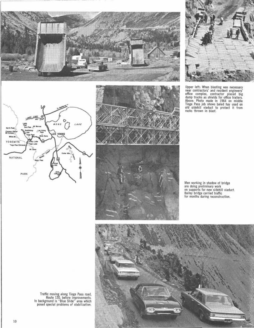
Traffic moving along Tioga Pass road,Route 120, before improvements.
In background is "Blue Slide" area whichposed special problems of stabilization.
Upper left: When blasting was necessarynear contractors' and resident engineers'office complex, contractor placed bigdump trucks as shields for office trailers.Above: Photo made in 1964 on middleTioga Pass job shows baled hay used onold sidehill viaduct to protect it fromrocks thrown in blast.
Men working in shadow of bridgeare doing preliminary workon supports for new sidehill viaduct.Bailey bridge carried trafficfor months during reconstruction.

By October 1965 the work had progressed far enough to
proceed with the blasting of Elephant Head. The contractor
estimated it would require 13 tons of 40 percent gelatin
dynamite to do the job correctly, about a pound to the yard
of rock. The quality of the explosive was important, as it
was desired to shatter this rock as much as possible, to make
it suitable for road base.Since the face of the cliff was so sheer, transport of this
much material was difficult. A helicopter was brought in,
and it made shuttle trips, with a 750-pound payload each
time. The dynamite was carried in a sling. The chopper
never landed. Each trip it hovered until the crew on the
ground loaded it, and then hovered over the gang on the
rock face for unloading, making in all about 30 trips with
the explosive.A seven-by-seven pattern was used in drilling the holes
for the shot—that is—the roles were on the corners of con-
tinuous and contiguous squares seven feet on a side. Depth
of the holes in places was almost 100 feet.The drilling and the placement of the charges required
considerable care and skill, for the old road, which was still
carrying traffic, lay directly below the shot area, and a poor
shot would cover it with thousands of tons of debris which
would take days to clear. On the other hand, one or more
additional shots to "baby up" on the cut would be expensive.
The shot was designed to throw the 29,000 yards of material
to either side, not only keeping it off the roadway below,
but breaking it up and dumping it in one tremendous shove,
to put it in position as fill for the grade which was coming
through.The blast was fired at 10:50 on October 15, and it was
unqualifiedly successful. Not only did the material go where
it was intended it should, but the debris which' spilled over
on the raad below was so insignificant that trafric was coming
through again in less than two hours. The first vehicle through
was a utilities repair truck with crew to repair powerlines
damaged by the blast; a casualty that could not be avoided.
Of course, at this altitude, the working days each year
on these contracts has been limited. Because of deep snow,
the equipment cannot get into the upper project until mid-
May or even June, while it might be necessary to move out
as early as October. On the middle canyon job, work was
suspended the first year on November 20, but the second
year the contractor was able to work as late as December 20.
This job was completed on October 26, 1965, after three
seasons' work, although the original contract called for
only 160 working days. It had presented many problems.
The towering walls of the canyon extend upward several
thousand feet above the right-of-way, and the sun shines
on some parts of the road only a few hours daily. In the
shade at 9,000 feet it is often cold on the warmest day
elsewhere, and equipment operators working in these areas
were bundled up as though working on a winter job, while
men in the sun on the same job were working in shirt-
sleeves. Because they were often operating really large
pieces of equipment on narrow ledges, and the slightest
miscalculation meant a fall of hundreds of feet, all three
jobs have, in the words of John Sexton, supervising project
engineer, produced the "world's finest operators."
The extreme temperature ranges, and the cool days, ofcourse make working. with portland cement and asphaltespecially difficult. In early September 1965, six inches ofsnow fell, and there was also snow in mid-October 1965,as the contractor was trying to get the last of the asphaltpaving laid.
r~,An v ~ cw
PROF I {..~
Sketch shows elevation and plan view of required construction of artificial
riffles, pools, and resting areas for trout where channel changes were neces-
sary in realignment of road near summit.
Since the total amount of asphalt paving was insufficient
to justify bringing in a hot-mix plant, the asphalt concrete
was mixed by the windrow method. The difficulties in main-
taining the necessary 60° in the mixture at times seemed
almost insurmountable. Atraveling pugmill fitted with a
fuel oil tank and flame jets to keep the metal surfaces warm
was special equipment designed by the contractor in deal-
ing with this problem.The footings of the slidehill viaduct presented a unique
problem, since they had to be constructed on the face of a
precipice. A "donicker" which had been planned on as a
base for the footing proved insecure, and had to be dis-
carded, but below the bridge there was a slight incurving
of the rock face which gave precarious footing to rope-
suspended workers. Two foremen refused the job before
the contractor could get a man to take charge of forming
and concrete pouring.
The footings were anchored by steel dowels made from
reinforcing rods, and set in the solid rock. A special type
5 class D (seven-sack) portland cement was used, with low
alkali and air entraining not to exceed 4-5 percent. As a
timesaver, the concrete was mixed down on the. flat, andbrought to the job in Goodyear Rota bags, holding about1 %Z cubic yards. This method, developed for concrete workat radar stations on high peaks, proved very satisfactory.Tremie tubes were used to deliver the material, about 205yards altogether, to the footing forms.
At that stage in the job when it became necessary to re-
move the old viaduct, the contract called for building a
one-way detour bridge, but the contractor asked permission
to use a Bailey Bridge instead, and a change order was
issued. The Bailey, a "double triple," was set in place across
the gap, above the old structure, and remained there a year,
carrying contractor's heavy equipment as well as routine
traffic. Of considerable help in handling the Bailey bridge
sections were the existing bin walls at either end of the
abutments.Although the road is not heavily traveled, it does carry a
steady flow of traffic, mostly vacationers and tourists, dur-
ing the summer months. In July 1965 this- totaled 30;000
vehicles. The summer season, of course, is also the only
opportunity a contractor has to work on the road. Con-
struction of a detour was out of the question, and, although
the contractor was working on and directly adjacent to
the right-of-way, usually 60 or more hours a week, traffic
had to be allowed to pass through somehow.
The problem was greatly complicated by the large
amount of hard rock blasting necessary, plus the fact the
broken material had to be removed to disposal areas. Traffic11
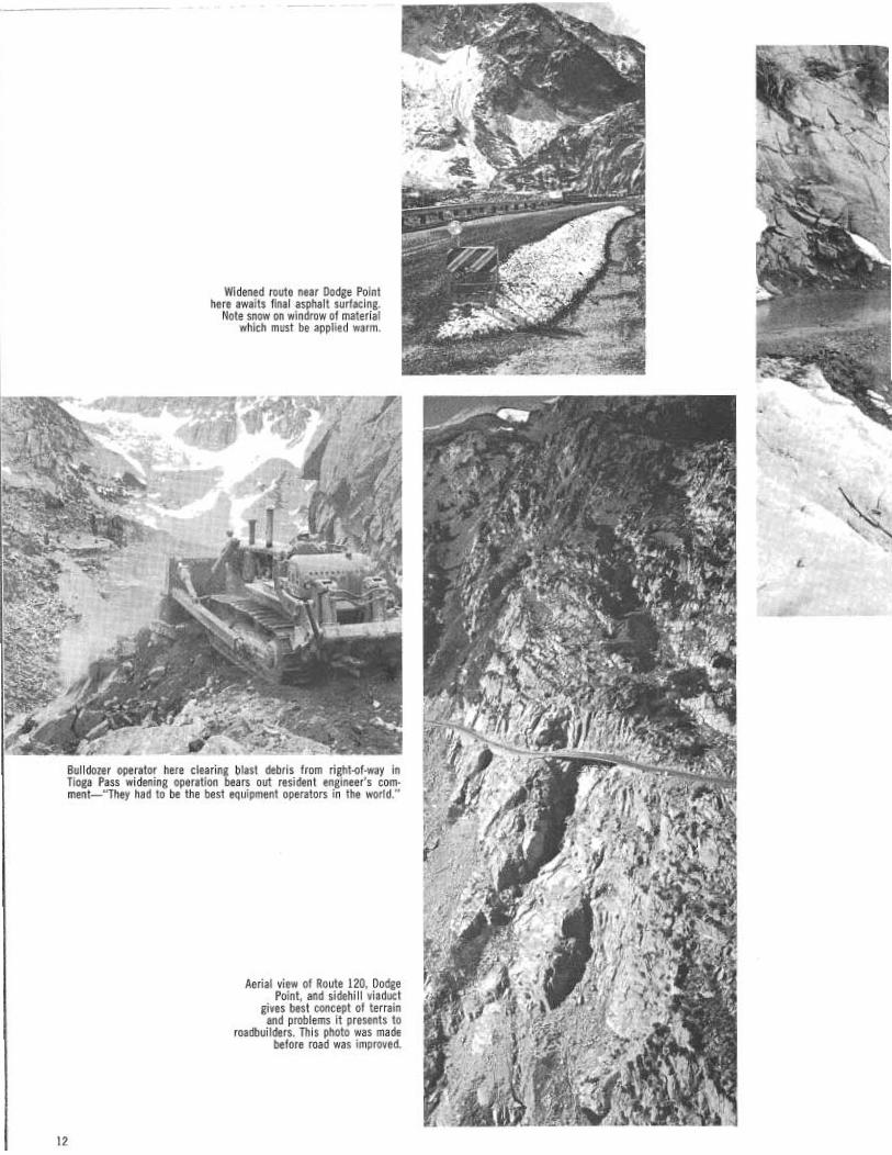
Widened route near Dodge Pointhere awaits final asphalt surfacing.
Note snow on windrow of materialwhich must be applied warm.
Bulldozer operator here clearing blast debris from right-of-way inTioga Pass widening operation bears out resident engineer's com-ment—"They had to be the best equipment operators in the world."
Aerial view of Route 120, DodgePoint, artd sidehill viaduct
gives best concept of terrainand problems it presents to
roadbuilders. This photo was madebefore road was improved.
12
~: ~'~~e ~ ~.
~ "` ~ ti

R.
Section of State Route 120, Tioga Pass Road, made in spring 1963, before contractor began work. Curve in center of photo rounds Dodge Point, with
sidehill viaduct just beyond. Contract now completed has widened road here, and provided viewpoint.
had to be protected during the shots, of course, but therewas also the continual movement through the jobs of anumber of oversize rock Trucks, as well as debris on theroad from the shots.The district prepared a very effective "handout" sheet,
explaining the problem to the traveling public, pointing outthe movement of earth and rock involved in the three con-tracts-1 %Z million yards—would require a loaded freighttrain 430 miles long. These problems were met by sched-uling the hours the route would be open and closed eachday, and these schedules were given the widest circulationin all press media. No mishaps had yet occurred by theclose of work this winter, and, since the job in the areamost difficult to negotiate—along the cliffs of the uppercanyon—is completed, traffic movement in the future willbe much simpler in the construction zones.However, it was not sufficient just to open and close
the route. Because of the terrain, the presence of workingequipment, the narrow roadbed, and the tendency of trav-elers to stop for sightseeing, picturetaking, and an occasionalvapor lock, there was considerable straggling. While therule of thumb adopted allowed traffic 45 to 60 minutes toclear, it was found expedient for a Division of Highwaysvehicle to follow the last car through all three projects,otherwise an occasional straggler might have gotten intoserious trouble.
This traffic problem was complicated by the arrival inAugust 1965 of the Inqua Conference—a group of eminentgeologists from all over the world, hosted by the Univer-sity of California at Berkeley—traveling in buses whichcould not make the switchbacks. Since the Tioga Pass areaand Lee Vining Canyon are of absorbing interest to thesemen, they had come to study it. By pooling most of thepickups available at the job, assisted by the local nationalforest officials, all were transported through the job as nec-essary, and left at the end of the day in a happy mood.Both the upper job and the lower job at Tioga will
continue through at least one more season, before the newalignment is graded and paved. The lower job probablywon't be completed until 1967. Some inconvenience to thetraveling public will be necessary during this time, but theworst is over.When all three jobs are completed, the eastern entrance
to Yosemite and the Tioga Summit vicinity will be muchmore easily accessible. For some of the things which willbe found up there, see the following pages.
(Contractor on middle job—C. W. McGrath of El Cajon; Divisionof Highways Resident Engineers Charles Jackson, Lloyd Hopper;contractor on upper job—McGrath also; Resident Engineer E. G."Lou" Wadsworth; contractor on lower job—Harms Bros., H-BInvestment, Inc., & J. W. Briggs Construction, Inc.; Resident EngineerW. R. Coons. During 1965 area supervisor was Associate HighwayEngineer John Sexton of District 9.)
13

T~OGI~PASS
a is
enduring
beauty
Disregarding the value of the Tioga Pass route as the onlyeastern entrance to Yosemite, the Mono Lake-Dana Plateaucountry outside the park entrance has much to attract thevisitor in its .own right. The terrain surrounding the summit,in the words of District Ranger Jack Reveal of Lee Vining,"offers even a little old lady a satisfying subalpine experience,"which she can easily reach within a few hundred feet of thehighway. Since the improvements now underway on the roadwill make.. ascent of the pass much easier, it is helpful to lookat some of the things in the vicinity which can expand theexperience of those using the route.Even before entering the pass there is much to fascinate the
traveler on US 395. Not only is this entire section exceedinglyscenic, as it passes below one of the most beautiful mountainscarps in the world, but there is everywhere evidence of thegreat glaciers which carved the present landscape. There isalso interesting evidence of volcanic action in the Mono Cratersarea. The layman can learn to read much of this evidence.The Sierra Nevada is a single block of granite, with its
western edge disappearing under the great Central Valley andits eastern face uptilted and still rising. Its slow rise in responseto the great pressures forcing up its eastern edge can be~ com-pared to the way a tree root slowly forces up a block of pavingin a sidewalk.This great piece of granite, cracked and faulted here and
there, of course, stretches all the way from the southern edgeof Lassen Volcanic National Park to Walker Pass in KernCounty. As it extends southward, it gradually gets higher,reaching its greatest elevation at 14,495-foot high MountWhitney, which is also the highest point in the continentalUnited States.In the several millions years the Sierra Nevada has existed
in its present stage, frost has cracked its rocks, and streamshave cut deep canyons. During the past half-million years, sixglacial epochs have unmistakably marked it for the practisedeye to see. In fact, much of the beauty and grandeur of thescenery can be traced back to the slow grinding of these thick,
14
A sub-Alpine experienceavailable "even to a little old lady"five minutes from the road

Travelers descending Tioga Passcatch this view of valleybeyond through notch of lowerLee Vining Canyon. Odd-looking formations in middledistance are Mono Craters, withWhite Mountains on horizon.
`~~UfldyQE~cel~ior Mfa
~ izaasLand/ LoM
D / ~~~ek
s~~~ ~H0.
\ QGilcriiboo~ak
C~~q~~\
B/us Loks
Ugosr Me s ~ ~ Crysfo/ LoR~
LoMod Onrido LoAe
W ~~n(, ~ ~ QMt. z
North P~okQ ~ AJo LogeX2242
~ Sodd/sboy~- Lake
Mt. Connns~1259D ~-'~
Saddlebag~((Ci~QUe ~.
~o Boat Resort~aa°a
..
Tioga PeakQ II 513
~WhiteZ M1n~M~
s,~ Dodge Point
~ Bennettville~ Les Vining Fo//s
'' ~1, Torras'~,
o° RESORTS//pry Coke
6ronils ~'~
TiopoOnoLokss
e ~Loks
,o
~~rsv~f ~, ~~
Tiogo Pale '•f9991
Mt. Dana`~ tl3Q50
~LU Vlninq P~ok11691
Mono Dome0 11614
15

heavy ice rivers of ancient times which once flowed down allthe east side canyons.As the ice melted at the end of each glacial age, the water
ran into the valleys east of the Sierra and made a chain of greatinland lakes. One of these, Lake Russell, was at one time 700feet above the present surface of Mono Lake, and its ancientshoreline is visible along the slopes north and east of the lakeabout at the 6,800-foot level. The town of Lee Vining is situ-ated on one of this lake's beaches which was created fromglacial debris as both lake and glacier were disappearing. MonoLake is all that remains of Lake Russell, Its moisture evaporatedinto the air, but its mineral content was concentrated into therelatively small Mono basin to give today's lake its heavysalinity.
Contrary to public belief and Mark Twain's story about thedog, people sometimes swim in Mono Lake and occasionallyuse it for water skiing. There are beaches along the shore goodfor sunbathing, and some of the local people, accustomed tothe odd smell and the flies, use them at times. The water doessting, however, when it comes in contact with open cuts orraw places on the skin.Mono's flies were once a major source of food for the local
population when it was the Piute Indians of the "Cutza Dika"group. These east side Piute tribes lived a happy but precariousexistence, almost "hand to mouth," and each tribe was classifiedby the major food source available to it.In the Mono Lake area it was the larvae of the local fly,
called c.uzavi, which collected in piles in and around the lakeand which the local Piutes harvested and dried. Sometimes theyground it into meal. If they had a bumper crop, they tradedthe surplus to other tribes for necessities.In other seasons the Mono area Indians lived on greens,
rodents and a rare deer when they were lucky; berries, roots,seeds of grasses, and the larvae of the pandora moth whichthey collected in summerrn the Jeffrey pine forests on thehigher slopes. In the fall they gathered great quantities ofpinon pine nuts from the cones of the singleleaf pinon, Pinusmonophylla. This was their favorite food, high in nutrientvalue with good keeping qualities, and they stored as muchas they could gather. If the pine nut harvest was poor and ahard winter followed, many Piutes starved before spring.
Seagulls are an important part of the scene in the MonoLake-Lee Vining area, returning each year in May when thevalley has warmed somewhat, and the winter snow has melted.They likE Negit, one of the islands in the lake, as a place tonest. The black volcanic rock absorbs the sun's heat and keepstheir eggs warm. For the bird lover, the shores of Mono Lakeoffer haven at one time or another to grebes, mergansers,ducks, swans, teals, bitterns, rails, coots, geese, phaleropes,pelicans, herons, cranes, and other waterfowl.
16
Just to the south of Mone Lake are the Mono Craters, aseries of volcanic cones which geologists say are geologicallyvery young. Studies show that the most recent have risen afterLake Russell evaporated, and are only 6,500 years old. Savefor Mount Lassen, this is probably California's most interestingvolcanic exhibit. That part of State Route 120 which continueseastward to Benton Station passes close to the craters.The Mono cones should not be confused with the many
small hills and ridges which are seen in the Lee Vining areaand, for that matter, all along the eastern scarp of the Sierra.These are glacial moraines, although they are often a mixtureof moraine and alluvial fan, resulting from stream action afterthe glaciers melted. Bloody Canyon, which opens into the1Vlonc~ Valley just a few miles south of Lee Vining Catayon,has much glacial evidence. This canyon is said to have gainedits name because the first pack animals through the canyon in1852 rubbed themselves raw against the rock cliff faces at thesides of the narrow Indian trails.The canyon, the creek, the peak, and the town of Lee Vining
all take their name from Leroy or "Lee" Vining, the first home-steader in the canyon. In the 1850's he settled near the mouthof the canyon and operated a sawmill for a while, selling hislumber to the many mining camps scattered along the easternslope and throughout the Mono Lake region.:His productivityended when he accidentally killed himself in an Aurora saloonwhile handling a pistol he did not know was loaded. Despitepopular belief, he did not found the town. It was started in1923 by a garage owner named Gus Hess, formerly a black-smith at Mono Mills.The traveler who turns off on Route 120 just south of Lee
Vining and starts the climb toward Tioga Pass will begin tosee glacial moraines everywhere. Some are parallel to the sidesof the valley; others are like giant steps across the valley—recessional moraines dating back to the end of the last glacialadvance, and marking a point where the glacier terminatedfor a number of seasons before another warm cycle camp andit retreated farther up the canyon.Be sure to stop at the U.S. Forest Service ranger station on
the left a few hundred yards outside Lee Vining. Here is easyparking, with nature exhibits and a selection of informationsheets on the geology, flora, and fauna of the vicinity.As the road climbs upward in the pass, it reaches a hard rock
area where the right-of-way had to be blasted from solidgranite walls. Here evidence of glacial carving and "plucking"is everywhere. On the newly completed section of road thereis now an opportunity for study of these features, as well assuperb views of the valley, from a new pullout area at DodgePoint, just above the sidehill viaduct.Dodge Point is said to have gotten its name from an unhappy
accident which occurred there in the early days of automo-
Another view of one of TiogaTarns, with Mount Dana inbackground. Trees are mostlylodgepole pines.
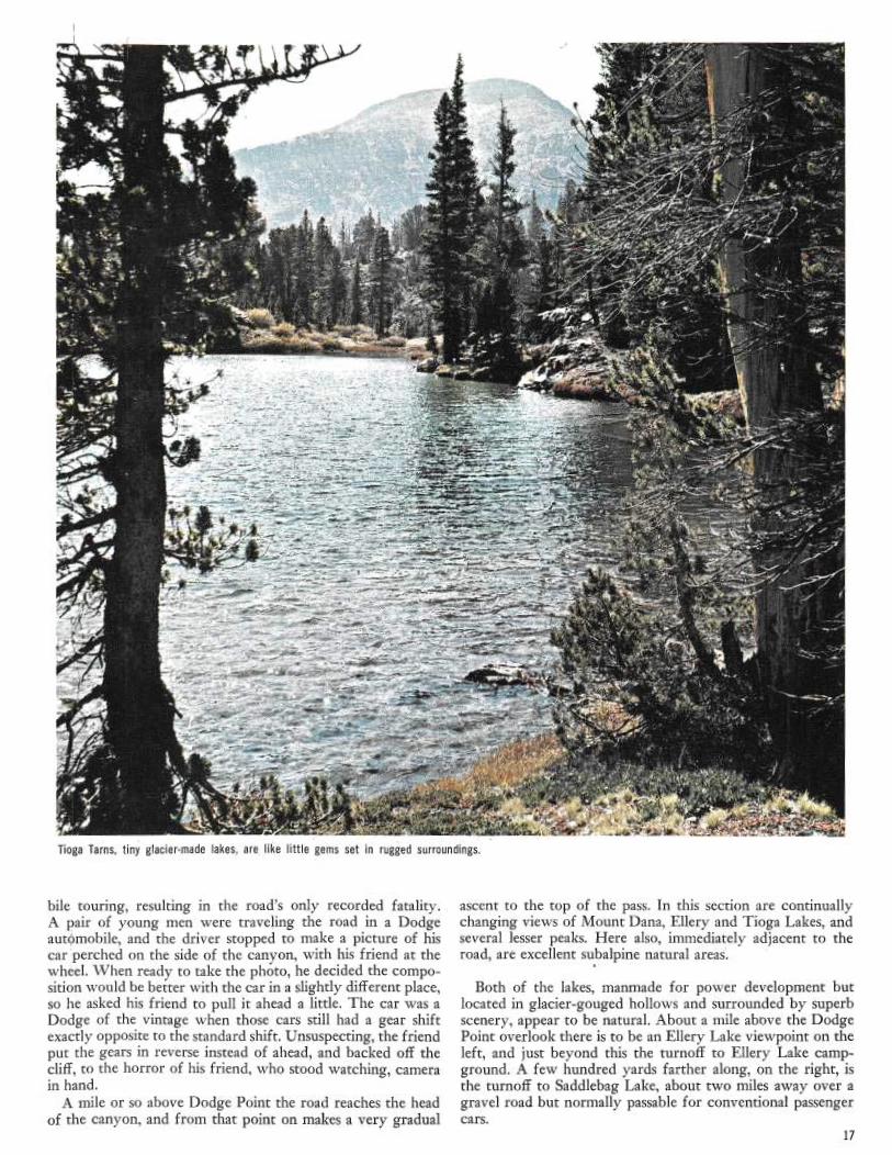
noga earns, tiny giacier•matle lakes, are, like little gems set in rugged surroundings.
bile touring, resulting in the road's only recorded fatality.A pair of young men were traveling the road in a Dodgeautgmobile, and the driver stopped to make a picture of hiscar jperched on the side of the canyon, with his friend at thewheel. When ready to take the photo, he decided the compo-sition would be better with the car in a slightly different place,so he asked his friend to pull it ahead a little. The car was aDodge of the vintage when those cars still had a gear shiftexactly opposite to the standard shift. Unsuspecting, the friendput the gears in reverse instead of ahead, and backed off thecliff, to the horror of his friend, who stood watching, camerain hand.A mile or so above Dodge Point the road reaches the head
of the canyon, and from that point on makes a very gradual
ascent to the top of the pass. In this section are continuallychanging views of Mount Dana, Ellery and Tioga Lakes, andseveral lesser peaks. Here also, immediately adjacent to theroad, are excellent subalpine natural areas'.
Both of the lakes, manmade for power development butlocated in glacier-gouged hollows and surrounded by superbscenery, appear to be natural. About a mile above the DodgePoint overlook there is to be an Ellery Lake viewpoint on theleft, and just beyond this the turnoff to Ellery Lake camp-ground. Afew hundred yards farther along, on the right, isthe turnoff to Saddlebag Lake, about two miles away over agravel road but normally passable for conventional passengercars.
17

High Sierra, Mono Valley, andMono Lake as seen from
ridge at top of Conway Summiton US 395. Lighter line
along base of mountains marksold shoreline of Lake Russell.
Behind ridge at extremeright center is Division of
Highways viewpoint.
Farther along on Route 120, 2 %Z miles above Dodge Point
and just east of Tioga Lake, are the Tioga Tarns—small,
glacier-created lakes in a beautiful setting. Since grazing has
been prohibited in these portions of the national forest for
nearly 50 years, the high country ecology has nearly returned
to the natural balance which existed prior to the coming of
the white man. In the Tioga Tarns area the U.S. Forest Service
has established a nature trail. There are two turnoffs here a
short distance apart.About ahalf-mile beyond is another connection to the old
mining road, and just beyond that, less than a mile from the
park entrance, is a left turnoff to the Tioga La#e vista point.
This is a total of nine turnouts for recreational purposes in a
four-mile stretch, but parking will be permissible at other
points where vehicles can get completely clear of the traveled
way.The vista points have been selected in each case to give the
best possible view of the scenic area, and the campgrounds are
Forest Service administered with tl~e usual facilities of that
agency. The old town of Bennettville will be disappointing to
all but inveterate history buffs, for nearly all the buildings are
gone, and the machinery has been moved down to the Pioneer
Museum at Wawona.The Smithsonian Institution has been trying to get at least
one piece—the Burley Air Compressor—but the park rangers
are obdurate. It turned out this is the only specimen of this
type compressor left in the world.The trip to Saddlebag Lake is a slow but easy trip along the
side of Tioga Peak, partially through superb groves of lodge-
pole pines. In places the trees open up to provide vistas across
a great open valley to White Mountain and Mount Conness,
with their many intricately carved glacial cirques. The lake,
another manmade one, is very dramatic, surrounded by high
rock ridges and battered whitebark pines. Here a Forest Ser-
vice boat concessionaire takes backpack parties to the Hoover
Wilderness at the north end of the lake.18
It was approximately over today's route to Saddlebag Lakethat the Tioga Mine crew traveled its last lap when it broughtin the machinery for digging its tunnel. When it was decidedin February 1882 that it was impossible to get the shaft as deepas it should go with hand labor, 16,000 pounds of machinerywas brought up Mill Creek Canyon in March and April. Asingle pair of mules and about a dozen men hauled the equip-ment, loaded on homemade sleds, through snowbanks and upseveral thousand feet of precipices and impossible grades,mostly by block and tackle, a few hundred feet a day. Carry-ing their bedding and cooking equipment along, they madecamp each evening. The nine-mile trip took slightly more thantwo months.The Inyo National Forest nature trail in the Tioga Tarns
area is delightful. A few steps from the road, across a low ridge,
and all signs of civilization are gone. There are several tarns,each in its own little basin, surrounded by ridges of resistantrock the glacier failed to wear down to the level of the valleyfloor. Here are some fine lodgepole and white-bark pines, andin July and August an outstanding display of high mountain
wildflowers. In the mud along the shoreline you may see acougar's tracks. The Forest Service has marked the spots ofspecial interest with small wooden plaques.
For the more ambitious outdoorsman, several of the sur-
rounding peaks are easy climbs. T`he crest of jVlount Dana,
over 13,000 feet high, is only about 2 %Z miles from the highway
as the crow flies, and only a little over 3,000 feet higher than
the road here. Although somewhat more than 2 %Z miles on
foot, the climb up the ridge to the summit is not difficult, and
the view from the peak is superb. An easier project is the
Dana Plateau, just to the east of the peak, a climb of about
1,300 feet. Of course, from this portion of the Sierra, there
is access to a big portion of the High Country, but the average
traveler will have time for just a quiet sojourn of a few hours,perhaps on his way north or south on IJS 395. This theimprovements in Route 120 will make infinitely easier.
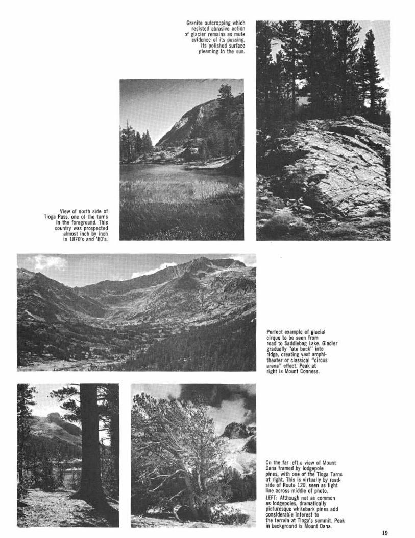
View of north side ofTioga Pass, one of the tarns
in the foreground. Thiscountry was prospected
almost inch by inchin 1870's and '80's.
Granite outcropping whichresisted abrasive action
of glacier remains as muteevidence of its passing,
its polished surfacegleaming in the sun.
Perfect example of glacialcirque to be seen fromroad to Saddlebag Lake. Glaciergradually "ate back" intoridge, creating vast amphi-theater or classical "circusarena" effect. Peak atright is Mount Conness.
On the far left a view of MountDana framed by lodgepolepines, with one of the Tioga Tarnsat right. This is virtually by road-side of Route 120, seen as lightline across middle of photo.LEFT: Although not as commonas lodgepoles, dramaticallypicturesque whitebark pines addconsiderable interest tothe terrain at Tioga's summit. Peakin background is Mount Dana.
19

~~~~~t~`+~~~~t~ ~.v~~~
„ {rfit,
i! 4~
~~'~ f~~'~~
~ •~
~~
~ ~
~
_
~
~."~t
y = 't,
t t ~' S
Try ~
.~ ~ ~ s
~~ ~
~
j ~
.. ' /
9. '"
w
i ~
't*~' a0 ~
`. s ~ a
}i~yE 1:
c , r ~
t
,~ ~
`r
~ !
~ r ;
~{
~C i
^x~ ~1 Q
~-i ~ 1
~11~~~',r~ ~~
~E , `
~.^ ~~~j;. ~
tsy~+
~ r~ ~
~. ~
e i
1 7~
RI, ~'r' ~ ~
~~I ~~~
i
y~i ~
I
ti I >
> ~/
a
r 1
tit ~c~
Ft, # ~
~ a~
t t
~!~
~y ''; /
a A ~
~. -~~° tY j ~"
w ♦
E'
1
t' ~;
~[c ~
'w~" r~ ~
~'~'7r ~ ~
~ r
l
~ ~ i
~
F e ~
y' ~ .~
st( { k't f :
~
1 ti ~s; +~ ~1
Y i~ y
c~ ~
1i'''~ ! ~
,/ o
I~ i j 4~ ~ ~
F iy
'f3''1~~,,~
~ ~ 04
y ~~ils~
1.x
x ~`
~
~~"
~
r~
'~'v.~ ~
~ ~a,
j
~ ~
1 x,'~~!„+,~~
I
~. i f
1
'l ~
~ ~ ~
r ~F~it~
~,~.~
11'.~ ~`~ i'~~ ~'
~- ;, °
P1
qF, art
~ ; ~.: p► ~ ~
Y ~ ~ ~ . ~ ~
~"`~
~
~p,~.,l,.~r ~c
q
~y1~~'i,~,. 4 dtit,~~~~
*►-iv *!r.
a.~'
~~r; ~ • i
~ ~
~.
~~f/~ ~
~'i,~~
ia' 1~.
i
Z
~fl ~
~.la ~
ii. 1~,~ ~
'~ {/Yr.~ n~
1 A~'~ ~~1~ /~
~
~'
~-~t~j ~~iYr7p~~~'"~u` 'y~:~t
!,
~ ̀
"~~X !
'fi3 ~y
~ 'r ~
'" J*'`f~1. ~ j, ~
i ,$,.
~
~+" ,r'
~~r` N~~'.
~~t~t~~~ t,
r„~`- ? ~.~ ar
+i s.
~.,re. ~r pa.
r ~
~i`, ~i.
J(. ~ .~
`~ ~# "~~~~~
~`
~
Y
.~ ,
y~
'~4
z_i=~
~y~
`'~
'~ ~
~ ~'y~
,'~ .,~ '~
~ ,
~r. {~
day nt t >
#'~.~'ae~ ~~~~
.s
c•.:~~t~l~~ ;~~,~
.k~r'~. r'
°~'~"~""1L~ ~ °~i'~i
'll~ '".~
iR
~w. d ~~
., F~
a1
t: +• s
to ♦iis*
;
,Yr1
-¢'~r:
~ i1~*~
~'~
y~
x"~„q` ,~4
y ~ f ye
i~S f ~r~
~`~ ~
L, a
~
~,I ~:
yr ~~~r
i..
µ+#
~ ~'ti
w
2
1 '~
~~ ~
t ~ c
~+ ~+
s
M.
~
~
,yY
~,~.r
,~,- ~,~i
gip, .' V
r
g,.~ r4'
ar'f'°' ~'
iI'' `s ~ ~
I ~~. ♦
r'
~,..
~,
~~ °r k'~a a'
ry~ ~ #
"~. `S~
'~`~*"~'S~-~ t"t'kM".:
s
t
,+$` ~ .
i~`R. _ ,
~~~^'i w ...r
- .,.
~ r
As
t - s
w n .
.r ar' .
~ ~ •
.oe
•
a
~: •_ .;~'
rte., „`~'~
~+II► ~~ae•R,y ~7~'~_
~
_
~~~
ir:
.
..
,~y.~w~
tea... ,~Y~
'; ~ ~.~
~ ~s
~n ~ L
~-
rM.
~~e -
3
,~. ~ -~
1+
'~. '.~'
c~y ~ ".
.~+~,,,~ ~'
~. ~~
~.
• 1win er main enante~4N ALL-YEAR JOB
BY MARCIA J. MICKELSEN
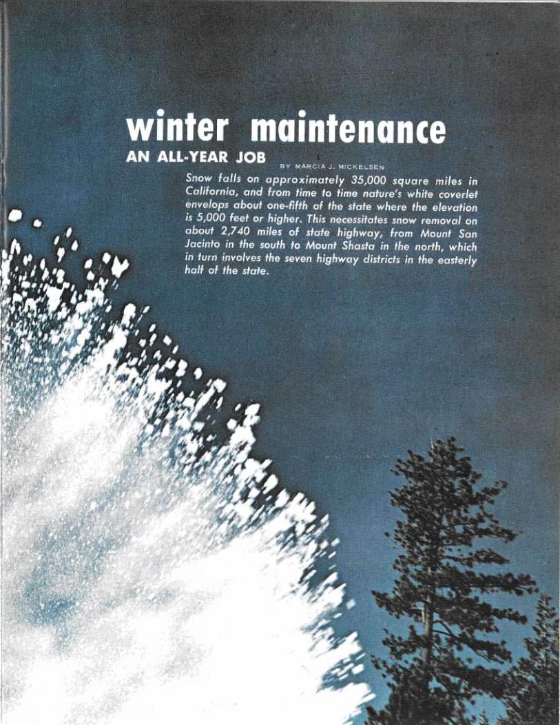
Snow fal►s on approximately 35,000 square o~iles inCalifarnia, and from time to time natu~e'v white coverletenvelops about one-fifth of the state where the elevationis 5,000 feet or higher..This necessitates snow removal on
~ about 2,740 miles of state highway, from Mount San/ ~~ Jacinto in the south to lvlovnt Shasta in the north, which
'~~ in turn involves the seven highwa districts in the easterly~~ ~ half of the state.~ ~,, ~,~f t ~~

For some people, getting readyfor winter was a simple task: Theyput up storm windows, added anti-freeze to the car, and changed to awinter wardrobe.
For the Division of Highways,getting ready for winter was likegetting ready to clear a colossaldriveway over and over again. Toprepare for this annual long sweep,some activities were begun as longago as last March. In the time thatfollowed, hundreds of projects werecarried out, and the same is trueevery year. November 1 is alwayscircled as the cutoff date—after thatpossible snows could make gettingready for winter an afterthoughtspelled disaster.
This machine, same as above, can throw up to 2,200tons of snow per hour. Power comes from twodiesel engines (220 horsepower for propulsion and 335horsepower for feeder and rotary blades).
This 19-ton rotary plow is used in areas of combinedheavy snow and high traffic volume, such as
Interstate 80 in fhe high Sierra.

dome idea of the hustle-bustle a heavy snow fall brings about is indicated by a score of ready-to-go vehicles ranging from rotaryplows to sand spreaders and snow Loaders.
Several passes on state routes—Carson,Ebbetts, Sonora, Tioga, and Monitor—are not in-cluded in snow removal operations. The elevationand weather at these points is such xhat wintermai~itenance is too dangerous and too costly topursue. On the average, these passes are closed inlate November and reopened around MemorialDay, but portions of these routes below the passesare usually open for recreational purposes.
Iii spite of the closure of these passes, thereare still plenty of roads to clear. All major high-ways, including Interstate routes 5, 8, 15, and 80,are kept open in all but the most extreme condi-tions by crews working out of 69 winter mainte-
Hance stations. Many of the maintenance stationsare far removed from population centers. Some;perched high in the mountains, bear fascinatingnames such as Eskimo Summit, Dead Horse, KeenCamp, and Fawnskin. These stations are the "hubs"from which the men propel the big orange snow-plows out to and down the roads, and to w~Yichthey return after a 12-hour shift or combat withnature.
The first flurry of white crystals sets the snowcrews to work with a full array of equipment.The state has 440 snowplows of several types, 179motor graders, and 666 pieces of allied equipmentsuch as sand spreaders and snow loaders.
~~.
o f _,
-.. ~,
fib
Ee ~ ~ _, ~> ~g"~
3~ ~
It takes a massive grader and lots of power to push snow from the traveled way.
23

~'~~hen the force of a partic-ular storm subsides and the road-ways have been cleared, the crewsuse the reprieve for repairs in-cidental to bad weather. Theyreplace sno«~ poles, unplug snow-packed culverts, restore sightmarkers and fixed objects (dam-aged by motorists when visibilityis poor), patch portions of black-top damaged by tire chains, andspread sand to cope with the dailymelting and freezing cycle.
Done on a day-to-day basis,these tasks are dwarfed by whattook place before the snows hadcome. The snow stakes (whichmark the highway in deep snow)were driven; altogether more than88,000 were put in place; 129,000tons of sand (enough to create apile 100 feet high) were storedin sand bunkers; 11,000 tons ofsalt were toted to maintenancestations, and all equipment was
inspected, overhauled and modi-
fled to improve the season's clear-ing operation.
In mid-March, snow equip-ment slated for modification wasshipped to the Equipment Depart-ment in Sacramento. Machineafter machine was modified toincrease its effectiveness in dealingwith villain. snow. Auger boxeswere changed; larger fans in themhelp throw more snow. Dieselengines were installed. Conven-tional truck transmissions werereplaced with power shift trans-missions for more efficient opera-ting and maneuvering. "No spin"
differential modifications weremade to enable a snowplow tomove out of the way even witha broken axle, and improvedpower steering systems have givenbetter maneuverability as well asreduction in operator fatigue.Onlv a few machines can be doneat a time, but little by little. allequipment is updated.
Changing wiring on snow-going ma-
chines to synthetic rubber jacketing has
prevented freezing and corroding that
once made lights inoperable.
~-- ~;,
~I.District 2 employees load cinders from bunker into waiting trucks while other men fill salt spreaders. Although the sky is blue
in Susanville, traction materials may be needed upon very little notice.
24
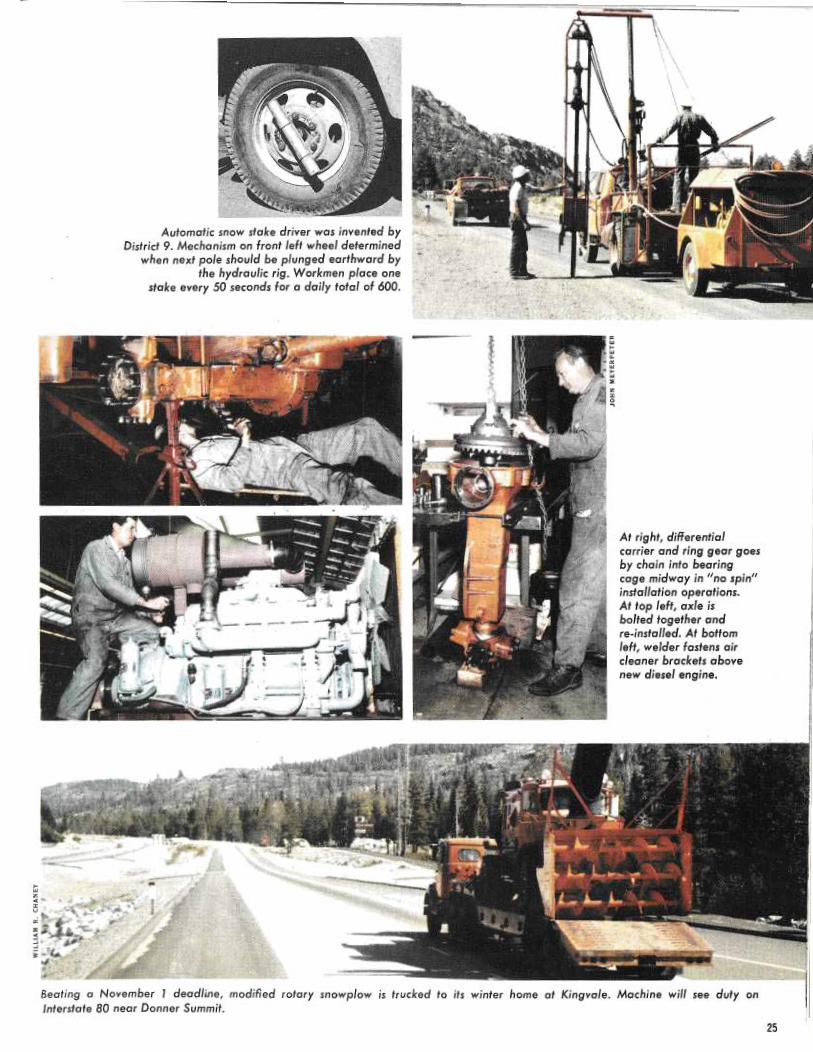
Automatic snow stake driver was invenfed byDistrict 9. Mechanism on front left wheel determined
when next pole should be plunged earthward bythe hydraulic rig. Workmen place one
stake every 50 seconds for a daily total of 600.
At right, differentialcarrier and ring gear goesby chain into bearingcage midway in "no spin"installation operations.At top left, axle isbolted together andre-installed. At bottomleft, welder fastens aircleaner brackets abovenew diesel engine.
Beating a November 1 deadline, modified rotary snowplow is trucked to ifs winter home at Kingvale. Machine will see duty on
Interstate 80 near Donner Summit.25

_~ ~ __ ~..
_ _ - ,. ~~
"' ~ ~ IPx
` * 8
- 1
3 ";r V
~.
...-. ya ~~,.t ..
~ .. !s~ i
m x '•
~,
a
i~..?`
t
~ a'
^e,'~i y"
`'I~~' ~., ~ I. ~ ~
y_ t,.. yP
~
v'
_R..~
~{ I~''~~s ~~ R
e
~tl',^~r~~
+ a`@~ r _ ~~4,~ , ~ ~, ~ i~ a
i~ ~ _ ~,. _.
~~ ~:~~ ~" r
~x ~ ~. g~`~
#;
~,
When roads are icy or snow is falling, the motorist may en-In areas without wide medians for snow storage,counter signs which provide two choices: put on chains or turnrotary
plows funnel their intake into waiting snow loaders. Theback. Most go through the rigors of the former.loaders then proceed to other areas where they deposit
their winter bounty.Chain control stop point on Interstate 80 seems to feature some last-minute
frolicking in snow as wellas chain removal on westboundlanes. Motorists in eastbound lanes more seriously attack the problems of
putivng them on in to drive Summit (elevation 7,127 feet).order over nearby Donner
t~ ~ .~ __ __ _ _.n ._ _ __~ _ _ — ~~ ..~_~. - _~
~ E ~ ; ~ ~'~t *e~ r" a
~~
~R §,~ `k~,. ~$d}~~-' ~ 9~'
,~yJY ~$~ &~i,a *fit^j~, ~~
~,~ _:; ,.
r~ ~,.
w-
~ A`~ r~ u~ ~.~..._..~.; cs-L
„*~~ ins s ti
,yr aG _.
-_r7 ~±-',f
~
~~ ~
.r, '"r . dfa +'r•i ~,
- ~
~~~. ~. c am_ ' ~P z~"`
_ _.b._ ~._, ~ ai
~ --~ .~ ,k ,..' c .,,,.
~~
`~,..e
k~f
'
~,_;, %K
..~+T .~
»;,of . ,
~
e_~ ,. _. ,. -. ar-'--.r . '~~
,~y
~~ uc _~ '> ...
~ ~~,. _.__
~ .- _
i.P .. a. ~~_.. ,. ~~' ~....ar,~e.,
x~~ ~,~~~
..~~~~

°'
,;~ _~ ;~,Rotary snowplows of lesser size than in previous pictures can also throw a mighty spray across the
horizon. i
Machine capabilities have been increased through many modifications by the Equipment Department. ~
The Squaw Valley parking lot is filled! to the brim by cars, skis, and skiers who arrive at this resort area by way of
Interstate 80 and State Route 89 (south). The area, which lies southwest of Truckee, is best known as the site of the
1960 Winter Olympics.
Q

wrwrcwrwfzsO
x.~?aw.,~*..
~.
~G . +...
k~ "~,,~,~ `"fir ~~~~
w ~ ,~,~ ~,~~.
~ ~ S~ ~
r ~ ~y`^-~~`6'+~ ~.., _
~ .^'tea
~N ..
+'Gv~~,.._ ~ ~ „ .
..~y~~~..~.. ~.
.~ E
Conway Summit maintenance station, elevation 8,138 feet, lies east of the main Interstate 80 eastbound lanes near Donner Sierro ridge (background) above Mono Lake. North-south tragic on U.S. 395 ~ Lake are rapidly opened after a snowfall of
(foreground) is dependent upon clearing operations of this District 9 station less than major proportions. Clearing this when snows come. transcontinental corridor is facilitated by gentlysloping grades designed for this new road.
The increased efficiency made possible by equip=ment changes is perhaps best shown by the fact thatInterstate 80, opened over Donner Summit last year,was cleared without using any additional snow-plows—yet there were twice as many lanes to clearas there had been on the old US 40.
All phases of getting ready for winter, as thetranscontinental traveler, the trucker, the bus opera-tor, and the ski buff can tell you, pay handsomedividends in winter mobility. The open road, flankedby walls of white, proves that demon weather canbe successfully challenged.
28
Signs on turnabout mountings are inspectedand repaired each fall. When Route 20
east of Nevada City is clear,Highways personnel turn sign to
present a blank face to the motorist.

WILLIAM R. CHAN EY ~~
* ~
~'~
y,
5 _
_ti
~y
'i' u
'+Ea~,a
Y
~ ~
..
S ~
~
's rg
_
~
~~.
f
fi ~
ai
"`
hfi
r-
~ ~~.
r~, ~r~~.
-~ ~~
"^
?.~w
_.
. ~'
.. 4,~
_
~, ~
s v~~
nit
- ~
y~.~§~g~.
~ ~~
+~
{
ms s" .,~~7'
~.,, .
X
'g
x~*' F KW'
`? y'
+~
.~a
.y0
~ ~.<:~~...
N CO

combating snow
•
~'M
radioBy
AliceWiegand
New over-the-snow vehicle will enablecommunications specialists to serviceunmanned radio repeater station net-work despite heavy snow.
(Editor's Note: This story aboutco~maaunications in District 3 holds autrue 'for all highway districts %nCalifornia which have mountainroads to maintain.)
-The radio communicationsnetwork used by the Divisionof Highways at no time serveswith more frequency or ur-gencythan during snowstormsor low-visibility periods whenmountain travel is hazardousand traffic must have safe pas-sage over the Sierra Nevadarange.The mile-and-a-half-high
granite passes pierced by USSO south of Lake Tahoe andInterstate 80 north of the lake,are under constant surveillanceby highway maintenance menand their supervisors who canrelay any change in road con-ditions instantly. They use acommunications system com-bining direct telephone lines,high frequency radio and mi-crowave. The three-way com-bination is used because of itseconomy, flexibility and time-saving efficiency.30
The network is centered inMarysville, headquarters forHighway District 3, and itlinks 16 base stations, over200 mobile units and 6 radio-repeater microwave stations.These effectively blanket the12,600 square miles and the1,400 miles of Mate highwaysinside the district's boundarieswhich include the only twomajor trans-Sierra routes innorthern California.The repeater stations bounce
radio signals beamed to themand are, therefore, located onremote mountain peaks wherereceprion is good but access tothem difficult.Although they are serviced
monthly, severe storms, highwinds and ice sometimes inter-rupt the power and for theseemergencies the stations arefortified with emergency gen-erators.In order to improve main-
tenance of them and to reducehazard of power failure atthese units, a new vehicle withwide tracks for over-the-snowmobility has been purchasedfor the radio communicationsdepartment in Marysville. It
Qn left is one of six radio repeater stations in the District 3 network. Built onmountain peaks, these units support antenna and reflector dishes sending radioand microwave signals to highways units in 11 counties. Mrs. June DeVore, dispatcher (above), gives complete road/weather information to field workers and highway officials using athree-way combination of telephone, VHF radio andmicrowave.
will permit technicians, forthe first time, to have theirown means of transportationto the isolated relay stations.Up to this year the spe-
cialists have been hitchhikingto remote stations wheneversnow vehicles operated byother public or private agen-cies made a trip. But the tripsdid not always coincide withDivision of Highways' emer-gencies !A soundproof, dustproof
studio at Marysville highwayheadquarters is the nerve cen-ter for the radio communica-tionsnetwork. There, a skilled,competent dispatcher, Mrs.June DeVore of Sutter Coun-ty, maintains constant contactwith all stationary and mobileunits.Mrs. DeVore is able to keep
state offices, including Sacra-mento headquarters, informedof highway conditions, includ-ing those over the Sierra,which are constantly chang-ing during inclement weather.
Public news media have im-mediate access to this informa-tion.Two important installations
which are vital to the smoothflow of trans-Sierra traffic areremote-control signs, one ~nUS SO at Placerville and theother on Interstate 80 at Col-fax. Black with white letters,the signs are blacklighted forhigh visibility day or night. Sixmessages are stored on eachsign, and, when activated byspecial coded dialing, flip intoplace advising motorists ofchain requirements and roadconditions over the mountainsummits. Great timesavers,they are the best known meansfor conveying instant informa-tion to the motorist.The highway division is
charged with responsibility formaintaining a safe and orderlyprogression of traffic for the7,000 to 9,000 motorists whodaily drive over the crest ofthe Sierra in winter on Routes50 and 80. While no amount ofequipment can forestall roadclosures, the use of it by highlytrained men and women ena-bles the highways' communi-cations staff to advise motor-ists in advance of the capricesof nature which may impairsafety.
SOUTHERN CALIFORNIA
By Paul Brown
In the series of storms which struckRiverside and San Bernardino Coun-ties last November, Division of High-ways maintenance crews, workingaround the clock, struggled mightily tokeep the roads open despite flooding,washouts, and slides. Occasionally theylooked up from their work and peeredinto the darkness, trying to see the hugeboulders they could hear bouncing andgrinding their way down the hillsidesnearby. When the storm passed it lefta nasty trail of mud, rock, .and debrisover the highways.
Surprisingly, not a single State Di-vision of Highways maintenance orconstruction man was injured duringthe storm—which, although it lasteda week, concentrated its destructiveforce into atwo-day period, November
22 and 23.The storm did not single out one
spot, but hammered away at a multi-
tude of locations throughout Riverside
and San Bernardino Counties. There
were two areas which received severepunishment. One of these—the mostseverely damaged area in the two coun-
~, =~" r
u .~ ~- ro~`~: o~~ . ,p
r N ~ a -.~ ir e
~~
sr ~ .~yr »r
ties—was at Mill Creek on Route 38 inthe San Bernardino Mountains. Waterroaring down the creek bed brokethrough the dike and undermined theroadway. About S00 feet of road waslost in one area; and the storm wipedout approximately 800 feet of roadwayat another section.The second severely damaged area
was located on Interstate 10 and Route111 near Palm Springs. Flood waterspouring out of the mountains dumpedheavy quantities of mud and debris onInterstate 10 along atwo-mile sectionstretching westerly from the Route10/111 junction. Route 111 near thejunction also was buried in mud anddebris.About 100 cars and trucks were stuck
in the mud in this area. Mud on thehighway was three to four feet deep insome spots.The storm also left its mark at Snow
Creek near Palm Springs on Route 111.A contractor's bridge, under construc-tion on a new project at this location,collapsed when falsework washed out.During the storm, maintenance crews
~~C~IDENTAL COILEC
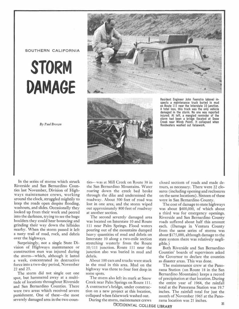
Resident Engineer John Feenstra (above) in-spects amaintenance truck buried in mudon Route 111 near the Interstate 10 junction.A total loss, this truck was the only vehicledamaged in the storm. No one was reportedinjured. At left, a mangled reminder of thestorm had been a bridge (located at SnowCreek near Windy Point). It collapsed whenfloodwaters washed out falsework.
closed section's of roads and made de-tours, as necessary. There were 22 clo-sures (including opening and reclosureson the same locations). Sixteen of thesewere in San Bernardino County.The.cost of damage to state highways
was about $600,000, of which abouta third was for emergency openings.Riverside and San Bernardino Countyroads suffered about half this amounteach. (Damage in Ventura Countyfrom the same series of storms wasabout $175,000, although damage to thestate system there was relatively negli-gible. )Both Riverside and San Bernardino
Counties' boards of supervisors askedthe Governor to declare the countiesas disaster areas. This was done.The maintenance crew at the Pano-
rama Station (on-Route 18 in the SanBernardino Mountains) keeps a recordof precipitation at that location. Duringthe entire year of 1964, the rainfalltotal at the Panorama Station was 19.7inches. The rainfall total for just themonth of November. 1965 at the Pano-rama location was 2'1 inches.
~E LIBRAR1f 31

~lG~ l~ ~ o
PollackPi~zes
~ree~~
Tranquillity of small communityreturns as new✓ freeway opens
32
Rural freeway bypassing Pollock Pines cg•ries average daily traffic of 11,500 vehicles in peak period.
By Ray Sorum
Heavy traffic on US 50, California'sfirst state highway, has been common-place for a Hundred years, and duringthose years- it has bit by bit beenchanged from a winding, dusty, freight-ers' haul road to a modern highway.Today, with the route still increasingin popularity, US 50 is being convertedto freeway as rapidly as availability offunds allows. The latest unit in thistransition is 6 %Z miles completed in latesummer last year, bypassing the com-munities of Cedar Grove -and PollockPines, and relieving the serious bottle-neck which has traditionally developedin the latter community on weekendsand holidays.In the late 1850's this route was
the main connection between Sacra-mento, Placerville and Nevada's Com-stock mines. By the 1860's uncountedhundreds of freight wagons rolled overits dirt and corduroy surface with car-goes ranging from drygoods and flourto blasting powder and whiskey.
Traffic was said to be so heavy thatit was "nose to tailboard" and that ifa wagon dropped out of the trafficstream "it waited until nightfall to get
hack into line."The road was first opened between
Placerville and the Carson Valley inNevada in 1852 by Col. J. B. Johnsonand with a few deviations from its orig-inal location has become US 50.The first stage line between Placer-
ville and the railroad at Folsom beganoperation in 1857 and improvementsbegan to follow with moneys sub-scribed by El Dorado, Sacramento andYolo Counties. Construction during1860-65 fixed the location for whatcame to be know n as the "Lake TahoeWagon Road" for more than 60 years.Tolls were collected on the road be-
tween Smiths Flat (near Placerville)and the Nevada state line until 1886when the rights were purchased by ElDorado County and the route declareda public highway. In 1895 it was offi-cially designated as the "Lake •TahoeWagon Road" and the following yearbecame the first state road in California.
In the intervening years the oldwagon road became a federal aid route,getting its US number, and today is avital east-west highway which servesthe popular Lake Tahoe resort area aswell as the year-round recreation areas
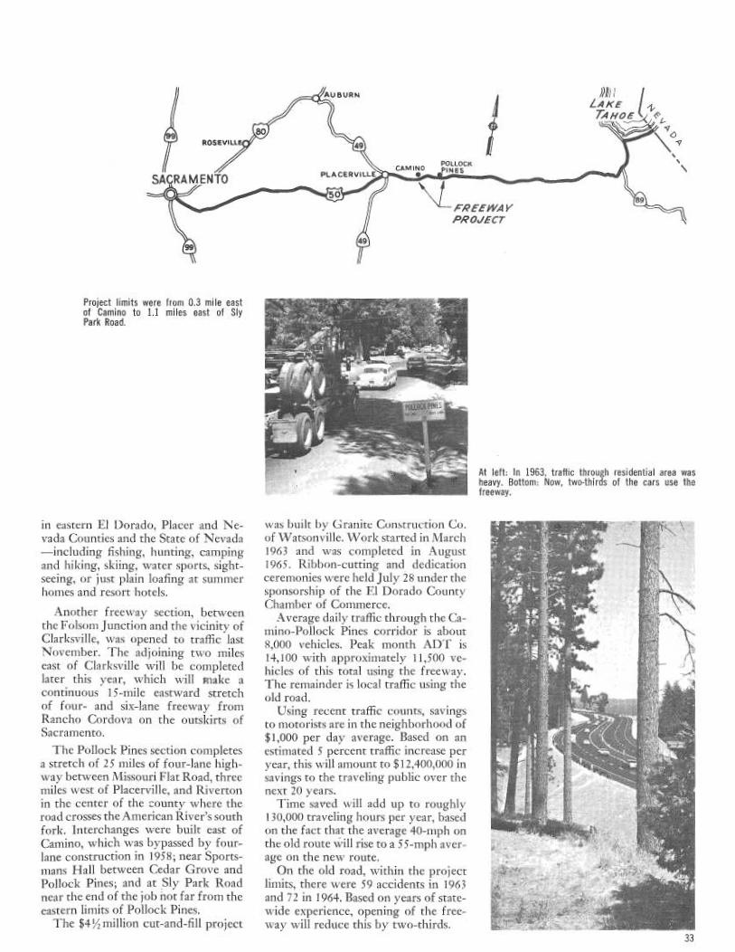
99ROSEVi
'~CRA M ENTO
Project limits were from 0.3 mile eastof Camino to 1.1 miles east of SlyPark Road.
in eastern El Dorado, Placer and Ne-vada Counties and the State of Nevada—including fishing, hunting, campingand hiking, skiing, water sports, sight-seeing, or just plain loafing at summerhomes and resort hotels.
Another freeway section, betweenthe Folsom Junction and the vicinity ofClarksville, was' opened to traffic lastNovember. The adjoining two mileseast of Clarksville will be completedlater this year, which will make acontinuous 15-mile eastward stretchof four- and six-lane freeway fromRancho Cordova on the outskirts ofSacramento.
The Pollock Pines section completesa stretch of 25 miles of four-lane high-way between 1~lissouri Flat Road, threemiles west of Placerville, and Rivertonin the center of the county where theroad crosses the American River's southfork. Interchanges were built east ofCamino, which was bypassed by four-lane construction in 1958; near Sports-mans Hall between Cedar Grove andPollock Pines; and at Sly Park Roadnear the end of the job not far from theeastern limits of Pollock Pines.The $4%z million cut-and-fill project
AUBURN
LAKE
TAH~ ~
~O49 \ 9
CAMINOPOILOCK ~PINESPLACERVR~E • _-! -
FREElN~1 VPRO✓ECT
was built by Granite Construction Co.of Watsonville. Work started in March1963 and was completed in August1965. Ribbon-cutting and dedicationceremonies were held July 28 under thesponsorship of the El Dorado CountyChamber of Commerce.Average daily traffic through the Ca-
mino-Pollock Pines corridor is about8,000 vehicles. Peak month ADT is14,100 with approximately 11,500 ve-hicles of this total using the freeway.The remainder is local traffic using theold road.Using recent traffic counts, savings
to motorists are in the neighborhood of$1,000 per day average. Based on anestimated 5 percent traffic increase peryear, this will amount to $12,400,000 insavings to the traveling public over thenext 20 years.Time saved will add up to roughly
130,000 traveling hours per year, basedon the fact that the average 40-mph onthe old route will rise to a 55-mph aver-age on the new route.On the old road, within the project
limits, there were 59 accidents in 1963and 72 in 1964. Based on years of state-v~~ide experience, opening of the free-way will reduce this by two-thirds.
At left: In 1963, traffic through residential area washeavy. Bottom: Now, two-thirds of the cars use thefreeway.
33

°•.
and their do it yoursel froadside beautification
Take 25,000 empty two-pound cof-fee cans, a like number of redbud seeds,add a state highway and mix with theingenuity, nursery knowhow and en-thusiasm of a community and whathave you got? Perhaps the biggest do-it-yourself roadside beautification pro-gram in the history of California.'The community is the City of Mari-
posa and the state highway is Route140, a main entry point into YosemiteNational Forest.
Rows of redbud seedlings arenurtured for their eventualplanting to beautify Route 140.
The project had its beginning in1964 with William Brady, who had thethought of planting redbud shrubsthroughout the county. Brady, an ama-teur horticulturist, had developed asuccessful germinating process that cansimulate—in a two-pound coffeecontainer—conditions found in raa-ture. When Brady and a friend, KeithKaylor, passed the idea on to variouscivic groups, the Mariposa Chamber ofCommerce and the Highway 140 As-
34

Governor Edmund G. Brown accepts a redbud plant from William Brady. Mrs. Brady watches with Robert Romaine (center righU, president of the Highway140 Association, and Roy Radanovich (right), the group's publicity charman.
sociation agreed to take over.bast spring they made a nationwide
appeal for people to send them emptycoffee cans. Thousands were receivedwith many coming in by parcel post.The project seemed to sound a par-ticularly responsive note in Brooklynfor many were forwarded to Mariposafrom that city. But Air Force bases,schools and civic groups from all overthe nation also responded with bulkshipments.
Since then 8,000 shrubs have sprout-ed and are being planted. The first wasemplanted in a permanent place of hon-or adjacent to Route 140 during cere-monies on September 21.The date coincided with National
Highway Week and the California Di-vision of Highways took cognizanceof the project by issuing a permit au-thorizing the planting of a single red-bud. Later, a permit covering the re-mainder of the thousands of shrubs wasmailed to the chamber of commerce.The project has received recognition
from numerous officials and private cit-izens who are interested in beauty.Included are Mrs. Lyndon Johnson,Governor Edmund G. Brown and Cali-fornia's State Highway Engineer, J. C.Womack.In a letter to the Highway 140 Asso-
ciation, Governor Brown said, "Alaskaand Texas may dwarf California inmere geography, but when a group ofcur citizens envision and carry nut aplan such as yours, it again proves thatCalifornia is second to none in note-worthy accomplishments and love ofbeauty."
Brady prepares the soil for the planting of the first redbud at a special ceremony in Mariposa.
35

LIMESTABILIZATION
...;
36
0
y_,. .. ~~, r°
Experiment on cohesiveness of lime-treated clay.Specimen A was kept damp before immersion;specimen B was allowed to dry before immersion.Nate B's more rapid disintegration.
California's Experience WithLime Treatment in Road
ConstructionBy Erryaest Zaibe a~ac~ Clyde Gcrtes
InTroduction
Highway engineers are cunstantlyseeking better and more economicalways of building highways which willsafely carry traffic and give more yearsof service with aminimum of mainte-nance. This is a never ending job. De-sign criteria have had to be modifiedas traffic, and particularly wheel loadsHave increased. Specifications for road-building materials have had to be morerigid as the supply of good roadbuild-ing materials becomes scarcer. Ne~vmaterials have had to be found andmethods of treating or stabilizing thepoorer materials have had to be devel-oped. Newer and getter methods ofconstruction have had to be developed.
PHOTOS LEFT, TOP TO BOTTOM. A tank truckspreads lime slurry in an area where lime dustcould cause damage to airplanes stored nearby.SECOND PHOTO—Mechanical road mixing of limewitfi damp aggregate. THIRD PHOTO—Large tanktruck and spreader used in laying dry lime.BOTTOM PHOTO—Dry lime is converted into slurryin mixing tank.

Rock, stone, gravel and sand havelong been used successfully and eco-nomically for road building. WlZilethese materials are plentiful in manyareas of California, there is a scarcity incertain areas. Many cif the good sourcesof aggregates are being depleted orfail to meet the rigid specifications re-c~uired for modern road building. Ur-ban expansion and zoning ordinancesare limiting the development of newsources. In recent years it has becomequite obvious that methods of treatingor stabilizing local available soils wouldhave to he developed.
Clays or clayey soils are usually quiteabundant in areas where good naturalroadbuilding materials are scarce. Thisaggravates the situation, since claysleave little load-carrying capacity whenvet and therefore require blanketingwith thick raadway structural sections.~~~Tany methods of waterproofing withbituminous products or stabilizingclays such as blending with better ag-gregate have been tried but most havebeen impractical. The most promisingstabilizing agent, in recent years, hasbeen hydrated lime. The results inmany cases hive been phenomenal.These problem clays can now be con-verted into stable bases and subbasesand used in the structural elements ofmodern highways.
History
The use of lime for the stabilizationof soils is not ne~v. Lime is actually oneof t11e oldest man-developed construc-tion materials. Early history does notrecord the first use cif lime stabilization.However, it is known that mixtures ofclay and lime were used in construct-ing the pyramids of Shensi in the Ti-betan-Mongolian Plateau more than5,000 years ago. The Romans used limein subbases of many of their roads, in-cluding the famous Appian Way.Some interest was shown in lime
stabilization in the United States about40 years ago. A few small experimentalprojects were constructed but soonfailed due tc> the lack of proper wearingsurfaces. The first real lime stabilizationproject was consrtucted in 1943 by theCorps of Engineers. Two percent ofhydrated lime was used to reduce the
plasticity of a caliche gravel used as avase course for runways and taxiwaysat Chase Field in Texas. Since that timet11e State of Texas has been a leader inthe use of lime stabilization.In the late 1940's the California
llivision of Highways became inter-ested in lime stabilization. Our High-~vay District 3, with headquartersat ~~'Iarysville, vas very progressive inits application. Many projects, someof a maintenance nature, were con-structed in EI Dorado, Placer, and Sut-ter,Counties. The ready availability ofa cheap waste lime in this area made itsuse particularly attractive from an eco-nomica] standpoint. Two small experi-mental projects constructed in the Si-erra, one near Truckee and the othernear Georgetown, were particularlysuccessful *` and led to the use of limeon further projects. At the presenttime, dime is being used on ii~ore andmore •projects by counties, cities, andthe state. It is estimated that lime treat-ment has been used on more than 200projects in California. Over 600,000tons of lime were used for stabilizationlast year in tl~e United States.
Lime Reaction
There are two main chemical reac-tions which take place when lime andwater are added to clayey soils. Thefirst is an agglomeration of the fineplastic clay particles into coarse friableparticles through a phenomena calledbase exchange. This action is rapid andis usually completed within an hour ortwo if the soil is pulverized and thor-oughly mixed with the proper amountof lime and water. The second actionis a cementing or hardening action inwhich the lime reacts chemically withavailable silica and some alumina iq thera~v soil forming calcium silicates andalumiriates. This is a slow action whichcontinues for a period of a year orlonger providing there is adequatemoisture available.
Types of Lime
Ground or pulverized limestone is
•,Tl~ese projects described in article entitled"Experimental Use of Lime for Treat-nzent o f Higl~way Base Courses" by E.Zube, California Highways and PublicWorks, Judy—August 19so.
often called "lime." However, whenwe speak of lime for soil stabilization,we think primarily of calcium hydrox-ide. Limestone is calcium carbonateand has little or no chemical reactionwhen mixed with clay soils. When cal-cium carbonate is heated to a tempera-ture of about 1,800° F., carbon dioxideis driven off and calcium oxide, com-monly called quicklime, is formed.Quicklime is quite effective for soil sta-bilization but is dangerous to use andcan produce severe burns when in con-tact with moist skin. Calcium hydrox-ide is formed by adding water to quick-lime. Calcium hydroxide cari also beproduced as a byproduct in the manu-facture of acetylene and carbide. Cal-cium hydroxide is the type of limenormally used for treating toils in Cali-fornia. Another tyke of lime, producedfrom dolomite, is normally a mixtureof magnesium hydroxide and calciumhydroxide and is called c~blomitic lime.It has also been used for stabilizing cer-tain types of clays.
Uses of Lime in Highway Consfruction
The most common use o~ lime treat-ment or stabilization in highway con-struction is for subbase. Norri-►ally the"in place" clayey soil or a loyally im-ported soil is treated with about 3 or4 percent of lime, by weight of thedry aggregate. The R-value o~ the un-treated soil is frequently as loin as fiveand after lime treatment the R-value isusually well above 60. This type oftreatment has been used successfully onmany projects. (R-value is resistanceto deformation.)Graded aggregates which contain
plastic fines can be treated with limeand used as base material. Even heavyclays have been treated with lime andused as base material on secondaryroads having light traffic. However,experience with this latter type of de-sign is limited, especially insofar asheavy traffic is concerned. Laboratorytests indicate that the R-value of manyclays, when mixed with from 4 to6 percent lime, can be f aised to 80'.However, designers should proceedwith caution until more informationis available on field performance. Sev-eral experimental projects are under-
37

ioo
90
BO
70
60
W
J
~ 50
40
30
20
10
~0 I 2 3
LIME
EFFECT
-~-Soil 61-1329
OF LIME
Cloy
ONR-VALUE
O
—-- /I--
CHEMICAL ANALYSIS
LIME A LIME B LIME CO O Q
~
7
%Ca(OH)56.079.897.3
%Mg(OH)239.411.20.2
%Ca (C0130.27.40.9
Mg 0NILNILNIL
way to gain objective knowledge inthis area.
Another use of hydrated lime has
been for the treatment of expansive
clay soils under portland cement con-
crete pavements. The lime reduces the
expansion of the treated layer and also
serves as a moisture barrier, thus pre-
venting water which might enter joints
or cracks in the pavement from get-
ting to the expansive clays in concen-
treated amounts and raising the joints.
By using lime treatment it is often pos-
sible to decrease the thickness of aggre-
gate subbase by as much as two feet,
thus effecting a substantial saving in
cost.Lime is also used successfully for
treating wet subgrades which will not
support construction equipment. The
lime not only blots up some of the
excess moisture but also stabilizes the
layer to which it is added. Therefore,
38
goo
90
80
70
60
W
J
j 50i
40
30
20
10
00
EFFECT OF Ca(OH)2 ON R-VALUE
Soil61-1329Clay
O
D
CHEMICALANALYSISLI ME Av
LIME 8O
LIME Cp
Co (OH)256.079.897.3
Mg(OH)239.411.202
Mg0NILNFLNIL
lime treatment of wet subgrades canspeed up construction by negating theneed for extensive digouts or delaysin drying operations.
In certain areas of California thereis a scarcity of good mineral aggregatefor asphalt concrete. One such area isin Modoc County- where asphalt con-crete pavements, using highly absorp-tive local aggregates, have shown earlyfailures due to stripping, raveling andcracking. Texas has had similar prob-lems with their aggregates in the Pan-handle area. They found that limetreatment of the mineral aggregate, be-fore the •addition of the asphalt, cor-rected the problem. Therefore, it wasdecided to use this method of treat-ment on a project just completed inModoc County near the town ofLikely. One percent of hydrated lime,in a slurry form, was added to the min-eral aggregate before it passed into the
2 3 4
Ca (OH)Z
drier. Laboratory tests show that thelime treated aggregate has satisfactoryresistance to moisture.
About two years ago the OklahomaHighway Department developed a newmaintenance technique referred to as"drill-lime stabilization" for correctingboth distressed flexible pavements andsliding highways fills. With this tech-nique, hydrated lime is introduced intothe wet unstable plastic subgrade bymeans of holes drilled through thepavement. It is claimed that the limepermeates through the subgrade, sta-liilizing it to the extent that furtherdistress is minimized or even stopped.The holes are usually about nine inchesin diameter and about 30 inches deepand spaced on approximately five-footcenter. About one-half sack of limeis poured into each hole, water addedand the holes backfilled, tamped andpatched. In California, at least three
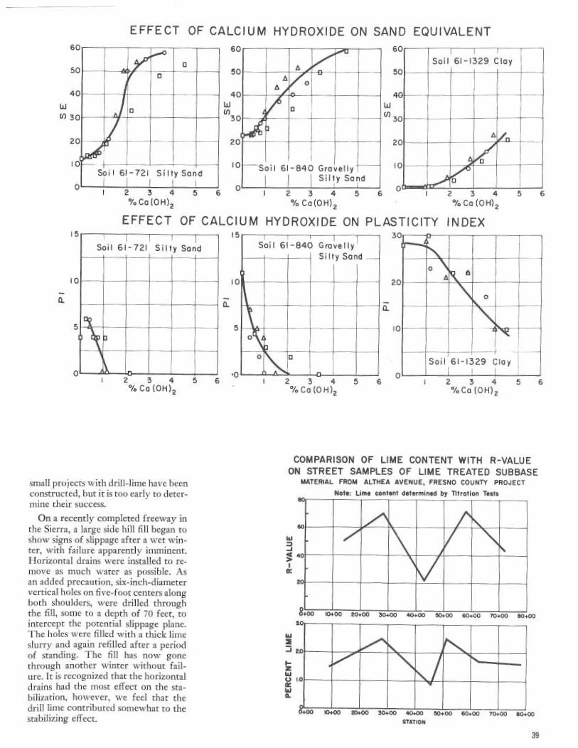
0
5
4
W
~ 3
2
~F
10
a
5
EFFECT OF CALCIUM HYDROXIDE ON SAND EQUIVALENT60
5D
4CW
3C
20
10
4
60
50
W
~ 30
2
10
Soil 61-1329 Clay
D0 - --
-- ~
o ~2 3 4 5 6 I 2 3 4 5 6 `~ I 2 3 4 5 6%Ca(OH)2 %Ca(OH)Z %Ca(OH)2
EFFECT OF CALCIUM HYDROXIDE ON PLASTICITY INDEX
2 3 4 5 6Ca (OH)2
small projects with drill-lime have beenconstructed, but it is too early to deter-mine their success.
On a recently completed freeway inthe Sierra, a large side hill fill began toshow signs of slippage after a wet win-ter, with failure apparently imminent.Horizontal drains were installed to re-move as much water as possible. Asan added precaution, six-inch-diametervertical holes on five-foot centers alongboth shoulders, were drilled throughthe fill, some to a depth of 70 feet, tointercept the potential slippage plane.The holes were filled with a thick limeslurry and again refilled after a periodof standing. The fill has now gonethrough another winter without fail-ure. It is recognized that the horizontaldrains had the most effect on the sta-bilization, ho`vever, we feel that thedrill lime contributed somewhat to thestabilizing effect.
10
4.
5
,n
Soil 61-840 Gravelly~ Si Ity Sand
2 3 4 5 6%Ca (O H)2
30
o IID
20
0
10
—l-- --+Soil 61-1329 Clay
0 ~2 3 4 5 6%Ca (O H)2
COMPARISON OF LIME CONTENT WITH R-VALUEON STREET SAMPLES OF LIME TREATED SUBBASE
MATERIAL FROM ALTHEA AVENUE, FRESNO COUNTY PROJECTNo4e: Lime content determined by Titration Tests
W
Ja
~~iaoo 20+00
ao
W
J 2p
zWv i.oWa
o+oo io+oo 20+0o ao+oo 40«00 so+oo saoo ~o+oo eo.STATION
~oo
0
39

Hydrated lime can be used to reducefrost damage in subbases and basementsoils. At the Wingate Ordnance Depotat Gallup, New Mexico, lime treatmentof existing base course materials elim-inated frost-heaving damage on roadswhich previously had perennial prob-lems of frost heaving. Luckily in Cali-fornia frost heaves are a minor prob-]em.
Construction Details
The construction procedure for limetreatment is similar to that used forroad-mixed cement treatments. Theonly difference is that lime treatmentis not as critical to mixing delays.The soil or aggregate, either material
in place or imported, is brought up tothe proposed finished surface of thelayer to be treated and then rolled.The compacted surface is carefullytrimmed to grade so as to provide theproper amount of material for limetreatment. The aggregate is then loos-ened to the proper depth. Dry clayeysoils should be premoistened to facili-tate pulverization of clods.
Lime, in either the dry form or ina slurry, is spread in carefully measuredamounts. Mixing is then accomplishedby aroad-mixing machine which addsthe required amount of water duringthe mixing operation. If clay lumps per-sist after the first mixing, the materialshould be allowed to "mellow" for aday or two and then remixed.The distribution of lime is checked
by the titration test method No. Calif.338. If the lime content varies morethan 0.6 percent lime from the plannedlime content, the cause is determinedand corrective measures taken beforeproceeding with further operations.
After the mixed material has set longenough for the clay to become non-plastic, sometimes only an hour or two,the material is spread to the requiredthickness and compacted.Compaction should be accomplished
within 48 hours after the addition oflime and water to the soil or aggregate.Measurable reduction in quality takesplace with certain types of soils whendelays in compaction exceed 48 hours.Good compaction is essential for
best results. A sheepsfoot or segmentedroller is best for initial compaction toinsure good density in the lower por-tion of the layer. The final rolling canbe accomplished by pneumatic-tiredor steel-tired rollers.Compacted lime treated soils should
not be reworked after the material hasbeen compacted and cured for a fewdays. This reworking disrupts the ce-menting action and permits additional40
carbonation of the lime. Therefore,there is less available lime for furthercementing action. The reworked ma-terial will usually Crave lower strengththan the undisturbed material. If re-working is necessary, additional limeand water should be incorporated be-fore recompacting.Lime-treated soils should not be per-
mitted to dry out after mixing. Thechemical action not only ceases whenthe lime dries but some carbonation ofthe lime takes place, thus preventing acomplete return of the chemical actionwhen water is again added. Californiaspecifications require the compactedlime treated material to be kept dampuntil such time as the curing seal isapplied. Liquid asphalt MC-250 is nor-mally used for the curing seal.
Research
1'he Materials and Research llepart-ment of the Division of Highways hasbeen interested in lime stabilization formany years, and has been exploring thepossibilities of expanding the use oflime for various types of construction.several research projects have~been un-dertaken.In 1961 a research study was under-
tal:en to determine the effect of thecalcium hydroxide content upon sta-bilizing ability of lime. This study re-vealed that the higher the percentageof calcium hydroxide, the greater theimprovement in R-value, sand equiva-lent and plasticity index. The resultsshown in Figures 1, 2 and 3 taken froma paper presented at the University ofthe Pacific,# shows some of the data.
The early specifications for lime in Ca]-ifornia called for a minimum of 85 per-cent calcium hydroxide. However, thisrequired a high grade limestone tobe used. An economic study in 1962showed that a saving could be madeby lowering the calcium hydroxide re-quirement to 75 percent minimum,thereby permitting the use of lowergrade limestone, but requiring the useof a little more lime.
Several years ago a titration test, testmethod No. Calif. 33H, was developedfor determining the percentage of ce-rnent or lime in treated soils and aggre-gates. This test has been very helpfulfor controlling cement and lime distri-bution during construction.The use of lime for treating expan-
sive soils, when used under portland
*'California's Experience Wfth Lime Treat-ment of Soils and Aggregates by ClydeG. Crates, Fifth Annual Highway Con-ference, University of Pacific, Stockton,1962.
cement concrete pavements, was thesubject of a research project during thepast year. While the project is not com-pleted, the results have shown conclu-sively that lime treatment of a six inchlayer of clay is effective in eliminatingthe expansion cif the layer and also infarming a barrier for preventing water~~Ilich enters joints and cracks in thepavement from getting to the expan-sive basement soils in concentratedamounts.A research project is nc~w underway
nn a current construction project fordetermining the benefits of using a limetreated heavy clay for base and subbaseunder an asphalt concrete pavement.In the near future, it is planned to
develop improved tests for a betterevaluation of lime treatment. It is in-tended to explore present constructionmethods with the hope of improvinguniformity of mixing. Another projectthat will be investigated is the basic re-action between lime and various typesof clay.
Conclusions
Lime treatment provides a meansof utilizing low-quality aggregates andsoils in the structural design of high-~vays. In many areas of the country thisis important since good aggregates arenot always available ~~~ithin reasonablehaul distance. The decision to use limetreatment, in lieu of other types of con-struction, should be based upon eco-nomic cost comparison.Not all types of soils and aggregates
respond favorably to lime treatment.Lime treatment is most effective withclayey soils or gravel-clay mixtures.It can make the clays friable, reducethe plasticity index, increase the sandequivalent, increase the R-value andreduce the amount of volume change.Sands and the coarser silts are gener-ally not benefited by lime treatment.Laboratory tests, such as the R-value(test method Nn. Calif. 301), should beused for determining the beneficial ef-fects of lime treatment and the per-centages of lime to use. Additional lime,usually about 0.5 percent, should be in-cluded to compensate far constructionvairiations.Good construction control is essen-
tial for consistent results. It is necessary
that the proper amount of lime and wa-ter'be used and that uniform mixing,proper compaction and adequate cur-
ing be maintained.The use of lime in highway construc-
tion has increased during the last few}'ears and will undoubtedly continueto increase as sources of good aggre-gates become scarcer.

STATEMENT BY GOVERNOR EDMUND G. BROWN
I was grieved to learn o f the death o f George T. McCoy, formerState Highway Engineer and Chief of the Division of Highways, whoretired in 1959.
It. was under Mr. McCoy's strong and capable leadership as StateHighway Engineer from 1943 to 1959 that California attained aposition of ~ireeminence throicghout the nation and the world in thedevelopment of freeways and other contributions to the economy,efficiency a~ad safety o f motor vehicle transportation so essential tothe growth and welfare o f our state.
It was given to hi~n to be the one in chnrge of the vast ex~iansionof our state highway system which re~iresented the expenditure ofmore than 2 %Z billion dollars and construction o f 2,3 00 miles o fmultilane, divided highways.Mr. McCoy was accorded nationwide professional recognition and
honor. He zuas elected president of the American Association of StateHighway Officials in 1954. In 1958 he received the Thomas H.MacDonald Award for outstanding achievement in the developmentof highways.
His career refderted great honor on our state and its highZVayprogram.
Internati~na~ly Known Former StateHighway Engineer G. T. McCoy' DiesA few years before her death a
writer intercie~ved A1rs. Edith Wil-son McCoy on the subject of herhusband, George T. McCoy, whoat the time was the California StateHighway Engineer."George leas never been inter-
ested in acquiring personal wealth,"Mrs. McCoy said."His life has always beeir on the
idealistic side. He finds satisfactionin building something worthwhileand enduring, and building it so asto do the most good for the mostpeople: 'Although she preceded him in
death, Mrs. McCoy's words makean epitaph worthy of George T.McCoy, who died Christmas eve,1965, at the age of 76.There were many facets to the
man. He was a classical scholar whaspent eight years studying Greekand Latin. He was an athletA whowon college letters in football, bas-ketball and track. He was an engi-neer and worked at his professionfor more than 44 years-32 of themwith the California Division ofHighways and 16 of those years(1943-1959) as State Highway En-gineer.He was responsible for the spend-
ing of rnure than 2 %z billiun dollarsin tax funds during• the period heserved as State Highv~ay Engineer,and he lived up to his Scottishancestry by making sure that fullvalue was returned for every singledollar.He tried to avoid arguments, de-
bates and controversy. Neverthe-less, McCoy was a master of logicand always stated his recomxnenda-tions and position in a firm butsoft-spoken voice.McCoy was born on SeptemUer
12, 1889, on a ranch near Milton,Oregon. After cotnpleting gtarn-
roar school, he attended Pearson'sAcademy and Whitman College(both in Walla Walla, Washing-tc~n) .He graduated from college in
1913 with an A.B. degree, suz~rrnacu~rz laude. It was at Whitman thathe first became affiliated with BetaTheta Pi fraternity. The scholastichonor society, Phi Beta Kappa, didnot have a chapter at Whitman dur-ing the years that McCoy attended,but when one was organized therein 1918 McCoy was one of thoseretroactively chosen for member-ship.
It was at Whitman that McCoyfirst met Edith Wilson, and whenthey graduated he proposed mar-riage, but she insisted that first shewanted to ~o to an eastern schoolfor postgraduate work.Going east fitted iq with Mc-
Coy's plans, for he, too, wanted tocontinue his education. Althoughhis undergraduate work was pre-paratory to entering law school,McCoy had decided to switch toengineering and intended to enrollat Massachusetts Institute of Tech-nology.But Editli Wilson had enrolled
at Columbia and McCoy stoppedoff in New York to help his fianceeget settled. He never got back onthe train bat changed universitiesinstead and graduated from his civilengineering• studies at Columbia in1915.McCoy returned to the west
coast, for Miss Wilson had joinedthe faculty of Spokane's Collegeof Puget Sound. The couple weremarried in that city nn April 3,1916.McCoy's first job in 1916 was as
au instrumentman for the Washing-ton State •Highway Department,and his salary was $65 a month. Of
course there were fringe benefitssuch as assignments in 28 differentlocarion~ the first year.But the newlyweds found mov-
ing wasn't difficult, for the high-way department_ furnished themwith a tent that included a port-able board floor. A few packingcases that doubled as furniture car-ried their belongings safely to thenext place they pitched the tent.The McCoys kept on the move
until 1927, for during those yearshe worked as a bridge engineer inNorth Dakota, as a highway engi-neer in Idaho and Montana for thefederal PuUlic Roads Administra-tion, and once again for the Wash-ington State Highway Department.He remained with the organiza-
tion until 1927 and then joined theCalifornia Division of Highways.
California's present State High-way Engineer, J. C. Womack,worked in close association withMcCoy for a number of years."California will reap benefits
from his highway planning for thenext several generations," Womacksaid. "Every person who drives onthe state highways is indebted toUeorge McCoy, for much of thesystem's efficiency is directly at-tributable to the leadership andguidance that he provided for somany years:'John Erreca, the Director of the
Department of Public Works, wasa mayor and a county supervisorduring some of the years McCoyserved as State Highway Engineer."His integrity was his shield,"
Erreca said in describing McCoy."It didn't matter how big or smalla community's problem might be,if it had to do with highways, Mr.McCoy was anxious to know aboutit and help if he could.
"But there was one thing alwayscertain. Political pressure wasn'tgoing to sway him, for he had nopet projects. He was guided solelyby the merits of each situation:'The Administrator of the Cali-
fornia Transportation Agency,Robert B. Bradford, also was wellacquainted with McCoy. "GeorgeMcCoy vas a quiet, modest personwho made immeasureable contribu-tions to his adopted State of Cali-fornia. He will be long rememberedby those who knew him as a manwho willingly gave much and askedfor little in return:'McCoy's contributions have re-
ceived previous recognition. In ad-dition to serving as president ofAASHO, he was the recipient ofthat organization's Thomas H.MacDonald Award in 1958. TheMacDonald Award is presented for"outstanding service in highwayengineering:'And just before he retired in
1959, separate resolutions honoringMcCoy were adopted unanimouslyby the State Senate and the Assem-bly. House Resolution Number 34Gwas introduced by AssemblymanVincent Thomas of San Pedro, andSenate Resolution 168 by SenatorRandolph Collier of Yreka.Both took note of the growth and
progress of California highwaysduring Mr. McCoy's 16-year 'ten-ure as State Highway Engineerand called attention to the nation-wide professional honors accordedto him.Mr. McCoy is survived by a son,
George T. McCoy, Jr., and twogranddaughters. The younger Mc-Coy also is an engineer and resideswith his family in Millbrae.Funeral services were held in Sac-
rarnento on Tuesday, December 28,1965.
41

~eauti in Cali ornia ~ ~
Four-level interchange in downtown San Diego at junction of Cross Town Freeway and US 395 through Balboa Park. Beauty of landscaping here was factorin award to District 11 from Downtown Improvement Association.
With additional funding for high-way beautification, and more liberal-ized directives on the spending ofthese funds, activity in this facet ofhighway design has been considerablyincreased recently.
Typical of these activities area re-cent award of the largest highwaylandscaping contract ever let in Cali-fornia; appointment by State HighwayEngineer J. C. Womack of a specialbeautification committee in the Divi-sion of Highways; and substantialchanges in the Division of Highwayslandscaping section.The three-man committee to coor-
dinate the division's efforts at highwaybeautification, and to develop specialtraining in aesthetics for Division ofHighways employees, is composed ofDesign Engineer A. C. Estep, BridgePlanning Engineer A. L. Elliott, andPrincipal Landscape Architect D. P.Van Riper.At the time of the appointments,
State Highway Engineer Womacksaid, "We are simply centralizing aprogram that has been in effect—andsuccessfully so—for many years. In1964 three of our freeways receivednational recognition in the Parademagazine `scenic highway' contest.This year three state highway bridges42
have won blue ribbons and two otherswon merit awards in similar competi-tion."Winners in the Parade magazine
contest are chosen for their success ina "marriage of the designs of man andnature." The bridge awards weregiven for cleanness and simplicity ofdesign, plus the success of the designerin fitting them into their environment.
Starting in January this year, thedivision instigated a new training pro-grarn in aesthetics for all levels of em-ployees. Top-level engineers partici-pated in six-hc, sr workshop sessions,and beginning in February this pro-gram is being extended to the 11 high-way districts, with special emphasison the application of aesthetics toproblems of design, right-of-way con-struction and maintenance.In November 1965, the name of the
Headquarters Roadside DevelopmentDepartment was changed to Head-quarters Landscape Architecture De-partment. The change in name wasmade as more indicative of the variousfunctions of the department, sinceroadside development is but one partof its responsibilities. The unit con-tinues as a part of the Planning De-partment of Headquarters.James Gordon, senior landscape
architect; has transferred from the
District 7 office in Los Angeles to theDistrict 4 ofrice in San Francisco, tohead up a reorganized landscaping sec-tion there. He will also have additionalduties as chairman of the District 4Aesthetics Committee. Replacing Gor-don in charge of the Los Angeles unitis Richard Paine, promoted to seniorlandscape architect from his positionwith the Division of Beaches and Parksin Goleta.
Since the Legislature made .thescenic highway system into .law in1963, this program also has taken longstrides forward. There is now a Citi-zens Advisory Committee composedof specialists in design and aesthetics,and also an Interdepartmental Coordi-nating Committee of qualified individ-uals of the various agencies involved.
Early in January the Department ofPublic Work's Guide for the Designa-tion o f an O fJicial Scenic Highrwaycame off the press, and was immedi-ately mailed to all local governingbodies in the state. The booklet, whichspells out the minimum standards to bemet for a scenic highway, goes intoconsiderable detail on what must beexpected from such a highway.
One of the introductory paragraphsof the new book covers the subject ofresponsibilities. In clarifying this point,
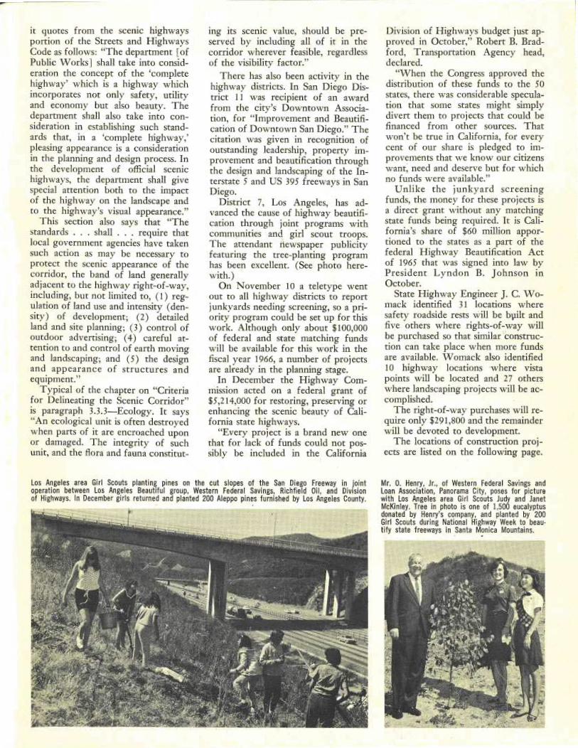
it quotes from the scenic highwaysportion of the Streets and Highwaysbode as follows: "The department [ofPublic Works] shall take into consid-eration the concept of the `completehighway' which is a highway whichincorporates not only safety, utilityand economy but also beauty. Thedepartment shall also take into con-sideration in .establishing- such stand-ards that, in a `complete highway,'pleasing appearance is a considerationin the planning and design process. Inthe development of official scenichighways, the department shall givespecial attention both to the impactof the highway on the landscape andto the highway's visual appearance."This section also says that "The
standards ...shall ...require thatlocal government agencies have takensuch action as may be necessary toprotect the scenic appearance of thecorridor, the band of land generallyadjacent to the highway right-of-way,including, but not limited to, (1) reg-ulation of land use and intensity (den-sity) of development; (2) detailedland and site planning; (3) control ofoutdoor advertising; (4) careful at-tention to and control of earth movingand landscaping; and (S) the designand appearance of structures andequipment."Typical of the chapter on "Criteria
for Delineating the Scenic Corridor"is paragraph 3.3.3—Ecology. It says"An ecological unit is often destroyedwhen parts of it are encroached uponor damaged. The integrity of suchunit, and the flora and fauna constitut-
ing its scenic value, should be pre-served by including all of it in thecorridor wherever feasible, regardlessof the visibility factor."
There has also been activity in thehighway districts. In San Diego Dis-trict 11 was recipient of an awardfrom the city's Downtown Associa-tion, for "Improvement and Beautifi-cation of Downtown San Diego." Thecitation was given in recognition ofoutstanding leadership, property im-provement and beautification throughthe design and landscaping of the In-terstate 5 and US 395 freeways in SanDiego.
Districe 7, Los Angeles, has ad-vanced the cause of highway beautifi-cation through joint programs withcommunities and, girl scout troops.The attendant newspaper publicityfeaturing the tree-planring programhas been excellent. (See photo here-with. )On November 10 a teletype went
out to all highway districts to reportjunkyards needing screening, so a pri-ority program could be set up for thiswork. Although only about $100,000of federal and state matching fundswill be available for this work in thefiscal year 1966, a number of projectsare already in the planning stage.In December the Highway Com-
mission acted on a federal grant of$5,214,000 for restoring, preserving orenhancing the scenic beauty of Cali-fornia state highways."Every project is a brand new one
that for lack of funds could not pos-sibly be included in the California
Los Angeles area Girl Scouts planting pines on the cut slopes of the San Diego Freeway in jointoperation between Los Angeles Beautiful group, Western Federal Savings, Richfield Oil, and Divisionof Highways. In December girls returned and planted 200 Aleppo pines furnished by Los Angeles County.
Division of Highways budget just ap-proved in October," Robert B. Brad-ford, Transportation Agency head,declared."When the Congress approved the
distribution of these funds to the SOstates, there was considerable specula-tion that some states might simplydivert them to projects that could befinanced from other sources. Thatwon't be true in California, for everycent of our share is pledged to im-provements that we know our citizenswant, need and deserve but for whichno funds were available."Unlike the junkyard screening
funds, the money for these projects isa direct grant without any matchingstate funds being required. It is Cali-fornia's share of $60 million appor-tioned to the states as a part of thefederal Highway Beautification Actof 1965 that was signed into law byPresident Lyndon B. Johnson inOctober.
State Highway Engineer J. C. Wo-mack identified 31 locations wheresafety roadside rests will be b}~ilt andfive others where rights-of-way willbe purchased so that similar ̀construc-tion can take place when more fundsare available. Womack also identified10 highway locations where vistapoints will be located and 27 otherswhere landscaping projects will be ac-complished.The right-of-way purchases will re-
quire only $291,800 and the remainderwill be devoted to development.The locations of construction proj-
ects are listed on the following page.
Mr. 0. Henry, Jr., of Western Federal Savings andLoan Association, Panorama Gity, poses for picturewith Los Angeles area Girl Scouts Judy and JanetMcKinley. Tree in photo is one of 1,500 eucalyptusdonated by Henry's company, and planted by 200Girl Scouts during National Highway Week to beau-tify state freeways in Santa Monica Mountains.

County ~ Route
BEAUTIFICATION PROJECTS
Description
1pprox-imate Estimatedmileage cost
Del Nort¢.........199At Collier Tunnel; grading to improve vi¢w ...............................................0.7$15,000Humboldt.........36At Revils Elbow, approximately 7.7 miles west of Bridg¢ville; vista point .......................6,500Humboldt.........101About 8.5 miles south of Myers Flat; safety roadside rest .....................................75,000Humboldt.........1011.7 miles south of Fortuna to Elk River; functional and tree planting ...........................15.722,500Humboldt.........101Mad River, approximately 0.3 mile north of Arcata to 0.2 mile north of Little River; functional
and tree planting ...................................................................8.010,000Humboldt.........101At McKinleyville Vista Point; 4.1 to 4.3 miles north of Rout¢ 200; convert to safety roadside
rest (lighting, picnic tables, comfort facilities) .......... . ...................................40,000Mendocino........1016.0 miles north of Hopland to 0.5 mile east of Forsythe Creek; functional and tree planting.......14.550,000Mendocino........10,1Ak Moss Cove, approximately 10.5 miles south of Laytonvill¢; safety roadside rest ................119,000Mendocino........101At Irvine Lodge, approximately 7.9 miles south of Laytonville; safety roadside rest ...............54,000Mendocino........101At Empire Camp, approximately 2.6 miles south of Cummings Post Office; safety roadside rest......100,000Lassen............139At south end of Eagle Lake; vista point ....................................................15,000Lassen............3957.7 miles north of Milford; safety roadside rest ..............................................42,000Modoc...........2997.0 miles northeast of Adin; safety roadside rest .............................................45,500Plumas............701.5 miles west of Route 89 near Keddie; safety roadside rest ..................................37,000Plumas............707.0 miles east of Quincy; safety roadside rest ...............................................46,700Shasta............443.0 miles east of Shingletown; safety roadside rest ...........................................46,500Shasta............44Approximately 5.0 miles north of Route 89 near Lassen National Park; vista point ................17,000Shasta ....... , ....2993.5 mils east of Montgomery Creek; safety roadside rest .....................................42,000Shasta............299Approximately 4.0 miles west of Burney; vista point .........................................16,000Shasta............299Approximately 1.5 miles west of Fall River Mills; vista point ..................................17,500Sislciyou..........97Approximately 19 mils north of Weed; vista point .........................................19,500Siskiyou..........9721.8 miles north of Weed; safety roadside rest ............:.................................41,000Trinity............2993.5 miles east of V~eaverville; safety roadside rest ...........................................32,000Butte .............700.1 mile east of West Branch Bridge; safety roadside rest......................................35,00'0EI Dorado.........50Snowshoe Thompson Memorial Overlook at Echo Summit; vista point ...........................30,000EI Dorado.........89Above Christmas Valley on Luther Pass; vista point ..........................................10,000Nevada...........20Alpha-Omega Monument, 4.1 miles east of Washington Junction; safety roadside rest.............27,000Sacramento........99At Grant Line Road Interchange; 2 safety roadside rests ......................................130,000Sierra .............49Depot Hill near the Yuba County Line; safety roadside rest...................................17,000Alameda....... ; ..17South of Route 262 to north city limits of Fremont; functional and tree planting .................8.645,000Contra Costa.......4East of L Street to H Street in Antioch; landscape .........................................0.222,000Contra Costa.......242North of junction of Routes 680/242 Interchange to Olivera Road in Concord; landscape........2.6236,000Marin............131Blackfield Drive to 0.7 mile west of San Rafael Avenue in Tiburon; landscape, functional and tree
planting..........................................................................1.415,000San Mateo........101Marsh Road Interchange in Menlo Park; functional and tree planting ............................25,000San Matco........114Cypress Avenue to Route 101; landscape ................................................1.125,000Santa Cruz.........35At junction of Routes 35 and 9; safety roadside rest ...........:.............................30,000Monterey.........11.3 miles north of Vicente Creek; vista point ...............................................15,000Monterey.........1012.5 miles north of Camp Roberts Overcrossing; safety roadside rest .............................75,000San Benito.........25At Willow Creek, approximately 7.0 miles north of Route 146; saf¢ty roadside rest ...............25,000$an Benito.........156Route 101 to west city limits of San Juan Bautista; tree planting ..............................2.45,000San Luis Obispo...11.2 miles south to 1.2 miles north of Cayucos; functional and tree planting .....................2.410,000San Luis Obispo...46At Cholame Valley Road near Cholame; safety roadside rest ..................................70,000San Luis Obispo...580:7 mile west of San Juan Creek; safety roadside rest .........................................35,000San Luis Obispo...101At Santa Barbara Road Overcrossing, Santa Rosa Road Overcrossing and Curbaril Avenue Over-
crossing;free planting ...............................................................3.15,000Santa Barbara......1010.6 mile south to 0.8 mile north of Gaviota Tunnel; 2 safety roadside rests .......................164,000Santa Barbara......1540.5 mile north of Cold Spring Canyon Bridge; vista point .....................................30,000Kern ..............991.0 mile north of Herring Road to 0.2 mile south of Planz Road; functional and tree planting.....11.190,000Kern ..............99Perkins Avenue in McFarland to 0.5 mile south of Woollomes Road; functional planting.........4.025,000Tulare............99Kern County Line to Tulare Airport; functional planting ....................................25.9160,000Tulare............990.5 mile south and 0.4 mile north of Kings River; 2 safety roadside rests .........................163,000Los Angeles.......7Long Beach Freeway-Pacific Coast Highway to Willow Stre¢t; landscape .....................1.1160,000Los Angeles.......7Long Beach Freeway-Willow Street to Wardlow Road; landscape ...........................1.2135,000Los Angeles.......11Harbor Freeway-190th Street to 0.2 mile south of 149th Street; landscape ....................2.2260,000Orange...........22Garden Grove Freeway-Trask Avenue to Manchester Avenue; landscape ....................2.0220,000Riverside..........60Santa Ana River to 8th Street Interchange (portions); landscape ..............................2.6267,000Riverside..........60South junction of Routes 60/395 to Pennsylvania Avenue; tree planting ......................3.35,000Riverside..........91East city limits of Corona to east end of Magnolia Avenue Interchange; tree planting............4.36,500(nyo ..............395At Haiwee; safety roadside rest..........................................................15,000Kern ..............14At Red Rock Canyon; safety roadside rest.................................................80,000Mono............395North of Casa Diablo; safety roadside rest ..................................................60,000Merced...........152Santa Clara County Line to Route 207; tree planting .......................................15.025,000
San Joaquin.......99Calaveras River to Armstrong Road; functional and tree planting ..............................7.2200,000Solano............21Route 680 in Benicia to Route 80 near Cordelia; functional and tree planti.ng ..................13.1225,000
San Diego.........9422nd Street to w¢st limits of F.A.I. 805 in $an Diego; landscape, functional and tree planting.....2.3240,000San Diego.........94East limits of F.A.I. 805 Interchange to west limits of Route 125 Int¢rchange in San Diego and
Lemon Grove; landscape, functional and tree planting ....................................5.7595,000
44

FREEWAY ROUTE ADOPTED
aso ~w
~ EX/S7 RTE ~ ~ 42 T R AVE.
INGLE QOD~ ~ W~ L 0 S~ --"' HOL~LYWOODa ai~, LOS ANGELES_~~~~___- ~ ~ °C ~_- ___"-~`_ ;~i~s_" ~ = PARK=--=~s~~' ~ NTURY I ~ BLVD.
~~'lNTERNATION~̂ '?-=---- ~ ~ - A N G E~ ~ - - -_=_=_=_ 0 3
n o 1~'s` =-=_ ̀ AIRPORT) ~ 107~'• IMP RIAL HWY.
~ n ti ~ 'RY tE~ iZ ; ~_ = z --- ~ ~_-=~— R ~ a
`' --J ~ AWTHQRNE _, -~ EL SE U o' iSEGUNDO___~,__- _J W Q ~,ic., ~ ~
Highlights of CHC Actions, Sept.— Dec.In addition to budgeting more than
$739,000,000 for highway purposes inth+e 1966-67 fiscal year, plus more than$157,000,000 fox functions not understate highway jurisdiction, the Califor-nia Highway Commission made severalimportant decisions involving freewayroutings during the last quarter of 1965.Two freeway route adoptions in Los
Angeles County followed communitycontroversies that required public hear-ings by the Highway Commission it-self, after earlier hearings conducted bythe Division of Highways.The first concerned a routing for 8.4
miles of the Route 42 (Century) Free-way, extending from Sepulveda Boule-vard (Route 1) at Imperial Highway,near the southeast corner of the LosAngeles International Airport, to Cen-tral Avenue in Los Angeles (see map).The second concerned a 9.3-mile
adoption of the Route 2 (BeverlyHills) Freeway from the San DiegoFreeway (Interstate 405 ~ through Bev-erly Hills to Ardmore Avenue in LosAngeles.The commission also adopted a rout-
ing for S,2 miles of the Interstate 80Freeway in Sacramento between CStreet and the future Route 244 Free-way at existing Route 80 near WattAvenue. Although the existing routebetween these limits is constructed to
freeway standards, State Highway En-gineer. J. C. Womack had told the com-missionthat itwas not feasible to widenit to the number of lanes that will berequired by future traffic.Because of problems arising from the
planning of the City of Fremont's pro-posed civic center-recreational com-plex, the commission had authorizedthe Division of Highways to explorepossible alternate routings jointly withthe city for the southerly portion of afreeway routing adopted in 1961.
These studies led to the commissionrevising the routing of a 3.6-mile sec-tion of the future Route 238 Freewaybetween the future Interstate 680 Free-way and Peralta Boulevard (Route 84. )
In other actions, the commissionreaffirmed its routings for the Route1 (Pacific Coast) Freeway throughHuntington Beach and NewportBeach; the Interstate 280 (JuniperoSerra) Freeway near the Upper Crys-tal Springs Reservoir in San MateoCounty; and the Route 7 (Long BeachExtension] Freeway in Pasadena. Vari-ous local governments had urged re-vising these. routings.
The Highway Commission adoptsroutings for conventional highways aswell as freeways. Two-such adoptionsof considerable interest made in the
year's last quarter were a 47-mi}e reut-ing to extend Route 190 in TulareCounty from its present terminus atQuaking Aspen Meadow to HaiweePass at the Tulare-Inyo County line,and a 12.7-mile routing for Highway267 in its entirety between the Inter-state 80 Freeway near Truckee, Ne-vada County, and Route 28 nearKings Beach, Placer County.
The latter route was added to thestate highway system by the 1965 Leg-islature. Its use will result in substantialtime-distance savings to motorists trav-eling to Lake Tahoe's north shore.At its November meeting, the com-
mission adopted a resolution which di-rected the Division of Highways toundertake further studies of possiblefreeway alignments in the Prairie Creekarea of Humboldt County, and thatwould skirt the boundaries of Jedediahsmith State Park in Del Norte County.Both parks contain some of California'sprime redwoods.
The commission had earlier resolvedto call for practical cooperation be-tween itself, the Depatrment of PublicWorks and the California Division ofHighways with various federal agen-cies and the California Legislature im-plementingthe federal highway beauti-fication grogram.
45

A night view of a pedestrian overcrossing lighted by one of the new fluorescent fixtures.
By T. N. Kreiberg
The lighting of pedestrian crossingsover freeways has usually been limitedto installing a few incandescent or mer-cury vapor lamps on 20-foot standardsspaced along the top of the struc-tures. These, with their conduit andembedded pull boxes, are no longer inharmony with the precast, prestressedsuperstructure design employed today.Since the basic lines of the pedestrianovercrossings are horizontal, verticalstandards detract from the basic hori-zontal silhouette.An essential part of the pedestrian
overcrossings is the chain linl~ sidewalkrailing. The top rail on this chain linkrailing can be used for installing fluo-rescent lighting.
Development
Such a lighting system involves thesame problems which were success-fullysolved in the design of the under-crossing or tunnel fixtures now usedextensively in pedestrian tunnels underfreeways throughout the state, namely:resistance to vandalism; adequate lightdistribution; provision for heat dissi-pation; and easy accessibility for re-
46
Tamping and other maintenance. Theseproblems suggested the use of the fluo-rescent lamp and plastic lens that hadbeen adapted for the undexcrossing fix-tures: A four-foot lamp was developedwith a %z -inch-wide slit in the phos-phor coating along the full length ofthe glass tube.'The lamp operates at acurrent of 1 % amperes. (This is threeto five times the current in the ordi-nary fluorescent lamp.) Lenses of clearmethyl-methacrylate plastic resin cast-ings are mounted parallel to the lamp.This lens system was adapted to fit aprotruding aluminum housing of twoparts 6 feet 4 inches long and less than5 inches in width. The fixture can hepositioned to concentrate light on anyportion of the walkway.
Two such fixtures were produced asthe result of a Bureau of Public Roadsparticipating research project. Thesefi~:tures were tested in the Materialsand Research Department of the Divi-sion of Highways. The tests includedplotting isolux curves for a variety ofplastic lens shapes, measuring temper-atures developed in the fixtures, and
NewLi htin ~ g~~rPe~estria~nt~v~r~~ossin
checking the abzlity of the fixture towithstand bad weather.Some improvements were also made
in the components of the fixture, in-cludng development of a cast methyl-methacrylate resin lens to replace themachined acrylic rods originally used.
Evaluation
The cast acrylic lens afforded an op-portunity to experiment with variouslens shapes. Three different shapes ofhollow lenses were produced and testedin addition to the solid flat lens andsolid concave lens. The usable portionof the light is normally considered tobe the central 10 feet of the patternindicated by the unshaded portion ofeach isolux curve. Ideally, the patternshould extend as far as possible parallelto the fixture. There was not muchdifference in the shapes produced bythe lenses, as far as the light in theusuable portion was concerned. Theisolux curve of the hollow concave lensappeared to extend slightly farther andconsequently is being used for the timebeing. It may be possible to improvethe lengthwise distribution of light by

A new fluorescent luminaire unit in a chain linksidewalk railing.
further experimenting although pre-liminary trials with additional prismsin the .lenses have not been encour-aging.
Tests also showed that an aperturelamp gives twice as much light under-neath the fixture as a very high output(VHO) lamp and over twice as muchlight at a 10-foot distance endwise fromthe centerline of the fixture.The water tests included spraying
a stream of water from a garden hosenozzle at the fixture at an angle to simu-late awind-driven rain. Some moisturedid penetrate the fixture by capillaryaction through the hinge connection.However, lubrication of the hinge withsilicon grease eliminated the leak.
Fixtures will be aimed to direct thecenter of the light pattern along thecenterline of the structure walkway.This would normally tilt the fixtureabout 15 degrees from the vertical,causing any moisture to collect on theinner surface nearest the hinge anddrain from the end of the door. Fixturewiring from the ballast to the lampswill be clipped to the door on the op-
A pedestrian overcrossing with the old-style luminaires mounted on 20-foot standards.
fhe Tweedy Lane pedestrian overcrossing in Los Angeles with the new-style fluorescent luminaires in thechain link sidewalk railing.
posite side of the lamp in order to keepit out of this moisture.Study of the isolux curves suggests
that enough light can be provided withspacing the units 40 feet apart. Thelight pattern on the walkway is notcompletely uniform but will be ade-quate.
Conclusion
The unique feature of this lightingmethod is the combining of the light-ingcomponents and the fence membersas one unit in which the top rail notonly supports the fixture and housesthe circuit conductors but is a struc-tural part of the fence, presenting aneat appearance and simplicity of de-sign.The fixtures developed as a result of
this project are being installed on mostpedestrian overcrossings on state high-ways. The first such installation wasthe Tweedy Lane pedestrian overcross-ing on the Santa Ana Freeway in LosAngeles County which was completedin April 1965. The manufacturer ofthe fixtures estimates that they can beproduced at a cost of under $250 each.
A condulet fitting'(upper left) on the end post of thechain link railing on a pedestrian overcrossing.
47

LangsnerReceives
A.S.C.E.Award
George Langsner (right), DeputyState Highway Engineer, receives
a certificate of appreciation from Wayne1VIacRostie, president of Sacramento
section of the American Society ofCivil Engineers, for completing
a term of office as ~I-Eairman ofthe Highway Technical Division
of the national society.
earl IN. TaylorE~~s 42 -Year Career
District 6 Traffic Engineer EarleW. Taylor retired November 30ending a 42-year career with High-ways.Taylor was among the first district
traffic engineers in the division, beingappointed in 1938. From his Fresno-based headquarters, he pioneered nu-merous improvements in highwaydesign and signing which have hadstatewide impact in traffic safety.Through his close association withcity and cc,unty engineers in the
48
southern San Joaquin Valley, he be-came known as an "experts' expert"in the traffic engineering field.He organized the first district
safety committee in the state andserved as a member and its chairmanfor many years. Upon his retirementhe was presented with a certificateof merit citing his 42 years' lost-time-free accident record.
Taylor's first job with Highwayswas in District 4 working on thePacheco Pass Road. Later he workedin Districts Z, 3, 5, 7, and 9 beforegoing to District 6 in 1934. Duringhis early career he held engineeringjobs with the Oregon HighwayCommission, the City of San Fran-cisco, P.G. & E., and the City ofSanta Barbara. For 2 %z years duringWorld War II, he was highwaybranch chief of the U.S. ArmyTransportation Corps covering thesix New England states. He retiredfrom the Army Reserve in 1955 asa lieutenant colonel.He was born in Pullman, Wash-
ington, and attended schools thereand in Salem, Oregon. He later at-tended the University of California.He is a mert~ber of the Institute of
Traffic Engineers and the EngineersClub of Fresno.Taylor and his wife, Norma, have
two sons, Bob and dill. Bill is an as-sociate right-of-way agent for thedivision.
ttichard 5. QuintrellRetires in Eureka
Richard Samuel Quintrell, assistanthighway mechanic foreman at Shop 1,Eureka, has retired from state service.
Quintrell started working for the Divi-sion of Highways in June 1938 at Shop 2in Redding as a heavy equipment me-chanic. He later worked at Shops 7 and9, served in the Army during World WarII, and then came to Shop 1 in Eurekain 1945.
Twenty-five-yea rA~rards Announced
The following Division of High-ways employees have received their25-year awards since the last listwas published in the November—December 1965 issue of the maga-zine:Lloyd A. Lane, Luis Aramayo,
Marion W. McCleary, Charles K.Bruner, William Travis, WilliamD. Rambo, Everett P. Pyles, OmarG. Alexander, John H. Bennett,Abe Brodkin, Seymour Cowan,Leo Linde, Arthur E. Bethurum,Bliss A. Hinshaw, Charles L. Sex-auer, Dudley B. Hatch, Homer H.Moore, Mary Catherine Malloy,Herbert A. Rooney, Thomas C.Royce, llale F. Downing, OliverArnold, O. W. i'erry.

STATE OF CALIFORNIAEDMUt~iD G. BROWN, Governor
TRANSPORTATION AGENCYROBERT B. BRADFORD Administrator
DEPARTMENT OF PUBLIC WORKS JOHN ERRECA, Director
FRANK A. CHAMBERS . Chief Deputy Director
RUSSELL 1. t00NEY . Deputy Director (Management) T. F. BAGSHAW Assistant Director JUSTIN DuCRAY Departmental Management Analyst
HARRY D. FREEMAN Deputy Director (Planning) C. RAY VARLEY Assistant Director S. ALAN WHITE DepaPtmental Personnel Officer
DIVISION OF HIGHWAYS
J. C. WOMACK State Highway Engineer, Chief of Division
J. P. MURPHY Deputy State Highway Engineer, ►tighr of wayJ. A. LEGARRA Deputy Sfafe Highway Engineer RUDOLF HESS Chief Right of Way Agent
GEO. LANGSNER Deputy State Highway Engineer HARRY L. KAGAN Assistant Chief
LYMAN R. GILLIS Assislant State Highway Engineer DEXTER D. MacBRIDE Assistant Chief
J. E. McMAHON Assistant State Highway EngineerR. S. J. PIANEZZI Assistant Chief
FRANK E. BAXTER Assistant State Highway Engineer District 7, eurekaSAM HELWER District Engineer
GEORGE A. HILL Assisfanl State Highway Engineer
J. C. BURRILL Comptroller Disrrict 2, ReddingH. S. MILES District Engineer
NEAL E. ANDERSEN . Equipment EngineerJOHN L. BEATON Materials and Research Engineer District 3, Marysville
C. G. BEER Urban Planner W L. WARREN District Engineer
A. N. DUNHAM Computer Systems Engineer District 4, san FranciscoALVORD C. ESTEP Engineer of Design ALAN S. HART District EngineerJ. F. JORGENSEN Construction Engineer R. A. HAYLER Deputy Disirici EngineerSCOTT N. LATHROP Personnel and Pubiic Information HAIG A"YANIAN Deputy District EngineerC. T. LEDDEN City and County Projects Engineer C. F. GREENE Deputy District EngineerJACK E. PEDDY Project Control EngineerDANA G. PENGILLY Planning Engineer DistricA 5, saw Bois ObispoE. J. L. PETERSON Program and Budget Engineer R. 1. DATEL District EngineerR. V. POTTER Systems Research EngineerPAUL C. SHERIDAN Office Engineer District 6, Fresno
E. L. TINNEY . Maintenance Engineer W L. WELCH District Engineer
DONALD P. VAN RIPER Principal Landscape Architect nis►ricr ~, cos AngelesJ. E. WILSON Traffic Engineer E. T. TELFORD District EngineerA. L. ELLIOTT Bridge Engineer—Planning A. L. HIMELHOCH Deputy District EngineerH. R. HINEMAN Bridge Engineer—Operations A. C. BIRNIE Deputy District EngineerR. J. IVY Bridge Engineer—Administration A. W. HOY Deputy District EngineerDALE DOWNING Bridge Engineer—Southern Area R. E. DEFFEBACH Deputy District Engineer
CALIFORNIA
I~IGHWAY COMMISSION
ROBERT B. BRADFORD Chairman andAdministrator,
Transportation AgencyROGER S. WOOLLEY Vice Chairman
San DiegoJAMES A. GUTHRIE San BernardinoABRAHAM KOFMAN AlamedaFRANKLIN S. PAYNE Los AngelesWILLIAM S. WHITEHURST . FresnoJOSEPH C. HOUGHTELING Sunnyvale
JOHN ERRECA Administrative Officerand Director of Public Works
JACK COOPER, Secretary Sacramento
District 8, San Bernardino
C. V. KANE District Engineer
District 9, Bishop
C. A. SHERVINGTON District Engineer
District f 0, Stockton
JOHN G. MEYER District Engineer
District 11, San Diego
JACOB DEKEMA District Engineer
DIVISION OF CONTRACTS AND RIGHTS OF WAY
HARRY S. FENTON Chief CounselEMERSON RHYNER Deputy Chief (Sacramento) HOLLOWAY JONES Deputy Chief (San Francisco) REGINALD B. PEGRAM Deputy Chief (Los Angeles)
DIVISION OF BAY TOLL CROSSINGS
E. R. FOLEY . Chief EngineerJ. !. KOZAK . Deputy Chief Engineer BEN BALALA Design and Construction Engineer LHARLES 1. SWEET Operations Engineer
HOWARD F. TOPPING Planning Engineer GEORGE 'r. ANDERSON Administrative Officer
DIVISION OF AERONAUTICS
CLYDE P. BARNETT Director, Chief of Division
Q 60144-500 12-()5 77M printed Itt CALIFORNIA OFFICE OF 57A IE PR3NTING

+~...::~n~