16 water mouse - santos · 16 water mouse 16.1 epbc act legal status vulnerable – listed 16 july...
TRANSCRIPT
Part 2 – Management Plans 3380-GLNG-4-1.3-0104
Page 2-135
16 Water mouse
16.1 EPBC Act legal status
Vulnerable – listed 16 July 2000
16.2 Biology and ecology
16.2.1 Characteristics
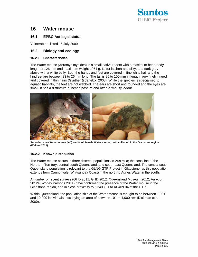
The Water mouse (Xeromys myoides) is a small native rodent with a maximum head-body length of 126 mm and maximum weight of 64 g. Its fur is short and silky, and dark grey above with a white belly. Both the hands and feet are covered in fine white hair and the hindfeet are between 23 to 26 mm long. The tail is 85 to 100 mm in length, very finely ringed and covered in thin hairs (Gynther & Janetzki 2008). While the species is specialised to aquatic habitats, the feet are not webbed. The ears are short and rounded and the eyes are small. It has a distinctive hunched posture and often a ‘mousy’ odour.
Sub-adult male Water mouse (left) and adult female Water mouse, both collected in the Gladstone region (Walters 2011)
16.2.2 Known distribution
The Water mouse occurs in three discrete populations in Australia; the coastline of the Northern Territory, central south Queensland, and south-east Queensland. The central south Queensland population is relevant to the GLNG GTP Project in Gladstone, as this population extends from Cannonvale (Whitsunday Coast) in the north to Agnes Water in the south.
A number of recent surveys (GHD 2011, GHD 2012, Queensland Museum 2012, Aurecon 2012a, Worley Parsons 2011) have confirmed the presence of the Water mouse in the Gladstone region, and in close proximity to KP408.81 to KP409.04 of the GTP.
Within Queensland, the population size of the Water mouse is thought to be between 1,001 and 10,000 individuals, occupying an area of between 101 to 1,000 km2 (Dickman et al 2000).

Part 2 – Management Plans 3380-GLNG-4-1.3-0104
Page 2-136
Figure 16.1 Distribution range of the Water mouse (Source: DSEWPaC 2012z)
16.2.3 Known species populations and their relationship with the GTP footprint
This species was identified during the pre-clearance survey in close proximity to KP408.81to KP409.04 of the GTP and ancillary areas, and potential habitat has also been identified in close proximity to the site.
16.2.4 Biology and reproduction
The diet of the Water mouse has been well surveyed. Van Dyck (1996) investigated the diet of the Water mouse on North Stradbroke Island in south-east Queensland. The composition of the diet included a variety of crustaceans (Parasesarma erythrodactyla, Helice leachi and Australoplax tridentata), Marine polyclads, Marine pulmonates (Salinator solida, Ophicardelus quoyi and Ochidina australis) and Marine bivalves (Glauconome sp.). Investigations of middens within and outside tree hollows also revealed the remains of the Mud lobster (Laomedia healyi) and Mottled shore crab (Peragrapsis laevis) (Van Dyck 1996). This suite of species is common on intertidal saltmarsh habitats in south-east Queensland (Breitfuss et al 2004).
The dietary preferences in central south Queensland appear to be similar and include grapsid crabs (Ball 2004). Plant foods to date have not been reported in the diet of the Water mouse, however gut morphology suggests that the diet of the Water mouse should not be totally carnivorous (Van Dyck 1996).
The Water mouse creates nests which are important for breeding and refuge from high tide and predators. Five types of nests have been identified (Van Dyck & Gynther 2003):
• Free-standing mound nests or mounds at the base of mangrove trees
• Mound nests on small elevated ‘islands’ within the tidal zone
• Mound nests or holes in supralittoral banks
• Nests inside hollow tree trunks
• Nests in spoil heaps created as a result of human activity
Recent surveys by Aurecon in the Gladstone region have detected:
• A free-standing mound nest above the high-tide mark, in a supralittoral bank vegetated with Saltwater couch (Sporobolus virginicus)

Part 2 – Management Plans 3380-GLNG-4-1.3-0104
Page 2-137
• A sub-adult male Water mouse that was radio-tracked to its daytime shelter inside a hollow stag of White-flowered black mangrove (Lumnitzera racemosa), below the high-tide mark, and approximately 100 m in to a dense forest of Rhizophora stylosa
• A second sub-adult male Water mouse that was radio-tracked to its daytime shelter beneath a rock pile adjacent to a dense mangrove forest of Yellow mangrove (Ceriops tagal)
• An apparent nest within a hollow mangrove tree containing four individuals, including one sub-adult male which was captured and subsequently released
Water mouse nest structures recently observed in the Gladstone region: a) a free-standing mound nest in the supralittoral bank, b) a hollow stag c) location of the entrance hole within the mangrove roots of the hollow stag d) close image of the entrance hole
a
b
c d
Part 2 – Management Plans 3380-GLNG-4-1.3-0104
Page 2-138
16.3 Habitat
The Water mouse requires mangrove communities and associated saltmarsh, sedgelands, clay pans, heathlands and freshwater wetlands with intact hydrology that provide adequate nest sites and prey resources.
In central south Queensland, the Water mouse has been captured in the high inter-tidal zone in tall, closed fringing mangrove forest containing Ceriops tagal and/or Bruguiera sp and in saline grassland adjacent to this type of forest (Ball 2004, DSEWPaC 2012z). The Water mouse was also recorded in closed forest of Avicennia marina and a supralittoral bank is generally absent in the south central Queensland subregion (Ball 2004). Typical Water mouse habitat in this subregion has been described as the distinct ecotones between mangroves and dry sclerophyll woodlands and/or saltpan. However, very little research of the species has been completed, and recent surveys in the Gladstone region have added to the body of knowledge of Water mouse habitat use. This animal has recently been detected in the following habitats:
• Closed Rhizophora stylosa forest bordered by closed Ceriops tagal (Aurecon 2012a)
• Open Avicennia marina forest with supralittoral bank bordered by saline grassland (Aurecon 2012a)
• Closed Ceriops tagal forest (FEC 2012b)
• Closed Avicennia marina/Ceriops tagal forest bordered by closed Rhizophora stylosa (GHD 2011)
Very little is known about the dispersal and movement activities of the Water mouse. Only one published study has involved radio-tracking of individuals (Van Dyck 1996), which provided the following information:
• Animals may travel up to 3 km in a night
• The average home range is 0.7 ha
• Males generally have a larger home range than females (male average 0.77 ha, female 0.53 ha)
• Microhabitat complexity and width of mangrove strip influence the size of home range (ie animals will range further when the microhabitat is less complex and the mangrove strip is narrower)
The Water mouse is known to nest communally, and exhibit territorial behaviour (Gynther & Janetzki 2008). Van Dyck (1996) found that a nest usually contained only one sexually active male. It is reasonable to assume that animals and in particular sub-adult males will disperse from the original nest to establish new territories. Thus, areas that are not considered core habitat in terms of food or nesting resources, however may still provide important dispersal pathways.

Part 2 – Management Plans 3380-GLNG-4-1.3-0104
Page 2-139
16.4 Habitat assessment
Information obtained from Biodiversity Planning Assessment (BPA) (ie Brigalow Belt South Fauna Expert Panel Report (EPA 2006)), together with expert advice, site based species records and pre-clearance survey data has been used to define a set of assumptions that have been used to identify areas of habitat that are consistent with the definitions of ‘core habitat’, ‘essential habitat’ and ‘general habitat’ presented in Part 1 of this SSMP. The habitat assessment assumptions for the Water mouse are presented below.
16.4.1 General assumptions
The following general habitat assumptions have been made based on current scientific knowledge of this species:
• Species is associated the upper inter-tidal zone in tall, closed fringing mangrove forest containing only Ceriops tagal and/or Bruguiera sp (Ball 2004, DSEWPaC 2012z)
• Species is associated with saline grassland on the landward side of closed forest of Ceriops tagal and Bruguiera sp and within closed forest of Avicennia marina (DSEWPaC 2012z)
• Species is associated with open mangrove communities that support invertebrate prey (DSEWPaC 2012z)
• Areas with corresponding habitat features to that of RE 11.1.2a and RE 12.1.2 which are described as bare mud flats on Quaternary estuarine deposits, with very isolated individual stunted mangroves and very sparse saltpan vegetation including grassland and herbland on marine clay plains, are not considered to be habitat as they are lacking the required structural attributes of cover for foraging and structure/resources for nesting that have been referenced in literature and points above in addition to the increased risk and exposure of predation in the open areas
• An allowance has been made to accommodate Water mouse movements across and within these areas to reach adjacent suitable habitats, assuming the species will move no more than 50 m from cover (based on current scientific knowledge and pre-clearance survey and trapping programs and habitat assessments)
16.4.2 Core habitat
‘Core habitat’ consists of ‘essential habitat’ in which the species is known and the habitat is recognised under relevant recovery plans or other relevant plans/policies/regulations. Also included within this category are populations that are limited geographically within the region.
For the Water mouse, all REs or Pre-REs that contain a specimen backed record, which overlap with areas identified in the BPA mapping that have been identified as containing a ‘State’ or ‘Regional’ ‘Corridor’ (J-Rating) and/or ‘Core habitat’ (H-Rating) and/or ‘Habitat for EVR Taxa’ (A-Rating) have been mapped as ‘Core habitat’.
No ‘core habitat’ for this species exists within KP0 to KP30, KP30 to KP40, KP40 to KP130, KP130 to KP312, KP312 to KP408.81, KP408.81 to KP409.04 and KP413.57 to KP419.69 of the GTP.
16.4.3 Essential habitat
‘Essential habitat’ is an area containing resources that are considered essential for the maintenance of populations of the species (eg potential habitat for breeding, roosting,
Part 2 – Management Plans 3380-GLNG-4-1.3-0104
Page 2-140
foraging, shelter, for either migratory or non-migratory species). ‘Essential habitat’ is defined from known records and/or expert advice (including the findings of pre-clearance surveys).
For the Water mouse, ‘essential habitat’ is defined as the RE polygon in which Water mouse individuals have been found during pre-clearing surveys.
No ‘essential habitat’ for this species exists within KP0 to KP30, KP30 to KP40, KP40 to KP130, KP130 to KP312, KP312 to KP408.81, KP408.81 to KP409.04 and KP413.57 to KP419.69 of the GTP.
16.4.4 General habitat
‘General habitat’ consists of areas or locations that are used by transient individuals or where species may have been recorded but where there is insufficient information to assess the area as essential/core habitat. ‘General habitat’ also includes areas defined from known records or habitat that is considered to potentially support a species according to expert knowledge of habitat relationships, despite the absence of specimen backed records. ‘General habitat’ may include areas of suboptimal habitat for species. As potential habitat for many species contained within this SSMP may include most of the regional ecosystems of the Brigalow Belt Bioregion, the ‘general habitat’ category restricts the habitat to a more limited and realistic set of environmental parameters that are supported by literature and field based observation.
KP0 to KP30
No ‘general habitat’ for this species exists within KP0 to KP30 of the GTP.
KP30 to KP40
No ‘general habitat’ for this species exists within KP30 to KP40 of the GTP.
KP40 to KP130
No ‘general habitat’ for this species exists within KP40 to KP130 of the GTP.
KP130 to KP312
No ‘general habitat’ for this species exists within KP130 to KP312 of the GTP.
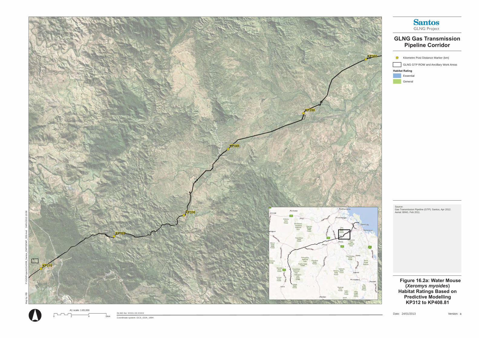
KP312 to KP408.81
Pre-clearance surveys identified ‘general habitat’ for this species within KP408.3 to KP408.7 (Santos GLNG 2013).
The location of the ‘general habitat’ for this species within KP312 to KP408.81 is shown in Figure 16.2a and Figure 16.2b.
KP408.81 to KP409.04
No ‘general habitat’ for this species exists within KP408.81 to KP409.04 of the GTP although ‘general habitat’ for this species exists in close proximity to the ROW and ancillary areas and is shown in Figure 16.2c.
KP413.57 to KP419.69
Pre-clearance surveys did not identify ‘general habitat’ for this species within this section of the GTP although ‘general habitat’ was identified within close proximity to the GTP and is shown in Figure 16.2d. It is important to note that the GLNG GTP ROW and ancillary
KP330
KP340
KP350
KP360
KP320
KP310
P:\
GIS
\Pro
ject
s\21
4208
_San
tos_
EM
P\S
EM
P_
328.
mxd
2
4/0
1/20
13 1
0:0
8
Coordinate system: GCS_GDA_1994
Map
by:
RB
24/01/2013Date:0 2 4 6km
A1 scale: 1:65,000GLNG No: XXXX-XX-XXXX
GLNG Gas TransmissionPipeline Corridor
Figure 16.2a: Water Mouse(Xeromys myoides)
Habitat Ratings Based onPredictive ModellingKP312 to KP408.81
a
Kilometre Post Distance Marker (km)
GLNG GTP ROW and Ancillary Work Areas
Habitat Rating
Essential
General
Source:Gas Transmission Pipeline (GTP): Santos, Apr 2012.Aerial: BING, Feb 2011.
Version:

KP380
KP390
KP400
KP360
KP410
KP370
P:\
GIS
\Pro
ject
s\21
4208
_San
tos_
EM
P\S
EM
P_
328.
mxd
2
4/0
1/20
13 1
0:0
8
Coordinate system: GCS_GDA_1994
Map
by:
RB
24/01/2013Date:0 2 4 6km
A1 scale: 1:65,000GLNG No: XXXX-XX-XXXX
GLNG Gas TransmissionPipeline Corridor
Figure 16.2b: Water Mouse(Xeromys myoides)
Habitat Ratings Based onPredictive ModellingKP312 to KP408.81
a
Kilometre Post Distance Marker (km)
GLNG GTP ROW and Ancillary Work Areas
Habitat Rating
Essential
General
Source:Gas Transmission Pipeline (GTP): Santos, Apr 2012.Aerial: BING, Feb 2011.
Version:

!R
!R
!R !R
!R
KP407
KP406KP405
KP409
KP408
P:\
Au
reco
n\2
15
64
8 S
an
tos\M
ap
pin
g\2
21
71
4\2
21
71
4_
Te
rns_
1.m
xd
02
/08
/20
12
10
:56
Coordinate system: GDA 1994 MGA Zone 56
Ma
p b
y:
Zo
nta
RA
°24/09/2012Date:
0 0.25 0.5 0.75km
A1 scale: 1:10,000
GLNG No: XXXX-XX-XXXX
Marine CrossingGTP Early Works
Figure 1 .2c: Water Mouse(Xeromys myoides)
Habitat Ratings Based onPredictive Modelling
KP408.81 to KP409.04
a
!R Kilometre Post Distance Marker (km)
GLNG GTP ROW and Ancillary Work Areas
Proposed Access Road
Construction Tunnel Launch Pad
Habitat Ratings
General Habitat
Essential Habitat
Source:Aerial: BING, Feb 2011.
Version:

!R
!R!R
!R
!R
!R
!R
P:\
GIS
\Pro
jects
\21
420
8_
San
tos_
EM
P\S
EM
P_
35
6.m
xd
0
2/0
4/2
013
16:3
0
Coordinate system: GCS_GDA_1994
Ma
p b
y:
RB
°02/04/2013Date:
0 250 500 750Meters
A1 scale: 1:10,000
GLNG No: XXXX-XX-XXXX
Xeromys myoides
a
!R Kilometre Post Distance Marker (km)
GLNG Narrows Pipeline Alignment
GLNG GTP ROW and Ancillary Work Areas
General
Source:Gas Transmission Pipeline (GTP): Santos, Apr 2012.
Aerial: BING, Feb 2011.
Version:
!R

Part 2 – Management Plans 3380-GLNG-4-1.3-0104
Page 2-141
activities do not interfere with the tidal zone and therefore the hydrology of the habitat areas will not be altered.
16.4.5 Unlikely habitat
‘Unlikely habitat’ areas are those areas that do not contain records of the particular species and contain no habitat values to support the presence or existence of resident or migratory individuals or populations of the species.
16.5 Anticipated threats and potential impacts as a result of the GTP
Habitat loss and fragmentation
Habitat degradation due to altered hydrology
Entrapment in trenches
Reduction in nesting and foraging opportunities
Acid sulfate soil exposure
Increased anthropogenic disturbance
Chemical, oil and/or fuel spills
Increase in weed impacts
Increase in impacts from predators
16.6 Unavoidable impact from the GTP
Areas of proposed disturbance associated with clearing and construction activities for the GTP between KP0 to KP30, KP30 to KP40, KP40 to KP130, KP130 to KP312, KP312 to KP408.81, KP408.81 to KP409.04 and KP413.57 to KP419.69 for the Water mouse are presented in Table 16.1. The location of this habitat is shown in Figure 16.2a, Figure 16.2b, Figure 16.2c and Figure 16.2d.
A cumulative total of proposed clearing of habitat for the Water mouse is provided in Table 16.1.
Table 16.1 Cumulative total of Water mouse habitat to be cleared
Location ‘General habitat’
KP0 to KP30 0 ha
KP30 to KP40 0 ha
KP40 to KP130 0 ha
KP130 to KP312 0 ha
KP312 to KP408.81 0.34 ha
KP408.81 to KP409.04 0 ha
KP413.57 to KP419.69 0 ha
Total habitat area 0.34 ha
Part 2 – Management Plans 3380-GLNG-4-1.3-0104
Page 2-142
16.7 Management practices and methods
16.7.1 Pre-construction mitigation measures
Measures to avoid impact
All reasonable and practical measures will be taken to locate site offices, construction camps, stockpiling/lay down areas and plant and equipment storage areas (including heavy machinery) on existing cleared lands
Where the Water mouse and its breeding site is located within or within close proximity of the GTP and ancillary work areas, the location will be recorded and checked again for activity prior to construction clearing. All practical and reasonable steps will be taken to avoid disturbing these areas including the investigation of alternative construction measures near known habitats. The establishment of a 100 m buffer around breeding site(s) will also be applied if there are no applicable alternative GTP construction methods
Where practically feasible, efforts should be made to co-locate the pipeline adjacent to existing cleared areas to minimise fragmentation and reduction of core habitat within remnant communities
Measures to minimise impacts
Pre-clearing ecological surveys have been undertaken by a suitably qualified Ecologist(s) in accordance with the Survey Guidelines for Australia’s Threatened Mammals
Prior to the commencement of construction clearing, the limits of clearing will be clearly marked out by a suitably qualified and experienced EO. Barricade webbing or similar should be used for ‘No Go’ zones
Wherever practicable, signage will be erected to increase awareness of this species and its habitat in the area
Prior to site entry, all site personnel will be appropriately trained and made aware of the sensitive environs in which they will be working (refer Part 1, Section 7.7)
16.7.2 Construction phase mitigation measures
Measures to avoid impact
Vehicle and pedestrian access to and from the GTP will be restricted to the defined access tracks
The limits of clearing will be clearly marked out by a suitably qualified and experienced EO. Barricade webbing or similar will be present highlighting all temporary and permanent ‘No Go’ zones relevant to the Water mouse
Measures to minimise impacts
All site personnel will be educated in not harming any animals. All native animals are protected under legislation and it is illegal to harm them
All vegetation clearing and/or construction activities within known Water mouse habitat will comply with the clearing approval conditions (eg EPBC Act, EP Act, NC Act and other statutory approvals) and be supervised by the relevant EO

Part 2 – Management Plans 3380-GLNG-4-1.3-0104
Page 2-143
Implement the Fauna Handling Procedures (refer Appendix C)
Clearing will be conducted in a sequential manner and in a way that directs escaping wildlife away from the clearing activities and into adjacent natural areas
Clearing activities will be restricted to the maximum disturbance limits authorised for the GTP and ancillary areas
All clearing activities within identified sensitive areas will be supervised by the relevant EO
Surveillance of the open trench in all areas and the removal of wildlife from the trench by appropriately trained personnel (the whole trench will be checked at least twice a day (early morning/late afternoon)
The spotter catcher(s) will have access to the site (particularly the open trench) during all weather conditions to check for trapped fauna
Measures will be adopted to prevent fauna entrapment within the pipeline trench, such as:
– Minimising the period of time the trench is open
– Constructing ramps with a non-slip surface with slopes less than 45° to provide exit ramps for fauna at intervals no greater than 500 m
– Trench plugs shall be installed in open trenches. These will be provided as a minimum every 500 m
– Installing additional ramps at greater than normal frequencies (500 m) in areas identified as known or high value habitat
– Branches, hessian sacks, ramped gangplanks or similar to be used to create ‘ladders’ to enable fauna to exit the trench. These structures will be placed every 250 to 500 m, depending on the surrounding landscapes
Direct temporary lighting away from light-sensitive areas such as intertidal zones. Light shades and low lighting will be applied to construction and operational areas located adjacent to intertidal areas. This includes remnant native vegetation and other environmentally sensitive areas within and adjacent to intertidal zones
Prior to backfilling, the spotter catcher(s) will check the open trench in all areas for trapped fauna and where required move them to a safe location away from the trench. This may include disturbing the top layer of soil to ensure no reptiles are camouflaged under the soil
The construction phase component of the LRMP will be implemented
Weather permitting, rehabilitation of all areas identified will commence immediately after the pipeline has been lowered in and backfilled (refer LRMP). With the exception of operational constraints, revegetation will be consistent with the plant density, floristic composition and distribution of the adjacent communities (particularly ground cover). Rehabilitation will also incorporate the re-establishment of Water mouse habitat and landscape connectivity within ‘core habitat’ and ‘essential habitat’ areas
Clearance of the GTP ROW and ancillary areas will be subject to comprehensive stormwater management and sediment and erosion control measures as detailed in the SMESCP to ensure that there is no sediment runoff from construction areas into the habitat

Part 2 – Management Plans 3380-GLNG-4-1.3-0104
Page 2-144
All construction phase activities will be in accordance with the noise and vibration management measures outlined in the Marine Crossing EMP with construction operations reducing or ceasing at night within close proximity to the Water mouse habitat. It is important to note however that no night works are planned within close proximity to the potential habitat areas
Observations from construction activities associated with the Gladstone Wiggins Island Coal Terminal project indicate that the Water mouse is still active and forages within its habitat during construction activities and that mitigation measures contained within this document are sound for reducing potential impacts for this species. However, these are observations only as very little published research of the species has been completed.
Importantly, as the ROW and ancillary works area construction footprint does not impact on the intertidal zone and night works are not planned for the ROW activities, it is considered that the potential impacts to this species will be minimised by the documented management measures.
16.7.3 Operational phase mitigation measures
Measures to avoid impact
Vehicle and pedestrian access within the GTP and ancillary areas will be restricted to the defined access tracks
Measures to minimise impacts
Implementation of the Fauna Handling Procedures (refer Appendix C)
Appropriate maintenance measures will be adopted in the GTP to minimise potential risk to recolonising species. This includes ensuring that appropriate fire regimes are adopted (where necessary) as well as minimising the disturbance to rocky outcrops, woody debris and rehabilitating vegetation
The operational phase component of the LRMP will be implemented to encourage the re-establishment of ecological communities impacted as a result of construction works. In particular, associated habitat areas for the Water mouse
The PWMP will be implemented to minimise the risk of weed and pest animal establishment within known and/or potential Water mouse habitat
16.7.4 Decommissioning phase mitigation measures
Measures to minimise impacts
Implementation of the Fauna Handling Procedures (refer Appendix C)
A decommissioning plan will be developed by GLNG and provided for approval. The plan will aim to address the requirements of AS2885 and also to ensure environmental harm is avoided, including:
– The Project area no longer contains hazardous contaminants and is in stable condition
– All above ground infrastructure is removed
– All areas disturbed by above ground infrastructure are rehabilitated in accordance with the relevant conditions
Part 2 – Management Plans 3380-GLNG-4-1.3-0104
Page 2-145
For a minimum of five years after the completion of rehabilitation, rehabilitated areas will be monitored on a yearly basis
The monitoring programme will include:
– Methods to measure subsidence and erosion rates at rehabilitated buried transmission pipeline corridors and buried flow lines
– BioCondition assessment in accordance with the BioCondition: A Condition Assessment Framework for Terrestrial Biodiversity in Queensland: Assessment Manual: Version 2.1 (Eyre et al 2011)
– Monitoring of indicators identified in the LRMP at analogue sites to measure progressive and final rehabilitation success relevant to the final land use(s)
– Frequency and seasonality of monitoring analogue sites and rehabilitated areas to assess rehabilitation success
– Identification of the experimental design for analysing analogue and rehabilitated site data including statistical methods of analyses