10 years after the largest river restoration project in
TRANSCRIPT
Aalborg Universitet
10 years After The Largest River Restoration Project In Northern Europe
Hydromorphological changes on multiple scales in River Skjern
Kristensen, Esben; Kronvang, Brian; Wiberg-Larsen, Peter; Thodsen, Hans; Nielsen, CarstenBrian; Amor, E.; Friberg, Nikolai; Pedersen, Morten Lauge; Baattrup-Pedersen, AnnettePublished in:Ecological Engineering
DOI (link to publication from Publisher):10.1016/j.ecoleng.2013.10.00110.1016/j.ecoleng.2013.10.001
Publication date:2014
Document VersionEarly version, also known as pre-print
Link to publication from Aalborg University
Citation for published version (APA):Kristensen, E., Kronvang, B., Wiberg-Larsen, P., Thodsen, H., Nielsen, C. B., Amor, E., Friberg, N., Pedersen,M. L., & Baattrup-Pedersen, A. (2014). 10 years After The Largest River Restoration Project In Northern Europe:Hydromorphological changes on multiple scales in River Skjern. Ecological Engineering, 66, 141-149. [16].https://doi.org/10.1016/j.ecoleng.2013.10.001, https://doi.org/10.1016/j.ecoleng.2013.10.001
General rightsCopyright and moral rights for the publications made accessible in the public portal are retained by the authors and/or other copyright ownersand it is a condition of accessing publications that users recognise and abide by the legal requirements associated with these rights.
? Users may download and print one copy of any publication from the public portal for the purpose of private study or research. ? You may not further distribute the material or use it for any profit-making activity or commercial gain ? You may freely distribute the URL identifying the publication in the public portal ?
Take down policyIf you believe that this document breaches copyright please contact us at [email protected] providing details, and we will remove access tothe work immediately and investigate your claim.
Downloaded from vbn.aau.dk on: January 07, 2022
G
E
1H
EEa
b
a
ARRAA
KRLPFL
1
eeFteflEte
V
0h
ARTICLE IN PRESS Model
COENG-2759; No. of Pages 9
Ecological Engineering xxx (2013) xxx– xxx
Contents lists available at ScienceDirect
Ecological Engineering
journa l h om epage: www.elsev ier .com/ locate /eco leng
0 years after the largest river restoration project in Northern Europe:ydromorphological changes on multiple scales in River Skjern
.A. Kristensena,∗, B. Kronvanga, P. Wiberg-Larsena, H. Thodsena, C. Nielsena,
. Amora, N. Friberga, M.L. Pedersenb, A. Baattrup-Pedersena
Aarhus University, Department of Bioscience, Silkeborg, DenmarkAalborg University, Department of Civil Engineering, Aalborg, Denmark
r t i c l e i n f o
rticle history:eceived 26 February 2013eceived in revised form 22 August 2013ccepted 7 October 2013vailable online xxx
eywords:iver restorationong-termhysical conditionloodplainow-land rivers
a b s t r a c t
The lower river Skjern (Denmark) historically contained a large variation in habitats and the river ranthrough large areas with wetlands, many backwaters, islands and oxbow lakes. During the 1960s theriver was channelized and the wetland drained. A restoration during 2001–2002 transformed 19 km ofchannelized river into 26 km meandering river. The short-term effects of this restoration have previouslybeen reported and for this study we revisited the river and with new data evaluated the long-term (10years) hydrological effects of the restoration. The evaluation was done on three different scales: (1) in-stream habitats, (2) channel stability and (3) re-connection with the floodplain. In-stream habitats hadchanged little over the past 10 years and the habitats today showed close similarity with the habitatsrecorded immediately after the restoration. Measurements of channel stability showed that erosion andsedimentation have changed the cross-sectional profiles over the last 10 years, resulting in a net input ofsediment to the lower reaches of the river. However, the change of channel form was a slow process andpredicted bank retreat over a 100 year period was only up to 6.8 m. Hence the formation of lost habitats(islands, backwaters and oxbow lakes) is a very slow process and the spontaneous development of thesehabitats will take centuries. Furthermore, the evaluation also showed that the restoration re-connected
the river with its floodplain and large areas of riparian areas are today periodically flooded, but thatthe flooding is controlled and tamed due to the restoration design. The restoration of River Skjern hastherefore failed to re-create the natural habitats formerly present and the natural dynamic processes thatshape these habitats are slow. To speed up this process we therefore recommend restoration engineeringusing a natural guiding image when restoring lowland rivers in the future and through this restoring thelost habitats and the dynamic processes characteristic of natural rivers.BsTwE
rsp
. Introduction
Habitat degradation is a serious threat to biodiversity (Dobsont al., 1997; Vitousek et al., 1997; Wilcove et al., 1998) and aquaticcosystems are among those most severely impacted (Allan andlecker, 1993; Sala et al., 2000). Over centuries, streams, rivers andheir floodplains have been modified (e.g. Sparks, 1995; Kronvangt al., 1998; Bernhardt et al., 2005) as a result of land drainage,ood plain urbanization, flood defence and navigation (European
Please cite this article in press as: Kristensen, E.A., et al., 10 years after thelogical changes on multiple scales in River Skjern. Ecol. Eng. (2013), http://
nvironment Agency, 1998). In North-western Europe, modifica-ion and channelization of watercourses have been particularlyxtensive and have left less than 10% of lowland streams in Great
∗ Corresponding author at: Aarhus University, Department of Bioscience,ejlsøvej 25, DK-8600 Silkeborg, Denmark. Tel.: +45 87158753.
E-mail address: [email protected] (E.A. Kristensen).
eciseeai
925-8574/$ – see front matter © 2013 Elsevier B.V. All rights reserved.ttp://dx.doi.org/10.1016/j.ecoleng.2013.10.001
© 2013 Elsevier B.V. All rights reserved.
ritain, the Netherlands and Denmark in their natural physicaltate (Brookes and Long, 1990; Verdonschot and Niiboer, 2002).hus, extensive damage has been caused to the river ecosystemsith a widespread loss of habitats for biota, and the biodiversity of
uropean rivers and floodplains is today significantly reduced.As a consequence of the widespread damage to stream and
iver ecosystems, and based on a growing recognition of the con-ervation values within them, the number of river restorationrojects has increased substantially in recent years (Bernhardtt al., 2005). River restoration efforts have primarily focused onhannel re-configuration, and in-stream habitat improvementsncreasing heterogeneity, by re-meandering and adding physicaltructures such as wood, boulders and artificial riffles (e.g. Larson
largest river restoration project in Northern Europe: Hydromorpho-dx.doi.org/10.1016/j.ecoleng.2013.10.001
t al., 2001; Kasahara and Hill, 2008; Miller et al., 2010). How-ver, during the last 10 years there has been a growing scientificnd management-oriented recognition of the importance of restor-ng the natural processes of river ecosystems (Williams, 2001;

ING Model
E
2 al Eng
KftipBfwapsm2c2s
eiarcbtlLgmco2tab1wctiia2oehraRoWe(h1wi(
2
2
h
tiowdtlaiesfsyosaetis1sScamw
dgT1tttvtczmb2opusmwtt1uddwpfT
a
ARTICLECOENG-2759; No. of Pages 9
E.A. Kristensen et al. / Ecologic
ondolf et al., 2006). This paradigm shift has resulted in a transitionrom small-scale engineering-dominated restoration approachesoward catchment-scale approaches that focus on enhancing bothn-stream habitats and re-connection of the river with its flood-lain and through this restoring freshwater wetlands (Hillman andrierly, 2005; Kondolf et al., 2006). Therefore, there is a need to
ocus on the entire freshwater ecosystems including the riparianetlands and through this the restoration of ecosystem processes
nd functioning which is vital to sustain the services these systemsrovide (Loomis et al., 2000). Scientific evaluations of catchment-cale restoration projects are however rare, especially studies thatonitor the long-term responses (Friberg et al., 1998; Feld et al.,
011). Long-term evaluations are highly relevant as such studiesan help us to advance the science of river restoration (Wohl et al.,005) and ultimately help us achieve a higher rate of restorationuccess (Palmer et al., 2005).
The overall aim of this study was to evaluate the longer-termffects of restoring River Skjern, Denmark. This restoration projects the largest river restoration project in Northern Europe to date,iming to enhance the nutrient retention capacity of the river bye-creating a natural hydrology in the river valley including re-onnection of the river and the riparian wetlands and to enhanceiodiversity by restoring the physical and hydrological dynamics ofhe river and the floodplain (Pedersen et al., 2007a). River Skjern isocated in Western Denmark and drains a catchment of 2490 km2.and use in the catchment is dominated by agriculture and theeology of the area is a combination of sandy outwash plains andostly sandy moraines (Smed, 1982). The river has the highest dis-
harge of any Danish rivers (annual mean 35 m3/s) why the river isf high regional importance as a biodiversity hotspot (Ovesen et al.,000; Andersen et al., 2005). From historical maps dating back tohe 1800th century the lower 10 km of the river can be classified asnastomosing with numerous channels between low relatively sta-le vegetated islands (Miall, 1977; Richards, 1997). During the late960s the lower 19 km of the river was channelized and riparianetlands were drained as a result of increasing demand for agri-
ultural production. River channelization and drainage was at theime considered a prerequisite condition for agricultural growthn the Danish society. However, 25 years later the area had lostts agricultural value and in 1987 the Danish government initi-ted plans to restore the area. The restoration was conducted in000–2002 and resulted in the transformation of the lower 19 kmf channelized river into 26 km of meandering river (Pedersent al., 2007a). The short-term effect of the restoration on in-streamabitats, macrophytes and macroinvertebrates has previously beeneported (Pedersen et al., 2007b), however, the longer-term effectsre unknown. The aim of this study was therefore to re-visit theiver Skjern and analyze the development in channel morphol-gy and habitats 10 years after the completion of the restoration.e investigated morphological development using three differ-
nt spatial scales: (1) in-stream habitats, (2) channel stability and3) the re-connection of the river with its riparian wetlands. Weypothesized that significant changes have occurred during these0 years and that the River Skjern has developed into a river systemith near-natural hydromorphology. The term hydromorphology
s used as defined by Sípek et al. (2009), for discussion see Vogel2011).
. Methods
Please cite this article in press as: Kristensen, E.A., et al., 10 years after thelogical changes on multiple scales in River Skjern. Ecol. Eng. (2013), http://
.1. In-stream habitats
The short-term effects of the restoration on in-stream habitatsave previously been evaluated in three 300 m long reaches along
PBpt
PRESSineering xxx (2013) xxx– xxx
he restored River Skjern (R1, R2, R3, Fig. 1) based on a compar-son with a 300 m long control reach (C, Fig. 1) located upstreamf the restoration area (Pedersen et al., 2007b). All four reachesas sampled once before the restoration (2000) and again imme-iately after the restoration (2003; Pedersen et al., 2007b). Afterhe restoration the location of R2, R3 and C remained at the sameocation as pre-restoration, while, as a results of the restorationnd filling-up of major parts of the channelized river, reach R1 wasn 2003 moved from the northern drainage channel to the newlyxcavated river channel located app. 2 km south (Fig. 1). For thistudy, we re-sampled these four reaches in 2011 providing dataor a long-term evaluation (app. 10 years) of the restoration on in-tream habitats. Identical surveying methods were used in all threeears to allow for cross-year comparison, for a detailed descriptionf the methodology, see Pedersen et al. (2007b). In brief, six tran-ects were placed equally spaced along each of the four reachesnd each transect was divided into 1 m × 1 m quadrats across thentire width. A GPS was used to exactly identify location of eachransect. At each quadrat, depth (to nearest cm), current veloc-ty (at 10 cm above the stream bed), dominating substrates (usingeven categories according to the Wentworth-scale (Wentworth,922) and macrophyte coverage (%) was recorded. Recording of in-tream variables was done in September 2000, August 2003 andeptember 2011 and it was aimed to collect data at similar dis-harge levels. However, the summer 2003 was drier than normalnd mean monthly discharge for August 2003 was 12.7 m3/s, whileean monthly discharge for September 2000 and September 2011as 19.4 m3/s and 19.1 m3/s, respectively.
To evaluate the long-term changes to in-stream habitats weivided the recordings from each transect into two groups tworoups termed a “Vegetated zone” and a “Main current zone”.he first group was defined as quadrats with depths from 0 to30 cm, often located along the edges of the river channel suppor-ing vascular macrophytes, as these rarely occur at depths largerhan 130 cm. The second group was quadrats with depths largerhan 130 cm, often located in the mid-channel and being withoutascular macrophytes. We preformed this a priori separation ofhe data to obtain a river-zone-specific evaluation of the physicalhanges during the 10 year period because these two main channelones are expected to form different in-stream habitats for plants,acroinvertebrates and fish. For this study, we calculated a num-
er of in-stream parameters using the transect data recorded in000, 2003 and 2011. For each transect, we calculated Coefficientsf Variation (CV) for depth, mean current velocity and mean macro-hyte coverage separate for the two habitat zones. In addition, wesed substrate recording to calculate percent occurrence of fourubstrate types (peat, mud, sand and gravel) and produced transecteans for each substrate type separately for the two zones. Finally,e used three different variables (domination, diversity and score)
o describe changes in substrate for each transect divided intohe two zones according to O’Hare et al. (2006). A value between
and 4 was allocated to the four substrate categories with val-es increasing with particle size. Domination was defined as theominant substrate, i.e. the category occurring in most quadrats,iversity was the number of categories occurring and score theeighted average of the categories present in each transect. Allhysical variables used to evaluate changes to in-stream habitatsor the four reaches and the two different zones are summarized inable 1.
To investigate the effect of the restoration on in-stream habitatsnd the long-term development in the habitats we preformed
largest river restoration project in Northern Europe: Hydromorpho-dx.doi.org/10.1016/j.ecoleng.2013.10.001
rincipal Response Curve analyses (PRC, Van den Brink and Terraak, 1999). The analyses were done with year 2000 as referenceoints (Van den Brink et al., 2009) thus enabling us to investigatehe change of in-stream habitats relative to the physical condition
ARTICLE IN PRESSG Model
ECOENG-2759; No. of Pages 9
E.A. Kristensen et al. / Ecological Engineering xxx (2013) xxx– xxx 3
, R3 an
b2ataF
fz
TP
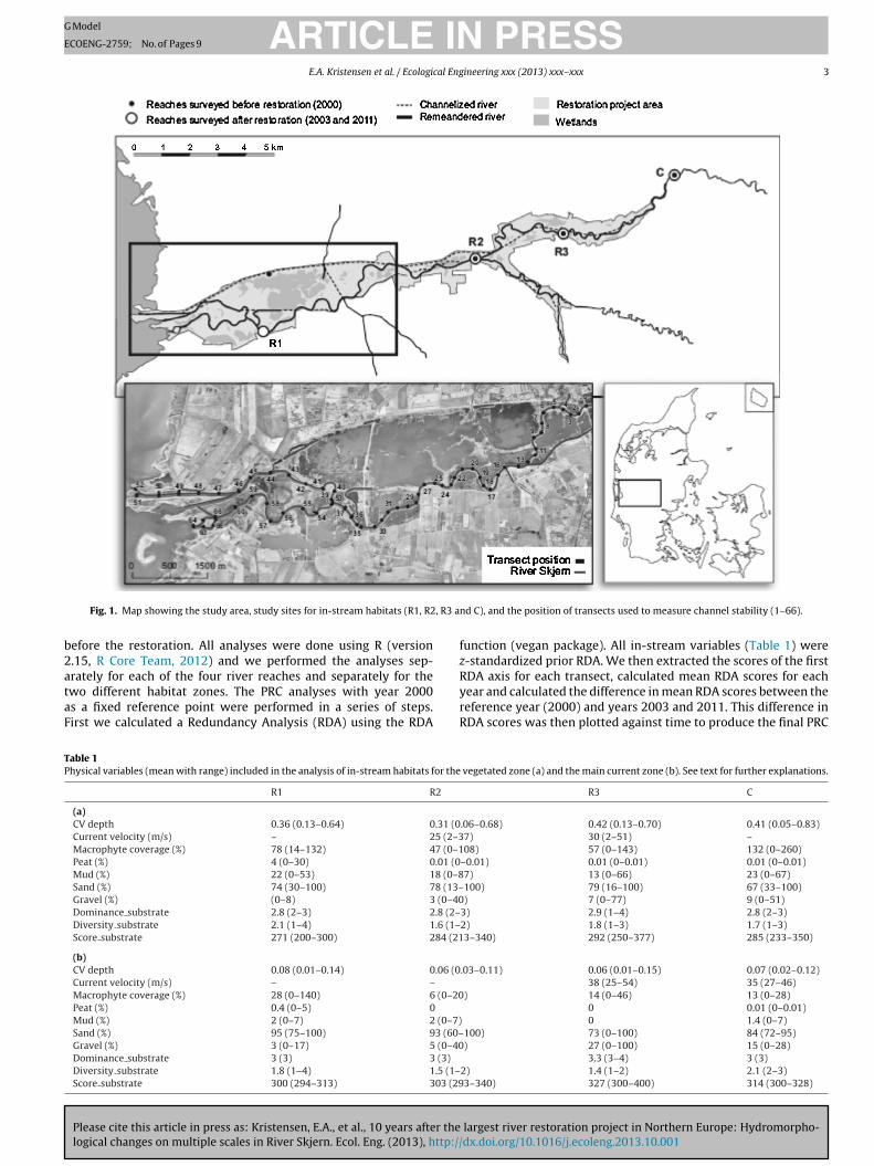
Fig. 1. Map showing the study area, study sites for in-stream habitats (R1, R2
efore the restoration. All analyses were done using R (version.15, R Core Team, 2012) and we performed the analyses sep-
Please cite this article in press as: Kristensen, E.A., et al., 10 years after thelogical changes on multiple scales in River Skjern. Ecol. Eng. (2013), http://
rately for each of the four river reaches and separately for thewo different habitat zones. The PRC analyses with year 2000s a fixed reference point were performed in a series of steps.irst we calculated a Redundancy Analysis (RDA) using the RDA
RyrR
able 1hysical variables (mean with range) included in the analysis of in-stream habitats for the
R1 R2
(a)CV depth 0.36 (0.13–0.64) 0.31 (0Current velocity (m/s) – 25 (2–3Macrophyte coverage (%) 78 (14–132) 47 (0–1Peat (%) 4 (0–30) 0.01 (0Mud (%) 22 (0–53) 18 (0–8Sand (%) 74 (30–100) 78 (13–Gravel (%) (0–8) 3 (0–40Dominance substrate 2.8 (2–3) 2.8 (2–Diversity substrate 2.1 (1–4) 1.6 (1–Score substrate 271 (200–300) 284 (21
(b)CV depth 0.08 (0.01–0.14) 0.06 (0Current velocity (m/s) – –
Macrophyte coverage (%) 28 (0–140) 6 (0–20Peat (%) 0.4 (0–5) 0
Mud (%) 2 (0–7) 2 (0–7)Sand (%) 95 (75–100) 93 (60–Gravel (%) 3 (0–17) 5 (0–40Dominance substrate 3 (3) 3 (3)
Diversity substrate 1.8 (1–4) 1.5 (1–Score substrate 300 (294–313) 303 (29
d C), and the position of transects used to measure channel stability (1–66).
unction (vegan package). All in-stream variables (Table 1) were-standardized prior RDA. We then extracted the scores of the first
largest river restoration project in Northern Europe: Hydromorpho-dx.doi.org/10.1016/j.ecoleng.2013.10.001
DA axis for each transect, calculated mean RDA scores for eachear and calculated the difference in mean RDA scores between theeference year (2000) and years 2003 and 2011. This difference inDA scores was then plotted against time to produce the final PRC
vegetated zone (a) and the main current zone (b). See text for further explanations.
R3 C
.06–0.68) 0.42 (0.13–0.70) 0.41 (0.05–0.83)7) 30 (2–51) –08) 57 (0–143) 132 (0–260)
–0.01) 0.01 (0–0.01) 0.01 (0–0.01)7) 13 (0–66) 23 (0–67)100) 79 (16–100) 67 (33–100)) 7 (0–77) 9 (0–51)
3) 2.9 (1–4) 2.8 (2–3)2) 1.8 (1–3) 1.7 (1–3)3–340) 292 (250–377) 285 (233–350)
.03–0.11) 0.06 (0.01–0.15) 0.07 (0.02–0.12)38 (25–54) 35 (27–46)
) 14 (0–46) 13 (0–28)0 0.01 (0–0.01)
0 1.4 (0–7)100) 73 (0–100) 84 (72–95)) 27 (0–100) 15 (0–28)
3.3 (3–4) 3 (3)2) 1.4 (1–2) 2.1 (2–3)3–340) 327 (300–400) 314 (300–328)

ARTICLE IN PRESSG Model
ECOENG-2759; No. of Pages 9
4 E.A. Kristensen et al. / Ecological Engineering xxx (2013) xxx– xxx
Fig. 2. Principal response curve analyses of the development of in-stream habitat parameters in four different sites of the vegetated zone (depths 0–130 cm) of River Skjern:c
pzwaoaygc
2
tp1s2G22twofrwmtcs
2
rth(o(bBmadShbbflr
3
3
c
ontrol upstream the restored reaches (R1, R2, R3).
lot. Current velocities (v10) were not measured in the vegetatedone of the control reach and both zones of R3 why the analysisere performed without this variable for these. Following PRC
nalyses we used one-way ANOVA’s to test for a significant effectf year. We used the RDA scores for each transect of the firstxis for 2000 and the difference in scores between the referenceear (2000) and years 2003 and 2011 in the ANOVA’s. When thelobal one-way ANOVA was significant, we used Tukey pair-wiseomparisons to compare years.
.2. Sedimentation and erosion
To study the stability of the restored river channel and inves-igate how sedimentation and erosion affects the cross-sectionalrofile of the river, 65 transects were surveyed along the lower0 km of the river (Fig. 1). Detailed measurements of these 65 cross-ections were performed immediately after the restoration (in001) and again in 2011. All cross sections were surveyed using RTKPS equipment with a vertical error <20 mm (Leica Geosystems,010) and for each year x, y and z coordinates were obtained for0 points per transect. After measurements all data points wereransformed into profile lines. Erosion and sedimentation volumesere then calculated for each transect as the difference in height
f the riverbed (z coordinate). Calculations were done separatelyor three cross-sectional compartments: (i) the left bank, (ii) theight bank and (iii) the river bed. The erosion and sedimentationas estimated as both a gross and a net amount and to deter-
Please cite this article in press as: Kristensen, E.A., et al., 10 years after thelogical changes on multiple scales in River Skjern. Ecol. Eng. (2013), http://
ine the erosion and sedimentation between two consecutiveransects we used nearest neighbor interpolation. In addition, wealculated bank retreat for both left and right bank for each tran-ect.
r2wh
.3. Re-connection with the floodplain
To study the connectivity between the River Skjern, and its sur-ounding riparian areas river, water levels were modeled usinghe one dimensional hydraulic model MIKE11 (DHI, 2011). Theydraulic model was based on trans-sectional profiles no. 1–33Fig. 1) measured in 2001. The upstream model boundary was basedn measured daily river flows covering the period 2001–2011Ovesen et al., 2000) and the downstream model boundary wasased on sub-daily measurements of sea surface water levels atork Harbor located 9 km south west of the river outflow. Theodel was calibrated against measured water levels by adjusting
time series of daily Manning M numbers calculated at the mostownstream permanent river flow gauging station on the Riverkjern (Thodsen et al., 2006). When the modeled water levels wereigher than the river banks the extent of the flooding was estimatedased on a 1.6 m resolution LIDAR DEM (KMS, 2010) and the com-ined flooded area were calculated. Riparian wetland areas beingooded were estimated based on the 90th flow percentile in theiver during the period 2001–2011.
. Results
.1. In-stream habitats
When comparing RDA scores, we found no significant overallhange to in-stream habitats in the vegetated zone of the control
largest river restoration project in Northern Europe: Hydromorpho-dx.doi.org/10.1016/j.ecoleng.2013.10.001
each from 2000 to 2003 (P = 0.493; Fig. 2) however, from 2003 to011 there was a significant change (P = 0.0008; Fig. 2). This changeas primarily caused by an increase in CV Depth, indicating moreeterogeneous stream profiles with larger variation in depth in
ARTICLE IN PRESSG Model
ECOENG-2759; No. of Pages 9
E.A. Kristensen et al. / Ecological Engineering xxx (2013) xxx– xxx 5
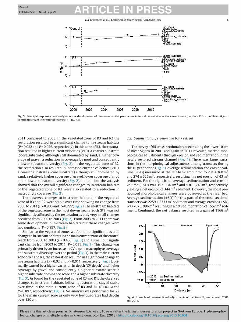
Fig. 3. Principal response curve analyses of the development of in-stream habitat parameters in four different sites of the current zone (depths >130 cm) of River Skjern:control upstream the restored reaches (R1, R2, R3).
2r(t(eatasasom
z2ososn
crcpazimch(coPfo
3
opnttuasvynAtransects was 2259 ± 2333 m sediment and average erosion (±SD)was 707 ± 996 m3 resulting in a net sedimentation of 1552 m3 sed-iment. Combined, the net balance resulted in a gain of 1166 m3
011 compared to 2003. In the vegetated zone of R3 and R2 theestoration resulted in a significant change to in-stream habitatsP = 0.022 and P = 0.026, respectively). In this zone of R3, the restora-ion resulted in higher current velocities (v10), a coarser substrateScore substrate) although still dominated by sand, a higher cov-rage of gravel, a reduction in coverage by mud and consequently
lower substrate diversity (Fig. 2). In the vegetated zone of R2,he restoration also resulted in increased current velocities (v10),
coarser substrate (Score substrate) although still dominated byand, a relatively higher coverage of gravel, lower coverage of mudnd a lower substrate diversity (Fig. 2). In addition, the analysishowed that the overall significant changes to in-stream habitatsf the vegetated zone of R3 were also related to a reduction inacrophyte coverage (Fig. 2).The observed changes to in-stream habitats in the vegetated
one of R3 and R2 were stable over time showing no change from003 to 2011 (P = 0.906 and P = 0.722; Fig. 2). The in-stream habitatsf the vegetated zone in the most downstream reach (R1) was notignificantly affected by the restoration as only very small changesccurred from 2000 to 2003 (Fig. 2). From 2003 to 2011 there wasome development in in-stream habitats but these changes wereot significant (P = 0.897; Fig. 2).
Similar to the vegetated zone, we found no significant overallhange to in-stream habitats in the main current zone of the controleach from 2000 to 2003 (P = 0.460; Fig. 3) and a small but signifi-ant change from 2003 to 2011 (P = 0.011; Fig. 3). This change wasrimarily driven by an increase in CV depth, macrophyte coveragend substrate diversity over the period (Fig. 3). In the main currentone of R3 and R1, the restoration resulted in a significant change ton-stream habitats (P = 0.02 and P = 0.011 respectively; Fig. 3), pri-
arily caused by a higher variation in depth (CV depth) and higheroverage by gravel and consequently a higher substrate score, aigher substrate dominance score and a higher substrate diversityFig. 3). As found for the vegetated zone of R3 and R1, the observedhanges to in-stream habitats following restoration, stayed stable
Please cite this article in press as: Kristensen, E.A., et al., 10 years after thelogical changes on multiple scales in River Skjern. Ecol. Eng. (2013), http://
ver time in the main current zone of R3 and R1 (P = 0.161and = 0.897, respectively; Fig. 3). No analysis was performed for R2or the main current zone as only very few quadrates had depthsver 130 cm.
Fa
.2. Sedimentation, erosion and bank retreat
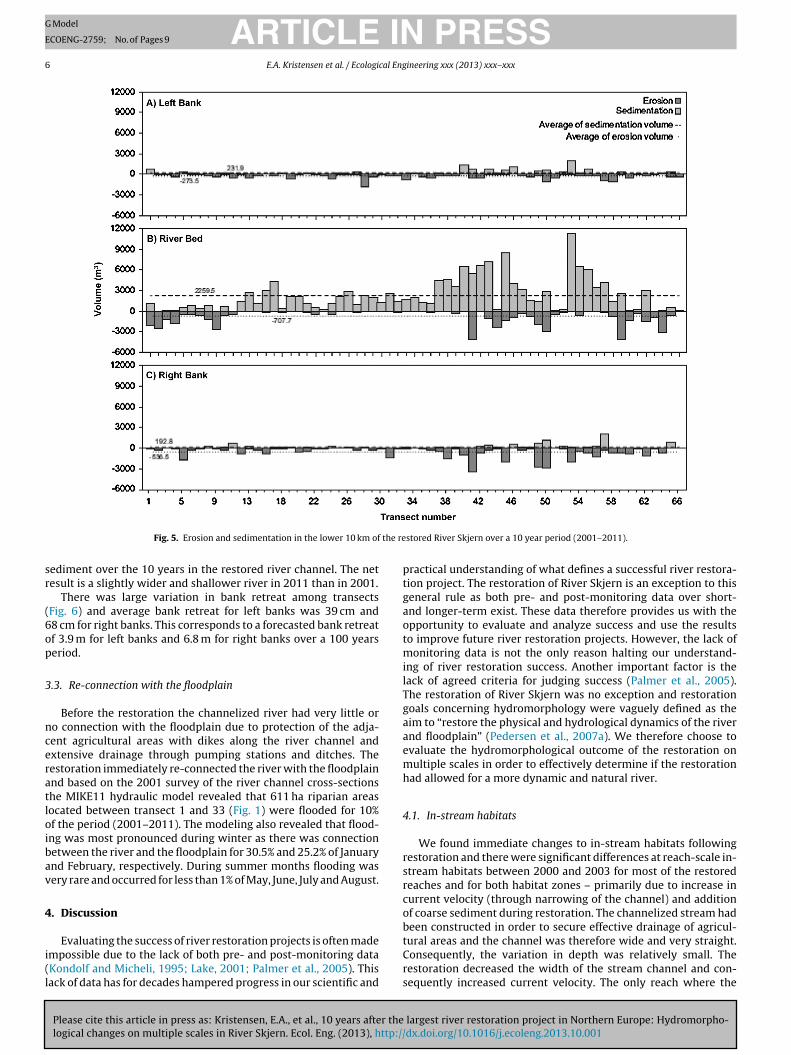
The survey of 65 cross-sectional transects along the lower 10 kmf River Skjern in 2001 and again in 2011 revealed marked mor-hological adjustments through erosion and sedimentation in theewly restored stream channel (Fig. 4). There was large varia-ions in the morphological adjustments among transects duringhe 10 year period (Fig. 5). Average sedimentation and erosion vol-me (±SD) measured at the left bank amounted to 231 ± 360 m3
nd 274 ± 325 m3, respectively, resulting in a net erosion of 43 m3
ediment. For the right bank, average sedimentation and erosionolume (±SD) was 192 ± 340 m3 and 536 ± 740 m3, respectively,ielding a net erosion of 344 m3 sediment. However, the most pro-ounced morphological changes were observed at the river bed.verage sedimentation (±SD) for this part of the cross-sectional
3
largest river restoration project in Northern Europe: Hydromorpho-dx.doi.org/10.1016/j.ecoleng.2013.10.001
ig. 4. Example of cross-sectional adjustments of the River Skjern between 2001nd 2012.
ARTICLE IN PRESSG Model
ECOENG-2759; No. of Pages 9
6 E.A. Kristensen et al. / Ecological Engineering xxx (2013) xxx– xxx
the re
sr
(6op
3
nceratloibav
4
i(l
ptgaotmilTgaaemh
4
rsrcob
Fig. 5. Erosion and sedimentation in the lower 10 km of
ediment over the 10 years in the restored river channel. The netesult is a slightly wider and shallower river in 2011 than in 2001.
There was large variation in bank retreat among transectsFig. 6) and average bank retreat for left banks was 39 cm and8 cm for right banks. This corresponds to a forecasted bank retreatf 3.9 m for left banks and 6.8 m for right banks over a 100 yearseriod.
.3. Re-connection with the floodplain
Before the restoration the channelized river had very little oro connection with the floodplain due to protection of the adja-ent agricultural areas with dikes along the river channel andxtensive drainage through pumping stations and ditches. Theestoration immediately re-connected the river with the floodplainnd based on the 2001 survey of the river channel cross-sectionshe MIKE11 hydraulic model revealed that 611 ha riparian areasocated between transect 1 and 33 (Fig. 1) were flooded for 10%f the period (2001–2011). The modeling also revealed that flood-ng was most pronounced during winter as there was connectionetween the river and the floodplain for 30.5% and 25.2% of Januarynd February, respectively. During summer months flooding wasery rare and occurred for less than 1% of May, June, July and August.
. Discussion
Please cite this article in press as: Kristensen, E.A., et al., 10 years after thelogical changes on multiple scales in River Skjern. Ecol. Eng. (2013), http://
Evaluating the success of river restoration projects is often madempossible due to the lack of both pre- and post-monitoring dataKondolf and Micheli, 1995; Lake, 2001; Palmer et al., 2005). Thisack of data has for decades hampered progress in our scientific and
tCrs
stored River Skjern over a 10 year period (2001–2011).
ractical understanding of what defines a successful river restora-ion project. The restoration of River Skjern is an exception to thiseneral rule as both pre- and post-monitoring data over short-nd longer-term exist. These data therefore provides us with thepportunity to evaluate and analyze success and use the resultso improve future river restoration projects. However, the lack of
onitoring data is not the only reason halting our understand-ng of river restoration success. Another important factor is theack of agreed criteria for judging success (Palmer et al., 2005).he restoration of River Skjern was no exception and restorationoals concerning hydromorphology were vaguely defined as theim to “restore the physical and hydrological dynamics of the rivernd floodplain” (Pedersen et al., 2007a). We therefore choose tovaluate the hydromorphological outcome of the restoration onultiple scales in order to effectively determine if the restoration
ad allowed for a more dynamic and natural river.
.1. In-stream habitats
We found immediate changes to in-stream habitats followingestoration and there were significant differences at reach-scale in-tream habitats between 2000 and 2003 for most of the restoredeaches and for both habitat zones – primarily due to increase inurrent velocity (through narrowing of the channel) and additionf coarse sediment during restoration. The channelized stream hadeen constructed in order to secure effective drainage of agricul-
largest river restoration project in Northern Europe: Hydromorpho-dx.doi.org/10.1016/j.ecoleng.2013.10.001
ural areas and the channel was therefore wide and very straight.onsequently, the variation in depth was relatively small. Theestoration decreased the width of the stream channel and con-equently increased current velocity. The only reach where the

ARTICLE ING Model
ECOENG-2759; No. of Pages 9
E.A. Kristensen et al. / Ecological Eng
Fp
rtr4aiKottra
tscn1tsfedabc
tdtLacttaasotsnpisww
4
cmbfptagduticeoibacboi(sDtapate
wAhaoand Bravard, 1996; Hooke, 2004). We measured the lateral migra-
ig. 6. Bank retreat in the lower 10 km of the restored River Skjern over a 10 yeareriod.
estoration did not have an immediate impact on in-stream condi-ion was the reach located most downstream (R1). At this reach, theestoration only decreased average transects width from 47.7 m to5.7 m (4% decrease), while the decrease in average width was 29%nd 17% for reaches R2 and R3, respectively. The addition of gravels a common restoration practice in Denmark (Pedersen et al., 2009;ristensen et al., 2011) and R2 and R3 also received gravel as partf the restoration. Gravel was not added to R1 which together withhe limited reduction in width reflects the downstream location ofhis reach. Excessive addition of coarse material and further nar-owing of the stream channel would therefore not have been inccordance with the natural river type for this location.
10 years after the restoration, we found that the in-stream habi-ats had gone through very little changes compared to the 2003ituation. The condition of all restored reaches was not signifi-antly different from the condition created 10 years before. Byature, rivers and river channels are temporally variable (Rosgen,996) and natural rivers are characterized by continuous changeso channel form and habitats (Petts et al., 1995). These naturaltructural processes are important for river biodiversity and bio-unction (Elosegi et al., 2010) and therefore ultimately for thecological quality of rivers. However, defining the natural level ofynamic hydromorphological processes in rivers are not easy (Sear
Please cite this article in press as: Kristensen, E.A., et al., 10 years after thelogical changes on multiple scales in River Skjern. Ecol. Eng. (2013), http://
nd Newson, 2003; Newson and Large, 2006) and relatively sta-le periods might be interspersed with periods of disturbance orhange. Large changes to in-stream habitats in River Skjern over
t6r
PRESSineering xxx (2013) xxx– xxx 7
he time spand of our evaluation would probaply require moreynamism than is possible at the moment. This is primarilly dueo the lack of large structuring elements (e.g. large woody debris;WD) in the river – elements that can be transported downstreamnd create erosion of banks and streambed and consequentlyhange the habitats. The question is therefore if the restoration ofhe lower River Skjern has created an artificially stable conditionhat leaves little room for the dynamics that forms natural riversnd creates habitats for a large variety of flora and fauna? Definitivenswers to this question are difficult due to the relatively short timepan of our evaluation however, it is very likely that increasing theccurrence of LWD in the rivers would increase the dynamism ofhe river. This would require a change to the current managementtrategy of Danish rivers where LWD are removed from the chan-els. Furthermore, it is importance to acknowledge the fact that weerformed a transect-scale analysis of the long-term development
n physical conditions. Had we done the evaluation on a smallercale (e.g. quadrate-scale or microhabitat scale) temporal changesould most likely have been larger as temporal dynamics increaseith decreasing spatial scale (Frissell et al., 1986).
.2. Sedimentation, erosion and bank retreat
Immediately following restoration, the newly created streamhannel of River Skjern experienced marked morphological adjust-ents because of the unconsolidated state of the river bed and
anks (Pedersen et al., 2007b). This phenomenon has been reportedor other river restoration projects as well (e.g. Sear et al., 1998). Theresent study has documented further morphological adjustmentso the channel and 10 years later erosion and sedimentation hasltered the cross-sectional profiles significantly. Along the investi-ated 10 km of river there was a surplus of sediment indicating aecrease in bed sediment transport capacity compared to furtherpstream. Over time the surplus of sediment and deposition alonghe lower parts of the River Skjern will lead to increased flood-ng that potentially will erode flood channels that again potentiallyould develop into permanent channels and recreate the formerlyxisting anastomosing river planform. Furthermore, the surplusf sediment can also over time lead to the formation of fluvialslands – a habitat type that existed historically in the river. It muste estimated that the time horizon of a new naturally developednastomosing river and fluvial islands pattern is long, probablyenturies. There are yet no safe indications on this developmenteing ongoing. In other river types (braided rivers) the formationf islands occurs over 10–20 years (Gurnell et al., 2001) and is typ-cally initiated when LWD lodges on a shallow section of the riverWard et al., 2002). The formation of islands process is probablylower in lowland rivers and LWD is completely absent from mostanish rivers (including River Skjern) as trees are often not allowed
o grow along river channels due to their extensive use for farmingnd any wood are routinely removed through river maintenanceractices (Kristensen et al., 2012). Abandoning this practice andllowing trees along rivers and LWD in the rivers would benefithe creation of dynamic river channels (Gurnell et al., 2005) andventually speed up the formation of fluvial islands.
In general, is the dynamics of river channels dependent onhich scale the morphological changes occur (Frissell et al., 1986).t small scale (e.g. sediment rearrangement), changes occur overours or days (Elosegi et al., 2010). Changes at a larger scale, suchs lateral migration of river channels that leads to meander cut-ff and the formation of oxbow lakes can take centuries (Gilvear
largest river restoration project in Northern Europe: Hydromorpho-dx.doi.org/10.1016/j.ecoleng.2013.10.001
ion rates (bank retreat) of River Skjern to be 3.9 cm/year and.8 cm/year for the left and right bank, respectively. Compared toeported migration rates for another Danish river (River Odense)
ING Model
E
8 al Eng
tbomeoSnecHecnlhhbrsa
4
waEt3nDwttfl(wewmepStclimsHotfc
5
meipe
tchtdsw(a(oRcltaswaeatdi(varw
A
pat
R
A
A
A
B
B
B
B
B
D
ARTICLECOENG-2759; No. of Pages 9
E.A. Kristensen et al. / Ecologic
he rate for River Skjern is relatively high (Kronvang et al., 2012)ut the rate is relatively low compared to lowland rivers fromther regions (Gilvear and Bravard, 1996). Meander cutoff and for-ation of oxbow lakes in the restored river can therefore not be
xpected within the next centuries. Historical maps confirm thatxbow lakes and fluvial islands were features of the lower Riverkjern before channelization and drainage however, these chan-el characteristic were not re-created during restoration (Pedersent al., 2007a). There has been extensive research on the roles ofhannel complexity on biodiversity and ecosystem functioning (e.g.utchinson, 1959; Beisel et al., 1998; Aldridge et al., 2009; Elosegit al., 2010) providing evidence for a positive relationship betweenomplexity and biodiversity. Given the extensive periods of timeeeded before spontaneous re-formation of islands and oxbow
akes in River Skjern and the fact that these features were presentistorically, active re-creation of them during restoration wouldave increased chances of ecosystem recovery. We did not includeiological samples in the current evaluation of the River Skjernestoration however, it is likely that species inhabiting shallow andlow-flowing areas (e.g. backwaters or oxbow lakes) have not made
full recovery due to the scarcity of these habitats today.
.3. Re-connection with the floodplain
The restoration of the lower River Skjern re-connected the riverith the floodplain and large areas are frequently flooded and some
reas are even permanently water filled (Andersen et al., 2005).specially the birdlife has responded positively to this change andhe number of breeding species in the area increased from 7 to1 between 2000 and 2003 (Andersen et al., 2005) however, thisumber has declined in recent years (Holm, T.E., unpublished data).uring flooding, the water delivers sediment to the floodplainhich contains seeds and the re-connection can therefore help
o increase the possibility of re-colonization by plant species tohe riparian areas (Baattrup-Pedersen et al., 2012). Furthermore,ooding can also increase retention of phosphorous and nitrogenBaldwin and Mitchell, 2000; Kronvang et al., 2007) that other-ise would end up in the marine recipient and potentially cause
nvironmental problems. The benefits from re-connection of riversith their floodplain are therefore plentiful and there are manyore than the ones mentioned here (Tockner et al., 2000). How-
ver, the flooding along River Skjern does not follow a naturalattern. It has previously been estimated that discharge in Riverkjern have to be above 40 m3/s before the river is connected withhe floodplain (Andersen et al., 2005). This threshold value is aonsequence of a desire to limit water flow through riparian wet-ands and the construction of the restored river channel thereforencluded a designated in-flow area. This design was used to mini-
ize the loss through predation of downstream migrating Atlanticalmon smolts (Salmo salar) in the wetlands (Andersen et al., 2005).owever, this design limits the flooding frequency and the amountf water that flow into the floodplain (Andersen et al., 2005). Fur-hermore, the limited connection probably also has consequencesor the morphological dynamics of the restored river channel as thehannel is fixed in places to maintain the design.
. Conclusion
With this study we have highlighted the value of long-termonitoring following river restoration and present data from an
Please cite this article in press as: Kristensen, E.A., et al., 10 years after thelogical changes on multiple scales in River Skjern. Ecol. Eng. (2013), http://
valuation 10 years after one of the largest river restoration projectsn Europe. Long-term monitoring is rare and this study thereforerovides us with a unique opportunity to improve our knowl-dge about restoration success (Palmer et al., 2005). We evaluated
D
E
PRESSineering xxx (2013) xxx– xxx
he restoration on three different morphological scales (in-stream,hannel morphology and re-connection with the floodplain) andow the morphology had hanged over the last 10 years. We foundhat in-stream habitats had changed very little since the imme-iate change following restoration and that the relatively stabletream channels were created during restoration. Along this line,e also measured the dynamic processes shaping river channels
erosion and sedimentation) and found that the rate of changesre relatively slow and the spontaneous creation of lost habitatsislands, backwaters and oxbow lakes) will take centuries. More-ver, although we found that the restoration had re-connected theiver Skjern with its floodplain, this re-connection was tamed andontrolled. If the aim of restoring River Skjern was to bring back theost habitats, and the flora and fauna associated with these, we canherefore concluded that the restoration is not yet a success. Riversre dynamic and the processes that will shape the lost habitats arelow and even within the scope of the present study (10 years),hich is relatively long-term, the success can therefore be evalu-
ted. However, to speed up this process we recommend restorationngineering using a natural guiding image when restoring streamsnd rivers in the future and through this restoring the lost habi-ats and the dynamic processes characteristic of natural rivers. Weid not evaluate the biological recovery of River Skjern follow-
ng restoration in the present study, but recently collected dataWiberg-Larsen, unpublished data) suggest that the many macroin-ertebrate and macrophytes associated with islands, backwatersnd other slow-flowing areas have not returned to the restorediver – partly because the habitats have not been re-created. Onlyhen doing this we can expect a return of the lost species.
cknowledgements
This study was funded by the 15. Juni Foundation and the EUroject REFORM. We wish to thank Sandra Hille for statisticaldvice and Uffe Mensberg and Henrik Stenholt for assistance inhe field.
eferences
ldridge, K.T., Brookes, J.D., Ganf, G.G., 2009. Rehabilitation of stream ecosystemfunctions through the reintroduction of coarse particulate organic matter. Res.Ecol. 17, 97–106.
llan, D.J., Flecker, A.S., 1993. Biodiversity conservation in running waters. Bio-Science 43, 32–43.
ndersen, J.M., Jessen, K., Larsen, B.B., Bundgaard, P., Glüsing, H., Illum, T., Hansen,L.B., Damgaard, O., Koed, A., Baktoft, H., Jensen, J.H., Linnemann, M., Ovesen, N.B.,Svendsen, L.M., Bregnballe, T., Skriver, J., Baattrup-Pedersen, A., Pedersen, M.L.,Madsen, A.B., Amstrup, O., Bak, B., 2005. Restoration of River Skjern (in Danish).Scientific Report from NERI no. 531.
aldwin, D.S., Mitchell, A.M., 2000. The effects of drying and re-flooding on thesediment and soil nutrient dynamics of lowland river–floodplain systems: asynthesis. Reg. Rivers: Res. Manag. 16, 457–467.
eisel, J.N., Usseglio-polatera, P., Thomas, S., Moreteau, J.-C., 1998. Stream com-munity structure in relation to spatial variation: the influence of mesohabitatcharacteristics. Hydrobiologia 422, 163–171.
ernhardt, E.S., Palmer, M.A., Allan, J.D., Alexander, G., Barnas, K., Brooks, S., Carr,J., Clayton, S., Dahm, C.N., Follstad-Shah, J., Galat, D.L., Closs, S., Goodwin, P.,Hart, D.D., Hassett, B., Jenkinson, R., Katz, S., Kondolf, G.M., Lake, P.S., Lave, R.,Meyer, J.L., O’Donnell, T.K., Pagano, L., Powell, B., Sudduth, E., 2005. Ecology –synthesizing US river restoration efforts. Science 308, 636–637.
rookes, A., Long, A.J., 1990. Chart Catchment Morphological Survey: AppraisalReport and Watercourse Summaries. National Rivers Authority Reding.
aattrup-Pedersen, A., Dalkvist, D., Dybkjær, J.B., Riis, T., Larsen, S.E., Kro-nvang, B., 2012. Species recruitment following flooding, sedimentdeposition and seed addition in restored riparian areas. Res. Ecol.,http://dx.doi.org/10.1111/j.1526-100X.2012.00893.x.
HI, 2011. MIKE 11 – A Modelling System for Rivers and Channels, Reference Man-
largest river restoration project in Northern Europe: Hydromorpho-dx.doi.org/10.1016/j.ecoleng.2013.10.001
ual. Danish Hydraulic Institute, pp. 536.obson, A.P., Bradshaw, A.D., Baker, J.M., 1997. Hopes for the future: restoration
ecology and conservation biology. Science 277, 515–522.losegi, A., Díez, J.R., Mutz, M., 2010. Effects of hydromorphological integrity on
biodiversity and functioning of river ecosystems. Hydrobiologia 657, 199–215.
ING Model
E
al Eng
E
F
F
F
G
G
G
H
H
H
K
K
K
K
K
K
K
K
K
L
L
LL
M
M
N
O
O
P
P
P
P
P
R
R
R
S
S
S
S
SS
T
T
V
V
V
V
VW
W
W
W
ARTICLECOENG-2759; No. of Pages 9
E.A. Kristensen et al. / Ecologic
uropean Environment Agency, 1998. Europe’s Environment – The Second Assess-ment – An Overview. State of the Environment Report. EEA, Copenhagen, pp.293.
eld, C.K., Birk, S., Bradley, D.C., Hering, D., Kail, J., Marzin, A., Melcher, A., Nemitz, D.,Pedersen, M.L., Pletterbauer, F., Pont, D., Verdonschot, P.F.M., Friberg, N., 2011.From natural to degraded rivers and back again: a test of restoration ecologytheory and practice. Adv. Ecol. Res. 44, 119–209.
riberg, N., Kronvang, B., Hansen, H.O., Svendsen, L.M., 1998. Long-term, habitat-specific response of a macroinvertebrate community to river restoration. Aquat.Conserv. 8, 87–99.
rissell, C.A., Liss, W.L., Warren, C.E., Hurley, M.D., 1986. A hierarchical framework forstream habitat classification: viewing streams in a watershed context. Environ.Manag. 10, 199–214.
ilvear, D., Bravard, J.P., 1996. Geomorphology of temperate rivers. In: Petts,G.E., Amoros, C. (Eds.), Fluvial Hydrosystems. Chapman & Hall, London,pp. 68–97.
urnell, A., Petts, G., Hannah, D.M., Smith, B.P.G., Edwards, P.J., Kollmann, J., Ward,J.V., Tockner, K., 2001. Riparian vegetation and island formation along the gravel-bed Fiume Tagliamento, Italy. Earth Surf. Process. Landforms 26, 31–62.
urnell, A., Teckner, K., Edwards, P., Petts, G., 2005. Effects of deposited wood onbiocomplexity of river corridors. Fron. Ecol. Environ. 3, 377–382.
illman, M., Brierly, G., 2005. A critical review of catchment-scale rehabilitationprogrammes. Prog. Phys. Geograp. 29, 50–70.
ooke, J.M., 2004. Cutoffs galore!: occurrence and causes of multiple cutoffs on ameandering river. Geomorphology 61, 225–238.
utchinson, G.E., 1959. Homage to Santa Rosalia or why are there so many kinds ofanimals? Am. Nat. 93, 145–159.
asahara, T., Hill, A.R., 2008. Modeling the effects of lowland stream restorationprojects on stream–subsurface water exchange. Ecol. Eng. 32, 310–319.
MS, 2010. Danmarks Højdemodel – DHM Terræn. National Survey and Cadastre,pp. 1–10 (In Danish).
ondolf, G.M., Boulton, A.J., O’Daniel, S., Poole, G.C., Rahel, F.J., Stanley, E.H., Wohl, E.,Bång, A., Carlstrom, J., Cristoni, C., Huber, H., Koljonen, S., Louhi, P., Nakamura, K.,2006. Process-based ecological river restoration: visualizing three-dimensionalconnectivity and dynamic vectors to recover lost linkages. Ecol. Soc. 11, 1–17.
ondolf, G.M., Micheli, E.R., 1995. Evaluating stream restoration projects. Environ.Manage. 19, 1–15.
ristensen, E.A., Baattrup-Pedersen, A., Jensen, P.N., Wiberg-Larsen, P., Friberg, N.,2012. Selection, implementation and cost of restorations in lowland streams: abasis for identifying restoration priorities. Environ. Sci. Policy 23, 1–11.
ristensen, E.A., Baattrup-Pedersen, A., Thodsen, H., 2011. An evaluation of restora-tion practises in lowland streams: has the physical integrity been re-created?Ecol. Eng. 37, 1654–1660.
ronvang, B., Andersen, I.K., Hoffmann, C.C., Pedersen, M.L., Ovesen, N.B., Andersen,H.E., 2007. Water exchange and deposition of sediment and phosphorus duringinundation of natural and restored lowland floodplains. Water Air Soil Pollut.181, 115–121.
ronvang, B., Audet, J., Baattrup-Pedersen, A., Jensen, H.S., Larsen, S.E., 2012. Phos-phorus load to surface water from bank erosionin a Danish lowland river basin.J. Environ. Qual. 41, 304–313.
ronvang, B., Svendsen, L.M., Brookes, A., Fisher, K., Møller, B., Ottosen, O., New-son, M., Sear, D., 1998. Restoration of the rivers Brede, Cole and Skerne: a jointDanish and British EU-LIFE demonstration project, III – channel morphology,hydrodynamics and transport of sediment and nutrients. Aquat. Conserv. 8,209–222.
ake, P.S., 2001. On the maturing of restoration: linking ecological research andrestoration. Ecol. Manage. Res. 2, 110–115.
arson, M.G., Booth, D.B., Morley, S.A., 2001. Effectiveness of large woody debris instream rehabilitation projects in urban basins. Ecol. Eng. 18, 211–226.
eica Geosystems, 2010. Leica Viva Netrover, Datasheet. Leice Geosystems.oomis, J., Kent, P., Strange, L., Fausch, K., Covich, A., 2000. Measuring the total eco-
nomic value of restoring ecosystem services in an impaired river basin: resultsfrom a contingent valuation survey. Ecol. Econ. 33, 103–117.
iall, A.D., 1977. Review of braided-river depositional environment. Earth Sci. Rev.13, 1–62.
iller, S.W., Budy, P., Schmidt, J.C., 2010. Quantifying macroinvertebrate responsesto in-stream habitat restoration: applications of meta-analysis to river restora-tion. Res. Ecol. 18, 8–19.
ewson, M.D., Large, A.R.G., 2006. ‘Natural’ rivers, ‘hydromorphological quality’ and
Please cite this article in press as: Kristensen, E.A., et al., 10 years after thelogical changes on multiple scales in River Skjern. Ecol. Eng. (2013), http://
river restoration: a challenging new agenda for applied fluvial geomorphology.Earth Surf. Process. Landforms 31, 1606–1624.
’Hare, M.T., Baattrup-Pedersen, A., Nijboer, R., Szoszkiewicz, K., Ferreira, T., 2006.Macrophyte communities of European streams with altered physical habitat.Hydrobiologia 566, 197–210.
W
PRESSineering xxx (2013) xxx– xxx 9
vesen, N.B., Iversen, H.L., Larsen, S., Müller-Wohlfeil, D.I., Svendsen, L.M., 2000.Runoff in Danish water courses (in Danish). Scientific Report from NERI no. 340.
almer, M.A., Bernhardt, E.S., Allan, J.D., Lake, P.S., Alexander, G., Brooks, S., Carr,J., Clayton, S., Dahm, C.N., Follestad Shan, J., Galat, D.L., Loss, S.G., Goodwin, P.,Hart, D.D., Hassett, B., Jenkinson, R., Kondolf, G.M., Lave, R., Meyr, L.J., O’Donnell,T.K., Pagano, L., Sudduth, E., 2005. Standards for ecologically successful riverrestoration. J. Appl. Ecol. 42, 208–217.
edersen, M.L., Andersen, J.M., Nielsen, K., Linnemann, M., 2007a. Restoration ofSkjern River and its valley: project description and general ecological changesin the project area. Ecol. Eng. 30, 131–144.
edersen, M.L., Friberg, N., Skriver, J., Baattrup-Pedersen, A., 2007b. Restoration ofSkjern River and its valley – short-term effects on river habitats, macrophytesand macroinvertebrates. Ecol. Eng. 30, 145–156.
edersen, M.L., Kristensen, E.A., Kronvang, B., Thodsen, H., 2009. Ecological effectsof re-introduction of salmonid spawning gravel in lowland Danish streams. R.Res. Appl. 25, 626–638, http://dx.doi.org/10.1002/rra.1232.
etts, G., Maddock, I., Bickerton, M., Ferguson, A.J.D., 1995. Linking hydrology andecology: the scientific basis for river management. In: Harper, D.M., Ferguson,A.J.D. (Eds.), The Ecological Basis for River Management. John Wiley, Chichester,pp. 1–16.
Core Team, 2012. A Language and Environment for Statistical Computing. R CoreTeam, Vienna, Austria.
ichards, K.S., 1997. Channel morphology and dynamics. In: Thorne, C.R., Hey, R.D.,Newson, M.D. (Eds.), Applied Fluvial Geomorphology for River Engineering andManagement. Wiley & Sons, p. 376.
osgen, D.L., 1996. Applied River Morphology, Wildland Hydrology. Pagosa Springs,Colorado (USA).
ala, O.E., Chapin III, F.S., Armesto, J.J., Berlow, E., Bloomfield, J., Dirzo, R., Huber-Sanwald, E., Huenneke, L.F., Jackson, R.B., Kinzig, A., Leemans, R., Lodge, D.M.,Mooney, H.A., Oesterheld, M., Poff, N.L., Sykes, M.T., Walker, B.H., Walker, M.,Wall, D.H., 2000. Global biodiversity scenarios for the year 2100. Science 287,1770–1774.
ear, D.A., Briggs, A., Brookes, A., 1998. A priliminary analysis of the morpholog-ical adjustment within and downstream of a lowland river subject to riverrestoration. Aquat. Conserv. 8, 167–183.
ear, D.A., Newson, M.D., 2003. Environmental change in river channels: a neglectedelement. Towards geomorphological typologies, standards and monitoring. Sci.Total Environ. 310, 17–23.
ˆípek, V., Matousková, M., Dvorák, M., 2009. Comparative analysis of selected hydro-morphological assessment methods. Environ. Monit. Assess. 169, 309–319.
med, P., 1982. Geomorphological Maps of Denmark. Geograf Forlaget.parks, R.E., 1995. Need for ecosystem management of large rivers and their flood-
plains. Bioscience 45, 168–182.hodsen, H., Pedersen, J.B.T., Svinth, S., Sunesen, S.T., 2006. The influence of climate
change on bed sediment transport in the alluvial River Kongeå, Denmark. In:Refsgaard, J.C., Højbjerg, A.J. (Eds.), XXIV Nordic Hydrological Conference 2006.Experiences and Challenges in implementation of the EU Water FrameworkDirective, NHP Report. Vingsted, Denmark, pp. 593–600.
ockner, K., Malard, F., Ward, J.V., 2000. An extension of the flood pulse concept.Hydrol. Process. 14, 2861–2883.
an den Brink, P.J., den Besten, P.J., Bij de Vaate, A., Ter Braak, C.J.F., 2009. Principalresponse curves technique for the analysis of multivariate biomonitoring timeseries. Environ. Monit. Assess. 152, 271–281.
an den Brink, P.J., Ter Braak, C.J.F., 1999. Principal response curves: analysis of time-dependent multivariate responses of biological community to stress. Environ.Toxicol. Chem. 18, 138–148.
erdonschot, P.F.M., Niiboer, R.C., 2002. Towards a decision support system forstream restoration in the Netherlands: an overview of restoration projects andfuture needs. Hydrobiologia 478, 131–148.
itousek, P.M., Mooney, H.A., Lubchenko, J., Melillo, J.M., 1997. Human dominationof Earth’s ecosystems. Science 277, 494–499.
ogel, R., 2011. Hydromorphology. J. Water Resour. Plan. Manage. 137, 147–149.ard, J.V., Tockner, K., Arscott, D.B., Claret, C., 2002. Riverine landscape diversity.
Freshw. Biol. 47, 517–539.entworth, C.K., 1922. A scale for grade and class terms of clastic sediments. J. Geol.
30, 377–392.ilcove, D.S., Rothstein, D., Dubow, J., Phillips, A., Losos, E., 1998. Quantifying threats
to imperiled species in the United States. BioScience 48, 607–615.illiams, P.B., 2001. River engineering versus river restoration. In: Hayes, D.F. (Ed.),
largest river restoration project in Northern Europe: Hydromorpho-dx.doi.org/10.1016/j.ecoleng.2013.10.001
Proceedings of the 2001 Wetlands Engineering and River Restoration Confer-ence, Reno, Nevada.
ohl, E., Angermeier, P.L., Bledsoe, B., Kondolf, G.M., MacDonnell, L., Merritt, D.M.,Palmer, M.A., Poff, N.L., Tarboton, D., 2005. River restoration. Water Resour. Res.41, 1–12, http://dx.doi.org/10.1029/2005WR003985.