1.0 project report cover page · detailed within the standards and guidelines for consultant...
TRANSCRIPT

1.0 PROJECT REPORT COVER PAGE
LICENSEE INFORMATION: Contact Information: Michael B. Henry CD BA FRAI FRSA Southwestern District Office
553 Dufferin Avenue London, ON N6B 2A5 Phone: (419) 432-4435 Email: [email protected] www.amick.ca
Licensee: Sarah MacKinnon MSc Ontario Archaeology Licence: P1024 PROJECT INFORMATION: Corporate Project Number: 16898 MTCS Project Number: P1024-0159-2016 Investigation Type: Stage 1-2 Archaeological Assessment Project Name: St. George. Project Location: 191 German School Road and 40 Beverly Street, Part of Lots 7 & 8, Concession 2, Township of South
Dumfries, County of Brant Project Designation Number: Not Currently Available MTCS FILING INFORMATION: Site Record/Update Forms: 13 February 2017 Date of Report Filing: April 20 2017 Type of Report: ORIGINAL

2016 Stage 1-2 Archaeological Assessment of 191 German School Road and 40 Beverly Street, Part of Lots 7 & 8, Concession 2, Township of South Dumfries, County of Brant
(AMICK File #16898/MTCS File #P1024-0159-2016)
AMICK Consultants Limited Page 2
2.0 EXECUTIVE SUMMARY This report describes the results of the 2016 Stage 1-2 Archaeological Assessment of 191 German School Road and 40 Beverly Street, Part of Lots 7 & 8, Concession 2, Township of South Dumfries, County of Brant, conducted by AMICK Consultants Limited. This study was conducted under Professional Archaeologist License #P1024 issued to Sarah MacKinnon by the Minister of Tourism, Culture and Sport for the Province of Ontario. This assessment was undertaken as a requirement under the Planning Act (RSO 1990b) and the Provincial Policy Statement (2014) in order to support a Draft Plan of Subdivision application and companion Zoning By-law Amendment application as part of the pre-submission process. Within the land use planning and development context, Ontario Regulation 544/06 under the Planning Act (1990b) requires an evaluation of archaeological potential and, where applicable, an archaeological assessment report completed by an archaeologist licensed by the Ministry of Tourism, Culture and Sport (MTCS). Policy 2.6 of the Provincial Policy Statement (PPS 2014) addresses archaeological resources. All work was conducted in conformity with Ontario Ministry of Tourism and Culture (MTC) Standards and Guidelines for Consultant Archaeologists (MTC 2011), the Ontario Heritage Act (RSO 1990a). AMICK Consultants Limited was engaged by the proponent to undertake a Stage 1-2 Archaeological Assessment of lands potentially affected by the proposed undertaking and was granted permission to carry out archaeological fieldwork. The entirety of the study area was subject to property inspection and photographic documentation concurrently with the Stage 2 Property Assessment on May 31, July 8, 15, 18, 20-22, 25-29, August 2-4, 8-11, 23, October 26-28, 31, and November 1, 2, 7-10, 18, and 21, 2016, consisting of high-intensity test pit survey at intervals of five and ten metres between individual test pits and high intensity pedestrian survey at intervals of one and five metres between individual transects. All records, documentation, field notes, photographs and artifacts (as applicable) related to the conduct and findings of these investigations are held at the Lakelands District corporate offices of AMICK Consultants Limited until such time that they can be transferred to an agency or institution approved by the Ontario Ministry of Tourism, Culture and Sport (MTCS) on behalf of the government and citizens of Ontario. As a result of the property Assessment of the study area, three Post-Contact scatters (H1(AhHb-237), H2, H3(AhHb-238)), eleven Pre-contact lithic scatters, and twenty-four isolated Pre-Contact findspots were encountered. Of the resources encountered, two post-contact scatters (H1(AhHb-237) and H3(AhHb-238)) and six lithic scatters (P11(AhHb-239), P12(AhHb-240), P20(AhHb-241), P28(AhHb-242), P31(AhHb-243), and P33(AhHb-234)) the following recommendations are made:
1. Further study is warranted. Stage 3 Site-specific assessment of the archaeological sites identified as H1(AhHb-237), H3(AhHb-238), P11(AhHb-239), P12(AhHb-240), P20(AhHb-241), P28(AhHb-242), P31(AhHb-243), and P33(AhHb-234), is required.
2. The Stage 3 Site-specific Assessments for each of these sites will be completed as detailed within the Standards and Guidelines for Consultant Archaeologists (MTC 2011).
2016 Stage 1-2 Archaeological Assessment of 191 German School Road and 40 Beverly Street, Part of Lots 7 & 8, Concession 2, Township of South Dumfries, County of Brant
(AMICK File #16898/MTCS File #P1024-0159-2016)
AMICK Consultants Limited Page 3
3. No soil disturbances or removal of vegetation shall take place within the archaeological sites identified as H1(AhHb-237), H3(AhHb-238), P11(AhHb-239), P12(AhHb-240), P20(AhHb-241), P28(AhHb-242), P31(AhHb-243), and P33(AhHb-234) within this Stage 1-2 Archaeological Assessment report, or within the area enclosed within a 20 metre buffer surrounding the H1(AhHb-237), H3(AhHb-238), P11(AhHb-239), P12(AhHb-240), P20(AhHb-241), P28(AhHb-242), P31(AhHb-243), and P33(AhHb-234) sites prior to the acceptance of the Ministry of Tourism, Culture and Sport (MTCS) of a report recommending that all archaeological concerns for the H1(AhHb-237), H3(AhHb-238), P11(AhHb-239), P12(AhHb-240), P20(AhHb-241), P28(AhHb-242), P31(AhHb-243), and P33(AhHb-234) sites have been addressed and that there is no further cultural heritage value or interest for these sites.
4. Prior to pre-grading, servicing or registration, the owner shall erect and maintain a temporary high visibility construction fence to be maintained through the course of all construction activities at a 20 metre buffer around the archaeological sites identified as H1(AhHb-237), H3(AhHb-238), P11(AhHb-239), P12(AhHb-240), P20(AhHb-241), P28(AhHb-242), P31(AhHb-243), and P33(AhHb-234) to ensure that construction activities do not impinge upon H1(AhHb-237), H3(AhHb-238), P11(AhHb-239), P12(AhHb-240), P20(AhHb-241), P28(AhHb-242), P31(AhHb-243), and P33(AhHb-234) unless under the direct supervision of a consulting archaeologist licensed in Ontario by the Minister of Tourism, Culture and Sport and as a part of the ongoing archaeological investigations of that site.
5. The high visibility fence will be installed at the outer limit of the 20 metre wide Protective Buffer surrounding the H1(AhHb-237), H3(AhHb-238), P11(AhHb-239), P12(AhHb-240), P20(AhHb-241), P28(AhHb-242), P31(AhHb-243), and P33(AhHb-234) sites as illustrated in the accompanying mapping within the Supplementary Report Package of this report filed with MTCS prior to the commencement of any development activity anywhere within the proposed development.
6. A Fifty (50) metre wide Monitoring Buffer shall be observed surrounding the above-noted 20 metre wide Protective Buffer. Within the 50 metre Monitoring Buffer no ground altering works (including removal of vegetation or demolition of existing features) may be conducted unless under the direct supervision of a licensed archaeologist.
7. The licenced archaeologist supervising any work conducted within the 50 metre wide Monitoring Buffer has the authority to order a halt to any activity which in his or her view may result in adverse impacts to archaeological resources.
8. The 50 metre wide Monitoring Buffer will remain in effect until such time that the Stage 3 Site-specific Assessment report for the H1(AhHb-237), H3(AhHb-238), P11(AhHb-239), P12(AhHb-240), P20(AhHb-241), P28(AhHb-242), P31(AhHb-243), and P33(AhHb-234) sites identified within this Stage 1-2 Archaeological Assessment report is accepted into the Provincial Registry of Archaeological Reports by the Ontario Ministry of Tourism, Culture and Sport.
9. Written instructions will be provided to all persons permitted to enter the property to stay out of the area of the 20 metre wide Protective Buffer unless permitted to enter the area accompanied by a licenced archaeologist.

2016 Stage 1-2 Archaeological Assessment of 191 German School Road and 40 Beverly Street, Part of Lots 7 & 8, Concession 2, Township of South Dumfries, County of Brant
(AMICK File #16898/MTCS File #P1024-0159-2016)
AMICK Consultants Limited Page 4
10. Written instructions will be provided to all persons permitted to enter the property for the purposes of undertaking work associated with the development that no work is permitted to occur within the 50 metre wide Monitoring Buffer unless under direct supervision of a licenced archaeologist.
11. Written instructions will be provided to all persons permitted to conduct work within the 50 metre wide Monitoring Buffers that the licenced archaeologist has the authority to order a halt to any work that he or she feels may adversely impact archaeological resources.
12. It is anticipated that the fieldwork and reporting of the Stage 4 Mitigation of Development Impacts (if required) will be completed before the end of 2016 and it is not anticipated that any development activity will be necessary within the 50 metre wide Monitoring Buffers prior to the Spring of 2017.
13. The proponent must provide a letter on letterhead to MTCS itemizing all of the above conditions and committing to ensure that all of these recommendations are implemented. This letter must be submitted together with this report at the time of filing with MTCS.
14. It is recommended that the balance of the study area outside of the site areas and surrounding Protective Buffer be cleared of archaeological concern and that development activity be permitted to proceed, subject to the above provisions.
Of the remaining scatters and findspots, the following recommendations are made:
- No further archaeological assessment of sites H2, P1-P10, P13-P19, P21-P27, P29, P30, P32 and P34-35 is warranted;
- The Provincial with respect to the above noted archaeological sites H2, P1-P10, P13-P19, P21-P27, P29, P30, P32 and P34-35 has been addressed;
- Sites H2, P1-P10, P13-P19, P21-P27, P29, P30, P32 and P34-35 have yielded all data they are likely to produce and are clear of any archaeological concern.

2016 Stage 1-2 Archaeological Assessment of 191 German School Road and 40 Beverly Street, Part of Lots 7 & 8, Concession 2, Township of South Dumfries, County of Brant
(AMICK File #16898/MTCS File #P1024-0159-2016)
AMICK Consultants Limited Page 5
3.0 TABLE OF CONTENTS 1.0 PROJECT REPORT COVER PAGE 12.0 EXECUTIVE SUMMARY 23.0 TABLE OF CONTENTS 54.0 PROJECT PERSONNEL 55.0 PROJECT CONTEXT 76.0 FIELD WORK METHODS AND WEATHER CONDITIONS 187.0 RECORD OF FINDS 238.0 ANALYSIS AND CONCLUSIONS 309.0 RECOMMENDATIONS 3910.0 ADVICE ON COMPLIANCE WITH LEGISLATION 42311.0 BIBLIOGRAPHY AND SOURCES 44412.0 MAPS 46613.0 IMAGES 57 4.0 PROJECT PERSONNEL AMICK CONSULTANTS LIMITED PARTNERS Michael Henry (MTCS Professional Archaeologist Licence #P058) Marilyn Cornies (MTCS Professional Archaeologist Licence #P038) AMICK CONSULTANTS LIMITED BUSINESS MANAGER Melissa Maclean BBA email [email protected] PROJECT COORDINATOR Melissa Maclean PROJECT LICENSEE ARCHAEOLOGIST Sarah MacKinnon (MTCS Professional Archaeologist Licence #P1024) PROJECT FIELD DIRECTORS Kayleigh MacKinnon (MTCS Professional Archaeologist Licence #P384) Norbert Stanchly (MTCS Applied Research Archaeologist Licence #R149) Dan Savage (MTCS Applied Research Archaeologist Licence #R489) PROJECT FIELD ASSISTANTS Christopher Fairman Laura Burke (MTCS Applied Research Archaeologist Licence #R1113) Renee Hendricks Richard Meadows PROJECT REPORT PREPARATION Elizabeth Grant PROJECT HISTORIC ARTIFACT ANALYSES Norbert Stanchly (MTCS Applied Research Archaeologist Licence #R149) Dan Savage (MTCS Applied Research Archaeologist Licence #R489)

2016 Stage 1-2 Archaeological Assessment of 191 German School Road and 40 Beverly Street, Part of Lots 7 & 8, Concession 2, Township of South Dumfries, County of Brant
(AMICK File #16898/MTCS File #P1024-0159-2016)
AMICK Consultants Limited Page 6
PROJECT PRE-CONTACT ARTIFACT ANALYSES Norbert Stanchly (MTCS Applied Research Archaeologist Licence #R149) Dan Savage (MTCS Applied Research Archaeologist Licence #R489) PROJECT GRAPHICS Elizabeth Grant Norbert Stanchly (MTCS Applied Research Archaeologist Licence #R149) Dan Savage (MTCS Applied Research Archaeologist Licence #R489) PROJECT PHOTOGRAPHY Kayleigh MacKinnon (MTCS Professional Archaeologist Licence #P384) Norbert Stanchly (MTCS Applied Research Archaeologist Licence #R149) Dan Savage (MTCS Applied Research Archaeologist Licence #R489)

2016 Stage 1-2 Archaeological Assessment of 191 German School Road and 40 Beverly Street, Part of Lots 7 & 8, Concession 2, Township of South Dumfries, County of Brant
(AMICK File #16898/MTCS File #P1024-0159-2016)
AMICK Consultants Limited Page 7
5.0 PROJECT CONTEXT 5.1 DEVELOPMENT CONTEXT This report describes the results of the 2016 Stage 1-2 Archaeological Assessment of 191 German School Road and 40 Beverly Street, Part of Lots 7 & 8, Concession 2, Township of South Dumfries, County of Brant, conducted by AMICK Consultants Limited. This study was conducted under Professional Archaeologist License #P1024 issued to Sarah MacKinnon by the Minister of Tourism, Culture and Sport for the Province of Ontario. This assessment was undertaken as a requirement under the Planning Act (RSO 1990b) and the Provincial Policy Statement (2014) in order to support a Draft Plan of Subdivision application and companion Zoning By-law Amendment application as part of the pre-submission process. Within the land use planning and development context, Ontario Regulation 544/06 under the Planning Act (1990b) requires an evaluation of archaeological potential and, where applicable, an archaeological assessment report completed by an archaeologist licensed by the Ministry of Tourism, Culture and Sport (MTCS). Policy 2.6 of the Provincial Policy Statement (PPS 2014) addresses archaeological resources. All work was conducted in conformity with Ontario Ministry of Tourism and Culture (MTC) Standards and Guidelines for Consultant Archaeologists (MTC 2011), the Ontario Heritage Act (RSO 1990a). AMICK Consultants Limited was engaged by the proponent to undertake a Stage 1-2 Archaeological Assessment of lands potentially affected by the proposed undertaking and was granted permission to carry out archaeological fieldwork. The entirety of the study area was subject to property inspection and photographic documentation concurrently with the Stage 2 Property Assessment on May 31, July 8, 15, 18, 20-22, 25-29, August 2-4, 8-11, 23, October 26-28, 31, and November 1, 2, 7-10, 18, and 21, 2016, consisting of high-intensity test pit survey at intervals of five and ten metres between individual test pits and high intensity pedestrian survey at intervals of one and five metres between individual transects. All records, documentation, field notes, photographs and artifacts (as applicable) related to the conduct and findings of these investigations are held at the Lakelands District corporate offices of AMICK Consultants Limited until such time that they can be transferred to an agency or institution approved by the Ontario Ministry of Tourism, Culture and Sport (MTCS) on behalf of the government and citizens of Ontario. At the time of assessment, a draft plan of subdivision had not been supplied to AMICK Consultants Limited. Topographic surveys of the study area have been submitted together with this report to MTCS for review and reproduced within this report as Maps 3-6. 5.2 HISTORICAL CONTEXT 5.2.1 GENERAL HISTORICAL OUTLINE Located at the mid-point of the Grand River, Brant County began to be settled by European settlers in 1793. The name Brant comes from Joseph Brant, chief of the Six Nations confederacy. The Six Nations are a confederacy originally from Upper New York State who

2016 Stage 1-2 Archaeological Assessment of 191 German School Road and 40 Beverly Street, Part of Lots 7 & 8, Concession 2, Township of South Dumfries, County of Brant
(AMICK File #16898/MTCS File #P1024-0159-2016)
AMICK Consultants Limited Page 8
were granted land along the Grand River in recognition of their loyalty to the British Crown after the American Revolution in 1784. Brant was a part of the County of Wentworth until 1852 when it joined the townships of Brantford, Oakland, Onondaga, south Dumfries and Burford to Become Brant County. (“Heritage Driving,” 2009). Located in the North part of the county, South Dumfries earliest settlements were in and around the Village of St. George. The first establishments in the township were: a grist mill (1817), distillery (1818), grocery store (1820) log school (1823), and a post office in 1833. The first church was opened as a Baptist Church in 1824 (“Heritage Driving,” 2009). Map 2 is a facsimile segment of the Township of South Dumfries map reproduced from Illustrated Historical Atlas of the County of Brant, Ont (Page & Smith 1875). Map 2 illustrates the location of the study area and environs as of 1875. The study area is shown to be separated into eight properties. They belong to D.R., R. Lawraeon, J. Richardson, D. Burt, L. Howell, W. Glass, and Geo. Vanevery; two structures are located in the northwest, two structures are located in the east, and two structures are located in the south. This demonstrates that the original property of which the study area is a part was settled by the time that the atlas data was compiled. Accordingly, it has been determined that there is potential for archaeological deposits related to early Post-contact settlement within the study area. The study area is also southwest adjacent the historic town of Saint George. In addition, this map illustrates an unnamed stream channel situated immediately east of the study area, settlement roads are depicted as adjacent to the study area to the north, east, and south, and a historic railway is depicted as transecting the study area. These roads are the current Main St South, Beverly St West, and German School Road. The stream channel is unnamed. The railway is G.W.R.R, which recent maps no longer show. It must be borne in mind that inclusion of names of property owners and depictions of structures within properties on these maps were sold by subscription. While information included within these maps may provide information about occupation of the property at a specific point in time, the absence of such information does not indicate that the property was not occupied. 5.2.2 CURRENT CONDITIONS The present use of the study area is as actively farmed agricultural land. The study area is roughly 120 hectares in area. The study area includes within it mostly ploughable lands. Situated in the northwest corner of the study area is a residential lot. This property contains a house structure and adjacent shed and garage structure. Proceeding from the north of the study area to the house and garage structure is an asphalt driveway. Situated in the center of the north of the study area is a second residential lot. This lot contains a house and garage structure, with a similar asphalt driveway proceeding to the two from the north. Surrounding the structures of both lots are areas of lawn. The majority of the remainder of the study area consists of agricultural fields. Situated in the west and east of the study area are three large wooded areas. Located in the southeast of the study area and amid the agricultural fields in the northeast are areas of meadow. Throughout the study area, in the northeast, southeast,

2016 Stage 1-2 Archaeological Assessment of 191 German School Road and 40 Beverly Street, Part of Lots 7 & 8, Concession 2, Township of South Dumfries, County of Brant
(AMICK File #16898/MTCS File #P1024-0159-2016)
AMICK Consultants Limited Page 9
southwest, north central, south central, and center of the study area are large low lying and wet areas surrounding associated unnamed creeks and ponds. Adjacent these low lying and wet areas are areas of steep slope. Situated in the center and north center of the study area are large disturbed areas of gravel fill. The study area is bounded on the north by Beverly St West, on the east by Main St South, on the west by existing residential and agricultural, and on the south by German School Road. The study area is approximately 100 metres to the northwest of the intersection of the German School Road and Main St South. A plan of the study area is included within this report as Maps 3-6. Current conditions encountered during the Stage 1-2 Property Assessment are illustrated in Maps 7-11. 5.2.3 SUMMARY OF HISTORICAL CONTEXT The brief overview of documentary evidence readily available indicates that the study area is situated within an area that was close to the historic transportation routes and in an area well populated during the nineteenth century and as such has potential for sites relating to early Post-contact settlement in the region. Background research indicates the property has potential for significant archaeological resources of Native origins based on proximity to a natural source of potable water in the past. 5.3 ARCHAEOLOGICAL CONTEXT The Archaeological Sites Database administered by the Ministry of Tourism, Culture and Sport (MTCS) indicates that there are thirty-one (31) previously documented sites within 1 kilometre of the study area. However, it must be noted that this is based on the assumption of the accuracy of information compiled from numerous researchers using different methodologies over many years. AMICK Consultants Limited assumes no responsibility for the accuracy of site descriptions, interpretations such as cultural affiliation, or location information derived from the Archaeological Sites Database administered by MTCS. In addition, it must also be noted that a lack of formerly documented sites does not indicate that there are no sites present as the documentation of any archaeological site is contingent upon prior research having been conducted within the study area. On the basis of information supplied by MTCS, no archaeological assessments have been conducted within 50 metres of the study area. AMICK Consultants Limited assumes no responsibility for the accuracy of previous assessments, interpretations such as cultural affiliation, or location information derived from the Archaeological Sites Database administered by MTCS. In addition, it must also be noted that the lack of formerly documented previous assessments does not indicate that no assessments have been conducted. Data contained in previous archaeological reports in close proximity to the study area that is relevant to Stage 1 Background Study is defined within the Standards and Guidelines for Consultant Archaeologists in Section 7.5.8 Standard 4 as follows:

2016 Stage 1-2 Archaeological Assessment of 191 German School Road and 40 Beverly Street, Part of Lots 7 & 8, Concession 2, Township of South Dumfries, County of Brant
(AMICK File #16898/MTCS File #P1024-0159-2016)
AMICK Consultants Limited Page 10
“Provide descriptions of previous archaeological fieldwork carried out within the limits of, or immediately adjacent to the project area, as documented by all available reports that include archaeological fieldwork carried out on the lands to be impacted by this project, or where reports document archaeological sites immediately adjacent (i.e., within 50 m) to those lands.”
(MTCS 2011: 126 Emphasis Added) In accordance with data supplied by MTCS for the purposes of completing this study, there are no previous reports detailing, “archaeological fieldwork carried out on the lands to be impacted by this project”, nor do any previous reports document known archaeological sites within 50 metres of the study area. The Standards and Guidelines for Consultant Archaeologists stipulates that the necessity to summarize the results of previous archaeological assessment reports, or to cite MTCS File Numbers in references to other archaeological reports, is reserved for reports that are directly relevant to the fieldwork and recommendations for the study area (S & Gs 7.5.7, Standard 2, MTC 2011: 125). This is further refined and elaborated upon in Section 7.5.8, Standards 4 & 5, MTC 2011:
“4. Provide descriptions of previous archaeological fieldwork carried out within the limits of, or immediately adjacent to the project area, as documented by all available reports that include archaeological fieldwork carried out on the lands to be impacted by this project, or where reports document archaeological sites immediately adjacent (i.e., within 50m) to those lands.”
“5. If previous findings and recommendations are relevant to the current stage of work, provide the following:
a. a brief summary of previous findings and recommendations b. documentation of any differences in the current work from the previously
recommended work c. rationale for the differences from the previously recommended work”
(Emphasis Added)
The study area is situated in area for which there is no archaeological master plan. It must be further noted that there are no relevant plaques associated with the study area. 5.3.1 PRE-CONTACT REGISTERED SITES A summary of registered and/or known archaeological sites within a 1-kilometre radius of the study area was gathered from the Archaeological Sites Database, administered by MTCS. As a result it was determined that twenty-seven (27) archaeological sites relating directly to Pre-contact habitation/activity had been formally registered within the immediate vicinity of

2016 Stage 1-2 Archaeological Assessment of 191 German School Road and 40 Beverly Street, Part of Lots 7 & 8, Concession 2, Township of South Dumfries, County of Brant
(AMICK File #16898/MTCS File #P1024-0159-2016)
AMICK Consultants Limited Page 11
the study area. All previously registered Pre-contact sites are briefly described below in Table 1:
TABLE 1 PRE-CONTACT SITES WITHIN 1KM
Site Name Borden # Site Type Cultural Affiliation
AhHb-5 Woodland, Late Wratten AhHb-15 Woodland Sunnyside 1 AhHb-74 Archaic, Late, Woodland, Late Sunnyside 4 AhHb-77 Pre-Contact Sunnyside 5 AhHb-78 Archaic, Early Sunnyside 6 AhHb-79 Archaic, Late Sunnyside 7 AhHb-80 Pre-Contact AhHb-193 - P1 AhHb-193 Pre-Contact AhHb-194 - P2 AhHb-194 Pre-Contact AhHb-195 - P4 AhHb-195 Pre-Contact AhHb-196 - P8 AhHb-196 Pre-Contact AhHb-197 - P11, P12 AhHb-197 Woodland, Early AhHb-199 - P17, P18, P19 AhHb-199 Pre-Contact AhHb-200 - P22 AhHb-200 Pre-Contact AhHb-201 - P23 AhHb-201 Archaic, Late AhHb-202 - P25, P27 AhHb-202 Pre-Contact AhHb-203 - P31 AhHb-203 Pre-Contact AhHb-204-P32 AhHb-204 Pre-Contact AhHb-205 - P34 AhHb-205 Woodland, Middle AhHb-206 - P38, P39 AhHb-206 Pre-Contact AhHb-207 - P43 AhHb-207 Pre-Contact AhHb-208 - P45, P46 AhHb-208 Pre-Contact AhHb-209 - P47-P49, P52 AhHb-209 Pre-Contact AhHb-210 - P53-P57 AhHb-210 Archaic, Late AhHb-211 - P59 AhHb-211 Pre-Contact AhHb-212 - P60 AhHb-212 Archaic, Late AhHb-213 Pre-Contact Several of the above noted archaeological sites are situated within 300 metres of the study area. Therefore, they demonstrate archaeological potential for further archaeological resources related to Pre-contact activity and occupation with respect to the archaeological assessment of the proposed undertaking. The study area contains several unnamed creeks, which are sources of potable water. The distance to water criteria used to establish potential for archaeological sites suggests potential for Pre-contact occupation and land use in the area in the past.

2016 Stage 1-2 Archaeological Assessment of 191 German School Road and 40 Beverly Street, Part of Lots 7 & 8, Concession 2, Township of South Dumfries, County of Brant
(AMICK File #16898/MTCS File #P1024-0159-2016)
AMICK Consultants Limited Page 12
Table 2 illustrates the chronological development of cultures within southern Ontario prior to the arrival of European cultures to the area at the beginning of the 17th century. This general cultural outline is based on archaeological data and represents a synthesis and summary of research over a long period of time. It is necessarily generalizing and is not necessarily representative of the point of view of all researchers or stakeholders. It is offered here as a rough guideline and outline to illustrate the relationships of broad cultural groups and time periods.
TABLE 2 CULTURAL CHRONOLOGY FOR SOUTHERN ONTARIO
Years ago Period Southern Ontario 250 Terminal Woodland Ontario and St. Lawrence Iroquois Cultures
1000 2000
Initial Woodland Princess Point, Saugeen, Point Peninsula, and Meadowood Cultures
3000 4000 5000 6000
Archaic
Laurentian Culture
7000 8000 9000
10000 11000
Palaeo-Indian
Plano and Clovis Cultures
(Wright 1972) 5.3.2 POST-CONTACT REGISTERED SITES A summary of registered and/or known archaeological sites within a 1-kilometre radius of the study area was gathered from the Archaeological Sites Database, administered by MTCS. As a result it was determined that four (4) archaeological sites relating directly to Post-contact habitation/activity had been formally registered within the immediate vicinity of the study area. All previously registered Post-contact sites are briefly described below in Table 3:
TABLE 3 POST-CONTACT SITES WITHIN 1KM
Site Name Borden # Site Type Cultural Affiliation
AhHb-189 H1 AhHb-189 Post-Contact AhHb-190 - H2 AhHb-190 Post-Contact AhHb-191 - H6 AhHb-191 Post-Contact AhHb-192 - H7 AhHb-192 Post-Contact One of the above noted archaeological sites is situated within 300 metres of the study area. Therefore, it demonstrates archaeological potential for further archaeological resources related to Post-contact activity and occupation with respect to the archaeological assessment of the proposed undertaking.
2016 Stage 1-2 Archaeological Assessment of 191 German School Road and 40 Beverly Street, Part of Lots 7 & 8, Concession 2, Township of South Dumfries, County of Brant
(AMICK File #16898/MTCS File #P1024-0159-2016)
AMICK Consultants Limited Page 13
5.3.3 LOCATION AND CURRENT CONDITIONS The study area is described as 191 German School Road and 40 Beverly Street, Part of Lots 7 & 8, Concession 2, Township of South Dumfries, County of Brant. This assessment was undertaken as a requirement under the Planning Act (RSO 1990b) in order to support a Draft Plan of Subdivision application and companion Zoning By-law Amendment application as part of the pre-submission process. The present use of the study area is as actively farmed agricultural land. The study area is roughly 120 hectares in area. The study area includes within it mostly ploughable lands. Situated in the northwest corner of the study area is a residential lot. This property contains a house structure and adjacent shed and garage structure. Proceeding from the north of the study area to the house and garage structure is an asphalt driveway. Situated in the center of the north of the study area is a second residential lot. This lot contains a house and garage structure, with a similar asphalt driveway proceeding to the two from the north. Surrounding the structures of both lots are areas of lawn. The majority of the remainder of the study area consists of agricultural fields. Situated in the west and east of the study area are three large wooded areas. Located in the southeast of the study area and amid the agricultural fields in the northeast are areas of meadow. Throughout the study area, in the northeast, southeast, southwest, north central, south central, and center of the study area are large low lying and wet areas surrounding associated unnamed creeks and ponds. Adjacent these low lying and wet areas are areas of steep slope. Situated in the center and north center of the study area are large disturbed areas of gravel fill. The study area is bounded on the north by Beverly St West, on the east by Main St South, on the west by existing residential and agricultural, and on the south by German School Road. The study area is approximately 100 metres to the northwest of the intersection of the German School Road and Main St South. A plan of the study area is included within this report as Maps 3-6. Current conditions encountered during the Stage 1-2 Property Assessment are illustrated in Maps 7-11. 5.3.4 PHYSIOGRAPHIC REGION The study area is within the Norfolk sand plain; this is a wedge shaped area with a broad, curved base along the shore of Lake Erie and tapers northward to a point at Brantford on the Grand River. The plain declines southward from about 850 feet to the level of Lake Erie (572 feet) or in the west to the top of the shore cliff 100 feet or more above the lake. In good-sized sections of the plain the slope is only a foot or two to the mile, while a noticeable break in the slope occurs five to ten miles from the shore of Lake Erie. The sands and silts of this region were deposited as a delta in glacial Lakes Whittlesey and Warren. The drainage is through small rivers flowing directly to Lake Erie, except in a small area in the north, which is tributary to the Grand River (Chapman and Putnam 1984: 153). 5.3.5 SURFACE WATER
2016 Stage 1-2 Archaeological Assessment of 191 German School Road and 40 Beverly Street, Part of Lots 7 & 8, Concession 2, Township of South Dumfries, County of Brant
(AMICK File #16898/MTCS File #P1024-0159-2016)
AMICK Consultants Limited Page 14
Sources of potable water, access to waterborne transportation routes, and resources associated with watersheds are each considered, both individually and collectively to be the highest criteria for determination of the potential of any location to support extended human activity, land use, or occupation. Accordingly, proximity to water is regarded as the primary indicator of archaeological site potential. The Standards and Guidelines for Consultant Archaeologists stipulates that undisturbed lands within 300 metres of a water source are considered to have archaeological potential (MTC 2011: 21). Unnamed creeks are situated within and adjacent the study area. 5.3.6 CURRENT PROPERTY CONDITIONS CONTEXT Current characteristics encountered within an archaeological research study area determine if property Assessment of specific portions of the study area will be necessary and in what manner a Stage 2 Property Assessment should be conducted, if necessary. Conventional assessment methodologies include pedestrian survey on ploughable lands and test pit methodology within areas that cannot be ploughed. For the purpose of determining where property Assessment is necessary and feasible, general categories of current landscape conditions have been established as archaeological conventions. These include: 5.3.6.1 BUILDINGS AND STRUCTURAL FOOTPRINTS A building, for the purposes of this particular study, is a structure that exists currently or has existed in the past in a given location. The footprint of a building is the area of the building formed by the perimeter of the foundation. Although the interior area of building foundations would often be subject to property Assessment when the foundation may represent a potentially significant historic archaeological site, the footprints of existing structures are not typically assessed. Existing structures commonly encountered during archaeological assessments are often residential-associated buildings (houses, garages, sheds), and/or component buildings of farm complexes (barns, silos, greenhouses). In many cases, even though the disturbance to the land may be relatively shallow and archaeological resources may be situated below the disturbed layer (e.g. a concrete garage pad), there is no practical means of assessing the area beneath the disturbed layer. However, if there were evidence to suggest that there are likely archaeological resources situated beneath the disturbance, alternative methodologies may be recommended to study such areas. The study area contains five buildings or structural footprints. A residential property with a house and garage structure is located in the center of the north of the study area. Another residential property with a house, garage, and shed structure is located in the northwest corner of the study area. Maps 8-11 of this report illustrate the locations of these features. 5.3.6.2 DISTURBANCE Areas that have been subjected to extensive and deep land alteration that has severely damaged the integrity of archaeological resources are known as land disturbances. Examples
2016 Stage 1-2 Archaeological Assessment of 191 German School Road and 40 Beverly Street, Part of Lots 7 & 8, Concession 2, Township of South Dumfries, County of Brant
(AMICK File #16898/MTCS File #P1024-0159-2016)
AMICK Consultants Limited Page 15
of land disturbances are areas of past quarrying, major landscaping, and sewage and infrastructure development (MTC 2011: 18), as well as driveways made of gravel or asphalt or concrete, in-ground pools, and wells or cisterns. Surfaces paved with interlocking brick, concrete, asphalt, gravel and other surfaces meant to support heavy loads or to be long wearing hard surfaces in high traffic areas, must be prepared by the excavation and removal of topsoil, grading, and the addition of aggregate material to ensure appropriate engineering values for the supporting matrix and also to ensure that the installations shed water to avoid flooding or moisture damage. All hard surfaced areas are prepared in this fashion and therefore have no or low archaeological potential. Major utility lines are conduits that provide services such as water, natural gas, hydro, communications, sewage, and others. These major installations should not be confused with minor below ground service installations not considered to represent significant disturbances removing archaeological potential, such as services leading to individual structures which tend to be comparatively very shallow and vary narrow corridors. Areas containing substantial and deeply buried services or clusters of below ground utilities are considered areas of disturbance, and may be excluded from Stage 2 Property Assessment. Disturbed areas are excluded from Stage 2 Property Assessment due to no or low archaeological potential and often because they are also not viable to assess using conventional methodology.
“Earthwork is one of the major works involved in road construction. This process includes excavation, material removal, filling, compaction, and construction. Moisture content is controlled, and compaction is done according to standard design procedures. Normally, rock explosion at the road bed is not encouraged. While filling a depression to reach the road level, the original bed is flattened after the removal of the topsoil. The fill layer is distributed and compacted to the designed specifications. This procedure is repeated until the compaction desired is reached. The fill material should not contain organic elements, and possess a low index of plasticity. Fill material can include gravel and decomposed rocks of a particular size, but should not consist of huge clay lumps. Sand clay can be used. The area is considered to be adequately compacted when the roller movement does not create a noticeable deformation. The road surface finish is reliant on the economic aspects, and the estimated usage.” [Emphasis Added]
(Goel 2013) The supporting matrix of a hard paved surface cannot contain organic material which is subject to significant compression, decay and moisture retention. Topsoil has no engineering value and must be removed in any construction application where the surface finish at grade requires underlying support. Installation of sewer lines and other below ground services associated with infrastructure development often involves deep excavation that can remove archaeological potential. This consideration does not apply to relatively minor below ground services that connect structures and facilities to services that support their operation and use. Major servicing corridors will be situated within adjacent road allowances with only minor, narrow and relatively shallow underground services entering into the study area to connect existing

2016 Stage 1-2 Archaeological Assessment of 191 German School Road and 40 Beverly Street, Part of Lots 7 & 8, Concession 2, Township of South Dumfries, County of Brant
(AMICK File #16898/MTCS File #P1024-0159-2016)
AMICK Consultants Limited Page 16
structures to servicing mainlines. The relatively minor, narrow and shallow services buried within a residential property do not require such extensive ground disturbance to remove or minimize archaeological potential within affected areas. The study area does contain previous disturbances. The two residential lots contain asphalt driveways to the house structures. Additional disturbed areas of gravel fill are located throughout the study area. Maps 8-11 of this report illustrate the locations of these features. 5.3.6.3 LOW-LYING AND WET AREAS Landscape features that are covered by permanently wet areas, such as marshes, swamps, or bodies of water like streams or lakes, are known as low-lying and wet areas. Low-lying and wet areas are excluded from Stage 2 Property Assessment due to inaccessibility. The study area does contain low-lying and wet areas adjacent the existing creeks and ponds. Maps 8-11 of this report illustrate the locations of these features. 5.3.6.4 STEEP SLOPE Landscape which slopes at a greater than (>) 20 degree change in elevation, is known as steep slope. Areas of steep slope are considered uninhabitable, and are excluded from Stage 2 Property Assessment. Generally, steep slopes are not assessed because steep slopes are interpreted to have low potential, not due to viability to assess, except in cases where the slope is severe enough to become a safety concern for archaeological field crews. In such cases, the Occupational Health and Safety Act takes precedence as indicated in the introduction to the Standards and Guidelines. AMICK Consultant Limited policy is to assess all slope areas whenever it is safe to do so. Assessment of slopes, except where safety concerns arise, eliminates the invariably subjective interpretation of what might constitute a steep slope in the field. This is done to minimize delays due to conflicts in such interpretations and to increase the efficiency of review. The study area does contain areas of steep slope throughout, separating the low lying and wet areas, disturbed areas, and agricultural fields. Maps 4 & 5 of this report illustrate the locations of these features. 5.3.6.5 WOODED AREAS Areas of the property that cannot be ploughed, such as natural forest or woodlot, are known as wooded areas. These wooded areas qualify for Stage 2 Property Assessment, and are required to be assessed using test pit survey methodology.

2016 Stage 1-2 Archaeological Assessment of 191 German School Road and 40 Beverly Street, Part of Lots 7 & 8, Concession 2, Township of South Dumfries, County of Brant
(AMICK File #16898/MTCS File #P1024-0159-2016)
AMICK Consultants Limited Page 17
The study area does contain wooded areas in the center north, center west, and center east of the study area adjacent agricultural fields. Maps 8-11 of this report illustrate the locations of these features. 5.3.6.6 PLOUGHABLE AGRICULTURAL LANDS Areas of current or former agricultural lands that have been ploughed in the past are considered ploughable agricultural lands. Ploughing these lands regularly turns the soil, which in turn brings previously buried artifacts to the surface, which are then easily identified during visual inspection. Furthermore, by allowing the ploughed area to weather sufficiently through rainfall, soil is washed off of exposed artifacts at the surface and the visibility of artifacts at the surface of recently worked field areas is enhanced markedly. Pedestrian survey of ploughed agricultural lands is the preferred method of physical assessment because of the greater potential for finding evidence of archaeological resources if present. The study area does contain ploughable lands. In addition to the farm complexes and woodlots, the study area includes active agricultural fields, which were worked and allowed to weather for the purposes of the completion of the Stage 2 Property Assessment. Over 80% of the study area is covered by a series of nine agricultural fields. Maps 8-11 of this report illustrate the locations of these features. 5.3.6.7 LAWN, PASTURE, MEADOW Landscape features consisting of former agricultural land covered in low growth, such as lawns, pastures, meadows, shrubbery, and immature trees. These are areas that may be considered too small to warrant ploughing, (i.e. less than one hectare in area), such as yard areas surrounding existing structures, and land-locked open areas that are technically workable by a plough but inaccessible to agricultural machinery. These areas may also include open area within urban contexts that do not allow agricultural tillage within municipal or city limits or the use of urban roadways by agricultural machinery. These areas are required to be assessed using test pit survey methodology. The study area does contain areas of lawn or meadow. The two residential lots contain lawn areas around the structures. Additional areas of meadow are located in the southeast corner and between the northeast agricultural fields of the study area. Maps 8-11 of this report illustrate the locations of these features. 5.3.7 SUMMARY Background research indicates the vicinity of the study area has potential for archaeological resources of Native origins based on proximity to previously registered archaeological sites of Pre-contact origins and proximity to a source of potable water. Background research also suggests potential for archaeological resources of Post-contact origins based on proximity to

2016 Stage 1-2 Archaeological Assessment of 191 German School Road and 40 Beverly Street, Part of Lots 7 & 8, Concession 2, Township of South Dumfries, County of Brant
(AMICK File #16898/MTCS File #P1024-0159-2016)
AMICK Consultants Limited Page 18
previously registered archaeological sites of Post-contact origins, proximity to a historic roadway, and proximity to areas of documented historic settlement. Current conditions within the study area indicate that some areas of the property may have no or low archaeological potential and do not require Stage 2 Property Assessment or should be excluded from Stage 2 Property Assessment. These areas would include the footprint of existing structures and areas under pavement. A significant proportion of the study area does exhibit archaeological potential and therefore a Stage 2 Property Assessment is required. Archaeological potential does not indicate that there are necessarily sites present, but that environmental and historical factors suggest that there may be as yet undocumented archaeological sites within lands that have not been subject to systematic archaeological research in the past. 6.0 FIELD WORK METHODS AND WEATHER CONDITIONS This report confirms that the study area was subject to Stage 2 Property Assessment by test pit and pedestrian methodology on May 31, July 8, 15, 18, 20-22, 25-29, August 2-4, 8-11, 23, October 26-28, 31, and November 1, 2, 7-10, 18, and 21, 2016 and that the fieldwork was conducted according to the archaeological fieldwork standards and guidelines, including weather and lighting conditions. Weather conditions were appropriate for the necessary fieldwork required to complete the Stage 2 Property Assessment and to create the documentation appropriate to this study. The locations from which photographs were taken and the directions toward which the camera was aimed for each photograph are illustrated in Maps 4 & 5 of this report. Upon completion of the property inspection of the study area, it was determined that select areas would require Stage 2 archaeological assessment consisting of test pit survey and pedestrian survey methodology. 6.1 PROPERTY INSPECTION A detailed examination and photo documentation was carried out on the study area in order to document the existing conditions of the study area to facilitate the Stage 2 Property Assessment. All areas of the study area were visually inspected and photographed. Observations made of conditions within the study area at the time of the inspection were used to inform the requirement for Stage 2 Property Assessment for portions of the study area as well as to aid in the determination of appropriate Stage 2 Property Assessment strategies. The locations from which photographs were taken and the directions toward which the camera was aimed for each photograph are illustrated in Maps 4 & 5 of this report. 6.2 PEDESTRIAN SURVEY In accordance with the Standards and Guidelines for Consultant Archaeologists, pedestrian survey is required for all portions of the study area that are ploughable or can be subject to cultivation. This is the preferred method to utilize while conducting an assessment. This

2016 Stage 1-2 Archaeological Assessment of 191 German School Road and 40 Beverly Street, Part of Lots 7 & 8, Concession 2, Township of South Dumfries, County of Brant
(AMICK File #16898/MTCS File #P1024-0159-2016)
AMICK Consultants Limited Page 19
report confirms that the conduct of pedestrian survey within the study area conformed to the following standards:
1. Actively or recently cultivated agricultural land must be subject to pedestrian survey. [All actively or recently cultivated agricultural land was subject to pedestrian survey]
2. Land to be surveyed must be recently ploughed. Use of chisel ploughs is not acceptable. In heavy clay soils ensure furrows are disked after ploughing to break them up further. [All land was recently ploughed]
3. Land to be surveyed must be weathered by one heavy rainfall or several light rains to improve visibility of archaeological resources. [All land was weathered by rainfall]
4. Provide direction to the contractor undertaking the ploughing to plough deep enough to provide total topsoil exposure, but not deeper than previous ploughing. [Direction was given to the contractor undertaking the ploughing to plough deep enough to provide total topsoil exposure, but not deeper than previous ploughing]
5. At least 80 % of the ploughed ground surface must be visible. If surface visibility is below 80% (e.g. due to crop stubble, weeds, young crop growth), ensure the land is re-ploughed before surveying. [Roughly >80% of the ploughed field surface was exposed and visible]
6. Space survey transects at maximum intervals of 5m (20 survey transects per hectare) [Transects were conducted at an interval of 5m between individual transects, except in the western most field where transects were conducted at a reduced interval of 1m to compensate for reduced visibility.]
7. When archaeological resources are found, decrease survey transects to 1m
intervals over a minimum of a 20m radius around the find to determine whether it is an isolated find or part of a larger scatter. Continue working outward at this interval until full extent of the surface scatter has been defined. [Survey transects were reduced to 1m intervals over a minimum of 20m radius around finds]
8. Collect all formal artifact types and diagnostic categories. For 19th century archaeological sites, collect all refined ceramic sherds (or, for larger sites collect a sufficient sample to form the basis for dating). [All formal artifact types and diagnostic categories were collected]

2016 Stage 1-2 Archaeological Assessment of 191 German School Road and 40 Beverly Street, Part of Lots 7 & 8, Concession 2, Township of South Dumfries, County of Brant
(AMICK File #16898/MTCS File #P1024-0159-2016)
AMICK Consultants Limited Page 20
9. Based on professional judgment, strike a balance between gathering enough artifacts to document the archaeological site and leaving enough in place to relocate the site if it is necessary to conduct further assessment. [Based on professional judgment, a balance between gathering enough artifacts to document the archaeological site and to leave enough in place to relocate the site was achieved]
(MTC 2011: 30-31) The Guidelines contained within Section 2.1.1 of the Standards and Guidelines for Consultant Archaeologists (MTC 2011: 30) allow some variation in the conduct of pedestrian survey depending upon conditions, as follows:
1. When appropriate based on crop conditions, (e.g. corn fields where herbicides have prevented weed growth, young winter wheat without weed growth between the rows), survey transects at intervals of less than 5 m may be used to achieve the minimum 80% visibility. [Due to existing crop conditions of the western most field, a reduced survey transect of 1m between individual transects was used to achieve an survey coverage equivalent to an open field. More than 80% of the surface of the ground was visible between the planted rows and a reduced interval of 1 metre between individual transects was employed to compensate for a reduction in peripheral vision view of the ground surface. (MTC 2011: 30)
6.3 TEST PIT SURVEY In accordance with the Standards and Guidelines for Consultant Archaeologists, test pit survey is required to be undertaken for those portions of the study area where deep prior disturbance had not occurred prior to assessment or which were accessible to survey. Test pit survey is only used in areas that cannot be subject to ploughing or cultivation. This report confirms that the conduct of test pit survey within the study area conformed to the following standards:
1. Test pit survey only on terrain where ploughing is not possible or viable, as in the following examples:
a. wooded areas [All wooded areas were test pit surveyed at an interval of 5 m between individual test pits]
b. pasture with high rock content [Not Applicable - The study area does not contain any pastures with high rock content] c. abandoned farmland with heavy brush and weed growth

2016 Stage 1-2 Archaeological Assessment of 191 German School Road and 40 Beverly Street, Part of Lots 7 & 8, Concession 2, Township of South Dumfries, County of Brant
(AMICK File #16898/MTCS File #P1024-0159-2016)
AMICK Consultants Limited Page 21
[Not Applicable - The study area does not contain any abandoned farmland with heavy brush and weed growth] d. orchards and vineyards that cannot be strip ploughed (planted in rows 5 m apart or less), gardens, parkland or lawns, any of which will remain in use for several years after the survey [The study area contained a lawn area amongst the residential structures that could not be ploughed and was test pit surveyed at an interval of 5m between individual test pits.] e. properties where existing landscaping or infrastructure would be damaged. The presence of such obstacles must be documented in sufficient detail to demonstrate that ploughing or cultivation is not viable. [Not Applicable - The study area does not contain the above-mentioned circumstances] f. narrow (10 m or less) linear survey corridors (e.g., water or gas pipelines, road widening). This includes situations where there are planned impacts 10 m or less beyond the previously impacted limits on both sides of an existing linear corridor (e.g., two linear survey corridors on either side of an existing roadway). Where at the time of fieldwork the lands within the linear corridor meet the standards as stated under the above section on pedestrian survey land preparation, pedestrian survey must be carried out. Space test pits at maximum intervals of 5 m (400 test pits per hectare) in areas less than 300 m from any feature of archaeological potential. [Not Applicable – The study area does not contain any linear corridors]
2. Space test pits at maximum intervals of 5 m (400 test pits per hectare) in areas less than 300 m from any feature of archaeological potential. [All test pits were spaced at an interval of 5m between individual test pits]
3. Space test pits at maximum intervals of 10 m (100 test pits per hectare) in areas more than 300 m from any feature of archaeological potential. [The entirety of the test pitted areas of the study area were assessed using high intensity test pit methodology at an interval of 5 metres between individual test pits]
4. Test pit to within 1 m of built structures (both intact and ruins), or until test pits show evidence of recent ground disturbance. [Test pits were placed within 1m of all built structures]
5. Ensure that test pits are at least 30 cm in diameter. [All test pits were at least 30 cm in diameter]
6. Excavate each test pit, by hand, into the first 5 cm of subsoil and examine the pit for
stratigraphy, cultural features, or evidence of fill.

2016 Stage 1-2 Archaeological Assessment of 191 German School Road and 40 Beverly Street, Part of Lots 7 & 8, Concession 2, Township of South Dumfries, County of Brant
(AMICK File #16898/MTCS File #P1024-0159-2016)
AMICK Consultants Limited Page 22
[All test pits were excavated by hand into the first 5 cm of subsoil and examined for stratigraphy, cultural features, or evidence of fill]
7. Screen soil through mesh no greater than 6 mm. [All soil was screened through mesh no greater than 6 mm]
8. Collect all artifacts according to their associated test pit. [All artifacts were collected according to their associated test pit]
9. Backfill all test pits unless instructed not to by the landowner.
[All test pits were backfilled] (MTC 2011: 31-32)
“A combination of property inspection and test pitting may be used when initial Stage 2 results determine that all or part of the project area may in fact be disturbed. The Stage 2 survey may then consists of a detailed inspection (equivalent to Stage 1), combined with test pitting.” 1. If it was not done as part of Stage 1, inspect and document the disturbed areas
according to the standards described for Stage 1 property inspections. [The disturbed areas of the study area were inspected and documented as per the standards described for Stage 1 property inspections. Apparent areas of disturbance where Stage 2 Property Assessment survey was not viable were mapped and documented photographically but excluded from the Stage 2 survey. Surfaces paved with interlocking brick, concrete, asphalt, gravel and other surfaces meant to support heavy loads or to be long wearing hard surfaces in high traffic areas, must be prepared by the excavation and removal of topsoil, grading, and the addition of aggregate material to ensure appropriate engineering values for the supporting matrix and also to ensure that the installations shed water to avoid flooding or moisture damage. All hard surfaced areas are prepared in this fashion and therefore have no or low archaeological potential. Major utility lines are conduits that provide services such as water, natural gas, hydro, communications, sewage, and others. These major installations should not be confused with minor below ground service installations not considered to represent significant disturbances removing archaeological potential, such as services leading to individual structures which tend to be comparatively very shallow and vary narrow corridors. Areas containing substantial and deeply buried services or clusters of below ground utilities are considered areas of disturbance, and may be excluded from Stage 2 Property Assessment. Disturbed areas are excluded from Stage 2 Property Assessment due to no or low archaeological potential and often because they are also not viable to assess using conventional methodology. Areas of exclusion include the structures, asphalt driveway, steep slopes and low-lying and wet areas. Areas of suspected disturbance where test pit survey was viable were shovel tested as described below.]

2016 Stage 1-2 Archaeological Assessment of 191 German School Road and 40 Beverly Street, Part of Lots 7 & 8, Concession 2, Township of South Dumfries, County of Brant
(AMICK File #16898/MTCS File #P1024-0159-2016)
AMICK Consultants Limited Page 23
2. Place Stage 2 test pits throughout the disturbed areas according to professional judgment (and where physically viable) as to confirm that these areas have been completely disturbed. [Areas of probable disturbance were identified during the property inspection conducted concurrently with the Stage 2 Property Assessment. These areas consist of areas of gravel fill. Test pits were excavated every 10m across the entirety of the disturbed portions of the study area. The excavated soil and the profiles of these test pits were examined to determine if each represented an area of disturbance. In this manner the extent of the disturbed areas were delineated. These areas was deemed to have low potential for archaeological resources. Once the extent and limits of the disturbances were identified, standard test pit survey at a 5-metre interval between test pits was resumed.]
(MTC 2011: 38) Approximately 60% of the study area consisted of agricultural field that was pedestrian surveyed at an interval of 5 metres between individual transects. Approximately 10% of the study area consisted of wooded area that was test pit surveyed at an interval of 5 metres between individual test pits. Approximately 5% of the study area consisted of lawn area that was test pit surveyed at an interval of 5 metres between individual test pits. Approximately 5% of the study area was unploughable meadow that was test pit surveyed at an interval of 5 metres between individual test pits. Approximately 20% of the study area was not assessable due to the presence of existing structures, driveways, steep slopes, and low lying and wet areas. 7.0 RECORD OF FINDS Section 7.8.2 of the Standards and Guidelines for Consultant Archaeologists (MTC 2011: 137-138) outlines the requirements of the Record of Finds component of a Stage 2 report:
1. For all archaeological resources and sites that are identified in Stage 2, provide the following:
a. a general description of the types of artifacts and features that were identified
b. a general description of the area within which artifacts and features were identified, including the spatial extent of the area and any relative variations in density
c. a catalogue and description of all artifacts retained d. a description of the artifacts and features left in the field (nature of
material, frequency, other notable traits). 2. Provide an inventory of the documentary record generated in the field (e.g.
photographs, maps, field notes). 3. Submit information detailing exact site locations on the property separately from
the project report, as specified in section 7.6. Information on exact site locations includes the following:
a. table of GPS readings for locations of all archaeological sites

2016 Stage 1-2 Archaeological Assessment of 191 German School Road and 40 Beverly Street, Part of Lots 7 & 8, Concession 2, Township of South Dumfries, County of Brant
(AMICK File #16898/MTCS File #P1024-0159-2016)
AMICK Consultants Limited Page 24
b. maps showing detailed site location information. 7.1 ARCHAEOLOGICAL RESOURCES As a result of the property Assessment of the study area, three Post-Contact scatters (H1 (AhHb-237), H2, H3 (AhHb-238)), eleven Pre-contact lithic scatters, and twenty-four isolated Pre-Contact findspots were encountered. Detailed description of the location of these sites can be found in the supplementary information package of this report filed under separate cover with the Ministry of Tourism culture and Sport. 7.1.1 POST-CONTACT SCATTERS
TABLE 4 H1 (AHHB-237) ARTIFACT COUNTS AND TYPES
DESCRIPTION FREQUENCY PERCENTAGE Bone 1 2 Glass 3 6 Ceramic 44 92 Total 48 100
TABLE 5 H2 ARTIFACT COUNTS AND TYPES
DESCRIPTION FREQUENCY PERCENTAGE Metal 1 8 Glass 2 17 Ceramic 9 75 Total 12 100
TABLE 6 H3 (AHHB-238) ARTIFACT COUNTS AND TYPES
DESCRIPTION FREQUENCY PERCENTAGE Glass 9 20 Ceramic 37 80 Total 46 100
7.1.2 PRE-CONTACT FINDS Isolated Find P1 Isolated Find P1 consists of a single flake of Onondaga chert.

2016 Stage 1-2 Archaeological Assessment of 191 German School Road and 40 Beverly Street, Part of Lots 7 & 8, Concession 2, Township of South Dumfries, County of Brant
(AMICK File #16898/MTCS File #P1024-0159-2016)
AMICK Consultants Limited Page 25
Isolated Find P2 Isolated Find P2 consists of a shatter of Fossil Hill chert. Isolated Find P3 Isolated Find P3 consists of an indeterminate shatter and shatter of Onondaga chert. Scatter P4 Scatter P4 consists of an indeterminate shatter, a shatter of possibly fossil hill chert, a shatter of fossil hill, a biface fragment of fossil hill, and a projectile point of Onondaga chert, measuring 69 mm in length, 31 mm in width, and 7 mm in thickness.
DESCRIPTION TYPE FREQUENCY PERCENTAGE Biface Fragment Fossil Hill 1 20 Projectile Point Onondaga 1 20 Shatter Indeterminate 1 20 Shatter Fossil Hill 1 20 Shatter Fossil Hill? 1 20 Total 5 100
Isolated Find P5 Isolated Find P5 consists of a shatter of fossil hill chert Scatter P6 Scatter P6 consists of three utilized biface fragments of Onondaga chert, an indeterminate shatter, and a shatter of fossil hill.
DESCRIPTION TYPE FREQUENCY PERCENTAGE Biface Fragment Onondaga 3 60 Shatter Indeterminate 1 20 Shatter Fossil Hill 1 20 Total 5 100
Isolated Find P7 Isolated Find P7 consists of a blocky fragment of Onondaga chert. Isolated Find P8

2016 Stage 1-2 Archaeological Assessment of 191 German School Road and 40 Beverly Street, Part of Lots 7 & 8, Concession 2, Township of South Dumfries, County of Brant
(AMICK File #16898/MTCS File #P1024-0159-2016)
AMICK Consultants Limited Page 26
Isolated Find P8 consists of a shatter of Onondaga chert. Isolated Find P9 Isolated Find P9 consists of a shatter of a possible kettle point. Isolated Find P10 Isolated Find P10 consists of a flake of Onondaga chert. Scatter P11 (AhHb-239)
DESCRIPTION TYPE FREQUENCY PERCENTAGE PRIMARYREDUCTIONFLAKE ONONDAGA 4 7 PRIMARYTHINNINGFLAKE ONONDAGA 10 19 SECONDARYKNAPPINGFLAKE ONONDAGA 9 17 DETRITUS ONONDAGA 13 24 SHATTER ONONDAGA 5 9 SHATTER FOSSILHILL 4 7 SHATTER INDETERMINATE 3 5.5 SHATTER KETTLEPOINT 1 2 BIFACEFRAG ONONDAGA 3 5.5 SIDESCRAPER ONONDAGA 1 2 PROJECTILEPOINT ONONDAGA 1 2 Total 54 100
Scatter P12 (AhHb-240)
DESCRIPTION TYPE FREQUENCY PERCENTAGE PROJECTILEPOINT KETTLEPOINT 1 5 SHATTER ONONDAGA 8 38 SHATTER FOSSILHILL 1 5 SHATTER INDETERMINATE 1 5 SECONDARYKNAPPINGFLAKE ONONDAGA 2 9 PRIMARYTHINNINGFLAKE ONONDAGA 2 9 SECONDARYRETOUCHFLAKE ONONDAGA 5 24 BIFACEFRAG KETTLEPOINT 1 5 Total 21 100
Isolated Find P13
2016 Stage 1-2 Archaeological Assessment of 191 German School Road and 40 Beverly Street, Part of Lots 7 & 8, Concession 2, Township of South Dumfries, County of Brant
(AMICK File #16898/MTCS File #P1024-0159-2016)
AMICK Consultants Limited Page 27
Isolated Find P13 consists of a thermally altered utilized primary thinning flake of Onondaga chert. Isolated Find P14 Isolated Find P14 consists of a Brewerton Corner Notched Projectile Point of Onondaga Chert. It measures 35 mm in length, 29 mm in width, and 9 mm in thickness. Isolated Find P15 Isolated Find P15 consists of a Biface Onondaga chert, measuring 43 mm in length, 32 mm in width, and 12 mm in thickness. Isolated Find P16 Isolated Find P16 consists of a thermally altered primary reduction flake of fossil hill chert. Isolated Find P17 Isolated Find P17 consists of a projectile point of Onondaga chert measuring 41 mm in length, 28 mm in width, and 5 mm in thickness. Isolated Find P18 Isolated find P18 consists of a projectile point of Onondaga chert measuring 21 mm in width, and 6 mm in thickness. Isolated Find P19 Isolated find P19 consists of a biface fragment of Onondaga chert. Scatter P20 (AhHb-241)
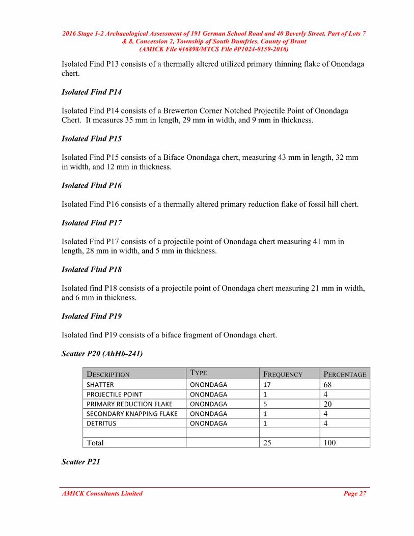
DESCRIPTION TYPE FREQUENCY PERCENTAGE SHATTER ONONDAGA 17 68 PROJECTILEPOINT ONONDAGA 1 4 PRIMARYREDUCTIONFLAKE ONONDAGA 5 20 SECONDARYKNAPPINGFLAKE ONONDAGA 1 4 DETRITUS ONONDAGA 1 4 Total 25 100
Scatter P21

2016 Stage 1-2 Archaeological Assessment of 191 German School Road and 40 Beverly Street, Part of Lots 7 & 8, Concession 2, Township of South Dumfries, County of Brant
(AMICK File #16898/MTCS File #P1024-0159-2016)
AMICK Consultants Limited Page 28
DESCRIPTION TYPE FREQUENCY PERCENTAGE PROJECTILEPOINT ONONDAGA 1 33 SHATTER ONONDAGA 1 33 SECONDARYKNAPPINGFLAKE ONONDAGA 1 34 Total 3 100
Scatter P22
DESCRIPTION TYPE FREQUENCY PERCENTAGE PRIMARYREDUCTIONFLAKE INDETERMINATE 1 20 SECONDARYKNAPPINGFLAKE ONONDAGA 2 40 DETRITUS INDETERMINATE 2 40 Total 5 100
Isolated Find P23 Isolated Find P23 consists of a primary thinning flake of Onondaga chert. Isolated Find P24 Isolated Find P24 consists of a primary thinning flake of fossil hill chert. Isolated Find P25 Isolated Find P25 consists of a primary reduction flake of Onondaga chert. Isolated Find P26 Isolated Find P26 consists of a shatter of fossil hill chert. Isolated Find P27 Isolated Find P27 consists of a primary reduction flake of Onondaga chert. Scatter P28 (AhHb-242)
DESCRIPTION TYPE FREQUENCY PERCENTAGE SHATTER FOSSILHILL 3 11.5 SHATTER ONONDAGA 2 8 PRIMARYREDUCTIONFLAKE ONONDAGA 1 4 PRIMARYREDUCTIONFLAKE FOSSILHILL 1 4
2016 Stage 1-2 Archaeological Assessment of 191 German School Road and 40 Beverly Street, Part of Lots 7 & 8, Concession 2, Township of South Dumfries, County of Brant
(AMICK File #16898/MTCS File #P1024-0159-2016)
AMICK Consultants Limited Page 29
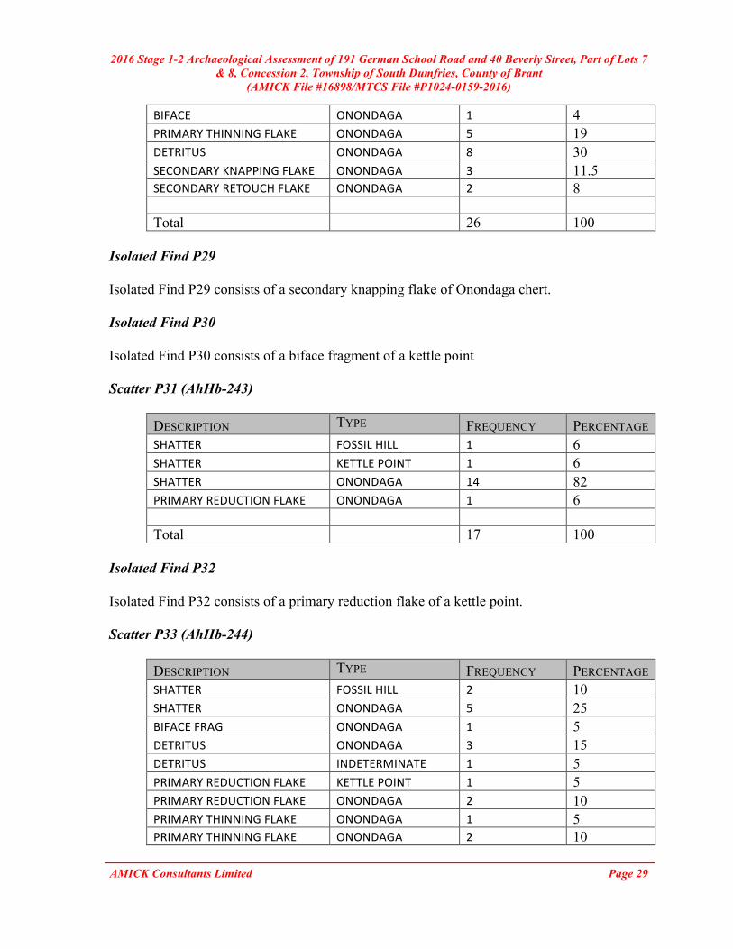
BIFACE ONONDAGA 1 4 PRIMARYTHINNINGFLAKE ONONDAGA 5 19 DETRITUS ONONDAGA 8 30 SECONDARYKNAPPINGFLAKE ONONDAGA 3 11.5 SECONDARYRETOUCHFLAKE ONONDAGA 2 8 Total 26 100
Isolated Find P29 Isolated Find P29 consists of a secondary knapping flake of Onondaga chert. Isolated Find P30 Isolated Find P30 consists of a biface fragment of a kettle point Scatter P31 (AhHb-243)
DESCRIPTION TYPE FREQUENCY PERCENTAGE SHATTER FOSSILHILL 1 6 SHATTER KETTLEPOINT 1 6 SHATTER ONONDAGA 14 82 PRIMARYREDUCTIONFLAKE ONONDAGA 1 6 Total 17 100
Isolated Find P32 Isolated Find P32 consists of a primary reduction flake of a kettle point. Scatter P33 (AhHb-244)
DESCRIPTION TYPE FREQUENCY PERCENTAGE SHATTER FOSSILHILL 2 10 SHATTER ONONDAGA 5 25 BIFACEFRAG ONONDAGA 1 5 DETRITUS ONONDAGA 3 15 DETRITUS INDETERMINATE 1 5 PRIMARYREDUCTIONFLAKE KETTLEPOINT 1 5 PRIMARYREDUCTIONFLAKE ONONDAGA 2 10 PRIMARYTHINNINGFLAKE ONONDAGA 1 5 PRIMARYTHINNINGFLAKE ONONDAGA 2 10
2016 Stage 1-2 Archaeological Assessment of 191 German School Road and 40 Beverly Street, Part of Lots 7 & 8, Concession 2, Township of South Dumfries, County of Brant
(AMICK File #16898/MTCS File #P1024-0159-2016)
AMICK Consultants Limited Page 30
SECONDARYKNAPPINGFLAKE KETTLEPOINT 2 10 Total 20 100
Isolated Find P34 Isolated Find P34 consists of a secondary knapping flake of Onondaga chert. Isolated Find P35 Isolated Find P35 consists of a thermally altered primary thinning flake of Onondaga chert. The collection of artifacts from this assessment is packaged in a single banker’s box and housed at the Port McNicoll office of AMICK Consultants Limited until such time as an appropriate permanent location, as approved by MTCS, is located and appropriate arrangements for the transfer of the collection and associated responsibilities for the material is made. 7.2 ARCHAEOLOGICAL FIELDWORK DOCUMENTATION The documentation produced during the field investigation conducted in support of this report includes: twelve sketch maps, four pages of photo log, four pages of field notes, and 96 digital photographs. 8.0 ANALYSIS AND CONCLUSIONS AMICK Consultants Limited was engaged by the proponent to undertake a Stage 1-2 Archaeological Assessment of lands potentially affected by the proposed undertaking and was granted permission to carry out archaeological fieldwork. The entirety of the study area was subject to property inspection and photographic documentation concurrently with the Stage 2 Property Assessment on May 31, July 8, 15, 18, 20-22, 25-29, August 2-4, 8-11, 23, October 26-28, 31, and November 1, 2, 7-10, 18, and 21, 2016, consisting of high-intensity test pit survey at intervals of five and ten metres between individual test pits and high intensity pedestrian survey at intervals of one and five metres between individual transects. All records, documentation, field notes, photographs and artifacts (as applicable) related to the conduct and findings of these investigations are held at the Lakelands District corporate offices of AMICK Consultants Limited until such time that they can be transferred to an agency or institution approved by the Ontario Ministry of Tourism, Culture and Sport (MTCS) on behalf of the government and citizens of Ontario. 8.1 STAGE 1 ANALYSIS AND CONCLUSIONS As part of the present study, background research was conducted in order to determine the archaeological potential of the proposed project area.

2016 Stage 1-2 Archaeological Assessment of 191 German School Road and 40 Beverly Street, Part of Lots 7 & 8, Concession 2, Township of South Dumfries, County of Brant
(AMICK File #16898/MTCS File #P1024-0159-2016)
AMICK Consultants Limited Page 31
“A Stage 1 background study provides the consulting archaeologist and Ministry report reviewer with information about the known and potential cultural heritage resources within a particular study area, prior to the start of the field assessment.” (OMCzCR 1993) The evaluation of potential is further elaborated Section 1.3 of the Standards and Guidelines for Consultant Archaeologist (2011) prepared by the Ontario Ministry of Tourism and Culture: “ The Stage 1 background study (and, where undertaken, property inspection) leads to an evaluation of the property’s archaeological potential. If the evaluation indicates that there is archaeological potential anywhere on the property, the next step is a Stage 2 assessment.”
(MTC 2011: 17) Features or characteristics that indicate archaeological potential when documented within the study area, or within close proximity to the study area (as applicable), include: “ - previously identified archaeological sites
- water sources (It is important to distinguish types of water and shoreline, and to distinguish natural from artificial water sources, as these features affect site locations and types to varying degrees.):
o primary water sources (lakes, rivers, streams, creeks) o secondary water sources (intermittent streams and creeks, springs, marshes,
swamps) o features indicating past water sources (e.g., glacial lake shorelines indicated
by the presence of raised sand or gravel beach ridges, relic river or stream channels indicated by clear dip or swale in the topography, shorelines of drained lakes or marshes, cobble beaches)
o accessible or inaccessible shoreline (e.g., high bluffs, swamp or marsh fields by the edge of a lake, sandbars stretching into marsh)
- elevated topography (e.g., eskers, drumlins, large knolls, plateaux) - pockets of well-drained sandy soil, especially near areas of heavy soil or rocky
ground - distinctive land formations that might have been special or spiritual places, such as
waterfalls, rock outcrops, caverns, mounds, and promontories and their bases. There may be physical indicators of their use, such as burials, structures, offerings, rock paintings or carvings.
- resource areas, including: o food or medicinal plants (e.g., migratory routes, spawning areas, prairie) o scarce raw materials (e.g., quartz, copper, ochre or outcrops of chert) o early Post-contact industry (e.g., fur trade, logging, prospecting, mining)
- areas of early Post-contact settlement. These include places of early military or pioneer settlement (e.g., pioneer homesteads, isolated cabins, farmstead complexes), early wharf or dock complexes, pioneer churches and early cemeteries. There may be

2016 Stage 1-2 Archaeological Assessment of 191 German School Road and 40 Beverly Street, Part of Lots 7 & 8, Concession 2, Township of South Dumfries, County of Brant
(AMICK File #16898/MTCS File #P1024-0159-2016)
AMICK Consultants Limited Page 32
commemorative markers of their history, such as local, provincial, or federal monuments or heritage parks.
- Early historical transportation routes (e.g., trails, passes, roads, railways, portage routes)
- property listed on a municipal register or designated under the Ontario Heritage Actor that is a federal, provincial or municipal historic landmark or site
- property that local histories or informants have identified with possible archaeological sties, historical events, activities, or occupations”
(MTC 2011: 17-18) The evaluation of potential does not indicate that sites are present within areas affected by proposed development. Evaluation of potential considers the possibility for as yet undocumented sites to be found in areas that have not been subject to systematic archaeological investigation in the past. Potential for archaeological resources is used to determine if property assessment of a study area or portions of a study area is required.
“Archaeological resources not previously documented may also be present in the affected area. If the alternative areas being considered, or the preferred alternative selected, exhibit either high or medium potential for the discovery of archaeological remains an archaeological assessment will be required.”
(MCC & MOE 1992: 6-7) “The Stage 1 background study (and, where undertaken, property inspection) leads to an evaluation of the property’s archaeological potential. If the evaluation indicates that there is archaeological potential anywhere on the property, the next step is a Stage 2 assessment.”
(MTC 2011: 17)
In addition, archaeological sites data is also used to determine if any archaeological resources had been formerly documented within or in close proximity to the study area and if these same resources might be subject to impacts from the proposed undertaking. This data was also collected in order to establish the relative cultural heritage value or interest of any resources that might be encountered during the conduct of the present study. For example, the relative rarity of a site can be used to assign an elevated level of cultural heritage value or interest to a site that is atypical for the immediate vicinity. The requisite archaeological sites data of previously registered archaeological sites was collected from the Programs and Services Branch, Culture Programs Unit, MTCS and the corporate research library of AMICK Consultants Limited. The Stage 1 Background Research methodology also includes a review of the most detailed available topographic maps, historical settlement maps, archaeological management plans (where applicable) and commemorative plaques or monuments. When previous archaeological research documents lands to be impacted by the proposed undertaking or archaeological sites within 50 metres of the study area, the reports documenting this earlier work are reviewed for pertinent information. AMICK Consultants Limited will often modify this basic methodology based on professional judgment to include

2016 Stage 1-2 Archaeological Assessment of 191 German School Road and 40 Beverly Street, Part of Lots 7 & 8, Concession 2, Township of South Dumfries, County of Brant
(AMICK File #16898/MTCS File #P1024-0159-2016)
AMICK Consultants Limited Page 33
additional research (such as, local historical works or documents and knowledgeable informants). Section 7.7.3 of the Standards and Guidelines for Consultant Archaeologists (MTC 2011: 132) outlines the requirements of the Analysis and Conclusions component of a Stage 1 Background Study. 1) “Identify and describe areas of archaeological potential within the project area. 2) Identify and describe areas that have been subject to extensive and deep land
alterations. Describe the nature of alterations (e.g., development or other activity) that have severely damaged the integrity of archaeological resources and have removed archaeological potential.”
CHARACTERISTICS INDICATING ARCHAEOLOGICAL POTENTIAL Section 1.3.1 of the Standards and Guidelines for Consultant Archaeologists specifies the property characteristics that indicate archaeological potential (MTC 2011: 17-18). Factors that indicate archaeological potential are features of the local landscape and environment that may have attracted people to either occupy the land or to conduct activities within the study area. One or more of these characteristics found to apply to a study area would necessitate a Stage 2 Property Assessment to determine if archaeological resources are present. These characteristics are listed below together with considerations derived from the conduct of this study.
1) Previously Identified Archaeological Sites Previously registered archaeological sites have been documented within 300 metres of the study area.
2) Water Sources
Primary water sources are described as including lakes, rivers streams and creeks. Close proximity to primary water sources (300 metres) indicates that people had access to readily available sources of potable water and routes of waterborne trade and communication should the study area have been used or occupied in the past. There are no identified primary water sources within 300 metres of the study area. Secondary water sources are described as including intermittent streams and creeks, springs, marshes, and swamps. Close proximity (300 metres) to secondary water sources indicates that people had access to readily available sources of potable water, at least on a seasonal basis, and in some cases seasonal access to routes of waterborne trade and communication should the study area have been used or occupied in the past.

2016 Stage 1-2 Archaeological Assessment of 191 German School Road and 40 Beverly Street, Part of Lots 7 & 8, Concession 2, Township of South Dumfries, County of Brant
(AMICK File #16898/MTCS File #P1024-0159-2016)
AMICK Consultants Limited Page 34
There are identified secondary water sources within 300 metres of the study area. Unnamed tributary streams and low lying and wet ponds are located throughout the study area.
3) Features Indicating Past Water Sources
Features indicating past water resources are described as including glacial lake shorelines indicated by the presence of raised sand or gravel beach ridges, relic river or stream channels indicated by clear dip or swale in the topography, shorelines of drained lakes or marshes, and cobble beaches. Close proximity (300 metres) to features indicating past water sources indicates that people had access to readily available sources of potable water, at least on a seasonal basis, and in some cases seasonal access to routes of waterborne trade and communication should the study area have been used or occupied in the past.
There are no identified features indicating past water sources within 300 metres of the study area.
4) Accessible or Inaccessible Shoreline
This form of landscape feature would include high bluffs, swamp or marsh fields by the edge of a lake, sandbars stretching into marsh, etc.
There are no shorelines within 300 metres of the study area.
5) Elevated Topography
Features of elevated topography that indicate archaeological potential include eskers, drumlins, large knolls, and plateaux.
There are no identified features of elevated topography within the study area.
6) Pockets of Well-drained Sandy Soil
Pockets of sandy soil are considered to be especially important near areas of heavy soil or rocky ground.
The soil throughout the study area is medium brown sand, which is consistent with the wider area surrounding the property. Therefore, the presence of this soil has no impact on potential within the study area, as the wider area is not known for clay soils or exposed bedrock.
7) Distinctive Land Formations
These are landscape features that might have been special or spiritual places, such as waterfalls, rock outcrops, caverns, mounds, and promontories and their bases. There may be physical indicators of their use, such as burials, structures, offerings, rock paintings or carvings.
There are no identified distinctive land formations within the study area.

2016 Stage 1-2 Archaeological Assessment of 191 German School Road and 40 Beverly Street, Part of Lots 7 & 8, Concession 2, Township of South Dumfries, County of Brant
(AMICK File #16898/MTCS File #P1024-0159-2016)
AMICK Consultants Limited Page 35
8) Resource Areas
Resource areas that indicate archaeological potential include food or medicinal plants (e.g., migratory routes, spawning areas, and prairie), scarce raw materials (e.g., quartz, copper, ochre or outcrops of chert) and resources of importance to early Post-contact industry (e.g., logging, prospecting, and mining).
There are no identified resource areas within the study area.
9) Areas of Early Post-contact Settlement
These include places of early military or pioneer settlement (e.g., pioneer homesteads, isolated cabins, and farmstead complexes), early wharf or dock complexes, pioneer churches and early cemeteries. There may be commemorative markers of their history, such as local, provincial, or federal monuments or heritage parks.
The study area is situated in close proximity to a historic community identified on the historic atlas map.
10) Early Historical Transportation Routes
This includes evidence of trails, passes, roads, railways, portage routes.
The study area is situated within 100 metres of early settlement roads that appear on the Historic Atlas Map of 1875. These historic roads correspond to the roads presently known as Main St South, Beverly St West, and German School Road, which are adjacent to the study area. The study area contains a railway line indicated on the historic atlas map.
11) Heritage Property
Property listed on a municipal register or designated under the Ontario Heritage Act or is a federal, provincial or municipal historic landmark or site.
There are no listed or designated heritage buildings or properties that form a part of the study area. There are no listed or designated heritage buildings or properties that are adjacent to the study area.
12) Documented Historical or Archaeological Sites This includes property that local histories or informants have identified with possible archaeological sites, historical events, activities, or occupations. These are properties which have not necessarily been formally recognized or for which there is additional evidence identifying possible archaeological resources associated with historic properties in addition to the rationale for formal recognition.
There are no known heritage features, or known historic sites, or known archaeological sites within the study area in addition to those formally documented with the appropriate agencies or previously noted under a different criterion.
2016 Stage 1-2 Archaeological Assessment of 191 German School Road and 40 Beverly Street, Part of Lots 7 & 8, Concession 2, Township of South Dumfries, County of Brant
(AMICK File #16898/MTCS File #P1024-0159-2016)
AMICK Consultants Limited Page 36
CHARACTERISTICS INDICATING REMOVAL OF ARCHAEOLOGICAL POTENTIAL Section 1.3.2 of the Standards and Guidelines for Consultant Archaeologists specifies the property characteristics which indicate no archaeological potential or for which archaeological potential has been removed (MTC 2011: 18-19). These characteristics are listed below together with considerations derived from the conduct of this study. The introduction of Section 1.3.2 (MTC 2011: 18) notes that “Archaeological potential can be determined not to be present for either the entire property or a part(s) of it when the area under consideration has been subject to extensive and deep land alterations that have severely damaged the integrity of any archaeological resources. This is commonly referred to as ‘disturbed’ or ‘disturbance’, and may include:”
1) Quarrying There is no evidence to suggest that quarrying operations were ever carried out within the study area.
2) Major Landscaping Involving Grading Below Topsoil Unless there is evidence to suggest the presence of buried archaeological deposits, such deeply disturbed areas are considered to have lost their archaeological potential. Properties that do not have a long history of Post-contact occupation can have archaeological potential removed through extensive landscape alterations that penetrate below the topsoil layer. This is because most archaeological sites originate at grade with relatively shallow associated excavations into the soil. Pre-contact sites and early historic sites are vulnerable to extensive damage and complete removal due to landscape modification activities. In urban contexts where a lengthy history of occupation has occurred, properties may have deeply buried archaeological deposits covered over and sealed through redevelopment activities that do not include the deep excavation of the entire property for subsequent uses. Buildings are often erected directly over older foundations preserving archaeological deposits associated with the earlier occupation.
There is no evidence to suggest that major landscaping operations involving grading below topsoil were ever carried out within the study area. Surfaces paved with interlocking brick, concrete, asphalt, gravel and other surfaces meant to support heavy loads or to be long wearing hard surfaces in high traffic areas, must be prepared by the excavation and removal of topsoil, grading, and the addition of aggregate material to ensure appropriate engineering values for the supporting matrix and also to ensure that the installations shed water to avoid flooding or moisture damage. All hard surfaced areas are prepared in this fashion and therefore have no or low archaeological potential. Disturbed areas are excluded from Stage 2 Property Assessment due to no or low archaeological potential and often because they are also not viable to assess using conventional methodology.
3) Building Footprints

2016 Stage 1-2 Archaeological Assessment of 191 German School Road and 40 Beverly Street, Part of Lots 7 & 8, Concession 2, Township of South Dumfries, County of Brant
(AMICK File #16898/MTCS File #P1024-0159-2016)
AMICK Consultants Limited Page 37
Typically, the construction of buildings involves the deep excavation of foundations, footings and cellars that often obliterate archaeological deposits situated close to the surface.
There are five buildings within the study area.
4) Sewage and Infrastructure Development
Installation of sewer lines and other below ground services associated with infrastructure development often involves deep excavation that can remove archaeological potential.
There is no evidence to suggest that substantial below ground services of any kind have resulted in significant impacts to any significant portion of the study area. Major utility lines are conduits that provide services such as water, natural gas, hydro, communications, sewage, and others. These major installations should not be confused with minor below ground service installations not considered to represent significant disturbances removing archaeological potential, such as services leading to individual structures which tend to be comparatively very shallow and vary narrow corridors. Areas containing substantial and deeply buried services or clusters of below ground utilities are considered areas of disturbance, and may be excluded from Stage 2 Property Assessment.
“Activities such as agricultural cultivation, gardening, minor grading and landscaping do not necessarily affect archaeological potential.”
(MTC 2011: 18) “Archaeological potential is not removed where there is documented potential for deeply buried intact archaeological resources beneath land alterations, or where it cannot be clearly demonstrated through background research and property inspection that there has been complete and intensive disturbance of an area. Where complete disturbance cannot be demonstrated in Stage 1, it will be necessary to undertake Stage 2 assessment.”
(MTC 2011: 18) Table 4 below summarizes the evaluation criteria of the Ministry of Tourism and Culture together with the results of the Stage 1 Background Study for the proposed undertaking. Based on the criteria, the property is deemed to have archaeological potential on the basis of proximity to water, proximity to historic settlement structures, and the location of early historic settlement roads adjacent to the study area.

2016 Stage 1-2 Archaeological Assessment of 191 German School Road and 40 Beverly Street, Part of Lots 7 & 8, Concession 2, Township of South Dumfries, County of Brant
(AMICK File #16898/MTCS File #P1024-0159-2016)
AMICK Consultants Limited Page 38
TABLE 4 EVALUATION OF ARCHAEOLOGICAL POTENTIAL
FEATUREOFARCHAEOLOGICALPOTENTIAL YES NO N/A COMMENT
1 Knownarchaeologicalsiteswithin300m Y
IfYes,potentialdetermined
PHYSICALFEATURES2 Istherewateronorneartheproperty? Y IfYes,whatkindofwater?
2aPrimarywatersourcewithin300m.(lakeshore,river,largecreek,etc.) N
IfYes,potentialdetermined
2bSecondarywatersourcewithin300m.(stream,spring,marsh,swamp,etc.) Y
IfYes,potentialdetermined
2cPastwatersourcewithin300m.(beachridge,riverbed,reliccreek,etc.) N
IfYes,potentialdetermined
2dAccessibleorInaccessibleshorelinewithin300m.(highbluffs,marsh,swamp,sandbar,etc.)
N
IfYes,potentialdetermined
3Elevatedtopography(knolls,drumlins,eskers,plateaus,etc.) N
IfYes,andYesforanyof4-9,potentialdetermined
4 Pocketsofsandysoilinaclayorrockyarea N IfYesandYesforanyof3,5-9,potentialdetermined
5Distinctivelandformations(mounds,caverns,waterfalls,peninsulas,etc.) N
IfYesandYesforanyof3-4,6-9,potentialdetermined
HISTORIC/PREHISTORICUSEFEATURES
6
Associatedwithfoodorscarceresourceharvestareas(traditionalfishinglocations,agricultural/berryextractionareas,etc.) N
IfYes,andYesforanyof3-5,7-9,potentialdetermined.
7 EarlyPost-contactsettlementareawithin300m. Y
IfYes,andYesforanyof3-6,8-9,potentialdetermined
8HistoricTransportationroutewithin100m.(historicroad,trail,portage,railcorridors,etc.) Y
IfYes,andYesforany3-7or9,potentialdetermined
9
Containspropertydesignatedand/orlistedundertheOntarioHeritageAct(municipalheritagecommittee,municipalregister,etc.) N
IfYesand,Yestoanyof3-8,potentialdetermined
APPLICATION-SPECIFICINFORMATION
10Localknowledge(localheritageorganizations,Pre-contact,etc.) N
IfYes,potentialdetermined
11
Recentdisturbancenotincludingagriculturalcultivation(post-1960-confirmedextensiveandintensiveincludingindustrialsites,aggregateareas,etc.) N
IfYes,nopotentialorlowpotentialinaffectedpart(s)ofthestudyarea.
IfYEStoanyof1,2a-c,or10ArchaeologicalPotentialisconfirmedIfYESto2ormoreof3-9,ArchaeologicalPotentialisconfirmed
IfYESto11orNoto1-10LowArchaeologicalPotentialisconfirmedforatleastaportionofthestudyarea.

2016 Stage 1-2 Archaeological Assessment of 191 German School Road and 40 Beverly Street, Part of Lots 7 & 8, Concession 2, Township of South Dumfries, County of Brant
(AMICK File #16898/MTCS File #P1024-0159-2016)
AMICK Consultants Limited Page 39
8.2 STAGE 2 ANALYSIS AND CONCLUSIONS
Section 7.8.3 of the Standards and Guidelines for Consultant Archaeologists (MTC 2011: 138-139) outlines the requirements of the Analysis and Conclusions component of a Stage 2 Property Assessment.
1. Summarize all finding from the Stage 2 survey, or state that no archaeological sites were identified.
2. For each archaeological site, provide the following analysis and conclusions: a. A preliminary determination, to the degree possible, of the age and cultural
affiliation of any archaeological sites identified. b. A comparison against the criteria in 2 Stage 2: Property Assessment to determine
whether further assessment is required c. A preliminary determination regarding whether any archaeological sites identified
in Stage 2 show evidence of a high level cultural heritage value or interest and will thus require Stage 4 mitigation.
Archaeological sites or resources were found during the Stage 2 survey of the study area. 9.0 RECOMMENDATIONS 9.1 STAGE 1 RECOMMENDATIONS Under Section 7.7.4 of the Standards and Guidelines for Consultant Archaeologists (MTC 2011: 133) the recommendations to be made as a result of a Stage 1 Background Study are described.
1) Make recommendations regarding the potential for the property, as follows: a. if some or all of the property has archaeological potential, identify areas recommended for further assessment (Stage 2) and areas not recommended for further assessment. Any exemptions from further assessment must be consistent with the archaeological fieldwork standards and guidelines. b. if no part of the property has archaeological potential, recommend that the property does not require further archaeological assessment.
2) Recommend appropriate Stage 2 assessment strategies.
The study area has been identified as an area of archaeological potential and Stage 2 Property Assessment is recommended. Portions of the study are have been determined to have low archaeological potential or are not viable to assess and are therefore excluded from Stage 2 Property Assessment. The areas that may be excluded from the Stage 2 Property Assessment include:
2016 Stage 1-2 Archaeological Assessment of 191 German School Road and 40 Beverly Street, Part of Lots 7 & 8, Concession 2, Township of South Dumfries, County of Brant
(AMICK File #16898/MTCS File #P1024-0159-2016)
AMICK Consultants Limited Page 40
- Areas capped with asphalt, concrete or gravel where grading below topsoil is indicated by the existing surface treatment installed to be long wearing and to support heavy loads. Archaeological potential has been removed from these areas.
- Permanently low-lying wet areas have low archaeological potential and are also not viable to assess using land based archaeological survey methodologies.
- Areas of steep slope have low archaeological potential. - The footprint of existing structures.
A plan of the study area is provided as Maps 3-6. Within Maps 8-11 of this report the areas depicted as subject to Stage 2 Property Assessment correspond to those areas that were determined to exhibit archaeological potential. Areas that were not subject to Stage 2 Property Assessment correspond to areas that have low or no archaeological potential, as noted above, and may be excluded from the Stage 2 Property Assessment. It is important to note that areas deemed to be of low or no archaeological potential based on the professional judgement of and/or appropriate testing (if necessary) by a licensed archaeologist are areas that are deemed to have been assessed for the purposes of addressing the provincial interest in archaeological resources pursuant to a proposed development or undertaking. 9.2 STAGE 2 RECOMMENDATIONS Under Section 7.8.4 of the Standards and Guidelines for Consultant Archaeologists (MTC 2011: 139) the recommendations to be made as a result o f a Stage 2 Property Assessment are described.
1) For each archaeological site, provide a statement of the following: a. Borden number or other identifying number b. Whether or not it is of further cultural heritage value or interest c. Where it is of further cultural heritage value or interest, appropriate Stage 3 assessment strategies
2) Make recommendations only regarding archaeological matters. Recommendations regarding built heritage or cultural heritage landscapes should not be included.
3) If the Stage 2 survey did not identify any archaeological sites requiring further assessment or mitigation of impacts, recommend that no further archaeological assessment of the property be required.
As a result of the property Assessment of the study area, three Post-Contact scatters (H1(AhHb-237), H2, H3(AhHb-238)), eleven Pre-contact lithic scatters, and twenty-four isolated Pre-Contact findspots were encountered. Of the resources encountered, two post-contact scatters (H1(AhHb-237) and H3(AhHb-238)) and six lithic scatters (P11(AhHb-239), P12(AhHb-240), P20(AhHb-241), P28(AhHb-242), P31(AhHb-243), and P33(AhHb-234)) the following recommendations are made:

2016 Stage 1-2 Archaeological Assessment of 191 German School Road and 40 Beverly Street, Part of Lots 7 & 8, Concession 2, Township of South Dumfries, County of Brant
(AMICK File #16898/MTCS File #P1024-0159-2016)
AMICK Consultants Limited Page 41
1. Further study is warranted. Stage 3 Site-specific assessment of the archaeological sites identified as H1(AhHb-237), H3(AhHb-238), P11(AhHb-239), P12(AhHb-240), P20(AhHb-241), P28(AhHb-242), P31(AhHb-243), and P33(AhHb-234), is required.
2. The Stage 3 Site-specific Assessments for each of these sites will be completed as detailed within the Standards and Guidelines for Consultant Archaeologists (MTC 2011).
3. No soil disturbances or removal of vegetation shall take place within the archaeological sites identified as H1(AhHb-237), H3(AhHb-238), P11(AhHb-239), P12(AhHb-240), P20(AhHb-241), P28(AhHb-242), P31(AhHb-243), and P33(AhHb-234) within this Stage 1-2 Archaeological Assessment report, or within the area enclosed within a 20 metre buffer surrounding the H1(AhHb-237), H3(AhHb-238), P11(AhHb-239), P12(AhHb-240), P20(AhHb-241), P28(AhHb-242), P31(AhHb-243), and P33(AhHb-234) sites prior to the acceptance of the Ministry of Tourism, Culture and Sport (MTCS) of a report recommending that all archaeological concerns for the H1(AhHb-237), H3(AhHb-238), P11(AhHb-239), P12(AhHb-240), P20(AhHb-241), P28(AhHb-242), P31(AhHb-243), and P33(AhHb-234) sites have been addressed and that there is no further cultural heritage value or interest for these sites.
4. Prior to pre-grading, servicing or registration, the owner shall erect and maintain a temporary high visibility construction fence to be maintained through the course of all construction activities at a 20 metre buffer around the archaeological sites identified as H1(AhHb-237), H3(AhHb-238), P11(AhHb-239), P12(AhHb-240), P20(AhHb-241), P28(AhHb-242), P31(AhHb-243), and P33(AhHb-234) to ensure that construction activities do not impinge upon H1(AhHb-237), H3(AhHb-238), P11(AhHb-239), P12(AhHb-240), P20(AhHb-241), P28(AhHb-242), P31(AhHb-243), and P33(AhHb-234) unless under the direct supervision of a consulting archaeologist licensed in Ontario by the Minister of Tourism, Culture and Sport and as a part of the ongoing archaeological investigations of that site.
5. The high visibility fence will be installed at the outer limit of the 20 metre wide Protective Buffer surrounding the H1(AhHb-237), H3(AhHb-238), P11(AhHb-239), P12(AhHb-240), P20(AhHb-241), P28(AhHb-242), P31(AhHb-243), and P33(AhHb-234) sites as illustrated in the accompanying mapping within the Supplementary Report Package of this report filed with MTCS prior to the commencement of any development activity anywhere within the proposed development.
6. A Fifty (50) metre wide Monitoring Buffer shall be observed surrounding the above-noted 20 metre wide Protective Buffer. Within the 50 metre Monitoring Buffer no ground altering works (including removal of vegetation or demolition of existing features) may be conducted unless under the direct supervision of a licensed archaeologist.
7. The licenced archaeologist supervising any work conducted within the 50 metre wide Monitoring Buffer has the authority to order a halt to any activity which in his or her view may result in adverse impacts to archaeological resources.
8. The 50 metre wide Monitoring Buffer will remain in effect until such time that the Stage 3 Site-specific Assessment report for the H1(AhHb-237), H3(AhHb-238), P11(AhHb-239), P12(AhHb-240), P20(AhHb-241), P28(AhHb-242), P31(AhHb-243), and P33(AhHb-234) sites identified within this Stage 1-2 Archaeological Assessment

2016 Stage 1-2 Archaeological Assessment of 191 German School Road and 40 Beverly Street, Part of Lots 7 & 8, Concession 2, Township of South Dumfries, County of Brant
(AMICK File #16898/MTCS File #P1024-0159-2016)
AMICK Consultants Limited Page 42
report is accepted into the Provincial Registry of Archaeological Reports by the Ontario Ministry of Tourism, Culture and Sport.
9. Written instructions will be provided to all persons permitted to enter the property to stay out of the area of the 20 metre wide Protective Buffer unless permitted to enter the area accompanied by a licenced archaeologist.
10. Written instructions will be provided to all persons permitted to enter the property for the purposes of undertaking work associated with the development that no work is permitted to occur within the 50 metre wide Monitoring Buffer unless under direct supervision of a licenced archaeologist.
11. Written instructions will be provided to all persons permitted to conduct work within the 50 metre wide Monitoring Buffers that the licenced archaeologist has the authority to order a halt to any work that he or she feels may adversely impact archaeological resources.
12. It is anticipated that the fieldwork and reporting of the Stage 4 Mitigation of Development Impacts (if required) will be completed before the end of 2016 and it is not anticipated that any development activity will be necessary within the 50 metre wide Monitoring Buffers prior to the Spring of 2017.
13. The proponent must provide a letter on letterhead to MTCS itemizing all of the above conditions and committing to ensure that all of these recommendations are implemented. This letter must be submitted together with this report at the time of filing with MTCS.
14. It is recommended that the balance of the study area outside of the site areas and surrounding Protective Buffer be cleared of archaeological concern and that development activity be permitted to proceed, subject to the above provisions.
Of the remaining scatters and findspots, the following recommendations are made:
- No further archaeological assessment of sites H2, P1-P10, P13-P19, P21-P27, P29, P30, P32 and P34-35 is warranted;
- The Provincial with respect to the above noted archaeological sites H2, P1-P10, P13-P19, P21-P27, P29, P30, P32 and P34-35 has been addressed;
- Sites H2, P1-P10, P13-P19, P21-P27, P29, P30, P32 and P34-35 have yielded all data they are likely to produce and are clear of any archaeological concern.
2016 Stage 1-2 Archaeological Assessment of 191 German School Road and 40 Beverly Street, Part of Lots 7 & 8, Concession 2, Township of South Dumfries, County of Brant
(AMICK File #16898/MTCS File #P1024-0159-2016)
AMICK Consultants Limited Page 43
10.0 ADVICE ON COMPLIANCE WITH LEGISLATION While not part of the archaeological record, this report must include the following standard advisory statements for the benefit of the proponent and the approval authority in the land use planning and development process:
a. This report is submitted to the Minister of Tourism and Culture as a condition of licensing in accordance with Part VI of the Ontario Heritage Act, R.S.O. 1990, c. 0.18. The report is reviewed to ensure that it complies with the standards and guidelines issued by the Minister, and that the archaeological fieldwork and report recommendations ensure the conservation, protection and preservation of the cultural heritage of Ontario. When all matters relating to archaeological sites within the project area of a development proposal have been addressed to the satisfaction of the Ministry of Tourism and Culture, a letter will be issued by the ministry stating that there are no further concerns with regard to alterations to archaeological sites by the proposed development.
b. It is an offence under Sections 48 and 69 of the Ontario Heritage Act for any party other than a licensed archaeologist to make any alteration to a known archaeological site or to remove any artifact or other physical evidence of past human use or activity from the site, until such time as a licensed archaeologist has completed archaeological fieldwork on the site, submitted a report to the Minister stating that the site has no further cultural heritage value or interest, and the report has been filed in the Ontario Public Register of Archaeological Reports referred to in Section 65.1 of the Ontario Heritage Act.
c. Should previously undocumented archaeological resources be discovered, they may
be a new archaeological site and therefore subject to Section 48 (1) of the Ontario Heritage Act. The proponent or person discovering the archaeological resources must cease alteration of the site immediately and engage a licensed archaeologist to carry out archaeological fieldwork, in compliance with sec. 48 (1) of the Ontario Heritage Act.
d. The Cemeteries Act, R.S.O. 1990, c. C.4 and the Funeral, Burial and Cremation
Services Act, 2002, S.O. 2002, c.33 (when proclaimed in force) require that any person discovering human remains must notify the police or coroner and the Registrar of Cemeteries at the Ministry of Consumer Services.
e. Archaeological sites recommended for further archaeological fieldwork or protection
remain subject to Section 48 (1) of the Ontario Heritage Act and may not be altered, or have artifacts removed from them, except by a person holding an archaeological licence.

2016 Stage 1-2 Archaeological Assessment of 191 German School Road and 40 Beverly Street, Part of Lots 7 & 8, Concession 2, Township of South Dumfries, County of Brant
(AMICK File #16898/MTCS File #P1024-0159-2016)
AMICK Consultants Limited Page 44
11.0 BIBLIOGRAPHY AND SOURCES A.T. McLaren Ltd. (2015). Topographic Survey of Part of Lot 8, Concession 2, Geographic
Township of South Dumfries all in the County of Brant. A.T. McLaren Ltd., Hamilton. A.T. McLaren Ltd. (2015). Topographic Survey of Part of Lots 7 and 8, Concession 2, Geographic
Township of South Dumfries all in the County of Brant. A.T. McLaren Ltd., Hamilton. A.T. McLaren Ltd. (2015). Topographic Survey of Part of Lots 20, 21 and 22, Block “J” and Part of
Lots 1 and 2, Block “O” and Part of Lot 2, Block “N” Registered Plan 81 and Part of Lots 7 and 8, Concession 2, Geographic Township of South Dumfries all in the County of Brant. A.T. McLaren Ltd., Hamilton.
Chapman, L.J. & D.F. Putnam. (1984). The Physiography of Southern Ontario (Third Edition).
Ontario Geological Survey, Special Report #2. Ontario Ministry of Natural Resources, Toronto.
Goel, Tarun (2013). Road Construction: History and Procedure. Bright Hub Engineering.
Retrieved 24 May 2015 from URL: http://www.brighthubengineering.com/structural-engineering/59665-road-construction-history-and-procedure/
Google Earth (Version 6.0.3.2197) [Software]. (2009). Available from
http://www.google.com/earth/index.html. Google Maps. (2012). Available from: http://maps.google.ca/?utm_campaign =en&utm_source=en-
ha-na-ca-bk-gm&utm_medium=ha&utm_term =google%20maps. Heritage Driving Tour Brochure. (2010). County of Brant. Retrieved June 8, 2011 from
http://www.brant.ca/forvisitors/heritagedrivingtour/BCDriverBro2009a.pdf Ontario Heritage Act, RSO 1990a, Government of Ontario. (Queen’s Printer, Toronto). Ontario Heritage Amendment Act, SO 2005, Government of Ontario. (Queen’s Printer, Toronto). Ontario Ministry of Citizenship, Culture and Recreation (OMCzCR). (1993). Archaeological
Assessment Technical Guidelines, Stages 1-3 and Reporting Format. (Queen’s Printer for Ontario 1993)
Ontario Ministry of Culture (MCL). (2005). Conserving a Future for Our Past: Archaeology, Land
Use Planning & Development in Ontario (An Educational Primer and Comprehensive Guide for Non-Specialists). (Heritage & Libraries Branch, Heritage Operations Unit: Toronto).
Ontario Ministry of Culture and Communications (MCC) & Ministry of Environment (MOE). (1992).
Guideline for Preparing the Cultural Heritage Resource Component of Environmental Assessments. (Cultural Programs Branch, Archaeology and Heritage Planning: Toronto).
Ontario Ministry of Tourism and Culture (MTC). (2011). Standards and Guidelines for Consultant
Archaeologist. (Programs and Services Branch: Culture Programs Unit, Toronto).

2016 Stage 1-2 Archaeological Assessment of 191 German School Road and 40 Beverly Street, Part of Lots 7 & 8, Concession 2, Township of South Dumfries, County of Brant
(AMICK File #16898/MTCS File #P1024-0159-2016)
AMICK Consultants Limited Page 45
Ontario Planning Act, RSO 1990b, Government of Ontario. (Queen’s Printer, Toronto). Page & Smith (1875). Illustrated Historical Atlas of the County of Brant, Ont.,
Page & Smith, Toronto. Provincial Policy Statement (2014). Government of Ontario. (Queen’s Printer, Toronto). Wright, J.V. (1972). Ontario Prehistory: an Eleven-thousand-year Archaeological Outline. Archaeological Survey of Canada. National Museum of Man, Ottawa.

2016 Stage 1-2 Archaeological Assessment of 191 German School Road and 40 Beverly Street, Part of Lots 7 & 8, Concession 2, Township of South Dumfries, County of Brant
(AMICK File #16898/MTCS File #P1024-0159-2016)
AMICK Consultants Limited Page 46
12.0 MAPS
MAP 1 LOCATION OF THE STUDY AREA (GOOGLE MAPS 2012)

2016 Stage 1-2 Archaeological Assessment of 191 German School Road and 40 Beverly Street, Part of Lots 7 & 8, Concession 2, Township of South Dumfries, County of Brant
(AMICK File #16898/MTCS File #P1024-0159-2016)
AMICK Consultants Limited Page 47
MAP 2 FACSIMILE SEGMENT OF THE HISTORIC ATLAS MAP OF THE TOWNSHIP OF
SOUTH DUMFRIES (PAGE & SMITH 1875)

2016 Stage 1-2 Archaeological Assessment of 191 German School Road and 40 Beverly Street, Part of Lots 7 & 8, Concession 2, Township of South Dumfries, County of Brant
(AMICK File #16898/MTCS File #P1024-0159-2016)
AMICK Consultants Limited Page 48
MAP 3 PLAN OF SURVEY: NORTHWEST CORNER (A.T. MCLAREN LTD. 2015)

2016 Stage 1-2 Archaeological Assessment of 191 German School Road and 40 Beverly Street, Part of Lots 7 & 8, Concession 2, Township of South Dumfries, County of Brant
(AMICK File #16898/MTCS File #P1024-0159-2016)
AMICK Consultants Limited Page 49
MAP 4 PLAN OF SURVEY: NORTHEAST CORNER (A.T. MCLAREN LTD. 2015)

2016 Stage 1-2 Archaeological Assessment of 191 German School Road and 40 Beverly Street, Part of Lots 7 & 8, Concession 2, Township of South Dumfries, County of Brant
(AMICK File #16898/MTCS File #P1024-0159-2016)
AMICK Consultants Limited Page 50
MAP 5 PLAN OF SURVEY: CENTRAL (A.T. MCLAREN LTD. 2015)
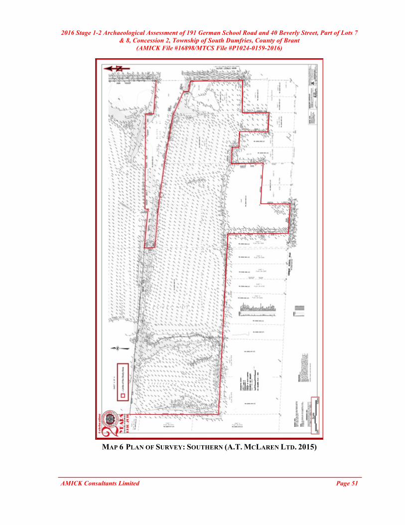
2016 Stage 1-2 Archaeological Assessment of 191 German School Road and 40 Beverly Street, Part of Lots 7 & 8, Concession 2, Township of South Dumfries, County of Brant
(AMICK File #16898/MTCS File #P1024-0159-2016)
AMICK Consultants Limited Page 51
MAP 6 PLAN OF SURVEY: SOUTHERN (A.T. MCLAREN LTD. 2015)
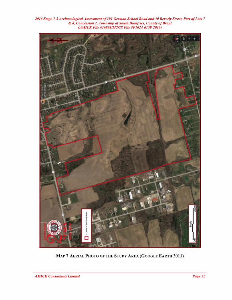
2016 Stage 1-2 Archaeological Assessment of 191 German School Road and 40 Beverly Street, Part of Lots 7 & 8, Concession 2, Township of South Dumfries, County of Brant
(AMICK File #16898/MTCS File #P1024-0159-2016)
AMICK Consultants Limited Page 52
MAP 7 AERIAL PHOTO OF THE STUDY AREA (GOOGLE EARTH 2011)

2016 Stage 1-2 Archaeological Assessment of 191 German School Road and 40 Beverly Street, Part of Lots 7 & 8, Concession 2, Township of South Dumfries, County of Brant
(AMICK File #16898/MTCS File #P1024-0159-2016)
AMICK Consultants Limited Page 53
MAP 8 DETAILED PLAN OF THE STUDY AREA

2016 Stage 1-2 Archaeological Assessment of 191 German School Road and 40 Beverly Street, Part of Lots 7 & 8, Concession 2, Township of South Dumfries, County of Brant
(AMICK File #16898/MTCS File #P1024-0159-2016)
AMICK Consultants Limited Page 54
MAP 9 DETAILED PLAN OF THE STUDY AREA

2016 Stage 1-2 Archaeological Assessment of 191 German School Road and 40 Beverly Street, Part of Lots 7 & 8, Concession 2, Township of South Dumfries, County of Brant
(AMICK File #16898/MTCS File #P1024-0159-2016)
AMICK Consultants Limited Page 55
MAP 10 DETAILED PLAN OF THE STUDY AREA

2016 Stage 1-2 Archaeological Assessment of 191 German School Road and 40 Beverly Street, Part of Lots 7 & 8, Concession 2, Township of South Dumfries, County of Brant
(AMICK File #16898/MTCS File #P1024-0159-2016)
AMICK Consultants Limited Page 56
MAP 11 DETAILED PLAN OF THE STUDY AREA
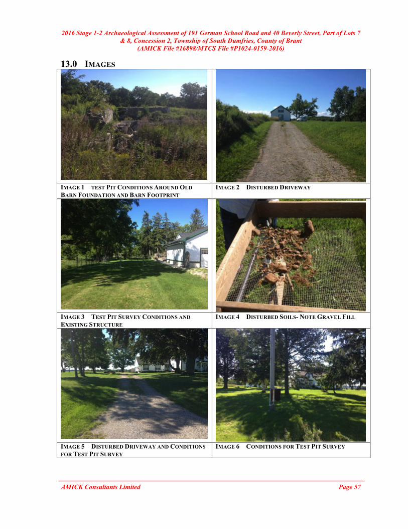
2016 Stage 1-2 Archaeological Assessment of 191 German School Road and 40 Beverly Street, Part of Lots 7 & 8, Concession 2, Township of South Dumfries, County of Brant
(AMICK File #16898/MTCS File #P1024-0159-2016)
AMICK Consultants Limited Page 57
13.0 IMAGES
IMAGE 1 TEST PIT CONDITIONS AROUND OLD BARN FOUNDATION AND BARN FOOTPRINT
IMAGE 2 DISTURBED DRIVEWAY
IMAGE 3 TEST PIT SURVEY CONDITIONS AND EXISTING STRUCTURE
IMAGE 4 DISTURBED SOILS- NOTE GRAVEL FILL
IMAGE 5 DISTURBED DRIVEWAY AND CONDITIONS FOR TEST PIT SURVEY
IMAGE 6 CONDITIONS FOR TEST PIT SURVEY

2016 Stage 1-2 Archaeological Assessment of 191 German School Road and 40 Beverly Street, Part of Lots 7 & 8, Concession 2, Township of South Dumfries, County of Brant
(AMICK File #16898/MTCS File #P1024-0159-2016)
AMICK Consultants Limited Page 58
IMAGE 7 AREA OF SLOPE IMAGE 8 BARN FOOTPRINT
IMAGE 9 CONDITIONS FOR PEDESTRIAN SURVEY IMAGE 10 CONDITIONS FOR PEDESTRIAN SURVEY
IMAGE 11 FIELD CONDITIONS IMAGE 12 CONDITIONS FOR PEDESTRIAN SURVEY

2016 Stage 1-2 Archaeological Assessment of 191 German School Road and 40 Beverly Street, Part of Lots 7 & 8, Concession 2, Township of South Dumfries, County of Brant
(AMICK File #16898/MTCS File #P1024-0159-2016)
AMICK Consultants Limited Page 59
IMAGE 13 STEEP SLOPE IMAGE 14 LOW LYING AND WET AREA AND AREA
OF SLOPE
IMAGE 15 CONDITIONS FOR PEDESTRIAN SURVEY IMAGE 16 STEEP SLOPE
IMAGE 17 LOW LYING AND WET AREA AND EXISTING CREEK
IMAGE 18 CREEK AND TEST PIT SURVEY CONDITIONS

2016 Stage 1-2 Archaeological Assessment of 191 German School Road and 40 Beverly Street, Part of Lots 7 & 8, Concession 2, Township of South Dumfries, County of Brant
(AMICK File #16898/MTCS File #P1024-0159-2016)
AMICK Consultants Limited Page 60
IMAGE 19 CONDITIONS FOR PEDESTRIAN SURVEY
IMAGE 20 CONDITIONS FOR TEST PIT SURVEY
IMAGE 21 CONDITIONS FOR TEST PIT SURVEY
IMAGE 22 CONDITIONS FOR PEDESTRIAN SURVEY
IMAGE 23 DISTURBED GRAVEL DRIVEWAY AND LOW LYING AND WET AREA
IMAGE 24 STEEP SLOPE
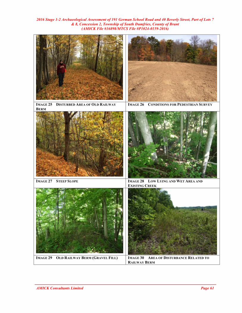
2016 Stage 1-2 Archaeological Assessment of 191 German School Road and 40 Beverly Street, Part of Lots 7 & 8, Concession 2, Township of South Dumfries, County of Brant
(AMICK File #16898/MTCS File #P1024-0159-2016)
AMICK Consultants Limited Page 61
IMAGE 25 DISTURBED AREA OF OLD RAILWAY BERM
IMAGE 26 CONDITIONS FOR PEDESTRIAN SURVEY
IMAGE 27 STEEP SLOPE IMAGE 28 LOW LYING AND WET AREA AND
EXISTING CREEK
IMAGE 29 OLD RAILWAY BERM (GRAVEL FILL) IMAGE 30 AREA OF DISTURBANCE RELATED TO
RAILWAY BERM

2016 Stage 1-2 Archaeological Assessment of 191 German School Road and 40 Beverly Street, Part of Lots 7 & 8, Concession 2, Township of South Dumfries, County of Brant
(AMICK File #16898/MTCS File #P1024-0159-2016)
AMICK Consultants Limited Page 62
IMAGE 31 COMPACT GRAVEL FILLS
IMAGE 32 CONDITIONS FOR PEDESTRIAN SURVEY
IMAGE 33 CONDITIONS FOR PEDESTRIAN SURVEY
IMAGE 34 CONDITIONS FOR PEDESTRIAN SURVEY
IMAGE 35 LOW LYING AND WET AREA IMAGE 36 CONDITIONS FOR PEDESTRIAN SURVEY

2016 Stage 1-2 Archaeological Assessment of 191 German School Road and 40 Beverly Street, Part of Lots 7 & 8, Concession 2, Township of South Dumfries, County of Brant
(AMICK File #16898/MTCS File #P1024-0159-2016)
AMICK Consultants Limited Page 63
IMAGE 37 LOW LYING AND WET AREA IMAGE 38 STEEP SLOPE
IMAGE 39 CONDITIONS FOR TEST PIT SURVEY IMAGE 40 CONDITIONS FOR TEST PIT SURVEY AND
LOW LYING AND WET AREA
IMAGE 41 DISTURBED DRIVEWAY, EXISTING STRUCTURE, AND CONDITIONS FOR TEST PIT SURVEY
IMAGE 42 CONDITIONS FOR TEST PIT SURVEY AND INFRASTRUCTURE
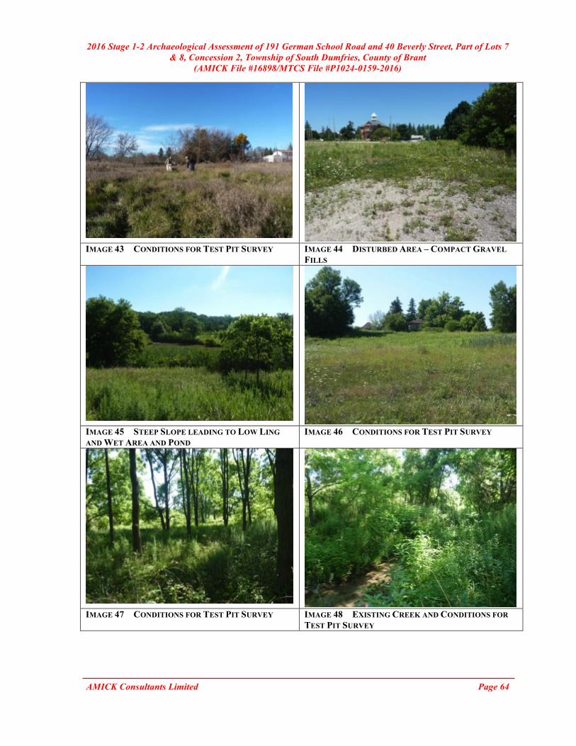
2016 Stage 1-2 Archaeological Assessment of 191 German School Road and 40 Beverly Street, Part of Lots 7 & 8, Concession 2, Township of South Dumfries, County of Brant
(AMICK File #16898/MTCS File #P1024-0159-2016)
AMICK Consultants Limited Page 64
IMAGE 43 CONDITIONS FOR TEST PIT SURVEY IMAGE 44 DISTURBED AREA – COMPACT GRAVEL
FILLS
IMAGE 45 STEEP SLOPE LEADING TO LOW LING AND WET AREA AND POND
IMAGE 46 CONDITIONS FOR TEST PIT SURVEY
IMAGE 47 CONDITIONS FOR TEST PIT SURVEY IMAGE 48 EXISTING CREEK AND CONDITIONS FOR
TEST PIT SURVEY
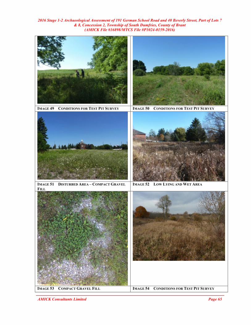
2016 Stage 1-2 Archaeological Assessment of 191 German School Road and 40 Beverly Street, Part of Lots 7 & 8, Concession 2, Township of South Dumfries, County of Brant
(AMICK File #16898/MTCS File #P1024-0159-2016)
AMICK Consultants Limited Page 65
IMAGE 49 CONDITIONS FOR TEST PIT SURVEY IMAGE 50 CONDITIONS FOR TEST PIT SURVEY
IMAGE 51 DISTURBED AREA – COMPACT GRAVEL FILL
IMAGE 52 LOW LYING AND WET AREA
IMAGE 53 COMPACT GRAVEL FILL IMAGE 54 CONDITIONS FOR TEST PIT SURVEY

2016 Stage 1-2 Archaeological Assessment of 191 German School Road and 40 Beverly Street, Part of Lots 7 & 8, Concession 2, Township of South Dumfries, County of Brant
(AMICK File #16898/MTCS File #P1024-0159-2016)
AMICK Consultants Limited Page 66
IMAGE 55 DISTURBED SOILS IMAGE 56 DISTURBED LANEWAY RUNNING
THROUGH PROPERTY
IMAGE 57 LOW LYING AND WET AREA IMAGE 58 CONDITIONS FOR PEDESTRIAN SURVEY
IMAGE 59 DISTURBED LANEWAY IMAGE 60 CONDITIONS FOR PEDESTRIAN SURVEY

2016 Stage 1-2 Archaeological Assessment of 191 German School Road and 40 Beverly Street, Part of Lots 7 & 8, Concession 2, Township of South Dumfries, County of Brant
(AMICK File #16898/MTCS File #P1024-0159-2016)
AMICK Consultants Limited Page 67
IMAGE 61 LOW LYING AND WET AREA IMAGE 62 CONDITIONS FOR PEDESTRIAN SURVEY
IMAGE 63 CONDITIONS FOR PEDESTRIAN SURVEY IMAGE 64 CONDITIONS FOR PEDESTRIAN SURVEY
IMAGE 65 LOW LYING AND WET AREA IMAGE 66 CONDITIONS FOR PEDESTRIAN SURVEY
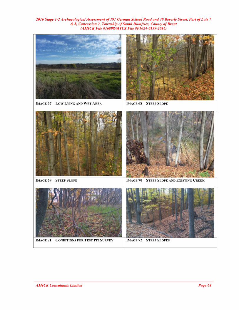
2016 Stage 1-2 Archaeological Assessment of 191 German School Road and 40 Beverly Street, Part of Lots 7 & 8, Concession 2, Township of South Dumfries, County of Brant
(AMICK File #16898/MTCS File #P1024-0159-2016)
AMICK Consultants Limited Page 68
IMAGE 67 LOW LYING AND WET AREA IMAGE 68 STEEP SLOPE
IMAGE 69 STEEP SLOPE IMAGE 70 STEEP SLOPE AND EXISTING CREEK
IMAGE 71 CONDITIONS FOR TEST PIT SURVEY IMAGE 72 STEEP SLOPES
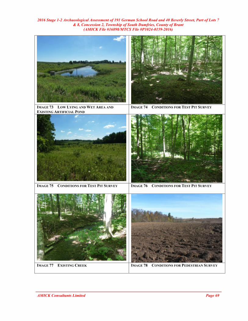
2016 Stage 1-2 Archaeological Assessment of 191 German School Road and 40 Beverly Street, Part of Lots 7 & 8, Concession 2, Township of South Dumfries, County of Brant
(AMICK File #16898/MTCS File #P1024-0159-2016)
AMICK Consultants Limited Page 69
IMAGE 73 LOW LYING AND WET AREA AND EXISTING ARTIFICIAL POND
IMAGE 74 CONDITIONS FOR TEST PIT SURVEY
IMAGE 75 CONDITIONS FOR TEST PIT SURVEY IMAGE 76 CONDITIONS FOR TEST PIT SURVEY
IMAGE 77 EXISTING CREEK IMAGE 78 CONDITIONS FOR PEDESTRIAN SURVEY

2016 Stage 1-2 Archaeological Assessment of 191 German School Road and 40 Beverly Street, Part of Lots 7 & 8, Concession 2, Township of South Dumfries, County of Brant
(AMICK File #16898/MTCS File #P1024-0159-2016)
AMICK Consultants Limited Page 70
IMAGE 79 CONDITIONS FOR PEDESTRIAN SURVEY IMAGE 80 LOW LYING AND WET AREA
IMAGE 81 LOW LYING AND WET AREA AND EXISTING CREEK
IMAGE 82 CONDITIONS FOR PEDESTRIAN SURVEY
IMAGE 83 STEEP SLOPE IMAGE 84 LOW LYING AND WET
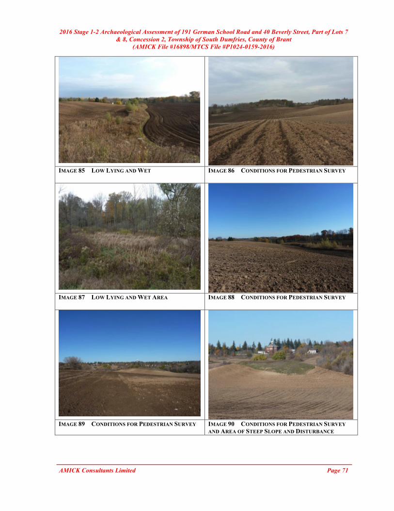
2016 Stage 1-2 Archaeological Assessment of 191 German School Road and 40 Beverly Street, Part of Lots 7 & 8, Concession 2, Township of South Dumfries, County of Brant
(AMICK File #16898/MTCS File #P1024-0159-2016)
AMICK Consultants Limited Page 71
IMAGE 85 LOW LYING AND WET IMAGE 86 CONDITIONS FOR PEDESTRIAN SURVEY
IMAGE 87 LOW LYING AND WET AREA IMAGE 88 CONDITIONS FOR PEDESTRIAN SURVEY
IMAGE 89 CONDITIONS FOR PEDESTRIAN SURVEY IMAGE 90 CONDITIONS FOR PEDESTRIAN SURVEY
AND AREA OF STEEP SLOPE AND DISTURBANCE

2016 Stage 1-2 Archaeological Assessment of 191 German School Road and 40 Beverly Street, Part of Lots 7 & 8, Concession 2, Township of South Dumfries, County of Brant
(AMICK File #16898/MTCS File #P1024-0159-2016)
AMICK Consultants Limited Page 72
IMAGE 91 DISTURBANCE IMAGE 92 DISTURBANCE
IMAGE 93 CONDITIONS FOR PEDESTRIAN SURVEY IMAGE 94 CONDITIONS FOR PEDESTRIAN SURVEY
IMAGE 95 CONDITIONS FOR PEDESTRIAN SURVEY IMAGE 96 LOW LYING AND WET AREA

2016 Stage 1-2 Archaeological Assessment of 191 German School Road and 40 Beverly Street, Part of Lots 7 & 8, Concession 2, Township of South Dumfries, County of Brant
(AMICK File #16898/MTCS File #P1024-0159-2016)
AMICK Consultants Limited Page 73
IMAGE 97 ARTIFACT PHOTO:
LEFT TO RIGHT: ONONDAGA FLAKE, FOSSIL HILL SHATTER, ONONDAGA FLAKE
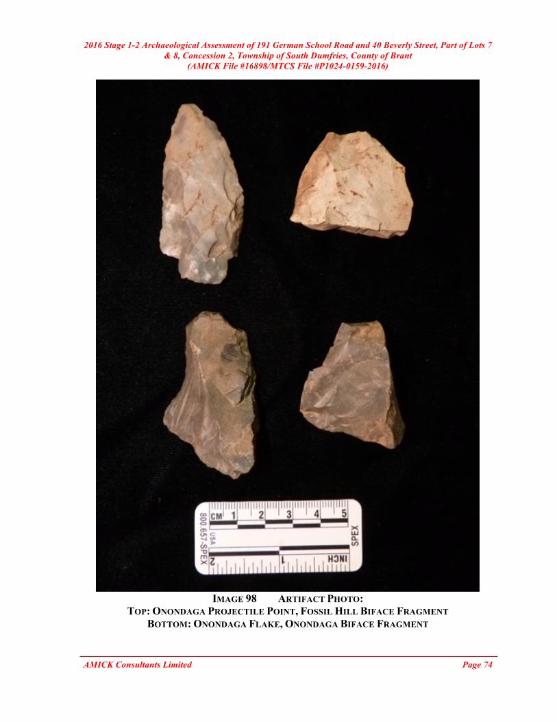
2016 Stage 1-2 Archaeological Assessment of 191 German School Road and 40 Beverly Street, Part of Lots 7 & 8, Concession 2, Township of South Dumfries, County of Brant
(AMICK File #16898/MTCS File #P1024-0159-2016)
AMICK Consultants Limited Page 74
IMAGE 98 ARTIFACT PHOTO:
TOP: ONONDAGA PROJECTILE POINT, FOSSIL HILL BIFACE FRAGMENT BOTTOM: ONONDAGA FLAKE, ONONDAGA BIFACE FRAGMENT

2016 Stage 1-2 Archaeological Assessment of 191 German School Road and 40 Beverly Street, Part of Lots 7 & 8, Concession 2, Township of South Dumfries, County of Brant
(AMICK File #16898/MTCS File #P1024-0159-2016)
AMICK Consultants Limited Page 75
IMAGE 99 ARTIFACT PHOTO:
TOP: ONONDAGA BIFACE FRAGMENT, ONONDAGA PROJECTILE POINT, ONONDAGA SIDE SCRAPER
BOTTOM: ONONDAGA PRIMARY THINNING FLAKE, ONONDAGA SHATTER
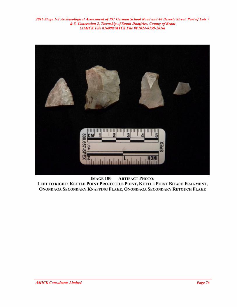
2016 Stage 1-2 Archaeological Assessment of 191 German School Road and 40 Beverly Street, Part of Lots 7 & 8, Concession 2, Township of South Dumfries, County of Brant
(AMICK File #16898/MTCS File #P1024-0159-2016)
AMICK Consultants Limited Page 76
IMAGE 100 ARTIFACT PHOTO:
LEFT TO RIGHT: KETTLE POINT PROJECTILE POINT, KETTLE POINT BIFACE FRAGMENT, ONONDAGA SECONDARY KNAPPING FLAKE, ONONDAGA SECONDARY RETOUCH FLAKE

2016 Stage 1-2 Archaeological Assessment of 191 German School Road and 40 Beverly Street, Part of Lots 7 & 8, Concession 2, Township of South Dumfries, County of Brant
(AMICK File #16898/MTCS File #P1024-0159-2016)
AMICK Consultants Limited Page 77
IMAGE 101 ARTIFACT PHOTO:
TOP: ONONDAGA PROJECTILE POINT, ONONDAGA BIFACE BOTTOM: ONONDAGA PROJECTILE POINT, ONONDAGA PROJECTILE POINT

2016 Stage 1-2 Archaeological Assessment of 191 German School Road and 40 Beverly Street, Part of Lots 7 & 8, Concession 2, Township of South Dumfries, County of Brant
(AMICK File #16898/MTCS File #P1024-0159-2016)
AMICK Consultants Limited Page 78
IMAGE 102 ARTIFACT PHOTO:
LEFT TO RIGHT: ONONDAGA PROJECTILE POINT, FOSSIL HILL PRIMARY THINNING FLAKE, KETTLE POINT BIFACE FRAGMENT

2016 Stage 1-2 Archaeological Assessment of 191 German School Road and 40 Beverly Street, Part of Lots 7 & 8, Concession 2, Township of South Dumfries, County of Brant
(AMICK File #16898/MTCS File #P1024-0159-2016)
AMICK Consultants Limited Page 79
IMAGE 103 ARTIFACT PHOTO:
LEFT TO RIGHT: ONONDAGA PROJECTILE POINT, ONONDAGA PRIMARY REDUCTION FLAKE, ONONDAGA SECONDARY KNAPPING FLAKE

2016 Stage 1-2 Archaeological Assessment of 191 German School Road and 40 Beverly Street, Part of Lots 7 & 8, Concession 2, Township of South Dumfries, County of Brant
(AMICK File #16898/MTCS File #P1024-0159-2016)
AMICK Consultants Limited Page 80
IMAGE 104 ARTIFACT PHOTO:
TOP: ONONDAGA PRIMARY REDUCTION FLAKE, ONONDAGA BIFACE, ONONDAGA PRIMARY THINNING FLAKE
BOTTOM: ONONDAGA SECONDARY KNAPPING FLAKE, ONONDAGA SECONDARY RETOUCH FLAKE
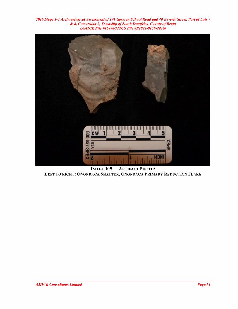
2016 Stage 1-2 Archaeological Assessment of 191 German School Road and 40 Beverly Street, Part of Lots 7 & 8, Concession 2, Township of South Dumfries, County of Brant
(AMICK File #16898/MTCS File #P1024-0159-2016)
AMICK Consultants Limited Page 81
IMAGE 105 ARTIFACT PHOTO:
LEFT TO RIGHT: ONONDAGA SHATTER, ONONDAGA PRIMARY REDUCTION FLAKE

2016 Stage 1-2 Archaeological Assessment of 191 German School Road and 40 Beverly Street, Part of Lots 7 & 8, Concession 2, Township of South Dumfries, County of Brant
(AMICK File #16898/MTCS File #P1024-0159-2016)
AMICK Consultants Limited Page 82
IMAGE 106 ARTIFACT PHOTO:
LEFT TO RIGHT: ONONDAGA BIFACE FRAGMENT, KETTLE POINT PRIMARY REDUCTION FLAKE, ONONDAGA PRIMARY THINNING FLAKE

2016 Stage 1-2 Archaeological Assessment of 191 German School Road and 40 Beverly Street, Part of Lots 7 & 8, Concession 2, Township of South Dumfries, County of Brant
(AMICK File #16898/MTCS File #P1024-0159-2016)
AMICK Consultants Limited Page 83
IMAGE 107 ARTIFACT PHOTO:
TOP: BOTTLE GLASS, CONTAINER GLASS, WINDOW GLASS BOTTOM: CONTAINER GLASS, BOTTLE GLASS, MILK GLASS GLASS
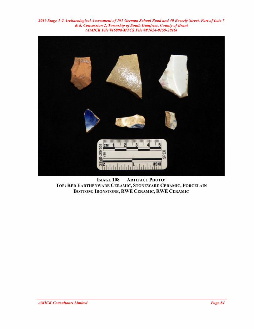
2016 Stage 1-2 Archaeological Assessment of 191 German School Road and 40 Beverly Street, Part of Lots 7 & 8, Concession 2, Township of South Dumfries, County of Brant
(AMICK File #16898/MTCS File #P1024-0159-2016)
AMICK Consultants Limited Page 84
IMAGE 108 ARTIFACT PHOTO:
TOP: RED EARTHENWARE CERAMIC, STONEWARE CERAMIC, PORCELAIN BOTTOM: IRONSTONE, RWE CERAMIC, RWE CERAMIC
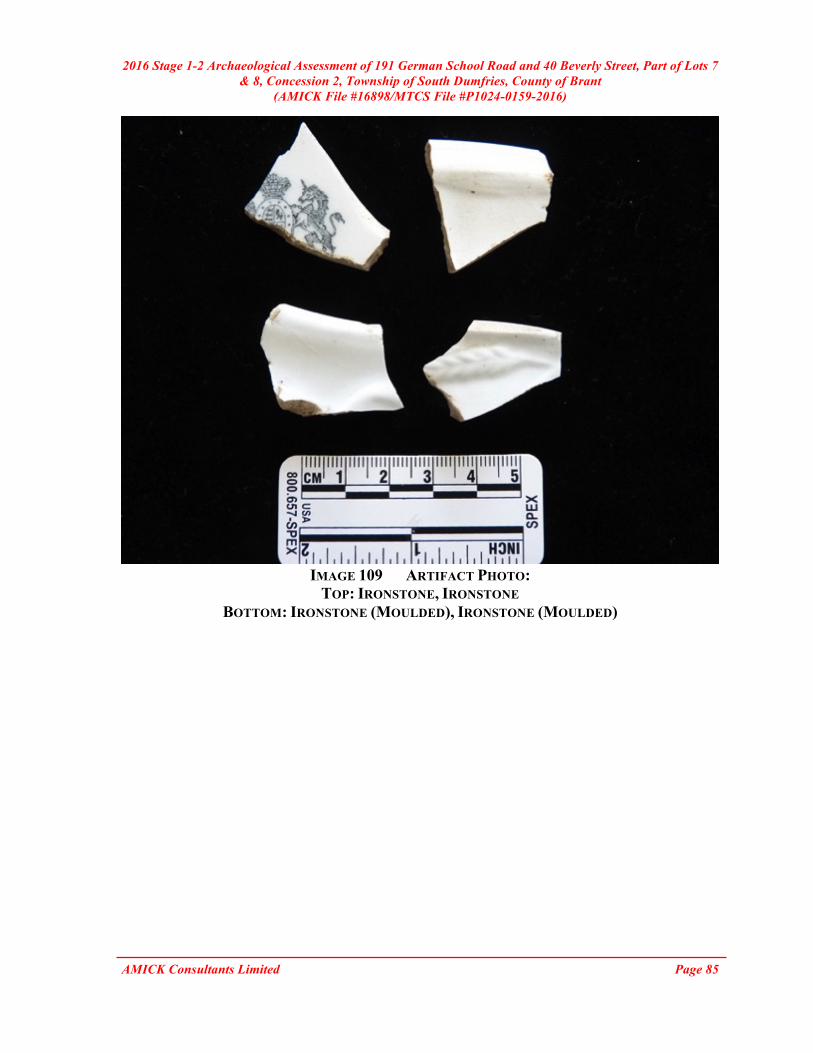
2016 Stage 1-2 Archaeological Assessment of 191 German School Road and 40 Beverly Street, Part of Lots 7 & 8, Concession 2, Township of South Dumfries, County of Brant
(AMICK File #16898/MTCS File #P1024-0159-2016)
AMICK Consultants Limited Page 85
IMAGE 109 ARTIFACT PHOTO:
TOP: IRONSTONE, IRONSTONE BOTTOM: IRONSTONE (MOULDED), IRONSTONE (MOULDED)

2016 Stage 1-2 Archaeological Assessment of 191 German School Road and 40 Beverly Street, Part of Lots 7 & 8, Concession 2, Township of South Dumfries, County of Brant
(AMICK File #16898/MTCS File #P1024-0159-2016)
AMICK Consultants Limited Page 86
IMAGE 110 ARTIFACT PHOTO:
LEFT TO RIGHT: INDETERMINATE NAIL, BOTTLE GLASS, BOTTLE GLASS

2016 Stage 1-2 Archaeological Assessment of 191 German School Road and 40 Beverly Street, Part of Lots 7 & 8, Concession 2, Township of South Dumfries, County of Brant
(AMICK File #16898/MTCS File #P1024-0159-2016)
AMICK Consultants Limited Page 87
IMAGE 111 ARTIFACT PHOTO:
LEFT TO RIGHT: RED EARTHENWARE CERAMIC, IRONSTONE, IRONSTONE, RWE CERAMIC

2016 Stage 1-2 Archaeological Assessment of 191 German School Road and 40 Beverly Street, Part of Lots 7 & 8, Concession 2, Township of South Dumfries, County of Brant
(AMICK File #16898/MTCS File #P1024-0159-2016)
AMICK Consultants Limited Page 88
IMAGE 112 ARTIFACT PHOTO:
LEFT TO RIGHT: BONE BUTTON, BOTTLE GLASS, BOTTLE GLASS, WINDOW GLASS

2016 Stage 1-2 Archaeological Assessment of 191 German School Road and 40 Beverly Street, Part of Lots 7 & 8, Concession 2, Township of South Dumfries, County of Brant
(AMICK File #16898/MTCS File #P1024-0159-2016)
AMICK Consultants Limited Page 89
IMAGE 113 ARTIFACT PHOTO:
TOP: RWE (RED TRANSFER PRINT), RWE (BROWN TRANSFER PRINT), RWE (BLUE TRANSFER PRINT)
BOTTOM: RWE (BLUE SPONGEWARE), RWE, GILDED PORCELAIN

2016 Stage 1-2 Archaeological Assessment of 191 German School Road and 40 Beverly Street, Part of Lots 7 & 8, Concession 2, Township of South Dumfries, County of Brant
(AMICK File #16898/MTCS File #P1024-0159-2016)
AMICK Consultants Limited Page 90
IMAGE 114 ARTIFACT PHOTO:
TOP: IRONSTONE, IRONSTONE, IRONSTONE BOTTOM: RWE, RWE, IRONSTONE