1. metro colombo urban project - world bank€¦ · 1 1. metro colombo urban development project...
TRANSCRIPT

1
1. Metro Colombo Urban Development Project
Environmental Screening Report for Establishment of Beddagana and Kotte Ramparts Parks
Draft Final Report
December 2011
Uni‐Consultancy Services University of Moratuwa
Pub
lic D
iscl
osur
e A
utho
rized
Pub
lic D
iscl
osur
e A
utho
rized
Pub
lic D
iscl
osur
e A
utho
rized
Pub
lic D
iscl
osur
e A
utho
rized
Pub
lic D
iscl
osur
e A
utho
rized
Pub
lic D
iscl
osur
e A
utho
rized
Pub
lic D
iscl
osur
e A
utho
rized
Pub
lic D
iscl
osur
e A
utho
rized

2
Table of Contents
1. Project Identification 3
2. Project Location 3
3. Project Justification 7
4. Project Description 9
5. Description of the Existing Environment 12
6. Public Consultation 20
7. Environmental Effects and Mitigation Measures
7a. Screening for Potential Environmental Impacts 22
7b. Environmental Management Plan 29
8. Conclusion and Screening Decision 37
9. Screening Decision Recommendation 44
10. EMP implementation responsibilities and costs 45
11. Details of Persons Responsible for the Environmental Screening 48
Annexes
1. List of bird species recorded during previous studies at Beddagana
2. Some species suitable for reforestation programme at Beddagana
3. Photographs of some of the important locations along project roads
4. Detailed drawings of project components

3
Metro Colombo Urban Development Project
Environmental Screening Report
1. Project Identification
Project title Establishment of Beddagana and Kotte Rampart Park
Project Proponent
Urban Development Authority
2. Project Location
Location Location of the project is depicted in the Fig. 1.
Definition of Project Area
(The geographical extent of the project & areas affected during construction)
The project area is located within Sri Jayawardenapura Kotte MC area. Boundaries are as follows:
Site 1
North - Nippon Mawatha
South - Canal
East - Beddagana Road
West - Diyawanna Oya
Site 2
North - Jayawardenapura Kotte Road
South - Thotupola Road
East - Nippon Mawatha
West - School lane and Electricity Board Premises
Adjacent land and features
See “Other features” in Section 5.2 .
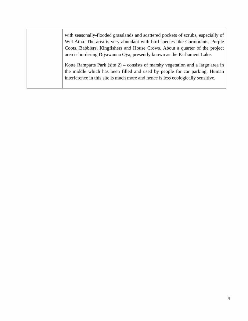
Beddagana Park (site 1) consists of a few natural water ponds and marshy areas
URBAN UPGRADING WORK
4
with seasonally-flooded grasslands and scattered pockets of scrubs, especially of Wel-Atha. The area is very abundant with bird species like Cormorants, Purple Coots, Babblers, Kingfishers and House Crows. About a quarter of the project area is bordering Diyawanna Oya, presently known as the Parliament Lake.
Kotte Ramparts Park (site 2) – consists of marshy vegetation and a large area in the middle which has been filled and used by people for car parking. Human interference in this site is much more and hence is less ecologically sensitive.

5
Figure 1. Map showing Beddagana Park (Site 1 - below), Kotte Rampart Park (Site 2 - above) and its surrounding areas

6
Figure 2. Layout and the details of the Beddagana Park

7
3. Project Justification
Need for the project
(What problem is the project going to solve)
Sri Jayawardanapura Kotte is significant in terms of historical importance as the last Kingdom of Sri Lanka and also as the present administrative capital of the country. Most of the land, which is located around the parliament complex consists of vast stretches of low-lying land. Being the administrative capital, most of the low lying lands had to be filled for development while some lands were identified to be preserved for flood retention purposes.
This is one of the sub projects of the integrated urban development project of “Improvement, Management and Maintenance of UDA owned flood detention areas around the Parliament Lake”. The site is located close to the parliament complex abutting Diyawanna Oya, with very high scenic beauty and bio- diversity. In 1984, this area was gazetted as a Wildlife Sanctuary by the Department of Wild Life Conservation considering its bird habitation. Sri Lanka Land Reclamation and Development Corporation has also identified this area as a flood retention area. However, there has been severe pressure in numerous occasions requesting these lands to be filled for development, since the area in the vicinity of a highly urbanized environment with sound infrastructure and high land value. In addition, these lands are severely threatened by encroachments as most areas are without proper demarcation of boundaries.
According to the Development Plan of the UDA and Sri Jayawardanapura Kotte MC, this area falls within the wetland protection zone. Hence it is not permitted to develop the land for any construction works other than the uses mentioned in the said zone.
The project will help solve the following problems and contribute immensely to environmental protection.
• Encroachments and unauthorized filling • Dumping of garbage • Lack of facilities for environmentalist, students, public and
tourist to enjoy scenic beauty and learn about wetland structure, functions and bio-diversity
• Threat to the Bio- diversity • Visual pollution • Flooding

8
• Security (Smugglers and others who loiter in the area)
Purpose of the project
(what is going to be achieved by carrying out the project)
The project has the following multiple objectives (See Fig. 2). • To enhance the natural environment of the area combining the
Water Front Development of Diyawanna Oya which is rich in scenic beauty where recreational facilities could be introduced
• To protect wetland bio–diversity by preserving a preferred environment, especially for birds and butterflies
• To create opportunities for students and naturalists to learn/explore wetland plants and animal species
• To improve as a tourist attractive site with providing recreational facilities
• To maintain and preserve the wetland for flood retention purposes
Also, the project will derive the following benefits:
Preserve the natural environment by utilizing the land for eco-friendly development (nature trials, timber structures, creation of ponds, tree planting etc.)
Protect wildlife by creating breeding and feeding grounds for birds
Promote recreational activities, walkways, bird watching etc. Prevent public land development for unacceptable uses and
from encroachments Conserve the area for the use of future generation
Alternatives considered
(different ways to meet the project need and achieve the project purpose)
No other alternative is considered for the project as it is envisaged that there are no other technically feasible and economically viable engineering interventions that could be accommodated in place of the proposed option.

9
4. Project Description
Proposed start date
The tender documents are expected to be ready by 31/01/2012. Awarding of the tender will take place only after the 16th of March 2011. Construction period is estimated to be 20 months.
Proposed completion date
It will take approximately 25 months to finish the project from the date of opening bid documents.
Estimated total cost
Estimate: Rs. 175 Mn.
Present land ownership
Entire project lies in areas belonging to UDA, SLLRDC and SJKMC.
Description of the project
(with supporting material such as maps, drawings etc attached as required)
The project area consists of two blocks of wetlands located close to each other as indicated in the figure above. Details of the developments in each site (All the structures are made of timber) Site 1 (Beddagana Park – 18 ha) i. Orientation Centre - Open deck (95 Sq.m.); Display area/
Office with seating facilities; Toilets; Supply of Electricity and Water ii Entrance - Entrance Bridge (15 m length); 2 Tree
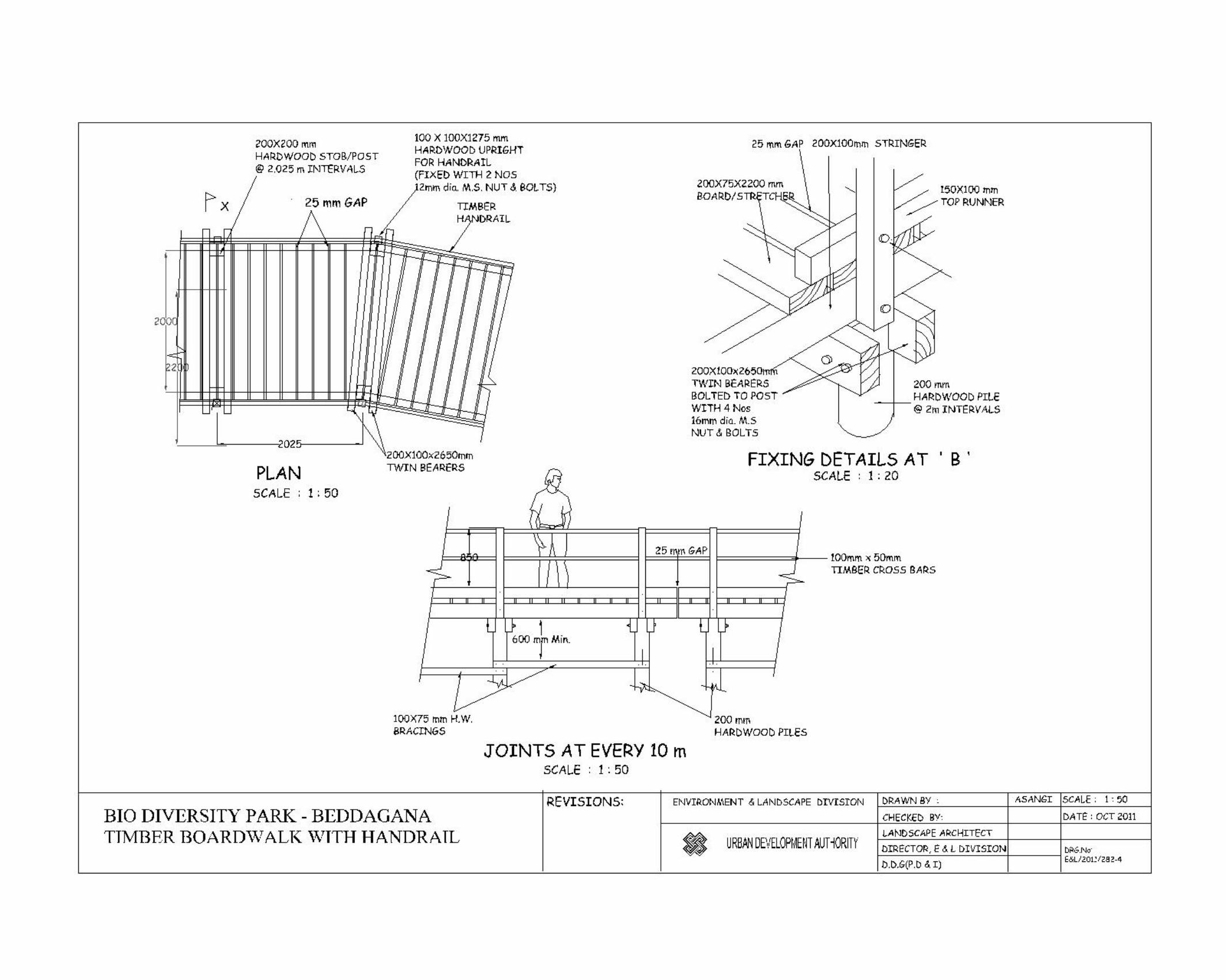
troughs; Paved area (10’x20’) ; Lighting iii. 2 Bridges connecting with two bunds (1.5 m width) - length 37 m iv. Board walks (2 Nos.) - Total length 100 m v. Open Decks (4 Nos.) - 3.0 m x 3.0 m - 03 Nos. and 4.5 m x 2.4
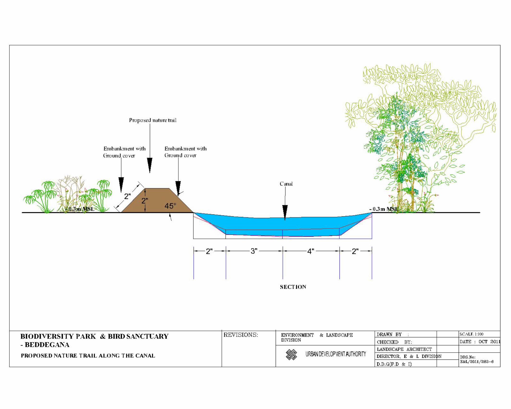
m – 01 Nos. vi. Bird watching Hide (2 Nos.) - (3 m x 1 m) 3 Sq.m. vii. Resting place (01 Nos.) - 6 Sq.m viii. Bird watching tower - 3 m x 3 m and 7.5 m height ix. Nature trail - 320 m x. Cleaning of existing canals - 600 m xi. Improvement of bund roads - 1250 m xii. Reforestation of Field Study area -Tree planting, Timber play features

10
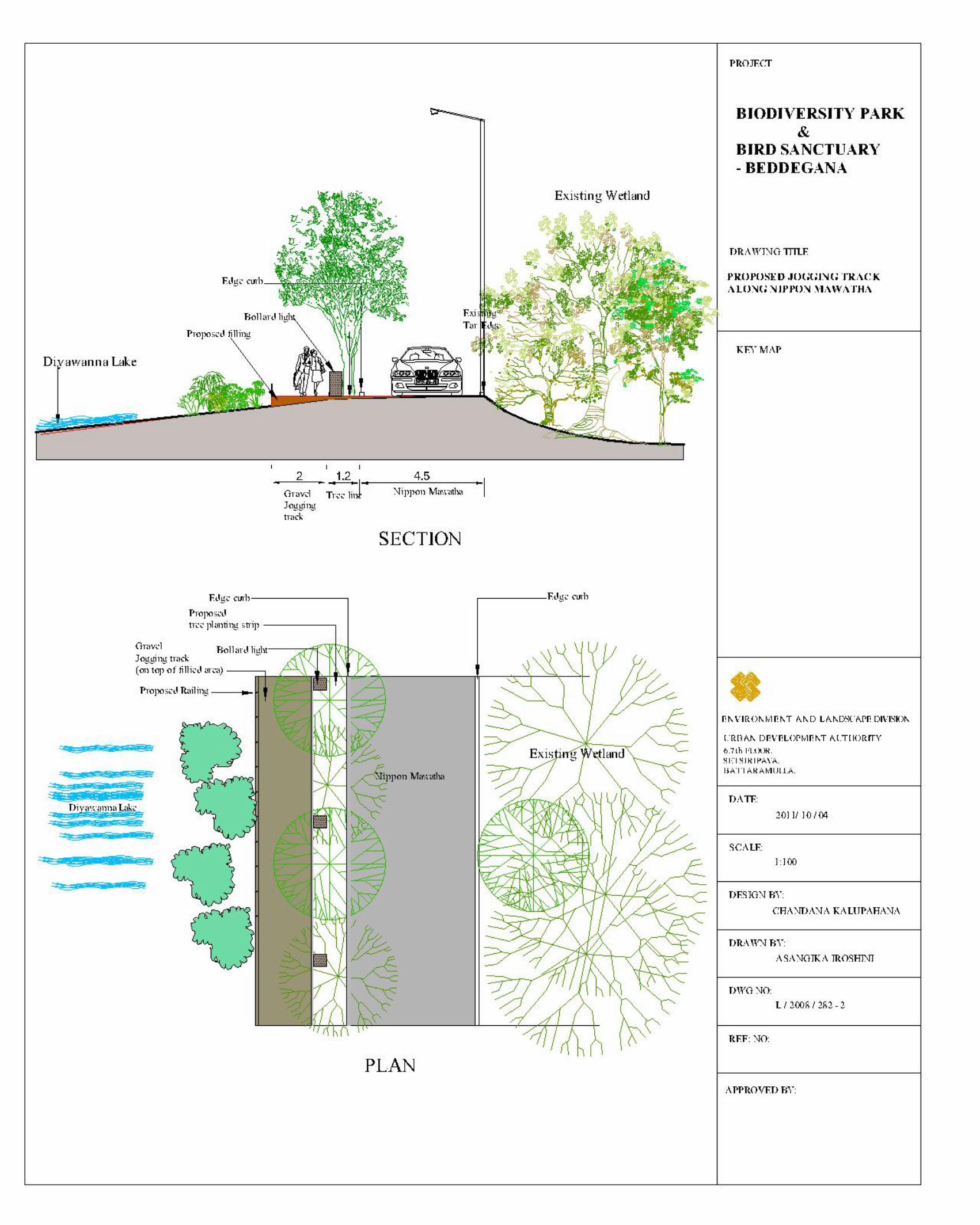
xiii. Improvement of Play area - 1 Acre xiv. Pond with Island - 1500 m3 xv. Jogging path - Length 2.2 km
Tree planting Strip in either side (1.2 m wide) Paved jogging track (6 m wide) Timber Board wakes where necessary Street lamps, Resting place with Decks
xvi. Improvement of Nippon Mawatha
2. Site No.2 (Kotte Rampart Park – 14 ha) i. Tree planting - ii. Dredging of peripheral canal - iii. Creating bund road - iv. Nature trails - v. Board walks - 850 Sq.m vi. Open decks - vii. Eco-kiosks - viii. Jungle Gym/ Yoga Centre - ix. Security hut/ Ticketing counter- x. Car park - xi. Toilets - xii. Supply of Electricity and Water- xiii. Removal of invasive Vegetation Species where possible -
Project Management Team
Agency:
All planning, architectural, landscaping and engineering design works have been carried out by the UDA. Project supervision will also be carried out by the UDA project team. Canal cleaning, Drainage and excavation work will be supervised by the SLLR&DC. For operation and maintenance of the site, the UDA has carried out several rounds of discussion with the Sri Lanka Nippon Educational & Cultural Center (SLNE&CC), Diyawanna Walkers Club and community organizations who have willing agreed to come together as a management committee to ensure the proper maintenance of the Parks. The UDA as well as the Department of Wildlife Conservation, Central Environmental Authority etc will be stakeholders of the management committee as monitoring agencies. A

11
formal MOU is proposed to be signed before the completion of the project.
Contact person:
Mrs. Priyani , Development Officer, UDA
Nature of the consultation and input received:
Meeting and consultation at design office and site were done. Design drawings, master plans and other relevant information were too gathered.

12
5. Description of the existing environment
5.1 Physical features – Ecosystem components
Topography and terrain
The topography of Sri Lanka is marked by great diversity caused by long years of faulting and erosion of the landscape. The central mountainous region with the highest elevations covered by virgin forests and grasslands rises up to about 2,500 m above mean sea level. The surrounding plains, which rise to about 50 to 100 m above sea level, are largely used for agriculture and homesteads, but still have virgin scrubland where the population distribution is lower. This general topography of the country can be divided into three distinct geographical areas or well marked peneplains featuring the coastal belt, the plains, and the central highlands. The Colombo district which incorporates the project area falls into the so called lowest peneplain of Sri Lanka (after P.G. Cooray – Geology of Sri Lanka, 1984). The elevation variation of Colombo district situated in this coastal peneplain ranges to a maximum elevation of 150 m from sea coast. The terrain in Colombo largely consists of gently undulating plains and low-lying flatlands with a high density of drainage paths formulating a geography consisting of a mix of land and water. The city has many canals and the 65-hectare (160-acre) Beira Lake situated in the heart of the city is one of the most distinctive landmarks of Colombo. The proposed Bio-diversity Park in Beddagana is situated in a 46-acre marshy land with rich biodiversity. The locality falls within the Sri Jayewardenepura Kotte Municipal Council administrative boundary and lies about 3 km east to the Colombo commercial hub. The marshland is connected to the Diyawanna Lake which is part of Diyawanna Oya (stream) and is drained by Kirulapone Canal via Dehiwala Canal and Wellawatta Canal to the sea. The general topography of the project area where the constructions of the park, drainage improvement, and embankment stabilization works have been proposed consists of largely flat or mildly sloping low-lying terrain with a mix of marshy wetlands and water bodies/canals. Elevations vary only from 3 m above mean sea level (MSL) in low-lying areas to 11 m MSL in road embankments and other high areas. Therefore, the slopes

13
encountered in the project area are flat to mild (<1.0 %).
Soil (type and quality)
The geology of Colombo is representative of the geology of the western coast of Sri Lanka and has existed for much of the Quaternary era. Bore holes drilled in central Colombo City show that this area once formed an estuary of the Kelani River and the Kalu Ganga River, the two main rivers that drain into the sea on the western coast. A few kilometers upstream in the inland valleys, there is a high-level gravel formation consisting of quartz pebbles embedded in a matrix of laterite separated with pebble-free layers of laterites. The floodplains along the rivers consist mainly of alluvial deposits. The floodplains of Kelani River also provide thick alluvial profiles for unconfined aquifers, in addition to the productive overburden along tributary banks. Vast area (over 90%) of Sri Lanka is underlain by metamorphic crystalline rocks of Precambrian age, which includes the project area, which cover a variety of Gneisses. The geology of Colombo is representative of the geology of the western coast of Sri Lanka and has existed for much of the Quaternary era. This is shown in the 1:10,000 and 1:50,000 geological maps of Colombo region produced by the Geological Survey and Mines Bureau. The typical rock types of this basement include Biotite gneiss, Hornblende Biotite gneiss, Charnockites, Charnockitic gneisses, Quartzite and undifferentiated Meta sediments. The floodplains along Kelani River and the Kalu Ganga rivers consist mainly of alluvial deposits. The floodplains of Kelani River also provide thick alluvial profiles for unconfined aquifers, in addition to the productive overburden along tributary banks. According to Survey Department soil maps (Fig. 3) the main soil types in the project area are as follows.
• Red Yellow Podzolic soils with soft or hard laterite and undulating terrain • Bog and Half bog soils: flat terrain • Alluvial soils of variable texture and drainage: flat terrain • Regosols on recent beach sands: flat terrain
Field surveys and direct observations carried using recently formed earthen embankments and burrow pits

14
have indicated that the local geology in the proposed project area is characterized by peat/peaty clays with sand and patches of laterite with bedrock > 20 m depth while the soil types include peat and organic clays with surface alluvium with sporadic laterite patches, especially on high ground. It is presumed that these site-specific features are the most important ones as the environmental impact is considered.
Figure 3. Soil Maps of the Study Area (Source: Greentech, 2011)

15
Surface water (sources, distance from the site, local uses and quality)
Sources: The most prominent source of surface water in the vicinity is the Diyawanna lowland area, canals and surface water ponds, and marshes that are connected with wetland.
Distance from the site: Project area is within the wetland.
Local uses: The surface water bodies connected with the wetland play an important role in conveying surface drainage and flood waters. Apart from direct uses that the local people derive, such as recreation, bathing, washing and for other domestic purposes, other indirect benefits such as scenic beauty, use of the area as a nature reserve, diverting their surface drainage into these canals, are too vital and most important intrinsic functions. Illegal discharge of grey water from residences and, commercial establishments, dumping solid waste into water bodies and encroachment are common problems that pollute the water resources in the area.
Quality:
Table 1. Water quality fluctuations in the Diyawanna Oya
Parameter Water Quality (during 2004-2009)
pH 5.8 – 6.9 Conductivity (dS/m) 0.1-0..3 Turbidity (NTU) 8-15 Ammonia (mg/l) 0.24-0.56 Nitrates (mg/l) 0.3-0.4 Phosphates (mg/l) 0.3-0.4 DO (mg/l) 3.2-5.5 BOD (mg/l) 6-10 COD (mg/l) 17-33
The water quality of the Diyawanna lowland area does not seems to be badly deteriorated but as it goes
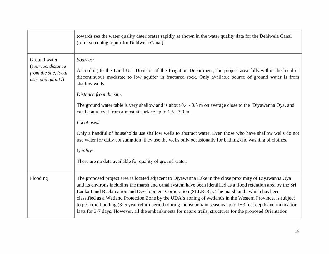
16
towards sea the water quality deteriorates rapidly as shown in the water quality data for the Dehiwela Canal (refer screening report for Dehiwela Canal).
Ground water (sources, distance from the site, local uses and quality)
Sources:
According to the Land Use Division of the Irrigation Department, the project area falls within the local or discontinuous moderate to low aquifer in fractured rock. Only available source of ground water is from shallow wells.
Distance from the site:
The ground water table is very shallow and is about 0.4 - 0.5 m on average close to the Diyawanna Oya, and can be at a level from almost at surface up to 1.5 - 3.0 m.
Local uses:
Only a handful of households use shallow wells to abstract water. Even those who have shallow wells do not use water for daily consumption; they use the wells only occasionally for bathing and washing of clothes.
Quality:
There are no data available for quality of ground water.
Flooding The proposed project area is located adjacent to Diyawanna Lake in the close proximity of Diyawanna Oya and its environs including the marsh and canal system have been identified as a flood retention area by the Sri Lanka Land Reclamation and Development Corporation (SLLRDC). The marshland , which has been classified as a Wetland Protection Zone by the UDA’s zoning of wetlands in the Western Province, is subject to periodic flooding (3~5 year return period) during monsoon rain seasons up to 1~3 feet depth and inundation lasts for 3-7 days. However, all the embankments for nature trails, structures for the proposed Orientation

17
Centre, walkways and footpaths and structures for bird watching are expected to be designed by SLLRDC, considering these historical flood records/levels and without obstructing the existing cross – and through drainage paths and flow regimes, and also not leading to any reduction in the present flood retention and detention capacities of the wetland and marsh areas.
Air quality (any pollution issues)
The project lies close (0.1 - 0.5 Km) to the busy Parliament main road from Colombo which carries a heavy load of vehicular traffic. However, traffic along Nippon Mawatha which is the road that goes bordering the wetland is very low leading to somewhat reduced pollution from dust and vehicle emissions and also because of the abundance of vegetation. No air quality data has been recoded for this area.
Noise level and vibration (Any anticipated issues)
Existing ambient noise and vibration levels in the area are consistent with suburban and light industrial areas. There is also moderate levels of traffic noise from adjoining roads. Industrial activities and commercial activities of the area are not very significant to have high levels of noise.
5.2 Ecological features – Eco-system components
Vegetation
(trees, ground cover, aquatic vegetation)
Mainly, secondary vegetation can be found in the area including native species; Bowitiya (Osbeckia parvifolia), Andara (Dichrostachys cinerea), Weralu (Elaeocarpus serratus), Wel atta (Annona glabra), Wata-keyiya (Pandanus kaida), Pera (Psidium guajava), Kirilla (Glochidion stellatum), Kenda (Macaranga peltata), Himbutu wel (Salacia chinensis), Wal Habarala (Alocasia macrorrhizos), Hambu pan (Typha angustifolia), Caju (Anacardium occidentale), Gandapana (Lantana camara), Nidikumba (Mimosa pudika), Balunakuta (Dichapetalum gelonioides), Nuga (Ficus bengalensis), Mango (Mangifera indica), Araliya (Plumeria obtusa), Kesel (Musa x paradisiaca), Suriya (Thespesia populnea), Eth thora (Atylosia trinervia), Kaduru (Sapium insigne), Endaru (Ricinus communis), Coconut (Cocus nusifera), Madan (Syzygium cumini), Pethithora (Cassia tora), Acacia (Acacia melanoxylon) etc.

18
Two invasive species such as Wel atta (Annona glabra) and introduced species Acacia (Acacia melanoxylon) were recorded.
Presence of wetlands Majority of the land extend of the proposed project site is a marshy land. Birds and butterflies diversity is high in the proposed Beddagana park. However, existing condition of the wetland is very poor. For instance, some areas have been used as dumping sites (Beddagana) and as car parks (Kotte Ramparts). In addition, plastic, paper, and glass were strewn in the area by visitors to the site.
Fish and fish habitats
There is a water hole in the Beddagana site and at present its banks are somewhat eroded. However the place provides habitat for fresh water fish species. Fish sampling was not carried out during the rapid study.
Birds (waterfowl, migratory birds, others)
According to the previous records of birds there are 18 migrant bird species and 34 resident bird species present in the area. During the rapid survey, 12 bird species were recorded; Cattle Egtret (Bubulcus ibis), Spotted Dove (Streptopelia chinensis ceylonensis), Red-Wattled Lapwing (Vanellus cinereus), Asian Paradise Fly Catcher (Terpsiphone paradisi), Common Mayna (Acridotheres tristis), Yellow-Billed Babbler (Turdoides affinis), Purple Swamp Hen (Porphyrio porphyrio), White Breasted Water Hen (Amaurornis phoenicurus), Black Hooded Oriole (Oriolus xanthornus), Rose ringed parakeet (Psittacula krameri), Lesser Whistling Duck (Dendrocygna javanica), and Indian Pond Heron (Ardeola grayii) were found during the site visit. Detail list of birds recorded given in the Annex I.
Presence of special habitat areas (special designations & identified sensitive zones)
Entire Beddagana project site is identified as a sensitive area. Part of the wetland area which has been filled many years ago and currently used by people for walking etc will be replanted with native trees to create a mini jungle effect. List of species proposed for reforestation programme is given in Annex II. The Kotte Ramparts wetland does not support as much diversity as Beddagana and hence is considered less sensitive.

19
Other features
Residential/Sensitive Areas (Eg, Hospitals, Schools)
Two temples are located on the opposite side of the Beddagana Wetland. The rest of the area surrounding the wetlands are higly residential. The proposed project would be a complementary to the present built environment.
Traditional economic and cultural activities
No traditional economic activities are carried out. Two temples (not ancient ones) attract a large number of people particularly during weekends and Poya days.
Archeological resources
The rampart of the Ancient Kotte Kingdom is located in close proximity to the proposed Kotte Ramparts park and the project area and is coming under the authority of Department of Archeology. None of the project activities have any impact on the ramparts.

20
6. Public Consultation
Public consulted Consultation method
Date Details/Issues raised
Meegahatenne Chandasiri Thero (the Chief Incumbent of Sri Mahindarama Temple)
Explaining the project followed by informal discussion
20th December
The temple has been maintaining the environment of the area for the last 20 years through environmental awareness programs among the children and the community. A society has been established within the community to conserve the wetlands. The children who come to the Sunday school are engaged in cleaning the environment through nature loving practical education programmes. The proposed project is a long due one and the temple can assist in many ways to the UDA in implementing the project.
Senevirthne
(A person from the community)
Explaining the project followed by informal discussion
20th December
The main issue is that a few groups of people use this location for consuming alcohol and other narcotics. They are found to travel by three wheelers / motor bicycles and spend the day engaged in numerous illegal activities. The empty bottles and cans are thrown into the wetlands. Some outsiders also dispose of garbage here. It is necessary to make sure that such activities are prevented in the future. The project is good for the community.
Thilakerathne
(A person from the community close to the bathing place)
Explaining the project followed by informal discussion
20th December
The project is very good for the community. It is of importance to make sure that the present bathing place of the community is protected and provide access to it as the community has been using it for bathing for a long period of time. However, an issue at the bathing place is that a few fish vendors from outside as a habit come to wash their fish containers and bicycles. It is prudent to make sure to prevent such activities to keep the bathing place clean. The community is aware of the environmental significance of the project and that they can assist UDA in looking after the project area.

21
Sunanda Rathnayake (A youth playing with a team on the existing play area adjacent to the project)
Explaining the project followed d by informal discussion
20th December
This playground had been a part of the wetland system and had been filled by the SLLRDC at the time of dredging Diyawanna Oya for development of the Parliament complex and has ever since become the play area of the youth and children of the area. This open space is widely used by the community and is the only place for them to play. The proposed project is very interesting. But it is very necessary to reserve a reasonable space of land at the present place for the community for a play area.
A motorist
(Name not disclosed), on the road
Explaining the project followed by informal discussion
20th December
It seems that the internal roads are used by many motorists. This is a good by pass as the main road network is congested. However he agreed that the heavy vehicular movement disturbs the natural environment, particularly the bird's sanctuary.

22
7. Environmental Effects and Mitigation Measures
7a. Screening for Potential Environmental Impacts
Screening question Yes No Significance of the effect
(Low, moderate, high)
Remarks
1 Will construction and operation of the Project involve actions which will cause physical changes in the locality
No No physical change is anticipated.
2 Will the Project involve use, storage, transport, handling or production of substances or materials which could be harmful to human health or the environment or raise concerns about actual or perceived risks to human health?
Yes Low
The amount of material to be handled is small. However, for the proposed reforestation area in the Beddagana park good soil may be needed other than peat. The amount of peat that is generated from the project will be kept in the same area or be used for filling purpose for the project itself.
3 Will the Project produce solid wastes during construction or operation?
No Low
During construction period, Municipal solid waste that has been dumped by visitors needs to be collected and disposed of in proper manner. Such material if collected for a lengthy period may become good breeding grounds for mosquitoes.
During operations, MSW will be generated from the
23
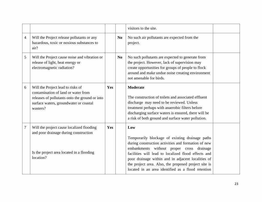
visitors to the site.
4 Will the Project release pollutants or any hazardous, toxic or noxious substances to air?
No No such air pollutants are expected from the project.
5 Will the Project cause noise and vibration or release of light, heat energy or electromagnetic radiation?
No No such pollutants are expected to generate from the project. However, lack of supervision may create opportunities for groups of people to flock around and make undue noise creating environment not amenable for birds.
6 Will the Project lead to risks of contamination of land or water from releases of pollutants onto the ground or into surface waters, groundwater or coastal wasters?
Yes Moderate
The construction of toilets and associated effluent discharge may need to be reviewed. Unless treatment perhaps with anaerobic filters before discharging surface waters is ensured, there will be a risk of both ground and surface water pollution.
7 Will the project cause localized flooding and poor drainage during construction
Is the project area located in a flooding location?
Yes Low Temporarily blockage of existing drainage paths during construction activities and formation of new embankments without proper cross drainage facilities will lead to localized flood effects and poor drainage within and in adjacent localities of the project area. Also, the proposed project site is located in an area identified as a flood retention

24
marshland by the SLLRDC, so periodic inundation, especially during monsoon seasons is expected.
However, ensuring the adaptation of proper design guidelines and construction practices like provision of improved and alternative drainage network, maintaining naturally stable slopes, vegetation replanting, use of suitably designed structures not to disrupt drainage flow regimes and cross drainage without reducing detention/retention capacities of marshes, etc., will improve drainage conditions, reducing flood risk during the construction phase and in the aftermath of project completion.
8 Will there be any risks and vulnerabilities to public safety due to physical hazards during construction or operation of the Project?
No Low
If the walkways, hand rails and children’s play structures are not strong enough including birds watching huts, there will be a slight risk of safety.
9 Are there any transport routes on or around the location which are susceptible to congestion or which cause environmental problems, which could be affected by the project?
No No such congestion is expected from the proposed project.
10 Are there any routes or facilities on or around the location which are used by the public for access to recreation or other
Yes Low
The road along which a jogging track will be

25
facilities, which could be affected by the project?
created is used by the people to access this wetland for recreation purposes. However the accessibility through this road will not be closed during construction.
11 Are there any areas or features of high landscape or scenic value on or around the location which could be affected by the project?
No The whole project area comprises high landscape and scenic value. The project will enhance this value. Scenic value of the area is improved by the project.
12 Are there any other areas on or around the location which are important or sensitive for reasons of their ecology e.g. wetlands, watercourses or other water bodies, the coastal zone, mountains, forests which could be affected by the project?
No The whole project area is a valuable wetland comprising high bio diversity (especially Beddagana park) which is part of the declared wild life sanctuary. The project will enhance the value of this wetland and the sanctuary.
The area is important as it is rich in biodiversity. However, the proposed project may enhance the existing condition of the environment with removal of dumped garbage and it also prevents further garbage dumping as well.
13 Are there any areas on or around the location which are used by protected, important or sensitive species of fauna or flora e.g. for breeding, nesting, foraging, resting, migration, which could be affected by the project?
Yes Low
The whole project area is a valuable wetland and a site for breeding, nesting and resting site for both local and migrant birds. The project will enhance the ecological value of the site and also continue to play its vital role as a breeding, nesting and resting

26
site for both local and migrant birds.
Nesting sites were recorded during previous studies. And trees in the area are roosting sites for migratory and native bird species. However contractor must take every step to minimize the damage to be caused to such sensitive habitats during construction stage.
14 Is the project located in a previously undeveloped area where there will be loss of green-field land
No Green fields will be enhanced after project implementation as there is a reforestation area.
15 Will the project cause the removal of trees in the locality?
No Some parts of the site where species of Annona glabra is grown (evident in the Kotte Rampart park) and spread will be removed to facilitate more indigenous wetlands species that will support the bird life. Therefore, Removal of Wel anoda (Annona glabra) will improve the condition of the environment as it is a invasive wetland tree
.
16 Are there any areas or features of historic or cultural importance on or around the location which could be affected by the project?
No The sites of historical significance belonging to the "Kotte Kingdom" are located close to the site but will have no impact. In fact they would be complementary for the proposed project.
17 Are there existing land uses on or around the location e.g. homes, gardens, other private property, industry, commerce,
No There are private properties next to the project site but will have no impact. In fact they will benefit largely due to improved wetland environment.

27
recreation, public open space, community facilities, agriculture, forestry, tourism, mining or quarrying which could be affected by the project?
18 Are there any areas on or around the location which are densely populated or built-up, which could be affected by the project?
No The residential area exists close to the project site is not densely populated.
19 Are there any areas on or around the location which are occupied by sensitive land uses e.g. hospitals, schools, places of worship, community facilities, which could be affected by the project
No The two temples located will have no impact from the project. In fact they will benefit from the enhanced natural environment.
20 Are there any areas on or around the location which contain important, high quality or scarce resources e.g. groundwater, surface waters, forestry, agriculture, fisheries, tourism, minerals, which could be affected by the project?
Yes Low Increased flow velocities in cleaned, unlined natural or earthen canals may lead to increased erosion risk, while new formations, embankments, loosened soil in unpaved areas may also susceptible to high erosion when exposed to drainage paths, causing washout of fines, degrading surface and groundwater quality in downstream areas and water bodies. The project area consists of one of the most significant surface water bodies. However it will
28
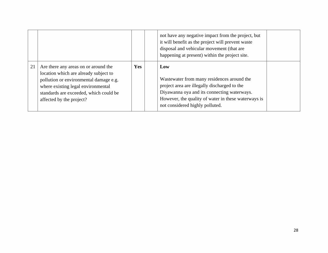
not have any negative impact from the project, but it will benefit as the project will prevent waste disposal and vehicular movement (that are happening at present) within the project site.
21 Are there any areas on or around the location which are already subject to pollution or environmental damage e.g. where existing legal environmental standards are exceeded, which could be affected by the project?
Yes Low
Wastewater from many residences around the project area are illegally discharged to the Diyawanna oya and its connecting waterways. However, the quality of water in these waterways is not considered highly polluted.
29
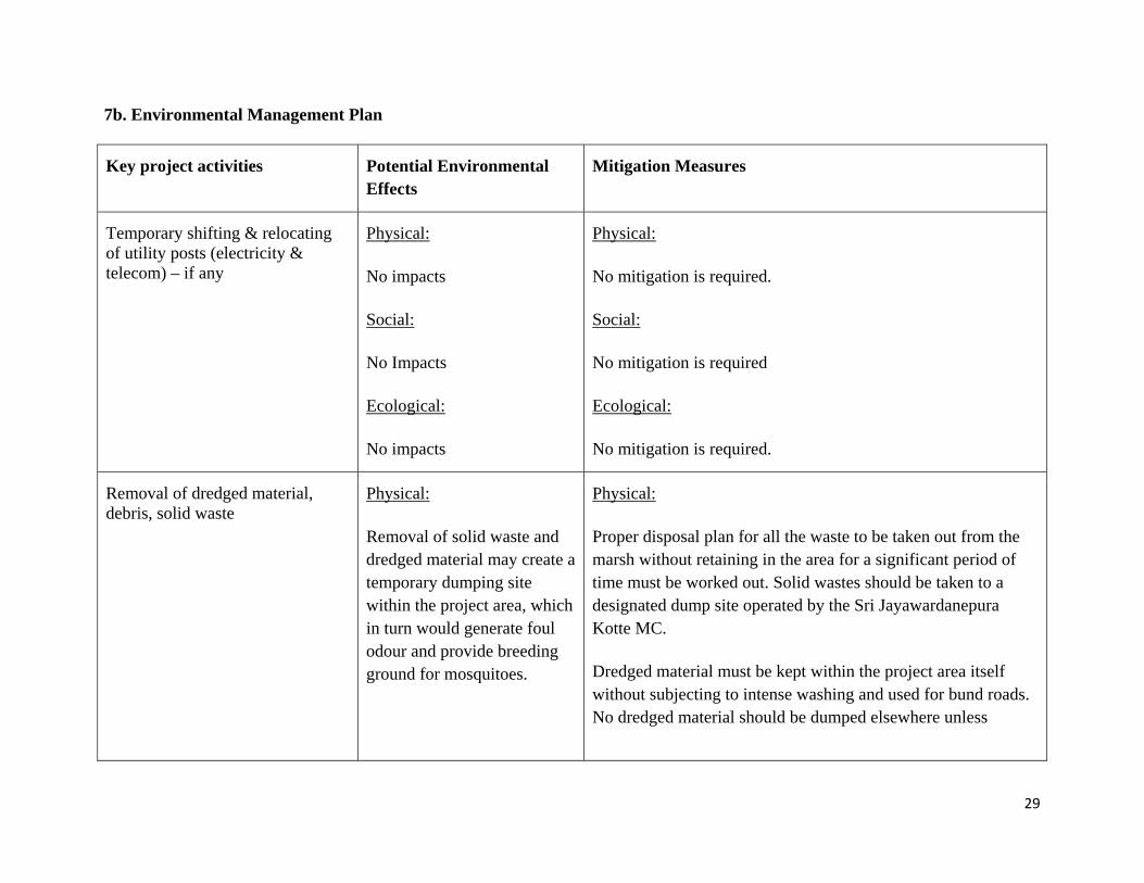
7b. Environmental Management Plan
Key project activities Potential Environmental Effects
Mitigation Measures
Temporary shifting & relocating of utility posts (electricity & telecom) – if any
Physical:
No impacts
Social:
No Impacts
Ecological:
No impacts
Physical:
No mitigation is required.
Social:
No mitigation is required
Ecological:
No mitigation is required.
Removal of dredged material, debris, solid waste
Physical:
Removal of solid waste and dredged material may create a temporary dumping site within the project area, which in turn would generate foul odour and provide breeding ground for mosquitoes.
Physical:
Proper disposal plan for all the waste to be taken out from the marsh without retaining in the area for a significant period of time must be worked out. Solid wastes should be taken to a designated dump site operated by the Sri Jayawardanepura Kotte MC.
Dredged material must be kept within the project area itself without subjecting to intense washing and used for bund roads. No dredged material should be dumped elsewhere unless

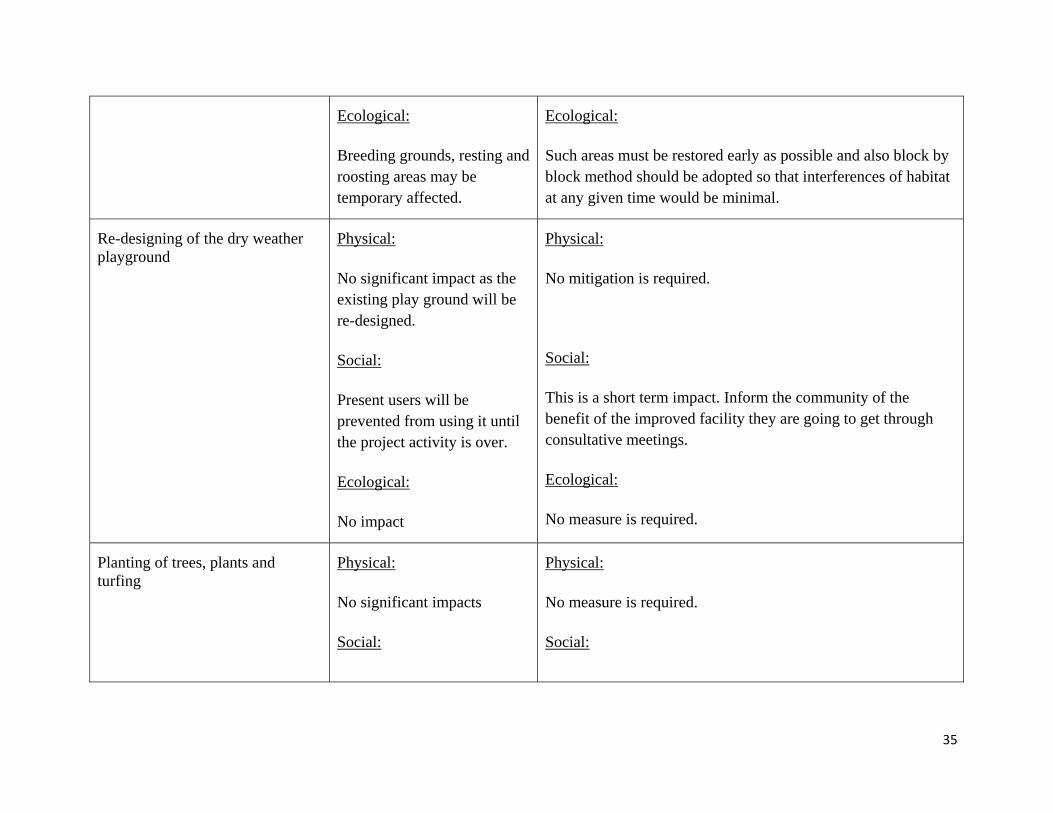
30
Social:
Visual pollution is apparent
Ecological:
Breeding grounds, resting and roosting areas may be temporary affected.
otherwise approval is granted by Department of Wildlife.
Social:
Such heaps should be disposed off as early as possible in accordance with the recommendations above.
Ecological:
Such areas must be restored early as possible and also block by block method should be adopted so that interferences of habitat at any given time would be minimal.
Rehabilitation of bund roads, existing main road, drainage canals along bund roads, existing canals draining the water out and into the nature park area
Physical:
Formation of new embankments/slopes in existing bund roads and rehabilitation of internal canals will increase risk of slope failure when near vertical soil faces are formed, and will increase erosion risk when loose soils are exposed to drainage paths. Excavation for additional drains and dredging to attain required design depths in
Physical:
Naturally stable slopes should be maintained where ever possible. Provision of alternate flow paths adequate cross drainage (culverts), should be ensured during rehabilitation of existing roads to avoid localized flooding and related adverse impacts. Slopes in canals, should be provided properly following appropriate design guidelines, not to exceed safe velocities to avoid erosion and to maintain minimum slopes to ensure self cleansing of silts and colloids. Construction activities should be scheduled during dry periods to reduce runoff flows, causing siltation and water quality

31
existing canals may generate debris, soil and dredge materials which may pose risk of fine material washout, cause obstruction to existing drainage patterns, hinder site mobility when not stored properly.
Social:
Visual pollution may be apparent
Ecological:
Smothering of benthic fauna on temporary basis
degradation in the water bodies. Construction debris, materials should be stored covered on high ground and away from flow paths. Material recycling should be promoted and period of temporary storage should be minimized through proper scheduling of construction activities and debris disposal at designated locations. Dredged material from the deepening of canals inside the wetlands should be used in the bund roads, as has been done earlier by the SLLRDC in the Beddagana park.
Social:
Too much of colloidal particles must be trapped as indicated above.
Ecological:
Engineering interventions as described above should be implemented in order to prevent wash out and deposition of benthic particles.
Material transport and storage
Physical:
The bye-roads can be congested as they are narrow.
Storage of material can block
Physical:
Transporting activities can be carried out during off-peak hours, and heavy vehicular transport should be prohibited.
Storage sites can be selected so that drainage paths are not

32
drainage paths
Sporadic high noise and dust levels could be apparent
Social:
Inconvenience to the neighbours may result in
Ecological:
No Impacts
obstructed.
Covering material while transporting is made mandatory.
Social:
Proper housekeeping practices of engineering will be encouraged.
Ecological:
No mitigation is required
Re-designing of all foot walks, jogging paths
Physical:
Blockage to existing flow patterns due to new formations/embankments would affect existing flow regimes causing undesirable environmental consequences to sensitive ecosystems. Social: Inconvenience to people who use this road as a jogging track at present
Physical:
Adequate cross drainage should be provided while minimizing undesirable flow diversions to maintain existing flow regimes.
Social: This is very negligible. However it is necessary to fix sign boards at appropriate locations to keep the pedestrians informed of the construction.
Proper safety wearing is essential. Safety Officer must be

33
Health hazards and deceases such as leptospirosis, dengue may be unavoidable for workers
Ecological:
Temporary smothering will be possible
appointed for monitoring purposes.
Ecological:
Proper planning of work in the form of sections will be encouraged.
Construction of structures including visitors’ centre, bird watching areas, nature trails, viewing decks, toilets, nature trails etc.
Physical:
Blockage to existing flow patterns due to new formations/embankments would affect existing flow regimes causing undesirable environmental consequences to sensitive ecosystems. Water pollution may take place from toilets
Social:
Inconvenience to people who use this road as a jogging
Physical:
Adequate cross drainage should be provided while minimizing undesirable flow diversions to maintain existing flow regimes.
The proposed toilet design with sealed type septic tank as proposed may not be the most suitable for the project area. The design should be reviewed according to SLS 745 : 2004 Code of Practice for Design and Construction of Septic Tanks and Associated Effluent Disposal System.
Social:
This is very negligible. However it is necessary to fix sign boards at appropriate locations to keep the pedestrians informed

34
track at present
Health hazards and deceases such as leptospirosis, dengue may be unavoidable for workers
Ecological:
Temporary smothering will be possible
of the construction.
Proper safety wearing is essential. Safety Officer must be appointed for monitoring purposes.
Ecological:
Proper planning of work in the form of sections will be encouraged.
Dredging, physical strengthening of embankments
Physical:
Removal of dredged material from the wetland canals may create temporary dumping site within the project area, which in turn create fouling odour and be breeding ground for mosquitoes.
Social:
Visual pollution is apparent
Physical:
Dredged material must be kept at the project area itself without subject to intense washing and used for bun road strengthening, as has been done earlier. No dredged material would be dumped elsewhere unless otherwise approval is granted by Department of Wildlife.
Social:
Such heaps should be disposed of as early as possible in accordance to the management plan.
35
Ecological:
Breeding grounds, resting and roosting areas may be temporary affected.
Ecological:
Such areas must be restored early as possible and also block by block method should be adopted so that interferences of habitat at any given time would be minimal.
Re-designing of the dry weather playground
Physical:
No significant impact as the existing play ground will be re-designed.
Social:
Present users will be prevented from using it until the project activity is over.
Ecological:
No impact
Physical:
No mitigation is required.
Social:
This is a short term impact. Inform the community of the benefit of the improved facility they are going to get through consultative meetings.
Ecological:
No measure is required.
Planting of trees, plants and turfing
Physical:
No significant impacts
Social:
Physical:
No measure is required.
Social:

36
No Impacts
Ecological:
No negative impact of the activity and this may enhance the environment.
No measure is required.
Ecological:
It is better to introduce plants found in the area rather than introducing new species.

37
8. Conclusion and Screening Decision
Summary of environmental effects: Assuming that all mitigation measures are implemented as proposed, the following effects can be predicted
Key project activities Potential Environmental Effects Significance of the environmental effect with mitigation in place
NS- Effect not significant, or can be rendered insignificant with mitigation SP - Significant positive effect SN - Significant negative effect U - Outcome unknown or cannot be predicted, even with mitigation NA – Not applicable
Temporary shifting & relocating of utility posts (electricity & telecom) – if any
Physical:
No impacts
Social:
No Impacts
Ecological:
No impacts
NA
NA
NA

38
Removal of dredged material, debris, solid waste
Physical:
Removal of solid waste and dredged material may create temporary dumping site within the project area, which in turn create fouling odour and be breeding ground for mosquitoes.
Social:
Visual pollution is apparent
Ecological:
Breeding grounds, resting and roosting areas may be temporary affected.
NS NS NS
Rehabilitation of access roads, existing roads, drainage canals along roads, existing canals draining the water out and into the nature park area
Physical:
Formation of new embankments/slopes in existing roads and rehabilitation of drainage canals will increase risk of slope failure when near vertical soil faces are formed, and will increase erosion risk when loose soils are exposed to drainage paths. Excavation for additional drains and dredging to attain required design depths in existing canals may generate huge volumes of debris, soil and dredge materials which may pose risk
NS
NS

39
of fine material washout, cause obstruction to existing drainage patterns, hinder site mobility when not stored properly, and also pose environmental and health risks when not disposed of into predetermined safe locations.
Social:
Visual pollution may be apparent
Ecological:
Smothering of benthic fauna on temporary basis
NS
NS
Material transport and storage
Physical:
The bye-roads can be congested as they are narrow.
Storage of material can block drainage paths
Sporadic high noise and dust levels could be apparent
Social:
Inconvenience to the neighbours may result in
NS
NS
NS
NS

40
Ecological:
No Impacts
NA
Re-designing of all foot walks, jogging paths
Physical:
Blockage to existing flow patterns due to new formations/embankments would affect existing flow regimes causing undesirable environmental consequences to sensitive ecosystems.
Social:
Inconvenience to people who use this road as a jogging track at present
Health hazards and deceases such as leptospirosis, dengue may be unavoidable for workers
Ecological:
Temporary smothering will be possible
NS NS NS NS
Construction of structures including visitors’ centre, bird watching areas, nature trails,
Physical:
Blockage to existing flow patterns due to new
NS

41
viewing decks, toilets, nature trails etc.
formations/embankments would affect existing flow regimes causing undesirable environmental consequences to sensitive ecosystems. Water pollution may be apparent from toilets
Social:
Inconvenience to people who use this road as a jogging track at present
Health hazards and deceases such as leptospirosis, dengue may be unavoidable for workers
Ecological:
Temporary smothering will be possible
NS NS NS NS
Dredging, physical strengthening of embankments
Physical:
Removal of dredged material may create temporary dumping site within the project area, which in turn create fouling odour and be breeding ground for mosquitoes.
NS

42
Social:
Visual pollution is apparent
Ecological:
Breeding grounds, resting and roosting areas may be temporary affected.
NS
NS
Re-designing of the dry weather playground
Physical:
No significant impact as the existing play ground will be re-designed.
Social:
Present users will be prevented from using it until the project activity is over.
Ecological:
No impact
NS
NS
NA
Planting of trees, plants and turfing
Physical:
No significant impacts
Social:
NA

43
No Impacts
Ecological:
No negative impact of the activity and this may enhance the environment.
NA
SP
Maintenance and management of the plan
Possible neglect leading to deterioration of the park
This is the most vital aspect of the project. While the local community represented by the temple, jogger’s club and other CBOs have keenly come forward to take responsibility, the UDA should take steps to formalize a management system with an organization structure, administrative procedures and financial plan for the maintenance of the park. A park management plan should be prepared incorporating all these vital aspects of maintenance.
Key state agencies such as the UDA, DWLC and CEA should participate as monitoring stakeholders. The CEA has experience in community managed wetlands (ex: Talangama) and its experience and lessons learn should be brought into benefit the sustainable management of the Beddagana park.

44
9. Screening Decision Recommendation:
Final recommendation
Majority of the potentially adverse effects can be classified as general construction related impacts and are mitigatable with known technology. Public is very supportive of the project and their concerns do not warrant further assessment. Therefore, a stand- alone Environmental Assessment is not required and, the Environmental Management Plan provided with this report would be sufficient to mitigate the identified impact. The Department of Wildlife Conservation (DWLC) which declared this area as part of a larger sanctuary (around Parliament lake) in 1984 has given their approval for the project and is collaborating with the UDA to implement it. Recognizing the largely positive impacts of the project towards wetland conservation and the minimalistic nature of the interventions proposed, the DWLC (who by virtue of its own legislation can request for a EIA/IEE for development activities taking place in wildlife declared areas) has conferred that an EIA/IEE is not required. However, the following specific recommendations given in the EMP are of utmost importance to be implemented.
Dredged material should be used for strengthening the bund roads and should not be taken away from the project site without proper approvals from Department of Wildlife.
Prior approval and arrangement must be taken to dispose of municipal solid waste found in the marsh.
Health and safety plan is necessary to look after the health conditions of workers to protect them from getting water related and borne diseases.
The proposed toilet design should be reviewed according to SLS 745 : 2004 Code of Practice for Design and Construction of Septic Tanks and Associated Effluent Disposal System.
Construction of timber structures must be done with commercially available timber recommended by a competent authority for the safety of people.

45
10. EMP implementation responsibilities and costs
The overall responsibility of ensuring compliance with safeguard requirements for the sub-project lie with the UDA. In addition, the UDA will be responsible for ensuing that the designs are compatible with the wetland environment and not to hinder any of its functions. The contractor will be responsible for implementing all other provisions in the EMP that relate mostly to good construction planning, site management and worker/public safety practices. No additional costs are envisaged at this point. Environmental monitoring will be carried out largely through compliance monitoring using the checklist provided in the EMF by the Environmental Officer of the UDA and the contractor jointly.

46
Screening report completed by Dr. Mahesh Jayaweera, Team Leader
University of Moratuwa
Tel: 0777320590
email: [email protected]
Name/Designation/Contact information
Date Signature
Screening report reviewed by Name/Designation/Contact information
Date Signature
Approved by Name/Designation/Contact information
Date Signature

47
11. Details of Persons Responsible for the Environmental Screening (1) Dr. Mahesh Jayaweera, PhD, BSc in Civil Eng (Hons.), MIE (SL), CEng. – Team Leader (Overall coordination and planning) Experience: Team Leader/Consultant/Expert for more than 60 EIA and IEE studies during the past 15 years (2) Professor Mrs. Niranjanie Ratnayake, BSc in Civil Eng (Hons.), MSc, FIE (SL), CEng. – Environmental assessment specialist Experience: Team Leader/Consultant/Expert for more than 40 EIA and IEE studies during the past 20 years (3) Dr. Jagath Manatunge, PhD, MSc, DIC, BSc in Civil Eng (Hons.), MIE (SL), CEng. – Environmental Engineer (Noise, Water, Wastewater, Vibration, Air) Experience: Team Leader/Consultant/Expert for more than 40 EIA and IEE studies during the past 12 years (4) Dr. Lalith Rajapakse, PhD, MEng, BSc in Civil Eng (Hons.), MIE (SL), CEng. – Civil Engineer (Hydrology, Geology, other civil engineering aspects) Experience: Consultant/Expert for more than 20 EIA and IEE studies and assignments mainly related to hydrological during the past 6 years (5) Mr. Hemantha Jayasundara, BA (Hons.), MSc (Town and Country Planning), PG Dip in Urban Development, PD Dip in Environmental Sci. –Urban Planner Experience: More than 20 years as a Consultant/Expert on Urban and Regional Planning, Urban Design, Disaster Management, Environmental Management, Projects Management etc. (6) Dr. Anusha Kasige, PhD, MSc, BSc in Zoology – Ecologist (Flora, Fauna, Ecosystems) Experience: more than 15 EIA and IEE studies and ecological studies during the past 5 years

48
References
Cooray, P.G.(1984). An introduction to the geology of Sri Lanka (Ceylon), with a foreword by John Sutton, National Museums of Sri Lanka Publication, Colombo, Sri Lanka.
Greentech (2011). Environmental Assessment Final Report for Metro Colombo Urban Development Project, Vol. 1, Greentech Consultants (Pvt) Ltd., Colombo 5, Sri Lanka.

49
Annex I
List of bird species recorded during previous studies at Beddagana
Common name Scientific nameMigrant birds Kentish plovers Charadrius placidusPacific golden plovers Pluvialis fulva Grey plovers Pluvialis squatarola Little stints Calidris minuta Pintail snipes Gallinago stenuraYellow bitterns Ixobrychus sinensis Grey wag tail Motacilla cineriaYellow wag tails Motacilla flavaCommon Sand piper Actitis hypoleucos Marsh Sand piper Tringa stagnatilisGreenshank Tringa nebularia Black wing stilt Himantopus himantopusGreen bee eater Merops orientalis Blue tailed Bea Eater Merops philippinusBarn swallow Hirundo rustica Whiskered tern Chlidonias hybridusBrown shrike Lanius cristatusAsian paradise fly catcher Terpsiphone paradisi Resident birds Asian open bill Anastomus oscitansLesser whistling duck Dendrocygna javanica Cattle egret Bubulcus ibisIndian cormorant Phalacrocorax fuscicollis Purple swamphen Porphyrio porphyrioCommon coot Fulica atraWhite breasted water hen Amaurornis phoenicurus Little grebe Tachybaptus ruficollisPond heron Ardeola grayii Night heron Nycticorax nycticoraxPurple heron Ardea sumatrana Grey heron Ardea goliathBrown headed barbet Megalaima zeylanica Crimson fronted barbet Megalaima rubricapilla Spotted dove Streptopelia chinensis ceylonensis White throated kingfisher Halcyon smyrnensis Orange billed babbler Turdoides affinisAsian koel Eudynamys scolopaceae Greater coucal Centropus sinensisRose ringed parakeet Psittacula Krameri Brown fish owl Ketupa zeylonensis White bellied drongo Dicrurus caerulescens

50
Common iora Aegithina tiphia Common myna Acridotheres tristis Magpie robin Copsychus saularis Red vented bulbul Pycnonotus caferAshy prinia Prinia socialisPlain prinia Prinia inornata Pesent tailed jacana Hydrophasianus chirurgusHouse crow Corvus splendes Black hooded oriole Oriolus xanthornus
51
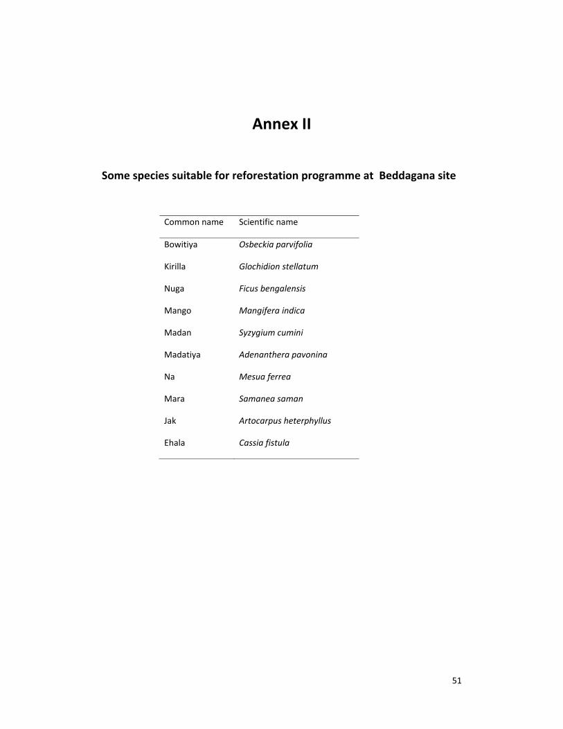
Annex II
Some species suitable for reforestation programme at Beddagana site
Common name Scientific name
Bowitiya Osbeckia parvifolia
Kirilla Glochidion stellatum
Nuga Ficus bengalensis
Mango Mangifera indica
Madan Syzygium cumini
Madatiya Adenanthera pavonina
Na Mesua ferrea
Mara Samanea saman
Jak Artocarpus heterphyllus
Ehala Cassia fistula
52
Annex 3:
Photographs of some of the important locations along project roads

53
Beddagana site for the nature park
Lat‐6.891560 Lon‐79.908780 Lat‐6.891590 Lon‐79.908710
Lat‐6.891840 Lon‐79.909440 Lat‐6.891610 Lon‐79.910560
Fig. 1. Lake located near the site Fig. 2. The natural vegetation at the site
Fig. 3. Natural drainage paths at the wetland Fig. 4. These embankments need strengthening
54
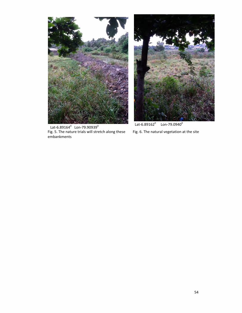
Fig. 5. The nature trials will stretch along these Fig. 6. The natural vegetation at the site embankments
Lat‐6.891640 Lon‐79.909390 Lat‐6.891620 Lon‐79.09400

55
Annex 4: Detailed drawings of project components


56