1 daily report 257/2021
TRANSCRIPT
- 1 -
1
Summary
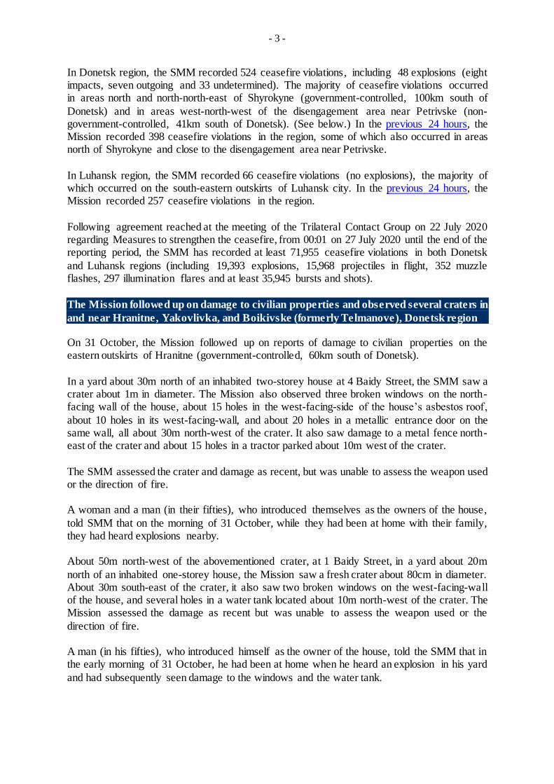
In Donetsk region, the SMM recorded 524 ceasefire violations, including 48 explosions. In the
previous 24 hours, it recorded 398 ceasefire violations in the region.
In Luhansk region, the Mission recorded 66 ceasefire violations and no explosions. In the previous
24 hours, it recorded 257 ceasefire violations in the region.
The Mission followed up on reports of damage to civilian properties in government-controlled
Hranitne and in non-government-controlled Yakovlivka and Boikivske (formerly Telmanove) ,
Donetsk region.
Small-arms fire near an SMM patrol prevented it from conducting a mid-range unmanned aerial
vehicle (UAV) flight near non-government-controlled Khriashchuvate, Luhansk region.
The Mission continued monitoring the disengagement areas near Stanytsia Luhanska, Zolote and
Petrivske and observed people inside the disengagement area near Petrivske.
The SMM facilitated and monitored adherence to localized ceasefires to enable the operation and
repair of critical civilian infrastructure.
The Mission continued following up on the situation of civilians, including at four entry-exit
checkpoints and the four corresponding checkpoints of the armed formations in Donetsk and
Luhansk regions.
The SMM visited two border crossing points outside government control and monitored the
border areas outside the government control in Donetsk and Luhansk regions.
The Mission’s freedom of movement continued to be restricted, including at checkpoints of the
armed formations inside and near the disengagement areas near Stanytsia Luhanska and Petrivske,
as well as near Novoazovsk, in southern Donetsk region. Its UAVs again experienced multiple
instances of probable jamming and jamming.*
Ceasefire violations2
Number of recorded ceasefire violations 3 Number of recorded explosions4
1 Based on information from the Monitoring Teams as of 19:30, 1 November 2021. All times are in Eastern
European Time. 2 For a complete breakdown of ceasefire violations, please see the annexed table. 3 Including explosions. 4 Including from unidentified weapons.
Daily Report 257/2021 2 November 20211

- 2 -
Map of recorded ceasefire violations
- 3 -
In Donetsk region, the SMM recorded 524 ceasefire violations, including 48 explosions (eight impacts, seven outgoing and 33 undetermined). The majority of ceasefire violations occurred in areas north and north-north-east of Shyrokyne (government-controlled, 100km south of
Donetsk) and in areas west-north-west of the disengagement area near Petrivske (non-government-controlled, 41km south of Donetsk). (See below.) In the previous 24 hours, the Mission recorded 398 ceasefire violations in the region, some of which also occurred in areas north of Shyrokyne and close to the disengagement area near Petrivske.
In Luhansk region, the SMM recorded 66 ceasefire violations (no explosions), the majority of which occurred on the south-eastern outskirts of Luhansk city. In the previous 24 hours, the Mission recorded 257 ceasefire violations in the region.
Following agreement reached at the meeting of the Trilateral Contact Group on 22 July 2020 regarding Measures to strengthen the ceasefire, from 00:01 on 27 July 2020 until the end of the reporting period, the SMM has recorded at least 71,955 ceasefire violations in both Donetsk
and Luhansk regions (including 19,393 explosions, 15,968 projectiles in flight, 352 muzzle flashes, 297 illumination flares and at least 35,945 bursts and shots).
The Mission followed up on damage to civilian properties and observed several craters in
and near Hranitne, Yakovlivka, and Boikivske (formerly Telmanove), Donetsk region On 31 October, the Mission followed up on reports of damage to civilian properties on the eastern outskirts of Hranitne (government-controlled, 60km south of Donetsk).
In a yard about 30m north of an inhabited two-storey house at 4 Baidy Street, the SMM saw a crater about 1m in diameter. The Mission also observed three broken windows on the north-facing wall of the house, about 15 holes in the west-facing-side of the house’s asbestos roof,
about 10 holes in its west-facing-wall, and about 20 holes in a metallic entrance door on the same wall, all about 30m north-west of the crater. It also saw damage to a metal fence north-east of the crater and about 15 holes in a tractor parked about 10m west of the crater.
The SMM assessed the crater and damage as recent, but was unable to assess the weapon used or the direction of fire. A woman and a man (in their fifties), who introduced themselves as the owners of the house,
told SMM that on the morning of 31 October, while they had been at home with their family, they had heard explosions nearby. About 50m north-west of the abovementioned crater, at 1 Baidy Street, in a yard about 20m
north of an inhabited one-storey house, the Mission saw a fresh crater about 80cm in diameter. About 30m south-east of the crater, it also saw two broken windows on the west-facing-wall of the house, and several holes in a water tank located about 10m north-west of the crater. The Mission assessed the damage as recent but was unable to assess the weapon used or the
direction of fire. A man (in his fifties), who introduced himself as the owner of the house, told the SMM that in the early morning of 31 October, he had been at home when he heard an explosion in his yard
and had subsequently seen damage to the windows and the water tank.
- 4 -
On 28 October, at 133 Yasynuvatska Street in the south-south-eastern part of Yakovlivka (non-government-controlled, 10km north of Donetsk), next to a one-storey inhabited house, an SMM-mini unmanned aerial vehicle (UAV) spotted a destroyed outhouse with piles of rubble
and debris nearby. The Mission assessed the damage as recent but was unable to assess the weapon used or the direction of fire. At two locations in a field on the south-eastern outskirts of Yakovlivka, the same UAV spotted
in total 15 impact craters assessed as recent and caused by probable 120mm rounds but was unable to assess the direction of fire. On 31 October, the Mission followed up on reports of damage to civilian properties on the
south-eastern outskirts of Boikivske (formerly Telmanove, non-government-controlled, 67km south-east of Donetsk). At two locations in a backyard about 140m south and a field about 1.3 km south-east of a two-
storey inhabited house on Zhovtneva Street, an SMM mini-UAV spotted two craters (about 1m and about 1.5m in diameter). The UAV also spotted damage to a concrete fence about 80m south of the house, to a south-west-facing wall of the house, and to a satellite antenna. It also observed damage to a north-east-facing metal fence, about 35m south-west of the house. The
Mission assessed all damage as recent and caused by shrapnel, but was unable to assess the weapon used or the direction of fire.
Small-arms fire near an SMM patrol prevented it from conducting a mid-range UAV
flight near non-government-controlled Khriashchuvate, Luhansk region While positioned about 3km north-west of Khriashchuvate (non-government-controlled, 10km south-east of Luhansk) preparing to launch an announced mid-range UAV flight, the SMM
heard 60 shots of small-arms fire, at an assessed distance of 200-400m west-south-west of its position. It immediately left the area.*
Disengagement areas near Stanytsia Luhanska, Zolote and Petrivske5
Inside the disengagement area near Stanytsia Luhanska (government-controlled, 16km north-east of Luhansk), the Mission saw two members of the armed formations (wearing armbands with “JCCC” written on them) south of the repaired span of the Stanytsia Luhanska
bridge (15km north-east of Luhansk).* During the day on 31 October, inside the disengagement area near Zolote (government-controlled, 60km west of Luhansk), an SMM mini-UAV spotted three people inside a former
position of the armed formations about 500m north of the area’s south-eastern corner as well as a civilian vehicle about 30m south of the abovementioned position. On 1 November, an SMM mini-UAV experienced GPS signal interference, assessed as caused
by probable jamming, while flying over the disengagement area.* Near the checkpoint of the armed formations south of the disengagement area, the Mission saw four members of the armed formations (wearing armbands with “JCCC” written on them). The
5 Disengagement is foreseen in the Framework Decision of the Trilateral Contact Group relating to disengagement
of forces and hardware of 21 September 2016.

- 5 -
SMM again saw the seven previously observed containers located south of the area’s southern edge and inside the disengagement area. It saw that the previously reported road barriers across road T-1316, on the area’s southern edge, were closed.
During the day on 30 October, inside the disengagement area near Petrivske (non-government-controlled, 41km south of Donetsk), about 550m east-north-east of the area’s south-western corner, an SMM long-range UAV spotted a person inside a former position of
the Ukrainian Armed Forces. The same UAV also spotted two people inside a former position of the armed formations about 360m north-north-west of the area’s south-eastern corner. During the day on 31 October, inside the disengagement area, about 500m east-north-east of
the area’s south-western corner, an SMM long-range UAV spotted a person inside a former position of the Ukrainian Armed Forces. During the day on 1 November, the SMM camera in Petrivske recorded 12 projectiles in flight
at an assessed range of 0.7km-3km west-north-west, unable to be assessed as inside or outside the disengagement area near Petrivske.
Withdrawal of weapons
The SMM continued to monitor the withdrawal of weapons in implementation of the Memorandum and the Package of Measures and its Addendum.
In violation of withdrawal lines, the Mission saw six howitzers in a government-controlled area of Donetsk region. Beyond withdrawal lines but outside designated storage sites, the SMM observed 21 howitzers,
20 tanks, and five anti-tank guns at three railway stations in government-controlled areas of Donetsk region and 77 tanks in two training areas in non-government-controlled areas of Donetsk and Luhansk regions. (For further information, see the tables below.)
Indications of military and military-type presence in the security zone The Mission observed an armoured combat vehicle near a residential area of a government-controlled area of Luhansk region. (For further information, see the table below.)
Presence of anti-tank mines near Spartak and Vesele and mine hazard signs near
Novohryhorivka, Donetsk region
On 29 October, on the northern outskirts of Spartak (non-government-controlled, 9km north of Donetsk), an SMM mini-UAV spotted two previously reported anti-tank mines laid across road T-05-05, assessed as belonging to the armed formations. (For previous observations in the area, see SMM Daily Report of 27 September 2021.)
On the same day, at two locations about 500m north-north-east of Vesele (non-government-controlled, 9km north-west of Donetsk), an SMM mini-UAV spotted 35 previously reported anti-tank mines laid in three rows across a former taxiway of the destroyed Donetsk
international airport (8km north-west of Donetsk), assessed as belonging to the armed formations. (For previous observations in the area, see SMM Daily Report of 27 August 2021.)
- 6 -
On 1 November, about 1.5km west of Novohryhorivka (government-controlled, 55km south of Donetsk), the Mission observed 18 mine hazard signs (red squares with white skull and crossbones, with “Caution! Explosion risk!” written on them in Ukrainian and Russian) placed
near the north-eastern side of road C-051621 over a distance of about 1km in south-south-eastern direction.
Impact craters near Vesele and Staromarivka, Donetsk region On 29 October, in a field about 1km north-north-east of Vesele, an SMM-mini UAV spotted an impact crater, assessed as recent and as caused by a 120mm mortar round.
On 31 October, in a field just north of road T-0512, about 1.6km south-east of Staromarivka (62km south of Donetsk), the Mission observed a Ukrainian flag and barbed wire and saw four impact craters (assessed as recent) nearby, three of which contained tailfins of 120mm mortar shells.
SMM facilitation of operation and repair critical civilian infrastructure The Mission continued to facilitate the operation of the Donetsk Filtration Station (DFS) (15km
north of Donetsk). While positioned at two locations near the DFS, the SMM heard eight explosions (four outgoing and four undetermined), assessed as inside a 5km radius of the DFS. The SMM also monitored adherence to a localized ceasefire to enable electrical repair works
in Staromykhailivka (non-government-controlled, 15km west of Donetsk).
Situation at entry-exit checkpoints and corresponding checkpoints
In Donetsk region, the SMM observed that the entry-exit checkpoint (EECP) near Novotroitske (government-controlled, 36km south-west of Donetsk) and the corresponding checkpoint of the armed formations near Olenivka (non-government-controlled, 23km south-west of Donetsk) were open, with civilian traffic passing through in both directions.
In Luhansk region, the SMM observed that the EECP near Stanytsia Luhanska and the corresponding checkpoint of the armed formations south of the Stanytsia Luhanska bridge were open and saw people queueing to travel in both directions at the latter checkpoint.
The Mission noted that the EECPs near Zolote and Shchastia (government-controlled, 20km north of Luhansk) were open, but that the corresponding checkpoints of the armed formations south of the disengagement area near Zolote and 3km south-east of the bridge in Shchastia
were closed. At the latter checkpoint, the SMM observed five Czech hedgehogs (not previously reported) blocking the lanes of road H-21 in both directions.
Border areas outside government control6
While at a border crossing point near Ulianivske (61km south-east of Donetsk) for about 35 minutes, the SMM observed a woman (in her seventies) entering Ukraine and a woman (in her forties) exiting Ukraine.
6 According to decisions in 2014 by the Cabinet of Ministers of Ukraine, operations are officially designated as
suspended at these and other border crossing points located outside government control.

- 7 -
While at a border crossing point near Uspenka (73km south-east of Donetsk) for about 35 minutes, the Mission saw twenty cars (including 13 with “DPR” plates), four covered cargo trucks (with “DPR” plates) and 32 people (22 women and 10 men of mixed ages) entering
Ukraine and 27 cars (including 21 with “DPR” plates), two covered cargo trucks (including one with “DPR” plates), two buses (both with “DPR” plates, including one carrying people of mixed genders and ages), and nine people (one teenage girl and three women and five men of mixed ages) exiting Ukraine.
The SMM also monitored areas close to the border with the Russian Federation in Donetsk region near Zhytenko (70km east of Donetsk), Manych (76km east of Donetsk) and Novoukrainske (77km east of Donetsk) and in Luhansk region near Sukhodilsk (non-
government-controlled, 38km south-east of Luhansk), Malyi Sukhodil (non-government-controlled, 44km south-east of Luhansk) and Uralo-Kavkaz (non-government-controlled, 46km south-east of Luhansk), and observed no change in the security situation.
The Mission continued monitoring in Odessa, Lviv, Ivano-Frankivsk, Kharkiv, Dnipro, Chernivtsi, Kherson and Kyiv.
*Restrictions of the SMM’s freedom of movement or other impediments to fulfilment of
its mandate The SMM’s monitoring and freedom of movement are restricted by security hazards and threats,
including risks posed by mines, unexploded ordnance (UXO) and other impediments – which vary from
day to day. The SMM’s mandate provides for safe and secure access throughout Ukraine. All
signatories of the Minsk agreements have agreed on the need for this safe and secure access, that
restriction of the SMM’s freedom of movement constitutes a violation, and on the need for rapid response to these violations. They have also agreed that the Joint Centre for Control and Co-ordination
(JCCC) should contribute to such response and co-ordinate mine clearance. Nonetheless, the armed
formations in parts of Donetsk and Luhansk regions frequently deny the SMM access to areas adjacent
to Ukraine’s border outside control of the government (for example, see SMM Daily Report of 1 November 2021). The SMM’s operations in Donetsk and Luhansk regions remain restricted following
the fatal incident of 23 April 2017 near Pryshyb; these restrictions continued to limit the Mission’s
observations.
Denials:
- At a checkpoint near Petrivske (non-government-controlled, 41km south of Donetsk), an armed member of the armed formations again denied the SMM passage south towards the disengagement area near Petrivske, citing “the SMM’s safety”.
- At a checkpoint near Novoazovsk (non-government-controlled, 102km south-east of Donetsk) an armed member of the armed formations denied the Mission passage west towards Samsonove (non-government-controlled, 101km south of Donetsk). While at the checkpoint, the SMM observed civilian traffic passing through.
- At a checkpoint south of the Stanytsia Luhanska bridge (15km north-east of Luhansk), a member of the armed formations denied the Mission passage northwards, citing a need for permission from those in control in non-government-controlled areas of Luhansk region.
Regular restrictions related to disengagement areas and mines/UXO:

- 8 -
- The sides continued to deny the SMM full access, as well as the ability to travel certain roads previously identified as important for effective monitoring by the Mission and for civilians’
movement, through failure to conduct comprehensive clearance of mines, UXO and other obstacles.
Other impediments:7
- While positioned west of Khriashchuvate (non-government-controlled, 10km south-east of
Luhansk) and preparing to launch an announced mid-range UAV flight, the SMM heard 60 shots of small-arms fire at an assessed distance of 200-400m west-south-west of its position. It
immediately left the area. (See above.) - While conducting two test flights, an SMM long-range UAV experienced GPS signal
interference, assessed as caused by probable jamming, while flying over areas between Rohanske (government-controlled, 79km north-west of Donetsk) and Kostiantynivka
(government-controlled, 60km north of Donetsk), between Rohanske and Berezivka (government-controlled, 44km north-west of Donetsk) and over areas near Novoandriivka (government-controlled, 75km north-west of Donetsk) and Varvarivka (government-controlled, 81km north-west of Donetsk). The same UAV experienced GPS signal interference,
assessed as caused by jamming, while flying over areas between Kostiantynivka and Novoandriivka and between Berezivka and Varvarivka.
- SMM mini-UAVs experienced GPS signal interference, assessed as caused by probable jamming, during five flights: twice while flying over areas near Oleksandrivske (formerly Rozy Liuksemburh, non-government-controlled, 90km south-east of Donetsk) and once while flying
over areas near Tonenke (government-controlled, 19km north-west of Donetsk), near Fedorivka (government-controlled, 71km south of Donetsk) and while flying over the disengagement area near Zolote (government-controlled, 60km west of Luhansk).
7 For cases of probable jamming and jamming mentioned in this section, the interference could have originated
from anywhere within the radius of tens of kilometres from the UAVs’ positions.

- 9 -
Table of weapons
Weapons in violation of withdrawal lines
Date No. of
weapons Type of weapon Location
Source of
observation
Government-controlled areas
1/11/2021 6 Self-propelled howitzer (2S1 Gvozdika,
122mm) In Kostiantynivka (60km north of Donetsk) Patrol
Weapons beyond withdrawal lines but outside designated storage sites
Date No. of
weapons Type of weapon Location
Source of
observation
Government-controlled areas
30/10/2021 20 Tank (type undetermined) At a railway station in Kostiantynivka (60km north of Donetsk) Long-range UAV
1/11/2021
6 Towed anti-tank gun (type undetermined) At a railway station in Druzhkivka (72km north of Donetsk)
Patrol 15 Towed howitzer (2A36 Giatsint-B,
152mm gun) At a railway station in Rubizhne (84km north-west of Luhansk)
5 Anti-tank gun (MT-12 Rapira, 100mm)
Non-government-controlled areas
26/10/2021 10
Tank (type undetermined)
In a training area near Shymshynivka (27km south-west of
Luhansk) where imagery also revealed the presence of 25
armoured combat vehicles.8
Aerial imagery
30/10/2021 40 In a training area near Ternove (57km east of Donetsk) where
imagery also revealed the presence of 12 armoured combat
vehicles.9
Long-range UAV 31/10/2021 27
Table of military and military-type presence in the security zone 10
Date No. Type Location Source of
observation
Government-controlled areas
29/10/2021 1 Armoured combat vehicle (BTR
variant)
Near a residential area of Stanytsia Luhanska (16km north-east
of Luhansk) Mini-UAV
8 The armoured combat vehicles mentioned here are not proscribed by the provisions of the Minsk agreements on
the withdrawal of weapons. 9 The armoured combat vehicles mentioned here are not proscribed by the provisions of the Minsk agreements on
the withdrawal of weapons. 10 The hardware mentioned in this section is not proscribed by the provisions of the Minsk agreements on the
withdrawal of weapons.

- 10 -
Table of ceasefire violations as of 1 November 202111
SMM position Event
location Means No. O bservation Description Weapon Date, time
SMM camera 1.5km NE of Hnutove
(government-controlled, 90km S of
Donetsk)
2-4km SE Recorded 3 Projectile SW to NE N/K 31-Oct, 23:52
SMM camera 1km SW of Shyrokyne (government-controlled, 100km S of
Donetsk)
4-6km N Recorded 1 Muzzle flash N/K 31-Oct, 19:12
4-6km N Recorded 1 Projectile WSW to ENE (subsequent to
previous event)
N/K 31-Oct, 19:12
4-6km NNE Recorded 1 Projectile W to E N/K 31-Oct, 19:46
4-6km NNE Recorded 5 Projectile W to E N/K 31-Oct, 19:47
4-6km NNE Recorded 18 Projectile W to E N/K 31-Oct, 19:52
4-6km NNE Recorded 9 Projectile W to E N/K 31-Oct, 19:53
5-7km N Recorded 2 Projectile WSW to ENE N/K 31-Oct, 19:55
4-6km N Recorded 1 Projectile WSW to ENE N/K 31-Oct, 20:21
4-6km N Recorded 2 Projectile WSW to ENE N/K 31-Oct, 20:31
4-6km N Recorded 1 Explosion Undetermined N/K 31-Oct, 20:45
4-6km NNE Recorded 24 Projectile WSW to ENE N/K 31-Oct, 20:49
4-6km NNE Recorded 32 Projectile WSW to ENE N/K 31-Oct, 20:53
4-6km N Recorded 1 Explosion Undetermined N/K 31-Oct, 21:05
4-6km NNE Recorded 26 Projectile WSW to ENE N/K 31-Oct, 21:14
4-6km NNE Recorded 24 Projectile WSW to ENE N/K 31-Oct, 21:15
4-6km NNE Recorded 40 Projectile WSW to ENE N/K 31-Oct, 21:16
4-6km N Recorded 3 Projectile WSW to ENE N/K 31-Oct, 21:17
4-6km N Recorded 1 Illumination
flare E to W N/K 31-Oct, 22:16
4-6km N Recorded 5 Explosion Impact N/K 31-Oct, 22:30
4-6km N Recorded 7 Projectile SW to NE N/K 31-Oct, 22:32
4-6km N Recorded 1 Projectile WSW to ENE N/K 31-Oct, 22:33
4-6km N Recorded 1 Illumination
flare In vertical flight N/K 31-Oct, 22:59
4-6km N Recorded 2 Projectile SE to NW N/K 31-Oct, 23:15
4-6km N Recorded 1 Projectile WSW to ENE N/K 31-Oct, 23:15
4-6km N Recorded 16 Projectile WSW to ENE N/K 31-Oct, 23:16
4-6km N Recorded 1 Illumination
flare In vertical flight N/K 31-Oct, 23:39
4-6km N Recorded 1 Projectile SW to NE N/K 31-Oct, 23:52
2-4km N Recorded 4 Projectile WSW to ENE N/K 1-Nov, 00:00
2-4km N Recorded 5 Projectile WSW to ENE N/K 1-Nov, 00:01
2-4km N Recorded 2 Projectile WSW to ENE N/K 1-Nov, 00:09
2-4km N Recorded 4 Projectile WSW to ENE N/K 1-Nov, 00:10
2-4km N Recorded 2 Projectile WSW to ENE N/K 1-Nov, 00:22
2-4km N Recorded 2 Projectile ESE to WNW N/K 1-Nov, 00:42
2-4km N Recorded 2 Projectile WSW to ENE N/K 1-Nov, 00:57
2-4km N Recorded 2 Projectile ESE to WNW N/K 1-Nov, 00:57
2-4km N Recorded 2 Projectile ESE to WNW N/K 1-Nov, 02:24
2-4km N Recorded 10 Projectile WSW to ENE N/K 1-Nov, 02:48
2-4km N Recorded 25 Projectile WSW to ENE N/K 1-Nov, 03:34
2-4km N Recorded 2 Projectile ESE to WNW N/K 1-Nov, 04:11
11 The table only includes ceasefire violations directly observed by SMM patrols or recorded by the SMM
cameras, and it may include those also assessed to be live-fire exercises, controlled detonations, etc. Details
provided – in terms of distance, direction, weapons-type, etc. – are based on assessments provided by monitors on the ground and technical monitoring officers, and are not always necessarily precise. When information is not known (indicated with an “N/K”), the SMM was unable to ascertain such info rmation due to distance,
weather conditions technical limitations and/or other considerations. Ceasefire violations recorded by more than one patrol/camera and assessed to be the same are entered only once.

- 11 -
SMM position Event
location Means No. O bservation Description Weapon Date, time
5-7km N Recorded 1 Explosion Undetermined N/K 1-Nov, 17:49
4-6km N Recorded 1 Explosion Undetermined N/K 1-Nov, 17:49
3-5km N Recorded 4 Projectile W to E N/K 1-Nov, 17:50
3-5km N Recorded 5 Projectile W to E N/K 1-Nov, 17:51
3-5km NNE Recorded 2 Projectile E to W N/K 1-Nov, 18:17
3-5km N Recorded 4 Projectile WSW to ENE N/K 1-Nov, 18:22
3-5km N Recorded 3 Projectile WSW to ENE N/K 1-Nov, 18:34
4-6km N Recorded 3 Projectile E to W N/K 1-Nov, 18:26
4-6km N Recorded 1 Projectile ESE to WNW N/K 1-Nov, 18:27
4-6km N Recorded 1 Explosion Undetermined N/K 1-Nov, 18:43
SMM camera in Petrivske (non-
government-controlled, 41km south of
Donetsk)
0.7-2km
WNW Recorded 8 Projectile
SE to NW (unable
to be assessed as
inside or outside the disengagement area
near Petrivske)
N/K 1-Nov, 17:25
1-3km WNW Recorded 4 Projectile
ESE to WNW
(unable to be
assessed as inside or
outside the
disengagement area
near Petrivske)
N/K 1-Nov, 17:25
About 700m WSW of the railway
station in Yasynuvata (non-
government-controlled, 16km NE of
Donetsk)
2-3km WSW Heard 4 Explosion Outgoing N/K 1-Nov, 11:08-11:12
About 1.5km E of Staromykhailivka
(non-government-controlled, 15km W
of Donetsk)
5-6km WSW Heard 1 Explosion Undetermined N/K 1-Nov, 13:40
About 500m NE of Kamianka
(government-controlled, 20km N of
Donetsk)
3-5km SW Heard 4 Explosion Undetermined N/K 1-Nov, 11:08
SE edge of Avdiivka (government -
controlled, 17km N of Donetsk) 3-5km NW Heard 1 Explosion Undetermined N/K 1-Nov, 11:09
About 2km NE of Chernenko
(government-controlled, 86km S of
Donetsk)
3-5km ESE Heard 2 Burst Small
arms 1-Nov, 10:47-10:52
Pavlopil (government -controlled, 84km
S of Donetsk)
2-3km NE Heard 15 Shot Small
arms 1-Nov, 11:07-11:28
2-3km NE Heard 1 Burst Small
arms 1-Nov, 11:07-11:28
2-3km NE Heard 1 Explosion Undetermined N/K 1-Nov, 11:07-11:28
5-6km SE Heard 3 Explosion Undetermined N/K 1-Nov, 11:32-11:57
2-3km NE Heard 22 Shot Small
arms 1-Nov, 11:32-11:57
2-3km NE Heard 15 Burst Small
arms 1-Nov, 11:32-11:57
Hranitne (government -controlled, 60km
S of Donetsk)
1km E Heard 1 Explosion Undetermined N/K 1-Nov, 11:15
1km E Heard 1 Explosion Undetermined N/K 1-Nov, 11:15
600m E Heard 1 Explosion Undetermined N/K 1-Nov, 12:11
2km NE Heard and
saw 3 Explosion Outgoing
Mortar
(type
N/K)
1-Nov, 12:54-13:00
5km E Saw 3 Explosion Impact N/K 1-Nov, 12:54-13:00
About 2.5km NE of Novotroitske
(government-controlled, 36km SW of
Donetsk)
2-3km SE Heard 12 Shot Small
arms 1-Nov, 12:14-12:20
2-3km SE Heard 15 Burst HMG 1-Nov, 12:14-12:20
2-3km SE Heard 2 Burst HMG 1-Nov, 12:40-12:50
2-3km SE Heard 1 Explosion Undetermined N/K 1-Nov, 12:40-12:50
N/K S Heard 30 Shot Unable to be
assessed as inside or
Small
arms 1-Nov, 12:15-12:35
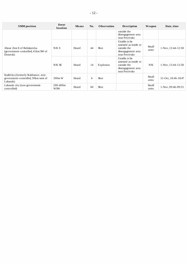
- 12 -
SMM position Event
location Means No. O bservation Description Weapon Date, time
About 2km E of Bohdanivka
(government-controlled, 41km SW of
Donetsk)
outside the disengagement area
near Petrivske
N/K S Heard 44 Shot
Unable to be
assessed as inside or
outside the
disengagement area
near Petrivske
Small
arms 1-Nov, 12:44-12:58
N/K SE Heard 14 Explosion
Unable to be
assessed as inside or
outside the
disengagement area
near Petrivske
N/K 1-Nov, 12:44-12:58
Kadiivka (formerly Stakhanov, non-
government-controlled, 50km west of
Luhansk)
300m W Heard 6 Shot Small
arms 31-Oct, 18:46-18:47
Luhansk city (non-government-
controlled)
200-400m
WSW Heard 60 Shot
Small
arms 1-Nov, 09:46-09:55

- 13 -
Map of Donetsk and Luhansk regions 12
12 The SMM is deployed to ten locations throughout Ukraine – Kherson, Odessa, Lviv, Ivano-Frankivsk, Kharkiv,
Donetsk, Dnipro, Chernivtsi, Luhansk and Kyiv – as per Permanent Council Decision 1117 of 21 March 2014.
This map of eastern Ukraine is meant for illustrative purposes and indicates locations mentioned in the report, as well as those where the SMM has offices (monitoring teams, patrol hubs and forward patrol bases) in Donetsk and Luhansk regions. (In red: a forward patrol base from which SMM staff have temporarily relocated based on
recommendations of security experts from participating States, as well as SMM security considerations. The SMM uses the premises during daylight hours and also patrols in this settlement during daylight hours).