© texte: fg fetten the changes of a ‘maar’. pulvermaar ... · number of volcanoes and...
TRANSCRIPT
ThePulvermaar
The deepest "Eye of the Eifel"
Holiday on the volcano
Right next to the German Volcanic Road
Feriendorf „Pulvermaar“ owner Frank G. Fetten
D-54558 Gillenfeld · Vulkanstraße (Auf der Maarhöhe)Phone: 0049-65 73-287 · Mobil: 0049-172-88 79 345e-Mail: [email protected] · www.feriendorf-pulvermaar.de
GPS-coordinates for entrance RV-ground:50° 7'48.36'' N / 6° 55'55'' E =50° 130100 N / 6° 931935 E
bik
-we
rbe
ag
en
tur.
de
Camping on the volcanoFeriendorf Pulvermaar
CampingBungalowsmobile home/RV groundCycling and hiking mapstourist information300 m to Pulvermaarlake and pool
small corner-shoprestaurant facilitiessfresh bread-rolls dailychildren‘s playgroundfootball groundopen all year around
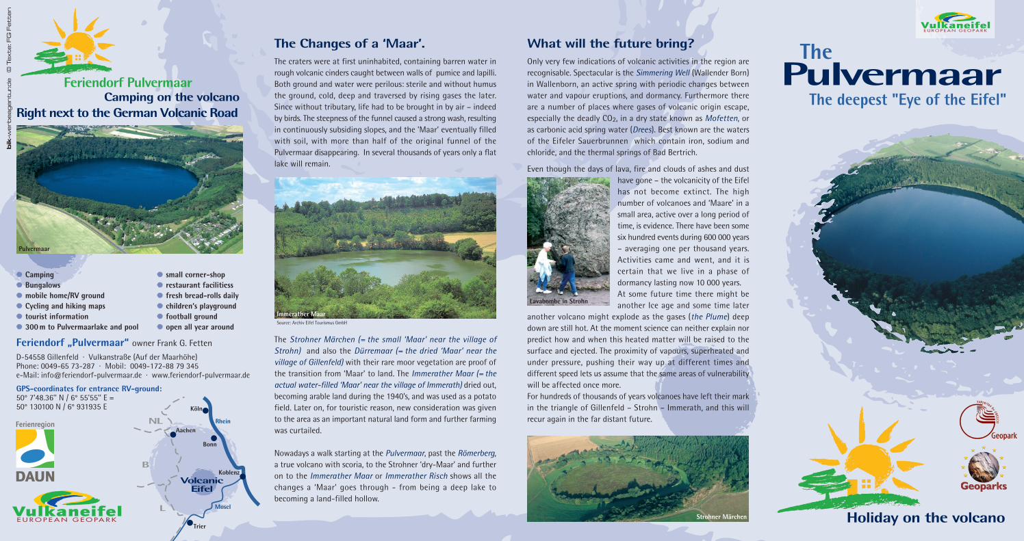
The Changes of a ‘Maar’.The craters were at first uninhabited, containing barren water inrough volcanic cinders caught between walls of pumice and lapilli.Both ground and water were perilous: sterile and without humusthe ground, cold, deep and traversed by rising gases the later.Since without tributary, life had to be brought in by air – indeedby birds. The steepness of the funnel caused a strong wash, resultingin continuously subsiding slopes, and the ’Maar’ eventually filledwith soil, with more than half of the original funnel of thePulvermaar disappearing. In several thousands of years only a flatlake will remain.
The Strohner Märchen (= the small ‘Maar’ near the village ofStrohn) and also the Dürremaar (= the dried ‘Maar’ near thevillage of Gillenfeld) with their rare moor vegetation are proof ofthe transition from ‘Maar’ to land. The Immerather Maar (= theactual water-filled ‘Maar’ near the village of Immerath) dried out,becoming arable land during the 1940’s, and was used as a potatofield. Later on, for touristic reason, new consideration was givento the area as an important natural land form and further farmingwas curtailed.
Nowadays a walk starting at the Pulvermaar, past the Römerberg,a true volcano with scoria, to the Strohner ‘dry-Maar’ and furtheron to the Immerather Maar or Immerather Risch shows all thechanges a ‘Maar’ goes through - from being a deep lake tobecoming a land-filled hollow.
Strohner Märchen
Pulvermaar
Source: Archiv Eifel Tourismus GmbH
Immerather Maar
© T
ex
te: F
G F
ett
en
VolcanicEifel
Bonn
Köln
Koblenz
Trier
Rhein
Mosel
NL
B
L
Aachen
VulkaneifelE U R O P E A N G E O PA R K
VulkaneifelE U R O P E A N G E O P A R K
What will the future bring?Only very few indications of volcanic activities in the region arerecognisable. Spectacular is the Simmering Well (Wallender Born)in Wallenborn, an active spring with periodic changes betweenwater and vapour eruptions, and dormancy. Furthermore thereare a number of places where gases of volcanic origin escape,especially the deadly CO2, in a dry state known as Mofetten, oras carbonic acid spring water (Drees). Best known are the watersof the Eifeler Sauerbrunnen which contain iron, sodium andchloride, and the thermal springs of Bad Bertrich.
Even though the days of lava, fire and clouds of ashes and dusthave gone – the volcanicity of the Eifelhas not become extinct. The highnumber of volcanoes and ‘Maare’ in asmall area, active over a long period oftime, is evidence. There have been somesix hundred events during 600 000 years– averaging one per thousand years.Activities came and went, and it iscertain that we live in a phase ofdormancy lasting now 10 000 years.At some future time there might beanother Ice age and some time later
another volcano might explode as the gases (the Plume) deepdown are still hot. At the moment science can neither explain norpredict how and when this heated matter will be raised to thesurface and ejected. The proximity of vapours, superheated andunder pressure, pushing their way up at different times anddifferent speed lets us assume that the same areas of vulnerabilitywill be affected once more.For hundreds of thousands of years volcanoes have left their markin the triangle of Gillenfeld – Strohn – Immerath, and this willrecur again in the far distant future.
Lavabombe in Strohn

How was a ‘Maar’ formed?The volcanoes of the Eifel cannot be compared with Mt. Etna, forexample, where one sees an open magma field boiling and lavaflowing. The volcanic centre in a ‘Maar’ lies at great hidden depths.In the volcanic region of the Eifel, from Bad Bertrich to as far awayas the Belgian border, we find rocks being heated by hot gases ata depth of some 400 km (Eifel-Plume). When these hot vapoursmeet ground water or surface water caught in crevices and caves,pressure has to be released in the form of an eruption due todifferences in temperature and pressure. The force behind theseexplosions varied as seen in the many different forms of craterfunnels, some small or larger, shallow or deeper. In a deep crater,with additional cavities giving way after the explosion, we find theideal prerequisite for a future ‘Maar’, especially when water-resistingsediments have encouraged a build-up of groundwater allowing alake of considerable depth to form ( see drawing).
The Pulvermaar, with a depth of more than 70 m in places, is the"deepest eye” and also the deepest lake north of the Alps. These 70meters are only a fraction of the original depth of the crater whichgeologists estimate at 300 m. The power of numerous explosionsover a period of several weeks or months must have been breathtakingfor the people of the Eifel, turning day into night and leaving a100 m high wall of debris, ash and stones (lapilli). Later on, morethan 13 million cubic meters of water collected within the funnel.Because of its great depth, the temperature remains a constant+4°C.
How old is a ‘Maar’?The oldest volcanic action goes back some 40 to 50 million years(Eckfelder Maar). Modern landscape was formed by much morerecent volcanoes which belong to the geological present.All ‘Maare‘ date back to prehistory when climate changed betweenwarm and cold periods and when early man came to Europe. Formore than 600 000 years volcanic activities existed, and the ‘Maare’we know now belong to the most recent phase. On average theyare somewhere between 10 000 and 30 000 years old, with theNeanderthal being the first to witness their formation. The mostrecent eruption of the Laacher volcano which led to the formingof the Laacher See (East Eifel) can be dated back to 10 960 BC.The eruption hurled masses of pumiceous lava into the Rhinevalley, with water rising and ashes and dust blown as far as theBaltic states. Pumice buried a camp of red deer hunters of thefinal Ice age time - as disastrous for the people then as theeruption of Mt. St. Helens today.
Sour
ce: G
EO-I
nfob
and
„Vul
kane
ifel“
, Edi
tor:
Ldkr
. Vul
kane
ifel/
Daun
200
2
Holzmaar
The deepest "Eye of the Eifel"The vernacular expression in the Eifel for a lake of volcanic origin inthe region is ‘Maar’, in English: crater. Their proximity, round formsand considerable depth made people aware early on of their specialnature, even though only modern life with a view from a plane orhot-air balloon discloses the full charm and secret of their beauty:‘Maare’ are the Eyes of the Eifel.
What exactly is a "Maar"?In modern science only such lakes of volcanic origin which werefilled by ground water are called ‘Maar’. These are: the Pulvermaar,Holzmaar, Immerather Maar, Meerfelder Maar, SchalkenmehrenerMaar, Weinfelder Maar, Gemünderner Maar as well as the ‘UlmenerMaar’. ( Whereas the Windsborn "Maar” close to Manderscheid isnot a ‘Maar’, scientifically speaking, but a lake filled by surfacewater). Next to the above named Eifel-Eyes, there are countlessfurther craters which will not easily be recognized as such as theydo not contain water, e.g. are no longer lakes but wet land - forexample the Strohner Märchen (or Maarchen = a small Maar) withits rare moor vegetation.
Most of the volcanic craters of today are filled with soil and are dry,early relics of a time when volcanoes were still alive and the surfaceof the Eifel was being shaped by explosions. Of the 350 volcanoesin the region, there are at least 75 craters, only eight of which aretrue ‘Maare’. Some others are wet depressions, though most of themdried out and became arable land. The village Immerrath, for example, lies in a large volcanic hollow called the Immerather Risch, remainsof a prehistoric crater.