· sbtn (robertson 1990) 0 2 4 6 8 10 12 14 16 18 depth (ft) 8 7.5 7 6.5 6 5.5 5 4 3.5 3 2.5 2 1.5...
TRANSCRIPT


CWE 2140061.02RLake Jennings Marketplace
Lake Jennings Park Road and Olde Highway 80San Diego County, California
APPENDIX BCPT LOGS

Project: Lake Jennings Marketplace
Christian Wheeler Engineering
3980 Home Avenue
San Diego, CA 92109Total depth: 8.04 ft, Date: 3/25/2014
Surface Elevation: 0.00 ft
Lake Jennings Park Road
Coords: X:0.00, Y:0.00
Cone Type: Uknown
Cone Operator: Uknown
CPT: CPT-01
Location:
Cone resistance qt
Tip resistance (tsf)
800600400200
Depth
(ft
)
8
7.5
7
6.5
6
5.5
5
4.5
4
3.5
3
2.5
2
1.5
1
0.5
Cone resistance qt Pore pressure u
Pressure (psi)
86420
Depth
(ft
)
8
7.5
7
6.5
6
5.5
5
4.5
4
3.5
3
2.5
2
1.5
1
0.5
Pore pressure uFriction ratio
Rf (%)
1086420
Depth
(ft
)
8
7.5
7
6.5
6
5.5
5
4.5
4
3.5
3
2.5
2
1.5
1
0.5
Friction ratio SBT Index
Ic SBT
4321D
epth
(ft
)8
7.5
7
6.5
6
5.5
5
4.5
4
3.5
3
2.5
2
1.5
1
0.5
SBT Index Soil Behaviour Type
SBT (Robertson, 2010)
181614121086420
Depth
(ft
)
8
7.5
7
6.5
6
5.5
5
4.5
4
3.5
3
2.5
2
1.5
1
0.5
Soil Behaviour Type
Sensitiv e f ine grained
Clay & silty clay
Silty sand & sandy silt
Sand & silty sand
Silty sand & sandy silt
Sand & silty sand
Very dense/stif f soil
Sand & silty sand
Very dense/stif f soil
SBT legend
1. Sensitive fine grained
2. Organic material
3. Clay to silty clay
4. Clayey silt to silty clay
5. Silty sand to sandy silt
6. Clean sand to silty sand
7. Gravely sand to sand
8. Very stiff sand to clayey sand
9. Very stiff fine grained
CPeT-IT v.1.7.6.42 - CPTU data presentation & interpretation software - Report created on: 6/11/2014, 9:09:19 AM 1
Project file: W:\2014 Jobs\2140061 - Lake Jennings Market Place\Reports\2140061.02- Supplemental Geo Inv\2140061 CPeT.cpt

Project: Lake Jennings Marketplace
Christian Wheeler Engineering
3980 Home Avenue
San Diego, CA 92109Total depth: 8.04 ft, Date: 3/25/2014
Surface Elevation: 0.00 ft
Lake Jennings Park Road
Coords: X:0.00, Y:0.00
Cone Type: Uknown
Cone Operator: Uknown
CPT: CPT-01
Location:
Norm. cone resistance
Qtn
200150100500
Depth
(ft
)
8
7.5
7
6.5
6
5.5
5
4.5
4
3.5
3
2.5
2
1.5
1
0.5
Norm. cone resistance Norm. pore pressure ratio
Bq
10.80 .60.40 .20-0.2
Depth
(ft
)
8
7.5
7
6.5
6
5.5
5
4.5
4
3.5
3
2.5
2
1.5
1
0.5
Norm. pore pressure ratioNorm. friction ratio
Fr (%)
1086420
Depth
(ft
)
8
7.5
7
6.5
6
5.5
5
4.5
4
3.5
3
2.5
2
1.5
1
0.5
Norm. friction ratio SBTn Index
Ic
4321D
epth
(ft
)8
7.5
7
6.5
6
5.5
5
4.5
4
3.5
3
2.5
2
1.5
1
0.5
SBTn Index Norm. Soil Behaviour Type
SBTn (Robertson 1990)
181614121086420
Depth
(ft
)
8
7.5
7
6.5
6
5.5
5
4.5
4
3.5
3
2.5
2
1.5
1
0.5
Norm. Soil Behaviour Type
Sand & silty sand
Silty sand & sandy silt
Sand & silty sand
Sand
Sand & silty sand
Silty sand & sandy silt
Sand & silty sand
Very dense/stif f soil
Sand & silty sand
Very dense/stif f soil
SBTn legend
1. Sensitive fine grained
2. Organic material
3. Clay to silty clay
4. Clayey silt to silty clay
5. Silty sand to sandy silt
6. Clean sand to silty sand
7. Gravely sand to sand
8. Very stiff sand to clayey sand
9. Very stiff fine grained
CPeT-IT v.1.7.6.42 - CPTU data presentation & interpretation software - Report created on: 6/11/2014, 9:09:19 AM 2
Project file: W:\2014 Jobs\2140061 - Lake Jennings Market Place\Reports\2140061.02- Supplemental Geo Inv\2140061 CPeT.cpt

Project: Lake Jennings Marketplace
Christian Wheeler Engineering
3980 Home Avenue
San Diego, CA 92109Total depth: 8.04 ft, Date: 3/25/2014
Surface Elevation: 0.00 ft
Lake Jennings Park Road
Coords: X:0.00, Y:0.00
Cone Type: Uknown
Cone Operator: Uknown
CPT: CPT-01
Location:
Permeability
Ksbt (ft/s)
-91x10 -61x10 -31x10
Depth
(ft
)
8
7
6
5
4
3
2
1
Permeability Young's modulus
Es (tsf)
4,0002 ,000
Depth
(ft
)
8
7
6
5
4
3
2
1
Young's modulusSPT N60
N60 (blows/ft)
50403020100
Depth
(ft
)
8
7
6
5
4
3
2
1
SPT N60 Relative density
Dr (%)
100806040200
Depth
(ft
)
8
7
6
5
4
3
2
1
Relative density
Calculation parameters
Relative desnisty constant, CDr: 350.0Permeability: Based on SBTn
SPT N60: Based on Ic and qt
Young’s modulus: Based on variable alpha using Ic (Robertson, 2009)
Phi: Based on Kulhawy & Mayne (1990)
User defined estimation data
Friction angle
φ (degrees)
60555045403530
Depth
(ft
)
8
7
6
5
4
3
2
1
Friction angle
CPeT-IT v.1.7.6.42 - CPTU data presentation & interpretation software - Report created on: 6/11/2014, 9:09:19 AM 3
Project file: W:\2014 Jobs\2140061 - Lake Jennings Market Place\Reports\2140061.02- Supplemental Geo Inv\2140061 CPeT.cpt

Project: Lake Jennings Marketplace
Christian Wheeler Engineering
3980 Home Avenue
San Diego, CA 92109Total depth: 8.04 ft, Date: 3/25/2014
Surface Elevation: 0.00 ft
Lake Jennings Park Road
Coords: X:0.00, Y:0.00
Cone Type: Uknown
Cone Operator: Uknown
CPT: CPT-01
Location:
Constrained Modulus
M(CPT) (tsf)
4,0002 ,000
Depth
(ft
)
8
7
6
5
4
3
2
1
Constrained Modulus Shear strength
Su (tsf)
0
Depth
(ft
)
0
Su peak
Su remolded
Shear strengthShear modulus
Go (tsf)
4,0002 ,000
Depth
(ft
)
8
7
6
5
4
3
2
1
Shear modulus Undrained strength ratio
Su/σ',v
21.510 .50
Depth
(ft
)
0
Undrained strength ratio OCR
OCR
1086420
Depth
(ft
)
0
OCR
Calculation parameters
Undrained shear strength cone factor for clays, Nkt: 14
OCR factor for clays, Nkt: 0.33
Go: Based on variable alpha using Ic (Robertson, 2009)
Constrained modulus: Based on variable alpha using Ic and Qtn (Robertson, 2009)
User defined estimation data
CPeT-IT v.1.7.6.42 - CPTU data presentation & interpretation software - Report created on: 6/11/2014, 9:09:19 AM 4
Project file: W:\2014 Jobs\2140061 - Lake Jennings Market Place\Reports\2140061.02- Supplemental Geo Inv\2140061 CPeT.cpt

Project: Lake Jennings Marketplace
Christian Wheeler Engineering
3980 Home Avenue
San Diego, CA 92109Total depth: 8.04 ft, Date: 3/25/2014
Surface Elevation: 0.00 ft
Lake Jennings Park Road
Coords: X:0.00, Y:0.00
Cone Type: Uknown
Cone Operator: Uknown
CPT: CPT-01
Location:
Shear Wave velocity
Vs (ft/s)
1,5001,000500
Depth
(ft
)
8
7
6
5
4
3
2
1
Shear Wave velocity In-situ stress ratio
Ko
0
Depth
(ft
)
0
In-situ stress ratioState parameter
ψ
-0.1-0.2-0.3-0.4
Depth
(ft
)
8
7
6
5
4
3
2
1
State parameter Soil sensitivity
S
0
Depth
(ft
)
0
Soil sensitivity Effective friction angle
Peak φ (degrees)
20
Depth
(ft
)
8
7
6
5
4
3
2
1
Effective friction angle
Calculation parameters
Soil Sensitivity factor, NS: 7.00
User defined estimation data
CPeT-IT v.1.7.6.42 - CPTU data presentation & interpretation software - Report created on: 6/11/2014, 9:09:19 AM 5
Project file: W:\2014 Jobs\2140061 - Lake Jennings Market Place\Reports\2140061.02- Supplemental Geo Inv\2140061 CPeT.cpt

Project: Lake Jennings Marketplace
Christian Wheeler Engineering
3980 Home Avenue
San Diego, CA 92109Total depth: 12.14 ft, Date: 3/25/2014
Surface Elevation: 0.00 ft
Lake Jennings Park Road
Coords: X:0.00, Y:0.00
Cone Type: Uknown
Cone Operator: Uknown
CPT: CPT-02
Location:
Cone resistance qt
Tip resistance (tsf)
400300200100
Depth
(ft
)
12
11.5
11
10.5
10
9.5
9
8.5
8
7.5
7
6.5
6
5.5
5
4.5
4
3.5
3
2.5
2
1.5
1
0.5
Cone resistance qt Pore pressure u
Pressure (psi)
10
Depth
(ft
)
12
11.5
11
10.5
10
9.5
9
8.5
8
7.5
7
6.5
6
5.5
5
4.5
4
3.5
3
2.5
2
1.5
1
0.5
Pore pressure uFriction ratio
Rf (%)
1086420
Depth
(ft
)
12
11.5
11
10.5
10
9.5
9
8.5
8
7.5
7
6.5
6
5.5
5
4.5
4
3.5
3
2.5
2
1.5
1
0.5
Friction ratio SBT Index
Ic SBT
4321D
epth
(ft
)
12
11.5
11
10.5
10
9.5
9
8.5
8
7.5
7
6.5
6
5.5
5
4.5
4
3.5
3
2.5
2
1.5
1
0.5
SBT Index Soil Behaviour Type
SBT (Robertson, 2010)
181614121086420
Depth
(ft
)
12
11.5
11
10.5
10
9 .5
9
8 .5
8
7 .5
7
6 .5
6
5 .5
5
4 .5
4
3 .5
3
2 .5
2
1 .5
1
0 .5
Soil Behaviour Type
Very dense/stif f soil
Clay
Very dense/stif f soil
Clay
Very dense/stif f soil
SBT legend
1. Sensitive fine grained
2. Organic material
3. Clay to silty clay
4. Clayey silt to silty clay
5. Silty sand to sandy silt
6. Clean sand to silty sand
7. Gravely sand to sand
8. Very stiff sand to clayey sand
9. Very stiff fine grained
CPeT-IT v.1.7.6.42 - CPTU data presentation & interpretation software - Report created on: 6/11/2014, 9:09:19 AM 6
Project file: W:\2014 Jobs\2140061 - Lake Jennings Market Place\Reports\2140061.02- Supplemental Geo Inv\2140061 CPeT.cpt

Project: Lake Jennings Marketplace
Christian Wheeler Engineering
3980 Home Avenue
San Diego, CA 92109Total depth: 12.14 ft, Date: 3/25/2014
Surface Elevation: 0.00 ft
Lake Jennings Park Road
Coords: X:0.00, Y:0.00
Cone Type: Uknown
Cone Operator: Uknown
CPT: CPT-02
Location:
Norm. cone resistance
Qtn
200150100500
Depth
(ft
)
12
11.5
11
10.5
10
9.5
9
8.5
8
7.5
7
6.5
6
5.5
5
4.5
4
3.5
3
2.5
2
1.5
1
0.5
Norm. cone resistance Norm. pore pressure ratio
Bq
10.80.60.40 .20-0 .2
Depth
(ft
)
12
11.5
11
10.5
10
9.5
9
8.5
8
7.5
7
6.5
6
5.5
5
4.5
4
3.5
3
2.5
2
1.5
1
0.5
Norm. pore pressure ratioNorm. friction ratio
Fr (%)
1086420
Depth
(ft
)
12
11.5
11
10.5
10
9.5
9
8.5
8
7.5
7
6.5
6
5.5
5
4.5
4
3.5
3
2.5
2
1.5
1
0.5
Norm. friction ratio SBTn Index
Ic
4321D
epth
(ft
)
12
11.5
11
10.5
10
9.5
9
8.5
8
7.5
7
6.5
6
5.5
5
4.5
4
3.5
3
2.5
2
1.5
1
0.5
SBTn Index Norm. Soil Behaviour Type
SBTn (Robertson 1990)
181614121086420
Depth
(ft
)
12
11.5
11
10.5
10
9 .5
9
8 .5
8
7 .5
7
6 .5
6
5 .5
5
4 .5
4
3 .5
3
2 .5
2
1 .5
1
0 .5
Norm. Soil Behaviour Type
Very dense/stif f soil
SBTn legend
1. Sensitive fine grained
2. Organic material
3. Clay to silty clay
4. Clayey silt to silty clay
5. Silty sand to sandy silt
6. Clean sand to silty sand
7. Gravely sand to sand
8. Very stiff sand to clayey sand
9. Very stiff fine grained
CPeT-IT v.1.7.6.42 - CPTU data presentation & interpretation software - Report created on: 6/11/2014, 9:09:19 AM 7
Project file: W:\2014 Jobs\2140061 - Lake Jennings Market Place\Reports\2140061.02- Supplemental Geo Inv\2140061 CPeT.cpt

Project: Lake Jennings Marketplace
Christian Wheeler Engineering
3980 Home Avenue
San Diego, CA 92109Total depth: 12.14 ft, Date: 3/25/2014
Surface Elevation: 0.00 ft
Lake Jennings Park Road
Coords: X:0.00, Y:0.00
Cone Type: Uknown
Cone Operator: Uknown
CPT: CPT-02
Location:
Permeability
Ksbt (ft/s)
-91x10 -61x10 -31x10
Depth
(ft
)
12
11
10
9
8
7
6
5
4
3
2
1
Permeability Young's modulus
Es (tsf)
0
Depth
(ft
)
0
Young's modulusSPT N60
N60 (blows/ft)
50403020100
Depth
(ft
)
12
11
10
9
8
7
6
5
4
3
2
1
SPT N60 Relative density
Dr (%)
100806040200
Depth
(ft
)
0
Relative density
Calculation parameters
Relative desnisty constant, CDr: 350.0Permeability: Based on SBTn
SPT N60: Based on Ic and qt
Young’s modulus: Based on variable alpha using Ic (Robertson, 2009)
Phi: Based on Kulhawy & Mayne (1990)
User defined estimation data
Friction angle
φ (degrees)
60555045403530
Depth
(ft
)
0
Friction angle
CPeT-IT v.1.7.6.42 - CPTU data presentation & interpretation software - Report created on: 6/11/2014, 9:09:19 AM 8
Project file: W:\2014 Jobs\2140061 - Lake Jennings Market Place\Reports\2140061.02- Supplemental Geo Inv\2140061 CPeT.cpt

Project: Lake Jennings Marketplace
Christian Wheeler Engineering
3980 Home Avenue
San Diego, CA 92109Total depth: 12.14 ft, Date: 3/25/2014
Surface Elevation: 0.00 ft
Lake Jennings Park Road
Coords: X:0.00, Y:0.00
Cone Type: Uknown
Cone Operator: Uknown
CPT: CPT-02
Location:
Constrained Modulus
M(CPT) (tsf)
6,0004 ,0002,000
Depth
(ft
)
12
11
10
9
8
7
6
5
4
3
2
1
Constrained Modulus Shear strength
Su (tsf)
400200
Depth
(ft
)
12
11
10
9
8
7
6
5
4
3
2
1
Su peak
Su remolded
Shear strengthShear modulus
Go (tsf)
20,00010,000
Depth
(ft
)
12
11
10
9
8
7
6
5
4
3
2
1
Shear modulus Undrained strength ratio
Su/σ',v
21.510.50
Depth
(ft
)
12
11.5
11
10.5
10
9 .5
9
8 .5
8
7 .5
7
6 .5
6
5 .5
5
4 .5
4
3 .5
3
2 .5
2
1 .5
1
0 .5
Undrained strength ratio OCR
OCR
1086420
Depth
(ft
)
12
11
10
9
8
7
6
5
4
3
2
1
OCR
Calculation parameters
Undrained shear strength cone factor for clays, Nkt: 14
OCR factor for clays, Nkt: 0.33
Go: Based on variable alpha using Ic (Robertson, 2009)
Constrained modulus: Based on variable alpha using Ic and Qtn (Robertson, 2009)
User defined estimation data
CPeT-IT v.1.7.6.42 - CPTU data presentation & interpretation software - Report created on: 6/11/2014, 9:09:19 AM 9
Project file: W:\2014 Jobs\2140061 - Lake Jennings Market Place\Reports\2140061.02- Supplemental Geo Inv\2140061 CPeT.cpt

Project: Lake Jennings Marketplace
Christian Wheeler Engineering
3980 Home Avenue
San Diego, CA 92109Total depth: 12.14 ft, Date: 3/25/2014
Surface Elevation: 0.00 ft
Lake Jennings Park Road
Coords: X:0.00, Y:0.00
Cone Type: Uknown
Cone Operator: Uknown
CPT: CPT-02
Location:
Shear Wave velocity
Vs (ft/s)
3,0002,000
Depth
(ft
)
12
11
10
9
8
7
6
5
4
3
2
1
Shear Wave velocity In-situ stress ratio
Ko
32.82.62.4
Depth
(ft
)
12
11
10
9
8
7
6
5
4
3
2
1
In-situ stress ratioState parameter
ψ
0
Depth
(ft
)
0
State parameter Soil sensitivity
S
0.070 .07
Depth
(ft
)
12
11
10
9
8
7
6
5
4
3
2
1
Soil sensitivity Effective friction angle
Peak φ (degrees)
20
Depth
(ft
)
12
11
10
9
8
7
6
5
4
3
2
1
Effective friction angle
Calculation parameters
Soil Sensitivity factor, NS: 7.00
User defined estimation data
CPeT-IT v.1.7.6.42 - CPTU data presentation & interpretation software - Report created on: 6/11/2014, 9:09:19 AM 10
Project file: W:\2014 Jobs\2140061 - Lake Jennings Market Place\Reports\2140061.02- Supplemental Geo Inv\2140061 CPeT.cpt

Project: Lake Jennings Marketplace
Christian Wheeler Engineering
3980 Home Avenue
San Diego, CA 92109Total depth: 17.06 ft, Date: 3/25/2014
Surface Elevation: 0.00 ft
Lake Jennings Park Road
Coords: X:0.00, Y:0.00
Cone Type: Uknown
Cone Operator: Uknown
CPT: CPT-03
Location:
Cone resistance qt
Tip resistance (tsf)
800600400200
Depth
(ft
)
17
16.5
16
15.5
15
14.5
14
13.5
13
12.5
12
11.5
11
10.5
10
9.5
9
8.5
8
7.5
7
6.5
6
5.5
5
4.5
4
3.5
3
2.5
2
1.5
1
0.5
Cone resistance qt Pore pressure u
Pressure (psi)
0.50
Depth
(ft
)
17
16.5
16
15.5
15
14.5
14
13.5
13
12.5
12
11.5
11
10.5
10
9.5
9
8.5
8
7.5
7
6.5
6
5.5
5
4.5
4
3.5
3
2.5
2
1.5
1
0.5
Pore pressure uFriction ratio
Rf (%)
1086420
Depth
(ft
)
17
16.5
16
15.5
15
14.5
14
13.5
13
12.5
12
11.5
11
10.5
10
9.5
9
8.5
8
7.5
7
6.5
6
5.5
5
4.5
4
3.5
3
2.5
2
1.5
1
0.5
Friction ratio SBT Index
Ic SBT
4321D
epth
(ft
)17
16.5
16
15.5
15
14.5
14
13.5
13
12.5
12
11.5
11
10.5
10
9.5
9
8.5
8
7.5
7
6.5
6
5.5
5
4.5
4
3.5
3
2.5
2
1.5
1
0.5
SBT Index Soil Behaviour Type
SBT (Robertson, 2010)
181614121086420
Depth
(ft
)
17
16.5
16
15.5
15
14.5
14
13.5
13
12.5
12
11.5
11
10.5
10
9 .5
9
8 .5
8
7 .5
7
6 .5
6
5 .5
5
4 .5
4
3 .5
3
2 .5
2
1 .5
1
0 .5
Soil Behaviour Type
Silty sand & sandy silt
Sand & silty sand
Silty sand & sandy silt
Clay & silty clay
Silty sand & sandy silt
Sand & silty sand
Silty sand & sandy silt
Sand & silty sand
Silty sand & sandy silt
Sand & silty sand
Silty sand & sandy silt
Sand & silty sand
Silty sand & sandy silt
Clay & silty clay
Sand & silty sand
Very dense/stif f soilSand
SBT legend
1. Sensitive fine grained
2. Organic material
3. Clay to silty clay
4. Clayey silt to silty clay
5. Silty sand to sandy silt
6. Clean sand to silty sand
7. Gravely sand to sand
8. Very stiff sand to clayey sand
9. Very stiff fine grained
CPeT-IT v.1.7.6.42 - CPTU data presentation & interpretation software - Report created on: 6/11/2014, 9:09:19 AM 11
Project file: W:\2014 Jobs\2140061 - Lake Jennings Market Place\Reports\2140061.02- Supplemental Geo Inv\2140061 CPeT.cpt

Project: Lake Jennings Marketplace
Christian Wheeler Engineering
3980 Home Avenue
San Diego, CA 92109Total depth: 17.06 ft, Date: 3/25/2014
Surface Elevation: 0.00 ft
Lake Jennings Park Road
Coords: X:0.00, Y:0.00
Cone Type: Uknown
Cone Operator: Uknown
CPT: CPT-03
Location:
Norm. cone resistance
Qtn
200150100500
Depth
(ft
)
17
16.5
16
15.5
15
14.5
14
13.5
13
12.5
12
11.5
11
10.5
10
9.5
9
8.5
8
7.5
7
6.5
6
5.5
5
4.5
4
3.5
3
2.5
2
1.5
1
0.5
Norm. cone resistance Norm. pore pressure ratio
Bq
10.80.60.40 .20-0 .2
Depth
(ft
)
17
16.5
16
15.5
15
14.5
14
13.5
13
12.5
12
11.5
11
10.5
10
9.5
9
8.5
8
7.5
7
6.5
6
5.5
5
4.5
4
3.5
3
2.5
2
1.5
1
0.5
Norm. pore pressure ratioNorm. friction ratio
Fr (%)
1086420
Depth
(ft
)
17
16.5
16
15.5
15
14.5
14
13.5
13
12.5
12
11.5
11
10.5
10
9.5
9
8.5
8
7.5
7
6.5
6
5.5
5
4.5
4
3.5
3
2.5
2
1.5
1
0.5
Norm. friction ratio SBTn Index
Ic
4321D
epth
(ft
)17
16.5
16
15.5
15
14.5
14
13.5
13
12.5
12
11.5
11
10.5
10
9.5
9
8.5
8
7.5
7
6.5
6
5.5
5
4.5
4
3.5
3
2.5
2
1.5
1
0.5
SBTn Index Norm. Soil Behaviour Type
SBTn (Robertson 1990)
181614121086420
Depth
(ft
)
17
16.5
16
15.5
15
14.5
14
13.5
13
12.5
12
11.5
11
10.5
10
9 .5
9
8 .5
8
7 .5
7
6 .5
6
5 .5
5
4 .5
4
3 .5
3
2 .5
2
1 .5
1
0 .5
Norm. Soil Behaviour Type
Sand & silty sand
Silty sand & sandy silt
Sand & silty sand
Silty sand & sandy silt
Sand & silty sand
Silty sand & sandy silt
Sand & silty sand
Silty sand & sandy silt
Sand & silty sand
Silty sand & sandy silt
Sand & silty sand
Silty sand & sandy silt
Sand & silty sand
Silty sand & sandy silt
Sand & silty sand
Silty sand & sandy silt
Clay & silty clay
Sand & silty sand
Very dense/stif f soilSand
SBTn legend
1. Sensitive fine grained
2. Organic material
3. Clay to silty clay
4. Clayey silt to silty clay
5. Silty sand to sandy silt
6. Clean sand to silty sand
7. Gravely sand to sand
8. Very stiff sand to clayey sand
9. Very stiff fine grained
CPeT-IT v.1.7.6.42 - CPTU data presentation & interpretation software - Report created on: 6/11/2014, 9:09:19 AM 12
Project file: W:\2014 Jobs\2140061 - Lake Jennings Market Place\Reports\2140061.02- Supplemental Geo Inv\2140061 CPeT.cpt

Project: Lake Jennings Marketplace
Christian Wheeler Engineering
3980 Home Avenue
San Diego, CA 92109Total depth: 17.06 ft, Date: 3/25/2014
Surface Elevation: 0.00 ft
Lake Jennings Park Road
Coords: X:0.00, Y:0.00
Cone Type: Uknown
Cone Operator: Uknown
CPT: CPT-03
Location:
Permeability
Ksbt (ft/s)
-91x10 -61x10 -31x10
Depth
(ft
)
17
16
15
14
13
12
11
10
9
8
7
6
5
4
3
2
1
Permeability Young's modulus
Es (tsf)
3,0002,0001 ,0000
Depth
(ft
)
17
16
15
14
13
12
11
10
9
8
7
6
5
4
3
2
1
Young's modulusSPT N60
N60 (blows/ft)
50403020100
Depth
(ft
)
17
16
15
14
13
12
11
10
9
8
7
6
5
4
3
2
1
SPT N60 Relative density
Dr (%)
100806040200
Depth
(ft
)
17
16
15
14
13
12
11
10
9
8
7
6
5
4
3
2
1
Relative density
Calculation parameters
Relative desnisty constant, CDr: 350.0Permeability: Based on SBTn
SPT N60: Based on Ic and qt
Young’s modulus: Based on variable alpha using Ic (Robertson, 2009)
Phi: Based on Kulhawy & Mayne (1990)
User defined estimation data
Friction angle
φ (degrees)
60555045403530
Depth
(ft
)
17
16
15
14
13
12
11
10
9
8
7
6
5
4
3
2
1
Friction angle
CPeT-IT v.1.7.6.42 - CPTU data presentation & interpretation software - Report created on: 6/11/2014, 9:09:20 AM 13
Project file: W:\2014 Jobs\2140061 - Lake Jennings Market Place\Reports\2140061.02- Supplemental Geo Inv\2140061 CPeT.cpt

Project: Lake Jennings Marketplace
Christian Wheeler Engineering
3980 Home Avenue
San Diego, CA 92109Total depth: 17.06 ft, Date: 3/25/2014
Surface Elevation: 0.00 ft
Lake Jennings Park Road
Coords: X:0.00, Y:0.00
Cone Type: Uknown
Cone Operator: Uknown
CPT: CPT-03
Location:
Constrained Modulus
M(CPT) (tsf)
4,0002,000
Depth
(ft
)
17
16
15
14
13
12
11
10
9
8
7
6
5
4
3
2
1
Constrained Modulus Shear strength
Su (tsf)
210
Depth
(ft
)
15.91
15 .9
15 .89
15 .88
15 .87
15 .86
15 .85
15 .84
15 .83
15 .82
15 .81
15 .8
15 .79
15 .78
15 .77
15 .76
15 .75
15 .74
15 .73
15 .72
15 .71
15 .7
15 .69
15 .68
15 .67
15 .66
15 .65
15 .64
15 .63
15 .62
15 .61
15 .6
15 .59 Su peak
Su remolded
Shear strengthShear modulus
Go (tsf)
4,0002,000
Depth
(ft
)
17
16
15
14
13
12
11
10
9
8
7
6
5
4
3
2
1
Shear modulus Undrained strength ratio
Su/σ',v
21.510.50
Depth
(ft
)
15.91
15 .9
15 .89
15 .88
15 .87
15 .86
15 .85
15 .84
15 .83
15 .82
15 .81
15 .8
15 .79
15 .78
15 .77
15 .76
15 .75
15 .74
15 .73
15 .72
15 .71
15 .7
15 .69
15 .68
15 .67
15 .66
15 .65
15 .64
15 .63
15 .62
15 .61
15 .6
15 .59
Undrained strength ratio OCR
OCR
1086420
Depth
(ft
)
15.91
15 .9
15 .89
15 .88
15 .87
15 .86
15 .85
15 .84
15 .83
15 .82
15 .81
15 .8
15 .79
15 .78
15 .77
15 .76
15 .75
15 .74
15 .73
15 .72
15 .71
15 .7
15 .69
15 .68
15 .67
15 .66
15 .65
15 .64
15 .63
15 .62
15 .61
15 .6
15 .59
OCR
Calculation parameters
Undrained shear strength cone factor for clays, Nkt: 14
OCR factor for clays, Nkt: 0.33
Go: Based on variable alpha using Ic (Robertson, 2009)
Constrained modulus: Based on variable alpha using Ic and Qtn (Robertson, 2009)
User defined estimation data
CPeT-IT v.1.7.6.42 - CPTU data presentation & interpretation software - Report created on: 6/11/2014, 9:09:20 AM 14
Project file: W:\2014 Jobs\2140061 - Lake Jennings Market Place\Reports\2140061.02- Supplemental Geo Inv\2140061 CPeT.cpt

Project: Lake Jennings Marketplace
Christian Wheeler Engineering
3980 Home Avenue
San Diego, CA 92109Total depth: 17.06 ft, Date: 3/25/2014
Surface Elevation: 0.00 ft
Lake Jennings Park Road
Coords: X:0.00, Y:0.00
Cone Type: Uknown
Cone Operator: Uknown
CPT: CPT-03
Location:
Shear Wave velocity
Vs (ft/s)
1,5001 ,000500
Depth
(ft
)
17
16
15
14
13
12
11
10
9
8
7
6
5
4
3
2
1
Shear Wave velocity In-situ stress ratio
Ko
10.50
Depth
(ft
)
15.91
15 .9
15 .89
15 .88
15 .87
15 .86
15 .85
15 .84
15 .83
15 .82
15 .81
15 .8
15 .79
15 .78
15 .77
15 .76
15 .75
15 .74
15 .73
15 .72
15 .71
15 .7
15 .69
15 .68
15 .67
15 .66
15 .65
15 .64
15 .63
15 .62
15 .61
15 .6
15 .59
In-situ stress ratioState parameter
ψ
0-0 .1-0.2-0 .3
Depth
(ft
)
17
16
15
14
13
12
11
10
9
8
7
6
5
4
3
2
1
State parameter Soil sensitivity
S
3210
Depth
(ft
)
15.91
15 .9
15 .89
15 .88
15 .87
15 .86
15 .85
15 .84
15 .83
15 .82
15 .81
15 .8
15 .79
15 .78
15 .77
15 .76
15 .75
15 .74
15 .73
15 .72
15 .71
15 .7
15 .69
15 .68
15 .67
15 .66
15 .65
15 .64
15 .63
15 .62
15 .61
15 .6
15 .59
Soil sensitivity Effective friction angle
Peak φ (degrees)
20
Depth
(ft
)
17
16
15
14
13
12
11
10
9
8
7
6
5
4
3
2
1
Effective friction angle
Calculation parameters
Soil Sensitivity factor, NS: 7.00
User defined estimation data
CPeT-IT v.1.7.6.42 - CPTU data presentation & interpretation software - Report created on: 6/11/2014, 9:09:20 AM 15
Project file: W:\2014 Jobs\2140061 - Lake Jennings Market Place\Reports\2140061.02- Supplemental Geo Inv\2140061 CPeT.cpt
Project: Lake Jennings Marketplace
Christian Wheeler Engineering
3980 Home Avenue
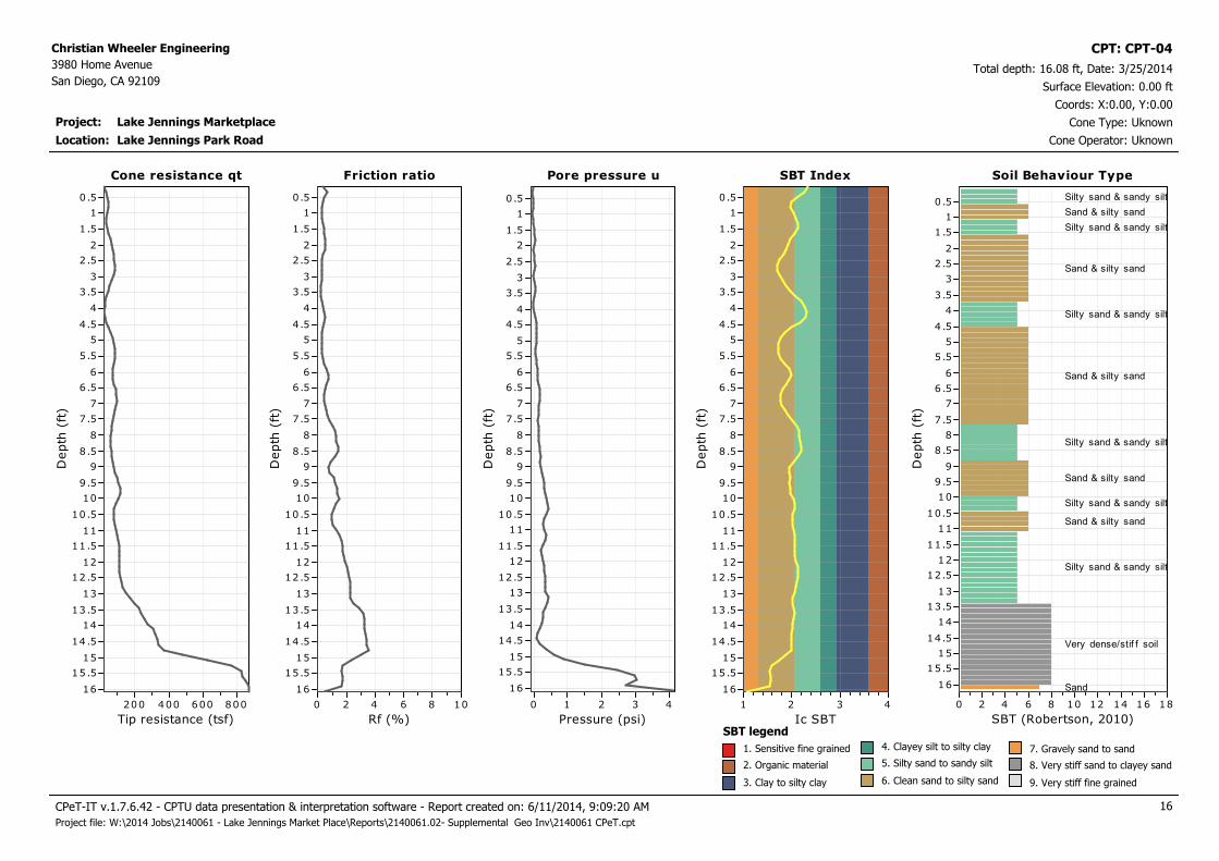
San Diego, CA 92109Total depth: 16.08 ft, Date: 3/25/2014
Surface Elevation: 0.00 ft
Lake Jennings Park Road
Coords: X:0.00, Y:0.00
Cone Type: Uknown
Cone Operator: Uknown
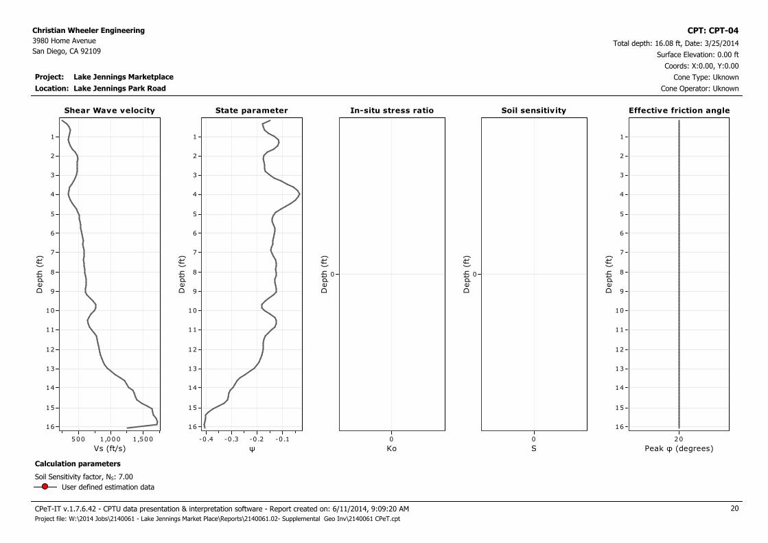
CPT: CPT-04
Location:
Cone resistance qt
Tip resistance (tsf)
800600400200
Depth
(ft
)
16
15.5
15
14.5
14
13.5
13
12.5
12
11.5
11
10.5
10
9.5
9
8.5
8
7.5
7
6.5
6
5.5
5
4.5
4
3.5
3
2.5
2
1.5
1
0.5
Cone resistance qt Pore pressure u
Pressure (psi)
43210
Depth
(ft
)
16
15.5
15
14.5
14
13.5
13
12.5
12
11.5
11
10.5
10
9.5
9
8.5
8
7.5
7
6.5
6
5.5
5
4.5
4
3.5
3
2.5
2
1.5
1
0.5
Pore pressure uFriction ratio
Rf (%)
1086420
Depth
(ft
)
16
15.5
15
14.5
14
13.5
13
12.5
12
11.5
11
10.5
10
9.5
9
8.5
8
7.5
7
6.5
6
5.5
5
4.5
4
3.5
3
2.5
2
1.5
1
0.5
Friction ratio SBT Index
Ic SBT
4321D
epth
(ft
)16
15.5
15
14.5
14
13.5
13
12.5
12
11.5
11
10.5
10
9.5
9
8.5
8
7.5
7
6.5
6
5.5
5
4.5
4
3.5
3
2.5
2
1.5
1
0.5
SBT Index Soil Behaviour Type
SBT (Robertson, 2010)
181614121086420
Depth
(ft
)
16
15.5
15
14.5
14
13.5
13
12.5
12
11.5
11
10.5
10
9 .5
9
8 .5
8
7 .5
7
6 .5
6
5 .5
5
4 .5
4
3 .5
3
2 .5
2
1 .5
1
0 .5
Soil Behaviour Type
Silty sand & sandy silt
Sand & silty sand
Silty sand & sandy silt
Sand & silty sand
Silty sand & sandy silt
Sand & silty sand
Silty sand & sandy silt
Sand & silty sand
Silty sand & sandy silt
Sand & silty sand
Silty sand & sandy silt
Very dense/stif f soil
Sand
SBT legend
1. Sensitive fine grained
2. Organic material
3. Clay to silty clay
4. Clayey silt to silty clay
5. Silty sand to sandy silt
6. Clean sand to silty sand
7. Gravely sand to sand
8. Very stiff sand to clayey sand
9. Very stiff fine grained
CPeT-IT v.1.7.6.42 - CPTU data presentation & interpretation software - Report created on: 6/11/2014, 9:09:20 AM 16
Project file: W:\2014 Jobs\2140061 - Lake Jennings Market Place\Reports\2140061.02- Supplemental Geo Inv\2140061 CPeT.cpt
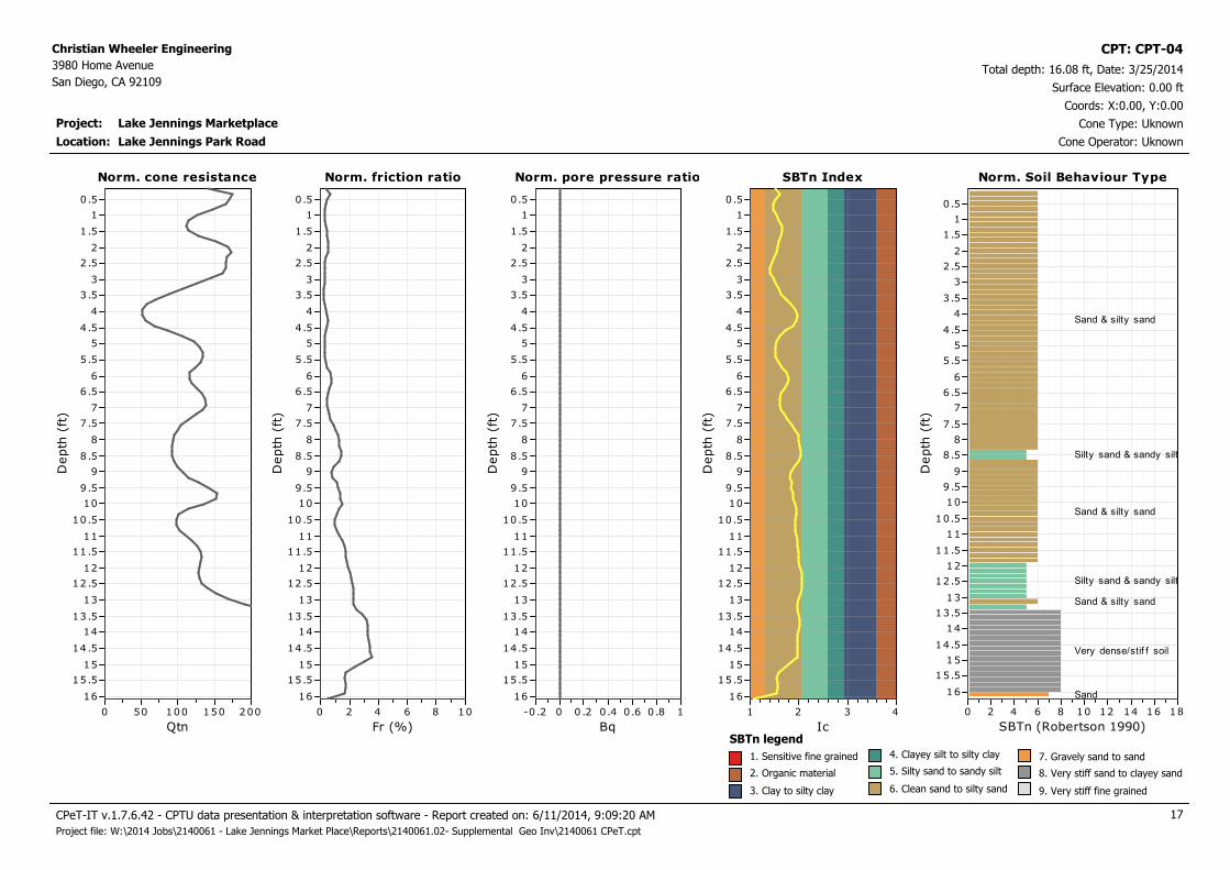
Project: Lake Jennings Marketplace
Christian Wheeler Engineering
3980 Home Avenue
San Diego, CA 92109Total depth: 16.08 ft, Date: 3/25/2014
Surface Elevation: 0.00 ft
Lake Jennings Park Road
Coords: X:0.00, Y:0.00
Cone Type: Uknown
Cone Operator: Uknown
CPT: CPT-04
Location:
Norm. cone resistance
Qtn
200150100500
Depth
(ft
)
16
15.5
15
14.5
14
13.5
13
12.5
12
11.5
11
10.5
10
9.5
9
8.5
8
7.5
7
6.5
6
5.5
5
4.5
4
3.5
3
2.5
2
1.5
1
0.5
Norm. cone resistance Norm. pore pressure ratio
Bq
10.80.60.40 .20-0 .2
Depth
(ft
)
16
15.5
15
14.5
14
13.5
13
12.5
12
11.5
11
10.5
10
9.5
9
8.5
8
7.5
7
6.5
6
5.5
5
4.5
4
3.5
3
2.5
2
1.5
1
0.5
Norm. pore pressure ratioNorm. friction ratio
Fr (%)
1086420
Depth
(ft
)
16
15.5
15
14.5
14
13.5
13
12.5
12
11.5
11
10.5
10
9.5
9
8.5
8
7.5
7
6.5
6
5.5
5
4.5
4
3.5
3
2.5
2
1.5
1
0.5
Norm. friction ratio SBTn Index
Ic
4321D
epth
(ft
)16
15.5
15
14.5
14
13.5
13
12.5
12
11.5
11
10.5
10
9.5
9
8.5
8
7.5
7
6.5
6
5.5
5
4.5
4
3.5
3
2.5
2
1.5
1
0.5
SBTn Index Norm. Soil Behaviour Type
SBTn (Robertson 1990)
181614121086420
Depth
(ft
)
16
15.5
15
14.5
14
13.5
13
12.5
12
11.5
11
10.5
10
9 .5
9
8 .5
8
7 .5
7
6 .5
6
5 .5
5
4 .5
4
3 .5
3
2 .5
2
1 .5
1
0 .5
Norm. Soil Behaviour Type
Sand & silty sand
Silty sand & sandy silt
Sand & silty sand
Silty sand & sandy silt
Sand & silty sand
Very dense/stif f soil
Sand
SBTn legend
1. Sensitive fine grained
2. Organic material
3. Clay to silty clay
4. Clayey silt to silty clay
5. Silty sand to sandy silt
6. Clean sand to silty sand
7. Gravely sand to sand
8. Very stiff sand to clayey sand
9. Very stiff fine grained
CPeT-IT v.1.7.6.42 - CPTU data presentation & interpretation software - Report created on: 6/11/2014, 9:09:20 AM 17
Project file: W:\2014 Jobs\2140061 - Lake Jennings Market Place\Reports\2140061.02- Supplemental Geo Inv\2140061 CPeT.cpt

Project: Lake Jennings Marketplace
Christian Wheeler Engineering
3980 Home Avenue
San Diego, CA 92109Total depth: 16.08 ft, Date: 3/25/2014
Surface Elevation: 0.00 ft
Lake Jennings Park Road
Coords: X:0.00, Y:0.00
Cone Type: Uknown
Cone Operator: Uknown
CPT: CPT-04
Location:
Permeability
Ksbt (ft/s)
-91x10 -61x10 -31x10
Depth
(ft
)
16
15
14
13
12
11
10
9
8
7
6
5
4
3
2
1
Permeability Young's modulus
Es (tsf)
4,0002 ,000
Depth
(ft
)
16
15
14
13
12
11
10
9
8
7
6
5
4
3
2
1
Young's modulusSPT N60
N60 (blows/ft)
50403020100
Depth
(ft
)
16
15
14
13
12
11
10
9
8
7
6
5
4
3
2
1
SPT N60 Relative density
Dr (%)
100806040200
Depth
(ft
)
16
15
14
13
12
11
10
9
8
7
6
5
4
3
2
1
Relative density
Calculation parameters
Relative desnisty constant, CDr: 350.0Permeability: Based on SBTn
SPT N60: Based on Ic and qt
Young’s modulus: Based on variable alpha using Ic (Robertson, 2009)
Phi: Based on Kulhawy & Mayne (1990)
User defined estimation data
Friction angle
φ (degrees)
60555045403530
Depth
(ft
)
16
15
14
13
12
11
10
9
8
7
6
5
4
3
2
1
Friction angle
CPeT-IT v.1.7.6.42 - CPTU data presentation & interpretation software - Report created on: 6/11/2014, 9:09:20 AM 18
Project file: W:\2014 Jobs\2140061 - Lake Jennings Market Place\Reports\2140061.02- Supplemental Geo Inv\2140061 CPeT.cpt

Project: Lake Jennings Marketplace
Christian Wheeler Engineering
3980 Home Avenue
San Diego, CA 92109Total depth: 16.08 ft, Date: 3/25/2014
Surface Elevation: 0.00 ft
Lake Jennings Park Road
Coords: X:0.00, Y:0.00
Cone Type: Uknown
Cone Operator: Uknown
CPT: CPT-04
Location:
Constrained Modulus
M(CPT) (tsf)
4,0002,000
Depth
(ft
)
16
15
14
13
12
11
10
9
8
7
6
5
4
3
2
1
Constrained Modulus Shear strength
Su (tsf)
0
Depth
(ft
)
0
Su peak
Su remolded
Shear strengthShear modulus
Go (tsf)
4,0002,000
Depth
(ft
)
16
15
14
13
12
11
10
9
8
7
6
5
4
3
2
1
Shear modulus Undrained strength ratio
Su/σ',v
21.510 .50
Depth
(ft
)
0
Undrained strength ratio OCR
OCR
1086420
Depth
(ft
)
0
OCR
Calculation parameters
Undrained shear strength cone factor for clays, Nkt: 14
OCR factor for clays, Nkt: 0.33
Go: Based on variable alpha using Ic (Robertson, 2009)
Constrained modulus: Based on variable alpha using Ic and Qtn (Robertson, 2009)
User defined estimation data
CPeT-IT v.1.7.6.42 - CPTU data presentation & interpretation software - Report created on: 6/11/2014, 9:09:20 AM 19
Project file: W:\2014 Jobs\2140061 - Lake Jennings Market Place\Reports\2140061.02- Supplemental Geo Inv\2140061 CPeT.cpt
Project: Lake Jennings Marketplace
Christian Wheeler Engineering
3980 Home Avenue
San Diego, CA 92109Total depth: 16.08 ft, Date: 3/25/2014
Surface Elevation: 0.00 ft
Lake Jennings Park Road
Coords: X:0.00, Y:0.00
Cone Type: Uknown
Cone Operator: Uknown
CPT: CPT-04
Location:
Shear Wave velocity
Vs (ft/s)
1,5001 ,000500
Depth
(ft
)
16
15
14
13
12
11
10
9
8
7
6
5
4
3
2
1
Shear Wave velocity In-situ stress ratio
Ko
0
Depth
(ft
)
0
In-situ stress ratioState parameter
ψ
-0.1-0.2-0.3-0.4
Depth
(ft
)
16
15
14
13
12
11
10
9
8
7
6
5
4
3
2
1
State parameter Soil sensitivity
S
0
Depth
(ft
)
0
Soil sensitivity Effective friction angle
Peak φ (degrees)
20
Depth
(ft
)
16
15
14
13
12
11
10
9
8
7
6
5
4
3
2
1
Effective friction angle
Calculation parameters
Soil Sensitivity factor, NS: 7.00
User defined estimation data
CPeT-IT v.1.7.6.42 - CPTU data presentation & interpretation software - Report created on: 6/11/2014, 9:09:20 AM 20
Project file: W:\2014 Jobs\2140061 - Lake Jennings Market Place\Reports\2140061.02- Supplemental Geo Inv\2140061 CPeT.cpt

Project: Lake Jennings Marketplace
Christian Wheeler Engineering
3980 Home Avenue
San Diego, CA 92109Total depth: 12.14 ft, Date: 3/25/2014
Surface Elevation: 0.00 ft
Lake Jennings Park Road
Coords: X:0.00, Y:0.00
Cone Type: Uknown
Cone Operator: Uknown
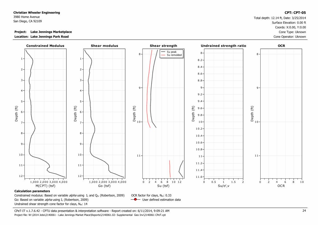
CPT: CPT-05
Location:
Cone resistance qt
Tip resistance (tsf)
400200
Depth
(ft
)
12
11.5
11
10.5
10
9.5
9
8.5
8
7.5
7
6.5
6
5.5
5
4.5
4
3.5
3
2.5
2
1.5
1
0.5
Cone resistance qt Pore pressure u
Pressure (psi)
0.50
Depth
(ft
)
12
11.5
11
10.5
10
9.5
9
8.5
8
7.5
7
6.5
6
5.5
5
4.5
4
3.5
3
2.5
2
1.5
1
0.5
Pore pressure uFriction ratio
Rf (%)
1086420
Depth
(ft
)
12
11.5
11
10.5
10
9.5
9
8.5
8
7.5
7
6.5
6
5.5
5
4.5
4
3.5
3
2.5
2
1.5
1
0.5
Friction ratio SBT Index
Ic SBT
4321D
epth
(ft
)
12
11.5
11
10.5
10
9.5
9
8.5
8
7.5
7
6.5
6
5.5
5
4.5
4
3.5
3
2.5
2
1.5
1
0.5
SBT Index Soil Behaviour Type
SBT (Robertson, 2010)
181614121086420
Depth
(ft
)
12
11.5
11
10.5
10
9 .5
9
8 .5
8
7 .5
7
6 .5
6
5 .5
5
4 .5
4
3 .5
3
2 .5
2
1 .5
1
0 .5
Soil Behaviour Type
Clay & silty clay
Silty sand & sandy silt
Clay & silty clay
Silty sand & sandy silt
Clay & silty clay
Silty sand & sandy silt
Clay & silty clay
Silty sand & sandy silt
Very dense/stif f soil
Very dense/stif f soil
Very dense/stif f soil
SBT legend
1. Sensitive fine grained
2. Organic material
3. Clay to silty clay
4. Clayey silt to silty clay
5. Silty sand to sandy silt
6. Clean sand to silty sand
7. Gravely sand to sand
8. Very stiff sand to clayey sand
9. Very stiff fine grained
CPeT-IT v.1.7.6.42 - CPTU data presentation & interpretation software - Report created on: 6/11/2014, 9:09:21 AM 21
Project file: W:\2014 Jobs\2140061 - Lake Jennings Market Place\Reports\2140061.02- Supplemental Geo Inv\2140061 CPeT.cpt

Project: Lake Jennings Marketplace
Christian Wheeler Engineering
3980 Home Avenue
San Diego, CA 92109Total depth: 12.14 ft, Date: 3/25/2014
Surface Elevation: 0.00 ft
Lake Jennings Park Road
Coords: X:0.00, Y:0.00
Cone Type: Uknown
Cone Operator: Uknown
CPT: CPT-05
Location:
Norm. cone resistance
Qtn
200150100500
Depth
(ft
)
12
11.5
11
10.5
10
9.5
9
8.5
8
7.5
7
6.5
6
5.5
5
4.5
4
3.5
3
2.5
2
1.5
1
0.5
Norm. cone resistance Norm. pore pressure ratio
Bq
10.80.60.40 .20-0 .2
Depth
(ft
)
12
11.5
11
10.5
10
9.5
9
8.5
8
7.5
7
6.5
6
5.5
5
4.5
4
3.5
3
2.5
2
1.5
1
0.5
Norm. pore pressure ratioNorm. friction ratio
Fr (%)
1086420
Depth
(ft
)
12
11.5
11
10.5
10
9.5
9
8.5
8
7.5
7
6.5
6
5.5
5
4.5
4
3.5
3
2.5
2
1.5
1
0.5
Norm. friction ratio SBTn Index
Ic
4321D
epth
(ft
)
12
11.5
11
10.5
10
9.5
9
8.5
8
7.5
7
6.5
6
5.5
5
4.5
4
3.5
3
2.5
2
1.5
1
0.5
SBTn Index Norm. Soil Behaviour Type
SBTn (Robertson 1990)
181614121086420
Depth
(ft
)
12
11.5
11
10.5
10
9 .5
9
8 .5
8
7 .5
7
6 .5
6
5 .5
5
4 .5
4
3 .5
3
2 .5
2
1 .5
1
0 .5
Norm. Soil Behaviour Type
Sand & silty sand
Very dense/stif f soil
Silty sand & sandy silt
Very dense/stif f soil
Very dense/stif f soil
Clay & silty clay
Very dense/stif f soil
Very dense/stif f soil
Very dense/stif f soil
SBTn legend
1. Sensitive fine grained
2. Organic material
3. Clay to silty clay
4. Clayey silt to silty clay
5. Silty sand to sandy silt
6. Clean sand to silty sand
7. Gravely sand to sand
8. Very stiff sand to clayey sand
9. Very stiff fine grained
CPeT-IT v.1.7.6.42 - CPTU data presentation & interpretation software - Report created on: 6/11/2014, 9:09:21 AM 22
Project file: W:\2014 Jobs\2140061 - Lake Jennings Market Place\Reports\2140061.02- Supplemental Geo Inv\2140061 CPeT.cpt

Project: Lake Jennings Marketplace
Christian Wheeler Engineering
3980 Home Avenue
San Diego, CA 92109Total depth: 12.14 ft, Date: 3/25/2014
Surface Elevation: 0.00 ft
Lake Jennings Park Road
Coords: X:0.00, Y:0.00
Cone Type: Uknown
Cone Operator: Uknown
CPT: CPT-05
Location:
Permeability
Ksbt (ft/s)
-91x10 -61x10 -31x10
Depth
(ft
)
12
11
10
9
8
7
6
5
4
3
2
1
Permeability Young's modulus
Es (tsf)
3,0002,0001,000
Depth
(ft
)
12
11
10
9
8
7
6
5
4
3
2
1
Young's modulusSPT N60
N60 (blows/ft)
50403020100
Depth
(ft
)
12
11
10
9
8
7
6
5
4
3
2
1
SPT N60 Relative density
Dr (%)
100806040200
Depth
(ft
)
12
11
10
9
8
7
6
5
4
3
2
1
Relative density
Calculation parameters
Relative desnisty constant, CDr: 350.0Permeability: Based on SBTn
SPT N60: Based on Ic and qt
Young’s modulus: Based on variable alpha using Ic (Robertson, 2009)
Phi: Based on Kulhawy & Mayne (1990)
User defined estimation data
Friction angle
φ (degrees)
60555045403530
Depth
(ft
)
12
11
10
9
8
7
6
5
4
3
2
1
Friction angle
CPeT-IT v.1.7.6.42 - CPTU data presentation & interpretation software - Report created on: 6/11/2014, 9:09:21 AM 23
Project file: W:\2014 Jobs\2140061 - Lake Jennings Market Place\Reports\2140061.02- Supplemental Geo Inv\2140061 CPeT.cpt
Project: Lake Jennings Marketplace
Christian Wheeler Engineering
3980 Home Avenue
San Diego, CA 92109Total depth: 12.14 ft, Date: 3/25/2014
Surface Elevation: 0.00 ft
Lake Jennings Park Road
Coords: X:0.00, Y:0.00
Cone Type: Uknown
Cone Operator: Uknown
CPT: CPT-05
Location:
Constrained Modulus
M(CPT) (tsf)
4,0003 ,0002 ,0001,000
Depth
(ft
)
12
11
10
9
8
7
6
5
4
3
2
1
Constrained Modulus Shear strength
Su (tsf)
121086420
Depth
(ft
)
11
10
9
8Su peak
Su remolded
Shear strengthShear modulus
Go (tsf)
4,0003 ,0002 ,0001,000
Depth
(ft
)
12
11
10
9
8
7
6
5
4
3
2
1
Shear modulus Undrained strength ratio
Su/σ',v
21.510.50
Depth
(ft
)
11.6
11.4
11.2
11
10.8
10.6
10.4
10.2
10
9 .8
9 .6
9 .4
9 .2
9
8 .8
8 .6
8 .4
8 .2
8
Undrained strength ratio OCR
OCR
1086420
Depth
(ft
)
11
10
9
8
OCR
Calculation parameters
Undrained shear strength cone factor for clays, Nkt: 14
OCR factor for clays, Nkt: 0.33
Go: Based on variable alpha using Ic (Robertson, 2009)
Constrained modulus: Based on variable alpha using Ic and Qtn (Robertson, 2009)
User defined estimation data
CPeT-IT v.1.7.6.42 - CPTU data presentation & interpretation software - Report created on: 6/11/2014, 9:09:21 AM 24
Project file: W:\2014 Jobs\2140061 - Lake Jennings Market Place\Reports\2140061.02- Supplemental Geo Inv\2140061 CPeT.cpt

Project: Lake Jennings Marketplace
Christian Wheeler Engineering
3980 Home Avenue
San Diego, CA 92109Total depth: 12.14 ft, Date: 3/25/2014
Surface Elevation: 0.00 ft
Lake Jennings Park Road
Coords: X:0.00, Y:0.00
Cone Type: Uknown
Cone Operator: Uknown
CPT: CPT-05
Location:
Shear Wave velocity
Vs (ft/s)
1,000500
Depth
(ft
)
12
11
10
9
8
7
6
5
4
3
2
1
Shear Wave velocity In-situ stress ratio
Ko
210
Depth
(ft
)
11
10
9
8
In-situ stress ratioState parameter
ψ
0-0.1-0 .2-0 .3
Depth
(ft
)
12
11
10
9
8
7
6
5
4
3
2
1
State parameter Soil sensitivity
S
21.510 .50
Depth
(ft
)
11
10
9
8
Soil sensitivity Effective friction angle
Peak φ (degrees)
20
Depth
(ft
)
12
11
10
9
8
7
6
5
4
3
2
1
Effective friction angle
Calculation parameters
Soil Sensitivity factor, NS: 7.00
User defined estimation data
CPeT-IT v.1.7.6.42 - CPTU data presentation & interpretation software - Report created on: 6/11/2014, 9:09:21 AM 25
Project file: W:\2014 Jobs\2140061 - Lake Jennings Market Place\Reports\2140061.02- Supplemental Geo Inv\2140061 CPeT.cpt

Project: Lake Jennings Marketplace
Christian Wheeler Engineering
3980 Home Avenue
San Diego, CA 92109Total depth: 21.16 ft, Date: 3/25/2014
Surface Elevation: 0.00 ft
Lake Jennings Park Road
Coords: X:0.00, Y:0.00
Cone Type: Uknown
Cone Operator: Uknown
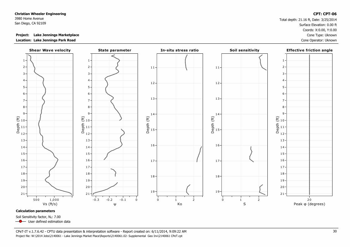
CPT: CPT-06
Location:
Cone resistance qt
Tip resistance (tsf)
400200
Depth
(ft
)
21
20
19
18
17
16
15
14
13
12
11
10
9
8
7
6
5
4
3
2
1
Cone resistance qt Pore pressure u
Pressure (psi)
0
Depth
(ft
)
21
20
19
18
17
16
15
14
13
12
11
10
9
8
7
6
5
4
3
2
1
Pore pressure uFriction ratio
Rf (%)
1086420
Depth
(ft
)
21
20
19
18
17
16
15
14
13
12
11
10
9
8
7
6
5
4
3
2
1
Friction ratio SBT Index
Ic SBT
4321D
epth
(ft
)21
20
19
18
17
16
15
14
13
12
11
10
9
8
7
6
5
4
3
2
1
SBT Index Soil Behaviour Type
SBT (Robertson, 2010)
181614121086420
Depth
(ft
)
21
20
19
18
17
16
15
14
13
12
11
10
9
8
7
6
5
4
3
2
1
Soil Behaviour Type
Silty sand & sandy silt
Sand & silty sand
Silty sand & sandy silt
Sand & silty sand
Silty sand & sandy siltSand & silty sandSilty sand & sandy silt
Clay & silty clay
Silty sand & sandy silt
Sand & silty sand
Silty sand & sandy silt
Sand & silty sandSilty sand & sandy silt
Sand & silty sandSilty sand & sandy silt
Very dense/stif f soil
Silty sand & sandy silt
Clay & silty clay
Silty sand & sandy silt
Sand & silty sand
Very dense/stif f soil
SBT legend
1. Sensitive fine grained
2. Organic material
3. Clay to silty clay
4. Clayey silt to silty clay
5. Silty sand to sandy silt
6. Clean sand to silty sand
7. Gravely sand to sand
8. Very stiff sand to clayey sand
9. Very stiff fine grained
CPeT-IT v.1.7.6.42 - CPTU data presentation & interpretation software - Report created on: 6/11/2014, 9:09:21 AM 26
Project file: W:\2014 Jobs\2140061 - Lake Jennings Market Place\Reports\2140061.02- Supplemental Geo Inv\2140061 CPeT.cpt

Project: Lake Jennings Marketplace
Christian Wheeler Engineering
3980 Home Avenue
San Diego, CA 92109Total depth: 21.16 ft, Date: 3/25/2014
Surface Elevation: 0.00 ft
Lake Jennings Park Road
Coords: X:0.00, Y:0.00
Cone Type: Uknown
Cone Operator: Uknown
CPT: CPT-06
Location:
Norm. cone resistance
Qtn
200150100500
Depth
(ft
)
21
20
19
18
17
16
15
14
13
12
11
10
9
8
7
6
5
4
3
2
1
Norm. cone resistance Norm. pore pressure ratio
Bq
10.80.60 .40.20-0.2
Depth
(ft
)
21
20
19
18
17
16
15
14
13
12
11
10
9
8
7
6
5
4
3
2
1
Norm. pore pressure ratioNorm. friction ratio
Fr (%)
1086420
Depth
(ft
)
21
20
19
18
17
16
15
14
13
12
11
10
9
8
7
6
5
4
3
2
1
Norm. friction ratio SBTn Index
Ic
4321D
epth
(ft
)21
20
19
18
17
16
15
14
13
12
11
10
9
8
7
6
5
4
3
2
1
SBTn Index Norm. Soil Behaviour Type
SBTn (Robertson 1990)
181614121086420
Depth
(ft
)
21
20
19
18
17
16
15
14
13
12
11
10
9
8
7
6
5
4
3
2
1
Norm. Soil Behaviour Type
Sand & silty sand
Silty sand & sandy silt
Sand & silty sand
Silty sand & sandy silt
Clay & silty clay
Silty sand & sandy silt
Sand & silty sand
Silty sand & sandy silt
Sand & silty sand
Silty sand & sandy silt
Very dense/stif f soil
Silty sand & sandy silt
Clay & silty clay
Silty sand & sandy silt
Sand & silty sand
Very dense/stif f soil
SBTn legend
1. Sensitive fine grained
2. Organic material
3. Clay to silty clay
4. Clayey silt to silty clay
5. Silty sand to sandy silt
6. Clean sand to silty sand
7. Gravely sand to sand
8. Very stiff sand to clayey sand
9. Very stiff fine grained
CPeT-IT v.1.7.6.42 - CPTU data presentation & interpretation software - Report created on: 6/11/2014, 9:09:21 AM 27
Project file: W:\2014 Jobs\2140061 - Lake Jennings Market Place\Reports\2140061.02- Supplemental Geo Inv\2140061 CPeT.cpt

Project: Lake Jennings Marketplace
Christian Wheeler Engineering
3980 Home Avenue
San Diego, CA 92109Total depth: 21.16 ft, Date: 3/25/2014
Surface Elevation: 0.00 ft
Lake Jennings Park Road
Coords: X:0.00, Y:0.00
Cone Type: Uknown
Cone Operator: Uknown
CPT: CPT-06
Location:
Permeability
Ksbt (ft/s)
-91x10 -61x10 -31x10
Depth
(ft
)
21
20
19
18
17
16
15
14
13
12
11
10
9
8
7
6
5
4
3
2
1
Permeability Young's modulus
Es (tsf)
3,0002,0001 ,000
Depth
(ft
)
21
20
19
18
17
16
15
14
13
12
11
10
9
8
7
6
5
4
3
2
1
Young's modulusSPT N60
N60 (blows/ft)
50403020100
Depth
(ft
)
21
20
19
18
17
16
15
14
13
12
11
10
9
8
7
6
5
4
3
2
1
SPT N60 Relative density
Dr (%)
100806040200
Depth
(ft
)
21
20
19
18
17
16
15
14
13
12
11
10
9
8
7
6
5
4
3
2
1
Relative density
Calculation parameters
Relative desnisty constant, CDr: 350.0Permeability: Based on SBTn
SPT N60: Based on Ic and qt
Young’s modulus: Based on variable alpha using Ic (Robertson, 2009)
Phi: Based on Kulhawy & Mayne (1990)
User defined estimation data
Friction angle
φ (degrees)
60555045403530
Depth
(ft
)
21
20
19
18
17
16
15
14
13
12
11
10
9
8
7
6
5
4
3
2
1
Friction angle
CPeT-IT v.1.7.6.42 - CPTU data presentation & interpretation software - Report created on: 6/11/2014, 9:09:21 AM 28
Project file: W:\2014 Jobs\2140061 - Lake Jennings Market Place\Reports\2140061.02- Supplemental Geo Inv\2140061 CPeT.cpt

Project: Lake Jennings Marketplace
Christian Wheeler Engineering
3980 Home Avenue
San Diego, CA 92109Total depth: 21.16 ft, Date: 3/25/2014
Surface Elevation: 0.00 ft
Lake Jennings Park Road
Coords: X:0.00, Y:0.00
Cone Type: Uknown
Cone Operator: Uknown
CPT: CPT-06
Location:
Constrained Modulus
M(CPT) (tsf)
4,0002 ,000
Depth
(ft
)
21
20
19
18
17
16
15
14
13
12
11
10
9
8
7
6
5
4
3
2
1
Constrained Modulus Shear strength
Su (tsf)
86420
Depth
(ft
)
19
18
17
16
15
14
13
12
11
Su peak
Su remolded
Shear strengthShear modulus
Go (tsf)
4,0002 ,000
Depth
(ft
)
21
20
19
18
17
16
15
14
13
12
11
10
9
8
7
6
5
4
3
2
1
Shear modulus Undrained strength ratio
Su/σ',v
21.510.50
Depth
(ft
)
19
18.5
18
17.5
17
16.5
16
15.5
15
14.5
14
13.5
13
12.5
12
11.5
11
10.5
Undrained strength ratio OCR
OCR
1086420
Depth
(ft
)
19
18
17
16
15
14
13
12
11
OCR
Calculation parameters
Undrained shear strength cone factor for clays, Nkt: 14
OCR factor for clays, Nkt: 0.33
Go: Based on variable alpha using Ic (Robertson, 2009)
Constrained modulus: Based on variable alpha using Ic and Qtn (Robertson, 2009)
User defined estimation data
CPeT-IT v.1.7.6.42 - CPTU data presentation & interpretation software - Report created on: 6/11/2014, 9:09:21 AM 29
Project file: W:\2014 Jobs\2140061 - Lake Jennings Market Place\Reports\2140061.02- Supplemental Geo Inv\2140061 CPeT.cpt
Project: Lake Jennings Marketplace
Christian Wheeler Engineering
3980 Home Avenue
San Diego, CA 92109Total depth: 21.16 ft, Date: 3/25/2014
Surface Elevation: 0.00 ft
Lake Jennings Park Road
Coords: X:0.00, Y:0.00
Cone Type: Uknown
Cone Operator: Uknown
CPT: CPT-06
Location:
Shear Wave velocity
Vs (ft/s)
1,000500
Depth
(ft
)
21
20
19
18
17
16
15
14
13
12
11
10
9
8
7
6
5
4
3
2
1
Shear Wave velocity In-situ stress ratio
Ko
210
Depth
(ft
)
19
18
17
16
15
14
13
12
11
In-situ stress ratioState parameter
ψ
0-0.1-0 .2-0 .3
Depth
(ft
)
21
20
19
18
17
16
15
14
13
12
11
10
9
8
7
6
5
4
3
2
1
State parameter Soil sensitivity
S
210
Depth
(ft
)
19
18
17
16
15
14
13
12
11
Soil sensitivity Effective friction angle
Peak φ (degrees)
20
Depth
(ft
)
21
20
19
18
17
16
15
14
13
12
11
10
9
8
7
6
5
4
3
2
1
Effective friction angle
Calculation parameters
Soil Sensitivity factor, NS: 7.00
User defined estimation data
CPeT-IT v.1.7.6.42 - CPTU data presentation & interpretation software - Report created on: 6/11/2014, 9:09:22 AM 30
Project file: W:\2014 Jobs\2140061 - Lake Jennings Market Place\Reports\2140061.02- Supplemental Geo Inv\2140061 CPeT.cpt

Project: Lake Jennings Marketplace
Christian Wheeler Engineering
3980 Home Avenue
San Diego, CA 92109Total depth: 22.15 ft, Date: 3/25/2014
Surface Elevation: 0.00 ft
Lake Jennings Park Road
Coords: X:0.00, Y:0.00
Cone Type: Uknown
Cone Operator: Uknown
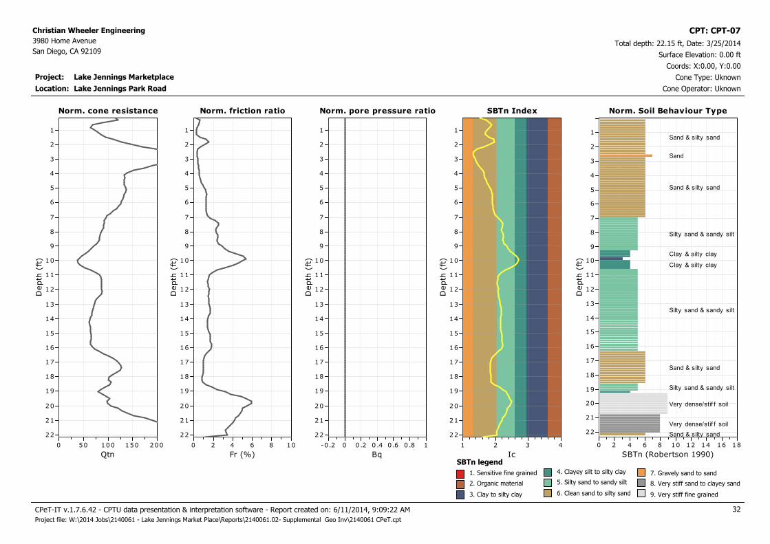
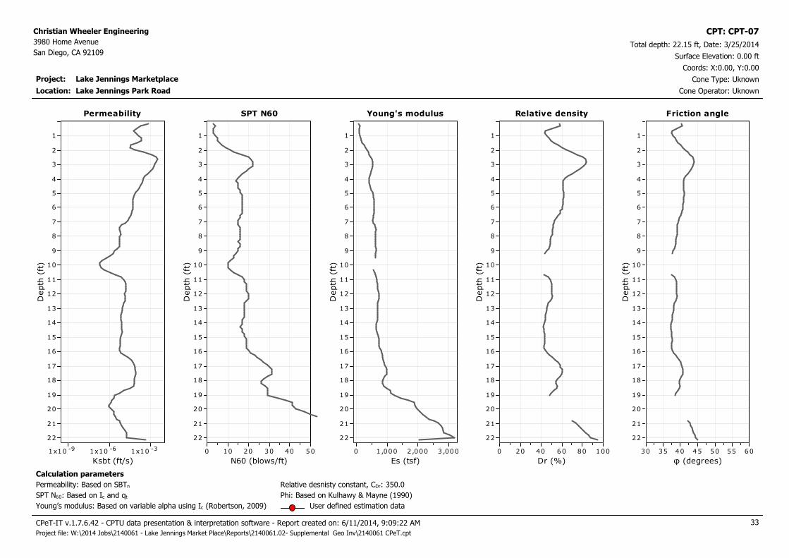
CPT: CPT-07
Location:
Cone resistance qt
Tip resistance (tsf)
300200100
Depth
(ft
)
22
21
20
19
18
17
16
15
14
13
12
11
10
9
8
7
6
5
4
3
2
1
Cone resistance qt Pore pressure u
Pressure (psi)
210
Depth
(ft
)
22
21
20
19
18
17
16
15
14
13
12
11
10
9
8
7
6
5
4
3
2
1
Pore pressure uFriction ratio
Rf (%)
1086420
Depth
(ft
)
22
21
20
19
18
17
16
15
14
13
12
11
10
9
8
7
6
5
4
3
2
1
Friction ratio SBT Index
Ic SBT
4321D
epth
(ft
)22
21
20
19
18
17
16
15
14
13
12
11
10
9
8
7
6
5
4
3
2
1
SBT Index Soil Behaviour Type
SBT (Robertson, 2010)
181614121086420
Depth
(ft
)
22
21
20
19
18
17
16
15
14
13
12
11
10
9
8
7
6
5
4
3
2
1
Soil Behaviour Type
Silty sand & sandy silt
Sand & silty sand
Silty sand & sandy silt
Clay & silty clay
ClayClay & silty clay
Silty sand & sandy silt
Sand & silty sand
Silty sand & sandy silt
Very dense/stif f soil
Very dense/stif f soil
Sand & silty sand
SBT legend
1. Sensitive fine grained
2. Organic material
3. Clay to silty clay
4. Clayey silt to silty clay
5. Silty sand to sandy silt
6. Clean sand to silty sand
7. Gravely sand to sand
8. Very stiff sand to clayey sand
9. Very stiff fine grained
CPeT-IT v.1.7.6.42 - CPTU data presentation & interpretation software - Report created on: 6/11/2014, 9:09:22 AM 31
Project file: W:\2014 Jobs\2140061 - Lake Jennings Market Place\Reports\2140061.02- Supplemental Geo Inv\2140061 CPeT.cpt
Project: Lake Jennings Marketplace
Christian Wheeler Engineering
3980 Home Avenue
San Diego, CA 92109Total depth: 22.15 ft, Date: 3/25/2014
Surface Elevation: 0.00 ft
Lake Jennings Park Road
Coords: X:0.00, Y:0.00
Cone Type: Uknown
Cone Operator: Uknown
CPT: CPT-07
Location:
Norm. cone resistance
Qtn
200150100500
Depth
(ft
)
22
21
20
19
18
17
16
15
14
13
12
11
10
9
8
7
6
5
4
3
2
1
Norm. cone resistance Norm. pore pressure ratio
Bq
10.80.60 .40.20-0.2
Depth
(ft
)
22
21
20
19
18
17
16
15
14
13
12
11
10
9
8
7
6
5
4
3
2
1
Norm. pore pressure ratioNorm. friction ratio
Fr (%)
1086420
Depth
(ft
)
22
21
20
19
18
17
16
15
14
13
12
11
10
9
8
7
6
5
4
3
2
1
Norm. friction ratio SBTn Index
Ic
4321D
epth
(ft
)22
21
20
19
18
17
16
15
14
13
12
11
10
9
8
7
6
5
4
3
2
1
SBTn Index Norm. Soil Behaviour Type
SBTn (Robertson 1990)
181614121086420
Depth
(ft
)
22
21
20
19
18
17
16
15
14
13
12
11
10
9
8
7
6
5
4
3
2
1
Norm. Soil Behaviour Type
Sand & silty sand
Sand
Sand & silty sand
Silty sand & sandy silt
Clay & silty clay
Clay & silty clay
Silty sand & sandy silt
Sand & silty sand
Silty sand & sandy silt
Very dense/stif f soil
Very dense/stif f soil
Sand & silty sand
SBTn legend
1. Sensitive fine grained
2. Organic material
3. Clay to silty clay
4. Clayey silt to silty clay
5. Silty sand to sandy silt
6. Clean sand to silty sand
7. Gravely sand to sand
8. Very stiff sand to clayey sand
9. Very stiff fine grained
CPeT-IT v.1.7.6.42 - CPTU data presentation & interpretation software - Report created on: 6/11/2014, 9:09:22 AM 32
Project file: W:\2014 Jobs\2140061 - Lake Jennings Market Place\Reports\2140061.02- Supplemental Geo Inv\2140061 CPeT.cpt
Project: Lake Jennings Marketplace
Christian Wheeler Engineering
3980 Home Avenue
San Diego, CA 92109Total depth: 22.15 ft, Date: 3/25/2014
Surface Elevation: 0.00 ft
Lake Jennings Park Road
Coords: X:0.00, Y:0.00
Cone Type: Uknown
Cone Operator: Uknown
CPT: CPT-07
Location:
Permeability
Ksbt (ft/s)
-91x10 -61x10 -31x10
Depth
(ft
)
22
21
20
19
18
17
16
15
14
13
12
11
10
9
8
7
6
5
4
3
2
1
Permeability Young's modulus
Es (tsf)
3,0002,0001,0000
Depth
(ft
)
22
21
20
19
18
17
16
15
14
13
12
11
10
9
8
7
6
5
4
3
2
1
Young's modulusSPT N60
N60 (blows/ft)
50403020100
Depth
(ft
)
22
21
20
19
18
17
16
15
14
13
12
11
10
9
8
7
6
5
4
3
2
1
SPT N60 Relative density
Dr (%)
100806040200
Depth
(ft
)
22
21
20
19
18
17
16
15
14
13
12
11
10
9
8
7
6
5
4
3
2
1
Relative density
Calculation parameters
Relative desnisty constant, CDr: 350.0Permeability: Based on SBTn
SPT N60: Based on Ic and qt
Young’s modulus: Based on variable alpha using Ic (Robertson, 2009)
Phi: Based on Kulhawy & Mayne (1990)
User defined estimation data
Friction angle
φ (degrees)
60555045403530
Depth
(ft
)
22
21
20
19
18
17
16
15
14
13
12
11
10
9
8
7
6
5
4
3
2
1
Friction angle
CPeT-IT v.1.7.6.42 - CPTU data presentation & interpretation software - Report created on: 6/11/2014, 9:09:22 AM 33
Project file: W:\2014 Jobs\2140061 - Lake Jennings Market Place\Reports\2140061.02- Supplemental Geo Inv\2140061 CPeT.cpt
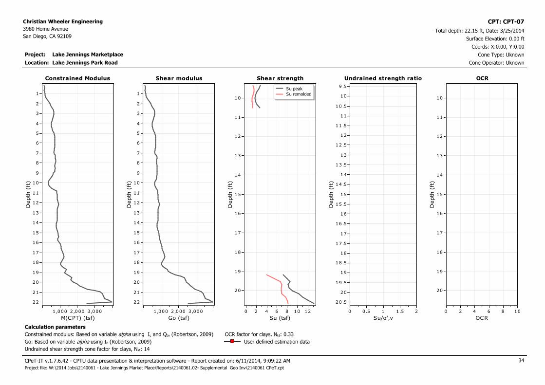
Project: Lake Jennings Marketplace
Christian Wheeler Engineering
3980 Home Avenue
San Diego, CA 92109Total depth: 22.15 ft, Date: 3/25/2014
Surface Elevation: 0.00 ft
Lake Jennings Park Road
Coords: X:0.00, Y:0.00
Cone Type: Uknown
Cone Operator: Uknown
CPT: CPT-07
Location:
Constrained Modulus
M(CPT) (tsf)
3,0002,0001 ,000
Depth
(ft
)
22
21
20
19
18
17
16
15
14
13
12
11
10
9
8
7
6
5
4
3
2
1
Constrained Modulus Shear strength
Su (tsf)
121086420
Depth
(ft
)
20
19
18
17
16
15
14
13
12
11
10
Su peak
Su remolded
Shear strengthShear modulus
Go (tsf)
3,0002,0001 ,000
Depth
(ft
)
22
21
20
19
18
17
16
15
14
13
12
11
10
9
8
7
6
5
4
3
2
1
Shear modulus Undrained strength ratio
Su/σ',v
21.510.50
Depth
(ft
)
20.5
20
19.5
19
18.5
18
17.5
17
16.5
16
15.5
15
14.5
14
13.5
13
12.5
12
11.5
11
10.5
10
9 .5
Undrained strength ratio OCR
OCR
1086420
Depth
(ft
)
20
19
18
17
16
15
14
13
12
11
10
OCR
Calculation parameters
Undrained shear strength cone factor for clays, Nkt: 14
OCR factor for clays, Nkt: 0.33
Go: Based on variable alpha using Ic (Robertson, 2009)
Constrained modulus: Based on variable alpha using Ic and Qtn (Robertson, 2009)
User defined estimation data
CPeT-IT v.1.7.6.42 - CPTU data presentation & interpretation software - Report created on: 6/11/2014, 9:09:22 AM 34
Project file: W:\2014 Jobs\2140061 - Lake Jennings Market Place\Reports\2140061.02- Supplemental Geo Inv\2140061 CPeT.cpt

Project: Lake Jennings Marketplace
Christian Wheeler Engineering
3980 Home Avenue
San Diego, CA 92109Total depth: 22.15 ft, Date: 3/25/2014
Surface Elevation: 0.00 ft
Lake Jennings Park Road
Coords: X:0.00, Y:0.00
Cone Type: Uknown
Cone Operator: Uknown
CPT: CPT-07
Location:
Shear Wave velocity
Vs (ft/s)
1,000500
Depth
(ft
)
22
21
20
19
18
17
16
15
14
13
12
11
10
9
8
7
6
5
4
3
2
1
Shear Wave velocity In-situ stress ratio
Ko
210
Depth
(ft
)
20
19
18
17
16
15
14
13
12
11
10
In-situ stress ratioState parameter
ψ
0-0.1-0 .2
Depth
(ft
)
22
21
20
19
18
17
16
15
14
13
12
11
10
9
8
7
6
5
4
3
2
1
State parameter Soil sensitivity
S
210
Depth
(ft
)
20
19
18
17
16
15
14
13
12
11
10
Soil sensitivity Effective friction angle
Peak φ (degrees)
20
Depth
(ft
)
22
21
20
19
18
17
16
15
14
13
12
11
10
9
8
7
6
5
4
3
2
1
Effective friction angle
Calculation parameters
Soil Sensitivity factor, NS: 7.00
User defined estimation data
CPeT-IT v.1.7.6.42 - CPTU data presentation & interpretation software - Report created on: 6/11/2014, 9:09:22 AM 35
Project file: W:\2014 Jobs\2140061 - Lake Jennings Market Place\Reports\2140061.02- Supplemental Geo Inv\2140061 CPeT.cpt

Project: Lake Jennings Marketplace
Christian Wheeler Engineering
3980 Home Avenue
San Diego, CA 92109Total depth: 28.05 ft, Date: 3/25/2014
Surface Elevation: 0.00 ft
Lake Jennings Park Road
Coords: X:0.00, Y:0.00
Cone Type: Uknown
Cone Operator: Uknown
CPT: CPT-08
Location:
Cone resistance qt
Tip resistance (tsf)
30025020015010050
Depth
(ft
)
28
27
26
25
24
23
22
21
20
19
18
17
16
15
14
13
12
11
10
9
8
7
6
5
4
3
2
1
Cone resistance qt Pore pressure u
Pressure (psi)
1
Depth
(ft
)
28
27
26
25
24
23
22
21
20
19
18
17
16
15
14
13
12
11
10
9
8
7
6
5
4
3
2
1
Pore pressure uFriction ratio
Rf (%)
1086420
Depth
(ft
)
28
27
26
25
24
23
22
21
20
19
18
17
16
15
14
13
12
11
10
9
8
7
6
5
4
3
2
1
Friction ratio SBT Index
Ic SBT
4321D
epth
(ft
)28
27
26
25
24
23
22
21
20
19
18
17
16
15
14
13
12
11
10
9
8
7
6
5
4
3
2
1
SBT Index Soil Behaviour Type
SBT (Robertson, 2010)
181614121086420
Depth
(ft
)
28
27
26
25
24
23
22
21
20
19
18
17
16
15
14
13
12
11
10
9
8
7
6
5
4
3
2
1
Soil Behaviour Type
Silty sand & sandy silt
Clay & silty clay
Silty sand & sandy silt
Very dense/stif f soil
Clay & silty clay
Clay
Clay & silty clay
Silty sand & sandy silt
Clay & silty clay
Silty sand & sandy siltSilty sand & sandy silt
Clay & silty clay
Silty sand & sandy silt
Silty sand & sandy silt
Clay & silty clay
Sand & silty sand
Silty sand & sandy silt
Silty sand & sandy siltSand & silty sand
Silty sand & sandy silt
Sand & silty sand
SBT legend
1. Sensitive fine grained
2. Organic material
3. Clay to silty clay
4. Clayey silt to silty clay
5. Silty sand to sandy silt
6. Clean sand to silty sand
7. Gravely sand to sand
8. Very stiff sand to clayey sand
9. Very stiff fine grained
CPeT-IT v.1.7.6.42 - CPTU data presentation & interpretation software - Report created on: 6/11/2014, 9:09:23 AM 36
Project file: W:\2014 Jobs\2140061 - Lake Jennings Market Place\Reports\2140061.02- Supplemental Geo Inv\2140061 CPeT.cpt

Project: Lake Jennings Marketplace
Christian Wheeler Engineering
3980 Home Avenue
San Diego, CA 92109Total depth: 28.05 ft, Date: 3/25/2014
Surface Elevation: 0.00 ft
Lake Jennings Park Road
Coords: X:0.00, Y:0.00
Cone Type: Uknown
Cone Operator: Uknown
CPT: CPT-08
Location:
Norm. cone resistance
Qtn
200150100500
Depth
(ft
)
28
27
26
25
24
23
22
21
20
19
18
17
16
15
14
13
12
11
10
9
8
7
6
5
4
3
2
1
Norm. cone resistance Norm. pore pressure ratio
Bq
10.80.60 .40.20-0.2
Depth
(ft
)
28
27
26
25
24
23
22
21
20
19
18
17
16
15
14
13
12
11
10
9
8
7
6
5
4
3
2
1
Norm. pore pressure ratioNorm. friction ratio
Fr (%)
1086420
Depth
(ft
)
28
27
26
25
24
23
22
21
20
19
18
17
16
15
14
13
12
11
10
9
8
7
6
5
4
3
2
1
Norm. friction ratio SBTn Index
Ic
4321D
epth
(ft
)28
27
26
25
24
23
22
21
20
19
18
17
16
15
14
13
12
11
10
9
8
7
6
5
4
3
2
1
SBTn Index Norm. Soil Behaviour Type
SBTn (Robertson 1990)
181614121086420
Depth
(ft
)
28
27
26
25
24
23
22
21
20
19
18
17
16
15
14
13
12
11
10
9
8
7
6
5
4
3
2
1
Norm. Soil Behaviour Type
Sand & silty sand
Very dense/stif f soil
Very dense/stif f soilClay & silty clay
Very dense/stif f soil
Clay & silty clay
Silty sand & sandy silt
Clay & silty clay
Silty sand & sandy silt
Clay & silty clay
Silty sand & sandy silt
Silty sand & sandy silt
Clay & silty clay
Sand & silty sand
Silty sand & sandy siltClay & silty clay
Silty sand & sandy silt
Sand & silty sand
SBTn legend
1. Sensitive fine grained
2. Organic material
3. Clay to silty clay
4. Clayey silt to silty clay
5. Silty sand to sandy silt
6. Clean sand to silty sand
7. Gravely sand to sand
8. Very stiff sand to clayey sand
9. Very stiff fine grained
CPeT-IT v.1.7.6.42 - CPTU data presentation & interpretation software - Report created on: 6/11/2014, 9:09:23 AM 37
Project file: W:\2014 Jobs\2140061 - Lake Jennings Market Place\Reports\2140061.02- Supplemental Geo Inv\2140061 CPeT.cpt
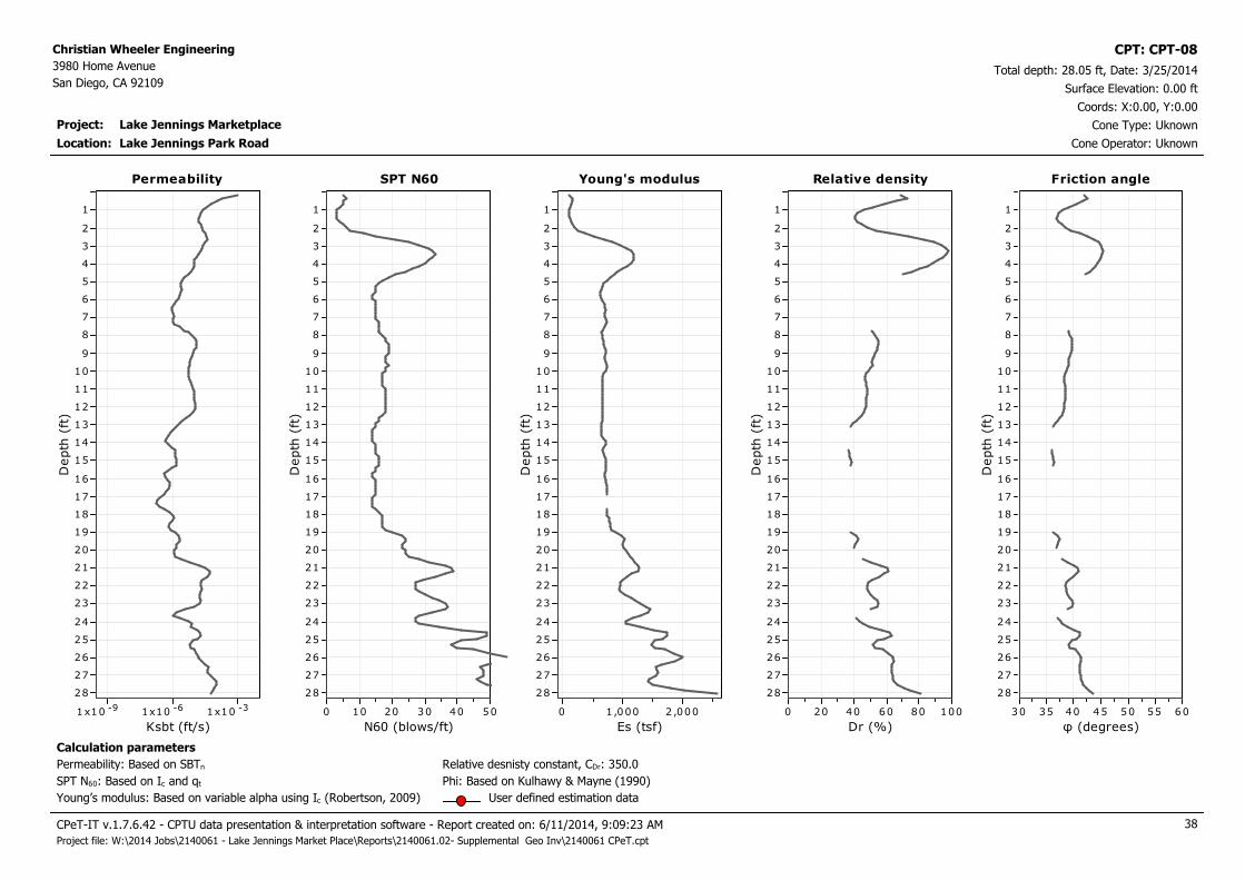
Project: Lake Jennings Marketplace
Christian Wheeler Engineering
3980 Home Avenue
San Diego, CA 92109Total depth: 28.05 ft, Date: 3/25/2014
Surface Elevation: 0.00 ft
Lake Jennings Park Road
Coords: X:0.00, Y:0.00
Cone Type: Uknown
Cone Operator: Uknown
CPT: CPT-08
Location:
Permeability
Ksbt (ft/s)
-91x10 -61x10 -31x10
Depth
(ft
)
28
27
26
25
24
23
22
21
20
19
18
17
16
15
14
13
12
11
10
9
8
7
6
5
4
3
2
1
Permeability Young's modulus
Es (tsf)
2,0001,0000
Depth
(ft
)
28
27
26
25
24
23
22
21
20
19
18
17
16
15
14
13
12
11
10
9
8
7
6
5
4
3
2
1
Young's modulusSPT N60
N60 (blows/ft)
50403020100
Depth
(ft
)
28
27
26
25
24
23
22
21
20
19
18
17
16
15
14
13
12
11
10
9
8
7
6
5
4
3
2
1
SPT N60 Relative density
Dr (%)
100806040200
Depth
(ft
)
28
27
26
25
24
23
22
21
20
19
18
17
16
15
14
13
12
11
10
9
8
7
6
5
4
3
2
1
Relative density
Calculation parameters
Relative desnisty constant, CDr: 350.0Permeability: Based on SBTn
SPT N60: Based on Ic and qt
Young’s modulus: Based on variable alpha using Ic (Robertson, 2009)
Phi: Based on Kulhawy & Mayne (1990)
User defined estimation data
Friction angle
φ (degrees)
60555045403530
Depth
(ft
)
28
27
26
25
24
23
22
21
20
19
18
17
16
15
14
13
12
11
10
9
8
7
6
5
4
3
2
1
Friction angle
CPeT-IT v.1.7.6.42 - CPTU data presentation & interpretation software - Report created on: 6/11/2014, 9:09:23 AM 38
Project file: W:\2014 Jobs\2140061 - Lake Jennings Market Place\Reports\2140061.02- Supplemental Geo Inv\2140061 CPeT.cpt
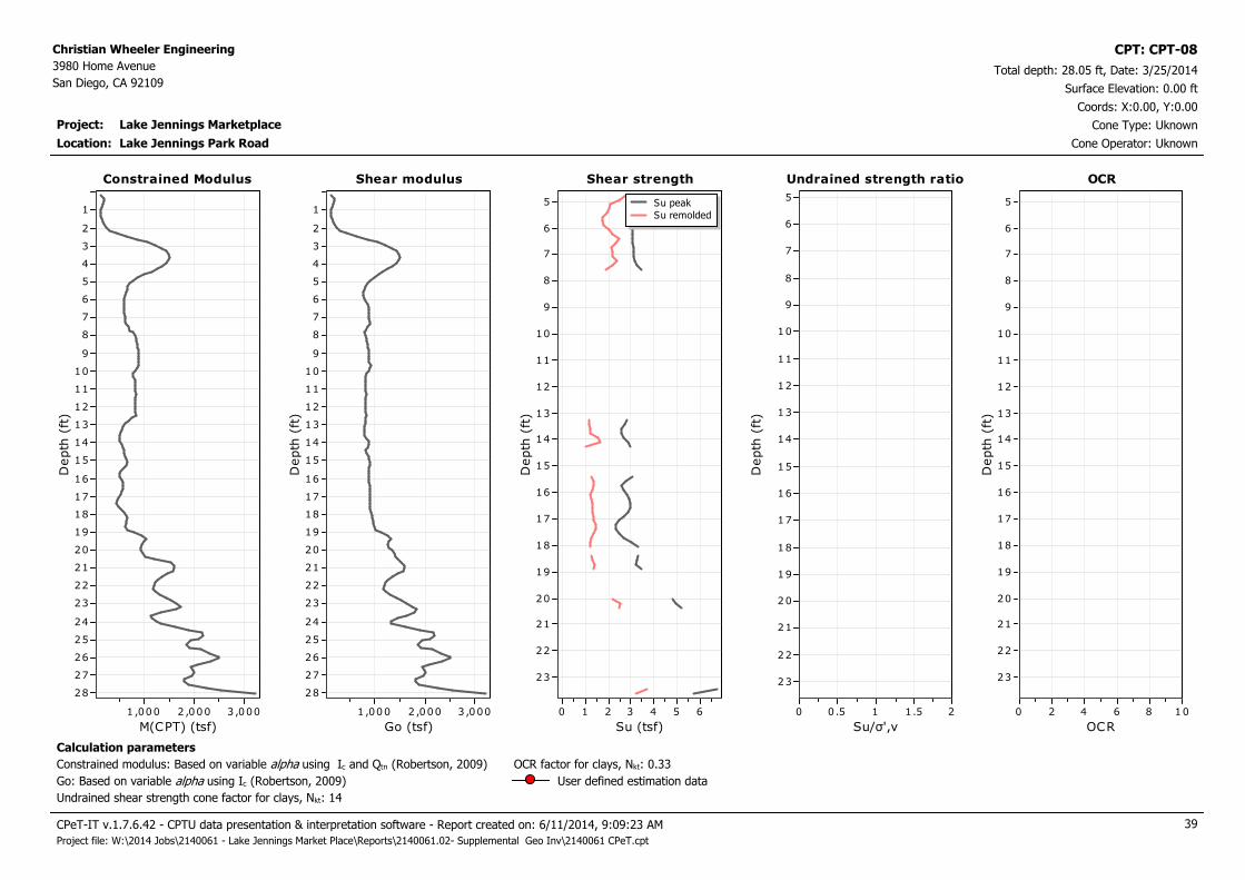
Project: Lake Jennings Marketplace
Christian Wheeler Engineering
3980 Home Avenue
San Diego, CA 92109Total depth: 28.05 ft, Date: 3/25/2014
Surface Elevation: 0.00 ft
Lake Jennings Park Road
Coords: X:0.00, Y:0.00
Cone Type: Uknown
Cone Operator: Uknown
CPT: CPT-08
Location:
Constrained Modulus
M(CPT) (tsf)
3,0002 ,0001 ,000
Depth
(ft
)
28
27
26
25
24
23
22
21
20
19
18
17
16
15
14
13
12
11
10
9
8
7
6
5
4
3
2
1
Constrained Modulus Shear strength
Su (tsf)
6543210
Depth
(ft
)
23
22
21
20
19
18
17
16
15
14
13
12
11
10
9
8
7
6
5 Su peak
Su remolded
Shear strengthShear modulus
Go (tsf)
3,0002 ,0001 ,000
Depth
(ft
)
28
27
26
25
24
23
22
21
20
19
18
17
16
15
14
13
12
11
10
9
8
7
6
5
4
3
2
1
Shear modulus Undrained strength ratio
Su/σ',v
21.510.50
Depth
(ft
)
23
22
21
20
19
18
17
16
15
14
13
12
11
10
9
8
7
6
5
Undrained strength ratio OCR
OCR
1086420
Depth
(ft
)
23
22
21
20
19
18
17
16
15
14
13
12
11
10
9
8
7
6
5
OCR
Calculation parameters
Undrained shear strength cone factor for clays, Nkt: 14
OCR factor for clays, Nkt: 0.33
Go: Based on variable alpha using Ic (Robertson, 2009)
Constrained modulus: Based on variable alpha using Ic and Qtn (Robertson, 2009)
User defined estimation data
CPeT-IT v.1.7.6.42 - CPTU data presentation & interpretation software - Report created on: 6/11/2014, 9:09:23 AM 39
Project file: W:\2014 Jobs\2140061 - Lake Jennings Market Place\Reports\2140061.02- Supplemental Geo Inv\2140061 CPeT.cpt

Project: Lake Jennings Marketplace
Christian Wheeler Engineering
3980 Home Avenue
San Diego, CA 92109Total depth: 28.05 ft, Date: 3/25/2014
Surface Elevation: 0.00 ft
Lake Jennings Park Road
Coords: X:0.00, Y:0.00
Cone Type: Uknown
Cone Operator: Uknown
CPT: CPT-08
Location:
Shear Wave velocity
Vs (ft/s)
1,000500
Depth
(ft
)
28
27
26
25
24
23
22
21
20
19
18
17
16
15
14
13
12
11
10
9
8
7
6
5
4
3
2
1
Shear Wave velocity In-situ stress ratio
Ko
210
Depth
(ft
)
23
22
21
20
19
18
17
16
15
14
13
12
11
10
9
8
7
6
5
In-situ stress ratioState parameter
ψ
0-0.1-0 .2-0.3
Depth
(ft
)
28
27
26
25
24
23
22
21
20
19
18
17
16
15
14
13
12
11
10
9
8
7
6
5
4
3
2
1
State parameter Soil sensitivity
S
210
Depth
(ft
)
23
22
21
20
19
18
17
16
15
14
13
12
11
10
9
8
7
6
5
Soil sensitivity Effective friction angle
Peak φ (degrees)
20
Depth
(ft
)
28
27
26
25
24
23
22
21
20
19
18
17
16
15
14
13
12
11
10
9
8
7
6
5
4
3
2
1
Effective friction angle
Calculation parameters
Soil Sensitivity factor, NS: 7.00
User defined estimation data
CPeT-IT v.1.7.6.42 - CPTU data presentation & interpretation software - Report created on: 6/11/2014, 9:09:23 AM 40
Project file: W:\2014 Jobs\2140061 - Lake Jennings Market Place\Reports\2140061.02- Supplemental Geo Inv\2140061 CPeT.cpt
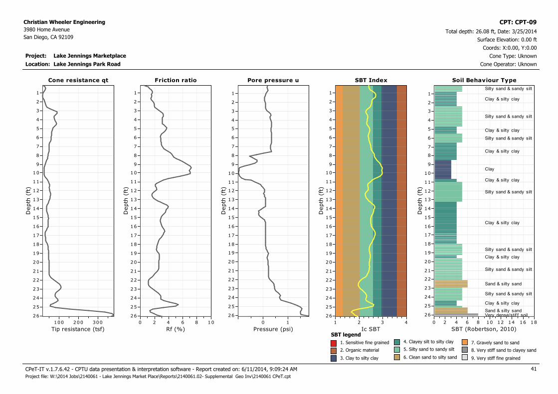
Project: Lake Jennings Marketplace
Christian Wheeler Engineering
3980 Home Avenue
San Diego, CA 92109Total depth: 26.08 ft, Date: 3/25/2014
Surface Elevation: 0.00 ft
Lake Jennings Park Road
Coords: X:0.00, Y:0.00
Cone Type: Uknown
Cone Operator: Uknown
CPT: CPT-09
Location:
Cone resistance qt
Tip resistance (tsf)
300200100
Depth
(ft
)
26
25
24
23
22
21
20
19
18
17
16
15
14
13
12
11
10
9
8
7
6
5
4
3
2
1
Cone resistance qt Pore pressure u
Pressure (psi)
10
Depth
(ft
)
26
25
24
23
22
21
20
19
18
17
16
15
14
13
12
11
10
9
8
7
6
5
4
3
2
1
Pore pressure uFriction ratio
Rf (%)
1086420
Depth
(ft
)
26
25
24
23
22
21
20
19
18
17
16
15
14
13
12
11
10
9
8
7
6
5
4
3
2
1
Friction ratio SBT Index
Ic SBT
4321D
epth
(ft
)26
25
24
23
22
21
20
19
18
17
16
15
14
13
12
11
10
9
8
7
6
5
4
3
2
1
SBT Index Soil Behaviour Type
SBT (Robertson, 2010)
181614121086420
Depth
(ft
)
26
25
24
23
22
21
20
19
18
17
16
15
14
13
12
11
10
9
8
7
6
5
4
3
2
1
Soil Behaviour Type
Silty sand & sandy silt
Clay & silty clay
Silty sand & sandy silt
Clay & silty clay
Silty sand & sandy silt
Clay & silty clay
Clay
Clay & silty clay
Silty sand & sandy silt
Clay & silty clay
Silty sand & sandy silt
Clay & silty clay
Silty sand & sandy silt
Sand & silty sand
Silty sand & sandy silt
Clay & silty clay
Sand & silty sandVery dense/stif f soil
SBT legend
1. Sensitive fine grained
2. Organic material
3. Clay to silty clay
4. Clayey silt to silty clay
5. Silty sand to sandy silt
6. Clean sand to silty sand
7. Gravely sand to sand
8. Very stiff sand to clayey sand
9. Very stiff fine grained
CPeT-IT v.1.7.6.42 - CPTU data presentation & interpretation software - Report created on: 6/11/2014, 9:09:24 AM 41
Project file: W:\2014 Jobs\2140061 - Lake Jennings Market Place\Reports\2140061.02- Supplemental Geo Inv\2140061 CPeT.cpt

Project: Lake Jennings Marketplace
Christian Wheeler Engineering
3980 Home Avenue
San Diego, CA 92109Total depth: 26.08 ft, Date: 3/25/2014
Surface Elevation: 0.00 ft
Lake Jennings Park Road
Coords: X:0.00, Y:0.00
Cone Type: Uknown
Cone Operator: Uknown
CPT: CPT-09
Location:
Norm. cone resistance
Qtn
200150100500
Depth
(ft
)
26
25
24
23
22
21
20
19
18
17
16
15
14
13
12
11
10
9
8
7
6
5
4
3
2
1
Norm. cone resistance Norm. pore pressure ratio
Bq
10.80.60 .40.20-0.2
Depth
(ft
)
26
25
24
23
22
21
20
19
18
17
16
15
14
13
12
11
10
9
8
7
6
5
4
3
2
1
Norm. pore pressure ratioNorm. friction ratio
Fr (%)
1086420
Depth
(ft
)
26
25
24
23
22
21
20
19
18
17
16
15
14
13
12
11
10
9
8
7
6
5
4
3
2
1
Norm. friction ratio SBTn Index
Ic
4321D
epth
(ft
)26
25
24
23
22
21
20
19
18
17
16
15
14
13
12
11
10
9
8
7
6
5
4
3
2
1
SBTn Index Norm. Soil Behaviour Type
SBTn (Robertson 1990)
181614121086420
Depth
(ft
)
26
25
24
23
22
21
20
19
18
17
16
15
14
13
12
11
10
9
8
7
6
5
4
3
2
1
Norm. Soil Behaviour Type
Sand & silty sand
Silty sand & sandy silt
Very dense/stif f soil
Silty sand & sandy silt
Clay & silty clay
Clay
Clay & silty clay
Silty sand & sandy silt
Clay & silty clay
Silty sand & sandy silt
Clay & silty clay
Silty sand & sandy silt
Sand & silty sand
Silty sand & sandy silt
Clay & silty clayClay & silty clay
Sand & silty sand
SBTn legend
1. Sensitive fine grained
2. Organic material
3. Clay to silty clay
4. Clayey silt to silty clay
5. Silty sand to sandy silt
6. Clean sand to silty sand
7. Gravely sand to sand
8. Very stiff sand to clayey sand
9. Very stiff fine grained
CPeT-IT v.1.7.6.42 - CPTU data presentation & interpretation software - Report created on: 6/11/2014, 9:09:24 AM 42
Project file: W:\2014 Jobs\2140061 - Lake Jennings Market Place\Reports\2140061.02- Supplemental Geo Inv\2140061 CPeT.cpt

Project: Lake Jennings Marketplace
Christian Wheeler Engineering
3980 Home Avenue
San Diego, CA 92109Total depth: 26.08 ft, Date: 3/25/2014
Surface Elevation: 0.00 ft
Lake Jennings Park Road
Coords: X:0.00, Y:0.00
Cone Type: Uknown
Cone Operator: Uknown
CPT: CPT-09
Location:
Permeability
Ksbt (ft/s)
-91x10 -61x10 -31x10
Depth
(ft
)
26
25
24
23
22
21
20
19
18
17
16
15
14
13
12
11
10
9
8
7
6
5
4
3
2
1
Permeability Young's modulus
Es (tsf)
2,0000
Depth
(ft
)
26
25
24
23
22
21
20
19
18
17
16
15
14
13
12
11
10
9
8
7
6
5
4
3
2
1
Young's modulusSPT N60
N60 (blows/ft)
50403020100
Depth
(ft
)
26
25
24
23
22
21
20
19
18
17
16
15
14
13
12
11
10
9
8
7
6
5
4
3
2
1
SPT N60 Relative density
Dr (%)
100806040200
Depth
(ft
)
26
25
24
23
22
21
20
19
18
17
16
15
14
13
12
11
10
9
8
7
6
5
4
3
2
1
Relative density
Calculation parameters
Relative desnisty constant, CDr: 350.0Permeability: Based on SBTn
SPT N60: Based on Ic and qt
Young’s modulus: Based on variable alpha using Ic (Robertson, 2009)
Phi: Based on Kulhawy & Mayne (1990)
User defined estimation data
Friction angle
φ (degrees)
60555045403530
Depth
(ft
)
26
25
24
23
22
21
20
19
18
17
16
15
14
13
12
11
10
9
8
7
6
5
4
3
2
1
Friction angle
CPeT-IT v.1.7.6.42 - CPTU data presentation & interpretation software - Report created on: 6/11/2014, 9:09:24 AM 43
Project file: W:\2014 Jobs\2140061 - Lake Jennings Market Place\Reports\2140061.02- Supplemental Geo Inv\2140061 CPeT.cpt
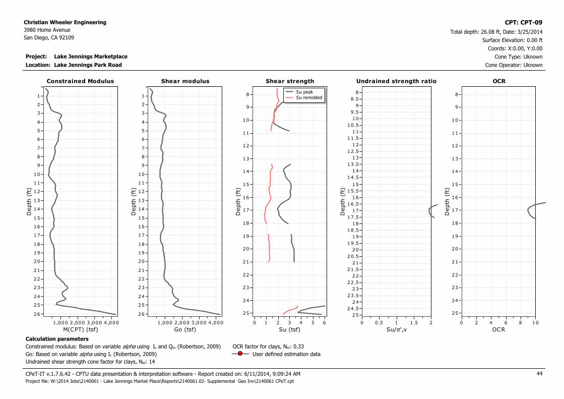
Project: Lake Jennings Marketplace
Christian Wheeler Engineering
3980 Home Avenue
San Diego, CA 92109Total depth: 26.08 ft, Date: 3/25/2014
Surface Elevation: 0.00 ft
Lake Jennings Park Road
Coords: X:0.00, Y:0.00
Cone Type: Uknown
Cone Operator: Uknown
CPT: CPT-09
Location:
Constrained Modulus
M(CPT) (tsf)
4,0003 ,0002,0001,000
Depth
(ft
)
26
25
24
23
22
21
20
19
18
17
16
15
14
13
12
11
10
9
8
7
6
5
4
3
2
1
Constrained Modulus Shear strength
Su (tsf)
6543210
Depth
(ft
)
25
24
23
22
21
20
19
18
17
16
15
14
13
12
11
10
9
8Su peak
Su remolded
Shear strengthShear modulus
Go (tsf)
4,0003 ,0002,0001,000
Depth
(ft
)
26
25
24
23
22
21
20
19
18
17
16
15
14
13
12
11
10
9
8
7
6
5
4
3
2
1
Shear modulus Undrained strength ratio
Su/σ',v
21.510.50
Depth
(ft
)
25
24.5
24
23.5
23
22.5
22
21.5
21
20.5
20
19.5
19
18.5
18
17.5
17
16.5
16
15.5
15
14.5
14
13.5
13
12.5
12
11.5
11
10.5
10
9 .5
9
8 .5
8
Undrained strength ratio OCR
OCR
1086420
Depth
(ft
)
25
24
23
22
21
20
19
18
17
16
15
14
13
12
11
10
9
8
OCR
Calculation parameters
Undrained shear strength cone factor for clays, Nkt: 14
OCR factor for clays, Nkt: 0.33
Go: Based on variable alpha using Ic (Robertson, 2009)
Constrained modulus: Based on variable alpha using Ic and Qtn (Robertson, 2009)
User defined estimation data
CPeT-IT v.1.7.6.42 - CPTU data presentation & interpretation software - Report created on: 6/11/2014, 9:09:24 AM 44
Project file: W:\2014 Jobs\2140061 - Lake Jennings Market Place\Reports\2140061.02- Supplemental Geo Inv\2140061 CPeT.cpt

Project: Lake Jennings Marketplace
Christian Wheeler Engineering
3980 Home Avenue
San Diego, CA 92109Total depth: 26.08 ft, Date: 3/25/2014
Surface Elevation: 0.00 ft
Lake Jennings Park Road
Coords: X:0.00, Y:0.00
Cone Type: Uknown
Cone Operator: Uknown
CPT: CPT-09
Location:
Shear Wave velocity
Vs (ft/s)
1,000500
Depth
(ft
)
26
25
24
23
22
21
20
19
18
17
16
15
14
13
12
11
10
9
8
7
6
5
4
3
2
1
Shear Wave velocity In-situ stress ratio
Ko
21.510 .50
Depth
(ft
)
25
24
23
22
21
20
19
18
17
16
15
14
13
12
11
10
9
8
In-situ stress ratioState parameter
ψ
0-0 .1-0.2
Depth
(ft
)
26
25
24
23
22
21
20
19
18
17
16
15
14
13
12
11
10
9
8
7
6
5
4
3
2
1
State parameter Soil sensitivity
S
210
Depth
(ft
)
25
24
23
22
21
20
19
18
17
16
15
14
13
12
11
10
9
8
Soil sensitivity Effective friction angle
Peak φ (degrees)
20
Depth
(ft
)
26
25
24
23
22
21
20
19
18
17
16
15
14
13
12
11
10
9
8
7
6
5
4
3
2
1
Effective friction angle
Calculation parameters
Soil Sensitivity factor, NS: 7.00
User defined estimation data
CPeT-IT v.1.7.6.42 - CPTU data presentation & interpretation software - Report created on: 6/11/2014, 9:09:24 AM 45
Project file: W:\2014 Jobs\2140061 - Lake Jennings Market Place\Reports\2140061.02- Supplemental Geo Inv\2140061 CPeT.cpt

Project: Lake Jennings Marketplace
Christian Wheeler Engineering
3980 Home Avenue
San Diego, CA 92109Total depth: 20.01 ft, Date: 3/25/2014
Surface Elevation: 0.00 ft
Lake Jennings Park Road
Coords: X:0.00, Y:0.00
Cone Type: Uknown
Cone Operator: Uknown
CPT: CPT-10
Location:
Cone resistance qt
Tip resistance (tsf)
800600400200
Depth
(ft
)
20
19
18
17
16
15
14
13
12
11
10
9
8
7
6
5
4
3
2
1
Cone resistance qt Pore pressure u
Pressure (psi)
210
Depth
(ft
)
19
18
17
16
15
14
13
12
11
10
9
8
7
6
5
4
3
2
1
Pore pressure uFriction ratio
Rf (%)
1086420
Depth
(ft
)
19
18
17
16
15
14
13
12
11
10
9
8
7
6
5
4
3
2
1
Friction ratio SBT Index
Ic SBT
4321D
epth
(ft
)
19
18
17
16
15
14
13
12
11
10
9
8
7
6
5
4
3
2
1
SBT Index Soil Behaviour Type
SBT (Robertson, 2010)
181614121086420
Depth
(ft
)
20
19
18
17
16
15
14
13
12
11
10
9
8
7
6
5
4
3
2
1
Soil Behaviour Type
Clay & silty clay
Silty sand & sandy silt
Clay & silty clay
Silty sand & sandy siltClay & silty clay
Silty sand & sandy silt
Clay & silty clay
Very dense/stif f soil
Clay & silty clay
Silty sand & sandy silt
Clay & silty clay
Silty sand & sandy silt
Sand & silty sand
Silty sand & sandy siltSand & silty sand
Very dense/stif f soilSand & silty sand
SBT legend
1. Sensitive fine grained
2. Organic material
3. Clay to silty clay
4. Clayey silt to silty clay
5. Silty sand to sandy silt
6. Clean sand to silty sand
7. Gravely sand to sand
8. Very stiff sand to clayey sand
9. Very stiff fine grained
CPeT-IT v.1.7.6.42 - CPTU data presentation & interpretation software - Report created on: 6/11/2014, 9:09:24 AM 46
Project file: W:\2014 Jobs\2140061 - Lake Jennings Market Place\Reports\2140061.02- Supplemental Geo Inv\2140061 CPeT.cpt
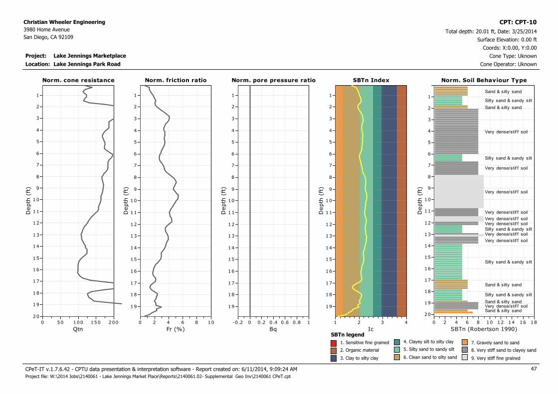
Project: Lake Jennings Marketplace
Christian Wheeler Engineering
3980 Home Avenue
San Diego, CA 92109Total depth: 20.01 ft, Date: 3/25/2014
Surface Elevation: 0.00 ft
Lake Jennings Park Road
Coords: X:0.00, Y:0.00
Cone Type: Uknown
Cone Operator: Uknown
CPT: CPT-10
Location:
Norm. cone resistance
Qtn
200150100500
Depth
(ft
)
20
19
18
17
16
15
14
13
12
11
10
9
8
7
6
5
4
3
2
1
Norm. cone resistance Norm. pore pressure ratio
Bq
10.80.60 .40.20-0.2
Depth
(ft
)
19
18
17
16
15
14
13
12
11
10
9
8
7
6
5
4
3
2
1
Norm. pore pressure ratioNorm. friction ratio
Fr (%)
1086420
Depth
(ft
)
19
18
17
16
15
14
13
12
11
10
9
8
7
6
5
4
3
2
1
Norm. friction ratio SBTn Index
Ic
4321D
epth
(ft
)
19
18
17
16
15
14
13
12
11
10
9
8
7
6
5
4
3
2
1
SBTn Index Norm. Soil Behaviour Type
SBTn (Robertson 1990)
181614121086420
Depth
(ft
)
20
19
18
17
16
15
14
13
12
11
10
9
8
7
6
5
4
3
2
1
Norm. Soil Behaviour Type
Sand & silty sand
Silty sand & sandy silt
Sand & silty sand
Very dense/stif f soil
Silty sand & sandy silt
Very dense/stif f soil
Very dense/stif f soil
Very dense/stif f soil
Very dense/stif f soilVery dense/stif f soil
Silty sand & sandy siltVery dense/stif f soil
Very dense/stif f soil
Silty sand & sandy silt
Sand & silty sand
Silty sand & sandy silt
Sand & silty sandVery dense/stif f soilSand & silty sand
SBTn legend
1. Sensitive fine grained
2. Organic material
3. Clay to silty clay
4. Clayey silt to silty clay
5. Silty sand to sandy silt
6. Clean sand to silty sand
7. Gravely sand to sand
8. Very stiff sand to clayey sand
9. Very stiff fine grained
CPeT-IT v.1.7.6.42 - CPTU data presentation & interpretation software - Report created on: 6/11/2014, 9:09:24 AM 47
Project file: W:\2014 Jobs\2140061 - Lake Jennings Market Place\Reports\2140061.02- Supplemental Geo Inv\2140061 CPeT.cpt

Project: Lake Jennings Marketplace
Christian Wheeler Engineering
3980 Home Avenue
San Diego, CA 92109Total depth: 20.01 ft, Date: 3/25/2014
Surface Elevation: 0.00 ft
Lake Jennings Park Road
Coords: X:0.00, Y:0.00
Cone Type: Uknown
Cone Operator: Uknown
CPT: CPT-10
Location:
Permeability
Ksbt (ft/s)
-91x10 -61x10 -31x10
Depth
(ft
)
19
18
17
16
15
14
13
12
11
10
9
8
7
6
5
4
3
2
1
Permeability Young's modulus
Es (tsf)
4,0002,0000
Depth
(ft
)
19
18
17
16
15
14
13
12
11
10
9
8
7
6
5
4
3
2
1
Young's modulusSPT N60
N60 (blows/ft)
50403020100
Depth
(ft
)
19
18
17
16
15
14
13
12
11
10
9
8
7
6
5
4
3
2
1
SPT N60 Relative density
Dr (%)
100806040200
Depth
(ft
)
19
18
17
16
15
14
13
12
11
10
9
8
7
6
5
4
3
2
1
Relative density
Calculation parameters
Relative desnisty constant, CDr: 350.0Permeability: Based on SBTn
SPT N60: Based on Ic and qt
Young’s modulus: Based on variable alpha using Ic (Robertson, 2009)
Phi: Based on Kulhawy & Mayne (1990)
User defined estimation data
Friction angle
φ (degrees)
60555045403530
Depth
(ft
)
19
18
17
16
15
14
13
12
11
10
9
8
7
6
5
4
3
2
1
Friction angle
CPeT-IT v.1.7.6.42 - CPTU data presentation & interpretation software - Report created on: 6/11/2014, 9:09:25 AM 48
Project file: W:\2014 Jobs\2140061 - Lake Jennings Market Place\Reports\2140061.02- Supplemental Geo Inv\2140061 CPeT.cpt

Project: Lake Jennings Marketplace
Christian Wheeler Engineering
3980 Home Avenue
San Diego, CA 92109Total depth: 20.01 ft, Date: 3/25/2014
Surface Elevation: 0.00 ft
Lake Jennings Park Road
Coords: X:0.00, Y:0.00
Cone Type: Uknown
Cone Operator: Uknown
CPT: CPT-10
Location:
Constrained Modulus
M(CPT) (tsf)
4,0002 ,0000
Depth
(ft
)
19
18
17
16
15
14
13
12
11
10
9
8
7
6
5
4
3
2
1
Constrained Modulus Shear strength
Su (tsf)
86420
Depth
(ft
)
13
12
11
10
9
8 Su peak
Su remolded
Shear strengthShear modulus
Go (tsf)
4,0002 ,0000
Depth
(ft
)
19
18
17
16
15
14
13
12
11
10
9
8
7
6
5
4
3
2
1
Shear modulus Undrained strength ratio
Su/σ',v
21.510.50
Depth
(ft
)
13
12.8
12.6
12.4
12.2
12
11.8
11.6
11.4
11.2
11
10.8
10.6
10.4
10.2
10
9 .8
9 .6
9 .4
9 .2
9
8 .8
8 .6
8 .4
8 .2
8
Undrained strength ratio OCR
OCR
1086420
Depth
(ft
)
13
12
11
10
9
8
OCR
Calculation parameters
Undrained shear strength cone factor for clays, Nkt: 14
OCR factor for clays, Nkt: 0.33
Go: Based on variable alpha using Ic (Robertson, 2009)
Constrained modulus: Based on variable alpha using Ic and Qtn (Robertson, 2009)
User defined estimation data
CPeT-IT v.1.7.6.42 - CPTU data presentation & interpretation software - Report created on: 6/11/2014, 9:09:25 AM 49
Project file: W:\2014 Jobs\2140061 - Lake Jennings Market Place\Reports\2140061.02- Supplemental Geo Inv\2140061 CPeT.cpt

Project: Lake Jennings Marketplace
Christian Wheeler Engineering
3980 Home Avenue
San Diego, CA 92109Total depth: 20.01 ft, Date: 3/25/2014
Surface Elevation: 0.00 ft
Lake Jennings Park Road
Coords: X:0.00, Y:0.00
Cone Type: Uknown
Cone Operator: Uknown
CPT: CPT-10
Location:
Shear Wave velocity
Vs (ft/s)
1,5001,0005000
Depth
(ft
)
19
18
17
16
15
14
13
12
11
10
9
8
7
6
5
4
3
2
1
Shear Wave velocity In-situ stress ratio
Ko
210
Depth
(ft
)
13
12
11
10
9
8
In-situ stress ratioState parameter
ψ
0-0 .1-0.2-0 .3
Depth
(ft
)
19
18
17
16
15
14
13
12
11
10
9
8
7
6
5
4
3
2
1
State parameter Soil sensitivity
S
1.510 .50
Depth
(ft
)
13
12
11
10
9
8
Soil sensitivity Effective friction angle
Peak φ (degrees)
20
Depth
(ft
)
20
19
18
17
16
15
14
13
12
11
10
9
8
7
6
5
4
3
2
1
Effective friction angle
Calculation parameters
Soil Sensitivity factor, NS: 7.00
User defined estimation data
CPeT-IT v.1.7.6.42 - CPTU data presentation & interpretation software - Report created on: 6/11/2014, 9:09:25 AM 50
Project file: W:\2014 Jobs\2140061 - Lake Jennings Market Place\Reports\2140061.02- Supplemental Geo Inv\2140061 CPeT.cpt

CWE 2140061.02RLake Jennings Marketplace
Lake Jennings Park Road and Olde Highway 80San Diego County, California
APPENDIX CSCS&T DATA


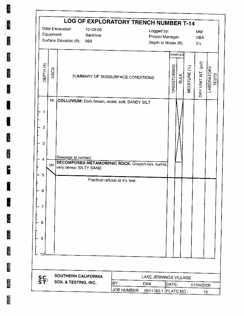


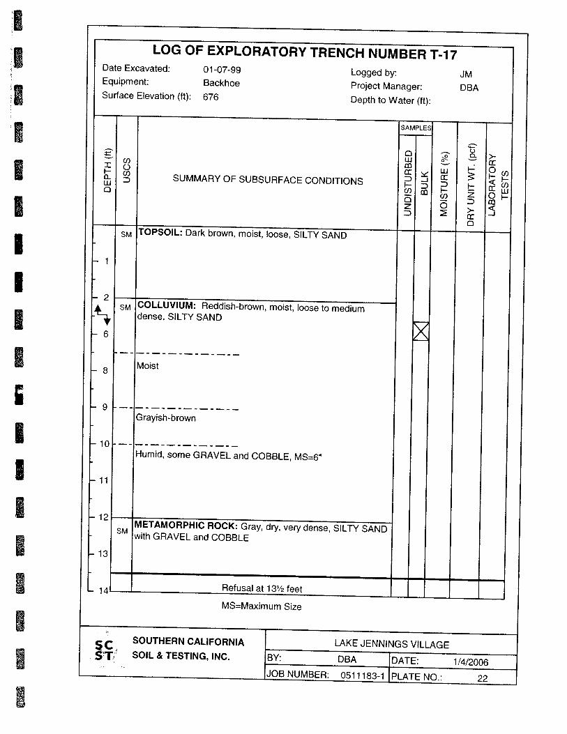
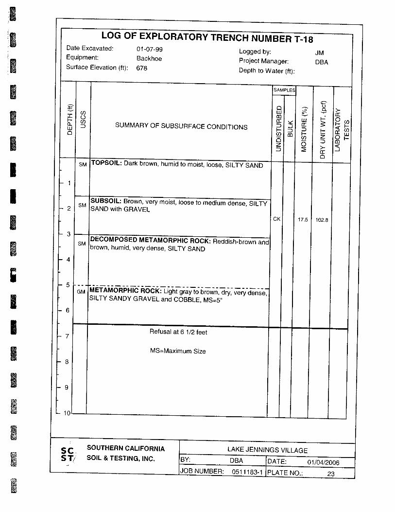

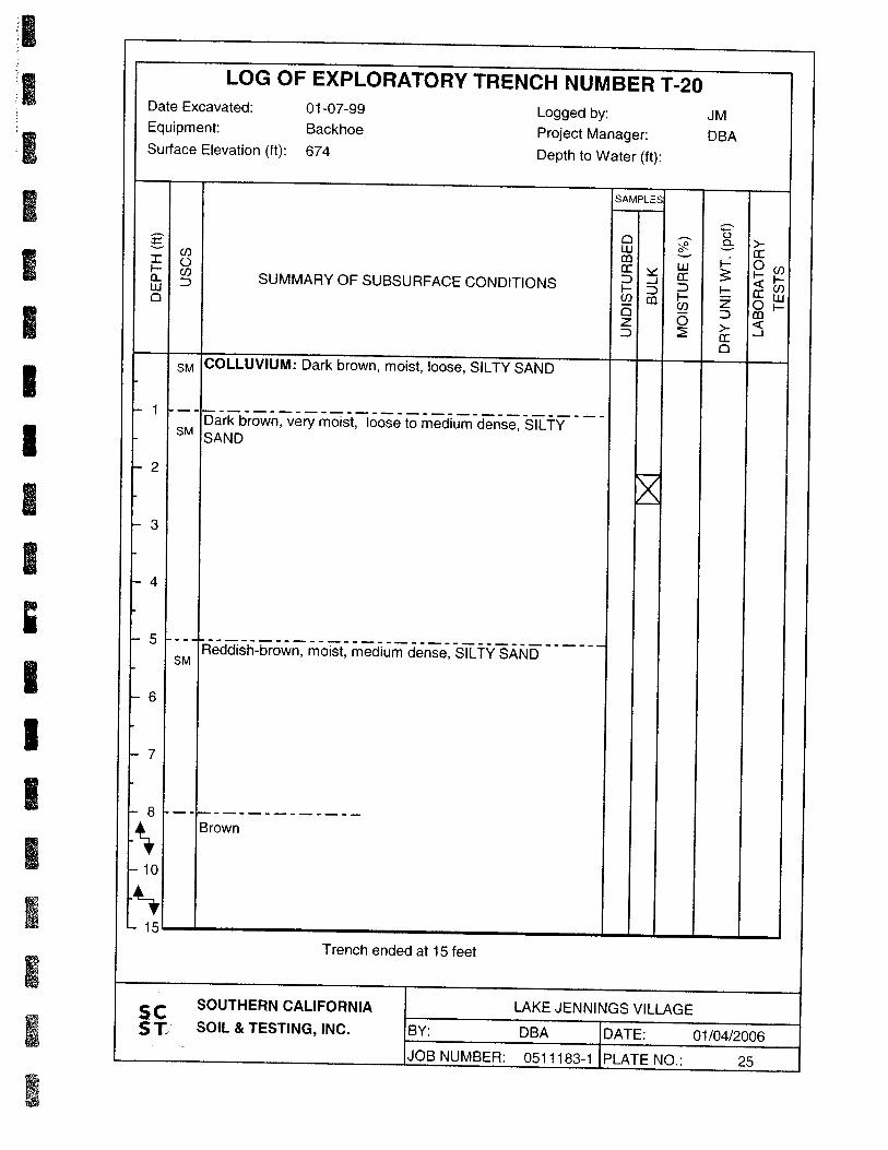


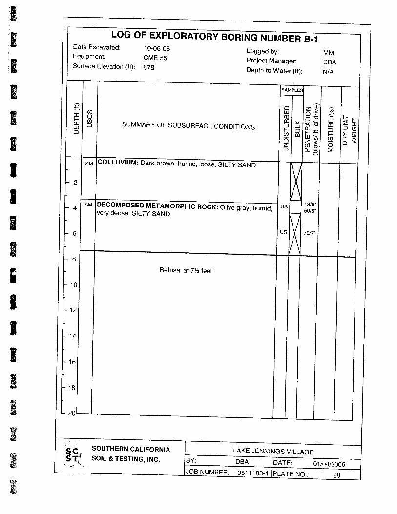

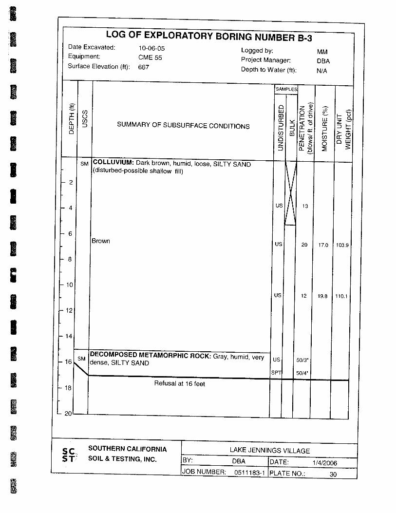


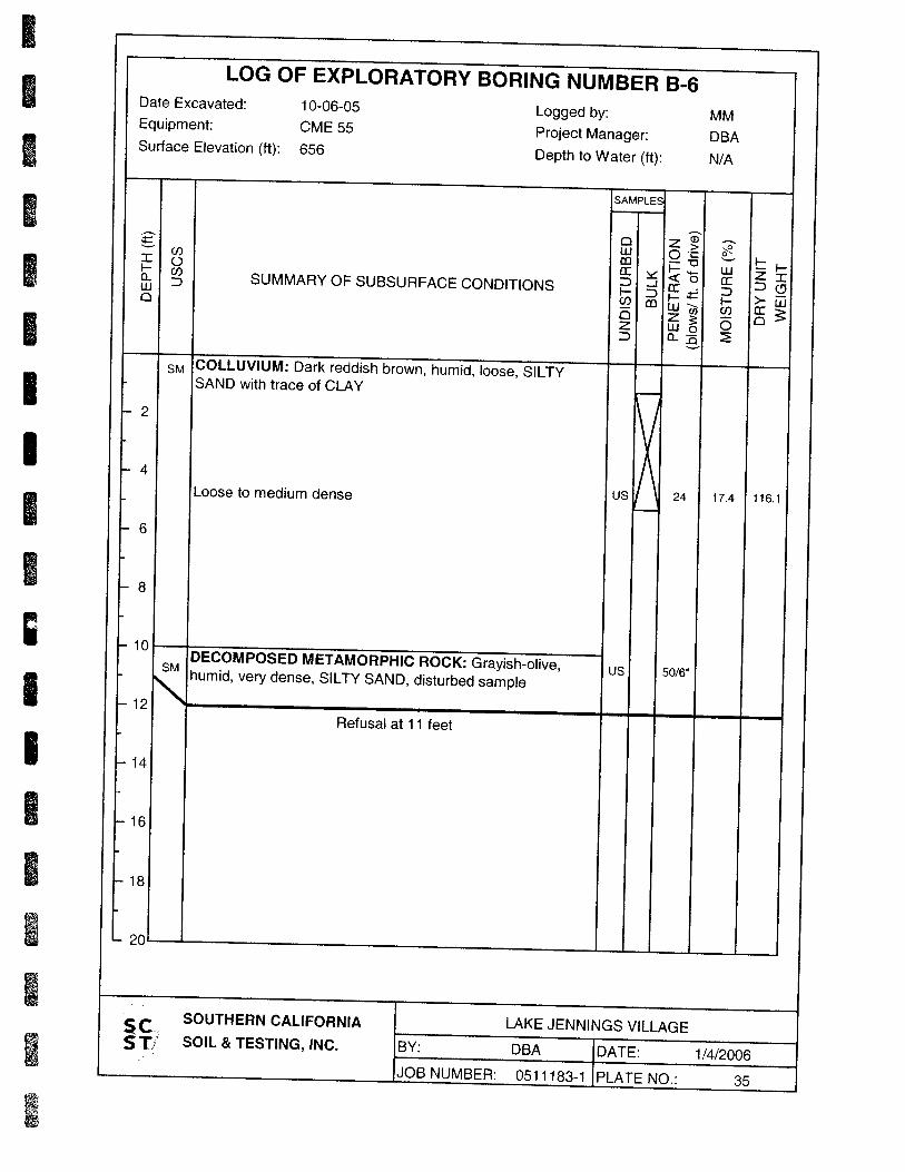
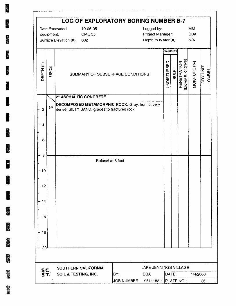


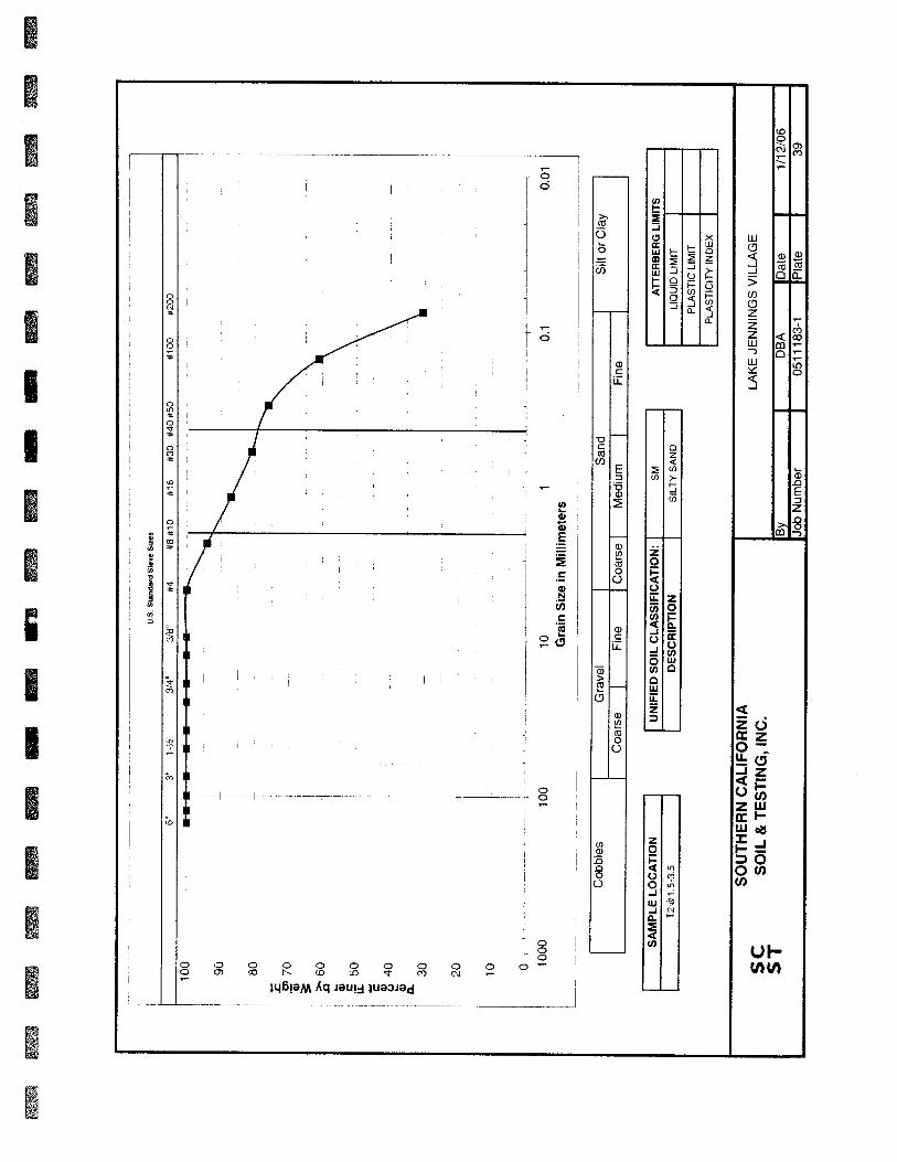
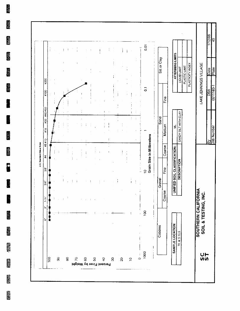

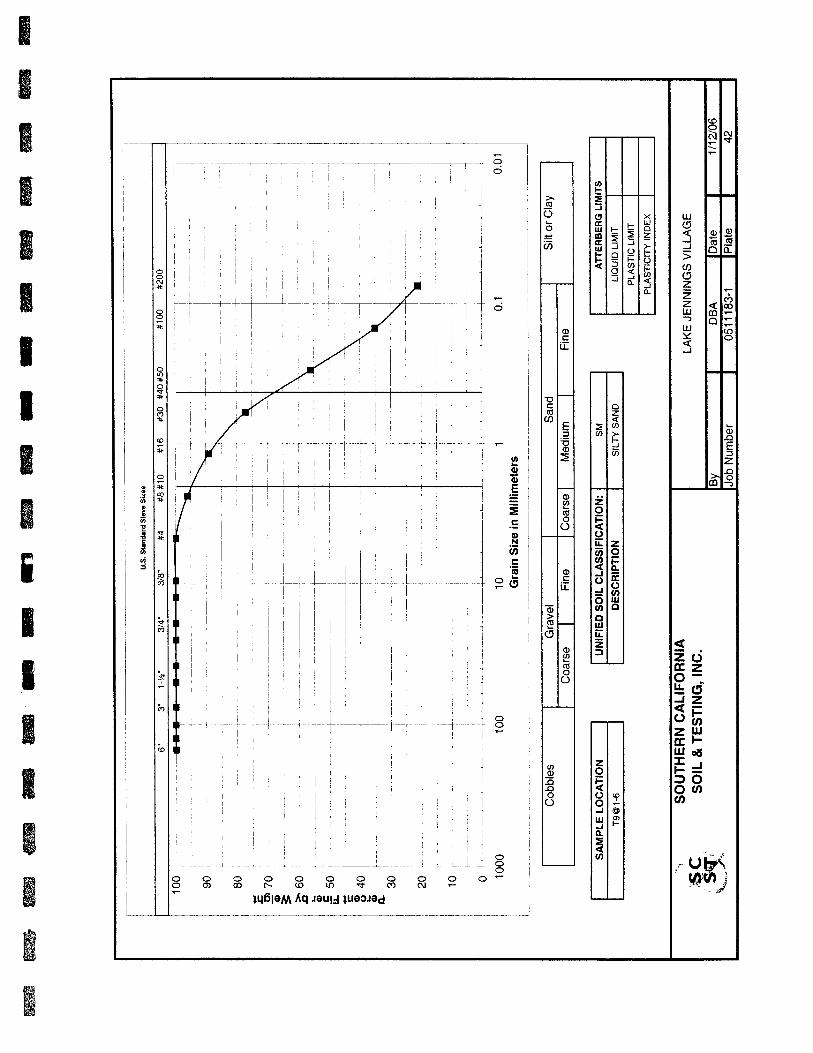
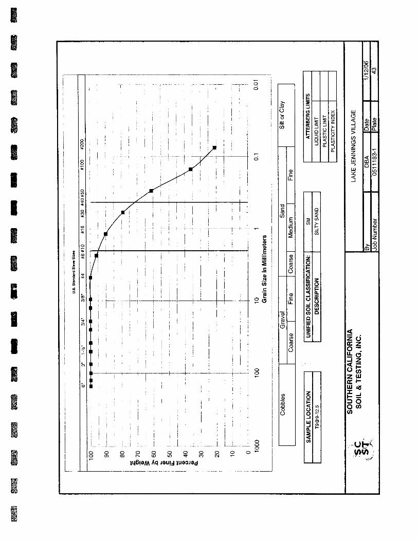
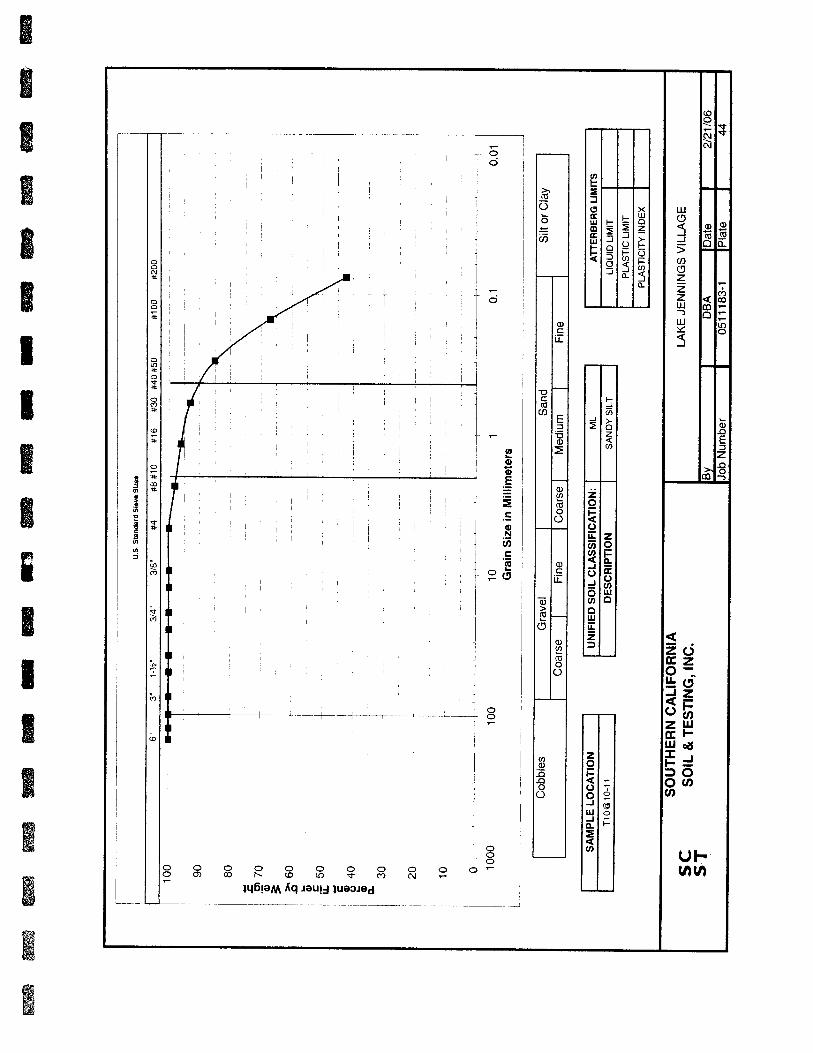
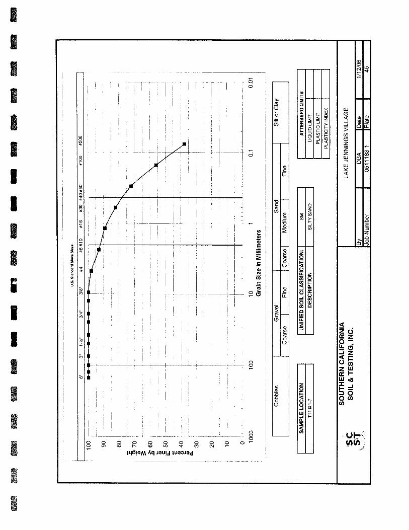


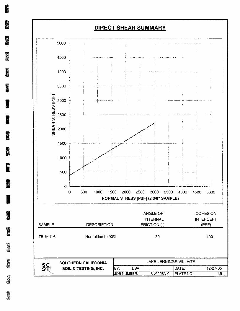
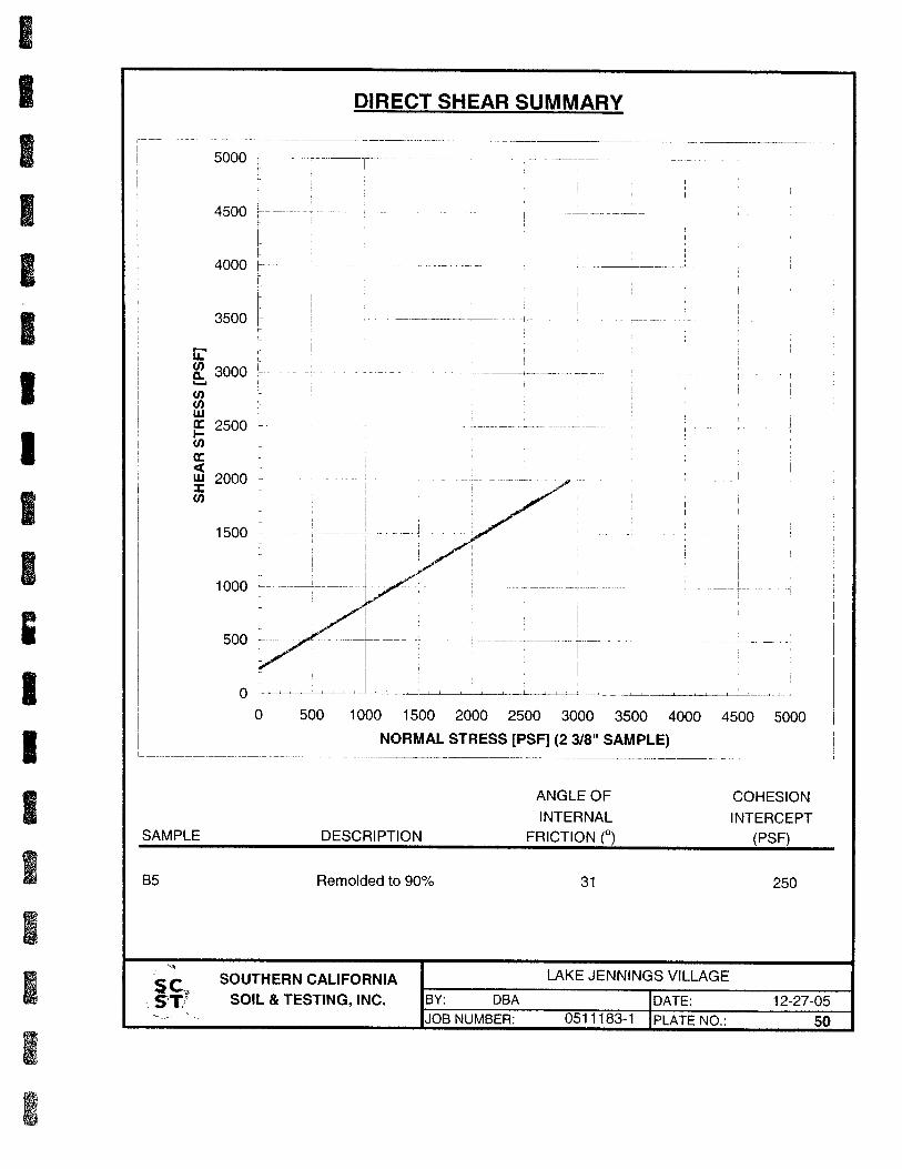

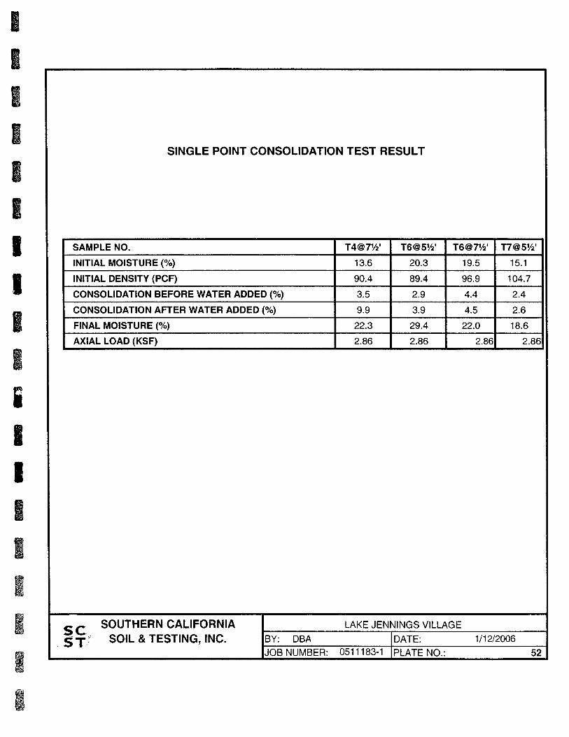
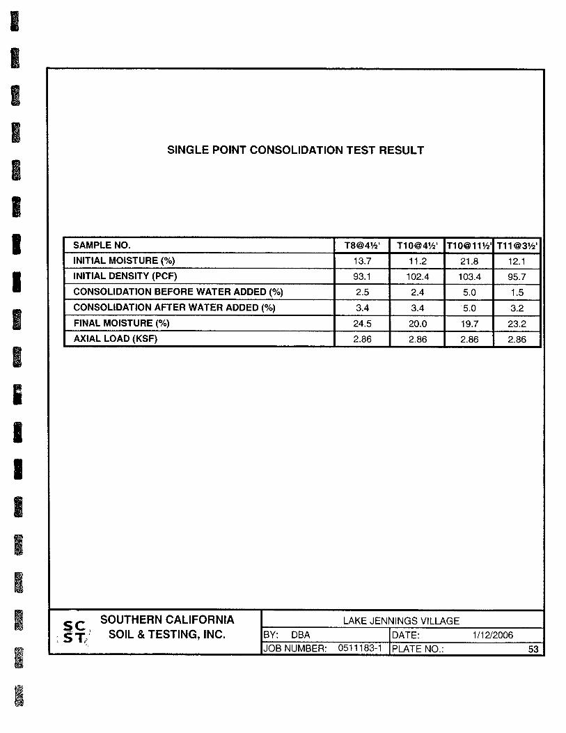


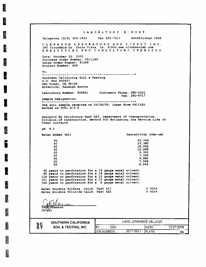


CWE 2140061.02RLake Jennings Marketplace
Lake Jennings Park Road and Olde Highway 80San Diego County, California
APPENDIX DLIQUEFACTION ANALYSIS

Christian Wheeler Engineering
3980 Home Avenue
San Diego, CA 92105
Overall vertical settlements report
Project title : Lake Jennings Markeplace
Location : Lake Jennings Park Road
CPTU name
CPT-6
CPT-7
CPT-8
CPT-9
CPT-1
0
Vert
ical se
ttle
ment (in)
1.10
1.05
1.00
0.95
0.90
0.85
0.80
0.75
0.70
0.65
0.60
0.55
0.50
0.45
0.40
0.35
0.30
0.25
0.20
0.15
0.10
0.05
0.00
0.236
0.5980.568
1.142
0
CLiq v.1.7.6.34 - CPT Liquefaction Assessment Software 1
Project file: W:\2014 Jobs\2140061 - Lake Jennings Market Place\Reports\2140061.02- Supplemental Geo Inv\2140061 CLiq.clq

L IQUEFACTION ANALYSIS REPORT
Input parameters and analysis data
Analysis method:
Fines correction method:Points to test:
Earthquake magnitude Mw:Peak ground acceleration:
NCEER (1998)
NCEER (1998)Based on Ic value
6.90
0.40.
G.W.T. (in-situ):
G.W.T. (earthq.):Average results interval:
Ic cut-off value:Unit weight calculation:
Project title : Lake Jennings Markeplace Location : Lake Jennings Park Road
Christian Wheeler Engineering
3980 Home Avenue
San Diego, CA 92105
CPT file : CPT-6
9.00 ft
9.00 ft3
2.60Based on SBT
Use fill:
Fill height:Fill weight:
Trans. detect. applied:Kσ applied:
No
N/AN/A
YesYes
Clay like behavior
applied:Limit depth applied:
Limit depth:MSF method:
Sands onlyNo
N/AMethod based
Cone resistance
qt (tsf)400200
Depth
(ft
)
21
20
19
18
17
16
15
14
13
12
11
10
9
8
7
6
5
4
3
2
1
Cone resistance SBTn Plot
Ic (Robertson 1990)4321
21
20
19
18
17
16
15
14
13
12
11
10
9
8
7
6
5
4
3
2
1
SBTn Plot CRR plot
CRR & CSR0.60.40.20
21
20
19
18
17
16
15
14
13
12
11
10
9
8
7
6
5
4
3
2
1
CRR plot
During earthq.
Qtn,cs200180160140120100806040200
Cycl
ic S
tress
Rati
o* (
CSR
*)
0.8
0.7
0.6
0.5
0.4
0.3
0.2
0.1
0
Liquefaction
No Liquefaction
Normalized friction ratio (%)0.1 1 10
Norm
alize
d C
PT p
enetr
ati
on r
esi
stance
1
10
100
1,000
Friction Ratio
Rf (%)1086420
21
20
19
18
17
16
15
14
13
12
11
10
9
8
7
6
5
4
3
2
1
Friction Ratio
Mw=71/2, sigma'=1 atm base curve Summary of liquefaction potential
FS Plot
Factor of safety21.510.50
21
20
19
18
17
16
15
14
13
12
11
10
9
8
7
6
5
4
3
2
1
FS Plot
During earthq.
Zone A1: Cyclic liquefaction likely depending on size and duration of cyclic loading
Zone A2: Cyclic liquefaction and strength loss likely depending on loading and ground
geometry
Zone B: Liquefaction and post-earthquake strength loss unlikely, check cyclic softening
Zone C: Cyclic liquefaction and strength loss possible depending on soil plasticity,
brittleness/sensitivity, strain to peak undrained strength and ground geometry
CLiq v.1.7.6.34 - CPT Liquefaction Assessment Software - Report created on: 6/11/2014, 9:00:39 AMProject file: W:\2014 Jobs\2140061 - Lake Jennings Market Place\Reports\2140061.02- Supplemental Geo Inv\2140061 CLiq.clq
2

This software is licensed to: Christian Wheeler Engineering CPT name: CPT-6
Total cone resistance
qt (tsf)500400300200100
Depth
(ft
)
21
20
19
18
17
16
15
14
13
12
11
10
9
8
7
6
5
4
3
2
1
Total cone resistance
L i q u e f a c t i o n a n a l y s i s o v e r a l l p l o t s ( i n t e r m e d i a t e r e s u l t s )
SBTn Index
Ic (Robertson 1990)4321
Depth
(ft
)
21
20
19
18
17
16
15
14
13
12
11
10
9
8
7
6
5
4
3
2
1
SBTn Index Norm. cone resistance
Qtn200150100500
Depth
(ft
)
21
20
19
18
17
16
15
14
13
12
11
10
9
8
7
6
5
4
3
2
1
Norm. cone resistance Grain char. factor
Kc109876543210
Depth
(ft
)
21
20
19
18
17
16
15
14
13
12
11
10
9
8
7
6
5
4
3
2
1
Grain char. factor Corrected norm. cone resistance
Qtn,cs200150100500
Depth
(ft
)
21
20
19
18
17
16
15
14
13
12
11
10
9
8
7
6
5
4
3
2
1
Corrected norm. cone resistance
CLiq v.1.7.6.34 - CPT Liquefaction Assessment Software - Report created on: 6/11/2014, 9:00:39 AM 3Project file: W:\2014 Jobs\2140061 - Lake Jennings Market Place\Reports\2140061.02- Supplemental Geo Inv\2140061 CLiq.clq
Input parameters and analysis data
Analysis method:
Fines correction method:Points to test:
Earthquake magnitude Mw:
Peak ground acceleration:Depth to water table (insitu):
NCEER (1998)
NCEER (1998)Based on Ic value
6.90
0.409.00 ft
Depth to water table (erthq.):
Average results interval:Ic cut-off value:
Unit weight calculation:
Use fill:Fill height:
9.00 ft
32.60
Based on SBT
NoN/A
Fill weight:
Transition detect. applied:Kσ applied:
Clay like behavior applied:
Limit depth applied:Limit depth:
N/A
YesYes
Sands only
NoN/A

This software is licensed to: Christian Wheeler Engineering CPT name: CPT-6
CRR plot
CRR & CSR0.60.40.20
Depth
(ft
)
21
20
19
18
17
16
15
14
13
12
11
10
9
8
7
6
5
4
3
2
1
CRR plot
During earthq.
L i q u e f a c t i o n a n a l y s i s o v e r a l l p l o t s
FS Plot
Factor of safety21.510.50
Depth
(ft
)
21
20
19
18
17
16
15
14
13
12
11
10
9
8
7
6
5
4
3
2
1
FS Plot
During earthq.
LPI
Liquefaction potential20151050
Depth
(ft
)
21
20
19
18
17
16
15
14
13
12
11
10
9
8
7
6
5
4
3
2
1
LPI Vertical settlements
Settlement (in)0.20.150.10.050
Depth
(ft
)
21
20
19
18
17
16
15
14
13
12
11
10
9
8
7
6
5
4
3
2
1
Vertical settlements Lateral displacements
Displacement (in)0
Depth
(ft
)
21
20
19
18
17
16
15
14
13
12
11
10
9
8
7
6
5
4
3
2
1
Lateral displacements
CLiq v.1.7.6.34 - CPT Liquefaction Assessment Software - Report created on: 6/11/2014, 9:00:39 AM 4Project file: W:\2014 Jobs\2140061 - Lake Jennings Market Place\Reports\2140061.02- Supplemental Geo Inv\2140061 CLiq.clq
F.S. color scheme LPI color schemeInput parameters and analysis data
Analysis method:
Fines correction method:Points to test:
Earthquake magnitude Mw:
Peak ground acceleration:Depth to water table (insitu):
NCEER (1998)
NCEER (1998)Based on Ic value
6.90
0.409.00 ft
Depth to water table (erthq.):
Average results interval:Ic cut-off value:
Unit weight calculation:
Use fill:Fill height:
9.00 ft
32.60
Based on SBT
NoN/A
Fill weight:
Transition detect. applied:Kσ applied:
Clay like behavior applied:
Limit depth applied:Limit depth:
N/A
YesYes
Sands only
NoN/A
Almost certain it will liquefy
Very likely to liquefy
Liquefaction and no liq. are equally likely
Unlike to liquefy
Almost certain it will not liquefy
Very high risk
High risk
Low risk

L IQUEFACTION ANALYSIS REPORT
Input parameters and analysis data
Analysis method:
Fines correction method:Points to test:
Earthquake magnitude Mw:Peak ground acceleration:
NCEER (1998)
NCEER (1998)Based on Ic value
6.90
0.40.
G.W.T. (in-situ):
G.W.T. (earthq.):Average results interval:
Ic cut-off value:Unit weight calculation:
Project title : Lake Jennings Markeplace Location : Lake Jennings Park Road
Christian Wheeler Engineering
3980 Home Avenue
San Diego, CA 92105
CPT file : CPT-7
9.00 ft
9.00 ft3
2.60Based on SBT
Use fill:
Fill height:Fill weight:
Trans. detect. applied:Kσ applied:
No
N/AN/A
YesYes
Clay like behavior
applied:Limit depth applied:
Limit depth:MSF method:
Sands onlyNo
N/AMethod based
Cone resistance
qt (tsf)300200100
Depth
(ft
)
22
21
20
19
18
17
16
15
14
13
12
11
10
9
8
7
6
5
4
3
2
1
Cone resistance SBTn Plot
Ic (Robertson 1990)4321
22
21
20
19
18
17
16
15
14
13
12
11
10
9
8
7
6
5
4
3
2
1
SBTn Plot CRR plot
CRR & CSR0.60.40.20
22
21
20
19
18
17
16
15
14
13
12
11
10
9
8
7
6
5
4
3
2
1
CRR plot
During earthq.
Qtn,cs200180160140120100806040200
Cycl
ic S
tress
Rati
o* (
CSR*)
0.8
0.7
0.6
0.5
0.4
0.3
0.2
0.1
0
Liquefaction
No Liquefaction
Normalized friction ratio (%)0.1 1 10
Norm
alize
d C
PT p
enetr
ati
on r
esi
stance
1
10
100
1,000
Friction Ratio
Rf (%)1086420
22
21
20
19
18
17
16
15
14
13
12
11
10
9
8
7
6
5
4
3
2
1
Friction Ratio
Mw=71/2, sigma'=1 atm base curve Summary of liquefaction potential
FS Plot
Factor of safety21.510.50
22
21
20
19
18
17
16
15
14
13
12
11
10
9
8
7
6
5
4
3
2
1
FS Plot
During earthq.
Zone A1: Cyclic liquefaction likely depending on size and duration of cyclic loading
Zone A2: Cyclic liquefaction and strength loss likely depending on loading and ground
geometry
Zone B: Liquefaction and post-earthquake strength loss unlikely, check cyclic softening
Zone C: Cyclic liquefaction and strength loss possible depending on soil plasticity,
brittleness/sensitivity, strain to peak undrained strength and ground geometry
CLiq v.1.7.6.34 - CPT Liquefaction Assessment Software - Report created on: 6/11/2014, 9:00:40 AMProject file: W:\2014 Jobs\2140061 - Lake Jennings Market Place\Reports\2140061.02- Supplemental Geo Inv\2140061 CLiq.clq
5

This software is licensed to: Christian Wheeler Engineering CPT name: CPT-7
Total cone resistance
qt (tsf)35030025020015010050
Depth
(ft
)
22
21
20
19
18
17
16
15
14
13
12
11
10
9
8
7
6
5
4
3
2
1
Total cone resistance
L i q u e f a c t i o n a n a l y s i s o v e r a l l p l o t s ( i n t e r m e d i a t e r e s u l t s )
SBTn Index
Ic (Robertson 1990)4321
Depth
(ft
)
22
21
20
19
18
17
16
15
14
13
12
11
10
9
8
7
6
5
4
3
2
1
SBTn Index Norm. cone resistance
Qtn200150100500
Depth
(ft
)
22
21
20
19
18
17
16
15
14
13
12
11
10
9
8
7
6
5
4
3
2
1
Norm. cone resistance Grain char. factor
Kc109876543210
Depth
(ft
)
22
21
20
19
18
17
16
15
14
13
12
11
10
9
8
7
6
5
4
3
2
1
Grain char. factor Corrected norm. cone resistance
Qtn,cs200150100500
Depth
(ft
)
22
21
20
19
18
17
16
15
14
13
12
11
10
9
8
7
6
5
4
3
2
1
Corrected norm. cone resistance
CLiq v.1.7.6.34 - CPT Liquefaction Assessment Software - Report created on: 6/11/2014, 9:00:40 AM 6Project file: W:\2014 Jobs\2140061 - Lake Jennings Market Place\Reports\2140061.02- Supplemental Geo Inv\2140061 CLiq.clq
Input parameters and analysis data
Analysis method:
Fines correction method:Points to test:
Earthquake magnitude Mw:
Peak ground acceleration:Depth to water table (insitu):
NCEER (1998)
NCEER (1998)Based on Ic value
6.90
0.409.00 ft
Depth to water table (erthq.):
Average results interval:Ic cut-off value:
Unit weight calculation:
Use fill:Fill height:
9.00 ft
32.60
Based on SBT
NoN/A
Fill weight:
Transition detect. applied:Kσ applied:
Clay like behavior applied:
Limit depth applied:Limit depth:
N/A
YesYes
Sands only
NoN/A

This software is licensed to: Christian Wheeler Engineering CPT name: CPT-7
CRR plot
CRR & CSR0.60.40.20
Depth
(ft
)
22
21
20
19
18
17
16
15
14
13
12
11
10
9
8
7
6
5
4
3
2
1
CRR plot
During earthq.
L i q u e f a c t i o n a n a l y s i s o v e r a l l p l o t s
FS Plot
Factor of safety21.510.50
Depth
(ft
)
22
21
20
19
18
17
16
15
14
13
12
11
10
9
8
7
6
5
4
3
2
1
FS Plot
During earthq.
LPI
Liquefaction potential20151050
Depth
(ft
)
22
21
20
19
18
17
16
15
14
13
12
11
10
9
8
7
6
5
4
3
2
1
LPI Vertical settlements
Settlement (in)0.50.40.30.20.10
Depth
(ft
)
22
21
20
19
18
17
16
15
14
13
12
11
10
9
8
7
6
5
4
3
2
1
Vertical settlements Lateral displacements
Displacement (in)0
Depth
(ft
)
22
21
20
19
18
17
16
15
14
13
12
11
10
9
8
7
6
5
4
3
2
1
Lateral displacements
CLiq v.1.7.6.34 - CPT Liquefaction Assessment Software - Report created on: 6/11/2014, 9:00:40 AM 7Project file: W:\2014 Jobs\2140061 - Lake Jennings Market Place\Reports\2140061.02- Supplemental Geo Inv\2140061 CLiq.clq
F.S. color scheme LPI color schemeInput parameters and analysis data
Analysis method:
Fines correction method:Points to test:
Earthquake magnitude Mw:
Peak ground acceleration:Depth to water table (insitu):
NCEER (1998)
NCEER (1998)Based on Ic value
6.90
0.409.00 ft
Depth to water table (erthq.):
Average results interval:Ic cut-off value:
Unit weight calculation:
Use fill:Fill height:
9.00 ft
32.60
Based on SBT
NoN/A
Fill weight:
Transition detect. applied:Kσ applied:
Clay like behavior applied:
Limit depth applied:Limit depth:
N/A
YesYes
Sands only
NoN/A
Almost certain it will liquefy
Very likely to liquefy
Liquefaction and no liq. are equally likely
Unlike to liquefy
Almost certain it will not liquefy
Very high risk
High risk
Low risk

L IQUEFACTION ANALYSIS REPORT
Input parameters and analysis data
Analysis method:
Fines correction method:Points to test:
Earthquake magnitude Mw:Peak ground acceleration:
NCEER (1998)
NCEER (1998)Based on Ic value
6.90
0.40.
G.W.T. (in-situ):
G.W.T. (earthq.):Average results interval:
Ic cut-off value:Unit weight calculation:
Project title : Lake Jennings Markeplace Location : Lake Jennings Park Road
Christian Wheeler Engineering
3980 Home Avenue
San Diego, CA 92105
CPT file : CPT-8
10.00 ft
10.00 ft3
2.60Based on SBT
Use fill:
Fill height:Fill weight:
Trans. detect. applied:Kσ applied:
No
N/AN/A
YesYes
Clay like behavior
applied:Limit depth applied:
Limit depth:MSF method:
Sands onlyNo
N/AMethod based
Cone resistance
qt (tsf)300200100
Depth
(ft
)
28
27
26
25
24
23
22
21
20
19
18
17
16
15
14
13
12
11
10
9
8
7
6
5
4
3
2
1
Cone resistance SBTn Plot
Ic (Robertson 1990)4321
28
27
26
25
24
23
22
21
20
19
18
17
16
15
14
13
12
11
10
9
8
7
6
5
4
3
2
1
SBTn Plot CRR plot
CRR & CSR0.60.40.20
28
27
26
25
24
23
22
21
20
19
18
17
16
15
14
13
12
11
10
9
8
7
6
5
4
3
2
1
CRR plot
During earthq.
Qtn,cs200180160140120100806040200
Cycl
ic S
tress
Rati
o* (
CSR*)
0.8
0.7
0.6
0.5
0.4
0.3
0.2
0.1
0
Liquefaction
No Liquefaction
Normalized friction ratio (%)0.1 1 10
Norm
alize
d C
PT p
enetr
ati
on r
esi
stance
1
10
100
1,000
Friction Ratio
Rf (%)1086420
28
27
26
25
24
23
22
21
20
19
18
17
16
15
14
13
12
11
10
9
8
7
6
5
4
3
2
1
Friction Ratio
Mw=71/2, sigma'=1 atm base curve Summary of liquefaction potential
FS Plot
Factor of safety21.510.50
28
27
26
25
24
23
22
21
20
19
18
17
16
15
14
13
12
11
10
9
8
7
6
5
4
3
2
1
FS Plot
During earthq.
Zone A1: Cyclic liquefaction likely depending on size and duration of cyclic loading
Zone A2: Cyclic liquefaction and strength loss likely depending on loading and ground
geometry
Zone B: Liquefaction and post-earthquake strength loss unlikely, check cyclic softening
Zone C: Cyclic liquefaction and strength loss possible depending on soil plasticity,
brittleness/sensitivity, strain to peak undrained strength and ground geometry
CLiq v.1.7.6.34 - CPT Liquefaction Assessment Software - Report created on: 6/11/2014, 9:00:41 AMProject file: W:\2014 Jobs\2140061 - Lake Jennings Market Place\Reports\2140061.02- Supplemental Geo Inv\2140061 CLiq.clq
8

This software is licensed to: Christian Wheeler Engineering CPT name: CPT-8
Total cone resistance
qt (tsf)30025020015010050
Depth
(ft
)
28
27
26
25
24
23
22
21
20
19
18
17
16
15
14
13
12
11
10
9
8
7
6
5
4
3
2
1
Total cone resistance
L i q u e f a c t i o n a n a l y s i s o v e r a l l p l o t s ( i n t e r m e d i a t e r e s u l t s )
SBTn Index
Ic (Robertson 1990)4321
Depth
(ft
)
28
27
26
25
24
23
22
21
20
19
18
17
16
15
14
13
12
11
10
9
8
7
6
5
4
3
2
1
SBTn Index Norm. cone resistance
Qtn200150100500
Depth
(ft
)
28
27
26
25
24
23
22
21
20
19
18
17
16
15
14
13
12
11
10
9
8
7
6
5
4
3
2
1
Norm. cone resistance Grain char. factor
Kc109876543210
Depth
(ft
)
28
27
26
25
24
23
22
21
20
19
18
17
16
15
14
13
12
11
10
9
8
7
6
5
4
3
2
1
Grain char. factor Corrected norm. cone resistance
Qtn,cs200150100500
Depth
(ft
)
28
27
26
25
24
23
22
21
20
19
18
17
16
15
14
13
12
11
10
9
8
7
6
5
4
3
2
1
Corrected norm. cone resistance
CLiq v.1.7.6.34 - CPT Liquefaction Assessment Software - Report created on: 6/11/2014, 9:00:41 AM 9Project file: W:\2014 Jobs\2140061 - Lake Jennings Market Place\Reports\2140061.02- Supplemental Geo Inv\2140061 CLiq.clq
Input parameters and analysis data
Analysis method:
Fines correction method:Points to test:
Earthquake magnitude Mw:
Peak ground acceleration:Depth to water table (insitu):
NCEER (1998)
NCEER (1998)Based on Ic value
6.90
0.4010.00 ft
Depth to water table (erthq.):
Average results interval:Ic cut-off value:
Unit weight calculation:
Use fill:Fill height:
10.00 ft
32.60
Based on SBT
NoN/A
Fill weight:
Transition detect. applied:Kσ applied:
Clay like behavior applied:
Limit depth applied:Limit depth:
N/A
YesYes
Sands only
NoN/A

This software is licensed to: Christian Wheeler Engineering CPT name: CPT-8
CRR plot
CRR & CSR0.60.40.20
Depth
(ft
)
28
27
26
25
24
23
22
21
20
19
18
17
16
15
14
13
12
11
10
9
8
7
6
5
4
3
2
1
CRR plot
During earthq.
L i q u e f a c t i o n a n a l y s i s o v e r a l l p l o t s
FS Plot
Factor of safety21.510.50
Depth
(ft
)
28
27
26
25
24
23
22
21
20
19
18
17
16
15
14
13
12
11
10
9
8
7
6
5
4
3
2
1
FS Plot
During earthq.
LPI
Liquefaction potential20151050
Depth
(ft
)
28
27
26
25
24
23
22
21
20
19
18
17
16
15
14
13
12
11
10
9
8
7
6
5
4
3
2
1
LPI Vertical settlements
Settlement (in)0.50.40.30.20.10
Depth
(ft
)
28
27
26
25
24
23
22
21
20
19
18
17
16
15
14
13
12
11
10
9
8
7
6
5
4
3
2
1
Vertical settlements Lateral displacements
Displacement (in)0
Depth
(ft
)
28
27
26
25
24
23
22
21
20
19
18
17
16
15
14
13
12
11
10
9
8
7
6
5
4
3
2
1
Lateral displacements
CLiq v.1.7.6.34 - CPT Liquefaction Assessment Software - Report created on: 6/11/2014, 9:00:41 AM 10Project file: W:\2014 Jobs\2140061 - Lake Jennings Market Place\Reports\2140061.02- Supplemental Geo Inv\2140061 CLiq.clq
F.S. color scheme LPI color schemeInput parameters and analysis data
Analysis method:
Fines correction method:Points to test:
Earthquake magnitude Mw:
Peak ground acceleration:Depth to water table (insitu):
NCEER (1998)
NCEER (1998)Based on Ic value
6.90
0.4010.00 ft
Depth to water table (erthq.):
Average results interval:Ic cut-off value:
Unit weight calculation:
Use fill:Fill height:
10.00 ft
32.60
Based on SBT
NoN/A
Fill weight:
Transition detect. applied:Kσ applied:
Clay like behavior applied:
Limit depth applied:Limit depth:
N/A
YesYes
Sands only
NoN/A
Almost certain it will liquefy
Very likely to liquefy
Liquefaction and no liq. are equally likely
Unlike to liquefy
Almost certain it will not liquefy
Very high risk
High risk
Low risk

L IQUEFACTION ANALYSIS REPORT
Input parameters and analysis data
Analysis method:
Fines correction method:Points to test:
Earthquake magnitude Mw:Peak ground acceleration:
NCEER (1998)
NCEER (1998)Based on Ic value
6.90
0.40.
G.W.T. (in-situ):
G.W.T. (earthq.):Average results interval:
Ic cut-off value:Unit weight calculation:
Project title : Lake Jennings Markeplace Location : Lake Jennings Park Road
Christian Wheeler Engineering
3980 Home Avenue
San Diego, CA 92105
CPT file : CPT-9
15.00 ft
15.00 ft3
2.60Based on SBT
Use fill:
Fill height:Fill weight:
Trans. detect. applied:Kσ applied:
No
N/AN/A
YesYes
Clay like behavior
applied:Limit depth applied:
Limit depth:MSF method:
Sands onlyNo
N/AMethod based
Cone resistance
qt (tsf)300200100
Depth
(ft
)
26
25
24
23
22
21
20
19
18
17
16
15
14
13
12
11
10
9
8
7
6
5
4
3
2
1
Cone resistance SBTn Plot
Ic (Robertson 1990)4321
26
25
24
23
22
21
20
19
18
17
16
15
14
13
12
11
10
9
8
7
6
5
4
3
2
1
SBTn Plot CRR plot
CRR & CSR0.60.40.20
26
25
24
23
22
21
20
19
18
17
16
15
14
13
12
11
10
9
8
7
6
5
4
3
2
1
CRR plot
During earthq.
Qtn,cs200180160140120100806040200
Cycl
ic S
tress
Rati
o* (
CSR*)
0.8
0.7
0.6
0.5
0.4
0.3
0.2
0.1
0
Liquefaction
No Liquefaction
Normalized friction ratio (%)0.1 1 10
Norm
alize
d C
PT p
enetr
ati
on r
esi
stance
1
10
100
1,000
Friction Ratio
Rf (%)1086420
26
25
24
23
22
21
20
19
18
17
16
15
14
13
12
11
10
9
8
7
6
5
4
3
2
1
Friction Ratio
Mw=71/2, sigma'=1 atm base curve Summary of liquefaction potential
FS Plot
Factor of safety21.510.50
26
25
24
23
22
21
20
19
18
17
16
15
14
13
12
11
10
9
8
7
6
5
4
3
2
1
FS Plot
During earthq.
Zone A1: Cyclic liquefaction likely depending on size and duration of cyclic loading
Zone A2: Cyclic liquefaction and strength loss likely depending on loading and ground
geometry
Zone B: Liquefaction and post-earthquake strength loss unlikely, check cyclic softening
Zone C: Cyclic liquefaction and strength loss possible depending on soil plasticity,
brittleness/sensitivity, strain to peak undrained strength and ground geometry
CLiq v.1.7.6.34 - CPT Liquefaction Assessment Software - Report created on: 6/11/2014, 9:00:42 AMProject file: W:\2014 Jobs\2140061 - Lake Jennings Market Place\Reports\2140061.02- Supplemental Geo Inv\2140061 CLiq.clq
11

This software is licensed to: Christian Wheeler Engineering CPT name: CPT-9
Total cone resistance
qt (tsf)35030025020015010050
Depth
(ft
)
26
25
24
23
22
21
20
19
18
17
16
15
14
13
12
11
10
9
8
7
6
5
4
3
2
1
Total cone resistance
L i q u e f a c t i o n a n a l y s i s o v e r a l l p l o t s ( i n t e r m e d i a t e r e s u l t s )
SBTn Index
Ic (Robertson 1990)4321
Depth
(ft
)
26
25
24
23
22
21
20
19
18
17
16
15
14
13
12
11
10
9
8
7
6
5
4
3
2
1
SBTn Index Norm. cone resistance
Qtn200150100500
Depth
(ft
)
26
25
24
23
22
21
20
19
18
17
16
15
14
13
12
11
10
9
8
7
6
5
4
3
2
1
Norm. cone resistance Grain char. factor
Kc109876543210
Depth
(ft
)
26
25
24
23
22
21
20
19
18
17
16
15
14
13
12
11
10
9
8
7
6
5
4
3
2
1
Grain char. factor Corrected norm. cone resistance
Qtn,cs200150100500
Depth
(ft
)
26
25
24
23
22
21
20
19
18
17
16
15
14
13
12
11
10
9
8
7
6
5
4
3
2
1
Corrected norm. cone resistance
CLiq v.1.7.6.34 - CPT Liquefaction Assessment Software - Report created on: 6/11/2014, 9:00:42 AM 12Project file: W:\2014 Jobs\2140061 - Lake Jennings Market Place\Reports\2140061.02- Supplemental Geo Inv\2140061 CLiq.clq
Input parameters and analysis data
Analysis method:
Fines correction method:Points to test:
Earthquake magnitude Mw:
Peak ground acceleration:Depth to water table (insitu):
NCEER (1998)
NCEER (1998)Based on Ic value
6.90
0.4015.00 ft
Depth to water table (erthq.):
Average results interval:Ic cut-off value:
Unit weight calculation:
Use fill:Fill height:
15.00 ft
32.60
Based on SBT
NoN/A
Fill weight:
Transition detect. applied:Kσ applied:
Clay like behavior applied:
Limit depth applied:Limit depth:
N/A
YesYes
Sands only
NoN/A

This software is licensed to: Christian Wheeler Engineering CPT name: CPT-9
CRR plot
CRR & CSR0.60.40.20
Depth
(ft
)
26
25
24
23
22
21
20
19
18
17
16
15
14
13
12
11
10
9
8
7
6
5
4
3
2
1
CRR plot
During earthq.
L i q u e f a c t i o n a n a l y s i s o v e r a l l p l o t s
FS Plot
Factor of safety21.510.50
Depth
(ft
)
26
25
24
23
22
21
20
19
18
17
16
15
14
13
12
11
10
9
8
7
6
5
4
3
2
1
FS Plot
During earthq.
LPI
Liquefaction potential20151050
Depth
(ft
)
26
25
24
23
22
21
20
19
18
17
16
15
14
13
12
11
10
9
8
7
6
5
4
3
2
1
LPI Vertical settlements
Settlement (in)10.80.60.40.20
Depth
(ft
)
26
25
24
23
22
21
20
19
18
17
16
15
14
13
12
11
10
9
8
7
6
5
4
3
2
1
Vertical settlements Lateral displacements
Displacement (in)0
Depth
(ft
)
26
25
24
23
22
21
20
19
18
17
16
15
14
13
12
11
10
9
8
7
6
5
4
3
2
1
Lateral displacements
CLiq v.1.7.6.34 - CPT Liquefaction Assessment Software - Report created on: 6/11/2014, 9:00:42 AM 13Project file: W:\2014 Jobs\2140061 - Lake Jennings Market Place\Reports\2140061.02- Supplemental Geo Inv\2140061 CLiq.clq
F.S. color scheme LPI color schemeInput parameters and analysis data
Analysis method:
Fines correction method:Points to test:
Earthquake magnitude Mw:
Peak ground acceleration:Depth to water table (insitu):
NCEER (1998)
NCEER (1998)Based on Ic value
6.90
0.4015.00 ft
Depth to water table (erthq.):
Average results interval:Ic cut-off value:
Unit weight calculation:
Use fill:Fill height:
15.00 ft
32.60
Based on SBT
NoN/A
Fill weight:
Transition detect. applied:Kσ applied:
Clay like behavior applied:
Limit depth applied:Limit depth:
N/A
YesYes
Sands only
NoN/A
Almost certain it will liquefy
Very likely to liquefy
Liquefaction and no liq. are equally likely
Unlike to liquefy
Almost certain it will not liquefy
Very high risk
High risk
Low risk

L IQUEFACTION ANALYSIS REPORT
Input parameters and analysis data
Analysis method:
Fines correction method:Points to test:
Earthquake magnitude Mw:Peak ground acceleration:
NCEER (1998)
NCEER (1998)Based on Ic value
6.90
0.40.
G.W.T. (in-situ):
G.W.T. (earthq.):Average results interval:
Ic cut-off value:Unit weight calculation:
Project title : Lake Jennings Markeplace Location : Lake Jennings Park Road
Christian Wheeler Engineering
3980 Home Avenue
San Diego, CA 92105
CPT file : CPT-10
9.00 ft
9.00 ft3
2.60Based on SBT
Use fill:
Fill height:Fill weight:
Trans. detect. applied:Kσ applied:
No
N/AN/A
YesYes
Clay like behavior
applied:Limit depth applied:
Limit depth:MSF method:
Sands onlyNo
N/AMethod based
Cone resistance
qt (tsf)8006004002000
Depth
(ft
)
19
18
17
16
15
14
13
12
11
10
9
8
7
6
5
4
3
2
1
Cone resistance SBTn Plot
Ic (Robertson 1990)4321
19
18
17
16
15
14
13
12
11
10
9
8
7
6
5
4
3
2
1
SBTn Plot CRR plot
CRR & CSR0.60.40.20
20
19
18
17
16
15
14
13
12
11
10
9
8
7
6
5
4
3
2
1
CRR plot
During earthq.
Qtn,cs200180160140120100806040200
Cycl
ic S
tress
Rati
o* (
CSR*)
0.8
0.7
0.6
0.5
0.4
0.3
0.2
0.1
0
Liquefaction
No Liquefaction
Normalized friction ratio (%)0.1 1 10
Norm
alize
d C
PT p
enetr
ati
on r
esi
stance
1
10
100
1,000
Friction Ratio
Rf (%)1086420
19
18
17
16
15
14
13
12
11
10
9
8
7
6
5
4
3
2
1
Friction Ratio
Mw=71/2, sigma'=1 atm base curve Summary of liquefaction potential
FS Plot
Factor of safety21.510.50
20
19
18
17
16
15
14
13
12
11
10
9
8
7
6
5
4
3
2
1
FS Plot
During earthq.
Zone A1: Cyclic liquefaction likely depending on size and duration of cyclic loading
Zone A2: Cyclic liquefaction and strength loss likely depending on loading and ground
geometry
Zone B: Liquefaction and post-earthquake strength loss unlikely, check cyclic softening
Zone C: Cyclic liquefaction and strength loss possible depending on soil plasticity,
brittleness/sensitivity, strain to peak undrained strength and ground geometry
CLiq v.1.7.6.34 - CPT Liquefaction Assessment Software - Report created on: 6/11/2014, 9:00:43 AMProject file: W:\2014 Jobs\2140061 - Lake Jennings Market Place\Reports\2140061.02- Supplemental Geo Inv\2140061 CLiq.clq
14

This software is licensed to: Christian Wheeler Engineering CPT name: CPT-10
Total cone resistance
qt (tsf)800600400200
Depth
(ft
)
20
19.5
19
18.5
18
17.5
17
16.5
16
15.5
15
14.5
14
13.5
13
12.5
12
11.5
11
10.5
10
9.5
9
8.5
8
7.5
7
6.5
6
5.5
5
4.5
4
3.5
3
2.5
2
1.5
1
0.5
Total cone resistance
L i q u e f a c t i o n a n a l y s i s o v e r a l l p l o t s ( i n t e r m e d i a t e r e s u l t s )
SBTn Index
Ic (Robertson 1990)4321
Depth
(ft
)
19.5
19
18.5
18
17.5
17
16.5
16
15.5
15
14.5
14
13.5
13
12.5
12
11.5
11
10.5
10
9.5
9
8.5
8
7.5
7
6.5
6
5.5
5
4.5
4
3.5
3
2.5
2
1.5
1
0.5
SBTn Index Norm. cone resistance
Qtn200150100500
Depth
(ft
)
20
19.5
19
18.5
18
17.5
17
16.5
16
15.5
15
14.5
14
13.5
13
12.5
12
11.5
11
10.5
10
9.5
9
8.5
8
7.5
7
6.5
6
5.5
5
4.5
4
3.5
3
2.5
2
1.5
1
0.5
Norm. cone resistance Grain char. factor
Kc109876543210
Depth
(ft
)
20
19.5
19
18.5
18
17.5
17
16.5
16
15.5
15
14.5
14
13.5
13
12.5
12
11.5
11
10.5
10
9.5
9
8.5
8
7.5
7
6.5
6
5.5
5
4.5
4
3.5
3
2.5
2
1.5
1
0.5
Grain char. factor Corrected norm. cone resistance
Qtn,cs200150100500
Depth
(ft
)
20
19.5
19
18.5
18
17.5
17
16.5
16
15.5
15
14.5
14
13.5
13
12.5
12
11.5
11
10.5
10
9.5
9
8.5
8
7.5
7
6.5
6
5.5
5
4.5
4
3.5
3
2.5
2
1.5
1
0.5
Corrected norm. cone resistance
CLiq v.1.7.6.34 - CPT Liquefaction Assessment Software - Report created on: 6/11/2014, 9:00:43 AM 15Project file: W:\2014 Jobs\2140061 - Lake Jennings Market Place\Reports\2140061.02- Supplemental Geo Inv\2140061 CLiq.clq
Input parameters and analysis data
Analysis method:
Fines correction method:Points to test:
Earthquake magnitude Mw:
Peak ground acceleration:Depth to water table (insitu):
NCEER (1998)
NCEER (1998)Based on Ic value
6.90
0.409.00 ft
Depth to water table (erthq.):
Average results interval:Ic cut-off value:
Unit weight calculation:
Use fill:Fill height:
9.00 ft
32.60
Based on SBT
NoN/A
Fill weight:
Transition detect. applied:Kσ applied:
Clay like behavior applied:
Limit depth applied:Limit depth:
N/A
YesYes
Sands only
NoN/A

This software is licensed to: Christian Wheeler Engineering CPT name: CPT-10
CRR plot
CRR & CSR0.60.40.20
Depth
(ft
)
20
19.5
19
18.5
18
17.5
17
16.5
16
15.5
15
14.5
14
13.5
13
12.5
12
11.5
11
10.5
10
9.5
9
8.5
8
7.5
7
6.5
6
5.5
5
4.5
4
3.5
3
2.5
2
1.5
1
0.5
CRR plot
During earthq.
L i q u e f a c t i o n a n a l y s i s o v e r a l l p l o t s
FS Plot
Factor of safety21.510.50
Depth
(ft
)
20
19.5
19
18.5
18
17.5
17
16.5
16
15.5
15
14.5
14
13.5
13
12.5
12
11.5
11
10.5
10
9.5
9
8.5
8
7.5
7
6.5
6
5.5
5
4.5
4
3.5
3
2.5
2
1.5
1
0.5
FS Plot
During earthq.
LPI
Liquefaction potential20151050
Depth
(ft
)
20
19.5
19
18.5
18
17.5
17
16.5
16
15.5
15
14.5
14
13.5
13
12.5
12
11.5
11
10.5
10
9.5
9
8.5
8
7.5
7
6.5
6
5.5
5
4.5
4
3.5
3
2.5
2
1.5
1
0.5
LPI Vertical settlements
Settlement (in)0
Depth
(ft
)
20
19.5
19
18.5
18
17.5
17
16.5
16
15.5
15
14.5
14
13.5
13
12.5
12
11.5
11
10.5
10
9.5
9
8.5
8
7.5
7
6.5
6
5.5
5
4.5
4
3.5
3
2.5
2
1.5
1
0.5
Vertical settlements Lateral displacements
Displacement (in)0
Depth
(ft
)
20
19.5
19
18.5
18
17.5
17
16.5
16
15.5
15
14.5
14
13.5
13
12.5
12
11.5
11
10.5
10
9.5
9
8.5
8
7.5
7
6.5
6
5.5
5
4.5
4
3.5
3
2.5
2
1.5
1
0.5
Lateral displacements
CLiq v.1.7.6.34 - CPT Liquefaction Assessment Software - Report created on: 6/11/2014, 9:00:43 AM 16Project file: W:\2014 Jobs\2140061 - Lake Jennings Market Place\Reports\2140061.02- Supplemental Geo Inv\2140061 CLiq.clq
F.S. color scheme LPI color schemeInput parameters and analysis data
Analysis method:
Fines correction method:Points to test:
Earthquake magnitude Mw:
Peak ground acceleration:Depth to water table (insitu):
NCEER (1998)
NCEER (1998)Based on Ic value
6.90
0.409.00 ft
Depth to water table (erthq.):
Average results interval:Ic cut-off value:
Unit weight calculation:
Use fill:Fill height:
9.00 ft
32.60
Based on SBT
NoN/A
Fill weight:
Transition detect. applied:Kσ applied:
Clay like behavior applied:
Limit depth applied:Limit depth:
N/A
YesYes
Sands only
NoN/A
Almost certain it will liquefy
Very likely to liquefy
Liquefaction and no liq. are equally likely
Unlike to liquefy
Almost certain it will not liquefy
Very high risk
High risk
Low risk

Procedure for the evaluation of soil liquefaction resistance, NCEER (1998)
Calculation of soil resistance against liquefaction is performed according to the Robertson & Wride (1998) procedure. The
procedure used in the software, slightly differs from the one originally published in NCEER-97-0022 (Proceedings of the NCEER
Workshop on Evaluation of Liquefaction Resistance of Soils). The revised procedure is presented below in the form of a
flowchart1:
1 "Estimating l iquefaction-induced ground settlements from CPT for level ground", G. Zhang, P.K. Robertson, and R.W.I. Brachman
CLiq v.1.7.6.34 - CPT Liquefaction Assessment Software 17

Procedure for the evaluation of soil liquefaction resistance (all soils), Robertson (2010)
Calculation of soil resistance against liquefaction is performed according to the Robertson & Wride (1998) procedure. This
procedure used in the software, slightly differs from the one originally published in NCEER-97-0022 (Proceedings of the NCEER
Workshop on Evaluation of Liquefaction Resistance of Soils). The revised procedure is presented below in the form of a
flowchart1:
1 P.K. Robertson, 2009. “Performance based earthquake design using the CPT”, Keynote Lecture, International Conference on
Performance-based Design in Earthquake Geotechnical Engineering – from case history to practice, IS-Tokyo, June 2009
CLiq v.1.7.6.34 - CPT Liquefaction Assessment Software 18
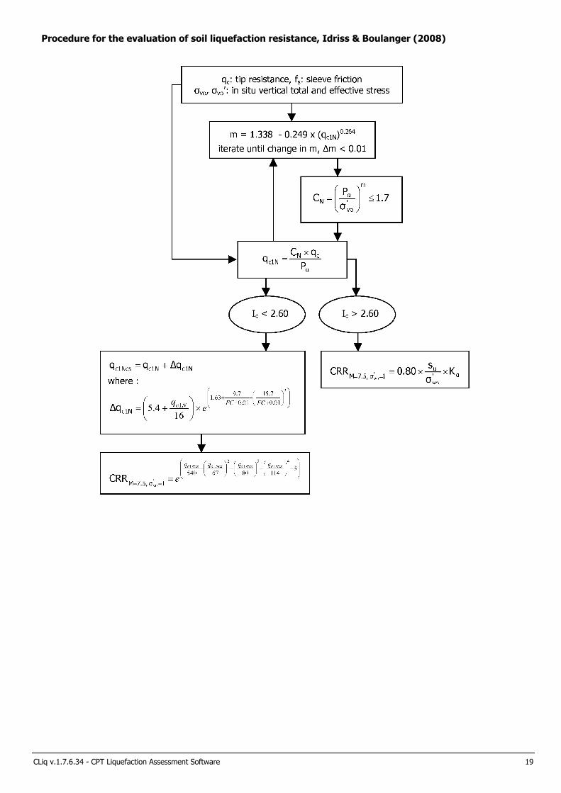
Procedure for the evaluation of soil liquefaction resistance, Idriss & Boulanger (2008)
CLiq v.1.7.6.34 - CPT Liquefaction Assessment Software 19

Procedure for the evaluation of soil liquefaction resistance (sandy soils), Moss et al. (2006)
CLiq v.1.7.6.34 - CPT Liquefaction Assessment Software 20

Procedure for the evaluation of liquefaction-induced lateral spreading displacements
Site investigation
with SPT or CPT
Design earthquake
Ground geometry
SPT data with fines content
measurements or CPT data
Moment magnitude
of earthquake (M w ) and peak surface
acceleration ( a max )
Geometric parameters
for each of different zones in level (or
gently sloping) ground
with (or without) a free face
Liquefaction potential analysis to calculate FS, (N 1 ) 60cs or
(q c1N ) cs
( using the NCEER SPT-
or CPT-based method ( Youd et al.
2001))
Calculation of the lateral displacement index
(LDI)
( using Figure 1 and Equation [3])
Zones with three major
geometric parameters or less - free face height (H), the distance to a free face
(L), or/and slope (S)
Zones with more than three major
geometric
parameters
L/H or/and
S
Estimated lateral displacement, LD
For gently sloping ground without a free face,
LD = (S + 0.20) · LDI (for 0.2% < S < 3.5%)
For level ground with a free face,
LD = 6 · (L/H)-0.8 · LDI (for 5 < L/H < 40)
Evaluation of lateral
displacements
based on other
approaches
and engineering
judgment
If (N 1 ) 60cs < 14
or
( q c1N ) cs < 70
evaluate
potential of
flow
liquefaction
1 Flow chart i l lustrating major steps in estimating l iquefaction-induced lateral spreading displacements using the proposed approach
1 Figure 1
1 Equation [3]
CLiq v.1.7.6.34 - CPT Liquefaction Assessment Software 21
1 "Estimating l iquefaction-induced ground settlements from CPT for level ground", G. Zhang, P.K. Robertson, and R.W.I. Brachman

Procedure for the estimation of seismic induced settlements in dry sands
Robertson, P.K. and Lisheng, S., 2010, “Estimation of seismic compression in dry soils using the CPT” FIFTH INTERNATIONAL CONFERENCE ON
RECENT ADVANCES IN GEOTECHNICAL EARTHQUAKE ENGINEERING AND SOIL DYNAMICS, Symposium in honor of professor I. M. Idriss, San
Diego, CA
CLiq v.1.7.6.34 - CPT Liquefaction Assessment Software 22

Liquefaction Potential Index (LPI) calculation procedure
Graphical presentation of the LPI calculation procedure
Calculation of the Liquefaction Potential Index (LPI) is used to interpret the liquefaction assessment calculations in terms of
severity over depth. The calculation procedure is based on the methology developed by Iwasaki (1982) and is adopted by AFPS.
To estimate the severity of liquefaction extent at a given site, LPI is calculated based on the following equation:
LPI =
where:
FL = 1 - F.S. when F.S. less than 1
FL = 0 when F.S. greater than 1
z depth of measurment in meters
Values of LPI range between zero (0) when no test point is characterized as liquefiable and 100 when all points are characterized
as susceptible to liquefaction. Iwasaki proposed four (4) discrete categories based on the numeric value of LPI:
• LPI = 0 : Liquefaction risk is very low
• 0 < LPI <= 5 : Liquefaction risk is low
• 5 < LPI <= 15 : Liquefaction risk is high
• LPI > 15 : Liquefaction risk is very high
CLiq v.1.7.6.34 - CPT Liquefaction Assessment Software 23

References
• Lunne, T., Robertson, P.K., and Powell, J.J.M 1997. Cone penetration testing in geotechnical practice, E & FN Spon Routledge,
352 p, ISBN 0-7514-0393-8.
• Boulanger, R.W. and Idriss, I. M., 2007. Evaluation of Cyclic Softening in Silts and Clays. ASCE Journal of Geotechnical and
Geoenvironmental Engineering June, Vol. 133, No. 6 pp 641-652
• Robertson, P.K. and Cabal, K.L., 2007, Guide to Cone Penetration Testing for Geotechnical Engineering. Available at no cost at
http://www.geologismiki.gr/
• Robertson, P.K. 1990. Soil classification using the cone penetration test. Canadian Geotechnical Journal, 27 (1), 151-8.
• Robertson, P.K. and Wride, C.E., 1998. Cyclic Liquefaction and its Evaluation based on the CPT Canadian Geotechnical Journal,
1998, Vol. 35, August.
• Youd, T.L., Idriss, I.M., Andrus, R.D., Arango, I., Castro, G., Christian, J.T., Dobry, R., Finn, W.D.L., Harder, L.F., Hynes, M.E.,
Ishihara, K., Koester, J., Liao, S., Marcuson III, W.F., Martin, G.R., Mitchell, J.K., Moriwaki, Y., Power, M.S., Robertson, P.K., Seed, R., and Stokoe, K.H., Liquefaction Resistance of Soils: Summary Report from the 1996 NCEER and 1998 NCEER/NSF Workshop on Evaluation of Liquefaction Resistance of Soils, ASCE, Journal of Geotechnical & Geoenvironmental Engineering, Vol. 127, October, pp 817-833
• Zhang, G., Robertson. P.K., Brachman, R., 2002, Estimating Liquefaction Induced Ground Settlements from the CPT, Canadian
Geotechnical Journal, 39: pp 1168-1180
• Zhang, G., Robertson. P.K., Brachman, R., 2004, Estimating Liquefaction Induced Lateral Displacements using the SPT and CPT,
ASCE, Journal of Geotechnical & Geoenvironmental Engineering, Vol. 130, No. 8, 861-871
• Pradel, D., 1998, Procedure to Evaluate Earthquake-Induced Settlements in Dry Sandy Soils, ASCE, Journal of Geotechnical &
Geoenvironmental Engineering, Vol. 124, No. 4, 364-368
• Iwasaki, T., 1986, Soil liquefaction studies in Japan: state-of-the-art, Soil Dynamics and Earthquake Engineering, Vol. 5, No. 1,
2-70
• Papathanassiou G., 2008, LPI-based approach for calibrating the severity of liquefaction-induced failures and for assessing the
probability of liquefaction surface evidence, Eng. Geol. 96:94–104
• P.K. Robertson, 2009, Interpretation of Cone Penetration Tests - a unified approach., Canadian Geotechnical Journal, Vol. 46,
No. 11, pp 1337-1355
• P.K. Robertson, 2009. “Performance based earthquake design using the CPT”, Keynote Lecture, International Conference on
Performance-based Design in Earthquake Geotechnical Engineering - from case history to practice, IS-Tokyo, June 2009
• Robertson, P.K. and Lisheng, S., 2010, “Estimation of seismic compression in dry soils using the CPT” FIFTH INTERNATIONAL
CONFERENCE ON RECENT ADVANCES IN GEOTECHNICAL EARTHQUAKE ENGINEERING AND SOIL DYNAMICS, Symposium in honor of professor I. M. Idriss, SAN diego, CA
• R. E. S. Moss, R. B. Seed, R. E. Kayen, J. P. Stewart, A. Der Kiureghian, K. O. Cetin, CPT-Based Probabilistic and Deterministic
Assessment of In Situ Seismic Soil Liquefaction Potential, Journal of Geotechnical and Geoenvironmental Engineering, Vol. 132, No. 8, August 1, 2006
• I. M. Idriss and R. W. Boulanger, Soil liquefaction during earthquakes, Earthquake Engineering Research Institute MNO-12
CLiq v.1.7.6.34 - CPT Liquefaction Assessment Software 24

CWE 2140061.02RLake Jennings Marketplace
Lake Jennings Park Road and Olde Highway 80San Diego County, California
APPENDIX ESETTLEMENT ANALYSIS

Project: Lake Jennings Marketplace
Christian Wheeler Engineering
3980 Home Avenue
San Diego, CA 92109Total depth: 21.16 ft, Date: 3/25/2014
Surface Elevation: 0.00 ft
Lake Jennings Park Road
Coords: X:0.00, Y:0.00
Cone Type: Uknown
Cone Operator: Uknown
CPT: CPT-06
Location:
Cone resistance qt
Tip resistance (tsf)
5 004 003 002 0 01 0 0
De
pth
(ft
)
2 1
2 0
1 9
1 8
1 7
1 6
1 5
1 4
1 3
1 2
1 1
1 0
9
8
7
6
5
4
3
2
1
Cone resistance qt Constrained Modulus
M(CPT) (tsf)
3 ,2 082,2 081,20 82 0 8
De
pth
(ft
)
2 1
2 0
1 9
1 8
1 7
1 6
1 5
1 4
1 3
1 2
1 1
1 0
9
8
7
6
5
4
3
2
1
Constrained Modulus
End of Primary
Overall
Cumulative settlement
Settlement (in)
0 .20 .1
De
pth
(ft
)
21
20
19
18
17
16
15
14
13
12
11
10
9
8
7
6
5
4
3
Cumulative settlement
Settlements calculation according to theory of elasticity*
Caclulation properties
Footing type: Rectangular
Footing width: 200.00 (ft)
L/B: 1.0
Footing pressure: 1.00 (tsf)
Embedment depth: 2.00 (ft)
Footing is rigid: No
Remove excavation load: No
Apply 20% rule: No
Calculate secondary settlements: No
Time period for second. settlements: N/A
* Primary settlements calculation is performed according to
the following formula:
)log(S tzCa
⋅∆⋅=
* Secondary (creep) settlements calculation is performed
according to the following formula:
z
CPT
v ∆Μ
∆=∑
σS
CPeT-IT v.1.7.6.42 - CPTU data presentation & interpretation software - Report created on: 6/11/2014, 9:32:16 AM 1
Project file: W:\2014 Jobs\2140061 - Lake Jennings Market Place\Reports\2140061.02- Supplemental Geo Inv\2140061 CPeT.cpt
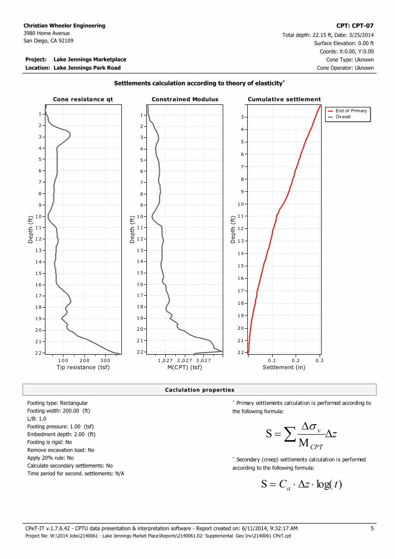
Project: Lake Jennings Marketplace
Christian Wheeler Engineering
3980 Home Avenue
San Diego, CA 92109Total depth: 22.15 ft, Date: 3/25/2014
Surface Elevation: 0.00 ft
Lake Jennings Park Road
Coords: X:0.00, Y:0.00
Cone Type: Uknown
Cone Operator: Uknown
CPT: CPT-07
Location:
Cone resistance qt
Tip resistance (tsf)
3 002 0010 0
De
pth
(ft
)
2 2
2 1
2 0
1 9
1 8
1 7
1 6
1 5
1 4
1 3
1 2
1 1
1 0
9
8
7
6
5
4
3
2
1
Cone resistance qt Constrained Modulus
M(CPT) (tsf)
3,02 72 ,02 71,0 27
De
pth
(ft
)
2 2
2 1
2 0
1 9
1 8
1 7
1 6
1 5
1 4
1 3
1 2
1 1
1 0
9
8
7
6
5
4
3
2
1
Constrained Modulus
End of Primary
Overall
Cumulative settlement
Settlement (in)
0 .30 .20 .1
De
pth
(ft
)
22
21
20
19
18
17
16
15
14
13
12
11
10
9
8
7
6
5
4
3
Cumulative settlement
Settlements calculation according to theory of elasticity*
Caclulation properties
Footing type: Rectangular
Footing width: 200.00 (ft)
L/B: 1.0
Footing pressure: 1.00 (tsf)
Embedment depth: 2.00 (ft)
Footing is rigid: No
Remove excavation load: No
Apply 20% rule: No
Calculate secondary settlements: No
Time period for second. settlements: N/A
* Primary settlements calculation is performed according to
the following formula:
)log(S tzCa
⋅∆⋅=
* Secondary (creep) settlements calculation is performed
according to the following formula:
z
CPT
v ∆Μ
∆=∑
σS
CPeT-IT v.1.7.6.42 - CPTU data presentation & interpretation software - Report created on: 6/11/2014, 9:32:17 AM 5
Project file: W:\2014 Jobs\2140061 - Lake Jennings Market Place\Reports\2140061.02- Supplemental Geo Inv\2140061 CPeT.cpt

Project: Lake Jennings Marketplace
Christian Wheeler Engineering
3980 Home Avenue
San Diego, CA 92109Total depth: 28.05 ft, Date: 3/25/2014
Surface Elevation: 0.00 ft
Lake Jennings Park Road
Coords: X:0.00, Y:0.00
Cone Type: Uknown
Cone Operator: Uknown
CPT: CPT-08
Location:
Cone resistance qt
Tip resistance (tsf)
30 02 5 02 0015 010 05 0
De
pth
(ft
)
2 8
2 7
2 6
2 5
2 4
2 3
2 2
2 1
2 0
1 9
1 8
1 7
1 6
1 5
1 4
1 3
1 2
1 1
1 0
9
8
7
6
5
4
3
2
1
Cone resistance qt Constrained Modulus
M(CPT) (tsf)
2 ,25 41,25 425 4
De
pth
(ft
)
2 8
2 7
2 6
2 5
2 4
2 3
2 2
2 1
2 0
1 9
1 8
1 7
1 6
1 5
1 4
1 3
1 2
1 1
1 0
9
8
7
6
5
4
3
2
1
Constrained Modulus
End of Primary
Overall
Cumulative settlement
Settlement (in)
0 .30 .20 .1
De
pth
(ft
)
27
26
25
24
23
22
21
20
19
18
17
16
15
14
13
12
11
10
9
8
7
6
5
4
3
Cumulative settlement
Settlements calculation according to theory of elasticity*
Caclulation properties
Footing type: Rectangular
Footing width: 200.00 (ft)
L/B: 1.0
Footing pressure: 1.00 (tsf)
Embedment depth: 2.00 (ft)
Footing is rigid: No
Remove excavation load: No
Apply 20% rule: No
Calculate secondary settlements: No
Time period for second. settlements: N/A
* Primary settlements calculation is performed according to
the following formula:
)log(S tzCa
⋅∆⋅=
* Secondary (creep) settlements calculation is performed
according to the following formula:
z
CPT
v ∆Μ
∆=∑
σS
CPeT-IT v.1.7.6.42 - CPTU data presentation & interpretation software - Report created on: 6/11/2014, 9:32:17 AM 9
Project file: W:\2014 Jobs\2140061 - Lake Jennings Market Place\Reports\2140061.02- Supplemental Geo Inv\2140061 CPeT.cpt

Project: Lake Jennings Marketplace
Christian Wheeler Engineering
3980 Home Avenue
San Diego, CA 92109Total depth: 26.08 ft, Date: 3/25/2014
Surface Elevation: 0.00 ft
Lake Jennings Park Road
Coords: X:0.00, Y:0.00
Cone Type: Uknown
Cone Operator: Uknown
CPT: CPT-09
Location:
Cone resistance qt
Tip resistance (tsf)
30 02 001 00
De
pth
(ft
)
2 6
2 5
2 4
2 3
2 2
2 1
2 0
1 9
1 8
1 7
1 6
1 5
1 4
1 3
1 2
1 1
1 0
9
8
7
6
5
4
3
2
1
Cone resistance qt Constrained Modulus
M(CPT) (tsf)
3 ,2 772 ,2 771 ,2 772 77
De
pth
(ft
)
2 6
2 5
2 4
2 3
2 2
2 1
2 0
1 9
1 8
1 7
1 6
1 5
1 4
1 3
1 2
1 1
1 0
9
8
7
6
5
4
3
2
1
Constrained Modulus
End of Primary
Overall
Cumulative settlement
Settlement (in)
0.40 .2
De
pth
(ft
)
26
25
24
23
22
21
20
19
18
17
16
15
14
13
12
11
10
9
8
7
6
5
4
3
Cumulative settlement
Settlements calculation according to theory of elasticity*
Caclulation properties
Footing type: Rectangular
Footing width: 200.00 (ft)
L/B: 1.0
Footing pressure: 1.00 (tsf)
Embedment depth: 2.00 (ft)
Footing is rigid: No
Remove excavation load: No
Apply 20% rule: No
Calculate secondary settlements: No
Time period for second. settlements: N/A
* Primary settlements calculation is performed according to
the following formula:
)log(S tzCa
⋅∆⋅=
* Secondary (creep) settlements calculation is performed
according to the following formula:
z
CPT
v ∆Μ
∆=∑
σS
CPeT-IT v.1.7.6.42 - CPTU data presentation & interpretation software - Report created on: 6/11/2014, 9:32:17 AM 14
Project file: W:\2014 Jobs\2140061 - Lake Jennings Market Place\Reports\2140061.02- Supplemental Geo Inv\2140061 CPeT.cpt

Project: Lake Jennings Marketplace
Christian Wheeler Engineering
3980 Home Avenue
San Diego, CA 92109Total depth: 20.01 ft, Date: 3/25/2014
Surface Elevation: 0.00 ft
Lake Jennings Park Road
Coords: X:0.00, Y:0.00
Cone Type: Uknown
Cone Operator: Uknown
CPT: CPT-10
Location:
Cone resistance qt
Tip resistance (tsf)
80 06 004 0020 0
De
pth
(ft
)
2 0
1 9
1 8
1 7
1 6
1 5
1 4
1 3
1 2
1 1
1 0
9
8
7
6
5
4
3
2
1
Cone resistance qt Constrained Modulus
M(CPT) (tsf)
3 ,5 821,5 82
De
pth
(ft
)
1 9
1 8
1 7
1 6
1 5
1 4
1 3
1 2
1 1
1 0
9
8
7
6
5
4
3
2
1
Constrained Modulus
End of Primary
Overall
Cumulative settlement
Settlement (in)
0 .150 .10.0 5
De
pth
(ft
)
19
18
17
16
15
14
13
12
11
10
9
8
7
6
5
4
3
Cumulative settlement
Settlements calculation according to theory of elasticity*
Caclulation properties
Footing type: Rectangular
Footing width: 200.00 (ft)
L/B: 1.0
Footing pressure: 1.00 (tsf)
Embedment depth: 2.00 (ft)
Footing is rigid: No
Remove excavation load: No
Apply 20% rule: No
Calculate secondary settlements: No
Time period for second. settlements: N/A
* Primary settlements calculation is performed according to
the following formula:
)log(S tzCa
⋅∆⋅=
* Secondary (creep) settlements calculation is performed
according to the following formula:
z
CPT
v ∆Μ
∆=∑
σS
CPeT-IT v.1.7.6.42 - CPTU data presentation & interpretation software - Report created on: 6/11/2014, 9:32:18 AM 19
Project file: W:\2014 Jobs\2140061 - Lake Jennings Market Place\Reports\2140061.02- Supplemental Geo Inv\2140061 CPeT.cpt

CWE 2140061.02RLake Jennings Marketplace
Lake Jennings Park Road and Olde Highway 80San Diego County, California
APPENDIX FREFERENCES

CWE 2140061.02 June 25, 2014 Appendix F-1
REFERENCES
California Division of Mines and Geology, 1998, Maps of Known Active Fault Near Source-Zones in
California and Adjacent Portions of Nevada.
California Division of Mines and Geology, 1999, Recommended Procedures for Implementation of
DMG Special Publication 117 Guidelines for Analyzing and Mitigating Liquefaction Hazards in
California, organized through the Southern California Earthquake Center, University of Southern
California.
Federal Emergency Management Agency, 2002, San Diego County, California and Incorporated Areas
Flood Insurance Rate Map, Panel 1660 of 2375, Map Number 06073C1660G.
Hart, E.W., 1994, Fault-Rupture Hazard Zones in California, California Division of Mines and Geology
Special Publication 42.
Jennings, C.W., 1975, Fault Map of California, California Division of Mines and Geology, Map
No. 1, Scale 1:750,000.
Kern, P., 1989, Earthquakes and Faults in San Diego County, Pickle Press, 73 pp.
Southern California Soil & Testing, Inc., 2008, Report of Preliminary Geotechnical Investigation,
Lake Jennings Village, SCS&T 0511183, Report No. 1, prepared February 21, 2008.
Tan, Siang S., 2002, Geologic Map of the El Cajon 7.5’ Quadrangle, San Diego County, California,
California Geologic Survey.
Tan, S.S., 1995, Landslide Hazards in the Southern Part of the San Diego Metropolitan Area, San
Diego County, California, California Division of Mines and Geology Open-File Report 95-03.
U.S. Geological Survey, U.S. Seismic Design Maps Web Application,
http://geohazards.usgs.gov/designmaps/us/application.php

CWE 2140061.02RLake Jennings Marketplace
Lake Jennings Park Road and Olde Highway 80San Diego County, California
APPENDIX GRECOMMENDED GRADING SPECIFICATIONS
GENERAL PROVISIONS

CWE 2140061.02 June 25, 2014 Appendix G, Page G-1
RECOMMENDED GRADING SPECIFICATIONS - GENERAL PROVISIONS
LAKE JENNINGS MARKETPLACE
LAKE JENNINGS PARK ROAD AND OLDE HWY 80
SAN DIEGO COUNTY, CALIFORNIA
GENERAL INTENT
The intent of these specifications is to establish procedures for clearing, compacting natural ground,
preparing areas to be filled, and placing and compacting fill soils to the lines and grades shown on the
accepted plans. The recommendations contained in the preliminary geotechnical investigation report
and/or the attached Special Provisions are a part of the Recommended Grading Specifications and
shall supersede the provisions contained hereinafter in the case of conflict. These specifications shall
only be used in conjunction with the geotechnical report for which they are a part. No deviation
from these specifications will be allowed, except where specified in the geotechnical report or in other
written communication signed by the Geotechnical Engineer.
OBSERVATION AND TESTING
Christian Wheeler Engineering shall be retained as the Geotechnical Engineer to observe and test the
earthwork in accordance with these specifications. It will be necessary that the Geotechnical Engineer
or his representative provide adequate observation so that he may provide his opinion as to whether
or not the work was accomplished as specified. It shall be the responsibility of the contractor to assist
the Geotechnical Engineer and to keep him appraised of work schedules, changes and new
information and data so that he may provide these opinions. In the event that any unusual conditions
not covered by the special provisions or preliminary geotechnical report are encountered during the
grading operations, the Geotechnical Engineer shall be contacted for further recommendations.
If, in the opinion of the Geotechnical Engineer, substandard conditions are encountered, such as
questionable or unsuitable soil, unacceptable moisture content, inadequate compaction, adverse
weather, etc., construction should be stopped until the conditions are remedied or corrected or he
shall recommend rejection of this work.

CWE 2140061.02 June 25, 2014 Appendix G, Page G-2
Tests used to determine the degree of compaction should be performed in accordance with the
following American Society for Testing and Materials test methods:
Maximum Density & Optimum Moisture Content - ASTM D-1557-91
Density of Soil In-Place - ASTM D-1556-90 or ASTM D-2922
All densities shall be expressed in terms of Relative Compaction as determined by the foregoing
ASTM testing procedures.
PREPARATION OF AREAS TO RECEIVE FILL
All vegetation, brush and debris derived from clearing operations shall be removed, and legally
disposed of. All areas disturbed by site grading should be left in a neat and finished appearance, free
from unsightly debris.
After clearing or benching the natural ground, the areas to be filled shall be scarified to a depth of 6
inches, brought to the proper moisture content, compacted and tested for the specified minimum
degree of compaction. All loose soils in excess of 6 inches thick should be removed to firm natural
ground which is defined as natural soil which possesses an in-situ density of at least 90 percent of its
maximum dry density.
When the slope of the natural ground receiving fill exceeds 20 percent (5 horizontal units to 1 vertical
unit), the original ground shall be stepped or benched. Benches shall be cut to a firm competent
formational soil. The lower bench shall be at least 10 feet wide or 1-1/2 times the equipment width,
whichever is greater, and shall be sloped back into the hillside at a gradient of not less than two (2)
percent. All other benches should be at least 6 feet wide. The horizontal portion of each bench shall
be compacted prior to receiving fill as specified herein for compacted natural ground. Ground slopes
flatter than 20 percent shall be benched when considered necessary by the Geotechnical Engineer.
Any abandoned buried structures encountered during grading operations must be totally removed.
All underground utilities to be abandoned beneath any proposed structure should be removed from
within 10 feet of the structure and properly capped off. The resulting depressions from the above
described procedure should be backfilled with acceptable soil that is compacted to the requirements of

CWE 2140061.02 June 25, 2014 Appendix G, Page G-3
the Geotechnical Engineer. This includes, but is not limited to, septic tanks, fuel tanks, sewer lines or
leach lines, storm drains and water lines. Any buried structures or utilities not to be abandoned
should be brought to the attention of the Geotechnical Engineer so that he may determine if any
special recommendation will be necessary.
All water wells which will be abandoned should be backfilled and capped in accordance to the
requirements set forth by the Geotechnical Engineer. The top of the cap should be at least 4 feet
below finish grade or 3 feet below the bottom of footing whichever is greater. The type of cap will
depend on the diameter of the well and should be determined by the Geotechnical Engineer and/or a
qualified Structural Engineer.
FILL MATERIAL
Materials to be placed in the fill shall be approved by the Geotechnical Engineer and shall be free of
vegetable matter and other deleterious substances. Granular soil shall contain sufficient fine material
to fill the voids. The definition and disposition of oversized rocks and expansive or detrimental soils
are covered in the geotechnical report or Special Provisions. Expansive soils, soils of poor gradation,
or soils with low strength characteristics may be thoroughly mixed with other soils to provide
satisfactory fill material, but only with the explicit consent of the Geotechnical Engineer. Any
import material shall be approved by the Geotechnical Engineer before being brought to the site.
PLACING AND COMPACTION OF FILL
Approved fill material shall be placed in areas prepared to receive fill in layers not to exceed 6 inches
in compacted thickness. Each layer shall have a uniform moisture content in the range that will allow
the compaction effort to be efficiently applied to achieve the specified degree of compaction. Each
layer shall be uniformly compacted to the specified minimum degree of compaction with equipment
of adequate size to economically compact the layer. Compaction equipment should either be
specifically designed for soil compaction or of proven reliability. The minimum degree of compaction
to be achieved is specified in either the Special Provisions or the recommendations contained in the
preliminary geotechnical investigation report.

CWE 2140061.02 June 25, 2014 Appendix G, Page G-4
When the structural fill material includes rocks, no rocks will be allowed to nest and all voids must be
carefully filled with soil such that the minimum degree of compaction recommended in the Special
Provisions is achieved. The maximum size and spacing of rock permitted in structural fills and in non-
structural fills is discussed in the geotechnical report, when applicable.
Field observation and compaction tests to estimate the degree of compaction of the fill will be taken
by the Geotechnical Engineer or his representative. The location and frequency of the tests shall be at
the Geotechnical Engineer's discretion. When the compaction test indicates that a particular layer is
at less than the required degree of compaction, the layer shall be reworked to the satisfaction of the
Geotechnical Engineer and until the desired relative compaction has been obtained.
Fill slopes shall be compacted by means of sheepsfoot rollers or other suitable equipment.
Compaction by sheepsfoot roller shall be at vertical intervals of not greater than four feet. In
addition, fill slopes at a ratio of two horizontal to one vertical or flatter, should be trackrolled.
Steeper fill slopes shall be over-built and cut-back to finish contours after the slope has been
constructed. Slope compaction operations shall result in all fill material six or more inches inward
from the finished face of the slope having a relative compaction of at least 90 percent of maximum dry
density or the degree of compaction specified in the Special Provisions section of this specification.
The compaction operation on the slopes shall be continued until the Geotechnical Engineer is of the
opinion that the slopes will be surficially stable.
Density tests in the slopes will be made by the Geotechnical Engineer during construction of the
slopes to determine if the required compaction is being achieved. Where failing tests occur or other
field problems arise, the Contractor will be notified that day of such conditions by written
communication from the Geotechnical Engineer or his representative in the form of a daily field
report.
If the method of achieving the required slope compaction selected by the Contractor fails to produce
the necessary results, the Contractor shall rework or rebuild such slopes until the required degree of
compaction is obtained, at no cost to the Owner or Geotechnical Engineer.

CWE 2140061.02 June 25, 2014 Appendix G, Page G-5
CUT SLOPES
The Engineering Geologist shall inspect cut slopes excavated in rock or lithified formational material
during the grading operations at intervals determined at his discretion. If any conditions not
anticipated in the preliminary report such as perched water, seepage, lenticular or confined strata of a
potentially adverse nature, unfavorably inclined bedding, joints or fault planes are encountered during
grading, these conditions shall be analyzed by the Engineering Geologist and Geotechnical Engineer
to determine if mitigating measures are necessary.
Unless otherwise specified in the geotechnical report, no cut slopes shall be excavated higher or
steeper than that allowed by the ordinances of the controlling governmental agency.
ENGINEERING OBSERVATION
Field observation by the Geotechnical Engineer or his representative shall be made during the filling
and compaction operations so that he can express his opinion regarding the conformance of the
grading with acceptable standards of practice. Neither the presence of the Geotechnical Engineer or
his representative or the observation and testing shall release the Grading Contractor from his duty to
compact all fill material to the specified degree of compaction.
SEASON LIMITS
Fill shall not be placed during unfavorable weather conditions. When work is interrupted by heavy
rain, filling operations shall not be resumed until the proper moisture content and density of the fill
materials can be achieved. Damaged site conditions resulting from weather or acts of God shall be
repaired before acceptance of work.
RECOMMENDED GRADING SPECIFICATIONS - SPECIAL PROVISIONS
RELATIVE COMPACTION: The minimum degree of compaction to be obtained in compacted
natural ground, compacted fill, and compacted backfill shall be at least 90 percent. For street and

CWE 2140061.02 June 25, 2014 Appendix G, Page G-6
parking lot subgrade, the upper six inches should be compacted to at least 95 percent relative
compaction.
EXPANSIVE SOILS: Detrimentally expansive soil is defined as clayey soil which has an expansion
index of 50 or greater when tested in accordance with the Uniform Building Code Standard 29-2.
OVERSIZED MATERIAL: Oversized fill material is generally defined herein as rocks or lumps of
soil over 6 inches in diameter. Oversized materials should not be placed in fill unless
recommendations of placement of such material is provided by the Geotechnical Engineer. At least 40
percent of the fill soils shall pass through a No. 4 U.S. Standard Sieve.
TRANSITION LOTS: Where transitions between cut and fill occur within the proposed building
pad, the cut portion should be undercut a minimum of one foot below the base of the proposed
footings and recompacted as structural backfill. In certain cases that would be addressed in the
geotechnical report, special footing reinforcement or a combination of special footing reinforcement
and undercutting may be required.

CWE 2140061.02RLake Jennings Marketplace
Lake Jennings Park Road and Olde Highway 80San Diego County, California
APPENDIX HREGIONAL, VICINITY AND RESPONSIBILITY AREA MAPS


