) april, 1972rcin.org.pl/igipz/content/4228/wa51_13447_r1975-t30_geogr-polonica.p… · of the...
TRANSCRIPT


E d i t o r i a l B o a r d
S T A N I S Ł A W L E S Z C Z Y C K I ( E D I T O R - I N - C H I E F ) K A Z I M I E R Z D Z I E W O Ń S K I , J E R Z Y K O S T R O W I C K I , J A N U S Z P A S Z Y Ń S K I J P I O T R K O R C E L L I ( S E C R E T A R Y ) T E R E S A L I J E W S K A ( A S S I S T A N T S E C R E T A R Y )
A d d r e s s of E d i t o r i a l B o a r d
K R A K O W S K I E P R Z E D M I E Ś C I E 3 0 0 0 - 9 2 7 W A R S Z A W A P O L A N D
E R R A T A
Page Ligne Au lieu de Lire
219 293
titre 9
années 1969—1970 produits animaux
années 1960—1970 producteurs artisanaux
Geographia Polonica, vol. 29
P r i n t e d in P o l a n d
http://rcin.org.pl

P O L I S H A C A D E M Y O F S C I E N C E S I N S T I T U T E O F G E O G R A P H Y
GEOGRAPHIA POLONICA
30 P W N — P o l i s h S c i e n t i f i c P u b l i s h e r s • W a r s z a w a 1975
http://rcin.org.pl

PROCEEDINGS OF THE SECOND POLISH-GOB GEOGRAPHICAL SEMINAR
SZYMBARK (POLAND) APRIL, 1072
http://rcin.org.pl

f
CONTENTS
List of participants in the Second Polish-GDR Geographical Seminar . . . 5 Report ol tne Meeting . 7 Kazimierz Dziewoński: The place of urban agglomerations in the settlement
system of Poland 9 Gerhard Mohs: Society and settlement. Development trends in the spatial
structure of the GDR 21 Stanisław Leszczycki, Piotr Eberhardt, Stanisław Herman: Spatial structure
of the national economy in Poland 29 Frankdieter Grimm: The hinterlands of regional centres in the GDR. First
approximation 41 Dieter Scholz: On territorial structural effects and their economic role within
agglomerations 49 Helga Schmidt: Development trends in the industrial structure of urban
agglomerations in the GDR 61 Jan Rahman: The dynamics of urbanized zones formation: Methods of socio-
occupational structure analysis. Case study of the Upper-Silesian Indu-strial District 69
W. E. Bruno Tauche: Elaborating of alternative plans for the development of a settlement system 81
Joachim Heinzmann: On the development of the industrial structure of large cities 85
Hans Richter: Changes in land development within the peripheral zone. Case study of the Halle-Leipzig agglomeration 95
Heinz Spitzer: Recreational areas within the Berlin agglomeration . . . . 105 Bronisław Kortus: Structure and development trends in the Cracow agglom-
eration 113 Christa Rosenkranz: Commune categories. A method of determination of con-
ditions and tendencies in the Halle-Leipzig agglomeration 125 Janusz Paszyński: Local energy balance in urban and industrial environment 133 Konrad Billwitz: Some natural environmental changes within the Halle-Leipzig
agglomeration and their interpretation 149
http://rcin.org.pl

http://rcin.org.pl
L I S T O F P A R T I C I P A N T S I N T H E S E C O N D P O L I S H - G D R G E O G R A P H I C A L S E M I N A R
GERMAN DEMOCRATIC REPUBLIC
1. H. Lüdemann, Geographical Insti tute, Academy of Sciences of the GDR, Leipzig
2. G. Mohs, Mar t in-Luther University, Halle-Wittenberg 3. K. Billwitz, Mar t in-Luther University, Hal le-Wit tenberg 4. F. Gr imm, Geographical Institute, Academy of Sciences of the GDR,
Leipzig 5. J . Heinzmann, Geographical Insti tute, Academy of Sciences of the
GDR, Leipzig 6. F. Hönsch, Geographical Society of the GDR, Leipzig 7. H. Neumann, Geographical Insti tute, Academy of Sciences of the GDR,
Leipzig 8. Ch. Rosenkranz, Mar t in-Luther University, Hal le-Wit tenberg 9. H. Schmidt, Mar t in-Luther University, Hal le-Wit tenberg
10. D. Scholz, Mar t in-Luther University, Halle-Wittenberg 11. H. Spitzer, Humboldt University, Berl in 12. B. Tauche, Mar t in-Luther University, Hal le-Wit tenberg 13. W. Wehner , College of Pedagogy, Dresden
POLAND
1. S. Leszczycki, Inst i tute of Geography, P.Ac.Sei., Warsaw 2. K. Dziewoński, Insti tute of Geography, P.Ac.Sei., Warsaw 3. J. Paszyński, Insti tute of Geography, P.Ac.Sci., Warsaw 4. L. Starkel , Inst i tute of Geography, P.Ac.Sci., Cracow 5. B. Bajorek. City Planning Office, Łódź 6. L. Biegański, Insti tute of Geography, P.Ac.Sci., Warsaw 7. J. Grzeszczak, Insti tute of Geography, P.Ac.Sci., Warsaw 8. S. Herman, Inst i tute of Geography, P.Ac.Sci., Warsaw 9. W. Kluge, Inst i tute of Geography, P.Ac.Sci., Warsaw
10. B. Kortus, Jagellonian University, Cracow 11. S. Kozłowski, Inst i tute of Geography, P.Ac.Sci., Warsaw 12. T. Lijewski, Inst i tute of Geography, P.Ac.Sci., Warsaw 13. S. Misztal, Inst i tute of Geography, P.Ac.Sci., Warsaw 14. M. Najgrakowski , Insti tute of Geography, P.Ac.Sci., Warsaw 15. J. Namysłowski, City Planning Office, Toruń 16. L. Pakuła , College of Pedagogy, Cracow 17. J. Ra jman , College of Pedagogy, Cracow 18. H. Simbierowicz, Insti tute of Geography, P.Ac.Sci., Warsaw
http://rcin.org.pl

http://rcin.org.pl

G E O G R A P H I A P O L O N I C A 30, 1975
R E P O R T O F T H E M E E T I N G
The Second Polish-GDR Geographic Seminar was held at Szymbark near Gorlice at the Polish Academy's of Sciences Geographic Research Stat ion; f rom 17th to the 22nd of Apri l 1972. The principle theme was the development of urban- industr ia l agglomerations with special reference to changes in the geo-graphical envi ronment of those regions. The Seminar was organized by the Inst i tute of Geography of the Polish Academy of Sciences, according to the agreement be tween the Academies of Sciences of both countries. 13 German and 18 Polish scientists participated in t.he Seminar . On their way f rom Warsaw to Szymbark the part icipants of the Seminar visited the Old-Polish Industr ial Region and sulphur mines, as well at the castle and museum in Baranów San-domierski.
The Seminar s tar ted on the 18th of Apri l wi th an address delivered by the Director of the Inst i tute of Geography P.Ac.Sc. prof, dr S. Leszczycki followed by tha t of prof, dr H. Ludemann Director of the Geographical Inst i tute of the Academy of Sciences of the GDR. 16 papers were delivered and several discus-sions were conducted during the three day session. The themes of the papers were as follows:
(1) The set t lement system and the u rban- indus t r i a l agglomerat ions (4 pa-pers);
(2) Methods and results of research with regard to part icular urban- indus-trial agglomerations (8 papers);
(3) The shaping of natura l environment in the urban- indust r ia l agglomera-tions (4 papers). The Seminar Session was summed up by the chairmen of both delegations: prof, dr S. Leszczycki and prof, dr H. Ludemann . The part ic ipants of the Se-minar accepted the f inal resolution summing up the results of the session. It was decided that selected papers are to be published in geographic magazines in both countries; in addition the whole scientific mater ia l was to be published in English in Geographia Polonica. It has also been agreed upon that the next Seminar is to be held in 1974/75, in the GDR, devoted to the theme "Man and his Environment" .
On the 19th of April, following additional consultations, an agreement on cooperation between the Inst i tute of Geography of the Academies of both coun-tries was signed. On the 18th, 20th of Apr i l in the af ternoon hours, the par t i -cipants of the Seminar took par t in short excursions to Biecz, Krynica, Poprad Valley and Nowy Sącz.
The last two days — 21 and 22 of Apri l were designed to get the partici-pants acquainted wi th the problems of Cracow agglomeration (21.IV. headed by Docent B. Kortus) as well as that of the Upper Silesian Industr ial Region (21-22.IV. headed by Docent J . Rajman). In Katowice the part icipants of the excursion visited the Regional Planning Office and listened to a lecture on the problems connected wi th regional planning in the Upper Silesian Industr ial Region; the lecture was delivered by its director Docent Zieliński.
http://rcin.org.pl

http://rcin.org.pl
G E O G R A F H I A P O L O N I C A 30, 1975
T H E P L A C E O F U R B A N A G G L O M E R A T I O N S I N T H E S E T T L E M E N T S Y S T E M O F P O L A N D
KAZIMIERZ DZIEWOŃSKI
I. THEORETICAL AND METHODOLOGICAL QUESTIONS
In the growing number of geographical studies and planning schemes the concept of a "set t lement system" is taken as the s tar t ing point and the main basis of construction. The concept itself is young and its definitions are ra ther general and not very precise, in fact — vague. The reason for the abandoning of the older concept of a "set t lement ne twork" is clear. The last concept was too much connected wi th the theory of central places. In part icular there is included — implicite — the division of space, of the ear th surface into the zones of inf luence of specific settlements, essentially the same in their function. In re-sult all se t t lements are evenly distr ibuted and it is assumed tha t the whole ne twork is s t rongly hierarchical . However in the set t lement system the func-tions of any single set t lement are based on the social division of labour. Their location is a consequence of their funct ions and there is no "a priori" pat terns of their distr ibution. In other words, with the set t lement network the concept of continuous, isotropic (or even isometric) space is involved, while with the se t t lement system the space is identified wi th a discrete set of points, each with d i f fe ren t locational advantages. The space is anisotropic in character and s t ructure . The set t lement ne twork implies competition between the settlements; one set t lement grows at the expense of its neighbours. On the other hand, the se t t lement system is based on cooperation and the growth of one set t lement leads to the f u r t h e r development of others.
An analysis of the set t lement system has to be multidimensional, based on s imultaneous use of mult iple methods. At least six problems are involved: (1) defini t ion and s t ructura l analysis of the system, (2) description of its func-tioning, (3) del imitat ion of the system, (4) defining its environment , (5) the state of the system, and (6) measuring of its main parameters . The definit ion of the system itself involves identification of the e lements of which the system is composed — in our case they are basic set t lement uni ts e.g. villages, towns, cities, large u r b a n agglomerations. As in the all system research the main stress is being laid on the relations and interdependencies of the elements, one of the ma in tasks being to construct a ma t r ix of all those elements — the set t lement units. Taking into account the number of independent sett lements in an average European country it is obvious tha t the construction of such a ma t r ix is a too heavy task for both the analytical capabilities of h u m a n mind and technical potentiali t ies of the largest computers. Hence the grouping of set t lement units into set t lement complexes, which may be t reated as subsystems is a methodo-
http://rcin.org.pl

10 K A Z I M I E R Z D Z I E W O Ń S K I
logical necessity. Such grouping, however, involves specific generalizations and leads to the diminuation, if not complete elimination, of some information about the reality. As a result we have to face the problem of such grouping into set-t lement complexes — subsystems which would involve the smallest loss of in-formation. This may be obtained by adjustment of grouping to the natural set-tlement complexes within which all human activities are at least partly closed. Then the loss of information due to the process of grouping and generalization shall be the lowest and perhaps insignificant.
In Poland to such settlement complexes belong, without any doubt, the lar-ge urban agglomerations which are usually categorized into metropolitan areas (essentially monocentric, with one main city clearly dominating over all other settlements) and industrial conurbations (policentric by definition, growing out of a more or less integrated set of industrial cities and villages, without any one dominating over the others). The third kind of urban agglomerations — recreational and tourist conurbation which is already well-known in the west-ern countries, does not in Poland exist as yet.
Introduction of urban agglomerations as a basic element — a subsystem — into the settlement system creates, however, a number of difficulties both the-oretical and methodological. How in such a case should cities, towns and vil-lages located outside of the agglomerations be treated in the analysis of the whole system? Specific proposals were made to define settlement subsystems of a country on a regional basis i.e. corresponding to its economic regions. But then it is necessary to establish the complete division of the whole country into such regions and the criteria of regionalization have to be defined. Assum-ing the hierarchical organization of central functions as the starting point we quickly arrive to the identification of economic regions with the admin-istrative units of higher rank (in Poland with voivodships). However, is it admissible to identify such units, which accidentally tend to change fairly of-ten and rather quickly into radically different ones, with economic regions and their settlement systems or subsystems? And then what relation is there be-tween urban agglomerations and those administrative regions? To what degree and for what area such agglomerations function as their central places?
Often enough urban agglomerations are located in the middle of economic regions of nodal character and of administrative regions as well, but in cases of industrial (and recreational) conurbations they may easily be in an excentric position. This phenomenon usually takes place when a new agglomeration starts to develop. Then the processes of spatial integration and of social entropy do not progress far enough and the regional structure is not yet adjusted to the settlement pattern. However, at present in Poland all urban agglomerations cover the central areas of economic regions with the exception of coastal re-gions where agglomerations nevertheless form the nodes of administrative regions.
Theoretically we may face three different situations: the area of an agglo-meration may be smaller, equal or larger than the area of its nodal (or adminis-trative) region. The first case raises a specific methodological difficulty in form of a question: to what subsystem belong those settlements which are located outside of the agglomeration. This difficulty increases when we assume that the settlement units forming the agglomeration may intertwine in space with other settlements of regional subsystem in such a way that some of the latter lie within the area defined as the agglomeration itself. The second case, although rare, is the one where the area of an urban agglomeration and of an eco-nomic region coincide. It does not create any more serious methodological dif-ficulties. If we assume that the area of an economic region should be treated
http://rcin.org.pl
U R B A N A G G L O M E R A T I O N 11
as the potential area of its agglomeration then the first case may be consid-ered as identical with the second one. In the third case in which the area of the urban agglomeration is much larger and crosses the boundaries of the region we face in reality a new phenomenon which may be called a "superagglomera-tion" and may be considered as an early phase in the development of the so--called "megalopolis".
These short reflections indicate clearly that the theory of urban agglomer-ations as subsystems in the settlement system of a country involves signifi-cant modification of the theories of central places. Urban agglomerations due to their size are so far outside the whole set of basic concepts involved in such theories.
Before approaching other problems, the identification and delimitation of urban agglomerations should be discussed in detail. In recent numerous public-ations, such as for instance those of S. Leszczycki and his associates, the num-ber and size of urban agglomerations in Poland are extensivelly studied. In general the views are extremely divergent. However, if the problem is consi-dered dynamically and agglomerations are treated as phenomena in time the major differences tend to diminish significantly. Urban agglomerations, like other settlement systems and subsystems, occur in space-time with some dis-tinctive phases or even stages of growth. This implies that in successive periods of time they have different characteristics and structures. The differences of views about the number of urban agglomerations may be solved by their dif-ferentiation according to their state and phase of development. The division of agglomerations into growing ones, fully matured, finally transforming and in-tegrating into the super-agglomerations leads to the concordance of almost all views and proposals.
The problem of delimitation may be studied with the help of numerous me-thods — simple or more sophisticated and involved. One of them, compara-tively simple, was used by S. Leszczycki and his associates. Another, more com-plex (in an interesting way diversifying delimiting factors), called a method of an aggregated index, was presented during the First German-Polish Geograp-hical Seminar (Halle, 1969) by E. Iwanicka-Lyra. The most sophisticated met-hod — the multifactor analysis, was not yet applied in Poland. Lately a study of urban agglomerations was undertaken based on the use of this method which at the same time provides additional interesting information on their internal structures. With this statement we come to another important and as yet not fully solved problem. With internal structure of urban agglomeration which at least partly possesses a ring-like pattern — a new divergence of views de-velops as to which ring should be still included into the agglomeration itself and which already represents its external sphere of influence. Here we meet an additional theme, so far overlooked which with the growth in number of pri-vate cars becomes more and more evident. The question is to what extent an agglomeration is an area spatially integrated or even continuous. It is an im-portant question, although the traditional views as well as old organizational and administrative, political, social and economic patterns and habits are most difficult to overcome. The assumption of an urban agglomeration with a dis-continuous or even dispersed physical structure would allow us to solve an-other problem already discussed — that of spatial relations between agglomera-tions and their regions, which is still treated in form of a network of central places. In particular it would be convenient to identify the area of an agglom-eration with its nodal region not only as the potential territory of its growth but as an area in which all more important urban centers belong to the agglom-eration as a settlement subsystem. The division within the region into the
http://rcin.org.pl

12 K A Z I M I E R Z D Z I E W O Ń S K I
subsystems would not be then any more spatial, i.e., horizontal but hierarchi-cal and functional, i.e., vertical. It is possible to assume also a mixed pattern of subsystems i.e. partly spatial, partly hierarchical. With such an approach local complexes of rural settlements would form in the regional settlement sys-tem the second subsystem, the first one being that of the urban agglomeration. Such a proposal implies of course a specific model of settlement system and subsystems. There is no logical necessity that in any country all settlement patterns and regional settlement systems would be formed according to one model only. In fact the analysis of the historical and contemporary settlement system of Poland indicates the existence of a wide diversity of such models.
But let us turn back to questions of urban agglomerations. As already men-tioned, the most significant aspect is here the dynamics and stages of their growth. Research carried out so far indicates that there are two radically diffe-rent or even opposed forms of growth and evolution as well as numerous inter-mediate cases.
The first of the radically different cases is the growth of the so-called me-tropolitan area which in its pr imary stage may be defined on the basis of a mo-nocentric model with one main and dominant city in the middle. The charac-teristics of such a model and its mathematical formalization are fairly well identified and developed. It shall be sufficient to mention in this paper the fol-lowing successive phases of development, all observable in Poland: (1) a city filling up completely an area defined by the 19th century fortifications, with only a certain number of summer residences and settlements in the peripheries (beginning of the 20th century); (2) strong and rapid ring-like growth on the land made available through the liquidation of fortifications as well as along the 4-6 main radial exits equipped at least with a good arterial road and rail-road line (the first quarter of the 20th century); (3) a spontaneous, "mushroom" growth of the suburban zone with its characteristic specialized agriculture, housing estates, often of the substandard type and first decentralized industrial plants (the second quarter of the 20th century); (4) full crystalization and de-velopment of satellite towns originally only with housing (dormitory) functions, with industrial and service functions later added, finally renewed growth of recreational centers and settlements (the third quarter of the 20th century).
The second case refers to mining and industrial conurbations. In this field we lack a clear picture of their structure together with the identification of their successive phases in development, nor do we possess a logical and forma-lized model. In the last years I tried to formulate a general outline of specific development phases. I identified tentatively the primary phase of dispersed mining and industrial villages (till the middle of the 19th century), and the following one with an increase in their density and coalescence into larger although irregular units (second half of the 19th century). In the next phase various centers of services and social life emerged and a tendency towards creation of the main center for the whole conurbation began to develop (the first half of the 20th century). The final characteristic of the stage of full ma-turity for the growing urban community may be defined by its ability to de-fend its endangered existence by the substitution of new resources and new technologies for the traditional ones, by modernization or even by total change of the economic base of the whole conurbation (agglomeration), i.e., its economic profile and specialization (in Poland: the second half of the 20th century).
It may be observed by comparison of the data given that in Poland the growth of industrial conurbations preceded that of metropolitan areas. This specific characteristic may be explained by the fact of the political division of
http://rcin.org.pl

U R B A N A G G L O M E R A T I O N 13
the country during the 19th century with the main political and administrative centers located outside the Polish territories.
Another interesting phenomenon, this time of general character, is that both forms of development of urban agglomerations, although so different in their genesis and primary forms, tend to resemble one another in the final stages of their growth. It seems that we are facing here some kind of social entropy which evolves within the settlement system. With metropolitan areas there is a city which in the beginning is dominated by its central functions. In the end it acquires new, additional, highly specialized functions and evolves into an in-dustrial region which, however, is oriented mainly towards its internal market. With industrial conurbations there emerges the main city of central functions within an area which is essentially an industrial region. These functions, how-ever, possess a clearly endogenous character serving in the first place the very large population of the conurbation.
Lately another and new stage in the growth of urban agglomeration may be discerned which should perhaps be defined as the birth of "super-agglomer-ations" or of relatively integrated complexes of urban agglomerations. Agglo-merations increase in number, in size and in area. Due to the technical revolu-tion in the means of transport and of the constant improvement in the living conditions the spatial growth proceeds at a higher rate than tht population in-crease. This phenomenon forms an additional factor for the coalescence of more distant agglomerations and for the steady increase of their interdependencies New ties develop and the growth of internal markets leads up to stronger con-centration and specialization both in production and in services. A new chap-ter in the story of technical, economic and social integration is beginning.
We do not possess as yet any theory or even a loose hypothesis about the emergence of super-agglomerations. Perhaps it is still too early. The only new spatial phenomena which we are able to observe so far are first, their nega-tive consequences for the geographical environment with obnoxious influences of one agglomeration hampering or even seriously limiting the possibilities of growth and reconstruction of the physical structure of another. Secondly, the emergence of new internal, highly technically sophisticated transport patterns within and between urban agglomerations, specifically between their main ser-vice centers.
If the relations between adjacent urban agglomerations may be defined as factors integrating them together into new settlement subsystem — in form of super-agglomerations — it will be much more difficult to identify future devel-opment of the relations between the more distant ones. This difficulty is at least partly connected with lack of data and information about the present in-terrelations between already existing agglomerations. Without any doubt within the national settlement systems or even on a wider scale of such an internatio-nal system there exists between the agglomerations, a specific social division of labour and functions. Such a division is the main basis of their existence and development. What is its strength? Are the ties between agglomerations stron-ger than those connecting the individual agglomerations with their surround-ings, their region? In the first case we would have to face the emergence of a natura l subsystem of urban agglomerations within the total settlement system. Within such a subsystem the full specializaion of large scientific and cultural centers could take place and be developed fully together with decentralization of specific functions of a national capital into other large urban agglomerations. Such decentralization was and is often proposed. In Poland it is to be incorpor-ated into the proposed national plan of physical development. Such decentraliz-ation would be a real one. The often discussed alternative proposals for the
http://rcin.org.pl

14 K A Z I M I E R Z D Z I E W O Ń S K I
t ransfer of such functions to small or middle-sized cities or to some u rban sat-ellites of the capital (i.e. well within the capital agglomeration) turns out quick-ly to be unrealistic and therefore impossible in implementat ion.
In Poland the emergence of super-agglomerations, visible in the southern industrial region, may be, and perhaps should be considered as the beginning in the development of an integrated subsystem of u rban agglomerations, leading towards the bir th of the Polish "megalopolis".
In discussing problems of u rban agglomerations and in par t icular their role in the national set t lement system, their position in relat ion to the set t lement systems of other countries, specifically neighbouring ones, should be taken into account. This applies, in the first place, to u rban agglomerat ions located near frontiers . Such a study should be extended to include in their feedbacks the in-fluence of these agglomerations on the Polish set t lement system. These pro-blems were not of greater importance so long as the f ron t ie rs remained prac-tically closed in result of formal difficult ies and controls involved in their crossing. With their even part ial l iquidation the inf luences may increase and become very significant. With the growing economic in tegrat ion of the socialist countries the possibility of emergence of super-agglomerat ions located across or on both sides of the common front iers cannot be excluded. Such agglomerations would be mult inat ional in their economic, social and cul tural character cre-ating communities more complex and composite than those known in agglom-erations developing in the last twenty- f ive years.
Problems of cohesion, stability and permanence of u rban agglomerations, which are not really well known, may be omitted here as wi th very dynamic growth of existing agglomerations both in size and in area they cannot be de-cisive.
II. URBAN AGGLOMERATIONS IN TODAY'S POLAND
As it has already been mentioned there is a large d i f ference of opinions as to the number of urban agglomerations in Poland. These differences may be reduced, to a great extent, to the variabili ty of criteria used for the ident i f i -cation of an agglomeration and its area. They per ta in par t icular ly to the lower limit of population size of an agglomeration and to the size of the largest city within. They deal, therefore, not so much wi th its character and s t ruc ture as with its size. We have already observed that the problem of size may be best clarified when various phases or stages in the process of development are con-sidered. Star t ing f rom this point of view it may be stated tha t at present in Poland there are 9 agglomerations ful ly developed wi th one polycentric in-dustrial conurbation and 8 metropoli tan areas included (Upper-Silesian co-nurbat ion and metropoli tan areas of Warsaw, Cracow, Łódź, Gdańsk-Gdynia , Wroclaw, Poznań, Bydgoszcz-Toruń, and Szczecin), 7 agglomerat ions par t ly de-veloped, i.e., 5 industr ial conurbations with main u rban centres with population below 200,000 and 2 metropoli tan areas without more developed suburban zo-nes (Sudets, Kamienna or Old Polish, Bielsko, Opole, Częstochowa conurbat ions and Lublin and Białystok metropoli tan areas) and 4 emerging agglomerat ions (industrial conurbations: a t the confluence of the Wisła and San r ivers and the Sub-Carpathian, Lower Silesian Copper District and a twin as yet undef ined agglomeration of Kalisz and Ostrów); altogether there are f r o m 9 to 20 agglom-erations. The total number is the same as given by S. Leszczycki and his asso-ciates but the terminology differs. The te rms proposed by me are based par t ly on genetical and typological approach (metropolitan areas and conurbations) and par t ly on morphological ones (main centers of services and social life).
http://rcin.org.pl

U R B A N A G G L O M E R A T I O N 15
Physical planners propose to add to this list two new agglomerations in southern Poland (those of Tarnów and of Rzeszów) and at a more distant mo-ment two in the North (centered around the cities of Olsztyn and Koszalin).
The above mentioned agglomerations vary not only from the point of view of the development stages but also in their physical structure and the degree of concentration and cohesion. Naturally both these characteristics are involved in the processes of development but there are also other important factors. For instance all conurbations are by definition polycentric but even here Łódź, which was originally an industrial conurbation, is very highly concentrated, more than any other metropolitan area. On the other side, very often among those later ones there are cases of twin cities such as Gdańsk and Gdynia, Byd-goszcz and Toruń or Kalisz and Ostrów.
The average densities of the population in agglomerations as compiled by S. Leszczycki and his associates are varying from 150 inhabitants to 1600 inha-bitants per 1 sq. km.
In such a situation a question may be raised whether and to what extent the already mentioned phenomenon of social entropy does take place in reality. Its existence is — in my opinion — fairly obvious and a strong reason for its de-velopment may be found in the unified, centrally established national planning and investment policies. But its intensity should be explored and clarified.
The intensity of entropy, i.e., of growing resemblance between urban agglom-erations may be measured by the existence of differences and efforts towards their elimination or even liquidation. As an example, either the growth of cen-tral functions in the highly specialized industrial center may serve, as it hap-pened during this century in Łódź, or, in opposite direction, the increase in specialized functions, specifically in specialized industries of such central pla-ces like Warsaw, Wroclaw, Poznań or Lublin. There are parallel efforts towards the diversification of productive profile of industries in the conurbations. Such tendencies are notable for the agglomeration of Łódź but they are also present in the Upper-Silesian conurbation. This process is very characteristic of the transformation f rom a conurbation into a metropolitan area.
Another phenomenon is represented by the efforts to develop the main city or central service district for the so-far polycentric conurbation (e.g., the dev-elopment of Katowice as the main center of the Upper-Silesian conurbation).
The emergence of satellite centers both in services and in industry, counter-balancing the so-far monocentric pattern of metropolitan areas may be consid-ered as an analogous although opposite in direction, entropie phenomenon. Here cases of various new centers growing around Warsaw or the construction of Nowa Huta in Cracow and of Psie Pole in the vicinity of Wrocław may be cited.
Even recently a strong polarization among urban agglomerations as to their importance and cultural role was still surviving. The complexity and number of universities, schools and colleges as well as the number of students may serve here as a convenient measure. The concentration of the institutions of higher education in Warsaw, Cracow, Wroclaw, Poznań and Łódź was much larger and structurally more diversified than in the other urban agglomera-tions. In the second, rather distant place, were the agglomerations of Byd-goszcz-Toruń, Lublin, Gdańsk, Szczecin, Upper-Silesian conurbation and still far ther down of Białystok and remaining centers. This kind of dichotomy was even more evident in the case of the analysis of the student recruiting basis. Only four centers: Warsaw, Cracow, Wrocław and Poznań possessed well-esta-blished wide regional spheres of influence. However, the last years brough some significant changes: the creation of new universities in Katowice and Gdańsk
http://rcin.org.pl

16 K A Z I M I E R Z D Z I E W O Ń S K I
has moved the Upper-Silesian conurbation and the Gdańsk agglomeration to the first group. In the case of the Upper-Silesian conurbation the institutions of higher education possess an endogenous character, i.e., they do not perform a wider regional function but satisfy the internal needs of a very populous area.
However, the entropy is not strong enough to make the full standardization of urban agglomeration feasible in a short period of time. The slow-down is at least partly due to the great immobility of the existing structures and pat-terns and the diversity of geographical environment in individual agglomera-tions.
One of the aspects which in the last years was an object of attention and research was the demographic structure, variable both in space and time. Ge-nerally speaking such a structure is a direct result of changes in the rates and factors of natural growth as well as of migrations.
The natural increase within agglomerations is low and it is falling down at a quicker rate than that for the whole country. This statement has to be qua-lified as the size of natural increase derives f rom the age structure of inhabi-tants which, in turn, is strongly connected with the volume of immigration in the preceding years, because among migrants there usually prevail people in productive age. On the other hand, the migratory increase is connected with the factual possibilities of employment, that is with the newly created work-places. It is also connected with the cultural attractiveness of the agglomera-tion, specifically with the capacities and specialization in higher and profes-sional education. However, the statistical data on natural increase and its structure for the whole agglomeration have not so far been collected. We pos-sess them only for the central cities. These, although pertaining only to the core areas, reflect to a certain extent the conditions in the whole of the agglom-eration. In addition the data on fertility were published only for the five cities forming administrative units on the voivodship (regional) level.
So far as the fertility is concerned there is a basic difference between War-saw and Łódź on one side and the remaining cities on the other, where it is practically the same although by 25% higher than in the first two cities (in-dices of 35-36 and 43-45 live births per 1000 women in age from 15 to 49). So far as the indices of natural increase are concerned their variability is much greater. The lowest indices characterized Łódź (0.5%o in 1971 and 1.9%o in 1972) and Warsaw (0.9%o in 1971 and 2.0%o in 1972). The cities in the Upper-Silesian conurbation had in 1972 indices varying f rom 5.0-5.9%o in the western par t to 3.1%o in the eastern part. The highest indices were observed in Białystok and Kielce (over 10%o). Very high indices were also characteristic of the western and northern agglomerations: Szczecin (9.8%o in 1972), Gdańsk (9.0%o in 1972) and Wrocław (7.7%o in 1972). Relatively high index was registered in Cracow (5.8%o in 1972). All these data indicate the significant influence of age structure on these indices and, therefore, of immigration. This element came out very strongly in Warsaw where in the last decade the immigration was sharply reduced through the employment policies and administrative regulations. As a result, specific negative consequences in form of quickly ageing population and low rate of natural increase, which in the long run does not even ensure the simple reproduction, were evident.
The influx of population f rom the outside is one of the obvious measures of relations between a city or an agglomeration and the external world. In a majori ty of cases the main recruiting bases for immigrating population were the immediate regions, the voivodships in which the given agglomeration was located. Generally speaking, f rom two-thirds to four-f i f ths of all migrants to
http://rcin.org.pl
U R B A N AGGLOMERATION 17
t h e individual agglomerations came f rom the corresponding voivodship. There w a s one significant exception: the Upper-Silesian conurbation wi th inflow f rom t h e whole country, and the most intense immigrat ion f rom all southern regions-v<oivodships.
T h e population living in the sphere of inf luence and using the services con-cen t r a t ed in the given agglomeration would have been another convenient m e a s u r e but the necessary data are not available and only rough estimates may b e colated. One factor is sure: wi th an enormous development of bus services and the result ing increase in accessability of service centers in the agglomera-t ions the number of regional customers is growing. Another piece of informa-t ion available here indicates that the spheres of inf luence may of ten cross the boundar ies of the voivodships, wi thin which the given agglomeration is located. This is well i l lustrated by the fact tha t the drainage areas in the general migra-t ions and in the s tudent recru i tment rare ly coincide wi th such boundaries.
F r o m the regional point of view there are only th ree voivodships (of Kosza-lin, Olsztyn and Zielona Góra) in which it is diff icul t to discuss the growth of n e w agglomerations, al though in the case of two of them the physical plans p rov ide for their development. Among the already developing agglomerations t h e r e a re some where the f u t u r e growth may meet with specific difficulties and impediments. Łódź represents a case of overconcentrated s t ructure. On the o the r hand, the so-called Old-Polish industr ial conurbat ion is pr imar i ly char-acterized by the dispersed development and by the concentration taking place on the outskirts of the original industr ial region (cities of Kielce and Radom). In the voivodship of Rzeszów there are th ree separate areas which tend to de-velop into parallel agglomerations (the sulphur mining district at the confluence of the Vistula and San river, around the city of Rzeszów and in the valley be tween the Carpathians and their piedmont). Their simultaneous development m a y slow down the growth of them all. Finally there are the large and fast g rowing cities of Lublin and Białystok wi th a ra ther slow development of the suburban zone and satellite set t lements which may easily lead to the overcon-centra ted s t ructure . These are the problem areas but in all cases there are some problems of growth.
Finally it should be said that f ive southern agglomerations (the Upper-Sile-sian conurbation and the agglomerations of Cracow, Bielsko, Opole and Czę-stochowa) are a l ready growing closer one to another . The process of integration into one super-agglomerat ion has — it may be said — already begun. Later on, this process may even extend first , towards Wrocław in the West and Tarnów in the East and later towards Łódź and Warsaw in the North. We are, in fact, witnessing the emergence of still higher and newer forms of urbanizat ion and u rban sett lement.
III. PERSPECTIVES OF FUTURE CHANGE AND DEVELOPMENT
To forecast the f u t u r e development of u rban agglomerations in Poland may seem to be easy but in real i ty it is quite diff icul t and in certain elements unsol-vable, therefore it seems to be impossible. We may be quite sure tha t consid-er ing the present dynamic growth the u rban agglomerations will be much larger than they are at present. But certain conditions which have supported their growth so f a r shall change into the l imiting ones. New constraints will probably arise soon.
Let us look more closely at these conditions beginning wi th the demographic conditions and structures. Lately Poland was characterized by a ra ther para-doxical situation: the country possessed ve ry high rates of na tura l increase and,
2 Geographia P o l o n i c a http://rcin.org.pl

18 K A Z I M I E R Z D Z I E W O Ń S K I
at the same time, its population was practically stabilized throughout the last three quarters of the century. This was the direct result of population losses due to the two World Wars. The rates of natural increase, although widely fluctuating and diminishing in its secular trend, belonged to the highest in Europe and even at present — although seriously deflated — they are still well over the European average. If however the present situation and trends will persist, Poland similarly to the whole Europe, will became by the year 2000 a country of simple reproduction and of biologically stabilized population. There are even some pessimistic demographers who think that in the final stage even the simple reproduction shall not be ensured. They connect their forecast with a spread of the family model with one or at the most two children. The result is already clear. Among the demographic structural changes the first place is taken by the extension of life period for individuals and in result there is sharp increase in numbers of ageing population. The foreseable increase of the population till the end of the century be some 15-20% will be mainly connected with these phenomena. Excluding such destructions as another war Poland will have, by the end of the century, a population of almost 40 million. But larger reserves of manpower will not be available. This will be quite a significant change as so far we have been a rather unusual European state which had a large surplus of agricultural population that had served as the recruitment base for non-agricultural and urban population.
The fact of stabilized and ageing population has to have a significant influ-ence on the growth and development of urban agglomerations. We have already observed that in Łódź and Warsaw the low rate of natural increase tends to fall below the limit of simple reproduction of their populations. The growth of agglomerations clearly depends on the immigration. So far it has been the rural population that was migrating even in case when such migration would be taken in several steps. However, by the end of this century the surpluses of the rural population will be exhausted. The fur ther growth of agglomera-tions will have to take place at the cost of small towns and middle-sized cities or will have to depend on the reversal of trends in the rates of natural increase within the agglomerations themselves. This may seriously influence not only their growth but also their structure, in particular, their spatial pattern.
The increase in mobility of population, specially that of the inhabitants of urban agglomerations, shall create new settlement and housing pressures and problems due to the increase in number of private cars added to the increasing number of people in post-productive age, living in the agglomerations. The possibilities of migrations, both temporary and permanent, out of urban agglom-erations has to be taken seriously into account. Their direction shall be to more attractive areas from the environmental point of view. A new form of "recreational conurbations" may easily develop and should be provided for. Certainly the over-all climatic conditions prevailing in Poland throughout the year do not form a propitious situation for the settlement pat terns which have recently developed in California or Florida in the United States, or on the Ri-viera and along the shore of La Manche in Europe. Nevertheless, in the mount -ains, lakelands or even on the sea-coast possibilities of an extensive permanent recreational settlement should be seriously taken into account.
From all these remarks one conclusion may easily be drawn: fur ther growth of urban agglomerations in Poland, foreseen as very strong, shall diminish at the end. By the beginning of the next century the agglomerations shall reach the stage of relative stabilization so far as the number of inhabitants is con-cerned. Their size shall depend mainly on their own demographic s t ructure and in particular on the family structure.
http://rcin.org.pl
U R B A N A G G L O M E R A T I O N 19
On the other side, however, the increasing mobility of their population shafl resul t in their fu r the r t ransformat ions and extension, as well as in the in tegra-tion of individual agglomerations into larger ones (i.e. super-agglomerations) leading at the end to a clearly defined national set t lement subsystem of urban agglomerations. In the last phase it is possible to foresee a total integrat ion of such a subsystem with the whole set t lement system in the country. In the long-est perspective — at least in my opinion — such an integrat ion of set t lement in Poland should be taken for granted and it should be connected with ful l equal-ization of living conditions and far- reaching specialization in funct ions of single set t lement par ts of large Polish "megalopolis". Let us hope tha t Polish p lanners will be able to f ind satisfactory and effect ive spatial and landscape designs for such a set t lement system towards which the spread of urban agglom-erat ions is logically leading.
Urban agglomerations are already the dominant form of u rban sett lement, playing the role of main centers around which the population tends to concen-trate . This role and funct ion shall continue growing till in the end it will be fu l ly identified with the basic pa t te rn of the whole set t lement.
Let us end these comments with some data i l lustrat ing these t rends and changes in the role of u rban agglomerations in the set t lement system of Poland.
At present the urban population does account for more than half of whole populat ion (53.1% in 1973) and by the end of this century it will be more than two-thi rds or three- four ths of the whole population (in 2000 between 66.6 and 75%). In absolute numbers, 17.5 millions lived in the cities in 1973 and it is foreseen that in 2000 the number shall reach up to 30 million. The urban agglom-erat ions were in 1973 inhabited by two thirds of the u rban population and over one third of the whole population (i.e. about 12 million, but in the opinion of S. Leszczycki already in 1966 the number was 12,5 million). In the beginning of the 21st century it is estimated that agglomerations shall have 22-24 million inhabi tants which means that they will comprise four f i f ths of urban popula-tion and three f i f ths of all the population. In the nex t f i f ty years their popu-lation will reach some 30 million, i.e., three four ths of all the population and the remaining ten million shall live in the concentrated set t lements of urban type, within an easy reach of agglomerations. This last forecast is based on the assumption tha t the size of population shall remain stabilized, that there will be fu l l integration of the set t lement system, and the total ter r i tory of the country shall be polarized into areas of intensive and extensive land use. Within the intensive land use zone the dominant role shall be played by urban agglom-erations, industry and mining; within the extensive land use zone — by agri-culture, forestry, and recreation.
Institute of Geography, Polish Academy of Sciences, Warsaw
9* http://rcin.org.pl

http://rcin.org.pl

G E O G R A P H I A P O L O N I C A 30, 1975
S O C I E T Y A N D S E T T L E M E N T . D E V E L O P M E N T T R E N D S I N T H E S P A T I A L S T R U C T U R E O F T H E G D R
GERHARD MOHS
The problem of urban agglomerations has received much attention in geo-graphical research of the German Democratic Republic for the last 10 years. This is explained by the historical development conditions of the spatial struc-ture of this country and by the recurring present day phenomena regarding territorial development in connection with the development of the socialist society.
While it was the economic aspects of the agglomeration phenomena that prevailed initially, it is the ever more comprehensive questions of the develop-ment conditions and goals of the socialist way of life within the given terri tory that are now gaining main consideration. This is not merely a change of accent concerning the scientific question but the reflection of the new, wider socio-po-litical objectives. The main social aim of the GDR of today is the steady impro-vement of the material and cultural living standard of the working population. The outcome of this are problems concerning applied research as well. This is, not to deny the economic implications, neither f rom the angle of the develop-ment of the national economy on the whole, nor f rom that of spatial devel-opment. On the contrary: it is the steady increase of social labour effectiveness that can ensure the material basis for the development of the socialist way of life. The fur ther development of the socialist society must be accompanied by the scientific-and-technological revolution. In a country with a high standard of industrial development, as in the GDR, there is no other answer to the problem.
This is why issues concerning the development of the territorial structure of production and of the effectivity of economic growth in space rank so high in the geographical research. As the target has been set at the promotion of the socialist way of life the problems connected with settlement development, spatial physical development, and with man's environment are gaining special importance.
At the Second Polish-GDR Seminar, in continuation of the First Seminar of 1968, the discussion was focussed upon the problems of urban agglomera-tions. Here one could speak of an at tempt to answer questions, involved in the fur ther development of methods of geographical analysis. At the same time there is a need to discuss the theoretical bases of spatial analysis as related to the socio-political development goals in the socialist countries.
The theoretical and methodological problems of concentration, planned pro-portional development, and time budgets, as seen f rom the economic point of view, have become the subject of a scientific discussion. The same applies to
http://rcin.org.pl

22 G E R H A R D M O H S
the sociological aspects of development of demand patterns as a social motive power, as well as to those of the development of the socialist personality within the society. With view to the geographical questions that arise from the above issues, the importance of identifying such regularities of spatial problems is increasing. They include above all:
Fig. 1. Urban places of over 10,000 inhabitants http://rcin.org.pl

SOCIETY A N D S E T T L E M E N T 23
— local and regional agglomeration processes (concentration and production integration);
— terr i tor ial labour division processes (specialization and cooperation); — urbanizat ion processes; — utilization of the terri torial na tura l resources (particularly land use). Questions of opt imum proportions within the spatial organization of the
society (G. Mohs, 1972) are also of importance. Terri torial planning, in the GDR, follows in this respect the basic principles of rat ional utilization and spatial order. The goal is to create opt imum conditions for the promotion of the socialist way of life. This is expressed by the set t lement s t ructure reflecting par t icular ways adopted by the society.
The set t lement s t ructure is an integral and integrat ing pa r t of the spatial s t ructure . It is emerging and growing depending on the distribution of produc-tive forces. With this in mind, it is the man, together wi th his social activities and endeavours who decides about all the development issues of a set t lement s t ructure .
The set t lement s tructure, with its complex nature, shows numerous interre-lations with other part ial s t ructures of the ter r i tory in question. This is par t i -cularly t rue of the population structure, manpower structure, production struc-ture, in f ras t ruc ture and physical space (natural resources) and development (H. Forster , K. Scherf, 1971).
The set t lement ne twork in the GDR reflects the thousand-year old process of set t lement development. Today there are almost 9000 adminis trat ive com-munes in the GDR, 7800 below 2000 inhabitants . The disintegration of the set-t lement system that can be traced back to the feudal era is actually deeper, since the administrat ive communes incorporate some 8000 set t lement units and 10,000 individual hamlets.
Diverse distribution of industr ial production centres is accompanied by sub-stantial population concentration. The density is highest in industr ial agglomer-ations and large cities. The districts of Halle, Leipzig, Dresden, Kar l -Marx-
TABLE 1. Distribution of resident population of the GDR according to commune size categories (in %)
Size category ('000 in- < 0.5 0.5-1 1-2 2-3 3-5 5-10 10-20 20-50 50-100 > 100 habitants)
1950 6.9 10.8 11.3 5.9 7.8 9.2 9.0 13.6 4.8 20.7 1970 7.4 9.6 9.3 5.4 6.4 8.5 9.4 15.3 6.8 21.9
Stadt and Berlin — the capital of the GDR — occupy but 25 per cent of the total area of the country; they are inhabited by 50 per cent of the population, and yield 60 per cent of the gross industrial production.
The basic s t ructure of the set t lement ne twork of the GDR is closely related wi th the density and terr i torial production effectiveness. The districts of Halle, Leipzig, Dresden and Kar l -Marx-Stadt that comprise the industr ial agglomera-t ion areas in the South of the GDR, show the highest share of population by communes with more than 2000 inhabitants each. In the entire nor thern par t of the GDR, on the other hand, only the district centers of Schwerin and Neu-brandenburg, and four coastal cities fal l within the category of large cities.
http://rcin.org.pl

24 G E R H A R D MOHS
Out of the 1536 towns and communes within the districts of Rostock, Schwerin and Neubrandenburg, only 12 had over 20,000 inhabitants in 1970 (Table 1).
There arises a problem concerning general population trends and settle-ment concentration in socialist conditions specially in the GDR. This problem is at present open to a discussion with its theoretical-methodological and prac-tical planning aspects. The basis for such considerations is that in long-term planning terms the scientific-and-technological revolution must lead to fur ther concentration of production and of infrastructure. The directives followed in the GDR aimed at securing the socialist way of life and working conditions are in accordance with the optimum spatial concentration of material means to meet this end. For political, sociological and economic reasons this problem ranks among the leading in territorial planning.
The growing local and regional concentration, above all that of industrial production, and the growth of urbanization make the interaction pat tern be-tween man and environment more complicated. This particularly applies to urban agglomerations. Despite this, long-term planning insists on fur ther con-centration of industrial production, and fur ther intensification of agriculture in the southern regions of the GDR. This is justified by economic reasons. It is the economic factors that decide about the possibilities of fur ther growth of densely developed, highly-productive areas. Fur thermore they decide about the possibilities of implementation of long-term plans to t ransform the structure of areas that were once dominated by agriculture.
The general principle of the growing spatial concentration will find its justification during the next decades not only in the industrial production con-centration. The point of departure is the fact that a city is not only the most economical, but also the most advanced form of living and centre of the work-ing class. Hence the social policy demand to re-model the settlement system and to promote the ful l urbanization within the GDR. Increasing urbanization is a global phenomena: In better developed and the developing countries its rate is now higher than ever in the past. Urbanization is but one aspect of gen-eral social development whose driving forces are the interrelations between the productive forces and production conditions within the given countries and regions. Urbanization can be generally defined as the process of concentration and the intensification of human communication as well as a process of inte-gration of diverse social activities (A. S. Akhiyeser, L. B. Kogan, O. N. Janitski, 1969, p. 1020).
The socialist re-modelling of the settlement system in the GDR, based on socio-political and economical premises, will be implemented during the next decades, through a rapid development of a limited number of medium-size and large cities. Large cities allow to utilize complete structural advantages of con-centration of production and science. The same applies to the socialist living and working conditions both in large cities and their surrounding regions. The trend towards the increasing concentration of population in large cities as a particular form of urbanization in the GDR during the last two decades, may be illustrated by the growing percentage of population in the higher size cate-gories of communes (Table 2).
The process of concentration within the settlement structure is brought about by various factors. Initially, production concentration is responsible for local population clustering in the settlements. Concentration in the industrial sector in the GDR assumed considerable during the past two decades. This was due to the fact that in the case of state-owned plants there were no property limits that could hamper the development. This mas accompanied by the grow-
http://rcin.org.pl

SOCIETY A N D S E T T L E M E N T 25
ing importance of large cities as centres of informat ion exchange as the scien-tific-and-technological revolution advanced.
The concentration of production processes in agricul ture is of growing importance. The cooperation unions, formed by voluntary collaboration of f a rm-
TABLE 2. Distribution of population in the GDR by communes (Gemeinde) within individual administrative districts (Bezirke) in % (1970)
Size categories ('000) inhabitants
District In-
habitants ('000)
<0.5 0.5-1 1-2 2-3 3-5 5-10 10-20 20-50 50-100 >100
Berlin 1085,4 100 100 Cottbus 861,1 14.9 10.9 7.4 4.2 7.4 11.7 6.5 20.5 16.5 — 100 Dresden 1873,1 4.8 9.3 9.5 5.6 6.7 6.9 8.0 17.7 4.7 26.8 100 Erfurt 1255,5 8.6 12.4 13.8 5.5 6.6 5.2 5.0 13.6 13.7 15.6 100 Frankfurt 680,6 12.0 9.6 9.1 5.6 10,1 8.2 13.4 22.9 9.1 — 100 Gera 738,5 13.4 7.9 6.5 6.0 5.5 6.0 13.6 14.1 12.0 15.0 100 Halle 1926,0 3.1 8.6 13.3 6.4 6.9 9.3 5.1 26.0 8.0 13.3 100 Karl-
Marx-Stadt 2047,9 3.1 5.2 9.5 8.8 7.0 13.4 13.8 11.9 6.5 20.8 100
Leipzig 1490,6 5.0 10.0 5.8 2.7 3.9 9.7 9.6 14.1 — 39.2 100 Magde-
burg 1317,5 8.5 10.8 11.6 5.9 6.7 7.7 11.8 16.5 — 20.5 100 Neubran-
denburg 638,8 15.5 21.8 7.5 2.5 7.3 10.0 17.2 18.2 — — 100 Potsdam 1132,8 13.1 10.8 8.1 5.2 8.0 12.1 11.2 13.4 8.3 9.8 100 Rostock 858,8 6.3 10.7 11.2 5.7 6.7 3.6 12.3 5.5 14.9 23.1 100 Schwerin 597,4 16.3 17.7 7.3 2.0 5.9 11.3 8.1 15.2 16.2 — 100 Suhl 553,0 9.5 12.8 15.8 11.8 11.4 9.0 14.0 15.7 — — 100
GDR 17,057,0 7.4 9.6 9.3 5.4 6.4 8.5 9.4 15.3 6.8 21.9 100
ing cooperation brings about the concentration of individual production stages (the cattle breeding) wi thin single facilities located in individual settlements. Fur the rmore one notes the growth of those units of the set t lement network, in which the concentration of production processes and service facilities occurs, and which assume service function rendered for large areas (e.g. production and distribution of fodder, repair workshops for f a rm machinery). Finally the centralization of general eductional, cul tural and public heal th facilities also affects the set t lement concentration pat terns. Its impact is the expansion of both cities and selected rura l set t lement centres.
The t ransformat ions within the set t lement system will become part icular ly striking in the nor thern regions of the GDR. Their characterist ic fea ture is not only the smallest share of u rban population, but also a relatively high incre-ment in the number of inhabitants. Due to the industr ia l development, certain small and medium-size towns in the nor thern districts will become large towns by the year 2000.
http://rcin.org.pl

26 G E R H A R D MOHS
Anticipation concerning the agglomerations during the next decades also point towards fur ther growth, above all of large-city cores, in spite of low development of the population potential in the southern districts of the GDR during the next two or three decades. The proportional development combined with amenities offered by large urban centres within agglomerations will bring about a fur ther concentration of production and population in main and second-ary centres situated along the axes of transportation and settlement systems.
Further expansion of large urban centres within the settlement system of the GDR involves problem of territorial planning aiming at curbing the exces-sive sprawl of such centres over surrounding areas. The goal is to maintain open space areas that would be sufficient to provide conditions for recreation and environmental protection. This is also the reason why socialist city planning favours a compact urban development. This is supported by land price policies which act against the encroachment of urban growth on highly-valuable arable land.
Still more important is the task of territorial planning to control the concen-tration process within the settlement network so as to guarantee the suburban population a rapid and comfortable travel to work in the industrial plants in the cities. This also allows the commuters to benefit from the high-quality cul-tural services offered by a city. Measures taken in order to improve the com-muter traffic within industrial districts and agglomeration centres, will help to find the correct answers to this problem.
Generally speaking, the main task will be aimed at alterations within the settlement structure in such a way as to make them match the social demand on the whole and to secure working and living conditions of the population in all areas involved.
All guide-lines concerning the development of the settlement structure in the GDR, result f rom the above consideration. This provides for the future development of a sufficient number of medium-size sities (50-100 thousand) as regional centres, and for the expansion of a limited number of large cities, to supra-regional centres. Such regional and supra-regional centres would then form the macro-structure of the settlement system in the GDR. Their alloca-tion over the terri tory of the GDR is to be planned in such a way, as to cover the entire territory by their influence zones.
The concentration processes within the settlement network, regarding the fur ther development of regional and supra-regional centres bring up a ques-tion of development trends of the remaining settlements, particularly small ones. The discussion is far f rom being concluded. Even if the opinion is held that the still existing basic differences between town and country should be removed is not possible, in the foreseeable future, to think about such advan-ced concentration stage as to eliminate residential function of all small settle-ments (below 2000 inhabitants or so).
This is the reason why questions concerning city-periphery relationship are becoming of interest, both from the theoretical and practical angle. Settlement systems will have to be developed with a dominant role of those cities which form the system's macrostructure. This is the main task for territorial planning within next decades. To what extent one would have to develop systems of hig-her order, in the form of settlement clusters or belt structures, with their sub-dominant regional and supra-regional centres is still subject to discussion from the angle of both geography and territorial planning, as well as f rom that of town building aspects (G. Kaplan, A. Kotshokov, F. Listengurt, 1972).
http://rcin.org.pl

SOCIETY A N D S E T T L E M E N T 27
With the present development of society and set t lement in the GDR, one can (with reference to R. Bönisch, W. Ostwald, 1971) enumera te the basic t rends of development of terr i tor ia l s t ructure of the GDR, as follows:
— Opt imum terr i tor ial concentration of manpower with proport ionate allo-cation of centres of production and social services over the terr i tory of the GDR;
— Pr ior i ty development and more- than-average growth of supra-regional and regional centres, wi th an a t tempt to level-off the development s tandard of regions;
— Specialization of centres and areas wi th a t tempts to raise the complex development within the terr i tory;
— Increasing economic integrat ion of individual areas; growing spatial in-terrelat ions and cooperation on a national and internat ional scale.
Intensive scientific research programmes have to be carried out in order to substant ia te this theoretical model of spatial s t ructure of the GDR, the model which seems most suitable for the development of socialist way of life. Geo-graphy alone would not be able to deal wi th the task, al though its accomplish-ment will call for a wide part icipation of professional geographers.
Mar t in -Luther University, Halle-Wittenberg
BIBLIOGRAPHY
Akhiyeser, A. S., Kogan, L. B., Janitski, O. N., 1962, Urbanisierung, Gesellschaft und wissenschaftlich-technische Revolution, in: Sowjetwissenschaft — Gesellschafts-wissenschaftliche Beiträge, 10.
Bönisch, R., Ostwald, W., 1971, Zur Planung der Territorialstruktur der gesellschaft-lichen Reproduktion, in: Volkswirtschaftsplanung. Beiträge zur Theorie und Pra-xis, 1, Berlin.
Förster, H., Scherf, K., 1971/1972, Zu einigen Problemen der Entwicklung der Sied-lungsstruktur in der Deutschen Demokratischen Republik, in: Informationen der Forschungsleitstelle für Territorialplanung, 3, 2, Berlin.
Kaplan, G., Kotshokov, A., Listengurt, F., 1972, Zur Umgestaltung des Siedlungsnet-zes und zum Aufbau von Gruppensiedlungen, Deutsche Architektur, 2.
Mohs, G., 1972, Strukturentwicklung und Plannung von Ballungsgebieten als Pro-blem und Aufgabe der territorialen Strukturforschung, Petermanns Geogr. Mitt., l.
Mohs, G., Schmidt, H., Scholz, D., 1972, Die territoriale Konzentration als Problem und Aufgabe der territorialen Strukturentwicklung in der DDR, in: Die Gesel-lschaft und ihr Territorium im Sozialismus. Tagungsband der X. Wiss. Haupt-versammlung der Geogr. Gesellschaft der DDR, Gotha.
Schmidt, H., Linke, R., Wessel, G., 1970, Gestaltung und Umgestaltung der Stadt. Beiträge zum sozialistischen Städtebau, Berlin.
Schloz, D., 1971, Die wirtschaftsräumliche Struktur der DDR, Geogr. Ber., 59, 2.
http://rcin.org.pl

http://rcin.org.pl

G E O G R A F H I A P O L O N I C A 30, 1975
SPATIAL STRUCTURE OF THE NATIONAL ECONOMY IN POLAND
STANISŁAW LESZCZYCKI, PIOTR EBERHARDT, STANISŁAW HERMAN
The urban-industr ial agglomerations are the product of the socio-economic concentration processes, particularly active in the contemporary civilization era. Socio-economic concentration — a characteristic feature in the development of man's activity has been always subject to periodical fluctuations. It may be as-sumed that the division of labour subject to redistributions during its historic development is the underlying cause of concentration processes. The following factors are responsible for the intensification of socio-economic concentration in the present era of technical civilization.
— Revolutionary technological progress in all the domains of man's acti-vity;
— Considerable development of production and services on the scale not encountered before;
— Rapid development of transport and information transmission systems; — Development of education and growth of professional skills; — Rapid increase of population and of its standard of living. A considerable differentiation of spatial forms is a characteristic feature of
contemporary urban-industrial agglomerations. The general tendency, though, is a spatial socio-economic concentration on the national scale with the parallel déconcentration within agglomerations. The phenomenon of déconcentration consists in:
— increase of the spatial extent of agglomerations; — introduction of loose building forms in the central areas of agglomera-
tions; — changes in the distribution of jobs towards the lessening of their con-
centration in central areas; — spatial growth of areas occupied by single family housing; transport and
public green space; — decrease of population density in agglomerations which is a result of
the factors listed before. The fact that besides heavily invested urban land the urban-industrial agglo-
merations include substantial agricultural areas, woodlands and recreation and tourist areas with specialized functions, should also be taken into consideration. These functions integrate the non-urban lands — into the agglomerations.
Déconcentration concerns the population in the first place, nevertheless it may be also observed in regard to industry, services, research institutes, insti-tutions of higher education and others. Déconcentration processes within agglom-erations lead to changes in their spatial s tructure which enable to meet more rationally the needs of their population and industry. That is why these decon-
http://rcin.org.pl

30 S T A N I S Ł A W L E S Z C Z Y C K I , P I O T R E B E R H A R D T , S T A N I S Ł A W H E R M A N
centrat ion t rends may be regarded as favourable for the improvement of living s tandards of the agglomerations' inhabitants. This, however, requires a constant development of technical inf ras t ruc ture .
Processes of spatial concentration are accompanied by the development of strong links between individual agglomerations and even by the phenomena of their spatial integration. These phenomena result f rom the need of cooperation and the interdependence in the field of specialized funct ions of the agglomera-tions as well as f rom the competition in the field of their central functions. The development of technical in f ras t ruc ture ribbons may be observed. In the spatial economic s t ructure of a country bundles of t ransport and communication lines are of ma jo r importance. Along them urbanizat ion processes and the spatial and funct ional integrat ion processes between agglomerations advance. Other ele-ments of technical in f ras t ruc ture ribbons (power transmission lines, gas pipe-lines etc.) do not induce urbanizat ion processes along their course. It may be assumed that in the f u t u r e both the previously mentioned elements as well as wa te r pipelines will de termine the directions of socio-economic and u rban de-velopment. Thus, the fundamenta l f r amework of spatial economic s t ructure de-velops. It is a policentric system consisting of nodes and belts where the role of main social and economic centres is played by agglomerations and addition-ally by smaller urban- indust r ia l centres. By the t e rm "belts" we mean com-munication links connecting the nodes and mark ing out the direction of urba-nization processes.
1. A POLICENTRIC NODES-AND-BELTS PATTERN IN THE PRESENT SPATIAL STRUCTURE OF POLISH ECONOMY
Urban- indust r ia l agglomerations are the basic nodes of the national settle-ment system. In an earlier study by the authors 16 urban- indust r ia l agglomera-tions have been determined together wi th the urbanizing areas surrounding them.1 The above mentioned agglomerations (Table 1) which occupy 26,900 km2
(that is 8.6% of the country 's terr i tory) account for the population of 12,274,000 that is 39% of the national total. In the agglomerations the percentage of people earning their living f rom sources other than agricul ture is over 75.5%. The same index for the whole country is 58.6% and for the areas outside agglom-erations it is only 44%. The values are d i f fe ren t for individual agglomerations.
Agglomerations account for 66% of the all country 's employment in indus-try, 65% of gross f ixed assets in industry and 67.5% of the country 's total in-dustr ial production.
Cultural funct ions of the highest order and research funct ions show still gre-ater degree of concentration within the agglomerations. All publishing houses, broadcasting and television stations and all f i lm manufac tures are concentrated there. 90% of theaters, operas, and concert halls, symphonic orchestras and mus-ical theatres are situated there. Agglomerations account for 99% of research institutions wi th 99% of the staff , and 99% of scientific libraries. Out of the 85 universit ies and other higher education insti tutions in Poland 77 are situated wi thin the agglomerations. During the academic year 1970/1971 those universi-ties accounted for 98% of the academic and research staff and 96% of the total number of students.
1 The method of delimitation of agglomerations and urban-industrial centres has been presented in the article: S. Leszczycki, P. Eberhardt and S. Herman —"The role of urban-industrial agglomerations in the spatial-economic structure of Poland", Geogr. Pol., 27.1973. pp. 87-97. Cf. also the map enclosed to this article.
http://rcin.org.pl

TABLE 1. Urban-industrial agglomerations, 1966-2000
1966 Area of expan- Population Popula- Expected popula- 2000 Population
No. Urban-industrial agglomerations
Area in km2
Total ('000)
/0
Popula-tion den-sity per
km2
sion of the ag-glomerations
between 1966-2000
of agglome-rations (1966) territory as
of 2000 Area in Popula- ( i t e m s 4
km2 tion plus 8) ('000)
tion in 2000
as % of 1966
figure
tion Growth resulting from migrations
and natural increa-se, 1966-2000
Population Area
in km2 Total ('000)
V /0 Popula-tion
density per km2
Total ('000)
/ 0
1 2 3 4 5 6 7 8 9 10 11 12 13 14 15 16
1 Katowice 6124 3032 9.6 495 680 49 3081 101.6 519 17.0 6804 3600 9.5 530 2 Warsaw 1893 1782 5.6 941 4740 482 2264 127.0 636 28.1 6633 2900 7.6 437 3 Cracow 2832 985 3.1 348 3270 357 1342 136.2 358 26.7 6102 1700 4.5 279 4 Łódź 587 932 2.9 1586 2450 318 1250 133.9 250 20.0 3037 1500 3.9 494 5 Sub-Sudetes 2641 722 2.3 273 3606 366 1088 150.7 212 19.5 6247 1300 3.4 205 6 Old-Polish 2691 633 2.0 235 4276 368 1001 156.5 199 19.9 6967 1200 3.2 176 7 Gdańsk 510 618 2.0 1211 1282 132 750 121.7 450 60.0 1792 1200 3.2 669 8 Bielsko-Biała 2564 553 1.7 216 529 41 594 107.4 206 34.7 3093 800 2.1 259 9 Wroclaw 482 510 1.6 1057 1426 144 654 128.2 246 37.6 1908 900 2.4 471
10 Poznań 455 501 1.6 1099 991 80 581 115.9 219 37.7 1446 800 2.1 551 11 Opole 3114 474 1.5 152 3110 266 740 156.1 260 35.1 6224 1000 2.6 161 12 Bydgoszcz-Toruń 384 399 1.3 1037 4366 527 926 232.1 374 48.0 4750 1300 3.4 270 13 Częstochowa 1521 398 1.3 262 2373 178 576 144.7 224 39.8 3894 800 2.1 206 14 Szczecin 420 331 1.0 786 1195 104 435 131.4 465 107.0 1615 900 2.4 557 15 Lublin 201 230 0.7 1145 621 60 290 126.1 110 37.6 822 400 1.1 486 16 Białystok
Existing agglome-466 172 0.5 307 658 35 207 120.4 143 69.1 1124 350 0.9 311
rations (total) 26,885 12,272 38.7 456 35,573 3507 15,779 128.5 4871 30.9 62,458 20,650 54.4 330 17 Rzeszów-
35,573 15,779 62,458 20,650
Tarnobrzeg X X X X 5234 814 814 X 186 22.8 5234 1000 2.6 191 18 Carpathian X X X X 2435 432 432 X 68 15.7 2435 500 1.3 206 19 Copper Basin X X X X 2438 257 257 X 243 94.5 2438 500 1.3 206 20 Kalisz-Ostrów
New agglomera-X X X X 1418 231 231 X 119 50.2 1418 350 0.9 246
tions (total) X X X X 11,525 1734 1734 X 616 34.3 11,525 2350 6.1 204 All urban-industrial
11,525 11,525
agglomerations X X X X 47,098 5241 17,513 X 5487 31.4 73,983 23,000 60.5 311 The remaining
23,000
areas of the country 284,845 19,279 61.3 68 X X X X X X 237,747 15,000 39.5 63 Poland (total) 311,730 31,551 100.0 101 X X X X X X 311,730 38,000 100.0 121 http://rcin.org.pl

32 S T A N I S Ł A W L E S Z C Z Y C K I , P I O T R E B E R H A R D T , S T A N I S Ł A W H E R M A N
18 urban industrial centres as complementary nodes in the spatial structure of the country have also been identified. They include: Elbląg, Kalisz, Olsztyn, Legnica, Grudziądz, Rzeszów, Włocławek, Gorzów Wielkopolski, Zielona Góra, Słupsk, Piotrków Trybunalski, Płock, Koszalin, Tomaszów Mazowiecki, Inowroc-ław, Przemyśl, Gniezno, and Ostrów Wielkopolski. The above mentioned urban-industrial centres account for 3.6% of the country's population, 6% of total em-ployment in industry and 6.3% of Poland's total industrial production.
The role of those centres as second degree nodes is determined by their func-tions and their location in regard to urban industrial agglomerations. In ref-erence to function urban industrial centres may be divided into two groups. The first group includes voivodship capitals (Olsztyn, Rzeszów) and four cities where these functions are split into two complimentary centres, as in the case of Zie-lona Góra and Gorzów Wielkopolski or Koszalin and Słupsk. Three of those cities (Rzeszów, Gorzów Wielkopolski and Zielona Góra) when compared with other urban-industrial centres have considerable industrial potential. The se-cond group includes all the remaining centres with industry as the dominant function.
Trends towards formation of new settlement complexes may also be obser-ved. These complexes at present do not fulfi l the criteria adopted in this article as the basis for identifying urban-industrial agglomerations. One such settle-ment complex develops due to emerging integration of Kalisz and Ostrów Wiel-kopolski, another is being formed from settlement units of the Copper Basin in-cluding Legnica, Głogów, Lubin, Polkowice and Bolesławiec. The third com-plex is situated along the Carpathian railway line between Nowy Sącz, Gorlice, Jasło, Krosno and Sanok.
In result of the territorial expansion of the existing 16 urban-industrial ag-glomerations a number of the previously mentioned cities will be absorbed by them by the year 2000. The development of other cities, within the next 30 years, must also be taken into consideration; in due time those cities may ha-ve to be regarded as urban-industrial centres according to our criteria.
It may be assumed that the policentric nodes and belts pattern, consisting of nodes (agglomerations and urban-industrial centres) and belts linking the nodes, constitutes a f ramework for the country's contemporary spatial econo-mic structure. This f ramework is filled in by the following elements:
— urbanized areas; — urbanizing areas; — agricultural land; — forests and woodlands; — recreation areas and other related areas (such as inland water areas,
wastelands and others).
Population increase in the agglomerations attest to the growth of their im-portance in the spatial s tructure of the country. During the ten years period (1960-1970) 65% of the national increase of population occurred within the ag-glomerations. Absolute increases for individual agglomerations were very dif-ferentiated. Another indicator of their growing importance is the industrial ex-pansion in the post-war period. In all the agglomerations combined the employ-ment in industry increased by 1,587,000 workers which gives 62% of the to-tal national increase.
The following data represent the development rate of the urban-industr ial centres. Their total population increase during the ten year period (1960-1970) was equal to 245,200 or 24.3°/o, which is two and a half times the national aver-
http://rcin.org.pl

S P A T I A L S T R U C T U R E OF ECONOMY 33
age1. The increase of employment in indust ry (1946-1966) was over 167,000 which equalled 7% of the total national increase. During this twenty year period employment in urban- industr ia l centres increased four times.
2. PREDICTED CHANGES IN THE SPATIAL ECONOMIC STRUCTURE BY THE YEAR 2000
To propose a concept of fu tu re changes in the spatial economic s t ruc ture at the nat ional level we must consider various elements determining those chan-ges. There are two types of elements: pe rmanen t elements which represent so-me potentiali t ies or act as st imulating or as constraining factors, as well as non-changeable elements directing development processes and t ransformat ions in accordance with the changes in existing political, and economic conditions and socio-economic development.
P e r m a n e n t elements include above all geographical situation. Its consequ-ences are problems of the development of mar ine economy and t ransi t connec-tions be tween the USSR and Western European coijmtries and between the Scandinavian countries and the South European ones. Resources and amenit ies of the na tura l environment constitute another relatively permanent element. The main role is played here by water and mineral resources, as well as soils and forests. Existing investment is regarded as a third relatively pe rmanen t element. According to Centra l Statistical Office data the value of Poland's fixed assets was equal to 3.8 billion zl in 1970. Over 50% of that sum was invested since 1945 that is in Socialist Poland. Considerable durabi l i ty of technical in-f r a s t ruc tu re results in relatively small changes in the spatial s t ructure of na-tional economy.
Non-permanent elements include demographic and socio-economic phenom-ena and processes. The most significant among demographic questions is the populat ion potential and its s tructure. According to the Central Statistical Of-fice Poland's population will equal about 38 million by the year 2000. On the basis of the accepted concept of economic s t ruc ture changes in Poland, we may assume the following occupational s t ructure of its population:
— people earning their living f rom agricul ture — 17% (about 6.5 million); — people earning their living f rom industry and construction — 30% (about
11.5 million); — people earning their living f rom the ter t iary and qua te rnary sectors —
53% (about 20 million); total population — 1 0 0 % (about 38 million). There is a high probabili ty that up to 1985 the increase of employment in
industry, services and research will be of p r imary importance whereas employ-m e n t in agricul ture will decrease. We may assume that a f te r 1985 the employ-men t in indust ry will be ra ther stable and by the year 2000 the absolute num-ber of people employed in this sector may even diminish. In such a situation the surplus of manpower will move to the te r t ia ry and qua te rnary sectors.
Due to the development of technology the industr ial production will be sub-ject to automation and will respond quickly to the demands of consumer m a r -ket which will grow in size. New industr ial branches will take the place of old ones. The following branches of industry are bound to receive top priori ty: automobile industry, electronics, organic chemicals, and nuclear power genera-tion. A high degree of automation and technological change will eliminate or diminish h a r m f u l effects on environment caused by nearly all industrial acti-vities. Considerable progress will be noted in the field of public t ransport , thus increasing its effectiveness.
3 G e o g r a p h i a P o l o n i c a http://rcin.org.pl
34 S T A N I S Ł A W L E S Z C Z Y C K I , P I O T R E B E R H A R D T , S T A N I S Ł A W H E R M A N
On the basis of all the previously quoted data we may assume that the per capita income will increase four or f ive times by the year 2000 in comparison with 1970.
The estimated increase of national income will cause real per capita income to rise probably three times in comparison wi th the present income. This in-crease will certainly lead to considerable changes in the s t ruc ture of population demands. For example more money will be spent on pr ivate automobiles. Great increase of social demands in relation to housing conditions, both in quant i ta -tive and qual i tat ive terms, mus t also be taken into account. This is strictly con-nected with the ever growing demand for family housing and the development of recreation areas.
According to the present development we may assume tha t the existing po-licentric pa t te rn of nodes, and belts will continue to constitute the basic f r a -mework of the country 's spatial s t ructure up to the jrear 2000. New centres of the economic s t ructure and new inf ras t ruc ture belts will develop where new mineral resources extract ion will develop or where new demands connected with regional development or internat ional cooperation will arise. It may be, however, assumed that the existing nodal-belt pa t te rn will determine the struc-ture of the country 's economy in the fu ture . Major changes may be expected to come about wi thin the system itself due to the modernization of technical in-f ras t ruc tu re ribbons and related to the a t tempts at creating a more rat ional in-ternal spatial s t ructure of agglomerations and urban industrial centres.
Various interdependencies and funct ional links within the nodes and belts pat tern lead to its integrat ion via feedback effects. When analysing or planning fu r the r development of the nodes and belts pat tern we must consider the whole system and not only its part icular components. This s ta tement will be valid for the next 30 years since f u r t h e r socio-economic concentration of economic and social activity is well under way in the existing nodes and urbanized belts as well as fu r the r development of communication and t ransport lines.
The division into u rban and rura l areas no longer adequate due to new forms of urbanizat ion will totally lose its meaning by the year 2000. The divi-sion into agglomerations and the remainder of the country will take its place. Regional statistics and adminis trat ive divisions should be adjusted to such new division.
For all agglomerations, appropria te ly to their functions, size, population, spatial form and development phase there should be worked out development prognoses. As fa r as the remaining par ts of the national terr i tory are concern-ed, development plans should be worked out for urbanized areas, urbanizing areas as well as areas wi th dominant agricultural , forest, recreational and other functions. However, the division of population into agricultural and non-agri-cultural will retain its significance.
As we mentioned before, the population of Poland will amount to about 38 million, by the year 2000. It may be assumed that about 75% of the total population will live in agglomerations and urbanized areas, the size of which will by then increase, taking up over 20% of Poland's terr i tory. The area which will be t ransformed into urbanizing areas due to changing living conditions and rising social demands, will be inhabited by 9 million people, out of which 4 mil-lion will earn their living f rom sources other than agriculture. Out of 6.5 mil-lion of agricul tural population in 2000, 5 million will live outside agglomera-tions and urban- indust r ia l centres. In addition, about 1.5 million of the inhabi-tants of agglomerations and urban- indust r ia l centres will earn their living f rom agriculture.
http://rcin.org.pl
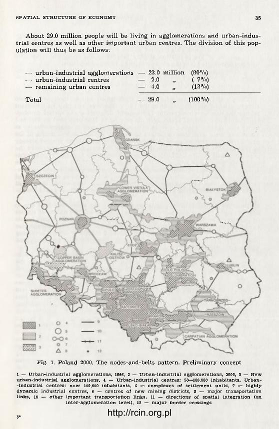
S P A T I A L S T R U C T U R E OF ECONOMY 35
About 29.0 million people will be living in agglomerations and urban-indus-trial centres as well as other important urban centres. The division of this pop-ulation will thus be as follows:
— urban-industrial agglomerations — 23.0 million (80%) — urban-industrial centres — 2.0 „ ( 7%) — remaining urban centres — 4.0 „ (13%)
Total — 29.0 „ (100%)
Fig. 1. Poland 2000. The nodes-and-belts pattern. Preliminary concept
1 — U r b a n - i n d u s t r i a l a g g l o m e r a t i o n s , 1966, 2 — Urban- indus tr ia l a g g l o m e r a t i o n s , 2000, 3 — N e w u r b a n - i n d u s t r i a l a g g l o m e r a t i o n s , 4 — Urban- indus tr ia l centres : 50—100,000 i n h a b i t a n t s , U r b a n -- indus tr ia l c en tre s : over 100,000 inhabi tants , 6 — c o m p l e x e s of s e t t l e m e n t uni t s , 7 — h i g h l y d y n a m i c indus tr ia l centres , 8 — c e n t r e s of n e w m i n i n g distr icts , 9 — m a j o r t ranspor ta t ion l inks , 10 — other i m p o r t a n t t ranspor ta t ion l inks , 11 — d irec t ions of spat ia l i n t e g r a t i o n (on
i n t e r - a g g l o m e r a t i o n leve l ) , 12 — m a j o r border cross ings
3* http://rcin.org.pl

36 S T A N I S Ł A W L E S Z C Z Y C K I , P I O T R E B E R H A R D T , S T A N I S Ł A W H E R M A N
The above population prediction up to 2000 anticipates an increase in pop-ulation of urban agglomerations by over 10 million inhabitants (1966 — 12.3 mil-lion; 2000 — 23 million). This increase will be a result of:
— growth of the population already inhabiting the areas which by 2000 will be incorporated into the already existing 16 agglomerations;
— growth of population presently inhabiting the area of four additional ag-glomerations, which will develop in the future;
— growth of the population due to migration; — natural increase. The population presently inhabiting areas which will be incorporated into
already existing agglomerations in the years 1966-2000 will play an important role in the demographic growth. The concept illustrating the spatial develop-ment of urban-industrial agglomerations existing in 1966 presented on Figure 1 as well as Table 1 show the scale of population growth in agglomerations as a result of their territorial expansion up to 2000. Within the boundaries of the existing agglomerations, as of 2000, the number of inhabitants totalled already in 1966 — 15,779,000 people. Thus, due solely to the territorial incorporation the population will rise by 3,507,000 — in comparison to the number of inhabitants of the agglomerations within the 1966 boundaries (12,272,000 inhabitants). The areas of four new agglomerations which will develop by 2000 namely: Rze-szów-Tarnobrzeg, Carpathian, the Copper Basin, Kalisz-Ostrów, were inhabited in 1966 by 1,734,000 people (see Table 1). Thus, we see that within the spatial limits of the agglomerations as set for 2000 there lived in 1966 —17,513,000 pe-ople.
Thus the agglomerations' population growth in the years 1966-2000 due to migration and natural increase will be about 5.5 million. The results of studies on population change in the years 1960-1970 within the agglomerations (limits as of 2000) showed that population growth in this area during the decade, due to migration and natural increase amounted to 2,400,000 persons. Comparing those figures it is more than possible that the population of agglomerations will be 23 million in 2000.
Present processes of functional and spatial integration have already led to a clear-cut separation of large territorial units which have been formed by the coalescence of particular neighbouring agglomerations. The Southern Macrore-gion which encompasses the Katowice, Cracow, Opole, Częstochowa and Biels-ko-Biała agglomerations is a typical example of such phenomena. The Macro-region whose area equals 5.2% of the country's terri tory was inhabited in 1970 by 5.8 million people, that is 18% of the total population of Poland. This Ma-croregion will enlarge its spatial extent both by encompassing the territories contiguous to the presently existing agglomerations as well as by territorial ex-pansion along the main transportation routes. One of the directions of expan-sion may lead to a functional and spatial integration with the Wrocław agglom-eration which also shall increase its territorial extent.
Very strong integration links will arise between the Southern Macroregion and the Sub-Sudetes agglomeration but this will not lead to their territorial in-tegration. Though until 2000 a full spatial integration will not be achieved, the Sub-Sudetes agglomeration and the new Copper Basin agglomeration will have been incorporated into the Southern Macroregion. Because of its presently exis-ting and also foreseen in the prediction period, high dynamics of economic and social development, in 2000 the Copper Basin agglomeration will meet the delim-itation criteria determined by the authors. The agglomeration will include the following centres: Legnica, Lubin-Polkowice, Głogów and Bolesławiec. In 1970 this area was inhabited by 292,000 people.
http://rcin.org.pl

S P A T I A L S T R U C T U R E OF E C O N O M Y 37
The marked spatial development of the Southern Macroregion in eastern direction will lead to its full integration with the Rzeszów-Tarnobrzeg agglom-eration which will be definitely formed in the prediction period. This agglom-eration is made up of urbanized areas lying on the area of a triangle formed by the Dębica-Przemyśl, Dębica-Sandomierz and Sandomierz-Przemyśl railroad lines. These areas are already on their way to form an integrated complex of urbanized areas, which will have 882,000 inhabitants by the year 2000.
The Carpathian agglomeration comprised of settlement units reaching from Sanok, through Krosno, Jasło, Gorlice to Nowy Sącz will arise south-east of the Southern Macroregion. Beginnings of this urban belt, characterized by a large population (1970-497,000 inhabitants) and a relatively high degree of population density (185 persons per km2), but a relatively small economic poten-tial, could have been noticed already in 1970. It seems that because of the im-portance of the Southern Macroregion, and especially of the Cracow agglomer-ation, spatial integration precesses between the Carpathian agglomeration and the Southern Macroregion may take place during the prediction period.
The second large area to be formed within the next 30 years, as a result of integration between the Warsaw and Łódź agglomerations, will be the Central Macroregion. The formation of this Macroregion can be observed at present.
The urbanization processes which take place in the belt between the Sout-hern and the Central Macroregion enable us to state that till 2000 spatial inte-gration between these two large spatial units may be a fact. The twelve agglom-erations which make up the spatially linked Macroregion will have a popula-tion of 17 million in 2000.
Six million people will inhabit the remaining eight agglomerations (Gdańsk, Szczecin, Lower Vistula, Old Polish, Poznań, Lublin, Białystok and Kalisz-Ost-rów). Heavy development of the Gdańsk and Szczecin agglomerations is a re-sult — according to the authors' assumption — of a major expansion of maritime trade and port facilities, the major part of which will be located in the two harbour complexes. A substantial spatial development of the Lower Vistula agglomerations, which is changing its pat tern from the now existing bi-polar (Bydgoszcz-Toruń) into a policentric one, is due to dynamic development of the new industrial centres of Płock, Włocławek and Świecie-Chełmno as well as to important population and economic potentials of the remaining cities which will be incorporated into the fu ture agglomeration. This will speed up urbanization processes along Vistula between Płock and Grudziądz.
Just as in 1966, the role of supplementary nodes in the nodes and belts pattern will be played in Poland, in 2000, by over 20 urban-industrial centres with a total population of 2.0 million. They are the following centres: Konin, Elbląg, Olsztyn, Koszalin, Słupsk, Gorzów Wielkopolski, Kołobrzeg, Piła, To-maszów Mazowiecki, Siedlce, Zamość, Gniezno, Szczecinek, Starogard Gdański, Leszno, Ełk, Kutno, as well as three new complexes of settlement units — na-mely: Zielona Góra and Nowa Sól, Żary and Żagań, Chełm and Rejowiec. In comparison to centres marked for 1966 we see here differences which are a re-sult of: first, formation of new agglomerations which will include the cities of: Kalisz, Legnica, Rzeszów, Przemyśl and Ostrów Wielkopolski; second, spatial development of existing agglomerations which will absorb the cities of Gru-dziądz, Włocławek, Piotrków Trybunalski, Płock and Inowrocław; and third, growth of cities which in 1966 were not yet marked as urban-industrial cent-res. Besides that, if a decision was made to extract coal in Lublin voivodship, iron ore near Suwałki or brown coal near Bełchatów, we should foresee a possi-bility of formation of new industrial centres based on extraction of mineral resources.
http://rcin.org.pl

38 S T A N I S Ł A W L E S Z C Z Y C K I , P I O T R E B E R H A R D T , S T A N I S Ł A W H E R M A N
The mentioned nodes (agglomerations and urban-industrial centres) linked by transportation and technical infrastructure ribbons form an elementary f ramework of spatial structure of national economy in Poland, in 2000. Most transportation ribbons will run along railroad lines and intercity roads already existing in 1970. Transportation ribbons point-out, at the same time, the direc-tions of urban development as well as of the development of spatial and func-tional integration between particular nodes. In the first phase integration trends are expressed in growing commodity flows and passenger traffic. Next, indus-trial cooperation and urbanization along the transportation ribbons will take place, leading in the last phase to a full spatial integration.
The remaining urban centres which in 2000 will reach 4 million people, we-re inhabited in 1966 by 3,200,000 people. Thus, in the prediction period, the pop-ulation will increase there by about 25% in comparison to 1966. Among these centres there should be pointed out towns and settlements which in 1966 had a considerable industrial potential. The remaining small towns will perform central functions for agricultural, forest and recreational areas surrounding them. We must also have in mind that until 2000 these areas will undergo con-siderable changes. These changes will in the first place effect the living con-ditions, and will lead towards diminishing the differences between the living standards of these areas and of the agglomerations. Thus, the occupational structure as well as housing, service facilities and utilities will undergo a chan-ge. Simultaneously, these areas will meet the needs of the country in the fields of agriculture, forestry and recreation.
The agricultural economy will undergo serious changes pertaining to pro-duction and organization. Specialized, commercial farms will dominate, adjus-ting their production profile to changes in market demand and natural condi-tions.
Polish agriculture is in a condition to meet the demand of not only the co-untry 's own market but also to take over some leading functions in the field of intensive, specialized and labour-consuming cultures in the cooperation f rame-work of the Council for Mutual Economic Aid. In order to achieve this, t ra-ditional rye and potato cultures must be given up and stress should be put on specialized crops, animal and f rui t and vegetable production. A considerable raise in the standard of living of individual farm owners as well as workers of state farms will be the result of a considerable intensification which will gua-rantee the profitability of farms. Achieving this has a double — social and eco-nomic — importance. On the one hand, it may constitute a profit-oriented de-velopment of services for agriculture and agricultural population, and on the other hand, it may counter disadvantageous outflow of young labour force f rom agriculture.
In order to achieve this objective, protection of the best soils (class I, II and III) which constitute 30.4% of Poland's total agricultural lands, is necessary. Besides that, areas with a high degree of investments enabling highly inten-sive and specialized agricultural economy should be kept specifically for agricul-tural purposes. We should aim at protecting agricultural lands against erosion and industrial pollution as well as through rational drainage and irrigation against disadvantageous changes in water conditions.
Within the next 30 years, functions of forest areas will undergo serious changes. Although their productive functions will still be of considerable im-portance (about 2/3 of the national forest area) the protective functions of the remaining part of the forest area will serve social needs for recreation. Appro-priate forest areas should be marked for recreation purposes, where adequate investments, to protect the forest against spontaneous tourist penetration, wo-
http://rcin.org.pl

S P A T I A L S T R U C T U R E OF E C O N O M Y 39
uld be made. National parks and reservations, in other words, totally protected forests, will make up the third group.
As f a r as preserving areas for the purposes of recreation, tourism and sport (water sports) activities is concerned, the main emphasis should be put on the unique, on a European scale, Mazury and Pomorze lake districts. These areas should be completely protected against industr ial investments which might cause the degradation of the geographical environment . The above mentioned objections also refer to other areas of yet undestroyed na ture which bear con-siderable value for recreation and tourism. As a result of a more "urbanized" style of l ife of most Poles in 2000 as well as a shorter workday, problems of recreat ion and tourism will grow in importance. We should have in mind that about 25 million Poles will have vacations and more leisure time. As fa r as week-end recreation is concerned, appropr ia te areas should be set up within agglomerat ions and their peripheries in such distances that they would be easy to reach within an hour 's t ravel by means of public t ransportat ion. Summer houses buil t by agglomeration dwellers will probably become more and more common. As far as longer holidays are concerned, an important role, besides that a l ready played by the lake districts, and the Tatra Mts. will be played by the whole mountain areas and the Baltic shore. Health resorts and climatic sta-tions play an important role among other recreat ion areas.
A plan prepared by the Insti tute of Recreational Planning of the General Commit tee for Sport and Tourism provides for the protection of an area of 45,700 km2 (14.6% of Poland's total area) against investments which could de-grade the natural environment .
CONCLUDING REMARKS
The concept of a policentric nodes and belts pat tern which constitues the main skeleton of Poland's 2000 spatial economic s t ructure was based on an ex-pected growth of cooperation and socio-economic concentration on a national scale. Concentrat ion processes will lead to a considerable population clustering in agglomerations and urban- industr ia l centres which will together account for 65% of the country's total number of inhabitants .
Simultaneously, larger u rban concentrations are undergoing changes leading to their t ransformat ion into loose set t lement systems with different ia ted spa-tial forms and considerable spatial extent . These agglomerations constitute to-day, and also will in the fu ture , the nodal points with a high degree of concen-t ra t ion of human and economic potential. The nodes will constitute focal points for the development of economic and social linkages. The agglomerations at present already constitute cores of economic nodal regions. In the fu tu re the links of tha t kind will f u r the r develop. It seems that the linkages leading to the format ion of Poland's contemporary nodal regions should be used in the f u t u r e as a bases for revisions of the adminis t ra t ive division of the country. It also seems that the system of agglomerations and of nodal regions should be more widely utilized in regional statistics.
A different ia t ion in the spatial forms of agglomerations with the existing t rends towards socio-economic concentration on the national scale, should lead simultaneously to déconcentration processes within agglomerations.
The phenomenon of déconcentration will f i rs t of all per ta in to population which can choose dwelling place not in the central areas only but throughout the broader urbanized areas. The growing social demand for the development of single family housing is one of the leading factors of spatial déconcentration.
http://rcin.org.pl

40 S T A N I S Ł A W L E S Z C Z Y C K I , P I O T R E B E R H A R D T , S T A N I S Ł A W H E R M A N
To a smaller degree, déconcentrat ion t rends per ta in to the location of work-places, whe the r in indus t ry or services. Nevertheless, a change leading to a gre-ater dispersion of places of employment within the agglomerat ions might also be expected. It seems tha t through urban planning there exists a possibility of the proper regulat ion of changes in the internal s t ructure of u r b a n agglomera-tions. Based on the notion of déconcentration processes, this p lanning might facil i tate meet ing sooner the needs of inhabi tants while ensuring a t the same time protection of man ' s na tura l environment .
The spatial ex tent of the agglomerations (as presented on Fig. 1) and their spatial fo rms do not prede te rmine their internal spatial s t ructure. It should be remembered tha t wi th in an agglomeration there will remain, apa r t f r o m buil t-up areas, re lat ively large areas of intensive agricul ture as well as forest and recreat ional areas.
A policentric nodes and belts pa t t e rn — treated in a very f lexible way — enables to control changes in the spatial economic s t ructure of the country as a whole and the t ransformat ion and development of its individual elements. There exist possibilities for dividing funct ions and socio-economic tasks among individual uni ts according to, evolving in time, social and economic demands.
The year 2000 is simply a conventional date — it is the last phase of the changes occurring in the 20th century and the f irst of those of the 21st cen-tury. Thus, all predict ions should be based on dynamic systems, thus taking perspective of f u r t h e r development and change.
Institute of Geography-Polish Academy of Sciences, Warsaw
http://rcin.org.pl

G E O G R A P H I A P O L O N I C A 30, 1975
T H E H I N T E R L A N D S O F R E G I O N A L C E N T R E S I N T H E G D R . F I R S T A P P R O X I M A T I O N
FRANKDIETER GRIMM
Investigations on the interactions of cities and their h in te r lands have been carried on at the Geographical Inst i tute of the Academy of Sciences of the GDR in the last few years. The following repor t gives an introduct ion to some as-sumptions and evaluat ions at the beginning of this research work. The repor t is limited to one impor tan t type of centres: regional centres, because the h in-terland relations of these centres (including those of h igher rank) are of main interest for the ter r i tor ia l planners in our country.
The concentrated e f for t of the economic geographical team in Leipzig since the Szymbark meet ing has led to many new results. In the mean t ime a new level of knowledge on the interactions of centres with their h in ter lands in the GDR and of the h in ter land has been achieved. The ma in resul ts of these in-vestigations since the Szymbark meeting are as follows:
— analyses of the existing interactions between all towns in the GDR above 5000 inhabi tants and their hinterlands;
— classification of all towns above 5000 inhabi tants according to the im-portance for their h inter land;
— determinat ion and modelling of the d i f ferent zones of inf luence wi th in the hinterlands, considering mainly t raf f ic facilities, commuting, adminis t ra -tive boundaries.
Some of these n e w results have been already published in German , other publications have been prepared. They are listed at the end of the article.
1. THE CONTEMPORARY REGIONAL CENTRES AND CENTRES OF HIGHER RANK IN THE GDR
This repor t is based on the following tentat ive hypothesis concerning the te rm "regional centres" (Gebietszentren): Regional centres are of in termedia te level be tween district capitals (Bezirksstädte) and county seats (Kreisstädte) . They render services to both he intermediate and broader h in ter land. These services of regional centres are beyond the capacity and scope of a normal co-unty seat. The h in ter land covers an area equal to tha t of several counties.
With this general unders tanding of the te rm as a s tar t ing point, more de-tailed fea tures have been regarded as he lpful in classifying the city in te rms of a "regional centre" . Such a characterist ic encompasses the pol i t ical-and-ad-ministrat ive importance of the city concerned, the populat ion f igures and the situation of the city in relation to others, as well as the size of the dominated region, i.e., of the area within which the city in question is the dominat ing
http://rcin.org.pl
42 F R A N K D I E T E R GRIMM
centre. Almost all cities wi th more than 50,000 inhabi tants are regional centres or the centre of higher r ank according to our definition. They dominate over an area inhabited by at least 150,000 people. Besides, some cities wi th 25,000 and 50,000 inhabi tants are at present regional centres.
Since the funct ions of regional centres are also common to centres of higher rank, we shall consider both wi thout any f u r t h e r different iat ion.
The analysis has proved 43 cities of the GDR capable of being classified as regional centres or centres of h igher rank according to the definition adopted, for example Greifswald, Neubrandenburg , Eberswalde-Finow, F rank fu r t , Cot-tbus, Hoyerswerda, Gorlitz and Bautzen. Those 43 districts and higher-order centres accommodate, wi th their 5.6 million inhabitants, near ly one-third of the entire population of the GDR, including:
3.0 million in 6 cities of more than 200,000 inhabitants, 0.7 million in 5 cities of 100-200,000 1.3 million in 16 cities of 50-100,000 0.6 million in 16 cities of 25-50,000
2. ON THE SURVEY OF HINTERLAND AND THE DELIMITATION OF DOMI-NANCE ZONES. FIRST APPROXIMATION.
The deductive classification of the established rank-size s t ructure and rela-tionships is based wi th regard to regional and higher-order centres on the fol-lowing assumptions:
— specific contacts maintained to the regional or h igher-order centres, are the necessity of all communit ies (Gemeinden);
— each of the regional or higher-order centres yields a certain equal spec-t rum of basic services, specific for such centres;
— every community mainta ins a priori ty contact with a single regional or h igher-order centre and shows preference to the centre tha t offers the most favourable access to public t ransportat ion.
The above mentioned assumptions have proved sufficient to gain a prel imi-nary unders tanding of the rank-size and spatial relations.
The following index has been adopted to represent the established and the possible ci ty-hinterland relations in order to simplify f u r t h e r assumptions: , , , 100 X mean travell ing t ime Index of accessibility = —-— —
daily t ravel f requency The index of accessibility has served as the basis for the determinat ion of
the most favourable t raf f ic connection for each of the communit ies to a neigh-bouring regional or h igher-order centre. Such calculations were of p r imary importance for the delimitation of dominance zones.
3. THE PRESENT REGIONAL AND HIGHER-ORDER CENTRES AS DETERMI-NED BY MEANS OF THE INDEX OF ACCESSIBILITY
3.1. T h e size of d o m i n a n c e zones With the above mentioned provisions and assumptions as the s t rat ing point,
the following relationships and size orderings are distinctly outlined: The GDR incorporates 191 counties (Landkreise) and 27 townships (Stadt-
kreise). On the basis of the introductory definition of the regional centres in respect to ci ty-hinterland relations, we have found out 43 cities tha t meet the requirements . Every f i f th county seat in the GDR can be considered as a re-gional or a higher-order centre. Therefore 4 county seats are on the average
http://rcin.org.pl

H I N T E R L A N D S OF R E G I O N A L C E N T R E S 43
subordinated to a regional or a h igher-order centre. The mean size of a dom-inance zone would thus be calculated at 2340 km2.
The dominance zones, as determined on the basis of the index of accessibil-ity, show fairly varied area sizes. They range between 6500 sq.km (Stendal) and 570 sq.km (Aue). At the same t ime there is a clear correlation between the area and the population density: dominance zones of the largest size are found in sparsely populated regions, and vice versa, those of the smallest size — in densely populated regions.
The six largest dominance zones are found in the sparsely populated dis-tricts of the nor thern and central regions: Berlin, Stendal, Schwerin, Neubran-denburg, Cottbus, Magdeburg. 30% of the terr i tory of the GDR, in te rms of ci-ty-hinter land relations of regional centres is oriented towards the above 6 cen-tres. The average population density of the above dominance zones (the 6 cen-tres not included) amounts to 75 inhabi tants per 1 sq.km. (The mean value for the ent i re GDR is 158 inhabi tants per 1 sq.km).
The smallest dominance zones are situated in the densely populated South of the GDR. With the exception of the hinter lands of Leipzig, Dresden, Kar l -Marx-Stadt and Er fur t , the size of the dominance zones in the southern dis-tricts is below the GDR-mean.
Less obvious, but still evident, is the relationship between the population total of a centre, and the area size of its dominance zone, part icularly in res-pect to large cities. The dominance zones of 8 large cities of the GDR (Berlin, Leipzig, Dresden, Kar l -Marx-Stadt , Magdeburg, Halle, Rostock, Erfurt) , claim 29,000 sq.km, while the average area size for the remaining 35 centres is only 2100 sq.km each.
3.2. P o p u l a t i o n To ta l s of D o m i n a n c e Zones
The size s t ructure in t e rms of the population totals for the dominance areas can be calculated in a similar way as in the case of the first approximate esti-mation of area size. Since the 43 centres accommodate 5.6 million people, the population total of all dominance zones without the centres, would amount to 11.6 million. The average dominance zone without its centre, accommodates thus 270,000 inhabitants, or 400,000 inhabi tants with a centre of an average size included.
The population f igures calculated individually show considerable variation. The most densely populated are the dominance zones of Halle (850,000 inhabi-tants) and Leipzig (700,000 inhabitants). Berlin ranks 5th on the list. The smal-lest population f igures per dominance zone are noted in the case of Wismar and Giistrow (each 90,000 inhabitants). The bigger population f igures in the domi-nance zones of large cities are a result of basically higher population density and bet ter t ransportat ion linkages. The lowest population totals of dominance zones are noted in the sparsely populated regions, and in the peripheral ly situ-ated districts, e.g. Giistrow (low populat ion density), Eisenach, Meiningen (pe-r ipheral situation).
3.3. On t h e d i f f e r e n t i n t e n s i t y of c i t y - h i n t e r l a n d r e l a t ions in t h e d o m i n a n c e zones
The delimitation of the dominance zones, and the calculation of the popula-tion total and area figures, allows for an initial estimation of the established size ordering. More precise s ta tements will be possible while considering the differ ing intensity of contact wi thin the individual dominance zones, (a) The 40-minute isochrone:
http://rcin.org.pl

44 F R A N K D I E T E R G R I M M
The area within the 40-minute isochrone (net travell ing time, public t rans-portation) corresponds approximately to a distance that requires an effect ive travelling time of one hour f rom place of residence to place of work. This equ-als the ext reme limit of zones of assumed commuting. Such a space is the area of the most essential terr i tor ia l labour relations between a centre and the h in-terland. The inhabitants are f ree to take the choice of jobs offered in a city, sin-ce they are capable of commuting to work daily. Such a favourable si tuation allows the inhabi tants wi th in the 40-minute isochrone to benefi t wholly or part ial ly f rom services offered by a centre. Accepting the 40-minute isochrone as the basis, the population total corresponding to the available manpower po-tential within a dominance zone can be calculated: 5.6 milion inhabi tants in the regional centres, 9.5 million in the regional centres and their zone of 40 min. accessibility. On the other hand 7.8 million inhabi tants of the GDR live beyond the employment fields of regional and higher-order centres and thus they can not take advantage of the favourable labour conditions and their changes. The above f igure is a min imum value, as the 40-minute distance of net t ravell ing time presents the ex t reme limit. If we assumed a 40-minute isochrone for walk-ing distance plus travell ing time, it would resul t in a population total of 10-10,5 million beyond tha t isochrone.
The largest population totals wi thin the 40-minute zone (net travell ing time), are noted with regard to the largest cities in the densely populated South of the GDR: Leipzig — 270,000 inhabitants , Zwickau — 260,000 inhabitants, Dres-den — 250,000 inhabi tants and Kar l -Marx-Stad t — 220,000 inhabitants. The low-est population totals are — as could have been expected — in the sparsely po-pulated districts of the nor thern and central GDR: Stendal — 35,000 inhabi-tants, Brandenburg — 35,000 inhabitants , F r an fu r t /Ode r — 25,000 inhabitants . The average population total within the 40 minutes zone of each of the 8 lar-gest cities amounts to 160,000 inhabitants , and 70,000 inhabitants in relat ion to the remaining 35 cities, (b) The index of accessibility: 500 value
The index of accessibility 500 can be based upon various combinations of travell ing time and travell ing f requency. E.g., 8 t ravels per day taking 40-min-utes or 12 travels taking 10-minutes. In accordance with our experience, the in-dex of accessibility represents a range allowing people to benefi t f rom the nu-merous services offered by a centre. By simplification, one can classify the zone with the 40-minutes isochrone as the area of established or potential t e r -ritorial labour relations. The area within the 500 accessibility range is, on the other hand, the zone wi thin which the employment and living conditions are marked or influenced by contacts wi th the centre, i.e., the area where changes occurring at the centre are also reflected.
The zones of accessibility values up to 500 accommodate 12 million people, which is more than in case of the 40-minutes zone; 2/3 of the GDR-populat ion are capable of benefi t ing f rom the services offered by the centres. Nevertheless there still remain more than 5 million people beyond such areas. This one-third of the GDR-population must be ensured equal contacts wi th centres of fer ing services. This demand of the social policy imposes an impor tan t l imitation upon all concentration t rends wi thin the state terr i tory.
The most remarkable differences between the 40-minute-zone and the zone of index 500 were found out in the h in ter lands of big cities. The greatest pop-ulation totals in relation to the index of accessibility 500 are noted for Dresden (530,000), Kar l -Marx-Stadt (510,000) and Leipzig (400,000) followed by Zwickau, Halle and Berlin. Only small population totals are noted within the 500-zones of numerous centres of the sparsely populated North. This means tha t the
http://rcin.org.pl

Fig. 1. Hinterlands of the regional centres 1 — state boundary; 2 — district ( B e z i r k ) boundary; 3 — regional centre (including centres of higher rank); 4 — range of dominance; 5— index of access ibi l i ty: be low 500; 6 — index of
accessibi l i ty: above 500; 7 — travel l ing t ime to regional centre more than 2 hours
This map was first published in Geographische Berichte and is here reprinted by permission of Professor Mohs, the Editor.
http://rcin.org.pl

46 F R A N K D I E T E R GRIMM
conditions, both quali tat ive and quanti tat ive, for the shaping of the city-hin-terland relations are d i f ferent within those areas. This fact should be taken into consideration wi th regard to planned development of the terr i tor ia l s truc-ture.
A regional comparison for the GDR shows tha t agglomerat ion areas are oriented, in terms of such relations, to h igher-order centres. Favourable con-ditions in respect to ci ty-hinterland relations (in case of regional and higher order centres) are characteristic of those regions. Par t icu lar ly favourable is the existing possibility of contacts of an individual community wi th various centres. The variety of possible interactions is of importance for individual citizens as well as for the planning and utilization of the agglomerat ion areas as a whole. (c) Areas beyond the intense contact-zones
Areas situated beyond centres and their zones of direct inf luence deserve part icular attention. The relations of such areas to the regional and higher-order centres are relative small. Assuming tha t contacts with the regional and higher-order centres are necessary for all communities, all shortcomings must be presented. It will require a more detailed research to ascertain if, and to what degree these assumptions are real. At present we can only list the regions of the GDR within which such areas are noted, and estimate their size. Areas beyond the intense contact zones are the regions to the North of the Ber l in-Magdeburg line (coastal districts not included) the Fläming hills (central GDR) and certain smaller peripheral ly located areas. The strip that runs f rom the western Al tmark towards the eastern par t of the Usedom island is part icular ly distant f rom the regional and higher-order centres.
The distant areas are either sparsely populated, per ipheral zones, e.g., the Al tmark region or densely populated smaller areas with their own local centres as in the case of the Halle district.
3.4. T h e s t r u c t u r e of h i n t e r l a n d in t e r m s of con tac t s w i t h t h e reg iona l a n d h i g h e r - o r d e r c e n t r e s
Maps showing the delimitation of the dominance zones of regional and higher-order centres within the GDR show the varying intensi ty of contacts in relation to the 43 centres. The maps offer a basis for a pre l iminary asses-sment of the ci ty-hinterland relations of the above centres. The agglomeration areas are clearly distinguished as showing most intense spatial relations with the centres. Two advantages of the agglomerations appear. The one is an availability to utilize fu l ly the existing potential relating to labour and living conditions. The other is a possibility to utilize manpower and other resources. On the other hand there are areas where close contacts wi th regional and higher-order centres are hardly feasible. Fu r the r research seems necessary, to tell which of those areas are in fact handicapped due to the possibilities of the improvement of labour and living conditions.
The importance of county towns (Kreisstädte) in shaping the labour and living conditions deserve special consideration. A gap exists here in spatial planning policies carried so fa r in the GDR. According to our analyses the overwhelming major i ty of large county towns are situated within the 500-zone (index of accessibility) of the 43 centres. Exceptions are only four cities of over 25,000 inhabi tants situated beyond the 500-zone of the regional or h igher-order centres (Wittenberge, Sonneberg, Schwedt, Luckenwalde). The lat ter , perhaps with the exception of Wittenberge, do not have sufficiently large h in ter land to assume the role of a regional centre, according to our definition. Apar t f r o m
http://rcin.org.pl

H I N T E R L A N D S OF R E G I O N A L C E N T R E S 47
the above exceptions, most of the larger county towns are situated relatively favourably in relation to their regional and higher-order centres. Their own hinter land is however restricted to immediate vicinity. This double-role of many county towns has been already emphasized by Mohs and Scholz with regard to the cities of the peripheral area in the Halle-Leipzig agglomeration.
The analysis of the ci ty-hinterland relations proves that the larger areas in the southern regions of the GDR accommodate large county towns situated between the regional and higher order centres, e.g. Dobeln between Kar l -Marx--Stadt and Dresden, Naumburg and Weissenfels between Weimar and Halle, Bernburg, Stassfur t and Aschersleben between Halle and Magdeburg. The Nor th of the GDR on the other hand, apar t f rom the district of Rostock, is noted for only small county towns, and those show no closer ties with regional and higher-order centres. Such a diverse s tar t ing point requires specific solu-tions which would give due consideration to the ne twork of small centres and low population density. Latest research on the ci ty-hinterland relations within the GDR has proved that the major i ty of such relationships, important for the working and living conditions of the population have developed between resid-ential communities and the corresponding county towns.
3.5. C o m p a r i s o n of r eg iona l a n d h ighe r c e n t r e s cons ide r ing t h e h i n t e r l a n d s
While analysing the terri torial and higher-order centres, in terms of services rendered to hinterland, the following distinction should be made:
— centres with their dominance zone maintaining intense contact with the centre (e.g. Aue wi th 97% and Zwickau wi th 95% of population within the dominance zone according to accessibility values of up to 500);
— centres with dominance zones still substantial ly more extensive than the range of intensive contacts (e.g. Bautzen, Leipzig, Miihlhausen and Wismar with 50-60% of population within the 500-zone; the GDR average — 55%);
— centres with dominance zones si tuated essentially beyond intense con-tacts range (e.g. Schwerin with 6%, Stendal with 9%, Neubrandenburg with 11% of population within the 500-zone).
Fu r the r research stemming f rom the deductive-abstract study of the city-hinter land relations is aimed at a closer analysis of the f igures and interrela-tions presented, as well as at the examinat ion of their correlations with empir-ical results.
Geographical Institute, Academy of Sciences of the GDR, Leipzig
BIBLIOGRAPHY
Christaller, W., 1933, Die zentralen Orte in Süddeutschland, Jena. Grimm, F., 1973, Zur Berücksichtigung von Stadt-Umland-Beziehungen bei der Ent-
wicklung der Siedlungs struktur, Inform. Forschungsleitstelle f. Territorial-planung.
Grimm, F., 1974, Die Kreisstädte der DDR und ihre Rolle im Siedlungssystem, Geogr. Ber., 4.
Grimm, F., Hönsch, I., Taege, G., 1972, Gebietliche Zentren in der DDR und ihre verkehrsbezogenen Dominanzbereiche, Geogr. Ber., 64/65.
http://rcin.org.pl

48 F R A N K D I E T E R GRIMM
Grimm, F., Hönsch, I., 1974, Zur Typisierung der Zentren in der DDR nach ihrer Umlandbedeutung, Petermanns Geogr. Mitt., 4.
Grimm, F., Hönsch, I., 1975, Die Zentrumstypen in der DDR. Methodik und Ergebnis-se einer Typisierung auf Grund der Umlandbedeutung, Wiss. Veröff. Geogr. Inst. AdW, 30.
Grundmann, L., 1975, Zur territorialen Differenzierung der Pendelwanderung in der DDR, Wiss. Veröff. Geogr. Inst. AdW, 30.
Heidenreich, G., 1970, Die Beziehungen zwischen Stadt und Gebiet und ihr Einfluss auf Inhalt und Methode der räumlichen Planung, Hochsen. Archit. u. Bauwesen, Weimar, 1970 (Thesis).
Känel, A.v., 1969, Siedlungstypen nach berufstätiger Wohnbevölkerung (a map), in: Planungsatlas Land- und Nahrungsgüterwirtschaft, Potsdam.
Känel, A.v., Krönert, R., 1972, Die Stadt-Umland-Beziehungen und ihre Analyse, dargestellt am Beispiel von Greifswald und Dessau, Geogr. Ber., 3/4.
Krönert, R., 1975, Struktur und Aspekte von Zentrumsregionen, Wiss. Veröff. Geogr. Inst. AdW, 30.
Krönert, R., Schmidt, R., 1974, Das Umland von Mittelstädten, — dargestellt am Beispielgebiet Dessau, Petermanns Geogr. Mitt., 4.
Lüdemann, H., Heinzmann, J., 1974, Die Rolle der Stadt-Umland-Beziehungen bei der Entwicklung der Siedlungsstruktur, in: Festschrift z. 60. Geburtstag H. Sab-ke, Berlin.
Neumann, H., 1974, Territoriale Wirkungsbedingungen und Entwicklungstendenzen der Pendelwanderung — Möglichkeiten und Aspekte ihrer künftigen Gestaltung, Martin-Luther Univ. Halle (Thesis).
Taege, G., 1973, Die Ermittlung der Verkehrsanbindung als eine Methode der Ana-lyse der Siedlungsstruktur, Vortragsthesen Arbeitstagung Siedlungsstruktur, Leipzig, Nov.
http://rcin.org.pl

G E O G R A P H I A P O L O N I C A 30, 1975
O N T E R R I T O R I A L S T R U C T U R A L E F F E C T S A N D T H E I R E C O N O M I C R O L E W I T H I N A G G L O M E R A T I O N S
DIETER SCHOLZ
1. INTRODUCTION: THE PROBLEM, ITS ECONOMIC AND SOCIO-POLITICAL IMPORTANCE FOR THE EXPANSION OF THE DEVELOPED SOCIALIST SOCIETY IN THE GDR
The advance of planned shaping of the developed system of socialism in the GDR proceeds wi thin a terr i tory the economic- and geographical s t ructure of which has been determined by centuries long development process. It was the process of pre-socialist format ions of the society (commenced wi th the relicts of ear ly feudal set t lement structures). This has been followed by at-tempts at providing more rat ional terr i tor ia l s t ructures to answer the require-ments of the socialist working and living standards. It was part icularly the development of the past decade (ever since the socialist production conditions have succeeded in the agriculture) tha t has tr iggered a process aimed at essen-tial changes with view to the inheri ted terr i tor ia l s t ructure. The results of this process are new as to their quality, and their target is a terr i tor ial s t ructure to suit the demands of the socialist-communist society and of scientific-tech-nological progress.
At the moment we are facing the beginning of this process which for our present knowledge may claim an undef ini te period of t ime unti l it is finished. This process d i f fers f rom the entire heretofore development of our terr i torial s t ructure . The di f ference consists in the fact that the course taken by this process is anyth ing but spontaneous and running undernea th the threshold of congizance of the society. On the contrary, it is consciously and p lanful ly controlled by the socialist society.
This fact has the effect of the two comprehensive and extraordinar i ly impor tant tasks which the organs responsible for the terr i tor ia l planning and research are faced with:
1. The necessity of determinat ion and formulat ion of objective social and of special economic laws (or principles) to control the development and shaping of the terr i tor ia l s t ructure. Conscious application of such principles would pe rmi t such a development .
2. The necessity of formulat ing targets for the control of the terr i tor ia l development process in the GDR. Such targets must answer the requirements of the f u t u r e socialist-and-communist society.
The scope of problems to be discussed below encompasses the terr i tor ia l s t ruc tura l effects and their effectivi ty wi thin the agglomerations of the GDR. It belongs to the former complex of tasks and is therefore of basic importance
4 Geograph ia P o l o n i c a http://rcin.org.pl
50 D I E T E R SCHOLZ
for the long-term or prognostic developments. It harbours at the same time a most up-to-date reference: the directive of the SED VIII Congress for the years of the 5 year plan period 1971-1975 points to the "Intensification and increasing the effect ivi ty" of the social production as the leading path towards reaching the goals for the nat ional economy. This demands undoubt fu l ly also an increased terr i torial effect ivi ty of production, as well as an improvement in the working and living s tandards of the population.
A scientific approach to this field has commenced in the GDR but several years ago, and f rom the angle of regional economics f rom the very beginning. The start ing point was marked by the research conducted in Ökonomisches For-schungsinstitut of the State P lanning Commission on the questions of improve-ments wi thin the agglomerations, on the problems of an effect ive utilization of local resources, on the terr i tor ia l s t ructure of national gross product, as well as on the problems of the research of terr i tor ial economy spending (Rationali-sierung, 1967; Terri toriale Ressourcen, 1967; Ergebnisse, 1968; G. Lindenau, 1968). The above effor ts were used by Ritzschke (1967) as the basis for his com-prehensive study which resulted in the formulat ion of a system of terr i tor ial effectivi ty calculus (G. Ritzschke, G. Kind, 1969). The system presents an a t -tempt at summarizing the heretofore highly varied as to their details, empiric analyses f rom a more general angle. It is f u r t he rmore aimed at their classifica-tion and at render ing them at the same t ime an universal ins t rument for the determinat ion of the effect ivi ty of terr i tor ial s tructures. Thus, the above work lays stress on the methodic aspect, while its theoretic bases appear r a the r weak, and strongly marked for empiric prel iminaries.
Similar is the procedure adopted by J . Heinzmann (1971). His dissertation on the large agglomeration core of Leipzig refers to the leading groups of factors that determine the effect ivi ty of the production s t ructure of a te r r i tory (devel-opment t rends of the scientific-and-technological progress, shaping the s t ructu-re of production, development of the terr i tor ial production management , dislo-cation of production wi thin a certain territory), and at tempts to f ind quant i ta -tive criteria for the above.
At tempts made in this line encompass f u r t h e r research, e.g., the work by the Inst i tute of Industr ial Construction of Deutsche Bauakademie (1971) and that by the Office for Regional Planning in Cottbus (1971).
The theoretic discussion on the problem of the terr i torial effectivi ty, on the other hand, lags behind empiric research. The beginnings may be found in the paper by R. Bönisch, W. Ostwald (1971), and in an unpublished research repor t by the Working Group on Agglomerations of the Geographical Section of the Mar t in-Luther University, of Halle-Wit tenberg (April, 1971). The most com-prehensive discussion to date is contained in a paper by R. Bönisch (1972).
The above brief review of the present position of scientific achievements permits the following conclusions to be d rawn:
1. The scope of problems involved in the terr i tor ia l s t ructural effects — to the terr i torial effect ivi ty relations is of great importance for the long-term and prognostic as well as for the present tasks of the terr i torial planning.
2. The l i tera ture available in the relevant fields supplies some empir ic re-search results and notions. The lat ter , apar t f rom being oriented at practical re-sults, communicate methodical possibilities and experiences.
3. The theoretic penetra t ion of the scope of questions is involved only at the initial stage and must be at any rate promoted in order to ensure a correct evaluation of the practical results.
The above purposes are mean t to be served by this paper. It is based on the practical experiences gained by the Working Group of Agglomerations of the
http://rcin.org.pl
TERRITORIAL, S T R U C T U R A L E F F E C T S 51
Geographical Section of the Mar t in-Luther Universi ty in Halle, and supported by the discussions carried out by the members of the Group (Professor G. Mohs, Dr. H. Schmidt, B. Gallander , E. Trawnicek, and G. Kroll).
2. ON THE ESSENCE OF TERRITORIAL STRUCTURAL EFFECTS AND THEIR IMPORTANCE
Discussion on the contents of both the basic te rms " terr i tor ia l s t ructura l effects" and "terr i tor ial effect ivi ty" must be made the s tar t ing point for the following considerations.
The t e rm "ef fec t" denotes in the f i rs t place any action (Wirkung) or a re-sult thereof (Auswirkung ) in general. A s t ruc tura l effect may thus be solely an outcome of a specific s t ructure or of a change in a specific s tructure.
A terr i tor ia l s t ructure (economic area, terr i tor ial s t ructura l unit, etc.) is to be understood as a spatial sector of the ent i re social s t ructure of a country in-cluding her na tura l basis. The terr i tor ial s t ruc tura l uni t presents a highly com-plex format ion (or a system) of most varied mater ia l objects, relations and processes which fo rm such a unit , and account at the same t ime for its ex t ra -ordinari ly complex structure. Such a s t ruc ture is noted for the totality of re la-tions be tween the individual segments (elements, s t ructural components), as well as for the proportions between the elements and s t ructura l segments.
Thus, all effects could be looked upon as s t ructura l effects which result f rom a s t ruc ture of a certain terr i tory or f r o m its alterations, i.e., f rom the relations and proport ions between the elements of the ter r i tory in question or par t ia l s t ructures .
Such effects are extremely manifold and contradictory. An a t tempt at br ing-ing t hem into an order or rendering them more perspicuous requires the ap-plication of certain principles and of correct s tar t ing values. Those result f rom the definit ions of terr i torial s t ructural elements and components, and f r o m the defini t ion of terr i tor ial relations and proportions.
If to conceive according to G. Schmidt-Renner (1961, p. 11) the production (and social reproduction, D. S.) location as the basic element of the terr i torial s tructures, such an element may be considered in its double respect to the larger terr i tor ia l part ial s t ructures in the following summarised way:
1. According to the type and degree of spatial l inkages and concentration of locations of most varied nature, such factors result in complexes of locations, sub-terri tories, and in other levels of spatial units of a terr i tor ial s t ructural unity. As their size grows, those latter are becoming ever more complex, al-though they are already relatively complex in their e lementary forms.
2. If to consider locations of a similar na ture (i.e., equally formed sectors of the social reproduction process wi thin a terr i tory) one will be able to distin-guish par t ia l s t ructures (like the terr i tor ial s t ructure of production, tha t of pop-ulation, etc.) which will reflect in their whole again the terr i torial s t ructure.
In this connection, the terr i torial s t ruc ture may be described both as a spa-tial s t ruc ture ma t r i x (according to B. J . L. Berry, 1964, as quoted by R. J. Chor-ley and P. Haggett , 1967, page 28), or as a vector field (according to G. Kind, 1969). I t is par t icular ly the former representat ion (Table 1) that seems be t te r suited to reflect the essential relations and proportions of a terr i tor ial s t ructure. It may be used to classify the basic terr i tor ia l s t ructura l effects. The lat ter may be grouped according to the following categories:
1. Effects resul t ing out of the mater ia l substance of the terr i tor ial s t ructu-ral elements:
4* http://rcin.org.pl

Main possibilities of structural representation of the elements of territorial structure
http://rcin.org.pl

T E R R I T O R I A L S T R U C T U R A L E F F E C T S 53
1.1. Properties of the natural material substance permit to obtain the following: — Effects resulting from a given territory being provided with resources;
— Effects resulting from a given territory being provided with substance that can be won as raw materials. 1.2. Properties of a material substance produced by the society by work-
ing, permit to obtain the following: — Effects resulting from a given terri tory being provided with inf ra-
structural facilities; — Effects resulting from a given terri tory being provided with dwel-
lings and industrial buildings, and thus with a population and settlements. Such effects are triggered in the case a society is willing to make use of
the above properties, and the proper substance is sufficiently or insufficiently available. This requires a remark that sufficiency or insufficiency are relative values that result each time from the relation between the demand and the possibility of meeting the demand.
2. Effects that result f rom the relations and proportions between the ter -ritorial structural elements, i.e., of the territorial management of the repro-duction process at given locations, location complexes, etc. The most essential relations of that type include:
2.1. Situation relations as the most general relation of the territorial type;
2.2. Flows of commodities resulting from requirements of the territorial production management, circulation and consumption;
2.3. Flows of population resulting from the requirements of the terri to-rial management of production, circulation and consumption (commuting to work, business and shopping trips);
2.4. Communication and information linkages; 2.5. Relations resulting f rom other important sectors of the social repro-
duction that cause predominatly flows of persons (culture, entertainment and education, management, public health service and reproduction of labour, itc.). It is the above relations around which the entire scope of territorial problems
of concentration, specialization, and cooperations is focussed. 3. Effects that result from the relations and proportions between the ter -
ritorial partial structures. Those latter may include proportions between the part ial structure like production and science, population, resources, infrastruc-
Settlement structure
Fig. l http://rcin.org.pl

54 D I E T E R SCHOLZ
tura l facilities and set t lement network. Such relations and proport ions are de-veloped in an entirely reciprocal way, and may be represented as on Figure 1.
The d iagram shows that a large number of the above effects are directly re-lated wi th the production, and may be represented by the corresponding values (eventually in monetary terms). Quite a portion of the above effects are, how-ever, of non-economic nature , and can thus hard ly be represented in a value form, whi le being part ial ly unident i f iable in terms of quanti t ies al together. This s t rongly hampers such effects considered wi th in the comprehensive effectivi ty calculation.
Terr i tor ia l s t ructura l effects may be evaluated positively or negatively f rom the social point of view. One and the same form of terr i torial s t ruc ture may lead to positive and negative results at the same time. (E.g., a high terr i tor ial concentrat ion of the chemical industry may influence the production costs po-sitively, while burdening the land with re fuse at the same time). The individual ef fects m a y superimpose, reinforce or neutralize one another . This proper ty of s t ruc tura l effects that makes an analysis of the effectivity very complicated has also been pointed out by R. Bonisch (1972).
This means, at the same time, that a knowledge of the terr i tor ia l s t ructural effects is not sufficient to permi t an immediate and automatic determinat ion of the effect ivi ty.
A review of l i tera ture available in the GDR, as well as our own consider-ations, permi t to present the problem of effectivity of the terr i tor ial s t ructure.
The contents of the te rm covering the terr i tor ial effectivity has been defi-ned by several authors more or less univocally (G. Ritzschke, 1967; R. Bonisch, H. Ostwald, 1971; R. Bonisch, 1972), as below:
The terr i tor ia l effect ivi ty is to be understood as total benefi t , par t icular ly the nat ional economy benefit , as produced by a terr i torial management of so-cial reproduction. The effect ivi ty is the integrated expression of influencing factors acting upon social costs and effects.
The above definit ion points towards the fact tha t no ful l congrui ty has been obtained as to the contents of the te rms of terr i torial s t ructura l effects and ter r i tor ia l effectivity. The t e rm effect ivi ty contains solely the benef i t effects, and is predominant ly economic-effect-oriented (owing to its being based on the cost-benefit relation). The cost-effects are given by an indirect reckoning (in the fo rm of consideration of increased outlays to compensate for the losses which again reduce the benefit-effect) , while effects of non-economic na ture a re occasionally pointed to (e.g., by G. Ritzschke, 1967 and R. Bonisch, 1972). In the sets of methods, on the other hand, as proposed for the determinat ion of effect ivi ty, the non-economic effects are hardly mentioned.
If to follow the above definit ion for all the limitations — this would lead to a f u r t h e r conclusion:
The benef i t of terr i tor ial s t ructura l effects consists, in fact, pr imar i ly in the increase of production results for the society (which finds its expression par t icu-lar ly in the increment of the gross national product of the working output) and in other value index figures. The benef i t for the society also lies in the expan-sion of leisure t ime and in a heal thier and bet ter s tandard of living (R. Bonisch, 1972). Apar t f rom the above, this consists also in the sufficient production of goods and availability of services enabling the society to meet social and in-dividual needs. The contents of the te rm of effectivi ty should be clearly con-ceived also in this sense.
This is of a par t icular importance in connection with the problem of the ef-fect ivi ty of agglomeration areas. The reason is tha t while in a consumption oriented benef i t calculation one can still ident i fy the expenses on the whole,
http://rcin.org.pl

T E R R I T O R I A L S T R U C T U R A L E F F E C T S 55
this would hardly be possible as concerns the results. This means, however , that, e.g., the benef i t that results f rom the improvement of municipal t ra f f ic in agglomeration core can hardly be determined quanti tat ively, while the ex-pense side would show amounts running f requen t ly in millions and billions of Marks.
A f u r t h e r problem that results f rom the value-oriented effect ivi ty de te rmin-ation has already been pointed to. It is derived f rom the fact tha t benef i t va-lues are based in the rule not on the terr i tor ia l s t ructura l effects bu t on the s t ructural effects as such. The latter include technological effects, economic sec-toral effects, mater ia l input effects, power input effects, etc. It is for this re-ason extremely difficult , if not impossible, to determine the benef i t e f fec t of specific terr i tor ia l s t ructures in total. How far the terr i torial ef fect iv i ty com-parisons could be of assistance in this respect — should be examined f i rs t . The above state of things contributes to reduce the declarativeness of the ter r i tor ia l effectivity calculations considerably.
3. THE SPECIFIC CHARACTER OF TERRITORIAL STRUCTURAL EFFECTS AND THEIR IMPORTANCE IN THE CASE OF AGGLOMERATIONS
Agglomerations are of a part icular importance in te rms of ter r i tor ia l s t ruc-tural effects as fa i r ly large par ts of production and population are concentra-ted within such areas over a limited terr i tory. Their economic potent ial de te r -mines the effect ivi ty of the ent i re national economy. Par t icular ly strong concen-trat ion of population — a product of concentration of production wi th in agglom-erations itself — is an essential impulse for the f u r t h e r development of the productivi ty and effectivity.
This circumastance has been part icular ly emphasized by K. Marx in his Capital in which he wrote:
"Just as a certain number of simultaneously employed labourers are the material pre-requisites for division of labour in manufacture, so are the number and density of the population, which here correspond to the agglomeration in one workshop, a necessary condition for the division of labour in society. Nevertheless, this density is more or less relative. A relatively thinly populated country, with well-developed means of communication, has a denser population than a more numerously populated country, with badly-developed means of communication; and in this sense the North-ern States of the American Union, for instance, are more thickly populated than India" (Vol. I, pp. 345-346, George Allen and Unwin Ltd. 1946; reprinted from 1889 edition).
In this quotat ion the importance of the population, its density is emphasi -zed. The la t ter in tu rn is determined essentially by the terr i tor ia l concentra-tion of commuters and by local inf ras t ruc ture .
If we were to formula te a f r amework for the s t ructure of the agglomerat ions which should ful f i l l the condition of terr i torial s t ructura l effects and a high effectivity, this would lead — on the basis of the heretofore results of work by the Section of Agglomerations, and of experiences gained f rom the l i te ra ture — to the same points of view:
1. The most impor tan t basis is the high degree of terr i tor ial concentrat ion of population, production, and technical in f ras t ruc ture wi th in the agglomera-tions. This results in the secondary effectivi ty factors (groups):
1.1. Numerous, in the rule highly skilled manpower locally available for -ming an env i ronment that strongly favours specialized t raining, as well as gaining skill in a second and a third vocation. The present shortage of m a n -power wi th in the agglomerations of the GDR does not speak against this factor of effectivi ty, but presents the result of the general populat ion and
http://rcin.org.pl
56 D I E T E R S C H O L Z
labour structure in the GDR, as well as of disproportions that were noted in the past between the demand for labour and the possibilities of this demand to be met.
1.2. The high concentration of production and services is determined at the same time by clearly outlined specialization and a broadly defined gen-eral profile. On this are based possibilities and real conditions of a well-developed cooperation between individual partners within a specific area. The above problems have been dealt with in detail by H. Schmidt (1971) as concerns the structure of industry of the agglomerations in the South of the GDR.
1.3. The qualitatively comprehensive and quantitatively highly concen-trated technical infrastructure within the agglomerations enables a complex and full utilization of such facilities. The latest research by G. Kehrer (1971) on the example of the capital of the GDR has confirmed the above fact. The relation of investments in the technical infrastructure to those of the users (predominantly production units) shows an average value of 1:4 for all of Eerlin, reaching 1:6 within the city core and showing a correspondingly low-er value in the peripheral zone. An inverted increase shows that spendings on investments in the technical infrastructure per one inhabitant may grow to almost two and a half its value along the line from the city core towards the peripheral zone, though the city core involves 29 times as much value of investments in the technical infrastructure per 1 square kilometre. A negative impact of a high concentration of population, production and
infrastructure on the effectivity of agglomerations is noted wherever the local resources (which are not renovable or can be reproduced to but a limited de-gree) are claimed to a full extent. This applies mainly to area and water. This results in consequence ranging from a direct reduction in the effectivity of production to diminishing the recreational facilities of the population.
Apart from the above, one must also consider the strong territorial con-centration of industrial waste materials occurring within the agglomerations. It has to be considered as a negative structural effect.
2. The fact that with high share of potentials of the agglomerations in the entire national economy such areas are closely tied with the remaining terri to-ries on the whole is of secondary importance. This is manifested by a very ef-ficient public transportation systems; it offers the possibility to develop to an optimum also the other territorial relations beyond and between the agglom-erations.
If to compare the above briefly outlined specific structure effects of the agglomerations from the angle of the cost-benefit aspect, they may be summari-zed in the following way:
1. An augmentation of the social benefit effect of the agglomerations as con-fronted with that of other territories is expressed by the following facts:
— higher or equal production returns at a lower cost as concerns comparable products and production standards. This does not have to be true of every in-dividual production branch, but of production on the whole.
— A higher-than-average standard of provision of goods both with view to the quantity and quality of marketable products. (This is due to the concentra-tion of high standard production equipment situated centrally in the cities of agglomerations. It is again the efficient transportation system that enables to serve a greater part of the population of areas in question than in other types of economic areas.)
— A higher-than-average income of the population in such areas. The main factors of the increase of effectivity as quoted above should, of
http://rcin.org.pl

T E R R I T O R I A L S T R U C T U R A L E F F E C T S 57
course, be understood as complexes which m a y be fu r the r disaggregated. They may be used to depict the social benefi t effect of agglomerations (as opposed to that of other territories), as on the average higher mater ia l and cultural way of life of the population.
2. Increased expenditures, and thus a reduction of the benefi t effect within the agglomerations as confronted wi th other territories, result f rom the follow-ing:
— the f requent ly higher expenditure, in absolute and relat ive figures, in-volved in the utilization and reproduction of terr i torial resources, and partial ly in the technical inf ras t ructure .
— Part ial ly strongly increased expendi ture involved in the management of production cooperation wherever this is necessitated by the more advanced con-centrat ion and specialization within an area, but diff icult to ar range for.
— Increased spendings on the par t of individuals and of the society, as con-cerns cost and time involved in commuting, increasing cost of meeting demand for services, educational and cultural facilities;
— Increased costs of refuse disposal as regards both the production and the population showing an upward trend wi th in agglomerations, or of steps taken to increase the effectiveness of a district on the whole.
Should the a t tempts at a comparison of both those groups (benefit and ex-penditure) succeed, with the di f ference being determined, this would enable to calculate precisely the effectivity of agglomerations for the national economy.
4. CERTAIN COMMENTS ON THE POSSIBILITIES OF MEASUREMENT AND EVALUATION
The cost-benefit comparison as mentioned above is for the t ime being not possible as concerns agglomerations. Two problems representa t ive in this res-pect, according to R. Bönisch (1972), are:
1. The benefi t effect of agglomerations comprises components that can be evaluated f rom an economic angle, and those that cannot be evaluated f rom that angle. So far there is no basis for a joint t rea tment of the two;
2. Components to be evaluated by economic s tandards are not the result of terr i tor ial s t ructural effects alone, but also of other s t ructural effects. The problem of identifying terr i torial s t ructura l effects as concerns the effectivity of agglomerations, has not been solved yet.
This results in the general observation — which R. Bönisch has also rightly pointed out (1972) — that it is basically not possible today, and not advisable, to look for an expression of the benefi t effect of agglomerations by a single criterion. Instead, it would be ra ther desirable to describe any given sector of the social reproduction process with the use of the most suitable criteria, and thus to develop step by step, an entirely new system of criteria and measure-ment values. Some interesting a t tempts have been recorded as concerns both ent i re complexes and parts of a terr i tor ial s t ructure (thus, e.g., that by G. Ritz-schke, 1967 who proposed a system of almost 40 criteria to deal with an ent i re complex of terr i torial effectivity, or by Lindau, 1968, concerning local economy expenditure, by a team of authors of Ökonomisches Forschungsinstitut 1968, concerning the resource economy, or by J . Heinzmann, 1971, concerning the effect ivi ty of the s t ructure of production).
All those permit — when proper data are available — to express the benef i t effect for the national economy, of terr i tor ies or within territories, wholly or part ial ly in absolute figures.
Clearly enough, there remains the question how fa r may such f igures be
http://rcin.org.pl

60 DIETER S C H O L Z
deemed the representat ive of specific areas, and how fa r do they reflect normal, above — or below-the-average output conditions. In other words: the question still remains to be answered for the s tandard that would permi t an assessment of such values f rom the terr i torial aspect. Such a s tandard is quite obviously not to be set in absolute figures. One cannot say: a certain area of s t ruc ture A, or of type A is effective by national economy standards, whi le an area of struc-ture B or of type B is not.
Hence, the s ta tement tha t an evaluation of f igures to measure effectivi ty may be carried out only by means of a comparison. To this end two basic pos-sibilities are offered:
1. A terr i tor ial comparison This is a normal measure used in geography, and known to be applied in two versions.
1.1. A comparison of a certain area wi th the average conditions prevail ing in a certain country. Examples of consequent procedures of such type are presented in works by S. Leszczycki (1966) on the spatial s t ruc ture of the national economy in the Polish People's Republic, or by E. Iwanicka-Lyra (1969) on the delimitation of large urban agglomerations in Poland.
1.2. As a comparison of various types of economic areas. As to the ef-fectivity of agglomerations this would include above all a comparison of agglomerations wi th other types of areas (industrial areas of various type, agricultural areas, etc.), as well as a comparison wi th proport ions between the par ts of agglomerations, as well as of agglomerations one with another . The initial results in this respect are already at hand in the GDR (group of authors f rom Ökonomisches Forschungsinstitut — on questions of the ter r i -torial s t ructures of gross national product, 1968; individual, unpublished re-search reports by the Section on Agglomerations on selected questions).
To assess the effect ivi ty of agglomerations, terr i tor ial composition based on the above methods should take account of their most impor tan t feature , i.e., high spatial concentration as expressed in density exceeding average values. This means that an a t tempt must be made at re fer r ing the criteria of effect i-vity that have been found correct here tofore (like efficiency of labour, the size and intensity of in f ras t ruc tura l investments, also to spatial units, and to work out measurements for terr i tor ial productivity. This possibility has been pointed out some t ime ago by E. Neef (1961) in connection wi th the problems of cen-tral places (Flächenzentralität), and recently again by H. Roos (1971) in an un-published discussion paper.
2. Apar t f rom the terr i tor ial comparison there is a possibility of an evalua-tion of effectivi ty measures by t ime comparison. The ra te of growth (G. Ritz-schke, 1967, page 56 ff; R. Bönisch, 1972) is by all means suitable to render the development of effectivi ty of terr i tor ial s t ructures f i t for evaluation, both f rom the individual and complex angle. It should thus be expected tha t the agglomer-ations represent higher rates of growth than other terri tories. The combination of comparison of the t ime and area factor could eventual ly yield some rela-tively safe evaluation s tandards for individual absolute values. The above re-sults may be summarized in the following way:
The assessing of the effectivi ty of terr i tor ia l s tructures, and par t icular ly in the case of agglomerations, presents an extremely impor tant problem. The scientific approach to the problem is for the t ime being at its initial stage only. At tempts to solve this problem should be examined and evaluated through em-pirical research.
The Working Group on Agglomerations of the Geographical Depar tment
http://rcin.org.pl

T E R R I T O R I A L S T R U C T U R A L E F F E C T S 59
of the Mar t in -Luther Universi ty at Halle-Wit tenberg have been carrying stu-dies on the above subject, part icular ly in respect to the effectivi ty of the pro-duction s t ructure wi thin the Halle-Leipzig agglomeration.
Martin-Luther University, Halle-Wittenberg
BIBLIOGRAPHY
Bönisch, R., Grundzüge des theoretischen Inhalts und der Planung territorialer Ef-fektivität, Wirtschaftswissenschaft, 20 (1972), 6.
Bönisch, R., Ostwald, W., Zur Planung der Territorialstruktur der gesellschaftlichen Reproduktion, in: Volkswirtschaftsplanung, Beiträge zu Theorie und Praxis, 1, Berlin 1971, ökonomisches Forschungsinstitut der Staatlichen Plankommission der DDR.
Chorley, R. J., Haggett, P. (eds), Models in geography, London 1967, Methuen & Co Ltd.
Ergebnisse und Probleme der Erfassung, Analyse und Prognose des Nationaleinkom-mens nach Bezirken und Kreisen. Forschungsbericht der Abteilung Territoriale Planung des ökonomischen Forschungsinstituts der Staatlichen Plankommission der DDR, Berlin 1968 (typescript).
Heinzmann, J., Analyse und Probleme der Prognose der Produktions struktur der Industrie in grossstädtis'chen Ballungskern Leipzig, Ph. D. thesis, Halle 1971.
Iwanicka-Lyra, E., Delimitacja aglomeracji wielkomiejskich w Polsce (Sum.: The délimitation of large urban agglomérations in Poland), Prace Geogr. IG PAN, 76, Warszawa 1969.
Kehrer, G., Stadtfunktionen, Infrastruktur und rationelle Flächennutzung am Beispiel des Ballungskernes Berlin und seiner Randzone. Vortrag auf der 3. Arbeitstag-ung des Fachverbandes der Berufsgeographen der Geographischen Gesellschaft der DDR am 11. und 12. November 1971 in Leipzig.
Kind, G., Untersuchungen zur Konstruktion eines mathematischen Analogmodells des geographischen Kontinuums, Petermanns Geogr. Mitt., 4, Gotha 1969.
Leszczycki, S., Die räumliche Struktur der Volkswirtschaft in der polnischen Volks-republik, Petermanns Geogr. Mitt., 4, Gotha 1966.
Lindenau, G., Der gebietswirtschaftliche Aufwand, Planung und Leitung der Volks-wirtschaft, 22, Berlin 1968.
Marx, K., Das Kapital, Berlin 1953, Dietz-Verlag. Modellierung und Arbeiten der Territorialplanung im Bezirk Cottbus, Cottbus 1971,
Büro für Territorialplanung Cottbus. Nachweis des Nutzeffekts. Methodische Hinweise, in: Städtebauliche Enwurfsgrund-
lagen für Industriegebiete, 5, Berlin 1971, Deutsche Bauakademie, Institut für Industriebau.
Neef, E., Die Veränderlichkeit der zentralen Orte niederen Ranges, Geogr. Ber., 19 (1961), 2.
Rationalisierung in den Ballungsgebieten. Forschungsbericht der Abteilung Territo-riale Planung des ökonomischen Forschungsinstituts der Staatlichen Plankom-mission der DDR, Berlin 1967 (typescript).
Ritzschke, G., Territoriale Effektivitätsrechnungen. Habilschrift Hochschule für Ökonomie, Berlin-Karlshorst, 1967 (typescript).
Ritzschke, G., Kind, G., Zum Aufbau eines Systems territorialer Effektivitätsrechn-ungen, Petermanns Geogr. Mitt., 1, Gotha 1969.
http://rcin.org.pl

60 D I E T E R S C H O L Z
Roos, H., Diskussionsbeitrag auf der 3. Arbeitstagung des Fachverbandes der Berufs-geographen der Geographischen Gesellschaft der DDR am 11 u. 12. November 1971 in Leipzig.
Schmidt, H., Abschnitte zur Industriestruktur, in: Grundmann, L. Schmidt, H., Ten-denzen und Leitvorstellungen fur eine langfristige Entwicklung der Territorial-struktur der Ballungsgebiete im Süden der DDR, untersucht am Beispiel der Bevölkerungs-, Arbeitskräfte- und Industriestruktur, Ph. D. thesis, Halle 1971.
Schmidt-Renner, G., Elementare Theorie der Ökonomischen Geographie, Berlin 1961, Die Wirtschaft.
Territoriale Ressourcen. Information zu aktuellen Problemen, Planung und Leitung der Volkswirtschaft, 12, Berlin 1967.
Die Territorialstruktur des Ballungsgebietes Halle-Leipzig. Studie zu methodischen Ergebnissen der Strukturanalyse und Aufgabenstellvngen für die territoriale Pro-zessforschung. Forschungsbericht 1/71 der Arbeitsgruppe Ballungsgebiete an der Sektion Geographie der Martin-Luther Universität Halle, 1971 (typescript).
http://rcin.org.pl
G E O G H A P H I A P O L O N I C A 30, 1975
D E V E L O P M E N T T R E N D S I N T H E I N D U S T R I A L S T R U C T U R E O F U R B A N A G G L O M E R A T I O N S I N T H E G D R
HELGA SCHMIDT
The search for an optimal concentration of production occupies a significant position among the problems of development of the territorial structure of ur-ban agglomerations in the GDR.
The aim is to find and work out ways and alternatives within the propor-tional development of the national economy on the whole, to contribute to the planned development of optimum conditions for working and life.
Problems of the territorial industrial structure are a domain of a relatively young branch of science. Notwithstanding this fact, many analytical efforts concerning these problems have been made during the recent years in many industrial countries. Still, it is striking that only few studies are devoted to such long-term development trends as those triggered within the industrial structure by the technological-and-scientific revolution. This is particularly t rue of studies originating from the capitalist countries. In those latter, questions pertaining to the territorial division and management of the industry are usu-ally treated marginally, or approached almost entirely f rom the angle of land utilization or of city planning. Those discussions reflect the capitalist produc-tion conditions and their applicability is limited to a particular social system. This is why they can hardly constitute a basis for solving the problems of ter-ritorial structure in the socialist system. The scope of problems involved in a rational territorial management of manpower presents an essential research gravity point in the socialist countries.
It is the Soviet authors who concentrate particularly on such questions. The scientific achievements concerned with the territorial s tructure of the industry are, however, due to different natural and historical conditions only to a limi-ted degree applicable to the GDR.
The historical development led to a non-uniform territorial arrangement of the social production. Concentration within the four agglomerations of the GDR which cover only 15.2% of the entire territory, involves 50% of all fixed assets in industry and approximately 50% of the entire industrial production. At the same time, there are regional differences in the industrial development within the agglomerations. Such disproportions within the agglomerations have been taken over from the capitalist system. They are manifested particularly in the disharmonious development of working and dwelling areas, in heavy burden put on the existing infrastructure and on the local natural resources. It is the goal under the socialist production conditions to overcome those problems in a planned way within the coming years. As concerns the answers to questions involved in prognoses for the development of the production structure, we shall outline several basic problems:
http://rcin.org.pl

62 H E L G A S C H M I D T
1) General conditions and t rends in the development of highly effect ive in-dustr ial s tructure, including the shaping of new industr ial location factors.
2) Problems involved in the inner different ia t ion and improvements of the production s t ructure in the agglomerations.
GENERAL CONDITIONS AND TRENDS IN THE DEVELOPMENT OF HIGHLY EFFECTIVE INDUSTRIAL STRUCTURE
The conditions imposed by the scientific-and-technological revolut ion will cause quali tat ive and quant i ta t ive changes in the industrial s t ructure of the ag-glomerations in the GDR. It is above all the non-uni form growth of the indivi-dual industr ial branches tha t t r iggers changes in the terr i tor ial s t ructure .
The high regional flexibil i ty of production of the agglomerations proves par-ticularly favourable. The growth of indus t ry is effected general ly speaking by the following terr i torial aspects: — the process of terr i tor ial s t ructura l changes of the industry; — the process of the terr i tor ia l division of labour; — the process of concentration within the local in f ras t ruc ture and wi th in the
set t lement network; — the most rat ional use of local resources and the possibly highest s tandard
of their reproduction. Under such conditions the following general terr i torial t rends in the devel-
opment of a highly eff icient industr ial s t ructure can be noted: 1) The progressing integrat ion of science within the process of the nation-
al economic growth and reproduction. This is visible in the t rends towards placing industr ial and scientific-and-technological establishments closer to each other, as well as in the fact tha t the la t ter assumes the forms of impor tan t ele-ments of terr i torial s t ructure (e.g. large-scale research centres in the agglomer-ation cores);
2) The scattered and un-economic terr i torial a r rangement of indust ry must be converted step by step, into rat ional forms. Tha t most essential task con-sist in the development of more efficient forms of the terr i tor ial labour divi-sion and cooperation. This involves a persistent specialization of indust ry to overcome non-economical, redundant production activities, to l imit pro-duction assortments, to develop establishments with a higher working capacity at one place or wi th in one economic area, to erect higher-capaci ty in-tegrated works and to promote integrat ion and cooperation on the nat ional or internat ional scale;
3) Overcoming the strongly dispersed production profiles and terr i tor ia l specialization should not lead to a one-sided s tructure. Instead, the degree of complexity of the areas in question must be increased. This involves above all an expansion of the local production interrelations, and effective use of local na tura l resources. At the same time, a high efficiency of terr i tor ial production management must be aimed at;
4) The development of the social labour potential in the GDR demands ra -tional manpower management in the s t ructure-shaping branches. General ly speaking, however, the growth of employment in such branches must be strictly controlled with overbridging the gap between the manpower demand and reser-ves in mind. The controversy between the development of labour capacities and the number of jobs offered is to be levelled-off step by step, wi th the as-sistance of the socialist movement of technical improvements and automation. This means that expansion of the existing plants or building new ones in the agglomerations is possible only under conditions of a high degree of mechaniza-
http://rcin.org.pl

T R E N D S IN I N D U S T R I A L S T R U C T U R E 63
tion and automation. The terr i torial a r rangement of industr ial capacities must be put in line with the growth of the social labour potential;
5) The same can bt said in relation to f u r t h e r shortage of terri torial re-sources, above all of land and water. It may be observed tha t the dependence of the production site on the availability of resources may be limited or changed due to the application of modern technology;
6) The same applies basically to the local inf ras t ruc ture . Its concentration may influence favourably the spatial organization of industry. This means above all reduction in the land requirement ;
7) The intensive or extensive industrial development should be connected with the concentration processes within the set t lement network. This can re-duce the special terr i torial costs while carrying the program of terr i torial de-velopment.
Apar t f rom the above general trends, the scientific-and-technological de-velopment till and af te r 1980 will be of an essential impact on the spatial dis-t r ibut ion of industry. The rapid growth of new technologies is reflected, i.a., in the automation of the ent i re manufac tur ing processes, in the development of new raw materials, in the intensification of the t raf f ic ne twork over t ime and space, in the automatic dispatch of crude oil, na tura l gas, water and elec-tric power over long distances. This makes thinking over the ent i re complex of industr ial plant location a necessity. Apar t f rom those considerations as con-cerns the development of the industrial s t ruc ture of agglomerations in the GDR, like the raw materials supply, t ransportat ion, labour, etc. new location factors will gain greater importance (Fig. 1):
Location factors ••
Fig. 1. New location factors of industry in the sub-structures of the system "Agglomeration"
1) The progressing integration of industry and of scientific establishments, as well as the EPD-capacities;
2) The progressive automation; 3) The introduction of new production materials; 4) The s t ructural changes in the power supply; 5) Alterat ions of the inf ras t ruc ture ; 6) The growing requirements in te rms of labour skill;
http://rcin.org.pl

64 H E L G A S C H M I D T
7) The growing at tract iveness of the " large city env i ronment" wi th in which to promote the socialist working and living standards.
The knowledge and awareness of those new location factors allows for mo-re efficient and rat ional assignement of production branches, commodity groups and main products within the agglomerations.
Major requirements as concerned with the development of industr ial s truc-ture of the agglomerations result f rom intense expansion of the overwhelming major i ty of sectors and branches. This means that the g rowth of production must be obtained by increasing labour effectivity, i.e., essentially by complex socialist rationalization movement . The development of s t ructure-shaping branches will follow the road of an intensely ra ther than extensively expanding reproduction. Extensive in this case means an increased use of the terr i tor ial resources, par t icular ly of land and water . Terr i tor ia l reserves of manpower must, however, be made available by rationalization wi th in the branch in question or within the part icular area. An extensive development also involves an increasing demand as concerns inf ras t ruc ture . Due to the heavy demand put on the local resources and inf ras t ruc ture in the agglomerat ions an extensive development should be reserved essentially for those branches where contacts with science are most essential.
The development of individual branches and lines in various agglomerations must follow their importance for the national economy and their contribution to the production totals of the given agglomeration. With the demand put on the local resources as the start ing point, the branches may be assigned to three principal groups:
1) Branches and lines noted for a dynamic or an extensive development, i.e., for expansion in space of capacities and with the supply of the local re-sources involved (part of the s t ructure-shaping branches);
2) Branches and lines capable of development wi thout any demand for local resources, due to the application of the complex socialist rationalization methods by way of expanded reproduction (branches typical of par t icular area);
3) Branches and lines that for a planned proport ional development must rely on local resources or, otherwise, must be subject to restructural izat ion.
PROBLEMS INVOLVED IN THE INNER DIFFERENTIATION AND IMPROVEMENTS OF THE PRODUCTION STRUCTURE IN THE
AGGLOMERATIONS
Depending on the degree of the concentration of populat ion and production, one can distinguish three types of sub-areas wi thin the agglomerations. It can be assumed that growth t rends of the indust ry are spreading over the ent i re area in question. The main problem is the rat ional management of industry. The following general outline have been proposed to describe the individual sub-areas (Fig. 2).
The agglomeration centre or core represents the strongest local concentra-tion. It comprises the densely bui l t -up town and its suburban zone. The positive s t ructural effects of the agglomeration are shown here as concentrated over a restricted area. This results in the possibility and the necessity to make use (by direct and mult i la teral contacts) of the close interrelat ions between produc-tion, science and education, of the proximi ty of the places of residence and work as well as of cultural and social facilities, for the development of opt imum working and living conditions.
From the industr ial development angel an agglomeration centre represents such production branches which requi re close contact be tween science, produc-
http://rcin.org.pl

T R E N D S IN I N D U S T R I A L S T R U C T U R E 65
tion, and skilled manpower . Hence, the aim is to provide within the agglomera-tion centre those production branches which involve a high degree of specializa-tion and modern technology. This requires the development of dynamic indus-trial branches, as well as the overcoming of still of ten existing scattering of production capacities by a pronounced concentration at the level of a plant or industrial branch. This demands an increase of the degree of the complexity of science and production, as this forms the basis for a high standard of availabi-lity and flexibility of production, while permit t ing s t ructura l changes to be
° / • • /1 ° •: • • B
Fig. 2. A model of the system: "Agglomeration-Agglomeration peripheral area"
Structure Central (core) c i ty 1 S u b u r b a n zone T y p e F P — l a r g e industr ia l c o m p l e x e s w i t h d o m i n a n c e of p r i m a r y i n d u s t r y T y p e FI — areas of industr ia l c o n c e n t r a t i o n of m e d i u m and smal l p l a n t s w i t h d o m i n a n c e of process ing indus try T y p e F A —agr icu l tura l areas w i t h industry of s e c o n d a r y i m p o r t a n c e T y p e PI — per iphera l zones of s p e c i f i c pat tern of indus try T y p e PM — per iphera l areas w i t h m i x e d s t r u c t u r e and n o do-m i n a n t e c o n o m i c branch T y p e P A — per iphera l agr icu l tura l areas
Function
A g g l o m e r a t i o n cen tre
A g g l o m e r a t i o n f i e l d
A g g l o m e r a t i o n per iphera l area
A — b o u n d a r y b e t w e e n a g g l o m e r a t i o n and per iphera l area B — b o u n d a r y b e t w e e n z o n e s of i n f l u e n c e of t w o a g g l o m e r a t i o n c e n t r e s
effected with the higher economic results obtained, at smallest cost possible. An a t tempt at modelling the industrial s t ruc ture of an agglomeration must be viewed together with the development of terr i tor ia l labour division. On the basis of the complex socialist rationalization and the automation of production, the agglomeration centre developes as a centre of scientific-and-technological controls and the industr ial production management , as well as a concentration of those industr ial establishments (both research and development units and f inal goods producers) which require close interaction with scientific insti tu-tions. Such a funct ion requires conditions already represented by the major i ty
5 G e o g r a p h i a P o l o n i c a http://rcin.org.pl

66 H E L G A S C H M I D T
of agglomeration centres. Those include possible advantages of contact wi th and information inputs f rom the scientific-and-technological research centres and the p lanning-and-management centres. Fu r the r they include access to efficient t ransformat ion systems, suff icient manpower, availabili ty of land for production purposes (at least in sub-urban zone), possibilities of local cooperation and co-ordination between production units in supplying s tandardized par ts and com-ponents, etc.
An agglomeration field is noted for a relat ively dense ne twork of production sites of various size and s t ructure . From the angle of the production s t ructure the agglomeration field is not homogeneous. A distinction can be d rawn between sub-areas dominated by pr imary industries, those wi th the domination of the processing industries, and those dominated by agricul ture. Since the pr imary and the processing industry are situated within an agglomerat ion field in mani -fold combinations, this fact accounts for a high proport ion of interrelat ions of industr ial plants wi thin the area in question. A dynamic development of a sub--area of an agglomeration field necessitates an expansion of both qual i tat ive and quant i ta t ive proport ional relations between the agglomerat ion centre and its field. This can be manifested in the utilization of local resources or in the demand put on the local inf ras t ruc ture . Hence, the conclusion with view to the determinat ion of development of the terr i tor ial industr ial s t ructure. This tends towards f u r t h e r development of an agglomeration field in contact wi th the agglomeration centre as the site of assembly plants and plants producing par ts and components, as well as of p r imary industries making use of the capacities available. The generally satisfactory t raf f ic and public t ranspor t facilities within an agglomeration field, permit rational interrelat ions with the plants of the agglomeration centre. The generally impor tant agr icul tural funct ion of the agglomeration field shall not be here dealt with.
The agglomeration peripheral areas d i f fer f rom the above sub-areas by a low degree of spatial concentration in all sectors of economy. Also in this case one can distinguish between subareas of various na tu re f rom the angle of the production structure, e.g., per ipheral zones wi th relat ively independent profile marked by the industr ial production, per ipheral zones of a mixed struc-ture, with no pronounced domination of a single branch of economy, and per i -pheral zones with agricul ture predominant .
The per ipheral zone of the agglomeration mainta in varying terr i tor ial ties with the agglomeration centre and to the agglomeration field. The prerequisi tes for the fu r the r development of the former also vary depending on the type of an agglomeration area. Per iphera l zones which are not specialized and therefore are showing an extensive range of production wi thin the light, foodstuffs pro-cessing and metal working industries, fo rm a potential area for the expansion of initial stages of production, tied to plants located wi th in the agglomeration centre and agglomeration field. Per iphera l zones may f u r t h e r m o r e relieve the strongly concentrated sub-areas of the agglomeration. This is due to the avail-ability of manpower , of land and of their favourable si tuation in relation to the t ransportat ion system (Figs. 3 and 4).
Apar t f rom a more rat ional organization of production management wi thin an agglomeration, the growing terr i torial labour division results in the advan-cing interrelat ions between the agglomerations. It is to be estimated that the agglomerations in the south of the GDR will tend to in ter re la te and fo rm over-lapping zones due to growing production ties. A diversified production s t ruc ture and a great var iety of auxil iary production being typical of the agglomerations follows in mult i la teral cooperation possibilities for a ra t ional production m a n a -
http://rcin.org.pl

TRENDS IN INDUSTRIAL STRUCTURE 67
Fig. 3. A model of the development of territorial division of labour within the system "Agglomeration"
Function 1. Scientif ic and technological management
organizations, data processing centres 2. Production of semi-f inished and final goods 3. Preparation and assembly of construction
e lements 4. Preparation of standardized parts and com-
ponents
Spatial sub-structure Central (core) city
Suburban zone Agglomeration f ield
Agglomeration peripheral area
Agglomeration centre
Fig. 4. A model of the development of production structure within the system "Agglomeration"
1 — Agglomeration centre, 2 — groupings of industry (mostly county capitals), 3 — primary industry, 4 — engineering industry, 5 — processing industry, 6 — light and food industry, 7 — agri-
culture
Central (core) city Suburban zone
Agglomeration field
Agglomeration peripheral area
Spatial sub-structure Groupings of light industry Areas of concentration of processing industry Areas of concentration of primary and engineering industry Groupings of light, foot and engine-ering industry
5* http://rcin.org.pl

68 H E L G A S C H M I D T
gement , part icularly for the expansion of efficient auxil iary industr ies result ing in an essential increase of the terr i tor ia l s t ructure effects.
The implementat ion of schemes for the development of the industr ial s t ruc-tu re as presented above, is possible only together wi th a proport ional develop-men t of all sub-structures of the ter r i tory in question. This is also t rue of both qual i ta t ive and the quant i ta t ive proport ional relations that must be developed be tween the sub-areas of an agglomeration, part icular ly wi th view to the ra t ional utilization of local resources and infras t ructure . If the question of proper relations between the sub-areas of an agglomeration is disregarded dis-proport ions in the development and in spatial balance may result .
Martin-Luther University, Halle-Wittenberg
BIBLIOGRAPHY
Mohs, G., 1966, Die Ballungsgebiete der DDR, Z. Erdkundeunter11. Schmidt, H., 1970, Tendenzen und Leitvorstellungen der Lokalisation der Industrie in
den Ballungsgebieten, Mitt.-Bl. Fachverb. Beruf sgeogr. Schmidt, H., Grundmann, L., 1971, Auswirkungen der wissenschaftlich-technischen
Revolution auf die Entwicklung der Industrie struktur in den Ballungsgebieten der DDR, Halle (Thesis).
Scholz, D., 1966, Ballungsgebiete der DDR — eine geographisch-statistische Übersicht, Wiss. Z. Karl-Marx-Univ., Math.-Nat. R., 15, 4.
Scholz, D., 1969, Probleme der Industrieentwicklung im Ballungsgebiet Halle-Leipzig, Wiss. Abh. Geogr. Ges. DDR, 7.
http://rcin.org.pl
G E O G H A P H I A P O L O N I C A 30, 1975
T H E D Y N A M I C S O F U R B A N I Z E D Z O N E S F O R M A T I O N : M E T H O D S O F S O C I O - O C C U P A T I O N A L S T R U C T U R E A N A L Y S I S .
C A S E S T U D Y O F T H E U P P E R - S I L E S I A N I N D U S T R I A L D I S T R I C T
J A N RAJMAN
GENERAL ASSUMPTIONS
The industr ia l potential of u rban centres and local industr ial concentrations plays a leading role in the forming of urbanizat ion processes in large industr ial districts. It is expressed by the activity of more or less active "leading units". The influence of these units on others is due to their activity or because they are par t of the areas ma jo r form of activity. (F. Perroux, 1950, p. 257). A city, apar t f rom its size and place in the set t lement ne twork is a collection of fac-tories and insti tutions whose in te rdependences and specialization fo rm its functional character . The economic potential of the cities — built up as a result of industrialization and investments of the socialist economy — is a ma jo r factor in the process of t ransforming them f rom central places (where services func -tions were dominant) into important regional centres of economic growth (S. Leszczycki, P. Eberhardt , S. Herman, 1971a, p. 38).
The growing need for labor power during the period of socialist industr ial-ization, which cannot be satisfied by the city population alone, causes tha t ever-wider par ts of the cities and industr ial centres are plunged into the r h y t h m of socio-economic changes. They are therefore an especially good area for observing newly rising socio-economic structures. The base of the mentioned changes is a progressive specialization of the social and terr i torial division of la-bour which in tu rn leads to a formation of the new arrangements of spatial em-ployment structures, of set t lement and production complexes and urbanized zones.
At tempts made by some western sociologists and planners of conceiving the evolution of the spatial s t ructures of cities and their spheres of inf luence as theoretical geometric a r rangements of the annular or cuneiform type (W. Bur -gess, 1925; H. Hoyt 1939-43; E. Gloeden, 1923) do not give the ful l picture (M. Dobrowolska, 1964, p. 120). Being based on development processes typical of the capitalistic format ion they cannot be fu l ly generalised.
The basic assumption of the under taken studies on urbanizat ion processes is to confirm tha t the old model ideas of the set t lement ne twork are outdated (for ex. W. Christal ler 's central place theory). An interdependent a r rangement of cities as the result of their spatial competit ion is replaced by the being newly formed, under the influence of new investments, system of cities — in other words — interdependent a r rangements based on a territorial , social and funct ional division of labour. Having these assumptions in mind we aim at distinguishing in detail the specific s t ructura l fea tures or spatial dependencies
http://rcin.org.pl
70 J A N R A J M A N
within the mentioned set t lement systems which might in turn lead to the verification of hypothesis, newly formed in Polish geographical l i terature, in the theory of human set t lement (K. Dziewoński, 1971a, p. 109).
The knowledge of the mechanism of urbanizat ion processes of Poland 's largest urban- indust r ia l agglomeration which arose around the Upper-Silesian Industr ial District may have an impor tant meaning as fa r as modelling is con-cerned for the fu tu re large industr ial areas of the country. Even today 43.3% of Poland's u rban population live in large cities, while the so-called "u rban complexes" as defined by the Central Statistical Office including cities wi th over 100,000 inhabi tants comprise 51.2% of total number of urban dwellers. Thus one of the main tasks in the field of set t lement problems are studies aiming at the simulation of the mechanism of u rban agglomeration growth and leading to an establishment of optimal models of urbanized regions (J. Go-ryński, 1967, p. 48).
METHODICAL BASIS
1. Our reflections upon the urban- indust r ia l agglomeration of Upper-Silesia have their s tart ing point in the following statements:
a) spatial development of all forms of set t lement expresses the social divi-sion of labour; the influence of the geographical environment as a stable and indispensable (but not decisive) factor being of second-rate importance for their development;
b) the development of set t lement forms is governed by economic laws, related to given socio-economic formations;
c) the set t lement ne twork t ransformed under the influence of industrial iza-tion, consists of in terdependent set t lement arrangements , representing d i f fe ren t types and development phases;
d) set t lement pa t te rns of the urban- indust r ia l agglomeration type are one of the a l ternat ive forms of the evolution of set t lement networks in Poland. At the same time, as S. Leszczycki (1971, pp. 14-15) points out, there is a tendency of forming axial pa t te rns or possibly locating new investments in a l ready dev-eloped centres.
It should be noted, that in the analysis of set t lement pa t te rns of the agglom-eration type a large role may be played by methods taken f rom cybernetics, which aim, as it is well known, at defining the functioning mechanism of a relat ively isolated system (H. Greniewski, 1959, p. 11). From the point of view of the nomenclature of cybernetics all agglomerations may be t reated as relatively isolated systems under the influence of a feedback. Feedbacks of a d i f ferent kind are so-called regional-urban advantages, defined by W. Isard (1965, p. 258). The influence of these advantages, that is positive feedbacks may at least be par t ly grasped, in case of a large regions with the help of the model of the potential of relative income (W. Isard, 1965, p. 528).
But other methods must be used in order to obtain knowledge of the inner s t ructure of the urban- indust r ia l agglomeration, for the use of the determinis t i -cal gravi ty model is not recommended in this case. A developed mathemat ica l model should be t reated as an empirical generalization with a d i f ferent degree of universal i ty and thus consti tute a contribution to theory building. (Z. Choj-nicki, 1966, p. 16). But in the mechanism of forming the urban processes of large industrial districts a f a r too great a role is played by di f ferent endo- and egzo-genic factors, which should be classified as random variables as depicted in the classical approach to probabilistic models (Z. Pawłowski, 1963, p. 18).
http://rcin.org.pl

U R B A N I Z E D Z O N E S F O R M A T I O N 71
Team studies of urban processes of different regions in southern Poland (M. Dobrowolska, 1962, 1967) made it possible to formulate the following hypo-theses:
The basic element which influences the spatial structure of the urban-in-dustrial agglomeration is the system of relations consisting of the given indus-trial plant and the places of residence of its employees. The technical and so-cial infrastructure, connected with this system is in relation to the industrial unit, of secondary importance. The role of a single element, in the meaning suggested above, is influenced by the function played by a given plant in the s tructure of the whole agglomeration (or even in the region, macro-region or country), as a unit of reference. The method of identifying this function, for example by way of measuring the urban economic base (K. Dziewoński, M. Jer-czyński, 1971, p. 55) is one of the more important research postulates in the empirical studies of large urban industrial districts.
According to the theory of production concentration (K. Dziewoński, 1948) every urban-industrial agglomeration has a certain measure of attractiveness to individuals which find themselves near it due to the fact that it concentrates a certain number of units and places of employment. A growth in the number of jobs available makes the place more attractive, bringing in, thus, more pe-ople. In the urban agglomeration positive feedbacks occur until a certain level of development is reached above which there take place negative effects, that is feedbacks of the negative value. Thus, while studying urban-industrial ag-glomerations it is important to recognise their respective development thre-sholds (B. Malisz, 1963, p. 271). A hypothesis may be formulated that in the sphere of urban research these thresholds are:
a) reaching a certain housing capacity, measured in building density and pop-ulation density per dwelling;
b) exhaustion of local labour force reserves and the existance of labour for-ce shortages on the non-agricultural labour market which might in consequen-ce lead to immigration from often distant regions. A different situation may also arise in a given city, when supply exceeds demand. Then a job shortage will constitute the development threshold and in consequence — a substantial outflow of the population to more attractive areas.
c) failure to maintain the urban and industrial investment standards, which causes burdensome living, conditions, degradation of the geographical environ-ment, and, as a consequence centrifugal migratory movements of the popula-tion.
In the case of a simultaneous existence of thresholds (a) and (c) is a need to make decisions about the deglomeration of an industrial district (see Regional Plan of the Upper-Silesian Industrial District for 1953, M. Grabania, 1964, pp. 12-13).
2) The separation, in research studies, of the idea of large urban-industrial districts from the administrative notion of "city" and replacing it by the notion of "settlement system", "urbanized area" or "urban-industrial agglomeration" forces us to reorganize our research methods. Thus we must pas f rom studies of localized points (cities as points in the geographical and socio-economic spa-ce), for which it was easier to obtain statistical information, to studies of areal pat terns — zones and clusters — often of considerable size (urbanied zones, ur-banized regions, Megalopolis). Unfortunatelly the official statistics does not of-fer much data on these territorial systems. Thus including the smallest units of the administrative or even economic division (institutions, factories) into re-search studies causes additional methodical difficulties.
In order to present the inner differentiations or functional relations within
http://rcin.org.pl

72 J A N R A J M A N
the a priori defined complexes, zones or whole agglomerations, necessary in-format ion has to be gathered almost exclusively by way of fields work. Data obtained f rom general population censuses (hold every 10 years) are not suf-ficient since the situation changes too rapidly. A big role in this research work may be played by team work, for which however there must be prepared a de-tailed and long-range research programme.
The importance of field work in the study of large urban- indust r ia l agglom-erat ions is due to the fact that , besides that it allows for the obtaining of the statistical materials, it also makes possible a direct contact with the object study. This contact allows for the making of working hypothesis and for an empirical check of the resarch assumptions. Also, a f i rs t -hand knowledge of the studied area prevents against making hasty generalizations on certain phe-nomena. A theoretical generalization, based on deductional analysis should ta-ke into consideration spatial differences, the manifoldedness of which is the essence of geo-economic phenomena (M. Dobrowolska, 1967, p. 9). Knowledge of these differences has an exceptional meaning in studies concerning the met -hodology of planning set t lement systems. The process of their formation, al-though it must be based on a coordinated planning system, is greatly complicated in the social aspect. Thus it cannot be presented only in formalized schemes or general ly depicted in an economic calculus (B. Malisz, 1963, p. 296).
In this paper, methods of analysis of adminis trat ive units (points pat terns) and areal pat terns (employment systems, urbanized zones) have been combined. Detailed criteria of the delimination of these systems ware presented on exam-ples taken f rom the Upper-Silesian Industr ial District.
The basic research assumption of the presented studies on the dynamics of urbanized zones formation was the combining of micro-analitic research methods with a macroscope interpreta t ion of the spatial s t ructure of the region. Like every economic region, the urban- indust r ia l agglomeration of Upper-Si-lesia is made-up of a certain number of interrelated d i f ferent socio-economic elements. One of the main phases of the research procedure outlined was to br ing out the meaning and the role of these elements in the growth process. The changeabili ty of relations between socio-economic components, which may be defined as e lementary spaces of urban- indust r ia l agglomerations (R. Do-mański , 1970, p. 54) can be studied wi th the use of d i f ferent methods. Having in mind the Marxist idea of a city as an evolutional form connected wi th pro-gressing social division of labour (W. Kula, 1951, p. 14; B. Malisz, 1966, p. 37) we view it (as well as an u rban agglomeration) as a collection of factories and service institutions, which together wi th their labour force potential de termine its economic base. Thus, the research method of economic urbanization proces-ses is based on an analysis of changes in the employment s t ructure in connec-tion wi th the volume and specific characteristics of an urban labour marke t as well as the need for local and non-local labour force. Difficulties in securing detailed statistical data necessitate field work in which a plant or an institution, is the smallest unit under research. The reconstruction of it's role in shaping its own sett lement pa t te rn leads us to an analysis of employment complexes and urbanized zones.
UPPER-SILESIAN URBAN-INDUSTRIAL AGGLOMERATION AS A STUDY AREA
The Upper-Silesian urban- indust r ia l agglomeration, though with of ten dif-fe rent ly defined boundaries, was already the subject of a number of geographi-cal economic studies (S. Leszczycki, 1959; A. Wrzosek, 1964, 1967; N. J. Pounds, 1958 and others). Although these studies gave us a bet ter knowledge of the de-
http://rcin.org.pl

U R B A N I Z E D ZONES FORMATION 73
velopment of its industrial potential, they did not sufficiently concentrate on the changes in the settlement network and settlement patterns beyond the central conurbation area. Thus an attempt has been made in this paper to discuss the subject, making use of the author's own studies as well as of team work per-formed at the Institute of Geography of the College of Pedagogy in Crarow (M. Dobrowolska, 1959, 1964). 1. D I F F E R E N T I A T I O N OF THE SOCIO-ECONOMIC S T R U C T U R E
The northern part of Upper-Silesian Coal Basin consists of a group of min-ing and industrial cities forming a conurbation. This pattern is the result of mining activities (coal, iron and zinc ore), which started at the end of the 18th century, as well as of the development of manufacturing. The Upper-Silesian conurbation, the development of which took place until World War I within different states (that of Prussia and Russia; later, during the inter-war period it was divided by the Polish-German border) has a complicated socio-economic structure.
The main characteristic of the conurbation, which makes it unlike other large Polish urban agglomerations is a very high population concentration meas-ured in absolute figures (1603,9 thousands in 1970), as well as in population density per square unit (2620 persons per km2). Thus, we notice that an area that represents 0.2% of Poland is inhabited by 4.9% of Poland's population. The spatial structure of the conurbation is characterized, on the one hand, by a great density of industrial and service units (nearly 790,000 persons work in socialized economy) and on the other hand, by a specific settlement pattern in which urban formes mix with rural forms. Production and functional relations as well as administrative decisions were the factors that transformed individual mining, steel-making or factory settlements into large cities.
A characteristic of this settlement pattern is an non-uniform functional and size structure of its elements. Katowice (city) with 303.7 thousand inhabitants (in 1970) are nine times larger than Czeladź (32.0 thousand inhabitants), the con-urbation's smallest town. Disproportions in population density are not so large (1513 persons per km2 in Mysłowice and 4494 persons per km2 in Chorzów — Poland's most densely populated city) due to a similar use of space based on a dominant urban-industrial utilization of land. A very advanced degradation of the geographical environment is a consequence of the dynamically develo-ping Upper-Silesian industry (A. Wrona, B. Żemła, 1971, p. 365 ff.).
Individual urban-industrial centres, which developed through use of local energy and mineral base, and have been linked by technical and partly social infrastructure, show presently, due to a planned economic feedback, characte-ristics typical of component units of a conurbation (K. Dziewoński, 1962). Al-though within the conurbations limits there are still rural areas (pastures com-prise presently 28,8% of the total area) agriculture is of secondary importance.
Although the Upper-Silesian conurbation is not yet an uniform economic and administrative unit, multiple transportation links between all of its ele-ments make it easy to utilize a vast number of services and functions thus con-tributing to the formation of a supra-regional organism bearing the characteris-tics of a metropolitan centre. The long-term plan (till 1980) assumes the form-ation of a big, inter-connected urban region which will comprise 30 cities of the Upper-Silesian and Dąbrowa Coal Basins.
Around the Upper-Silesian mining and industrial conurbation, which should be treated as the nucleus of a greater agglomeration, there sprang up other eco-nomic sub-districts functionally connected to the central area. Through they differ in size, mineral base, economic profile and in the degree of urbanization,
http://rcin.org.pl

74 J A N R A J M A N
they form subsequent zones of the urban-industrial agglomeration which from in turn a central part of the Silesian-Cracow Industrial Region (T. Mrzygłód, 1962, p. 118). This whole region which extends over the Silesian Upland, Cra-cow-Częstochowa Plateau, Beskid Mountains and their Piedmont areas and the Odra river valley, shows great spatial contrasts which are a result of economic and historical development.
Within immediate neighbourhood of the Upper-Silesian conurbations there sprang up a number of smaller industrial centres and clusters which together with the local housing areas come close to the notion of an "urbanized zone" as interpreted by O. Boustedt (1960) in his concept of an urban region. Within the subsequent zones of the Upper-Silesian agglomeration there arose fur ther eco-nomic sub-districts:
a) those created on the bases of coal mining and supporting industries (Ryb-nik Basin, Chrzanów-Jaworzno Basin);
b) those erected on networks of medieval towns with craftsmanship tradi-tions and a late-feudal centres of wood, foundry, metal, mineral and textile in-dustries and developed as a part of the national economic development plan (Bielsko Industrial District, Częstochowa Industrial District, Upper-Odra In-dustrial District, partly also centres of the western part of the Cracow Indus-trial District like Chrzanów, Olkusz, Oświęcim). 2. EMPLOYMENT COMPLEXES A S MAJOR ELEMENTS OF THE S P A T I A L S T R U C T U R E
The investigations carried on in the Upper-Silesian conurbation and its marginal zones have revealed the existence of settlement and employment complexes, at various stages of development, namely:
a) settlement complexes made up of a given industrial plant and workers homes and peasant-workers farms situated in one or more villages;
b) complexes treated as a result of the impact of an industrial centre or duster on a rural area;
c) urbanized zones, developed as a result of linkages between several or more neighbouring, but also competitive in space, urban-industrial centres.
The spatial extent of these settlement complexes has been determined on the basis of employment links taking also into consideration a wide range of existing functional and service relations. This spatial extent may be consid-ered as an important delimitation criterion of the urban-industrial agglomera-tion, or at least these parts, which together with the core should be covered by a single local plan.
In studies conducted by this author, or under his direction in several centres of the agglomeration there has been noticed a characteristic phenomena of mixing of various types of settlement complexes. This phenomena is a result of an excessive concentration of industrial and service units on a relatively small area. Specific plants with various needs for labour force, include into their sphere of influence several or few dozen villages. Thus, it is difficult to talk about a settlement complex which is the result of solely daily home-to--work commutation (B. Malisz, 1966, p. 37). When it comes to defining it, we must additionally take into consideration quantitative criteria concerning these relations which are dependant on type of industry as well as the location of a plant in a given socio-economic space.
Coal mines and transportation and building enterprises show the greatest demand for non-local labour force. In extreme cases the percentage of com-muter workers is as high as 75% (the following mines for example: "Brzeszcze", "Komuna Paryska", "Siersza", in the Jaworzno Basin). Since these plants are located in the Upper-Silesian conurbation or in developing centres of marginal
http://rcin.org.pl

U R B A N I Z E D ZONES FORMATION 75
sub-regions, they seldomely develop their own settlement complexes. A big competition on the non-agricultural labour market, where demand often exce-eds supply forces the mentioned plants to look for employees in distant areas. Thus the places of residence of their employees are dispersed over a vast area. Field work conducted by J. Herma (1962, 1966) in a number of industrial centres in the western part of the Cracow voivodship pointed that the range of com-mutation (based mostly on trains and factory buses) is highly diverse. In some cases the length of commuter trips exceeds 100 km, and employees of certain plants or mines may live in several tens (even 230 — "Brzeszcze" mine) of vil-lages.
Heavy commutation is a characteristic feature of every construction site; be it a city or a factory. This phenomenon has been observed in the Rybnik Coal Basin. It is due to a large demand for unqualified labour. Once the fac-tory or given housing district is completed the number of commuters rapidly decreases; this particularly applies to long-distance commuting. This means that in order to delineate the labour field for a given factory, one must not only determine the place of residence of its employees but also consider the proper period of research. It is one of the principal postulates in the study of settle-ment complexes based on employment linkages.
In urban-industrial centres of Upper Silesia a different type of competition has also been observed on the labour market; namely a part of workers belong-ing to one plant are being seized by others. As a rule this takes place when a new plant offering better wages and working conditions is opened. Such was the case with the newly opened "Staszic" coal mine in Katowice-Szopienice when a part of the crew decided to leave the old "Wieczorek" mine situated in the same quarter of Katowice. A similar process, but on a much larger scale, may be observed in the Rybnik Basin. As consequence the spatial links of many plants as well as their internal structure of employment change.
A characteristic feature of social and territorial division of labour in the urban-industrial agglomeration of Upper-Silesia is the overlapping of the in-fluence spheres of particular plants. The result of this phenomenon, genetically connected with the previously mentioned specific demand for manpower as well as the competitive role of urban and local production centres, is growing complexity of settlement patterns. This system of linkages can no longer be interpreted in terms of a simple hierarchical network of urban places. Employ-ment linkages lead to settlement systems where particular villages, settlements and cities occupy a definite position determined by progressing social and ter-ritorial division of labour.
3. CRITERIA OF DETERMINING N O N - A G R I C U L T U R A L E M P L O Y M E N T COMPLEXES
In an attempt to show the mechanism of urbanization processes of rural hin-terland surrounding the urban-industrial centres of the Upper Silesian agglo-meration, all cities where the number of employees in both industry and ser-vices exceeded 10,000 were subject to detailed analysis. The point of departure was the reconstruction of daily commutation patterns on the basis of the em-ployment structure of rural population. This allowed to determine the range of employment complexes for particular plants and employment centres.
Into those complexes, constituting parts of urbanized zones, are included, apart f rom the main urban centre, all those communes in which urban occup-ations accounted for more than 40% in respect to professionally active popul-ation. Applying the intensity of linkages as a criterion, three zones have been distinguished within the complexes. In general they correspond to subsequent
http://rcin.org.pl

76 J A N R A J M A N
r ings in Boustedt 's model of an urban region. a) u rban zone grouping communes where 70% of the professionally active
population is in non-agricul tural occupations and over 30% commutes to a cen-t ra l city;
b) closer border zones (50% outside agricul ture and over 15% employed in u rban centre);
c) f a r the r border zone (40% outside agricul ture and over 10% employed in u rban centre).
The above mentioned criteria d i f fer f rom delimitation principles applied by S. Leszczycki, P. Eberhard t and S. Herman since they concern employment s t ruc ture ra ther than occupational s t ructure of ru ra l population. The aim of this approach was not only to delimit the boundaries of urban- indust r ia l agglomerations but also to reconstruct their internal d i f ferent ia t ion.
Applying the above mentioned criteria 22 non-agr icul tura l employment com-plexes have been delimited within the marginal zones of the Upper Silesian Industr ia l District. They represent various stages of development: f rom simple complexes comprising a town and a few neighbour villages (eg. around the textile metal centre of Andrychów, mining centre of Knurów, poviat centre of Żywiec, to a ful ly shaped u rban region around the text i le-machinery centre of Bielsko-Biała.
It is to emphasize that only in 9 out of all the del imitated complexes did all the spheres of influence develop. Another characteristic f ea tu re is the overlap-ping of individual complexes leading to the format ion of very intr icate sett le-men t pat terns. The delimitated complexes di f fer considerably as to the degree of professional activity and non-agricul tural occupations of their residents. The percentage of those working outside agricul ture ranges f r o m 67.3% in the Ży-wiec complex including several urbanized mountain villages, to 92% in the direct neighbourhood of the Jaworzno mining-energy producing centre. It is to be assumed that those complexes created under the inf luence of Upper-Si -lesian conurbation, which were not subject of comparat ive analysis, have an equally high level of "u rban" occupations.
This level is higher in mining basins and complexes formed by large u r -ban-industr ia l centres like Bielsko-Biała, and Częstochowa, than in those si tu-ated in the Southern and Western margin of the Upper-Silesian agglomeration. The f irst group includes communes where 60-80% of the professionally active residents work outside agricul ture (the modal value being 68,2% for mining complexes and 79% for the complexes formed by the largest centres of the margina l zone of the Upper-Silesian Industr ial District).
The second group is dominated by communes with 40-60% of non-agr icul tu-ral occupations (the modal value being 45.7%). The contr ibut ion of urbanized communes (80% outside agriculture) is also higher in mining basins. This po-ints indirectly to the leading role of coal mining in the urbanizat ion processes of the Upper-Silesian Industr ia l District.
A characteristic element of almost all employment complexes is their s t ruc-tura l differentiat ion. Each complex contains a number of local gravi tat ion pa t -te rns related with the production profi le of local plants. They represent ele-men ta ry and simple set t lement pa t te rns (B. Malisz, 1966, p. 51) and consti tute a characterist ic component of the spatial s t ruc ture of non-agricul tural employ-ment complexes. High percentage of non-agricul tural occupations among the rura l population is due to the impact of both cities as employment centres and industr ial clusters located beyond city boundaries.
Non-agricul tural s t ruc ture of employment, typical for m a n y suburban vil-lages undergoing urbanization, is not the only measure of their t ransformat ion.
http://rcin.org.pl
U R B A N I Z E D ZONES F O R M A T I O N 77
It has been proved that the occupational structure is unstable even in rsgard to particular branches of the national economy. (M. Charkiewicz 1965, p. 104). In connection with the intensive modernization of production processes and the introduction of new technologies the demand for highly qualified labour in specialized fields is constantly growing. This situation exerts a certain influence on the differentiation of industrial employees division of labour and as a conse-quence, on the progress of "occupational" urbanization of a large rural areas.
A characteristic feature of this process is a widening range of professions, depending: on the type of plant, type of production, degree of mechanization and a few other factors. In connection with this in non-agricultural employ-ment complexes the types of specialization most likely to occur are those re f -lecting the production structure of the main centre. Apart f rom that other oc-cupational groups, connected with local as well as more distant production centres are represented. Therefore, it is important to consider the problems of occupation structure, on some detail, which allows to grasp the impact of individual plants and to reconstruct the mechanizm governing the "occupatio-nal" urbanization of rural population.
During field work and statistical analysis a number of interdependencies between the type, size and influence exerted by given centres, the number of commuters and socio-occupational changes in the structure of rural population have been determined. Settlements which have undergone the most pronoun-ced transformation belong to the Bielsko-Biała, Rybnik-Boguszowice and Chrza-nów-Trzebinia employment complexes; in other words they are situated in the vicinity of old industrial centres. New centres, built since World War II during the socialist industrialization, have not changed the socio-occupational struc-ture of rural population in spite of the strong influence they already exert on their hinterlands. Apart f rom that the above mentioned centres have consider-ably augmented the non-agricultural economic activity of rural population. This in turn caused fu r the r socio-economic urbanization of the rural areas of the Silesian and Cracow regions.
4. D E L I M I N A T I O N OF U R B A N I Z E D ZONES
A basis for the delimitation of spatial influence of urbanized zones, regard-ed as elements of urban-industrial agglomerations, were density and employ-ment structure indicators. Referring to O. Boustedt's urban region concept, with the specific spatial structure of Upper-Silesian agglomerations in mind, the following values of delimitative criteria were used: (J. Rajman 1969, p. 60).
a) urban areas above 500 people per 1 km2 and over 90% outside agri-culture;
b) suburban areas above 200 people per 1 km2 and over 70% outside agri-culture;
c) complementary zone — above 150 people per 1 km2 and over 50% outside agriculture;
d) transitional zone — above 100 people per 1 km2 and over 40% outside agriculture.
With the density lower than the national average the only communes to be considered were the ones where the urbanization index percentage of econom-ically active residents exceeded 50. The additional criterion was the territorial contiguity of administrative units.
On the basis of the above mentioned criteria, urbanized zones constituting parts of larger urban regions have been delimited. Due to considerable com-pactness of administrative units the above mentioned zones include 83.5% of
http://rcin.org.pl
78 J A N R A J M A N
the Region's population and 60.5% of its territory; this is 2,279,200 people and 9234 km2. The average density in the previously mentioned urbanized zones is 247 per km2, which is high, since most of the zones include arable land and woodlands.
Out of the 29 urbanized zones, which have been delimited on the basis of the previously mentioned criteria only 21 developed full range. In 6 of the fully urbanized zones core regions have not yet been formed, although main centres of those zones possess an urban functional structure. They are characterized by a higher than average employment in agriculture (Lubliniec, Pszczyna, Strzelce Opolskie, Żywiec) or by low density due to the inclusion of arable lands and woodlands (Lubliniec, Strzelce Opolskie) into administrative urban units.
The population of urbanized zones ranges from 24,600 (Zawadzkie) to 244,400 (Częstochowa); ten times more. The size of the zones is not so differentiated: 130 km2 in Cieszyn zone and 610 km2 in the Bielsko-Biała urbanized zone.
A characteristic feature of the urbanized areas within the marginal zone of the Upper Silesian Industrial District, is a considerable difference in the degree of their "formal" urbanization (in administrative terms), which ranges from 27.2% of urban population in the small centre of Skoczów to 77.5% in the Mi-kołów-Tychy mining zone.
Economic urbanization indices do not show such considerable differentiation (58.5% in the Żywiec zone and 87.5% in the Tarnowskie Góry zone). A com-parison of those indices aff i rms the previously formulated hypothesis on re-latively retarded process of the "formal" urbanization of the Upper-Silesian Industrial District, in regard to economic changes (J. Rajman 1969, p. 49).
An analysis of the internal structure of urbanized zones proves that the overlapping of regions characterized by large concentrations of non-agricultu-ral population is a typical phenomenon. Boundaries of urbanized regions seem to possess different features in relation to administrative boundaries and those of particular economic districts. The present zonal pat tern being the spatial reflection of influence exerted by urban industrial centres (considerable zone to zone commutation) and transport systems, points to the non-uniform devel-opment of urban-industrial agglomeration patterns, still vast agricultural and transitional areas within the marginal zone of the Upper-Silesian Industrial District remain beyond the zones delimited. The analysis demonstrated that the intensity and pace of urbanization processes depends on the phase of economic development of each particular segment of the Upper-Silesian agglomeration. Its typical features are large spatial contrasts of settlement structures, bigger than in other industrial regions of Poland. They are due to the uneven econo-mic and demographic growth of particular centres determined by the histori-cal partitions of Poland and unequal pace of industrialization during the capi-talist period. The postwar industrial growth substantially diminished those dis-proportions. The present trend is to follow the principles of planned economy in such a way as to assure a rational production profile in particular subzones of the Upper-Silesian Industrial District. It may be assumed, by analogy to overall country scale, that functionally related urban regions will appear aro-und present subregional industrial centres (Bielsko-Biała, Częstochowa, Ryb-nik) of the Upper-Silesian agglomeration. Due to integration processes there has appeared a new form of complex spatial settlement pat tern in areas func-tionally connected with the Upper-Silesian Industrial Region. According to the classification proposed by S. Leszczycki et al. (1971a, p. 70) it is typical for the initial stage of metropolization of urban settlement. The non-agricultural
http://rcin.org.pl

U R B A N I Z E D Z O N E S F O R M A T I O N 79
employment complexes and urbanized zones defined in this study are regions where the processes leading to metropolization appear most evident.
College of Pedagogy, Cracow
BIBLIOGRAPHY
Boustedt, O., 1960, Wesen und Bedeutung der Stadtregionen, in: Stadtregionen in der Bundesrepublik Deutschland, Bremen.
Charkiewicz, M., 1965, Zapotrzebowanie gospodarki narodowej na kadry z wykształ-ceniem wyższym i średnim zawodowym w latach 1960-1980 (Demand for uni-versity graduates and vocational schools graduates in the years 1960-1980), in: Socjologia zawodów, Warszawa.
Chojnicki, Z., 1966, Zastosowanie modeli grawitacji i potencjału w badaniach prze-strzenno-ekonomicznych (Sum.: The application of gravity and potential models in spatial economic research), Studia KPZK PAN, 14, Warszawa.
Dobrowolska, M., 1959. Przemiany struktury społeczno-gospodarczej wsi małopols-kiej (Sum.: Changes of the socio-economical structure of the village in Lesser Poland), Przegl. Geogr., 31, 1.
Dobrowolska, M., 1962, Dynamika kształtowania się regionów w Polsce południowej po II wojnie światowej (Dynamics of the formation of regions in Southern Po-land since the World War II), Roczn. Nauk.-Dydakt. WSP w Krakowie, Prace Geogr., 10, Kraków.
Dobrowolska, M., 1964, Strefa podmiejska. I. Procesy demograficzne i społeczno-osad-nicze (Suburban zone. I. Demographic and social processes of settlement), Roczn. Nauk.-Dydakt. WSP w Krakowie, Prace Geogr., 22, Kraków.
Dobrowolska, M., 1967, Struktura regionu i powiązań regionalnych (Regional struc-ture and regional links), Prace Dydakt. Szk. Wyż., 4, Kraków.
Domański, R., 1970, Syntetyczna charakterystyka obszaru. Na przykładzie Okręgu Przemysłowego Konin-Łęczyca-Inowrocław (A synthetic characterization of a re-gion. On the example of the Konin-Łęczyca-Inowrocałw Industrial Region), War-szawa.
Dziewoński, K., 1948, Zasady przestrzennego kształtowania inwestycji podstawowych (Areal principles of shaping basic investments), Planowanie przestrzenne. Studia teoretyczne I, Warszawa.
Dziewoński, K., 1962, Zagadnienia typologii morfologicznej miast w Polsce (Sum.: The problem of morphological typology of towns in Poland), Czas. Geogr., 33, 4.
Dziewoński, K., 1971a, Baza ekonomiczna i struktura funkcjonalna miast. Studium rozwoju pojęć, metod i ich zastosowań (Sum.: Urban ekonomie base and func-tional structure of cities. A study of the development of concepts, methods and its applications), Prace Geogr. IG PAN, 87, Warszawa.
Dziewoński, K., 1971b, Hipoteza przekształceń sieci osadniczej w Polsce do roku 2000 (Hypothesis of the transformation of the settlement network in Poland by 2000), in: Polska 2000. Prognozy rozwoju sieci osadniczej, 2, Warszawa.
Dziewoński, K., Jerczyński, M., 1971, Tarnów, jego funkcje w sieci osadniczej kraju i regionu (Sum.: The functions of Tarnów in the regional and national settlement network), in: Studia z geografii średnich miast w Polsce. Problematyka Tarnowa, Prace Geogr. IG PAN, 82, Warszawa.
Goryński, J., 1967, Superm.iasto czy suburbanizacja (Super city or suburbanization), Warszawa.
Grabania, M., 1964. Górnośląski Okręg Przemysłowy. Liczby, fakty, problemy (Up-
http://rcin.org.pl
80 J A N R A J M A N
per Silesian Industrial District. Figures, facts, problems), Katowice. Greniewski, H., 1959, Elementy cybernetyki sposobem niematematycznym wyłożone
(Elements of cybernetics for non mathematicians), Warszawa. Herma, J., 1962, Dojazdy do pracy w województwie krakowskim (Commuting to work
in the Cracow voivodship), Roczn. Nauk-Dydakt. WSP w Krakowie, Prace Geogr., 10, Kraków.
Herma, J., 1966, Dojazdy do pracy w Polsce południowej (Commuting to work in Southern Poland), Prace Monogr. WSP, 5, Kraków.
Isard, W., 1960, Methods of regional analysis, Cambridge, MIT Press (Polish transla-tion 1965).
Kula, W., 1951, Uwagi nad stanem i potrzebami badań w zakresie dziejów miast w Polsce (Remarks on the state and needs for research on the history of Polish town), Prace Inst. Urb. Archit., 2, Warszawa.
Leszczycki, S., 1959, Zagadnienia Górnośląskiego Okręgu Przemysłowego w pracach PAN w latach 1955-1959 (Froblems of the Upper Silesian Industrial District in
the research activity of the P. Ac. Sc., 1955-1959), Biul. Komit. PAN do Spraw GOP, Warszawa.
Leszczycki, S., 1971, Long-term planning and spatial structure of Poland's national economy, Warszawa-Wrocław-Kraków-Gdańsk.
Leszczycki, S., Eberhardt, P., Herman, S., 1971a, Aglomeracje miejsko-przemysłowe w Polsce 1966-2000 (Urban-industrial Agglomerations in Poland 1966-2000), Biul. KPZK PAN, 67, Warszawa.
Leszczycki, S., Eberhardt, P., Herman, S., 1971b, Główne ogniwa przestrzenno-gospo-darczego rozwoju kraju do roku 2000 (The main nodes of the spatial-economic development of Poland by the year 2000), in: Polska 2000. Prognozy rozwoju sieci osadniczej, 2, Warszawa.
Malisz, B., 1963, Ekonomika kształtowania miast (The economics of the planned de-velopment of cities), Studia KPZK PAN, 4, Warszawa.
Malisz, B., 1966, Zarys teorii kształtowania układów osadniczych (Sum.: Formation of settlement systems — theory outline), Warszawa.
Mrzygłód, T., 1962, Polityka rozmieszczenia przemysłu w Polsce (1946-1980) (The industrial locational policy in Poland, 1946-1980), Warszawa.
Pawłowski, Z., 1963, Modele ekonometryczne równań opisowych (Econometric des-criptive equation models), Warszawa.
Perroux, F., 1950, Note sur le dynamisme de la domination, Econ. Appl., 3, 2, Paris. Pounds, N. J., 1958, The Upper Silesian Industrial Region, Indiana Univ. Rajman, J., 1969, Procesy urbanizacyjne w obrzeżu Górnośląskiego Okręgu Przemy-
słowego po II wojnie światowej (Urbanization processes within the marginal zone of the Upper Silesian Industrial District since the World War II), Prace Monogr. WSP, 7, Kraków.
Wrona, A., Żemła, B., 1971, Przestrzenny rozkład zanieczyszczeń powietrza w GOP (Sum.: Areał distribution of air contamination in the Upper Silesian Industrial Region), Czas. Geogr., 42, 4, Wrocław.
Wrzosek, A., 1964, Changes in the spatial structure of industry in Upper Silesia in 1946-1960, Geogr. Pol., 2, Warszawa.
Wrzosek, A., 1967, Le développement et les fonctions de l'ensemble industriel et urbain de la Haute Silesie, Geogr. Pol., 12, Warszawa.
Wybrane zagadnienia z metodyki ćwiczeń terenowych z geografii ekonomicznej (Se-lected aspects of field work methodology in economic geography), Prace Dydakt. Szk. Wyż., 4, Kraków 1967.
http://rcin.org.pl

G E O G H A P H I A P O L O N I C A 30, 1975
E L A B O R A T I N G O F A L T E R N A T I V E P L A N S F O R T H E D E V E L O P M E N T O F A S E T T L E M E N T S Y S T E M
W . E. BRUNO TAUCHE
1. The below considerations refer to the work of a research team within the Geography Section of the Martin-Luther University entrusted with draft ing alternative plans for the development of the settlement system in the area of Halle-Merseburg. The research has been scheduled for a 3-year period, and the below report accounts for the progress made during the past two years. Ten geographers representing various fields of specialization are taking part in the project.
The principal target of our research encompasses presenting a possibly large number of alternative plan versions for the development of the settlement sys-tem within the Halle-Merseburg area. Such draf ts are to be used as a basis for territorial planning within the area under research. They permit certain gen-eral views concerning methods to be applied. It is just this scope of problems that I wish to cope with, in order to explain the way in which we attempt to use the analysis as a starting point to form a prognosis. The versions to be wor-ked out shall thus supply the basic data for the planning discussions with pro-per authorities and at the local level. The motions to be formed and put for-ward, must give consideration to the present situation within the area, inclu-ding its historic background. This in turn must be compared with the social requirements and premises in order to draw necessary conclusions. Such a trend brings the mat ter close to the problems involved in the Operation Research. It is for this reason that considerations involving a cybernetic way of reasoning form the starting point for the research.
With due consideration given to the complexity carried by the term settle-ment system, the above task would appear too large to be handled by a small team. We are therefore forced to accept a logical starting point for our research, in order to come up with an operational method and necessary professional li-mitations.
2. A question arises as to what a settlement system actually means. We shall emphasize at this point that a settlement system reflects to a high degree the human activities within the area in question on the whole. We must there-fore keep in mind that a settlement system is influenced by factors originating f rom all the domains of the social life, be it of an economic, cultural or of po-litical nature. As far as the steady improvement of the production methods is concerned the settlement system has developed into an essential category de-termining the shape of the territory in question. The historical development process, and the impact of the socialist social order find their expression in the structure, functions and individual components of the system as well.
6 G e o g r a p h i a P o l o n i c a http://rcin.org.pl
82 W. E. B R U N O T A U C H E
The designation "settlement system" must have been adopted, as the indi-vidual settlements do not exist in isolation from one another, but each of them forms an integral component part of a certain entity.
We shall therefore consider a settlement system as a limited number of no-des K (settlements or communes), and denote the functions thereof as F, and the relations thereof as R. The arrangement in space is reflected by the network of settlements. Nodes that do not fall within the system situated outside the selected terr i tory as well as the remaining terri tory outside the area occupied by the settlements, form the relevant environment of the system.
It must be stressed that settlements considered as a set of places of residen-ce, of work and the recreation of an individual and of the society, must ensure a socialist way of life. Such basic functions may be realized only when contri-buted to by a substantial number of population involved, i.e., within a settle-ment system.
Below, you will find some more comments concerning the three fundamen-tal values of the system:
1. The set of nodes forms the starting point for the research. It must be considered of a prime importance also f rom the historical angle.
2. Each of the nodes corresponds to a single elementary system. 3. The unity of a node as determined consists in K being bound as a whole
to solve a specific task which corresponds to the function of the K and finds its justification in the function of the system.
4. The implementation of the function of K stipulates the course of proces-ses within the K that require interrelations with other nodes or with the en-vironment thereof.
This is reflected in a set of relations. The latter corresponds to the pat tern of relations and designates the structure of the system.
The relations furnish the cause of movements, i.e., interactions, flow of ma-terials, energy and information. One can analyse the relations f rom the angle of a node, providing that the functions of the latter are known, or, on the other hand, f rom the angle of movements. Relations are functional references, since every relation is determined by specific functions.
The set of functions ensures the totality of a system. The functions are of an immaterial nature. The knowledge of this fact is indispensable, since any planning and prognosing, as well as all administrative measures, are commen-ced with the determination of targets, i.e., with the t ransfer of functions for the object involved.
One must also be aware of the tasks of the settlements, since a compari-son with the targets determined allows for necessary alterations. The functions can be derived both f rom the source responsible for the functions within a no-de, and f rom the interactions.
3. If we were to compare, the settlement systems within agricultural areas with those within the agglomeration areas, it would become clear that there are no differences. Both are equal according to the fundamental principle. They differ only as to the type and nature of their objectivity. Density causes a hig-her dependence of nodes from one another, and a higher specialization con-cerning the determination of tasks for each of the nodes separately. Industrial communes, frequently grouped around a single plant, are noted to exist side by side with residential and other communes.
An examination of a settlement system in relation to a spatial order based on socialist principles is to be conducted. This involves nature protection as an integral component of eminent importance. Agglomerations are known to create problems of danger to health. In agricultural areas, on the other hand, the pr i-
http://rcin.org.pl

ELABORATING OF ALTERNATIVE PLANS 83
me consideration involves maintaining a balance between the demands of the farming and preservation of the landscape.
4. We have thus laid down our working plan in accordance with the preli-minary considerations adopted as the starting point (Fig. 1). The heterogeneous data has been selected as to obtain three values: set 1 — description of the no-des, est 2 — description of the environment of a system in question with par-ticular attention paid to the land use within the system under research, set
Fig. 1. Research Programme of the Study Group: "Settlement System"
3 — description of the structure of the system, the territorial interrelations. Further partial results will be obtained from separate data, and the distribution of the latter in space.
It should be stressed at this point that the above procedure would yield a multitude of possibilities of combination and of data comparison that cannot be utilized to the full extent. This concerns, such partial results that reach be-
6* http://rcin.org.pl

84 W. E. B R U N O T A U C H E
yond the set 3, e.g., the limitations of the planning area, the mathemat ica l cor-relat ion between the various data, e.g., be tween the employment wi th in the te r -t iary sector and the population, or the type of the terr i tor ial and statistical distr ibution of specific initial data (like the employment, age groups, age of buildings, intensity of t raf f ic etc.).
The main par t of the diagnostic evaluation that follows is obtained by des-cribing the 3 sets f rom the point of v iew of:
(a) account of the present land development and of the terr i tor ial interac-tions, and
(b) evaluation of facts for the development of the set t lement system. Evaluation in aspect (b) will help to single out the problems specific for par -
t icular areas. Those would in tu rn yield the start ing points for a l ternat ive plan elaborations.
Assumptions concerning the social questions are considered in parallel with the analytical procedure. They represent demands, l imitations and trends. A comparison of those at hand with assumptions relating to social questions, par t icular ly a confrontat ion of problems specific for given areas would yield directives for the al ternat ive plan versions. The versions proper are presented in accordance with two principles:
(a) the area principle, i.e., in compliance with the location and area coor-dination;
(b) the specialization principle, i.e., coded in compliance with the specific terr i tor ia l elements.
While dividing the fu tu re functions, a par t icular stress should be laid on the effects upon the three fundamenta l principles as mentioned above.
To summarize it should be stressed tha t while working out the al ternat ive plan versions of prognoses, the operational plan would be divided into the two main sections, whereas section 2 would assume a course counteropposed to tha t of section 1. We proceed f rom the detail to the general aspect and formulat ion of the problems involved, which is followed by summary directives, and by br inging diagnoses and conclusions possibly far apar t f rom one another .
Martin-Luther University, Halle-Wittenberg
http://rcin.org.pl

G E O G H A P H I A P O L O N I C A 30, 1975
O N T H E D E V E L O P M E N T O F T H E I N D U S T R I A L S T R U C T U R E O F L A R G E C I T I E S
JOACHIM HEINZMANN
The shaping of the developed socialist society under conditions of the scien-tific and technological progress involves quali tat ive changes within the terr i -torial s t ructure of the national economy. Industr ial agglomeration areas (indus-trielle Ballungsgebiete), part icularly the large cities in these areas, prove to be dynamic elements in this respect, due to the t rend towards the terr i torial con-centrat ion of production, scientific potential and population. Such areas already represent the most effective terr i torial s t ructural types in all of the GDR (H. Ltidemann, 1969), and they have impor tan t na tura l and economic growth reserves.
The cities, par t icular ly the large ones, of fer the best possibilities of ensuring their inhabi tants all the essential prerequisi tes for their personal development — which is a f te r all one of the main targets of socialism. The cities offer a wide spectrum of specialized jobs, and fu r the rmore of the possibilities of educational and cultural activities, as well as social and heal th facilities, living, service and t raff ic conditions. Modern public t ransporta t ion permits a high degree of spatial mobility.
The practical implementat ion of such potentials will help to promote the at tract iveness of the large cities and thus the process of urbanization.
The above confronts the geographical research with the task to f ind the solutions to problems of the opt imum st ructure of industr ial agglomeration are-as, and part icular ly of the large cities in these areas. An optimal s t ructure of the national economy including its terr i torial units is becoming a direct factor of growth at the present stage of productive forces development in the GDR.
Optimization of the s t ructure of industr ial agglomeration areas including the large cities is equal to the fu tu re oriented proportional development of all the spatially linked elements in the process of reproduction. The quali tat ive and quant i ta t ive spatial proportioning of the s t ructures of production, resources and the in f ras t ruc ture within the terr i torial units have become an important prerequisi te of effectiveness for the social and economic development.
Its is in par t icular the elements of the production and science s t ructure that will produce before long new impulses for the spatial and s tructural develop-ment of industr ial agglomeration areas and the large cities in these areas. The increasing automation of production, the shift ing over to the great scale and mass production, and the growth of cooperation add to the t rend towards the concentration of production in larger plants and also on the regional scale.
Assuming that the agglomeration presents the funct ion of an industrial de-velopment (G. Mohs, 1964) it would follow logically tha t a different ia ted pro-
http://rcin.org.pl

86 J O A C H I M H E I N Z M A N N
duction s t ructure yields di f ferent ia ted development impulses for agglomerations of d i f fe ren t s t ructure. Specific industr ial branches are s t imulat ing (each one for itself as well as in combinations) to a par t icular degree the large city devel-opment. Such branches include electronics and electrical engineering, the prod-uction of devises for EDP and information processing, the production of scien-tific ins t rument and of machine tools. They are par t icular ly st imulating the rate of development of the nat ional economy under the conditions of the scien-tific and technological explosion. It is especially the agglomerat ion cores (large cities) that offer locational advantages to such industries. The advantages of large cities for the industr ia l development are as follows (J. Reiner, 1968):
— manifold possibilités of production linkages wi thin a given terr i tory; — close contact to the capacities of scientific research development; — a purposeful usage of the large and qualified labour potential; — an affect ive usage of the developed technical in f ras t ruc ture . It must be taken into account, in order to obtain an effect ive production
s t ructure of a terr i tor ia l economic unit that such economic areas do not repre-sent any independent economic organization. The reproduct ion process of any area would never manifes t a closure equal to the nat ional economy on the whole. Every economic area has got specific production-and-economic funct ions within the social reproduction process. The proport ionali ty as related to the whole of national economy involves the proport ionali ty of the terr i torial units.
The practical planning task for the development of production s t ructure of any economic area consists thus "... in the determinat ion of the most effec-tive terr i torial distr ibution of industry and in the establishing of the most effec-tive terr i tor ial proport ions of product ion" (A. N. Yefimov, 1967).
FORMATION OF THE MANUFACTURING STRUCTURE OF PRODUCTION IN LARGE CITIES
Making the effect ive use, f rom the angle of production, of the recent scien-tific and technological achievements involves, i.a., the implementat ion of new technological methods, the application of new production materials, the manu-fac ture of new products. This aims towards changes in the branch s t ructure of production, both wi thin the national economy on the whole, and within the
TABLE 1. The share of industrial branches in the gross industrial production (in %)
GDR District of Leipzig Urban region of Leipzig
1960 1967 1960 1967 1960 1967
Primary industries 28.2 28.7 33.6 27.2 14.7 13.6 Metal working industries 34.6 38.0 31.7 39.2 45.7 52.2 Light industry 21.0 20.5 23.0 22.4 28.5 25.5 Food processing industry 16.2 12.8 11.7 11.2 11.1 8.7
terr i torial economic units. Different ia ted rates of growth lead above all towards changing proportions between individual production branches or groups of prod-uction in the production volume of the national economy or to changing pro-portions of a terr i tor ial economic unit.
Distinct shif ts in the proport ions between the industr ial branches witnessed during the recent years are the effect of the scientific and technological devel-
http://rcin.org.pl

D E V E L O P M E N T OF P R O D U C T I O N S T R U C T U R E 87
opment factors and of new consumption demand pat tern of the society. This world-wide process in the highly developed industr ial countries (G. Schulz, 1966) is manifested par t icular ly by the growing share of metal industries, while the basic, light, and the foodstuffs industry show a proport ional decline. This t rend can be seen also in the GDR.
Table 1 shows that the branch s t ructure of the industry in large cities dif-fers essentially f rom the nat ional average. The outstanding position of the me-tal working industries tha t accounted, e.g., in 1967 in Leipzig for already 52% of the industr ial gross production is in this respect remarkable . This t rend towards the increasing importance of the metal working industries within the large cities is expected to continue in the fu ture . This is explained by the fact that on one hand this sector of industry includes highly dynamic branches (elec-tronics, scientific instruments , EDP equipment) and on the other hand this is the resul t of its specific locational requirements (demand for cooperation within research and development centres, for highly skilled labour, relatively limited demand as concerns land, water supply, etc.). This explains why the metal work-ing indust ry f inds advantageous production conditions in the large cities.
SPATIAL ORGANIZATION OF PRODUCTION WITHIN LARGE CITIES
"The social labour division grows due to the increasing different ia t ion of production elements and production processes" (G. Mohs, 1967) which also in-cludes the terr i torial labour division. The process of terr i tor ial labour division is expressed by the terr i tor ia l aspects of concentration, linkage, specialization and the cooperation of production in the rat ional economy management , and in the intensification of relations between production and science.
The concentration of production general ly advances in two directions. The "branch-and-plant" concentrat ion finds its reflection in the size of production plants. The spatial concentration brings about the accumulation of production capacities within limited areas or sites.
It should be stressed tha t important spatial aspects are also characteristic of the so-called branch-and-plant concentration. Thus, the general trend towards
TABLE 2. Industrial plants, employment and industrial gross production in the urban region of Leipzig (1965), by plant size categories
Size of plants Industrial gross Industrial gross production (employees) Plants Employees production (employee)
Leipzig GDR y /0 y /0 y /0 1000 M 1000 M
0- 25 46.6 3.8 3.9 30.5 25.2 26- 100 39.6 12.5 11.9 28.5 28.7
101- 500 12.5 17.0 17.2 30.4 34.5 501-1000 3.4 15.8 16.7 32.0 31.8
> 1000 3.9 50.9 50.3 29.8 33.0 100.0 100.0 100.0
the increasing plant size, being dependent on the t ime period and the branch involved, leads to changing locational requirements which must be taken into consideration at the location decision.
A special set of problems is brought about in the large cities of the GDR by the high degree of the dispersion of plants and industrial land as a result of
http://rcin.org.pl

88 J O A C H I M H E I N Z M A N N
historical development. The share of small and medium-size plants in large cities is higher than the average for the GDR. In Leipzig for example 79% of all plants had less than 100 employees in 1967 (Table 2).
The hypothesis that the labour productivi ty in industry increases wi th the growth of plant size can be regarded as proved. L.Berry and J. Schilin (1965) demonstrate this on the basis of the abundant data records (Tables 3 and 4).
TABLE 3. Labour productivity by plant size categories in the industry of the Soviet Union (1960)
Plant size categories according to Percentage in the total Production per employee gross output (in 1000 rubel) number of industrial plants (size group 1 = 100)
up to 100 12.0 100 101- 500 26.2 159.2 501- 3000 43.8 247.8
3001-10,000 12.5 318.1 10,001-50,000 4.7 426.3
over 50,000 0.8 526.4
TABLE 4. Gross social product per employee in the American industry
Industrial plant size Gross social product per employee categories (in $ 1000's)
(number of employees) 1947 1954 1958 1958 in % of 1947 returns
1- 19 4.80 6.03 7.66 160 20- 99 4.97 6.37 7.82 157
100- 499 5.35 7.25 8.71 163 500- 999 5.42 7.87 9.56 176
1000-2499 5.41 8.50 10.46 193 > 2500 5.05 8.43 10.91 216
Thus, a high share of small plants equals to a certain degree a non-rat ional usage of the social labour potential . This is why the problems of the rationaliz-ation and automation of small and medium-size plants wi thin large cities de-serve special attention, the more so, as the labour demand by the ter t iary sec-tor is part icularly large in such areas.
It is due to small size and the lack of special locational requi rements that the small and medium-size plants ext remely vary in the choice of their location. Their sites within the large cities are therefore highly dispersed all over the city area. As concerns the re-shaping of entire city districts there is a necessity of elaborating a l ternat ive plans for the small plant site location policies. Two ways seem to be of a par t icular advantage:
— concentration of small and medium-size plants wi thin special industrial parks ( Indus tr iekov ip leze) ,
— linking the small and medium-size plants to the production programmes of dominant industr ial plants, par t icular ly under the schemes of the spatial rationalization projects.
http://rcin.org.pl
D E V E L O P M E N T OF P R O D U C T I O N S T R U C T U R E 89
The problems of spatial concentration are not limited to small and medium-size plants. A considerable portion of large plants in the cities have their pro-duction and storage facilities situated in various sites. Such a site dispersion (see W. Menge, 1965; J. Heinzmann, 1971) is par t icular ly typical of the industr ial and mixed districts of large cities that were developed dur ing the capitalist period at the end of the past century. The excessive building density on the plant area has limited the possibilities of expansion on the plant site. To secure more space the plants were purchasing any lot even at the cost of the f u r t h e r site dispersion. A large plant in Leipzig occupied in 1968 an area of 20.5 ha; out of this area 15.8 ha were claimed by its five com-ponents (of a min imum of 0.7 ha and a m a x i m u m of 7.2 ha area each). Fur the r 4.7 ha were dispersed into 29 pieces (ranging f rom 16 to 13.850 sq.m) and were used for storage. Spatial concentration of production within the large cities of the GDR presents a task to be carried out continously in the fu ture .
DISTRIBUTION OF INDUSTRIAL SITES WITHIN LARGE CITIES
An effective terr i torial s t ructure of the national economy, part icularly that of the large agglomeration areas and their cores, is re levant not only as an impor tan t factor for increasing the GNP, but also as one to meeting the requ-i rements of every individual of the socialist society. "The growing importance of f ree t ime for the production functions of the society, for the reproduction, and for the development of personality wi th in the communist society, justifies speaking of an unusual increase of importance of all the characteristic urban fea tures that present the spatial a r rangement in terms of t ime" (S. Shvarikov, 1968).
It becomes clear that a large city with a predominant concentric pa t te rn could hardly answer to the above requirements to ful l extent. The concentri-city reflects the historical process of emergence and development in the course of which ring by ring were spreading around the centre, while most a t t ract ive w e r e the grounds along the main t ra f f ic routes. Such a pa t te rn proves not f lexible enough for the functional development of a city. Such a develop-m e n t found its expression in the assignement of the d i f fe ren t functions of a large city to various zones.
The demand for a spatial separation of the place of work and the place of residence is in its absolute form no longer justified. The principle of the spa-t ia l separation of funct ions has been formula ted in the Char ta of Athens as a postulate of a lasting effect. It presented an a t tempt at stopping the ever more visible chaos in urban growth of the f i rs t decades of the present century, and an approach to look at the city as a s t ruc tura l whole. The Charta laid stress on the funct ions of living, working, recreation, and traff ic .
The present stage of development of productive forces renders the demand fo r the spatial separation of these funct ions outdated. It is not the schematic side-by-side in the spatial a r rangement of funct ions that can be regarded as t h e main principle, but the rational, optimal in ter twining of funct ions that may supply an answer to the problem. What a schematic separation of functions may r u n at is shown by the examples of dormitory towns, employment centres or la rge shopping centres, all of them unable to meet the demand of man in a com-p lex way and of at taining a higher economic effectiveness.
It is in line with the socialist approach to the shaping of an urban way of l i fe to make use of all the possibilities of combining the funct ions of working, l iving, servicing and recreation. "An increasing concentration, cooperation and combinat ion of man 's social activities leads in u rban development to the spatial
http://rcin.org.pl

90 J O A C H I M H E I N Z M A N N
concentration, the condensation and overlapping of functions" (U. Lammert , 1970).
A spatial intertwinning and the overlapping of functions will become a de-cisive element in shaping the spatial structure of a city.
When considering the trend toward the spatial concentration of functions as presented above it will become clear that the principle of zoning the func-tions can hardly provide the only basis for long-term city planning. According to E. Schulz-Fielitz (1966) as the target may be considered "... the develop-ment and establishing of spatial city-development systems with a high adapt-ation ability, with potential changeability. Such systems must enable the growth, regression and displacement of types of uses". It is necessary for the socia-list urban research to develop a model system accepting the integration of city within a large-scale regional scheme. This model has to show the flexibi-lity of the spatial functional patterns and of dynamic functions.
Concentric models fall short of ensuring such a flexibility to a sufficient de-gree, particularly with view to their regional effect. They include a reduction of intensity and thus of quality of urban life f rom the centre toward the outs-kirts of the city.
It would be rather axial or network structures that would better match the dynamic of urban functions. The concepts presented by R. Hillebrecht (1966) meet those requirements to a large degree. His suggestion is to assign new func-tions to places of secondary or tert iary importance within the urban region. Such places "... assume partial functions for the entire region which will be transformed into a new town of regional character wi th axial or network struc-tures".
The growing mobility of population, as well as the already visible effects of technological progress in the public transportation system, help to promote the above development and at the same time enable to cover longer distances within a shorter time.
The above general trends of the spatial and functional patterns of large cities have been referred to so far only, inasmuch they could provide a starting point for qualitatively new criteria of evaluation of industrial location. The locational selection by industry is bound to join this general development trend or to participate in its formation.
The principle of spatial separation of functions of places of work and of res-idence, as mentioned above, provided a decisive rule for the location of produc-tion plants within the city. It is self-explanatory that obnoxious plants must be located as to reduce their ha rmfu l effects upon the environment to the min-imum. New scientific and technological achievements offer a possibility of a general reduction of pollution and damages to the environment. A small dis-tance between the places of work and the places of residence should be a tar-get of industrial location.
The analysis of locational t rends in industry within large cities on the in-ternational scale points towards advantages offered by the peripheral zone. Variations, however, can be noted in respect to individual industrial branches and in respect to the distance from the city centre. The factors of such a shift towards periphery are the following:
— Many industrial plants are no longer able to expand within the central urban area due to high building density at the centre; thus the increasing de-mand for industrial land cannot be met.
— The general reconstruction policies within the city bring up the question of industrial relocations which are aimed to reduce the degree of pollution and other environmental disfunctions for the benefit of city inhabitants.
http://rcin.org.pl

D E V E L O P M E N T OF P R O D U C T I O N S T R U C T U R E 91
— Industrial plants prefer to have neighbouring land reserved for new re-quirements of scientific and technological progress.
— The peripheral zones offer reserves of vacant land that ensure advanta-geous conditions particularly for the development of large industrial parks.
— In the capitalist countries the above considerations are fur thermore in-fluenced by land price speculations.
In the case of the industrial plants with heavy demand for land within pri-mary metals and machinery branches in particular, advantageous conditions are offered on the outskirts of large cities.
While following the above growth trend towards the peripheries the plants are making use of the advantages offered by the peripheral zones with view to an extensive demand for area, and also they benefit f rom the advantages of the large city.
Variations in the peripheral movement according to the distance f rom the city centre reflect certain considerable differences between the cities of the capitalist and the socialist socio-economic systems. The problem of time claimed by covering the distances is of particular importance. In the case of capitalist cities the distance is referred to individual means of transportation. O. Boustedt (1961) refers to the research by Isenberg while estimating the new development areas for Munich within the distance of up to one hour travel time by car from the centre of the city. For the large socialist cities it is the range of reach of the public local transportation that makes a decisive location selection factor.
The presentation of the trend toward peripheral development should not imply that industry might be excluded f rom the inner city districts. On the contrary such a tendency must be brought into harmony with an intense usage of the industrial land within the city.
Apart from the phenomena of the move towards peripheries, certain other trends can be identified as concerns industrial site selection. It has already been mentioned that with the relative reduction of the number of industrial employment more persons find employment near the areas of population con-centration. This applies with only a few exceptions to all the infrastructural elements.
Otherwise, a certain structural change is noted within the industry itself. This finds its expression in a relative and sometimes also the absolute growth of employment in research and development, planning and management, and data processing. This involves the trend towards the location of these industrial jobs in the inner city districts, in order to ensure a more efficient exchange of information to take ful l use of the existing facilities. The up-to-date communi-cation systems offer enough possibilities to control the production locations si-tuated within the peripheral zone, f rom the management centres in the inner city. In the recent years in the planning of Soviet large cites special attention has been paid to the designing of office and management centres.
The recent developments in science and technology allow to expect (and the first practical examples prove this trend) that some branches of industry, due to changes in their locational requirements, are directly capable of being loca-ted within the inner city in the immediate neighbourhood of housing districts. This applies, i.a., to electronics and electrical engineering with its tendency towards the product compactness, to scientific instruments, printing and publish-ing, etc. It can be said in general that as pollutions and other adverse effects upon the natural environment diminish, and the possibility of production accom-odation in multi-storeyed buildings increases, the t rend towards locationing industry within the inner city districts may grow. "The quantitative and qu-alitative changes within the structure of the economy, and thus in the employ-
http://rcin.org.pl

92 J O A C H I M H E I N Z M A N N
ment pat tern, lead (as concerns the city planning and its growth) towards a con-centrat ion of employment wi th in the city centre, the t radi t ional place of servi-ce location" (Hillebrecht, 1962).
N. Baranov points in one of his latest works to the fact that near ly 30% of industr ial plants represent such a pa t te rn of their product ion methods, ma-terials handling, and the interaction with the na tura l envi ronment that they can be located within the direct neighbourhood of housing districts.
Geographical Institute, Academy of Sciences of the GDR, Leipzig
BIBLIOGRAPHY
Akhyeser, A. A., Kogan, L. B., Janitski, D. H., 1969, Urbanisierung, Gesellschaft und wissenschaftlich-technische Revolution, Sowjetwiss.., Gesellschaftwiss. Beiträ-ge, 10.
Baranov, N., 1971, Über die künftige Entwicklung des sowjetischen Städtebaues, Dtsch. Architekt., 6.
Berri, L., Schilin, J., 1965, Der ökonomische Nutzeffekt der Produktionskonzentration (in Russian), Vopr. Ekon., 2.
Boustedt, O., 1961, Die Wachstumskräfte einer Millionenstadt — dargestellt am Beis-piel Münchens, München.
Heinzmann, J., 1971, Analyse und Probleme der Produktionsstruktur der Industrie im grossstädtischen Ballungskern Leipzig, Halle (Thesis).
Hillebrecht, R., 1962, Die Stadtregion — Grossstadt und Städtebau, Gottingen. Hillebrecht, R., 1966, Entwicklungsmöglichkeiten unserer Städte, Vortragsreihe der
Niedersächs. Landesreg. zur Förderung der wiss. Forschung in Niedersachsen, 34, Göttingen.
Isenberg, G., 1957, Existenzgrundlage der Stadt, Köln. Isenberg, G., 1957, Die Ballungsgebiete in der Bundesrepublik, Veröffentl. aus dem
Inst, für Raumforschung, Bad Godesberg. Yefimov, A. N., 1967, Die Wirtschaftsplanung in der UdSSR (in Russian), Moskva. Kopyelansk, D., 1969, Verwaltungs- und Bürokomplexe in Grossstädten der Sowjet-
union, Dtsch. Archit., 6. Lammert, U., 1970, Städtebau — ein Problem der Prognose, Dtsch. Archit., 2. Lüdemann, H., 1969, Geographische Aspekte der Territorialplanung im Sozialismus,
Geogr. Ber., 52/53. Menge, W., 1965, Zur Problematik der standörtlichen Zersplitterung, Wiss. Z. Hoch-
schule Ökon. Berlin, Sonderh. Mohs, G., 1964, Bevölkerungs- und Siedlungsentwicklung im Ballungsgebiet Halle-Lei-
pzig, in: Leipziger Land, Festschrift zur Zehnjahrfeier der Geographischen Gesellschaft der DDR, Leipzig.
Mohs, G., 1967, Geographie und technische Revolution, Gotha-Leipzig. Mohs, G., 1968, Ballung und Ballungsgebiete als Problem und Gegenstand geograph-
ischer Untersuchungen, Geogr. Ber., 48. Reiner, J., 1968, Zur prognostischen Einschätzung territorialer Produktionsstrukturen,
Sozialist. Demokr., 50/51. Shvarikov, S., 1968, Die theoretischen Grundlagen der Gestaltung der sowjetischen
Stadt, Dtsch. Archit., 8. Scholz, D., 1964, Die Siedlungen des Leipziger Landes, in: Leipziger Land, Festschrift
zur Zehnjahrfeier der Geographischen Gesellschaft der DDR, Leipzig.
http://rcin.org.pl
D E V E L O P M E N T OF P R O D U C T I O N S T R U C T U R E 93
Scholz, D., 1965, Die Industrie im Ballungsgebiet Halle-Leipzig, Karl-Marx-Univer-sität, Leipzig (Thesis).
Schulz, G., 1966, Technische Revolution und Strukturwandel in der Industrie, Berlin.
Schulze-Fielitz, E., 1966, Stadtbausysteme, in: Probleme der Stadterneuerung, In-ternationaler Baukongress Essen.
Steinitz, K., 1968, Entwicklung der Produktionsstruktur als entscheidender Faktor des Ökonomischen Wachstums, Wirtschaftswissenschaft, 8.
http://rcin.org.pl

http://rcin.org.pl

G E O G H A P H I A P O L O N I C A 30, 1975
C H A N G E S I N L A N D D E V E L O P M E N T W I T H I N T H E P E R I P H E R A L Z O N E . C A S E S T U D Y O F T H E H A L L E - L E I P Z I G A G G L O M E R A T I O N
H A N S RICHTER
The land development pattern is the result of the natural conditions of an area in question re-modelled by its present and past use. This pattern, formed by natural, social and technical factors is a spatial expression of the dialectic interrelationships between nature and society. It heavily influences living and working conditions of the population and the present as well as fu tu re state of natural resources, needed for production and reproduction (soil, water, air, land, minerals, biological and other processes).
The state of land development is thus the expression and the measure of territorial effectivity which should not be evaluated singularly, but on the complex basis.
The land utilization and the natural conditions when brought together yield numerous types of land development areas, like lowlands dominated by agricul-ture and water management; the Pleistocene low plains and highland domi-nated by agriculture and forestry as well as mining districts, medium-size and large cities with their peripheral zones.
A general survey of all the essential types of land development areas in this country is not so far available. Such survey would be of a high value for planning, since areas of an equal state of land development require also equal development measures to be taken for their conservation and transformation in order to ensure the highest territorial effectivity.
The peripheral zone of a large city presents a specific and most complicated type of land development area. It surrounds and is contiguous to the built-up areas. Its exceptional position in relation to the more distant environment is secured due to the close, multi-functional links with the city centre. If to con-sider the city centre oriented linkages in particular, one can distinguish between the outer and the inner peripheral zone, on the basis of the range of the important functions performed.
The outer peripheral zone is limited by the outskirts of the settlements with commuter traffic gravitating still towards the city centre (see also Brause, 1964). It encloses the inner zone that comprises the areas contiguous to the city and utilized for city serving functions although not located within the city built-up area. If 40 to 50 per cent of the total area is claimed by the city-serving func-tions an inner peripheral zone usually develops. Such areas are seldom terr i-torially continuous and the fact that they are dispersed changes substantially the land use pat tern of an initially agricultural or forest area. This value can be used as a basis for delimiting the external boundary of an inner peripheral
http://rcin.org.pl

96 H A N S RICHTER
zone. The share of city-serving uses increases within the zone to 70 per cent and more.
Still larger areas si tuated within the outer per ipheral zone and even beyond it are also occupied by city-serving functions. However, the percentage of such lands which form water preservation, recreation and mining areas is lower than the percentage of agricul tural and forest land. The state of land develop-ment is therefore determined by those latter.
The land development in the outer, and in par t icular ly the inner per iphera l zone, is still more complicated due to the fact that the land utilization wi thin the city per ipheral zone is, apar t f rom the city-serving and local needs, to be used for such regional and supraregional funct ions as major airports, mining areas (like brown coal mines), industr ial districts (Brause, 1964). Land use problems of an inner per iphera l zone, disregarding other than its local func -tions, are presented below.
THE PRINCIPLES OF LAND DEVELOPMENT STATUS OF THE PERIPHERAL ZONE
The vicinities of every u rban centre accomodate a certain number of land-consuming funct ions or uses, such as housing estates, industr ial facilities, t rans-portat ion in a broad sense, municipal, local recreation, and national defence facilities. The above groups of facilities are ar ranged in Table 1 showing func -tional elements identified in a field survey wi thin the inner per ipheral zones of Leipzig, Halle and Halle-Neustadt (Richter, 1964, Scholz, 1964, Billwitz and Janckel , 1971, city plans of Leipzig and Halle). Such a classification presents a broad scope of funct ional elements within the inner per ipheral zone, al though some uses, like industr ial-storage areas, or mining areas, should have been classified in a more detailed way. Table 1 shows that the inner per iphera l zone, along with the u rban bui l t -up areas and the large-scale str ip mining and reclamation districts rank among area types showing the highest variat ion of land use elements.
Such elements strongly d i f fer f rom the point of view of their area demand and a r rangement in space. There is a substantial number of elements dispersed all over the ent i re zone, and an equally large number of elements represented either sporadically or singularly. This results in a great spatial variabili ty of funct ions and of spatial pat terns , the variabili ty which is a specific fea ture of land utilization in the inner per ipheral zone. It also determines the state of land developed both as concerns individual elements of land use and par ts of the s t ructural par ts of the per ipheral zone. The direct association between settle-ments, places of employment , public t ransporta t ion facilities and local recrea-tion areas brings major advantages, as those facilities are made available to both inhabi tants of the per iphera l zone and the city residents.
There are also certain service disadvantages of the above pat tern . They result f rom the direct neighbourhood of such "sensit ive" uses as housing and residential areas, and obnoxious uses, which are not only endanger ing man 's comfort and heal th locally, bu t also have an adverse effect upon the neighbour-ing areas situated in various distance. These disfunctions include noise, smell, dust, etc. Closely confined space and far- reaching funct ional variabil i ty result in f u r t h e r general disfunctions associated with every change of land use like the development of extract ion of valuable minerals, the extension of t ransport network, in recreational, housing or industr ial areas. In many instances, the change or conversion of land use provided that it is not intended to be effected
http://rcin.org.pl

CHANGES IN L A N D DEVELOPMENT 97
TABLE 1. Land use categories in the inner peripheral zone
No. A B C z> E F G / / I K
Transportation area Railway 01 4 4 2 1 3 4 1 2 3 4 Tramway 02 4 4 1 1 3 4 1 1 3 2 Highway 03 4 1 3 1 4 3 1 4 3 4 Belt ways 04 4 4 4 1 3 3 1 1 3 4 Thorough-fares 05 4 3 2 1 3 2 1 2 3 2 Marshalling yard 06 3 2 3 1 4 4 1 2 3 4 Channel 07 4 1 2 1 4 1 2 1 3 2 Canal harbour 08 3 1 2 1 4 4 1 1 2 4 Airport 09 3 1 3 1 2/4 4 1 4 2 2 Approach 10 3 1 (4) 1 1 4 1 4 — —
Surface Transmission 11 2 1 (3) 1 1 1 1 4 3 3 linejunctions
Lines Water pipe-lines 12 4 3 (3) 1 1 1 1 1 2 3 Heating pipelines 13 4 2 (4) 1 1 1 1 1 2 3
Underground Gas pipelines 14 4 3 (3) 1 1 2 1 1 2 3 Oil pipelines 15 4 2 (3) 1 1 2 1 1 2 3
Utilization Extraction of Mines 16 2/3 4 3 3 4 3 1 3 1 2 of natural building Dumps 17 2 4 2 1 4 3 1 3 1 2 resources materials Dump
slopes 18 2/3 4 3 1 4 2 1 2 1 1
Water supply Water works 19 2/3 4 3 2/3 4 1 1 2 3 4 & water pro- High water tection protection
facilities 20 4 2 2 3 — 1 2 1 3 —
Water pro-tection area 21 3 2 3 3 1 1 3 2 3 3
Solid waste Dump 22 2 4 4 2 4 3 2 1 1 2 dump Dump slopes 23 2/3 4 3 2 4 1 1 2 1 1 grounds Accidental 24 1 3 1 1 2 3 1 4 3 1
Liquid Sewage plant 25 3 2 3 2 4 3 2 1 3 4 wastes
Cemetery 26 2/3 4 2 2 3/4 1 1 1 3 3
Local Parks, historical recreation & cultural monuments 27 1-3 4 2 1 1 1 2 1 2 3 grounds
Zoological garden 28 3 1 3 1 4 2 2 1 3 4 Stadium, swim-ming pool (under roof) 29 2/3 4 3 1 4 2 1 1 3 4
7 Geograph ia P o l o n i c a http://rcin.org.pl
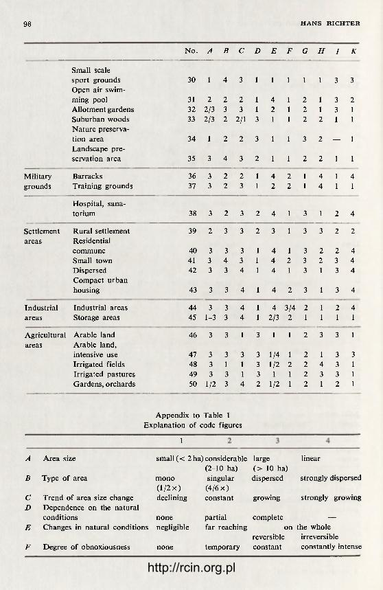
98 H A N S R I C H T E R
No. A B c D E F G H I K
Small scale sport grounds 30 1 4 3 1 1 1 1 1 3 3 Open air swim-ming pool 31 2 2 2 1 4 1 2 1 3 2 Allotment gardens 32 2/3 3 3 1 2 1 2 1 3 1 Suburban woods 33 2/3 2 2/1 3 1 1 2 2 1 1 Nature preserva-tion area 34 1 2 2 3 1 1 3 2 — 1 Landscape pre-servation area 35 3 4 3 2 1 1 2 2 1 1
Military Barracks 36 3 2 2 1 4 2 1 4 1 4 grounds Training grounds 37 3 2 3 1 2 2 1 4 1 1
Hospital, sana-torium 38 3 2 3 2 4 1 3 1 2 4
Settlement Rural settlement 39 2 3 3 2 3 1 3 3 2 2 areas Residential
commune 40 3 3 3 1 4 1 3 2 2 4 Small town 41 3 4 3 1 4 2 3 2 3 4 Dispersed 42 3 3 4 1 4 1 3 1 3 4 Compact urban housing 43 3 3 4 1 4 2 3 1 3 4
Industrial Industrial areas 44 3 3 4 1 4 3/4 2 1 2 4 areas Storage areas 45 1-3 3 4 1 2/3 2 1 1 1 1
Agricultural Arable land 46 3 3 1 3 1 1 2 3 3 1 areas Arable land,
intensive use 47 3 3 3 3 1/4 1 2 1 3 3 Irrigated fields 48 3 1 1 3 1/2 2 2 4 3 1 Irrigated pastures 49 3 3 1 3 1 1 2 3 3 1 Gardens, orchards 50 1/2 3 4 2 1/2 1 2 1 2 1
Appendix to Table 1 Explanation of code figures
1
A
B
C D
E
F
Area size
Type of area
Trend of area size change Dependence on the natural conditions none Changes in natural conditions negligible
Degree of obnoxiousness none
small (< 2 ha) considerable large linear (2-10 ha) (> 10 ha)
mono singular dispersed strongly dispersed 0 /2 x) (4/6 x) declining constant growing strongly growing
partial complete — far reaching on the whole
reversible irreversible temporary constant constantly intense
http://rcin.org.pl
C H A N G E S IN L A N D D E V E L O P M E N T 99
Susceptibility to natural and none/negli-technological disfunctional gible influences from the surroundings
H Dependence of functions in proximity of a city
I Change of function with the existing technological facilities retained
K Possibility of technological conversion
imperative
possible
differen-tiated
high on whole
the
historically imperative and condi-
tional conditionally impossible possible
conditional
complete low ex- high ex-penditure penditure involved involved
conditional low ex- high expenditure penditure involved involved
dispersed — analogical with space proportions of a rural settlement network (average distance = 2 km)
at the cost of the arable land, involves substantial expendi ture in order to t ransform or to dispose of the remnants of the earlier fo rm of utilization. Such a land use change is sometimes out of the question. The existing s t ruc ture of land use in large portions of a per ipheral zone brings about the same difficult ies of land use conversion which confront the city itself. Table 1 demonstrates the different ia t ion of evaluating the disadvantages according to the individual land use elements.
The above problems of the per ipheral zone are still more aggravated due to its earl ier mentioned funct ions of regional or even supraregional range and also due to external factors. The numerous fo rmer deep coal mines with their many decade long af ter-effects of devastation, and b rown coal strip mines as well as mines for extraction of other valuable minerals, all combine to compli-cate the present pat tern of land development wi thin the per ipheral zones of Leipzig and Halle. Pollution of air and of surface waters in the vicinities of these cities is still aggravated by industr ial waste, originat ing mainly f rom districts si tuated to the South and West of Leipzig and Halle.
CHANGES OF LAND DEVELOPMENT PATTERNS
The land improvement pat tern of any area is subject to continuous chan-ges. The above changes are the result of:
a) the annual cycle of weather ; b) other episodic phenomena due to various na tu ra l (i.e. climatic) or tech-
nological (e.g. damages) factors; c) continuous changes of land use. All the th ree above mentioned aspects are of consequence as concerns the
inner per ipheral zone, the most important of them being land use changes. Differences in the land development pat terns that a re due to the seasonal
weather cycle are of pr ime importance in agricul tural land use in the case of municipal wa te r supply and sewage systems, in t ransportat ion, and in util iza-tion of local recreational areas.
They are manifested by the degree of pollution of air wi th gas and dust. Thus, in cases of cyclone weather , due to the high degree of air turbulence, a considerable expansion of area affected by emissions generated by industry
http://rcin.org.pl

100 H A N S RICHTER
and t ransportat ion is noted. This causes, in fact, a reduct ion of emission values per square uni t in absolute terms, but — spread over considerably larger area. During periods of anti-cyclonic weather , the dust sedimentat ion is limited to smaller areas around the emission sources with resul t ing higher degrees of pollution. At the same t ime, due to a reduced exchange action wi thin the atmospheric basic s t ra tum at reduced wind velocities, exhaust expand over larger areas. Penetra t ion ranges and intensities are inf luenced each t ime by
of Leipzig, 1960-1971 (based on the city map of ca 1 : 15,000) Changes from agricultural to other land uses: I — h o u s i n g projects , 11 — s t o r e y h igh; 2 — hous ing projects , 5 — s t o r e y h igh; 3 — h o u s i n g projec t s , II — s t o r e y h igh w i t h a c c o m p a n y i n g fac i l i t i e s ; 4 — t e m p o r a r y h o u s i n g projec t s ; 5-7— a l l o t m e n t g a r d e n s , part ia l ly over m i n i n g grounds ; 8 — w a s t e d u m p , up to 40 m he ight , s l opes par t ia l ly s t a b l e ; 9 — w a s t e dump, up to 10 m he ight , part ia l ly o v e r g r o w n ; 10 — gardens ; 11 — orchards Other changes within agricultural land area: 12 — s ta t ionary i rr igat ion fac i l i t i e s ; 13 — r e c e n t co l lapse of m i n i n g grounds , par t ia l ly f i l l ed w i t h w a t e r ; 14 — e x h i b i t i o n grounds ; 15 — w a s t e land in v i c i n i t y of a g r a v e l pit; 16 — a f f o r e s t r y of d e v a s t a t e d agr icu l tura l land area; 17 — a f f o r e s t r y of d e v a s t a t e d agr icu l tura l land area on a b a n d o n e d m i n i n g s i tes;
Others: 18 — mine heap, slope stabilization, exhibition buildings A — Hous ing , B — A l l o t m e n t gardens , C — Waste dumps , D — Orchards , a f f o r e s t i n g , E — Waste land , F — Area of i n t e n s e c u l t i v a t i o n , G — pos i t ion of 1960, H — c h a n g e s a f t e r 1960
http://rcin.org.pl

C H A N G E S I N L A N D D E V E L O P M E N T 101
the ra te of emissions and si tuation of the emission sources as to their height over the ground level.
The episodic occurrences include sudden weather breaks, heavy rainfalls , as well as excessively long t ime periods wi thout rainfal l . Fur the rmore they include ext remely long t ime periods of ice cover and of ice dr i f t over r ivers and art if icial wa te r sheets, ex t remely low wa te r level or overflooding in cases of high wate r in rivers, long lasting and abundan t snowfall during frost pe r -iods, etc. The ext reme wea ther conditions t r igger a great many effects wi th in the areas in question. They resul t in considerable disturbances over the city per ipheral zone due to the h igh variabil i ty of land use. Such disturbances require high f inancial expendi ture unti l b rought under control.
It should be mentioned at this point, tha t af ter a 100-year period dur ing which par ts of the city and of the per iphera l zone of Leipzig situated within the valley of the Weisse Elster and Pleisse r ivers had been endangered by floods, no h a r m f u l high wate r tide has been noted there since 1954. This is the result of a systematic development of retention reservoires and wa te r storage projects wi thin the drainage basin of those r ivers over the past 25 years.
TABLE 2. Loss and recovery of agricultural land (in %). The district (Bezirk) of Halle: 1954-1969 After G. Hesse, 1970
Type of land-use change Halle Saal Merseburg Halle Type of land-use change (city) (Kreis) (Kreis) (Bezirk)
Mining 0.2 32.0 23.6 26.0 Industry 14.5 6.0 15.0 10.2 Solid waste dumping grounds 3.5 5.0 9.7 5.0 Agricultural production facilities 3.9 9.8 5.7 12.7 Housing 49.5 2.1 11.8 11.0 Water economy, partially forestry 19.9 15.1 12.5 12.7 Vacant and waste land 3.0 11.1 26.7 15.7 Others1 3.0 16.0 18.6 16.3
Loss ( —) Recovery ( + ) due to land-use change2 12.5 2.9 -23.6 -9 .3
Total area loss 100.0 100.0 100.0 100.0
Total area (ha) 1217 1918 3862 24,538 1 Areas used for recreation, sport, training purposes. 2 Agricultural areas occupied temporarily by other uses, e.g., by the construction of underground pipelines, tempo-
rary construction sites, also land reclaimed for agriculture. Example: Within the district (Bezirk) of Halle about 9.3 % of former farming land have been reclaimed by agriculture. At the same time 12.9% of agricultural land have been temporarily occupied by other uses.
Emergency cases in industr ia l production, as occurring in the fo rm of the fa i lures of t r ea tment plants for gas and dust emissions, of leaks in tanks and pipe lines, of leaks out of agr icul tural silos, etc., br ing temporary and also some-times more long-lasting effects upon the land development pat tern .
A specific fea ture of the land development dynamics in the per ipheral zone consists in the continuous change of land utilization. The t rend towards the augmenta t ion of both the number of units to be located, and of the area covered by them, is represented by certain, al though not all, categories of t ranspor ta -tion, and by the types of uses related to wate r protection and water utilization,
http://rcin.org.pl

102 H A N S R I C H T E R
housing, industry, storage, as well as the disposal and/or t rea tment of liquid and solid waste, and the extract ion of minerals for building industry. A decre-asing tendency, on the other hand, is characterist ic of some local recreat ional areas, the agricul tural areas, and part ial ly — forest areas situated near a city. A specific, growing importance is also represented by the reclamation of was te dumping grounds, of abandoned strip mines, and ul t imately the redevelopment of housing and industr ial areas under socialist reconstruction programmes. All this adds up to a total t ransformat ion of land development pa t te rns within areas of varying size. The mutua l ly reinforcing processes result in growing advantages of the inner per ipheral zone as well as in some of its disadvan-tages. The agr icul tural arable land, as shown in Table 2, present the most essential reserve for land use t ransformat ions wi thin the per ipheral zone and within isolated mining and industr ial districts. This means f rom the angle of land development within the city per ipheral zone not solely a diminishing of the agricultural production. Development of fo rmer fa rming areas cause changes in the spatial proport ions more and more towards the disadvantages of vacant land. In paral lel and in conjunction with the specific characteristics of the local recreational areas the open fa rming lands are of an essential impor-tance for the recreation as well as for absorbing noise, odour and dusts. This is why the reduction of fa rming lands is accompanied by the growing need for planned and developed grounds for daily and week-end recreation which should not to be situated ever f u r t h e r f r o m the city area.
DEVELOPMENT TRENDS WITHIN THE INNER PERIPHERAL ZONE
The changes occurring within the per iphera l zones under observation over t ime periods shorter than a decade allow to d raw conclusions concerning cer-tain t rends for the planned development of the land utilization pat terns .
1. Expansion of funct ional interrelat ions between the city core and its inner per ipheral zone is tr iggered by the technological progress, by the social develop-ment and by the changing demands of man with respect to his environment , as well as the production with respect to na tura l resources broadly conceived.
2. The location selection is determined par t ly by the na tura l conditions (sewage t rea tment plant — by slope; building mater ials — by the location of deposits; water power plant — by alt i tude; construction project — by the type of building grounds and ground wate r table). To a major par t this is also preconditioned by present land use, e.g., in the case of development of housing estates, of road network, and of industr ial areas. As far as the varying precon-ditions are concerned, there is a possibility that space scattering of the per iph-eral zone still increases. It m a y result in a decrease of the effect ivi ty of the land development pat tern . On the other hand, this explains the fact of growing expenditures aimed at the levelling-off spatial disproportions at the reclamation of the waste and devastated land of various type.
3. The city per ipheral zone wi th its specific forms of expansion is as old as the city itself. It can be observed that even smaller, par t ly ru ra l set t lements develop such "areal growth forms", at least for the dumping of solid wastes, for the construction of sewage t rea tment plants, etc. This is why wi th in one or more generat ions the cities have been reaching beyond their fo rmer per ipheral zones.
The more scattered, however, are the areas of a high development value, with important inf ras t ruc tura l facilities or a high ra te of change of the original na tura l environment, within the per iphera l zone, the more difficult is the solu-tion of tasks related to the spatial growth of a city. This is t rue of development
http://rcin.org.pl

C H A N G E S IN L A N D D E V E L O P M E N T 103
of compact housing and industr ial projects, as well as related t ransportat ion facilities and local recreational areas. This means either assembling land for such projects via the costly rehabili tat ion of extensive areas which involve pulling down (or making functionally obsolescent) certain facilities of consider-able inves tment value, or leap-frogging the present per ipheral zone in the course of city expansion. In the latter case the areas of the former , peripheral zone remain wi thin the expanded buil t -up area in the form of islands of an insufficient s tandard of funct ional utili ty. Thus, they present areas of poten-tial disfunctions within the land development pa t t e rn of the growing city. At the same t ime they constitute a factor of a disproportional growth of the buil t-up area. Thus, one must give consideration at a t ime when there is still a suff icient area available for the expansion of the per ipheral zone, to the needed changes in land use and the incorporation of still stable par ts of the per ipheral zone into the city. An essential contribution to the shaping of the optimal land development pa t te rn would be effected in such cases not by subsequent rehabil i tat ion of former , uneff icient and piecemal development, but already at the stage of planning of such complicated and dynamic types of areas.
Martin-Luther University, Halle-Wittenberg
BIBLIOGRAPHY
Billwitz, K., Jänkel, R., 1971, Die Flächennutzungskarte von Halle und Halle-Neustadt als Grundlage für die Erarbeitung von Nutzungseinheiten (HNE), Halle.
Billwitz, K., Mücke, E., 1970 and 1971, Die Flächennutzung der Stadtrandzone von Halle/Halle-Neustadt, Halle.
Brause, G., 1964, Entwicklungsprobleme in der Stadtrandzone Leipzigs, Wiss. Z. K. — M. Univ. Leipzig, Math. — Nat. R., 13, 3.
Grundmann, L., Schmidt, H., 1971, Tendenzen und Leitvorstellungen für eine lang-fristige Entwicklung der Territorialstruktur der Ballungsgebiete im Süden der DDR, Halle (Thesis).
Hesse, G., 1970, Ausmass und Verwendung der von 1954 bis 1969 im Bezirk Halle abgegangenen bisher landwirtschaftlich genutzten Flächen, Wiss. Z. M. — L.Univ., Halle-Wittenberg, 19, 6.
Kanow, E., 1956, Probleme der Stadtrandzone, dargestellt am Beispiel einiger Auf-baustädte, Städtebau und Siedlungswesen, 3.
Krause, K. — H., Richter, H., 1971, Zur begrifflichen Klärung territorialer Mehr-fachnutzung, in: Probleme der Flächennutzung bei der Entwicklung der Terri-torialstruktur, Vorträge der 3. Arbeitstagung des FV Berufsgeographen der Geogr. Gesell, d. DDR, Leipzig.
Kress, S., 1971, Tendenzen der Veränderung der Städtestrukturen und der städ-tischen Flächennutzung in der DDR, in: Probleme der Flächennutzung bei der Entwicklung der Territorialstruktur, Vorträge der 3. Arbeitstagung des FV Berufsgeographen der Geogr. Gesell, d. DDR, Leipzig.
Richter, H., 1964, Der Boden des Leipziger Landes, Wiss. Veröff. Dtsch. Inst. Län-derk., N.F., 21/22.
Scholz, D., 1964, Die Siedlungen des Leipziger Landes, Wiss. Veröff. Dtsch. Inst. Länderk., N.F., 21/22.
Scholz, D., 1965, Die Industrie im Ballungsgebiet Halle-Leipzig, Leipzig (Thesis).
http://rcin.org.pl

http://rcin.org.pl

G E O G H A P H I A P O L O N I C A 30, 1975
R E C R E A T I O N A L A R E A S W I T H I N T H E B E R L I N A G G L O M E R A T I O N *
HEINZ SPITZER
INTRODUCTION
The successful development of our socialist state, part icularly its economic development dur ing the recent years, has ensured all the citizens more leisure time. This has been due to the reduction of working hours, shift ing to the f ive-day working week, the extension of the min imum durat ion of annual vaca-tions, and to other measures. The socialist society, which regards the man and his mater ia l and cultural needs as its focal point, has to take care of the rational and purposeful utilization of leisure t ime by each person according to his needs and according to general social possibilities. Leisure t ime should not only allow to regenerate energy but also to contribute to the development of the socialistic personality, individual abilities and talents. The socialist society has to prove its superiori ty in relation to capitalism not only to the field of eco-nomic productivi ty but also by providing the opt imum conditions for every citizen with regard to the use he makes of his leisure time.
Daily and weekly recreation is of a great importance as concerns use being made of leisure time. It is of part icular concern for the inhabitants of agglome-rations who are exposed to such specific burdens and disfunctions as growing t raf f ic intensity, deterioration of the environment , etc.
The Geographical Section of the Humboldt-Universi ty of Berlin was enga-ged dur ing the past three years in the practical research project carried on for the Administrat ion of the city of Greater Berlin and per ta ining to the problem of near-distance (i.e. daily, weekly) recreation within the agglomeration of the capital. The aim of the research was to examine and to present the require-ments resulting f rom the na ture of the regenerat ion process especially the rat ional spatial organization of recreation. A part icular task was to propose a model of optimal relations between the spatial pa t te rn of work and residence and the distr ibuton of local recreational areas within the Berlin agglomeration.
The main points of the above research were among others: — determinat ion of the demand for near-distance recreation; — determinat ion and evaluation of the capacities of the existing recrea-
tional facilities; — determinat ion of mobility of inhabi tants with view to near-distance
recreation. A group headed by the author was assigned the task of compiling a large-
scale general map covering the local recreational area within the Berlin agglo-
* This article is an extended comment to a map of recreational zone of Berlin. The map is not being enclosed for technical reasons.
http://rcin.org.pl

106 H E I N Z S P I T Z E R
meration. The map has to show the existing capacities, facilities and the accessi-bility of Berlin's local recreational areas. The map covered all areas situated within the range of 90-minute t ravel t ime by local public transportat ion.
LIMITATION OF RESEARCH AREA
The area represented on the map covers all communes situated within the 90-minute t ravel t ime by public local t ransporta t ion f rom the centre of Berlin. The distance was calculated f rom a line which was represented by the sector between the stations Ostkreuz and Schönhauser Allee of the metropoli tan sur-face rai lway. This stretch of the Berlin metropol i tan surface rai lway (S-Bahn, former ly termed Ringbahn — circular rai lway) encloses essentially the core area of the inner city1 and it provides the most rapid access for the inhabitants of the city centre to the major i ty of local recreation areas wi thin and beyond the city. The t ime required to reach this sector of the rai lway f rom any point of the municipal core area by local public t ransportat ion, like a street car, a bus or the subway (U-Bahn) amounts to no more than 10 minutes on the average. The t ime to reach any local recreation area by the metropoli tan surface rai l-way has been determined within the dura t ion of 10 minutes. The isochrones plotted on the map represent therefore the distance f rom the sector of the rei lway between the stations Ostkreuz and Schönhauser Allee, less 10 minutes s tar t time. Transfer t ime for changing the means of t ransportat ion has been determined at 5 minutes within and 10 minutes beyond the city as average. With the t ime-table valid for all the local public t ransporta t ion it has proved possible to single out the four zones of accessibility of local recreational areas within the agglomeration of Berlin:
1. zone situated wi thin 15 minutes t ravel time; 2. zone situated between 15-30 minutes t ravel t ime; 3. zone situated between 30-60 minutes t ravel time; 4. zone situated between 60-90 minutes t ravel time. The limits of the t ime zones present the basic element of the map content.
They continue the presentat ion area, while giving hints as concerns essential interrelat ions between the demand for local recreation, a t t i tude towards the distance barr ier and the degree of the recreation demand being met. The upper limit of 90 minutes walking t ime distance has been determined by a question-aire. A clear 60% of those questioned have named destination areas that were accessible wi thin approximately 90-minute time. The outer limit of the area under examinat ion reflects a cumulation of holiday travels by the inhabi-tants of Berlin.
DETERMINATION OF LOCAL RECREATION DEMAND
The determinat ion of the number of potential holiday travels was based on the cartographic representat ion of the actual capacity and utilization of the local recreation areas. In Berlin, the capital of the GDR, the present estimations show that up to 35% inhabi tants seek local recreation and head, over the week-ends, for the local recreation areas wi th in and beyond the city. Those looking for off- t ime and week-end recreation account, according to the research accom-plished by a team of the city administrat ion, for 8-10% of the entire population
1 The capital district of the GDR, Berlin, incorporates the three structural types of sub-regions — the inner core area, the core surrounding zone, the city peripheral zone — each representing specific local recreation requirements. See also A. Zimm, H. Rumpf and J. Lange (1971).
http://rcin.org.pl

R E C R E A T I O N A L A R E A S 107
as regards the off-t ime, and for 30-35% thereof as regards the week-end recrea-tion (Zimm, et al., 1971, p. 783). When related to the present population total of 380,000 inhabi tants in search of recreation. With view to the communes sur-rounding Berlin, it has been assumed tha t the f igure of those in search for recreation in local areas in industr ial communes and in those of more than 5000 inhabi tants amounted to no less than 20% of inhabitants. As concerns rura l localities and those below 5000 inhabitants , the f igure of 12% has been accepted as the basis for the estimation of the number of local recreation seekers. According to the above representat ion, the area presented on the map has been based on the isochrone of 90-minute t ravel t ime by local public t rans-portat ion as f rom the city centre of Berlin. The area situated between the limits of the city of Berlin and the outer limit of the 90-minute zone is inha-bited by 427,000 people. With the 20% or 12% rate, this results in 86,000 recre-ation seekers. The total of the potential recreation seekers within area exami-n e d — the capital of Berlin together wi th its surroundings (population 1.5 million) — amounts to 465,000 people. The above f igure helps to visualize the scope and importance of the task of optimizing spatial relations within the local recreation areas of Berlin, for the benef i t of the man.
The capital of the GDR, Berlin, ranks among those f ew large cities offer ing highly advantageous local recreation possibilities within the city area. The south-eastern outskirts of the city enclose, e.g., the forest and lake region of the Grosser and Kleiner Müggelsee which is highly at t ract ive f rom the stand point of landscape qualities and very well suited for local recreation purposes. This fact has the effect tha t a considerable par t of the Berlin local recreation seekers remains over the week-ends wi thin the city boundaries. Some 46%
TABLE 1. Local recreation demand balance within the Berlin agglomeration — as related to the zone of 90-minute travel time by local public transportation from the city centre
Area Population Recreation seekers
Sub-regions
1. Berlin 1.1. Including commuters 2. Towns and communes within
the 30-60 minute isochrone 3. Towns and communes
within the 60-90 minute isochrone
Sub-regional total
sq.km
403.1
1,028.7
2,508.8
in 1000's total
in 1000's
1,081.9
228.7
198.6 4,012.6 1,509.2
378.7 204.5
46.5
39.8
465.0
bath demand in 1000's
2 2 6 . 2 122.7
27.9
23.9
278.0
out of the assumed 380,000 recreation seekers of the capital t ravel to the exten-sive local recreation areas within the city, while nearly 54% of this number look for recreation beyond the city boundaries.2
Water sports, water touring, and above all bathing are of great importance as concerns local recreation within the agglomeration of Berlin. It is estimated tha t at least 60% of visitors of the local recreation areas take open air baths. The advantageous possibilities of bathing in the open as offered by Berlin and the environments of the city effectively add to increase the attractiveness of its recreat ion areas.
2 See also O. Gloger (1966).
http://rcin.org.pl

108 H E I N Z S P I T Z E R
WATER AREAS IN THE LOCAL RECREATION LANDSCAPE WITHIN THE BERLIN AGGLOMERATION
Water areas are of great importance as an element of the local recreation landscape within the Berl in agglomeration. The recreation value of more than 100 lakes within the area depends, apar t f rom other factors, on the qual i ty of water and on the uti l i ty values of the lake shore.
The categories of bathing qualities according to the directives of the water management authorit ies of the GDR, as concerns the pur i ty of surface waters and principles of their classification are the following:
Quality class Characterist ics I par t icular ly clean waters
II normal waters III polluted waters IV use of waters forbidden
Quali ty class I water is suitable basically for all use, and meets highest bathing requirements . Quali ty class II water is moderately polluted, it is not suited to the municipal supply requirements , while still offering bathing possi-bilities. Quality class III characterizes polluted water , still suitable for various industr ial purposes, but only par t ly suitable for bathing. Water with an imper-missible degree of pollution, wi thin the quali ty class IV, offers no normal hydro-biologic self-purif ication potential, and is off- l imits for any bathing purposes.
Only a few out of the more than 100 lakes wi thin the area examined demon-strate features of the quali ty class I. The overwhelming major i ty fall under the quali ty class II. It should, however , not be ignored at the same t ime that a great par t of the "normal wa te r s" tends towards the quali ty class III, i.e., the polluted waters. The ra the r f r equen t draining non-treated or insufficiently t reated sewage into the waters , has resulted, together wi th the large-scale water fowls breeding, to affect the bathing possibilities of certain lakes in a negative way. The socialist Land Management Bill of the GDR that was passed in 1970, presents a decisive legal basis for the reclamation, maintenance and expansion of effect ive recreational potential of the nature . It also sets controls for fu r the r pollution of waters of par t icular importance f rom the standpoint of local re-creation.
BATHING CAPACITIES AND BATHING DEMAND
As concerns the determinat ion of the bathing capacity of waters, the value of 6-10 sq.m. of the lake shore per bathing person has been accepted as the s tar t ing point wi th regard to large area waters with in- and outflow, wi th the average depth within the near-shore zone of up to 50 m (Gloger, O., 1966, p. 34). Any overcrowding beyond the above limit, over a long time, by local recrea-tion seekers, would have a deter iorat ing effect, and in ex t reme cases even forfei t of the recreational qualities of waters or a sector of the shore in question.
Within the area examined the bathing capacity of all waters amounts ap-proximately to 60,000 persons, while accepting the above specified average density as the basis. Near ly half (44.6%) out of this f igure falls to the southern vicinities, while eastern (29.1%) and nor thern (26.3%) account each for some 1/4 of the total bathing capacity. The present capacity as concerns the bathing potential under a normal density, is confronted by the max imum demand of 160,000 persons.
http://rcin.org.pl
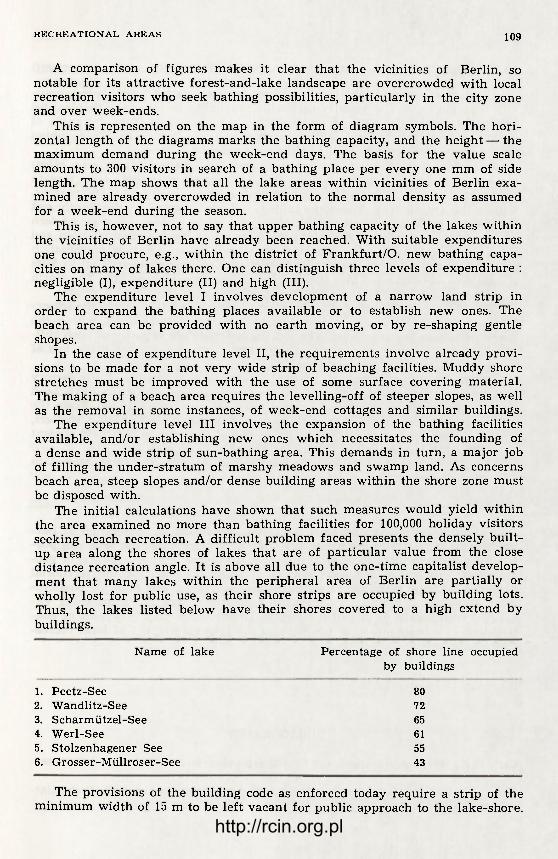
R E C R E A T I O N A L A R E A S 109
A comparison of f igures makes it clear tha t the vicinities of Berlin, so notable for its at tract ive forest-and-lake landscape are overcrowded with local recreation visitors who seek bathing possibilities, part icular ly in the city zone and over week-ends.
This is represented on the map in the fo rm of diagram symbols. The hori-zontal length of the diagrams marks the bathing capacity, and the height — the maximum demand during the week-end days. The basis for the value scale amounts to 300 visitors in search of a bathing place per every one mm of side length. The map shows that all the lake areas within vicinities of Berlin exa-mined are a l ready overcrowded in relation to the normal density as assumed for a week-end during the season.
This is, however, not to say that upper bathing capacity of the lakes within the vicinities of Berlin have already been reached. With suitable expenditures one could procure, e.g., within the district of F rankfu r t /O . new bathing capa-cities on many of lakes there. One can distinguish three levels of expendi ture : negligible (I), expendi ture (II) and high (III).
The expendi ture level I involves development of a na r row land strip in order to expand the bathing places available or to establish new ones. The beach area can be provided wi th no ear th moving, or by re-shaping gentle shopes.
In the case of expendi ture level II, the requirements involve already provi-sions to be made for a not very wide strip of beaching facilities. Muddy shore stretches must be improved with the use of some surface covering material . The making of a beach area requires the levelling-off of steeper slopes, as well as the removal in some instances, of week-end cottages and similar buildings.
The expendi ture level III involves the expansion of the bathing facilities available, and/or establishing new ones which necessitates the founding of a dense and wide strip of sun-bathing area. This demands in turn, a major job of fil l ing the under -s t ra tum of marshy meadows and swamp land. As concerns beach area, steep slopes and/or dense building areas within the shore zone must be disposed with.
The initial calculations have shown that such measures would yield within the area examined no more than bathing facilities for 100,000 holiday visitors seeking beach recreation. A diff icult problem faced presents the densely buil t -up area along the shores of lakes that are of par t icular value f rom the close distance recreation angle. It is above all due to the one-t ime capitalist develop-ment tha t many lakes wi thin the per ipheral area of Berlin are partially or wholly lost for public use, as their shore strips are occupied by building lots. Thus, the lakes listed below have their shores covered to a high extend by buildings.
Name of lake Percentage of shore line occupied by buildings
1. Peetz-See 2. Wandlitz-See 3. Scharmützel-See 4. Werl-See 5. Stolzenhagener See 6. Grosser-Müllroser-See
80 72 65 61 55 43
The provisions of the building code as enforced today require a strip of the min imum width of 15 m to be lef t vacant for public approach to the lake-shore.
http://rcin.org.pl

1 1 0 H E I N Z S P I T Z E R
FACILITIES FOR LONG-TERM RECREATION WITHIN THE AREA EXAMINED
The area is noted for the local and long-term recreation forms being mutu-ally superimposed. The vicinity of Berlin abounding in forests with plent i ful and enchanting waters, offers many established at tract ions f rom the angle of providing facilities for vacationeering-camping sites, fac tory and t rade union owned accommodations as well as children's vacation camps.
A steadily increasing importance is represented by the camping sites offer -ing admit tance to visitors f rom all of the GDR as well as to those f rom foreign countries. The camping sites have at present a total capacity of 31,000 persons, wi th in the entire area. The top ranking one are si tuated to the South and South-East of Berlin. They stretch along the lakes wi th in the south-eastern district of the city, and fu r the r into the districts of Königs Wusterhausen and Fürs tenwalde . They are incorporated into the large-area na tu re preservation grounds expanding f rom the Berlin district of Köpenick eas twards up to F ü r -s tenwalde and southward into the district of Teupitz — Gross-Köris. The North is sparsely used for camping sites in comparison with the above districts.
Apar t f rom the camping sites, it is the children's vacation camps the impor-tance of which increases, as far as long-term recreat ion facilities within the Berl in vicinities are concerned. The total accommodation capacity of such chil-dren ' s vacation camps amounts to 20,000, and most of them are made use of groups of visitors dur ing the season.
During the recent years, also the accommodation capacities of the factory and t rade union owned facilities within the vicinities of Berl in have been great ly expanded. They offer at present the total capacity of 10,000. F rom the angle of long-term recreation for the young youth hostels, hiking shelters, tourist shelter homes, and other facilities are of importance. At their present t ime their total capacity is 1600 within the area examined.
The total of accommodation offered by facilities for long- term recreation amounts to nearly 62,000.
SUMMARY
The questions concerning local recreation within the agglomerat ion of Ber-lin, presented brief ly in the paper, help to make it clear tha t the task of a pur -poseful development of local recreation would require the part icipat ion of geo-graphical sciences. In the development of scientific basis for the terr i torial p lanning thematic maps are of considerable importance. The mul t ip le p o s s i b i -lities of applying methods of thematic car tography are f a r f rom being ex-hausted with regard to this field of work. The thematic m a p is capable of con-t r ibut ing as a basic means of planning to the rat ional shaping of local recrea-tion management .
Humboldt University, Berlin
BIBLIOGRAPHY
Carl, F. E., 1960, Betrachtungen zur Erholungsplanung in der DDR, Dsche Gartenar-chit., 4.
Gloger, O., 1963, Probleme der Erholungsplanung im Bezirk Frankfurt/O., Dsche Gar-tenarchit., 3.
http://rcin.org.pl

R E C R E A T I O N A L A R E A S 111
Gloger, O., 1965, Zur Planung von Naherholungsgebieten unter Berücksichtigung der Erfahrungen bei der Auswertung der Gebietsprogramme Schwedt und Eisen-htittenstadt, Dsche Gartenarchit., 3.
Gloger, O., 1966, Versuch einer Bilanz der Naherholung am Beispiel des Bezirkes Frankfurt/O, Dsche Gartenarchit., 2.
Greiner, J. et al., 1968, Stadtnahe Erholungsgebiete, Städtebau und Architektur, 19, Berlin.
Hendl, M. et al., 1971, Zur räumlichen Ordnung in Erholungsgebieten (Verallgemeine-rungen aus siner Untersuchung im Kreis Königs Wusterhausen), Wiss. Z. Hum-boldt-Univ. Berlin, Math.-nat. R., 20, 4/5.
Hendl, M. et al., 1971, Theoretische Untersuchungen zur Methodik der Aufnahme und zur Bewertung von Seeuferregionen im Umland der Hauptstadt Berlin für die Zwecke der Naherholung mit Hilfe eines Kennziffern-Systems, Wiss. Z. Hum-boldt-Univ. Eerlin, Math.-nat. R., 20, 4/5.
Handl, M. et al., 1971, Das Erholungsgebiet Kothen, Kreis Königs Wusterhausen — ein Beitrag zur funktionellen Gliederung eines isolierten Erholungsgebietes am Aussensaum der Naherholungsgürtels einer Agglomeration, Wiss. Z. Humboid-Univ. Berlin, Math.-nat. R., 20, 4/5.
Jacob, G., 1968, Modell zur regionalen Geographie der Fremdenverkehrs, Geogr. Ber., 1.
Möbious, D., Nietz, B., 1971, Zur Problematik der territorialen Beziehungen zwischen den Funktionen Arbeiten, Wohnen und Erholen, dargestellt am Naherholungsge-biet Wuhlheide. Wiss. Z. Humboldt.-Univ. Berlin, Math. nat. R., 20, 4/5.
Rumpf, H., Janus, M., Analyse und Entwicklungsmöglichkeiten der Naherholungsbe-dingungen an der Spree im Bereich des Gebietes Oberschöneweide unter Berück-sichtigung der Ufernutzung, Wiss. Z. Humboldt-Univ. Berlin, Math.-nat. R., 20, 4/5.
Wagner, G., 1966, Die Ausstattung der Erholungsgebiete der DDR mit Ferienunter-künften, Geogr. Ber., 4.
Wehner, W., 1967, Die potentiellen Naherholungsbereiche der Ballungs- und Dicht-gebiete der DDR, Dsche Gartenarchit., 4.
Zimm, A., Rumpf, H., Lange, J., 1971, Studie zu territorialen Problemen der Repro-duktion der Arbeitskraft — dargestellt am Beispiel des Wirtschaft- und Lebens-gebietes der Hauptstadt der DDR, Berlin, Wiss. Z. Humboldt-Univ. Berlin, Math.-nat. R., 20 4/5.
http://rcin.org.pl

http://rcin.org.pl

G E O G H A P H I A POLONICA 30, 1975
S T R U C T U R E A N D D E V E L O P M E N T T R E N D S O F T H E C R A C O W A G G L O M E R A T I O N
BRONISŁAW KORTUS
The Cracow urban- industr ia l agglomeration includes the city of Cracow (586,000; 120,000 industrial employees in 1970) and a f ew other industr ial towns: Skawina (population 15,900), Wieliczka (13,600) Niepołomice (5200) and others, with a total employment in industry of over 10,000.
The Cracow agglomeration ranks f i f th in Poland in population size and four th in regard to the number employed in industry (Table 1). It is relatively
TABLE 1. Poland's largest urban-industrial agglomerations, 1966
Urban-industrial agglomerations Population Employment in (in thousands) industry
(in thousands)
1. Upper Silesian 2718 725 2. Warsaw 1623 295 3. Łódź 905 263 4. Gdańsk 600 100 5. Cracow 560 115 6. Wrocław 492 97 7. Poznań 480 103
Source: S. Leszczycki, P. Eberhardt, S. Hefman, Aglomeracje miejsko-przemyslowe w Polsce 1966—2000 (Urban-industrial agglomerations in Poland 1966—2000), Biul. KPZK PAN, 67, Warszawa 1971. Data for Cracow agglomeration calculated by the author.
TABLE 2. The development of industry in the Cracow agglomeration, 1938-1970 (according to the number of employed in industry)
The city of Cracow's Cracow Years Cracow satellites Agglomeration
(in thousands) (in thousands) (in thousands)
1938 20,7 3,4 24,1 1946 28,7 3,4 32,1 1956 78,2 6,8 85,0 1960 89,5 8,5 98,0 1965 104,5 9,6 114,1 1970 120,0 10,5 130,5
8 G e o g r a p h i a P o l o n i c a http://rcin.org.pl
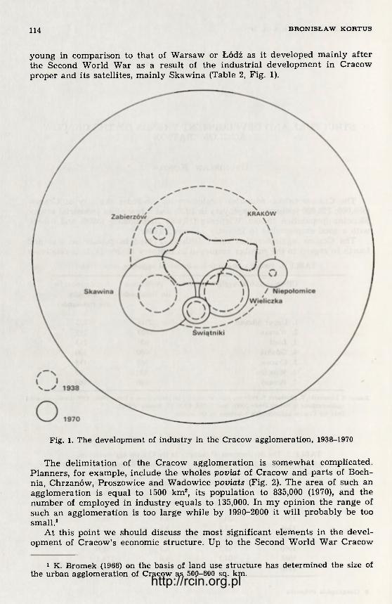
114 B R O N I S Ł A W K O R T U S
young in comparison to that of Warsaw or Łódź as it developed mainly af te r the Second World War as a result of the industr ial development in Cracow proper and its satellites, mainly Skawina (Table 2, Fig. 1).
Fig. 1. The development of industry in the Cracow agglomeration, 1938-1970
The delimitation of the Cracow agglomeration is somewhat complicated. Planners, for example, include the wholes poviat of Cracow and par ts of Boch-nia, Chrzanów, Proszowice and Wadowice poviats (Fig. 2). The area of such an agglomeration is equal to 1500 km2, its population to 835,000 (1970), and the number of employed in industry equals to 135,000. In my opinion the range of such an agglomeration is too large while by 1990-2000 it will probably be too small.1
At this point we should discuss the most significant elements in the devel-opment of Cracow's economic structure. Up to the Second World War Cracow
1 K. Bromek (1966) on the basis of land use structure has determined the size of the urban agglomeration of Cracow as 500-600 sq. km. http://rcin.org.pl

Fig. 2. Cracow urban-industrial agglomeration 1 — agglomeration boundaries, 2 — voivodships boundaries, 3 — poviats boundaries, 4 — main rail-roads http://rcin.org.pl

116 B R O N I S Ł A W K O R T U S
was mainly a centre of education, science, art , and place of historical monu-ments. Its industr ial funct ions lagged fa r behind service, t rade, educational, cultural, tourist functions. Historical t radit ion was the dominant force. During the postwar period, however, significant changes in Cracow's economic s t ruc-ture took place. In 1931 the number of people employed in industry and con-struction was equal to 32.6%. of the total number of people employed in Cra-cow. In 1950 it was already 44.2%. By 1960 it was equal to 53.4% and in 1970 to 57%. Cracow became a large industr ia l centre and a huge construction site. The number of people employed in indust ry and handicraf t went up f rom 30,000 in 1938 to 120,000 in 1970; that is four times. The population of the city doub-
Gross production value
(1950= 100)
Fig. 3. The growth of industry in Cracow, 1938-1970
led during that period f rom 260,000 to 586,000. In 1970 Cracow ranked third among Polish cities in regard to the number of population. Those facts and f igures point to the dynamic development of Cracow during the pos twar period. No other city in Poland, with the exception of Warsaw, did undergo such dy-namic development. Industry was the driving force of Cracow's growth, and to-day it is one of the most impor tan t funct ions of the city. This however does not mean that Cracow lost its t radi t ional functions. It is the country 's second cultural and scientific centre and one of Europe's ma jo r tourist centres.
http://rcin.org.pl

CRACOW A G G L O M E R A T I O N 117
The development of Cracow after the Second World War was the function of its industrial development. If we take the percentage of people employed in industry as an index of industrialization, it would mean that the industrializa-tion level of Cracow went up from 10% to over 21% during the years 1938-1970 (Fig. 3). The rapid industrialization as it is widely known, has been a char-acteristic feature of the postwar Poland. While, however, the index of indus-trial growth (measured according to production value) during 1950-1970 was equal to 760 for the country as a whole, it amounted to 2100 in the case of War-saw, 1300 for Cracow, 795 for Wrocław, 733 for Poznań and 440 for Łódź. The postwar industrialization of Cracow was much faster than that of other Polish cities (except Warsaw) and it was twice faster than the national average.
The main component in the industrialization of Cracow was the Lenin Steel Works, the biggest industrial investment in People's Poland. Out of its more than ten locations considered the one near Cracow was selected due to such fac-tors as: proximity of Silesian coal, the presence of the Upper Silesia-Cracow-Przemyśl-USSR railway line through which coal and iron ore are supplied and large reserves of manpower in the nearest hinterland. Apart f rom that Cra-cow's scientific institutions, particularly the Mining and Metallurgical Academy could provide qualified personnel and research facilities. The proximity of lar-ge city and the cultural centre was also an important factor f rom the point of view of the social adaptation of migrants to urban conditions of living and work. In 1946-1960 migrations to Cracow amounted to 100,000 persons, out of which 60% came from rural areas.
In 1973 the Lenin Steel Works produced 6.5 million tons of steel, 50% of the national total. Over 30,000 people are now employed in the still expanding Works.
Thus the Lenin Steel Works became the dominant element of Cracow's in-dustrial structure. Its share in total industrial employment is equal to 26% and in value of industrial production — 46%.
Apart f rom the Lenin Works about 20 large and 50 smaller industrial plants were constructed in Cracow since 1945. A number of already existing factories were expanded. As a result Cracow became one of the biggest industrial centres in Poland, ranking after Upper-Silesia, Warsaw and Łódź. The industrial struc-ture of Cracow has been also subject to major change (Table 3). Before the Se-cond World War machinery (31.2% employed), food processing (28% employed) and chemical industry (10% employed) were dominating. The metallurgy, which was added to the three traditional branches, became today dominant one. Ac-cording to the location index which reflects industrial specialization, Cracow is a significant metallurgical (5.4) and printing centre (3.0). It also specializes in chemical, electrical engineering and leather industries. However, the role of machinery, paper, textile, and food processing industries diminished in com-parison to that in 1938. According to the principles of comtemporary industrial s tructure a decline in the machinery and electrotechnical industries (1.4 to 0.8 and 3.5 to 1.3) is a negative phenomenon. It was caused by the fact that prio-r i ty was given to steel industry, while other branches were relatively negle-cted.
In comparison with Wroclaw and Poznań, cities similar to Cracow in size and function, Cracow's machinery and electrical engineering industry accounts for a small percentage of its industry, only 19.2%. In Poznań, Wrocław and Warsaw the above mentioned percentage is accordingly 51.5%, 54,8% and 55.3%. The situation in Łódź is similar to that in Cracow (19.8%). That is why the contribution of the so-called "new branches" (electrical engineering, che-mical) to industry as a whole is equal to 66% and 64% in Poznań and Wrocław
http://rcin.org.pl
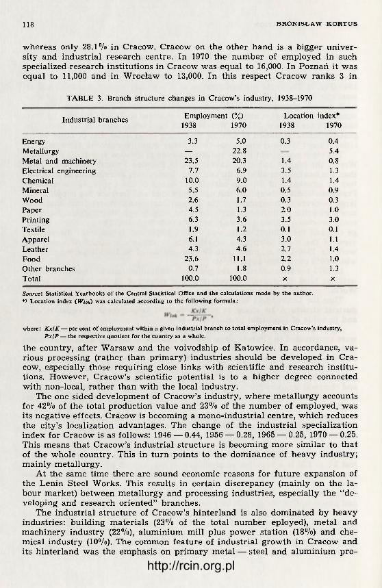
118 B R O N I S Ł A W K O R T U S
whereas only 28.1% in Cracow. Cracow on the other hand is a bigger univer-sity and industr ial research centre. In 1970 the number of employed in such specialized research institutions in Cracow was equal to 16,000. In Poznań it was equal to 11,000 and in Wrocław to 13,000. In this respect Cracow ranks 3 in
TABLE 3. Branch structure changes in Cracow's industry, 1938-1970
Industrial branches Employment (%) 1938 1970
Location index* 1938 1970
Energy 3.3 5.0 0.3 0.4 Metallurgy — 22.8 5.4 Metal and machinery 23.5 20.3 1.4 0.8 Electrical engineering 7.7 6.9 3.5 1.3 Chemical 10.0 9.0 1.4 1.4 Mineral 5.5 6.0 0.5 0.9 Wood 2.6 1.7 0.3 0.3 Paper 4.5 1.3 2.0 1.0 Printing 6.3 3.6 3.5 3.0 Textile 1.9 1.2 0.1 0.1 Apparel 6.1 4.3 3.0 1.1 Leather 4.3 4.6 2.7 1.4 Food 23.6 11.1 2.2 1.0 Other branches 0.7 1.8 0.9 1.3 Total 100.0 100.0 X X
Source: Statistical Yearbooks of the Central Statistical Office and the calculations made by the author. *> Location index (W/o*) was calculated according to the following formula:
where: Kx/K — per cent of employment within a given industrial branch to total employment in Cracow's industry, Px\P — the respective quotient for the country as a whole.
the country, a f te r Warsaw and the voivodship of Katowice. In accordance, va-rious processing (rather than pr imary) industr ies should be developed in Cra-cow, especially those requiring close links with scientific and research inst i tu-tions. However, Cracow's scientific potential is to a h igher degree connected with non-local, r a ther than with the local industry.
The one sided development of Cracow's industry, where meta l lurgy accounts for 42% of the total production value and 23% of the number of employed, was its negative effects. Cracow is becoming a mono-industr ia l centre, which reduces the city's localization advantages. The change of the industr ial specialization index for Cracow is as follows: 1946 — 0.44, 1956 — 0.28, 1965 — 0.25, 1970 — 0.25. This means that Cracow's industr ial s t ructure is becoming more similar to tha t of the whole country. This in tu rn points to the dominance of heavy industry; mainly metal lurgy.
At the same t ime there are sound economic reasons for f u t u r e expansion of the Lenin Steel Works. This results in certain discrepancy (mainly on the la-bour market) between metal lurgy and processing industries, especially the "de-veloping and research oriented" branches.
The industr ial s t ructure of Cracow's hinter land is also dominated by heavy industries: building mater ials (23% of the total number eployed), metal and machinery indust ry (22%), a luminium mill plus power station (18%) and che-mical industry (10%). The common fea tu re of industr ia l g rowth in Cracow and its hinter land was the emphasis on pr imary metal — steel and aluminium pro-
http://rcin.org.pl

C R A C O W A G G L O M E R A T I O N 119
duction. In 1970 the Lenin Steel Works (together with its cement plant) and the a luminium mill at Skawina accounted for 30% of the total number of in-dustr ial employees and 50% of the production value within the agglomeration. Therefore, the Cracow agglomeration is undoubtedly specializing in metal lurgy. In 1972 it produced 45% of the country 's steel and 51% of its aluminium.
TABLE 4. Cracow — structure of employment, 1970
Branches of economy Employment
(in thousands) 0 / / 0
National economy (total) 330.6 X
Non-private sector (total) 307.6 100.0 industry 114.3 37.1 construction 60.5 19.6 agriculture and forestry 1.9 0.3 transportation 24.0 7.8 trade 26.3 8.5 education, science, culture 33.3 10.8 others (health service, admini-
stration, etc.) 39.9 15.9
Source: Statistical Yearbook of Cracow 1971, MUS, Kraków 1971.
An impor tant locational characteristic of Łódź and Warsaw agglomerations is their situation in the centre of the country; in the case of Cracow an equiv-alent factor is its p roximi ty to the Upper-Silesian Industr ia l District. This fact main ly has de termined the industrial s t ructure and the ra te of growth of the Cracow agglomerat ion. In the industr ial s t ructure there prevails the heavy, resource-oriented indus t ry (the iron-consuming metal and machine industry, metal lurgy, building mater ia ls industry, soda and artificial ferti l izer produc-tion), the development of which is based on the Upper-Silesian coal and metal-lurgical base.
During the intensive period of the country 's industrialization a f te r the Se-cond World War, Cracow as a per ipheral industr ial centre of that type, acquired a number of industr ial investments which the Upper-Silesian Industr ial District was unable to accomodate. The localization of steel and aluminium works in Cracow and it 's satelli te centre, Skawina, is a concrete example of a policy of passive deglomerat ion in regard to the Upper-Silesian Industr ial District (ac-cording to a fo rmer plan the steel works were to be loacated near Gliwice and the a luminium works in Jaworzno, both within the Upper Silesia-agglome-ration).
The index of spatial po tent ia l 2 can be used to i l lustrate Cracow's size as an industr ia l centre in comparison with other big industr ial centres of Poland. Table 5 and Figure 4 contain the appropr ia te results.
It may be stated tha t Cracow's industr ial potential measured by the value of f ixed assets in indus t ry is second only to the Upper Silesian potential. The t radi t ional ly applied index-value of fixed assets in indust ry — M puts Cracow's indus t ry as being 5 t imes smaller than that of Upper-Silesian District (20:100), b u t in terms of the index of spatial potential — V Upper-Silesia 's ascendency
2 Cf. Z. Chojnicki, Zastosowanie modeli grawitacji i potencjału w badaniach przestrzenno-ekonomicznych (Sum.: The application of gravity and potential mo-dels in spatial economic research), Studia KPZK PAN, 14, Warszawa 1966.
http://rcin.org.pl
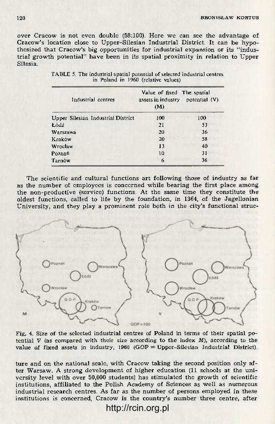
120 B R O N I S Ł A W K O R T U S
over Cracow is not even double (58:100). Here we can see the advantage of Cracow's location close to Upper-Silesian Industr ial District. It can be hypo-thesized tha t Cracow's big opportunit ies for industr ial expansion or its " indus-tr ial g rowth potent ial" have been in its spatial proximity in relation to Upper Silesia.
TABLE 5. The industrial spatial potential of selected industrial centres in Poland in 1960 (relative values)
Industrial centres Value of fixed
assets in industry (M)
The spatial potential (V)
Upper Silesian Industrial District 100 100 Łódź 21 53 Warszawa 20 36 Kraków 20 58 Wrocław 13 40 Poznań 10 31 Tarnów 6 36
The scientific and cultural funct ions ar t following those of indus t ry as fa r as the n u m b e r of employees is concerned while bear ing the first place among the non-product ive (service) functions. At the same time they consti tute the oldest funct ions, called to life by the foundation, in 1364, of the Jagellonian Universi ty, and they play a prominent role both in the city's funct ional s t ruc-
Fig. 4. Size of the selected industrial centres of Poland in terms of their spatial po-tential V (as compared with their size according to the index M), according to the value of fixed assets in industry, 1960 (GOP = Upper-Silesian Industrial District).
t u re and on the national scale, wi th Cracow taking the second position only a f -ter Warsaw. A strong development of higher education (11 schools at the uni-vers i ty level with over 50,000 students) has st imulated the growth of scientific insti tutions, aff i l iated to the Polish Academy of Sciences as well as numerous indust r ia l research centres. As f a r as the number of persons employed in these inst i tut ions is concerned, Cracow is the country 's number three centre, a f te r
http://rcin.org.pl

CRACOW A G G L O M E R A T I O N 121
Warsaw and the Katowice voivodship. With the post-war development of in-dustry and construction Cracow became an important scientific and research centre meeting the needs of southern Poland's coal mining and other industries. The territorial range of Cracow's influence as a centre of university education, the science and cultural functions encompasses entire Southern Poland. In the West it meets the corresponding zone of influence of Wroclaw (in the Opole voivodship) and that of Warsaw in the North (in the Kielce voivodship), while in the East Cracow's sphere of influence encompasses the Rzeszów and part of the Lublin voivodship.
Another function of Cracow on a supra-regional, national and to a large extent international scale is it's function as a tourist centre. The tourist move-ment to Cracow which in the inter-war period stood at about 80,000 persons per year, has passed presently the 2,000,000 persons per year mark. Foreign tourists constitute about 10% of the total number of visitors.
The following elements make Cracow a major tourist attraction: — numerous and well preserved historical and art monuments; — widely known cultural institutions, especially museums containing valu-
able and varied collections; — the proximity to such tourist centres as the National Park of Ojców, the
Wieliczka Salt Mine and the Oświęcim (Auschwitz) Museum of Martyrology; — a convenient location f rom the transportation point of view. There are 713 historical monuments in Cracow, both secular and sacral —
a record number in comparison to other Polish cities. Out of Poland's 52 mo-numents graded in the "0" group, that is monuments of the highest artistical and historical value on an international scale, Cracow has 11, outnumbering by far Poland's remaining regions and cities.
Finally, Cracow's transportation function is also one of supra-regional im-portance. It 's railroad junction, the airport and part ly its highway junctions are of national importance.
The expansion of city's economy and population has caused a substantial in-crease of transportation demand. A new complex of railroad terminals has been established in the eastern part of the city to handle the transportation needs of the Lenin Steel Works. It is connected by a new by-way with the Upper-Silesian-Przemyśl railroad by-passing the city. The total transport volume was 34.7 million tons in 1972 (the in-coming tonnage was 25 million tons). In this aspect Cracow is ahead of Poland's other railroad junctions, with the exception of course, of the Upper-Silesia. About 70% of Cracow's goods transportation is connected with the Lenin Steel Works (26 million tons in 1970).
Intraregional flows (within the Cracow voivodship) account for about 20% of total tonnage handled, while inter-regional flows (to other voivodships) ac-count for 55% (in this Katowice voivodship for about 30%) and flow to and f rom abroad — for about 25%. These proportions confirm the existence of strong economic linkages of Cracow on the national and international scale.
About half of Cracow's railroad and bus passenger trips are attributed to home-to-work commutation. The large labour deficit due to the constant devel-opment of industry and construction makes this kind of commutation neces-sary with 50 thousand (in 1970) persons travelling daily there and back. Af te r Warsaw, it is the highest number of commuters within a single city in Poland.
The ranges of this commutation in the Western (up to Krzeszowice) and East-ern (up to Bochnia) directions clearly demarcate the Cracow agglomerations sphere of influence from that of Upper-Silesia and Tarnów. In the Southern and Northern directions Cracow's commutation ranges are fairly small, and
http://rcin.org.pl
122 B R O N I S Ł A W K O R T U S
in the South most of the commutation is headed in the direction of Skawina and Wieliczka.
Within Cracow's close vicinity there exist several small industrial centres which might be called it's "industrial satellites" (Wieliczka, Skawina, Niepoło-mice, Zabierzów and others). Like in Cracow, the industrial growth of these towns is mainly a post-war phenomenon. Skawina, where in 1954 Poland's first aluminium mill was erected and later a big power station (570 MW), has devel-oped the most. Wieliczka on the other hand gradually ceases to be Cracow's industrial satellite. Its salt mine is nearly exhausted thus Cracow's soda plant takes its brine from a more distant Bochnia. Wieliczka's historic mine is presen-tly mainly a tourist attraction as well as a health resort (an anti-asthmatic sa-natorium). However, as a town Wieliczka is still Cracow's satellite since over 6000 persons (40n/o of the total population) commute daily from there to Cracow.
We should bear in mind that in the near fu ture Cracow's strong and vigo-rous industry will cause the establishment and development of fur ther indus-trial centres in it's vicinity. For a few years now we may observe in Cracow — as in other large industrial centres — difficulties in the fur ther development of industry due to labour shortages, a deficit of water and so on. One of the ways of overcoming these difficulties is the establishment of branches of Cra-cow's larger industrial plants in the voivodship area where labour force is still available, that is mainly in its Eastern and Southern parts. In 1968 there was established in Bochnia a branch of the Lenin Steel Works. In the years 1969-1970 branches of other factories, producing transportation equipment, meas-urement apparates, etc. were established in Sucha, Limanowa and other places. The development of the Tin Plate Packing Factory in Brzesko was based on plate produced in the Lenin Steel Works. The voivodship authorities encourage other large industrial plants which meet growth thresholds within the city to establish branches in smaller towns of the voivodship. This is undoubtedly the right kind of policy since it is in accord with the deglomeration policy of Cra-cow's industry as well as with the policy of stimulating economic expansion in less developed areas. In the plants that have been established as a result of the deglomeration policy of Cracow's industry by 1972 about 3000 persons were employed.
The spatial growth of the agglomeration of Cracow is headed in the Western (Trzebinia) and Eastern (Bochnia-Tarnów) directions along important transport lines: the Upper-Silesia-Cracow-Rzeszów-Przemyśl electric railroad and high-way and the natural gas pipeline. The Eastern direction of expansion must be regarded as proper and it is stimulated by appropriate localizational decisions — in places like Bochnia, Brzesko and others. The same cannot be said about the Western direction where the growth should be stopped. The area situated be-tween Cracow and the Upper-Silesian Industrial District is especially attractive for industrial development due to the already existing technical infrastructure (transport, energy and other lines) as well as a possibility of cooperation with both the industries of Upper-Silesia and Cracow. But an integration of the Cracow agglomeration of over 700,000 inhabitants with that of Upper-Silesia with its over 2 million population should not be allowed. Such an occurrence would worsen the bioclimatic, health and sanitary conditions in that area. The Cracow voivodship aims at preserving the biological protective zone between Cracow and Upper-Silesia, that is, agricultural and forest areas which are in-dustrialized only to a very small degree. The fu ture joining of the Upper-Sile-sian and Cracow agglomerations is unavoidable but the connecting area should be as narrow as possible — in other words — only along the transport routes.
The spatial development of the agglomeration core — Cracow — will head http://rcin.org.pl

CRACOW A G G L O M E R A T I O N 123
beyond the city's present adminis trat ive boundaries. All the vacant land between Nowa Huta and old Cracow as well as at the out-skirts of the city's present terr i tory will soon be used up. The city's fu tu re development in the Eastern direction is closed by the Lenin Steel Works, while development in the Northern direction is not advisable because of valuable soils there. In the Western direction the terra in is part ly unsuitable for construction, and on the other hand, it is part ly occupied by atractive recreation areas, which should be protected. Thus, there remains only the Southern direction which is designated for the city's urban development. The present satelli te-towns of Skawina and Wieliczka will probably be incorporated into the city.
The indust ry of the Cracow agglomeration needs serious reconstruction and modernization of its branch structure. As we saw before, the post-war develop-ment was mostly characterized by the growth of the basic, heavy industries — mainly steel and aluminium works. These works were accompanied by building mater ia ls plants (a cement plant in Nowa Huta, br ickworks and concrete plant in Cracow and Skawina). Thus independently of a fu r the r expansion of the Le-nin Steel Works (what should part ly be accomplished by way of deglomeration of its certain sections outside of Cracow) the processing industries, especially machinery and electrical engineering, should be developed more vigorously, using the considerable local scientific and research base.
Lately, more and more attention is being paid, within the agglomeration and its surroundings, to the protection of man's environment .
Due to the location of a large par t of the city in the valley of the Vistula river, Cracow has a very unfavourable micro-climatic conditions. Because of a lack of winds there often may be observed a smog residue over the city. It should be aimed, of course, at limiting or eliminating the sources of pollution. The Lenin Works have some marked achievements in this field. It has limited air pollution and the pollution of the Vistula r iver by sewage. Nevertheless, the mill still constitutes a threat to the Niepołomice Forest which lies more to the East. The industry as well as communal heat ing system should gradually switch f rom coal to na tura l gas which will be supplied by the pipeline f rom the Rze-szów voivodship (lately natural gas has also been discovered in the Bochnia area).
The Upper-Silesian Industrial District, especially its Eastern part, still con-st i tutes a danger as the pollution of air and water in the Cracow agglomera-tion is concerned. Due to Western and North-Western winds which are domi-nant in this area much of Upper Silesian smoke and dust reaches Cracow. Also the Vistula r iver is polluted by the industry of the Katowice voivodship (mainly through the Przemsza river) and by the industry of the Western par t of the Cra-cow voivodship.
Jagellonian University, Cracow
SELECTED BIBLIOGRAPHY
Bromek, K., 19C6, Użytkowanie ziemi w Krakowie i przyległych częściach powiatu krakowskiego około 1960 r. (Land use in Cracow and in the surrounding parts of the Cracow poviat by 1960), Zesz. Nauk. UJ, Prace Geogr., 14 Kraków.
Bromek, K., Kortus, B., 1972, Rozwój, funkcje i struktura przestrzenna Krakowa (Sum.: Cracow: evolution, functions rendered, spatial structure), Czas. Geogr., 43, 2.
http://rcin.org.pl

124 B R O N I S Ł A W K O R T U S
Kortus, B., 1968, Kraków jako ośrodek przemysłowy (Cracow as an industrial centre), Zesz. Nauk. UJ, Prace Geogr., 19, Kraków.
Kortus, B., 1969, Some selected problems of the development and structure of Cra-cow industry, Geogr. Pol., 16, Warszawa.
Kraków. Rozwój miasta w Polsce Ludowej (Cracow: Its development in People's Po-land), Warszawa 1971.
Studia geograficzne rozwoju i gospodarki miasta Krakowa (Geographical studies on the development and the economy of Cracow), Fol. Geogr., ser. geogr.-oecon., 1. Kraków 1969.
Warszyńska, J., Kortus, B., 1967, Struktura ekonomiczna i powiązania przestrzenne Krakowa w świetle przewozów towarowych (The economy of Cracow and its spatial links in the light of commodity flows), Biul. KPZK PAN, 44, Warszawa.
http://rcin.org.pl

GEOGHAPHIA POLONICA 30, 1975
C O M M U N E C A T E G O R I E S . A M E T H O D O F D E T E R M I N A T I O N O F C O N D I T I O N S A N D T E N D E N C I E S I N T H E H A L L E - L E I P Z I G
A G G L O M E R A T I O N
CHRISTA ROSENKRANZ
The problem of long-term formation of the set t lement ne twork plays an im-portant role in the f ramework of research on spatial s t ructure. It is necessary in the socialist system that a planned set t lement ne twork is based upon the fol-lowing objectives:
— continuous improvement of labour and living conditions of the working class;
— increase of national income. The increasing importance of solving the problems connected with rat ional
formation of the sett lement ne twork may be i l lustrated by the fact that all the socialist countries deal wi th those questions with special emphasis laid on:
— improvement of the hierarchic system of macrost ructure of the sett le-ment network. It is planned that 3-4 fundamenta l ranks will build up the s t ruct-ure of a set t lement network, i.e., supra-regional centres, regional centres, smal-ler centres and other sett lements;
— determining scientifically based commune (Gemeinde) categories 1 as f u n -damental for the long-term development, taking into consideration terri torial differencies.
The aim of this paper is to give an account to the problem of commune ca-tegories. To achieve this the following points have to be clarified:
— demonstrat ion of a method of evaluating the commune categories accord-ing to di f ferent ia l factors in the field of spatial s t ructure;
— definit ion of spatial differences within communal categories on the basis of s t ructural type of an agglomeration;
— presentat ion of long-term development tendencies for the par ts of agglom-erations corresponding with spatial d i f ferent ia t ion of commune categories.
This research has been conducted in the District of Halle which constitutes a ma jo r par t of the Halle-Leipzig agglomeration. Possessing near ly all spatial types it is a good object of research in the f r amework of given themes.
1. THE RANK-SEQUENCE METHOD OF CATEGORIZATION OF COMMUNES
The rank-sequence method is based upon the quantif icat ion of different ly se-lected qual i tat ive categories through a r ank number . The choice of factors (ca-tegories) for each commune is grounded upon the following premisses:
1 The research could be feasible only on a basis of commune being the smallest unit covered by statistics. The division into communes and settlements is not iden-tical; in some cases parts of individual settlements may be situated within adminis-trative boundaries of communes.
9 Geographia P o l o n i c a http://rcin.org.pl

126 C H R I S T A R O S E N K R A N Z
— a settlement as place of peoples' habitance, of production and processing for extended reproduction of socialist economy is a multi-shaped whole;
— settlements are elements of a settlement system thus having certain tasks (functions) to fulfill, which later on leads to different economic ability of each spatial unit and contribute to the development potential of a commune;
— the actual economic potential of a settlement, formed by its most impor-tant structural units — infrastructure, structure of production, structure of pop-ulation and structure of natural resources — co-acting complexively, eventu-ally results from the substantial abilities of productive and cultural centres (Fig. 1).
The following elements have been selected as the crucial qualitative catego-ries for the evaluation of the present economic abilities of a settlement and its development potential:
Fig. 1. Schematic presentation of social and geographical relations of a settlement within the settlement system
http://rcin.org.pl

COMMUNE CATEGORIES 127
1. Transportation linkages between communes in 1970/1971; 2. Structure of housing in 1966/1967 and in 1965/1966; 3. Degree of provision of services in 1971; 4. Types of functions in 1971; 5. Potential labour force in 1964; 6. Industrial productivity in 1971.
1. T R A N S P O R T A T I O N L I N K A G E S B E T W E E N COMMUNES IN 1970/1971
Transportation linkages are a result of the density of the public means of transport (rail, bus lines) within a commune and its external ties. They also re-sults from the frequency of service multiplied by the number of the correspond-ing lines of public transportation. In all highly developed industrial countries transportation is:
— condition of the increase of productivity and the growth of material production;
— an effect of material production through the movement of people and objects engaged in the process of production;
— a fundamental condition of the movement of people for recreational and educational purposes that is purposes related to the utilization of leisure time in the broad sense.
Therefore, the transportation may be treated as a measure of securing the socialist working and living conditions.
2. STRUCTURE OF H O U S I N G IN 1966/1967 A N D IN 1965/1966
The structure of housing can be illustrated by the percentage of houses with gas, water and sevage lines. The structure of housing has to be considered a basis for estimating the economic potential of a settlement, because with age-ing of houses their quality becomes unsatisfactory or just unsuitable to meet the requirements of extended reproduction in the socialist society. However, the technical equipment of dwellings is a precondition for the modern way of life.
3. DEGREE OF P R O V I S I O N OF SERVICES IN 1971
It is a coefficient resulting from the following indices: — number of employees in the fields other than the material production; — number of inhabitants; — types of functions. The value of the coefficient reflects the regional importance of a settlement.
Generally, its regional importance grows with the increasing degree of ser-vice provision, recreational settlements being exception to this rule.
As regards an economic utlization of the existing resources, this coefficient should be considered in the process of the rational shaping of the whole settle-ment system.
4. T Y P E S OF FUCTION IN 1971
The classification of functions is related to the classification of industrial establishments for statistic purposes. They cover the following branches of the national economy:
— transport, communication; — trade; — other production branches; — services;
9* http://rcin.org.pl
128 CHRISTA R O S E N K R A N Z
— cultural and social establishments; — state administration, social organizations. The types of functions and the settlement size are in close connection, i.e.,
the greater the number of functions the better the conditions of meeting perio-dical or incidental needs of the settlement's inhabitants.
5. P O T E N T I A L L A B O U R FORCE IN 1964
Potential labour force of a commune is a measure which allows to determ-ine the economic potential of a settlement. Taking into consideration the "un-healthy" age structure of the population in GDR, this coefficient is presently an important element in estimating the development potential.
6. I N D U S T R I A L P R O D U C T I V I T Y IN 1971
The index of industrial productivity encompases the following elements: — resident population; — productive capacity of individual establishments; — employment in industry. This index differentiates the communes characterized by industrial produc-
tion and evaluates them according to their share in the total of production. Each of the given indices has been supplied with a rank number; the bet-
ter quality given the higher value origining from the sum of settlements in an examined area. An equal quality is marked with the same rank number while the next lower levels are arranged respectively. With the lack of any of the given features within an order of numbers the quantification takes place only in respect to those communes in which that feature occurs. The total sum of rank number represents the existing economic potential of a commune with an exception of cultural potential.
Since the economic potential of a settlement is in close connection with its size and economic structure, it might be thus used to evaluate and outline the categories of communes.
On the basis of statistical frequency, the following five categories of com-munes have been developed in the case of the area under investigation:
Commune category Development trends
The advantage of the rank-sequence method consists in the fact that differ-ent qualitative categories can be looked upon as a whole which gives an oppor-tunity of evaluating the economic potential of a commune according to given capacity ranges, as well as of comparing them with each other. Subjective judgement is thus eliminated and a determination of basic factors by the way of factor analysis would more exactly define the resulting evaluation.
1 2
Commune with population decrease Stagnative communes with a conditional viability in long-term perspective Stable communes, which as a rule will form elements of settlement complexes with development perspecti-ves Communes with conditional dynamics Communes with gradually changing dynamics of popu-lation
3
4 5
http://rcin.org.pl

C O M M U N E C A T E G O R I E S 129
All c o m m u n e s can then , no m a t t e r w h a t t he i r spa t ia l a f f i l i a t i on is, be t r e -a ted , e x a m i n e d and devided in to specif ic t ypes of economic areas , t he s a m e m e t h o d st i l l be ing appl icable .
A d i s a d v a n t a g e of th is m e t h o d is t h a t it r e f e r s to t h e ex i s t ing level of q u a l -i ty w h i c h leads only to a r e l a t ive eva lua t ion of t he d e v e l o p m e n t po ten t i a l of a c o m m u n e . T h e me thod is t h o u g h appl icab le in t h e ana lys i s of sys t ema t i c com-m u n e ca tegor ies of t he d i f f e r e n t types of economic a reas . I t i nc ludes the fo l -lowing points :
— accounts f o r specific local f ea tu re s ; — prov ides a leading l ine as f a r as t e m p o r a l l y and spa t ia l ly co-ord ina ted
d e v e l o p m e n t of i n v e s t m e n t policy is concerned ;
Commune categories (•)
A system 'Agglomeration
Agglomeration core
Fig. 2. Territorial differentiation of commune categories in the system "Agglome ration"
http://rcin.org.pl

130 C H R I S T A R O S E N K R A N Z
— marks the set t lements in which shor t - term means of improvement of living s tandard are necessary.
2. SPATIAL DIFFERENTIATION OF COMMUNE CATEGORIES PRESENTED ON THE BASIS OF THE HALLE-LEIPZIG AGGLOMERATION (HALLE PART)
The Agglomeration It is formed by a spatial cluster of communes wi th a relatively high devel-
opment potential. It shows a specific di f ferent ia t ion of commune categories corresponding to the spatial s t ruc ture of production. It shows a decline of pro-ductive development potential of communes f rom the core towards the periph-eral area. This decline may be variable depending on d i f fe ren t inter-regional relations of the par ts of area.
The Agglomeration Core The agglomeration core corresponds to commune category 5, i.e., to the com-
munes of macro-s t ructure . While, in te rms of accessibility and t ransportat ion links, the degree of the provision of services and the number of functions it outstrips by far — all the other settlements, the qual i ty of its housing should be improved. The agglomeration core is a large city itself.
The Agglomeration Field L. Grundmann and H. Schmidt distinguished three sub-types of that area
which are reflected in the spatial different ia t ion of commune categories. Agglomeration fields wi th dominance of p r imary industry are at present
characterized by the highest industr ial potential a f t e r the agglomeration core in the examined area. Commune categories 3 and 4, i.e., stable and relatively dynamic ones, dominate in tha t terr i tory, while category 3 communes are char-acterized by a peripheric situation and have, on the average, up to 3000 in-habitants, the category 4 communes are centrally situated. The number of their inhabi tants varies as a rule between 3000 and 10,000 people. This sub-type is characteristic through its band- or r ibbon s t ructure which is especially apparent in the case of self-sufficient communes.
At this type of area there is a lways a central town of medium-size with a -bout 20-50,000 inhabi tants and wi th certain economic potential which is a basis including it into the category 5 of communes.
Agglomeration fields wi th no industry of a ma jo r importance are formed mainly by category 2 communes. Communes of categories 3 and 4 are relati-vely rare; if so, they are central places of a small regional importance. Gen-erally, in the areas adjoining these central places there are communes with population decrease.
Agglomeration Peripheral Area The per ipheral areas of agglomeration are not homogeneous as f a r their eco-
nomic s t ruc ture is concerned. In Halle District all three sub-types of peripheral areas of agglomeration are present (L. Grundmann and H. Schmidt). Areas with an independent production profi le are characterized by the most effective economic links of all commune categories within this type. The characteristic features of those areas are:
— a middle-size town (with population of about 20-50,000 inhabitants) be-longing to category 5 surrounded by relatively well economically developed communes of category 3 and 4;
— a limited number of category 1 communes with weak development po-tential.
Per iphera l areas wi thout a dominant industrial branch are character-ized by:
http://rcin.org.pl
C O M M U N E C A T E G O R I E S 131
— more or less industr ia l ly developed central town of category 5 or 4 which at the same t ime is surrounded- by communes with a relat ively sizeable poten-tial;
— a high number of small communes of category 1 (declining communes); Per iphera l areas wi th agr icul tural s t ruc ture possess: — a centre which is usually formed by a small town or a group of small
towns of complementary functions; this centre corresponds to the development potential of the level 4;
— show an absolute predominance of category 1, i.e., declining communes.
3. TENDENCIES OF LONG-TERM DEVELOPMENT OF SUB-AREAS OF AGGLOM-ERATION BASED UPON THE SPATIAL DIFFERENTIATION OF COMMUNE CATEGORIES
Agglomeration Core By long-term planning of economic development the advantages of the ag-
glomeration core should be utilized, advantages resulting f rom its large city char-acter, specially f rom the quali ty and quant i ty of inf ras t ructure . Agglomera-tion cores have been reconstructed and adapted to modern socialist town model. At the same t ime their population constantly increases. Through their own specific development processes they influence the size and the level of devel-opment of other towns wi thin the agglomeration system and par t ly — other surrounding areas.
Agglomeration Field Agglomerat ion field dominated by p r imary industry. Middle-size towns of this sub-type, depending on the direction of develop-
ment represented by the agglomeration core, will be characterized by d i f feren-tiated dynamics. The impor tan t impulses are the adoption of specialized func -tions being t rans fe r red f rom the core and the re inforcement of central funct ions per formed for their own umlands.
Central ly located communes show the population increase only in excep-tional cases, i.e., w hen a small town is planful ly developed into a central place. As a rule, the s t ruc ture and quali ty of housing should be improved through modernizat ion and conservation and the t ransportat ion network expanded. High economic potential is the basis for a fu r the r industr ial development specific for the par t icular area. The per iphera l communes should be revaluated in a long-term perspective par t icular ly f rom the point of view of quali tat ive changes in the housing and the improvement in t ransportat ion. Populat ion increase in this case is not to be aimed at.
In the f r a m e w o r k of the economic utilization of inf ras t ruc tura l equipment single central places may be characterized by a slow population increase. The measures aimed at long- term development of the s tagnant communes should be oriented towards the expansion of t ransporta t ion networks and the impro-vement of housing.
The inhabi tants of communes in the state of stagnation should — in reason-able proport ion — be moved up to the agglomeration core.
Agglomeration peripheral area Agglomerat ion per iphera l area wi th independent production profi le and dom-
ination of one industr ia l branch. The middle-size towns show diversified population t rends while their ma-
terial and product ive potentials are in the process of intensive growth. The neighbouring communes of category 3 and 4 may become stagnant in te rms of population numbers , a l though their funct ional relations with middle-size towns
http://rcin.org.pl

132 C H R I S T A R O S E N K R A N Z
should be s t renghtened by the growth of t raf f ic f requency and modernization and conservation of housing.
The inhabi tants of communes in the state of s tagnation should be par t ly lo-cated in their terr i torial centres, but mostly in the agglomerat ion core.
Other peripheral areas Small towns being already at present central places and centres of area ty-
pes will remain, as a rule, the terr i torial centres of m a j o r importance. They should nevertheless be characterized by a population dynamics in exceptional cases in the f r amework of a fu l l economic utilization of newly constructed or expanded inf ras t ruc ture . The inhabi tants of s tagnant communes should be ma-inly oriented towards the agglomeration core.
The set t lement pa t te rn wi th in agglomerations will have a heterogeneous character . While the agglomeration cores are characterized by a dynamic growth of population and the t ransformat ions of city plans and archi tecture through the reconstruction of areas extending f rom the centre towards per iphery and they s t imulate the development of all other communes, the other m a j o r settle-ment centres possess lower dynamics. Only some of the middle-size towns, par -ticularly those situated within the agglomeration field and its per ipheral area and which have an independent production profile, can experience a higher pop-ulation increase. In all other communes, with a developed level of population activity, the improvement in housing qual i ty and t ranspor ta t ion should be achieved.
Major means to increase the central place product ive potential should be directed (in addition to agglomeration cores and middle-size towns) only to small u rban centres.
Martin-Luther University, Halle-Wittenberg
BIBLIOGRAPHY
Grundmann, L., Schmidt, H., Tendenzen und Leitvorstellungen für eine langfristige Entwicklung der Territorialstruktur der Ballungsgebiete im Süden der DDR — untersucht am Beispiel der Bevölkerungs-, Arbeitskräfte- und Industriestruktur, Halle 1971.
Mohs, G., Bedingungen und Tendenzen der Entwicklung von Ballungsgebieten in der DDR im Prognosezeitraum, Ber. Dtsch. Ges. Geol. Wiss., R. A.: Geologie und Paläontologie, 16 (1971), 6.
Ryazanov, V., Markov, E. et al., Kleine Städte — Probleme ihrer städtebaulichen Entwicklung im Siedlungssystem, in: Schriftenreihe der Bauforschung, Reihe Städtebau und Architektur, 32. Deutsche Bauinformation, Berlin 1970.
http://rcin.org.pl

G E O G H A P H I A P O L O N I C A 30, 1975
L O C A L E N E R G Y B A L A N C E I N U R B A N A N D I N D U S T R I A L E N V I R O N M E N T
JANUSZ PASZYŃSKI
INTRODUCTION
During the last several years living conditions of a large par t of our pop-ulation have undergone many changes. This was caused by rapid growth of industrialization, which in tu rn induced the migrat ion of ru ra l population to towns and industr ial sett lements, in other words urbanization.
Such rapid development of industry and the creation of new urban centers t ransformed the physical and biological environment in many areas. Those t rans-format ions were not restr icted only to regions where the actual u rban centers and industr ial plants were located but in many cases they spread to neighbour-ing areas.
Those changes and t ransformat ions — often quite unintended — are very diverse and it is the re fore diff icul t to generalize them.
Nevertheless there exists a number of common features, occurring every-where where we have to do with the processes of industrialization and urbani-zation, as well as m a n y other common regulari t ies governing the t ransforma-tions of envi ronment which are connected wi th these processes.
Those rules allow of a very general definit ion of urban and industr ial en-vironments.
METHOD OF RESEARCH ON THE FEATURES OF URBAN AND INDUSTRIAL ENVIRONMENTS
Urbanizat ion and industrial ization are usually mutual ly inter-connected. Ne-vertheless the two phenomena should be different ia ted. A closer analysis of u r -banization and industr ial izat ion — in the ecological sense — ful ly justifies the above s ta tement . The fact of their overlapping hampers exact in terpreta t ion in many cases, but remains i r re levant f rom the methodical point of view, since both phenomena may be t reated in isolation. In Poland there are many towns wi th no indust ry on one hand and the other numerous industrial plants situ-ated fa r f rom u rban centers.
Each type of geographic environment is shaped as a consequence of basic physico-geographic processes of energy exchange and t ransfer of mat te r occur-r ing in the atmosphere, hydrosphere, l i tosphere and biosphere. All those proces-ses take place in accordance with the fundamenta l physical law concerning the conservation of energy and of mat ter . Quantit ively they may be presented in the fo rm of a number of equations: equation of heat balance, equation of wa-
http://rcin.org.pl

134 J A N U S Z P A S Z Y Ń S K I
ter balance, equation of denudat ion balance and the equation of organic sub-stance balance.
A conscious t ransformat ion of environmental conditions may be obtained by modifying the s t ructure of the balance in question. By the t e rm s t ruc ture we mean the share of part icular components and their mutua l relations to one ano-ther . That is why the research on process occurring in geographic environ-ment is so important .
It is to be remembered, according to the physical laws concerning the con-servation of energy and of mat ter , that a change in the value of one of the balance components causes also a change in o ther terms.
Apar t f rom that all the physico-geographic processes mentioned are strictly connected with one another.
That is w h y it is necessary to define the features of processes of the energy exchange and of the mat te r circulation, occurring in urbanized and industr ial-ized regions as well as to state how they differ f rom the same processes taking place in regions where the action of man is negligible.
ENERGY EXCHANGE PROCESS IN URBAN AND INDUSTRIAL ENVIRONMENTS
The process of energy exchange permanent ly takes place in nature . The most significant role in the forming of the geographic environment is the ener-gy exchange on the interface ear th-atmosphere . Quanti t ively this process may be expressed in the form of equation of energy balance on the active surface, in this case equivalent to interface ear th-atmosphere . In its simplest form the equation is as follows:
r+B+P+E=O
where: R — Radiative heat t ransfer ; B — Conductive heat t ransfer ; P — Turbulent t ransfer of sensible heat; E — Turbulen t t ransfer of latent heat of evaporation and condensation of water .
Other forms of heat exchange, as for example the t ransfer of heat through precipitations or the use of energy in photosynthetic processes, have very small numerical values in comparison wi th the four main components, and may there-fore be lef t out.
Each of those components may acquire a positive or negative value. The hea t f lux is regarded as positive when it is directed towards the interface, upwards or downwards . The heat f lux is regarded as negative when it is directed away f rom the interface either upwards or downwards .
It should be added that the values of part icular components are commonly expressed in units of heat per uni t of surface and t ime (e.g. cal. cm~2*min_ 1) . They may be determined either through direct measurements or through cal-culations based on various types of empirical formulae expressing the ralat ion between the components of the heat balance and d i f ferent climatological fac-tors quite easy to be measured or observed. For example: the amount of heat used for evaporation may be calculated empirically knowing the air t empera-ture, the air humidi ty and the wind velocity.
The previously mentioned heat balance equation refers to na tu ra l conditions or those only slightly modified by h u m a n activity. However in u rban and in-dustrial areas the rate of each t e rm is subject to far- reaching changes, leading to considerable modifications in the s t ruc ture of heat balance. Apar t f r o m that —
http://rcin.org.pl

LOCAL E N E R G Y B A L A N C E 135
as we shall see — other components may appear in the heat balance of those regions, and therefore change the present form of its equation.
The mechanism of those changes is based on the influence exerted by a num-ber of d i f fe ren t factors, and namely;
(a) modified physical propert ies of the substra tum; (b) modified geometry of the interface; (c) addit ional sources of heat reaching the interface ear th-atmosphere; (d) atmospheric pollution.
All those factors exer t a part icular influence in both u rban and industr ial en-vironments , al though not to the same degree. Thus the heat balance of u rban areas is shaped by the f irst two factors, i.e., physical propert ies of the subst ra tum and geometry of the interface. As fa r as industrial regions are concerned addi-tional heat f rom artificial sources and atmospheric pollution are the two domi-nant features .
INFLUENCE OF PHYSICAL PROPERTIES OF THE EARTH SURFACE
Urban areas d i f fer f rom their environment due to the type of substance fo rm-ing the subs t ra tum of the atmosphere. Instead of the cultivated fields, or-chards, pastures, meadows and forests which are predominant in the rura l en-vironment , we have various construction mater ia ls like bricks, stones and tiles covering walls and roofs of houses on the one hand and asphalt or pavement covering the surface of streets and squares on the other. Due to the lack of ve-getation évapotranspirat ion is reduced and so is the amount of heat consumed by this process. Therefore the component E, constituting in our climatic con-ditions about 50% to 80% of the expendi ture side of heat balance, is consider-ably decreased in urbanized regions. This also arises f rom the increased ra te of runoff accelerated by the canalization system. In Warsaw, for example, all the vegetation in the center of the city consti tute about 3 % of the area. How-ever, it mus t be remembered tha t the évapotranspirat ion is increased f rom green areas surrounded by built up areas, and this increase is due to the advection causing the horizontal t ransfer of dryer air f rom built up areas.
A relat ively high heat conductivity of construction mater ials as well as their h igher heat capacity, in comparison with ru ra l areas, facilitates the con-duction of heat between interface and substratum, thus modifying the com-ponent B in the equation for the energy balance. Therefore the relative value of this component is bigger in cities than in surrounding regions.
The thermo-physical propert ies of the subst ra tum of u rban areas mitigate against a rapid cooling off of the interface and of the adjacent air layer dur ing clear nights as well as against a rapid loss of heat accumulated in the substra-tum during the day. This phanomenon is especially acute due to the lack of ve-getation, constituting an isolating layer in rura l areas, because of its bad heat conductivity hamper ing the heat t ransfer f rom the subst ra tum to the interface during periods of intensive outgoing thermal radiation.
INFLUENCE OF GEOMETRY OF THE INTERFACE EARTH-ATMOSPHERE
Buildings and other forms of construction to various heights in u rban areas involve the augmentat ion of the geometrical i r regulari ty of the interface ear th-a tmosphere . The degree of this i r regular i ty may be expressed quant i ta-t ively by the so-called roughness pa ramet r (zc). Numerical ly this parameter expresses the height above the ground at which the wind velocity falls to zero
http://rcin.org.pl

136 J A N U S Z P A S Z Y Ń S K I
under neutra l stratification. For a city, t reated as a whole, values of this para-meter are several t imes higher than for non u rban areas. In Łódź, for example, z0 is about 5 m while it reaches about 20 cm for crops, and about 1 cm only for short grass (Paszyński, et al., 1971). Together with the increase of the rough-ness of the interface, the tu rbulen t t ransfer of air of dynamic origin in the at-mospheric surface layer also increases. This is to be considered as a ra ther po-sitive phenomenon because it facili tates the mixing of air over the city, thus causing na tura l clearing of the a tmosphere f rom pollutants over u rban and in-dustr ia l areas. An increase in turbulent t ransfer of thermal origin also contri-butes to this, due to d i f ferent heating of shaded surfaces and those exposed to the sun. Therefore increased roughness of the interface ear th-a tmosphere must be regarded as a positive phenomenon in connection with bet ter possibilities of exchange of the air over the city.
We may assume that as far as the possibilities of self-cleaning of the a tmo-sphere are concerned, the optimal s t ruc ture of u rban areas seems to be one whe-re relat ively large built up areas are located in the neighbourhood of green surfaces. The dispersion of vegetation wi thin a city seems to give worse effects. This problem, however, requires more detailed comparat ive studies in relation to the cities of d i f ferent s tructure.
INFLUENCE OF ADDITIONAL SOURCES OF HEAT
In all large u rban agglomerations, and especially in industr ial centres, sig-nif icant amounts of coal and of other fuels: solid, liquid and gaseous, are used. In Poland the average annual fuel consumption gives about 600 «103 Teal of heat (Kraujalis , 1971). About 44% of this amount is used for industr ial purposes, and about 14% is used for t ransportat ion purposes. The remaining 42% is used for domestic purposes, and mainly for heat ing buildings. In some regions and dur-ing some periods, especially in winter , the amount of heat obtained f rom such sources is already comparable wi th the incoming solar radiation.
In urban and industrial regions we thus have to deal wi th an additional component of the heat balance. The equation for the heat balance in such con ditions will be as follows:
R + S + B + P + E = O
where is the heat f lux generated by man 's activity. Poland 's average annual value of t e rm S' is about 200 cal .cm - 2 . In comparison
wi th the heat obtained f rom solar radiat ion this amount is qui te insignificant since it is equal to only 0,25% of global solar radiation. However, in some in-dustr ia l cities of Upper Silesia this ratio is over 10%, and in some cases is as high as 20%, as in Bytom, Chorzów, Częstochowa or Wałbrzych. For Warsaw this rat io is equal to about 5% In winter this ratio is even bigger, due to larger fue l consumption. However, there are no adequate data concerning the seasonal variat ions of S'.
The ever increasing significance of the component S in the heat balance of in ter face ear th — atmosphere should be noted. In Poland its average annual g rowth is about 6%.
1 Cf. M. W. Kraujalis, Artificial heat over the territory of Poland, Geographia Polonica 21, 1972, Fig. 5.
http://rcin.org.pl

L O C A L E N E R G Y B A L A N C E 137
INFLUENCE OF AIR POLLUTION
Substant ial air pollution in industr ial and urban regions involves not only important modifications in the composition of the atmosphere, but it also inf lu-ences the heat balance and its s tructure.
This inf luence may be observed through the at tenuat ion of incoming direct solar radiation, reaching the ear th surface. This phenomenon is very pronoun-ced in the Upper Silesian Industr ial District and in other large u rban or indu-strial agglomerations like Warsaw or Cracow. It is presented on the map il lu-strat ing the t ransparency of the atmosphere in the Upper Silesian Indust r ia l Distr ict2 . This t ransparency is expressed by the turbidi ty factor computed for the shor t -wave spectral region (Kluge, 1969). The at tenuat ion of direct solar radiation is par t ly compensated by its increased scattering due to pol lutants of industr ial origin suspended in the atmosphere. On the whole, however, the global solar radiation, i.e., the sum of the direct and di f fuse radiation, in areas with heavy atmospheric pollution is considerably limited in comparison to tha t in neighbouring areas. On the basis of climatological data this decrease in the Upper Silesian Industr ial District is estimated at 12% on the annual scale (Paszynski, 1972). This is presented on the map il lustrating the geographi-cal distribution of mean annual global radiation in Poland. One can clearly dis-tinguish an "is land" of relatively low values, which corresponds to the Upper Silesian Industr ial District.3
The f lux of incoming long-wave radiation of an atmosphere containing a lar -ge number of suspended particles may be more intensive than that of clean atmosphere. We may therefore assume that the outgoing long-wave radiat ion f r o m the ear th surface (so-called effect ive long-wave radiation) is weakened due to the air pollution. This modification of radiat ive t ransfer similar to the glasshouse effect, may be caused by all types of suspended particles: solid, liquid or gaseous. This effect is in a certain degree similar to the influence tha t cloudiness exer ts on the at tenuat ion of outgoing long-wave radiation, and it would induce a certain increase of air t empera tu re in the atmospheric surface layer. However, exact measurements of long-wave radiation are still to be made before this hypothesis is ful ly acknowledged.
The pollution deposited on the earth 's surface diminishes its reflectivity for the shor t -wave radiation, i.e., albedo of the ear th surface. This phenomenon is of special climatic significance dur ing winter . Since the snow cover is less du r -able in u rban and industr ial areas, due to decreased albedo, the absorption of solar radiation is greater . It is wor th to mention that the albedo of f resh ly fal len snow is over 65%, while the albedo of dir ty snow is often far below 25% (Kozlowska-Szczçsna, 1973).
The overall effect of atmospheric pollution is to exer t an important inf luence on the component R of the heat balance, tha t is on the radiat ive heat exchange. Therefore the values of this component in u rban and industr ial areas decrease dur ing the day-t ime (mainly in the summer) and increase during the night- t ime (mainly in the winter) as compared wi th surrounding areas.
CONCLUSIONS
The influence exerted on the heat balance of the ear th-atmosphere interface by all factors mentioned causes distinct climatic differences between urban or
2 Cf. J. Paszynski, L'influence des conditions climatiques sur le développement des villes, Geographia Polonica 12, 1967, Fig. 5 (after M. Kluge).
3 Cf. J. Paszynski, Studies on the heat balance and on evaporation, Geographia Polonica 22, 1972, Fig. 2.
http://rcin.org.pl

138 J A N U S Z P A S Z Y Ń S K I
industrial regions and their surroundings. This influence results in d i f fe ren t thermal conditions for those regions.
These phenomena induce the increase of air t empera tu re in big cities br ing-ing the format ion of "hea t islands". The increase of air t empera ture is caused by a change of numerical values of all of the components of heat balance. This must be remembered when analysing the problems connected wi th the possibi-lities of a conscious t ransformat ion of the existing climatic conditions, and espe-cially of thermal conditions, by introducing changes and modifications in regard to the interface ear th-atmosphere.
The differences of t empera ture be tween the city and its surroundings espe-cially high dur ing frosty winters involve increased cloudiness and promote local systems of winds. The wind velocity in the atmospheric surface layer is generally smaller in cities. So is the air humidi ty .
It is to be remembered that climatic conditions depend on a great many factors; that is why it is of ten diff icul t to separate the influence exerted by one part icular factor, as orography or soils, since they overlap in many cases.
Institute of Geography, Polish Academy of Sciences, Warsaw
BIBLIOGRAPHY
Kluge, M., 1969, Osłabienie bezpośredniego promieniowania słonecznego w Górno-śląskim Okręgu Przemysłowym (Attenuation of direct solar radiation in the Upper-Silesian Industrial Region), Biul. Zakl. Bad. Nauk. Górnośl. Okr. Przem. PAN, 11.
Kozłowska-Szczęsna, T., 1973, Promieniowanie pochłonięte na obszarze Polski (Sum.: Absorbed solar radiation in Poland), Prace Geogr. IG PAN, 99, Warszawa 1973.
Kraujalis, M. W., 1971, Ratio of the artificial heat to the natural radiation in Poland, Idójaras, 3-4.
Paszyński, J. et al., 1971, Środowisko miejskie i przemysłowe (Urban and industrial environment), Biul. KPZK PAN, 68.
Paszyński, J., 1972, Studies on the heat balance and on evaporation, Geogr. Pol., 22.
http://rcin.org.pl

G E O G H A P H I A P O L O N I C A 30, 1975
S O M E N A T U R A L E N V I R O N M E N T A L C H A N G E S W I T H I N T H E H A L L E - L E I P Z I G A G G L O M E R A T I O N A N D T H E I R
I N T E R P R E T A T I O N
KONRAD BILLWITZ
1. INTRODUCTION
The t rend observed today towards a steadily growing spatial concentration of industr ial production favours the agglomeration of production and popula-tion. This necessitates an increased utilization of both economic and na tu ra l resources wi thin such areas.
The resulting "exchange" with na tu re (geotechnischer Metabolismus, acc. to E. Neef, 1967, p. 31) occurs in our era of scientific-and-technological revolu-tion on an enormous scale, whereas the individual geo-factors or elements of the landscape (i.e., water , soil, air, area, woods, minerals) assume the character of resources. They are being partially displaced in the process f rom their na t -ura l s t ructure, processed, re-shaped and altered according to the purpose of their utilization. In course of the above process, man not only removes mate -rial or energy out of the na tura l milieu, but also re turns such mater ials and energy. The natura l milieu is, however, f requent ly , not in the position to absorb such recovered mater ia ls and energy, or to accumulate them safely. This requi-res basically new economic-expenditure.
The above scope of man-envi ronment problems, or in other words questions arising within the system of the socialist land management are in my opinion too heterogeneous for geography to deal wi th them. They are ra ther involved in the ever more intense utilization of terr i tory, the phenomena and processes in space, the changed mater ial and energy management , i.e. the geo-ecology of intensely utilized geo-systems within the agglomerations. Since only individual pre l iminary geographical studies are available on the subject, we shall point in the fu r the r course of this paper merely to par t icular ly intensely claimed na t -ural resources which in addition to the complex problems will require in f u -ture a greater at tention.
2. AIR AS A RESOURCE
The terrestr ia l a tmosphere is to an ever increasing degree used by m a n for the disposal of solid, gaseous and liquid waste. Thus, an occurrence is noted f requent ly , par t icular ly within the agglomerations and over the centres of cer-tain large cities, of concentrations of h a r m f u l pollutants which the a tmosphere can no longer dilute and to remove effectively. Out of substances known to date, and emit ted by industry, by household facilities and by vehicles, and which affect men, animals and plants in an i rr i ta t ing or h a r m f u l way, we may
http://rcin.org.pl

140 K O N R A D B I L L WITZ
quote here: soot, ashes, S02 , CO, H2S, NH4, NOz, fluor compositions, phenols, chlorophenols and other unhurnt hydrocarbons, lead compositions and active herbicides. Many of the above substances are of a poisonous effect. While acting upon the vegetation and soil, they upset the biological balance and thus the entire natural environment.
One of the effects of such S02-emissions is the presence, to the East and North-east of the Halle-Leipzig-Dessau agglomeration, in the Diibener Heide forest, of some 60,000 ha of damaged pine trees. The damages range f rom dist-urbances within the assimilation organs, over damages — which can be noted on the decrease of yield — chronic up to the total necrosis of plants (H. G. Dassler, 1969), whereas the so called "smoke devastation areas" within sloping areas are most susceptible to erosion. Damages are also occurring in crops though they are difficult to estimate because of annual crop rotation. Notable are the fodder losses as concerns pasture plants, due to selective assimilation. In Fig. 1 are the most essential dust and S02-emissions given, as related to a certain part of the Halle-Leipzig agglomeration. An at tempt has been made at the same time, to plot lines representing equal monthly dust sedimentation values with the use of the few sedimentation dust measuring points available. The picture in the chart shows a particularly heavy load in the Geisel valley, in the vicinity of the Leuna- and Buna Works and in the municipal area of Halle. Daily S02-emis-sions amount within the entire area to nearly 1700 tons, those of dust — to nearly 800 tons. Local emissions of 70-270 g/sq*m»30 d are fur thermore noted within the direct vicinity of briquette factories, power plants and other large--scale dust producers. Basic load on the atmosphere due to dust and particularly as concerns S0 2 is averaging generally speaking in excess of values permissible from the viewpoint of human health. Some of the changes visible in the vege-tation are effective only above the soil surface. According to the chemical pro-perties of emissions which penetrate also into the soil, the continuous soil-mak-ing processes are being diverted into specific directions. Chemical and physical changes are noted as concerns the acidity relations, mineral matter balance, the formation of humus, the density of soil and its structure. The soil is, of course, capable of rejecting many of the above reactions. However, with the action of such substances being continued for decades, also changes in the pedosphere are becoming inevitable.
The effects of emissions affect men and animals in the same way, whereas the influence thereof upon the health conditions of the man cannot be evaluated to date. The medical authorities note for the time being a considerable peak of respiratory tract diseases within the agglomerations.
Apart f rom changes in the natural environment as quoted above, due to air pollution, one should by no means underestimate the direct influence of the latter upon certain meteorological phenomena (reduction of 20-50% as concerns radiation emission, air temperature increase, facilitation of condensation phe-nomena, and thus of occurrence of fog, and many others). This causes af ter-ef-fects within the entire nature which, however, cannot be evaluated to their full extent.
Although one must resort above all to technological safety measures in order to prevent harmful effects of emissions, we can already note adaptation pro-cesses to the air pollution within agglomerations advancing in the nature and in the society which are of a distinct influence upon the whole of the territorial structure:
— natural selection and planting of "smoke-resistant" tree species cause changes in the forest stand;
http://rcin.org.pl

Fig. 1. Halle-Merseburg. Emission of pollutants and dust sedimentation 1 — presumed lines of equal dust sedimentation (g/sqm-30 d) average for 1967-1970; 2 — dust emissions 1970; 3 — pollution compass rose for S0 2 (1969/1970); 4 — sedimentation measuring post; 5 — 1967 or 1970 value — out of operation today; 6 — MIKD = maximum permissible emission concentration (permanent load); according to Hammje-Schil ler (1971), Hammje-Rauh-Schil ler (1972) and to un-published emission data of the Bezirkshygiene-Institut, Halle. Tabulated and plotted by K. Bil lwitz (1972)
http://rcin.org.pl

142 K O N R A D B I L L WITZ
— small wood planting to shelter sett lements; — replacement of beet and pas ture forage plantations by grain cultivation; — dif ferent ia t ion of crops (field grasses, oil seeds, frain, potatoes in areas
most exposed to smoke action; on the other hand, an intensified forage growing over less inflicted areas);
— intensification of rotation as regards animal breeding (apart f rom direct animal losses, e.g., the milk capacity of cows is also known to drop essentially when feeding dusted fodder);
— shif t ing f rom the silo preservat ion of fodder to other methods (the fer -mentat ion process being affected by lime containing dust); (according to Krummsdorf , 1970, and Riihle, 1972).
The effects of air pollution upon the na tura l environment are complex to a degree tha t requires the entire potential of experiences and methods of the branch of science in question to solve them. It is only an interdisciplinary col-lective action tha t can be of help in this respect.
As concerns the methods, those following can, among others, be considered: — a measurement analysis approach to the problem of pollution; — a diagnostic recording of losses in excess of those normal, extra expend-
iture, increment losses, etc., and plotting them in the form of charts to be eva-luated (including a medical-and-geographic study);
— long-term stat ionary studies concerning sub-complexes of intensely utiliz-ed geo-systems, in order to form an opinion on the changes within the natura l balance.
3. WATER SUPPLY AND WATER RESOURCES UTILIZATION
Of all the elements of a landscape within agglomerations — apar t f rom the densely bui l t -up areas — it was the creeks and rivers together with processes progressing within them that have been mostly effected. This applies to changes caused due to water installations (projects with consideration given to drainage, wa te r regulat ion, supply f rom other drainage area, construction of retention dams, navigation locks, hydro power plants, harbour construction, laying of ponds, etc.) as well as due to an acute pollution by sewage waters. The entire scope of problems involved in the water technology and in the changes in the whole envi ronmenta l balance, shall be but briefly treated on the example of the so-called "Leipzig water system" (Fig. 2; acc. to W. Schwartze and K. Walotka, 1964). The ent i re hydrologic relations of the municipal area of Leipzig can be in-f luenced and controlled by man according to the water balance and economical considerations. Similar control measures as concerns the drainage area of the Saale r iver are being taken wi thin the agglomeration of Halle-Merseburg, ac-cording to the social economy and land improvement requirements , in the form of reservoirs in the upper r iver course (low-water retention, high water re ten-tion salt load control, and many others).
Apar t f rom the above, it must be observed the r ivers and creeks within the Halle-Leipzig agglomeration area have become t ransport routes for dissolved and finely dispersed inorganic and organic waste products. More than 100 water contained substances of h a r m f u l effect to the entire water economy as well as to the individual water installations and to water distribution projects, and f u r t h e r m o r e to the industrial and agricultural production, to the fishing, sport and recreat ion have been noted. Apar t f rom chlorides and sulphates, the above substances involve biochemically oxidating organic substances, phenols, eutro-phic substances, soda lye, sulphuric acid, and other materials. This is accom-panied at the same time by a "heat ing-up" of r ivers by an a f f lux of cooling
http://rcin.org.pl

Fig. 2. Water supply system Leipzig. A diagram According to the records of the Wasserwirtschaftsdirektion (Water System Management) Saale-Weisse Elster River, Halle
http://rcin.org.pl

144 K O N R A D B I L L WITZ
Fig. 3a. The rate of drifting and sedimentary materials flow in the Saale River while entering and leaving the agglomeration core, 1970
Fig. 3b. Saale River oxygen reduction rate while entering and leaving the agglomer-ation core, 1970
http://rcin.org.pl

N A T U R A L E N V I R O N M E N T A L C H A N G E S 145
water which when combined with pollution adds up to cause ma jo r changes within the ent i re system of water resources. Flora and fauna are diminishing; the biological self-purification capacity is in ter fered wi th or eliminated; a wide-spread of morbif ic agents is observed; the occurrence of ground water and bank f i l t rat ion is hampered; the quali ty of ground wate r is deteriorated; shrubs within the bank reach are dying off, silt builds up.
The Saale r iver enters the agglomeration of Halle-Merseburg near the local-ity of Bad Diirrenberg carrying water of the quali ty class 2 as measured on the waste load. The Saale river waters are soon becoming a t ransport route for solid and liquid waste products so that their quali ty class drops rapidly to 4. The in-dividual p lants are to a varying degree responsible for the contamination load according to equivalent per capita f i gu res 1 (see Table 1).
TABLE 1
Plant EWG (per capita equivalent) 1970
Chemische Werke Buna 2,084,650 Leuna-Werke "Walter Ulbricht" 1,173,500 Zellstoff-und-Papierfabrik Merseburg 1,097,000 Gaswerk Halle (uncertain, out of operation since 1972) 405,000 Trockenwerk Benkendorf (period of production) 3,250 Mineralölwerk Lützkendorf 11,714 Brauhaus Halle (brewery) 8,200 Kraftwerk Halle (power plant) 117 Sewage treatment plants of communes 251,778
5,035,209
The actual population f igure of the region as outlined above amounts to 0.5 million inhabitants .
This enormous pollution load still augmented by the admission of a f u r t h e r 1.4 million EGW (per capita equivalent figure) f rom the Leipzig region via the Weisse Elster river, t r iggers at the same time many fu r the r processes of serious consequences for biological life within the river, for the utilization thereof as an inland waterway, as a recreational water route, and many other purposes.
Apar t f r o m the analytical recording of water pollution by the water distr i-bution system authori t ies and a diagnosis of losses (much harder to pe r fo rm than in the case of air pollution) it is a task for geography experts to examine the effects thereof upon the entire na tura l and economic region. To do this, one must resort above all to economic, geo-ecologic, hydrologic, and f inally carto-graphic methods. Special studies can fu r the rmore be contributed in order to fulf i l l the principles for an opt imum development of ground and surface wate rs and for the ensuring of drainage wi th a consideration given to the na tura l and social factors.
*EGW per capita equivalent figure = BSB5 of a sewage quantity
BSB5 of an average contribution of waste water per capita (appr. 50 g 0 2 consumption during a 5-day period)
BSB5 = 0 2 content reduction during a 5-day period of biochemical oxygen consump-tion: a measure with respect to an organic substance which can be reduced
due to the effect of bacteria action. http://rcin.org.pl

146 K O N R A D B I L L WITZ
4. LAND UTILIZATION
Since all the spatial processes — including, of course, those of the agglom-eration of industry and population — are in this or another way area oriented, they s imultaneously f ind their reflection in the land utilization wi th in the re-gions in question. It is part icular ly within the agglomerations tha t a certain " land shor tage" occurs more f requent ly , this essentially result ing f r o m land being looked upon as a resource. In this respect, it is not the agr icul tural land utilization that is meant , but in a comprehensive sense the utilization of land surface (zemlepol ' zovani je , land use, l'utilisation des terres). This is to be under -stood as the utilization as reflected upon the ear th surface and having its im-pact upon it. This can be effected at varying levels (storeys) ( = Nutzung sstock-werke — util ization storeys according to K.-H. Krause and H. Richter, 1971). A potassium salt mine situated 1000 m underground has thus no, or qui te spe-cific inf luence upon the land use while a b rown coal s t r ip mine at a depth of 25-40 m is of an aggravat ing impact upon the land utilization due to pits and hollows lef t over a f te r its operation. Thus, the extract ion of minera l resources and land utilization are closely connected wi th one another . Consequently a grasping of land use and of the exploitation of resources are essentially help-fu l in t racing the impact upon the na tura l landscape exerted by m a n and his technology. Surveying the land use will thus help to record the essential changes in the environment . Let us i l lustrate the above wi th an example taken f rom the area of the city of Halle: Records of an inventory of the land use within the Halle and Halle-Neustadt region on 1:2000 to 1:10,000 scale (sectors: Figs. 4a, 4b) and those of the resource extract ion (brown coal, sand, gravel etc.,
Rig. 4A. and 4B. Post-strip mine cavity Bruckdorf-Nord (distance from Thàlmann-Platz: 3000 m)
P r e s e n t m a j o r ut i l i za t ion: w a t e r sport and s w i m m i n g pool (23.6 ha); s e c o n d a r y ut i l i za t ion: a g r i c u l t u r e (23.2 ha) and r e f u s e d u m p (16.4 ha). I n t e r f e r e n c e w i t h l a n d s c a p e ba lance : E x c a -v a t i o n of P l e i s t o c e n e s a n d s and g r a v e l s unt i l 1969 as w e l l as of u p p e r E o c e n e and m i d d l e O l i g o c e n e b r o w n coa l by s tr ip m i n i n g f r o m 1902 unt i l 1939 ( u n d e r g r o u n d m i n i n g 1913); agr i -cu l tura l r e - c u l t i v a t i o n of the inner d u m p (upper l e f t ) a c c o m p l i s h e d ; part ia l r e a f f o r e s t i n g of t h e s topes ; r e f u s e and s e w a g e d u m p i n g i n t o a l e f t - o v e r w a t e r f i l l e d c a v i t y — h e n c e a s trong p o l l u t i o n a l so of g r o u n d w a t e r : a d j u s t a b l e dr ink ing w a t e r s u p p l y in t w o i n s t a l l a t i o n s (3000 and 800 m d i s t a n c e ) ; w i t h soi l d e w a t e r i n g s topped , a rap id f i l l i n g has occurred of the l e f t - o v e r c a v i t y u p to t h e d e p t h of 7.5 m b e l o w t h e g r o u n d l e v e l ; r e f u s e d u m p i n g has c a u s e d a v i o l e n t odour and dus t v e x a t i o n t o the t o w n s h i p of K a n e n a . S l o p e s u n s t a b l e h e r e t o f o r e
http://rcin.org.pl

N A T U R A L E N V I R O N M E N T A L C H A N G E S 147
Fig. 4b. Post-strip mine cavity Bruckdorf-Süd (Distance from Thälmann-Platz: 4000 m)
Present major ut i l i za t ion: a g r i c u l t u r e (40.9 ha); s e c o n d a r y ut i l i za t ion: r e f u s e d u m p (14.1 ha). In ter f erence w i t h l a n d s c a p e b a l a n c e : e x c a v a t i o n of upper E o c e n e and m i d d l e O l i g o c e n e b r o w n coal by underground (1896 unt i l 1924) and s tr ip m i n i n g (unt i l 1966); agr icu l tura l r e - c u l t i v a t i o n of inner d u m p bas i ca l ly a c c o m p l i s h e d — agr i cu l tura l a m e l i o r a t i o n w a s no t requ ired: t o d a y c u l t i v a t i o n on s a n d - m o r a i n e - r o c k w a s t e and on Ter t iary sand dus t - coa l d u s t - d u m p rock; a s trong t e n d e n c y of s u c h s u r f a c e s t o w a r d s r e t a i n i n g moi s ture , par t ia l ly an o c c u r r e n c e of w a t e r s h e e t s over the d u m p ; d r a i n a g e f a c i l i t i e s st i l l i n t a c t — t h e r e f o r e g r o u n d w a t e r s t i l l ins ide t h e l e f t - o v e r c a v i t y ; l a r g e areas c l a i m e d by d u m p s bas i ca l ly of indus tr ia l w a s t e s ; r e a f f o r e s t i n g of the h i g h h e a p ( lower l e f t ) w i t h f o l i a c e o u s trees; s lopes u n s t a b l e
Key of symbols to the land use map 1:10,000 Agricultural use 1 — Arab le land ( r e - c u l t i v a t e d m i x e d d u m p soi l ) ; 2 — Arab le land ( n o n - c u l t i v a t e d soi l , par t ia l l y p o s t - m i n i n g area); 3 — P a s t u r e s Horticulture and fruit growing 4 — S m a l l g a r d e n lo t s and a l l o t m e n t s ; 5 — G a r d e n i n g l and (part ia l ly d e c a y i n g ) Forest 6 — F o l i a c e o u s w o o d of y o u n g g r o w t h (over d u m p s , heaps and s lopes); 7 — F o l i a c e o u s w o o d of old g r o w t h (over d u m p s , h e a p s and s lopes) Other utilization types 8 — Sport fac i l i t i e s ; 9 — S t o r a g e yards ; 10 — N e w bu i ld ing g r o u n d s w i t h s u r r o u n d i n g s ; 11 — Ga-rages; 12 — Cottages w i t h f r o n t and rear gardens ; 13 — Industry , h a n d i c r a f t ; 14 — R e f u s e , ash and s e w a g e dumps; Wastelands and lands of limited utility 15 — Waste land , par t ia l l y o v e r p o s t - m i n i n g g r o u n d s ; 16 — F a l l o w land , part ia l ly w i t h f e r t i l e soil o v e r l a y e r on top of 15; 17 — Water area for f i sh ing , bath ing , sport ; 18 — Water area p o l l u t e d w i t h re fuse , sewage.; 19 — W a s t e l a n d , p o s t - d u m p grounds , w e e d v e g e t a t i o n ; 20 — Waste land , heaps and d u m p s , b a s i c a l l y not o v e r g r o w n ; 21 — Waste land , b a s i c a l l y n o n - c u l t i v a t e d soil , w e e d v e g e t a t i o n ; 2 2 — W a s t e l a n d , b a s i c a l l y f l a t ; m i x e d d u m p soi l of P l e i s t o c e n e m a t e r i a l , w e e d v e g e t a t i o n ; 23 — W a s t e l a n d , n o n - l e v e l l e d g a p or crater ground , part ia l ly o v e r g r o w n w i t h scant shrubs
dr inking water) have permi t ted to plot a map of ma jo r uses (1:50,000) for the agglomeration core of Hal le/Hal le-Neustadt (Fig. 5). Individual types of util iza-tion have been f ixed therein, like "wa te r supply region" and "post-mining area", which are no longer or not wholly in the state of a complete na tu ra l ba-lance, whereas the remote or ad jacent effects project ing f rom the above sites have, however, not been given consideration for the t ime being. The wate r supply area can be character ized as follows: ground waters and bank f i l t ra t ion wate r in Holocene and Pleistocene sands and gravels are obtained and t reated for dr inking and ut i l i ty purposes. Such sands and gravels are deposited unde r -neath a clay layer of 40 to 100 cm deep. P lent i fu l f i l ter ing wells, l i f t ing pipes and infi l t rat ion pools have been buil t for gaining water . The daily wate r input amounts to approximate ly 35,000 cu.m. The agricul tural use of this land area classified as protection zone I is subject to restrictions (among others fert i l izing prohibited). Arable and pas ture lands dominate. Nar row shrub str ips m a r k the elevating pipe-lines. Dead wate r sleeves and left-over clay pits make reservoirs of relatively pure surficial water tha t serves the purposes of enriching the ground water reserves via an inf i l t ra t ion pool.
The size of the above areas (approximately 18.5 sq.km) and the technological operations accomplished wi thin it emphasize the essential impact of the man upon the landscape of tha t region.
It is known tha t post-mining landscape strips need restorat ion (see Fig. 4). Those lat ter are dominated over by waste and fallow land, areas for dumping, extensively utilized mil i tary grounds, extensive fa rming and forest areas, etc.
http://rcin.org.pl
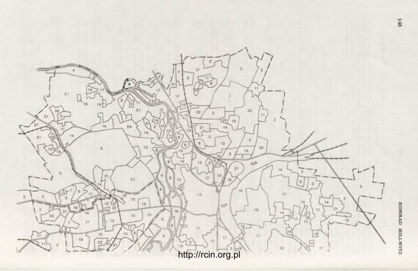
http://rcin.org.pl

Fig. 5. Principal types of utlization: Halle/Halle-Neustadt By: K. Billwitz and R. Janckel. Drafting: E. Miihlberg
1 — Water supply area; 2 — Arable land (plateaus); 3 — Fruit-and-vegetable growing and horticulture; 4 — Arable-and-pasture land (valleys); 5 — Recreation-and-reclamation forest strips; 6 — Recreation area; 7 — Mining area; 8 — Dump area; 9 — Waste water treatment area; 10 — Large-s:ale construction site; 11 — Area of rural houses; 12 — Compact urban built-up area; 13 — Loose urban built-up area; 14 — Area of s ingle-family housing and villas; 15 — N e w building grounds; 16 — Residential area with some industry; 17 — Industrial district with some housing functions; 18 — Mixed industrial district; 20 — River port; 21 — Agricultural suburban area; 22 — Post-mining area; 23a — Transportation area, a — compact; 23b — Transportation area, b — extensively utilized; 24 — Miscellaneous
http://rcin.org.pl
150 K O N R A D B I L L WITZ
There is hardly space within this paper to cope at length wi th the effects of b rown coal mining upon environmental balance. This topic is dealt wi th a grea t m a n y studies. It can only be stressed here tha t the deeply reaching changes caused by the mining are followed by essential environmenta l changes, such as those below:
— geosphere/morphosphere — development of new meso- (hollow and solid forms: lef t -over pits, high dumps) and micro-forms ("moon landscape", depres-sion, hollows, etc.);
— biosphere — total devastation of the na tura l and artificial vegetation, in-festat ion wi th weeds, in direct dependence f r o m this — also changes in the ani-mal life;
— pedosphere — absolute devastation of developed soils and replacement thereof by r a w dump soils;
— l i thosphere — devastation and mixing-up of the top s t ra tum on high land, development of loose dump rocks;
— hydrosphere — changes within the ent i re water regime within the reach of surficial, ground and subsoil waters;
— a tmosphere — development of new conditions, par t icular ly as concerns the micro- and part ial ly also the mezo-climate.
It deserves a stress at this point that also the relations and processes ad-vancing be tween the newly created components of a post-mining landscape are basically d i f f e ren t f rom those that have prevailed before.
An a t t empt has been made herein, to demonstra te certain changes wi th in the Halle-Leipzig agglomeration in their na tura l built-up, and simultaneously hint a t possible registrat ion methods. It must be borne in mind steadily while doing so tha t the above can make only p r imary a t tempts of an analytical approach to env i ronment changes within the agglomerations of forming an opinion on them, and of contr ibuting to the f inding of solutions answering to the socio-po-litical and land improvement requirements .
Martin-Luther University, Halle-Wittenberg
BIBLIOGRAPHY
Barthel, H., 1962, Braunkohlenbergbau und Landschaftsdynamik, Petermanns Geogr. Mitt., Erg.-Bd. 270, Gotha.
Billwitz, K., Guther, W., 1972, Stadtrandzone des grossstädtischen Kerngebietes, in: Halle und Umgebung. Geographische Exkursionen, Gotha-Leipzig.
Dässler, H.-G., 1969, Vegetationsschäden als Folge des Luftverschmutzung. Vortrag auf der Wiss. Konferenz "Sozialistische Umweltgestaltung" der TU Dresden am 4.12.1969.
Krause, K.-H., Richter, H., 1971, Zur begrifflichen Fixierung der territorialen Nutzung und Mehrfachnutzung des unbebauten Raumes. Vortrag auf der 3.Arbeitstagung "Probleme der Flächennutzung bei der Entwicklung der Territorialstruktur" v. 11-12. Nov. 1971 in Leipzig.
Krummsdorf, A., 1970, Biotechnische Massnahmen in Rauchschadensgebieten. Mitteil-ungsblatt des Bezirkstages und des Rates des Bezirkes Leipzig, Sondernummer, Juli 1970.
Neef, E., 1967, Die technische Revolution und die Aufgabe der Physischen Geographie, in: Geographie und technische Revolution, Gotha-Leipzig.
http://rcin.org.pl

N A T U R A L E N V I R O N M E N T A L C H A N G E S 151
Prognose Sozialistische Landeskultur für das Ballungsgebiet Halle-Halle-Neu-stadt-Merseburg, 1971, Ständige AG SLK beim Rat des Bezirkes Halle.
Rühle, G., 1972, Der Einfluss von staubförmigen Immissionen auf einige Zweige der Landwirtschaftlichen Produktion im Bezirk Cottbus. Vortrag auf dem 4. Luf thy-gienischen Kolloquium der KdT, Cottbus 10-12 Mai 1972.
Schwarze, C., 1972, Abwässerschäden im Gebiet Halle-Merseburg, Sektion Geographie MLU Halle (M. A. Thesis).
Schwartze, W., Walotka, K., 1964, Der "Leipziger Wasserknoten". Hydrologisch-was-serwirtschaftliche Probleme einer Grossstadt im mitteldeutschen Trockenraum, in: Exkursionsführer, erschienen anlässlich des zehnjährigen Bestehens der Geo-graphischen Gesellschaft der DDR, Leipzig.
Spengler, R., 1969, Wasserhaushalt und Wasserwirtschaft im Bereich der Wasserwirt-schaftsdirektion V Saale-Weisse Elster, Geogr. Ber., 52/53.
Spengler, R., 1972, Hydrologie und Wasserwirtschaft im Bereich der mittleren Saale, in: Halle und Umgebung. Geographische Exkursionen, Gotha-Leipzig.
http://rcin.org.pl

CONTENTS OF VOLUMES
GEOGRAPHIA POLONICA
http://rcin.org.pl

Subscription orders for the GEOGRAPHIA POLONICA should be placed with FOREIGN TRADE ENTERPRISE ARS POLONA — RUCH
Warszawa, Krakowskie Przedmieście 7, Poland Cables, ARSPOLONA, Warszawa
http://rcin.org.pl

http://rcin.org.pl

http://rcin.org.pl
