,= 490!0,. 0!,=6> 49?30 0 / 4?0==,90,9 h , $ ;=:; :>,7
TRANSCRIPT

C I E S M W o r k s h o p M o n o g r a p h s
Marine Peace Parks in the Mediterranean –a CIESM proposal
Siracusa, 18 - 20 November 2010
CIESM Workshop Monographs ◊ 41.
To be cited as: CIESM, 2011. Marine Peace Parks in the Mediterranean – A CIESM proposal.N° 41 in CIESM Workshop Monographs [F. Briand Ed.], 128 pages, Monaco.
This collection offers a broad range of titles in the marine sciences, with a particular focus onemerging issues. The Monographs do not aim to present state-of-the-art reviews; they reflect thelatest thinking of researchers gathered at CIESM invitation to assess existing knowledge, confronttheir hypotheses and perspectives, and to identify the most interesting paths for future action.
A collection founded and edited by Frédéric Briand.Publisher : CIESM, 16 bd de Suisse, MC-98000, Monaco.
1 / 113

3 CIESM Workshop Monographs n°41
MARINE PEACE PARKS IN THE MEDITERRANEAN - Siracusa, 18 - 20 November 2010
CONTENT
I - EXECUTIVE SUMMARY . . . . . . . . . . . . . . . . . . . . . . . . . . . . . . . . . . . . . . . . . . . . . . . . 7
1. Introduction
2. The concept of Peace Parks
3. An innovative, ecosystem-based solution
3.1. Coast-to coast – the importance of marine connections for maintainingbiodiversity
3.2. Geo- and hydrodynamic diversity –unique features essential toecosystem functioning and resilience
3.2.1 Geodiversity
3.2.2 Hydrodynamic diversity
3.3 Trans-frontier
3.3.1 Beyond national jurisdiction – legal and policy implications fortransboundary marine peace parks in the Mediterranean
3.3.2 The Pelagos Sanctuary – lessons to learn
4. Potential links with existing and planned national protection schemes
5. Marine peace parks in the Mediterranean – the challenges and the opportunities
5.1. Coordinated scientific research – making the case for 2020 conservationtarget
5.2. Goals for concerned countries
6. Preview of Marine Peace Parks proposed by CIESM
6.1 The Near Atlantic Peace Park
6.2 The Pelagian Sea Peace Park
6.3 Herodotus Peace Park
2 / 113

MARINE PEACE PARKS IN THE MEDITERRANEAN - Siracusa, 18 - 20 November 2010
CIESM Workshop Monographs n°41 4
6.4 Eratosthenes Peace Park
6.5 The north Levant Peace Park
6.6 The south Aegean Sea Peace Park
6.7 The south Adriatic Sea Peace Park
6.8 The north Ionian Sea Peace Park
II – WORKSHOP COMMUNICATIONS
- The Marine Peace Park paradigm: coast to coast international marine parks in theMediterranean.
Peter Mackelworth . . . . . . . . . . . . . . . . . . . . . . . . . . . . . . . . . . . . . . . . . . . . . . . . . . . .27
- International Marine Parks in the Mediterranean: a geological background.
Jean Mascle . . . . . . . . . . . . . . . . . . . . . . . . . . . . . . . . . . . . . . . . . . . . . . . . . . . . . . . . . .33
- Oceanographic characteristics of potential coast-to-coast international parks.
Miroslav Gačić . . . . . . . . . . . . . . . . . . . . . . . . . . . . . . . . . . . . . . . . . . . . . . . . . . . . . . . .37
- Scientific rationale for the proposed CIESM Near Atlantic Marine Peace Park.
Ricardo Aguilar, Mustapha Aksissou, José Templado and Marie Romani . . . . . . . . . . .43
- Scientific rationale for the proposed CIESM Pelagian Sea Marine Peace Park.
Adriana Vella, Salvatore Mazzola, Giuseppe Notarbartolo di Sciara, Chedly Rais andMaurizio Würtz . . . . . . . . . . . . . . . . . . . . . . . . . . . . . . . . . . . . . . . . . . . . . . . . . . . . . . . .51
- Scientific rationale for the proposed CIESM Herodotus and Eratosthenes Marine PeacePark.
Jean Mascle, Myroula Hadjichristoforou and Howaida Zakaria . . . . . . . . . . . . . . . . .55
- Scientific rationale for the proposed CIESM North Levant Marine Peace Park.
Ali Cemal Gücü and Bayram Öztürk . . . . . . . . . . . . . . . . . . . . . . . . . . . . . . . . . . . . . . .61
- Scientific rationale for the proposed CIESM South Aegean Sea Marine Peace Park.
Sylvaine Giakoumi, Miroslav Gačić, Jean Mascle, Anastasia Miliou, GiuseppeNotarbartolo di Sciara and Vangelis Papathanassiou . . . . . . . . . . . . . . . . . . . . . . . . . .69
- Scientific rationale for the proposed CIESM South Adriatic Sea Marine Peace Park.
Sajmir Beqiraj, Simonetta Fraschetti, Miroslav Gačić, Aleksandar Joksimovic, JeanMascle, Giuseppe Notarbartolo di Sciara and Roberto Odorico . . . . . . . . . . . . . . . . . .75
3 / 113

5 CIESM Workshop Monographs n°41
MARINE PEACE PARKS IN THE MEDITERRANEAN - Siracusa, 18 - 20 November 2010
- Scientific rationale for the proposed CIESM North Ionian Sea Marine Peace Park.
Simona Fraschetti, Sajmir Beqiraj, Miroslav Gačić, Jean Mascle and Roberto Odorico . .87
III - BIBLIOGRAPHIC REFERENCES . . . . . . . . . . . . . . . . . . . . . . . . . . . . . . . . . . . . . . . . .97
IV - LIST OF PARTICIPANTS . . . . . . . . . . . . . . . . . . . . . . . . . . . . . . . . . . . . . . . . . . . . . .119
4 / 113

Prop
osed
CIES
MM
arine
Peac
ePa
rks.
CIESM Workshop Monographs n°41 6
MARINE PEACE PARKS IN THE MEDITERRANEAN - Siracusa, 18 - 20 November 2010
5 / 113

I - EXECUTIVE SUMMARY
The Summary begins with a presentation of the “Peace Park” concept – initially developed forterrestrial habitats – followed by a short description of, and a scientific rationale for, each of theeight selected areas in the Mediterranean Sea which are detailed in the rest of the volume.
This synthesis, elaborated by Frédéric Briand, benefited from inputs received from the workshopparticipants, with a special mention to Jean Mascle (geodiversity, maps) and Paula Moschella(biodiversity). Enric Sala did moderate (and stimulate) the workshop discussions; Frédéric Briandreviewed the entire volume with precious editorial support from Tim Wyatt; Valérie Gollino tookcare of the physical production and layout.
1. INTRODUCTION
Mediterranean marine biodiversity and the ecosystem services it provides to humans are decliningunder the growing assaults of coastal development, tourism, fast-growing maritime traffic, oil andgas off-shore exploration, climate change, and overfishing. However, less than 2% of theMediterranean is now under effective protection. The main reasons for this dismal level ofprotection are the fragmented nature of maritime governance, the poor enforcement of existingregulations, and the difficult harmonization between EU and non-EU countries in theMediterranean Basin. Therefore there is an urgent need to rigorously define vast areas forconservation, straddling both open sea and coastal waters, if we are to preserve biodiversity andthe essential services it provides. This was the main goal of CIESM workshop n. 41.
In opening the meeting, Drs Frédéric Briand and Enric Sala, respectively Director General ofCIESM and Chair of the CIESM Committee on coastal systems, presented the overall backgroundand objectives of the workshop to the 28 invited participants (see list at the end of volume). Themain questions that framed the discussions were the following. How to circumvent the aboveobstacles to more effective conservation in the Mediterranean? How to reconcile such lowprotection levels with the targets defined by the Convention of Biological Diversity (CBD) at itsmost recent Conference in Nagoya (October 2010) – that is, protect at least 10% of the worldocean by 2020? How to move Governments of Mediterranean countries to multiply by five thecoverage of marine protection within ten years?
Such was the background for the work of the international experts gathered by CIESM in theancient, Sicilian town of Siracusa by the end of November 2011. They were asked to identify large,coast-to-coast, trans-frontier marine areas that represent key features of hydrodynamic, biologicaland geological importance. Protection of these areas would help achieve the CBD goals and ensurethe preservation of critical Mediterranean marine ecosystems. In closing, the Director Generalremarked that this would provide a rare opportunity to apply the concept of ‘Peace Parks’ – alreadywell tested in certain terrestrial regions of the globe – for the first time to the marine realm. Inaddition to strengthening marine conservation, marine Peace Parks would foster cooperationamong neighbours, a rare commodity in one of the most sensitive and conflict-ridden region of theglobe.
MARINE PEACE PARKS IN THE MEDITERRANEAN - Siracusa, 18 - 20 November 2010
7 CIESM Workshop Monographs n°41
6 / 113

On the last day of the Meeting, the participants were joined by two high-level personalities: HSHPrinceAlbert II of Monaco, President of CIESM, and HE Stefania Prestigiacomo, Italian Ministerfor the Environment. Upon hearing the workshop conclusions and recommendations, bothintervened to express their full support towards the ambitious goal of creating vast transboundaryMarine Peace Parks in the Mediterranean Sea.
2. THE CONCEPT OF PEACE PARKS
Transboundary protected areas were first developed in terrestrial environments with the clear,explicit objective to conserve biodiversity while fostering regional cooperation, peace and securityover countries whose relations are strained, or in regions where border disputes and conflicts arestill unresolved (McNeil, 1990; Hamilton et al., 1996). Even in areas clear of any trans-frontierpolitical issue, peace parks contribute to develop collaboration, smooth cultural and technicalimbalances, and enhance socio-economic exchanges (for more details on historic and politicalbackground, see Mackelworth, this volume).
The definition by Sandwith et al. (2001) adequately illustrates the Peace Park concept:
‘transboundary protected areas that are formally dedicated to the protection and maintenance ofbiological diversity and of natural and associated cultural resources, and to the promotion ofpeace and cooperation’
The benefits of trans-frontier peace parks for conservation purposes are many. From the biologicalperspective, the larger zone of protection so created (1) substantially preserves all the componentsof ecosystems straddling across countries; (2) embraces habitats for migratory or highly mobilespecies and increases regional connectivity for larval dispersal; and (3) helps face environmentalchanges. Further, from the management perspective, opportunities for staff exchange and jointtraining and initiatives at various levels promote mutual understanding between differentapproaches, different jurisdictions, and thus optimize conservation of large areas, as shown by thesuccess of transboundary cooperation in theWadden Sea shared by the Netherlands, Denmark andGermany <http://www.waddensea-secretariat.org/>.
The creation of trans-frontier ‘peace parks’will safeguard and improve existing friendly relationsbetween States, and lower the strain of existing disputes over contested territory. This is particularlydesirable in the Mediterranean Sea, where historical conflicts and ideological tensions are the rule.To date, peace parks have been conceived only for the terrestrial environment. Recent attempts inthe Gulf of Aqaba and the Korean Peninsula have met with considerable difficulties and are stillat the stage of promises.
It remains that the trans-boundary dynamics of the marine environment, as well as the legaldisputes regarding ownership over sea territories or boundaries, make the case for the establishmentof marine peace park even more compelling.
3. AN INNOVATIVE, ECOSYSTEM-BASED SOLUTION
The CIESM proposal innovates in combining three powerful, unique features, which can besummarized as such: coast-to-coast, geo- and hydrodynamics diversity, trans-frontier.
3.1. Coast-to coast – the importance of marine connections for maintaining biodiversityMarine peace parks will integrate contiguous coastal and open sea habitats, allowing for a coherentset of measures to protect a dynamic, inter-connected marine system. The dimension of the parkwill provide a more suitable range and connecting corridors to larger animals that actively moveacross the seascape, enhancing the robustness and resilience of the ecosystem in the face of climatechange, and thus ultimately enhancing resource yields and local economies.
Traditional Marine Protected Areas (MPAs) have often been the object of debates on whether ornot they exert effective conservation of marine species, especially with respect to populationdynamics and larval dispersal (Willis et al., 2003; Cowen et al., 2007). In most cases MPAs arevery limited in size and isolated, and they rarely extend beyond a few nautical miles offshore. Thesurvival and perpetuation of populations of many benthic organisms, fish and cephalopods dependon their larval dispersal and on the connectivity between the sources and sinks of larvae.
CIESM Workshop Monographs n°41 8
MARINE PEACE PARKS IN THE MEDITERRANEAN - Siracusa, 18 - 20 November 2010
7 / 113

Recruitment success of “local” populations may sometimes rely on sub-regional larval supplywhen local larval sources are hindered by environmental or anthropogenic factors (Bode et al.,2006). The scale of connectivity also plays an essential role in genetic interchange andbiogeography of coastal species (Cowen et al., 2006).
Preserving the connections between coastal and marine ecosystems, including the open sea, is alsovital to highly mobile animals, namely top predators such as tuna, sharks, turtles, seals, cetaceansand birds. Marine corridors, which are defined by oceanographic and geo-morphological features,are used as “channels” along which wide-ranging animals can migrate from one area to another,either to reproduce, feed or simply escape from environmental changes or anthropogenic threats(Good, 1998). In the Mediterranean Sea many endangered or threatened species migrate seasonallyacross sub-regional seas to reach remote breeding sites or feeding grounds. For example, differentroutes between the coast of Cyprus and Turkey have been observed for the green (Chelonia mydas)and leatherback (Caretta caretta) sea turtles and the monk sealMonachus monachus (Gucu et al.,this volume). Several important migratory routes in the Gibraltar/Alboran area, the North Ionianand the Levant are well known for fin whales (Balaenoptera physalus), sperm whales (Physetermacrocephalus), bluefin tuna (Thunnus thynnus), swordfish (Xiphias gladius) and other largepredators (see in this volume: Aguilar et al.; Fraschetti et al.; Mascle et al.). Coastal-marinecorridors are also important for migratory marine birds that cross the straits and use coastal andmarine wetlands as well as islands to rest, feed and reproduce. The Sicily Channel is one of themain bird migration routes between Europe and Africa, and many procellariiforms (shearwaters,storm petrels) use offshore islands located in the Channel to breed (Vella et al., this volume;RAC/SPA, 2010). Furthermore, the coastal region between southern Montenegro and northernAlbania is also a part of one of the three migration routes of European birds in the direction north– south (Beqiraj et al., this volume; Holcer et al., 2010).
Unfortunately, in the Mediterranean ecological corridors overlap with important shipping seaways,intensive fishery areas, and highly urbanized coastlines; thus the human pressures on these wide-ranging species are enormous and the protection efforts of small coastal areas remain irrelevantwith respect to the scale of threats.
The proximity of the continental shelf of the north and south shore of the Basin makes most highseas, especially vulnerable deep-sea areas, strongly linked with the coastal ecosystems viaoceanographic (currents, up-welling), physico-chemical (biogeochemical cycles) and biological(food chains) connections, which also imply unavoidable transfers of pollutants. Estuarine, coastaland marine ecosystems thus form a continuum, and large-scale marine conservation is credibleonly by means of harmonised protection measures across the different systems.
3.2. Geo- and hydrodynamic diversity – unique features essential to ecosystem functioningand resilienceNot only will Marine Peace Parks preserve an endemic, threatened biota (unique deep-seacommunities, white coral beds, monk seals, rare endemic species, fin whales, spawning groundsof bluefin tuna, etc.), but they will also protect unique geological features (deep sea canyons, mudvolcanoes, seamounts, hypersaline basins), and key oceanographic processes (surface sites of deepwater formation, strait fluxes) from the fast-growing exploitation of marine resources by moderntechnology.
3.2.1 Geodiversity
The Mediterranean Sea has a long and complex geological history (see CIESM, 2003; 2007)characterized by dramatic long-term events, major catastrophes, past and recent tectonicdeformations, which left peculiar geological imprints (outcrops, tectonics) in several areas of theEastern andWestern basins (Mascle, this volume) and large topographic features such as seamountswhere site-specific ecosystems developed.
Seamounts are considered hotspots of biodiversity worldwide; these submarine mountains provideunique habitats and support a highly diverse benthic and mobile fauna, yet only few have beenexplored and studied to date (see CIESM, 2003; Galil and Zibrowius, 1998). At the same time,seamounts have attracted much interest from the fishing industry and until recently they were
MARINE PEACE PARKS IN THE MEDITERRANEAN - Siracusa, 18 - 20 November 2010
9 CIESM Workshop Monographs n°41
8 / 113

exploited intensively with highly impacting techniques (e.g. bottom trawling, drift nets) leadingto rapid decline of commercial deep-water fish and benthic species (CIESM, 2003). Althoughfishing impacts have been put under some control by the international ban of bottom trawlingbelow 1000m, deep-sea oil exploration is intensifying, adding extra pressure to these highlyvulnerable ecosystems. The protection of these geological features such as the dominantEratosthenes seamount and the associated communities is thus highly advocated (Mascle et al., thisvolume).
Along the steep continental slopes, other geological features such as rocky outcrops and marinecanyons offer suitable habitats for settlement of hard bottom communities like gorgonians(Paramuricea clavata, Eunicella spp.) and deep-water corals (Lophelia pertusa, Madreporaoculata).
In addition to tectonic movements, the Basin is also subject to a variety of active volcanic andgeochemical processes. Hydrothermal vents, particularly numerous in the Tyrrhenian Sea, SouthAegean and Sicily Channel, are the site for specialized communities adapted to the hot temperatureof waters surrounding the vents (Danovaro et al., 2010). In the deep Eastern Mediterranean, severaltypes of fluid seepages were recently discovered, making this region unique for its rich geo-diversity (Mascle, this volume). Around the Egyptian continental slope, hundreds of these coldfluid seepages are emitted from depressions pockmarks and mounds on the seabed (pockmarks),where highly specialized bacterial communities contribute to build peculiar carbonate structures(Mascle et al., this volume).
Another geo-specific process leads to mud volcanoes and gas chimneys, mounds made of sedimentrich in organic matter from which cold seeps containing methane and sulfide gases are produced.Hundreds of mud volcanoes are scattered across the Mediterranean Sea (CIESM, 2005), inparticular along the Ibero-Moroccan Gulf (Aguilar et al., this volume), on the Mediterranean Ridge,and on the Anaximander Mountains (Mascle et al.; Giakoumi et al., this volume).
Pockmarks and mud volcanoes host a peculiar benthic macro- and megafauna, often in denseaggregations, consisting of bivalves, gastropods, giant tubeworms (Siboglinidae) sponges(Rhizaxinella pyrifera) and crabs (Chaceon mediterraneus) which are endemic to theMediterranean (CIESM, 2003). Such communities exist thanks to a symbiotic association with anextremely rich and diverse chemosynthetic bacterial assemblage developed around these specialgeo-chemical environments.
On the Mediterranean Ridge, in particular on Napoli mud volcano (Mascle et al., this volume), andon the foot of the Egyptian margin (Cheffren volcano, Mascle et al., this volume) extensive deepsea hypersaline lakes and smaller brine ponds containing salt-rich fluids that emerge fromsediments have been recently discovered. In these hyper-saline and anoxic basins, a large varietyof microorganisms belonging to the Bacteria and Archaea worlds have been detected, includingnew prokaryotic taxa (CIESM, 2003).
3.2.2 Hydrodynamic diversity
The water circulation of the entire Mediterranean Basin, including the main Mediterranean deepout-flowing waters and the Atlantic surface inflowing waters, is strongly affected by a peculiarclimate and wind regime that, together with the complex seabed morphology, determine theformation of deep, dense water masses as well as mesoscale features such as gyres and eddies(CIESM, 2005; 2009; Gacic, this volume;). These, in turn, play a major role in triggeringphytoplankton blooms through water mixing and upwelling of nutrients, with effects on the entirefood web. Coastal hydrodynamics (currents, tides, upwelling and water stratification) and otheroffshore meso- and large-scale processes are essential for larval transport and contributesignificantly to population connectivity (Pineda et al., 2007). Sea currents also mark the “routes”for migratory species such as tuna, cetaceans, sharks and marine turtles. Such hydrodynamicfeatures have to be taken into account when considering the protection of species, especially highlymobile species. All the proposed parks enclose at least some of these important hydrodynamicfeatures.
CIESM Workshop Monographs n°41 10
MARINE PEACE PARKS IN THE MEDITERRANEAN - Siracusa, 18 - 20 November 2010
9 / 113

Straits represent often choke points where the exchange of water masses generates mesoscalefeatures and upwelling phenomena; for example the area adjacent to the Strait of Gibraltar hoststwo semi-permanent gyres, the Alboran Gyres, with distinct oceanographic and biogeochemicaland properties and in the nearAlboran Sea (Gacic et al., this volume). Similarly, the Strait of Sicily(Pelagian Sea Park), the Strait of Otranto (North Ionian Park) and neighbouring areas arecharacterized by semi-permanent features, such as eddies and gyres. Periodical or semi-permanentgyres are also quite frequent in the Eastern Basin such as the Rhodes Gyre in the Aegean Sea(South Aegean Park), the Ierapetra eddy and Mersa-Matruth (Herodotus Park) gyre located southeast of Crete. The special hydrodynamics and nutrient upwellings properties characterizing thesestructures have been found to generate primary productivity and bacterial biomass notably higherthan in the surrounding oligotrophic waters (Denis et al., 2010; Robarts et al., 1996). The SouthAdriatic Gyre, located within the South Adriatic Park, is also the site of strong seasonalphytoplankton blooms resulting from vertical convection and nutrient input in the euphotic layer.
There are other important oceanographic structures that play an important role in Mediterraneanbiodiversity. It is the case for the peculiar circulation system between the South Adriatic and theNorthern Ionian, characterized by a bimodal oscillating system (BiOS) that regulates the alternationof anticyclonic and cyclonic phases for the Northern Ionian Gyre (see North Ionian Park). Theseperiodic inversions determine the influx of ModifiedAtlantic waters and Levantine waters into theAdriatic, which likely facilitate the presence of allochtonous species (and probably native speciesof different thermohaline affinity) from the Western Atlantic/Western Mediterranean and EasternMediterranean respectively (Civitarese et al., 2010).
The complexity and variability of Mediterranean hydrodynamics is not completely independentfrom anthropogenic pressures.While the main oceanographic features result from regional climateand wind regime, the thermohaline and other dynamic properties of the Mediterranean circulationcan be severely affected by human activities. For instance the drastic reduction of freshwater inputto the eastern Basin following theAssuan damming of the Nile led in the long-term to an increasedsalinity, which affected not only the thermohaline dynamics of the Cretan Sea and the EasternMediterranean climatic transient, but also the deep water formation process in the Gulf of Lionsand South Adriatic (CIESM, 2000; Skliris and Lascaratos, 2004).
3.3 Trans-frontierOn land, internationally designated protected areas are relatively spread worldwide and in mostcases their management requires coordination of conservation measures over a territory thatencompasses two or more countries and where borders are clearly defined. Each country thenapplies the commonly agreed conservation policy on its own territory, where it exerts sovereignrights.
At sea, political borders are often disputed, and there are still a lot of discussions and negotiationsover legal definitions and rights of use related to sea ownership issues. Further, beyond EconomicExclusive Zones (EEZs), the high seas do not fall under the control of any particular State and canbe used and exploited by all (part V, UNCLOS, 1982). This has led to various controversies relatedto the use of the sea for fishing, oil exploitation, maritime transport and military activities (Ronzitti,2010).
The complex historical and political context of the Mediterranean Basin, and its geographicconformation, where few coastal areas are farther than 200 nautical miles away from waters underanother jurisdiction, makes even more difficult a correct interpretation of the law of the sea andincreasingly hampers international scientific research. To date, a large number of legal disputes,some very ancient, others quite modern, are still unresolved.
The trans-frontier structure of the CIESM Marine Peace Parks puts this problem aside: it willencourage, without prejudice to current national claims, the Governments of those countriesdirectly concerned to join forces and develop joint planning in the pursuit of a cause higher thantheir national interest. In addition, the ‘borders’ of the proposed marine peace parks do not followpolitical boundaries, but delimit coastal and marine ecosystems hosting key features of high naturalvalue.
MARINE PEACE PARKS IN THE MEDITERRANEAN - Siracusa, 18 - 20 November 2010
11 CIESM Workshop Monographs n°41
10 / 113
3.3.1. Beyond national jurisdiction – legal and policy implications for transboundary marinepeace parks in the Mediterranean
The ‘High Seas’ (international waters) are less and less considered as a sort of “no man’s land”.The sustainable conservation of marine habitats and species is explicitly considered in the UNConvention of the Sea (UNCLOS) and several international conventions and treaties (Shine andScovazzi, 2007). At the regional level, the Protocol concerning specially protected areas andbiological diversity in the Mediterranean (Barcelona Convention, 1976, amended 1995) providesa well-constructed policy framework to establish specially protected areas of Mediterraneaninterest (SPAMI) that would include both coastal and open seas.
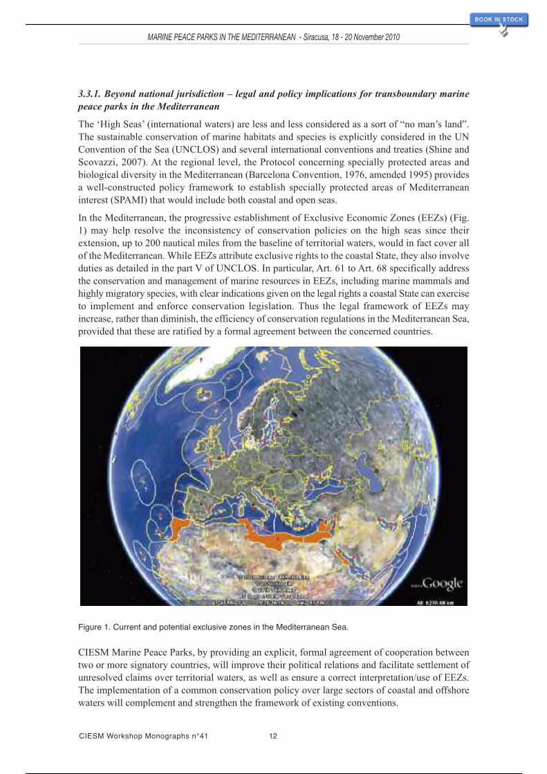
In the Mediterranean, the progressive establishment of Exclusive Economic Zones (EEZs) (Fig.1) may help resolve the inconsistency of conservation policies on the high seas since theirextension, up to 200 nautical miles from the baseline of territorial waters, would in fact cover allof the Mediterranean. While EEZs attribute exclusive rights to the coastal State, they also involveduties as detailed in the part V of UNCLOS. In particular, Art. 61 to Art. 68 specifically addressthe conservation and management of marine resources in EEZs, including marine mammals andhighly migratory species, with clear indications given on the legal rights a coastal State can exerciseto implement and enforce conservation legislation. Thus the legal framework of EEZs mayincrease, rather than diminish, the efficiency of conservation regulations in the Mediterranean Sea,provided that these are ratified by a formal agreement between the concerned countries.
Figure 1. Current and potential exclusive zones in the Mediterranean Sea.
CIESM Marine Peace Parks, by providing an explicit, formal agreement of cooperation betweentwo or more signatory countries, will improve their political relations and facilitate settlement ofunresolved claims over territorial waters, as well as ensure a correct interpretation/use of EEZs.The implementation of a common conservation policy over large sectors of coastal and offshorewaters will complement and strengthen the framework of existing conventions.
CIESM Workshop Monographs n°41 12
MARINE PEACE PARKS IN THE MEDITERRANEAN - Siracusa, 18 - 20 November 2010
11 / 113
3.3.2 The Pelagos Sanctuary – lessons to learn
In 1999 the Ministries of the Environment of France, Italy and the State Ministry of Monaco signedan agreement to designate within the Corsican-Ligurian-Provençal Basin a large sector of territorialand high seas as the International Sanctuary for Mediterranean Marine Mammals. The agreementof the Pelagos Sanctuary, which came into force in 2002, aimed at protecting Mediterraneancetaceans and their feeding and breeding grounds from the effects of increasing human pressuresin the region (for a detailed review of the Sanctuary; see Notarbartolo di Sciara et al., 2008).
From the legal point of view, the Sanctuary represented an unprecedented achievement: for the firsttime in the Mediterranean, the proposal of creating a large, internationally protected area on thehigh seas was endorsed at high political level and a solid legislative basis was established toimplement a wide range of conservation measures. Still, nine years after its creation, the efficiencyof the Sanctuary in protecting marine mammals is an open question, as many researchers andNGOs see no improvement in the conservation status of cetacean populations which, for certainspecies such as the fin whale (Balaenoptera physalus) and striped dolphins (Stenella coeruleoalba)apparently has worsened.
The lack of an ad hoc management body with clear mandates, executive power and sufficienthuman and financial resources, has been pointed out has one of the main reasons for failure inmeeting the conservation goals (Notarbartolo di Sciara et al., 2009). An intrinsic weakness of theSanctuary resides however in the reluctance of the three concerned countries in establishing EEZs,which would cover the open sea sector of the Sanctuary; without such zones, the full enforcementof protection regulations remains limited to territorial waters, since in high seas the third States arenot bound by theAgreement. This means that any vessel (fishing boats, ferries, cargoes, etc.) flyingother than French, Italian or Monegasque flags, is not obliged to comply with protection measuresbeyond the 12 nautical miles limits unless these overlap with other international or Europeantreaties/directives. This legal limitation is not negligible: more than 50% of the Sanctuary covershigh seas where threats such as illegal driftnet fishing, acoustic pollution, oil exploration andcollisions are out of control (Notarbartolo di Sciara et al., 2008).
4. POTENTIAL LINKS WITH EXISTING AND PLANNED NATIONAL PROTECTION SCHEMES
In the Mediterranean Sea, despite the minimal total area protected, a large variety of designationschemes exist (RAMSAR, Biosphere, MPA, SPAMI, PSSA, etc.), and several international,regional and national conservation organizations work to meet the 2020 CBD objective. The eightMarine Peace Parks proposed by CIESM, which embrace a variety of existing marine reserves(Fig. 2), could act as a convenient umbrella and forum to promote dialogue and develop synergiesamong the different conservation actors and stakeholders involved in these areas. A further, moreconcrete step would be to establish within each area a sub-regional network of MPA managers.Each sub-regional network could be:
- coordinated by all involved countries using or a common Secretariat (pooling resources toenhance the network); such a system has been adopted by the Pelagos Sanctuary;
- initiated by one MPA management body, considered to be particularly dynamic or managing aconsiderable protected zone; the network can then remain informal or become more institutional(with members officially appointed); as an example, in theAdriatic the MPA“Torre del Cerrano”created the Adriapan network; as above, but initiated by one country rather then a managementbody, it would be the case for the Pelagian Sea Park;
- managed by an international organization or a Foundation.
MARINE PEACE PARKS IN THE MEDITERRANEAN - Siracusa, 18 - 20 November 2010
13 CIESM Workshop Monographs n°41
12 / 113

MARINE PEACE PARKS IN THE MEDITERRANEAN - Siracusa, 18 - 20 November 2010
CIESM Workshop Monographs n°41 14
Figure 2. The eight CIESM Marine Peace Parks proposed by CIESM including the existing marine protectedareas.
The MedPAN regional network could have the role of facilitating the creation and linking of sub-regional networks. The progress made by MPA networks should be monitored with theestablishment of a Mediterranean MPA database shared between the regional, national and localnetwork partners. The aim is to evaluate the progress made in the Mediterranean with respect tothe CBD objectives and to draw up a regional report to be used as a discussion document for theMPAmanagers, the socio-economic stakeholders and the international, European, Mediterraneanand national decision-makers.
5. MARINE PEACE PARKS IN THE MEDITERRANEAN – THE CHALLENGES AND THEOPPORTUNITIES
Moving towards the implementation of Marine Peace Parks in the Mediterranean will be a hugechallenge, as the fate of recent attempts (Gulf of Aqaba, Korean Peninsula) amply demonstrates.The Mediterranean Basin is also one of the most impacted, semi-enclosed seas, where humanpressures (maritime transport, coastal development, overfishing, etc.) are at peak levels. Againstsuch a background, the idea is not to establish full protection over vast areas of the Mediterraneanthat depend on maritime resources and economics. Marine Peace Parks should be considered ratheras dynamic “conservation experiments” where sound, harmonised spatial planning is adopted bythe concerned countries to allocate within each park distinct zones with different levels ofprotection. For example, vessels transporting dangerous substances would follow well-definedmaritime corridors, away from particularly vulnerable areas. Other zones would be temporarilyrestricted to fishing during the spawning season, allowing for the replenishment of fish stocks.Such dynamic conservation measures will be possible only by close, formal cooperation amongthe countries, starting from high political levels to conservation managers and local councils.
5.1. Coordinated scientific research – making the case for 2020 conservation targetWhile a lot of efforts are invested in pushing decision makers to designate coastal and marinereserves, relatively little resources are used to provide scientific evidence of the natural value ofthe candidate area. The implementation of a proper spatial planning and zonation to protect not onlythe target species and habitats but also key geo-oceanographic hotspots, requires harmonisedmultidisciplinary research to fully understand the dynamic processes and ecological interactionsregulating ecosystem functioning and sustainability. Often, there is virtually no information onthe ecological features of the zone, especially on the high seas. In June 2010, the Eratosthenesseamount was proposed as candidate SPAMI but subsequently rejected by Cyprus due to itspotential for oil exploration (UNEP-RAC/SPA report, Istanbul, 2010). If valid scientific datasupporting the extreme value of geological and biological features associated to this seamount
13 / 113

were available – the only published biological data being by Galil and Zibrowius in 1998 – thismight help Cyprus to reconsider its position, at least with respect to the use and exploitationpriorities of this zone.
As recognized in UNCLOS and other treaties and conventions, countries should co-operate inorder to achieve the best scientific evidence prior to the implementation of proper conservation andmanagement measures (EEZ, Art. 61), coordinate their scientific research policies and undertakejoint programmes of scientific research in the area concerned (UNCLOS, Art. 123). Internationalresearch can be an influential instrument to improve political relations between countries andpromote transboundary cooperation in many sectors. The century-old experience of theMediterranean Science Commission demonstrates how scientific collaborations overcome thepolitical and cultural barriers.
5.2. Goals for concerned countriesThe creation, development and maintenance on a long-term basis of efficient marine peace parksinvolve a complex, time-consuming process. Clearly the political, administrative and scientificchallenges should not be underestimated. In particular the following steps:
reach formal agreement at high political level within (through dialogue among the relevantMinistries) and between countries (through dialogue between State leaders) for cooperation overthe concerned marine park area to develop a common conservation policy and legislation,especially when EEZs are in effect or are being established by the interested countries;
jointly design and enforce pragmatic, dynamic measures, such as spatial zoning, temporaryrestrictions of fishing, restricted navigation corridors, optimal location of off-shore drillingoperations, etc.;
increase cooperation, training and coordination between national agencies across the border andestablish sub-regional networks linking national and international nature designated areas;
develop and manage joint research programs and data sets that will provide ground scientificknowledge for sound spatial planning as well as monitoring the effectiveness of conservationmeasures following the marine peace park designation.
Creating a marine peace park, setting up its conservation objectives and the measures to achievethem, will have to be a dynamic, adaptive process. If we consider nature as a fixed, staticcompartment, there will be always a mismatch between what advocated on paper and the marineworld.
6. PREVIEW OF MARINE PEACE PARKS PROPOSED BY CIESMThe reader will find in the following pages a synthesis of the key geological, oceanographic andbiological features of high conservation value, together with the main anthropogenic threats, thatcharacterize each selected area.
MARINE PEACE PARKS IN THE MEDITERRANEAN - Siracusa, 18 - 20 November 2010
15 CIESM Workshop Monographs n°41
14 / 113

6.1 The Near Atlantic Peace ParkThe whole area of Ibero-Moroccan Gulf, Strait of Gibraltar andtheAlboran Sea constitutes the transition from theAtlantic Oceanto the Mediterranean Sea, with all the special interest that thisentails from geological, oceanographic, and biologicalperspectives. This area presents a very high level of speciesrichness due the co-existence of species from three marinebiogeographic regions (Mediterranean, Lusitanian andMauritanian provinces), plus some endemic species restricted tothis zone. It also represents an obligate pathway for migratoryvertebrates between the Atlantic and the Mediterranean: largepelagic fishes, cetaceans and sea turtles are very frequentlyobserved in the area.
Key features in need of protection- The area constitutes the “engine” where the Mediterranean water originates, playing a key control of theexchanges and modifications of the biogeochemical cycles and circulation of the entire Mediterranean;- More than 100 mud volcanoes and many fluid escape structures have been detected scattered around the wholeIbero-Maroccan Gulf;- Amajor hotspot of biodiversity, with the highest species richness in the European/North African waters;- Unique communities, dominated byAtlantic seaweed, such us forests of Laminaria ochroleuca and Saccorhyzapolyschides, or by the north African gorgonian Ellisella paraplexauroides;- Some living deep coral banks (Lophelia pertusa,Madrepora oculata) have been found near theAlboran Islandand on the Chella Seamount;- It hosts several threatened and endangered vertebrate species, including those migrating from the Atlantic tothe Mediterranean; the most threatened invertebrate species of the Mediterranean, Patella ferruginea,concentrates most of its population in this area.
Complementary informationExtensive volcanism is expressed in the Alboran Sea with several seamounts (Chella, Djbouti, and Motrilseamounts in its northern part, and Alidae, Cabliers, Porvençaux, Tofiño and Xauen in its southern parts). TheGulf of Cadiz, which is located west of the Gibraltar Arc, is characterized by mud volcanoes and fluid escapestructures that formed in connection to a complex tectonics history with several episodes of extension, strike-slip and compressions. Other mud volcanoes and diapiric structures with carbonate chimneys and crusts werediscovered along or in close proximity of the main channels of the Mediterranean outflow water for a total of100 volcanoes in the whole area.All these geological features host a unique and highly diverse fauna, includingliving white coral reefs (Madrepora oculata, Lophelia pertusa) and other deep sea benthic species such as coralsand gorgonians (Desmophyllum dianthus, Dendrobrachia sarmentosa) and sponges (Asconema setubalense,Asbestopluma hypogea).The entire area is of prime importance for hydrological processes. The stratification of waters in the Strait ofGibraltar, with a top layer of less saline inflowing Atlantic water, and a deeper and narrower outflowing layerof more saline, Mediterranean waters, facilitates the passing from the Atlantic to the Mediterranean of pelagicfauna and planktonic organisms, including larvae. The Alboran Sea hosts key oceanographic features thatsignificantly contribute to the diversity and distribution of the biota. Two large anticyclonic gyres generateupwellings in the deep waters inshore of Malaga and Granada and a dense oceanic front, the Almeria-Oranfront, separates the Alboran Sea from the rest of the Basin, acting as a biogeographic barrier for many planktonspecies and larvae.The region displays the highest values of species richness in the Mediterranean Sea, probably due to a widerange of physico-chemical conditions, to the co-existence of species from three marine biogeographical regions(Atlantic, northAfrica and Mediterranean), plus some locally endemic species. The Gibraltar Strait is an obligatemigration path for many marine mammals, large pelagics (Xiphias gladius, Istiophorus albicans, Thunnusthynnus) and sea turtles (Caretta caretta, Dermochelys coriacea). Many of these species are commonly observedor even resident in the Alboran Sea (Balaenoptera acutorostrata, Balaenoptera physalis, Physetermacrocephalus, Globicephala melas, Tursiops truncatus). Among resident species, the short-beaked commondolphin (Delphinus delphis) merits particular attention, because its population in theAlboran Sea is the healthiestin the Mediterranean, after a dramatic decline of this species in most of its Mediterranean range.A population of the green turtle Caretta caretta also thrives in the area thanks to periodic proliferations of theswimming crab Polybius henslowii, which is its primary food resource there.
Major pressuresThe entire area concentrates a large variety of human activities and a very intense maritime traffic. Coastaldevelopment, chemical pollution, military manoeuvres, oil facilities and pipelines, off-shore energeticdevelopments, harbour constructions, sea bottom mining, sand dredging, are just some of the threats. Fishery isthe main threat for this zone, with several fishing ports exerting enormous pressures on this system through anintensive fishing effort. Not only large pelagics, but also demersal and deep sea fishes, are intensively exploitedcausing serious decline of fish stocks as well as bycatch impacts on cetaceans and turtles passing through theStrait of Gibraltar.
Countries : Monaco, Spain
CIESM Workshop Monographs n°41 16
MARINE PEACE PARKS IN THE MEDITERRANEAN - Siracusa, 18 - 20 November 2010
15 / 113

6.2 The Pelagian Sea Peace ParkBeing a transitional zone between the Eastern and Western basins of theMediterranean Sea, the Sicily Channel is an area of high productivity –coupled with important pelagic and demersal fisheries – and one of theMediterranean marine biodiversity hotspots. Because of its geographicalposition, the area is influenced by human activities, in particular maritimetraffic and coastal development that generate a heavy pressure on themarine environment.
Key features in need of protection
- A complex and shallow orography with seamounts, volcanic islands andsubmerged volcanoes, slow-flux seeps and pockmarks;- Active volcanic processes, leading to expulsions of warm fluids thatmay be leading to hot spots of specific symbiotic biological communities;- An “ocean triad” – enrichment processes (upwelling, mixing),
concentration processes (convergence) and processes favouring retention of eggs and larvae within - or drifttowards – appropriate habitat (fronts, vortices);- A feeding, spawning and nursery ground for many species of ecological (white shark, fin whale, bottlenosedolphin, devils’ ray, loggerhead turtle, white corals) and economic importance (bluefin tuna, sword fish, greaterfork beard, hake, red mullet and pink shrimp);- Rare or endemic species unique of this area, such as the Maltese ray Leucoraja melitensis and the colonialscleractinian coral Cladopsammia rolandi;- One of the main bird migration routes between Europe and Africa and an important breeding site forprocellariiforms.Complementary information
Located along the African/ Europe plate boundary, the Pelagian Sea is an area of active tectonics cut by largegrabens (Pantelleria, Malta)
and intruded by few active submerged and emerged volcanoes.
The two main currents, theW-EAtlantic surface water and the denser, deeper E-WMediterranean water, conveyhigh amounts of energy which interact with the complex seabed orography and the dominant winds, formingpeculiar hydrographic features (upwelling, mixing, gyres) in the area. These generate high biologicalproductivity, resulting in high diversity and biomass of pelagic and demersal fish. The Sicily Strait and the areaaround Malta still remain a major fishing ground for the bluefin tuna Thunnus thynnus, whose stocks aredeclining.
Essential Fish Habitats (EFH) have been identified in the form of spawning aggregations and nursery groundsof hake (Merluccius merluccius) at 100 - 200m on the Adventure and Malta Banks; nursery grounds of thegreater fork beard (Phycis blennoides) at 200 - 400m on Adventure Bank and in the eastern Straits; spawningand nursery grounds of the red mullet (Mullus barbatus) to 100m on Adventure and Malta Banks. Pink shrimp(Parapenaeus longirostris) spawning and nursery grounds do coincide with theAdventure Bank and the IonianShelf vortices, respectively.
Nesting colonies of the endangered loggerhead turtle (Caretta caretta) still exist on the islands of Lampedusaand Linosa in the Pelagie Archipelago. The area off the coastline of Lampedusa is a feeding ground for the finwhale (Balaenoptera physalus) and possibly bottlenose dolphin (Tursiops truncatus).
The region is also one of the main migration pathways for many birds such as shearwaters, storm petrels.Breeding colonies of Cory’s shearwater (Calonectris diomedea) exist on islands and rocky coastline of theSicilian Straits.
Habitat forming key species are a rare feature of this area: the Mediterranean endemic scleractinian coralCladopsammia rolandi, white coral mounds composed of Lophelia pertusa, Madrepora oculata, the yellow treecoral Dendrophyllia cornigera, the octocorals Isidella elongata, red coral Corallium rubrum and Funiculinaquadrangularis create unique habitats characterised by high biodiversity.
Major pressures
In the area several human activities are present, mainly fishing, aquaculture, shipping and tourism while othersare planned like wind farm plants. Furthermore, extensive oil exploration takes place in the zone. As severalconcessions for oil exploration in the Sicily Strait have been recently granted by the Italian government, creatinga marine park in the region represents a urgent priority. The windmill development (59 marine windmills plannedin the Bank of Talbot) adds up further threats to the ecosystem. The intensive fishing efforts, especially forpelagic species (bluefin tuna, swordfish) and the dolphin fish Coryphaena hippurus are seriously underminingthe important stocks in the area.
Countries : Italy, Malta, Tunisia
MARINE PEACE PARKS IN THE MEDITERRANEAN - Siracusa, 18 - 20 November 2010
17 CIESM Workshop Monographs n°41
16 / 113

6.3 Herodotus Peace ParkThe proposed Herodotus Marine Peace Park extends between the coastsof Greece (South-eastern Crete) and of Egypt (Western Desert) and coversparts of the Libyan EEZ.
The area covers three main geological domains: (a) the passive Africancontinental margin of Egypt (and partly Libya), including thenorthwestern most corner of the Nile deep sea fan sedimentaryconstruction, (b) the seismically active continental margin which bordersthe island of Crete and, (c) between both continental margin segments, ahuge pile of tectonized sediments - ‘the Mediterranean Ridge’ - whichresults from the pilling up and strong deformations of sediments squeezedbetween the two rigid margins.
Key features in need of protection
- The occurrence of very abrupt and rocky continental slopes, particularlysouth of Crete, where deep sea corals and others fixed organisms have
been observed but are still poorly studied;- The temporary presence of some of the most popular migratory species, which should be better preserved inregions where they are reproducing or nesting; among them several species of Cetaceans (sperm whales, Cuvier’sbeaked whales, four dolphin species) and of sea turtles;- The area is a major corridor for the migration of many bird species;- Several persistent gyres (Ierapetra gyre for example), inducing local important variation in productivity,characterize the domain;- Another specificity of the area, and particularly of the deep sea (2000 to 3000m) is the presence of deep-seacold fluid seep fields, whose activities induce the developments of unique deep-sea environments and ofmicrobial-related biodiversity hot spots.Complementary information
Fluid seepage is an example of specific “geo-diversity” and its impact on deep-sea environments. In theHerodotus zone, fluids are emitted directly on the seafloor in two distinct settings: (a) within the Mediterraneanridge where they are closely linked to massive emissions of under-compacted and over-pressured mud knownas mud volcanoes, and (b) at the foot of the Nile submarine sedimentary construction on the Egyptian continentalslope.
On the Mediterranean ridge the Olympic field (red circle on figure), a group of several mud volcanoes discoveredsome 15 years ago, has been studied in detail since 2000, in particular the Napoli mud volcano. This structure,which lies by 2000m water depth, shows on its active top small sub-circular brine ponds, brine rivers, resultingfrom a mixing of mud, fluids and remobilized salt-rich sediments; the emitted gas, particularly biogenic andthermogenic methane, are degraded by specific Bacteria/Archeo consortia which favour chemosyntheticsymbiosis with worms, lamellibranches, sea urchins and others species, such as crabs and fishes taking advantageof this seabed food supply. In others words cold fluid seeps are at the basis of oasis of life created in particularlyextreme environments.
Similar processes are operating at the foot of the Egyptian continental margin by 3000m water depth (blue circleon figure); there the fluids are clearly originating from a deeply buried petroleum system and are similarlymixing with dissolved salt layers and over-pressured mud to generate small mud volcanoes and important gaschimneys. They also participate through chemosynthesic processes initiated by Bacteria/Archea consortia,degrading CH4 and others components, to specific biodiversity hot spots, which were totally unknown untilvery recently. It is most important to study and preserve such bio/geo-diversity environments.
Major pressures
Maritime traffic and its potential risks such as accidents, pollution, ballast water pollution, remains probably themost important threat to be considered. In addition, the area, particularly south of Crete, is a zone of unregulatedand uncontrolled fisheries activities in international waters; this impacts on biodiversity and leads to stockdepletion. Underwater noises generated by oil exploration and military activities are other problems to beconsidered.
Countries : Egypt, Greece
CIESM Workshop Monographs n°41 18
MARINE PEACE PARKS IN THE MEDITERRANEAN - Siracusa, 18 - 20 November 2010
17 / 113

6.4 Eratosthenes Peace ParkThe proposed Eratosthenes Marine Peace Park extends between the coastsof Egypt and of Cyprus and covers parts of their respective EEZs.
The area covers three main geological domains: (a) the wide passiveAfricancontinental margin of Egypt (and particularly large domains of the Nilesubmarine delta and of its sedimentary fan), (b) the seismically activecontinental margin which borders the island of Cyprus and, (c) a breakingAfrican continental margin fragment, the Eratosthenes seamount, which isentering continental collision with Cyprus; this flat seamount was an islandduring the Messinian desiccation crisis which affected the MediterraneanSea nearly 6 millions years ago and was thus submitted to intense continentalerosion.
Key features in need of protection
- The temporary presence of migratory species of Cetaceans, such asCuvier’s beaked whales and at least three dolphin species;
- The presence of at least two species of sea turtles nesting and feeding on the Cyprus and Egyptian coasts, aswell as monk seals still living on the western coast of Cyprus;- The occurrence of very abrupt and rocky continental slopes, particularly south of Crete, where deep sea coralsand other sessile organisms have been observed but are still poorly studied;- The presence of blue fin tuna spawning ground off the Egyptian coasts;- Important migration corridors used by many bird species do cross the area;- Very oligotrophic waters are known around Cyprus while high productive zones exist near the Egyptian coasts(nutrients from the Nile river input);- In addition several current gyres, inducing variations in productivity, characterize the domain;- Another specificity of the area, and particularly of the Egyptian margin (around 500 to 1000m) relates in thepresence of many cold fluid releasing features (pockmarks, gas chimneys), whose activities induce thedevelopment of specific deep sea environments and of microbial-related biodiversity hot spots. Cold fluids havealso been reported to occur along active faults on top of Eratosthenes seamount.Complementary information
Fluid seepage is an example of specific “geo-diversity” and its impact on deep-sea environments. In the southernregion of Eratosthenes zone fluids are emitted directly on the seafloor following two different mechanisms: (a)along fault zones used as a sort of “plumbing” system, and where fluids appear closely linked to massiveemissions of under-compacted and over-pressured mud known as mud volcanoes or gas chimneys, severalkilometers in diameter, and chiefly detected on the eastern upper continental slope (red circle on figure) and, (b)through hundred of pockmarks, sub-circular and small (only a few meters in diameters), depressions, whichaffect wide areas of the Nile submarine delta continental slope and indicate important degassing processes.
Concerning the gas chimneys it seems important to concentrate the conservation efforts on a group of severalgas chimneys discovered about 10 years ago and on which in situ researches have been conducted in the past 7years. One of these features, Amon gas chimney has particularly been studied. Amon GC, which lies by 1100mwater depth, shows, on its active top, quite disturbed sediments believed to result from explosive mud/gasemissions; the emitted gas, particularly thermogenic methane, are assimilated by bacteria/archea consortiafacilitating chemosynthetic symbiosis with many invertebrate species, as well as fish which feed on the seabed.Similarly to those in the Herodotus zone, cold fluid seeps located in the southern part of Eratosthenes Park formoases of specialized life in extreme environments.
Major pressures
Growing oil and gas exploration with current offshore production (off Egypt), underwater noises generated byoil exploration and military activities are other problems which should be considered. The area is also subjectto illegal fishing. The area is one of diffusion for newly arrived exotic species from the Red Sea via the SuezCanal.
Countries : Cyprus, Egypt
MARINE PEACE PARKS IN THE MEDITERRANEAN - Siracusa, 18 - 20 November 2010
19 CIESM Workshop Monographs n°41
18 / 113

6.5 The north Levant Peace ParkThe Levantine Sea has almost become a sea within theMediterranean Sea, because of the arrival and spread of RedSea fauna and flora. Besides, it represents the mostoligotrophic part of the Mediterranean. The northeast areapresents special hydrological conditions and critical habitatsthat are vital to many endangered species. The monk seal andthe bluefin tuna can still find in this area suitable sites for theirbreeding and feeding activities.
Key features in need of protection
- A peculiar circulation characterized by interanual variability,which triggers phytoplankton blooms via the intrusion ofmodified Atlantic water into the Taseli Strait;- A greater productivity compared to the extreme oligotrophy
of the Levantine Basin, offering more nutritious waters for the marine life at early life stages;- A high diversity of fish species, especially in small pelagics such as anchovy andAtlantic horse mackerel, thatfind suitable spawning and nursery areas in the nutrient-rich waters of Taseli Strait;- One of the four major spawning grounds of blue fin tuna (Thunnus thynnus), with the highest larvalconcentrations in the Taseli Strait; the commercially important hake (Merluccius merluccius) also uses this areaas nursery ground during the juvenile stage;- Several nesting sites for the leatherback (Caretta caretta) and green (Chelonia mydas) turtles are located onthe north coast of Cyprus as well as on the Turkish coast of Taseli Strait, nearbyAnamur andAkkuyu. The samearea also hosts a few nesting sites of the nearly threatened Audouin’s Gull (Larus audouinii);- Important breeding habitats of the endangered Mediterranean monk seal (Monachus monachus), mainly locatedon the west coast of Mersin and on both sides of the Taseli Strait.Complementary information
In the North Levant basin, which results from large scale extension between southern Turkey and Cyprus a fewmillion years ago, phytoplankton productivity, mainly induced by the riverine inputs and eutrophic waters of thenorth-east Levantine Sea, is relatively high with respect to the extreme oligotrophy of the Eastern Basin. Theproductivity in the lower trophic levels provides suitable spawning and nursery areas for the small pelagics(Engraulis encrasicolus, Trachurus trachurus, Sardinella aurita, Etrumeus teres) that represent an importantfood resource for large pelagics such as the blue fin tuna (Thunnus thynnus) and hake (Merluccius merluccius).
The most important large pelagic fish of the region is the endangered blue fin tuna. One of the four majorspawning grounds is located within the Taseli Strait which hosts the largest concentration of BFT larvae. Thearea between Iskenderun and the north east coast of Cyprus represent an important migration route for thisspecies but also for, albacore (Thunnus alalunga), little tunny (Euthynnus alletteratus), and bullet tuna (Auxisrochei).
The north Levant hosts the Mediterranean easternmost meadows of Posidonia oceanica, on the north coast ofTaseli Strait. Historical records show that the meadow has regressed almost 10km westwards within the last 25years, probably due to changes in temperature, salinity and disturbance by bottom trawlers. Protection measuresfor Posidoniameadows are thus sought to help slow down this regression in its Mediterranean distribution range.
Marine turtles are important elements of the conservation value of the Taseli Strait, especially on the north coastof Cyprus. The area offers suitable beaches for nesting by the green turtle Chelonia mydas and leatherback turtleCaretta caretta. Marine turtles, especially the juveniles and subadults of Chelonia mydas, are also observed onthe shallow waters rich of Cymodocea nodosa beds, which represent the major feeding grounds of the species.
One of the very few nesting sites of Audouin’s Gull (Larus audouinii) in the region is on the Gilindire islandsin Aydincik. The others are located on the northern part of Cyprus. The nesting is on spring and the hatchingsturn to juveniles in summer, that feed in the region before migrating off in late summer. The main concentrationof feeding juveniles is observed in flocks around Sancak cape and Besparmak Island.
The endangered Mediterranean monk seal (Monachus monachus) is perhaps the most critical element of theecosystem. Important breeding habitats have been found in the NE Levant Sea, on the west coast of Mersin andnorth of Cyprus. It has been estimated that the small seal population inhabiting the area consists of approximately40 individuals, with an average fecundity of 0.22. The surroundings of the breeding caves, and the foragingarea have been designated as “No-take-zone” in the sea and as “1st Degree Natural Asset” on land.
Major pressures
The north Levantine Basin is one of the Mediterranean areas most affected by exotic species, with potential riskfor decline of endangered native and endemic species due to competition of habitat and resources.Anthropogenicactivities such as over-fishing and by-catch, oil pollution by vessels and coastal degradation make the habitatsand the associated fauna and flora more vulnerable to the invasion of exotics.
Countries : Cyprus, Turkey, Syria
CIESM Workshop Monographs n°41 20
MARINE PEACE PARKS IN THE MEDITERRANEAN - Siracusa, 18 - 20 November 2010
19 / 113

6.6 The south Aegean Sea Peace ParkThe Aegean Sea hosts the highest biodiversity in the EasternMediterranean and the second highest species richness in thewhole Mediterranean. The region, because of its diversifiedtopography and bathymetry is characterized by a great variety ofhabitats for populations of rare and endangered species essentialto the regional ecosystems – from seagrasses to some of the mostimportant marine mammals in the Mediterranean. It also providesimportant feeding and breeding grounds for sea turtles, sharks andthe monk seals.
Key features in need of protection- The so-called volcano arch, characterized by several submarinevolcanoes such as Santorini and Kolumbo crater, surrounded by
high-temperature venting and vigorous gas emission plumes more than 10m high;- The Anaximander Mountains, where numerous active mud volcanoes have been discovered in the past 10years along with associated cold fluids and gas hydrates;- The Rhodes Gyre, a distinct vertical rotating cylinder of water generating strong upwellings that make thearea the most productive in the Mediterranean Eastern Basin;- Subpopulations of the most endangered pinniped species in the world, the Mediterranean monk seal (Monachusmonachus) as well as important breeding sites can still be found in the area;- An important feeding and breeding ground for sperm whales (Physeter macrocephalus) in the deep sea areanear the island of Rhodes and one of the world’ most important breeding zone of the Sandbar shark(Carcharhinus plumbeus);- An important site for the Cystoseirameadows, including the threatened Cystoseira amentancea, C. spinosa andC. zosteroides species.
Complementary informationThe southernAegean Sea is a major biodiversity hotspot; it also offers highly diverse seascapes: several islandsof metamorphic rock, the so-called volcanic arc, which includes the well-knownMilos and Santorini volcanoes,and several submarine volcanoes among which the Kolumbo, producing gas emissions and fluids made ofpolymetallic massive sulfides and sulfates at temperatures up to 220 °C. TheAnaximander Mountains and theirnumerous mud volcanoes, also provide cold fluids and gas hydrates leading to development of bacterial matsand symbiotic colonies of worms, molluscs, sea urchins and crabs.The most prominent oceanographic feature in the area is the quasi-permanent cyclonic Rhodes Gyre – locatedto the south of the island of Rhodes – formed by wind-driven basin circulation and the interaction of the Mid-Mediterranean Jet and the Asia Minor Current. The anticlockwise rotation causes strong concentration ofnutrients, making it the most productive area of the oligotrophic Eastern Mediterranean Sea, with the largestphytoplankton biomass. The Aegean Sea occasionally becomes the site of the dense water formation for theentire Eastern Mediterranean.Important sub-populations of the Mediterranean monk seal (Monachus monachus) reside in the area of Kimolos,Gyaros and Karpathos. The Kimolos-Polyegos island complex is one of the two most important reproductionareas for the species.The southern Aegean is a significant nesting and feeding area, predominantly for loggerhead (Caretta caretta)and green (Chelonia mydas) turtles. Furthermore, Boncuk Bay in Gökova, Turkey, is reported as the mostimportant breeding zone of the Sandbar shark (Carcharhinus plumbeus) after the southern coasts of NorthAmerica. Other vulnerable shark species such as Cetorhinus maximus and Carcharodon carcharias are normallyfound in the area.The area is selected as feeding and breeding grounds for several endangered/threatened dolphins (Delphinusdelphis, Tursiops truncates, Grampus griseus, Stenella coeruleoalba) and whales (Physeter macrocephalus,Ziphius cavirostris, Balaenoptera physalus) that can still be regularly found in the area.Posidonia and Cystoseyra meadows, which are conspicuous in the area, represent important habitat-formingspecies for many benthic organisms, including threatened species like Pinna nobilis, Charonia tritonis andHippocampus hippocampus.
Major pressuresMaritime traffic and military activities represent the two main threats for marine mammals especially due to noisepollution and accidental collisions. The Aegean Sea experiences one of the most intense maritime traffic in theworld. The lack of shipping lanes and the unregulated dense traffic present different levels of hazards forcetaceans. In addition, some zones that are used for military activities by Greece, Turkey and NATO coincidewith the main marine mammal migration routes; the use of sonars has been associated with disease, loss oforientation, starvation and the stranding of the animals. Habitat degradation due to coastal urbanization anddevelopment of mass tourism and illegal fishing practices contribute to the decline of many vulnerable species.
Countries : Greece, Turkey
MARINE PEACE PARKS IN THE MEDITERRANEAN - Siracusa, 18 - 20 November 2010
21 CIESM Workshop Monographs n°41
20 / 113
6.7 The south Adriatic Sea Peace ParkDespite the relatively scarce knowledge on biodiversity in the southeastern part of this area, there is a large variety of coastal and marinebiological features of high ecological value, some of which alreadyclassified under national and international conservation schemes. Thepresence of numerous small islands, islets and semi-submerged reefs inthe northern part provides for different habitats and for the developmentof a highly diverse fauna and flora, often rare or endemic. Severalendangered and threatened species (from marine invertebrates tocetaceans, reptiles and birds) inhabit the region. The area is also wellknown to fisheries for the presence of many commercially importantspecies (including picarel, red mullet, hake, squid and cuttlefish).
Key features in need of protection- The submergedMezosoicApulian platform, made of karstic limestone
marked by numerous marine caves and undeground freshwaters circulations;- Peculiar geo-morphological features – the Japuka pit, the Palagruza sill and the SouthAdriatic Pit – associatedto key oceanographic processes;- Sites of dense water formation, vertical mixing and seasonal up-welling, cyclonic circulations characterize thearea, providing important biogeochemical exchange and circulation of nutrients between the east and WestAdriatic coasts;- Numerous wetlands (e.g. the Neretva delta) and saltmarshes make the Croatian coastline one of the mostimportant area for bird diversity, hosting many endangered species such as the Great bittern, the FerruginousDuck, the snowy plover and the Common Snipe;- On the Italian coast, the Varano and Lesina lagoons are important habitats bird sheltering and nesting, as wellas spawning and nursery grounds for fish;- The Vis and Palagruza Archipelagos hosts the endangered fin whale Baleanoptera physalus, and the giantdevil ray Mobula mobular.
Complementary informationThe South Adriatic, which rests on a homogenous geological domain made of massive Mesozoic limestones isparticularly important for coastal biodiversity and the presence of sensitive habitats; the Buna/Bojana deltashelters a high proportion of coastal populations of birds, fish, mammals, reptiles and amphibians. One of themost important ecological features of the area is the biological migration, especially for globally threatenedspecies of fish (sturgeons, lampreys), sharks and bird species. The area represents also one of the three North-South migration routes for European birds.Many endangered species still reside in the area: bottlenose dolphins (Tursiops truncates), giant devil rays(Mobula mobular), blue-fin tuna (Thunnus thynnus), swordfish (Xiphias gladius), and birds like Eleonora’sfalcon (Falco eleonorae), Manx shearwater (Puffinus puffinus), Cory’s shearwater (Calonectris diomedea) andEuropean shag (Phalacrocorax aristotelis) have been regularly observed around the Vis archipelago. Otherspecies of dolphins (Stenella coeruleoalba, Grampus griseus) and whales (Balaenoptera physalus, Ziphiuscavirostris) are found in the region.Other globally threatened species may also be encountered in the proposed area. The Mediterranean monk seal(Monachus monachus) is believed to be transient in the region. The loggerhead turtle (Caretta caretta) can befound in large numbers and is believed to reside year-round. Finally, the otter (Lutra lutra) inhabits the rivermouths and deltas in the south-eastern part of the region.Jabuka Pit, adjacent to the island of Jabuka, is the most important spawning and nursery ground for Europeanhake (Merlucius merlucius) and Norway lobster (Nephrops norvegicus) in the Adriatic Sea. The cold, nutrient-rich waters generated in winter in the northern Adriatic accumulate in this depression, making the area a site ofstrong nutrient re-cycling processes leading to very high productivity.Rana e hedhun (Blown sand) in the Baks Rrjolli coastal zone represents an interesting combination of habitatswith karstic caves, mountain slopes, sandy dunes, alluvial forest, tamarisks marshes, interstitial pools combinedwith a peculiar sandy beach. The Blown Sand is an active dune 50m high, 600m long and 100m wide,accumulated on a rocky coast by the wind activity, a unique habitat in the Adriatic. This area gives shelter tonesting bird species of regional and global concern.
Major pressuresIncreasing human occupation of the coastal zone, with localised pollution, increasing fishing effort, maritimetraffic, uncontrolled recreational use of the sea, habitat degradation, sewage discharge and discharges fromagricultural activity and coastal erosion are the main threats for this area. Besides the numerous anthropogenicpressures which this area is subject to, there is a new potential threat represented by the wind farm industry, whichis quickly expanding in areas where knowledge is still limited. In the Gulf of Manfredonia, previously consideredan area essentially dominated by muddy assemblages and thus selected for development of windmills, extensivebanks of coralligenous formation have been recently found. Uncontrolled and illegal fishing practices are animportant threat to marine biodiversity in theAdriatic, having a significant impact in fish stock depletion. Further,intense fishing and non-selective fishing gear have already significantly affected the demersal ecosystem andspecies biodiversity around the regions of Jabuka Pit and the Palagruza Sill.
Countries : Albania, Croatia, Montenegro, Italy
CIESM Workshop Monographs n°41 22
MARINE PEACE PARKS IN THE MEDITERRANEAN - Siracusa, 18 - 20 November 2010
21 / 113

6.8 The north Ionian Sea Peace ParkAhotspot of biodiversity: coastal wetlands hosting rare wild birds, richcoralligenous communities, seagrass meadows, deep sea white coralsand many threatened and endangered species such as the commondolphin, sperm whale and Cuvier’s beaked whales, sharks and rays.This section of the Mediterranean Sea combines high levels of marinediversity and a relatively low human population density, with a longhistory of exploitation of marine resources and an increasing alterationof coastal habitats.
Key features in need of protection
- A unique oceanographic circulation, which connects the SouthAdriatic Sea to the Northern Ionian Sea, establishing vital corridors formarine organisms between the East and West coasts;- A site of deep water mass formation, essential to the functioning of theentire Mediterranean circulation;
- A seabed, derived from the Apulian platform and marked by a rich variety of marine canyons, caves andsubmarine valleys, the latter hosting extensive white coral banks;- Deep hypersaline anoxic basins characterized by new, highly specialized microbial communities;- Several submarine caves in the region represent a unique, vulnerable ecosystem, with specialized speciesassemblages, highly vulnerable to disturbance;- Extensive deep sea white coral banks, considered biodiversity “hotspots” in the Mediterranean, have beenfound in two submerged “Messinian” valleys located in Ionian Sea and South Adriatic respectively.Complementary information
Massive Mesozoic limestones characterize the area. About 6 million years ago, during the “Messinian” SalinityCrisis, the former MesozoicApulian platform was submitted to intense continental erosion and karsts processes.As a result, many caves and aerial valleys were cut into these rocks, to be later submerged in the lower Pliocene.These geomorphologic features provide hard rock settlements for fixed organisms such as deep water corals inthe south of Italy and also probably along the steep Hellenic Ionian margin.
The recent exploration of the deep sea between the Southern Adriatic and the Ionian seas led to the discoveryof important white-coral banks (Lophelia pertusa,Madrepora oculata): one South of Capo Santa Maria di Leucaand another, less known, between Italy and Albania (Canyon of Bari). The coral banks represent an important‘‘hot-spot’’ of species diversity in the Mediterranean basin comparable to the Posidonia meadows andcoralligenous bioconstructions on the shelf, and require urgent protection from trawl and long lines fishing. TheNorth Ionian is also extremely rich in submarine caves, which are singled out the EU Habitat Directive as aspecial habitat in need of protection.
The eastern part of the Ionian Sea (Greece and Albania) is vital for biodiversity. Beyond the Amvrakikos Gulf,which is one of the most important wetland systems in Greece, there are important lagoons inApulia (Aquatina,Alimini and Mar di Taranto) and inAlbania (Butrinti). TheAlbanian part of this area, especially the KaraburuniPeninsula – Sazani Island, has also been identified as a priority area for marine biodiversity conservation byrecent national and international environmental reports.
The northern part constitutes an important migrating corridor for cetaceans (Delphinnus delphis, Physetermacrocephalus), marine turtles and the monk seal (Monachus monachus) to and from the Adriatic Sea.
Major pressures
The region is a complex mosaic of relatively well-preserved stretches of coast interspersed with areas subjectedto multiple stressors, in particular deep sea fishing and illegal harvest of date mussels, and heavy metalcontamination.
Hundreds of kilometres of subtidal rocky coast have been destroyed in Apulia due to the illegal fishery of thedate mussel Lithophaga lithophaga (L.). This rock-boring bivalve is extracted from the substrate withsledgehammers causing detrimental effects on communities colonising the surface. But deep sea fishing andillegal artisanal fishery are not the only threats; the Apulian area has been selected as a priority area for windfarms, with potential impacts on marine mammals due to noise and vibration generation.
Countries : Albania, Greece, Italy
MARINE PEACE PARKS IN THE MEDITERRANEAN - Siracusa, 18 - 20 November 2010
23 CIESM Workshop Monographs n°41
22 / 113

25 CIESM Workshop Monographs n°41
MARINE PEACE PARKS IN THE MEDITERRANEAN - Siracusa, 18 - 20 November 2010
II - WORKSHOP COMMUNICATIONS
23 / 113

The Marine Peace Park paradigm: coast to coastinternational marine parks in the Mediterranean
Peter Mackelworth
Blue World Institute of Marine Research and Conservation, Veli Losinj, Croatia
INTRODUCTION
As regions and countries become more interdependent and environmental problems become moreglobal, conservation on a unilateral basis is no longer a viable option for the maintenance of largeecological systems (Thorsell and Harrison, 1990). This presents a challenge for the developmentof strategies for the coordination of transboundary conservation (López-Hoffman et al., 2010).Assuch, there is an opportunity for the ‘Peace Park’ concept to contribute to the development offrameworks for ecosystem based management, whilst providing a symbol of political cooperation.The ‘Peace Park’ rationale recognises the equal importance of both political and environmentalcriteria for balanced conservation (Westing, 1998). The designation of a peace park provides arare opportunity for conservation and politics to benefit in harmony rather than at the expense ofone another, which should be attractive both to environmentalists and politicians (Hammill andBesançon, 2007). The World Conservation Union (IUCN) defines peace parks as:
‘transboundary protected areas that are formally dedicated to the protection andmaintenance of biological diversity and of natural and associated cultural resources, andto the promotion of peace and cooperation’
(Sandwith et al., 2001).
Establishing a protected area in a single State is a challenge; bringing together two or more States,with their associated differences, is even more difficult (Westing, 1998). Besides the politicalborder between the States, Hamilton et al. (1996) highlight other forms of boundaries which needto be bridged for cooperation in transboundary conservation; particularly imbalances in economics,power, or technical competence. In addition, legal compatibility between the structures of Statesand the application of international environmental regimes may be problematic (Young, 2002).Finally, issues of language, culture and religion may also restrict cooperation (Hamilton et al.,1996). Hence, these initiatives, more than many other forms, may require support or interventionat a high political level (Sandwith et al., 2001). The assistance of an independent third party mayalso help to facilitate cooperation between States (Akçali and Antonsich, 2009). Yet theenvironment offers certain characteristics that make it particularly suitable as a tool to foster peaceand cooperation. Environmental issues cross political boundaries, require a long-term commitment,encourage the wider participation of citizens and NGOs, and extend beyond short-term economicperspectives (Conca et al., 2005). In the absence of direct conflict, peace parks have value forhelping to develop confidence and cooperation between States. Institutions evolve though theexperiences of their constituent individuals. Officials working together with colleagues from
MARINE PEACE PARKS IN THE MEDITERRANEAN - Siracusa, 18 - 20 November 2010
27 CIESM Workshop Monographs n°41
24 / 113

neighbouring States, resolving issues of low political priority such as nature conservation, canhelp to develop institutional trust (Westing, 1993). This trust can then be built upon to find otherareas of cooperation, to foster understanding of other cultures, good relations, and to reinforceconfidence between States (Odegaard, 1990).
McNeil (1990) identifies four different forms of peace park: the first, celebrates the ongoingpeaceful relationship between two countries; the second, occurs where international relations maybe slightly strained, but the park serves to ease tensions. The third is used as a means to ease borderdisputes after a war; and finally, in rare situations, a park could be used to foster peace in a war-like situation or ease reunification of a divided State. Similarly, Westing (1998) categorises threepolitical criteria for the development of a potential site: first, where it safeguards and improvesgood ongoing relations; second, where it would make a dispute over territory irrelevant; and finally,where it could help bring a divided State back together. In practice these definitions should not beregarded as distinct categories but points along a spectrum of social conditions and politicalrelations ranging from peace and goodwill at the one end to armed conflict at the other. The firstformal peace park is an example of celebrating peaceful relations between States; the Waterton-Glacier International Peace Park was dedicated in 1932 for the purpose of:
‘establishing an enduring monument of nature to the long-existing relationship of peaceand goodwill between the people of and Governments of Canada and United States’
(Bill HR4752, 1932 Government of Canada cited in: Lieff and Lusk, 1990).
Since the Waterton-Glacier International Peace Park was dedicated, numerous other Parks havebeen developed between States with relationships at different points along the spectrum of socialand political conditions. At the positive end of the spectrum, where relations are good, politicalboundaries may be more fluid allowing peace parks to develop greater management cooperation;however moving further down, emphasis may be focussed on rebuilding confidence and goodwill;whilst where conflict is ongoing, a peace park may be used to demonstrate non-military methodsof conflict avoidance and resolution (McNeil, 1990). The potential for conflict prevention andconfidence building is further strengthened by the development of mechanisms for informationexchange, joint action training, education, research, tourism, policing, governance and support oflocal cultural values (Sandwith et al., 2001). Although the concept provides a framework to workwith, each area should be defined according to the context of the social and political relationsbetween the States involved.
From a conservation perspective the primary purpose of most transboundary conservationmeasures are either for the management of straddling natural systems or protection of habitatsimportant for migratory species (Phillips, 1998). Westing (1998) highlights three mainenvironmental criteria that should be addressed by the development of a peace park. The areashould be a high priority for biological diversity; or, encompass a biome that is inadequatelyprotected; or, be important to one or all the countries involved to fulfil their 10% target forconservation. Naturally, these criteria are designed to apply to both terrestrial and marineenvironments. However, as with most conservation measures, work on peace parks has beendominated by the terrestrial environment (Ali, 2007). Yet the dynamics and legal ambiguity of themarine environment may lend itself to the concept more readily than on the land (McDowell,1998). For science and management the bio-geographical complexity and difficulties inundertaking direct observation make the marine environment inherently uncertain. Theconnectivity of the system makes borders more permeable, enabling the free movement of groupsand individuals of animal and plant species, as well as humans (Carr et al., 2003; Jones, 2001). Inaddition, although borders may be defined on paper, they are blurred on the sea by the absence ofclear physical boundaries, leading to disputes over ‘ownership’ (Blake, 1998). Bearing these issuesin mind, the initiation of projects in the marine environment is more likely to require high-levelsupport on which formal agreements or a general memorandum of understanding can be drawn up(Sandwith et al., 2001). This is illustrated in the development of theWadden SeaArea (WSA), oneof the largest transboundary conservation areas in Europe. Initiated in 1978, through the TrilateralWadden Sea Governmental Conference between Denmark, Germany, and the Netherlands, thisarea is one of the largest wild marine intertidal ecosystems in Europe. A Joint Declaration was
CIESM Workshop Monographs n°41 28
MARINE PEACE PARKS IN THE MEDITERRANEAN - Siracusa, 18 - 20 November 2010
25 / 113

signed in 1982, with the Secretariat being established in 1987. The area hosts wild bird populations,marine mammals and fish species in addition to protected habitats (Commission of the EuropeanCommunities (CEC), 2007). Cooperative management is based on the Wadden Sea Plan (WSP)(1997) with the overall objective to protect, conserve and manage the area whilst allowingsustainable use (Enemark, 2005). The WSA incorporates all the aspects of a successfulTransboundary Biodiversity Conservation Area (TBCA), coordinated management principles,common targets, shared monitoring and the use of international and regional legislation. In 2002the area was declared a Particularly Sensitive SeaArea by the International Maritime Organisation,and in 2009 added to the World Heritage List. In 2010 the States reaffirmed their commitment tocooperate in the management of the WSA as a single ecological unit for present and futuregenerations (Joint Declaration on the Protection of the Wadden Sea, 2010).
THE MEDITERRANEAN CONTEXT
The Mediterranean Sea is often viewed as a microcosm of the global ocean situation, and used asa model to predict the response of the World’s oceans to varying pressures (Coll et al., 2010). Ithas been a pilot area for the development of research and policy for marine conservation, includingthe first UNEP Action Plan, adopted in 1975, following the creation of the Regional SeasProgramme in 1974 (Bliss-Guest and Keckes, 1982). The Mediterranean Sea is recognised as a hotspot for biodiversity, with a high number of species contained in a relatively small area (Bianchiand Morri, 2000). In addition the Basin has a particularly high species endemism (Myers et al.,2000). Much of this biological diversity is related to the historical geological and oceanographicprocesses of the Basin. The Mediterranean remains geologically active, with both catastrophic andlonger time scale geological events unfolding on the seabed. Oceanographically, permanent andsemi-permanent features, often related to bathymetry of the region, power the circulation of theBasin. The enclosed nature and connectivity of the Mediterranean requires that in the developmentof a protected area network oceanographic features, such as dominant currents, gyres and fronts,be taken into account (CIESM, 1999.). These factors are an important foundation for biologicaldiversity and require protection within their own right, according to ecosystem based managementmodel (Dudley, 2008). Of course diversity is not uniformly spread throughout the Basin; withinthis global hotspot are regional hotspots important for geological diversity, ocean processes andbiological diversity that should be protected. Yet, its unique natural and cultural values are underthreat from increasing anthropogenic use (Notarbartolo di Sciara, 2008). Threatening the Basin area range of pressures from global to local scale, including climate change, acidification, pollutionfrom terrestrial and maritime sources, invasive species, over fishing, habitat destruction anduncontrolled tourism to name but a few (Abdulla et al., 2008). Many of these issues are being feltglobally; however the semi-enclosed nature of the Basin exacerbate their effects and makes theMediterranean one of the most threatened seas in theWorld (Coll et al., 2010).Again these threatsare varied and non-uniformly distributed throughout the Basin. In response there have beennumerous efforts to develop conservation. Although the amount of protected marine area in theregion varies from one report to another, it is widely recognised that less than 10% of theMediterranean is managed appropriately for conservation, and few States can boast that they havefulfilled their targets (Abdulla et al., 2008).
The Mediterranean Basin is both culturally and politically highly diverse. Considering that theBasin links the three continents of Europe,Asia andAfrica, and borders twenty-one modern States,there is a high potential for dispute and conflict between these close neighbours. There are twomajor narratives regarding the political, social and cultural stability of the Mediterranean. Thefirst, refers to the concept of the ‘cradle of civilisation’; generally this is a positive perceptionrelated to shared heritage, culture and values (Tassinari and Holm, 2010). The second, more recent,refers to the Basin as an area of conflict (Lia, 1999). There have been various efforts to generallypromote peace and cooperation throughout the region most of which have been Eurocentric intheir development. These range from the Euro-Mediterranean Partnership launched in 1995through the European Neighbourhood Policy of 2003, to the Union for the Mediterranean createdin 2008 (Balfour, 2009). These processes have been met with varied responses, particularly bypost-colonial and post-socialist States, which have been concerned with the power dynamicsbetween partners (Isaac, 2010; Mackelworth et al., 2011). However, attempts to define the
MARINE PEACE PARKS IN THE MEDITERRANEAN - Siracusa, 18 - 20 November 2010
29 CIESM Workshop Monographs n°41
26 / 113

Mediterranean as a single unit and to find a solution to all of the issues that exist has provedimpossible. Relationships between the States cover the whole social and political spectrum;however, what is consistent is that the Mediterranean is a shared collective resource. Sandwithand Besançon (2007) suggest that by concentrating on the concept of co-operation over a sharedresource, mutual benefits can be accrued to promote common understanding and to foster goodrelations between States. Bearing this in mind, the concept of a marine peace park network in theMediterranean has the potential to contribute to both the environmental and political aspects ofrelations between the States in the region. However, the context of each individual peace park,and the partners therein, should be of critical concern.
Fundamental to the development of any conservation strategy is the underlying legal frameworkon which measures must be based. Bearing in mind the coast to coast aspect of the proposal, manyof the areas will be declared outside the territorial sea of the States involved. As such the ways inwhich individual States apply the United Nations Convention on the Law of the Sea (UNCLOS)(Montego Bay, 1982) to the areas contiguous to their territorial seas is essential. Generally, thefurther offshore a conservation area is sited, the greater the need for international cooperation andagreement. Article 192 of UNCLOS requires States ‘to protect and preserve the marineenvironment’ including those areas outside territorial seas (Shine and Scovazzi, 2007). UNCLOS(1982) clearly obliges the party States to protect the marine environment beyond nationaljurisdiction. The Mediterranean is again unique in that there is no point beyond 200 nautical milesof the coast, hence should all the States of the Basin apply their legal right to an ExclusiveEconomic Zone (EEZ), or variations thereof, there will be no high seas in the region.
Marine conservation in the Basin is facilitated by the Convention for the Protection of the MarineEnvironment and the Coastal Region of the Mediterranean (Barcelona, 1976). The 1995 ProtocolConcerning Specially Protected Areas and Biological Diversity in the Mediterranean (SPAProtocol) of the Convention applies to all the marine water, seabed and subsoil, and the terrestrialcoastal areas. It was specifically conceived to apply in cases of political or legal conflict (Shineand Scovazzi, 2007). The SPA Protocol includes two important disclaimers:
‘Nothing in this Protocol nor any act adopted on the basis of this Protocol shall prejudicethe rights, the present and future claims or legal views of any State relating to the law of thesea, in particular, the nature and the extent of marine areas, the delimitation of marine areasbetween States with opposite or adjacent coasts, freedom of navigation on the high seas, theright and the modalities of passage through straits used for international navigation and theright of innocent passage in territorial seas, as well as the nature and extent of thejurisdiction of the coastal State, the flag State and the port State...
...No act or activity undertaken on the basis of this Protocol shall constitute grounds forclaiming, contending or disputing any claim to national sovereignty or jurisdiction’
(Article 2, paragraphs 2 and 3).
These disclaimers allow for the establishment of intergovernmental cooperation without prejudiceto questions of a legal or political nature. In doing so these disclaimers also ensure that any openlegal or political questions should not delay the adoption of measures needed to protect theenvironment.
The SPA protocol also provides for the development of the Specially Protected Areas ofMediterranean Importance (SPAMIs) with clear procedures for the listing of these areas:
‘Proposals for inclusion in the List may be submitted:a) by the Party concerned, if the area is situated in a zone already delimited, over which itexercises sovereignty or jurisdiction;
b) by two or more neighbouring Parties concerned if the area is situated, partly or wholly,on the high sea;
c) by the neighbouring Parties concerned in areas where the limits of national sovereigntyor jurisdiction have not yet been defined’
(Article 9, paragraph 2).
CIESM Workshop Monographs n°41 30
MARINE PEACE PARKS IN THE MEDITERRANEAN - Siracusa, 18 - 20 November 2010
27 / 113

According to sections (b) and (c) joint proposals may be submitted by neighbouring partners. Inthis manner, the SPA protocol provides the opportunity for States to co-operate, regardless of thestatus of the definition of their maritime boundaries. The SPAMI list constitutes the core of aprotected area network aimed at the conservation of Mediterranean heritage. To fulfil this objective,Parties to the Convention are required to develop cooperation on bilateral and multilateral levels,notably through the establishment of transboundary SPAMIs (Lopez-Ornat, 2006).
At a global scale, the two conventions of particular importance are the Convention on BiologicalDiversity (CBD) (1992) and the Convention on the Conservation of Migratory Species of WildAnimals (CMS) (1979). The protected areas work programme of the CBD highlights theimportance of establishing and strengthening the development of transboundary conservation areasby 2012 in the marine environment (Anonymous, 2010). The CMS fulfils its obligations in twomanners. Species identified as being in danger of extinction, under appendix I, are protecteddirectly by imposition of strict conservation objectives on party States. Species that have anunfavourable conservation status or would benefit from international cooperation, listed underappendix II, are protected by regional agreements convened under the convention (Lyster, 1985).
The Convention on the Conservation of EuropeanWildlife and Natural Habitats (Bern Convention,1979) is the primary agreement to conserve the biodiversity of the European continent. The mainobjectives of the Convention are to ensure conservation and protection of wild plant and animalspecies and their natural habitats, to increase cooperation between contracting parties, and toregulate the exploitation of those species, including migratory species. Although the Conventiondoes not expressly refer to transboundary conservation, Article 1 highlights the need to protectthose species and habitats whose conservation requires the cooperation of several States withparticular emphasis on endangered and vulnerable migratory species. For European Union Statesthe Bern Convention has been transposed through Council Directive 79/409/EEC on theConservation of Wild Birds (Birds Directive, 1979) and Council Directive 92/43/EEC on theConservation of Natural Habitats and of Wild Fauna and Flora (Habitats Directive, 1992). Thesedirectives have been important in the development of consistent national policies in EU MemberStates and encouraging partnership with accession countries and other partners in the region. In themarine environment the importance of the trans-border dimension is highlighted due to issues ofconnectivity (CEC, 2007). The Habitats Directive calls for Member States to encouragetransboundary cooperative research, and to identify areas essential to the life, migration andreproduction of aquatic species which range over large areas (Habitats DirectiveArticles: 4.1; 10;18.2). (For a full review of the legal framework and instruments for the establishment marineprotected areas in the Mediterranean see Shine and Scovazzi, 2007).
CONCLUSION
The unprecedented environmental challenges faced by the oceans require a broader vision forsuccessful management of the marine environment than the current fragmented national systems.This is especially true in a confined and crowded region such as the Mediterranean. Yet, seekinga cure-all solution that can be applied to the diverse environments, cultures and political systemsof the region is impossible. Coast-to-Coast International Marine Parks provide the opportunity forcooperating States to develop contextually appropriate spatial plans and actualise ecosystem basedmanagement for large sections of the Mediterranean. Already the European States of theMediterranean are expected to prepare national strategies to manage their seas to achieve ormaintain good environmental status by 2020, under the requirements of the Marine StrategyFramework Directive. As spatial planning for the wider marine environment is inevitable, theseInternational Peace Parks enable States to pre-empt future un-sustainable use by creating spatialplans with conservation as one of the primary objectives. Once again the Mediterranean providesan ideal proving ground for this concept.
The development of any form of conservation is dependent on the political will of the Statesinvolved. There are political challenges for the development of a network of marine peace parksin the Mediterranean, problems exist with coordinating not only the States in the region, but alsothe intergovernmental bodies and organisations. Much of the science required to identify andmanage these parks already exists, and perhaps the greatest task now is to interface science with
MARINE PEACE PARKS IN THE MEDITERRANEAN - Siracusa, 18 - 20 November 2010
31 CIESM Workshop Monographs n°41
28 / 113

policy. This requires an objective facilitating organisation to synthesize current scientificknowledge and deliver impartial and authoritative advice to policy makers. As such theMediterranean Science Commission sits in a unique position to facilitate the development of theMediterranean Marine Peace Parks.
Acknowledgements: the author would like to thank colleagues working in various institutionsand non government organisations from around the Mediterranean who made comments upon thisarticle in previous drafts, in particular Tullio Scovazzi, Frédéric Briand, Paula Moschella, JeanMascle, Miroslav Gačić and Caterina Fortuna. The opinions expressed here are the soleresponsibility of the author.
CIESM Workshop Monographs n°41 32
MARINE PEACE PARKS IN THE MEDITERRANEAN - Siracusa, 18 - 20 November 2010
29 / 113

International Marine Parks in the Mediterranean: ageological background
Jean Mascle
Geo-Azur, CNRS, Villefranche-sur-mer, France
The incipient collision of two major tectonic plates, Africa and Europe, makes the MediterraneanSea an area where many active geological processes, either instantaneous or at longer time scales,are directly imprinted on the surrounding landscapes (mountain chains) and on its sea floor.
Figure 1. Shaded bathymetry of the Mediterranean Sea based on swath bathymetry (DTM at 500 m grid)completed by Gebco data.
The “coast to coast international marine parks” idea is totally new, and the geological backgroundneeds to be evaluated.
Which geological processes are involved? How and where are they imprinted on the seabed? Howdo active geological processes impact the biosphere and hydrosphere? What problems mightemerge from such initiatives? All these are questions that should be discussed and evaluated.
MARINE PEACE PARKS IN THE MEDITERRANEAN - Siracusa, 18 - 20 November 2010
33 CIESM Workshop Monographs n°41
30 / 113

VARIOUS ACTIVE GEOLOGICAL PROCESSES
As already indicated the Mediterranean is, geologically speaking, a very active area, almostcontinuously subject to catastrophic (instantaneous), and longer time scale geological events:seismicity, volcanism, sedimentary slides, and their frequent results, tsunamis, are among the mostwell-known and studied processes since they have direct impacts on human society. Climaticfluctuations, and one of their major consequences, sea level variations, are also quite well studiedsince they directly interfere with human settlement. Much longer time scale geological recordssuch as specific outcrops, minerals, and fossils, or remarkable tectonic deformations, may providegood reasons to establish protected geological parks. All these geological records are well knownand well recorded inshore and in coastal areas and may, locally, be preserved as specificsedimentary deposits (volcanic fields, tsunami-derived sediments), particular morphologies, oreven evidence of displacements (fault zones); some of them have led to the establishment ofprotected areas (e.g. volcanic parks).
The consequences and appearances of geological activities in the deep sea, particularly in theMediterranean, are less well known.
Many active geological processes however have been imprinted and observed in the deep basinsof the Mediterranean thanks to systematic use of multibeam bathymetric tools, at different scales,allowing construction of detailed maps, and of near bottom surveys using submersibles and/orRemotely Operated Vehicles (ROV).
Several distinct geological processes operate on the sea floor: these processes can be ofsedimentary or tectonic origin, and may result also from fluid circulations. Since erosion is almostinoperative on the deep sea floor, the morphological imprints of these processes are often wellpreserved and may be imaged using precise bathymetric tools.
Sedimentary processes are probably the most common since sedimentation, either of biogenic orof continental origin, operates continuously on the seabed. There is, in my view, not much to sayabout these categories, except to draw attention to areas where continuous records of sedimentationmay have preserved paleo-climatic/ paleo-oceanographic archives, which it may be important toprotect. This is for example the case for some areas of the deep sea where a regular sedimentationis mixed with products of almost instantaneous sedimentation such as volcanic ashes (tephras), ornearby large rivers where the sedimentary discharge reflect seasonal variations (for examplemonsoons or glacial versus arid/warm periods).
Tectonic processes are widespread in the Mediterranean, in both theWestern (Alboran, TyrrhenianSea) and Eastern basins (off Calabria, most of the Levantine basin). In the deep, relatively flat andsedimentary abyssal plains, tectonic deformations may be recorded by series of sedimentary folds,faults, thrusts, etc., but do not show significant interactions with the surrounding environments(biosphere, hydrosphere). In contrast, recently active or active tectonic imprints on steepcontinental slopes may have facilitated the occurrence of hard rock outcrops, which providefavourable habitats for fixed faunas (e.g. cold water deep corals). It thus appears important tobetter map and preserve such areas.
Active volcanic processes, such as those operating in the Tyrrhenian Sea, in the southern AegeanSea, and probably to a lesser extent between Sicily and Tunisia, are leading to expulsions of warmfluids, which, like the smokers of mid-oceanic ridges, may lead to hot spots of specific symbioticbiological colonies; it is thus also important to systematically map and explore areas of activeventing. These areas are known at a large scale but still very poorly known in detail.
Geochemical processes; one of the very important discoveries of the past decade has been theobservation of many fluid-releasing features, particularly within the deep margins and basins ofthe Eastern Mediterranean. Cold fluids are released in two main settings.
(a) At passive margin where they indicate the presence, at depth, of petroleum systems. This is thecase for example off Egypt, and probably along parts of the easternmost Levantine margin, wherethey are expressed by hundreds of small (meter size) depressions and mounds on the sea floor(pockmarks) where diagenetic carbonate crusts are constructed thanks to bacterial activities. Locallythese fluid-releasing systems may have led to much more important sedimentary constructions
CIESM Workshop Monographs n°41 34
MARINE PEACE PARKS IN THE MEDITERRANEAN - Siracusa, 18 - 20 November 2010
31 / 113

(several kilometres in diameter) made from successive mud flows discharged from relatively deepsedimentary layers (3 to 4 km), and known as mud volcanoes or gas chimneys depending of theirshape, size and activities. Driving mechanisms for these features are likely the sedimentary thicknessand the induced overpressure exerted on organic matter-rich sedimentary layers.
Figure 2. “Cheffren” mud volcano, at the foot (3000m) of the Egyptian continental margin; the twin mud conecontains a brine lake from which fluids are emitted.
(b) Mud volcanoes are also known along the active margins of the basin, and particularly on theMediterranean Ridge. On this huge mass of tectonically deformed sediments, mud volcanoesconstitute different belts closely matching the main tectonic lineaments such as the “backthrust”of the ridge against its “backstop” (the thinned and rigid Aegean continental crust); in this casedriving mechanisms relate both to the sedimentary thickness and to the global compressionstemming from the subduction collision. Whatever their origin, these features release significantamount of fluids (chiefly methane). Parts of the fluids are transformed by consortia of Bacteria andArchaea, that favour, by symbiotic mechanisms, the development of specialized worms,lamellibranches, sea urchins, crabs and others species. Such specific communities begin to beknown but still need to be studied in detail, and obviously such environments should be protected.
Figure 3. Different submarine geological landscapes: pillow and tube lavas in the Tyrrhenian Sea; A pockmark,an active mud cone and a brine pool surrounded by bacterial filaments on the Egyptian continental slope.
MARINE PEACE PARKS IN THE MEDITERRANEAN - Siracusa, 18 - 20 November 2010
35 CIESM Workshop Monographs n°41
32 / 113

Among the amazing discoveries made on the sea floor of the Eastern Mediterranean are theoccurrences of brine sources, rivers and lakes, where dense salt-rich water is either emerging fromthe sediments, or flowing along gentle slopes and filling local depressions. These brines may beassociated, or not, with cold fluid seepages.
So far, most of the brines lakes have been discovered on top of the Mediterranean Ridge, wherethey are believed to be linked to progressive dissolution of exposed underlying salt-rich sediments(the famous Messinian salt layers) or to be mixed with fluid seepages. Recently brine lakes andbrine ponds have been discovered in 3000 m depths within craters of active mud cones. Almostnothing is yet known of the impact of such brines on surrounding environments. Bacterial/ archaealconsortia live on brine-rich fluid seepages, and a project to study major brine lakes and theirrelationship with the biosphere and deep hydrosphere is in progress.
Active geological processes operating in the deep Mediterranean obviously have direct impacts onseveral aspects of the deep biosphere and hydrosphere; among these processes three are particularlyimportant, tectonic, submarine volcanism, and fluid/brine releases on the sea floor, since theseprocesses condition the setting of fixed organisms and the development of biological communities.
WHAT TO DO?Using existing and relatively precise bathymetric maps, we already have a rough knowledge of thedistribution of active geological features that may have direct impacts on the biosphere. In somecases (Mascle et al., this volume) we also have detailed knowledge not only of their distributionand morphologies but also of their links with specific communities.
What is needed is probably to establish as far as possible an inventory of these features, anddepending of scientific interests and of the location of future international parks, to select some ofthem for detailed near bottom investigations (mapping, sampling, monitoring).
POTENTIAL PROBLEMS
Exclusive Economic Zone (EEZ) definition; this is not specific to the geological characteristics butis a general problem in the Mediterranean, which strongly constraint scientific studies.
The EEZ have chiefly been created to protect the economical (fishing, mining, petroleum, etc.)resources of bordering countries. How will the proposed establishment of “coast to coast marineparks” be made compatible with potential economical exploitation of the same areas?
CIESM Workshop Monographs n°41 36
MARINE PEACE PARKS IN THE MEDITERRANEAN - Siracusa, 18 - 20 November 2010
33 / 113

Oceanographic characteristics of potential coast-to-coastinternational parks
Miroslav GačićOGS, Trieste, Italy
In the Mediterranean basin, evaporation exceeds freshwater inputs, and thus the fresher water ofAtlantic origin on its way eastward becomes, saltier and warmer, increasing in density. There is thusa two-layer exchange pattern in the Strait of Gibraltar where saltier Mediterranean waters exitbelow the inflowing Atlantic waters. Outflowing Mediterranean waters are formed continuouslyfrom theAtlanticWater (AW) along its path eastward by evaporation, and by dense water formationprocesses in some specific areas (Gulf of Lyons, Adriatic Sea, Rhodes Gyre) during winter. Theupper circulation cell extends through both sub-basins (eastern and western Mediterranean) andconsists of the inflowing AW and the return flow of saltier Mediterranean waters. Below, deepcirculation cells in the two basins are separate and driven by the dense water formation in theAdriatic/Aegean and Gulf of Lions respectively.
From the point of view of the bathymetry, the two basins differ greatly. The eastern basin ischaracterized by a number of bottom features that can trap sub-basin or mesoscale circulationfeatures; this basin also has two well-defined semi-enclosed sub-basins, the Adriatic and AegeanSeas. Dense water forms in these seas and then spreads through straits into the main eastern basin.In contrast, the western basin is characterized by a relatively flat bottom without clearly delimitedsemi-enclosed sub-basins: here the dense water formation site is located within the basin itself, andnot separated by topographic features from the rest of the sea. These differences in the bathymetryhave an important impact on the circulation patterns, and are responsible for some documenteddifferences in the circulation structure of the two sub-basins. The upper-layer circulation of thewestern basin is characterized by a longshore current on the NorthAfrican coast commonly namedthe Algerian Current. This current is unstable leading to the generation of meanders andsubsequently to a series of “coastal eddies” 50 - 100 km in diameter. These eddies propagateeastwards at about 3-5 km/day. The coastal eddies interact and can be disturbed by “open seaeddies” that wander around the center of the western basin (Millot, 1999). The only stationaryclosed structure is theAlboran Gyres (AG). The return flow in the western basin extends along thenorth coast of Sicily, the western Italian coast and thence along the Ligurian and Provençal coasts(Liguro-Provençal Current). The Tyrrhenian Sea is characterized by a number of anticyclonicmesoscale eddies as well as by the semi-permanent cyclonic wind-induced gyre located in frontof the Bonifacio Passage.
The eastern basin is characterized by a number of recurrent or semi-permanent topographically-trapped gyres, the Rhodes (RG), Iera-Petra (IPG), Mersa-Matruh (MMG), and Pellops (PG) Gyres,
MARINE PEACE PARKS IN THE MEDITERRANEAN - Siracusa, 18 - 20 November 2010
37 CIESM Workshop Monographs n°41
34 / 113
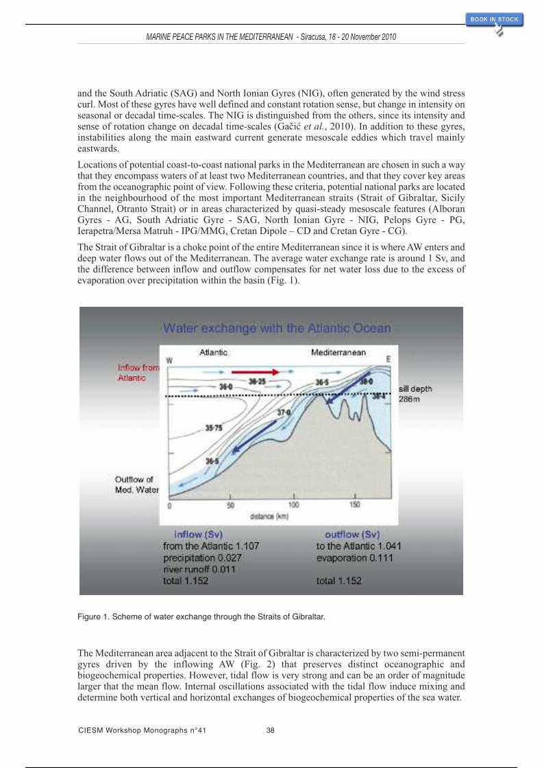
and the South Adriatic (SAG) and North Ionian Gyres (NIG), often generated by the wind stresscurl. Most of these gyres have well defined and constant rotation sense, but change in intensity onseasonal or decadal time-scales. The NIG is distinguished from the others, since its intensity andsense of rotation change on decadal time-scales (Gačić et al., 2010). In addition to these gyres,instabilities along the main eastward current generate mesoscale eddies which travel mainlyeastwards.
Locations of potential coast-to-coast national parks in the Mediterranean are chosen in such a waythat they encompass waters of at least two Mediterranean countries, and that they cover key areasfrom the oceanographic point of view. Following these criteria, potential national parks are locatedin the neighbourhood of the most important Mediterranean straits (Strait of Gibraltar, SicilyChannel, Otranto Strait) or in areas characterized by quasi-steady mesoscale features (AlboranGyres - AG, South Adriatic Gyre - SAG, North Ionian Gyre - NIG, Pelops Gyre - PG,Ierapetra/Mersa Matruh - IPG/MMG, Cretan Dipole – CD and Cretan Gyre - CG).
The Strait of Gibraltar is a choke point of the entire Mediterranean since it is whereAW enters anddeep water flows out of the Mediterranean. The average water exchange rate is around 1 Sv, andthe difference between inflow and outflow compensates for net water loss due to the excess ofevaporation over precipitation within the basin (Fig. 1).
Figure 1. Scheme of water exchange through the Straits of Gibraltar.
The Mediterranean area adjacent to the Strait of Gibraltar is characterized by two semi-permanentgyres driven by the inflowing AW (Fig. 2) that preserves distinct oceanographic andbiogeochemical properties. However, tidal flow is very strong and can be an order of magnitudelarger that the mean flow. Internal oscillations associated with the tidal flow induce mixing anddetermine both vertical and horizontal exchanges of biogeochemical properties of the sea water.
CIESM Workshop Monographs n°41 38
MARINE PEACE PARKS IN THE MEDITERRANEAN - Siracusa, 18 - 20 November 2010
35 / 113

Figure 2. IR satellite image with the Straits of Gibraltar and Alboran Sea.
Another choke point in the Mediterranean is the Sicily Strait (~300 m max depth), the area ofwater exchange between the eastern and western basins. Here the AW that propagates along theAfrican coast enters the eastern basin at the surface, while saltier LIW in deeper layers enters thewestern basin mainly across the sill south of Malta. Flow patterns in the strait are variable ondifferent time and space scales, and strong upwelling, filaments, and meanders have beendocumented both from experimental and modelling data (see e.g. Lermusiaux and Robinson, 2001;and references cited therein). These mesoscale features determine to a large extent thebiogeochemistry of the strait itself and of the larger adjacent area.
From an oceanographic viewpoint, the southAdriatic and northern Ionian region is a unique systemconnected through a feedback mechanism named “Bimodal Oscillating System” (BiOS) (Gačić etal., 2010; Borzelli et al., 2009). This feedback mechanism drives the inversions of the rotation ofthe NIG thanks to the salinity difference between AW and Levantine waters, and to open-oceanconvection taking place in the centre of the SAG. In the centre of the SAG, a marked springphytoplankton bloom is associated with the vertical mixing and nutrient input into the euphoticzone.
The bloom lasts for several days, up to a week, and is strongly dependent on cold air outbreaks andsubsequent restratification. Interannual variability of the vertical convection and consequently ofthe bloom is rather prominent and depends on both the buoyancy content in the water column andthe air-sea heat winter fluxes (Fig. 3).
MARINE PEACE PARKS IN THE MEDITERRANEAN - Siracusa, 18 - 20 November 2010
39 CIESM Workshop Monographs n°41
36 / 113

Figure 4. Visible satellite image of the Cretan Sea and a portion of the northern Levantine basin.
Figure 3. Distribution of salinity in post-convection periods in the South Adriatic Pit in the new millennium.Inversions of the Ionian upper-layer circulation are on decadal time-scales and apart from bringingwaters of varying salinity into the Adriatic, are also responsible for advection of allochtonousspecies into both areas (Civitarese et al., 2010), thus changing the biodiversity. The open seaphytoplankton biomass in the Ionian Sea is generally low but associated with upwelling due to theNIG, can in some years reach larger values. In general as opposed to the rest of the Mediterranean,the northern Ionian circulation shows stronger variability on decadal time-scales; seasonalvariability is of secondary importance.
CIESM Workshop Monographs n°41 40
MARINE PEACE PARKS IN THE MEDITERRANEAN - Siracusa, 18 - 20 November 2010
37 / 113

41 CIESM Workshop Monographs n°41
MARINE PEACE PARKS IN THE MEDITERRANEAN - Siracusa, 18 - 20 November 2010
The area of the Cretan Sea and the Levantine Sea in general is characterized by strong influenceof northwesterly winds (Etesian winds) that blow continuously during summer (Fig. 4). Thesewinds, due to the orography of the Greek islands and coast, are responsible for the formation ofquasi-steady gyres like IPG and PG that in turn influence both thermohaline and biogeochemicalproperties of the Levantine Sea. To the north of Crete, the Cretan Dipole CD is clearly visiblefrom satellite IR imagery and a probably baroclinic feature (Cardin and Hamad, 2003).
38 / 113

MARINE PEACE PARKS IN THE MEDITERRANEAN - Siracusa, 18 - 20 November 2010
43 CIESM Workshop Monographs n°41
Scientific rationale for the proposed CIESM Near AtlanticMarine Peace Park
Ricardo Aguilar 1, Mustapha Aksissou 2, José Templado 3 and Marie Romani 4
1 Oceana, Madrid, Spain ; 2 Dept. of Biology, Faculty of Science of Tetouan, Morocco ;3 Museo Nacional de Ciencias Naturales (CSIC), Madrid, Spain ; 4 MedPAN, Hyères, France
INTRODUCTION
The whole area of Ibero-MoroccanGulf, Straits of Gibraltar and theAlboran Sea (Figure 1) constitutesthe transition from the AtlanticOcean to the Mediterranean, withall the special interest that thisentails from all points of view.The Alboran/Gibraltar area is theengine where Mediterranean wateroriginates. Due to its primeimportance, extensive oceano-graphic research has beenconducted in the past in this area.As a consequence, an extensiveliterature exists on the dynamics ofthe Strait andAlboran Sea (physicaloceanography reviewed by Parrillaand Kinder, 1992), and theunderlying physical mechanismsthat govern water exchanges
through this zone are now relatively well understood. In addition, the planktonic communitiesassociated with this water exchange have also been well studied historically (i.e. Madin, 1991),although the nektonic and benthonic communities of this area were not studied intensively untilthe 1980’s. In summary, knowledge of the hydrology, geology and biological communities of thisarea is now fairly satisfactory.
GEOLOGICAL FEATURES
The Iberian-Maghrebian region is seismically active, and has been widely discussed in platetectonic reconstructions, as it straddles the boundary between the African and Eurasian plates.Seismic activity in the region is linked to the collision of these two plates, which are convergingat approximately 5 mm/y (Gil et al., 2002).
Figure 1. Shaded bathymetry of the CIESM Near Atlantic MarinePeace Park (within yellow circle) based on swath bathymetry(DTM at 500m grid). Adapted from L. Brosolo and J. Mascle(2007).
39 / 113

MARINE PEACE PARKS IN THE MEDITERRANEAN - Siracusa, 18 - 20 November 2010
CIESM Workshop Monographs n°41 44
Extensive studies of the geology of the Betic (southwest Iberia) and Rif-Tell (northwest Africa)cordilleras in the southwestern Mediterranean region indicate the importance of a distinct set oftectonic and paleoceanographic events that have clearly influenced the evolution of the area(Maldonado and Comas, 1992). These include the relative movements of the African and Iberianplates during the Cenozoic, and the geodynamics of the Alboran Domain, probably related to thedevelopment of oceanic crust in the Algero-Balearic basin to the east. In addition, the location ofthe Atlantic/Mediterranean gateways in the Betic and Rif cordilleras were probably the mostsignificant factors controlling evolutionary patterns. Global eustatic and climatic oscillations havealso been recorded in sediments throughout this area, but their influence on depositional processeswas modified by local tectonic factors.
To the north, the Betic Cordillera is divided into internal and external zones with the Guadalquivirforeland basin separating it form the Iberian Massif. During the Mesozoic and until the Oligocene,the Betic-Rif Internal Zone was situated further east, but with the opening of theAlgero-Provençalbasin in the early Miocene, the Betic-Rif Internal Zone moved to the west. Contemporarily, theAlboran Sea was created as the western prolongation of theAlgero-Provençal basin. The Betic-RifInternal Zone overthrust parts of the Iberian and African plates, partial sinking of both platesresulted, and is responsible for intermediate seismicity in the western sector of the Alboran Sea(López Casado et al., 2001). In theAtlantic, the boundary of the Iberian andAfrican plates extendsfrom the Azores to the Gulf of Cadiz, and is relatively well defined in its westernmost part as faras the sector between the Gloria and Gorringe faults. Farther east, this contact zone is stronglyaffected by transverse faults.
Extensive volcanism is expressed at seamounts in the Alboran Sea and on Alboran Island. TheCabo de Gata volcanic province in southeastern Iberia has extensive Middle Miocene to Pliocenecalc-alkaline to acidic volcanic rocks, which are disrupted by strike-slip faults suggestingsignificant horizontal displacements (Gil et al., 2002). The Gulf of Cadiz, west of the GibraltarArc,has experienced a complex tectonic history with several episodes of extension, strike-slip andcompression since the Cenozoic, related to the closure of the Tethys Sea, the opening of the NorthAtlantic, and the African-Eurasian convergence (Maldonado et al., 1999). Due to the ongoingcompression, these rapidly deposited sediments dewater intensely and form mud volcanoes andfluid escape structures (Diaz-Del-Rio et al., 2003). The Gulf of Cadiz has been intensivelysurveyed with geophysical tools, leading to the discovery of the first mud volcanoes, mud diapirsand pockmarks here, in 1999 (Kenyon et al., 2000; Gardner, 2001; Pinheiro et al., 2003). Inaddition, an extensive field of mud volcanoes and diapir structures covered with carbonatechimneys and crusts was discovered along or in close proximity to the main channels of theMediterranean outflow (Somoza et al., 2003). To date, more than 100 mud volcanoes has beenfound in the whole area (Fernández-Puga et al., 2007; Hensen et al., 2007; Medialdea et al., 2009).
OCEANOGRAPHIC FEATURES
The Strait of Gibraltar, the only significant link between the Mediterranean Sea and the world’soceans (14 km width and less than 300 m depth at the sill), is the key to the control of the exchangesand modification of the biogeochemical cycles and circulation of the entire Mediterranean and theNEAtlantic Ocean (Ami and Farmer, 1988; Minas et al., 1991; Bryden et al., 1994; Echevarría etal., 2002; Gómez, 2003). The basic circulation in the Strait of Gibraltar comprises an upper layer(about 150 m thick) of warm, relatively fresh surface Atlantic water flowing into theMediterranean, and a deep current of colder, saltier outflowing Mediterranean water. Asevaporation exceeds the sum of precipitation and river discharges in the Mediterranean, theAtlanticinflow exceeds the Mediterranean outflow to balance the net loss. This stratification facilitates thepassage of pelagic and planktonic organisms, including larvae, from the Atlantic to theMediterranean.
It is difficult to measure water velocity in the upper layer of the Strait of Gibraltar due to alternatingtidal currents and strong winds, but taking in consideration the amount of water exchange, thethickness of the upper layer and the average width of the sill, velocities are estimated to rangefrom 0.31 to 0.37 m s-1 (Tsimplisand Bryden, 2000). Biomass import and export through the Straits
40 / 113

45 CIESM Workshop Monographs n°41
MARINE PEACE PARKS IN THE MEDITERRANEAN - Siracusa, 18 - 20 November 2010
has been estimated to be approximately 5600 and 1100 tonnes C day-1 respectively (Reul et al.,2002).
The Strait of Gibraltar gives access to the Alboran Sea, the western most basin of theMediterranean. This geographic location as a transition zone makes the area a place of primeimportance for any research on the gradients and variability of the biotic communities. Becauseof its strong Atlantic influence, the Alboran Sea has been considered as “the most Atlantic of theMediterranean basins”. The Atlantic inflow forms two large anticyclonic gyres, the permanentWestern Alboran gyre, and the more episodic Eastern Alboran gyre. These gyres are separatedmore or less by the 3ºW meridian, where Cape Tres Forcas (in Morocco) and Alboran Island arelocated, and generate some upwelling of deep Mediterranean waters along the coast of Malagaand Granada (S Spain). A strong oceanic front is present between Cape Gata (SE Spain) and Oran(Algeria), called the Almeria-Oran Front (Tintoré et al., 1988). It is a large-scale density front,formed by the convergence of two distinct water masses and controlled by the geographic positionand strength of the EasternAlboran Gyre. Physical and biochemical data indicate that this front islimited to the upper 300 m, with a strong southward baroclinic jet. The Almeria-Oran Frontconstitutes the eastern limit of theAlboran Sea, and acts as an effective barrier for many planktonicorganisms and their larvae. Some molecular studies have shown noticeable genetic differencesbetween populations on the two sides of the front (Patarnello et al., 2007).
The existence of meso- and macroscale eddies and fronts, associated with the contact of differentwater masses, determines both the circulation and the distribution of ecological variables (biomass,productivity and composition of the planktonic community) in the area (Graze et al., 1985; Prietoet al., 1999; Youssara and Gaudy, 2001, among others).
In addition, there is a strong impact of the Mediterranean undercurrent that flows through the Straitof Gibraltar to theAtlantic margins of Iberia and NorthAfrica. These outflow relationships suggestthat the Betic and Rif straits may also have been important in the past evolution of the Atlanticmargins.
BIOLOGICAL FEATURES
Biogeographically, the Strait of Gibraltar is the “meeting point” of the Mediterranean region (tothe east), the Lusitanian region (to the northwest), and the Mauritanian region (to the southwest).It is a place of contact between warm-water species (from Atlantic North Africa and theMediterranean) and cold and temperate-water species (from the northeastAtlantic). The area is thusspecies-rich due the confluence of three marine biogeographical regions, plus some endemicspecies restricted to this zone (Gofas, 1987).
Since the 1980’s, multidisciplinary studies of the biodiversity of the Straits of Gibraltar have beenconducted, mainly by the Laboratorio de Biología Marina of Seville University (i.e. Carballo et al.,1997; Naranjo et al., 1998).As a result, many new species from the area have been discovered, andthe benthic communities of the northern part of the Strait described (García-Gómez et al., 2003).Recently, a Marine Protected Area (MPA) has been declared in this sector, covering nearly 40 kmof coastline.Adescription of benthic communities on theAfrican margin of the Strait can be foundin the book of Ocaña et al. (2009).
Obviously, the Straits of Gibraltar is an obligatory path for migratory vertebrates between theAtlantic and the Mediterranean (Rey, 1996). Large pelagic fish, cetaceans and sea turtles are veryfrequently observed in the area. Among the cetaceans, at least six species are very common here,the dolphins Delphinus delphis, Globicephala melas, Tursiops truncatus, and Stenellacoeruleoalba, the minke whale Balaenoptera acutorostrata, and the sperm whale Physetermacrocephalus. The abundance of cetaceans in this area is related to the importance of thismigratory path, the special oceanographic characteristics (de Stephanis et al., 2008), and thepreference of specific habitats and areas in the Alboran Sea have also been mentioned (Cañadaset al., 2005).
Both loggerhead (Careta caretta) and leatherback (Dermochelys coriacea) turtles are frequent inthe Strait; the former has a semi-permanent population near the Straits of Gibraltar associated with
41 / 113

remarkable concentrations of the swimming crab Polybius henslowii, here its main food resource(Ocaña et. al., 2002b).
Like the Strait of Gibraltar, the Alboran Sea is a mixed area where the faunistic and floristicinfluences of three biogeographic regions overlap (i.e. Mauritanian, Lusitanian and westernMediterranean). Therefore, this area is useful for providing information of the recent and pastfaunistic interchange between theAtlantic and Mediterranean. The combination of all hydrologicalfeatures together with the pronounced biogeographic differences between the Atlantic Ocean andthe Mediterranean affect benthic communities and their zonation patterns.
A recent review of biodiversity in the Mediterranean (Coll et al., 2010) points out that theAlboranSea displays the highest values of species richness in the Mediterranean, probably due to the influxofAtlantic species and the wide range of physicochemical conditions. The same review highlightsthe ecological importance of the Strait of Gibraltar and Alboran Sea for many threatened orendangered vertebrate species. This area is key to the migration of the internationally protectedloggerhead turtle (Caretta caretta) from theAtlantic to theWestern Mediterranean, and hosts a highdiversity of cetacean species. Of the nine resident marine mammals in the Mediterranean, eight arecommon in the Alboran Sea (including minke whale Balaenoptera acutorostrata, fin whaleBalaenoptera physalis, sperm whale Physeter macrocephalus, pilot whale Globicephala melasand bottlenose dolphin Tursiops truncatus). Among resident species, the short-beaked commondolphin (Delphinus delphis) merits particular attention, because its population in the Alboran Seais the healthiest in the Mediterranean, after a dramatic decline of this species in most of itsMediterranean range (Notarbartolo di Sciara, 2002).
Most of the species of theAnnex II and III of the Barcelona Convention are present in theAlboranSea, and the most threatened invertebrate species, the limpet Patella ferruginea, is concentratedin this area (Templado et al., 2004).
The Alboran Sea biota is not homogeneous, since there is a west-east gradient due to the Atlanticinfluence, and an asymmetry in the north (European) - south (African) axis, due to the upwellingareas in the northern part. It is interesting to note that theAtlantic-Mediterranean and subtropical-temperate segregation patterns of benthic species are not the same on the North African coasts,where Tres Forcas Cape (3ºW) acts as an eastern limit for species with tropical affinities (and isat the same time the western limit for several Mediterranean species). In contrast, there are noclear limits the south Spanish coasts, and the upwelling areas determine the presence in shallowwaters of typical species from deeper levels (Cebrián and Ballesteros, 2004). García Raso et al.(2010) have highlighted that this area has the highest species richness of all European coasts;Luque and Templado (2004) provide a complete revision of the marine flora of the entire area.
The biomass and calcium carbonate content of communities thriving on rocky bottoms of thenorthern (Spanish) margin of theAlboran Sea were studied by Cebrián et al. (2000). Total biomassis slightly higher than in other Mediterranean areas due to the high biomass of suspension feeders.Since most animals and algae with high biomass have calcareous skeletons, carbonate productionis rather high (1.100 g Ca CO3 m
-2 y-1) compared with other temperate and Mediterranean sites.As an example, carbonate production from deep-water assemblages in this area is nearly four foldshigher than in similar studies carried out in the Balearic Islands (Cebrián et al., 2000). This highcarbonate production may be related to the particular hydrographic processes that take place in thisarea (mixing Atlantic and Mediterranean waters and upwelling of Mediterranean deep waters).
The African coasts of the Alboran Sea are still poorly known, but some peculiar and uniquecommunities have been identified, such as those characterized by the North African gorgonianEllisella paraplexauroides. This large gorgonian (up to 3 m high) dominates the rocky bottoms withnorthern orientation in the Chafarinas Islands between 20 and 40 m depth (Templado et al., 2006).These islands, designated as MPA by the Spanish government, also have the healthiest knownpopulations of the endangered limpet P. ferruginea.
There are several seamounts in the Alboran Sea (Chella, Djbouti, and Motril seamounts in itsnorthern part, andAlidae, Cabliers, Porvençaux, Tofiño and Xauen seamounts in its southern parts).The benthic fauna of these banks is poorly known, but is now under study. Although very diverse
CIESM Workshop Monographs n°41 46
MARINE PEACE PARKS IN THE MEDITERRANEAN - Siracusa, 18 - 20 November 2010
42 / 113

pre-modern Quaternary thanatocoenoses have been found, including dead reefs of white corals,living representatives have also been detected. Recent research on the Chella bank found importantMadrepora oculata reefs, sometimes mixed with Lophelia pertusa, as well as other scleractiniancorals typical of these communities, like Desmophyllum dianthus. This bank is also known forhosting the rare gorgonian Dendrobrachia sarmentosa, important aggregations of deep-sea glasssponges (Asconema setubalense), and the protected Mediterranean carnivorous sponge(Asbestopluma hypogea) (Aguilar et al., 2011), among other exceptional species. Furthermore, aprominent ridge about 150 km long, of whichAlboran Island forms the summit, extends in a SW-NE direction and divides the Alboran Sea in two subbasins.
A strong correlation has been found between the different water masses and the faunistic andfloristic composition of the sublittoral benthos aroundAlboran Island (a complete review has beenpublished by Templado et al., 2006). The infralittoral and upper circalittoral assemblages (between0 and about 50 m) of this island contain important Lusitanian components, and are dominated bythe seaweeds Cystoseira tamariscifolia in the upper infralittoral, Cystoseira usneoides in the lowerinfralittoral and Saccorhyza polyschides and Laminaria ochroleuca in the upper circalittoral.However, lower circalittoral-upper bathyal assemblages (50-200 m) harbour fauna with a peculiarspecies composition, lacking affinities with equivalent communities in neighbouring areas both inthe Atlantic and the Mediterranean. This suggests that the lower circalittoral of the Alboran shelfis an ecotone established in the boundary layer between the Atlantic and Mediterranean watermasses (Maldonado and Uriz, 1995). The species richness associated with the Laminaria forestsof Alboran Island is higher than that of the Mediterranean Posidonia meadows; but the highestspecies richness has been detected in the coralligenous communities here. As an example, up to15 species of gorgonians have been found in this area. The great species turnover rate as well asthe high species richness, suggest that this community is an ecotone assemblage within theAtlantic-Mediterranean axis. These coralligenous bottoms harbour well-known populations of the red coral(Corallium rubrum), that were intensively extracted in the past. Nowadays an extensiveMediterranean Action Plan (MAP) has been declared by Spanish Law around the island.
The marine biological assemblages around Alboran Island might be assumed to have a relativelyrecent origin, based on the co-existence of present-day (Holocene) species from nearbybiogeographical regions with late Quaternary (Sicilian, Tyrrhenian) relicts, and alternatingMediterranean andAtlantic influences. The environmental changes provoked by Quaternary eventswere to some extent attenuated below the shallowest bathymetrical level, allowing survival and co-existence for elements of different origin.
In conclusion, the current marine fauna of Alboran Island can be understood as a result of thecoexistence of:- Some very ancient elements (either true elements surviving the Messinian crisis or Tethyanelements reintroduced from the Ibero-Maroccan bay in the Pliocene);- Lusitanian and Mauritanian-Senegalese elements arising from the alternating glacial andinterglacial Quaternary migrations;- Mediterranean elements originated during the Quaternary;- New species evolved in the current peculiar environmental conditions.
It is noteworthy that at least 32 new marine species have been described from this island in the lasttwo decades (1 seaweed, 10 sponges, 1 isopod, 1 amphipod, 14 molluscs, 4 bryozoans, and 1ascidian). Extensive surveys of the island marine biodiversity begun in the 1980’s. Templado et al.(2006) list of more than 1,800 species (219 species of macrophytes, 183 of sponges, 98 cnidarians,630 of molluscs, 123 of bryozoans, among others).
In contrast, knowledge of the benthic communities of the Ibero-Moroccan Gulf is scarce. Bobo(1998) published a guide to the littoral fauna and flora of the coast of Huelva, and the conservationorganisation OCEANA is currently conducting Remotely Operated Vehicle (ROV) surveys of thesediments of the Gulf of Cadiz. In addition, the IEO is studying the mud volcanoes and diapirs inthe area, with their carbonate chimneys and crusts, but mainly from the geological point of view.
MARINE PEACE PARKS IN THE MEDITERRANEAN - Siracusa, 18 - 20 November 2010
47 CIESM Workshop Monographs n°41
43 / 113

MARINE PEACE PARKS IN THE MEDITERRANEAN - Siracusa, 18 - 20 November 2010
CIESM Workshop Monographs n°41 48
The Gulf of Cadiz coast is low and sandy, often with high sedimentation rates and large dunesystems. There are clear differences between the western and eastern sectors. While the bottomsoff Huelva are mostly covered by soft sediments, those off Cadiz are characterized by rockyoutcrops, and the shoreline has some rocky intertidal platforms with tide pools. The benthic faunaof the whole sectoris mainly dominated by communities typical of soft sediments (with somepeculiar species of the area, such as the gastropods Cymbium olla or Ampulla priamus), while therocky outcrops have rich communities of sessile filter feeding animals (Leptogorgia sarmentosa,Eunicella verrucosa, E. gazella, Elisella paraplexauroides, Dendrophyllia ramea, Astroidescalycularis, etc.) and important fish schools concentrate in these areas (Chromis chromis,Parapristipona octolineatum, Plectorhynchus mediterraneus, Diplodus spp.), includingendangered species, like the guitarfishes (Rhinobatos spp.).
Some of the mud volcanoes and chimneys scattered throughout thearea support communities ofvesicomyd clams and siboglinid tubeworms (Mata et al., 2009).
THREATS
The main threats to the region include intense and destructive fishing activities, urban developmentand infrastructure on the coastline, submarine cables, chemical pollution, military manoeuvres,oil facilities and pipelines, off-shore energetic plans development plans, harbour constructions,sea bottom mining, sand dredging, etc. There is also heavy marine traffic. Invasive species areincreasingly colonising the area, like the anemone Haliplanella lineata and the tunicate Styelaclava.
Fishing is one of the main human activities in the area. The Strait of Gibraltar is a transit zone forseveral species of large pelagic fish and crustaceans, e.g., swordfish (Xiphias gladius), marlins(Istiophorus albicans), bluefin (Thunnus thynnus) and other tunas (Techetach, 2002). Themigrations of these species through the strait each year occur during specific seasons determinedby their physiological needs, namely reproduction and diet. In fact, the highest catches of bluefintuna and swordfish in Morocco occur in Tangier waters. The Port of Tangier is ranked as the majorport of landing swordfish, making Morocco the second largest producer of swordfish across theMediterranean, after Italy (ONP, 2008).
There are also important fisheries for deep sea species, like red sea bream (Pagellus bogaraveo)which is heavily fished (Gil and CopeMed II Consultant, 2010), and with stock levels in a criticalstate.
The Strait of Gibraltar is also a very important area for marine turtles that migrate between theMediterranean and other areas of theAtlantic Ocean (Benhardouze, 2009; Ocaña et al., 2002a). TheStraits of Gibraltar does not appear to contain resident populations of marine turtles (Fretey, 2001)nor suitable nesting habitats, (Benhardouze, 2009) but is a transition zone for immatureloggerheads from the Americas and the eastern Atlantic (Bolten, 2003). Migratory fluxes ofloggerhead turtles near and through this strait has been reported in both directions (Camiñas, 1997;López-JuradoandAndreu, 1998; Margaritoulis et al., 2003). Loggerheads sea turtles are predictedto require a minimum straight carapace length (SCL) of 36.0 cm to swim against the current fromthe Mediterranean to the Atlantic (Revelles et al., 2007). Migration takes place from May toAugust, and includes both juveniles and adults (Camiñas, 1997; Revelles et al., 2007). The coastssurrounding the Strait of Gibraltar (Tetuan to Ceuta, Tangier, and Asilah) appear to be foragingareas for juvenile turtles primarily (Benhardouze, 2009). The rich fisheries of the region could bethe origin of the attendance of young turtles to these areas. Sea turtles and cetaceans commonlyinteract with fisheries in the Strait of Gibraltar (Acero et al., 2009).
On both sides of the Strait of Gibraltar, there are several fishing ports (Tangier, Cadiz, etc.), whichgenerate heavy fishing pressure. Therefore, fisheries resources are declining, according to thestatistics, and also according to statements of fishermen in the area. It is time to reduce fishing effortand also to eliminate the most harmful types of fisheries (driftnet) to protect species including seaturtles and dolphins (Tudela et al., 2004).
Fisheries are very important both in the Gulf of Cadiz and the Alboran Sea. Many species,including crustaceans like Parapenaeus longirostris and Melicertus kerathurus, molluscs like
44 / 113

49 CIESM Workshop Monographs n°41
MARINE PEACE PARKS IN THE MEDITERRANEAN - Siracusa, 18 - 20 November 2010
Chamelea gallina, Donax trunculus, Sepia spp. and Octopus vulgaris, and fish like Sardinapilchardus, Engraulis encrasicolus, Dicologlossa cuneata, Argyrosomus regius and many othersare target species for artisanal and semi-industrial fleets (IEO, 1989; Manzano et al., 2004;Aguilaret al., 2010).
CONCLUSIONS
Some of the key elements in favour of the proposition of the “Near Atlantic” among internationalMPPs within the Mediterranean are the following:
- The area constitutes the engine where Mediterranean water originates.
- It plays a key control of the exchanges and modification of the biogeochemical cycles andcirculation of the entire Mediterranean.
- It is an outstanding area for biodiversity in the Mediterranean, being a transitional zone betweenthe Atlantic Ocean and the Mediterranean, with the highest species richness in European/NorthAfrican waters.
- It is key route for the migration of the internationally protected marine vertebrate species (seaturtles, cetaceans, and target species of pelagic fish) from the Atlantic to the WesternMediterranean, and hosts a high diversity of cetaceans.
- There are some unique communities within the Mediterranean dominated byAtlantic seaweeds,such us the forests of Laminaria ochroleuca and Saccorhyza polyschides, or the communitydominated by the north African gorgonian Ellisella paraplexauroides.
- Some living deep coral banks of Lophelia pertusa andMadrepora oculata have been found nearAlboran Island and on the Chella Seamount.
- More than 100 mud volcanoes and many fluid escape structures have been detected scatteredover the whole Ibero-Moroccan Gulf.
- Most of the species included in Appendices II and III of the Barcelona Convention are presentin this area.
- The most threatened invertebrate species of the Mediterranean, Patella ferruginea, is mostabundant in this area (Templado et al., 2004).
- There are four important Spanish MPAs in this area: Cabo de Gata Natural Park and MarineReserve in the northeast limit of theAlboran Sea, TheAlboran Island Marine Reserve in the centreof this basin, the North Littoral of the Strait of Gibraltar Natural Park, and the Chafarinas IslandsRefuge on the Moroccan coast. There are also some other less extensive marine protected areas,some of them within Nature 2000 sites.
45 / 113
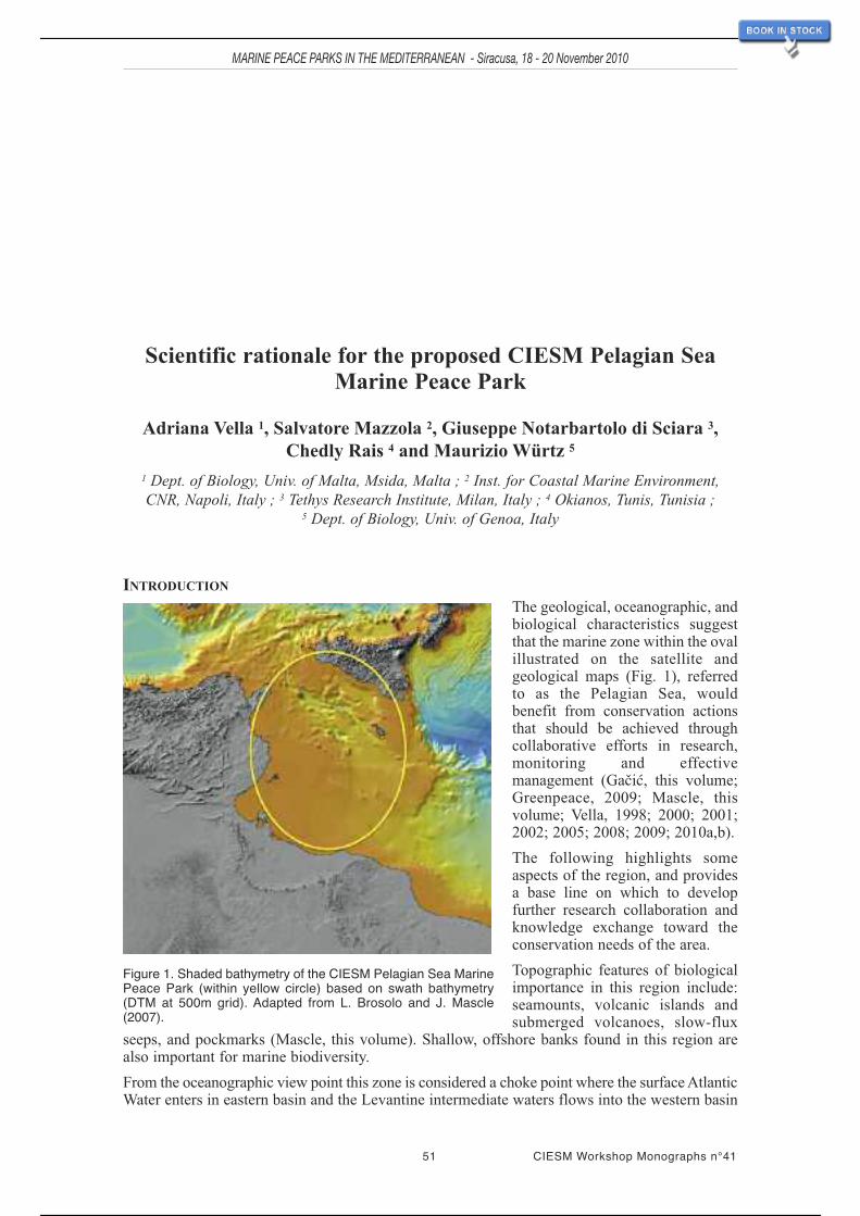
Scientific rationale for the proposed CIESM Pelagian SeaMarine Peace Park
Adriana Vella 1, Salvatore Mazzola 2, Giuseppe Notarbartolo di Sciara 3,Chedly Rais 4 and Maurizio Würtz 5
1 Dept. of Biology, Univ. of Malta, Msida, Malta ; 2 Inst. for Coastal Marine Environment,CNR, Napoli, Italy ; 3 Tethys Research Institute, Milan, Italy ; 4 Okianos, Tunis, Tunisia ;
5 Dept. of Biology, Univ. of Genoa, Italy
INTRODUCTION
The geological, oceanographic, andbiological characteristics suggestthat the marine zone within the ovalillustrated on the satellite andgeological maps (Fig. 1), referredto as the Pelagian Sea, wouldbenefit from conservation actionsthat should be achieved throughcollaborative efforts in research,monitoring and effectivemanagement (Gačić, this volume;Greenpeace, 2009; Mascle, thisvolume; Vella, 1998; 2000; 2001;2002; 2005; 2008; 2009; 2010a,b).
The following highlights someaspects of the region, and providesa base line on which to developfurther research collaboration andknowledge exchange toward theconservation needs of the area.
Topographic features of biologicalimportance in this region include:seamounts, volcanic islands andsubmerged volcanoes, slow-flux
seeps, and pockmarks (Mascle, this volume). Shallow, offshore banks found in this region arealso important for marine biodiversity.
From the oceanographic view point this zone is considered a choke point where the surfaceAtlanticWater enters in eastern basin and the Levantine intermediate waters flows into the western basin
MARINE PEACE PARKS IN THE MEDITERRANEAN - Siracusa, 18 - 20 November 2010
51 CIESM Workshop Monographs n°41
Figure 1. Shaded bathymetry of the CIESM Pelagian Sea MarinePeace Park (within yellow circle) based on swath bathymetry(DTM at 500m grid). Adapted from L. Brosolo and J. Mascle(2007).
46 / 113

(Gačić, this volume); the area is also characterised by several mesoscale features (upwelling,filaments, and meanders) that play an important role in the biogeochemistry dynamics of the SicilyStrait and surrounding area (Fig. 2).
Figure 2. Features of the Strait of Sicily/Malta/Pelagian Islands: AW= Atlantic Water; LIW=LevantineIntermediate Water; AIS = Atlantic Ionian Stream; ATC=Atlantic Tunisian Current; ABV=Adventure BankVortex; ISV=Ionian Shelf-break Vortex—After Lermusiaux (1999); Lermusiaux and Robinson (2001); Bérangeret al. (2004); Poulain and Zambianchi (2007).
Greenpeace published a proposal for a regional network of large-scale marine reserves with the aimof protecting the full spectrum of life in the Mediterranean (Greenpeace, 2006; 2009). The SicilianStraits Channel was identified as one of the areas to be protected within the network.
The network was drawn up with the help of experts and used a variety of data sets includingdistribution of species, areas important for key life stages e.g. spawning grounds, important habitatssuch as seamounts, and sites previously identified as priority sites for protection, such as SpeciallyProtected Areas of Mediterranean Importance (SPAMIs) (Greenpeace, 2009).
In the context of Ecologically and Biologically Significant Areas (EBSA) the Pelagian Sea offersvarious scientific criteria, and protocols for conservation and management measures, includingthe establishment of representative networks of marine protected areas in accordance withinternational law (Convention on Biological Diversity Decision IX/20).All the seven CBD EBSAcriteria adopted are relevant in this area.
UNIQUENESS OR RARITY
Rare habitats/assemblages are found in this region, such as the facies formed by Isidella elongataand that formed by Funiculina quadrangularis, and white corals. Rare and endemic species in thearea include the Maltese ray, Leucoraja melitensis and the scleractinian coral Cladopsammiarolandi (Pipitone et al., 1992).
SPECIAL IMPORTANCE FOR LIFE HISTORIES OF SPECIES
The area includes spawning, and nursery grounds for several species of ecological (fin whales,turtles, seabirds) and economic importance (bluefin tuna, deep sea gadoids, swordfish). To thisextent, a 25 nm fisheries conservation zone around Malta has been established (Aissi et al., 2008;Dalli and Vella, 2006; Greenpeace, 2009; Vella, 1998; 2000; 2001; 2002; 2005; 2008; 2009;
CIESM Workshop Monographs n°41 52
MARINE PEACE PARKS IN THE MEDITERRANEAN - Siracusa, 18 - 20 November 2010
47 / 113

2010a,b).
IMPORTANCE FOR THREATENED, ENDANGERED OR DECLINING SPECIES AND/OR HABITATS
Common dolphins (Delphinus delphis) and various other cetaceans including bottlenose, striped,and Risso’s dolphins, sperm and fin whales, elasmobranchs, including great white shark(Carcharodon carcharias), basking shark (Cetorhinus maximus) and devil’s ray (Mobula mobular),sea birds including shearwater species (Calonectris diomedea and Puffinus yelkouan) arevulnerable species resident or frequently observed in the region; some of them have been classifiedin the red list as threatened or endangered species. Posidonia oceanicameadows are still extensivein this region (Dalli and Vella, 2006; Greenpeace, 2009; Vella, 1998; 2000; 2001; 2002; 2005;2008; 2009; 2010a,b; Vella and Vella, 2010).
VULNERABILITY, FRAGILITY, SENSITIVITY, SLOW RECOVERY
Vulnerable deep coral assemblages, cold seep assemblages and benthic and pelagic species affectedby over-exploitation and habitat degradation are found in the region (Vella, 2010). Overall, marinebiodiversity impoverishment and change due to increasing human activities including oilexploration, aquaculture, maritime and fisheries activities, climate change and alien species fromboth sides of Gibraltar and Suez Canal openings.
BIOLOGICAL PRODUCTIVITY
Mesoscale structures referred to by Gačić (this volume) are related to wind driven upwelling,which affect both the Mazurka del Vallo fishing area and the Capopassero upwelling. While thesestructures may be stationary when wind-driven, they can move when influenced by sea currents.In the latter case the effects are temporary and last up to 20 days. he hydrography, canyons andcomplex fluxes in the region need to be considered in the light of their effects on biologicalproductivity too. The region is recognised as being important for spawning and as a nursery forvarious species including bluefin tuna (Thunnus thynnus) spawning areas (Vella, 2009; 2010a),swordfish (Xiphias gladius), anchovy (Engraulis encrasicolus), and several demersal species(Fortibuoni et al., 2010). The area around Malta was also found to be important for fisheriesconservation, and a 25 nm fisheries conservation zone around these islands was established.
BIOLOGICAL DIVERSITY
This area is important from an evolutionary point of view due to different sea level changes andisolation episodes, and therefore secondary contacts that may have paved the way to speciation andseparation between basins. Molecular genetics studies of species and populations in this region incomparison with other region in the Mediterranean are important for conservation and formonitoring changes in this region and in the Mediterranean distribution of species.
NATURALNESS
Though human use of the region is extensive, with impacts on its biological and environmentalstatus, unique natural conditions found here are essential to safeguard the marine life present, andto study the various unknown geological and environmental characteristics of this region in moredetail. The region is geologically complex, even though the Pelagian Sea overlies the Africanplatform and is thus mostly limestone. Extensive oil research takes place in the region, but thedata collected have not so far been released, and thus full bathymetric data for the area is not yetavailable (Mascle, this volume).
MARINE PEACE PARKS IN THE MEDITERRANEAN - Siracusa, 18 - 20 November 2010
53 CIESM Workshop Monographs n°41
48 / 113

55 CIESM Workshop Monographs n°41
MARINE PEACE PARKS IN THE MEDITERRANEAN - Siracusa, 18 - 20 November 2010
Scientific rationale for the proposed CIESM Herodotus andEratosthenes Marine Peace Park
Jean Mascle 1, Myroula Hadjichristoforou 2 and Howaida Zakaria 3
1 Geo-Azur, CNRS, Villefranche-sur-mer, France ; 2 Department of Fisheries and Marine
Research, Nicosia, Cyprus ; 3 NIOF, Alexandria, Egypt
The proposed Herodotus and Eratosthenes Marine Peace Parks (Figure 1a, b) are located in thesouth Eastern Basin: the forme extends between the coasts of Greece (South-eastern Crete) and ofEgypt (Western Desert) and the latter lay between the coasts of Egypt and of Cyprus. Both overlappartially with Exclusive Economic Zones.
Figure 1a. Shaded bathymetry of the CIESM Herodotus Marine Peace Park (within yellow circle) based onswath bathymetry (DTM at 500 m grid). Red circle: Olympic field; Blue circle: are of twin Cheffren mudvolcano. 1b. Shaded bathymetry of the CIESM Eratosthenes Marine Peace Park (within yellow circle) basedon swath bathymetry (DTM at 500 m grid). Red circle: area of Amon gas chimney. Adapted from L. Brosoloand J. Mascle (2007).
49 / 113

GEOMORPHOLOGY
Herodotus1 Marine Peace Park, which lies, with water depths up to 3000 m, between the coasts andthe continental slopes of Crete (to the North) and of the Western desert (Egypt, to the South). Thearea covers three main geological domains: (a) the passive African continental margin of Egypt(and partly Libya), including the northwestern most corner of the Nile deep sea fan sedimentaryconstruction, (b) the seismically active continental margin which borders the island of Crete and,(c) between both continental margin segments a huge mass of tectonic sediments, theMediterranean Ridge, which results from the piling up and strong deformations of sedimentssqueezed between the two rigid margins.
Eratosthenes2 Marine Peace Park, which extends up to 3000 m water depth, between the coasts andthe continental slopes of Egypt (Nile delta to the south) and of Cyprus (to the North); it includesa wide, flat-topped and relatively shallow (water depth less than 1000 m) seamount, theEratosthenes seamount. The area covers three main geological domains: (a) the wide passiveAfrican continental margin of Egypt (and particularly large domains of the Nile submarine deltaand of its sedimentary fan), (b) the seismically active continental margin which borders the islandof Cyprus and, (c) between both a breakingAfrican continental margin fragment, the Eratosthenesseamount, which is entering continental collision with Cyprus; moreover this flat-topped seamountwas an island during the Messinian desiccation crisis which affected the Mediterranean Seasometimes between 6 and 5 millions years ago, and thus submitted to intense continental erosion.
GEO- AND HYDRODYNAMICS DIVERSITY
Several current gyres characterize both Herodotus and Eratosthenes zones (Gačić, this volume),inducing at local scale temporarily highly productive zones. Primary productivity is particularlyhigh in waters near the Egyptian coast (Eratosthenes Park) due to the considerable input of nutrientsfrom Nile Delta.
Another specific feature common to the two areas is the presence of deep-sea (between 2000 to3000 m in Herodotus and between 500-1000 in Eratosthenes), cold fluid seep fields, whoseactivities induce the development of unique deep sea environments and of microbial-relatedbiodiversity hot spots.
FLUID SEEPAGE: AN EXAMPLE OF SPECIFIC “GEO-DIVERSITY” AND ITS IMPACT ON DEEP-SEA ENVIRONMENTS
In Herodotus zone fluids are emitted directly to the seafloor in two distinct settings: (a) within theMediterranean ridge where they are closely linked to massive emissions of under-compacted andover-pressurized mud known as mud volcanoes, and (b) at the foot of the Nile submarinesedimentary construction on the Egyptian continental slope.
On the Mediterranean ridge, particularly on the so-called Olympi field, group of several mudvolcanoes were discovered about 15 years ago and on which in situ research has been conductedin the past 10 years. One of these features, the Napoli mud volcano MV, has received particularattention. Napoli MV (see Figure 2), which lies in 2000 m depth, has small sub-circular brineponds and brine rivers on its active top, resulting from mixing of mud, fluids and remobilized salt-rich sediments; the emitted gases, particularly biogenic and thermogenic methane, are degraded by
CIESM Workshop Monographs n°41 56
MARINE PEACE PARKS IN THE MEDITERRANEAN - Siracusa, 18 - 20 November 2010
1 Herodotus was a Greek historian (c.484 t-c. 425 BC), well known for his “Histories” of the Mediterranean world. Hisname was given some 50 years ago to the deep abyssal plain extending to more than 3000 m depth at the foot of theAfrican continental margin from Libya to Egypt in the Eastern Mediterranean.2 Eratosthenes, Greek mathematician and geographer (born in Libya, c. 276 BC, died inAlexandria, c. 195 BC), createda system of latitude and longitude, and was the first to demonstrate that the earth was round! His name was given some50 years ago to the large flat seamount, which lies, in less than 1000 m water depth, between the African continentalmargin off Egypt and Cyprus.
50 / 113

specific bacterial/archaea consortia which favour chemosynthetic symbiosis with worms,lamellibranches, sea urchins and others species, including crabs and fishes which take advantageof this seabed food supply (Figure 3). Thus these cold fluid seeps form oases of life in particularlyextreme environments.
Figure 2. Napoli Mud Volcano in 2000 m water depth in the Olympi field, south of Crete.
Figure 3. Seabed views of Napoli Mud Volcano showing brine rivers, bacterial mats, crabs, rays and sponges.
Similar processes are operating at the foot of the Egyptian continental margin in 3000 m waterdepth (Figure 4). There the fluids clearly originate from a deep buried petroleum system, and aresimilarly mixing with dissolved salt layers and over-pressurized mud to generate small mudvolcanoes and important gas chimneys. These fluids also contribute through chemosynthesisprocesses initiated by bacterial/archaea consortia, degrading CH4 and other components, to specificbiodiversity hot spots, which were totally unknown less than 10 years ago. These discoverieshighlight the need to better study and preserve such bio/geo-diversity environments.
MARINE PEACE PARKS IN THE MEDITERRANEAN - Siracusa, 18 - 20 November 2010
57 CIESM Workshop Monographs n°41
51 / 113

MARINE PEACE PARKS IN THE MEDITERRANEAN - Siracusa, 18 - 20 November 2010
CIESM Workshop Monographs n°41 58
Figure 4. Seabed views of Cheffren Mud Volcano showing brine lake and brine rivers and bacterial mats andfilaments.In the southern region of Eratosthenes zone fluids are emitted directly on the seafloor followingtwo different mechanisms: (a) along fault zones that form a “plumbing” system, where the fluidsappear closely linked to massive emissions of under-compacted and over-pressurized mud knownas mud volcanoes or gas chimneys, several kilometers in diameter, and chiefly detected on theeastern upper continental slope and, (b) through hundreds of pockmarks, small sub-circular (onlya few meters in diameters) depressions, which affect wide areas of the Nile submarine deltacontinental slope and indicate important degassing processes.
Concerning the gas chimneyswe propose it is important to concentrate efforts on a group of severalgas chimneys discovered about 10 years ago, and on which “in situ” research has been conductedin the past 7 years. One of these features, Amon gas chimney (GC), has received special attention(Figure 5). The sediments on the active top of Amon GC, which lies in 1100 m water depth, arestrongly disturbed and believed to result from explosive mud/gas emissions; these gas emissions,particularly thermogenic methane, are assimilated by bacteria/archea consortia facilitatingchemosynthetic symbiosis with many invertebrate species, as well as fish which feed on the seabed.Similarly to those in the Herodotus zone, cold fluid seeps located in the southern part ofEratosthenes Park form oases of specialized life in extreme environments.
Figure 5. Amon gas chimney, in 1100 m water depth, along the Eastern Nile fan continental slope North ofDamietta. Plan and 3D views from a DTM at 2 m recorded near the seabed with an AUV system.
52 / 113
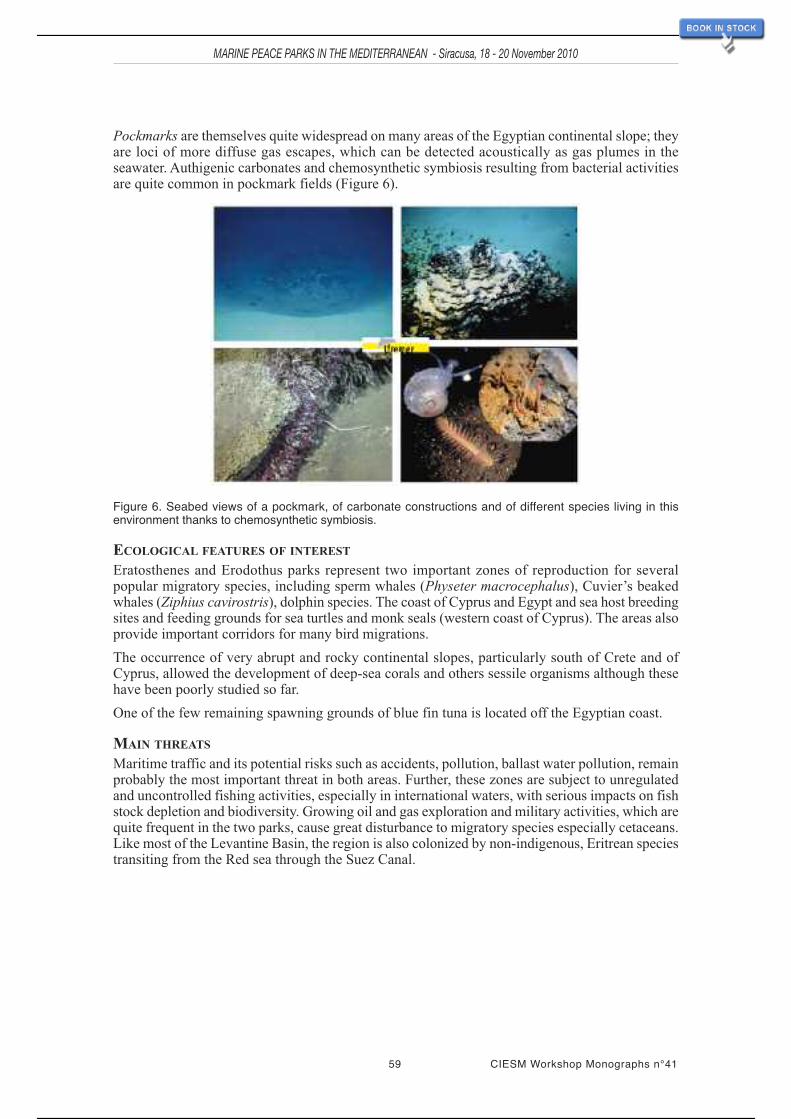
59 CIESM Workshop Monographs n°41
MARINE PEACE PARKS IN THE MEDITERRANEAN - Siracusa, 18 - 20 November 2010
Pockmarks are themselves quite widespread on many areas of the Egyptian continental slope; theyare loci of more diffuse gas escapes, which can be detected acoustically as gas plumes in theseawater. Authigenic carbonates and chemosynthetic symbiosis resulting from bacterial activitiesare quite common in pockmark fields (Figure 6).
Figure 6. Seabed views of a pockmark, of carbonate constructions and of different species living in thisenvironment thanks to chemosynthetic symbiosis.
ECOLOGICAL FEATURES OF INTEREST
Eratosthenes and Erodothus parks represent two important zones of reproduction for severalpopular migratory species, including sperm whales (Physeter macrocephalus), Cuvier’s beakedwhales (Ziphius cavirostris), dolphin species. The coast of Cyprus and Egypt and sea host breedingsites and feeding grounds for sea turtles and monk seals (western coast of Cyprus). The areas alsoprovide important corridors for many bird migrations.
The occurrence of very abrupt and rocky continental slopes, particularly south of Crete and ofCyprus, allowed the development of deep-sea corals and others sessile organisms although thesehave been poorly studied so far.
One of the few remaining spawning grounds of blue fin tuna is located off the Egyptian coast.
MAIN THREATS
Maritime traffic and its potential risks such as accidents, pollution, ballast water pollution, remainprobably the most important threat in both areas. Further, these zones are subject to unregulatedand uncontrolled fishing activities, especially in international waters, with serious impacts on fishstock depletion and biodiversity. Growing oil and gas exploration and military activities, which arequite frequent in the two parks, cause great disturbance to migratory species especially cetaceans.Like most of the Levantine Basin, the region is also colonized by non-indigenous, Eritrean speciestransiting from the Red sea through the Suez Canal.
53 / 113

Scientific rationale for the proposed CIESM North LevantMarine Peace Park
Ali Cemal Gücü 1 and Bayram Öztürk 2
1 Institute of Marine Sciences, Middle East Technical University, Erdemli-Mersin, Turkey ;2 Faculty of Fisheries, Istanbul University, Turkey
INTRODUCTION
This report summarizes the majorand peculiar features of TaseliStrait between Anatolia andCyprus, within the context of theeastern Mediterranean ecosystem(Figure 1). For this, we considerthe phytoplankton and zoo-plankton, essential buildingblocks of pelagic ecosystems, theichthyoplankton that deter-mines/ensures the future of fishstocks, the gelatinous organismswhich form trophic dead-endsin pelagic ecosystems, andendangered and threatenedspecies protected by internationalconventions and national laws.Life histories, habitats, spawning,nursery and overwintering
grounds are evaluated to the extent that available data permits.
The oceanography of the Eastern Mediterranean is characterized by a complex system of mesoscaleeddies, jets and meanders entrained and embedded in the general cyclonic circulation (Hamad etal., 2005; CIESM, 2005a). Although some of the main oceanographic features persist, the generalcirculation is subject to remarkable inter-annual variability (Özsoy et al., 1991; 1993). One of themost important temporal variations is the geographical range achieved by the (modified) AtlanticWater (MAW). This water mass enters the Levant Basin through the Cretan Passage, and the coreof the jet branches southwest of Cyprus. One branch passes Cyprus to the south and reaches theeastern boundary of the basin. In some years, an arm turns north, advecting a considerable amountof theAtlantic water into the NE Levant in the form of a subsurface filament (Özsoy et al., 1993).This is the main motive force of theAsia Minor Current that feeds Taseli Strait. However, at othertimes the mainstream flow is blocked in the Latakia basin, between Cyprus and Syria (Özsoy etal., 1991).
MARINE PEACE PARKS IN THE MEDITERRANEAN - Siracusa, 18 - 20 November 2010
61 CIESM Workshop Monographs n°41
Figure 1. Shaded bathymetry of the CIESM North Levant MarinePeace Park (within yellow circle) based on swath bathymetry (DTMat 500m grid). Adapted from L. Brosolo and J. Mascle (2007).
54 / 113

MARINE PEACE PARKS IN THE MEDITERRANEAN - Siracusa, 18 - 20 November 2010
CIESM Workshop Monographs n°41 62
Figure 2. Percentages of dominant yolk sac larval fish during the study periods (Ak and Uysal, 2008).
Productivity in the north-eastern Mediterranean is characterised by extreme oligotrophy (Yılmazet al., 1994; Ediger and Yılmaz 1996; Ediger et al., 2005). However, nearshore waters are typicalROFI (Regions of Freshwater Influence) with significant inputs from small to medium scale riversflowing into the region (Dogan-Saglamtimur and Tugrul, 2004). This feature leads to strongcontrasts between the continental shelf waters and those offshore in term of productivity.
Phytoplankton productivity, mainly induced by riverine inputs, is generally unimodal; but in someyears increased productivity is observed in late summer. This variable feature is associated withintrusions of modified Atlantic Water into the area (Uysal et al., 2008).
The spatial variability in chlorophyll shows that the spring bloom is more pronounced in the easternpart of the basin, especially in the inshore waters. The bloom productivity is absorbed by theecosystem until summer. Then in autumn a remarkable increase is observed in Taseli Strait.
The phytoplankton in the area is composed of three main groups, diatoms, dinoflagellates andchrysophytes. The first two groups always contribute 90% or more of total phytoplankton cells.Given that the diatom to dinoflagellate ratio may be used as an indicator of eutrophication level,the phytoplankton composition in the area shows eutrophic character relatively to the extremeoligotrophy of the Eastern basin. Taseli Strait is distinguished from the rest of the basin by thelonger duration of the period when diatoms exceed dinoflagellates, indicating that the spring bloomlasts longer and so provides a longer nutritious state.
To sum up, despite the extreme oligotrophy of the eastern Mediterranean, Taseli Strait is fed by theeutrophic waters of the NE Levant Sea, especially during late summer.Also, intrusions ofAtlanticWater additionally augment productivity in the area. These features increase the nutritious qualityof the Taseli region for zooplankton at early life stages.
Ichthyoplankton surveys carried out in the NE Levant Sea show a diversified composition, withinTaseli Strait alone a total of 125 larval fish taxa belonging to 39 families are recorded (Ak, 2004;Ak and Uysal, 2008). Among them small pelagics (mainly anchovy) are the most commonlyobserved species (Figure 2). It seems that productivity in the lower trophic levels provides suitablespawning and nursery areas for small pelagics in Taseli Strait.
Despite their slight commercial importance in Taseli Strait, small pelagics are among the dominantfish. Although present in summer, they do not then form dense schools as they do in winter.Dispersed aggregations are not suitable for exploitation, but nevertheless provide an importantfood source for the larger fish such as juvenile bluefin tuna and hake.
The most important large pelagic fish of the region is the bluefin tuna (Thunnus thynnus). One ofthe four major spawning grounds of the species is located within Taseli Strait (Figure 3). In asurvey of the area, the largest concentration of bluefin larvae was found in Taseli Strait (Karakulaket al., 2004 – Figure 4). Bluefin larvae bluefin, increase in size from east to west. The eggs andlarvae of bluefin are very small compared to the adult size of the species, and development of thelarvae is very rapid. Larvae usually hatched within 24 hours of spawning, so that the occurrenceof larvae in an area indicates that the adults spawned in the close vicinity.
55 / 113

63 CIESM Workshop Monographs n°41
MARINE PEACE PARKS IN THE MEDITERRANEAN - Siracusa, 18 - 20 November 2010
Figure 3. Most important spawning ground of bluefin tuna (Thunnus thynnus) in the Mediterranean. Numbersin grey circles are spawning ground located in the western Mediterranean; the black spot indicated by theblack arrow is the major spawning ground of the species (from Karakulak et al., 2004).
Figure 4. The position, abundance and length composition of bluefin tuna (Thunnus thynnus) larvae in theLevant Sea (Oray and Karakulak, 2005).
Amongst the demersal species, hake is commercially important. This species undergoesontogenetic migrations between the continental slope and upper shelf area; juvenile hake migrateto the upper shelf to fulfil their changing dietary requirements (Carpenteri et al., 2005). A trawlsurvey carried out in the area showed that the majority of hake sampled were juveniles (95% ofthe samples ranged from 12 to 28 cm, representing the 0 and I year classes). This group probablycomprises those changing their feeding behaviour from benthivorous to piscivorous, hence insearch of small pelagic fish in shallow waters. The sudden increase in the density of juvenile hakein the area may indicate that the spawning and nursery grounds are located within Taseli Strait(Gücü, 2006).
56 / 113

MARINE PEACE PARKS IN THE MEDITERRANEAN - Siracusa, 18 - 20 November 2010
CIESM Workshop Monographs n°41 64
The range of Posidonia oceanica ends on the north coast of Taseli Strait (Figure 5 – Gücü andGücü, 2002a). Historical records (Cirik, 1991) show that these meadows have regressed almost10 km westwards within the last 25 years. Temperature, salinity and mechanical stress by bottomtrawlers seem responsible for the absence of Posidonia oceanica in the Levant Sea (Celebi et al.,2006). Surprisingly, this northeastern limit of the species coincides with a remarkable gradient inthe distribution of Lessepsian fish (Figure 6 – Gücü and Bingel, 1994; Gücü and Gücü, 2002b).
Figure 5. The position of northeastern boundary of the Posidonia oceanica in the Mediterranean.
Figure 6. Percentage of Lessepsian fish in the total catch (Gücü and Bingel, 1994).
Marine turtles are important elements of the conservation value of Taseli Strait. The area providesimportant nesting sites for Chelonia mydas and Caretta caretta (Figures 7, 8 and 9).
Figure 7. Nesting beaches of the green turtle, Chelonia mydas, in the Mediterranean (Venizelos et al., 2005).The upper red circle is enlarged in Figure 8 and the lower circle in Figure 9.
57 / 113

65 CIESM Workshop Monographs n°41
MARINE PEACE PARKS IN THE MEDITERRANEAN - Siracusa, 18 - 20 November 2010
Figure 8. Important marine turtle nesting sites between Tasucu-Anamur (from Sakınan, 2008).
Figure 9. Nesting beaches used by green turtle, Chelonia mydas in northern Cyprus (Kasparek et al., 2001).
In addition to the nesting beaches, the turtles, especially subadult green turtle (Chelonia mydas)are also observed in the shallow waters rich with sea grass meadows. The Cymodocea nodosabeds are the major feeding grounds of the species. The dense meadow off Babadıl creek is thereforea favourable fishing ground for the species. The juveniles are observed frequently in the meadow.
One of the very few nesting sites of Audouin’s gull (Larus audouinii) is on the Gilindire islandsinAydıncık.Another may lie in northern Cyprus. Nesting is in spring, and the juveniles feed locallybefore the migration in late summer. The main accumulations of feeding juveniles are observed inflocks around Cape Sancak and Besparmak Island. Positions ofAudouin’s gull sightings are givenin Figure 10.
58 / 113

MARINE PEACE PARKS IN THE MEDITERRANEAN - Siracusa, 18 - 20 November 2010
CIESM Workshop Monographs n°41 66
Figure 10. Sightings of Audouinʼs gull (Larus audouinii) in the area between Tasucu and Anamur (Sakınan,2008).
The Mediterranean monk seal is perhaps the most critically threatened element of the ecosystem.Its occurrence in the NE Levant Sea has been investigated, and there are important breedinghabitats in Taseli Strait, on the west coast of Mersin (Gücü et al., 2004) and in northern Cyprus(Figures 11, 12; Gücü et al., 2009a). It was estimated that around 40 individuals inhabit the area(Gücü et al., 2009b) with an average fecundity of 0.22 (Gücü and Ok, 2006).
Figure 11. Distribution of monk seals along the Cilician Basin with the arbitrary ranges of the sub-regions, thetotal numbers of individuals using each sub-region, and the sub-group category compositions. The datapresented in the bottom right corner summarize the total numbers of seals in each category.
59 / 113

Figure 13. Conservation status of Taseli Strait area.
67 CIESM Workshop Monographs n°41
MARINE PEACE PARKS IN THE MEDITERRANEAN - Siracusa, 18 - 20 November 2010
Figure 12. Map showing the position of the main fishing ports (arrows); monk seal sightings recorded by theresearch team (�); the positions of all discovered caves (�), monitored caves (|), and the survey tracks (grayline along the coast).
The areas were marked for conservation in 1997. The surroundings of the identified breedingcaves, and the foraging areas have been designated as “No-take-zone” in the sea, and on the landas “1st Degree Natural Asset”.
EXISTING MPAS
Several studies of the area between Tasucu and Anamur, particularly those by the Middle EastTechnical University Institute of Marine Sciences, have identified high values of marinebiodiversity. Based on these studies, a 75 km stretch of coast has been declared a ‘first degreenatural asset’ by the Ministry of Culture, Adana Counsel of Protection of Natural and CulturalHeritage.Additionally, to facilitate recovery of the depleted ecosystem, the entire territorial watersin front of 16 nm of the coast between Cape Sancak, Aydıncık, and Cape Kızılliman, Bozyazı, is
60 / 113

closed for industrial fishery by the decisions of the Ministry of Agriculture and Rural Affairs,General Directorate for Protection and Control. Finally in 2000, the Ministry of Environmentdecided to include the area within the Emerald Network of the Barcelona Convention. Althoughnational nature protection legislation does not include the term, according to the criteria proposedby IUCN (International Union for the Conservation of Nature) the area (Figure 13) is defined asa “Marine Protected Area”.
CIESM Workshop Monographs n°41 68
MARINE PEACE PARKS IN THE MEDITERRANEAN - Siracusa, 18 - 20 November 2010
61 / 113

Scientific rationale for the proposed CIESM South AegeanSea Marine Peace Park
Sylvaine Giakoumi 1, Miroslav Gačić 2, Jean Mascle 3, Anastasia Miliou 4,Giuseppe Notarbartolo di Sciara 5 and Vangelis Papathanassiou 6
1 Dept. of Marine Science, University of Aegean, Mytilene, Greece ; 2 OGS, Trieste, Italy ;3 Geo-Azur, CNRS, Villefranche-sur-mer, France ; 4 Archipelagos, Institute ofMarine Conservation, Samos, Greece ; 5 Tethys Research Institute, Milan, Italy ;
6 HCMR, Anavissos, Greece
The proposed Southern Aegean Sea Marine Peace Park encompasses coastal and off-shore areasbetween Greece and Turkey (Fig. 1).
GEOLOGICAL CHARACTERISTICS
The southern Aegean Seaincludes three main domains: (a)a northern one, or CentralAegeanplateau, a shallow area includingmany islands made of massivemetamorphic rocks, (b) thevolcanic arc which bounds theCentral plateau to the south andruns between the area of Aeginaand Methana in the Saronic Gulf,to Nysiros to the east, andincludes the well known Milosand Santorini volcanoes, (c) theCretan Sea, formed by a series ofrecent grabens and troughswhich indicate the progressivestretching of the underlyingcontinental crust as a conse-quence of the Hellenic
subduction. Santorini is located on a major NE-SW oriented crustal fracture along which severalothers minor submarine volcanoes exist, including Kolumbo (Fig. 2a). High-temperature ventingoccurs in the northern part of the Kolumbo crater, with vigorous gas plumes more than 10 metersabove the crater floor, and fluid temperatures up to 220ºC from vent chimneys up to four metersin height, constructed of massive polymetallic sulfides and sulfates (Sirgudsson et al., 2006). Thesewarm fluid expulsions are likely fuel microbial activities and symbiotic biological colonies thatneed to be explored in detail.
MARINE PEACE PARKS IN THE MEDITERRANEAN - Siracusa, 18 - 20 November 2010
69 CIESM Workshop Monographs n°41
Figure 1. Shaded bathymetry of the CIESM South Aegean SeaMarine Peace Park (within yellow circle) based on swath bathymetry(DTM at 500m grid). Adapted from L. Brosolo and J. Mascle (2007).
62 / 113
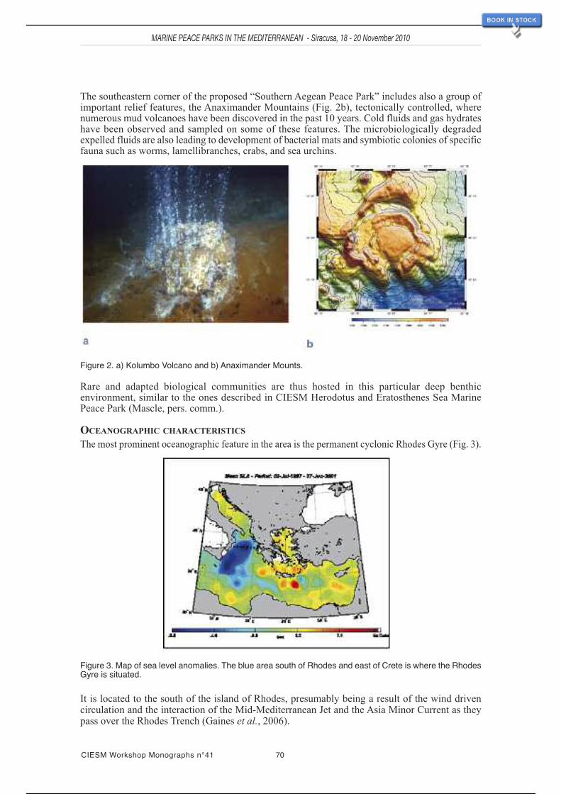
MARINE PEACE PARKS IN THE MEDITERRANEAN - Siracusa, 18 - 20 November 2010
CIESM Workshop Monographs n°41 70
The southeastern corner of the proposed “Southern Aegean Peace Park” includes also a group ofimportant relief features, the Anaximander Mountains (Fig. 2b), tectonically controlled, wherenumerous mud volcanoes have been discovered in the past 10 years. Cold fluids and gas hydrateshave been observed and sampled on some of these features. The microbiologically degradedexpelled fluids are also leading to development of bacterial mats and symbiotic colonies of specificfauna such as worms, lamellibranches, crabs, and sea urchins.
Figure 2. a) Kolumbo Volcano and b) Anaximander Mounts.
Rare and adapted biological communities are thus hosted in this particular deep benthicenvironment, similar to the ones described in CIESM Herodotus and Eratosthenes Sea MarinePeace Park (Mascle, pers. comm.).
OCEANOGRAPHIC CHARACTERISTICS
The most prominent oceanographic feature in the area is the permanent cyclonic Rhodes Gyre (Fig. 3).
Figure 3. Map of sea level anomalies. The blue area south of Rhodes and east of Crete is where the RhodesGyre is situated.
It is located to the south of the island of Rhodes, presumably being a result of the wind drivencirculation and the interaction of the Mid-Mediterranean Jet and the Asia Minor Current as theypass over the Rhodes Trench (Gaines et al., 2006).
63 / 113

71 CIESM Workshop Monographs n°41
MARINE PEACE PARKS IN THE MEDITERRANEAN - Siracusa, 18 - 20 November 2010
The rotation causes water rich in nutrients to rise from deeper layers to the surface and inconsequence the Gyre is the most productive area of the oligotrophic Eastern Mediterranean Sea.There, larger phytoplankton biomass is recorded.
Regarding the oceanography of the region, it is also worth mentioning that the Rhodes Gyre is thesite of the formation of the Levantine Intermediate Water (LIW) that represents one of the mostimportant water masses for the entire Mediterranean. Another important oceanographic feature ofthe area is the occasional dense water formation for the entire Eastern Mediterranean taking placein the southern Aegean Sea as it happened in mid 1990’s during the Eastern MediterraneanTransient (M. Gačić, pers. comm.).
ECOLOGICAL CHARACTERISTICS
The Aegean Sea is considered a biodiversity hot spot as it shows high concentrations ofendangered, threatened, or vulnerable species (Coll et al., 2010). In order to evaluate the ecologicalimportance of the proposed area, the criteria outlined by the Convention of Biological Diversitywere used.
UNIQUENESS OR RARITY
There are no references to unique biological features in the proposed area. However, the uniquegeological (presence of mud volcanoes) and oceanographic (Rhodes Gyre) features may beregarded as surrogates for rare biological communities.
SPECIAL IMPORTANCE FOR LIFE HISTORY OF SPECIES
The Mediterranean monk seal (Monachus monachus) is the most endangered pinniped species inthe world. According to Aguilar and Lowry (2008), the estimated total population size is 350-450animals, with 250-300 in the eastern Mediterranean within the largest subpopulation, of whichabout 150-200 are in Greece and about 100 in Turkey. The species is still widely distributedthroughout coastal and insular parts of this zone, with important sub-populations found in Kimolos,Gyaros and Karpathos (Dendrinos et al., 2008; Legakis and Maragou, 2009). The Kimolos-Polyegos island complex in the southern Aegean is one of the two most important reproductionareas for the species (Fig. 4a). The size of that population is estimated at approximately 43individual seals with a reproduction rate of 7 newborns annually (Mom, 2010).
The deep sea area near Rhodes (Fig. 1) is an important feeding and breeding ground for spermwhales (Dede et al., 2009), and also an important feeding ground for beaked whales (Woodside etal., 2006). In the sea area south of Samos, short-beaked common dolphins (Delphinus delphis), oneof the most endangered cetaceans in the Mediterranean, can still be regularly found (Miliou andNotarbartolo di Sciara, pers. comm.). Furthermore, Boncuk Bay in Gökova, Turkey, is reported asthe one of the most important breeding zones of the Sandbar shark (Carcharhinus plumbeus)(Fig. 4b), after the southern coasts of NorthAmerica (Öztürk, 2005). The SouthernAegean is alsoa significant nesting and feeding area, predominantly for loggerhead turtles (Caretta caretta) aswell as for green turtles (Chelonia mydas) (Geldiay et al., 1982; Margaritoulis, 1998).
Figure 4. a) Mediterranean monk seal (Monachus monachus) pup in breeding cave in the Southern Aegean.b) Sanbark shark (Carcharhinus plumbeus) near the coast of Turkey.
64 / 113

MARINE PEACE PARKS IN THE MEDITERRANEAN - Siracusa, 18 - 20 November 2010
CIESM Workshop Monographs n°41 72
IMPORTANCE FOR THREATENED, ENDANGERED OR DECLINING SPECIES AND/OR HABITATS
As stated above, the area is important for endangered or threatened marine mammals such as theMediterranean monk seal, the sperm whale and the short-beaked common dolphin. Other marinemammals present in the proposed area are bottlenose dolphins (Tursiops truncatus), stripeddolphins (Stenella coeruleoalba), Risso’s dolphins (Grampus griseus), Cuvier’s beaked whales(Ziphius cavirostris) and fin whales (Balaenoptera physalus) (Frantzis and Alexiadou, 2003).Additionally, the region is important for the seagrasses Posidonia oceanica, Cymodocea nodosaand Zostera marina as well as for coralligenous reefs. There are also Cystoseira forests includingthe threatened Cystoseira amentancea, C. spinosa and C. zosteroides. The importance of the areafor sea turtles has already been mentioned, while other species listed as endangered or threatenedin the Barcelona Convention Protocol have populations in the region such as the molluscs Pinnanobilis and Charonia tritonis and the sharks Cetorhinus maximus and Carcharodon carcharias, andthe fish Hippocampus hippocampus.
VULNERABILITY, FRAGILITY, SENSITIVITY, SLOW RECOVERY
All the above mentioned species are considered vulnerable or fragile or sensitive or with slowrecovery.
BIOLOGICAL PRODUCTIVITY
The region is characterized by low primary productivity with the exception of the upwelling areaof the Rhodes Gyre, where unusually high productivity is observed.
BIOLOGICAL DIVERSITY
The Aegean Sea presents the highest biodiversity in the Eastern Mediterranean and the secondhighest species richness (along with theAdriatic Sea) in the whole Mediterranean Sea (Coll et al.,2010). The region, because of its diversified topography and bathymetry is characterized by a greatvariety of habitats, supporting high mesozooplankton diversity with an estimated 367 species(SoHelME, 2005). The area also hosts 467 fish species, while the macrophyte flora of the Helleniccoasts is estimated at about 550 taxa (SoHelME, 2005; SoHelFI, 2007). Regarding zoobenthiccommunities, more than 3200 benthic species have been recorded in theAegean Sea, including 200species of sponges, 43 cumaceans, 107 echinoderms and 93 anthozoans (SoHelME, 2005; Coll etal., 2010).
NATURALNESS
In terms of naturalness, the region is quite heterogeneous; there are some areas with high humanpressure, others with lower human impact. At the same time, some areas (eastern) are moresusceptible to invasive species than others (western). In general, the Mediterranean has beenexploited by humans, centuries or even millennia (Juanes, 2001; Coll et al., 2010), so the conceptof “naturalness” can only be used comparatively.
THREATS
Most of the threats in the proposed area are common to the whole Mediterranean. These are:
- Overfishing and illegal fishing practices. Illegal, unregulated and unreported fisheries activitiestake place in national and international waters, due to lack of efficient control mechanisms andfisheries management regulations in the region. Öztürk et al. (2001) have reported dolphin by-catch due to swordfish driftnets in the Aegean Sea.
- Land-based pollution. Industrial, agricultural and urban sewage is frequently untreated, andsometimes causes mortality of marine organisms (Öztürk and Öztürk, 2003).
- Maritime traffic. In the area there is intense shipping traffic that causes both functional andaccidental pollution. Moreover, the noise associated with this traffic and collisions with vessels aremajor threats to marine mammals. The clear lack of shipping lanes results in dense unregulatedtraffic of all types of vessels, with varying hazard levels (Miliou et al., 2010), illustrated in Fig. 5.
65 / 113

73 CIESM Workshop Monographs n°41
MARINE PEACE PARKS IN THE MEDITERRANEAN - Siracusa, 18 - 20 November 2010
- Habitat degradation due to urbanization of coastal areas and the development of mass tourism.Increasing human activities have caused significant alterations to coastal ecosystems, disturbanceto marine species, and destruction of their habitats.
- Invasive species. The Eastern Mediterranean is particularly susceptible to invasive species dueto its proximity to the Suez Canal (Galil, 2000). Even though theAegean Sea is less threatened thanthe Levantine Sea, this may change as global warming facilitates the expansion of Lessepsianspecies (alien species originating from the Red Sea) to northwestern areas of the Mediterranean(Raitsos et al., 2010). These species can affect the survival of native species through competitionand predation (Zenetos et al., 2009).
- Military activities in national and international waters. Some of the zones used for naval activitiesby Greece, Turkey and NATO coincide with the main marine mammal migration routes. The useof sonar has been associated with disease, loss of orientation, starvation and the stranding of marinemammals (Frantzis, 1998).
Figure 5. Example of 24hr shipping traffic in the Aegean Sea 19/10/10 – Source: Archipelagos Institute ofMarine Conservation.
CURRENT MARINE PROTECTED AREAS (MPAS)In the proposed area there are seven MPAs on the Turkish coasts: Datça-Bozburun, DilekYarimadisi, Fethiye-Göcek, Gökova, Köycegiz-Dalayan, Kas-Kekova and Patara (Fig. 6).However, none of them has a management plan (Abdulla et al., 2008). On the Hellenic coastssome areas have been identified as Sites of Community Interest (SCIs) or as Special ProtectionAreas (SPAs) within the framework of the Natura 2000 network. However, these areas do notreceive protection at present, with the exception of the Karpathos-Saria MPA, where only basicconservation is being applied, since the management authority has only recently been established.Therefore, there is an urgent need for the establishment of an efficient MPAnetwork in the region(Giakoumi et al., 2010).
66 / 113

Figure 6. MPAs in the proposed area–Source: Abdulla et al. (2010).
CIESM Workshop Monographs n°41 74
MARINE PEACE PARKS IN THE MEDITERRANEAN - Siracusa, 18 - 20 November 2010
67 / 113

Scientific rationale for the proposed CIESM South Adriatic
Sea Marine Peace Park
Sajmir Beqiraj 1, Simonetta Fraschetti 2, Miroslav Gačić 3, Aleksandar
Joksimovic 4, Peter Mackelworth 5, Jean Mascle 6, Giuseppe Notarbartolo di
Sciara 7 and Roberto Odorico 8
1 Department of Biology, University of Tirana, Albania ; 2
Dept. of Biological and
Environmental Science and Technologies, Univ.of Salento, Lecce, Italy ; 3 OGS, Trieste, Italy ;
4 Institute of Marine Biology, Kotor, Montenegro ; 5 Blue World Institute of Marine Research and
Conservation, Veli Losinj, Croatia ; 6 Geo-Azur, CNRS, Villefranche-sur-mer,
France ; 7 Tethys Research Institute, Milan, Italy ; 8 Shoreline, Trieste, Italy
SUMMARY
The proposed area, South
Adriatic, covers a domain
including parts of the
central Croatian and
Montenegro coasts, and
northern Albanian shore on
the Eastern Adriatic
(Figure1). On the Western
side of the Adriatic it
extends from Manfredonia to
Brindisi in Italy. The
onshore area is geologically
quite homogeneous,
dominated by limestone
outcrops that belong to the
Mesozoic Apulian platform.
The central Adriatic region
displays several specific
morphological features such
as the Jabuka Pit and the
Palagrusa sill and deeper
areas to the north with a
maximum depth of 270m. The South Adriatic Pit is the dominant morphological feature of the
Southern Adriatic. Dense water formed on the Northern Adriatic shelf accumulates in the Jabuka
Pit. Along the eastern border of this Pit during summer, wind driven upwelling makes the area
potentially rich biologically. The South Adriatic Pit is an area of open ocean convection and
dense water formation, whose intensity depends on the air-sea heat flux and buoyancy content. In
Figure 1. Shaded bathymetry of the CIESM South Adriatic Sea Marine Peace Park (within yellow circle) based on swath bathymetry (DTM at 500m grid). Adapted from L. Brosolo and J. Mascle (2007).
MARINE PEACE PARKS IN THE MEDITERRANEAN - Siracusa, 18 - 20 November 2010
CIESM Workshop Monographs n°41 75
68 / 113

MARINE PEACE PARKS IN THE MEDITERRANEAN - Siracusa, 18 - 20 November 2010
CIESM Workshop Monographs n°41 76
the centre of the South Adriatic Gyre the spring phytoplankton bloom is associated with verticalmixing and nutrient input into the euphotic zone. The northern part of the proposed area has beenincluded (together with the northern Adriatic) in lists of important areas for biodiversity in theMediterranean, such as in potential SPAMI candidates, in the Ecologically or BiologicallySignificant Areas (EBSAs), in the priority conservation areas for sea birds, and in the priorityconservation areas considering the impacts of fisheries in the open seas, including the deep sea. Aconsiderable number of key and endangered species are found in this area. The seagrass Posidoniaoceanica, several cetacean species, many waterfowl, the monk seal, the loggerhead turtle, and theotter are among the most important globally threatened species of this area. This area ischaracterized by several unique and sensitive habitats, especially in the south-eastern part. Neretvaand Buna/Bojana river deltas, besides their role as sheltering habitats, are also important asmigration corridors, especially for fish and bird species. Several MPAs have been instituted inItaly and Croatia, and regionally important Coastal ProtectionAreas (CPAs) in the Montenegro andAlbania. Increasing human occupation of the coastal zone, with localised pollution, increasingfishing effort, maritime traffic, recreational use of the sea, habitat degradation, sewage dischargeand agricultural wastes are among the main threats to this area. In recent years, there has beenincreasing interest in research and environmental work in the southern part of the proposed area,where studies and knowledge are more limited. This work is enlarging the database on marinebiodiversity of the southern Adriatic, and improving biodiversity conservation and managementin this region. Countries in the eastern Adriatic (Croatia, Montenegro, Albania) are makingimportant steps towards fulfilling the environmental criteria and standards for their accession toEU structures: from this point of view, their involvement in the CIESM initiative for establishingcoast-to-coast Marine Parks is another progressive step.
KEY GEOLOGICAL FEATURES
Generally, in the South Adriatic, the onshore area is geologically quite homogeneous dominatedby limestone outcrops which belong to the Mesozoic Apulian platform, a former shallow regionof a passive continental margin. On the Italian side, these rocks have only been fractured duringtheir deposition, while on the Eastern side they are incorporated into tectonic units, the ‘Apuliannappes’ emplaced along the frontal domain of the Dinarides and Hellenides during the Alpinesorogenies. These thick piles of limestone are characterized by intense karstic processes, resultingin their dissolution, and the creation of numerous caves and frequent underground freshwaterdrainage systems.
Specific morphological features of the centralAdriatic include the Jabuka Pit and the Palagrusa silland deeper areas to the north with a maximum depth of 270m. The South Adriatic Pit is thedominant morphological feature of the Southern Adriatic. A number of islands, made mainly ofmassive limestone, are present in the area, which due to their isolation and abundant caves hostnumerous endemic species.
KEY OCEANOGRAPHIC FEATURES
Jabuka Pit is a sink for some of the dense water formed on the Northern Adriatic shelf that flowsalong the Italian coast. This water partly sinks into the pit and partly continues southward over thePalagrusa sill. The renewal of bottom water in Jabuka Pit does not occur every year, but dependson the density of the newly formed water; thus ventilation of the bottom layer is not necessarilyan annual occurrence.
Along the eastern border of Jabuka Pit, during summer, the wind drives upwelling making thearea potentially biologically rich. Along the Italian shelf, fresher water of terrestrial origin flowssouthward in the form of the coastal boundary current, separated from the open sea by the coastalfront. To the south of the Gargano peninsula (Gulf of Manfredonia) there is a semi permanent anti-cyclonic gyre.
The South Adriatic Pit is an area of open ocean convection and dense water formation, whoseintensity depends on the air-sea heat flux and buoyancy content. The buoyancy content dependson the salinity of the inflowing water from the Ionian Sea. The bottom layer is renewed by dense
69 / 113

77 CIESM Workshop Monographs n°41
MARINE PEACE PARKS IN THE MEDITERRANEAN - Siracusa, 18 - 20 November 2010
water from the northern Adriatic shelf that sinks in the Bari canyon and occupies the deepest partof the South Adriatic Pit.
In the centre of the SouthAdriatic Gyre, the spring phytoplankton bloom is associated with verticalmixing and nutrient input into the euphotic zone. The bloom is occasional, taking place over severaldays up to one week, depending on the frequency of cold air outbreaks and subsequent re-stratification. Inter-annual variability of the vertical convection, and consequently of the bloom,is rather prominent, and depends on both the buoyancy content of the water column and the winterair-sea heat fluxes.
Ionian waters enter the Adriatic close to the Albanian side (East Adriatic Current) and flow outalong the Apulian side (West Adriatic Current), forcing a basin-wide cyclonic circulation. Thiscirculation is subdivided into three cyclonic sub-circulations, occupying the northern, central andsouthern portions of the Adriatic, trapped by bathymetry (the central one being centred on theJabuka Pit, the southern one on the SouthernAdriatic Pit). Focusing on the southern gyre, surfaceand subsurface cyclonic circulations may provide an important link between the Marine ProtectedAreas located on the Eastern and Western coasts of the central and southern Adriatic Sea. Thisensures possible exchange of hydrological and biogeochemical characteristics as well as organismsfrom the eastern to the western side.
At an intermediate and deep level, communication is ensured throughout the whole water columnby intense convection occurring in relation to the South Adriatic Pit, originating in the SouthAdriatic Deep Water. Whilst on the western side of the basin coastal/deep-sea mixing is furtherenhanced by the overflow and deepening process of the North Adriatic Deep Water. This water isfunnelled by gravity and submarine canyons from the shelf break to the continental slope beforeexiting, along with the surface waters, through the Otranto Channel into the Ionian Sea and the Gulfof Taranto.
BIOLOGICAL FEATURES
General information about biodiversityThere is a significant difference in knowledge of marine biodiversity between the north-central andsouthern parts of theAdriatic Sea. The NorthernAdriatic has been studied for many decades, whilein the southern basin, especially in the south-eastern part, data about marine biodiversity are morelimited.
The northern part of the proposed area has been included (together with the northern Adriatic) inlists of important areas for biodiversity in the Mediterranean, such as the potential SPAMIcandidates (UNEP/DEPI/MEDWG.348/5), in the Ecologically or Biologically Significant Areas(EBSAs), in the priority conservation areas of sea birds (UNEP/DEPI/MEDWG.348/inf.5) and inthe priority conservation areas considering the impacts of fisheries in the open seas, including thedeep sea (UNEP/DEPI/MEDWG.348/inf.4).
In recent years the central easternAdriatic has started to become a focal point for marine research.Recent projects, including the UNDP/Croatian Ministry of Environment/GEF project“Conservation and Sustainable Use of Biodiversity in the Dalmatian Coast through GreeningCoastal Development (COAST)” and the WWF Mediterranean Gap Analysis, have identified theislands of Vis, Lastovo, Mljet and their surrounding waters as a priority for Mediterraneanconservation. The UNDP Coast project has integrated information from many of the nationalinstitutes, non government organisations and universities in Croatia. This list includes theUniversity of Zagreb, the Croatian Natural History Museum, the Institute for Oceanography andFisheries, the University of Split, and the Blue World Institute.
The Croatian Adriatic is fringed with over 1000 islands, islets and semi-submerged reefs. Withinthese dense archipelagos are numerous varied environmental niches including mud bottoms,substantial Posidoniameadows, limestone reefs and sandy bottoms, many of which have not beenfully investigated and mapped. There are offshore island areas thought to have high levels ofbiological diversity, partly due to their isolation. These are the Vis archipelago, Jabuka, andPalagrusa (United Nations Development Programme (UNDP), 2005). In addition the underwater
70 / 113

MARINE PEACE PARKS IN THE MEDITERRANEAN - Siracusa, 18 - 20 November 2010
CIESM Workshop Monographs n°41 78
regions around the islands of Lastovo and Mljet are considered as highly important and listed inprotected area networks.
The eastern coast of the proposed park is known for high diversity of birds, especially waterfowl.On the continental shoreline there are other areas of importance for birds. The Neretva Deltacontains the largest complex of wetlands in the Croatian littoral, with well developed coastalvegetation, as well as floating and submerged flora. The area is important for central and northeastEuropean bird populations (Muzinic, 2007).
Much of the CroatianAdriatic has been identified as important for the Croatian National EcologicalNetwork (CroNEN) as part of the Bern convention. Some of the same sites, and others, have beenlisted as potential Natura 2000 sites for when Croatia joins the EU.
Biodiversity in the southernAdriatic is less known. Data about zooplankton, benthic invertebrates,fish and large marine vertebrates are limited. Although the region is generally considered to be oflow productivity, in the open waters of the southern Adriatic, micro-phytoplankton includingdiatoms is quantitatively important (Fonda Umani, 1996). A recent aerial survey for large marinevertebrates has also suggested that there may be rare species, previously unrecorded, inhabiting theregion (Fortuna et al., 2010).
The coastal terrigenous mud biocenosis is well developed along almost the entire south-easternAdriatic, and particularly well developed in areas with relatively weak bottom currents. Sessileform facies are formed through a prolonged process of sedimentation; these are widely distributedand economically important for the coastal demersal fishery. Many economically importantcommercial species are found in this area, such as picarel, red mullet, hake, squid, cuttlefish,octopus, as well as many selachian species. In the infralittoral, Posidonia oceanica meadows arein relatively good conservation pristine status. Deeper bottoms are characterized by high gradientsthat host pristine sciaphilous assemblages. Coastal and open water detritic bottom biocoenoses, aswell as bathyal mud biocoenoses are also present in this area.
The south eastern corner of the proposed area (including north Albania and south Montenegro) isan important area for the coastal biodiversity and includes sensitive coastal habitats. TheBuna/Bojana delta shelters a high proportion of coastal biodiversity of the southwestern Balkans.The role of this area is particularly important for certain vertebrates such as birds, fish, mammals,reptiles and amphibians. One of the most important ecological features of the area is migration,especially for globally threatened species fish and bird species. This area is a part of one of the threemigration routes of European birds in the north – south direction. It plays a very important role formaintaining bird diversity at regional level, also sheltering species of global conservation concernand species of European conservation concern (see information in the paragraph below).
In recent years, there has been increasing interest in research and environmental work in thesouthern part of the proposed area, mainly through the implementation of projects at national,bilateral and regional scale, with the participation of universities and research institutions, such asUniversity of Salento, University of Bari, CNR Lesina, University of Split, University of Zagreb,Ruder Boskovic Institute, University of Podgorica, Institute of Marine Biology in Kotor, Universityof Tirana, University of Shkodra, among others. An important contribution is also provided bynon-governmental organisations, especially studies of cetaceans, marine turtles, fish, birds andmacrobenthos. These NGOs, include the Tethys Research Institute (Italy), the BlueWorld Instituteof Marine Research and Conservation (Croatia), and the Association for Protection of AquaticWildlife ofAlbania. This work is enlarging the data on marine biodiversity of the southernAdriaticand contributing to the improvement of biodiversity conservation and management in this region.
Presence of endangered/key speciesMeadows of Posidonia oceanica are widely distributed and in relatively good condition alongparts of the eastern coast of the proposed area.
The central Adriatic is an important region for cetacean species. Since 2007, cetacean researchhas been undertaken around the Vis archipelago; bottlenose dolphins (Tursiops truncatus) areregularly seen, and the presence of mother and calf groups indicates that this area may be importantfor this species. In addition to bottlenose dolphins, surveys also encountered other animals like
71 / 113

79 CIESM Workshop Monographs n°41
MARINE PEACE PARKS IN THE MEDITERRANEAN - Siracusa, 18 - 20 November 2010
giant devil rays (Mobula mobular), blue-fin tuna (Thunnus thynnus), swordfish (Xiphias gladius),as well as birds like Eleonora’s falcon (Falco eleonorae), Manx shearwater (Puffinuspuffinus),Cory’s shearwater (Calonectris diomedea) and European shag (Phalacrocorax aristotelis) amongothers (Holcer et al., 2010). A recent aerial survey for large marine vertebrates indicates that thisregion hosts fin whales (Balaenoptera physalus), particularly around the Palagrusa archipelagowhere they are sighted on a regular basis. Striped dolphins (Stenella coeruleoalba) can be foundin the middle of the Adriatic, and Cuvier’s beaked whales (Ziphius cavirostris) (Figure 2) andRisso’s dolphins (Grampus griseus) are found on the edges of the Southern Adriatic Pit (Fortunaet al., 2010) (Figure 3).
Figure 2. Cuvierʼs beaked whales on the edge of the south Adriatic Pit.
Figure 3. Rare cetacean species of the southern and central Adriatic.
Other globally threatened species may also be encountered in the proposed area. TheMediterraneanmonk seal (Monachus monachus) is believed to be a transient in the region. The loggerhead turtle(Caretta caretta) can also be found in large numbers and is believed to be resident year round(Lazar, 2010; Fortuna et al., 2010). Finally, the otter (Lutra lutra) is found around river mouths anddeltas, particularly in the southeastern region of the area (MacDonald and Mason, 1994).
The Neretva delta and river feeds a large number of protected species, provides breeding groundsfor certain fish and crabs, and is important for fish and bird migrations. There are 310 bird speciesin the Neretva Delta and 115 of them are nesting. Some endangered European species, like the greatbittern (Botaurus stellaris), the ferruginous duck (Aythya nyroca), the snowy plover (Charadriusalexandrinus), the common snipe (Gallinago gallinago L.) and other species, like the baillon’scrake (Porzana pusilla) and the moustached warbler (Acrocephalus melanopogon) (Mrakovcic,2001).
72 / 113

MARINE PEACE PARKS IN THE MEDITERRANEAN - Siracusa, 18 - 20 November 2010
CIESM Workshop Monographs n°41 80
In the south-eastern part of the proposed area, around Buna/Bojana river delta in Albania andMontenegro, at least 36 globally threatened animal species (referring to the IUCN Red List ofThreatened Species, 2008) have been recorded.Among them there are sturgeons Acipenser sturio,Acipenser naccarii, Acipenser stellaus, lampreys Lampetra fluviatilis and Lampetra planeri,16 shark species, and birds like the Levant sparrow hawk (Accipiter brevipes), the Europeannightjar (Camprimulgus europaeus), the European roller (Coracias garrulous), the black headedbunting (Emberiza melanocephala), the lesser gray shrike (Lanius minor), the woodchat shrike(Lanius senator), the black-eared wheatear (Oenanthe hispanica), the Eurasian scops owl (Otusscops), the Eurasian spoonbill (Platalea leucorodia) and the common redshank (Tringa tetanus).
Critical habitats and unique communities/ecosystemsWithin the central Adriatic are a number of islands some of which, including Jabuka and Brusnik,are formed from volcanic rock (Pelleri, 1942; Tućan, 1953). Many of the islands, due to theirisolation, host endemic species, including reptiles and mammals (UNDP, 2005). Jabuka island hasparticularly high biodiversity. Zavodnik et al. (2000) review surveys around and on the island ofJabuka and identify 300 taxa, more than 150 of them noted for the first time for the area. Inaddition, 159 taxa were identified during a dive survey of the near shore. Jabuka Pit, adjacent tothe island of Jabuka, is also the most important spawning and nursery ground in the Adriatic Seafor European hake (Merlucius merlucius) and Norway lobster (Nephrops norvegicus) (Vrgoč et al.,2004). The cold, nutrient-rich waters generated in winter in the northernAdriatic accumulate in thisdepression, making the area a site of strong nutrient re-cycling processes (Zavatarelli et al., 1998;Artegiani et al., 1997).
The area around the Palagrusa archipelago is also an important fishing area with productivityrelated to the mixing of waters from the northern Adriatic with the southern Adriatic (Vilibic andSupic, 2005). The Palagrusa archipelago is also considered an important habitat for fin whales(Balaenoptera physalus) that are sighted on a regular basis in this area. The Vis archipelago is ahabitat for a resident population of bottlenose dolphins (Tursiops truncatus) (Holcer et al., 2010).
The Neretva river region is unique in Croatia as a marsh delta. It provides numerous habitatsimportant for nesting bird species. Nesting is important in the cane fields, on the sand beaches andthe trees. The mouth of Neretva provides a nursery habitat for fish and crustacean species. The riveralso functions as a gateway for fish migrations (Muzinic, 2007).
The karst limestone coastline found along the eastern border of theAdriatic Sea provides a diversityof unique threatened habitats (Bakran-Petricioli and Petricioli, 2008). Within the karst system, anumber of unique habitats can be found such as anchialine caves, sea caves, cold saltwater cavernswith bathyal elements, submarine springs, karstic estuaries, saltwater lakes and submarine barekarst stone. These are all considered as endangered in Croatia (Ministry of Culture of the Republicof Croatia, 2009).
On the Italian coast (Gulf of Manfredonia) of the proposed area, the Varano and Lesina lagoonsare important habitats for bird sheltering and nesting, especially waterfowl, as well as spawningand nursery sites for fish. In this area, several studies have been carried out on benthic assemblages(Marzano et al., 2003; Munari et al., 2009). Attempts have been made to analyse the affinitybetween the zoobenthic assemblage recorded in the hyperhaline lagoon of Karavasta and theassemblages from two Italian lagoons, the brackish Lake of Lesina and the euhaline Lake ofFogliano, according to the different hydrological conditions and the geographical location(Marzano et al., 2010). In the Gulf of Manfredonia, previously considered an area essentiallydominated by muddy assemblages, extensive coralligenous banks have been found (Terlizzi,unpub. data); this represents important information in terms of spatial planning, since this areawas recently selected for development as a wind farm area.
In the South Adriatic Pit, a significant Nephrops norvegicus – Thenea muricata biocoenosis ispresent. Recent data suggests that this area could also be important for endangered cetacean speciessuch as Cuvier’s beaked whale (Fortuna et al., 2010).
The south-eastern corner of the proposed area represents a large transboundary ecosystem betweenAlbania and Montenegro, the delta of Buna/Bojana River (Figure 4). This ecosystem is important
73 / 113

81 CIESM Workshop Monographs n°41
MARINE PEACE PARKS IN THE MEDITERRANEAN - Siracusa, 18 - 20 November 2010
on a regional scale in terms of biodiversity and hydrology. The Buna/Bojana delta, withAda Islandin Montenegro, the Velipoja coastal forest inAlbania, the whole river bed and the Shkodra/SkadarLake from whence the river flows, has been proclaimed a Ramsar site and an international IBA(Important Bird Area). The mouth of the Buna/Bojana facilitates fish migration from ShkodraLake and its watershed into the Adriatic Sea. It also links the lakes of Ohrid and Prespa throughtheir connection with Drin River, which joins Buna upstream. This effectively covers a largehydrographic network of the southwestern Balkans, including Albania, Montenegro, Kosovo,Former Yugoslav Republic of Macedonia and Greece. At least 13 fish species and subspeciesmigrate through Buna/ Bojana mouth, of which 6 are globally threatened. The Buna/Bojana deltaoffers important food sources for fish, spawning grounds, nursery and migration paths on whichfish stocks depend (either within the wetland or other habitats connected to them). This area isalso very important hydrographically, and is well-known fot its high ecological sensitivity. The socalled “hydrologic junction” Shkodra Lake - River Buna - River Drin determines the hydrologicalregime of Shkodra Lake, River Buna itself, and their tributaries, and has an important impact onthe morphology and water regime in Buna delta in the south-eastern Adriatic.
In its northern part, in Montenegro, the saltpan (salina) of Ulcinj, is an important site for birdsheltering and nesting, andAda Island, an interesting habitat as a wetland and alluvial forest, withmany globally threatened species of plants and nesting birds (Schneider-Jacoby et al., 2003).
In the southern part of the delta, in Albania, the small Island of Franz Joseph (Figure 5) is well-known for the rare flora and fauna, and as a nesting site for globally threatened birds. It is a verysensitive area that, due to coastal erosion, often changes shape and size, shifting from an island toa promontory and vice-versa.
The Velipoja forest reserve, an alluvial coastal forest and a wetland complex created by Buna deltaand the Adriatic Sea, is well-known for the high diversity of flora and fauna, including rare andthreatened species at national and regional scales.
The Viluni lagoon, situated about 7 km south of Buna mouth, is known for its high diversity of fish,invertebrates and especially waterfowl of global concern.
Figure 4. Aerial view of Buna/Bojana delta (Albania & Montenegro).
74 / 113

MARINE PEACE PARKS IN THE MEDITERRANEAN - Siracusa, 18 - 20 November 2010
CIESM Workshop Monographs n°41 82
Baks Rrjolli coastal zone – Rana e hedhun (Blown sand) (Figure 6) - represents an interestingcombination of habitats with karstic caves, mountain slopes, sandy dunes, alluvial forest, tamariskmarshes, and interstitial pools combined with an excellent beach. The Blown Sand is an activedune 50 m high, 600 m long and 100 m wide, accumulated on a rocky coast by wind, a uniquehabitat in theAdriatic. This area gives shelter to nesting bird species of regional and global concern.
MAIN THREATS
The proposed zone faces similar threats to those found in all marine environments, increasinghuman occupation of the coastal zone, with related localised pollution, increasing fishing effort,increasing maritime traffic and increasing recreational use of the sea, besides the global threats ofclimate change, ocean acidification and invasive species. Being the most northern arm of the semi
Figure 6. The sand dune “Blown sand” (Rana e hedhun) (Albania).
Figure 5. Franz Joseph Island (Albania).
75 / 113

83 CIESM Workshop Monographs n°41
MARINE PEACE PARKS IN THE MEDITERRANEAN - Siracusa, 18 - 20 November 2010
enclosed Mediterranean, the Adriatic as a whole is strongly influenced by the adjacent terrestrialarea. Yet it remains relatively well preserved on its eastern side due to political isolation during thecold war period. However, Croatia, Montenegro and Albania have undergone significant changeover the last 20 years. Associated with this has been an increase in human population density inthe coastal zone, and accompanying urban development. In some areas these developments havebeen uncontrolled, causing considerable impacts to marine biodiversity and environment.
Habitat degradation is also related to increased human activity, urban development, and sewage andagricultural discharges in the coastal area. Chemical water pollution in the area is mainly due toindustrial activity, especially on the Italian coast.Also of concern for the Gargano area and TremitiIslands are chemical residuals from the 2nd World War. Perhaps the most polluted region of theeastern Adriatic is located in the northern part of this area. Kaštela Bay north of Split, Croatia’ssecond city, hosted a chlor-alkali cement works between 1950 and 1990 as well as other heavyindustry, and the bay remains contaminated with inorganic mercury and other heavy metals(Kljakovic-Gaspic et al., 2006). Other major towns and cities along the Croatian coast haveinappropriate waste water treatment with high levels of faecal coliforms in adjacent waters (WorldBank, 2008).
Excessive tourism can be found in some localised areas, such as Velipoja beach in Albania, andVelika Plaza in Ulcinj, Montenegro. In Croatia, where tourism is the largest contributor to GDP,there are numerous islands, including Mljet, Lastovo, Vis, Korcula, Hvar, Brac and Solta, subjectto high levels of seasonal migration related to tourism, as well as hosting fishing communities andagriculture (Mackelworth and Caric, 2010). Additionally, sites along the coast host major touristpopulations in the summer season, including in and around the major cities of Split and Dubrovnik.
The sensitive areas around the Buna/Bojana and Neretva rivers are threatened by untreated watersfrom large watersheds. Neretva is also threatened by increasing agricultural development. Theextensive karst ecosystems face similar threats from polluted water sources. These sensitive karstsystems also face disturbance from diving tourism, similar to those seen on coralligenous facies.
Increasing maritime transport, with merchant, ferry and cruising tourism, is another importantfactor affecting marine biodiversity. Maritime transport is one of the main reasons for increasedpollution, noise and disturbance in marine waters. The impact of noise is of major concern,especially for cetaceans, since the central Adriatic is an important area for these animals. The areaaround Dubrovnik faces threats from increasing pollution from visits by cruise liners, associatedwith this waste water pollution, solid pollution (including plastics), and air pollution (Caric, 2010).
Marine traffic also increases the transport and introduction of invasive species. Perhaps the greatestthreat is from Caulerpa taxifolia and C. racemosa, both of which are overwhelming habitats in theregion. Since 2001, C. taxifolia has been present in Stari Grad Bay, Hvar Island (Zuljevic andAntolic, 2002). Although data on alien and invasive species for this area are limited, a recentassessment in the shallow coastal waters of Albania and Montenegro, together with existing data,has recorded about 23 alien species for both countries, including macroalgae, macrophytes,annelids, crustaceans, molluscs and fish (Beqiraj et al., in press).
On the Albanian coast, erosion has become a major problem in the last 3 decades, mainly relatedto human activity and especially to hydrological changes and river damming. In the Buna/Bojanadelta, the Velipoja coast is one of the areas highly impacted by coastal erosion, and of Franz JosephIsland is rapidly losing its surface.
Finally, uncontrolled and illegal fishing practices are important threats to marine biodiversity intheAdriatic, and have a significant impact on fish stock depletion. High fishing pressure and non-selective fishing gear has already affected the demersal ecosystem and species biodiversity aroundthe regions of Jabuka Pit and the Palagruza Sill (Jukic-Peladic et al., 2001). Depletion of catchesin Albanian waters is mainly related to overfishing, water pollution, and habitat destruction.Generally in Croatia, the development of the industrial pelagic fishery threatens to overwhelmfish stocks if unchecked (Mackelworth et al., 2011). Ghost nets are also a threat to sensitiveecosystems, such as coralligenous facies.
76 / 113

MARINE PEACE PARKS IN THE MEDITERRANEAN - Siracusa, 18 - 20 November 2010
CIESM Workshop Monographs n°41 84
PROPOSED MODIFICATIONS OF ZONE BOUNDARIES AND JUSTIFICATIONS
It has been proposed to exclude most of the Montenegrin coast and territorial waters from theSouthAdriatic Sea Peace Park, since the inclusion of the whole coastline was deemed to be impracticaland politically sensitive.
The area was extended in the central part of theAdriatic, aiming to cover three important geologicaland oceanographic features, the southern Adriatic Pit, the Palagruza Sill and the Jabuka Pit.
The Albanian part has also been reduced to exclude the most southern segment, due to the highimpact of pollution and uncontrolled development in that segment.
The Albanian part is extended from Buna/Bojana river mouth to the Shengjini rocky coast (about25 km of coastline), while the Montengrin part is from Buna/Bojana river mouth to Ulcinj saltpan.
CURRENT MPAS AND REGULATIONS
There are a number of protected areas in the region. Marine Protected Areas (MPAs) have beenproclaimed in Croatian and Italian waters, while in Montenegro andAlbania the currently existingprotected areas within the proposed area have the status of Coastal Protected Areas (CPAs).
There are three protected areas in the Croatian part including a marine component: Mljet NationalPark, Malostonski Bay Special Reserve and Lastovo Park of Nature (Figure 7). Mljet NationalPark is managed mainly for ecosystem protection and recreation, with the original designationbased on terrestrial aesthetics rather than biodiversity. At the time of designation, there was littleavailable scientific data that would justify protective measures, and, it was only recently that thenational park boundaries were extended to include surrounding marine areas (Benoviç et al., 1999).Mljet National Park is under pressure predominantly from tourism, with additional problemsregarding illegal construction on the islands, localised pollution, uncontrolled access, and illegalfishing by visitors and the local community. Malostonski Bay was designated a Special MarineReserve, officially managed mainly for scientific reasons. However, this site was designated forhistorical bivalve aquaculture areas that have been protected with the aim of conserving presentand future bivalve production (Benoviç et al., 1999). But recreational use of the bay continues, withincreasing risk of pollution that could threaten the integrity of bivalve production. In 2006 theLastovo archipelago, which represents the second largest protected marine area in the country(UNEP-MAP RAC/SPA, 2007) was established for both terrestrial and marine natural values,archaeological findings, and a rich cultural heritage. It has been designated on biological grounds,but with the concept of multiple-use as part of its rationale. However, despite consultations, initiallocal support for the designation appears to have declined (Frankic, 2004; WWF, 2006).
Figure 7. Protected areas in Croatia.
77 / 113

85 CIESM Workshop Monographs n°41
MARINE PEACE PARKS IN THE MEDITERRANEAN - Siracusa, 18 - 20 November 2010
Additionally within the Neretva Delta is a Ramsar site, Mediterranean Specially Protected Area,Ornithological Reserve, Zoological Reserve and Protected Landscape Area. The Delta, itsassociated salt marshes, saline lagoons, sand banks and wet meadows are of considerableimportance for wintering and staging birds and for several species of breeding birds. Large partsof the area have been subject to drainage and agricultural development, increasing roadconstruction, urbanization and hunting.
Marine conservation has lagged behind terrestrial conservation in Croatia, and less than 1% of theterritorial sea is protected. Generally protected area management capacity and political will hasbeen lacking (Frankic, 2004). Recently, EU tenders have started to focus on marine conservation,and the Marine Natura 2000 sites should be identified in the coming months.
In Italy, the Gargano National Park includes the MPAof Tremiti Islands and the Varano and Lesinalagoons along the coast. Tremiti Islands was instituted in 1989. Systematic mapping activities haveshown that the Archipelago is characterized by critical habitats (coralligenous formations,submarine caves, seagrasses, rhodolite banks) deserving careful monitoring due to increasingthreats from tourism (diving, bathing, shipping, anchoring). Protection is generally weak, andpoaching is still very active (Guidetti et al., 2008). Long term monitoring, carried out by theUniversity of Salento, shows that the MPA has not been correctly zoned and that the no take noman zone (called Pianosa) is characterized by low biodiversity assemblages even after more thantwenty years of protection, (Fraschetti et al., 2011). Pianosa can be considered a de facto marinerefuge (e.g., a remote reef that is inaccessible) requiring the input of new recruits fromneighbouring unprotected areas. Considering the position of this MPA and the oceanographicfeatures described above, large-scale regulation could be a profitable strategy to facilitate therecovery of this area.
In the middle of theAdriatic, the Jabuka - Pomo Biological Protected Zone (BPZ) jointly declaredby Italy and Croatia is located outside national territorial boundaries. Other BPZs (for nurseries asmain purpose) are located around Tremiti Islands (Area Tremiti) and off Bari (so named Zone C“al largo della Puglia”).
In Montenegro, Ada Island, in the southern part of the Buna/Bojana delta is a Ramsar site, aninternational IBA (Important Bird Area) and IPA (Important Plant Area).
In the Albanian sector, there are several units with different protection status within the proposedarea. In the southern part of Buna/Bojana mouth, the Velipoja Forest has the status of a ManagedNatural Reserve with a core area, the Franz Joseph Island, which is strictly protected as a NationalNatural Monument. The Velipoja Reserve also has the status of a Ramsar site, IBA and IPA,together with Buna/Bojna River and Shkodra Lake in the Albanian part, as a whole unit. Furthersouth, the Viluni lagoon – Baks Rjolli coast is a Managed Nature Reserve, with a core area, thepeculiar sand dune “Blown sand” (Rana e hedhun), strictly protected as a National NaturalMonument.
InAlbania, despite the presence of protected areas, the implementation of environmental legislationis still weak. Damage to natural habitats, including that within protected areas, is due touncontrolled human access and illegal activities, such as construction of tourist facilities,deforestation, and fishing and hunting. Some recent efforts through national and internationalprojects on protected areas inAlbania aim to strengthen the national network of Coastal ProtectedAreas and encourage the proclamation of newMPAs. This should have positive impacts on marineecosystem conservation in the country.
The presence of different approaches and different levels of institutional conservation extended tothe middle ofAdriatic (i.e. Jabuka) should help a shared process of developing management basedon the best practice in the existing situations. Jabuka, for example, not only “covers” (with almost2000km2) one of the most important geo-oceanographic peculiarities, but also protects the nurseryareas for many of commercial fishes, thereby supporting the economies of the Croatian/Italiancoastal fisheries.
78 / 113

FINAL CONSIDERATIONS
The Bosnia and Herzegovina territorial sea and shared resources of the Neretva region should alsobe considered as they are included within the border of the proposed South Adriatic Park.
There are potential threats from the adjacent Northern Adriatic Sea. There is increasinghydrocarbon exploration in this shallow region, and proposals for the development of refinery andstorage capacity in the region.Associated tanker traffic must transit through this zone. In addition,the planned expansion of Northern Adriatic ports will add to maritime traffic and threats.
On the eastern coast, as the standard of living in Croatia, Bosnia and Herzegovina, Montenegro andAlbania rises towards EU levels, we can also expect a rise in the use of the coastal zone for tourismand recreation; this leads to further potential exploitation and disturbance. Some form of integratedplanning for the Adriatic is urgently required.
CIESM Workshop Monographs n°41 86
MARINE PEACE PARKS IN THE MEDITERRANEAN - Siracusa, 18 - 20 November 2010
79 / 113
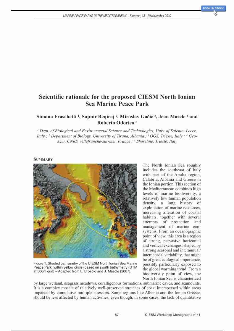
87 CIESM Workshop Monographs n°41
MARINE PEACE PARKS IN THE MEDITERRANEAN - Siracusa, 18 - 20 November 2010
Scientific rationale for the proposed CIESM North IonianSea Marine Peace Park
Simona Fraschetti 1, Sajmir Beqiraj 2, Miroslav Gačić 3, Jean Mascle 4 andRoberto Odorico 5
1 Dept. of Biological and Environmental Science and Technologies, Univ. of Salento, Lecce,Italy ; 2 Department of Biology, University of Tirana, Albania ; 3 OGS, Trieste, Italy ; 4 Geo-
Azur, CNRS, Villefranche-sur-mer, France ; 5 Shoreline, Trieste, Italy
SUMMARY
The North Ionian Sea roughlyincludes the southeast of Italywith part of the Apulia region,Calabria, Albania and Greece inthe Ionian portion. This section ofthe Mediterranean combines highlevels of marine biodiversity, arelatively low human populationdensity, a long history ofexploitation of marine resources,increasing alteration of coastalhabitats, together with severalattempts of protection andmanagement of marine eco-systems. From an oceanographicpoint of view, this area is a regionof strong, pervasive horizontaland vertical exchanges, shaped bya strong seasonal and interannual/interdecadal variability, that mightbe of great ecological importance,possibly particularly exposed tothe global warming trend. From abiodiversity point of view, theNorth Ionian Sea is characterized
by large wetland, seagrass meadows, coralligenous formations, submarine caves, and seamounts.It is a complex mosaic of relatively well-preserved stretches of coast interspersed within areasimpacted by cumulative multiple stressors. Some regions like Albania and the Ionian Greece,should be less affected by human activities, even though, in some cases, the lack of quantitative
Figure 1. Shaded bathymetry of the CIESM North Ionian Sea MarinePeace Park (within yellow circle) based on swath bathymetry (DTMat 500m grid) – Adapted from L. Brosolo and J. Mascle (2007).
80 / 113

information on spatial and temporal variations of their biodiversity, and of floristic and faunisticinventories might raise expectations about the presence of pristine environments no longer present.Several MPAs are present in this area (three in the south of Italy, one in Albania, and one inGreece). Results relative to the effectiveness of protection are promising. However, the limitedextension of these MPAs does not guarantee regional marine conservation. In some cases, poachingand illegal activities are still widespread. Fishing (both artisanal and commercial fleets) isconsidered a crucial pressure, but actual effort data are not available. Management of marinecoastal areas is, at least in the south of Italy, confined to the presence of Sites of ConservationInterest (SCIs) implemented for Posidonia meadows. No attempt at ecosystem-based approachesto the management of human activities has been implemented so far. However, this area surelyrequires priority for conservation efforts since impacts, singular or cumulative, are still limited inspace so that there is still potential for restoration.Also, since the North Ionian Sea is characterizedby strong oceanographic connections, this area has potential as a real ecological network.
KEY GEOLOGICAL CHARACTERISTICS
Geologically speaking, the selected area is rather homogenous, consisting mainly of massiveMesozoic limestones of the former Apulian platform, once the upper part of a passive continentalmargin created during the evolution of the Mesogean Sea, some 150 Ma ago. On the Italian side(Apulia), this platform has not been strongly compressed during the creation of the southernApennines, while on the Hellenic border (Albania, Greece) theApulian domain, and the so-calledPre-Apulian zone, also predominantly made of massive limestones, were incorporated in westwardverging tectonic nappe systems related to the alpine collision.
It is also important to keep in mind that during the “Messinian” salinity crisis, which affected theentire Mediterranean between 6 and 5 million years ago, large parts of the domain emerged, sincesea level dropped by probably more than 1200 meters.As a consequence, limestone outcrops wereexposed to continental erosion and intense karstic processes; which cut many caves and aerialvalleys into these rocks, leading to further submarine canyons when sea level was re-establishedin the lowermost Pliocene. These submerged aerial morphologies subsequently provided hard rocksettlement sites for fixed organisms such as the deep water corals discovered south of Italy, andwhich probably also exist along the steep Hellenic Ionian margin (Fig. 1).
KEY OCEANOGRAPHIC CHARACTERISTICS
Among the different regional systems of the Mediterranean, the southern Adriatic and NorthernIonian Seas are of particular relevance and importance since they are presumably characterized bystrong oceanographic connections. Cooled down by cold northern winds, the surface waters oftheAdriatic become colder than the rest of the Mediterranean; their increased density makes themsink to the deeper parts of the Ionian Sea. Ionian waters typically enter the Adriatic close to theAlbanian side (EastAdriatic Current) and flow out along theApulian side (WestAdriatic Current).This flow regime is part of the basin-wide cyclonic circulation, which comprises three sub-basincyclonic gyres, occupying the northern, central and southern portions of the Adriatic, trapped bybathymetry (the central one being centred on the Jabuka Pit, the southern one on the SouthernAdriatic Pit). Focusing on the southern gyre, at the surface and subsurface level, the cycloniccirculations may provide an important link among the Marine ProtectedAreas located on the EastandWest coasts of the central and southernAdriatic Sea, via possible exchange of hydrological andbiogeochemical properties as well as of organisms between the eastern and the western sides.Vertically mixing due to intense convection occurs with the SouthAdriatic Pit a source ofAdriaticDeep Water; on the western side of the basin, coastal/deep-sea mixing is further enhanced by theoverflow and deepening process of the NorthAdriatic DeepWater, funnelled by gravity and by thepresence of canyons from the shelf break to the continental slope. This water then exits, alongwith the surface waters, through the Otranto Channel into the Ionian Sea and the Gulf of Taranto.Thus, the area comprising the southern portion of the Adriatic and the northern Ionian Searepresents a place of strong, pervasive horizontal and vertical exchanges, shaped by a seasonaland interannual/ decadal variability that is of great ecological importance in connecting the Italianand the Balkan Peninsula coasts.
CIESM Workshop Monographs n°41 88
MARINE PEACE PARKS IN THE MEDITERRANEAN - Siracusa, 18 - 20 November 2010
81 / 113

ECOLOGICAL CHARACTERISTICS
If the Mediterranean is considered a hotspot of biodiversity, both on land and inthe sea, this area surely represents itscore. This area is a complex mosaic ofhabitats and assemblages, changingabruptly at small scales (e.g., see Fig. 2with habitat distribution along the40 km coast between Otranto and S.Maria di Leuca). The eastern part of theIonian Sea (Greece and Albania), hasbeen identified by the WWFMediterranean Program as one of the 10Mediterranean marine and coastal areasthat are vital for biodiversity. Thissector is also noted for the presence ofimportant lagoons (Aquatina, Aliminiand Mar di Taranto in Apulia, andButrinti in Albania). In Greece, theAmvrakikos Gulf (which comprises aseries of marshes and lagoons and isone of the most important wetlandsystems in Greece), was designated aRamsar site in 1975, as a SpecialProtection Area (EC Directive 79/409for bird conservation) and as a SpeciallyProtected Area (SPA) under theSPA/BD Protocol to the BarcelonaConvention (Bearzi et al., 2008a). InAlbania, the Butrinti lagoon togetherwith its surrounding wetland complexwas designated as Ramsar site in 2003,as an internationally Important PlantArea (IPA), and an Important BirdArea(IBA). The Albanian part of this area,especially the Karaburuni Peninsula –Sazani Island, has also been identifiedas a priority area for marine biodiversityconservation by many recent nationaland international environmental reports.
Several studies have been carried out inthis area, adding to our knowledge ofspatial and temporal patterns of speciesand assemblages (Fraschetti et al.,2001; 2002; 2005a; Terlizzi et al., 2007;Giangrande et al., 2003; Bussotti et al.,2007; Beqiraj et al., 2008; in press;Kasemi et al., 2008; Kashta et al.,2005b; Kashta et al., 2007; Pititto et al.,2009; Maiorano et al., 2011; Miho etal., in press), trophic cascades (Guidetti,2006), effects of Marine ProtectedAreas (Terlizzi et al., 2004; Fraschettiet al., 2005b; 2009; Guidetti and Sala,2007; Guidetti et al., 2008; Kashta and
MARINE PEACE PARKS IN THE MEDITERRANEAN - Siracusa, 18 - 20 November 2010
89 CIESM Workshop Monographs n°41
Figure 2. Habitat mapping along the coast between Otrantoand S. Maria di Leuca (Puglia, Italy) (from Fraschetti et al.,2009).
82 / 113

MARINE PEACE PARKS IN THE MEDITERRANEAN - Siracusa, 18 - 20 November 2010
CIESM Workshop Monographs n°41 90
Beqiraj, 2009; Kashta et al., 2010) and impacts of stressors such as coastal sewage discharges(Terlizzi et al., 2002; 2005; Fraschetti et al., 2006), offshore platforms (Terlizzi et al., 2008; 2009),species introductions (Gravili et al., 2010; Beqiraj et al., in press; Katsanevakis et al., 2011), habitatdestruction (Fraschetti et al., 2001; 2011; Claudet and Fraschetti, 2010), fisheries (Bearzi et al.,2006; 2008b), and direct and indirect effects of climate change (Guidetti and Boero, 2001; Kapuret al., 2010). Several local research institutions have traditionally studied the marine environment:the University of Salento, the University of Bari, the Talassografico di Taranto, the University ofTirana, the University of Vlora, the University of Athens and the Hellenic Center for MarineResearch share a long tradition of transnational research programmes. Several Marine ProtectedAreas have been instituted along the Italian coast, one on the Albanian Coast and one in Greece.There is already collaboration between research institutions and the MPAs present in this area sothat, to some extent, a network of institutions trying to coordinate their research activity alreadyexists.
PRESENCE OF ENDANGERED / KEY SPECIES – ASSEMBLAGES – CRITICAL HABITATS
The Sazani–Karaburuni area in Albania is a shelter for at least 36 internationally endangeredmarine species that belong to the lists/annexes of several conventions: Barcelona, Bern, CMS,CITES) and for about 75% of marine animal species included in the list of endangered species ona national scale (Red List of Albanian Fauna, 2007).
In Apulia and Albania, species such as Corallium rubrum, Pinna nobilis and Lithophagalithophaga are still present along the coast even though their populations are under threat.
Sperm whales, Cuvier’s beaked whales, common dolphins, Risso’s dolphins, bottlenose dolphins,marine turtles, sharks and rays can be present in this area. The northern part of this area, a “bridge”between the Adriatic and the Ionian, is an important migration corridor for cetaceans, marineturtles, and monk seals to and from the Adriatic Sea.
Dramatic changes are occurring in Ionian Sea ecosystems (Bearzi et al., 2005; 2006). Once-abundant top predators such as the monk sealMonachus monachus and the short-beaked commondolphinDelphinus delphis are in danger of extinction due to human impact; other high-order/uppertrophic level marine predators risk a similar fate unless appropriate management measures areimplemented immediately, particularly with regard to fishing. Once one of the commonestcetaceans in the Mediterranean, the common dolphin, has declined throughout the region duringthe last 30-40 years (Bearzi et al., 2003). In 2003, the Mediterranean common dolphinpopulation was classified as endangered in the IUCN Red List of Threatened Animals(<www.iucnredlist.org>). The causes of this decline arepoorly understood but are thought toinclude prey depletion (Bearzi et al., 2003 and Bearzi et al., 2004a).
Largely based on the presence of common dolphins, the eastern Ionian area around the island ofKalamos has been included by the Greek Ministry of the Environment in the Natura 2000 network(“Sites of Community Importance”) under the 9243 EEC “Habitats” Directive (Frantzis, 1998). Thearea around Kalamos has also been identified by ACCOBAMS (2002) as one where pilotconservation and management actions should be developed and implemented immediately topreserve common dolphin habitat. So far, however, no specific conservation actions have beentaken.
Forests of fucoids used to be diverse and abundant in this area. Losses have been documented atnumerous locations, and present-day Cystoseira forests are scattered and fragmented canopies.Cystoseira belts (mainly C. amentacea) are commonly present along the whole coast of KaraburuniPeninsula and Sazani Island inAlbania. Even though quantitative studies and historical informationare largely lacking, it has been estimated that 70% of the canopies have been lost during 2002-2005.
In the last twenty years, different institutions along the southern part of the Adriatic and thenorthern Ionian Sea have carried out detailed mapping. A map (scale 1:5000) is available for theseagrass Posidonia oceanica. Most information refers to depths between 0 and 30-50 meters. InApulia, Sites of Conservation Interest (SCIs, Natura 2000) have been implemented basedexclusively on the presence of Posidonia meadows. However, official regulation of humanactivities is still not active in this net of sites. At present, rough estimates indicate that about 16%
83 / 113

91 CIESM Workshop Monographs n°41
MARINE PEACE PARKS IN THE MEDITERRANEAN - Siracusa, 18 - 20 November 2010
of the meadows within the borders of the Apulian MPAs are protected. In Torre Guaceto MPA(Brindisi), data on Posidonia meadows have been collected since 2001. Fraschetti et al. (2011)show a general reduction of shoot density through time, although lower in protected beds than inunprotected ones. In Albania, in Vlora Bay, an interdisciplinary study (Interreg III, CISM project2006-2008; <www.cismalbania.it>) showed that 15 years of coastal development can result in aloss of over 50% of seagrass cover (Fraschetti et al., 2011). Data are also available on the seagrassof the MPA of Zakynthos in Greece (Interreg Project 2008), and show that fishing and anchoragehave destroyed a remarkable percentage of the meadows, and that Caulerpa is spreading on thePosidonia matte.
Coralligenous formations are widespread in the Mediterranean, and are particularly extensive inthis sector. Here, they have been studies since a long time ago for their peculiar morphologicalfeatures (Sarà, 1971), but continuous large-scale maps are not available. InApulia, the most recentinformation on the regional distribution of bioconstructors comes from mapping carried out in1989 by the Environmental National Energy Agency (ENEA), within 30 meter depth. Accordingto the values provided by ENEA, only 4% of this habitat is under protection regimes and, for themoment, is not included under international regulation interventions. Preliminary comparisons ofthe subtidal rocky reefs between Otranto and S. Maria di Leuca (south Apulia) with those ofAlbania (Fig. 3), about 50 nautical miles apart, show that, even though compositional differencesare slight, the Albanian reefs have higher biodiversity in terms of mean numbers of taxa (Terlizziet al., unpubl. data).
Figure 3. Rocky reefs in Albania, Karaburuni.
UNIQUE COMMUNITIES / ECOSYSTEMS
Caves. Submarine caves are widespread in the Mediterranean, and one of the few habitatsdeserving a generalized form of protection from EU initiatives (Habitat Directive).
In the seventies, submarine caves were the focus of several studies describing biodiversity changesalong environmental gradient, but structural and functional information on this habitat are stillscarce. Furthermore, studies on the effects of human activities (e.g. diving frequency, harvesting)on this habitat are very limited. The North Ionian is extremely rich in caves: in the Salento
84 / 113

MARINE PEACE PARKS IN THE MEDITERRANEAN - Siracusa, 18 - 20 November 2010
CIESM Workshop Monographs n°41 92
Peninsula in SE Italy, subtidal habitats are characterized mostly by calcareous substrates, conduciveto the formation of large cavities: in 100 km of rocky coast, about 90 submarine caves have beenmapped (see: <www.tamug.edu/cavebiology/Research/research.html>). Bussotti et al. (2007)compared three caves in Salento showing significant differences in species assemblages. Thisresult suggests that the processes determining spatio-temporal patterns are complex and context-and scale-dependent. Results also revealed the uniqueness of these assemblages, which hasimportant implications for their conservation and management (Fig. 4). As karstic areas, Albaniaand Ionian Greece are also rich in caves. However, no detailed studies on these habitats have beenpublished. As shown by several studies of submarine caves show they are not very resilientecosystems, and an understanding their potential to recover after major disturbances is essentialfor their management and conservation.
Figure 4. Sessile assemblages within a cave in the Salento Peninsula in SE Italy.
Deep sea. The recent exploration of the deep sea between the Southern Adriatic and Ionian seasled to the discovery of important white-coral banks, one between Italy andAlbania (Bari canyon),and one South of Capo Santa Maria di Leuca (SML). The Santa Maria di Leuca White CoralSystem could provide a model for deep-sea MPAs in the Mediterranean, due to its strongconnection with the surrounding ecosystems via the current regimes. These deep-sea communitiesare possibly connected, forming a network of areas in which Cold Water Corals thrive. The samecommunity type has also been identified in Bari Canyon, North of Santa Maria di Leuca, althoughthis latter is much less well-known than the former. The SML coral banks represent important‘‘hot-spots’’ of species diversity in the Mediterranean basin, comparable to the Posidoniameadowsand coralligenous bioconstructions on the shelf. For this reason, consideration of the impact oftrawls and other fishing gear (i.e. longlines) on white coral banks is crucial. In January 2006 theGeneral Fisheries Commission for the Mediterranean (GFCM) recommended prohibition of towedgears (dredges and trawl nets) in the deep-water coral banks of SML. To protect these deep areas,the GFCM has created the new legal category of ‘‘Deep-sea fisheries restricted area’’. The GFCMrecommends members to notify the appropriate authorities to protect these particular habitats. Theinstitutional process for a marine protected area beyond territorial waters in the northern Ionian Seashould be carried out in the context of the Barcelona Convention Protocol relative to SpeciallyProtectedAreas and Biological Diversity in the Mediterranean (SPAProtocol), asimplemented forthe Ligurian Sea Cetacean Sanctuary in 1999 by France, Italy and Monaco on the MediterraneanHigh Seas (Mastrototaro et al., 2010). The Mediterranean deep-sea contains several extremelypeculiar and interesting ecosystems, such as the deep hypersaline anoxic ‘‘lakes’’ in the IonianSea that are reported to include several new and little-known microbial lineages (Yakimov et al.,2007).
MAIN THREATS
Coastal development is less and human population densities lower in the North Ionian Sea than inother Mediterranean areas. This is especially true for the coast between Otranto and S. Maria di
85 / 113

93 CIESM Workshop Monographs n°41
MARINE PEACE PARKS IN THE MEDITERRANEAN - Siracusa, 18 - 20 November 2010
Leuca, the Karaburun inAlbania and the Ionian coast of Greece. The Karaburun peninsula-SazaniIsland is a MPA since April 2010 and has had a neighbouring terrestrial Managed Nature Reservesince 1968. However, the lack of quantitative information on spatial and temporal variations ofbiodiversity and of floral and faunistic inventories in this area may raise expectations of pristineenvironments no longer present. Poor historical baseline data prevent impact assessment andrestoration practices. As an example, in the last 20 years, Albania has undergone deep changes,almost without comparison in other transition economies. The effects of such transformation havebecome very visible in terms of the spatial distribution of human activities, and in the livingcondition of the people in urban areas, especially the rapidly growing ones (World Bank UrbanSector Review, January). In Apulia, impacts associated with different human pressures on keyhabitats are generally significant, and overall greater for hard-bottom habitats (rocky reefs, rockyshores, and coralligenous communities) and vegetated habitats (seagrass beds) than for muddyand sandy bottoms (Claudet and Fraschetti, 2010).
Multiple, possibly interacting stressors are widespread in other coastal areas where a combinationof costal development and erosion, invasive species, organic and inorganic pollution, habitat lossand overfishing and illegal fishing are present. When coupled with climatic variability, localizedhuman perturbations contribute to generate new regimes of disturbances expected to greatly affectthe stability, resilience and productivity of these marine ecosystems.
In this area, human threats have typically been studied and managed in isolation, although it isbecoming increasingly clear that a single-stressor perspective is inadequate when ecosystems arethreatened by multiple, co-occurring stressors. Few examples: coastal erosion is pervasive and, insome zones of Apulia characterised by a gently sloping shore platform, a significant shorelineretreat was calculated to be about 20 m in the last 100 years (0.2 m yr(-1)), caused, above all, byhuman activity (Andriani and Walsh, 2007). The same issue is shared with Albania (Ciavola etal., 1999).
The effects deriving from the two big harbours (Brindisi and Taranto) are well documented. Thewaters in the port of Brindisi are classified as hypertrophic and have very high biopolymeric carbon(BPC) concentrations and protein to carbohydrate ratio (PRT:CHO on average > 1). Tarantoharbour, located in Mar Piccolo, contains acutely toxic concentrations of metals.
This area also seems to favour the establishment of non-indigenous species (NIS) and deservesgreater attention, being a hotspot of alien biodiversity. Indeed, since it houses the Italian Navyshipyard, the largest Italian mussel farms, as well as an expanding trade port, it is particularlyexposed to the introduction of NIS. The geographical location of Apulia and Albania is central inthe Mediterranean, and biological communities here may be affected by arrivals of new speciesfrom all directions. Lessepsian migrations through the Suez Canal probably reach their westernextreme on the Italian coast, but Apulia also seems to accept species arriving from the west(Atlantic). In both cases, a warmer affinity and subtropical derivation of most species is evident.Thirty-eight NIS (macroalgae, sponges, hydrozoans, molluscs, polychaetes, crustaceans, ascidiansand fish), are reported from theApulian coast of Italy. Shipping, aquaculture, and migration throughthe Suez Canal are the main pathways of introduction of the NIS (Gravili et al., 2010). Reliableinformation about fishing effort is not available, but overfishing is generally considered one ofthe main pressures everywhere in the Mediterranean.
Furthermore, in this area, shallow rocky calcareous habitats are heavily threatened due todestructive fishing of the European date mussel Lithophaga lithophaga (L.), which leads to thedesertification of tens of kilometres of rocky coast each year (Fraschetti et al., 2001) (Fig. 5). Thisillegal fishery involves the removal of the benthic assemblages, since to extract these boringbivalves from rocky reefs, scuba divers scrape and break the carbonate rocks with special hammers,to the detriment of the organisms living on the surface and within the substrate. The extendingclearing action of date mussel fishing (DMF) is causing a shift from multilayered macrobenthicassemblages to coralline barrens in large areas of subtidal reefs in the Mediterranean, representingone of the most harmful human activities affecting temperate shallow rocky habitats. The impactof DMF also affect sea urchin distribution patterns, which have higher densities and biomass inimpacted areas (Guidetti et al., 2003).
86 / 113

MARINE PEACE PARKS IN THE MEDITERRANEAN - Siracusa, 18 - 20 November 2010
CIESM Workshop Monographs n°41 94
Thus, patches created by DMF may remain barren for a long time because increased grazingpressure restrains recolonization. So far, hundreds of kilometres of subtidal rocky coast have beendestroyed in Apulia.
InAlbania signs of impact are widespread, and the failure of subtidal assemblages to recover fromnatural and human disturbance, and their ultimate replacement by degraded habitats, are concreterisks recognised globally. From this perspective, appropriate management and conservationmeasures able to reverse the observed trends are urgently needed.
Finally, the production of “clean” energy that has been directed towards the use of wind as a sourceof power. Wind facilities are blooming throughout Europe, often impacting on the attractivenessof rural landscapes. Marine-based wind facilities are a feasible alternative to land-basedtechnologies. However, coastal wind facilities can impact on benthic habitats of particular valueand Apulia has been selected as a priority area by EU where to implement these structures. Thereare plans also to put these wind facilities in Karaburuni Peninsula. The effects of a large-scaleimplementation area are totally unknown.
Figure 5. The effects of the date mussel fishery in Apulia.
PROPOSED MODIFICATIONS OF ZONE BOUNDARIES AND JUSTIFICATIONS
We slightly modified the boundaries of a previously designated area. The present proposal is morefocused on a geographical area characterized by a combination of available scientific knowledgeand ecological connections.
CURRENT MPAS / REGULATIONS (INCLUDING LEGAL STATUS OF THREATENED /ENDANDERED SPECIES)Several Marine Protected Areas have been or are being instituted along the Italian coast, namelythe Tremiti Islands (N of the Gargano Peninsula), Torre Guaceto (N of Brindisi), the coast fromOtranto to Santa Maria di Leuca (legislation underway), and Porto Cesareo (on the Ionian Sea).One MPAs has been designated on the Albanian Coast (Sazani Island - Karaburun Peninsula).Five additional areas along the Ionian coast of Albania have been proposed as potential MPAs bythe National Biodiversity Strategy and Action Plan (NEA/AKM, 1999). In Greece, the MPA ofZakinthos was implemented by 1999.
It is important that detailed habitat maps are available for the three MPAs in Apulia and that ofZakinthos. In Albania, only a map of coastal habitats is available at the moment. Results showthat in all cases zonation is never correctly designed and vulnerable habitats are systematicallyoutside the zones under total protection. Fraschetti et al. (2009) used site selection algorithmsalong the Otranto and S. Maria di Leuca coast, and showed that despite widespread human
87 / 113

95 CIESM Workshop Monographs n°41
MARINE PEACE PARKS IN THE MEDITERRANEAN - Siracusa, 18 - 20 November 2010
influence, identification of parts of habitats to be protected from direct human disturbance as coreno-take areas is still possible using the inclusion of 10 and 30% of low and high priority habitatwithin reserves, respectively, as a conservation target.
Implementation of MPAs with limited protection schemes that also include several small no-takeareas may represent a feasible strategy for the conservation of Mediterranean coastal marinehabitats. Moreover, MPAs could be combined with coastal zoning of activities as a means of furthercontrolling effects over broader areas and allowing for recovery of degraded areas.
The MPA of Torre Guaceto (Brindisi), instituted in 1991 and embedded into a human-dominatedlandscape, is a rare example of well-managed MPAwhere adequate enforcement determined targetfish recovery. This MPA provides an excellent opportunity to analyse the effects of protection onsubtidal benthic assemblages, through the comparison of protected and unprotected locations.Clear differences between protected and unprotected assemblages have been revealed, withinvertebrates and canopy forming algal species recovering within the MPA, whereas unprotectedlocations are still characterized by barren habitats. Lower temporal variability in protectedassemblages than in controls has also been observed, demonstrating that, at least at a local scale,conservation can reverse the decline of marine biodiversity, and enhance community stability. Ourresults suggest that, even though marine benthic assemblages can be significantly affected byhuman activities, these trends are still reversible through effective ecosystem management. Here,fishing was completely banned in the entire MPA from 2001 to 2005. In 2005 fishing resumedwithin the buffer zone surrounding no-take zones. From 2005 to 2008, artisanal professional fishingwas monitored and CPUE values (kg km-1 of net) within the buffer MPA compared with thoseobtained outside (where fishing grounds are fully open to professional and recreational fishing)(Guidetti et al., 2010). Catches were higher inside than outside the MPA. Overall assemblagestructures were significantly different inside and outside the MPA, with the two most importantcommercial species, i.e.Mullus surmuletus and Scorpaena scrofa, accounting for about 40% of thecatch inside and about 20% outside.Average CPUE outside the MPAwas approximately 10 kg km-
1 of net and remained quite stable over the years. This study shows that the use of fishingco-management protocols within MPAs that properly involve local fishermen in the decisionprocess is a promising approach to balance fishermen’s and conservation needs.
Beside this excellent example, Tremiti and Porto Cesareo MPAs in Italy are still subjected topoaching and other illegal activities, even though, increased efforts by local managers are slowlychanging local attitudes.
FINAL CONSIDERATIONS
In this context, local management tools, such as isolated Marine Protected Areas (MPAs), areclearly insufficient. Suitable strategies for conservation and sustainable management of marinebiodiversity need large-scale integrative regulation of the uses of marine resources. Unfortunately,the fragmented geopolitical scenario characterizing the Mediterranean basin has led, and still leads,to weak, uncoordinated, conflicting, or non-existent regulatory frameworks, policy mechanismsand enforcements. Ecosystem-based management (EBM) frameworks including networks of MPAsare invoked as profitable strategies, but examples of effective EBM are rare, and single-sectormanagement strategies are still the rule. This initiative represents an excellent opportunity toreverse this trend.
88 / 113

97 CIESM Workshop Monographs n°41
MARINE PEACE PARKS IN THE MEDITERRANEAN - Siracusa, 18 - 20 November 2010
III - BIBLIOGRAPHIC REFERENCES
89 / 113

99 CIESM Workshop Monographs n°41
MARINE PEACE PARKS IN THE MEDITERRANEAN - Siracusa, 18 - 20 November 2010
Abdulla A., Gomei M., Maison E. and Piante C., 2008. Status of Marine Protected Areas in theMediterranean Sea. IUCN, Malaga and WWF, France, 152 p.
Acero A., Tello M.J., Gallego P., Andreu E. and Medina B., 2009. Cetacean interaction withfisheries in the Strait of Gibraltar and the Bay Cadiz<www.turmares.com/whalewatching/.../ECS-2009-Ari-EN.pdf>
Aguilar R., Torriente A. and García S., 2008. Propuesta de áreas marinas de ImportanciaEcológica: Atlántico Sur y Mediterráneo español. Oceana - Fundación Biodiversidad,Madrid, 132 p.
Aguilar A. and Lowry L., 2008. Monachus monachus. In: IUCN 2010. IUCN Red List ofThreatened Species <www.iucnredlist.org>
Aguilar R., Pardo E., Cornax M.J., García S. and Ubero J., 2010. Doñana y el Golfo de Cádiz.Propuesta para la ampliación del área marina protegida. Oceana, Madrid, 127 p.
Aguilar R., López Correa M., Calcinai B., Pastor X., de la Torriente A. and Garcia S., 2011.First records of Asbestopluma hypogea Vacelet and Boury-Esnault, 1996 (Porifera,Demospongiae, Cladorhizidae) on seamounts and in bathyal settings of the MediterraneanSea. Zootaxa, 2925: 33-40.
Aïssi M., Celona A., Comparetto G., Mangano R., Würtz M. and Moulins A., 2008. Large-scaleseasonal distribution of fin whales (Balaenoptera physalus) in the Central MediterraneanSea. J. Mar. Biol. Ass. UK, 88(6): 1253-1261.
Ak Örek Y. and Uysal Z., 2008. Seasonal patterns of larval fish distribution and abundance inthe north eastern Mediterranean. 32nd Annual Larval Fish Conference, August 4-7 Kiel.
Ak Y., 2004. Mersin İli Erdemli açıklarında yaşayan bazı Teleost balıkların pelajik yumurta velarvalarının dağılımı ve bolluğu, (Doktora tezi). Ege Üniversitesi., Fen Bilimleri Enstitüsü,syf. 387.
Akçali E. and Antonsich M., 2009. Nature knows no boundaries: a critical reading of UNDPenvironmental peacemaking in Cyprus. Annals of the Association of American Geographers,99(5): 1-8.
Ali S., (ed.), 2007. Peace parks: conservation and conflict resolution. MIT Press, 406p.
Andriani G.F. and Walsh N., 2007. Rocky coast geomorphology and erosional processes: a casestudy along the Murgia coastline South of Bari, Apulia - SE Italy. Geomorphology 87: 224-238.
Anonymous, 2010. Goal 1.3: To establish and strengthen regional networks, transboundaryprotected areas (TBPAs) and collaboration between neighbouring protected areas acrossnational boundaries <http://www.cbd.int/protected/pow/learnmore/goal13/> (downloaded on20.09.2010)
Armi L. and Farmer D.M., 1988. The flow of Mediterranean water through the Strait ofGibraltar. Progr. Oceanogr., 21(1): 1-105.
90 / 113

MARINE PEACE PARKS IN THE MEDITERRANEAN - Siracusa, 18 - 20 November 2010
CIESM Workshop Monographs n°41 100
Artegiani A., Bregant D., Paschini E., Pinardi N., Raicich F. and Russo A., 1997. The AdriaticSea general circulation. Part I. Air-sea interaction and water mass structure. J. Phys.Oceanogr., 27: 1492-1514.
Bakran-Petricioli T. and Petricioli D., 2008. Habitats in submerged karst of Eastern Adriaticcoast – Croatian natural heritage. Croat. Med. J., 49: 455-458.
Bakun A., 1996. Patterns in the ocean: ocean processes and marine population dynamics.California, USA: University of California Sea Grant, San Diego, in cooperation with Centrode Investigaciones Biologicas de Noroeste, La Paz, Baja California Sur, Mexico.
Balfour R., 2009. The transformation of the Union for the Mediterranean. Mediterr. Polit.,14(1): 99-105.
Barcelona convention, 1976, 1995. Convention for the Protection of the Marine Environmentand the Coastal Region in the Mediterranean<http://www.unep.ch/regionalseas/regions/med/t_barcel.htm>
Bearzi G., Politi E., Agazzi S., Bruno S., Costa M. and Bonizzoni S., 2005. Occurrence andpresent status of coastal dolphins (Delphinus delphis and Tursiops truncatus) in the easternIonian Sea. Aquat. Cons. Mar. Freshwat. Ecosyst., 15:243-257.
Bearzi G., Politi E., Agazzi S. and Azzellino A., 2006. Prey depletion caused by overfishing andthe decline of marine megafauna in eastern Ionian Sea coastal waters (centralMediterranean). Biol. Conserv., 127(4): 373-382.
Bearzi G., Agazzi S., Bonizzoni S., Costa M. and Azzellino A., 2008a. Dolphins in a bottle:abundance, residency patterns and conservation of bottlenose dolphins Tursiops truncatus inthe semi-closed eutrophic Amvrakikos Gulf, Greece. Aquat. Cons. Mar. Freshwat. Ecosyst.,18:130-146.
Bearzi G., Agazzi S., Gonzalvo J., Costa M., Bonizzoni S., Politi E., Piroddi C. and ReevesR.R., 2008b. Overfishing and the disappearance of short-beaked common dolphins fromwestern Greece. Endangered Species Research, 5:1-12.
Benhardouze W., 2009. Statut et conservation des tortues marines au Maroc. Thèse de Doctorat,Université Abdelmalek Essaâdi, Faculté des Sciences-Tetouan, 151p.
Benoviç A., Peharda M. and Onofri V., 1999. Marine protected areas in the Mediterranean Sea:Croatian experiences. In: Scientific design and monitoring of Mediterranean marineprotected areas, CIESMWorkshop Series 8, [F. Briand ed.], Monaco, pp. 29-31.
Beqiraj S., 2006. Data on sharks, cetaceans and sea turtles of the Albanian coast. In: Cetaceans,sea turtles and sharks of the Adriatic Sea, Fondazione Cetacea, Rimini, pp. 21-30.
Beqiraj S. and Kashta L., 2007. Preliminary data on benthic macrobenthos of Posidoniaoceanica meadows in Albanian coast. Universiteti i Shkodrës “Luigj Gurakuqi”. Bul. Shk.,Ser. Shk. Nat., nr., 57: 179-194.
Beqiraj S., Kashta L., Kuci M., Kasemi D., Mato Xh. and Gace A., 2008. Benthic macrofaunaof Posidonia oceanica meadows in the Albanian coast. Natura Montenegrina, 7(2): 55-69.
Beqiraj S., Kashta L., Macic V., Katsanevakis S., Poursanidis D. and Zenetos A. Marine alienspecies in the Albanian and Montenegrin coast. Mediterranean Marine Science (in press).
Béranger K., Mortier L., Gasparini G.P., Gervasio L., Astraldi M. and Crépon M., 2004. Thedynamics of the Sicily Strait: a comprehensive study from observations and models. Deep-Sea Res.II, 51: 411-440.
Bianchi C. and Morri C., 2000. Marine biodiversity of the Mediterranean Sea: situation,problems and prospects for future research.Mar. Pollut. Bull., 40: 367-376.
BirdLife International, 2001. Important bird areas and potential Ramsar sites in Europe.BirdLife International Waageningen, NL.
91 / 113

101 CIESM Workshop Monographs n°41
MARINE PEACE PARKS IN THE MEDITERRANEAN - Siracusa, 18 - 20 November 2010
Blake G., 1998. The geopolitics of transboundary cooperation: an overview. In: Phillips A. (ed.).Parks for Peace. Proceedings of the International Conference on Transboundary ProtectedAreas as a Vehicle for International Co-operation. September 1997, Somerset West, SouthAfrica, 273 p.
Bliss-Guest P. and Keckes S., 1982. The regional seas programme of UNEP. Environ. Conserv.,9: 43-49 doi:10.1017/S0376892900019494
Bobo A., 1998. Huelva desde el océano. Editorial Rueda, Madrid, 160 p.
Bode M., Bode L. and Armsworth P.R., 2006. Larval dispersal reveals regional sources andsinks in the Great Barrier Reef. Mar. Ecol. Prog. Ser., 308: 17-25.
Bolten A., 2003. Active swimmers-passive drifters: the oceanic juvenile stage of loggerheads inthe Atlantic Ocean. In: Loggerhead sea turtles, Bolten A. & Witherington B.E. (eds),Smithsonian Books, Washington, pp. 63-78.
Borzelli G.L.E., Gačić M., Cardin V. and Civitarese G., 2009. Eastern Mediterranean Transientand reversal of the Ionian Sea circulation. Geophys. Res. Lett., 36, L15108,doi:10.1029/2009GL039261.
Bryden H.L., Candela J. and Kinder T.H., 1994. Exchange through the Strait of Gibraltar. Progr.Oceanogr., 33: 201-248.
Buongiorno Nardelli B., Larnicol G., D’Acunzo E., Santoleri R., MarulloS. and Le Traon P.Y.,2003. Near Real Time SLA and SST products during 2-years of MFS pilot project:processing, analysis of the variability and of the coupled patterns. Ann. Geophys., 21: 103-121.
Bussotti S., Terlizzi A., Fraschetti S., Belmonte G. and Boero F., 2007. Spatial and temporalvariability of sessile benthos in shallow Mediterranean marine caves. Mar. Ecol. Prog. Ser.,325: 109-119.
Camiñas J.A., 1997. Relaciones entre las poblaciones de Tortuga boba (Caretta caretta)procedentes del Atlantico y del Mediterraneo en la region del Estrecho de Gibraltar y areasadyacentes. Rev. Esp. Herp., 11: 91-98.
Cañadas A., Sagarminaga R., de Stephanis R., Urquiola E. and Hammond P., 2005. Habitatpreference modelling as a conservation tool: proposals for marine protected areas forcetaceans in southern Spanish waters. Aquatic Conservation, 15: 495-521.
Carballo J.L., Naranjo S. and García-Gómez J.C., 1997. Where does the Mediterranean Seabegin? Zoogeographical affinities of the littoral sponges of the Strait of Gibraltar.J. Biogeogr., 24: 223-232.
Cardin V. and Hamad N., 2003. Cretan Sea circulation fromADCP and SST data during 2000-2001. In: Oceanography of Eastern Mediterranean and Black Sea – Similarities anddifferences of two interconnected basins.
Caric H., 2010. Direct pollution cost assessment of cruising tourism in the Croatian Adriatic.Financial Theory and Practice, 34(2): 161-180.
Carpenteri P., Colloca P., Cardinalle M., Belluscio A. and Ardizzone G.D., 2005. Feeding habitsof European hake (Merluccius merluccius) in the central Mediterranean Sea. Fish. B- NOAA,103: 411-416.
Carr M., Neigel J., Estes J., Andelman S., Warner R. and Largier J., 2003. Comparing marineand terrestrial ecosystems: implications for the design of coastal marine reserves. Ecol.Appl., 13(1): S90-S107.
Cebrián E., Ballesteros E. and Canals M., 2000. Shallow rocky bottom benthic assemblages ascalcium carbonate producers in the Alboran Sea (Southwestern Mediterranean). Oceanol.Acta, 23(3): 311-322.
92 / 113

MARINE PEACE PARKS IN THE MEDITERRANEAN - Siracusa, 18 - 20 November 2010
CIESM Workshop Monographs n°41 102
Cebrián E. and Ballesteros E., 2004. Zonation patterns of benthic communities in an upwellingarea from the western Mediterranean (La Herradura, Alboran Sea). Sci. Mar., 68(1): 69-84.
Celebi B., Gücü A.C., Ok M., Sakinan S. and Akoglu E., 2006. Hydrographic indications tounderstand the absence of Posidonia oceanicain the Levant Sea (Eastern Mediterranean).Biol. Mar. Mediterr., 13(4):34-38.
Ciavola P., Mantovani F., Simeoni U. and Tessari U., 1999. Relation between river dynamicsand coastal changes in Albania: an assessment integrating satellite imagery with historicaldata. Int. J. Remote Sens., 20: 561-584.
CIESM, 1999. Scientific design and monitoring of Mediterranean Marine Protected Areas.CIESM workshop series 8, [F. Briand ed.], 64 p., Monaco.
CIESM, 2000. The Eastern Mediterranean climatic transient: its origin, evolution and impact onthe ecosystem. CIESMWorkshop Series n°10 [F. Briand ed.], 86 p., Monaco.
CIESM, 2003a. Mare Incognitum? Exploring Mediterranean deep-sea biology. CIESMWorkshop Series n°23 [F. Briand ed.], 128 p., Monaco.
CIESM, 2003b. Human records of recent geological evolution in the Mediterranean Basin -historical and archaeological evidence. CIESMWorkshop Series n°24 [F. Briand ed.], 152 p.Monaco.
CIESM, 2005a. Strategies for understanding mesoscale processes. CIESMWorkshop Series 27,[F. Briand ed.], 131p., Monaco.
CIESM, 2005b. Fluid seepages / mud volcanism in the Mediterranean and adjacent domains.N° 29 in CIESMWorkshop Monographs [F. Briand ed.], 155 p., Monaco.
CIESM, 2007. The Messinian Salinity Crisis from mega-deposits to microbiology – Aconsensus report. N° 33 in CIESMWorkshop Monographs [F. Briand ed.], 168 p., Monaco.
CIESM, 2009. Dynamics of Mediterranean deep waters. N° 38 in CIESMWorkshopMonographs [F. Briand ed.], 132 p., Monaco.
Cirik S., 1991. A propos de la végétation marine de la baie d’Akkuyu. Flora Mediterranea, 1:202-212.
Civitarese G., Gačić M., Lipizer M. andBorzelli G.L.E., 2010. On the impact of the BimodalOscillating System (BiOS) on the biogeochemistry and biology of the Adriatic and IonianSeas (Eastern Mediterranean). Biogeosciences Discuss., 7: 6971-6995.
Claudet J. and Fraschetti S., 2010. Human-driven impacts on marine habitats: a regional meta-analysis in the Mediterranean Sea. Biol. Conserv., 143(9): 2195-2206.
Coll M., Piroddi C., Steenbeek J., Kaschner K., Ben Rais Lasram F., Aguzzi J., Ballesteros E.,Bianchi C.N., Corbera J., Dailianis T., Danovaro R., Estrada M., Froglia C., Galil B.S., GasolJ.M., Gertwagen R., Gil J., Guilhaumon F., Kesner-Reyes K., Kitsos M.S., Koukouras A.,Lampadariou N., Laxamana E., López-Fé de la Cuadra C., Lotze H.K., Martin D., MouillotD., Oro D., Raicevich S., Rius-Barile J., Saiz-Salinas J.I., San Vicente C., Somot S.,Templado J., Turon X., Vafidis D., Villanueva R. and Voultsiadou E., 2010. The biodiversityof the Mediterranean Sea: estimates, patterns, and threats. PLoS ONE 5, e11842.
Commission of the European Communities (CEC), 2007. Guidelines for the establishment ofthe Natura 2000 network in the marine environment. Application of the habitats and birdsdirectives, 112 p.
Conca K., Carius A. and Dabelko G., 2005. Building peace through environmental cooperation.In:World Watch Institute(ed.), State of the World 2005: redefining global security, NewYork: W.N. Norton, pp. 144-157.
Cowen R.K., Paris C.B. and Srinivasan A., 2006. Scaling of connectivity in marine populations.Science, 311: 522-527.
93 / 113

103 CIESM Workshop Monographs n°41
MARINE PEACE PARKS IN THE MEDITERRANEAN - Siracusa, 18 - 20 November 2010
Cowen R.K., Gawarkiewicz G., Pineda J., Thorrold S.R. andWerner F.E., 2007. Populationconnectivity in marine systems: an overview. Oceanography, 20(3): 14-21.
Dalli J. and Vella A., 2006. Elasmobranch diversity around the Maltese Islands. Poster presentedat MarBEF conference on marine research and general assembly in Lecce, Italy, May 2006.
Danovaro R., Company J.B., Corinaldesi C., D’Onghia G., Galil B. et al., 2010. Deep-seabiodiversity in the Mediterranean Sea: the known, the unknown, and the unknowable. PLoSONE, 5(8): e11832. doi:10.1371/journal.pone.0011832
Dede A., Saad A., Fakhri M. and Öztürk B., 2009. Cetacean sigthings in the easternMediterranean Sea during the cruise made in summer 2008. 23rd Annual Conference of theEuropean Cetacean Society, Istanbul, pp. 111-112.
Delgado J., García Lafuente J. and Vargas J.M., 2001. A simple model for submaximal exchangethrough the Strait of Gibraltar. Sci. Mar., 65: 313-322.
Dendrinos P., Karamanlidis A.A., Kotomatas S., Paravas V. and Adamantopoulou S., 2008.Report of a new Mediterranean monk seal (Monachus monachus) breeding colony in theAegean Sea, Greece. Aquatic Mammals, 34(3):355-361.
Denis M., Thyssen M., Martin V., Manca B. and Vidussi F., 2010. Ultraphytoplankton basin-scale distribution in the eastern Mediterranean Sea in winter: link to hydrodynamism andnutrients. Biogeosciences, 7: 2227-2244.
Dhora Dh. and Beqiraj S., 2001. Biodiversity of river Buna. APAWA, Albania/REC, Hungary.28 p.
Dıaz-del Río V., Somoza L., Martínez-Frías J., Mata P., Delgado A., Hernández-Molina F.J.,Lunar R., Martín-Rubí J.A., Maestro A., Fernández-Puga M.C., León R., Llave E.,Medialdea T., Vázquez T. and Hernández-Molina F.J., 2003. Vast fields of hydrocarbonderived carbonate chimneys related to the accretionary wedge/olistostrome of the Gulf ofCádiz. Mar. Geol., 195: 177-200.
Doğan-Sağlamtimur N. and Tuğrul S., 2004. Effect of riverine nutrients on coastal waterecosystems: a case study from the Northeastern Mediterranean. Fresen. Environ. Bull.,13(12), baskıda.
Dudley N. (ed.), 2008. Guidelines for applying protected area management categories. Gland,Switzerland: IUCN. x + 86p.
Echevarría F., García-Lafuente J., Bruno M. et al., 2002. Physical-biological coupling in theStrait of Gibraltar. Deep-Sea Res. II, pp. 4115-4130.
Ediger D. and Yılmaz A., 1996. Characteristics of deep chlorophyll maximum in the North-eastern Mediterranean with respect to environmental conditions. J. Marine Syst., 9: 291-303.
Ediger D., Tuğrul S. and Yılmaz A., 2005. Vertical profiles of particulate organic matter and itsrelationship with chlorophyll-a in the upper layer of the NE Mediterranean Sea. J. MarineSyst., 55: 311-326.
Enemark J., 2005. The Wadden Sea protection and management scheme – towards an integratedcoastal management approach? Ocean Coast. Manage., 48: 996-1015.
Fernández-Puga M.C., Vázquez J.T., Somoza L., Díaz del Río V., Medialdea T., Mata M.P. andLeón R., 2007. Gas-related morphologies and diapirism in the Gulf of Cádiz. Geo-Mar. Lett.,27: 213-221.
Fonda-Umani S., 1996. Pelagic production and biomass in the Adriatic Sea. Sci. Mar.,60(suppl.2): 65e77.
Fortibuoni T., Barhi T., Camilleri M., Garofalo G., Gristina M. and Fiorentino F., 2010 Nurseryand spawning areas of deep-water rose shrimp, Parapenaeus longirostris (decapoda:Penaeidae), in the Strait of Sicily (Central Mediterranean Sea). J. Crust. Biol., 30: 167-174.
94 / 113

MARINE PEACE PARKS IN THE MEDITERRANEAN - Siracusa, 18 - 20 November 2010
CIESM Workshop Monographs n°41 104
Fortuna C., Holcer D., Filidei E., Mackelworth P. and Tunesi L., 2010. Distribution andabundance of megafauna in the Adriatic Sea: relevance for identification of important marineareas. 3rd International Workshop on Biodiversity in the Adriatic, October 2010, Piran,Slovenia.
Frankic A., 2004. Conservation and sustainable use of biodiversity in the Dalmatian coastthrough greening coastal development, Progress Report. UNDP/GEF ‘Coast’ Project.
Frantzis A., 1998. Does acoustic testing strand whales? Nature, 392: 29.
Frantzis A. and Alexiadou P., 2003. Cetaceans of the Greek seas. Monographs on marinesciences (Hellenic Centre for Marine Research) 6: 156.
Fraschetti S., Bianchi C.N., Terlizzi A., Fanelli G., Morri C. and Boero F., 2001. Spatialvariability and human disturbance in shallow subtidal hard substrate assemblages: a regionalapproach.Mar. Ecol. Prog. Ser., 212: 1-12.
Fraschetti S., Giangrande A., Terlizzi A., Miglietta M.P., Della Tommasa L. and Boero F., 2002.Spatio-temporal variation of hydroids and polychaetes associated with Cystoseira amentacea(Fucales: Phaeophyceae). Mar. Biol., 140: 949-957.
Fraschetti S., Terlizzi A. and Benedetti-Cecchi L., 2005a. Patterns of distribution of marineassemblages from rocky shores: evidence of relevant scales of variation.Mar. Ecol. Prog.Ser., 296: 13-29.
Fraschetti S., Terlizzi A., Bussotti S., Guarnieri G., D’Ambrosio P. and Boero F., 2005b.Conservation of Mediterranean seascapes: analyses of existing protection schemes. Mar.Environ. Res., 59: 309-332.
Fraschetti S., Gambi C., Giangrande A., Musco L., Terlizzi A. and Danovaro R., 2006.Structural and functional response of meiofauna rocky assemblages to sewage pollution.Mar. Pollut. Bull., 52: 540-548.
Fraschetti S., D’Ambrosio P., Micheli F., Pizzolante F., Bussotti S. and Terlizzi A., 2009.Planning Marine Protected Areas in a human-dominated seascape. Mar. Ecol. Prog. Ser.,375: 13-24.
Fraschetti S., Terlizzi A., Guarnieri G., Pizzolante F., D’Ambrosio P., Maiorano P., Beqiraj S.and Boero F., 2011. Effects of unplanned development on marine biodiversity: a lesson fromAlbania (central Mediterranean Sea). J. Coastal Res., 270:106-115.
Fretey J., 2001. Biogeography and conservation of marine turtles of the Atlantic coast of Africa.CMS Technical Series Publication 6, UNEP/CMS Secretariat, Bonn, Germany, 429 p.
Gačić M., Borzelli G.L.E., Civitarese G., Cardin V. andYari S., 2010. Can internal processessustain reversals of the ocean upper circulation? The Ionian Sea example. Geophys. Res.Lett., 37, L09608, doi:10.1029/2010GL043216.
Gaines A.F., Copeland G.J.M., Coban-Yildiz Y., Ozsoy E., Davie A.M. and Konovalov S.K.,2006. The contrasting oceanography of the Rhodes Gyre and the Central Black Sea. TurkishJournal of Engineering and Environmental Sciences, 30: 69-81.
Galil B.S., 2000. A sea under siege – alien species in the Mediterranean. Biol. Invasions, 2: 177-186.
Galil B.S. and Zibrowius H., 1998. First benthos samples from Eratosthenes Seamount, EasternMediterranean. Senckenb Marit, 28(4/6): 111-121.
García-Gómez J.C., Corzo J.R., López-Fé C.M., Sánchez-Moyano J.E., Corzo M., Rey J.,Guerra-García J.M. and García-Asensio I., 2003. Metodología cartográfica submarinaorientada a la gestión y conservación del medio litoral: mapa de las comunidades bentónicasdel frente litoral norte del estrecho de Gibraltar. Bol. Inst. Esp. Oceanogr., 19(1-4): 149-163.
95 / 113

105 CIESM Workshop Monographs n°41
MARINE PEACE PARKS IN THE MEDITERRANEAN - Siracusa, 18 - 20 November 2010
García-Raso J.E., Gofas S., Salas C., Manjón-Cabeza E., Urra J. and García-Muñoz J.E., 2010.El mar más rico de Europa: biodiversidad del litoral occidental de Málaga entre Calaburras yCalahonda. Consejería de Medio Ambiente, Junta de Andalucía, Sevilla, 138 p.
Gardner J.M., 2001. Mud volcanoes revealed and sampled on the Western Moroccan continentalmargin. Geophys. Res. Lett., 28: 339-342.
Geldiay R., Koray T. and Balik S., 1982. Status of sea turtle populations (Caretta caretta andChelonia mydas) in the Northern Mediterranean Sea, Turkey. Biology and Conservation ofSea Turtles, pp. 425-434.
Giakoumi S., Grantham H., Kokkoris G. and Possingham H., 2010. Designing a network ofmarine reserves in the Mediterranean Sea with limited socio-economic data. Biol. Conserv.,doi: 10.1016/j.biocon.2010.11.006
Giangrande A., Delos A.L., Fraschetti S., Musco L., Licciano M. and Terlizzi A., 2003.Polychaete assemblages along a rocky shore on the South Adriatic coast (MediterraneanSea): patterns of spatial distribution. Mar. Biol., 143: 1109-1116.
Gil Herrera J. and CopeMed II Consultant, 2010. Spanish information about the red seabream(Pagellus bogaraveo) fishery in the Strait of Gibraltar Region. SRWG on shared demersalresources ad hoc Scientific Working Group between Morocco and Spain on Pagellusbogaraveo in the Gibraltar Strait area Malaga (Spain), 22 July 2010. CopeMed II –ArtFiMed Meeting Document.
Gil A.J., Rodríguez-Caderot G., Lacy M.C., Ruiz A.M., Sanz de Galdeano C. and Alfaro P.,2002. Establishment of a non-permanent GPS network to monitor the recent NE-SWdeformation in the Granada Basin (Betic Cordillera, Southern Spain). Stud. Geophys. Geod.,46: 395-410.
Notarbartolo-di-Sciara G., Agardy T., Hyrenbachc D., Scovazzi T. and Van Klaveren P., 2008.The Pelagos Sanctuary for Mediterranean marine mammals. Aquatic Conserv. Mar. Freshw.Ecosyst., 18: 367-391.
Gofas S., 1987. Marine molluscs with a very restricted range in the Strait of Gibraltar. Divers.Distrib., 4: 255-266.
Gómez F., 2003. The role of the exchanges through the Strait of Gibraltar on the budget ofelements in the Western Mediterranean Sea: consequences of human-induced modifications.Mar. Pollut. Bull., 46: 685-694.
Good J., 1998. The potential role of ecological corridors for habitat conservation in Ireland: areview. Irish Wildlife Manuals, 2: 72-138.
Gravili C., Belmonte G., Cecere E. et al., 2010. Non-indigenous species along the Apuliancoast, Italy. Chem. Ecol., 26: 121-142.
Graze V.N., Kovalev A.V., Baldina E.P., Bileva O.K. and Shmeleva A.A., 1985. Zooplanktontransfer through the Gibraltar Strait and peculiarities on its taxonomic composition anddistribution in adjacent areas. Invest. Pesq., 49: 3-13.
Greenpeace, 2006. Marine reserves for the Mediterranean Sea<http://www.greenpeace.org/international/press/reports/marine-reserves-for-the-medite>
Greenpeace, 2009. High seas Mediterranean marine reserves: a case study for the SouthernBalearics and the Sicilian Channel. A briefing to the CBD’s Expert workshop on scientificand technical guidance on the use of biogeographic classification systems and identificationof marine areas beyond national jurisdiction in need of protection. Ottawa 29th September -2nd October 2009.
Grimmett R. and Jones T.A., 1989. Important bird areas in Europe. ICBP Technical Publications(9), IUCN (2008) <www.RedList.org>
96 / 113

MARINE PEACE PARKS IN THE MEDITERRANEAN - Siracusa, 18 - 20 November 2010
CIESM Workshop Monographs n°41 106
Gücü A.C., 2006. Essential fish habitats in the NE Levant Sea. European Commission SubGroup Meeting on sensitive and essential fish habitats in the Mediterranean Sea (EC-SGMED-06-01). Scientific, Technical and Economic Committee for fisheries opinionEuropean Commission. Rome, 6-10 March 2006.
Gücü A.C. and Bingel F., 1994. Trawlable species assemblages on the continental shelf of theNortheastern Levant Sea (Mediterranean) with an emphasis on Lesseptian migration. ActaAdriat., 35(1/2):83-100.
Gücü A.C. and Gücü G., 2002a. Why Lessepsian immigrants are so successful in colonizing theeastern Mediterranean Sea and who are the defenders of the native ecosystem? Proceedingsof the Workshop on Lessepsian Migration, pp. 75-82.
Gücü G. and Gücü A.C., 2002b. Ecological significance of sea grass meadows (Posidoniaoceanica (l.) delile) In: Bozyazi-Kizilliman marine protected area. Proceedings of theSecond International Conference on Oceanography of the Eastern Mediterranean and BlackSea: similarities and differences of two interconnected basin, 14-18 October 2002, METUCultural and Convention Center Ankara, Turkey, pp. 924-930.
Gücü A.C., Gücü G. and Orek H., 2004. Habitat use and preliminary demographic evaluation ofthe critically endangered Mediterranean monk seal (Monachus monachus) in the CilicianBasin (Eastern Mediterranean). Biol. Conserv., 116: 417-431.
Gücü A.C. and Ok M., 2006. Experience and perspectives in Turkey – Seals of NortheasternMediterranean. Conference on Monk Seal Conservation, 17-18 September 2006 Antalya-Turkey <http://www.rac-spa.org/telechargement/Events/agend.pdf>
Gücü A.C., Ok M. and Sakınan S., 2009a. A survey on the critically endangered Mediterraneanmonk seal,Monachus monachus (Hermann, 1779) inhabiting the coast of Northern Cyprus.Israel Journal of Ecology and Evolution, 55: 72-87.
Gücü A.C., Sakınan S. and Ok M., 2009b. On the occurrence of the critically endangeredMediterranean monk seal,Monachus monachus (Hermann, 1779) at Olympos-BeydağlarıNational Park, Antalya, Turkey and its interaction with tourism. Zoology in Middle East,46:3-8.
Guidetti P., 2006. Marine reserves reestablish lost predatory interactions and cause communitychanges in rocky reefs. Ecol. Appl., 16: 963-976.
Guidetti P. and Boero F., 2001. Occurrence of the Mediterranean parrotfish Sparisoma cretense(Perciformes: Scaridae) in south- eastern Apulia (south-east Italy). Mar. Biol. Ass. U.K., 81:717-718.
Guidetti P. and Sala E., 2007. Community-wide effects of marine reserves in the MediterraneanSea. Mar. Ecol. Prog. Ser., 335: 43-56.
Guidetti P., Milazzo M., Bussotti S., Molinari A., Murenu M., Pais A., Spano N., Balzano R.,Agardy T., Boero F., Carrada G., Cattaneo-Vietti R., Cau A., Chemello R., Greco S.,Manganaro A., di Sciara G.N., Russo G.F. and Tunesi L., 2008. Italian marine reserveeffectiveness: does enforcement matter? Biol. Conserv., 141(3):699-709.
Guidetti P., Bussotti S., Pizzolante F. et al., 2010. Assessing the potential of an artisanal fishingco-management in the Marine Protected Area of Torre Guaceto (southern Adriatic Sea, SEItaly). Fish. Res., 101: 180-187.
Hamad N., Millot C. and Taupier-Letage I., 2005. A new hypothesis about the surfacecirculation in the Eastern Basin of the Mediterranean Sea. Progr. Oceanogr., 66: 287-298.
Hamilton L.S., Mackay J.C., Worboys G.L., Jones R.A. and Manson G.B., 1996. Transborderprotected area co-operation. IUCN, Gland, Switzerland &Australian Alps LiaisonCommittee, Canberra, Australia.
97 / 113

107 CIESM Workshop Monographs n°41
MARINE PEACE PARKS IN THE MEDITERRANEAN - Siracusa, 18 - 20 November 2010
Hammill A. and Besançon C., 2007. Measuring peace park performance: definitions andexperiences. In: Peace parks: conservation and conflict resolution, Ali S. (ed.), MIT Press.406p.
Hensen C., Nuzzo M., Hornibrook E., Pinheiro L.M., Bock B., Magalhães V.M. and BrückmannW., 2007. Sources of Mud Volcano Fluids in the Gulf of Cadiz – Indications forhydrothermal imprint. Geochim. Cosmochim. Acta, 71(5): 1.232-1.248.
Holcer D., Nimak Wood M., Fortuna C., Mackelworth P., Rako N., Dobric V. and Cukrov M.,2010. Utvrđivanje brojnosti i distribucije dupina na području Viškog arhipelaga, te davanjepreporuka za očuvanje i odr�ivo korištenje utvrđenih posebno značajnih područja. Izvještaj oprovođenju projekta. 61 str. Plavi svijet. Veli Lošinj.
IEO, 1989. Las pesquerías locales de la región Surmediterránea Española (entre Punta Europa yCabo de Gata). Proyecto de colaboración IEO/CEE/DGXIV-B-1/2871. IEO, Fuengirola,Málaga.
Isaac S., 2010. The quest for inter-cultural dialogue in the Euro-Mediterranean Region:Opportunities and challenges, March 2010. Paper presented at the Eleventh MediterraneanResearch Meeting, Florence and Montecatini Terme 24-27 March 2010.
Joint Declaration on the Protection of the Wadden Sea, 2010. Working together to meet thepresent and future challenges. The Trilateral Cooperation on the Protection of the WaddenSea, pp. 11.
JoksimovićA., 2007. The most common Fish species of the Montenegrin Coast. MontenegrinAcademy of Sciences and Arts, Special Editions (Monographies and Studies, Vol. 58,Section of Natural Sciences, Vol. 30, p. 140. COBISS.CG-ID 11938832.
Jones P.J.S., 2001. Marine Protected Area strategies: issues, divergences and the search formiddle ground. Reviews in Fish Biology and Fisheries, 11(3): 197-216.
Juanes F., 2001. Mediterranean marine protected areas. Trends Ecol. Evol., 16: 169-170.
Jukič-Peladič S., Vrgoč N., Krstulovič-Sifner S., Piccinetti C., Piccinetti-Manfrin G., Marano G.and Ungaro N., 2001. Long-term changes in demersal resources of the Adriatic Sea:comparison between trawl surveys carried out in 1948 and 1998. Fish. Res., 53: 95-104.
Kapur B., Pasquale S., Tekin S., Todorovic M., Sezen S.M., Özfidaner M. and Gümüs Z., 2010.Prediction of climatic change for the next 100 years in Southern Italy. Scientific Researchand Essays, 5: 1470-1478.
Karakulak S., Oray I., Corriero A., Deflorio M., Santamaria N., Desantis S. and De Metrio G.,2004. Evidence of a spawning area for the bluefin tuna (Thunnus thynnus L.) in the easternMediterranean. J. Appl. Ichthyol., 20(4): 318-320.
Kasemi D., Beqiraj S. and Ruci S., 2008. Macrozoobenthos of the rocky coast of Vlora,Albania. Natura Montenegrina, 7(2): 133-145.
Kashta L., 1987. Alga makrofite të brigjeve të Shqipërisë. (The macrophyte algae of Albaniancoast) - (Doctorate Thesis) Tiranë, 1-187.
Kashta L. and Pizzuto F., 1995. Sulla presenza di Halophila stipulacea (Forskaal) Aschersonnelle coste dell’Albania. Boll. Acc. Gioenia Sci. Nat. Catania, pp. 161-166.
Kashta L., Beqiraj S., Mato Xh., Xhulaj M., Gaçe A. and Mullaj A., 2005a. Marine underwatermeadows – green lungs of the Mediterranean. APAWA (ed.) Julvin, Tirana, 47 p.
Kashta L., Beqiraj S., Mato Xh., Xhulaj M., Gaçe A. and Mullaj A., 2005b. The inventory ofhabitats with Posidonia oceanica and littoral habitats in Albania. Technical Report, APAWA,Tirana, 96 p.
Kashta L., Xhulaj M., Mato Xh., Beqiraj S. and Gaçe A., 2007. The state of Posidonia meadowsalong the Albanian coast: general evaluation. Proceedings of the Third MediterraneanSymposium on Marine Vegetation, Marseilles, 27-29 March 2007, pp. 272-273.
98 / 113

MARINE PEACE PARKS IN THE MEDITERRANEAN - Siracusa, 18 - 20 November 2010
CIESM Workshop Monographs n°41 108
Kashta L. and Beqiraj S., 2009. Analysis of the proposed potential marine protected areas.Protected Areas Gap Assessment and Marine Protected Areas Development in Albania,(UNDP, GEF, MEFWA). Technical report, 81 p.
Kashta L., Beqiraj S., Tilot V., Zuna V. and Dodbiba E., 2010. The first MPA in Albania, SazaniIsland – Karaburuni Peninsula, as a regional priority conservation area for marinebiodiversity. Varstvo narave. Ljubljana (in press)
Kasparek M., Godley B.J., and Broderick A.C., 2001. Nesting of the Green Turtle, Cheloniamydas, in the Mediterranean: a review of status and conservation needs. Zool. Middle East,24: 45-74.
Katsanevakis S., Poursanidis D., Yokes B., Mačič V., Beqiraj S., Kashta L., Sghaier Y.R.,Zakhama-Sraieb R., Benamer I., Bitar G,. Bouzaza Z., Magni P., Nike Bianchi C. andZenetos A., 2011. Twelve years after the introduction of the Sally Lightfoot Crab Percnongibbesi (H. Milne Edwards, 1853) in the Mediterranean: current distribution and invasionrates. J. Bio. Res-Thessalon., 16: 224-236.
Kenyon N.H., Ivanov M.K., Akhmetzhanov A.M. and Akhmanov G.G., 2000. Multidisciplinarystudy of geological processes on the North East Atlantic and Western MediterraneanMargins. IOC Technical Series, No. 56.
Kress N., Gertman I. and Herut B. Two decades of studies document oceanographic changes inthe easternmost part of the Mediterranean Sea. Insights towards the design of repeated basin-wide surveys. In: Planning repeated basin-wide surveys for climatic studies in theMediterranean Sea. CIESMWorkshop Monograph n°43, [F. Briand ed.], Monaco (in press)
Kljaković-Gašpić Z., Od�ak N., Ujević I., Zvonarić T., Horvat M. and BarićA., 2006.Biomonitoring of mercury in polluted coastal area using transplanted mussels. Sci. Total.Environ., 368(1): 199-209.
Lazar B., 2010. Croatia report. In: Sea turtles in the Mediterranean: distribution, threats andconservation priorities, Casale P. & Margaritoulis D. (eds), Gland, Switzerland: IUCN 294 p.
Legakis A. and Maragou P., 2009. The Red Data Book of threatened animals of Greece.Hellenic Zoological Society, Athens, Greece.
Lermusiaux P.F.J., 1999. Estimation and study of mesoscale variability in the Strait of Sicily.Dynam. Atmos. Oceans, 29: 255-303.
Lermusiaux P. and Robinson A., 2001. Features of dominant mesoscale variability, circulationpatterns and dynamics in the Strait of Sicily. Deep-Sea Res. I, 48: 1953-1997.
Lia B., 1999. Security challenges in Europe’s Mediterranean periphery: perspectives and policydilemmas. European Security, 8(4): 27-56.
Lieff B. and Lusk G., 1990. Transfrontier cooperation between Canada and the US. In: Parks onthe borderline: experience in transfrontier conservation, Thorsell J. (ed.), Cambridge, UK:Piggott Printers, pp. 39-50.
López Casado C., Sanz de Galdeano C., Molina Palacios S. and Henares Romero J., 2001. Thestructure of the Alboran Sea: an interpretation from seismological and geological data.Tectonophysics, 338: 79-95.
López-Hoffman L., Varady R., Flessa K. and Balvanera P., 2010. Ecosystem services acrossborders: a framework for transboundary conservation policy. Frontiers in Ecology and theEnvironment, 8: 84-91. doi:10.1890/070216
López-Jurado L.F. and Andreu A.C., 1998. Caretta caretta (Linnaeus, 1758). In: Reptiles, faunaIberica, Salvador A. (ed.), vol. 10. Museo Nacional de Ciencias Naturales, CSIC, Madrid pp.44-56.
99 / 113

109 CIESM Workshop Monographs n°41
MARINE PEACE PARKS IN THE MEDITERRANEAN - Siracusa, 18 - 20 November 2010
Lopez-Ornat A. (ed.), 2006. Guidelines for the Establishment and Management ofMediterranean Marine and Coastal Protected Areas. MedMPA project(ed.) UNEP-MAPRAC/SPATunis, pp 82.
Luque A.A. and Templado J., 2004. Praderas y bosques marinos de Andalucía. Consejería deMedio Ambiente, Junta de Andalucía, Sevilla, 336 p.
Lyster S., 1985. International wildlife law: an analysis of international treaties concerned withthe conservation of wildlife. Cambridge University Press.
Macdonald S.M. and Mason C.F., 1994. Status and conservation needs of the Otter (Lutra lutra)in the Western Palaearctic. Council of Europe, Strasbourg.
Mačić V., 2010. Biodiversity and negative changes on the Montenegrin rocky coast. XXIConference on the sea, Alghero, 6-9 May 2010, Italy, pp.63-64.
Mačić V., Thibaut T., Antolic B. and Svircev Z., 2010. Distribution of the most commonCystoseira species on the coast of Montenegro (South-East Adriatic Sea). Fresen. Environ.Bull., 19(6): 1191-1198.
Mackelworth P. and Carić H., 2010. Gatekeepers of island communities - Exploring the pillarsof sustainable development. Environment, Development and Sustainability, 12 (4): 463-480<http://www.springerlink.com/content/t846616r15n36rk2/>
Mackelworth P., Holcer D., Jovanović J. and Fortuna C., 2011. Marine conservation andaccession, the future for the Croatian Adriatic. Environ. Manage., Special issue on MarineGovernance, 47: 644-655, DOI 10.1007/s00267-010-9460-z
Madin L.P., 1991. Distribution and taxonomy of zooplancton in the Alboran Sea and adjacentwestern Mediterranean: a literature review and field guide. Woods Hole OceanographicInstitution, Technical Report, WHOI-91-26: 1-150.
Maiorano P., Mastrototaro F., Beqiraj S., Costantino G., Kashta L., Gherardi M., Sion L.,D’Ambrosio P. and Tursi A., 2011. Bioecological study of the benthic communities on softbottom of the Vlora Gulf (Albania). J. Coastal Res. Special Issue 58 - Coastal Research inAlbania: Vlora Gulf [Tursi & Corselli], pp. 95-105.
Maldonado A. andComas M.C., 1992. Geology and geophysics of the Alboran Sea: anintroduction. Geo-Marine Letters, 12: 61-65.
Maldonado M. and Uriz M.J., 1995. Biotic affinities in a transitional zone between the Atlanticand the Mediterranean: a biogeographical approach based on sponges. J. Biogeogr., 22: 89-110.
Maldonado A., Somoza L. and Pallares L., 1999. The Betic Orogen and the Iberian-AfricanBoundary in the Gulf of Cadiz: Geological Evolution (Central North Atlantic). Mar. Geol.,155: 9-43.
Manzano J.C., Márquez I., Sánchez-Lamadrdi A., Muñoz J.L., García E., Jiménez T., Járez A.,Ruiz J., Sobrino I., Jiménez M.P., Bruno M. and Navarro G., 2004. Recursos pesqueros delGolfo de Cádiz. Junta de Andalucía, Consejería de Agricultura y Pesca. Colección pesca yacuicultura, 248 p.
Margaritoulis D., 1998. An estimation of the overall nesting activity of the loggerhead turtle inGreece. 18th International Symposium on Sea Turtle Biology and Conservation, p. 48.
Margaritoulis D., Argano R., Baran I., Bentivegna F., Bradai M.N., Camiñas J.A., Casale P., DeMetrio G., Demetropoulos A., Gerosa G., Godley B.J., Haddoud D.A., Houghton J., LaurentL. and Lazar B., 2003. Loggerhead turtles in the Mediterranean Sea: present knowledge andconservation perspectives. In: Loggerhead sea turtles, Bolten A. & Witherington BE. (eds),Smithsonian Books, Washington, pp. 175-198.
100 / 113

MARINE PEACE PARKS IN THE MEDITERRANEAN - Siracusa, 18 - 20 November 2010
CIESM Workshop Monographs n°41 110
Marzano C.N., Liaci, S.L. and Fianchini A., 2003. Distribution, persistence and change in themacrobenthos of the lagoon of Lesina (Apulia, southern Adriatic Sea). Oceanol. Acta, 26(1):57-66.
Marzano C.N., Gravina M.F., Fianchini A., Portacci G., Gherardi M., Tursi A., Corriero G.,2010. The macrozoobenthos of the Karavasta lagoon system (Albania): local assemblagesand geographical comparisons. Mar. Ecol., 31(4): 622-632.
Mastrototaro F., D’Onghia G., Corriero G., Matarrese A., Maiorano P., Panetta P., Gherardi M.,Longo C., Rosso A. and Sciuto F., 2010. Biodiversity of the white coral bank off Cape SantaMaria di Leuca (Mediterranean Sea): an update. Deep-Sea Res. II-Topical Studies inOceanography, 57: 412-430.
Mata M.P., Fernández M.C. and Pérez-Outeiral F.J., 2009. 1180 Estructuras submarinasproducidas por el escape de gases. En: VV.AA., Bases ecológicas preliminares para laconservación de los tipos de hábitat de interés comunitario en España. Ministerio de MedioAmbiente, y Medio Rural y Marino. Madrid, 61 p.
McDowell D., 1998. Opening remarks by the IUCN Director General. In: Parks for peace,Phillips A. (ed.), Proceedings of the International Conference on Transboundary ProtectedAreas as a Vehicle for International Co-operation. 16-18th September 1997, Somerset West,South Africa. 273 pp.
McNeil R., 1990. International parks for peace. In: Parks on the borderline: experience intransfrontier conservation, Thorsell J. (ed.), Cambridge, UK: Piggott Printers, pp. 23-38.
Medialdea T., Somoza L., Pinheiro L.M., Fernández-Puga M.C., Vasquez J.T., Léon R.,Ivanov M., Magalhães V., Diaz-del-Rio V. and Vegas R., 2009. Tectonics and mud volcanodevelopment in the Gulf of Cádiz.Mar. Geol., 209(1): 173-198.
Miho A., Kashta L. and Beqiraj S. Between the land and the sea. Ecoguide to discover thetransitional waters of Albania. University of Salento, Italy (in press)
Miliou A., Demetriou M., Caprio C., Tsimpidis T. and Barnicoat S., 2010. Boat trafficcharacteristics in three passages of the Aegean Sea: evidence, risk of maritime accidents,strategy for protection. Proceedings of the 2010 World Univeristies Congress.
Millot C., 1999. Circulation in the Western Mediterranean Sea. J. Mar. Syst., 20(1-4): 423-442.
Minas H.J., Coste B., Le-Corre P., Minas M. and Raimbault P., 1991. Biological andgeochemical signatures associated with the water circulation through the Strait of Gibraltarand the Western Alboran Sea. J. Phys. Res., 91: 8755-8771.
Ministry of Culture of the Republic of Croatia, 2009. Fourth National Report of the Republic ofCroatia to the Convention on Biological Diversity, 118 p.
Misja K., 2006. Libri i Kuq i Faunës Shqiptare. Ministria e Mjedisit, Pyjeve dhe Administrimittë Ujërave. Tiranë, pp. 1-256.
MMPAU, 2007. Lista e Kuqe e Faunes. Tirane, pp. 14-26.
MoE, 2002. National Report on Marine and Coastal Biodiversity, Tirana, March 2002, 126 p.
Mom, 2010. <http://www.mom.gr>– December 2010.
Mrakovčić M., 2001. Identification of relationship between hydrological dynamics andbiodiversity values of the Neretva river delta [in Croatian]. Zagreb: Regional Center forEnvironment Protection in Middle and Eastern Europe (REC – Croatia).
Munari C., Manini E., Pusceddu A. et al., 2009. Response of BITS (a benthic index based ontaxonomic sufficiency) to water and sedimentary variables and comparison with otherindices in three Adriatic lagoons. Mar. Ecol.-Evol. Persp., 30(2): 255-268.
Mu�inić J., 2007. The Neretva Delta: green pearl of coastal Croatia. Croat. Med. J., 48(2): 127-129.
101 / 113

111 CIESM Workshop Monographs n°41
MARINE PEACE PARKS IN THE MEDITERRANEAN - Siracusa, 18 - 20 November 2010
Myers N., Mittermeier R., Mittermeier C., da Fonseca G. and Kent J., 2000. Biodiversityhotspots for conservation priorities. Nature, 403: 853-858.
Naranjo S., Carballo J.L. and García-Gómez J.C., 1998. Towards a knowledge of marineboundaries using ascidians as indicators: characterising transition zones for speciesdistribution along Atlantic-Mediterranean shores. Biol. J. Linn. Soc., 64: 151-177.
NEA/AKM, 1999. Biodiversity strategy and action plan (National Report), Tirana, pp. 1-100.
Notarbartolo di Sciara G., 2002. Cetaceans of the Mediterranean and the Black Sea: state ofknowledge and conservation strategies. In:A report to the ACCOBAMS Secretariat,Monaco, section 7, 17 p.
Notarbartolo de Sciara G., 2008. Foreword. In: Status of Marine Protected Areas in theMediterranean Sea, Abdulla A., Gomei M., Maison E. & Piante C. (eds), IUCN, Malaga andWWF, France, 152 p.
Notarbartolo di Sciara G., Agardy T. and Scovazzi T., 2009. Governance shift required for theworld’s first high seas MPA, the Pelagos Sanctuary for Mediterranean Marine Mammals.Poster presented at the International Marine Conservation Congress, Washington, D.C. 19-24May 2009.
Ocaña O., De los Rios y los Huertos A.G. and Saoud Y., 2002a. Las poblaciones de tortugasmarinas y cetaceos de la region de Ceuta y areas proximas. Instituto de Estudios Ceuties,172p.
Ocaña O., García de los Ríos A. and Brito A., 2002b. The crab Polybius henslowii (DecapodaBrachyura) as the main resource in the loggerhead turtle (Caretta caretta) diet from NorthAfrica. In: Proceedings of the twenty-second Annual Symposium on the Sea Turtle Biologyand Conservation, Miami.
Ocaña O., Ramos A. and Templado J., 2009. Los paisajes sumergidos de la región de Ceuta y subiodiversidad. Fundación Museo del Mar de Ceuta, 254 p.
Odegaard C., 1990. Parks for Peace. In: Parks on the borderline: experience in transfrontierconservation, Thorsell J. (ed.), Cambridge, UK: Piggott Printers pp. 89-94.
Oray I.K. and Karakulak F.S., 2005. Further evidence of spawning of bluefin tuna (Thunnusthynnus L., 1758) and the tuna species (Auxis rochei Ris., 1810, Euthynnus alletteratus Raf.,1810) in the eastern Mediterranean Sea: preliminary results of TUNALEV larval survey in2004. J. Appl. Ichthyol., 21(3): 236-240.
Özsoy E. Coordinated Repeated Surveys in the Northern Levantine Sea and the Turkish StraitsSystem. In: Planning repeated basin-wide surveys for climatic studies in the MediterraneanSea. CIESMWorkshop Monograph n°43, [F. Briand ed.], Monaco (in press)
Özsoy E., Hecht A., Ünlüata Ü., Brenner S., Oguz T., Bishop J., Latif M.A. and Rosentroub Z.,1991. A review of the Levantine Basin circulation and its variability during 1985-88. Dynam.Atmos. Oceans, 15: 421-456.
Özsoy E., Hecht A., Unluata U., Brenner S., Sur H.I., Bishop J., Latif M.A., Rozentraub Z. andOguz T., 1993. A synthesis of the Levantine Basin circulation and hydrography, 1985-1990.Deep-Sea Res., 40: 1075-1119.
Özsoy E. and Sözer A., 2006. Forecasting circulation in the Cilician Basin of the Levantine Sea.Ocean Sci. Discuss., 3: 1481-1514.
Öztürk B., 2005. Save the Sandbar Sharks of Boncuk Bay/Turkey. The Proc. Int. Workshop onMed. Cartilaginous fish with species emphasis on southern and eastern Mediterranean,(Başusta, Keskin, Serena & Seret eds) UNEPMAP TUDAV Publ., pp. 42-46.
Öztürk B., Öztürk A.A. and Dede A., 2001. Dolphin bycatch in the Swordfish Driftnet Fisheryin the Aegean Sea. Rapp. Comm. Int. Mer Medit., 35(2): 308.
102 / 113

MARINE PEACE PARKS IN THE MEDITERRANEAN - Siracusa, 18 - 20 November 2010
CIESM Workshop Monographs n°41 112
Öztürk B. and Öztürk A.A., 2003. Environmental problems of the Aegean Sea. In: NordquistM.H., Moore J.N. & Mahmudi S (eds). The Stockholm declaration and low of the MarineEnvironment, Kluwer law Int. Netherland, pp. 359-366.
Özyurt C.E., 2003. Babadillimanı Koyu’nda Dip troli ile avlanan ekonomik öneme sahip bazıdemersel balık türleri için uygun ag göz genisliginin belirlenmesi, PhD Thesis, CukurovaUniversity Faculty of Fisheries, Adana Turkey. 123p.
Parrilla G. and Kinder T.H., 1992. The physical oceanography of the Alboran Sea. Reports inMeteorology and Oceanography, 40: 143-184.
Patarnello T., Volckaert F.A.M.J. and Castilho R., 2007. Pillars of Hercules: is the Atlantic-Mediterranean transition a phylogeographical break?Mol. Ecol., 16: 4426-4444.
Pelleri L.C., 1942. Sulle rocce dioritiche degli scogli Pomo e Mellisello nel Mare Adriatico[About diorite rocks of Jabuka and Brusnik islets – in Italian]. Per. Mineral., 13/2: 191-199.
Peres J.M. and Gamulin-Brida H., 1973. Bentoska bionomija Jadranskog mora. Školska knjiga.Zagreb 493 str.
Phillips A., (ed.), 1998. Parks for Peace. Proceedings of the International Conference onTransboundary Protected Areas as a Vehicle for International Co-operation. September 1997,Somerset West, South Africa, 273 p.
Pineda J., Hare J.A. et al., 2007. Larval transport and dispersal in the coastal ocean andconsequences for population connectivity. Oceanography, 20(3): 22-39.
Pinheiro L.M., Ivanov M.K., Sautkin G., Akhmanov G., Magalhães V.H., Volkonskaya A.,Monteiro J.H., Somoza L., Gardner J., Hamouni N. and Cunha M.R., 2003. Mud volcanismin the Gulf of Cadiz: results from the TTR-10 Cruise. Mar. Geol., 195: 131-151.
Pipitone C., Badalamenti F., Barbera G., D¹Anna G. and Pristina M., 1992. Fish fauna of thetrawlable mesobathyal grounds in the Sicilian Channel. Oebalia, 17(suppl.): 151153.
PitittoF., Grenci S., Dedej Z., Gace A., Kashta L., Beqiraj S., Acunto S., Bulgheri G., Cinelli F.,Sivini N., Greco R. and Torchia G., 2009. Cartografia e protezione delle praterie diPosidonia oceanica lungo la costa albanese. Biol. Mar. Mediterr., 16(1): 324-325.
Poulain P.M. and Zambianchi E., 2007. Surface circulation in the central Mediterranean Sea asdeduced from Lagrangian drifters in the 1990s. Cont. Shelf Res., 27: 981-1001.
Prieto L., García G.M., Corzo A., Ruiz Segura J. and Echeverría F., 1999. Phytoplankton andnitrate reductase activity distribution in relation to physical structure in the northern AlboranSea and Gulf of Cádiz (southern Iberian Peninsule). Bol. Inst. Esp. Oceanogr., 15(1-4): 401-411.
Raitsos D.E., Beaugrand G., Georgopoulos D., Zenetos A., Pancucci-Papadopoulou A.M.,Theocharis A. and Papathanassiou E., 2010. Global climate change amplifies the entry oftropical species into the Eastern Mediterranean Sea. Limnol. Oceanogr., 55: 1478-1484.
Ramsar, 2006. Information Sheet on Ramsar Wetlands (RIS).
Reul A., VargasJ.M., Jiménez-Gómez F., Echevarría F., García-Lafuente J. and Rodríguez J.,2002. Exchange of planktonic biomass through the Strait of Gibraltar. Deep-Sea Res. II, 49:4131-4144.
Revelles M., Carreras C., Cardona L., Marco A., Bentivegna F., Castillo J.J., de Martino G.,Mons J.L., Smith M.B., Rico C., Pascual M. and Aguilar A., 2007. Evidence foranasymmetrical size exchange of loggerhead seaturtles between the Mediterranean and theAtlantic through the Straits of Gibraltar. J. of Exp. Mar. Biol. and Ecol., 349: 261-271.
Rey J.C., 1996. Migraciones de túnidos entre el Atlántico y el Mediterráneo a través delEstrecho de Gibraltar y consideraciones hidrológicas. Biol. Mar. Medit., 3: 294-296.
103 / 113

113 CIESM Workshop Monographs n°41
MARINE PEACE PARKS IN THE MEDITERRANEAN - Siracusa, 18 - 20 November 2010
Robarts R.D., Zohary T., Waiser M.J. and Yacobi Y.Z., 1996. Bacterial abundance, biomass, andproduction in relation to phytoplankton biomass in the Levantine Basin of the southeasternMediterranean Sea. Mar. Ecol. Prog. Ser., 137: 273-281.
Ronzitti N., 2010. The Law of the Sea and Mediterranean security. Mediterranean paper series.The German Marshall Fund of the United States, 28 p.
Sakınan S., 2008. Selection of the priority areas on the west coasts of Mersin using GIS toassess a marine conservationplanning. M.S. Thesis, Institute of Marine Sciences/METU,Mersin, 100p.
Sandwith T., Shine C., Hamilton L. and Sheppard D., 2001. Transboundary Protected Areas forPeace and Co-operation. IUCN Gland, Switzerland and Cambridge, UK. Xi +111p.
Sandwith T. and Besançon C., 2007. Political Benefits: contributing to conflict resolution.Report for Equilibrium Consulting, 9 p.
Sarà M., 1971. Le peuplement du coralligène des Pouilles. Rapp. Comm. int. Mer Médit., 20(3):235-237.
Schneider-Jacoby M., Schwarz U., Sackl P., Dhora D., Saveljic D. and Stumberger B., 2003.Rapid assessment of the ecological value of the delta of Bojana-Buna delta(Albania/Montenegro). EURONATUR.
Scovazzi T., 2004. Marine Protected Areas on the high seas: some legal and policyconsiderations. Internatlonal Journal of Marine and Coastal Law, 19: 1.
Shine C. and Scovazzi T., 2007. Mediterranean countries’ needs for legal, policy andinstitutional reforms to strengthen the management of existing marine protected areas. UNEP(DEPI)/MEDWG.309/Inf.5. Second Meeting of the Advisory Committee of the StrategicAction Programme for the Conservation of Biological Diversity (SAP BIO) in theMediterranean Region, Regional Activity Centre for Specially Protected Areas (RAC/SPA).
Sigurdsson H., Carey S., Alexandri M., Vougioukalakis G., Croff K., Roman C., Sakellariou D.,Anagnostou C., Rousakis G., Ioakim C., Gogou A., Ballas D., Misaridis T. and Nomikou P.,2006. Marine investigations of Greece’s Santorini Volcanic Field. EOS, 87(34), 22 August2006.
Skliris N. and Lascaratos A., 2004. Impacts of the Nile River damming on the thermohalinecirculation and water mass characteristics of the Mediterranean Sea. J. Marine Syst., 52(1-4):121-143.
SoHelFI, 2007. State of Hellenic Fisheries. Papaconstantinou C., Zenetos A., Vassilopoulou V.& Tserpes G. (eds). HCMR Publ., 466 p.
SoHelME, 2005. State of the Hellenic marine environment. Papathanassiou E. & Zenetos A.(eds). HCMR Publ., 360 p.
Somoza L., Díaz-del-Río V., León R., Ivanov M., Fernández-Puga M.C., Gardner J.M.,Hernández-Molina F.J., Pinheiro L.M., Rodero J., Lobato A., Maestro A., Vázquez J.T.,Medialdea T. and Fernández-Salas L.M., 2003. Seabed morphology and hydrocarbonseepage in the Gulf of Cádiz mud volcano area: Acoustic Imagery, Multibeam and UltrahighResolution Seismic Data. Sedimentary processes and seafloor hydrocarbon emission on deepEuropean continental margins. Mar. Geol., 195(1-4): 153-176.
Stephanis(de) R., Cornulier T., Verborgh P., Salazar Sierra J., Pérez Gimeno N. and Guinet C.,2008. Summer spatial distribution of cetaceans in the Strait of Gibraltar in relation to theoceanographic context.Mar. Ecol. Prog. Ser., 353: 275-288.
104 / 113

MARINE PEACE PARKS IN THE MEDITERRANEAN - Siracusa, 18 - 20 November 2010
CIESM Workshop Monographs n°41 114
Stevanović V., Radović I., Regner S., Mandić S., Bulić Z., JoksimovićA. and Radović D., 2005.Adriatic Sea and coastal zone of Serbia and Montenegro: characteristic of biodiversity andposibilites for their sustainable exploitation. In: Environmental education, communicationand sustainability, 23, Sustainable Development in the Baltic and Beyond, Filho W.L.,Ubelius A. & Berzina D. (eds), PETER LANG, Europäischer Verlag derWissenschaften,GMBH, Frankfurt, pp. 239-253.
Tassinari F. and Holm U., 2010. Values promotion and security management in the Euro-Mediterranean relations: ‘Making democracy work’ or ‘Good-enough governance’? DIISWorking Paper, 17: 24.
Techetach M., 2002. Contribution à l’étude de la pêche de l’espadon (Xiphias gladius) au filetmaillant dérivant dans la région du détroit de Gibraltar ; exploitation et prise accessoire.Mémoire Desa. Fac des Sciences. Tétouan. 88 p.
Tekke R.M.H., 1996. Management of coastal lagoons in Albania. EUCC, Leiden, NL.
Templado J., Guerra A., Bedoya J., Moreno D., Remón J.M., Maldonado M. and Ramos M.A.,1993. Fauna marina circalitoral del sur de la Península Ibérica. Resultados de la campañaoceanográfica “Fauna I”. Museo Nacional de Ciencias Naturales. Consejo Superior deInvestigaciones Científicas, 133 p.
Templado J., Calvo M., Luque A.A., Garvia A., Maldonado M. and Moro L., 2004. Guia de losinvertebrados y peces marinos espanoles protegidos por la legislación nacional einternacional. Ministerio de Medio Ambiente, serie Tecnica, Madrid, 214 p.
Templado J., Calvo M., Moreno D., Flores A., Conde F., Abad R., Rubio J., López-Fé C.M. andOrtiz M., 2006. Flora y Fauna de la Reserva Marina y Reserva de Pesca de la isla deAlborán. Secretaría General de Pesca Marítima, MAPA, Madrid, 269 p.
Terlizzi A., Fraschetti S., Guidetti P. and Boero F., 2002. The effects of sewage discharge onshallow hard bottom sessile assemblage. Mar. Pollut. Bull., 44: 542-548.
Terlizzi A., Delos A.L., Garaventa F., Faimali M. and Geraci S., 2004. Limited effectiveness ofMarine Protected Areas: imposex in Hexaplex trunculus (Gastropoda, Muricidae)populations from Italian marine reserves. Mar. Pollut. Bull., 48: 186-190.
Terlizzi A., Benedetti-Cecchi L., Bevilacqua S., Fraschetti S., Guidetti P. and Anderson M.J.,2005. Multivariate and univariate asymmetrical analyses in environmental impactassessment: a case study of Mediterranean subtidal sessile assemblages. Mar. Ecol. Prog.Ser., 289: 27-42.
Terlizzi A., Anderson M.J., Fraschetti S. and Benedetti-Cecchi L., 2007. Scales of spatialvariation in Mediterranean subtidal sessile assemblages at different depths. Mar. Ecol. Prog.Ser., 332: 25-39.
Terlizzi A., Bevilacqua S., Scuderi D., Fiorentino D., Guarnieri G., Giangrande A., Licciano M.,Felline S. and Fraschetti S., 2008. Effects of offshore platforms on soft-bottom macro-benthic assemblages: a case study in a Mediterranean gas field. Mar. Pollut. Bull., 56/7:1303-1309.
Terlizzi A., Anderson M.J., Bevilacqua S., Fraschetti S., Wodarska-Kowalczuk M. and EllingsenK.E., 2009. Beta diversity and taxonomic sufficiency: do higher-level taxa reflectheterogeneity in species composition? Divers. Distrib., 15: 450-458.
Thorsell J. and Harrison J., 1990. Parks that promote peace: aglobal inventory of transfrontiernature reserves. In: Parks on the borderline: experience in transfrontier conservation,Thorsell J. (ed.), Cambridge, UK: Piggott Printers, pp. 3-22.
Tintoré J., La Violette P.E., Blade I. and Cruzado A., 1988. A study of an intense density front inthe Eastern Alboran Sea: the Almeria-Oran front. J. Phys. Oceanogr., 18(10): 1384-1397.
Tsimplis M.N. and Bryden H.L., 2000. Estimation of the transports through the Strait ofGibraltar. Deep-Sea Res., 147: 2219-2242.
105 / 113

115 CIESM Workshop Monographs n°41
MARINE PEACE PARKS IN THE MEDITERRANEAN - Siracusa, 18 - 20 November 2010
Tučan F., 1953. O istra�ivanju eruptivnih stijena otoka Jabuke, Brusnika i Visa [About researchon igneous rocks from Jabuka, Brusnik and Vis Islands], Ljetopis JAZU, Zagreb, 57: 215-225.
Tudela S., Kai Kai A., Maynou F., El Andalossi M. and Guglielmi P., 2004. Driftnet fishing andbiodiversity conservation: the case study of the large-scale Moroccan driftnet fleet operatingin the Alboran Sea (SWMediterranean). Biol. Conserv., 121: 65-78.
UNCLOS, 1982. United Nations Convention on the Law of the Sea<http://www.un.org/Depts/los/convention_agreements/texts/unclos/UNCLOS-TOC.htm>
UNEP/DEPI/MEDWG.348/5. Report of the 2010 extraordinary meeting of focal points forSPAs.
UNEP/DEPI/MEDWG.348/inf.4. Fisheries conservation management and vulnerableecosystems in the Mediterranean open seas, including the deep seas.
UNEP/DEPI/MEDWG.348/inf.5. Report presenting a geo-referenced compilation on birdimportant areas in the Mediterranean open seas.
UNEP/SPA, 2010. Report of the extraordinary meeting of the focal points for SPAs. Istanbul,Turkey, 1st June 2010, 19 p.
UNEP-MAP RAC/SPA, 2007. Mediterranean countries’ needs for legal, policy and institutionalreforms to strengthen the management of existing Marine Protected Areas. Scovazzi T.&Shine C.(eds), RAC/SPA, Tunis, 139 p.
UNDP (United Nations Development Programme), 2005. Conservation and sustainable use ofbiodiversity in the Dalmatian coast through greening coastal development. UNDP ProjectDocument, Government of the Republic of Croatia, UNDP and Global Environment Facility,183 p.
Uysal Z., Latif A., Muhammed, Özsoy E., Tugrul S., Kubilay N., Besiktepe S.T., YemeniciogluS., Mutlu E., Ediger D., Besiktepe S., Ediger V., Ak Örek Y., Örek H., Demirel M., Tunç S.C.and Terbiyik T., 2008. Kilikya Baseni Kiyisal Ekosisteminde Dolasim, Tasinim veÖtrofikasyon Arastirmalari. TÜB TAK Project Final Report (104Y277), 544 p.
Vella A., 1998. Cetacean research surveys around the Maltese islands and Maltese Sea-usercetacean questionnaire study. Poster presented at the First World Marine MammalConference in Monaco with paper publication in proceedings: European Research oncetaceans – No. 12 Evans & Parsons (eds).
Vella A., 2000. ‘Cetacean research and conservation around the Maltese Islands and in theCentral/Southern Mediterranean Region’ in monitoring and conservation of birds, mammalsand sea-turtles of the Mediterranean and the Black Sea. (MEDMARAVIS Symposium).Proceedings of the Pan-Mediterranean Marine Wildlife Symposium (29th September to 3rdOctober 1998). Published by the Environment Protection Department, Malta 2000.
Vella A., 2001. Fisheries Exploitation and Cetacean Survival in the Central-SouthernMediterranean Region, at the Marine Mammal Science Conference in Vancouver, Canada inNovember. Included in the Abstract Proceedings of the 14th Biennial conference on theBiology of Marine Mammals – Nov-Dec 2001, Vancouver, B.C. Canada. Society for MarineMammalogy.
Vella A., 2002. Delphinus delphis, (Common dolphins) status in Central/SouthernMediterranean around the Maltese Islands – Poster presented at the European CetaceanConference in Liege, Belgium. Publication in proceedings ECS no 16 (in press).
(This paper was also utilized by Bearzi G. et al. (2003) Ecology, status and conservation ofshort-beaked common dolphins (Delphinus delphis) in the Mediterranean Sea. MammalReview, 33(3):224-252).
106 / 113

MARINE PEACE PARKS IN THE MEDITERRANEAN - Siracusa, 18 - 20 November 2010
CIESM Workshop Monographs n°41 116
Vella A., 2005. Common dolphins (Delphinus delphis) status in the central and southernMediterranean around the Maltese Islands. In: Common dolphins: current research, threatsand issues. Stockin K., Vella A., & Evans P. (eds), ECS newsletter no. 45 - special issue July2005.
Vella A., 2008. Pelagic species diversity in the Central-Southern Mediterranean: overview fromlong-term field research. Poster presented at the World Conference on Marine Biodiversityheld in November 2008 in Valencia, Spain.
Vella A., 2009. Sustainable Fisheries in the Mediterranean. Study and publication commissionedby the Regional Activity Centre for Cleaner Production (CP/RAC), Barcelona, Spain<http://www.cprac.org/en/downloads/documents/sector-studies>
Vella A., 2010a. Bluefin tuna conservation research in the Central-Southern Mediterraneanspawning area. Rapp. Comm. Int. Mer Medit., 39: 694.
Vella A., 2010b. First research sightings of fin whales (Balaenoptera physalus) coastal waters ofthe Maltese Islands, Central-Southern Mediterranean. Rapp. Comm. Int. Mer Medit.,Vol. 39:693.
Vella A. et al., 2007. 25 miles of conservation around the Maltese Islands: theory and practicefor fisheries sustainability and marine species conservation. Poster presented at the EuropeanSymposium on “Marine Protected Areas as tools for Fisheries Management and EcosystemConservation Emerging Science and interdisciplinary approaches”, held in Murcia, Spain inSeptember 2007.
Vella N. and Vella A., 2010. A preliminary study of the bluntnose sixgill shark, Hexamchusgriseus, in the Central Mediterranean Region, around the Maltese Islands. Rapp. Comm. Int.Mer Medit., 39: 695.
Venizelos L., Papapavlou K., Dunais M.A. and Lagonika C., 2005. A review and reappraisal ofresearch in some previously unsurveyed Mediterranean marine turtle nesting sites, 1990-2001. Belg. J. Zool., 135(2): 271-277.
Vilibič I. and Supič N., 2005. Dense water generation on a shelf: the case of the Adriatic Sea.Ocean Dynam., 55: 403-415.
Westing A., 1993. Biodiversity and the challenge of national borders. Environ. Conserv., 20:5-6(Cambridge University Press).
Westing A., 1998. Establishment and management of transfrontier reserves for conflictprevention and confidence building. Environ. Conserv., 25(2):91-94.
White M., Kouroutus V., Plytas A., Gace A., Vaso A., Beqiraj S. and Haxhiu I., 2006. Sea turtlesin Albania: results of a rapid assessment of possible foraging and over-wintering habitats(October – November 2005). 26th Annual Symposium on sea turtle biology andconservation, Crete, Greece.
Willis T.J., Millar R.B., Babcock R.C. and Tolimieri N., 2003. Burdens of evidence and thebenefits of marine reserves: putting Descartes before des horse? Environ. Conserv., 30(2):97-103.
Woodside J.M., David L., Frantzis A. and Hooker S.K., 2006. Gouge marks on deep-sea mudvolcanoes in the eastern Mediterranean: caused by Cuvier’s beaked whales? Deep-Sea Res. I,53:1762-1771.
World Bank, 2008. Country partnership strategy for fy09-fy12 The Republic of Croatia. ReportNo. 44879-HR, pp 92.
WWF, 2006. Natura 2000 in Europe. An NGO assessment. Budapest, 92 p.
107 / 113

117 CIESM Workshop Monographs n°41
MARINE PEACE PARKS IN THE MEDITERRANEAN - Siracusa, 18 - 20 November 2010
Yakimov M.M., La Cono V., Denaro R., D’Auria G., Decembrini F., Timmis K.N., GolyshinP.N. and Giuliano L., 2007. Primary producing prokaryotic communities of brine, interfaceand seawater above the halocline of deep anoxic lake L’Atalante, Eastern Mediterranean Sea.The ISME Journal, 1: 743-755.
Yılmaz A., Ediger D., Baştürk Ö. and Tuğrul S., 1994. Phytoplankton fluorescence and deepchlorophyll maxima in the Northeastern Mediterranean. Oceanol. Acta, 17(1): 69-77.
Young O., 2002. Institutional Interplay: The Environmental Consequences of Cross-ScaleInteractions. In: The drama of the commons, Ostrom E., Dietz T., Dolsak N., Stern P.,Stonich S. & Weber E. (eds), Washington, DC: National Academy Press. Washington, DC.
Youssara F. and Gaudy R., 2001. Variations of zooplankton in the frontal area of the AlboranSea (Mediterranean Sea) in winter 1997. Oceanol. Acta, 24(4): 361-376.
Zavatarelli M., Raicich F., Artegiani A., Bregant D. and Russo A., 1998. Climatologicalbiogeochemical characteristics of the Adriatic Sea. J. Marine Syst., 18: 227-263.
Zenetos A., Pancucci-Papadopoulou M.A., Zogaris S., Papastergiadou E., Vardakas L., AligizakiK. and Economou A.N., 2009. Aquatic alien species in Greece: tracking sources, patterns andeffects on the ecosystem. J. Bio. Res-Thessalon, 12: 135-172.
Zuljevic A. and Antolic B., 2002. Appearance and eradication of Caulerpa taxifolia in Croatia.In: International Caulerpa taxifolia Conference Proceedings, Williams E. & Grosholz E.(eds), San Diego, pp. 67-76.
108 / 113

119 CIESM Workshop Monographs n°41
MARINE PEACE PARKS IN THE MEDITERRANEAN - Siracusa, 18 - 20 November 2010
IV - LIST OF PARTICIPANTS
109 / 113

Ricardo Aguilar OceanaMadrid – Spain<[email protected]>
Mustapha Aksissou Department of BiologyFaculty of Science of Tetouan – Morocco<[email protected]>
Sajmir Beqiraj Department of BiologyUniversity of Tirana – Albania<[email protected]>
Frédéric Briand CIESM(Director General, CIESM) 16, Bd de Suisse
Monaco<[email protected]>
Simonetta Fraschetti Dept. of Biological and Environmental Scienceand Technologies, Univ. of SalentoLecce – Italy<[email protected]>
Miroslav Gačić OGS(Chair, CIESM Committee on Trieste – ItalyPhysics & Climate of the Ocean) <[email protected]>
Sylvaine Giakoumi Department of Marine ScienceUniversity of AegeanMytilene – Greece<[email protected]>
Ali Cemal Gücü Institute of Marine SciencesMiddle East Technical UniversityErdemli-Mersin – Turkey<[email protected]>
Myroula Hadjichristoforou Department of Fisheriesand Marine ResearchNicosia – Cyprus<[email protected]>
MARINE PEACE PARKS IN THE MEDITERRANEAN - Siracusa, 18 - 20 November 2010
121 CIESM Workshop Monographs n°41
110 / 113

Aleksandar Joksimovic Institute of Marine BiologyKotor – Montenegro<[email protected]>
Peter Mackelworth Blue World Institute of Marine Researchand ConservationVeli Losinj – Croatia<[email protected]>
Jean Mascle Geo-Azur(Coordinator, CIESM CNRSDeep Sea Mapping) Villefranche-sur-mer – France
Salvatore Mazzola CNR - Institute for Coastal Marine EnvironmentNapoli – Italy<[email protected]>
Anastasia Miliou Archipelagos - Institute of Marine ConservationSamos – Greece<[email protected]>
Paula Moschella CIESM(Scientific Officer, 16, Bd de SuisseBiodiversity and Marine Conservation, MonacoCIESM) <[email protected]>
Giuseppe Notarbartolo di Sciara Tethys Research Institute(Coordinator, CIESM Task Force on Milan – ItalyMarine Mammals) <[email protected]>
Roberto Odorico ShorelineTrieste – Italy<[email protected]>
Bayram Öztürk Faculty of FisheriesIstanbul University – Turkey<[email protected]>
Vangelis Papathanassiou HCMRAnavissos – Greece<[email protected]>
Chedly Rais OkianosTunis – Tunisia<[email protected]>
Marie Romani MedPANHyères – France<[email protected]>
Enric Sala National Geographic Society(Chair, CIESM Committee on Washington DC – USACoastal Systems, CSIC, Blanes – SpainWorkshop Moderator) <[email protected]>
CIESM Workshop Monographs n°41 122
MARINE PEACE PARKS IN THE MEDITERRANEAN - Siracusa, 18 - 20 November 2010
111 / 113

123 CIESM Workshop Monographs n°41
MARINE PEACE PARKS IN THE MEDITERRANEAN - Siracusa, 18 - 20 November 2010
José Templado Museo Nacional de Ciencias Naturales (CSIC)Madrid – Spain<[email protected]>
Adriana Vella Department of BiologyUniversity of Malta<[email protected]>
Maurizio Würtz Department of BiologyUniversity of Genoa – Italy<[email protected]>
Howaida Zakaria NIOFAlexandria – Egypt<[email protected]>
Observers:Daniel Cebrián Menchero, RAC/ SPA, Tunis, TunisiaTatjana Hema, UNEP/MAP, Athens, Greece
112 / 113

MULTIPRINT - MONACODépôt légal 74418
Powered by TCPDF (www.tcpdf.org)
113 / 113