© 2011 pearson education, inc. the restless ocean chapter 10
TRANSCRIPT

© 2011 Pearson Education, Inc.
The Restless OceanChapter 10

© 2011 Pearson Education, Inc.
Ocean water movements
• Surface circulation • Ocean currents are masses of water that
flow from one place to another • Surface currents develop from friction
between the ocean and the wind that blows across the surface
• Huge, slowly moving gyres

© 2011 Pearson Education, Inc.
• Surface circulation • Five main gyres
• North Pacific gyre • South Pacific gyre• North Atlantic gyre• South Atlantic gyre• Indian Ocean gyre
• Related to atmospheric circulation

© 2011 Pearson Education, Inc.
Average ocean surface currents in February–March

© 2011 Pearson Education, Inc.
• Surface circulation • Deflected by the Coriolis effect
• To the right in the Northern Hemisphere • To the left in the Southern Hemisphere
• Importance of surface currents • Currents from low latitudes into higher
latitudes (warm currents) transfer heat from warmer to cooler areas

© 2011 Pearson Education, Inc.

© 2011 Pearson Education, Inc.
• Surface circulation • Importance of surface currents
• Climate• Influence of cold currents is most
pronounced in the tropics or during the summer months in the middle latitudes
• Upwelling • The rising of cold water from deeper layers • Most characteristic along west coasts of
continents
© 2011 Pearson Education, Inc.
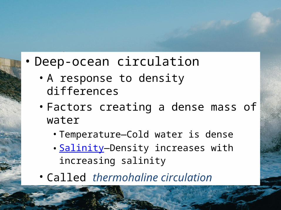
• Deep-ocean circulation • A response to density differences• Factors creating a dense mass of water
• Temperature—Cold water is dense• Salinity—Density increases with increasing
salinity
• Called thermohaline circulation

© 2011 Pearson Education, Inc.
• Deep-ocean circulation • Most water involved in deep-ocean
currents begins in high latitudes at the surface
• A simplified model of ocean circulation is similar to a conveyor belt that travels from the Atlantic Ocean, through the Indian and Pacific Oceans, and back again

© 2011 Pearson Education, Inc.
Idealized “Conveyor Belt” model of ocean circulation

© 2011 Pearson Education, Inc.
Waves
• Waves • Energy traveling along the interface
between ocean and atmosphere • Derive their energy and motion from wind • Parts
• Crest • Trough
© 2011 Pearson Education, Inc.
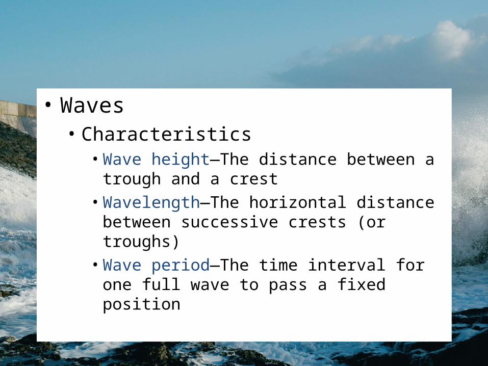
• Waves • Characteristics
• Wave height—The distance between a trough and a crest
• Wavelength—The horizontal distance between successive crests (or troughs)
• Wave period—The time interval for one full wave to pass a fixed position

© 2011 Pearson Education, Inc.
Characteristics and movement of waves

© 2011 Pearson Education, Inc.
Ocean water movements
• Waves • Wave height, length, and period
depend on • Wind speed • Length of time the wind blows • Fetch—The distance that the wind travels
• As the wave travels, the water passes energy along by moving in a circle

© 2011 Pearson Education, Inc.
Changes that occur when a wave moves onto shore

© 2011 Pearson Education, Inc.
Beaches and shoreline processes
• Beaches are composed of whatever material is available • Some beaches have a significant biological
component • Material does not stay in one place
• Wave erosion • Caused by
• Wave impact and pressure • Breaks down rock material and supplies sand
to beaches

© 2011 Pearson Education, Inc.
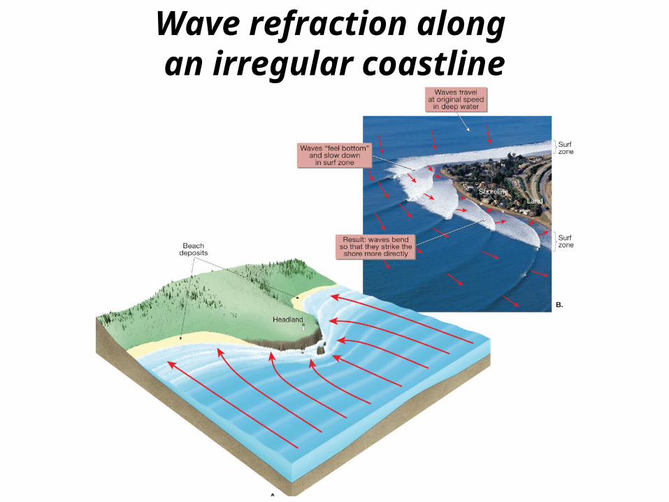
• Wave refraction • Bending of a waves• Wave arrives parallel to shore • Results
• Wave energy is concentrated against the sides and ends of the headland
• Wave erosion straightens an irregular shoreline
© 2011 Pearson Education, Inc.
Wave refraction along an irregular coastline

© 2011 Pearson Education, Inc.
• Longshore transport • Beach drift—Sediment moves in a zigzag
pattern along the beach face • Longshore current
• Current in surf zone • Flows parallel to the shore• Moves substantially more sediment than beach
drift

© 2011 Pearson Education, Inc.
Beach drift and longshore currents

© 2011 Pearson Education, Inc.
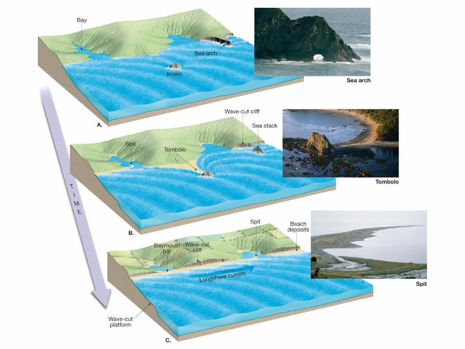
Shoreline features
• Erosional features • Wave-cut cliff• Wave-cut platform • Marine terraces• Associated with headlands
• Sea arch• Sea stack

© 2011 Pearson Education, Inc.
Wave-cut platform andMarine terrace

© 2011 Pearson Education, Inc.
Sea arch and sea stack

© 2011 Pearson Education, Inc.
• Depositional features • Spit—A ridge of sand extending from the
land into the mouth of an adjacent bay with an end that often hooks landward
• Baymouth bar—A sand bar that completely crosses a bay
• Tombolo—A ridge of sand that connects an island to the mainland

© 2011 Pearson Education, Inc.
Spit and baymouth
bar

© 2011 Pearson Education, Inc.
Spit

© 2011 Pearson Education, Inc.
Tombolo
© 2011 Pearson Education, Inc.

© 2011 Pearson Education, Inc.
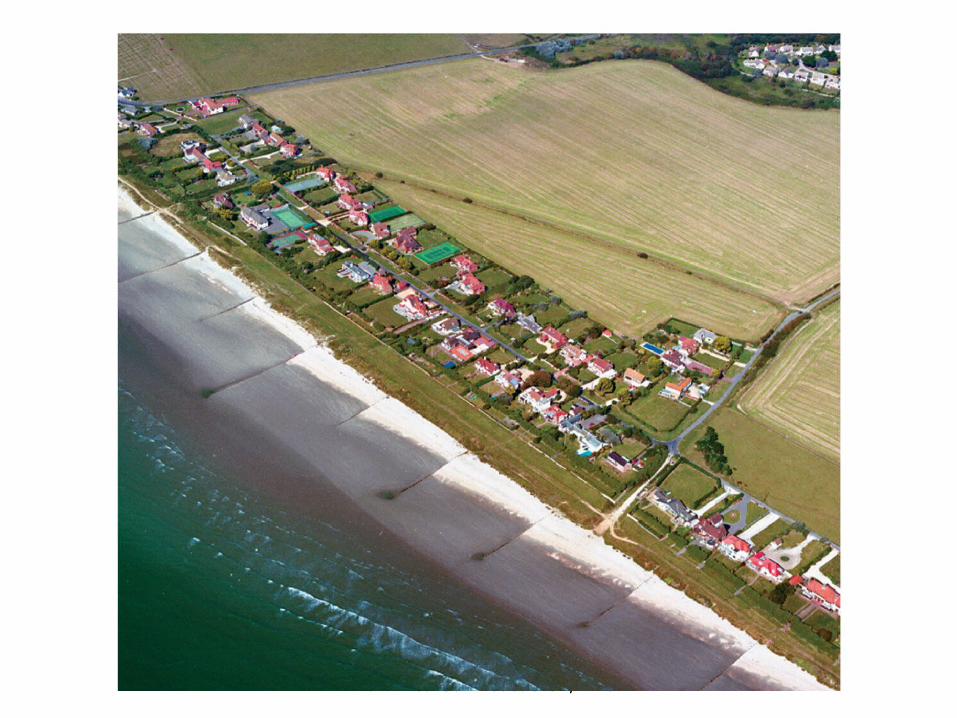
• Depositional features • Barrier islands
• Mainly along the Atlantic and Gulf Coastal Plains
• Parallel the coast

© 2011 Pearson Education, Inc.

© 2011 Pearson Education, Inc.
Stabilizing the shore
• Shoreline erosion is influenced by the local factors • Proximity to sediment-laden rivers • Degree of tectonic activity • Topography and composition of
the land • Prevailing wind and weather patterns • Configuration of the coastline

© 2011 Pearson Education, Inc.
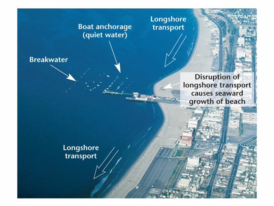
• Responses to erosion problems • Hard stabilization—Building structures
• Types of structures • Groins—Barriers built at a right angle to the
beach that are designed to trap sand• Breakwaters—Barriers built offshore and
parallel to the coast to protect boats from breaking waves
• Seawalls—Armors the coast against the force of breaking waves
• Often these structures are not effective
© 2011 Pearson Education, Inc.
© 2011 Pearson Education, Inc.

© 2011 Pearson Education, Inc.
• Responses to erosion problems • Alternatives to hard stabilization
• Beach nourishment by adding sand to the beach system
• Relocating buildings away from beach
• Erosion problems along U.S. Coasts• Shoreline erosion problems are different
along the opposite coasts

© 2011 Pearson Education, Inc.
Miami Beach before beach nourishment

© 2011 Pearson Education, Inc.
Miami Beach after beach nourishment

© 2011 Pearson Education, Inc.
• Erosion problems along U.S. Coasts• Atlantic and Gulf Coasts
• Development occurs mainly on barrier islands • Face open ocean • Receive full force of storms
• Development has taken place more rapidly than our understanding of barrier island dynamics

© 2011 Pearson Education, Inc.
• Erosion problems along U.S. Coasts• Pacific Coast
• Characterized by relatively narrow beaches backed by steep cliffs and mountain ranges
• Major problem is the narrowing of the beaches • Sediment for beaches is interrupted by
dams and reservoirs • Rapid erosion occurs along the beaches

© 2011 Pearson Education, Inc.
Coastal classification
• Shoreline classification is difficult
• Classification based on changes with respect to sea level • Emergent coast
• Caused by • Uplift of the land, or • A drop in sea level
© 2011 Pearson Education, Inc.
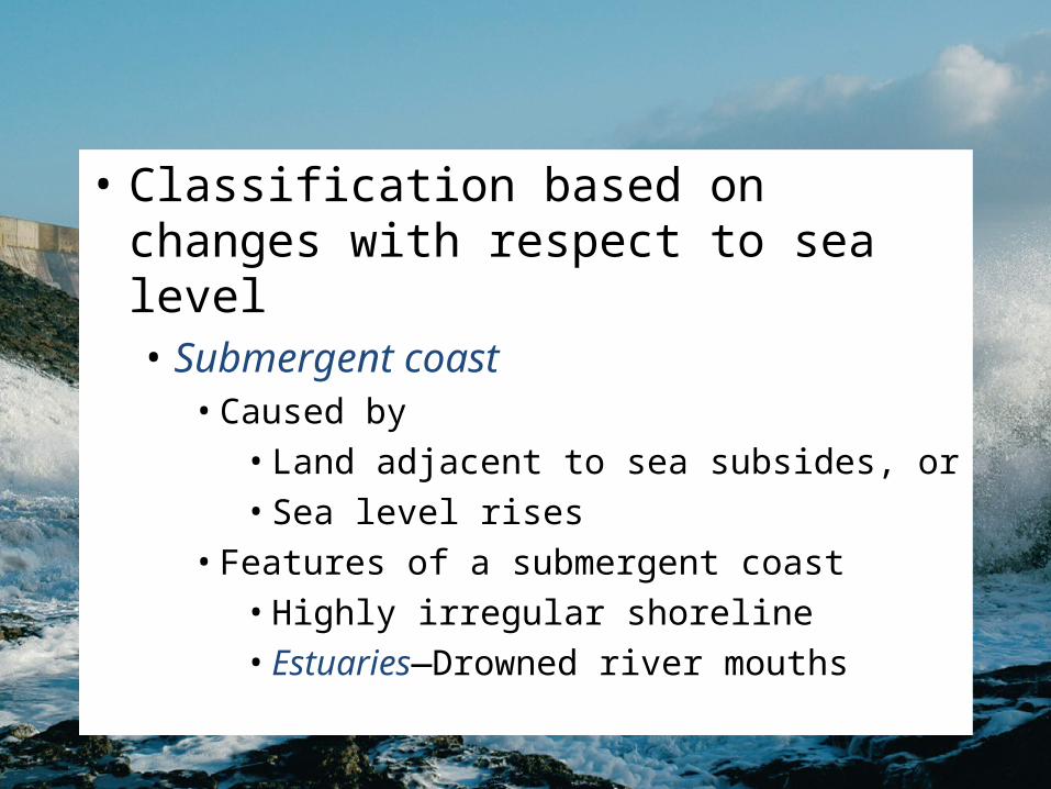
• Classification based on changes with respect to sea level • Submergent coast
• Caused by• Land adjacent to sea subsides, or • Sea level rises
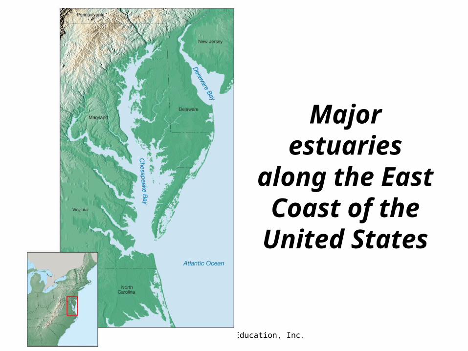
• Features of a submergent coast • Highly irregular shoreline • Estuaries—Drowned river mouths
© 2011 Pearson Education, Inc.
Major estuaries
along the East Coast of the
United States

© 2011 Pearson Education, Inc.
Tides
• Changes in elevation of the ocean surface
• Caused by the gravitational forces exerted upon the Earth by the • Moon, and to a lesser extent by the • Sun

© 2011 Pearson Education, Inc.
Idealized tidal bulges on Earth

© 2011 Pearson Education, Inc.
• Monthly tidal cycle • Spring tide
• During new and full moons• Gravitational forces added together • Especially high and low tides • Large daily tidal range

© 2011 Pearson Education, Inc.
Earth-Moon-Sun positions during the Spring Tide
© 2011 Pearson Education, Inc.
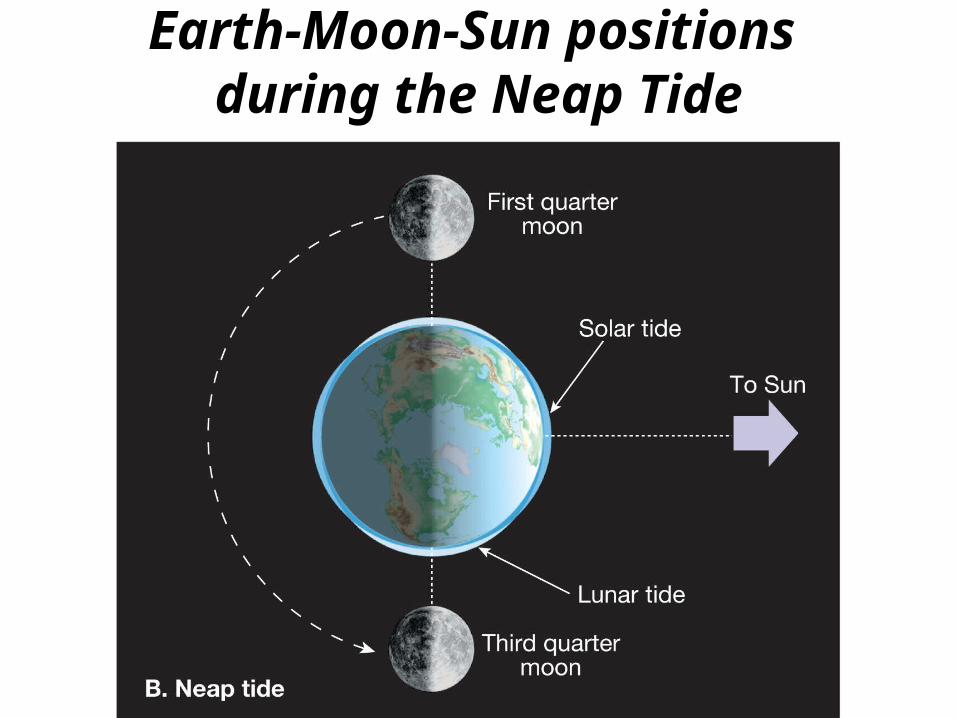
Earth-Moon-Sun positions during the Neap Tide

© 2011 Pearson Education, Inc.
• Monthly tidal cycle • Neap tide
• First and third quarters of the Moon • Gravitational forces are offset • Daily tidal range is least
• Tidal patterns • Many factors influence the tides
• Shape of the coastline • Configuration of the ocean basin • Water depth

© 2011 Pearson Education, Inc.
• Tidal patterns • Main tidal patterns
• Diurnal tidal pattern• A single high and low tide each tidal day • Occurs along the northern shore of the Gulf
of Mexico • Semidiurnal tidal pattern
• Two high and two low tides each tidal day
• Little difference in the high and low water heights

© 2011 Pearson Education, Inc.
• Tidal patterns • Main tidal patterns
• Mixed tidal pattern • Two high and two low waters each day • Large inequality in high water heights, low
water heights, or both• Prevalent along the Pacific Coast of the
United States

© 2011 Pearson Education, Inc.
• Tidal currents• Horizontal flow accompanying the rise
and fall of tides • Types of tidal currents
• Flood current—Advances into the coastal zone
• Ebb current—Seaward moving water
• Sometimes tidal deltas are created by tidal currents

© 2011 Pearson Education, Inc.
Features associated with tidal currents
© 2011 Pearson Education, Inc.
Questions ?