zoning ordinance article three ordinances/main6.6.pdfinstitutional/public uses • nature preserve...
TRANSCRIPT

Zoning Ordinance
Article Three
Zoning District Intent,
Uses, & Standards

50 Madison County, Indiana Land Use & Development Code
AP - Agriculture Protection District3.1 "AP" District Intent, Permitted Uses, and Special Uses
Permitted Uses
The "AP" District is intended toprovide a land use category exclu-sively for agricultural activities. Theprovisions that regulate this districtshould protect, promote and main-tain areas in Madison Countyexclusively for farming operations.
Madison County's Plan Commissionand Board of Zoning Appeals shouldstrive to protect this district fromconflicting land uses and non-agricultural development.
The Plan Commission and Board ofZoning Appeals should also strive topromote the development of resi-dences as accessory uses only inthe "AP" district.
Special Uses
Agricultural Uses• grazing/pasture land
• livestock
• agricultural crop production
• agricultural crop processing (ofmaterials produced on-site)
• agricultural product storage (ofmaterials produced on-site)
• agricultural product (seeds, fertilizer,etc.) sales, distribution, and storage
• farm implement storage (operableimplements used in the farmingoperation - not for sale)
Residential Uses (permitted asaccessory uses only)
• dwelling, single-family
• child day-care home
• home occupation (type I)
Institutional/Public Uses• nature preserve
• passive recreation trail
Communication/Utilities• utility substation
• public wellfield/pumphouse
• water tower
Agricultural Uses• confined feeding operation
• animal boarding
• retail sales (of crops produced on-site)
• seasonal farm worker housing
Residential Uses• dwelling, single-family (as a primaryuse)
• manufactured home (type I)
• manufactured home (type II)
• dwelling, single family (accessory, asan additional dwelling)
• bed and breakfast facility
• home occupation (type II)
• private air strip
Institutional/Public Uses• police, fire, or rescue station
• church or other place of worship
• government office or facility
• school (P-12)
Communication/Utilities• wireless telecommunications facility/tower
Business Uses• kennel
• recreation uses (large scale)
Industrial Uses• mineral extraction and processing
The Use Matrix at the end of this Article (p80 & 81) provides detailed use listings.
The flood hazard provisions of this Ordinance shall apply to all districts as specified in Article 6, Section 6.10.
The Corridor Development Overlay District shall apply as specified in Article 4 of this Ordinance.
Any district may be rezoned to "PD" (Planned Unit Development) as specified in Article 9 of this Ordinance.
The subdivision of land in this district shall be consistent with the specifications of the Madison County SubdivisionControl Ordinance.
District Intent
Use Notes & Subdivision Specifications

51Part "A" - Zoning Ordinance, Article Three: Zoning District Intent, Uses, and Standards
AP - Agriculture Protection District3.2 "AP" District Standards
Minimum Lot Area:• 40 acres
Minimum Lot Width:• 100 feet
Minimum Lot Frontage:• 50 feet (consistent with the require-ments of the Subdivision ControlOrdinance)
Maximum Lot Depth:• none
Sewer and Water:• May use public water and sewer orprivate well and septic systems
Minimum Front Yard Setback:• 150 feet when adjacent to an ArterialRoad
• 100 feet when adjacent to a CollectorRoad
• 35 feet when adjacent to a LocalRoad
Minimum Side Yard Setback:• 25 feet
Minimum Rear Yard Setback:• 30 feet
Maximum Lot Coverage:• square footage of all primary andaccessory structures, and impervioussurface cannot exceed 10% of the LotArea
Minimum Living Area:• 1,000 square feet
Minimum Ground Floor Area:• 40% of the total living area
Maximum Residential Structuresper Lot:
• 1
Additional Development Standards that Apply
Maximum Structure Height:• 35 feet for the Primary Structure
• 25 feet for Accessory Structures
• All agriculture related structures areexempt
• All telecommunication facilities shallconform to the requirements of Art. 6
Lot, Yard, and Density(LY)
• LY-01 ................... Page 93
Height (HT)• HT-01 ................... Page 94
Accessory Structure (AS)• AS-01 .................. Page 95
• AS-02 .................. Page 95
Buffer Yard (BY)• BY-01 .................. Page 99
Environmental (EN)• EN-01 ............... Page 102
Flood Hazard Area (FH)• FH-01 ................ Page 104
Parking (PK)• PK-01 ................. Page 110• PK-05 ................. Page 113
Entrances/Drives (ED)• ED-01 ................. Page 115• ED-02 ................. Page 116
Sight Visibility (SV)• SV-01 ................. Page 118
Home Occupation (HO)• HO-01 ............... Page 120
Telecom. Facilities (TF)• TF-01 ................. Page 123• TF-02 ................. Page 126
Farm Animal (FA)• FA-01 ................. Page 127• FA-02 ................. Page 127
Mobile/Man. Home (MS)• MS-01 ............... Page 128
Satellite Dish (SA)• SA-01 ................ Page 132
Temporary Uses (TU)•TU-01 ................. Page 134
•TU-02 ................. Page 134
Fences and Walls (FW)• FW-01 ............... Page 137
• FW-03 ............... Page 137
Seasonal Housing (SH)• SH-01 ............... Page 143
General Signs (GS)
• GS-01 ............... Page 147
Temporary Signs (TS)• TS-01 ................. Page 150
Permanent Signs (PS)• PS-01 ................ Page 151
Rear Yard
Setback
Front Yard
SetbackR.O.W.
Building
Envelope
Side
Yard
Setback
Lot Width
Lot FrontageR.O.W.
Property
Line
Lot
Area
Lo
t Dep
th
Accessory
Structures
R.O.W.
Lot
CoveragePrimary
Structure
R.O.W. = As Defined on Thoroughfare Plan
Accessory
Structures
R.O.W.
Lot
CoveragePrimary
Structure

52 Madison County, Indiana Land Use & Development Code
AG - Agriculture District3.3 "AG" District Intent, Permitted Uses, and Special Uses
• Permitted Uses
Agricultural Uses• grazing and pasture land
• livestock
• agricultural crop production
• retail sales (of crops produced on-site)
• agriculture crop processing (ofmaterials produced on-site)
• agriculture crop storage (of materialsproduced on-site)
• agricultural products (seeds, fertilizer,etc.) sales, distribution, and storage
• farm implement storage (operableimplements used in the farmingoperation - not for sale)
Residential Uses• dwelling, single-family
• manufactured home (type I)
• manufactured home (type II)
• residential facility for developmentallydisabled/mentally ill
• child day-care home
• home occupation (type I)
Institutional/Public Uses• nature preserve
• passive recreation trail
•public school (P-12)
•church or other place of worship
Communication/Utilities• utility substation
• public wellfield/pumphouse
• water tower
District Intent
The "AG" District is intended toprovide a land use category foragricultural activities. The provisionsthat regulate this land use districtshould protect, promote and main-tain areas in Madison Countyprimarily for farming operations.
Madison County's Plan Commissionand Board of Zoning Appeals shouldstrive to protect this district fromconflicting land uses, non-agricultureoriented businesses, and any usethat may inflict significant environ-mental impacts or be injurious to theagriculture community.
Special Uses
Agricultural Uses• confined feeding operation
• animal boarding
• livestock auction/sale facility
• commercial greenhouse
• farmer's market (for products grownoff-site)
• farm implement sales and service
• seasonal farm worker housing
Residential Uses• dwelling, single family (Accessory, asan additional dwelling)
• home occupation (type II)
• bed and breakfast facility
• boarding house
• private air strip
Institutional/Public Uses• police, fire, or rescue station
• government office/facility
Communication/Utilities• sewage treatment plant
• wireless telecommunications facility/tower
Business Uses• kennel
• recreational uses (large scale)
• expansion of existing, legal noncon-
forming uses
Industrial Uses• agricultural crop production (ofmaterials produced off-site)
• mineral extraction and processing inurban areas and floodplains asshown on the flood insurance ratemaps
• expansion of existing, legal noncon-
forming uses
The Use Matrix at the end of this Article (p80 & 81) provides detailed use listings.
The flood hazard provisions of this Ordinance shall apply to all districts as specified in Article 6, Section 6.10.
The Corridor Development Overlay District shall apply as specified in Article 4 of this Ordinance.
Any district may be rezoned to "PD" (Planned Unit Development) as specified in Article 9 of this Ordinance.
The subdivision of land in this district shall be consistent with the specifications of the Madison County SubdivisionControl Ordinance.
Use Notes & Subdivision Specifications
Rev. 2004 S-4 Rev. 2005 S-6

53Part "A" - Zoning Ordinance, Article Three: Zoning District Intent, Uses, and Standards
AG - Agriculture District3.4 "AG" District Standards
Minimum Lot Area:• 2 acres
Minimum Lot Width:• 200 feet
Minimum Lot Frontage:• 50% of the lot width (consistent with therequirements of the SubdivisionControl Ordinance) (for residentialprimary uses)
• 50 feet (consistent with the require-ments of the Subdivision ControlOrdinance) (for non-residential primaryuses)
Maximum Lot Depth:• 3.5 times the lot width (for residentialprimary uses)
• none (for non-residential primary uses)
Minimum Front Yard Setback:• 150 feet when adjacent to an ArterialRoad
• 100 feet when adjacent to a CollectorRoad
• 35 feet when adjacent to a LocalRoad
Minimum Side Yard Setback:• 25 feetMinimum Rear Yard Setback:
• 30 feet
Note:Lots that were legally createdunder a prior ordinance and are lessthan 2 acres, minimum side andrear setbacks - 10 feet.
Maximum Lot Coverage:• square footage of all primary andaccessory structures, and impervioussurface cannot exceed 10% of the LotArea.
Minimum Living Area:• 1,500 square feet (primary usedwelling)
• 1,000 square feet (accessory usedwelling)
Minimum Ground Floor Area:• 40% of the total living area
Maximum Primary Structures perLot:
• 1
Additional Development Standards that Apply
Maximum Structure Height:• 35 feet for the Primary Structure
• 25 feet for Accessory Structures
• All agriculture related structures areexempt
• All telecommunication facilities shallconform to the requirements of Art. 6
Lot, Yard, and Density(LY)
• LY-01 ................... Page 93
Height (HT)• HT-01 ................... Page 94
Accessory Structure (AS)• AS-01 .................. Page 95
• AS-02 .................. Page 95
Buffer Yard (BY)• BY-01 .................. Page 99
Environmental (EN)• EN-01 ................. Page102
Flood Hazard Area (FH)• FH-01 ................ Page 104
Parking (PK)• PK-01 ................. Page 110• PK-05 ................. Page 113
Entrances/Drives (ED)• ED-01 ................. Page 115• ED-02 ................. Page 116
Sight Visibility (SV)• SV-01 ................. Page 118
Home Occupation (HO)• HO-01 ............... Page 120
Telecom. Facilities (TF)• TF-01 ................. Page 123• TF-02 ................. Page 126
Farm Animal (FA)• FA-01 ................. Page 127• FA-02 ................. Page 127
Mobile/Man. Home (MS)• MS-01 ............... Page 128
Satellite Dish (SA)• SA-01 ................ Page 132
Temporary Uses (TU)•TU-01 ................. Page 134
•TU-02 ................. Page 134
Fences and Walls (FW)• FW-01 ............... Page 137
• FW-03 ............... Page 137
Seasonal Housing (SH)• SH-01 ............... Page 143
General Signs (GS)
• GS-01 ............... Page 147
Temporary Signs (TS)• TS-01 ................. Page 150
Permanent Signs (PS)• PS-01 ................ Page 151
Sewer and Water:• May use public water and sewer orprivate well and septic systems
Rear Yard
Setback
Front Yard
SetbackR.O.W.
Building
Envelope
Side
Yard
Setback
Lot Width
Lot Frontage R.O.W.
Property
Line
Lot
Area
Lo
t Dep
th
Accessory
Structures
R.O.W.
Lot
CoveragePrimary
Structure
R.O.W. = As Defined on Thoroughfare Plan
Accessory
Structures
R.O.W.
Lot
CoveragePrimary
Structure
Rev. 2003 S-1
54 Madison County, Indiana Land Use & Development Code
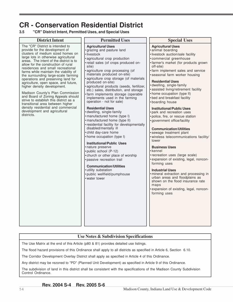
CR - Conservation Residential District3.5 "CR" District Intent, Permitted Uses, and Special Uses
District Intent
The "CR" District is intended toprovide for the development ofclusters of medium sized homes onlarge lots in otherwise agriculturalareas. The intent of the district is toallow for the construction of ruralresidences and small recreationalfarms while maintain the viability ofthe surrounding large-scale farmingoperations and preserving land foragriculture, open space, and future,higher density development.
Madison County's Plan Commissionand Board of Zoning Appeals shouldstrive to establish this district as atransitional area between higherdensity residential and commercialdevelopment and agriculturaldistricts.
Permitted Uses
Agricultural Uses• grazing and pasture land
• livestock
• agricultural crop production
• retail sales (of crops produced on-site)
• agriculture crop processing (ofmaterials produced on-site)
• agriculture crop storage (of materialsproduced on-site)
• agricultural products (seeds, fertilizer,etc.) sales, distribution, and storage
• farm implements storage (operableimplements used in the farmingoperation - not for sale)
Residential Uses• dwelling, single-family
• manufactured home (type I)
• manufactured home (type II)
• residential facility for developmentallydisabled/mentally ill
• child day-care home
• home occupation (type I)
Institutional/Public Uses• nature preserve
• public school (P-12)
• church or other place of worship
• passive recreation trail
Communication/Utilities• utility substation
• public wellfield/pumphouse
• water tower
Special Uses
Agricultural Uses• animal boarding
• livestock auction/sale facility
• commercial greenhouse
• farmer's market (for products grownoff-site)
• farm implement sales and service
• seasonal farm worker housing
Residential Uses• dwelling, single-family
• assisted living/retirement facility
• home occupation (type II)
• bed and breakfast facility
• boarding house
Institutional/Public Uses• park and recreation uses
• police, fire, or rescue station
• government office/facility
Communication/Utilities• sewage treatment plant
• wireless telecommunications facility/tower
Business Uses• kennel
• recreation uses (large scale)
• expansion of existing, legal, noncon-
forming uses
Industrial Uses• mineral extraction and processing inurban areas and floodplains asshown on the flood insurance ratemaps
• expansion of existing, legal, noncon-
forming uses
The Use Matrix at the end of this Article (p80 & 81) provides detailed use listings.
The flood hazard provisions of this Ordinance shall apply to all districts as specified in Article 6, Section 6.10.
The Corridor Development Overlay District shall apply as specified in Article 4 of this Ordinance.
Any district may be rezoned to "PD" (Planned Unit Development) as specified in Article 9 of this Ordinance.
The subdivision of land in this district shall be consistent with the specifications of the Madison County SubdivisionControl Ordinance.
Use Notes & Subdivision Specifications
Rev. 2004 S-4 Rev. 2005 S-6

55Part "A" - Zoning Ordinance, Article Three: Zoning District Intent, Uses, and Standards
CR - Conservation Residential District3.6 "CR" District Standards
Minimum Lot Area:• 2 acres (Septic System)
• 1 acre (Public Sewer)
Minimum Lot Width:• 100 feet
Minimum Lot Frontage:• 75% of the lot width (consistent with
the requirements of the SubdivisionControl Ordinance) (for residentialprimary uses)
• 50 feet (consistent with the require-ments of the Subdivision ControlOrdinance) (for non-residential
primary uses)
Maximum Lot Depth:• 3.5 times the lot width (for residentialprimary uses)
• none (for non-residential primary uses)
Minimum Front Yard Setback:• 150 feet when adjacent to an ArterialRoad
• 100 feet when adjacent to a CollectorRoad
• 30 feet when adjacent to a Local RoadMinimum Side Yard Setback:
• 25 feet each sideMinimum Rear Yard Setback:
• 30 feet
Note:Lots that were legally createdunder a prior ordinance and are lessthan 2 acres, minimum side andrear setbacks - 10 feet.
Maximum Lot Coverage:• square footage of all primary andaccessory structures, and impervioussurface cannot exceed 30% of the LotArea.
Minimum Living Area:• 1,500 square feet
Minimum Ground Floor Area:• 40% of the total living area
Maximum Primary Structures perLot:
• 1
Additional Development Standards that Apply
Maximum Structure Height:• 35 feet for the Primary Structure
• 25 feet for Accessory Structures
• All agriculture related structures areexempt
• All telecommunication facilities shallconform to the requirements of Art. 6
Sewer and Water:• May use public water and sewer orprivate well and septic systems
Lot, Yard, & Density (LY)• LY-01 ................... Page 93
Height (HT)• HT-01 ................... Page 94
Accessory Structure (AS)• AS-01 .................. Page 95
• AS-02 .................. Page 95
Buffer Yard (BY)• BY-01 .................. Page 99
Environmental (EN)• EN-01 ............... Page 102
Flood Hazard Area (FH)• FH-01 ................ Page 104
Parking (PK)• PK-01 ................. Page 110• PK-05 ................. Page 113
Entrances/Drives (ED)• ED-01 ................. Page 115
Sight Visibility (SV)• SV-01 ................. Page 118
Home Occupation (HO)• HO-01 ............... Page 120
Telecom. Facilities (TF)• TF-01 ................. Page 123• TF-02 ................. Page 126
Farm Animal (FA)• FA-01 ................. Page 127
Mobile/Man. Home (MS)• MS-01 ............... Page 128
Satellite Dish (SA)• SA-01 ................ Page 132
Temporary Uses (TU)•TU-01 ................. Page 134
•TU-02 ................. Page 134
Fences and Walls (FW)• FW-01 ............... Page 137
• FW-03 ............... Page 137
Seasonal Housing (SH)• SH-01 ............... Page 143
General Signs (GS)• GS-01 ............... Page 147
Temporary Signs (TS)• TS-01 ................. Page 150
Permanent Signs (PS)• PS-02 ................ Page 151
Rev. 2003 S-1

56 Madison County, Indiana Land Use & Development Code
R1 - Single-Family Residential District3.7 "R1" District Intent, Permitted Uses, and Special Uses
Permitted Uses
Agricultural Uses• agricultural crop production
• agriculture crop processing (ofmaterials produced on-site)
• agriculture crop storage (of materialsproduced on-site)
• farm implement storage (operableimplements used in the farmingoperation - not for sale)
Residential Uses• dwelling, single-family
• manufactured home (type I)
• manufactured home (type II)
• residential facility for developmentallydisabled/mentally ill
• child day-care home
• home occupation (type I)
Institutional/Public Uses• nature preserve
• passive recreation trail
District Intent
The "R1" District is intended toprovide for the development of largesingle-family detached homes onmedium-sized lots. The provisionsthat regulate this land use districtshould provide for the developmentof medium density residentialneighborhoods.
Madison County's Plan Commissionand Board of Zoning Appeals shouldstrive to integrate this type of neigh-borhood with higher density residen-tial developments and neighbor-hood-serving commercial facilities.This district should be protected fromconflicting land uses and be locatedin proximity to "CR" districts in a waythat does not inhibit farming prac-tices.
The Plan Commission and Board ofZoning Appeals should strive topromote an average net density of2.0 to 2.5 dwelling units per acrecommunity-wide in the "R1" district.
Special Uses
Agricultural Uses• grazing and pasture land
• livestock
Residential Uses• dwelling, single family
• assisted living/retirement facility
• nursing home
• home occupation (type II)
• bed and breakfast facility
Institutional/Public Uses• parks and recreation uses
• institutional uses (small scale)
• police, fire, or rescue station
• church or other place of worship
• government office/facility
• school (P-12)
Communication/Utilities• utility substation
• public wellfield/pumphouse
• water tower
• wireless telecommunications facility/tower
The Use Matrix at the end of this Article (p80 & 81) provides detailed use listings.
The flood hazard provisions of this Ordinance shall apply to all districts as specified in Article 6, Section 6.10.
The Corridor Development Overlay District shall apply as specified in Article 4 of this Ordinance.
Any district may be rezoned to "PD" (Planned Unit Development) as specified in Article 9 of this Ordinance.
The subdivision of land in this district shall be consistent with the specifications of the Madison County SubdivisionControl Ordinance.
Use Notes & Subdivision Specifications
Rev. 2003 S-2

57Part "A" - Zoning Ordinance, Article Three: Zoning District Intent, Uses, and Standards
R1 - Single-Family Residential District3.8 "R1" District Standards
Minimum Lot Area:•12,000 square feet
Minimum Lot Width:• 80 feet
Minimum Lot Frontage:• 70% of the lot width (consistent withthe requirements of the SubdivisionControl Ordinance)
Maximum Lot Depth:• 2.5 times the lot width
Sewer and Water:• Requires connection to public waterand sewer except may use privatewell and septic systems provided thelot is alegal nonconforming lot and nopublic water or sewer systems areavailable.
Minimum Front Yard Setback:• 50 feet when adjacent to an Arterial
• 35 feet when adjacent to a Collector
•30 feet when adjacent to a Local Road
Minimum Side Yard Setback:• 5 feet each side
• 20 feet total
Minimum Rear Yard Setback:• 25 feet
Maximum Lot Coverage:• square footage of all primary andaccessory structures, and impervioussurface cannot exceed 35% of the LotArea.
Minimum Living Area:• 1,800 square feet
Minimum Ground Floor Area:• 40% of the total living area
Maximum Primary Structures perLot:
• 1
Additional Development Standards that Apply
Maximum Structure Height:• 35 feet for the Primary Structure
• 25 feet for Accessory Structures
• All telecommunication facilities shallconform to the requirements of Art. 6
R.O.W. = As Defined on Thoroughfare Plan
LotCoverage
PrimaryStructure
AccessoryStructures
LotCoverage
Lot Width
Lo
t De
pth
R.O.W. = As Defined on Thoroughfare Plan
LotAreaProperty
Line
BuildingLine
R.O.W. = As Defined on Thoroughfare Plan
Rear YardSetback
BuildingEnvelope
Min.SideYard
Front YardSetback
Lot, Yard, & Density (LY)• LY-01 ................... Page 93
Height (HT)• HT-01 ................... Page 94
Accessory Structure (AS)• AS-01 .................. Page 95
• AS-03 .................. Page 96
Buffer Yard (BY)• BY-01 .................. Page 99
Environmental (EN)• EN-01 ............... Page 102
Flood Hazard Area (FH)• FH-01 ................ Page 104
Parking (PK)• PK-01 ................. Page 110• PK-02 ................. Page 110• PK-05 ................. Page 113• PK-06 ................. Page 113
• PK-07 ................. Page 113
Entrances/Drives (ED)• ED-01 ................. Page 115
Sight Visibility (SV)• SV-01 ................. Page 118
Open Space (OS)• OS-01 ................ Page 119
Home Occupation (HO)• HO-01 ............... Page 120
Telecom. Facilities (TF)• TF-01 ................. Page 123• TF-02 ................. Page 126
Farm Animal (FA)• FA-01 ................. Page 127
Mobile/Man. Home (MS)• MS-01 ............... Page 128
Satellite Dish (SA)• SA-01 ................ Page 132
Temporary Uses (TU)•TU-01 ................. Page 134
•TU-02 ................. Page 134
•TU-03 ................. Page 135
Fences and Walls (FW)• FW-01 ............... Page 137
• FW-02 ............... Page 137
Landscaping (LA)• LA-01 ................. Page 138
Seasonal Housing (SH)• SH-01 ............... Page 143
Lighting Standards (LS)
•LS-01 ................. Page 145
•LS-02 ................. Page 145
General Signs (GS)• GS-01 ............... Page 147
Temporary Signs (TS)• TS-01 ................. Page 150
Permanent Signs (PS)• PS-01 ................ Page 151• PS-02 ................ Page 151
Rev. 2003 S-1 Rev. 2005 S-6

58 Madison County, Indiana Land Use & Development Code
R2 - Single-Family Residential District3.9 "R2" District Intent, Permitted Uses, and Special Uses
District Intent
The "R2" District is intended toprovide for the development ofmedium-sized single-family de-tached homes on medium-sizedlots. The provisions that regulate thisland use district should provide forthe development of medium densityresidential neighborhoods.
Madison County's Plan Commissionand Board of Zoning Appeals shouldstrive to integrate this type of neigh-borhood with lower and higherdensity residential developmentsand neighborhood-serving commer-cial facilities. This district should beprotected from conflicting land usesand be located in proximity to "CR"districts in a way that does not inhibitfarming practices.
The Plan Commission and Board ofZoning Appeals should strive topromote an average net density of2.5 to 4.0 dwelling units per acrecommunity-wide in the "R2" district.
Permitted Uses
Agricultural Uses• agricultural crop production
• agriculture crop processing (ofmaterials produced on-site)
• agriculture crop storage (of materialsproduced on-site)
• farm implement storage (operableimplements used in the farmingoperation - not for sale)
Residential Uses• dwelling, single-family
• manufactured home (type I)
• manufactured home (type II)
• residential facility for developmentallydisabled/mentally ill
• child day-care home
• home occupation (type I)
Institutional/Public Uses• nature preserve
• passive recreation trail
Special Uses
Agricultural Uses• grazing and pasture land
• livestock
Residential Uses• dwelling, single-family
• assisted living/retirement facility
• nursing home
• home occupation (type II)
• bed and breakfast facility
Institutional/Public Uses• parks and recreation uses
• institutional uses (small scale)
• police, fire, or rescue station
• church or other place of worship
• government office/facility
• school (P-12)
Communication/Utilities• utility substation
• public wellfield/pumphouse
• water tower
• wireless telecommunications facility/tower
The Use Matrix at the end of this Article (p80 & 81) provides detailed use listings.
The flood hazard provisions of this Ordinance shall apply to all districts as specified in Article 6, Section 6.10.
The Corridor Development Overlay District shall apply as specified in Article 4 of this Ordinance.
Any district may be rezoned to "PD" (Planned Unit Development) as specified in Article 9 of this Ordinance.
The subdivision of land in this district shall be consistent with the specifications of the Madison County SubdivisionControl Ordinance.
Use Notes & Subdivision Specifications
Rev. 2003 S-2

59Part "A" - Zoning Ordinance, Article Three: Zoning District Intent, Uses, and Standards
R2 - Single-Family Residential District3.10 "R2" District Standards
Minimum Lot Area:•8,000 square feet
Minimum Lot Width:• 70 feet
Minimum Lot Frontage:• 70% of the lot width (consistent withthe requirements of the SubdivisionControl Ordinance)
Maximum Lot Depth:• 2.5 times the lot width
Sewer and Water:• Requires connection to public waterand sewer except may use privatewell and septic systems provided thelot is alegal nonconforming lot and nopublic water or sewer systems areavailable.
Minimum Front Yard Setback:• 50 feet when adjacent to an Arterial
• 35 feet when adjacent to a Collector
• 30 feet when adjacent to a Local Road
Minimum Side Yard Setback:• 5 feet each side
• 15 feet total
Minimum Rear Yard Setback:• 20 feet
Maximum Lot Coverage:• square footage of all primary andaccessory structures, and impervioussurface cannot exceed 45% of the LotArea
Minimum Living Area:• 1,400 square feet
Minimum Ground Floor Area:• 40% of the total living area
Maximum Primary Structures perLot:
• 1
Additional Development Standards that Apply
Maximum Structure Height:• 35 feet for the Primary Structure
• 25 feet for Accessory Structures
• All telecommunication facilities shallconform to the requirements of Art. 6
BuildingLine
Lot Width
Lo
t De
pth
R.O.W. = As Defined on Thoroughfare Plan
LotAreaProperty
Line
Front YardSetback
Min.SideYard
R.O.W. = As Defined on Thoroughfare Plan
Rear YardSetback
BuildingEnvelope
R.O.W. = As Defined on Thoroughfare Plan
LotCoverage
PrimaryStructure
AccessoryStructuresLot
Coverage
Lot, Yard, & Density (LY)• LY-01 ................... Page 93
Height (HT)• HT-01 ................... Page 94
Accessory Structure (AS)• AS-01 .................. Page 95
• AS-03 .................. Page 96
Buffer Yard (BY)• BY-01 .................. Page 99
Environmental (EN)• EN-01 ............... Page 102
Flood Hazard Area (FH)• FH-01 ................ Page 104
Parking (PK)• PK-01 ................. Page 110• PK-02 ................. Page 110• PK-05 ................. Page 113• PK-06 ................. Page 113
• PK-07 ................. Page 113
Entrances/Drives (ED)• ED-01 ................. Page 115
Sight Visibility (SV)• SV-01 ................. Page 118
Open Space (OS)• OS-01 ................ Page 119
Home Occupation (HO)• HO-01 ............... Page 120
Telecom. Facilities (TF)• TF-01 ................. Page 123• TF-02 ................. Page 126
Farm Animal (FA)• FA-01 ................. Page 127
Mobile/Man. Home (MS)• MS-01 ............... Page 128
Satellite Dish (SA)• SA-01 ................ Page 132
Temporary Uses (TU)•TU-01 ................. Page 134
•TU-02 ................. Page 134
•TU-03 ................. Page 135
Fences and Walls (FW)• FW-01 ............... Page 137
• FW-02 ............... Page 137
Landscaping (LA)• LA-01 ................. Page 138
Seasonal Housing (SH)• SH-01 ............... Page 143
Lighting Standards (LS)
•LS-01 ................. Page 145
•LS-02 ................. Page 145
General Signs (GS)• GS-01 ............... Page 147
Temporary Signs (TS)• TS-01 ................. Page 150
Permanent Signs (PS)• PS-02 ................ Page 151• PS-02 ................ Page 151
Rev. 2003 S-1 Rev 2005 S-6

60 Madison County, Indiana Land Use & Development Code
R3 - Single & Two-Family Residential District3.11 "R3" District Intent, Permitted Uses, and Special Uses
District Intent
The "R3" District is intended toprovide the development of small-sized single and two-family homeson small-sized lots. The provisionsthat regulate this land use districtshould provide for the developmentof high density residential neighbor-hoods.
Madison County's Plan Commissionand Board of Zoning Appeals shouldstrive to integrate this type of neigh-borhood with medium and highdensity residential developmentsand neighborhood-serving commer-cial facilities. This district should beprotected from conflicting land usesand be located in proximity to "CR"districts in a way that does not inhibitfarming practices.
The Plan Commission and Board ofZoning Appeals should strive topromote an average net density of4.0 to 6.0 dwelling units per acrecommunity-wide in the "R3" district.
Permitted Uses
Agricultural Uses• agricultural crop production
• agriculture crop processing (ofmaterials produced on-site)
• agriculture crop storage (of materialsproduced on-site)
• farm implement storage (operableimplements used in the farmingoperation - not for sale)
Residential Uses• dwelling, single-family
• manufactured home (type I)
• manufactured home (type II)
• dwelling, two-family
• residential facility for developmentallydisabled/mentally ill
• child day-care home
• home occupation (type I)
Institutional/Public Uses• nature preserve
• passive recreation trail
Special Uses
Agricultural Uses• grazing and pasture land
• livestock
Residential Uses• dwelling, single-family
• assisted living/retirement facility
• nursing home
• home occupation (type II)
Institutional/Public Uses• parks and recreation uses
• institutional uses (small scale)
• police, fire, or rescue station
• church or other place of worship
• government office/facility
• school (P-12)
Communication/Utilities• utility substation
• public wellfield/pumphouse
• water tower
• wireless telecommunications facility/tower
The Use Matrix at the end of this Article (p80 & 81) provides detailed use listings.
The flood hazard provisions of this Ordinance shall apply to all districts as specified in Article 6, Section 6.10.
The Corridor Development Overlay District shall apply as specified in Article 4 of this Ordinance.
Any district may be rezoned to "PD" (Planned Unit Development) as specified in Article 9 of this Ordinance.
The subdivision of land in this district shall be consistent with the specifications of the Madison County SubdivisionControl Ordinance.
Use Notes & Subdivision Specifications
Rev. 2003 S-2

61Part "A" - Zoning Ordinance, Article Three: Zoning District Intent, Uses, and Standards
R3 - Single & Two-Family Residential District3.12 "R3" District Standards
BuildingLine
Lot Width
Lo
t De
pth
R.O.W. = As Defined on Thoroughfare Plan
LotArea
PropertyLine
R.O.W. = As Defined on Thoroughfare Plan
Rear YardSetback
BuildingEnvelope Min.
SideYard
Front YardSetback
R.O.W. = As Defined on Thoroughfare Plan
LotCoverage
PrimaryStructure
AccessoryStructure
LotCoverage
Minimum Lot Area:• 6,000 square feet (single-family)
• 8,000 square feet (two-family)
Minimum Lot Width:• 60 feet (single-family)
• 75 feet (two-family)
Minimum Lot Frontage:• 70% of the lot width (consistent withthe requirements of the SubdivisionControl Ordinance)
Maximum Lot Depth:• 2.5 times the lot width
Sewer and Water:• Requires connection to public waterand sewer
Minimum Front Yard Setback:• 50 feet when adjacent to an Arterial
• 35 feet when adjacent to a Collector
•30 feet when adjacent to a Local Road
Minimum Side Yard Setback:• 5 feet each side
• 10 feet total
Minimum Rear Yard Setback:• 15 feet
Maximum Lot Coverage:• square footage of all primary andaccessory structures, and impervioussurface cannot exceed 55% of the LotArea
Minimum Living Area per Unit:• 1,200 square feet
Minimum Ground Floor Area perUnit:
• 40% of the total living area
Maximum Primary Structures perLot:
• 1
Additional Development Standards that Apply
Maximum Structure Height:• 35 feet for the Primary Structure
• 25 feet for Accessory Structures
• All telecommunication facilities shallconform to the requirements of Art. 6
Lot, Yard, & Density (LY)• LY-01 ................... Page 93
Height (HT)• HT-01 ................... Page 94
Accessory Structure (AS)• AS-01 .................. Page 95
• AS-03 .................. Page 96
Buffer Yard (BY)• BY-01 .................. Page 99
Environmental (EN)• EN-01 ............... Page 102
Flood Hazard Area (FH)• FH-01 ................ Page 104
Parking (PK)• PK-01 ................. Page 110• PK-02 ................. Page 110• PK-05 ................. Page 113• PK-06 ................. Page 113
• PK-07 ................. Page 113
Entrances/Drives (ED)• ED-01 ................. Page 115
Sight Visibility (SV)• SV-01 ................. Page 118
Open Space (OS)• OS-01 ................ Page 119
Home Occupation (HO)• HO-01 ............... Page 120
Telecom. Facilities (TF)• TF-01 ................. Page 123• TF-02 ................. Page 126
Farm Animal (FA)• FA-01 ................. Page 127
Mobile/Man. Home (MS)• MS-01 ............... Page 128
Satellite Dish (SA)• SA-01 ................ Page 132
Temporary Uses (TU)•TU-01 ................. Page 134
•TU-02 ................. Page 134
•TU-03 ................. Page 135
Fences and Walls (FW)• FW-01 ............... Page 137
• FW-02 ............... Page 137
Landscaping (LA)• LA-01 ................. Page 138
Seasonal Housing• SH-01 ............... Page 143
Lighting Standards (LS)
•LS-01 ................. Page 145
•LS-02 ................. Page 145
General Signs (GS)• GS-01 ............... Page 147
Temporary Signs (TS)• TS-01 ................. Page 150
Permanent Signs (PS)• PS-01 ................ Page 151• PS-02 ................ Page 151
Rev. 2005 S-6

62 Madison County, Indiana Land Use & Development Code
MR - Multifamily Residential District3.13 "MR" District Intent, Permitted Uses, and Special Uses
Permitted Uses
Agricultural Uses•agricultural crop production
• agriculture crop processing (ofmaterials produced on-site)
• agriculture crop storage (of materialsproduced on-site)
• farm implement storage (operableimplements used in the farmingoperation - not for sale)
Residential Uses• dwelling, two-family
• dwelling, multifamily
• residential facility for developmentallydisabled/mentally ill
• assisted living/retirement facility
• nursing home
• child day-care home
• home occupation (type I)
Institutional/Public Uses• nature preserve
• passive recreation trail
Special Uses
Agricultural Uses• grazing and pasture land
• livestock
Residential Uses• dwelling, single-family
Institutional/Public Uses• parks and recreation uses
• institutional uses (small scale)
• police, fire, or rescue station
• church or other place of worship
• government office/facility
• school (P-12)
Communication/Utilities• utility substation
• public wellfield/pumphouse
• water tower
• wireless telecommunications facility/tower
District Intent
The "MR" District is intended toprovide for multifamily residentialdevelopments. The provisions thatregulate this land use district shouldpromote the adequate provision ofopen spaces, living areas, andvehicle parking.
Madison County's Plan Commissionand Board of Zoning Appeals shouldstrive to integrate this district withhigh density single and two-familyresidential developments andneighborhood-serving and generalcommercial facilities. This districtshould be protected from conflictingland uses and be located in proximityto open space, services, and retailestablishments.
The Plan Commission and Board ofZoning Appeals should strive topromote an average net density of5.0 to 8.5 dwelling units per acrecommunity-wide in the "MR" district.
The Use Matrix at the end of this Article (p80 & 81) provides detailed use listings.
The flood hazard provisions of this Ordinance shall apply to all districts as specified in Article 6, Section 6.10.
The Corridor Development Overlay District shall apply as specified in Article 4 of this Ordinance.
Any district may be rezoned to "PD" (Planned Unit Development) as specified in Article 9 of this Ordinance.
The subdivision of land in this district shall be consistent with the specifications of the Madison County SubdivisionControl Ordinance.
Use Notes & Subdivision Specifications
Rev. 2003 S-2
63Part "A" - Zoning Ordinance, Article Three: Zoning District Intent, Uses, and Standards
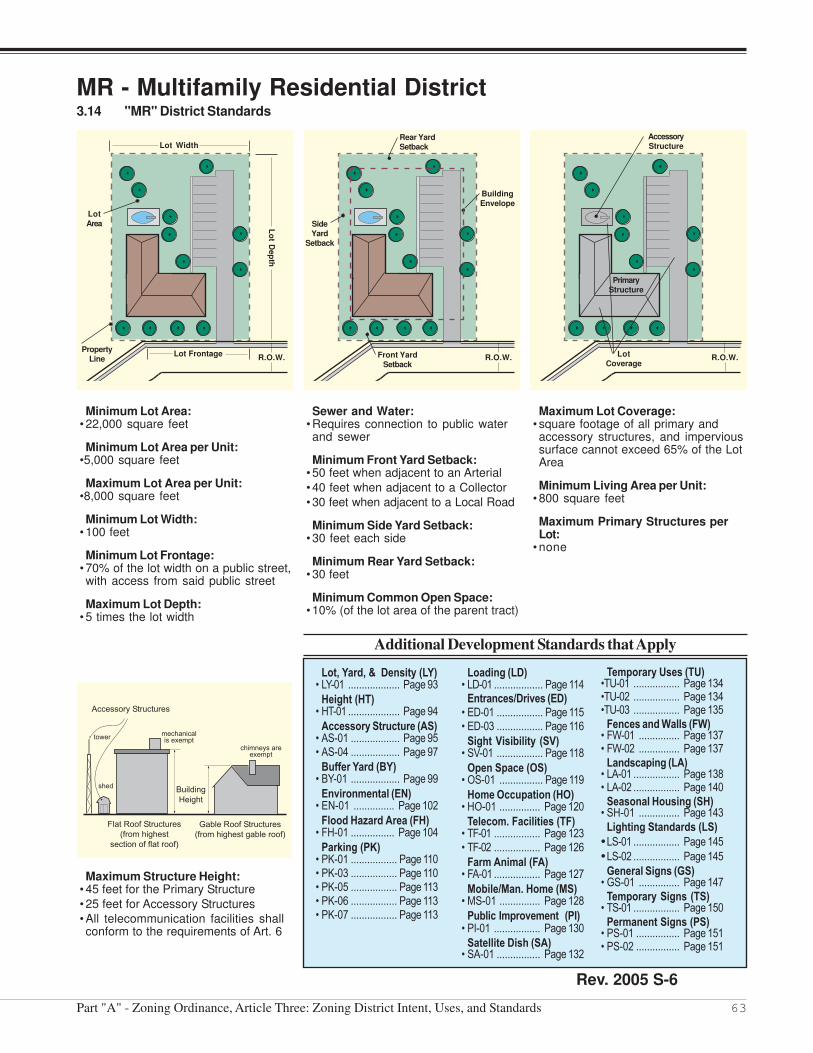
MR - Multifamily Residential District3.14 "MR" District Standards
Minimum Lot Area:• 22,000 square feet
Minimum Lot Area per Unit:•5,000 square feet
Maximum Lot Area per Unit:•8,000 square feet
Minimum Lot Width:• 100 feet
Minimum Lot Frontage:• 70% of the lot width on a public street,with access from said public street
Maximum Lot Depth:• 5 times the lot width
Sewer and Water:• Requires connection to public waterand sewer
Minimum Front Yard Setback:• 50 feet when adjacent to an Arterial
• 40 feet when adjacent to a Collector
• 30 feet when adjacent to a Local Road
Minimum Side Yard Setback:• 30 feet each side
Minimum Rear Yard Setback:• 30 feet
Minimum Common Open Space:• 10% (of the lot area of the parent tract)
Maximum Lot Coverage:• square footage of all primary andaccessory structures, and impervioussurface cannot exceed 65% of the LotArea
Minimum Living Area per Unit:• 800 square feet
Maximum Primary Structures perLot:
• none
Additional Development Standards that Apply
Maximum Structure Height:• 45 feet for the Primary Structure
• 25 feet for Accessory Structures
• All telecommunication facilities shallconform to the requirements of Art. 6
Lot, Yard, & Density (LY)• LY-01 ................... Page 93
Height (HT)• HT-01 ................... Page 94
Accessory Structure (AS)• AS-01 .................. Page 95• AS-04 .................. Page 97
Buffer Yard (BY)• BY-01 .................. Page 99
Environmental (EN)• EN-01 ............... Page 102
Flood Hazard Area (FH)• FH-01 ................ Page 104
Parking (PK)• PK-01 ................. Page 110• PK-03 ................. Page 110• PK-05 ................. Page 113• PK-06 ................. Page 113• PK-07 ................. Page 113
Loading (LD)• LD-01 .................. Page 114
Entrances/Drives (ED)• ED-01 ................. Page 115• ED-03 ................. Page 116
Sight Visibility (SV)• SV-01 ................. Page 118
Open Space (OS)• OS-01 ................ Page 119
Home Occupation (HO)• HO-01 ............... Page 120
Telecom. Facilities (TF)• TF-01 ................. Page 123• TF-02 ................. Page 126
Farm Animal (FA)• FA-01 ................. Page 127
Mobile/Man. Home (MS)• MS-01 ............... Page 128
Public Improvement (PI)• PI-01 ................. Page 130
Satellite Dish (SA)• SA-01 ................ Page 132
Temporary Uses (TU)•TU-01 ................. Page 134•TU-02 ................. Page 134•TU-03 ................. Page 135
Fences and Walls (FW)• FW-01 ............... Page 137• FW-02 ............... Page 137
Landscaping (LA)• LA-01 ................. Page 138• LA-02 ................. Page 140
Seasonal Housing (SH)• SH-01 ............... Page 143
Lighting Standards (LS)
•LS-01 ................. Page 145
•LS-02 ................. Page 145
General Signs (GS)• GS-01 ............... Page 147
Temporary Signs (TS)• TS-01 ................. Page 150
Permanent Signs (PS)• PS-01 ................ Page 151• PS-02 ................ Page 151
Lot Width
Lot FrontageR.O.W.
Property
Line
Lo
t Dep
th
Lot
Area
R.O.W.
Rear Yard
Setback
Front Yard
Setback
Building
Envelope
Side
Yard
Setback
R.O.W.
Accessory
Structure
Lot
Coverage
Primary
Structure
Rev. 2005 S-6

64 Madison County, Indiana Land Use & Development Code
MH - Manufactured Home Park District3.15 "MH" District Intent, Permitted Uses, and Special Uses
District Intent
The "MH" District is intended toprovide a land use district formanufactured home parks in thecommunity as attractive and decentaffordable housing . ManufacturedHome Parks shall be in accordancewith IC 16-11-27-1 et. seq., Rule 410IAC 6-6 and their subsequentamendments, the State Board ofHealth Requirements, and therequirements of this Ordinance.
This district should be within closeproximity to parks, open space,services and retail establishmentsand avoid locations near conflictingland uses.
Madison County's Plan Commissionand Board of Zoning Appeals shouldstrive to promote an average netdensity of 7 to 9 dwelling units peracre community-wide in the "MH"district.
Permitted Uses
Agricultural Uses• agricultural crop production
• agriculture crop processing (ofmaterials produced on-site)
• agriculture crop storage (of materialsproduced on-site)
• farm implement storage (operableimplements used in the farmingoperation - not for sale)
Residential Uses• manufactured home (type III)
• dwelling, mobile-home
• child day-care home
• home occupation (type I)
Institutional/Public Uses• nature preserve
• passive recreation trail
Special Uses
Agricultural Uses• grazing and pasture land
• livestock
Residential Uses• dwelling, single-family
• manufactured home (type I)
• manufactured home (type II)
Institutional/Public Uses• parks and recreation uses
• institutional uses (small scale)
• police, fire, or rescue station
• church or other place of worship
• government office/facility
• school (P-12)
Communication/Utilities• utility substation
• public wellfield/pumphouse
• water tower
• wireless telecommunications facility/tower
The Use Matrix at the end of this Article (p80 & 81) provides detailed use listings.
The flood hazard provisions of this Ordinance shall apply to all districts as specified in Article 6, Section 6.10.
The Corridor Development Overlay District shall apply as specified in Article 4 of this Ordinance.
Any district may be rezoned to "PD" (Planned Unit Development) as specified in Article 9 of this Ordinance.
The subdivision of land in this district shall be consistent with the specifications of the Madison County SubdivisionControl Ordinance.
Use Notes & Subdivision Specifications
Rev. 2003 S-2

65Part "A" - Zoning Ordinance, Article Three: Zoning District Intent, Uses, and Standards
MH - Manufactured Home Park District3.16 "MH" District Standards
Minimum Lot Size:• 10 acres
Minimum Lot Width:• 300 feet
Minimum Lot Frontage:• 70% of the lot width on a public street,with access from said public street
Minimum Common Open Space:• 10%
Sewer and Water:• Requires connection to public waterand sewer
Minimum Lot Front Yard Setback:• 50 feet when adjacent to an ArterialRoad
• 50 feet when adjacent to a CollectorRoad
• 50 feet when adjacent to a Local Road
Minimum Lot Side & Rear YardSetback:
• 30 feet
Minimum Dwelling Site Size:• 4,000 square feet
Minimum Dwelling Site Width:• 40 feet
Maximum Dwelling Site Depth:• 3.5 times the Lot Width
Minimum Dwelling Site Front YardSetback:
• 10 feet from edge of pavement ofinterior roads
Minimum Dwelling Site Side & RearYard Setback:
• 7 feet
Maximum Lot Coverage:• square feet of all primary andaccessory structures, and impervioussurface cannot exceed 65% of the lotarea.
Minimum Living Area per DwellingUnit:
• 750 square feet per dwelling unit
Maximum Primary Structures perLot:
• none
Additional Development Standards that Apply
Maximum Structure Height:• 24 feet for the Primary Structure
• 15 feet for Accessory Structures
• All telecommunication facilities shallconform to the requirements of Art. 6
Lot, Yard, & Density (LY)• LY-01 ................... Page 93
Height (HT)• HT-01 ................... Page 94
Accessory Structure (AS)• AS-01 .................. Page 95• AS-04 .................. Page 97
Buffer Yard (BY)• BY-01 .................. Page 99
Environmental (EN)• EN-01 ............... Page 102
Flood Hazard Area (FH)• FH-01 ................ Page 104
Parking (PK)• PK-01 ................. Page 110• PK-03 ................. Page 110• PK-05 ................. Page 113• PK-06 ................. Page 113• PK-07 ................. Page 113
Loading (LD)• LD-01 .................. Page 114
Entrances/Drives (ED)• ED-01 ................. Page 115• ED-03 ................. Page 116
Sight Visibility (SV)• SV-01 ................. Page 118
Open Space (OS)• OS-01 ................ Page 119
Home Occupation (HO)• HO-01 ............... Page 120
Telecom. Facilities (TF)• TF-01 ................. Page 123• TF-02 ................. Page 126
Farm Animal (FA)• FA-01 ................. Page 127
Mobile/Man. Home (MS)• MS-01 ............... Page 128• MS-02 ............... Page 128
Public Improvement (PI)• PI-01 ................. Page 130
Satellite Dish (SA)• SA-01 ................ Page 132
Temporary Uses (TU)•TU-01 ................. Page 134•TU-02 ................. Page 134
Fences and Walls (FW)• FW-01 ............... Page 137• FW-02 ............... Page 137
Landscaping (LA)• LA-01 ................. Page 138• LA-02 ................. Page 140
Seasonal Housing (SH)• SH-01 ............... Page 143
Lighting Standards (LS)
•LS-01 ................. Page 145
•LS-02 ................. Page 145
General Signs (GS)• GS-01 ............... Page 147
Temporary Signs (TS)• TS-01 ................. Page 150
Permanent Signs (PS)• PS-01 ................ Page 151• PS-02 ................ Page 151
Rev. 2005 S-6

66 Madison County, Indiana Land Use & Development Code
PR - Parks & Recreation District3.17 "PR" District Intent, Permitted Uses, and Special Uses
Permitted Uses
Agricultural Uses• agricultural crop production
• agriculture crop processing (ofmaterials produced on-site)
• agriculture crop storage (of materialsproduced on-site)
• farm implement storage (operableimplements used in the farmingoperation - not for sale)
Institutional/Public Uses• parks and recreation uses
• nature preserve
• passive recreation trail
Business Uses• recreation uses (medium scale)
• recreation uses (large scale)
District Intent
The "PR" District is intended toprovide for the development ofrecreational facilities and thedesignation of open space. Thisdistrict should be integrated withresidential districts and naturalfeatures potentially forming acommunity-wide open space system.
Madison County's Plan Commissionand Board of Zoning Appeals shouldstrive to establish this district inappropriate residential neighbor-hoods and in areas of natural openspace and recreational features. ThePlan Commission and Board ofZoning Appeals should also strive toensure that usable open space isprovided, and that connectivity ofrecreational amenities is promoted.
Special Uses
Agricultural Uses• grazing and pasture land
• livestock
Residential Uses• dwelling, single-family (as anaccessory to agriculture uses)
• dwelling, single-family (accessory, asan additional dwelling)
Institutional/Public Uses• police, fire, or rescue station
• church or other place of worship
• government office/facility
• school (P-12)
Communications/Utilities• utility substation
• public wellfield/pumphouse
• water tower
• wireless telecommunications facility/tower
The Use Matrix at the end of this Article (p80 & 81) provides detailed use listings.
The flood hazard provisions of this Ordinance shall apply to all districts as specified in Article 6, Section 6.10.
The Corridor Development Overlay District shall apply as specified in Article 4 of this Ordinance.
Any district may be rezoned to "PD" (Planned Unit Development) as specified in Article 9 of this Ordinance.
The subdivision of land in this district shall be consistent with the specifications of the Madison County SubdivisionControl Ordinance.
Use Notes & Subdivision Specifications

67Part "A" - Zoning Ordinance, Article Three: Zoning District Intent, Uses, and Standards
PR - Parks & Recreation District3.18 "PR" District Standards
Minimum Lot Area:• 2 acres
Minimum Lot Width:• 100 feet
Minimum Lot Frontage:• 100 feet on a public street, withaccess from said public street
Maximum Lot Depth:• none
Sewer and Water:• May use public sewer and water orprivate well and septic system
Minimum Front Yard Setback:• 50 feet when adjacent to an ArterialRoad
• 45 feet when adjacent to a CollectorRoad
• 30 feet when adjacent to a LocalRoad
Minimum Side Yard Setback:• 15 feet
Minimum Rear Yard Setback:• 15 feet
Maximum Lot Coverage:• square footage of all primary andaccessory structures, and impervioussurface cannot exceed 30% of the LotArea.
Maximum Primary Structures perLot:
• none
Additional Development Standards that Apply
Maximum Structure Height:• 35 feet for primary structures
• 25 feet for accessory structures
• All telecommunication facilities shallconform to the requirements of Art. 6
Lot, Yard, & Density (LY)• LY-01 ................... Page 93
Height (HT)• HT-01 ................... Page 94
Accessory Structure (AS)• AS-01 .................. Page 95
• AS-05 .................. Page 98
Buffer Yard (BY)• BY-01 .................. Page 99
Environmental (EN)• EN-01 ............... Page 102
Flood Hazard Area (FH)• FH-01 ................ Page 104
Parking (PK)• PK-01 ................. Page 110• PK-04 ................. Page 110• PK-05 ................. Page 113
Loading (LD)• LD-01 .................. Page 114
Entrances/Drives (ED)• ED-01 ................. Page 115• ED-03 ................. Page 116
Sight Visibility (SV)• SV-01 ................. Page 118
Telecom. Facilities (TF)• TF-01 ................. Page 123• TF-03 ................. Page 126
Farm Animal (FA)• FA-01 ................. Page 127
Rec. Vehicle (RV)• RV-01 ................ Page 129
Public Improvement (PI)• PI-01 ................. Page 130
Satellite Dish (SA)• SA-01 ................ Page 132
Temporary Uses (TU)•TU-01 ................. Page 134
•TU-04 ................. Page 136
Fences and Walls (FW)• FW-01 ............... Page 137
• FW-02 ............... Page 137
Landscaping (LA)• LA-01 ................. Page 138
• LA-02 ................. Page 140
Seasonal Housing (SH)• SH-01 ............... Page 143
Lighting Standards (LS)
•LS-01 ................. Page 145
•LS-02 ................. Page 145
General Signs (GS)• GS-01 ............... Page 147
Permanent Signs (PS)• PS-01 ................ Page 151• PS-02 ................ Page 151
Rev. 2005 S-6

68 Madison County, Indiana Land Use & Development Code
IS - Institutional District3.19 "IS" District Intent, Permitted Uses, and Special Uses
Permitted Uses
Agricultural Uses• agricultural crop production
• agriculture crop processing (ofmaterials produced on-site)
• agriculture crop storage (of materialsproduced on-site)
• farm implement storage (operableimplements used in the farmingoperation - not for sale)
Residential Uses• institutional facility for the develop-mentally disabled/mentally ill
• assisted living/retirement facility
• nursing home
Institutional/Public Uses• parks and recreation uses
• nature preserve
• passive recreation trail
• institutional uses (small scale)
• police, fire, or rescue station
• institutional uses (medium scale)
• institutional uses (large scale)
• church or other place of worship
• government office/facility
• school (P-12)
Communication/Utilities• utility substation
• public wellfield/pumphouse
• water tower
Special Uses
Agricultural Uses• grazing and pasture land
• livestock
Residential Uses• dwelling, single-family (as anaccessory to agriculture uses)
• dwelling, single-family (accessory, asan additional dwelling)
Communication/Utilities• wireless telecommunications facility/tower
District Intent
The "IS" District is intended to providea land use category for public andprivate institutions and governmentoffices. The provisions that regulatethis land use district should makethe district compatible with all otherdistricts.
Madison County's Plan Commissionand Board of Zoning Appeals shouldapply this district only where appro-priate to establish in the communitythe services provided by theseinstitutions.
The Plan Commission and Board ofZoning Appeals should also strive toprovide appropriate signage, lighting,and parking in the "IS" district.
The Use Matrix at the end of this Article (p80 & 81) provides detailed use listings.
The flood hazard provisions of this Ordinance shall apply to all districts as specified in Article 6, Section 6.10.
The Corridor Development Overlay District shall apply as specified in Article 4 of this Ordinance.
Any district may be rezoned to "PD" (Planned Unit Development) as specified in Article 9 of this Ordinance.
The subdivision of land in this district shall be consistent with the specifications of the Madison County SubdivisionControl Ordinance.
Use Notes & Subdivision Specifications

69Part "A" - Zoning Ordinance, Article Three: Zoning District Intent, Uses, and Standards
IS - Institutional District3.20 "IS" District Standards
Minimum Lot Area:• 10,000 square feet
Minimum Lot Width:• 100 feet
Minimum Lot Frontage:• 70% of the lot width on a public street,with access from said public street
Maximum Lot Depth:• 2.5 times the Lot Width
Sewer and Water:• Requires connection to public waterand sewer
Minimum Front Yard Setback:• 50 feet when adjacent to an ArterialRoad
• 45 feet when adjacent to a CollectorRoad
• 30 feet when adjacent to a LocalRoad
Minimum Side Yard Setback:• 25 feet
Minimum Rear Yard Setback:• 25 feet
Maximum Lot Coverage:• square footage of all primary andaccessory structures, and impervioussurface cannot exceed 70% of the LotArea.
Maximum Primary Structures perLot:
• 1
Additional Development Standards that Apply
Maximum Structure Height:• 40 feet for Primary Structures
• 25 feet for Accessory Structures
• All telecommunication facilities shallconform to the requirements of Art. 6
Lot, Yard, & Density (LY)• LY-01 ................... Page 93
Height (HT)• HT-01 ................... Page 94
Accessory Structure (AS)• AS-01 .................. Page 95
• AS-06 .................. Page 98
Buffer Yard (BY)• BY-01 .................. Page 99
Performance (PS)• PS-01 ................ Page 101
Environmental (EN)• EN-01 ............... Page 102
Flood Hazard Area (FH)• FH-01 ................ Page 104
Parking (PK)• PK-01 ................. Page 110• PK-04 ................. Page 110• PK-05 ................. Page 113
Loading (LD)• LD-01 .................. Page 114
Entrances/Drives (ED)• ED-01 ................. Page 115• ED-03 ................. Page 116
Sight Visibility (SV)• SV-01 ................. Page 118
Telecom. Facilities (TF)• TF-01 ................. Page 123• TF-03 ................. Page 126
Farm Animal (FA)• FA-01 ................. Page 127
Public Improvement (PI)• PI-01 ................. Page 130
Satellite Dish (SA)• SA-01 ................ Page 132
Temporary Uses (TU)•TU-01 ................. Page 134
•TU-04 ................. Page 136
Fences and Walls (FW)• FW-01 ............... Page 137
• FW-03 ............... Page 137
Landscaping (LA)• LA-01 ................. Page 138
• LA-02 ................. Page 140
Seasonal Housing (SH)• SH-01 ............... Page 143
Lighting Standards (LS)
•LS-01 ................. Page 145
•LS-02 ................. Page 145
General Signs (GS)• GS-01 ............... Page 147
Permanent Signs (PS)• PS-01 ................ Page 151• PS-03 ................ Page 151

70 Madison County, Indiana Land Use & Development Code
LC - Local Commercial District3.21 "LC" District Intent, Permitted Uses, and Special Uses
Permitted Uses
Agricultural Uses• agricultural crop production
• agriculture crop processing (ofmaterials produced on-site)
• agriculture crop storage (of materialsproduced on-site)
• farm implement storage (operableimplements used in the farmingoperation - not for sale)
Residential Uses• dwelling, single-family (upper floors)
• dwelling, two-family (upper floors)
• dwelling, multifamily (upper floors)
• child day-care home
• home occupation (type 1)
Institutional/Public Uses• nature preserve
• passive recreation trail
• police, fire, or rescue station
• church or other place of worship
• government office/facility
• school (P-12)
Business Uses• personal service uses
• office uses
• retail uses (small scale)
Special Uses
Agricultural Uses• grazing and pasture land
• livestock
• farmer's market (for products grownoff-site)
Residential Uses• dwelling, single-family (as anaccessory to agriculture uses)
• dwelling, single-family (accessory, asan additional dwelling)
• assisted living/retirement facility
• nursing home
• bed and breakfast facility• dwelling, single family
Institutional/Public Uses• institutional uses (small scale)
• institutional uses (medium scale)
Communications/Utilities• utility substation
• water tower
• wireless telecommunications facility/tower
Business Uses• auto-oriented uses (small scale)
• alcohol-related uses
• recreation uses (small scale)
• recreation uses (medium scale)
• retail uses (medium scale)
District Intent
The "LC" District is intended toprovide a land use category for smallscale commercial uses that provideproducts and services to neighbor-hoods. The provisions that regulatethis land use district should promoteappropriate commercial uses thatare clearly nonconflicting withresidential areas of Madison County.
Madison County's Plan Commissionand Board of Zoning Appeals shouldstrive to use this district selectively, inareas where small scale commercialcenters are appropriate to serviceneighborhoods.
The Plan Commission and Board ofZoning Appeals should also strive toexclude businesses from the "LC"district that have an adverse effect onexisting or future adjacent neighbor-hoods.
The Use Matrix at the end of this Article (p80 & 81) provides detailed use listings.
The flood hazard provisions of this Ordinance shall apply to all districts as specified in Article 6, Section 6.10.
The Corridor Development Overlay District shall apply as specified in Article 4 of this Ordinance.
Any district may be rezoned to "PD" (Planned Unit Development) as specified in Article 9 of this Ordinance.
The subdivision of land in this district shall be consistent with the specifications of the Madison County SubdivisionControl Ordinance.
Use Notes & Subdivision Specifications
Rev. 2003 S-1

71Part "A" - Zoning Ordinance, Article Three: Zoning District Intent, Uses, and Standards
LC - Local Commercial District3.22 "LC" District Standards
Minimum Lot Area:• 5,000 square feet
Maximum Lot Area:• 1 acre
Minimum Lot Width:• 70 feet
Maximum Lot Depth:• 2.5 times the Lot Width
Minimum Lot Frontage:• 100% of the lot width on a publicstreet with access from said publicstreet
Sewer and Water:• Requires connection to public waterand sewer
Minimum Front Yard Setback:• 40 feet when adjacent to an ArterialRoad
• 35 feet when adjacent to aCollectorRoad
• 20 feet when adjacent to a LocalRoad
Minimum Side Yard Setback:• 15 feet
Minimum Rear Yard Setback:• 15 feet
Maximum Lot Coverage:• square footage of all primary andsecondary structures, and impervioussurface cannot exceed 70% of the LotArea
Minimum Living Area per Unit:• 800 square feet
Maximum Primary Structures perLot:
• 1
Additional Development Standards that Apply
Maximum Structure Height:• 35 feet for the Primary Structure
• 15 feet for Accessory Structures
• All telecommunication facilities shallconform to the requirements of Art. 6
Lot, Yard, & Density (LY)• LY-01 ................... Page 93
Height (HT)• HT-01 ................... Page 94
Accessory Structure (AS)• AS-01 .................. Page 95
• AS-06 .................. Page 98
Buffer Yard (BY)• BY-01 .................. Page 99
Performance (PS)• PS-01 ................ Page 101
Environmental (EN)• EN-01 ............... Page 102
Flood Hazard Area (FH)• FH-01 ................ Page 104
Parking (PK)• PK-01 ................. Page 110• PK-02 ................. Page 110• PK-04 ................. Page 110• PK-05 ................. Page 113
Loading (LD)• LD-01 .................. Page 114
Entrances/Drives (ED)• ED-01 ................. Page 115• ED-03 ................. Page 116
Sight Visibility (SV)• SV-01 ................. Page 118
Home Occupation (HO)• HO-01 ............... Page 120
Telecom. Facilities (TF)• TF-01 ................. Page 123• TF-03 ................. Page 126
Farm Animal (FA)• FA-01 ................. Page 127
Public Improvement (PI)• PI-01 ................. Page 130
Satellite Dish (SA)• SA-01 ................ Page 132
Temporary Uses (TU)•TU-01 ................. Page 134
•TU-04 ................. Page 136
Fences and Walls (FW)• FW-01 ............... Page 137
• FW-03 ............... Page 137
Landscaping (LA)• LA-01 ................. Page 138
• LA-02 ................. Page 140
Large Retail (LR)• LR-01 ................. Page 141
Seasonal Housing (SH)• SH-01 ............... Page 143
Lighting Standards (LS)
•LS01 .................. Page 145
•LS02 .................. Page 145
General Signs (GS)• GS-01 ............... Page 147
Permanent Signs (PS)• PS-01 ................ Page 151• PS-04 ................ Page 151
Rev. 2005 S-6

72 Madison County, Indiana Land Use & Development Code
GC - General Commercial District3.23 "GC" District Intent, Permitted Uses, and Special Uses
District Intent
The "GC" District is intended toprovide a land use category for mostgeneral business uses. Theprovisions that regulate this land usedistrict should not overly restrictnormal business practices. Thisdistrict can be used adjacent to allother commercial and industrialdistricts and the "MH", and "MR"residential districts.
Madison County's Plan Commissionand Board of Zoning Appeals shouldstrive to use this district to encouragea strong and stable area for com-merce.
The Plan Commission and Board ofZoning Appeals should encouragedevelopment in clusters which shareresources and minimize the cost ofpublic utilities and services. ThePlan Commission and Board ofZoning Appeals should also strive tominimize lighting, parking lotsfronting the major streets, and trafficconflicts in the "GC" District.
Permitted Uses
Agricultural Uses• agricultural crop production
• agriculture crop processing (ofmaterials produced on-site)
• agriculture crop storage (of materialsproduced on-site)
• commercial greenhouse
• farmer's market (for products grownoff-site)
• agricultural products (seeds, fertilizer,etc.) sales, distribution, and storage
• farm implement storage (operableimplements used in the farmingoperation - not for sale)
Institutional/Public Uses• nature preserve
• passive recreation trail
• police, fire, or rescue station
• institutional uses (medium scale)
• government office/facility
Communication/Utilities• utility substation
• water tower
Business Uses• adult uses
• auto-oriented uses (small scale)
• auto-oriented uses (medium scale)
• recreation uses (small scale)
• recreation uses (medium scale)
• personal service uses
• office uses
• retail uses (small scale)
• retail uses (medium scale)
• retail uses (large scale)
Residential Uses• dwelling, single-faimily,existing
Special Uses
Agricultural Uses• grazing and pasture land
• livestock
• farm implement sales and service
Residential Uses• dwelling, single-family (as anaccessory to agriculture uses)
• dwelling, single-family (accessory, asan additional dwelling)
• dwelling, single-family (upper floors)
• dwelling, two-family (upper floors)
• dwelling, multifamily (upper floors)• dwelling, single family,new
Institutional/Public Uses• institutional uses (small scale)
• institutional uses (large scale)
• church or other place of worship
• school (P-12)
Communication/Utilities• wireless telecommunications facility/tower
Business Uses• auto-oriented uses (large scale)
• alcohol-related uses
• mini warehouse storage facility
The Use Matrix at the end of this Article (p80 & 81) provides detailed use listings.
The flood hazard provisions of this Ordinance shall apply to all districts as specified in Article 6, Section 6.10.
The Corridor Development Overlay District shall apply as specified in Article 4 of this Ordinance.
Any district may be rezoned to "PD" (Planned Unit Development) as specified in Article 9 of this Ordinance.
The subdivision of land in this district shall be consistent with the specifications of the Madison County SubdivisionControl Ordinance.
Use Notes & Subdivision Specifications
Rev. 2004 S-4 Rev. 2006 S-8

73Part "A" - Zoning Ordinance, Article Three: Zoning District Intent, Uses, and Standards
GC - General Commercial District3.24 "GC" District Standards
Minimum Lot Area:• 20,000 square feet
Minimum Lot Width:• 150 feet
Maximum Lot Depth:• 3.5 times the Lot Width
Minimum Lot Frontage:• 100 feet on a public street withaccess from said public street
Sewer and Water:• Requires connection to public waterand sewer
Minimum Front Yard Setback:• 50 feet when adjacent to an ArterialRoad
• 40 feet when adjacent to a CollectorRoad
• 30 feet when adjacent to a LocalRoad
Minimum Side Yard Setback:• 25 feet
Minimum Rear Yard Setback:• 25 feet
Maximum Lot Coverage:• square footage of all primary andsecondary structures, and impervioussurface cannot exceed 70% of the LotArea
Maximum Primary Structures perLot:
• 1
Additional Development Standards that Apply
Maximum Structure Height:• 35 feet for the Primary Structure
• 25 feet for Accessory Structures
• All telecommunications facilities shallconform to the requirements of Art. 6
Lot, Yard, & Density (LY)• LY-01 ................... Page 93
Height (HT)• HT-01 ................... Page 94
Accessory Structure (AS)• AS-01 .................. Page 95
• AS-06 .................. Page 98
Buffer Yard (BY)• BY-01 .................. Page 99
Performance (PS)• PS-01 ................ Page 101
Environmental (EN)• EN-01 ............... Page 102
Flood Hazard Area (FH)• FH-01 ................ Page 104
Parking (PK)• PK-01 ................. Page 110• PK-02 ................. Page 110• PK-04 ................. Page 110• PK-05 ................. Page 113
Loading (LD)• LD-01 .................. Page 114
Entrances/Drives (ED)• ED-01 ................. Page 115• ED-03 ................. Page 116
Sight Visibility (SV)• SV-01 ................. Page 118
Home Occupation (HO)• HO-01 ............... Page 120
Adult Use (AU)• AU-01 ............... Page 122
Telecom. Facilities (TF)• TF-01 ................. Page 123• TF-03 ................. Page 126
Farm Animal (FA)• FA-01 ................. Page 127
Public Improvement (PI)• PI-01 ................. Page 130
Satellite Dish (SA)• SA-01 ................ Page 132
Temporary Uses (TU)•TU-01 ................. Page 134
•TU-04 ................. Page 136
Fences and Walls (FW)• FW-01 ............... Page 137
• FW-03 ............... Page 137
Landscaping (LA)• LA-01 ................. Page 138
• LA-02 ................. Page 140
Large Retail (LR)• LR-01 ................. Page 141
Seasonal Housing (SH)• SH-01 ............... Page 143
Lighting Standards (LS)
•LS-01 ................. Page 145
•LS-02 ................. Page 145
General Signs (GS)• GS-01 ............... Page 147
Permanent Signs (PS)• PS-01 ................ Page 151• PS-05 ................ Page 153
Rev. 2005 S-6

74 Madison County, Indiana Land Use & Development Code
HC - Highway Commercial District3.25 "HC" District Intent, Permitted Uses, and Special Uses
District Intent
The "HC" District is intended toprovide a land use category forcommercial uses that are appropri-ate for locations along highways.The provisions that regulate this landuse district should make the districtcompatible with the agriculturedistrict and environmentally sensitiveareas. This district should be usedalong highways and at interchanges.
Madison County's Plan Commissionand Board of Zoning Appeals shouldstrive to provide for highway orientedbusiness and services whileminimizing light pollution, largeparking lots along the major road-ways, hazardous traffic patterns,traffic conflicts, and excessive use ofsigns in the "HC" District.
The use of access roads/frontageroads should be required for allcommercial uses in this district.Further, road cuts onto arterial orcollector roads should be restricted.
Permitted Uses
Agricultural Uses• agricultural crop production
• agriculture crop processing (ofmaterials produced on-site)
• agriculture crop storage (of materialsproduced on-site)
• commercial greenhouse
• farmer's market (for products grownoff-site)
• agricultural products (seeds, fertilizer,etc.) sales, distribution, and storage
• farm implement storage (operableimplements used in the farmingoperation - not for sale)
• farm implement sales and service
Institutional/Public Uses• nature preserve
• passive recreation trail
• police, fire, rescue station
Communication/Utilities• utility substation
• wireless telecommunications facility/tower
• water tower
Business Uses• corporate office uses
• auto-oriented uses (small scale)
• auto-oriented uses (medium scale)
• auto-oriented uses (large scale)
• truck stop
• retail uses (large scale)
Residential Uses• dwelling, single-family, existing
Special Uses
Agricultural Uses• grazing and pasture land
• livestock
Residential Uses• dwelling, single-family (as anaccessory to agriculture uses)
• dwelling, single-family (accessory, asan additional dwelling)
• dwelling, single family, new
Institutional/Public Uses• institutional uses (small scale)
• church or other place of worship
• government office/facility
•school (P-12)
Business Uses• alcohol-related uses
• recreation uses (small scale)
• recreation uses (medium scale)
• office uses
• retail uses (small scale)
• retail uses (medium scale)
• mini warehouse storage facility
The Use Matrix at the end of this Article (p80 & 81) provides detailed use listings.
The flood hazard provisions of this Ordinance shall apply to all districts as specified in Article 6, Section 6.10.
The Corridor Development Overlay District shall apply as specified in Article 4 of this Ordinance.
Any district may be rezoned to "PD" (Planned Unit Development) as specified in Article 9 of this Ordinance.
The subdivision of land in this district shall be consistent with the specifications of the Madison County SubdivisionControl Ordinance.
Use Notes & Subdivision Specifications
Rev. 2004 S-4 Rev. 2006 S-8

75Part "A" - Zoning Ordinance, Article Three: Zoning District Intent, Uses, and Standards
HC - Highway Commercial District3.26 "HC" District Standards
Minimum Lot Area:• 20,000 square feet
Minimum Lot Width:• 150 feet
Maximum Lot Depth:• 3.5 times the Lot Width
Minimum Lot Frontage:• 100 feet on a public street withaccess from said public street
Sewer and Water:• Requires connection to public waterand sewer
Minimum Front Yard Setback:• 50 feet when adjacent to an ArterialRoad
• 40 feet when adjacent to a CollectorRoad
Minimum Side Yard Setback:• 25 feet
Minimum Rear Yard Setback:• 25 feet
Maximum Lot Coverage:• square footage of all primary andaccessory structures, and impervioussurface cannot exceed 65% of the LotArea
Maximum Primary Structures perLot:
• 1
Additional Development Standards that Apply
Maximum Structure Height:• 40 feet for the Primary Structure
• 25 feet for Accessory Structures
• All telecommunications facilities shallconform to the requirements of Art. 6
Lot, Yard, & Density (LY)• LY-01 ................... Page 93
Height (HT)• HT-01 ................... Page 94
Accessory Structure (AS)• AS-01 .................. Page 95
• AS-06 .................. Page 98
Buffer Yard (BY)• BY-01 .................. Page 99
Performance (PS)• PS-01 ................ Page 101
Environmental (EN)• EN-01 ............... Page 102
Flood Hazard Area (FH)• FH-01 ................ Page 104
Parking (PK)• PK-01 ................. Page 110• PK-04 ................. Page 110• PK-05 ................. Page 113
Loading (LD)• LD-01 .................. Page 114
Entrances/Drives (ED)• ED-01 ................. Page 115• ED-03 ................. Page 116
Sight Visibility (SV)• SV-01 ................. Page 118
Telecom. Facilities (TF)• TF-01 ................. Page 123• TF-04 ................. Page 126
Farm Animal (FA)• FA-01 ................. Page 127
Public Improvement (PI)• PI-01 ................. Page 130
Satellite Dish (SA)• SA-01 ................ Page 132
Temporary Uses (TU)•TU-01 ................. Page 134
•TU-04 ................. Page 136
Fences and Walls (FW)• FW-01 ............... Page 137
• FW-03 ............... Page 137
Landscaping (LA)• LA-01 ................. Page 138
• LA-02 ................. Page 140
Large Retail (LR)• LR-01 ................. Page 141
Seasonal Housing (SH)• SH-01 ............... Page 143
Lighting Standards (LS)
•LS-01 ................. Page 145
•LS-02 ................. Page 145
General Signs (GS)• GS-01 ............... Page 147
Permanent Signs (PS)• PS-01 ................ Page 151• PS-06 ................ Page 154

76 Madison County, Indiana Land Use & Development Code
LI - Light Industrial District3.27 "LI" District Intent, Permitted Uses, and Special Uses
District Intent
The "LI" District is intended to providea land use category for assembly,warehousing, and other lightindustrial operations. The provisionsthat regulate this land use districtshould make the district compatiblewith the "GC", "HC" and "AG" districtsand environmentally sensitive areas.This district should be used incombination with the HC district inareas with convenient access tomajor transportation routes.
Madison County's Plan Commissionand Board of Zoning Appeals shouldstrive to provide for light industrialoperations while minimizing lightpollution, large parking lots along themajor roadways, hazardous trafficpatterns, and traffic conflicts in the"LI" district.
Permitted Uses
Agricultural Uses• agricultural crop production
• agriculture crop processing (ofmaterials produced on-site)
• agriculture crop storage (of materialsproduced on-site)
• agricultural products sales anddistribution
• farm implement storage (operableimplements used in the farmingoperation - not for sale)
• farm implement sales and service
Institutional/Public Uses• nature preserve
• passive recreation trail
• police, fire, or rescue station
Communication/Utilities• utility substation
• sewage treatment plant
• wireless telecommunications facility/tower
• water tower
Business Uses• corporate office uses
Industrial Uses• industrial uses (low impact)
Special Uses
Agricultural Uses• confined feeding operation
• grazing and pasture land
• livestock
• livestock auction and sale facility
• commercial greenhouse
Residential Uses• dwelling, single-family (as anaccessory to agriculture uses)
• dwelling, single-family (accessory, asan additional dwelling)
Institutional/Public Uses• institutional uses (small scale)
• institutional uses (medium scale)
• institutional uses (large scale)
• church or other place of worship
• government office/facility
• school (P-12)
Business Uses• truck stop
• kennel
• office uses
Industrial Uses• agricultural crop production andstorage (of materials produced off-site)
The Use Matrix at the end of this Article (p80 & 81) provides detailed use listings.
The flood hazard provisions of this Ordinance shall apply to all districts as specified in Article 6, Section 6.10.
The Corridor Development Overlay District shall apply as specified in Article 4 of this Ordinance.
Any district may be rezoned to "PD" (Planned Unit Development) as specified in Article 9 of this Ordinance.
The subdivision of land in this district shall be consistent with the specifications of the Madison County SubdivisionControl Ordinance.
Use Notes & Subdivision Specifications

77Part "A" - Zoning Ordinance, Article Three: Zoning District Intent, Uses, and Standards
LI - Light Industrial District3.28 "LI" District Standards
Maximum Structure Height:• 40 feet for the Primary Structure
• 25 feet for Accessory Structures
• All telecommunications facilities shallconform to the requirements of Art. 6
Minimum Lot Area:• 25,000 square feet
Minimum Lot Width:• 150 feet
Maximum Lot Depth:• none
Minimum Lot Frontage:• 100 feet on a public street withaccess from said public street
Sewer and Water:• Requires connection to public waterand sewer
Minimum Front Yard Setback:• 150 feet when adjacent to an ArterialRoad
• 100 feet when adjacent to a CollectorRoad
• 35 feet when adjacent to a LocalRoad
Minimum Side Yard Setback:• 25 feet
Minimum Rear Yard Setback:• 25 feet
Maximum Lot Coverage:• square feet of all primary andaccessory structures, and impervioussurface cannot exceed 70% of the LotArea
Maximum Primary Structures perLot:
• 1
Additional Development Standards that Apply
Lot, Yard, & Density (LY)• LY-01 ................... Page 93
Height (HT)• HT-01 ................... Page 94
Accessory Structure (AS)• AS-01 .................. Page 95
• AS-06 .................. Page 98
Buffer Yard (BY)• BY-01 .................. Page 99
Performance (PS)• PS-01 ................ Page 101
Environmental (EN)• EN-01 ............... Page 102
Flood Hazard Area (FH)• FH-01 ................ Page 104
Parking (PK)• PK-01 ................. Page 110• PK-04 ................. Page 110• PK-05 ................. Page 113
Loading (LD)• LD-01 .................. Page 114
Entrances/Drives (ED)• ED-01 ................. Page 115• ED-03 ................. Page 116
Sight Visibility (SV)• SV-01 ................. Page 118
Telecom. Facilities (TF)• TF-01 ................. Page 123• TF-04 ................. Page 126
Farm Animal (FA)• FA-01 ................. Page 127
Public Improvement (PI)• PI-01 ................. Page 130
Satellite Dish (SA)• SA-01 ................ Page 132
Temporary Uses (TU)•TU-01 ................. Page 134
•TU-04 ................. Page 136
Fences and Walls (FW)• FW-01 ............... Page 137
• FW-03 ............... Page 137
Landscaping (LA)• LA-01 ................. Page 138
• LA-02 ................. Page 140
Seasonal Housing (SH)• SH-01 ............... Page 143
Lighting Standards (LS)
•LS-01 ................. Page 145
•LS-02 ................. Page 145
General Signs (GS)• GS-01 ............... Page 147
Permanent Signs (PS)• PS-01 ................ Page 151• PS-07 ................ Page 155
Rev. 2005 S-6

78 Madison County, Indiana Land Use & Development Code
GI - General Industrial District3.29 "GI" District Intent, Permitted Uses, and Special Uses
District Intent
The "GI" District is intended toprovide a land use category for avariety of industrial operations. Theprovisions that regulate this land usedistrict should make the districtcompatible with the "GC", "HC", "LI"and "AG" districts and environmen-tally sensitive areas. This districtshould be used in combination withthe "LI" district in areas with conve-nient access to major transportationroutes.
Madison County's Plan Commissionand Board of Zoning Appeals shouldstrive to provide for industrialoperations while minimizing lightpollution, large parking lots alongmajor roadways, hazardous trafficpatterns, and traffic conflicts in the"GI" district.
Permitted Uses
Agricultural Uses• agricultural crop production
• agriculture crop processing (ofmaterials produced on-site)
• agriculture crop storage (of materialsproduced on-site)
• farm implement storage (operableimplements used in the farmingoperation - not for sale)
Institutional/Public Uses• nature preserve
• passive recreation trail
Communication/Utilities• utility substation
• sewage treatment plant
• wireless telecommunications facility/tower
• water tower
Industrial Uses• mineral extraction and processing
• industrial uses (high impact)
• agricultural crop production andstorage (materials produced off-site)
Special Uses
Agricultural Uses• grazing and pasture land
• livestock
Residential Uses• dwelling, single-family (as anaccessory to agriculture uses)
• dwelling, single-family (accessory, asan additional dwelling)
Institutional/Public Uses• church or other place of worship
• government office/facility
• school (P-12)
Industrial Uses• industrial uses (low impact)
• junk yard (including sanitary landfill,refuse dump, and scrap metal yard)
The Use Matrix at the end of this Article (p80 & 81) provides detailed use listings.
The flood hazard provisions of this Ordinance shall apply to all districts as specified in Article 6, Section 6.10.
The Corridor Development Overlay District shall apply as specified in Article 4 of this Ordinance.
Any district may be rezoned to "PD" (Planned Unit Development) as specified in Article 9 of this Ordinance.
The subdivision of land in this district shall be consistent with the specifications of the Madison County SubdivisionControl Ordinance.
Use Notes & Subdivision Specifications

79Part "A" - Zoning Ordinance, Article Three: Zoning District Intent, Uses, and Standards
GI - General Industrial District3.30 "GI" District Standards
Maximum Structure Height:• 40 feet for the Primary Structure
• 25 feet for Accessory Structures
• All telecommunications facilities shallconform to the requirements of Art. 6
Minimum Lot Area:• 2 acres
Minimum Lot Width:• 250 feet
Maximum Lot Depth:• none
Minimum Lot Frontage:• 100 feet on a public street withaccess from said public street
Sewer and Water:• Requires connection to public waterand sewer
Minimum Front Yard Setback:• 150 feet when adjacent to an ArterialRoad
• 100 feet when adjacent to a CollectorRoad
• 35 feet when adjacent to a LocalRoad
Minimum Side Yard Setback:• 40 feet
Minimum Rear Yard Setback:• 40 feet
Maximum Lot Coverage:• square feet of all primary andaccessory structures, and impervioussurface cannot exceed 70% of the LotArea
Maximum Primary Structures perLot:
• 1
Additional Development Standards that Apply
Lot, Yard, & Density (LY)• LY-01 ................... Page 93
Height (HT)• HT-01 ................... Page 94
Accessory Structure (AS)• AS-01 .................. Page 95
• AS-06 .................. Page 98
Buffer Yard (BY)• BY-01 .................. Page 99
Performance (PS)• PS-01 ................ Page 101
Environmental (EN)• EN-01 ............... Page 102
Flood Hazard Area (FH)• FH-01 ................ Page 104
Parking (PK)• PK-01 ................. Page 110• PK-04 ................. Page 110• PK-05 ................. Page 113
Loading (LD)• LD-01 .................. Page 114
Entrances/Drives (ED)• ED-01 ................. Page 115• ED-03 ................. Page 116
Sight Visibility (SV)• SV-01 ................. Page 118
Telecom. Facilities (TF)• TF-01 ................. Page 123• TF-04 ................. Page 126
Farm Animal (FA)• FA-01 ................. Page 127
Public Improvement (PI)• PI-01 ................. Page 130
Satellite Dish (SA)• SA-01 ................ Page 132
Temporary Uses (TU)• TU-01 ................ Page 134
• TU-04 ................ Page 136
Fences and Walls (FW)• FW-01 ............... Page 137
• FW-03 ............... Page 137
Landscaping (LA)• LA-01 ................. Page 138
• LA-02 ................. Page 140
Seasonal Housing (SH)• SH-01 ............... Page 143
Lighting Standards (LS)
•LS-01 ................. Page 145
•LS-02 ................. Page 145
General Signs (GS)• GS-01 ............... Page 147
Permanent Signs (PS)• PS-01 ................ Page 151• PS-07 ................ Page 155
Rev. 2005 S-6

80 Madison County, Indiana Land Use & Development Code
Land Use Matrix3.31 Land Use Matrix
Rev. 2004 S-4 Rev. 2005 S-6
AP AG CR R1 R2 R3 MR MH PR IS LC GC HC LI GI
Agricultural Uses
confined feeding operation S S S
grazing/pasture land P P P S S S S S S S S S S S S
livetock P P P S S S S S S S S S S S S
animal boarding S S S
livestock auction/sale facility S S S
agricultural crop production P P P P P P P P P P P P P P P
agricultural seed sales, fertilizer sales, farm co-op facility
retail sales (of crops produced on-site) S P P
agricultural crop processing (of materials produced on-site) P P P P P P P P P P P P P P P
agricultural product storage (or materials produced on-site) P P P P P P P P P P P P P P P
commercial greenhouse S S P P S
farmers market (for products grown off-site) S S S P P
agricultural products sales, distribution, and storage P P P P P P
agricultural seed sales, fertilizer sales, farmco-op facility
farm implement storage (operable implements) P P P P P P P P P P P P P P P
farm impleent sales and service S S S P P
seasonal farm worker housing S S S
Residential Uses
dwelling, single-family, new S P P P P P S S S
dwelling, single-family, existing S P P P P P P P
dwelling, single-family (accessory, as an additional dwelling) S
dwelling, mobile home P
dwelling, manufactured home (type I) S P P P P P S
dwelling, manufactured home (type II) S P P P P P S
dwelling, manufactured home (type III) P
dwelling, single-family (upper floors) P S
dwelling, two-family P P
dwelling, two-family (upper floors) P S
dwelling, multi-family P
dwelling, multi-family (upper floors) P S
residential facility for the developmentally/mentally disabled P P P P P P P
assisted living/retirement facility S S S S P P S
nursing home S S S P P S
child day-care home P P P P P P P P
home occupation (type I) P P P P P P P P
home occupation (type II) S S S S S S
bed and breakfast facility S S S S S S
boarding house S S
private air strip S S S S S
Institutional/Public Uses
Parks and Recreation Uses S S S S S S P P S
nature center, park, public athletic courts and fields, playground
nature preserve P P P P P P P P P P P P P P P
passive recreation trail P P P P P P P P P P P P P P P
institutional Uses (small scale) S S S S S P S S
institutional facilith for developmentally disabled, institutional facility
for mentally ill, child day-care center, adult day-care center
police, fire or rescue station S S S S S S S S S P P P P P
institutional uses (medium scale) P S P S
funeral home/mortuary, cemetry, public parking lot, crematory
armory, library, museum, post office, recreation center, community
center, service/fraternal/labor organization office and meeting hall
institutional uses (large scale) P S S
trade or business school, university or college, hospital
helipad/heliport, airport, fairground/race track
church or other place of worship S P P S S S S S S P P S S S S
government office/facillity S S S S S S S S P P P S S S S
school (P-12) S P P S S S S S S S P P S S S
Communication/Utilities
utility substation P P P S S S S S S P S P P P P
public wellfield/pumphouse P P P S S S S S S P
sewage treatment plant S S P P
wireless telecommunication facility/tower S S S S S S S S S S S S P P P
water tower P P P S S S S S P P S P P P P
P-Permitted Use S-Special Use
Zoning District
Use

81Part "A" - Zoning Ordinance, Article Three: Zoning District Intent, Uses, & Standards
AP AG CR R1 R2 R3 MR MH PR IS LC GC HC LI GI
Business Uses
adult uses P
adult-oriented business (including clubs, theaters, bookstores
corporate office uses P P
auto-oriented uses (small scale) S P P
gas station, drive thru ATM, restaurant (with drive-in service),
restaurant (with drive-thru service)
auto-oriented uses (medium scale) P P
bus station, auto repair and body shop, car wash, vehicle
detailing/accessory shop, oil change facility
auto-oriented uses (large scale) S P
hotel/motel, manufactured/mobile home sales and service, auto
sales and service, motorcycle sales and service, boat and RV sales
and service
truck stop P S
kennel S S S S
alcohol related uses S S S
bar, tavern, night club, liquor store
recreation uses (small scale) S P S
billard/arcade room, video/dvd store, banquet hall, bowling alley,
theater
recreation uses (medium scale) P S P S
driving range, miniature golf course, skating rink, swimming pool,
health spa/retreat center
recreation uses (large scale) S S S P
golf course, commercial athletic courts and fields, riding stables,
public fishing facility, camp ground, RV park
personal service uses P P
photographic studio, dance or martial arts studio, barber/beauty
shop, tanning salon,dry cleaners, self service laundry, fitness center,
tailor/pressing shop, shoe repair
office uses P P S S
veterinarian office/hospital, radio/TV station, print shop/copy center,
medical/dental clinic, gusiness/financial service office,
bank/financial institution, investment firm, secretarial service,
temporary service agency, employment service, general services
office, design services, insurance office, law office, real estate office,
title company, travel agency, medical/dental office
retail uses (small scale) P P S
ice cream shop, restaurant (without drive-thru service), delicatessen,
bakery (retail), art gallery, craft/fabric shop, flower shop, gift shop,
convenience store (without gas pumps), news dealer/bookstore,
music/instrument shop
retail uses (medium scale) S P S
butcher/meat locker, pharmacy, jewelry store, antique shop,
apparel/footwear shop, auto part sales (without on-site repair
service), garden shop, sporting goods, pet shop, variety store,
building finishes store (paint, windows, wallpaper)
retail uses (large scale) P P
grocery/supermaket, department store, furniture store, home
electronics/applicance store, office supply store, building supply store
Industrial Uses
mineral extraction and processing S S S P
industrial uses (low impact) S P S
wholesale facility, distribution facility, bakery (commercial),
warehouse/packaging facility, assembly facility, boat/RV storage
facility, engineering/research laboratory, food production/processing,
date processing center, printing/publishing facility, contractor
offices/workshop, tree trimming office/workshop, tool and dye shop,
welding shop, auction house or lot, lumber yard
industrial uses (high impact) P
bottled gas storage/distribution, incinerator, explosives manufacturing
and storage, manufacturing/fabrication facility, power generating plant
mini-warehouse storage facilities S S P
ag.crop prodution/storage (materials produced off-site) S S P
junk yard/scrap metal yard/sanitary landfill/refuse dump S
solid fill S S S S S S S S S S S S S S S
UseZoning District
Land Use Matrix(continued)
P-Permitted Use S-Special Use Rev. 2004 S-4 Rev. 2006 S-8

82 Madison County, Indiana Land Use & Development Code
This Page Intentionally
Left Blank