wyre forest district council green belt review...green belt to different degrees and in different...
TRANSCRIPT
Wyre Forest District Council
Green Belt Review Part II - Site Analysis
May 2018
Amec Foster Wheeler Environment & Infrastructure UK Limited

2 © Amec Foster Wheeler Environment & Infrastructure UK Limited
May 2018 Doc Ref. L40484
Report for Helen Smith Spatial Planning Manager Wyre Forest District Council Wyre Forest House Finepoint Way Kidderminster Worcestershire DY11 7WF
Main contributors Robert Deanwood Clive Harridge
Issued by
................................................................................. Robert Deanwood
Approved by
................................................................................. Clive Harridge
Amec Foster Wheeler Gables House Kenilworth Road Leamington Spa Warwickshire CV32 6JX United Kingdom Tel +44 (0) 1926 439 000 Doc Ref. L40484 h:\projects\40484 wyre forest site assessments\1 client\reports\green belt review part ii analysis of sites may 2018 update.docx
Copyright and non-disclosure notice The contents and layout of this report are subject to copyright owned by Amec Foster Wheeler (© Amec Foster Wheeler Environment & Infrastructure UK Limited 2016) save to the extent that copyright has been legally assigned by us to another party or is used by Amec Foster Wheeler under licence. To the extent that we own the copyright in this report, it may not be copied or used without our prior written agreement for any purpose other than the purpose indicated in this report. The methodology (if any) contained in this report is provided to you in confidence and must not be disclosed or copied to third parties without the prior written agreement of Amec Foster Wheeler. Disclosure of that information may constitute an actionable breach of confidence or may otherwise prejudice our commercial interests. Any third party who obtains access to this report by any means will, in any event, be subject to the Third Party Disclaimer set out below.
Third-party disclaimer Any disclosure of this report to a third party is subject to this disclaimer. The report was prepared by Amec Foster Wheeler at the instruction of, and for use by, our client named on the front of the report. It does not in any way constitute advice to any third party who is able to access it by any means. Amec Foster Wheeler excludes to the fullest extent lawfully permitted all liability whatsoever for any loss or damage howsoever arising from reliance on the contents of this report. We do not however exclude our liability (if any) for personal injury or death resulting from our negligence, for fraud or any other matter in relation to which we cannot legally exclude liability.
Management systems This document has been produced by Amec Foster Wheeler Environment & Infrastructure UK Limited in full compliance with the management systems, which have been certified to ISO 9001, ISO 14001 and OHSAS 18001 by LRQA.
3 © Amec Foster Wheeler plc
May 2018 Doc Ref. L40484
Executive summary
Purpose of this report
This report has been produced for the purpose of analysing the effect on the Green Belt of potential development sites across Wyre Forest District. The report takes forward the Strategic Review of the Green Belt within Wyre Forest District, and considers the relationship between the potential development sites for the emerging Local Plan and the Green Belt, determining the likely impact of site development on Green Belt purposes, its openness and permanence. The study objectives are as follows:
To analyse the effect of development proposals on the form and function of the Green Belt in a particular locality.
To identify opportunities for positive use of the Green Belt in the vicinity of new development, in particular its contribution to the Green Infrastructure network.
To determine where and if the designation of new Green Belt could be warranted in light of development pressures.
This report is an update to a version which accompanied the Preferred Options Consultation (June – August 2017) and includes the analysis of additional sites within the Green Belt received as part of a further call for sites.
Site Analysis
The potential development sites analysed are of significantly varying scale and affect the purposes of the Green Belt to different degrees and in different ways, strategically and locally. Equally, and predictably, the effect of site development on openness (i.e. the extent and perception of built development) varies significantly according to the particular locality into which development is to be introduced, influenced by factors such as the relationship with an existing built edge, topography, vegetation cover and nature of the containing boundaries. In these terms, a small site can have as significant an effect on openness as a large site. Indeed, large sites will typically entail strategic masterplanning which offers opportunities for the redefinition of the urban edge. In all cases, the nature and extent of harm caused by removal of the land from the Green Belt needs to be scrutinised, as determined through the effects of development on openness, the quality of boundaries which do, or could, contain the development and the overall effect on the strategic function of the Green Belt.
The most significant impact on the Green Belt is to the southeast and northeast of Kidderminster, the two locations which are the focus for potential development sites. In each case the scale of development means that a new relationship between town and country will need to be created through comprehensive masterplanning. These are:
WFR/WC/15 Lea Castle Hospital
WFR/WC/16 Land south of Park Gate Road
WFR/WC/33 Land west of Lea Castle Hospital
WFR/WC/16 (W) Land south of Wolverley Road
WFR/WC/17 Land at Wolverley Road
OC/13 Land at Stone Hill
WFR/ST/2 Land off Stanklyn Lane
AS/10 Land r/o Spennells and Easter Park

4 © Amec Foster Wheeler Environment & Infrastructure UK Limited
May 2018 Doc Ref. L40484
There are a number of sites where the impacts are judged to be significant and damaging to the Green Belt, through their likely effect on openness. These sites are as follows and may require more specific attention in consideration of their impacts:
BW/4 Land south of Stourbridge Road
OC/4 Land r/o Baldwin Road
OC/13 Land to the south of the A448, north of Captain’s Pool and Stanklyn Pool
WFR/ST/3 Land north of Stone Hill
WFR/CB/7 South of Birmingham Road
WFR/WC/32 North west of Stourbridge Road
WFR/WC/34 Land north of Lea Castle Hospital
WA/KF/1 Land at Grey Green Lane
WA/KF/3 Land at Low Habberley
LI/11 Former golf course off Windermere Way
Locally-specific developments are smaller but have the potential for significant localised effects, for example at Chaddesley Corbett, Blakedown, Stourport and Bewdley where edge-of-settlement development could have a disproportionate impact:
WFR/CC/7 Land at Bromsgrove Road Lower Chaddesley
WFR/CB/3 Land at Station Drive, Blakedown
LI/8 Lickhill Road North r/o Scout Hut
WA/BE/3 Bewdley Road/Kidderminster Road
It is important that strategic masterplanning is undertaken within the context of a wider Green Infrastructure strategy in order to make the most of strategic connections between town and countryside through best use of existing resources (river valleys, watercourses, woodlands, rights of way) and development of new connectivity, as part of positive planning for the Green Belt more generally and the creation of a more sympathetic relationship between town and country which in some instances is harshly drawn.
Positive Use of the Green Belt
It is important that strategic masterplanning is undertaken within the context of a wider Green Infrastructure strategy in order to make the most of strategic connections between town and countryside through best use of existing resources (river valleys, watercourses, woodlands, rights of way) and development of new connectivity, as part of positive planning for the Green Belt more generally and the creation of a more sympathetic relationship between town and country which in some instances is harshly drawn.
The prospect of substantial new development on greenfield land on the periphery of Kidderminster in particular creates the opportunity to develop a more systematic approach which addresses both strategic and local concerns, integrates with the Local Plan through new development (drawing on related CIL and s.106 funding opportunities), and is a focus for partnership working to ensure an integrated and sustainable approach to resource planning and management.
An outline structure for a GI Strategy is presented which addresses the need for an approach which integrates site-specific investment (such as through strategic masterplanning) with wider-off-site enhancement, the ‘pepper-potting’ of enhancement initiatives and the more systematic provision of cycling and walking routes, for example. The success of the Strategy would be measured by its ability to join the strategic with the local through cross-cutting themes.

5 © Amec Foster Wheeler Environment & Infrastructure UK Limited
May 2018 Doc Ref. L40484
Potential to Extend the Green Belt
The analysis has concluded that there is no strong case for the extension of the Green Belt across the River Severn to contain potential development at Bewdley or Stourport where there is clearly pressure for development but not of an extent that would justify the application of Green Belt principles, combined with an absence of coherent boundaries by which to define new Green Belt. In these cases, development restraint would need to be achieved through open countryside policies, perhaps strengthened to include specific reference to vulnerable areas where further growth is not considered to be appropriate.

6 © Amec Foster Wheeler Environment & Infrastructure UK Limited
May 2018 Doc Ref. L40484

7 © Amec Foster Wheeler Environment & Infrastructure UK Limited
May 2018 Doc Ref. L40484
Contents
1. Study remit and Objectives 9
2. Study Approach and Methodology 11
2.1 Approach 11
2.2 Survey 11 Site description 11 Survey proforma 11 Site Analysis 12
3. Site Appraisal 15
3.1 Introduction 15
3.2 Commentary 44
4. Opportunities for Positive Use of the Green Belt and Green Infrastructure Enhancement 46
4.1 Policy and Background 46
4.2 Green Infrastructure Planning 46 Rationale 46 Green Infrastructure Principles 47
4.3 Review of the Current GI Strategy for Wyre Forest 47
5. Potential for Extension of the Green Belt in Wyre Forest District 52
5.1 Background 52
5.2 Commentary 55
5.3 Conclusion 55
6. Conclusions 56
Table 2.1 Site Assessment Proforma 11 Table 2.2 The Colouring Assessment for Site Contribution to Individual Green Belt Purposes 12 Table 3.1 Site character, fulfilment of Green Belt purposes and likely effect of development on openness 15 Table 4.1 Generic Green Infrastructure Creation and Enhancement Principles 48 Table 5.1 Analysis of potential extensions to the Green Belt against Green Belt Purposes 54
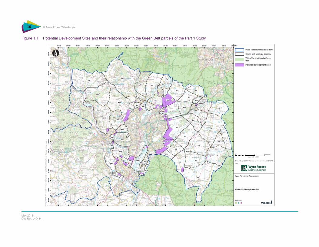
Figure 1.1 Potential Development Sites and their relationship with the Green Belt parcels of the Part 1 Study 10 Figure 5.1 Assets and constraints in the Bewdley – Stourport locality 52 Figure 5.2 Areas of search for potential extension to the Green Belt 54
Appendix A Potential Housing and Employment Sites in the Green Belt Appendix B Green Infrastructure planning in Wyre Forest District Appendix C Site-by-Site Analysis

8 © Amec Foster Wheeler Environment & Infrastructure UK Limited
May 2018 Doc Ref. L40484

9 © Amec Foster Wheeler Environment & Infrastructure UK Limited
May 2018 Doc Ref. L40484
1. Study remit and Objectives
Taking forward the Strategic Review of the Green Belt within Wyre Forest District, Part Two of the work considers the relationship between the potential sites for the Local Plan and the Green Belt, determining the likely impact of site development on Green Belt purposes. The study objectives are:
To analyse the effect of development proposals on the form and function of the Green Belt in a particular locality.
To identify opportunities for positive use of the Green Belt in the vicinity of new development, in particular its contribution to the Green Infrastructure network.
To determine where and if the designation of new Green Belt could be warranted in light of development pressures.
This report is an update to a version which accompanied the Preferred Options Consultation (June – August 2017) and includes the analysis of additional sites within the Green Belt received as part of a further call for sites.
The configuration of sites is presented as two options shown in Figure 1.1 below. These sites, listed in Appendix A, vary significantly in size and potential impact on the Green Belt. The analysis determines the likely impact on the Green Belt in respect of its ability to fulfil the purposes set for it in the NPPF and in particular effect of development on openness and opportunities for establishing long term site boundaries should land be removed from the Green Belt.
The remainder of this report is structured as follows:
Section 2 sets out the methodology used to appraise the sites.
Section 3 summarises the site appraisal.
Section 4 identifies opportunities for positive management of the Green Belt and other land in light of development proposals.
Section 5 considers the case for extending the Green Belt.
Section 6 sets out the overall conclusions to the study.
10 © Amec Foster Wheeler plc
May 2018 Doc Ref. L40484
Figure 1.1 Potential Development Sites and their relationship with the Green Belt parcels of the Part 1 Study
11 © Amec Foster Wheeler plc
March 2018 Doc Ref. L40484
2. Study Approach and Methodology
2.1 Approach
The approach to the study comprises:
Reviewing potential development sites against Green Belt purposes and other NPPF topics using a detailed survey proforma.
Judgements on the fit with existing development (i.e. built edge of the parent settlement) and overall impact on openness of the Green Belt.
Identifying opportunities for positive use of the Green Belt in the vicinity of the potential development site(s).
Reviewing potential opportunities for Green Belt extension e.g. at Stourport (Areley Kings) and Bewdley.
This approach allows for the rounded consideration of how development might be accommodated as part of Green Belt release within a wider context and not simply site-specific character.
2.2 Survey
Site description
The introductory description of the development parcel(s) is guided by consideration of the following matters:
location and setting
landscape features and vegetation cover
relationship with the current built edge and the wider open countryside
land use boundary character public access and evidence of use
topography nature conservation and cultural heritage interests
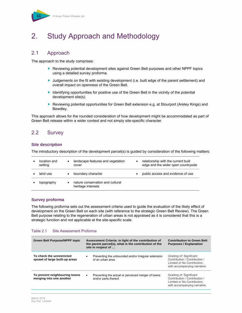
Survey proforma
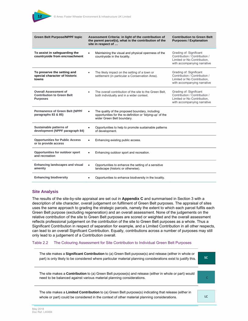
The following proforma sets out the assessment criteria used to guide the evaluation of the likely effect of development on the Green Belt on each site (with reference to the strategic Green Belt Review). The Green Belt purpose relating to the regeneration of urban areas is not appraised as it is considered that this is a strategic function and not applicable at the site-specific scale.
Table 2.1 Site Assessment Proforma
Green Belt Purpose/NPPF topic Assessment Criteria: in light of the contribution of the parent parcel(s), what is the contribution of the site in respect of …
Contribution to Green Belt Purposes / Explanation
To check the unrestricted sprawl of large built-up areas
Preventing the unbounded and/or irregular extension of an urban area.
Grading of: Significant Contribution / Contribution / Limited or No Contribution, with accompanying narrative
To prevent neighbouring towns merging into one another
Preventing the actual or perceived merger of towns and/or parts thereof.
Grading of: Significant Contribution / Contribution / Limited or No Contribution, with accompanying narrative
12 © Amec Foster Wheeler Environment & Infrastructure UK Limited
May 2018 Doc Ref. L40484
Green Belt Purpose/NPPF topic Assessment Criteria: in light of the contribution of the parent parcel(s), what is the contribution of the site in respect of …
Contribution to Green Belt Purposes / Explanation
To assist in safeguarding the countryside from encroachment
Maintaining the visual and physical openness of the countryside in the locality.
Grading of: Significant Contribution / Contribution / Limited or No Contribution, with accompanying narrative
To preserve the setting and special character of historic towns
The likely impact on the setting of a town or settlement (in particular a Conservation Area).
Grading of: Significant Contribution / Contribution / Limited or No Contribution, with accompanying narrative
Overall Assessment of Contribution to Green Belt Purposes
The overall contribution of the site to the Green Belt, both individually and in a wider context.
Grading of: Significant Contribution / Contribution / Limited or No Contribution, with accompanying narrative
Permanence of Green Belt (NPPF paragraphs 83 & 85)
The quality of the proposed boundary, including opportunities for the re-definition or ‘tidying-up’ of the wider Green Belt boundary.
Sustainable patterns of development (NPPF paragraph 84)
Opportunities to help to promote sustainable patterns of development.
Opportunities for Public Access or to provide access
Enhancing existing public access.
Opportunities for outdoor sport and recreation
Enhancing outdoor sport and recreation.
Enhancing landscapes and visual amenity
Opportunities to enhance the setting of a sensitive landscape (historic or otherwise).
Enhancing biodiversity Opportunities to enhance biodiversity in the locality.
Site Analysis
The results of the site-by-site appraisal are set out in Appendix C and summarised in Section 3 with a description of site character, overall judgement on fulfilment of Green Belt purposes. The appraisal of sites uses the same approach to grading the strategic parcels, namely the extent to which each parcel fulfils each Green Belt purpose (excluding regeneration) and an overall assessment. None of the judgements on the relative contribution of the site to Green Belt purposes are scored or weighted and the overall assessment reflects professional judgement on the contribution of the site to Green Belt purposes as a whole. Thus a Significant Contribution in respect of separation for example, and a Limited Contribution in all other respects, can lead to an overall Significant Contribution. Equally, contributions across a number of purposes may still only lead to a judgement of a Contribution overall.
Table 2.2 The Colouring Assessment for Site Contribution to Individual Green Belt Purposes
The site makes a Significant Contribution to (a) Green Belt purpose(s) and release (either in whole or
part) is only likely to be considered where particular material planning considerations exist to justify this. SC
The site makes a Contribution to (a) Green Belt purpose(s) and release (either in whole or part) would need to be balanced against various material planning considerations. C
The site makes a Limited Contribution to (a) Green Belt purpose(s) indicating that release (either in
whole or part) could be considered in the context of other material planning considerations. LC

13 © Amec Foster Wheeler Environment & Infrastructure UK Limited
May 2018 Doc Ref. L40484
The appraisal also includes comment on the likely effect that development would have on the openness (i.e. general absence of built development) of the Green Belt in the vicinity of a site. This reflects the importance of openness as a particular quality of the Green Belt (NPPF para.79) and how the introduction of built development to a site can influence the character of the wider Green Belt. As with the determination of the contribution of land parcels to Green Belt purposes, the observations reflect professional judgement.

14 © Amec Foster Wheeler Environment & Infrastructure UK Limited
May 2018 Doc Ref. L40484
15 © Amec Foster Wheeler plc
April 2017 Doc Ref. L40484
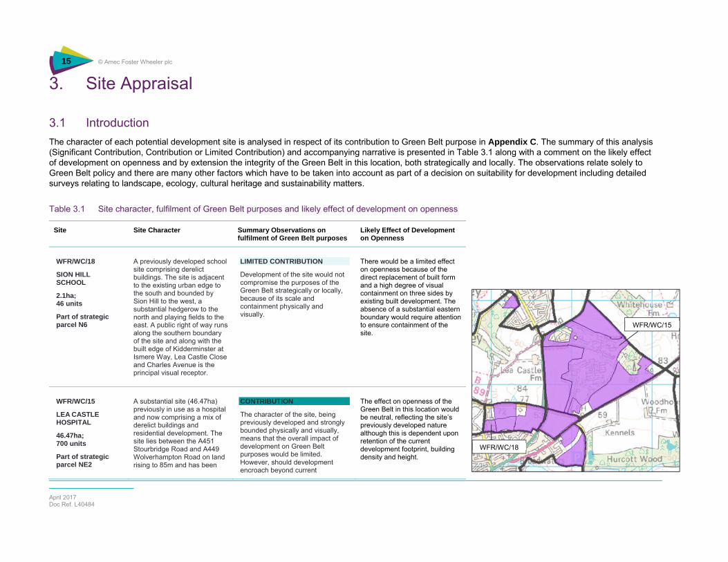
3. Site Appraisal
3.1 Introduction
The character of each potential development site is analysed in respect of its contribution to Green Belt purpose in Appendix C. The summary of this analysis (Significant Contribution, Contribution or Limited Contribution) and accompanying narrative is presented in Table 3.1 along with a comment on the likely effect of development on openness and by extension the integrity of the Green Belt in this location, both strategically and locally. The observations relate solely to Green Belt policy and there are many other factors which have to be taken into account as part of a decision on suitability for development including detailed surveys relating to landscape, ecology, cultural heritage and sustainability matters.
Table 3.1 Site character, fulfilment of Green Belt purposes and likely effect of development on openness
Site Site Character Summary Observations on fulfilment of Green Belt purposes
Likely Effect of Development on Openness
WFR/WC/18
SION HILL SCHOOL
2.1ha; 46 units
Part of strategic parcel N6
A previously developed school site comprising derelict buildings. The site is adjacent to the existing urban edge to the south and bounded by Sion Hill to the west, a substantial hedgerow to the north and playing fields to the east. A public right of way runs along the southern boundary of the site and along with the built edge of Kidderminster at Ismere Way, Lea Castle Close and Charles Avenue is the principal visual receptor.
LIMITED CONTRIBUTION
Development of the site would not compromise the purposes of the Green Belt strategically or locally, because of its scale and containment physically and visually.
There would be a limited effect on openness because of the direct replacement of built form and a high degree of visual containment on three sides by existing built development. The absence of a substantial eastern boundary would require attention to ensure containment of the site.
WFR/WC/15
LEA CASTLE HOSPITAL
46.47ha; 700 units
Part of strategic parcel NE2
A substantial site (46.47ha) previously in use as a hospital and now comprising a mix of derelict buildings and residential development. The site lies between the A451 Stourbridge Road and A449 Wolverhampton Road on land rising to 85m and has been
CONTRIBUTION
The character of the site, being previously developed and strongly bounded physically and visually, means that the overall impact of development on Green Belt purposes would be limited. However, should development encroach beyond current
The effect on openness of the Green Belt in this location would be neutral, reflecting the site’s previously developed nature although this is dependent upon retention of the current development footprint, building density and height.
WFR/WC/18
WFR/WC/15
16 © Amec Foster Wheeler Environment & Infrastructure UK Limited
May 2018 Doc Ref. L40484
screened from the surrounding area by extensive boundary planting of Corsican Pine and various native species. As such whilst there is a substantial built development footprint which extends towards Cookley to the west, the high degree of visual containment means that the sense of intrusion into the surrounding countryside is limited. The containing landscape to the east, west and north of the site is visually sensitive and of reasonable quality, being of an open character and falling away from the hill-top, with exposed slopes which are in extensive arable cultivation running down to the A451 and A449 and northward from Axborough Lane. The boundaries of the site are largely defined by the woodland planting and whilst not forming a permanent boundary do form a substantive and clear edge. Public access is limited to one PRoW between the A449 and Axborough Lane running east-west to the south then across the north of the site. There is no direct relationship with the urban edge of Kidderminster, but a strong proximate relationship with Cookley which lies across the A449 to the northwest. In advance of detailed survey, there are no recorded nature conservation or cultural heritage interests on the site.
developed footprint then the impact would be significantly greater, reflecting careful siting of past development on a plateau and the benefit of landscape planting containing visual impacts.

17 © Amec Foster Wheeler Environment & Infrastructure UK Limited
May 2018 Doc Ref. L40484
WFR/WC/32
NORTHWEST OF A451 STOURBRIDGE ROAD
Part of strategic parcel NE2
Land in arable use, rising from 65m to 99m north east from the A451, bounded to the south by the A451, to the north west by a woodland strip (screening the Lea Castle site) and woodland, to the north east by Axborough Lane (part) and to the south east by a field boundary. From the northeastern edge there are medium and longer distance views towards the south west, these diminishing to valley‐side views on the approach to Park Gate Road. The site is open countryside which is visually related to land to the south east across the Stourbridge Road. There is no public access and prior to survey no biodiversity or cultural heritage interest.
SIGNIFICANT CONTRIBUTION
Overall, the site makes a significant contribution to the Green Belt through its role in safeguarding the countryside from encroachment (clearly being visually and functionally part of the open countryside to the northeast of Kidderminster) and sprawl along the A451. Development would have a significant effect on openness reflecting the partial enclosure of the site and its visually sensitivity creating a fundamentally new character to this gateway to Kidderminster.
Development is judged to have a significant effect on the openness of the Green Belt in this location, being on the flanks of rising land which is exposed to the wider countryside to the south and south east. The land is part of the northeastern gateway to Kidderminster and notwithstanding the presence of the Lea Castle site immediately to the north west and being bounded to the south east by the A451 Stourbridge Road and partly to the north by Axborough Lane, development would intrude visually and physically into open countryside.
WFR/WC/16
LAND SOUTH OF PARK GATE ROAD
9.52ha; 150 units
Strategic parcel NE1
A single field of 9.52ha currently in arable cultivation bounded by the A449 Wolverhampton Road, A451 Stourbridge Road, the B4189 Park Gate Road and the urban edge of Kidderminster at Heath Drive. The field forms rises from around 50m along the A449 to 65m at the junction between the A451 and B4189, and as such forms the easterly context of the A449 as it enters Kidderminster and when viewed from the B4189 Wolverley Road. The land visually complements the field directly opposite to the west of the A449. Being in arable cultivation, the field is of limited visual interest or
CONTRIBUTION
Whilst the site makes a contribution to Green Belt purposes through preventing the encroachment of the urban edge of Kidderminster into open countryside and hence visual intrusion, development would not damage the wider function of the Green Belt in this location. However, the site is a gateway to Kidderminster, viewed from the A451 and A449 and development would create a new context to the town in this location.
The overall impact on openness is associated with the extension of the existing built edge of Kidderminster northwards on land which makes a contribution to Green Belt purposes in containing development. However, whilst the site is large and there would be a visual impact, development would not be out of character or proportion with the receiving environment.
WFR/WC/32
WFR/WC/16

18 © Amec Foster Wheeler Environment & Infrastructure UK Limited
May 2018 Doc Ref. L40484
character in itself, but is part of the northerly setting of the town and the exposed and harsh urban edge at Heath Drive and as such the site is reasonably visually sensitive within the context of this locality. It appears that development has in the past been kept back from the rising land toward Park Gate Road to avoid sprawl into open countryside, although the substantial Lea Castle site to the north of Park Gate Road modifies this perception to some degree. There is a high degree of containment by substantive boundaries on all sides of the site. There is no formal public access..
BW/4 NORTH
LAND SOUTH OF STOURBRIDGE ROAD
19.63ha; 82 units
Land bounded by the A461 Stourbridge Road to the northwest, the built edge of Kidderminster to the southwest, Hurcott Lane to the north east and a hedgerow to the south east. From a plateau adjacent to the A451, the land falls away to the south east, and is prominent to the easterly entrance to Kidderminster along the A451. Originally in rough grazing use, the land appears to be lying fallow. There is no public access to the site and prior to site investigation, there are no recorded nature conservation or cultural heritage interests on the site
.
CONTRIBUTION
The site makes a contribution to Green Belt purposes by virtue of its containment of the eastern edge of Kidderminster, preventing sprawl along the A451 and being part of the easterly setting for the town.
Development of the site would not significantly damage Green Belt function in this location, although the prominence of the site and the visual connection with the wider countryside to the south, north and east means that openness would be compromised, requiring particular attention to the scale and massing of development.
BW/4 NORTH
19 © Amec Foster Wheeler Environment & Infrastructure UK Limited
May 2018 Doc Ref. L40484
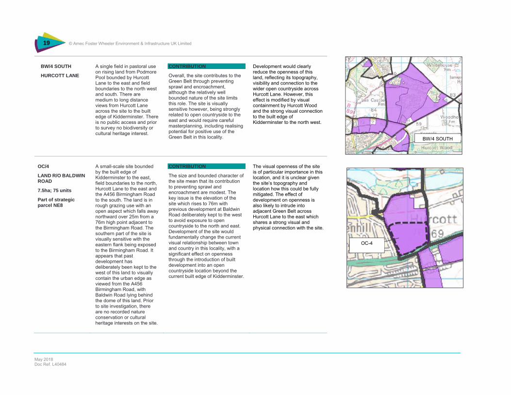
BW/4 SOUTH
HURCOTT LANE
A single field in pastoral use on rising land from Podmore Pool bounded by Hurcott Lane to the east and field boundaries to the north west and south. There are medium to long distance views from Hurcott Lane across the site to the built edge of Kidderminster. There is no public access and prior to survey no biodiversity or cultural heritage interest.
CONTRIBUTION
Overall, the site contributes to the Green Belt through preventing sprawl and encroachment, although the relatively well bounded nature of the site limits this role. The site is visually sensitive however, being strongly related to open countryside to the east and would require careful masterplanning, including realising potential for positive use of the Green Belt in this locality.
Development would clearly reduce the openness of this land, reflecting its topography, visibility and connection to the wider open countryside across Hurcott Lane. However, this effect is modified by visual containment by Hurcott Wood and the strong visual connection to the built edge of Kidderminster to the north west.
OC/4
LAND R/O BALDWIN ROAD
7.5ha; 75 units
Part of strategic parcel NE8
A small-scale site bounded by the built edge of Kidderminster to the east, field boundaries to the north, Hurcott Lane to the east and the A456 Birmingham Road to the south. The land is in rough grazing use with an open aspect which falls away northward over 25m from a 76m high point adjacent to the Birmingham Road. The southern part of the site is visually sensitive with the eastern flank being exposed to the Birmingham Road. It appears that past development has deliberately been kept to the west of this land to visually contain the urban edge as viewed from the A456 Birmingham Road, with Baldwin Road lying behind the dome of this land. Prior to site investigation, there are no recorded nature conservation or cultural heritage interests on the site.
CONTRIBUTION
The size and bounded character of the site mean that its contribution to preventing sprawl and encroachment are modest. The key issue is the elevation of the site which rises to 76m with previous development at Baldwin Road deliberately kept to the west to avoid exposure to open countryside to the north and east. Development of the site would fundamentally change the current visual relationship between town and country in this locality, with a significant effect on openness through the introduction of built development into an open countryside location beyond the current built edge of Kidderminster.
The visual openness of the site is of particular importance in this location, and it is unclear given the site’s topography and location how this could be fully mitigated. The effect of development on openness is also likely to intrude into adjacent Green Belt across Hurcott Lane to the east which shares a strong visual and physical connection with the site.
BW/4 SOUTH
OC-4

20 © Amec Foster Wheeler Environment & Infrastructure UK Limited
May 2018 Doc Ref. L40484
OC-4 (larger site)
LAND TO THE REAR OF BALDWIN ROAD
15.6ha; 350 units
Part of Strategic Parcel NE8
A medium-scale site bounded by the built edge of Kidderminster to the east, Hurcott Road to the north, Hurcott Lane to the east and the A456 Birmingham Road to the south. The land is in rough grazing use with an open aspect which falls away northward over 25m from a 76m high point adjacent to the Birmingham Road. A PRoW runs east – west through the site. The southern part of the site is visually sensitive with the eastern flank being exposed to the Birmingham Road. It appears that past development has deliberately been kept to the west of this land to visually contain the urban edge as viewed from the A456 Birmingham Road, with Baldwin Road lying behind the dome of this land. Prior to site investigation, there are no recorded nature conservation or cultural heritage interests on the site.
CONTRIBUTION
The size and bounded character of the site mean that its contribution to preventing sprawl and encroachment are modest. The key issue is the elevation of the site which rises to 76m with previous development at Baldwin Road deliberately kept to the west to avoid exposure to open countryside to the north and east. Development of the site would fundamentally change the current visual relationship between town and country in this locality, with a significant effect on openness through the introduction of built development into an open countryside location beyond the current built edge of Kidderminster.
The visual openness of the site is of particular importance in this location, and it is unclear given the site’s topography and location how this could be fully mitigated. The effect of development on openness is also likely to intrude into adjacent Green Belt across Hurcott Lane to the east which shares a strong visual and physical connection with the site.
OC/5
HUSUM WAY CORNER
2.11ha
Part of strategic parcel E1
A single field in arable use, of level topography and bounded on all sides, by a railway line to the south, the A456 to the north, Husum Way to the west and various properties to the east. There are medium to long distance views southwards across the site which is adjacent to the built edge of Kidderminster across Husum Way to the west.
CONTRIBUTION
Overall, the site contributes to the Green Belt in its contribution to safeguarding the countryside from encroachment (being visually interconnected with the wider open countryside) and although having a limited role in preventing sprawl in itself, in combination with land to the east has a more significant role.
Development would not have a significant effect on openness, given the strongly bounded character of the site, although it is visually sensitive and development would create a new character to this gateway site.
OC/5
OC-4 (larger site)

21 © Amec Foster Wheeler Environment & Infrastructure UK Limited
May 2018 Doc Ref. L40484
OC/13 LAND AT STONE HILL 89.37ha; 2,000 units
Land to the north of the A448
Part of strategic parcel E1
An extensive (60ha approx.) site situated to the east of Kidderminster at Comberton, immediately north of the A448 Comberton Road/Bromsgrove Road. The land is predominantly in arable use, of largely flat topography, rising gently to the east from an unnamed watercourse which is well defined by a linear woodland which in turn broadly forms the current eastern boundary of the built-up area of Kidderminster in this location. The site essentially comprises several large fields with limited internal boundaries (being variously intermittent hedgerow, farm tracks and drainage ditches). The outer boundaries are firmer, being the A448 to the south and intermittent hedgerows to the south east and north east, and the woodland belt associated with the watercourse to the north. However, these boundaries cannot be regarded as substantial. From within the site, there are various short, medium and long-distance views to the south-east, east and north-west, although these are interrupted by tree blocks and belts and hedgerows creating an attractive open countryside prospect. Whilst not of notable quality, landscape character and condition appears to be reasonably good. Views into
CONTRIBUTION
The site overall makes a contribution to Green Belt purposes by virtue of its role as open countryside containing the built edge of Kidderminster.
In the absence of clear, significant boundaries, development would represent encroachment and sprawl into open countryside which could only be overcome through masterplanning which considered the development in a wider context which attended to the southeastern edge of the town more generally. Whilst there are few visual receptors in this locality and the site is generally well screened from the A448, development would create a fundamentally new relationship between town and country.
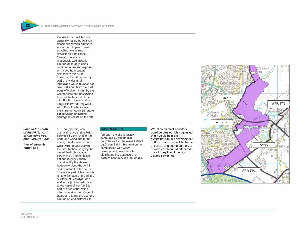
OC/13
WFR/ST/3
WFR/ST/1
WFR/ST/2
OC/13
22 © Amec Foster Wheeler Environment & Infrastructure UK Limited
May 2018 Doc Ref. L40484
the site from the A448 are generally restricted by high, dense hedgerows but there are some glimpsed views travelling westwards downslope from Stone. Overall, the site is reasonably well visually contained, largely sitting within a hollow and exposed on its southern extent adjacent to the A488. However, the site is clearly part of a wider rural landscape which thus far has been set apart from the built edge of Kidderminster by the watercourse and associated tree belt to the east of the site. Public access is via a single PRoW running west to east. Prior to site survey, there are no recorded nature conservation or cultural heritage interests on the site.
Land to the south of the A448, north of Captain’s Pool and Stanklyn Pool
Part of strategic parcel SE1
A 3.7ha (approx.) site comprising two arable fields bounded by the A448 to the north and woodland to the south, a hedgerow to the west, with no boundary to the east (defined only by the line of the high voltage power line). The fields are flat and largely visually contained by the dense hedgerow along the A448 and woodland to the south. The site is part of land which runs to the start of the village of Stone at Stanklyn Lane and in conjunction with land to the north of the A448 is part of open countryside which contains the village of Stone and forms the easterly context of, and entrance to,
CONTRIBUTION
Although the site is largely contained by substantial boundaries and the overall effect on Green Belt in this location (in combination with wider development) would not be significant, the absence of an eastern boundary is problematic.
Whilst an external boundary could be created, it is suggested that it would be more sympathetic to halt development at the access road which bisects the site, using the topography to contain development rather than the arbitrary line of the high voltage power line.
OC/13
WFR/ST/3
WFR/ST/1
WFR/ST/2
OC/13
23 © Amec Foster Wheeler Environment & Infrastructure UK Limited
May 2018 Doc Ref. L40484
Kidderminster. There is no public access and prior to site survey, there are no recorded nature conservation or cultural heritage interests on the site.
Land to the north of Stanklyn Lane, south of Captain’s Pool and west of Stanklyn Pool
Part of strategic parcel SE1
This is the southern part of this site comprising approximately 23ha and comprises open arable land largely north facing towards Captain’s Pool, dropping around 20m, and south facing falling away to Stanklyn Lane. The site is sharply defined on its southern edges by a substantial hedge running along the ridgeline, and by Stanklyn Lane. The site comprises three arable fields and there are extensive views northward across to Offmore Farm/Comberton from the ridgeline at approximately 60m. There is one PRoW running the length of the southwest boundary of the site and across the southern extension to Stanklyn Lane. Prior to site survey, there are no recorded nature conservation or cultural heritage interests on the site.
CONTRIBUTION
The site overall makes a contribution to Green Belt purposes by virtue of its role as open countryside containing the built edge of Kidderminster.
The relatively well bounded nature of the site means that development is readily contained, although the scale and topography of the site means that a new relationship between town and country would be created, extending development into visually exposed land where thus far development has used the topography to limit such exposure. This is particularly the case for land extending towards Stanklyn Lane, in combination with land immediately to the southwest, although further work on long and medium distance visual receptors would be needed.
WFR/ST/1
CAPTAINS & THE LODGE
4.59ha; 135 units
Part of strategic parcel SE1
A small (5.59ha) site bounded by the built edge of Kidderminster at Spennells, the A448 Comberton Road/Bromsgrove Road and Captain’s Pool. The site is flat and in use as rough grazing and caravan storage, with two large detached dwellings, with varying
LIMITED CONTRIBUTION
The site makes only a limited contribution to Green Belt purposes, being well bounded with limited visual connection.
Development would extend the current built edge of Kidderminster along the A448 but this would not be substantial and would visually contained by substantial boundary vegetation
OC/13
WFR/ST/3
WFR/ST/1
WFR/ST/2
OC/13

24 © Amec Foster Wheeler Environment & Infrastructure UK Limited
May 2018 Doc Ref. L40484
degrees of visual enclosure by dense hedgerows and woodland. There is no public access across the site, but a PRoW runs adjacent to the built edge of Kidderminster which forms the northern boundary of the site. The site adjoins Captain’s Pool at its southwestern extent, which is in turn hydrologically connected to the Spennells Valley Nature Reserve to the west.
WFR/ST/2
LAND OFF STANKLYN LANE
27.4ha; 350 units
Part of strategic parcel SE1
A medium-scale (27.4ha) site in predominantly in arable cultivation (with some rough grazing to the west). The site is bounded to the northwest by the linear urban edge of Kidderminster at Spennels, to the southeast by Stanklyn Lane (the hamlet of Summerfield) and by a railway line to the southwest. The site slopes from the plateau at 60m, which holds and conceals the urban edge, down to Stanklyn Lane and has extensive views south eastwards across open countryside. The site has substantial hedgerow boundaries, apart from that abutting the urban edge which comprises garden fences, but is visually exposed to Stanklyn Lane because of its sloping aspect. In this sense there is a degree of connection with the wider open countryside, but there is nevertheless a sense of containment of the site as a whole. Landscape character and condition is of average quality, but with
CONTRIBUTION
Overall the site makes a contribution to Green Belt purposes by virtue of its role in containing the southern edge of Kidderminster and having a strong visual connection with the wider countryside across Stanklyn Lane.
Development would create a new urban edge to the town on southeasterly facing site, although in combination with adjacent sites, masterplanning could mitigate the direct visual impact of development and hence perception of spillage of the town into open countryside. OC/13
WFR/ST/3
WFR/ST/1
WFR/ST/2
OC/13

25 © Amec Foster Wheeler Environment & Infrastructure UK Limited
May 2018 Doc Ref. L40484
some evidence of the withdrawal of active land management evidenced through poor crop growth (in contrast to arable cultivation on land immediately to the north east). The site is traversed by various PRoW which are very well used because of access from Spennels. Prior to site survey, there are no recorded nature conservation or cultural heritage interests on the site.
WFR/ST/3
LAND NORTH OF STONE HILL
7.61ha; 70 units
Part of strategic parcel E1
A small (2.8ha) site comprising part of one arable field bounded by the A448 to the south and Hoo Brook to the north, with no boundary to the east (defined only by the line of the high voltage power line). The field gently rises to 50m and is exposed to the A448 with only modest containment by a dense hedgerow along the A448 and vegetation along the line of Hoo Brook. The site is part of land which runs to the start of the village of Stone and in conjunction with land to the south of the A448 is part of open countryside which contains the village of Stone and forms the easterly context of, and entrance to, Kidderminster. There is no public access and prior to site survey, there are no recorded nature conservation or cultural heritage interests on the site.
CONTRIBUTION
The site makes a contribution to Green Belt purposes because of its role (in combination with adjacent land) in preventing encroachment into open countryside and in this instance sprawl along the A448. Absence of a significant eastern boundary is problematic, particularly given the gradually rising character of the site towards Stone.
Development would introduce built form into a location which is exposed and as such have a proportionately greater impact on openness than that immediately to the east where the external boundary should be held. The impact on openness reflects that of site OC/13 across the A448 with similar problems of exposure and absence of an external boundary.
OC/13
WFR/ST/3
WFR/ST/1
WFR/ST/2
OC/13
26 © Amec Foster Wheeler Environment & Infrastructure UK Limited
May 2018 Doc Ref. L40484
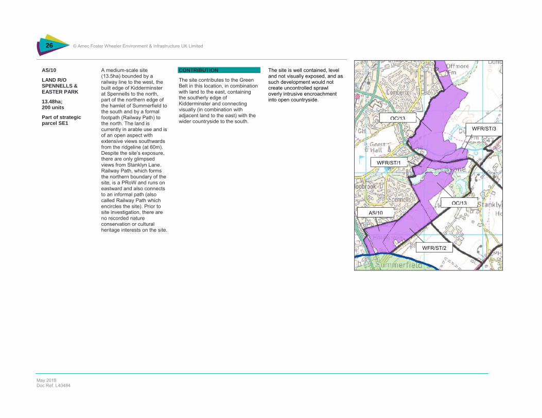
AS/10
LAND R/O SPENNELLS & EASTER PARK
13.48ha; 200 units
Part of strategic parcel SE1
A medium-scale site (13.5ha) bounded by a railway line to the west, the built edge of Kidderminster at Spennells to the north, part of the northern edge of the hamlet of Summerfield to the south and by a formal footpath (Railway Path) to the north. The land is currently in arable use and is of an open aspect with extensive views southwards from the ridgeline (at 60m). Despite the site’s exposure, there are only glimpsed views from Stanklyn Lane. Railway Path, which forms the northern boundary of the site, is a PRoW and runs on eastward and also connects to an informal path (also called Railway Path which encircles the site). Prior to site investigation, there are no recorded nature conservation or cultural heritage interests on the site.
CONTRIBUTION
The site contributes to the Green Belt in this location, in combination with land to the east, containing the southerly edge of Kidderminster and connecting visually (in combination with adjacent land to the east) with the wider countryside to the south.
The site is well contained, level and not visually exposed, and as such development would not create uncontrolled sprawl overly intrusive encroachment into open countryside.
OC/13
WFR/ST/3
WFR/ST/1
WFR/ST/2
OC/13
AS/10

27 © Amec Foster Wheeler Environment & Infrastructure UK Limited
May 2018 Doc Ref. L40484
LI/2
WYRE FOREST GOLF CLUB KINGSWAY
8.2ha; 80 units
Part of strategic parcel SW4
A small (8ha) site which is an extension of the urban edge at Burlish Park into land which was previously in extractive use but has been restored to rough grassland. The site is bounded to the south west by a hedgerow which contains development at Torridon Close/Elan Avenue, Kingsway to the southeast, with a substantial hedgerow/tree belt to the northeast. There is no defined boundary to the northeast. The site is gently undulating but of part of rising land to the northeast towards Burlish Top. It is an exposed site and development would be a clear extension of the urban edge in this location. There is no formal public access, but a well-used PRoW immediately to the north which is part of wider access to the semi-wooded heathland of Burlish Top Nature Reserve. Prior to site investigation, there are no recorded nature conservation or cultural heritage interests on the site.
CONTRIBUTION
The site contributes to the Green Belt insofar as it is open land (although previously quarried and classed as previously developed) which relates to the wider countryside to the northeast and northwest. The site is well-bounded on three side, but a new edge would be created to the northeast.
Development will impact on the openness of the countryside in this location by virtue of the introduction of built form onto an exposed site but this is judged not be significant because of site size and opportunities for containment. The current extensive use of the site for informal public access which is related to the adjacent Burlish Top Nature Reserve would be lost.
LI/5
BEWDLEY ROAD NORTH
Part of strategic parcel SW4
A single field in arable use forming part of the north western entrance to Stourport, adjacent to the current built of the town. The land is largely of level topography and there are short and middle distance views across it to open countryside between Stourport and Bewdley. The land is strongly bounded on all sides. There is no public access and prior to survey
CONTRIBUTION
The site is part of large tract of land forming a substantial part of the open countryside between Stourport, Kidderminster and Bewdley which makes a significant contribution to preventing sprawl, merger of towns, encroachment and the identity of towns. Thus, in principle, development would constitute harm to the Green Belt, although the local geography modifies this. Overall the land does make a contribution to Green Belt purposes, specifically in respect of
Notwithstanding the relatively strong degree of visual connectivity with the open countryside to the north east of Stourport, the effect of development on openness is likely to be tempered by the close relationship with existing urban edge, where rounding off could improve the visual context of this gateway to the town.
LI/2
LI/5
LI/6/7/8
LI/2
LI/5
LI/6/7/8

28 © Amec Foster Wheeler Environment & Infrastructure UK Limited
May 2018 Doc Ref. L40484
no biodiversity or cultural heritage interest.
sprawl and protection against encroachment into open countryside. The enclosed character of this site and its close relationship with the existing urban edge means that damage to the purposes of the Green Belt is reduced.
LI/6
BOURNEWOOD NURSERY
1.74ha; 45 units
Part of strategic parcel SW5
A small site on flat land off Lickhill Road North in horticultural use. The site is well bounded by extensive tree planting to the north and west, resulting in strong visual containment and no connection to the open countryside to the north. There is no public access to the site. Prior to site investigation, there are no recorded nature conservation or cultural heritage interests on the site.
CONTRIBUTION
The site makes a contribution to the Green Belt in this location by virtue of being part of wider undeveloped land which separates Bewdley and Sourport,
Development would marginally extend the urban edge of Stourport northwestwards, although because of the size and bounded character of the site and its adjacency to existing built form, this is unlikely to be a significant effect in terms of advancing the urban edge into open countryside or substantially altering the perception of that edge (for example from across the River Severn).
LI/7
BRADLEYS PADDOCKS
1.87ha; 49 units
Part of strategic parcel SW5
Adjacent to Lickhill Road North, the site is in grazing use. The land begins to fall away to the River Severn to the west and whilst visually enclosed by a substantial hedgerow to the north, has an open aspect to the west, with extensive views across to the dense woodland to the west of the River Severn. There is no public access and prior to site investigation, there are no recorded nature conservation or cultural heritage interests on the site.
CONTRIBUTION
The site makes a contribution to the Green Belt in this location by virtue of being part of wider undeveloped land which separates Bewdley and Stourport,
Development would marginally extend the urban edge of Stourport northwestwards and although there are substantial hedgerows to the northwest and southwest the sloping character of the land offers views across the River Severn. The overall effect would be to advance the urban edge into open countryside and potentially alter the perception of that edge (for example from across the River Severn), particularly given the separation of the site from existing built development.
LI/2
LI/5
LI/6/7/8

29 © Amec Foster Wheeler Environment & Infrastructure UK Limited
May 2018 Doc Ref. L40484
LI/8
LICKHILL ROAD NORTH r/o SCOUT HUT
2.24ha; 58 units
Part of strategic parcel SW5
A site comprising open fields in grazing use adjacent to Lickhill Road North. The site is bounded by a dense hedgerow to the south west, but of an open aspect to the north, with no substantive feature defining the boundary. The site gently slopes towards the River Severn with extensive views to dense woodland to the west of the River Severn. There is public access via a PRoW which crosses the site. Prior to site investigation, there are no recorded nature conservation or cultural heritage interests on the site.
CONTRIBUTION
The site makes a contribution to the Green Belt in this location by virtue of being part of wider undeveloped land which separates Bewdley and Stourport,
Development would extend the urban edge of Stourport northwestwards into open countryside with the likelihood of substantially altering the perception of the urban edge (for example from across the River Severn), particularly given the separation of the site from existing built development.
MI/17
WILDEN TOP ROAD
Part of strategic parcel SW12
A single field in pastoral use to the east of Wilden village and immediately north of a substantial hotel. The land is at grade and part of a wider plateau which constitutes Wilden Top. There are limited views to the west, but middle and long distance views to the east. There is no public access and prior to survey no biodiversity or cultural heritage interest.
CONTRIBUTION
The site is part of open land between Kidderminster and Stourport. As such development would contribution to the erosion of this gap in what is an exposed plateau setting, creating localised sprawl from existing development along Wilden Lane. Even if substantial outer boundaries were present, development would constitute encroachment into open countryside.
Notwithstanding the presence of a substantial hotel immediately to the south, development of the site would have a significant effect on the openness of the land in this location. There is no connection between this land and existing residential development at Wilden, and development would represent an uncharacteristic intrusion into a visually exposed landscape.
LI/2
LI/5
LI/6/7/8
MI/17
30 © Amec Foster Wheeler Environment & Infrastructure UK Limited
May 2018 Doc Ref. L40484
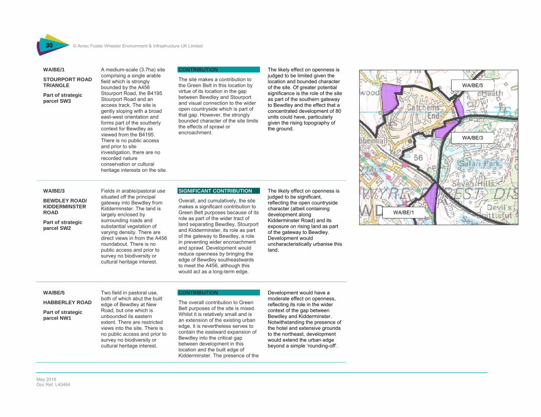
WA/BE/1
STOURPORT ROAD TRIANGLE
Part of strategic parcel SW3
A medium-scale (3.7ha) site comprising a single arable field which is strongly bounded by the A456 Stourport Road, the B4195 Stourport Road and an access track. The site is gently sloping with a broad east-west orientation and forms part of the southerly context for Bewdley as viewed from the B4195. There is no public access and prior to site investigation, there are no recorded nature conservation or cultural heritage interests on the site.
CONTRIBUTION
The site makes a contribution to the Green Belt in this location by virtue of its location in the gap between Bewdley and Stourport and visual connection to the wider open countryside which is part of that gap. However, the strongly bounded character of the site limits the effects of sprawl or encroachment.
The likely effect on openness is judged to be limited given the location and bounded character of the site. Of greater potential significance is the role of the site as part of the southern gateway to Bewdley and the effect that a concentrated development of 80 units could have, particularly given the rising topography of the ground.
WA/BE/3
BEWDLEY ROAD/ KIDDERMINSTER ROAD
Part of strategic parcel SW2
Fields in arable/pastoral use situated off the principal gateway into Bewdley from Kidderminster. The land is largely enclosed by surrounding roads and substantial vegetation of varying density. There are direct views in from the A456 roundabout. There is no public access and prior to survey no biodiversity or cultural heritage interest.
SIGNIFICANT CONTRIBUTION
Overall, and cumulatively, the site makes a significant contribution to Green Belt purposes because of its role as part of the wider tract of land separating Bewdley, Stourport and Kidderminster, its role as part of the gateway to Bewdley, a role in preventing wider encroachment and sprawl. Development would reduce openness by bringing the edge of Bewdley southeastwards to meet the A456, although this would act as a long-term edge.
The likely effect on openness is judged to be significant, reflecting the open countryside character (albeit containing development along Kidderminster Road) and its exposure on rising land as part of the gateway to Bewdley. Development would uncharacteristically urbanise this land.
WA/BE/5
HABBERLEY ROAD
Part of strategic parcel NW1
Two field in pastoral use, both of which abut the built edge of Bewdley at New Road, but one which is unbounded its eastern extent. There are restricted views into the site. There is no public access and prior to survey no biodiversity or cultural heritage interest.
CONTRIBUTION
The overall contribution to Green Belt purposes of the site is mixed. Whilst it is relatively small and is an extension of the existing urban edge, it is nevertheless serves to contain the eastward expansion of Bewdley into the critical gap between development in this location and the built edge of Kidderminster. The presence of the
Development would have a moderate effect on openness, reflecting its role in the wider context of the gap between Bewdley and Kidderminster. Notwithstanding the presence of the hotel and extensive grounds to the northeast, development would extend the urban edge beyond a simple ‘rounding-off’.
WA/BE/1
WA/BE/3
WA/BE/5

31 © Amec Foster Wheeler Environment & Infrastructure UK Limited
May 2018 Doc Ref. L40484
hotel imparts a semi-urbanised character to the land, and development would add to this impression further reducing the gap between the towns, even though the site is reasonably well enclosed visually.
WA/UA/4
ALLOTMENTS UPPER ARLEY
0.46ha; 10 units
Part of strategic parcel NW5
A small (0.5ha) site previously in use as allotments which is on sloping land towards the River Severn and bounded by thick hedgerows and scrub on three sides and a steep embankment onto Arley Lane on the fourth, resulting in strong physical and visual containment. There is no public access and prior to site investigation, there are no recorded nature conservation or cultural heritage interests on the site.
CONTRIBUTION
The physical and visual enclosure of the site means that development would not compromise the purposes of the Green Belt strategically or locally and the effect on openness would not be significant, being an extension of the existing built edge of the village.
The effect of development on openness is likely to be limited, reflecting the scale and physical and visual enclosure of the site.
WFR/CB/3
LAND AT STATION DRIVE BLAKEDOWN
2.25ha; 35 units
Part of strategic parcel NE11
A medium scale (2.3ha) site, is a single in arable use, bounded by Station Drive, a railway line, the A456 Birmingham Road and a hedgerow/thick woodland associated with a watercourse. The site is predominantly level but slopes gently down towards the watercourse. The site is visually well enclosed, although this is less strong on the A456 edge and the site forms part of the eastern entrance to Blakedown, complementing open land on the opposite side of the A456. There is no public access and prior to site investigation, there are no
CONTRIBUTION
The site makes a contribution to Green Belt purposes because of its containment of Blakedown particularly along the A456 Birmingham Road,
The high degree of physical and visual containment limits the impact of development on the Green Belt, although this is a gateway site into Blakedown which is locally significant in turn demanding particular attention to edge treatment, built density and massing.
32 © Amec Foster Wheeler Environment & Infrastructure UK Limited
May 2018 Doc Ref. L40484
recorded nature conservation or cultural heritage interests on the site.
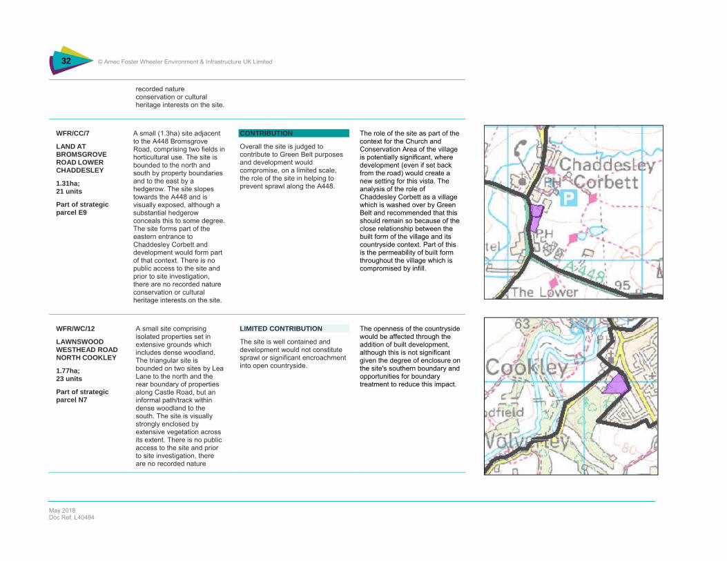
WFR/CC/7
LAND AT BROMSGROVE ROAD LOWER CHADDESLEY
1.31ha; 21 units
Part of strategic parcel E9
A small (1.3ha) site adjacent to the A448 Bromsgrove Road, comprising two fields in horticultural use. The site is bounded to the north and south by property boundaries and to the east by a hedgerow. The site slopes towards the A448 and is visually exposed, although a substantial hedgerow conceals this to some degree. The site forms part of the eastern entrance to Chaddesley Corbett and development would form part of that context. There is no public access to the site and prior to site investigation, there are no recorded nature conservation or cultural heritage interests on the site.
CONTRIBUTION
Overall the site is judged to contribute to Green Belt purposes and development would compromise, on a limited scale, the role of the site in helping to prevent sprawl along the A448.
The role of the site as part of the context for the Church and Conservation Area of the village is potentially significant, where development (even if set back from the road) would create a new setting for this vista. The analysis of the role of Chaddesley Corbett as a village which is washed over by Green Belt and recommended that this should remain so because of the close relationship between the built form of the village and its countryside context. Part of this is the permeability of built form throughout the village which is compromised by infill.
WFR/WC/12
LAWNSWOOD WESTHEAD ROAD NORTH COOKLEY
1.77ha; 23 units
Part of strategic parcel N7
A small site comprising isolated properties set in extensive grounds which includes dense woodland. The triangular site is bounded on two sites by Lea Lane to the north and the rear boundary of properties along Castle Road, but an informal path/track within dense woodland to the south. The site is visually strongly enclosed by extensive vegetation across its extent. There is no public access to the site and prior to site investigation, there are no recorded nature
LIMITED CONTRIBUTION
The site is well contained and development would not constitute sprawl or significant encroachment into open countryside.
The openness of the countryside would be affected through the addition of built development, although this is not significant given the degree of enclosure on the site's southern boundary and opportunities for boundary treatment to reduce this impact.
33 © Amec Foster Wheeler Environment & Infrastructure UK Limited
May 2018 Doc Ref. L40484
conservation or cultural heritage interests on the site.
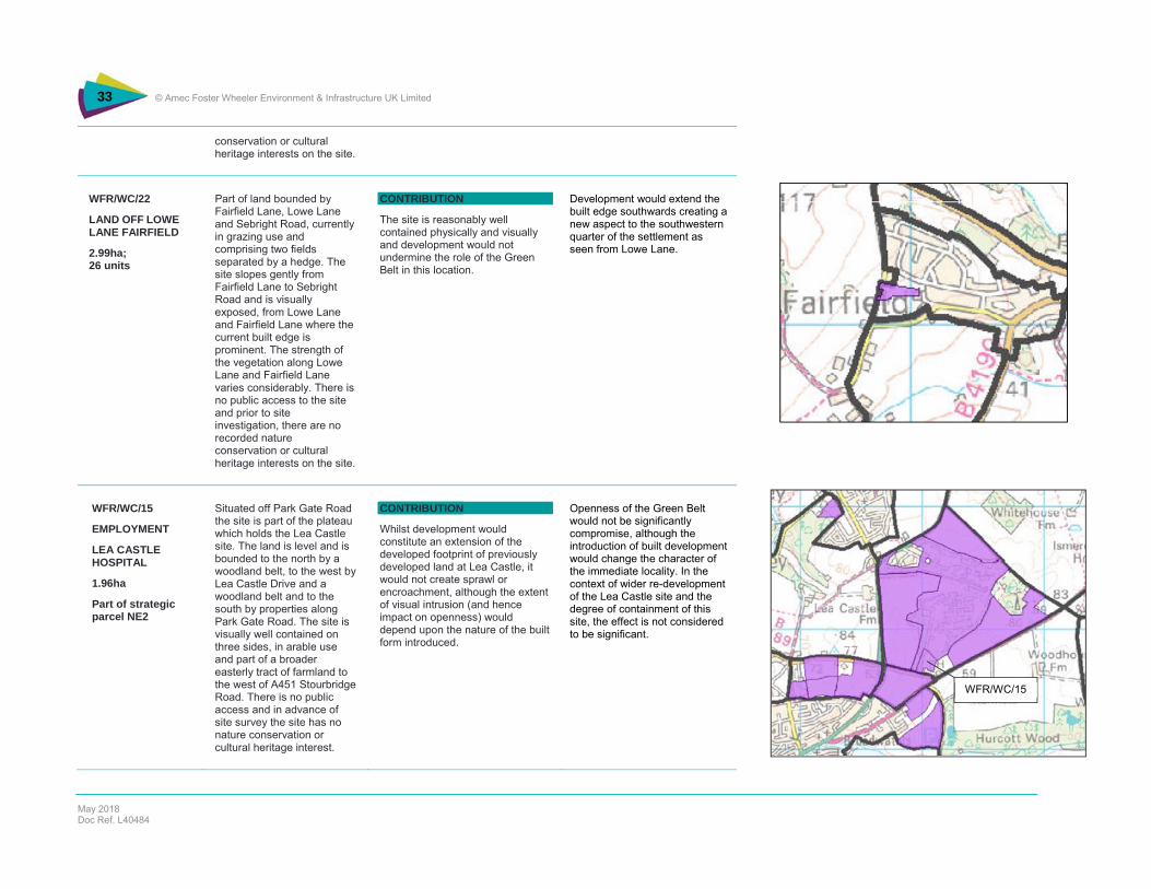
WFR/WC/22
LAND OFF LOWE LANE FAIRFIELD
2.99ha; 26 units
Part of land bounded by Fairfield Lane, Lowe Lane and Sebright Road, currently in grazing use and comprising two fields separated by a hedge. The site slopes gently from Fairfield Lane to Sebright Road and is visually exposed, from Lowe Lane and Fairfield Lane where the current built edge is prominent. The strength of the vegetation along Lowe Lane and Fairfield Lane varies considerably. There is no public access to the site and prior to site investigation, there are no recorded nature conservation or cultural heritage interests on the site.
CONTRIBUTION
The site is reasonably well contained physically and visually and development would not undermine the role of the Green Belt in this location.
Development would extend the built edge southwards creating a new aspect to the southwestern quarter of the settlement as seen from Lowe Lane.
WFR/WC/15
EMPLOYMENT
LEA CASTLE HOSPITAL
1.96ha
Part of strategic parcel NE2
Situated off Park Gate Road the site is part of the plateau which holds the Lea Castle site. The land is level and is bounded to the north by a woodland belt, to the west by Lea Castle Drive and a woodland belt and to the south by properties along Park Gate Road. The site is visually well contained on three sides, in arable use and part of a broader easterly tract of farmland to the west of A451 Stourbridge Road. There is no public access and in advance of site survey the site has no nature conservation or cultural heritage interest.
CONTRIBUTION
Whilst development would constitute an extension of the developed footprint of previously developed land at Lea Castle, it would not create sprawl or encroachment, although the extent of visual intrusion (and hence impact on openness) would depend upon the nature of the built form introduced.
Openness of the Green Belt would not be significantly compromise, although the introduction of built development would change the character of the immediate locality. In the context of wider re-development of the Lea Castle site and the degree of containment of this site, the effect is not considered to be significant.
WFR/WC/15

34 © Amec Foster Wheeler Environment & Infrastructure UK Limited
May 2018 Doc Ref. L40484
WFR/CB/7
SOUTH OF BIRMINGHAM ROAD
7.13ha
Part of strategic parcel E1
A single field in arable use between a railway line and the A456 Birmingham Road. The site gently slopes from the A448 to the railway line and is well bounded on all sides. The site is exposed to A448 with uninterrupted views across the site to the railway line and glimpsed views of the wider countryside beyond that. There is no public access and in advance of survey no records of biodiversity or cultural heritage interest.
SIGNIFICANT CONTRIBUTION
The site, despite being well-bounded, makes a significant contribution to preventing the sprawl of Kidderminster into open countryside and contributes to the prevention of encroachment more generally on what is a visually sensitive gateway site into Kidderminster. The scale and style of proposed employment uses could potentially exacerbate this impact.
Development would have a significant impact on openness in this locality, both in the immediate environs of the site and as part of the eastern entrance to Kidderminster. The introduction of significant built form would create a sense of sprawl along Birmingham Road. Any mitigation would need to address building form and height as well as effective masterplanning.
FPH/1
SETTLING PONDS
4.06ha
Part of strategic parcel SW8
A medium-scale (4ha) site which is derelict land and part of the wider WIlden Marsh which extends southwards towards Stourport. The land is not clearly defined in its extent apart from Wilden Lane which forms its eastern boundary. The site is flat and relatively concealed by extensive vegetation, reflecting its long-standing abandonment as a commercial use.
CONTRIBUTION
Whilst the site is technically previously developed land, it is part of the wider River Stour Valley which forms a significant portion of the Green Belt separating Kidderminster and Stourport.
Development of the site would not significantly contribute to coalescence given its size, but the apparent absence of clear boundaries to the south and west of the site creates uncertainty over longer term containment and thus greater impact on this narrow tongue of Green Belt.
FPH/27
ADJ. EASTER PARK
2.53ha
Part of strategic parcel SE1
A contained site in rough grazing use separated from the wider Green Belt to the east and south (within Wychavon District). The site is narrow with a railway line to the east, the A449 to the west and built development to the north and south.
LIMITED CONTRIBUTION
The site makes a very limited contribution to Green Belt purposes strategically and locally, being strongly bounded on all sides and largely visually isolated from the Green Belt to the east and south. The local context, which has a strongly urbanised character, adds to the sense of disconnection of the site from Green Belt purposes.
Development would have a limited effect on openness, being dominated by urban uses to the north and west. However, a degree of sensitivity in the scale and massing of development would need to be exercised given the site’s place as part of the southern gateway to Kidderminster along the A449.
WFR/CB/7
FPH/1
FPH/27

35 © Amec Foster Wheeler Environment & Infrastructure UK Limited
May 2018 Doc Ref. L40484
MI/18
NORTH OF WILDEN INDUSTRIAL ESTATE
Part of strategic parcel SW8
Land which is directly connected to the Wilden Industrial Estate and which appears to be is use as a storage area. There appears to be no proper northern boundary and the original boundary, which ran eastwards off the dog‐leg in the PRoW, appears to have been removed. There is no public access and prior to survey no biodiversity or cultural heritage interest.
CONTRIBUTION
The site is part of Green Belt which is judged to make a significant contribution to maintaining the separation between Kidderminster and Stourport. In principle, erosion of the Green Belt in this location is damaging but the scale of the extension and its close relationship with existing development to the south would not constitute significant harm to Green Belt purposes overall.
The scale and type of development (assuming for storage) would have a minimal effect on the openness of the Green Belt in this location.
WA-KF-1
LAND AT GREY GREEN LANE
4.0ha; 80 units
Part of Strategic Parcel NW3
A small (4ha) site adjoins the built edge of Bewdley at Catchems End, bounded to the north by Crundalls Lane and to the west by Grey Green Lane. The land is in pastoral use rising from north to south over 10m. There are expansive views southeastward from the junction of Crundalls Lane and Grey Green Lane and the site forms part of the northwesterly context for Bewdley on the eastern banks of the River Severn. There is no public access. Prior to site investigation, there are no recorded nature conservation or cultural heritage interests on the site.
SIGNFICANT CONTRIBUTION
This parcel contributes significantly to the containment of Bewdley to the south and retention of a sense of openness on land which constitutes part of the eastern backdrop to Bewdley. The wider strategic function of the Green Belt could begin to be compromised.
Development, which has thus far largely been kept to a 45m contour, would impinge on the openness of the Green Belt in this location by extending the built edge of Bewdley upslope into open countryside. Whist the site is bounded to the north and west by minor roads, it retains a strong physical and visual connection with open countryside and as such is part of that wider context.
WA/BE/1
WA/BE/3
WA/BE/5
WA-KF-1
36 © Amec Foster Wheeler Environment & Infrastructure UK Limited
May 2018 Doc Ref. L40484
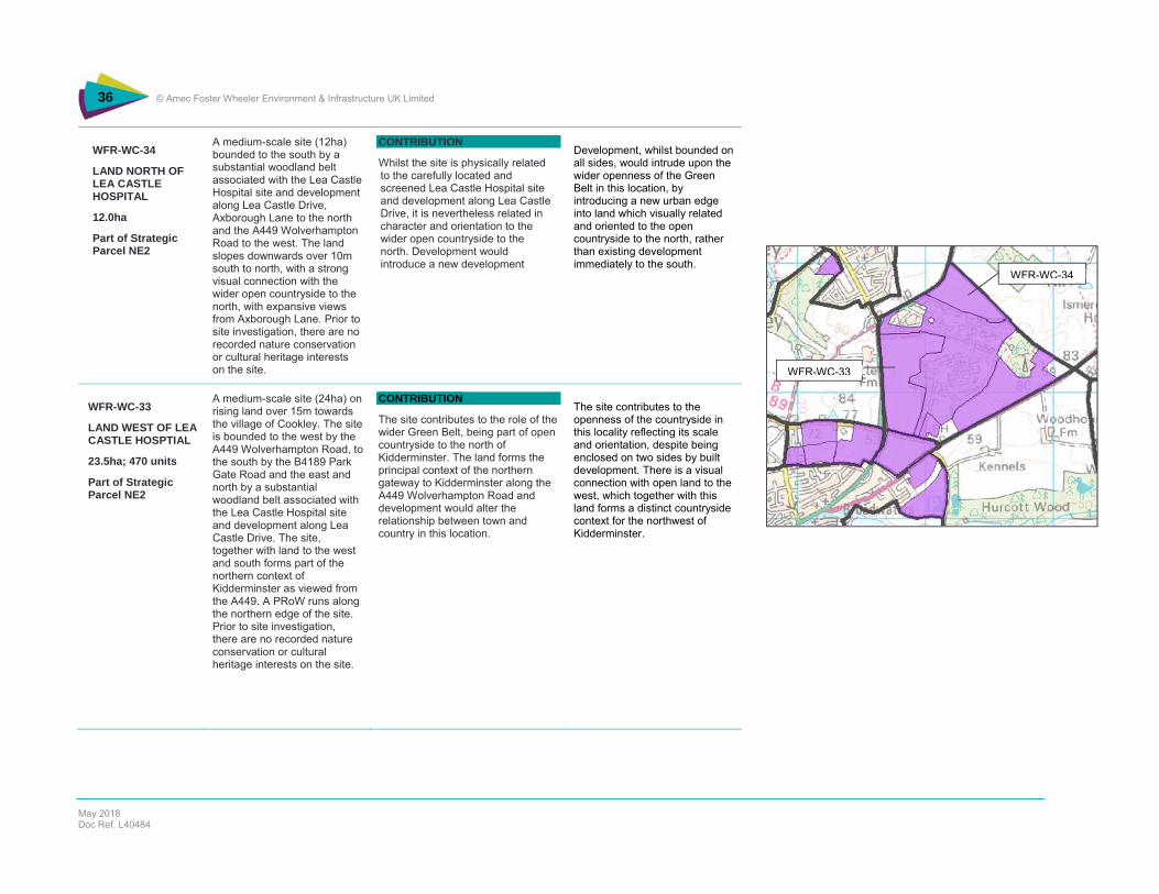
WFR-WC-34
LAND NORTH OF LEA CASTLE HOSPITAL
12.0ha
Part of Strategic Parcel NE2
A medium-scale site (12ha) bounded to the south by a substantial woodland belt associated with the Lea Castle Hospital site and development along Lea Castle Drive, Axborough Lane to the north and the A449 Wolverhampton Road to the west. The land slopes downwards over 10m south to north, with a strong visual connection with the wider open countryside to the north, with expansive views from Axborough Lane. Prior to site investigation, there are no recorded nature conservation or cultural heritage interests on the site.
CONTRIBUTION
Whilst the site is physically related to the carefully located and screened Lea Castle Hospital site and development along Lea Castle Drive, it is nevertheless related in character and orientation to the wider open countryside to the north. Development would introduce a new development
Development, whilst bounded on all sides, would intrude upon the wider openness of the Green Belt in this location, by introducing a new urban edge into land which visually related and oriented to the open countryside to the north, rather than existing development immediately to the south.
WFR-WC-33
LAND WEST OF LEA CASTLE HOSPTIAL
23.5ha; 470 units
Part of Strategic Parcel NE2
A medium-scale site (24ha) on rising land over 15m towards the village of Cookley. The site is bounded to the west by the A449 Wolverhampton Road, to the south by the B4189 Park Gate Road and the east and north by a substantial woodland belt associated with the Lea Castle Hospital site and development along Lea Castle Drive. The site, together with land to the west and south forms part of the northern context of Kidderminster as viewed from the A449. A PRoW runs along the northern edge of the site. Prior to site investigation, there are no recorded nature conservation or cultural heritage interests on the site.
CONTRIBUTION
The site contributes to the role of the wider Green Belt, being part of open countryside to the north of Kidderminster. The land forms the principal context of the northern gateway to Kidderminster along the A449 Wolverhampton Road and development would alter the relationship between town and country in this location.
The site contributes to the openness of the countryside in this locality reflecting its scale and orientation, despite being enclosed on two sides by built development. There is a visual connection with open land to the west, which together with this land forms a distinct countryside context for the northwest of Kidderminster.
WFR-WC-33
WFR-WC-34

37 © Amec Foster Wheeler Environment & Infrastructure UK Limited
May 2018 Doc Ref. L40484
WFR-WC-16(W)
LAND SOUTH OF WOLVERLEY ROAD
8.5ha; 170 units
Part of Strategic Parcel N6
A medium-scale site (8.5ha) bounded by the built edge of Kidderminster to the south, the A449 Wolverhampton Road to the east, the B4189 Wolverley Road to the north and a combination of substantial hedgerows and the curtilage of a dwelling to the east. The land rises east to west over 20m and mirrors land to the east across the A449 Wolverhampton Road. The site forms part of the northern context of Kidderminster as viewed from the A449. Prior to site investigation, there are no recorded nature conservation or cultural heritage interests on the site.
CONTRIBUTION
The parcel contributes to Green Belt purposes through preventing the encroachment of the urban edge of Kidderminster into open countryside., albeit contained to the north by the B4189 Wolverley Road. The site needs to be considered in the wider context of land to the west with development in its own right comprising the function of the Green Belt in this location.
Whilst being relatively well contained and connected to the built edge of Kidderminster to the south, the land has a degree of visual connection with wider open countryside to the north across Wolverley Road, although this is most strongly perceived from Park Gate Road. Development would impinge upon wider openness, although not significantly.
WFR-WC-17
LAND AT WOLVERLEY ROAD
5.0ha; 100 units
Part of Strategic Parcel N6
A small (5ha) site in agricultural use bordered by the 4189 Wolverley Road to the north, residential properties to the east and west and a substantial hedgerow to the south. The land rises south east to north west over 5m, with views southwards from Wolverley Road to the built edge of Kidderminster. There is no public access. Prior to site investigation, there are no recorded nature conservation or cultural heritage interests on the site.
CONTRIBUTION
The parcel contributes to Green Belt purposes through preventing the encroachment of the urban edge of Kidderminster into open countryside, albeit contained to the north by the B4189 Wolverley Road. The site needs to be considered in its wider context, and whilst being in proximity to the built edge of Kidderminster it is separate from it, with development on its own compromising the function of the Green Belt in this location.
The land is contained to varying degrees physically (most clearly to the north) and displays a moderate to high degree of openness, being on rising land related to open land to the south and west. As such development would be visually intrusive and inappropriate outside a wider context which entails visual mitigation including reducing the visual impact on open land to the north of the Wolverley Road.
WFR-WC-19
SION HILL PLAYING FIELDS
5.0ha; 100 units
Part of a previously developed school site comprising derelict school buildings and overgrown playing fields on level ground. The site is adjacent to the existing urban
CONTRIBUTION
Whilst making an overall contribution to Green belt purposes, development of the site would be unlikely to compromise the Green
The visual and topographic containment of the site means that the effects on openness are lessened, although development would still represent an extension of the built edge of
WFR-WC-16(W)WFR-WC-19
WFR-WC-17

38 © Amec Foster Wheeler Environment & Infrastructure UK Limited
May 2018 Doc Ref. L40484
Part of Strategic Parcel N6
edge to the south and bounded by Sion Hill school site to the west, a substantial hedgerow to the north and east. A public right of way runs along the southern boundary of the site and along with the built edge of Kidderminster (at Ismere Way, Lea Castle Close and Charles Avenue), is the principal visual receptor. The site is otherwise visually enclosed.
Belt strategically or locally because of its scale and containment physically and visually. There would be an effect on openness because of the introduction of built form into open land, but visual containment and previous development on the western part of the site reduces this impact. Although contained in its own right, the site is better considered as part of the wider land north to the B4189 Wolverley Road and east to the A449 Wolverhampton Road.
Kidderminster into open land which is related to the wider parcel extending north to the Wolverley Road and east to the Wolverhampton Road. As such, the land is probably more appropriate as part of a comprehensive development approach in this locality.
FHN-7
LAND NORTH OF MARPOOL
5.75ha; 115 units
Part of Strategic Parcel N3
A small site (6ha) bounded by Wolverley Road to the west, the built edge of Kidderminster to the south and a woodland edge/hedgerow to the north. The land slopes south to north over 10m from a spot point of 57m, with the northern part of the site being part of the upper slopes of Honey Brook which runs between Kidderminster and Fairfield. There are views across the site from the Wolverley Road and also across to Fairfield/Wolverley from the PRoW. Land use is scrub to the south, arable to the north and a PRoW bisects the site running east-west. Prior to site investigation, there are no recorded nature conservation or cultural heritage interests on the site.
CONTRIBUTION
Whilst the site has a degree of containment, particularly on its southern half, as a whole it contributes to Green Belt purposes, in combination with land to the north between Kidderminster and Fairfield by preventing sprawl and encroachment.
The impacts on openness of development would be mixed, reflecting the relative high degree of visual containment of the southern half of the site and the more open aspect to the north. Whilst bounded by a reasonably strong vegetation boundary, the land to the north is visually and topographically part of the open countryside to the north associated with the valley of Honey Brook.

39 © Amec Foster Wheeler Environment & Infrastructure UK Limited
May 2018 Doc Ref. L40484
OC-6
LAND EAST OF OFFMORE FARM
15.0ha; 300 units
Part of Strategic Parcel E1
A medium-scale site (15ha) bounded by a railway line to the north, the built edge of Kidderminster to the east and an unnamed watercourse to the south. To the west, the boundary is part defined by a hedgerow and otherwise strikes across an open field, to the east of Offmore Farm which divides the site into two parts. The site is in arable use and there is no public access. The site has an open aspect with views across from Husum Way towards rising land to the east. Prior to site investigation, there are no recorded nature conservation or cultural heritage interests on the site.
SIGNIFICANT CONTRIBUTION
The site is part of wider land to the east of Kidderminster which prevents sprawl into open countryside, and whilst the site is bounded on three sides, its eastern boundary is insubstantial. As such, the site makes a significant contribution to preventing sprawl and more broadly the encroachment of the urban area into the open countryside.
Whilst the site is a direct extension of the built edge of Kidderminster, there is no current eastern boundary. The openness of the, both physically and visually would be compromised, particularly given the rising topography to the east. Significant mitigation would be required to define a new eastern edge of the town in this location.
WA/KF/3 Phase 1
LAND AT LOW HABBERLEY
6.0ha; 120 units
Part of Strategic Parcel NW2
A small field (6.0ha) bounded by Habberley Lane to the north, Habberley Road to the south east, an unnamed track leading to High Habberley House to the south and a hedgerow to the northwest. The site is in arable use and falls from northeast to southwest over 20m. A PRoW runs along the access road to High Habberley House. Prior to site investigation, there are no recorded nature conservation or cultural heritage interests on the site.
SIGNIFICANT CONTRIBUTION
The site forms part of the arc of Green Belt which contains the northerly extent of Kidderminster, limiting extension of the contiguous built-up area of the town into open countryside. As such, and in combination with the wider Green Belt in this locality, the site makes a significant contribution to Green Belt purposes of containing sprawl and preventing encroachment.
Whilst the site is small and nominally adjacent to the urban edge of Kidderminster, it is nevertheless exposed visually and physically, being bounded by an insubstantial hedge to the north west and thereby physically and visually connected to the wider open countryside.
WA/KF/3 Phase 2
LAND AT LOW HABBERLEY
Several small to medium scale fields (34ha) bounded to the south by an access road to High Habberley House and Sandy Lane to
SIGNIFICANT CONTRIBUTION
The site forms part of the arc of Green Belt which contains the northerly extent of Kidderminster,
Whilst being adjacent to the built edge of Kidderminster, the site is unbounded along its northwest edge. Development would thereby compromise the
OC-6
WA/KF/3 Phase 2
WA/KF/3 Phase 1
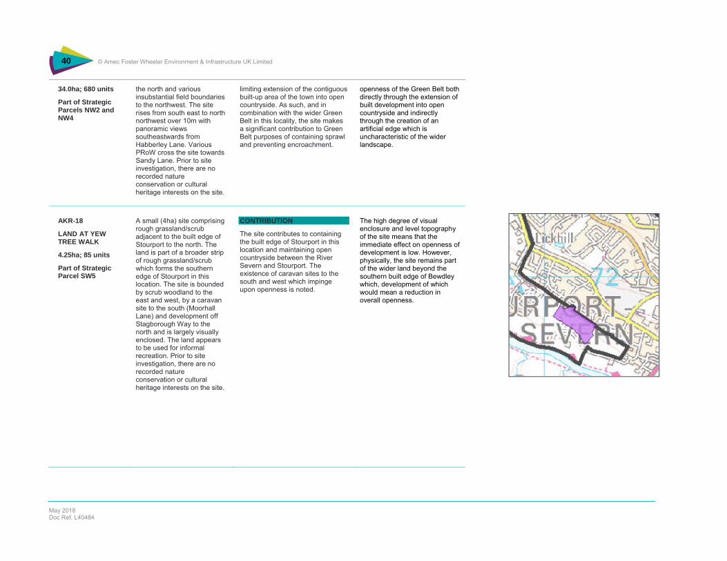
40 © Amec Foster Wheeler Environment & Infrastructure UK Limited
May 2018 Doc Ref. L40484
34.0ha; 680 units
Part of Strategic Parcels NW2 and NW4
the north and various insubstantial field boundaries to the northwest. The site rises from south east to north northwest over 10m with panoramic views southeastwards from Habberley Lane. Various PRoW cross the site towards Sandy Lane. Prior to site investigation, there are no recorded nature conservation or cultural heritage interests on the site.
limiting extension of the contiguous built-up area of the town into open countryside. As such, and in combination with the wider Green Belt in this locality, the site makes a significant contribution to Green Belt purposes of containing sprawl and preventing encroachment.
openness of the Green Belt both directly through the extension of built development into open countryside and indirectly through the creation of an artificial edge which is uncharacteristic of the wider landscape.
AKR-18
LAND AT YEW TREE WALK
4.25ha; 85 units
Part of Strategic Parcel SW5
A small (4ha) site comprising rough grassland/scrub adjacent to the built edge of Stourport to the north. The land is part of a broader strip of rough grassland/scrub which forms the southern edge of Stourport in this location. The site is bounded by scrub woodland to the east and west, by a caravan site to the south (Moorhall Lane) and development off Stagborough Way to the north and is largely visually enclosed. The land appears to be used for informal recreation. Prior to site investigation, there are no recorded nature conservation or cultural heritage interests on the site.
CONTRIBUTION
The site contributes to containing the built edge of Stourport in this location and maintaining open countryside between the River Severn and Stourport. The existence of caravan sites to the south and west which impinge upon openness is noted.
The high degree of visual enclosure and level topography of the site means that the immediate effect on openness of development is low. However, physically, the site remains part of the wider land beyond the southern built edge of Bewdley which, development of which would mean a reduction in overall openness.

41 © Amec Foster Wheeler Environment & Infrastructure UK Limited
May 2018 Doc Ref. L40484
WFR-ST-9
CURSLEY DISTRIBUTION PARK
4.0ha; 80 units
Part of Strategic Parcel SE4
A small-scale site (4ha) currently in use as a distribution depot. Located in open countryside to the north of the A442 between Kidderminster and Droitwich, the site is bounded to the east by Curslow Lane and to the west, in part, by an un-named minor road and intermittent hedgerow. To the south the boundaries are a hedgerow and PRoW, and to the north a hedgerow. The surrounding lands is of an open aspect with short and medium-distance views across land predominantly in arable use comprising small to medium scale hedged fields. The buildings currently on site are two/three-story distribution sheds which are visually conspicuous but akin to similar developments in the vicinity. Prior to site investigation, there are no recorded nature conservation or cultural heritage interests on the site.
CONTRIBUTION
The site contributes to the Green Belt in this location being part of open countryside between Kidderminster and Droitwich. However, the scale of current development is such that any change in use on the same footprint is unlikely to compromise the wider function of the Green Belt in this location.
A denser building footprint would be balanced against a reduction in building height in what is an open rural landscape which hosts a number of such visually prominent distribution-related developments.
MI-38
FORMER SCHOOL SITE OFF CONISTON CRESCENT
6.5ha; 130 units
Part of Strategic Parcel SW6
A small (6.5ha) site lying immediately to the north of the built edge of Stourport-on-Severn, being part of the open land between Kidderminster and Stourport. There are allotments to the north, a sports training facility top the south east, a school to the south and a former golf course to the north west. The land is previously developed (formerly a primary school), level and with views into the site restricted by boundary
SIGNIFICANT CONTRIBUTION
The site is part of the remaining open land between Stourport and Kidderminster, the erosion of which would further narrow the already limited gap between the two settlements. Development would have to be considered in the context of proposals on an adjacent site – land off Windermere Way.
Although part of a former school, the land retains an open aspect and visual relationship with the former golf course to the northwest and allotments to the northeast. Development would impinge upon the openness of the land and would, on its own, be an incongruous extension of the built edge of Bewdley.
MI-37
LI/11
MI-38

42 © Amec Foster Wheeler Environment & Infrastructure UK Limited
May 2018 Doc Ref. L40484
vegetation and built structures, with some glimpsed views across from Coniston Crescent. There is no public access. Prior to site investigation, there are no recorded nature conservation or cultural heritage interests on the site.
MI-37
HARRIERS TRAINING GROUND
19.0ha; potential stadium
Part of Strategic Parcel SW7
A medium-scale site (19ha) bounded by the A451 Minster Road to the east, an office development to the north, and a golf course to the west and south. Currently in use predominantly as sports pitches and associated buildings, together with some golf uses (driving range), there is no public access. The site is level with glimpsed views across from the A451. Prior to site investigation, there are no recorded nature conservation or cultural heritage interests on the site.
SIGNIFICANT CONTRIBUTION
The parcel is part of land which contributes to the continued separation of Stourport and Kidderminster. Development would compromise the openness of this land, notwithstanding the current sport and recreation use, and contribute to a narrowing of the gap (physical and perceptual) between the towns.
Notwithstanding the clear demarcation of the site, it retains a both physical and visual openness which would be removed by development. A greater sense of enclosure would also impinge upon adjacent land to the south and west which is laid out to a golf course use and visually exposed.
LI-11
FORMER GOLF COURSE OFF WINDERMERE WAY
10.75ha; 215 units
Part of Strategic Parcel SW6
A medium-scale site (10.75ha) bounded by the built edge of Stourport-on-Severn to the west and south west and a disused school site to the south east. There is no boundary to the north east, the land being part of a wider (now disused) golf course. The land has an open aspect, gently rising from south to north over 10m, with expansive views towards its northern extent from Kingsway. There is no public access. Prior to site investigation, there are no
SIGNIFICANT CONTRIBUTION
The site is part of the remaining open land between Stourport and Kidderminster, the erosion of which would further narrow the already limited gap between the two settlements. Development would have to be considered in the context of proposals on an adjacent site – land off Coniston Crescent.
The site and its wider context is characterised by a high degree of visual exposure which would be compromised by development, particularly in respect of the unbounded northeastern edge. Here, despite ‘rounding-off’ of the built edge, development would represent an extension into local countryside.
MI-37
LI/11
MI-38

43 © Amec Foster Wheeler Environment & Infrastructure UK Limited
May 2018 Doc Ref. L40484
recorded nature conservation or cultural heritage interests on the site.
44 © Amec Foster Wheeler plc
April 2017 Doc Ref. L38463
3.2 Commentary
The potential development sites analysed are of significantly varying scale and affect the purposes of the Green Belt to different degrees and in different ways, strategically and locally. Equally, and predictably, the effect of site development on openness (i.e. the extent and perception of built development) varies significantly according to the particular locality into which development is to be introduced, influenced by factors such as the relationship with an existing built edge, topography, vegetation cover and nature of the containing boundaries. In these terms, a small site can have as significant an effect on openness as a large site. Indeed, large sites will typically entail strategic masterplanning which offers opportunities for the redefinition of the urban edge. In all cases, the nature and extent of harm caused by removal of the land from the Green Belt needs to be scrutinised, as determined through the effects of development on openness, the quality of boundaries which do, or could, contain the development and the overall effect on the strategic function of the Green Belt.
The most significant impact on the Green Belt is to the southeast and northeast of Kidderminster, the two locations which are the focus for much of the development. In each case the scale of development means that a new relationship between town and country will need to be created through comprehensive masterplanning. These are:
WFR/WC/15 Lea Castle Hospital
WFR/WC/16 Land south of Park Gate Road
WFR/WC/33 Land west of Lea Castle Hospital
WFR/WC/16 (W) Land south of Wolverley Road
WFR/WC/17 Land at Wolverley Road
OC/13 Land at Stone Hill
WFR/ST/2 Land off Stanklyn Lane
AS/10 Land r/o Spennells and Easter Park
There are a number of sites where the impacts are judged to be significant and damaging to the Green Belt, through their likely effect on openness. These sites are as follows and may require more specific attention in consideration of their impacts:
BW/4 Land south of Stourbridge Road
OC/4 Land r/o Baldwin Road
OC/13 Land to the south of the A448, north of Captain’s Pool and Stanklyn Pool
WFR/ST/3 Land north of Stone Hill
WFR/CB/7 South of Birmingham Road
WFR/WC/32 North west of Stourbridge Road
WFR/WC/34 Land north of Lea Castle Hospital
WA/KF/1 Land at Grey Green Lane
WA/KF/3 Land at Low Habberley
LI/11 Former golf course off Windermere Way
Locally-specific developments are smaller but have the potential for significant localised effects, for example at Chaddesley Corbett, Blakedown, Stourport and Bewdley where edge-of-settlement development could have a disproportionate impact:
WFR/CC/7 Land at Bromsgrove Road Lower Chaddesley

45 © Amec Foster Wheeler Environment & Infrastructure UK Limited
May 2018 Doc Ref. L40484
WFR/CB/3 Land at Station Drive, Blakedown
LI/8 Lickhill Road North r/o Scout Hut
WA/BE/3 Bewdley Road/Kidderminster Road
It is important that strategic masterplanning is undertaken within the context of a wider Green Infrastructure strategy in order to make the most of strategic connections between town and countryside through best use of existing resources (river valleys, watercourses, woodlands, rights of way) and development of new connectivity, as part of positive planning for the Green Belt more generally and the creation of a more sympathetic relationship between town and country which in some instances is harshly drawn.
46 © Amec Foster Wheeler Environment & Infrastructure UK Limited
May 2018 Doc Ref. L40484
4. Opportunities for Positive Use of the Green Belt and Green Infrastructure Enhancement
4.1 Policy and Background
The NPPF encourages the positive use of the Green Belt, reflected in para 81 which says that: “Once Green Belts have been defined, local planning authorities should plan positively to enhance the beneficial use of the Green Belt, such as looking for opportunities to provide access; to provide opportunities for outdoor sport and recreation; to retain and enhance landscapes, visual amenity and biodiversity; or to improve damaged and derelict land.”
Direct intervention to strengthen the landscape character is typically reliant upon new development prompting opportunities to improve recreational opportunities, for example. The progressive erosion of landscape structure and wider changes in land use (for example to horsiculture) can greatly affect both the appearance of the Green Belt and the sense of openness that should characterise it. Whilst landscape quality is not a Green Belt criterion, as noted in the NPPF, identifying opportunities for enhancing landscape character of the Green Belt is important. Where development takes place, consideration should be given to positive land management and/or enhancement of landscape structure, ranging from the provision of recreational and nature conservation opportunities as more comprehensive approaches through to public rights of way enhancement and tree planting as part of selected intervention.
Where development takes place this can offer the opportunity for positive land management both as part of the development footprint and in the immediate environs, using the funding mechanisms of CIL and s106, providing monies for strategic and local interventions. Thus it is reasonable to expect that any development on Green Belt land pays heed to its context and contributes to the character and quality of its wider setting. In this regard, particular attention needs to be paid to:
Development densities, building heights and designs appropriate to the receiving environment;
Sensitive edge treatment, avoiding visually harsh transitions between built development and the wider countryside; and
Connecting to and enhancing existing Green Infrastructure and access opportunities across the locality and the Council more widely.
The latter point is of particular relevance to strategic Green Belt sites which may come forward, where opportunities for the creation, for example, of green corridors which integrate biodiversity, landscape and sustainable transport priorities, can be realised, in doing so create connections between town and country. Making the most of strategic and local opportunities needs to be set within an appropriate planning and management framework.
The size and location of sites will be greatly influential in determining their potential contribution to positive use of Green Belt land, either on or off-site. Large urban extension sites clearly offer the greatest potential for on-site GI, connectivity to external GI resources and contributions to off-site enhancement, through to small sites where modest off-site contributions might be secured but the focus will be on ensuring that there is no degradation of the wider Green Belt (such as abandonment for hope value) through the setting of clear development boundaries.
4.2 Green Infrastructure Planning
Rationale
The long term of planning and management of Green Infrastructure needs to be centred on a Green Infrastructure (GI) Strategy which considers, strategically and holistically, the needs and opportunities associated with planning for open spaces, natural resources and landscapes across the Council area and beyond. GI Strategies vary greatly in their focus, approaches and intended outcomes, reflecting their specific

47 © Amec Foster Wheeler Environment & Infrastructure UK Limited
May 2018 Doc Ref. L40484
geographies and past approaches to resource planning. Nevertheless they share a number of common features. These are:
The mixture of spatial and thematic approaches which uses core assets such as river valleys as the starting point for cross-cutting themes such as tree planting, biodiversity management and access enhancement.
Multifunctionality (i.e. addressing multiple interests) as a central principle, reflecting advice and guidance from statutory agencies.
Placement of the Strategy as part of a wider suite of interrelated strategy and policy documents concerning biodiversity, the historic environment, sport and recreation and climate change, for example.
Partnership working, both within the Strategy areas and cross-boundary, between local authorities, statutory agencies, interest groups and local communities.
A clear action plan which is realistic in nature, tied into existing initiatives, costed, and is capable of producing tangible outcomes in the short and longer term.
Green Infrastructure Principles
More formally, the core principles of a GI approach have been summarised1 as follows:
GI needs to be strategically planned to provide a comprehensive and integrated network
GI requires wide partnership buy-in
GI needs to be planned using sound evidence
GI needs to demonstrate ‘multi-functionality’
GI creation and maintenance need to be properly resourced
GI needs to be central to the development’s design and must reflect and enhance the area’s locally distinctive character
GI should contribute to biodiversity gain by safeguarding, enhancing, restoring, and creating wildlife habitat and by integrating biodiversity into the built environment
GI should achieve physical and functional connectivity between sites at strategic and local levels
GI needs to include accessible spaces and facilitate physically active travel
GI needs to be integrated with other policy initiatives
4.3 Review of the Current GI Strategy for Wyre Forest
The current Green Infrastructure Strategy (October 2012) identifies the emerging strategic priorities for Green Infrastructure within the District as being:
1 Town & Country Planning Association/The Wildlife Trusts (July 2012) Planning for a healthy environment – good practice guidance for green infrastructure and biodiversity Green Infrastructure is ‘a network of multi-functional green space, urban and rural, which is capable of delivering a wide range of environmental and quality of life benefits for local communities’ (Department for Communities and Local Government (2012) National Planning Policy Framework. Multi-functionality is ‘central to the green infrastructure concept and approach. It refers to the potential for green infrastructure to have a range of functions, to deliver a broad range of ecosystem services. Multi-functionality can apply to individual sites and routes, but it is when the sites and links are taken together that we achieve a fully multi-functional GI network’ (Natural England (2009) Green Infrastructure Guidance. http://publications.naturalengland.org.uk/file/94026).

48 © Amec Foster Wheeler Environment & Infrastructure UK Limited
May 2018 Doc Ref. L40484
Protection and enhancement of the existing green infrastructure within the District and particularly within the three main settlements, where the resource is often more scarce and at greater risk of adverse effects.
Creation of new or extension of existing green infrastructure to help fill gaps in provision.
The development of a District wide network of green infrastructure which will link existing and proposed new spaces focusing on connectivity and accessibility.
Table 4.1 summarises the generic principles by which such aspirations are intended to be achieved. Each area of intervention will require detailed analysis of landscape character, cultural heritage and biodiversity assets in order to secure the best fit between the existing character of the receiving environment and the influence and potential or new development. Indeed, the potential extent of change in some localities could be such that a re-writing of the GI Strategy for Wyre Forest is merited in order to ensure that account is taken of these new circumstances and opportunities.
Table 4.1 Generic Green Infrastructure Creation and Enhancement Principles
Overarching principles
Enhance stream and river corridors Protect ancient countryside character Protect and enhance the ancient woodland habitats of the Wyre Forest Enhance and expand acid grassland habitats
Biodiversity Protect and enhance existing site and biodiversity interests, with implementation and delivery to be directed to existing site management and buffering as a first principle.
Link networks of biodiversity sites where practicable. Restore functional stream corridors. Use newly created GI features to augment the existing resource concentrating on the main
priorities for protection and creation including acid grassland and veteran tree connectivity through linking, merging and buffering existing and newly created habitats.
Use hedgerows and small woodlands to provide connectivity through the landscape.
Historic Environment
Protect and enhance the diverse historic field boundary patterns and hedgerows that are associated with medieval assarting, post-medieval reorganisation and traditional orchards.
Buffer historic landscape features, such as earthwork boundaries, ridge and furrow, abandoned prehistoric and medieval settlement remains.
Protect historic water features and buffer key sites, such as moats, fishponds, millponds and leats.
Explore opportunities to protect below ground archaeology associated with multi-period settlements throughout the area, and particularly, adjacent to existing rural settlements.
Landscape Character
Protect and enhance ancient woodland cover, including replanting with mixed, native species where appropriate, respecting the characteristic tree cover pattern.
Protect and enhance the hedgerow network, respecting the characteristic enclosure pattern of each Landscape Type including safeguarding or replanting of hedgerow trees to address age structure and density.
Blue Infrastructure
Reduce dependence on raised flood defences, as this is unsustainable in the long term, by taking opportunities to restore sustainable natural storage of floodwater on undeveloped floodplains.
Make more space for rivers through urban areas via ‘blue corridors’ (i.e. restoring access for floodwater onto key strips of floodplain. This requires redevelopment to be limited to flood-compatible land-uses e.g. parkland). Activities that affect these sites must be changed to improve their condition.
Ensure that the run-off from all proposed development is minimised. For example, SUDS must be encouraged and targeted within planning approvals.

49 © Amec Foster Wheeler Environment & Infrastructure UK Limited
May 2018 Doc Ref. L40484
Encourage the retro-fitting of SUDS where surface water flooding is already a problem. Support ecological improvements. Examples of this include Severn & Avon Wetlands Project and Natural England’s three fluvial SSSIs.
Tackle issues of diffuse pollution in the catchment through the provision of advice to farmers under the England Catchment Sensitive Farming Delivery Initiative.
Access and Recreation
Consider the proximity to and ability to integrate with the rights of way network, recreational way-marked routes and the cycle network.
Accommodate associated facilities necessary for the use and enjoyment of the site in a manner that is appropriate and able to integrate with the landscape character, wildlife and cultural interests.
Create greenways from town into the countryside utilising canal and river corridors linked with public transport routes.
Adopt minimum quality standards, (commensurate with its location and scale) that sites and routes should be expected to achieve will be those from the Green Flag Award Programme, and the Country Parks Accreditation Scheme, as appropriate.
Transport Seek opportunities to protect, enhance and create green infrastructure that promotes sustainable movement by walking and cycling, reducing the need to travel by car by providing pleasant environments that promote sustainable transport as a means to minimise the impact of transport on the natural environment and mitigate the impacts of climate change.
Source: compiled from Wyre Forest District Green Infrastructure Strategy (October 2012)
As currently constituted, the GI Strategy fails to provide a convincing strategic framework to enable the principles set out in Table 4.1 to be fully realised. This is for a number of different reasons relating to the planning context within which the Strategy was prepared and matters relating to the document’s structure and content. The following observations capture the principal issues:
► The Strategy was prepared in the very different planning context of the previous plan period where all new development was focused on brownfield land. As such, the focus of the Strategy was therefore primarily on the towns with some attention to wider strategic assets, identified as priority areas:
o The Rivers Severn and Stour and associated wetlands
o the Staffordshire and Worcestershire Canal
o Heathlands and grasslands.
o The Wyre Forest and associated areas of high landscape and biodiversity value
► It is noted that in para 2.11 of the Strategy, in the absence of justification for major new GI projects (associate with urban extensions) the focus for provision is to address the typologies where deficiencies have been identified, ensuring new development does not exacerbate these deficiencies, whilst ensuring that new developments connect into and enhance the existing green infrastructure network.
► Notwithstanding the above, whilst attention on the combination of linear and site-based assets is reasonable and typical for a GI Strategy, there is very limited indication spatially of what constitutes the GI network across the District.
► The audit of open space provision and the socio-economic context of the strategy is noted, although these are not clearly linked to the Strategy’s vision and objectives.
► In terms of the assembly of a spatially coherent strategy, there is no indication of strategic approach to the three core components of biodiversity, landscape and access, and thereby a sense of district-wide connectivity which can serve as the focus for district-wide connectivity.

50 © Amec Foster Wheeler Environment & Infrastructure UK Limited
May 2018 Doc Ref. L40484
► Aside from some limited developer contributions relating to specific sites, there is no indication of how the Strategy might be delivered more widely, for example through engaging existing groups (voluntary and statutory).
► Overall, and perhaps understandably within the development context of that time, focus is on a series of closely defined development sites through which there could be enhanced connectivity to existing assets, enhancement of assets and provision of new assets.
The prospect of substantial new development on greenfield land on the periphery of Kidderminster in particular creates the opportunity to develop a more systematic approach which addresses both strategic and local concerns, integrates with the Local Plan through new development (drawing on related CIL and s.106 funding opportunities), and is a focus for partnership working to ensure an integrated and sustainable approach to resource planning and management.
The following outline of a structure for a GI Strategy addresses the need for an approach which integrates site-specific investment (such as through strategic masterplanning) with wider-off-site enhancement, the ‘pepper-potting’ of enhancement initiatives and the more systematic provision of cycling and walking routes, for example, The success of the Strategy would be measured by its ability to join the strategic with the local through cross-cutting themes.
1. Purpose and Foundation of the Strategy 1 What is Green Infrastructure? 2 Rationale and Strategic Fit
2. The Vision for Wyre Forest’s Green Infrastructure 3. The Geography of Wyre Forest’s Green Infrastructure: Issues and Opportunities
1 Watercourses and Flood Risk Management 2 Landscape and Cultural Heritage Protection and Enhancement 3 Biodiversity Protection and Enhancement 4 Access and Recreation 5 Health Improvement
4. Strategy Objectives and Key Interventions 1 Biodiversity
2 Communities and Health 3 Economy 4 Water Management 5 Heritage, Landscape and Townscape 6 Access and Recreation
5. A Spatial Strategy for Wyre Forest’s Green Infrastructure
1 Scale and Focus of Effort 2 Delivery
Partnership Working and Strategy Integration Providing Green Infrastructure through New Development Funding Community Participation
6. Monitoring and Evaluation Appendices 1. Current District-wide Strategies and their links to Green Infrastructure delivery 2. Accessibility by Type of Open Space 3. Green Spaces

51 © Amec Foster Wheeler Environment & Infrastructure UK Limited
May 2018 Doc Ref. L40484

52 © Amec Foster Wheeler Environment & Infrastructure UK Limited
May 2018 Doc Ref. L40484
5. Potential for Extension of the Green Belt in Wyre Forest District
5.1 Background
The Green Belt in Wyre Forest District largely uses the River Severn as its eastern boundary. This was entirely logical at the time of designation given the strength of the boundary and the relatively modest development of Bewdley and Stourport. However, there has been substantial development associated with these settlements in the past forty years such that they now form small-scale towns. Whilst the western fringes of Bewdley are constrained by topography and the environmental designations associated with the Wyre Forest, Stourport has expanded to the southern boundary of the District, with a narrow area of undeveloped land remaining between the flood plain of the River Severn and the western boundary of the District. Figure 5.1 illustrates these assets and constraints.
Figure 5.1 Assets and constraints in the Bewdley – Stourport locality
The NPPF (para. 82) specifically refers to the need to prove ‘exceptional circumstances’ where new Green Belt is proposed. The policy states that:
82. The general extent of Green Belts across the country is already established. New Green Belts should only be established in exceptional circumstances, for example when planning for larger scale

53 © Amec Foster Wheeler Environment & Infrastructure UK Limited
May 2018 Doc Ref. L40484
development such as new settlements or major urban extensions. If proposing a new Green Belt, local planning authorities should:
demonstrate why normal planning and development management policies would not be adequate;
set out whether any major changes in circumstances have made the adoption of this exceptional measure necessary;
show what the consequences of the proposal would be for sustainable development;
demonstrate the necessity for the Green Belt and its consistency with Local Plans for adjoining areas; and
show how the Green Belt would meet the other objectives of the Framework.
A means of identifying whether exceptional circumstances might be present is to test potential areas for addition against Green Belt purposes, namely the potential role of the land in:
Preventing unrestricted sprawl;
Preventing neighbouring towns from merging;
Safeguarding the countryside from encroachment;
Preserving the setting and special character of historic towns, and
Assisting in urban regeneration.
In addition, where an extension is proposed, the continuity of the Green Belt as a whole needs to be considered, that is the land should be of sufficient extent and a logical extension of existing Green Belt.
Figure 5.2 illustrates three areas of search for potential Green Belt extension. All are located to the west of the River Severn which is the western boundary of the Green Belt as currently designated. The areas of search are:
Area A: land to the north of the A456, south, west and north of Bewdley
Area B: land to the south of A456 and north of Areley Lane/Areley Wood
Area C: land to the north and west of Stourport south of Areley Lane
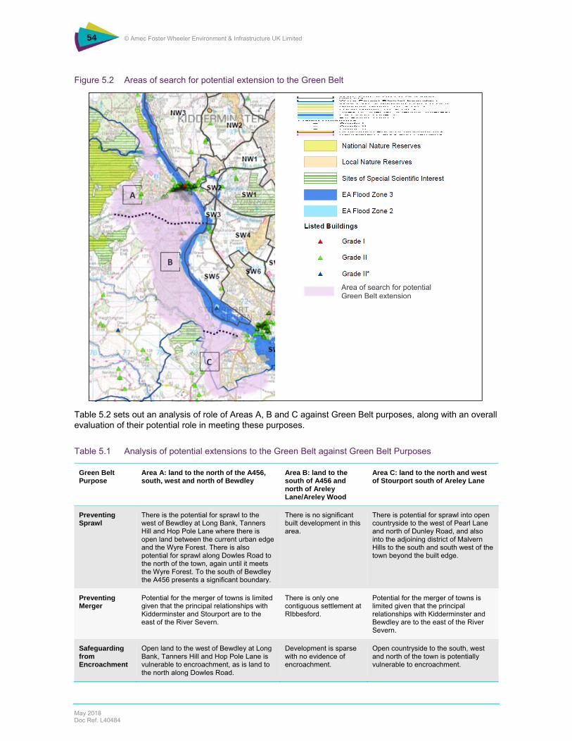
54 © Amec Foster Wheeler Environment & Infrastructure UK Limited
May 2018 Doc Ref. L40484
Figure 5.2 Areas of search for potential extension to the Green Belt
Table 5.2 sets out an analysis of role of Areas A, B and C against Green Belt purposes, along with an overall evaluation of their potential role in meeting these purposes.
Table 5.1 Analysis of potential extensions to the Green Belt against Green Belt Purposes
Green Belt Purpose
Area A: land to the north of the A456, south, west and north of Bewdley
Area B: land to the south of A456 and north of Areley Lane/Areley Wood
Area C: land to the north and west of Stourport south of Areley Lane
Preventing Sprawl
There is the potential for sprawl to the west of Bewdley at Long Bank, Tanners Hill and Hop Pole Lane where there is open land between the current urban edge and the Wyre Forest. There is also potential for sprawl along Dowles Road to the north of the town, again until it meets the Wyre Forest. To the south of Bewdley the A456 presents a significant boundary.
There is no significant built development in this area.
There is potential for sprawl into open countryside to the west of Pearl Lane and north of Dunley Road, and also into the adjoining district of Malvern Hills to the south and south west of the town beyond the built edge.
Preventing Merger
Potential for the merger of towns is limited given that the principal relationships with Kidderminster and Stourport are to the east of the River Severn.
There is only one contiguous settlement at RIbbesford.
Potential for the merger of towns is limited given that the principal relationships with Kidderminster and Bewdley are to the east of the River Severn.
Safeguarding from Encroachment
Open land to the west of Bewdley at Long Bank, Tanners Hill and Hop Pole Lane is vulnerable to encroachment, as is land to the north along Dowles Road.
Development is sparse with no evidence of encroachment.
Open countryside to the south, west and north of the town is potentially vulnerable to encroachment.
Area of search for potential Green Belt extension
A
B
C

55 © Amec Foster Wheeler Environment & Infrastructure UK Limited
May 2018 Doc Ref. L40484
Preserving Setting and Character
The land forms the immediate context for the south and west of Bewdley and as such contributes to the setting of the town as a whole. However, there is no visual connection between these areas and the historic core of Bewdley.
The land is part of the southerly setting for Bewdley and northerly setting for Stourport.
The land broadly contributes to the setting of Stourport although there is no visual connection between the historic core and the outskirts. Locally, Green Belt could have a role in protecting Areley Kings Conservation Area but the effect would be highly localised.
Assisting Regeneration
There is no clear contribution to this purpose
There is no clear contribution to this purpose
There is no clear contribution to this purpose
Overall Evaluation
Whether Green Belt is the appropriate planning tool to address the pressure for development is not convincing because of the localised extent of likely direction for growth and a clear connection with the wider Green Belt to the east of the River Severn. In addition, the definition of external boundaries is problematic with the A456 presenting the only significant boundary with the edge of Wyre Forest being complex and discontinuous in many places.
This area is dominated by Ribbesford Woods on rising land from the River Severn. There is no evidence of incremental change that would suggest the openness of the land is being compromised or under threat.
Whilst there is clearly pressure for development on the outskirts of Stourport (as evidenced by advance planting in some areas), there is limited evidence of development pressure or the need to shape the growth of the town in this location that might warrant Green Belt designation where open countryside policy could secure a similar outcome. Given the very limited potential role of land to the north of Areley Lane, Green Belt would not be a logical extension from across the River Severn. In addition, the determination of external boundaries is unclear.
5.2 Commentary
The case for extension of the Green Belt is mixed. Whilst there are clear pressures for growth around the fringes of Bewdley and Stourport, the extent to which this constitutes sprawl, encroachment into open countryside or compromising the setting of historic settlements is not of an extent to individually or cumulatively warrant designation. Whilst there are local pressures, notably to the south west of Bewdley up to the A456 and to the west of Stourport at Areley Kings, these are not of a scale that would warrant designation as well as being isolated from the wider Green Belt to east of the River Severn.
To be effective as a strategic planning tool which helps to shape urban form, Green Belt should be contiguous in its extent and of a sufficient scale to prevent development ‘leap-frogging’ or being diverted to nearby locations. Neither of these conditions are fulfilled in the fringes of Bewdley or Stourport. In the absence of Green Belt policy, a policy dealing with development in the open countryside would need to be used. This might have to be strengthened (for example through the addition of area-specific criteria) to deal with speculative development in the fringes of settlements which are not surrounded by Green Belt, particularly where there is evidence of preparation for development through advance planting for example. Determination of external boundaries is difficult for both Bewdley and Stourport, in the case of Bewdley the Wyre Forest presenting a complex and discontinuous boundary, and in the case of Stourport, there being numerous permutations extending into open countryside.
5.3 Conclusion
The analysis has revealed that there is no clear case for the extension of the Green Belt to the west of the River Severn. Notwithstanding the existence of development pressures (as evidenced by advance planting, for instance) and potential vulnerability of the open countryside to encroachment, the contribution to Green Belt purposes of the three areas of search analysed is not convincing. This is compounded by the absence of significant external boundaries by which Green Belt might be defined. The default position is therefore to rely on the application of policies which protect the openness of the countryside, which may have to be revised to include criteria relating to areas of particular development pressure. These results would need to be set within the context of the exploration of wider planning issues such the existence of any ‘major changes in circumstances’ or the ‘consequences for sustainable development’ which might constitute ‘exceptional circumstances’.
56 © Amec Foster Wheeler Environment & Infrastructure UK Limited
May 2018 Doc Ref. L40484
6. Conclusions
This Report has analysed the likely effect of the potential development sites on the Green Belt in Wyre Forest, strategically and locally. The overall effect of this scale of development on the purposes of Green belt within Wyre Forest District is judged to not be significant, although there are localised instances of development having an unacceptable effect on openness, both for large and smaller scale sites.
Generally, strategic allocations create challenges associated with the containment of development because of their scale and the fundamental change to that locality that development will inevitably bring. The importance of masterplanning these large sites is therefore emphasised, entailing both the establishment of a substantive outer boundary to the built edge of the development and integration with the existing urban area. Such large-scale development brings opportunities for the positive use of the Green Belt, both as part of the development itself and within the wider Green Belt where green infrastructure linkages and access opportunities in particular could be enhanced. This is particularly the case to the southeast and northeast of Kidderminster where a new relationship between town and country will have to be defined and there is the opportunity to draw upon principles of sustainable development and best practice in masterplanning to help achieve this. The sites of particular significance are:
WFR/WC/15 Lea Castle Hospital
WFR/WC/16 Land south of Park Gate Road
WFR/WC/33 Land west of Lea Castle Hospital
WFR/WC/16 (W) Land south of Wolverley Road
WFR/WC/17 Land at Wolverley Road
OC/13 Land at Stone Hill
WFR/ST/2 Land off Stanklyn Lane
AS/10 Land r/o Spennells and Easter Park
There are some sensitive gateway sites where even modest development would have a disproportionate effect both on the function of the Green Belt (principally in terms sprawl and effect on setting), but also on the wider perception of openness reflecting their prominence. The following sites merit particular (and further) attention in respect of their likely impacts:
BW/4 Land south of Stourbridge Road
OC/4 Land r/o Baldwin Road
OC/13 Land to the south of the A448, north of Captain’s Pool and Stanklyn Pool
WFR/ST/3 Land north of Stone Hill
WFR/CB/7 South of Birmingham Road
WFR/WC/32 North west of Stourbridge Road
WFR/WC/34 Land north of Lea Castle Hospital
WA/KF/1 Land at Grey Green Lane
WA/KF/3 Land at Low Habberley
LI/11 Former golf course off Windermere Way
Locally-specific developments are smaller but have the potential for significant localised effects, for example at Chaddesley Corbett, Blakedown, Stourport and Bewdley where edge-of-settlement development could have a disproportionate impact:

57 © Amec Foster Wheeler Environment & Infrastructure UK Limited
May 2018 Doc Ref. L40484
WFR/CC/7 Land at Bromsgrove Road Lower Chaddesley
WFR/CB/3 Land at Station Drive, Blakedown
LI/8 Lickhill Road North r/o Scout Hut
WA/BE/3 Bewdley Road/Kidderminster Road
It is important that strategic masterplanning is undertaken within the context of a wider Green Infrastructure Strategy in order to make the most of strategic connections between town and countryside through best use of existing resources (river valleys, watercourses, woodlands, rights of way) and development of new connectivity, as part of positive planning for the Green Belt more generally and the creation of a more sympathetic relationship between town and country which in some instances is harshly drawn.
The analysis has concluded that there is no strong case for the extension of the Green Belt across the River Severn to contain potential development at Bewdley or Stourport where there is clearly pressure for development but not of an extent that would justify the application of Green Belt principles, combined with an absence of coherent boundaries by which to define new Green Belt. In these cases development restraint would need to be achieved through open countryside policies, perhaps strengthened to include specific reference to vulnerable areas where further growth is not considered to be appropriate.
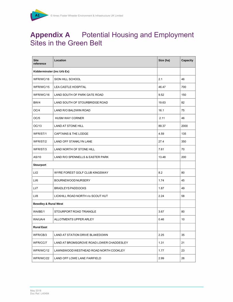
A1 © Amec Foster Wheeler Environment & Infrastructure UK Limited
May 2018 Doc Ref. L40484
Appendix A Potential Housing and Employment Sites in the Green Belt
Site reference
Location Size (ha) Capacity
Kidderminster (inc Urb Ex)
WFR/WC/18 SION HILL SCHOOL 2.1 46
WFR/WC/15 LEA CASTLE HOSPITAL 46.47 700
WFR/WC/16 LAND SOUTH OF PARK GATE ROAD 9.52 150
BW/4 LAND SOUTH OF STOURBRIDGE ROAD 19.63 82
OC/4 LAND R/O BALDWIN ROAD 16.1 75
OC/5 HUSM WAY CORNER 2.11 46
OC/13 LAND AT STONE HILL 89.37 2000
WFR/ST/1 CAPTAINS & THE LODGE 4.59 135
WFR/ST/2 LAND OFF STANKLYN LANE 27.4 350
WFR/ST/3 LAND NORTH OF STONE HILL 7.61 70
AS/10 LAND R/O SPENNELLS & EASTER PARK 13.48 200
Stourport
LI/2 WYRE FOREST GOLF CLUB KINGSWAY 8.2 80
LI/6 BOURNEWOOD NURSERY 1.74 45
LI/7 BRADLEYS PADDOCKS 1.87 49
LI/8 LICKHILL ROAD NORTH r/o SCOUT HUT 2.24 58
Bewdley & Rural West
WA/BE/1 STOURPORT ROAD TRIANGLE 3.67 80
WA/UA/4 ALLOTMENTS UPPER ARLEY 0.46 10
Rural East
WFR/CB/3 LAND AT STATION DRIVE BLAKEDOWN 2.25 35
WFR/CC/7 LAND AT BROMSGROVE ROAD LOWER CHADDESLEY 1.31 21
WFR/WC/12 LAWNSWOOD WESTHEAD ROAD NORTH COOKLEY 1.77 23
WFR/WC/22 LAND OFF LOWE LANE FAIRFIELD 2.99 26
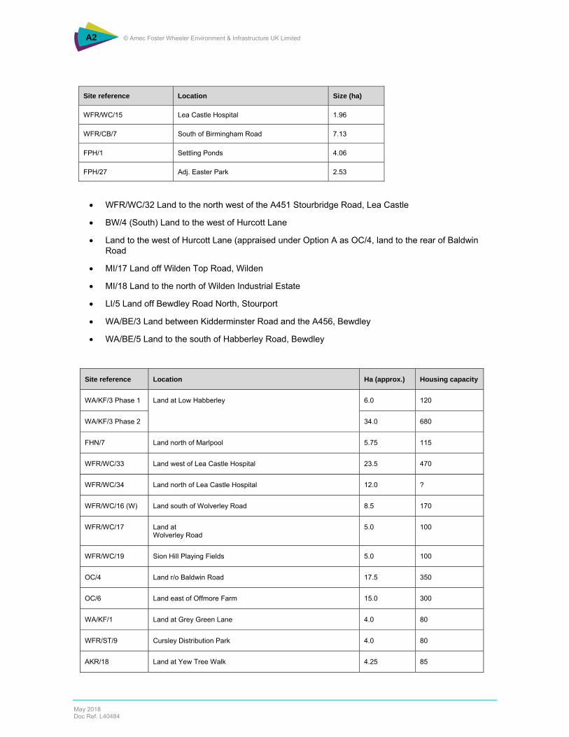
A2 © Amec Foster Wheeler Environment & Infrastructure UK Limited
May 2018 Doc Ref. L40484
Site reference Location Size (ha)
WFR/WC/15 Lea Castle Hospital 1.96
WFR/CB/7 South of Birmingham Road 7.13
FPH/1 Settling Ponds 4.06
FPH/27 Adj. Easter Park 2.53
WFR/WC/32 Land to the north west of the A451 Stourbridge Road, Lea Castle
BW/4 (South) Land to the west of Hurcott Lane
Land to the west of Hurcott Lane (appraised under Option A as OC/4, land to the rear of Baldwin Road
MI/17 Land off Wilden Top Road, Wilden
MI/18 Land to the north of Wilden Industrial Estate
LI/5 Land off Bewdley Road North, Stourport
WA/BE/3 Land between Kidderminster Road and the A456, Bewdley
WA/BE/5 Land to the south of Habberley Road, Bewdley
Site reference Location Ha (approx.) Housing capacity
WA/KF/3 Phase 1 Land at Low Habberley
6.0 120
WA/KF/3 Phase 2 34.0 680
FHN/7 Land north of Marlpool 5.75 115
WFR/WC/33 Land west of Lea Castle Hospital 23.5 470
WFR/WC/34 Land north of Lea Castle Hospital 12.0 ?
WFR/WC/16 (W) Land south of Wolverley Road 8.5 170
WFR/WC/17 Land at Wolverley Road
5.0 100
WFR/WC/19 Sion Hill Playing Fields 5.0 100
OC/4 Land r/o Baldwin Road 17.5 350
OC/6 Land east of Offmore Farm 15.0 300
WA/KF/1 Land at Grey Green Lane 4.0 80
WFR/ST/9 Cursley Distribution Park 4.0 80
AKR/18 Land at Yew Tree Walk 4.25 85

A3 © Amec Foster Wheeler Environment & Infrastructure UK Limited
May 2018 Doc Ref. L40484
Site reference Location Ha (approx.) Housing capacity
MI/37 Harriers Training Ground – potential stadium site 19.0 -
LI/11 Former Golf Course 10.75 215
MI/38 Former school site Coniston Crescent 6.5 130

B1 © Amec Foster Wheeler Environment & Infrastructure UK Limited
May 2018 Doc Ref. L40484
Appendix B Green Infrastructure planning in Wyre Forest District
The following extracts summarise the current approach to Green Infrastructure (GI) planning in Wyre Forest District, drawn from the Green Infrastructure Strategy (2012) and current local planning policy which provides the policy reference point for its implementation. Wyre Forest Green Infrastructure Strategy (October 2012) 2.11 “… the growth which will take place within the District over the next 25 years is not significant enough to warrant major new green infrastructure projects as would be the case if urban extensions were being proposed, therefore, the focus for green infrastructure provision will be addressing typologies where deficiencies have been identified, and ensuring the new development does not exacerbate these deficiencies, whilst ensuring the new developments connect into and enhance the existing green infrastructure network.” District-wide Green Infrastructure Objectives Within Wyre Forest District new development should:
Seek to retain existing open space and sports provision and where it can be demonstrated that this is not feasible, appropriate compensatory provision should be made.
Seek to retain mature trees where appropriate. Provide appropriate pedestrian and cycle access to the existing green infrastructure network in order
to encourage active recreation and travel. Provide opportunities for wildlife and biodiversity incorporating appropriate soft landscaping and
features which act as green stepping stones. Incorporate SUDS schemes which offer benefits for the green infrastructure network and consider
how flood alleviation schemes can incorporate green infrastructure provision. Consider the use of green infrastructure to adapt to and mitigate against climate change.
Environmental Character Areas 4.4 The Worcestershire County Council Environmental Character Areas have been developed since the preparation of the Green Infrastructure Study. These areas were developed as part of the Worcestershire Green Infrastructure Partnership's work and are based on landscape character areas, biodiversity and the historic environment. These characteristics were assessed and each attribute scored, with the amalgamated score for all the characteristics being used to determine the category for each ECA. The scores were determined by a weighted sum which gives greater importance to biodiversity as the key component of Green Infrastructure, with landscape and historic environmental character having an equal but lower weighting. The boundaries shown on the map are intended to be soft edged and indicative and do not define firm boundaries on the ground. 4.5 The Environmental Character Areas have been placed into one of three categories based on their overall score for Green Infrastructure. These are:
‐ Protect and enhance ‐ Protect and restore ‐ Restore and create
4.6 The Character Areas which cover Wyre Forest District are: ‐ Teme Valley & Wyre Forest - Protect and enhance ‐ Bewdley Fringe - Protect and restore ‐ Birchen Coppice - Protect and restore ‐ Hagley Hinterland - Protect and Restore ‐ Severn Valley North - Protect and Enhance
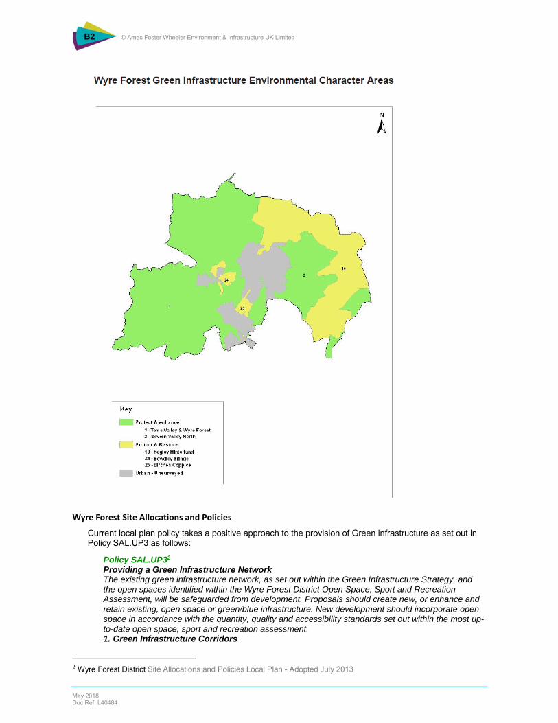
B2 © Amec Foster Wheeler Environment & Infrastructure UK Limited
May 2018 Doc Ref. L40484
Wyre Forest Site Allocations and Policies
Current local plan policy takes a positive approach to the provision of Green infrastructure as set out in Policy SAL.UP3 as follows:
Policy SAL.UP32 Providing a Green Infrastructure Network The existing green infrastructure network, as set out within the Green Infrastructure Strategy, and the open spaces identified within the Wyre Forest District Open Space, Sport and Recreation Assessment, will be safeguarded from development. Proposals should create new, or enhance and retain existing, open space or green/blue infrastructure. New development should incorporate open space in accordance with the quantity, quality and accessibility standards set out within the most up-to-date open space, sport and recreation assessment. 1. Green Infrastructure Corridors
2 Wyre Forest District Site Allocations and Policies Local Plan - Adopted July 2013

B3 © Amec Foster Wheeler Environment & Infrastructure UK Limited
May 2018 Doc Ref. L40484
The Green Infrastructure Strategy identifies the following key green infrastructure corridors which new development will be required to contribute towards the delivery and enhancement of: i. River Severn and River Stour Corridors - development along these corridors will be required to improve the attractiveness of the riverside environment, remove culverts where appropriate, enhance the biodiversity value and water quality of the river corridor, and ensure that the functional floodplain is maintained and restored. Development should recognise and enhance the multi-functional nature of these corridors and seize opportunities to link them with the wider green infrastructure network. ii. Staffordshire and Worcestershire Canal - development along the canal corridor must not have a detrimental impact on the existing sustainable transport route or the character of the Conservation Area. Development should seek to enhance the biodiversity and water quality of the canal corridor whilst recognising the multi-functional nature of the corridor. iii. Public Rights of Way Network - where appropriate.
To the north of Kidderminster Town Centre, the Council will safeguard the areas shown on the Policies Map in the Stour Valley for future development as a Country Park. Proposals for development which would prejudice the provision of a Country Park in these areas will not be permitted. 2. Public Rights of Way Developments which affect Public Rights of Way will be required to make adequate provision for the continuation or diversion of the route. New developments will be required to link into Public Rights of Way where appropriate. New Rights of Way will be established where possible.
Policy SALUP3 is based on the Green Infrastructure Strategy3 developed for the District, and identifies specific opportunities for strengthening the environmental and landscape character of the District, many of these areas being designated as Green Belt and some with nationally significant biodiversity designation, and environmental constraints such as flood risk. Specific green infrastructure enhancement opportunities which are covered by Green Belt designation are:
The River Stour and River Severn corridors
Hurcott Pools and Wood
The A451 Corridor
South Kidderminster Enterprise Park (Wilden Marsh)
3 Wyre Forest District Green Infrastructure Strategy – October 2012

B4 © Amec Foster Wheeler Environment & Infrastructure UK Limited
May 2018 Doc Ref. L40484

C1 © Amec Foster Wheeler Environment & Infrastructure UK Limited
May 2018 Doc Ref. L40484
Appendix C Site-by-Site Analysis
This Appendix assesses the potential development sites which are located in the Green Belt as set out in the table below.
Potential Housing Sites
Area HELAA Ref Location Pages
Kidderminster (inc Urb Ex)
WFR/WC/18 SION HILL SCHOOL C1 – C4
WFR/WC/15 LEA CASTLE HOSPITAL C5 – C9
WFR/WC/16 LAND SOUTH OF PARK GATE ROAD C10 – C14
BW/4 (North) LAND SOUTH OF STOURBRIDGE ROAD C15 – C19
OC/4 LAND R/O BALDWIN ROAD C20 – C25
OC/5 HUSUM WAY CORNER C26 – C30
OC/13 LAND AT STONE HILL C31 – C45
WFR/ST/1 CAPTAINS & THE LODGE C46 – C48
WFR/ST/2 LAND OFF STANKLYN LANE C49 – C55
WFR/ST/3 LAND NORTH OF STONE HILL C56 – C60
AS/10 LAND R/O SPENNELLS & EASTER PARK C61 – C65
WFR/WC/32 Land to the north west of the A451 Stourbridge Road, Lea Castle C66 – C70
BW/4 (South) Land to the west of Hurcott Lane C71 – C75
Stourport LI/2 WYRE FOREST GOLF CLUB KINGSWAY C76 – C80
LI/6 BOURNEWOOD NURSERY C81 – C84
LI/7 BRADLEYS PADDOCKS C85 – C89
LI/8 LICKHILL ROAD NORTH r/o SCOUT HUT C90 – C93
MI/17 Land off Wilden Top Road, Wilden C94 – C97
LI/5 Land off Bewdley Road North, Stourport C98 – C102
Bewdley & Rural West
WA/BE/1 STOURPORT ROAD TRIANGLE C103 – C107
WA/UA/4 ALLOTMENTS UPPER ARLEY C108 – C110
WA/BE/3 Land between Kidderminster Road and the A456, Bewdley C111 – C115
WA/BE/5 Land to the south of Habberley Road, Bewdley C116 – C120
Rural East WFR/CB/3 LAND AT STATION DRIVE BLAKEDOWN C121 – C125
WFR/CC/7 LAND AT BROMSGROVE ROAD LOWER CHADDESLEY C126 – C130
WFR/WC/12 LAWNSWOOD WESTHEAD ROAD NORTH COOKLEY C131 – C135
WFR/WC/22 LAND OFF LOWE LANE FAIRFIELD C136 – C140
Potential Employment Sites
Area HELAA Ref Location Pages
Kidderminster WFR/WC/15 Lea Castle Hospital C141 – C145
Kidderminster WFR/CB/7 South of Birmingham Road C146 – C150
Kidderminster FPH/1 Settling Ponds C151 – C155
Kidderminster FPH/27 Adj. Easter Park C156 – C160
Kidderminster MI/18 Land to the north of Wilden Industrial Estate C161 – C164
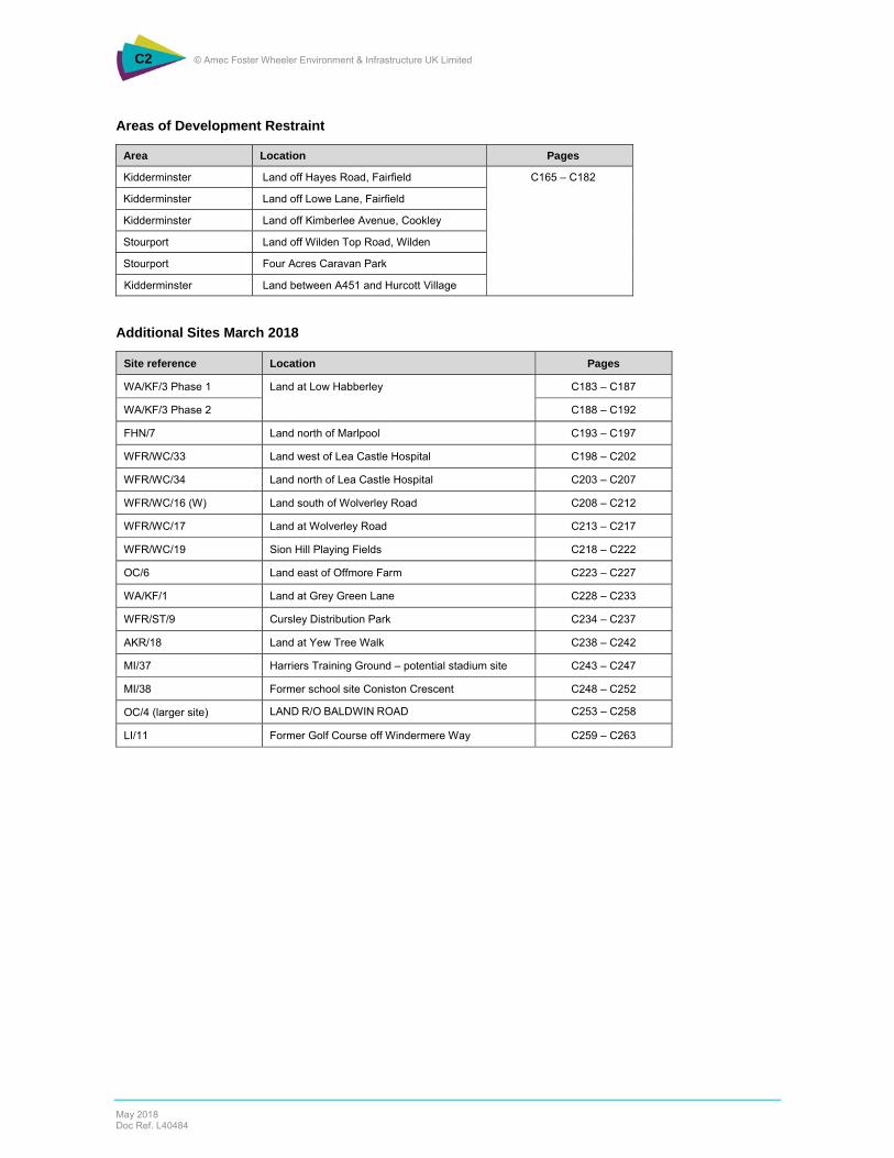
C2 © Amec Foster Wheeler Environment & Infrastructure UK Limited
May 2018 Doc Ref. L40484
Areas of Development Restraint
Area Location Pages
Kidderminster Land off Hayes Road, Fairfield C165 – C182
Kidderminster Land off Lowe Lane, Fairfield
Kidderminster Land off Kimberlee Avenue, Cookley
Stourport Land off Wilden Top Road, Wilden
Stourport Four Acres Caravan Park
Kidderminster Land between A451 and Hurcott Village
Additional Sites March 2018
Site reference Location Pages
WA/KF/3 Phase 1 Land at Low Habberley
C183 – C187
WA/KF/3 Phase 2 C188 – C192
FHN/7 Land north of Marlpool C193 – C197
WFR/WC/33 Land west of Lea Castle Hospital C198 – C202
WFR/WC/34 Land north of Lea Castle Hospital C203 – C207
WFR/WC/16 (W) Land south of Wolverley Road C208 – C212
WFR/WC/17 Land at Wolverley Road C213 – C217
WFR/WC/19 Sion Hill Playing Fields C218 – C222
OC/6 Land east of Offmore Farm C223 – C227
WA/KF/1 Land at Grey Green Lane C228 – C233
WFR/ST/9 Cursley Distribution Park C234 – C237
AKR/18 Land at Yew Tree Walk C238 – C242
MI/37 Harriers Training Ground – potential stadium site C243 – C247
MI/38 Former school site Coniston Crescent C248 – C252
OC/4 (larger site) LAND R/O BALDWIN ROAD C253 – C258
LI/11 Former Golf Course off Windermere Way C259 – C263

C3 © Amec Foster Wheeler Environment & Infrastructure UK Limited
May 2018 Doc Ref. L40484

4 © AMEC Environment & Infrastructure UK Limited
May 2018 Doc Ref. L40484