world studies faculty - magnus c of e academy
TRANSCRIPT

World Studies Faculty
Name ____________________ Teacher ___________________
Year 7 Geography Hello year 7 Geographers! Well done on completing all the booklets we have given you over the past few weeks. This new booklet will combine all of the previous booklets and help you develop your extended writing ability. There are lots of activities in this booklet and we do expect you to complete them all at once. Try and complete 1 maybe 2 sheets when you would normally have a geography lesson.
All the work in here can be done on paper or a purple book if you can’t print a copy. Please keep completed work to show us how hard you have been working when we return to School. In addition to the work provided, here are some great links to Geography resources you’ll find helpful and interesting. Keep up the hard work! Mr Peyton, Mr Holmes and Mr Bilbie www.timeforgeography.co.uk/ Fantastic library of videos about our world www.bbc.co.uk/bitesize/subjects/zrw76sg BBC bitesize Geography with links to all the
topics, activities and daily lessons coming later in April.
www.sporcle.com/games/category/geography Hundreds of Geography quizzes

Activity 1 Country Fact File For a country you have visited (this can include the UK) create a factfile on that country. You can use the internet, books or other people in your house to help you. Country Name ………………………………………………………………………………………………… Capital City ………………………………………………………………………………………………… Population ………………………………………………………………………………………………………… Continent ………………………………………………………………………………………………………… Bordering Countries ……………………………………………………………………………………… Bordering Seas or Oceans …………………………………………………………………………… ……………………………………………………………………………………………………………………………. Main geographical features (rivers, lakes, mountains, valleys. etc) …………………………………………………………………………………………………………….......………… …………………………………………………………………………………………………………….......………… …………………………………………………………………………………………………………….......………… …………………………………………………………………………………………………………….......………… …………………………………………………………………………………………………………….......………… Languages Spoken ………………………………………………………………………………………… …………………………………………………………………………………………………………….......………… Major Religions ……………………………………………………………………………………………… …………………………………………………………………………………………………………….......………… Draw your country’s flag below:

Activity 2 Country Fact File 2 For a country you would like to visit in the future visited (this can include the UK) create a factfile on that country. You can use the internet, books or other people in your house to help you. Country Name ………………………………………………………………………………………………… Capital City ………………………………………………………………………………………………… Population ………………………………………………………………………………………………………… Continent ………………………………………………………………………………………………………… Bordering Countries ……………………………………………………………………………………… Bordering Seas or Oceans …………………………………………………………………………… ……………………………………………………………………………………………………………………………. Main geographical features (rivers, lakes, mountains, valleys. etc) …………………………………………………………………………………………………………….......………… …………………………………………………………………………………………………………….......………… …………………………………………………………………………………………………………….......………… …………………………………………………………………………………………………………….......………… …………………………………………………………………………………………………………….......………… Languages Spoken ………………………………………………………………………………………… …………………………………………………………………………………………………………….......………… Major Religions ……………………………………………………………………………………………… …………………………………………………………………………………………………………….......………… Draw your country’s flag below:

Activity 3 Causes of Climate Change Complete the table for the sources of Greenhouse Gases. Human Sources Physical Sources Deforestation, volcanoes, animal digestion, burning fossil fuels, fridges/freezers/air conditioning, wild fires, landfill sites, respiration, decomposition, agriculture
Match the greenhouse gas to the picture of its source.
Explain two human sources of greenhouse gases (4) ___________________________________________________________________________________________________________________________________________________________________________________________________________________________________________________________________________________________________________________________________________________________________________________________________________________________________________________________________________________________________________________________________________________________________________________________________________________________________________________________________________________________________________________________________________________________________________________________________________________________________________________________________________________________________________________________________________________________________________________________________________________________________________________________________________
Landfill Site Landfill Site
Methane Nitrous Oxide
Carbon Dioxide
Fridges/Freezers Deforestation

Activity 4 Effects of Climate Change Task 1: Colour code the effects into positive and negative impacts Task 2: Categorise the effects into social, economic and environmental.
Social: About people’s lives and lifestyles Economic: About money and cost Environmental: About changes to the natural environment
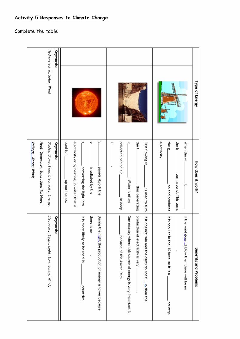
Activity 5 Responses to Climate Change Complete the table

Activity 4 Exam Question: Explain two sources of human greenhouse gases (4) _________________________________________________________________________________________________________________________________________________________________________________________________________________________________________________________________________________________________________________________________________________________________________________________________________________________________________________________________________________________________________________________________________________________________________________________________________________________________________________________________________________________________________________________________________________________________________________________________________________________________________________________________________________________________________________________________ Activity 5 Exam Question: Explain which type of renewable energy would be most suitable for the UK (4) ______________________________________________________________________________________________________________________________________________________________________________________________________________________________________________________________________________________________________________________________________________________________________________________________________________________________________________________________________________________________________________________________________________________________________________________________________________________________________________________________________________________________________________________________________________________________________________________________________________________________________________________________________________________________________________________________________________________________________________________________________

Activity 6 Rivers: Erosion Watch the video and complete the worksheet. If you cannot watch the video think about the Geog Jitsu (King Fu) we did in class. .Link: https://timeforgeography.co.uk/videos_list/rivers/river-erosion-processes/ Abrasion Definition: Annotated diagram
Attrition Definition: Annotated diagram
Hydraulic action Definition: Annotated Diagram
Solution Definition: Annotated diagram

Activity 7 Rivers: Transportation Watch the video and complete the worksheet. If you cannot watch the video think about the Geog Jitsu (King Fu) we did in class. Link: https://timeforgeography.co.uk/videos_list/rivers/river-transport-processes/ Traction Definition: Annotated diagram
Saltation Definition: Annotated diagram
Suspension Definition: Annotated Diagram
Solution Definition: Annotated diagram

Activity 8 Rivers: Features Use the boxes the create a storyboard of how a river feature of your choice is created eg. Waterfall, Meander, Oxbow Lake etc. You do not have use every box, but you must label your diagrams. If you are struggling to remember use one of the links from the front cover to help you. Using your storyboard write an explanation for how the feature you have drawn is formed _________________________________________________________________________________________________________________________________________________________________________________________________________________________________________________________________________________________________________________________________________________________________________________________________________________________________________________________________________________________________________________________________________________________________________________________________________________________________________________________________________________________________________________________________________________________________________________________________________________________________________________________________________________________________________________________________

Activity 9 Map Skills: Grid References Complete the worksheet on six figure grid references Look at the figure below. What is at the following grid references?
a) 276704 __________________________ b) 285715 __________________________ c) 272693 __________________________
d) 283692 _________________________ e) 288717 _________________________ f) 285705 _________________________
List the grid references for the following map features.
Give three reasons why six figure grid references are better than four figure grdi references
• • •
4 figure grid reference 6 figure grid reference School Centre of the wood Public House Campsite Level Crossing Picnic Site The “B” in B290

Activity 10: Map Skills: Symbols Complete the table naming the map symbols. Use this link to help you: https://www.ordnancesurvey.co.uk/mapzone/assets/doc/Explorer-25k-Legend-en.pdf
Symbol Name
Sch

A Letter to the Ordnance Survey You should follow the frame below:
School Address Ordnance Survey, Adanac Avenue, Southampton. SO16 0AS
Date Dear Sir/Madam,
I am writing to you to discuss the symbols that you use on your maps. In my opinion, the best symbol on the map is the................................, because.................................................................................................................................................................................................................................................................. Here’s a picture of the symbol: I think you need to improve the symbol for the ......................., because ........................................................................................................................................ ........................................................................................................................................ Here’s a picture of the symbol: This is how I would improve it: Thank you for reading this letter and I hope that my advice will help you design effective map symbols in the future..
Yours faithfully,
Signature Your full name and class

Activity 11 Map Skills: Scale Answer the Questions using the map below
1. How far is Barnet from Enfield?
2. How far is Weybridge from Croydon?
3. How far is Hounslow from Pinner?
4. The Metropolitan Tube Line in London divides into branch lines at Harrow. One branch goes to Uxbridge, the other to Watford. Which branch line is longer and by how much?
5. The Northern line runs from Morden in South London to Edgware in North London. The
District line runs from Richmond in West London to Upminster in East London. Which line is longer and by how far?
Explain why we need to have a scale on a map ____________________________________________________________________________________________________________________________________________________________________________________________________________________________________________________________________________________________________________________________________________________________________________________________________________________________
1cm 10k

Activity 12 Wordsearch Using the definitions work out what the word is and then find it in the wordsearch. When you have found to word add it to the table next to the definition. I Z J P J R F Q Z B Q U F G N D I A Z A E K J H I E L D T M G W M U W K S L A E O C U H Q G M T X S Q E L W X F U O A T Z U W P S S I A H N I J U M K S C A L E N E P Q K I B O T Q D G S N N D R F X Z L H W R O M G T T N E S D Q E R L G O S F T Z B V K V K Q P P A D K P I W U I N P A M W R F K J J Q Z P D B P I E P A T C B A B A A T D A X E W V L F J H H G X B C G I X P G E R W D M U P G Q I U J O C A U F M F I O R P L B W A Q O O O P D N J J L B B L W O D R N T B O V X T D K T S B X C Q K Y X T Y E I B Y K N W G N I L F G X S P P P N Y Q O Q C D H Y M V A P L M C P Y K B U O H P U Z U L W D J W I T A A R P X T C Y O B N U X E T T P B Q G X C W Q M F G T S Y D V H M W V U W R S V N R I C V Y G E X U S A E G O I U G X P M Y E L C P E P J T V K V D O W X T C K N O B A F Y W B A J N M N N H T E C N A T S I D H K Y W Q R N O G F X I A U W X P S P I K E Z I I B A L P X L K W V P A V V E X O N T M A T I E Z D Q D N Z V U D S M K T R O S Q V U Z G X Z H F U M D J D G U N Z N H G F X B C F D W P G U W E B U T K G Z X E B G K V B F Y C T W C Q N W I I G V S W S M Q N U K X B O F I N G L C Y X W T L K S C I C H H C Z K I F D S E Q D B J Q Y V W E Z L N E C H S Q T Q F Z L L I H Z Z Q V C L V R Q R Z W Y T U T R A N S P O R T A T I O N I C H Word Definition The length of the space between two points. Usually measures Metres,
Kilometres or miles. The difference between the highest and lowest elevations of an area. The ratio of the distance on a map in relation to the distance on the
ground. E.g 1CM=1KM. Rising temperatures will bring changes to rainfall, wind patterns and
weather conditions A period of time when Earth has permanent ice sheets The gases that surround the Earth keeping it warm. The wearing away of rock and soil found along the river bed and banks. When rocks/sediment are carried by the force of the river. The dropping of rocks and sediment by the river.

Activity 13 Crossword Complete the crosswords on rivers.