world meteorological organization … · world meteorological organization . ... communication...
TRANSCRIPT

WORLD METEOROLOGICAL ORGANIZATION
JOINT MEETING OF THE COMMISSION FOR BASIC SYSTEMS OPEN PROGRAMME AREA GROUP ON
PUBLIC WEATHER SERVICES (PWS) TASK TEAM ON IMPACT OF MULTI-HAZARD PREDICTION AND COMMUNICATION (TT/IMPACT) AND THE EXPERT TEAM ON MEETING USER NEEDS IN REDUCING
THE IMPACTS OF HYDROMETEOROLOGICAL HAZARDS
(ET/DPM)
SHANGHAI, CHINA, 27 JUNE-1 JULY 2016
FINAL REPORT

EXECUTIVE SUMMARY
The “Joint Meeting of the Commission for Basic Systems (CBS) Open Programme Area Group (OOPAG) on Public Weather Services (PWS) Task Team on Multi-hazard Prediction and Communication (TT/IMPACT) and the Expert Team on Meeting User Needs in Reducing the Impact of Hydrometeorological Hazards (ET/DPM)” was held in Shanghai, China from 27 June to 1 July 2016. The Meeting was chaired by Mr Paul Davies (Met Office, UK), the Chairperson of TT/IMPACT. Mr Eli Jacks, the Chairperson of ET/DPM tendered his apologies for his inability to attend due to unforeseen circumstances. The Meeting was informed of the decisions of CBS-MG-16 and EC-68 that were relevant to the work of ET/DPM and TT/IMPACT, and discussed how best those decisions could be addressed through the work of future ET/IMPACT. The key conclusions arising from the various reports, presentations and discussions are summarized below.
1. Merger of TT/IMPACT and ET-DPM: The Meeting supported the recommendation of the PWS OPAG/ICT to merge the TT/IMPACT and ET/DPM into a single expert team “ET/IMPACT”. The Team agreed on a pictorial representation for the new ET as shown in the report. (send to Catherine).
2. Promotion of Multi-Hazard Impact-based Forecast and Warning Services
(MHIBFWS) and encouraging National Meteorological and Hydrological Services (NMHSs) and stakeholder engagement: The Meeting agreed that every opportunity should be taken to promote the concept and practice of MHIBFWS and to emphasize the importance of stakeholder engagement by NMHSs.
3. Engagement of stakeholders to establish more concrete requirements:
The Meeting agreed that a key element in the success of Impact-based Forecasts (IBF) was the engagement of stakeholders to ensure that their requirements were clearly expressed, understood and recorded so that action could be taken on them.
4. Integration of social sciences throughout the entire end-to-end service
delivery process: The Meeting strongly supported the engagement of social scientists in the work related to IBF and agreed that to ensure success, social sciences needed to be integrated into the process of delivering MHIBFWS.
5. The need for two-way collaboration between research, technology and
science communities and NMHSs to ensure that user requirements are conveyed and acted upon: The collaboration between all contributors and stakeholders in the MHIBFWS was seen as crucial and the participants emphasized this point as a key message of the Meeting.
6. Review of PWS competencies to ensure requirements for the delivery of IBF
are included in the Framework and formulate training accordingly: The Meeting agreed that the PWS competency Framework as approved by Congress should be reviewed to ensure that any existing gaps in the provision of IBF are addressed and provisions are made in the Framework to guide the work of NMHSs to move towards delivery of MHIBFWS.
7. Fundamental role of Partnership in success:
The Meeting highlighted throughout the discussions the necessity for NMHSs to build partnerships with all the organizations and stakeholders that had a role in accessing and providing Impact-based Forecast and Warning Services (IBFWS).
________

- 2 -
1. INTRODUCTION 1.1 The Shanghai Meteorological Service (SMS) of China Meteorological Administration (CMA) kindly hosted the “Joint Meeting of the Commission for Basic Systems (CBS) Open Programme Area Group (OPAG) on Public Weather Services (PWS) Task Team on Multi-hazard Prediction and Communication (TT/IMPACT) and the Expert Team on Meeting User Needs in Reducing the Impact of Hydrometeorological Hazards (ET/DPM)”, in Shanghai, China, from 27 June to 1 July 2016. The list of participants is contained in Appendix I. On behalf of the China Meteorological Administration (CMA) Ms Wei Li welcomed the participants and wished the meeting success. Dr Chen Zhenlin (SMS/CMA) extended his own welcome to the participants and informed about the work of SMS in the area of impact-based forecasting. Dr Tang Xu (WMO Secretariat) welcomed the participants on behalf of the WMO Secretary-General and indicated the importance of the present meeting to continue with the initiative of the PWS Programme in impact-based forecast and warning services. The result of the work of the joint team would be an important step towards that goal with the preparation of more practical guidance in order to further assist Members to implement the principles contained in the “WMO Guidelines on Multi-hazard Impact-based Forecast and Warning Services” published in 2015. 1.2 The Meeting was chaired by Mr Paul Davies (Met Office, UK), who welcomed the participants to the meeting and outlined the objectives of the meeting and the issues that needed the focus of the Expert Team. He also relayed the regrets of Mr Eli Jacks, Chairperson of ET/DPM for not being able to attend the meeting due to unforeseen circumstances. The Chairperson explained the rationale for the joint meeting of the TT/IMPACT and ET/DPM, based on the discussions that took place at the meeting of Implementation Coordination Team of the Open Programme Area Group of PWS (ICT/PWS) in 2015, leading to proposals for restructuring the OPAG. As part of the restructuring, the two teams will be merged into a single Expert Team “ET/IMPACT”. These proposals were supported by the CBS Management Group in Geneva in February 2016, and will be formally presented to CBS at its 16th Session in November 2016 (See Agenda item 3). He drew attention to the Terms of Reference (TORs) of ET/DPM, as approved by the Fifteenth Session of the Commission for Basic Systems (CBS-15, Jakarta, Indonesia, September 2012), and those of TT/IMPACT as agreed to by CBS-Ext.(2014). The TORs are as follows: ET/DPM TORs (a) Monitor and report on the progress of recent initiatives of the Expert Team; (b) Develop a template for an agreement document for fostering collaboration and
partnership between National Meteorological and Hydrological Services (NMHSs) and respective national Disaster Management Authorities (DMA) organizations;
(c) Provide guidance to NMHSs on how to develop impact-based information, forecast, and
warning services on various time scales for Weather, Climate and Water (WCW) hazards; (d) Keep under review the development of cross-border exchange of warnings with
reference to the published WMO Guidelines; (e) Monitor and survey the usefulness of the work of the Expert Team in assisting NMHSs to
deliver improved products and services in reducing impact of WCW hazards; (f) Engage other WMO Programmes, PWS Expert Teams, CBS OPAGs and technical
commissions (TCs) to determine common areas of interest and possible collaboration; (g) Assist NMHSs with the definition and development of work force competencies needed
to effectively interact with the user community in the context of reducing impact of WCW hazards;
- 3 -
(h) Develop and maintain a list of experts in PWS aspects of reducing impact of WCW hazards who are willing to contribute to PWS training and development activities; and,
(i) Report to and make recommendations, as appropriate, to the ICT/PWS. TT/IMPACT TORs 1. Design and develop a plan to assist Members in implementing the “WMO Guidelines on
Multi-Hazard, Impact-based Forecast and Warnings Services” (MHIBFWS) using a multi-disciplinary approach within the framework of a Multi-Hazard Early Warning System (MHEWS);
2. Identify means to promote the concept of Multi-hazard Impact-based forecasts and
warnings among Members; 3. Identify competencies and relevant training needs associated with the wider
implementation of MHIBFWS. The Programme of the Meeting is contained in Appendix II. 2. ORGANIZATION OF THE MEETING
The Meeting adopted its agenda and agreed on its working hours to be 9:00-12:00 hrs and 13:30-17:00 hrs.
The Team members introduced themselves and gave a brief description of their national
responsibilities and the main issues that were the subject of their focus in their duties and responsibilities. It was clear from these introductions that the topic of impact-based forecasts and warnings and related issues was gaining increasing importance in nearly all NMHSs. 3. REVIEW OF RELEVANT DECISIONS OF CBS-MG-16 AND EC-68
The Meeting was informed by Ms Haleh Kootval (WMO Secretariat) of some of the decisions of CBS-MG-16 and the Sixty-eighth Session of the WMO Executive Council (EC-68) related to the work of the two Teams. The CBS-MG decided to recommend to CBS-16 to consider renaming the OPAG on Public Weather Services to the “OPAG on Public Weather Services Delivery (OPAG/PWSD). It further recommended that the previous Expert Team on Meeting User Needs in Reducing the Impact of Hydro-Meteorological Hazards (ET/DPM) should be re-named ET-IMPACT, and should take over the responsibilities of the “Impact Advisory Group” of the Task Team on Impact of Multi-hazard Prediction and Communication (TT/IMPACT) established by CBS-Ext (2014).
In recognizing that it is no longer sufficient to provide a good weather or flood forecast or warning for the population, based on Congress resolutions, EC-68 (June 2016) urged Members, with the support of the Secretariat, to accelerate adopting impact-based forecast and warning services, and invited Members with experience in this area to join with the Secretariat to share their knowledge and experience with those Members who wish to embark on this path, through twinning, mentoring and training. It also urged Members to support CBS and the Secretary-General in addressing the implementation of the seamless GDPFS, in which impact-related data processing is one of the critical blocks to be developed. EC requested CBS to initiate at CBS-16 (November 2016) as a matter of urgency, through the OPAG/PWS, the preparation of practical guidance materials based on the “WMO Guidelines on Multi-hazard Impact-based Forecast and Warning Services” and the experience gained from the in-country activities that have been initiated in 2015, for the step-by-step implementation of impact-based forecast and warning services by NMHSs. The cataloguing of hazards, and verification of probabilistic products used in impact-based forecasts and warnings, and consideration of

- 4 -
issues surrounding big data may also need to be taken into consideration in the preparation of the above-mentioned guidance material. EC also requested the Secretary-General to establish an indicator system for the assistance extended to Members who have requested it in this area. Such assistance could be through organizing training and in-country support for NMHSs and their stakeholders, and seeking partnerships with more advanced NMHSs in developing pilot projects in developing countries with the aim of eventual mainstreaming of this approach in their operations.
4. REPORT OF THE CHAIRPERSON OF ET/DPM AND TT/IMPACT
Mr Davies reviewed the work of the TT/IMPACT since its last meeting (Geneva 2015) in terms of the deliverables and actions taken, as well as matters, which would have relevance to the work of the Team.
The Chairperson reported that in recognition of the importance of partnership working
and stakeholder engagement, the inaugural meeting of TT/IMPACT (Geneva, February 2015) comprised representatives from a cross-section of stakeholders in impact-based forecast and warning service delivery including NMHSs, the health sector, The Global Facility for Disaster Reduction and Recovery (GFDRR)/The World Bank Group, humanitarian agencies (the United Nations Office for the Coordination of Humanitarian Affairs (OCHA)), private consulting service providers, social sciences, and communication. Among the main outcomes of the meeting was the emphasis on a pragmatic approach toward promoting impact-based forecast and warning service delivery in NMHSs. This approach would be characterized by practical implementation activities such as region- or country-specific pilot projects that would be scalable to other countries and regions, an example of which was Myanmar.
Stimulating the need for action and attracting the required decision makers may be the hardest part of integrating an impact-based forecast and warning service into disaster risk reduction management. This will require evidence of recent hydrometeorological events that have had negative impact on people, the economy or reputation of the country, and perhaps more importantly, will require a good understanding of the needs and expectations of the user community. The Task team further noted that impact-based forecasting could enhance existing, or develop new services for businesses such as operators of Hydroelectric dams and managers of retails outlets (users shouldn’t necessarily be restricted to Disaster Risk Management teams). Moreover, the team acknowledged a need to provide additional guidelines in dealing with uncertainty and exploitation of ensemble forecasting as well as addressing the need to express the uncertainty emanating from the hazard-to-impact translation and how best to communicate this uncertainty to users. This will involve training, and, in the context of impact-based forecasting, a review of the underpinning competency framework that enables the delivery of an impact-based forecasting service.
The Chairperson emphasized that there are a myriad of technological challenges in dealing with big data in a meteorological context, but how best to utilise big data for improved services will become an increasingly important topic as more sophisticated impact-based related services are developed. These considerations might include the necessary visualisation systems if a forecaster is to make sense of the vast amounts of information now available; the optimum use of probabilistic information from Ensemble Prediction Systems; the evolving role of the forecaster who has to deal with increasing amounts of information and mould it into improved products and services; e.g. combining forecasts with exposure and vulnerability data (in a rigorous manner) to generate impact-based services. In summary, the Chairperson concluded that moving towards an impact-based forecasting service ethos would require a paradigm shift in thinking as it requires new processes, tools, and new skills. It requires honesty, openness – soft skills that are actually hard and a certain amount of resolve and courage. At its heart, the transformation to impact-based forecasting will require new partnerships, sometimes with unexpected partners, but a

- 5 -
partnership that could expose a diverse range of capabilities that could be harnessed to create new and innovative solutions.
Ms Kootval, on behalf of the Chair of ET/DPM gave a brief update on the status of the work of the ET. She drew attention to the completion of the work of the ET with the publication of the “WMO Guidelines on Multi-hazard Impact-based Forecast and Warning Services- WMO-No. 1150”, and the recommendation by ICT/PWS to merge the work of the ET with that of TT/IMPACT in the framework of the new expert team ET/IMPACT. 4.1 Review of the proposed Terms of Reference (TORs) of the new ET/IMPACT
The Meeting reviewed the proposed TORs and offered a number of amendments. The amended TORs are reflected in Appendix III. 4.2 Review of the deliverables from the 2013 meeting of ET/DPM (Mauritius)
The Meeting reviewed the deliverables, which had been agreed to at the Mauritius meeting in 2013. It took note of one action that was still outstanding related to preparation of training requirements material to address impact-based forecast and warning services and agreed to take up this item under a new TOR of the ET/IMPACT. 5. PRESENTATIONS BY ALL PARTICIPANTS ON THEIR EXPERIENCES ON IMPACT-BASED FORECAST AND WARNING SERVICES: SUCCESSES AND CHALLENGES
Each participant made a presentation on the level of their experience in implementing impact-based forecast and warning services in their respective national institutions and the challenges met. These are reflected below. 5.1 Ms Jennifer Milton (Meteorological Service Canada, MSC), Canada Building a Weather Resilient Canada – Highlights, challenges and considerations in changing the culture and programs in MSC
In recent years, the Meteorological Service of Canada (MSC) has brought changes to its meteorological and environmental warning programs. These changes were motivated by the need to modernise the warning production tools used in prediction systems, developments in Numerical Weather Prediction and the impetus to making warnings increasingly relevant to users of this information.
MSC’s new Service Strategy defines the changes to the warning program and details the multi-scale, multi-hazard approach being developed to address requirements identified by stakeholders such as Public Authorities, Emergency Management Organisations, Health sector, media, and the public. This strategy supports where and how ‘Science to Services’ can better enable the authoritative alerting capacity of the MSC through the development of products, services and information that: - inform through early warning of the occurrence of potential high-impact weather, - communicate information regarding the predictability of high-impact weather, - incorporate social science research in the development and design of products, - are disseminated through various channels such as social media, wireless devices and
interoperable systems, - support access to public weather, water and climate information and services, - enable stakeholders to better integrate weather, climate and water information in their
decision making processes and emerging needs.

- 6 -
Partnerships between MSC and specific stakeholders are gradually leading to the development of impact-based information. For example through partnerships with the health sector (Health Canada), developments in the monitoring and modelling for air quality forecasts, and wildland fire smoke dispersion (through the Wild Fire Smoke Prediction System ‘Fireworks’) have led to the implementation of air quality forecast products associated with health-based risk levels and health advice. The Meteorological Service of Canada includes, in its public warning and special weather statements, the identification of potential impacts related to significant weather events and related recommendations garnered from Emergency Management and Health agencies.
The establishment of partnerships and outreach activities with various audiences enhances the understanding of severe weather, weather alerts and appropriate responses. Weather preparedness meteorologists work closely with the disaster management community at various levels of government in order to inform these users and also better understand their requirements for meteorological information. These weather preparedness meteorologists are in daily contact with emergency management organizations and some work on-site with this community. These collaborations have increased the understanding of partner’s vulnerabilities and are paramount to improving the decision making process of weather sensitive users. The development of products serving the extended user community such as ‘Early Notifications’, the Integrated Seasonal Climate Bulletin and pilots for impact-based approaches, such as the Weather Vigilance project and Veenix, have identified the following findings, among others: 1) Information related to forecaster confidence as well as a qualitative description of the
weather ‘a weather story’ are requested by many users; 2) Weather considered to have little or no impact can be significant for some users. An
impact-based approach would enable the adjustment of thresholds relevant to vulnerability thresholds;
3) Impact-based approaches should consider the integration of climatic, environmental and societal vulnerabilities and risk communication;
4) There is a need for user-outreach education, in particular in longer range prediction; 5) Training of NMHS staff is required on how to establish partnerships, gather
requirements, the understanding of concepts and linkages between hazards, vulnerability and impacts.
These pilots have also identified the need for changes in work flow and required
competencies of MSC staff. In order to address this, the ‘Decision Support Training for Weather Preparedness’ pilot was developed and delivered in 2015. Its main objectives were to develop competencies related to (1) communication with media and emergency management organisations, (2) the perception of risk, (3) the establishment of partnerships and understanding of requirements of Emergency Management Organisations, (4) use of specific tools and knowledge supporting users’ requirements for information.
The transformation of MSC’s warning program towards impact-based approaches will require a change in culture of the organisation. Pilots for impact-based approaches have initiated the assessment of user requirements for weather, climate and water information, forecasts and warnings and will guide further development. These pilots have also contributed to bringing a better understanding as to how organisations may use the information produced by MSC, on aligning its products towards impact-relevant information and in reinforcing a user-centered approach to services. Understanding partner’s needs and vulnerabilities and maintaining an awareness of these needs as they evolve are key in supporting this transformation and providing effective meteorological and hydrological services. 5.2 Ms Wei Li (CMA), China
In recent years, CMA has put risk assessment and risk-based warnings of meteorological hazards as key priorities of public meteorological service. An operational

- 7 -
system of risk-based warning has been established, covering risk survey, identification, warning, and assessment.
Since 2012, CMA, in cooperation with DMAs, has carried out risk surveys on floods, flash floods, landslides and mudflows induced by heavy rainfall in small and medium-sized river basins. This task has come to an end in 2190 counties in China, covering 5860 small and medium-sized river basins, 17759 flash flood sites, 12438 mudflow sites, and 53589 landslide sites. Totally, more than 1,160,000 records have been collected.
A database on historical meteorological disasters in China has been set up. It includes information on 28 types of disasters, such as drought, flood, typhoon, frost, heat wave, heavy snow, etc. It also includes impact information from different sectors, such as public, agriculture, animal husbandry, irrigation, industry, forestry, fishery transportation, power generation, telecommunication, infrastructure, commerce and other industries.
The thresholds of area precipitation leading to disaster have been estimated for small and medium-sized river basins, sites of flash floods, landslides, and mudflows, as well as for cities affected by waterlogging.
The correlation between precipitation and disaster is identified and the precipitation thresholds leading to disaster with different time scales and levels are calculated by using statistical analysis methods and hydrological models, for each river and potential sites of flash food, landslide and mud flow. Four risk levels are implemented with distinct colours, i.e. blue (low risk), yellow (medium risk), orange (high risk) and red (extremely high risk). These risk levels are coupled with different time scales corresponding to certain rainfall duration (48h, 24h, 12h, 6h, 3h and 1h). A total of 120040 threshold values have been developed up to now.
A Quantitative Precipitation Estimation (QPE) system has been established by CMA. This system is based on data from an automatic observation network and interpolated data from satellites and radar. National Quantitative Precipitation grid Forecast (QPF) sharing is applied and QPF products are developed, which are available nation-wide with 5km spatial resolution and 24hour on-going forecast capability. This has provided operational support for risk-based warning services of meteorological disasters. At provincial level and city level, 1-hour precipitation nowcast is also available based on 1km and 6 min on-going radar observation data and 1-hour QPE inverted from radar echo and surface precipitation data.
An up-to-date climate risk assessment is crucial to evaluate and estimate the possibility and consequences of meteorological disasters. Based on meteorological forecast and historical loss data, this risk assessment can provide necessary information of e.g. the spatial coverage, depth, and duration of a precipitation-triggered inundation and can estimate possible losses due to the disaster.
CMA has developed the operation platform “risk-based warning system of flood, flash flood and geological disaster induced by rainstorm". The system now includes the following

- 8 -
components: monitoring of rivers, flood and geological disaster, real-time data processing of the potential hazardous sites, threshold-based warning, inundation model analysis presentation, man-computer interaction warning revision, warning approval and issuing.
Risk Warning Operation Platform Flow
Real-time services of risk-based warning have been carried out at national, provincial, city, and county levels. Geological hazard warning is jointly disseminated by the Ministry of Land Resources and CMA. Flash flood warning is jointly disseminated by Ministry of Water Resources and CMA. The production, correction and dissemination of the warning products are the responsibilities of the meteorological services at provincial, city and county level.
CMA has developed a national emergency warning system, which is an information sharing mechanism with DMAs and other government agencies and instant information release system. Warnings are disseminated via a variety of communication means, including TV, radio, internet, mobile phone, land line services, Micro-blogging, Wechat, electronic display screens and radio loudspeaker in rural areas. With these systems, information of emergencies can be quickly collected, shared, and released at national, provincial, city and county levels.
5.3 Dr Chen Baode (SMS), China:
In this presentation, an overview of the NWP systems, namely, a holistic multi-scale regional high-resolution assimilation and model system, used in the SMS operational forecasting was given. Currently, the related research is mainly focused on the development of 1-km resolution meso-scale modelling system, and the physical initialization, gray-zone moisture processes and sub-grid mixing are major research subjects. In addition, a framework on how to translate weather forecast information into impact/risk information was proposed. These involve four steps: 1) gathering best available forecast and observational data, 2) translating weather forecasts into hazard information, 3) putting the hazard information into situational context, 4) with resulted impact/risk estimation, supporting decision-making for response and mitigation. 5.4 Dr Qiang Wang, (SMS), China: Exploration of urban flooding impact-based forecast and risk-based warning in Shanghai With global warming and acceleration of urbanization, urban rainstorm water logging happens more frequently with higher intensity, which has aroused great concerns of both governments and people. Shanghai is a crowded megacity with advanced economy, thus huge demands on meteorological service has been aroused. In order to enhance risk management ability, Shanghai Meteorological Service (SMS) has transformed relevant service from traditional ways to impact-based forecast and risk-based warning services.

- 9 -
Fig 1a Shanghai Urban Flooding Disaster Distribution map; Fig 1b Shanghai Heavy Rain frequency Distribution map
SMS has developed a friendly partnership with relevant authorities like Civil
Administration, Construction and Traffic Committee, Water Sectors and so on. Thus, a mechanism of long-term data sharing has been set up. SMS also conducts urban flooding risk survey jointly with Water Resources Sector to collect risk potential data every year. A risk database has been built and is updated regularly.
With continuous explorations, the Shanghai Urban flooding assessment Model (SUM) has been developed. In order to transform surface water simulation results into practical risk-based products that can be used by communities, we set up four urban flooding impact levels and relevant hazard thresholds with communities. Meanwhile, warning icons and relevant explanations have been agreed to. According to the explanations of warning icons, corresponding actions will be taken by the management staff to lower the risk in their community.
Fig 2. Community urban flooding risk-based warning product
SMS has developed impact-based forecast and risk-based warning services dissemination systems. Unlike the traditional way of warning service, communities now receive risk warnings directly from SMS. As a result, the relevance of service has been improved as well as communities’ satisfaction. Up to now, our services have covered all the communities in two districts of Shanghai. In the future, we will build a working cycle to better serve the users.
a b

- 10 -
Fig 3. A direct train for impact-based forecast and risk-based warning 5.5 Mr L.S. Lee (Hong Kong Observatory), Hong Kong
Mr Lap-shun Lee of the Hong Kong Observatory (HKO) briefed on the examples of weather warning services in Hong Kong which have taken impact and risk of weather into consideration.
In Hong Kong’s rainstorm warning system, there are three colour-coded tiers. Amber, red or black rainstorm warning will be issued, if heavy rain exceeding 30, 50 or 70 millimetres respectively in an hour has fallen, or is expected to fall generally over Hong Kong, and is likely to continue. With different infrastructure and natural environment across the territory, the degree of traffic disruption, flooding and landslip caused by heavy rain can vary significantly and these are also the factors for consideration in the warning system.
The HKO operates the landslip warning system in collaboration with the Geotechnical Engineering Office (GEO) of the Civil Engineering Department of Hong Kong. Its operation requires the knowledge of both the recorded and forecast rainfall intensity in real-time. The GEO has developed a correlation between 24-hour accumulated rainfall and number of landslips. Areas with more historical occurrences of landslip are assigned larger weightings. The warning level is reached when the predicted number of landslips reaches a pre-defined threshold. The role of HKO is to forecast whether rainfall in the next 1 to 3 hours, when summed up with the past rainfall, can give a 24-hour accumulated rainfall that causes landslips reaching the warning level in accordance with the rainfall-landslip correlation developed by GEO.
Regarding tropical cyclone, the HKO operates a graded signal system to warn the public of the threat of winds associated with a tropical cyclone. The system consists of numbers representing increasing levels of local wind strength. Number ‘1’ indicates general alert, ‘3’ means primary school and kindergarten students having no school, and ‘8’ means all schools closed and most organizations releasing their staff to return home. In an effort to reduce traffic disruption when millions of people hurry home at the same time when number 8 signal is issued, the HKO keeps close liaison with relevant government departments and transport operators to ensure a state of readiness. In this regard, when number 3 signal is in force, the HKO will provide them with updates on the probability of number 8 signal. The provision of risk assessment on higher impact weather, with mutual understanding between HKO and users on the interpretation of the probabilistic terms, can help avoid traffic chaos in tropical cyclone situations.
During the passage of a tropical cyclone, the HKO will also provide alert to the public to take precautionary measures against possible flooding due to storm surges. Besides the territory-wide alert, the HKO also issues specific alerts for certain low-lying areas vulnerable to flooding, so that mitigation measures based on local need can be arranged to alleviate the impact of flooding to local residents. Considering the local conditions, the HKO adopts
Shanghai Meteorological Center
Flood headquarter
District flood headquaters
Sub-district offices
Residents’s committees
Shanghai Meteorological Center&
Section-8 Multi hazard risk analysis and reduction support
Sub-district offices&
Residents’committees
Community flood-control headquarter’s staffs are in position
Weather warning is transmitted by Residents’committees and precautions are accomplished by them, too.
Water intakes on roads are cleaned by sanitation worker
Pump stations' staffs are in position
Emergency teams stay active for possible emergency
Victims are transferred and aided

- 11 -
different thresholds of water level for issuing the storm surge alerts for different flood vulnerable areas.
The HKO operates the fire danger warning to alert the public of conditions when fire risk is high, in the interest of protecting lives and property. Besides taking weather factors and vegetation conditions into account when considering the issue of warnings, the HKO also considers exposure factors related to social activities. Past records show that there were more fires during public holiday and some festivals such as the one in autumn when Chinese people traditionally went to the hills or cemeteries and paid tribute to their ancestors. The operation of fire danger warning is effective in saving lives and rescuing the precious trees by considering whether there will be more people engaging in activities in the countryside. 5.6 Mr Prem Goulaup: Mauritius Meteorological Services
Though Mauritius is a small island of about 2040 km2, some 800 km to the east of Madagascar, it has an Exclusive Economic Zone of about 2.3 million km2. Therefore, the country has the responsibility to keep weather watch and issue severe weather warnings for the population of the scattered Islands and for its fishing vessels over this extended large area of Ocean.
The most important weather hazards in this part of the world are tropical cyclones, heavy rainfall leading to flood and flash flood, landslide and rock fall, storm surge, high energy waves from extra-tropical cyclones travelling the southern Indian Ocean. The Island is located in a zone with low probability of being hit by tsunami waves.
The current warning system for the various hydrometeorological hazards is well documented though it is not a Multi-hazard, standardized colour-coded alert system. The country has not yet implemented the Multi-Hazard Impact-Based Forecast and Warning Services (MHIBFWS). Following the October 2015 WMO Stakeholders Consultation Workshop to implement the impact-based warning services in Mauritius, certain aspects of the MHIBFWS have been included in the warning bulletins issued during the cyclone season 2015-2016 of the Southwest Indian Ocean in collaboration with the National Disaster Risk Reduction and Management Centre (NDRRMC). This additional service was well received by the public.
As an example, the weakness in the existing torrential rain warning system was highlighted, wherein a torrential rain warning is issued only when the threshold of 100 mm of rainfall is equal to or has been exceeded in 12 hours. Over the last decade 15 people perished with significant material damage in various localized areas during several recurrent torrential rain events, though warnings were issued. It was argued that an impact-based warning service would have prompted the population to take necessary precaution and most likely lives would have been saved. Other examples considered were strong wind, high waves and storm surge warning.
At the October 2015 WMO Stakeholders Consultation Workshop, the concept of risk, exposure and vulnerability were introduced. The various hazards were categorized and impact and mitigation matrices were developed for the different sectors concerned. As a follow-up of the October 2015 Workshop, a “Wave model workshop” to identify the risk areas in the coastal zones was sponsored by WMO and held in mid-December 2015. Some of the risk maps needed for the provision of an impact-based warning service already exist at various Ministries/department. MMS has started to gather the relevant information.
Some of the challenges in the provision of an early warnings in Mauritius are the absence of high resolution model products in the region; (at the moment MMS uses product from ECMWF and Meteo France), the limit of model to capture high intensity rainfall in localized area and the explosive intensification of tropical cyclones. The implementation of the MHIBFWS will enhance the collaboration among stakeholders concerned with disasters and will contribute to reduce loss of lives and property.
- 12 -
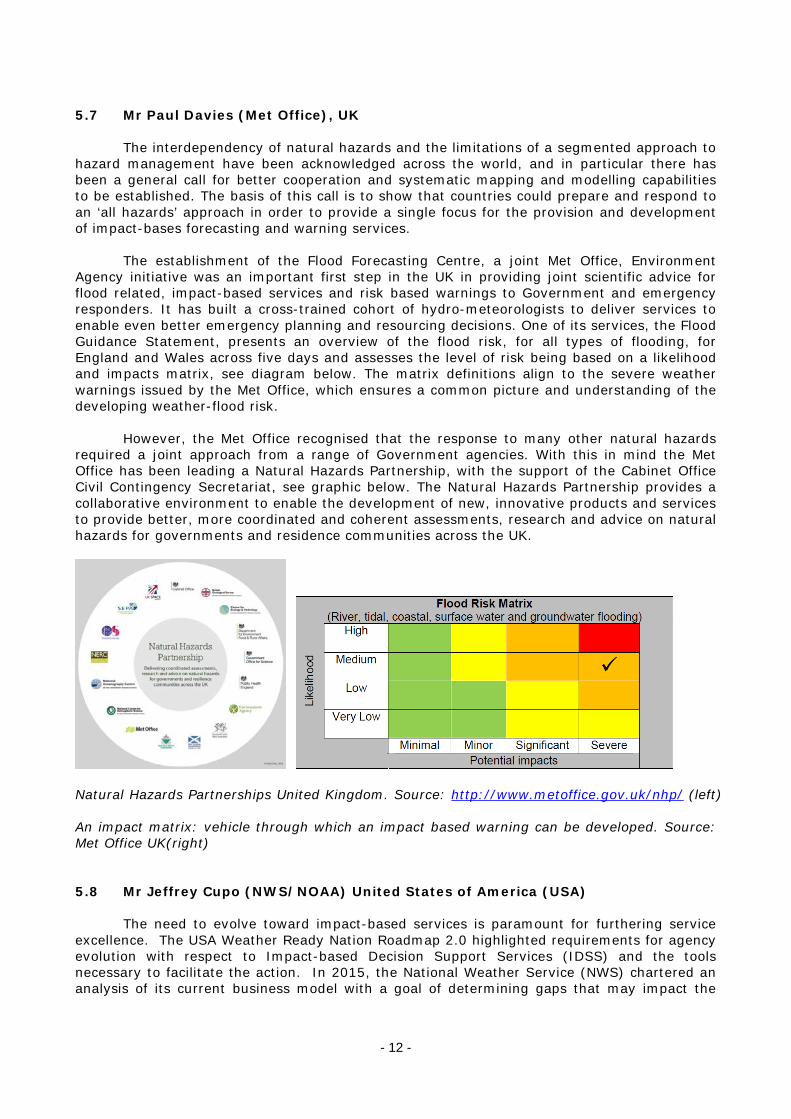
5.7 Mr Paul Davies (Met Office), UK
The interdependency of natural hazards and the limitations of a segmented approach to hazard management have been acknowledged across the world, and in particular there has been a general call for better cooperation and systematic mapping and modelling capabilities to be established. The basis of this call is to show that countries could prepare and respond to an ‘all hazards’ approach in order to provide a single focus for the provision and development of impact-bases forecasting and warning services.
The establishment of the Flood Forecasting Centre, a joint Met Office, Environment Agency initiative was an important first step in the UK in providing joint scientific advice for flood related, impact-based services and risk based warnings to Government and emergency responders. It has built a cross-trained cohort of hydro-meteorologists to deliver services to enable even better emergency planning and resourcing decisions. One of its services, the Flood Guidance Statement, presents an overview of the flood risk, for all types of flooding, for England and Wales across five days and assesses the level of risk being based on a likelihood and impacts matrix, see diagram below. The matrix definitions align to the severe weather warnings issued by the Met Office, which ensures a common picture and understanding of the developing weather-flood risk.
However, the Met Office recognised that the response to many other natural hazards required a joint approach from a range of Government agencies. With this in mind the Met Office has been leading a Natural Hazards Partnership, with the support of the Cabinet Office Civil Contingency Secretariat, see graphic below. The Natural Hazards Partnership provides a collaborative environment to enable the development of new, innovative products and services to provide better, more coordinated and coherent assessments, research and advice on natural hazards for governments and residence communities across the UK.
Natural Hazards Partnerships United Kingdom. Source: http://www.metoffice.gov.uk/nhp/ (left) An impact matrix: vehicle through which an impact based warning can be developed. Source: Met Office UK(right) 5.8 Mr Jeffrey Cupo (NWS/NOAA) United States of America (USA)
The need to evolve toward impact-based services is paramount for furthering service excellence. The USA Weather Ready Nation Roadmap 2.0 highlighted requirements for agency evolution with respect to Impact-based Decision Support Services (IDSS) and the tools necessary to facilitate the action. In 2015, the National Weather Service (NWS) chartered an analysis of its current business model with a goal of determining gaps that may impact the

- 13 -
effective provision of IDSS across the agency. By doing so, future operational roles and responsibilities would be developed for further discussion and review.
As we consider impact-based services, we need to consider the impact of the services themselves. The majority of NWS stakeholders are now increasingly requiring interpretive and interactive services. It is imperative that we review our service practices to reflect what the weather will do, rather than what the weather will be. While remaining strong in our science leadership, highlighting the impacts based on the science is critical to formulating a clear, easy to understand message upon which action can be taken. NWS is a science-based service organization.
Current accomplishments in the impact-based arena include retooling some of our severe weather and hydrological services to highlight the impacts the forecasted phenomena are expected to cause. Other accomplishments include the decision to expand Regional Operations Centers (ROC) across all six regions of the agency to improve message consistency for our regional partners, and to increase the number of specialists available for meeting the increased demand for embedding experts within state and regional Emergency Operations Center (EOC) operations during high-impact events. Along the same lines, we are developing Emergency Response Specialist (ERS) training plans for improved on-site skillsets to meet this increased demand.
Hazard Simplification continues to be another key improvement area that, once implemented, will reduce the number of text products from which the receiver will have to interpret. We continue to test and refine the Impacts Catalogue at certain local offices that will, once finished, provide focus for issuing alerts for key stakeholders for user-defined thresholds important to them.
Other accomplishments focus around increasing our relationship development with our key stakeholders. For example, “Pathfinder” Initiative is focusing on collaboration between local NWS Forecast Offices and their Departments of Transportation in order to translate the weather forecast into transportation impacts and improve message consistency between agencies. Evolving services within the health sector incudes NWS partnership with the Centers for Disease Control and Prevention (CDC) for improved response and preparedness efforts for mitigation purposes as well as Federal Emergency Management Agency (FEMA) for messaging support. Ecological services have also been identified as critical, partnering with other federal agencies such as the National Ocean Service (NOS) to provide corrective and mitigative action with respect to Harmful Algal Blooms and other water-based pathogens. Current gaps include verification of impact-based services as we attempt to measure our benefit for partners and society. The current arithmetic statistics would not serve the need to measure the value of our services to society, assuming we are fully successful in soliciting the proper response from impact-based services. Accordingly, new metrics are being analyzed to gather information on actions based on current forecasts. For example, we are testing measures that evaluate the change in the behaviour of the public based on the messages that are being transmitted and received. User-specific metrics are also being developed, including a fire weather-based metric, comparing the fire weather user decisions on forecasts with those that would have been made if the forecast was perfect (i.e., what we did vs. what we should have done). 5.9 (SMS), China, Impact-based Health Forecasts
It is well known that weather, climate and air pollution have direct and indirect effects on human health. Based on the capacity of weather forecasts, SMS provides health forecasts to the public and some special users to alleviate and avoid health risks caused by deteriorated weather and environment.

- 14 -
SMS has provided several types of health forecasts, such as meteorological index for daily life, food poisoning alert, heat index in Shanghai Expo 2010, and respiratory health forecast. Meteorological indices for daily life usually give people information on dressing, drinking, exercising and so on. Food poisoning alert is released during May and October each year when the incidence of bacteria food poisoning is higher. It provides catering enterprises and the public the risk of food poisoning and measures to take. During Shanghai Expo 2010, SMS provided heat index forecast to Expo Operations Command Center, who then could take cooling measure and arrange dispatched ambulances. In recent years, SMS has developed a forecast service for respiratory diseases, including common cold, asthma, and chronic obstructive pulmonary diseases (COPD). The risk of two days ahead could be automatically computed based on prediction models. Information of vulnerable people and advice is also included in the service. A pilot service has been conducted in 3 districts in Shanghai through a variety of dissemination ways, such as website, text message, electric screen, booklet, and mobile WeChat jiangkangqixiang.
SMS has evaluated the effect and efficiency of some health forecasts, which show good
outcomes. Over 90% of restaurants were satisfied with the bacteria food poisoning alert, and most people would take action on high-risk days. A cohort study was conducted on 2324 children in 10 kindergartens, which were divided in 2 groups, one receiving cold forecast (intervention group), and the other group not (control group). It showed that the days of absence from school declined by 2.6 days per person every year for the intervention group as compared with the control group. The cold incidence in intervention group was also less than the control group. 6. DISCUSSIONS AND DECISIONS ON THE MAJOR TOPICS TO BE ADDRESSED BY THE MEETING
The members of the ET and TT had been requested to suggest topics for the future work of the Team. These topics were meant to represent those areas that are important for the provision of effective forecasts and warnings by NMHSs, and all the associated issues, and which still need additional work and attention. A number of areas had been identified for discussion as listed below:
6.0 Developing, together with partners, an implementation plan based on “WMO Guidelines
on Multi-hazard Impact-based Forecast and Warning Services” (WMO-No. 1150) 6.1 Training and competencies in impact-based forecasting and warning services 6.2 Verification and evaluation of benefits of impact-based forecasts and warnings to social
and economic sectors 6.3 Harmonization/standardization/consistency of colours, messaging, graphics and formats
in impact-based forecasts and warnings 6.4 Development/strengthening of relationships with partners, in particular disaster
management agencies 6.5 Targeted thresholds for users 6.6 Use of probabilistic information in the forecast and warning process 6.7 Science and technology requirements to support impact-based forecasting and warning
services
Following extensive discussions the Meeting agreed to the development of an implementation plan to the existing Guidelines (item 6.0) and decided to use the other suggested items as chapter headings for the new publication, bearing in mind that these headings may not be exhaustive and that other topics could be added to the list as may be necessary. An annotated list of topics was developed by the Meeting as shown below. 6.1 Training and competencies in impact-based forecasting and warning services Under this item, the discussions focused on 2 areas, namely:

- 15 -
1. Review the Competency Framework for PWS Forecasters and Advisors (in particular the
competencies for a Disaster Prevention and Mitigation Weather Advisor) and identify other competencies required in Multi-disciplinary teams developing and supporting impact-based services;
2. Identify existing training that support the development of competencies specific to
impact-based forecasting and warning services. 6.1.1 Rationale in addressing ‘Training and competencies’ (the Why) Capacity building activities related to impact-based forecasting and warning services are required in order to: - inculcate the paradigm shift in mitigating adverse impacts of hazards/disasters - sustain or build new competencies among NMHS staff and specifically PWS personnel - create a multi-disciplinary team and multi-skilled operational staff - promote understanding of concepts serving MHIBFWS - understand scientific or technical background information - consider needs of stakeholders - ensure that staff are competent in production, delivery and continuous improvement in
the provision of MHIBFWS 6.1.2 Components supporting ‘Training and competencies’ (the What) - Revision of the Competency Framework for PWS Forecasters and Advisors (in particular
the competencies for a Disaster Prevention and Mitigation Weather Advisor) and identification of other required competencies in Multi-disciplinary teams developing and supporting impact-based services;
Some of the Competencies to be considered within the competency framework (non exhaustive):
o Communication and Interactions with stakeholders, including media o Development of relevant messages specific to impact-based services o Integration of the various facets required in the development and delivery of
MHIBFWS (including information related to social sciences) o Verification of IBFWS o Development of standardized products o Establishing relationships with highly relevant stakeholders o Use of NWP, probabilistic information and Ensemble Prediction Systems o Use of tools and applications used within NMHS, including GIS o Development of case studies o Risk assessments
- Identify resources that can be used for the development and delivery of training and continuous professional development. This may include Subject Matter Expertise, Education and Training Focal Points within NMHSs and Regional Training Centres (RTCs), training material and delivery methods
- Identify and organise outreach & training to support the relevance and the understanding of concepts of MHIBFWS;
- Define mechanisms to support change management for all staff within NMHS including top management;
- Identify training related to changes to the work flow for PWS forecasters and advisors; - Develop guidelines and new tools for the training of trainers in MHIBFWS; - Gather knowledge on the perception of risk in different cultures; - Provide expertise to stakeholders in the development of training for their purposes;
- 16 -
6.1.3 Activities supporting the development and implementation of ‘Training and competencies’ (the How) - Revise the Competency Framework for PWS Forecasters and Advisors (in particular the
competencies for a Disaster Prevention and Mitigation Weather Advisor) and identify other required competencies in Multi-disciplinary teams developing and supporting impact-based services;
- Conduct workshop with partners to exchange/share information regarding the impacts of hydro-meteorological hazards on their activities. This will also support the understanding of cascading impacts;
- Conduct workshop on defining competencies, training resources and outcomes through the ETR community in coordination with PWS;
- Identify TC/RA/RTCs workshops where MHIBFWS training can be delivered among other topics;
- Identify opportunities where expertise and best practices can be shared between NMHS and partners (ex: twining, workshop or symposiums on training);
- Develop or share training material, using collaborative e-learning platforms – e.g. WMO Global Campus initiative;
- Involve expertise such as social sciences to support change management; - Use SOPs to address the changes in work flow - Organize training on the perception of risk among the stakeholders, in different cultures - Organize training on the development and use of Impacts catalogue - Use case studies as training material 6.2 Verification and evaluation of benefits of impact-based forecasts and warnings to social and economic sectors 6.2.1 ‘the why’ - Society requires a clear idea about the cost effectiveness of a public service. Therefore,
it is important to develop a cost-effective MHIBFWS and to be able to provide insight into benefits of the service (e.g. Pappenberger et al., 2015), as well as to justify future investments in improving & maintaining a MHIBFWS.
- Partners need to have a clear idea about benefits and performance - Current metrics are not capable of measuring performance of MHIBFWS 6.2.2 ‘the what’ - Continuous/Systematic verification of MHIBFWS using observational databases 6.2.3 ‘the how’ - Develop metrics reflecting how well informed the public is on weather related impacts - Develop metrics reflecting how well prepared the public is prior to any event - Develop metrics reflecting whether or not the public took appropriate actions once an
event occured - Develop metrics reflecting the extent to which the action taken by the public reduced
property damage or avoided injuries/fatalities - Comparison of decisions based on impact-based forecasts with those that would have
been made if a perfect forecast would have been achieved (what we did / what we should have done)
- Develop observational database(s)

- 17 -
6.3 Harmonization/Standardization of colours, messaging, graphics and formats 6.3.1 ‘the why’ - Simplify the message/warning - People tend to like and relate/respond easily to colours (e.g. traffic light) - Colours are adaptable (sub scales can be used) - Enabling machine-machine communication for faster notification (e.g. CAP) - Language independent 6.3.2 ‘the what’ - Universally harmonized/standardized colours, messaging, graphics and formats (ISO
standard)
6.3.3 ‘the how’ - Adopt colour scheme informed by social science and existing best practise (e.g.
MeteoAlarm) - Adopt data and messaging standards/protocols (e.g. CAP) 6.4 Development/strengthening of relationships with partners, in particular disaster management agencies 6.4.1 ‘Development of relationships’ (the Why) Partnership between NMHS and other stakeholders are essantial in the development and implementation of Multi-Hazard Impact-based forecast and warning services, in order that these services be useful and respond to needs of these stakeholders. The development and establishment of relationships with relevant stakeholders will enable: (1) The development of MoUs to:
- Define roles and responsibilities of NMHS and partners; - Promote the role of NMHS to provide authoritative warnings services; - Identifying requirements and other relevant information
(2) The development of requirements to:
- Enable the understanding of how meteorological, climate and hydrological information, products and services support decision making activities of partners related to the reduction of negative impacts of multi-hazard events;
- Understand the vulnerabilities relative to the mandate of those partners in order that this information be integrated in the prediction and services process of NMHS
- Identify requirements for information, products and services; - Define intellectual property rights, expectations and limits;
(3) The definition of products and services: - Enable, develop and implement the delivery of collaborative products and
services by the NMHS and partners; - Identify the development of joint ventures, methodologies and processes for
mutual benefit and interest; - Collect and share data so as to enable NMHS to provide an improved service
(work in collaboration with partners and other stakeholders in certain projects of (national) interest to both parties).
6.4.2 Components supporting ‘Development of relationships’ (the What)

- 18 -
- Development of a MoU - Description of the context of the establishment of the relationship: International
(if required), WMO Regional Association, country and local - Definition of issues, the mandate and specific objectives of relationship - Definition of organizations involved, roles and responsibilities, and linkages
between these - Definition of concepts of impact-based forecasting and warnings Services that
support the mandate - Definitions of Intellectual Property rights during and post project. Legal
implications and legislative context of organizations - Exchange protocol and platforms - Definition of data and research needs and development (incl meteorological,
climate, hydrological, data from partners) - Definition of Big data requirements - Definition and details of required services (that will be detailed in other sections
of the implementation plan, including training, metadata) - Establishment of potential fast track processes with end-users in exceptional
situations - Inclusion of risk perception, exposure and vulnerability concepts - Definitions and expectations in the collaborative process (meetings, exchange of
information, documentation, reporting, archiving) - Verification and benefits - Communication plan, means and processes - Quality management processes - Expectations for ongoing support - Development of contingency plans
6.4.3 Activities supporting the development and implementation of ‘Development of relationships’ (the How)
- Workshop and Multi-stakeholder discussions and sharing of information to define needs and path forward to the establishment and maintenance of partnerships
- Calendar of regular meetings to plan, respond, review for recurring hazards, exceptional events and the unexpected events, (e.g. earthquake in Haiti or Japan)
- Secondment of staff (on-site assignment or sharing of staff) - Sharing of expertise on subject matter - Simulations/exercises/drills - Reference of existing documentation and processes such as:
o The WMO Guidelines on Multi-hazard Impact-based forecasting and warnings Services (WMO-No. 1150)
o The WMO Strategy for Service Delivery (WMO-No. 1129) o Quality management references o Guidelines for Creating a Memorandum of Understanding and Standard
Operating Procedure between an NMHS and a Partner Agency (WMO-No. 1099)
o Valuing Weather and Climate: Economic Assessment of Meteorological and Hydrological Services (WM0-No. 1153)
o Agency related guidelines and processes o Other reference documentation o Establish SOPs
- Establish continuous and post-project feedback mechanisms - Define data sourcing (for big data) - Promote opportunity for Public Private Partnerships (PPP)

- 19 -
- Develop communication strategy (involve the media as well) - (mutual and beneficial interest)
6.5 Impacts catalogue 6.5.1 ‘the why’ - General message could bury potential threats - Impacts are different for different partners - Need to tailor message to the public & different partners - a catalogue will allow several user specific messages to be automatically be generated
based on user specific criteria
6.5.2 ‘the what’ - To be able to notify key partners & the public when needed - The Impacts Catalogue is a database that would allow key stakeholders to identify
impact thresholds meaningful to their operations to better serve the public. Operational meteorologists would be alerted through triggers when these thresholds are forecast to be met or exceeded, prompting an alert.
6.5.3 ‘the how’ - Develop and maintain impact catalogue through partnerships for stakeholders - Develop and maintain impact catalogue through partnerships for the general public - Develop insight into cascading effects of impacts 6.6 Use of probabilistic information in the forecast & warning process 6.6.1 ‘the why’ - Trend to move away from yes/no decisions criteria to issue a warning (e.g. probabilistic
information)
- More and more users can handle probabilistic information and apply their own cost/loss
analysis (e.g. user defined/specific impact model)
6.6.2 ‘the what’
- Continuous stream of high-resolution probabilistic hazard information extending from minutes to days
- Impact-based forecast & warnings for the general public

- 20 -
- Effective use of probabilistic information by partners (large part of the benefits of probabilistic forecasts/warnings have to be realized here)
- Continuous/Systematic verification using observational databases
6.6.3 ‘the how’
- Development of skills, knowledge, abilities of forecasters through training - Routine & rigorous measurement of public response to probabilistic warnings - Build-up of forecast archive and observational database(s) - Training of partners to make effective use of the probabilistic information - Development of risk matrix - Better use of probabilities (trending, rate of change)
6.7 Science & technology requirements to support multi-hazard impact-based forecasting & warning services (MHIBFWS)
The science of natural hazards and future technological solutions to enable the translation of science to service, crosses the boundaries of a number of disciplines: meteorology, hydrology, hydraulics, oceanography, geology and soils. Many of these hazards begin with the weather, which is then often mediated through other parts of the geophysical system, especially the hydrological system. The impacts of natural hazards and their management have socio-economic elements, and mathematics and statistics provide important underpinnings to model formulation, risk assessments and decision-making.
There is an emerging requirement to accelerate advances in observing, modelling and predicting the integrated meteorological and geophysical environment. This is expected to

- 21 -
deliver step changes in enabling communities to be better prepared and more resilient to the whole gamut of natural hazards.
A holistic approach to observing, modelling and predicting severe weather and the consequent natural hazards, through to their impacts, needs to be developed. This will require a multi-disciplinary and highly integrated and directed scientific endeavour. This subchapter describes the link of MHIBFWS to science and technology developments. We start with describing why this is important and what we aim for and how it can be achieved 6.7.1 ‘the why’ - Latest scientific insights should be leading in developing and setting up MHIBFWS - Current state of IT offers many opportunities to improve and enhance MHIBFWS. - Many NHMS use disjointed tools (going from tool to tool to produce a forecast or
warning product) and there is a need to move more and more to an integrated IT environment
- There is a general need to have a better service in terms of more frequent updates of information, more accurate forecasts and warnings, improved messaging (more relevant, location specific, impact etc.), better accessibility (e.g. web services) and compliance with international data standards (of forecast and warning products).
- Society requires a clear idea about the cost effectiveness of a public service. Therefore, it is important to develop a cost effective MHIBFWS and to be able to provide insight into benefits of the service (e.g. Pappenberger et al., 2015) also to justify future investments in improving & maintaining a MHIBFWS.
- More and more observations become available and allow improving the accuracy, relevance but also the verification (and value) of a MHIBFWS service. Examples of observed data are the Sentinel satellite data, but also internet of things, social media like twitter, newsfeeds etc. Communications could be two-way allowing harvesting of data from the public (e.g. UKMO…) for verification.
- Currently, it is often difficult to integrate recent science developments into operational practise.
6.7.2 ‘the what’
- MHIBFWS where different disciplines are brought together to generate impact-based forecast & services through clearly defined interfaces between those disciplines (Weather Modelling-Hazard Modelling-Impact Modelling-Warning). o Software aspects o Hardware aspects
- Continuous communication among services, operations, research (e.g. testbeds) - Continuous/Systematic verification using observational databases
6.7.3 ‘the how’ - Development of an integrated user-defined model, such as a hydro-meteorological
model that addresses the movement of water through the soils, rivers and aquifers to the estuary, including tidal effects.
- Development of an ensemble aware integrated natural hazard forecasting system built around NWP, the storm surge modelling, an integrated hydrology model, and a recurring frequency climate (observational) database to improve the messaging based on the event being forecast.
- Development of an impact / risk model to translate natural hazard into economic, social and physical outcomes using vulnerability & exposure data.
- Development of technical platform(s) that allows users to develop, run and manage applications o workout further / examples / practical issues o Establish governance structure to better manage future developmentsA

- 22 -
- Establish and implement interoperability processes so that technical platform users are using industry common approaches and open standards to enable the exchange of information between scientific disciplinary boundaries.
- Establish information exchange between science and operations/services (workshops, questionnaires, meetings, testbeds, conferences e.g. link to HiWeather and HEPEX/GEWEX)
7. IDENTIFICATION OF CLEAR DELIVERABLES RELATED TO THE MAJOR TOPICS
CORRESPONDING TO THE ET TORS
Based on the discussions under Agenda item 6, the Meeting agreed that the development of the implementation plan to the “WMO Guidelines on Multihazard Forecast and Warning Services (WMO-No. 1150)” would constitute the one major deliverable for the team.The Action Sheet related to the deliverable and the agreed timeline is attached as Appendix IV. 8. WORK ON DELIVERABLES
The Meeting agreed to continue work on the deliverables as given in Appendix IV. The Meeting unanimously agreed that in order to give a pictorial representation to the ET-IMPACT, it would be desirable to create a visual identity for the Team. Ms Kootval agreed to work on this deliverable. The visual identity created by the Secretariat design specialist is shown below and as agreed by the Team will in the future appear on presentations and documents related to the ET-IMPACT.
In addition, the text as shown below could be used for PowerPoint presentations;
9. VISIT TO THE OPERATIONAL FORECAST AND SERVICE DELIVERY FACILITIES OF THE SHANGHAI METEOROLOGICAL SERVICE
The Team took the opportunity to pay a visit to the operational facilities of the SMS, the “Integrated Platform for Meteorological Operations”. The Platform consists of the Weather Forecast Area, the IT Support and Data Service, the Public Weather Service Area and the Training Area. The responsible officers provided in-depth briefing on the functions of the Platform, which includes preparation of impact-based forecasts and warnings. In addition, the Team visited the media centre where the daily forecasts are prepared and broadcasted. The Team expressed its appreciation for the opportunity of this informative and interesting visit and the warm hospitality it received during the visit.
- 23 -
10. PREPARATION OF THE REPORT OF THE MEETING AND THE EXECUTIVE
SUMMARY INCLUDING DECSIONS FOR CONSIDERARION BY CBS-16
The joint ET/DPM and TT/IMPACT prepared contributions to a draft report of its work, and Ms Kootval agreed to finalize the report and to circulate it to the participants for review and further input prior to its adoption and posting on the Meeting Website. 11. CLOSING
The joint “Meeting of the CBS/OPAG-PWS ET/DPM and TT/IMPACT” was closed at 12:00 hours on Friday, 1 JULY 2016 .
____________

- 24 -
LIST OF APPENDICES TO THE FINAL REPORT OF THE “JOINT MEETING OF THE
COMMISSION FOR BASIC SYSTEMS OPEN PROGRAMME AREA GROUP ON PUBLIC WEATHER SERVICES (PWS) EXPERT TEAM ON MEETING USER NEEDS IN REDUCING THE
IMPACT OF HYDROMETEOROLOGICAL HAZARDS (CBS/OPAG-PWS ET/DPM) AND THE TASK TEAM ON IMPACT OF MULTI-HAZARD PREDICTION AND COMMUNICATION
(TT/IMPACT” (SHANGHAI, CHINA 27 JUNE-1 JULY 2016)
Appendix I: List of Participants Appendix II: Meeting Programme Appendix III: Amended Terms of Reference (TORs) of ET/IMPACT Appendix IV: Action Sheet related to the Team deliverable Appendix V: A concept of how to translate weather information such as NWP products into impact/risk information
____________

- 25 -
APPENDIX I
“JOINT MEETING OF THE COMMISSION FOR BASIC SYSTEMS OPEN PROGRAMME AREA GROUP ON PUBLIC WEATHER SERVICES (PWS) EXPERT TEAM ON MEETING USER
NEEDS IN REDUCING THE IMPACT OF HYDROMETEOROLOGICAL HAZARDS (CBS/OPAG-PWS ET/DPM) AND THE TASK TEAM ON IMPACT OF MULTI-HAZARD PREDICTION AND
COMMUNICATION (TT/IMPACT”
(SHANGHAI, CHINA, 27 JUNE-1 JULY 2016)
LIST OF PARTICIPANTS
WMO TEAM MEMBERS
COUNTRY/ORGANIZATION PARTICIPANT
CANADA Mrs Jennifer Ann MILTON Environment Canada 2121 TransCanada Hwy, 1st Floor DORVAL, Québec H9P 1J3, Canada Tel.: +1 514 421 4610 Fax: +1 514 421 7285 Email: [email protected]
CHINA Ms WEI Li Deputy Director, National Meteorological Center, CMA South Zhongguancun Road, Haidian District, Beijing, 100080 Email: [email protected]
CHINA Dr Baode CHEN Shanghai Typhoon Institute of CMA 166 Puxi Road Xuhui District SHANGHAI 200030 Tel: +8689 182 069 61 Email: [email protected]
CHINA Dr Qiang WANG Shanghai Meteorological Disaster Protection Technology Center 166 Puxi Road Xuhui District SHANGHAI 200030 Email: [email protected]

- 26 -
COUNTRY/ORGANIZATION PARTICIPANT
HONG KONG Mr Lap Shun LEE Hong Kong Observatory 134A Nathan Road KOWLOON, HONG KONG China Tel: +852 2926 8416 Fax: +852 2311 9448 Email: [email protected]
MAURITIUS Mr Premchand GOOLAUP Mauritius Meteorological Service St. Paul Road VACOAS, Mauritius Tel: +230 686 1031 Fax: +230 686 1033 Email: [email protected]
NETHERLANDS
Mr Albrecht Weerts DELTARES Heimond 27 De Lier, The Netherlands 2629 HV Tel.: +31 62 0332696 Fax: +31 88 335 8322 E-mail: [email protected]
UNITED KINGDOM
Mr Paul DAVIES Met Office FitzRoy Road EXETER EX1 3PB, United Kingdom Tel.: +44 1392 88 6264 Fax: +44 1392 88 5681 E-mail: [email protected]
UNITED STATES OF AMERICA Mr. Jeffrey Cupo Operational Services Division Chief NOAA National Weather Service, Southern Region 819 Taylor Street Fort Worth, Texas (TX) 76102-6171 Tel: +1 (682) 703-3709 Fax: +1 (817) 978-2020 E-mail: [email protected]

- 27 -
COUNTRY/ORGANIZATION PARTICIPANT
WMO Dr Xu TANG Director Weather and Disaster Risk Reduction Services Department WMO SECRETARIAT 7 bis, avenue de la Paix, Case Postale No. 2300 CH-1211 GENEVA 2, Switzerland Tel.: +41 22 730 8264 Fax: +41 22 730 8128 E-mail: [email protected]
WMO Ms Haleh KOOTVAL Chief Public Weather Services Division Weather and Disaster Risk Reduction Services Department WMO SECRETARIAT 7 bis, avenue de la Paix, Case Postale No. 2300 CH-1211 GENEVA 2, Switzerland Tel.: +41 22 730 8333 Fax: +41 22 730 8128 E-mail: [email protected]
OBSERVERS FROM THE CHINESE METEOROLOGICAL ADMINISTRATION/SHANGHAI METEOROLOGICAL SERVICE, CHINA
1 Dr. CHEN Zhenlin
Director-General, Shanghai Meteorological Service (SHMS) Add: 166 Puxi Road, Shanghai, 200030 Email: [email protected]
2 Ms. WEI Li Deputy Director-General, National Meteorological Centre (NMC), CMA Add: 46 Zhongguancun Nandajie, Beijing, China, 100080 Email: [email protected]
3 Dr. YANG Yinming Deputy DG, SHMS Add: 166 Puxi Road, Shanghai, 200030 Email: [email protected]
4 Ms. YANG Jie Department of Emergency Response,Disaster Mitigation and Public Services, SHMS Add: 166 Puxi Road, Shanghai, 200030 Email: [email protected]
5 Ms. CHEN Qi Integrated Observation and Forecasting Department Add: 166 Puxi Road, Shanghai, 200030 Email: [email protected]
6 Mr. LU Yanyu Anhui Climate Center Add: Shihe Road, #16, Hefei, Anhui Province, China, 230031 Email: [email protected]

- 28 -
7 Dr. GAO Jianyun Fujian Climate Center Add: 108 Wushan, Fuzhou, Fujian, China, 350001 Email: [email protected]
8 Ms. LIU Min Wuhan Regional Climate Center Add: 3 Donghu (E) Road, Wuhan, Hebei, China, 430074 Email: [email protected]
9 Dr. PENG Li Impact Based Health Forecasting Division, SHMS Add: 166 Puxi Road, Shanghai, 200030 Email: [email protected]
10 Ms. GU Wen Shanghai Institute of Meteorological Science, SHMS Add: 166 Puxi Road, Shanghai, 200030 Email: [email protected]
11 Ms. KONG Chunyan Shanghai Public Weather Service Center, SHMS Add: 166 Puxi Road, Shanghai, 200030 Email: [email protected]
12 Ms. WU Yun General Office, SHMS Add: 166 Puxi Road, Shanghai, 200030 Email: [email protected]
- 29 -
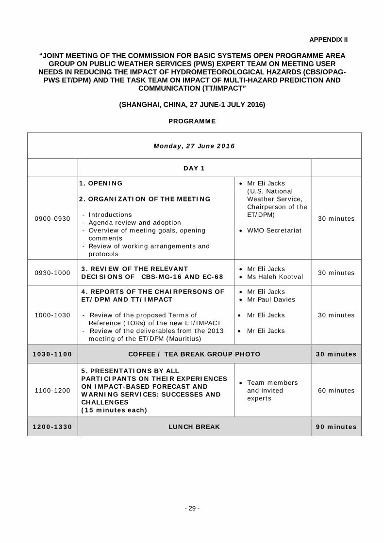
APPENDIX II
“JOINT MEETING OF THE COMMISSION FOR BASIC SYSTEMS OPEN PROGRAMME AREA GROUP ON PUBLIC WEATHER SERVICES (PWS) EXPERT TEAM ON MEETING USER
NEEDS IN REDUCING THE IMPACT OF HYDROMETEOROLOGICAL HAZARDS (CBS/OPAG-PWS ET/DPM) AND THE TASK TEAM ON IMPACT OF MULTI-HAZARD PREDICTION AND
COMMUNICATION (TT/IMPACT”
(SHANGHAI, CHINA, 27 JUNE-1 JULY 2016)
PPRROOGGRRAAMMMMEE
Monday, 27 June 2016
DDAAYY 11
0900-0930
1. OPENING 2. ORGANIZATION OF THE MEETING - Introductions - Agenda review and adoption - Overview of meeting goals, opening
comments - Review of working arrangements and
protocols
• Mr Eli Jacks (U.S. National Weather Service, Chairperson of the ET/DPM)
• WMO Secretariat
30 minutes
0930-1000 3. REVIEW OF THE RELEVANT DECISIONS OF CBS-MG-16 AND EC-68
• Mr Eli Jacks • Ms Haleh Kootval 30 minutes
1000-1030
4. REPORTS OF THE CHAIRPERSONS OF ET/DPM AND TT/IMPACT - Review of the proposed Terms of
Reference (TORs) of the new ET/IMPACT - Review of the deliverables from the 2013
meeting of the ET/DPM (Mauritius)
• Mr Eli Jacks • Mr Paul Davies • Mr Eli Jacks
• Mr Eli Jacks
30 minutes
1030-1100 COFFEE / TEA BREAK GROUP PHOTO 30 minutes
1100-1200
5. PRESENTATIONS BY ALL PARTICIPANTS ON THEIR EXPERIENCES ON IMPACT-BASED FORECAST AND WARNING SERVICES: SUCCESSES AND CHALLENGES (15 minutes each)
• Team members and invited experts
60 minutes
1200-1330 LUNCH BREAK 90 minutes

- 30 -
1330-1530
5. PRESENTATIONS BY ALL PARTICIPANTS ON THEIR EXPERIENCES ON IMPACT-BASED FORECAST AND WARNING SERVICES: SUCCESSES AND CHALLENGES (continued) (15 minutes each)
• Team members and invited experts
120 minutes
1530-1600 COFFEE / TEA BREAK 30 minutes
1600-1700
6. DISCUSSIONS AND DECISIONS ON THE MAJOR TOPICS TO BE ADDRESSED BY THE MEETING 6.0 Implementation plan based on “WMO Guidelines on Multi-hazard Impact-based Forecast and Warning Services” (WMO-No. 1150)
• Lead discussants Mr Eli Jacks and Mr Paul Davies
• All participants
60 minutes
Tuesday, 28 June 2016
DDAAYY 22
0900-1030
6. DISCUSSIONS AND DECISIONS ON THE MAJOR TOPICS TO BE ADDRESSED BY THE MEETING (Cont.) - Sub-teams commence individual
discussions - Sub-teams develop short, summary
presentations for plenary group (include suggested deliverables in presentations)
• All (in Sub-teams) 90 minutes
1030-1100 COFFEE / TEA BREAK 30 minutes
1100-1200
6. DISCUSSIONS AND DECISIONS ON THE MAJOR TOPICS TO BE ADDRESSED BY THE MEETING (Cont.) - Sub-team continue discussions - Sub-teams develop short, summary
presentations for plenary group (include suggested deliverables in presentations)
• All (in Sub-teams) 60 minutes
1200-1330 LUNCH BREAK 90 minutes
1330-1530
6. DISCUSSIONS AND DECISIONS ON THE MAJOR TOPICS TO BE ADDRESSED BY THE MEETING (Cont.) - Sub-team continue and conclude
discussions - Sub-teams develop short, summary
presentations for plenary group (include suggested deliverables in presentations)
• All (in Sub-teams) 120 minutes

- 31 -
1530-1545 COFFEE / TEA BREAK 15 minutes
1545-1700
6. DISCUSSIONS AND DECISIONS ON THE MAJOR TOPICS TO BE ADDRESSED BY THE MEETING (Cont.) - Sub-teams develop short, summary
presentations for plenary group (include suggested deliverables in presentations)
• All (in Sub-teams) 75 minutes
Wednesday, 29 June 2016
DDAAYY 33
0900-1030
6. DISCUSSION AND DECISIONS ON THE MAJOR TOPICS TO BE ADDRESSED BY THE MEETING (Cont.) - Presentation of Sub-team results
• All Members (back in plenary) 90 minutes
1030-1100 COFFEE / TEA BREAK 30 minutes
1100-1200
6. DISCUSSION AND DECISIONS ON THE MAJOR TOPICS TO BE ADDRESSED BY THE MEETING (Cont.) - Presentation of Sub-team results (Cont.)
• All Members (back in plenary) 60 minutes
1200-1330 LUNCH BREAK 90 minutes
1330-1530
7. IDENTIFICATION OF CLEAR DELIVERABLES RELATED TO THE MAJOR TOPICS AND CORRESPONDING TO THE ET/IMPACT TORS - Discuss deliverables as identified based on
Sub-team recommendations, reach agreement on deliverables and assign responsibilities for completion
• All Members 120 minutes
1530-1545 COFFEE / TEA BREAK 15 minutes
1545-1700
8. WORK ON DELIVERABLES - Based on agreed-upon deliverables, begin
work on outlining the said deliverables
• All Members 75 minutes
Thursday, 30 June 2016
DDAAYY 44
0900-1030 8. WORK ON DELIVERABLES (Cont.) - Continue to work on deliverables
• All Members 90 minutes

- 32 -
1030-1100 COFFEE / TEA BREAK 30 minutes
1100-1200 8. WORK ON DELIVERABLES (Cont.) - Continue to work on deliverables
• All Members 60 minutes
1200-1330 LUNCH BREAK 90 minutes
1330-1500
10. PREPARATION OF THE REPORT OF THE MEETING AND THE EXECUTIVE SUMMARY, INCLUDING DECISIONS FOR CONSIDERATION BY CBS-16 - Outline of the Final Report will be
presented - Begin preparation of the Report
• Chairpersons lead, with all Members
90 minutes
1500-1700
9. VISIT TO THE OPERATIONAL FORECAST AND SERVICE DELIVERY FACILITIES OF THE SHANGHAI METEOROLGOICAL SERVICE
• All Members 120 minutes
Friday, 1 July 2016
DDAAYY 55
0900-1030
9. PREPARATION OF THE REPORT OF THE MEETING AND THE EXECUTIVE SUMMARY, INCLUDING DECISIONS FOR CONSIDERATION BY CBS-16) (Cont.) - Preparation of the Report (Cont.)
• Chairpersons lead, with all Members
90 minutes
1000-1030 COFFEE / TEA BREAK 30 minutes
1030-1200 10. REVIEW AND ADOPTION OF THE REPORT
• Chairpersons lead, with all Members
90 minutes
1200-1330 LUNCH BREAK 90 minutes
1330-1500 10. REVIEW AND ADOPTION OF THE REPORT (Cont.)
• Chairpersons lead, with all Members
90 minutes
1500 11. CLOSURE OF THE MEETING
_____________

- 33 -
APPENDIX III
TERMS OF REFERENCE FOR THE EXPERT TEAM ON IMPACT-BASED FORECASTING AND
WARNING SERVICES (ET/IMPACT)
(a) Building on the WMO Guidelines on Multi-hazard Impact-Based Forecast and Warning Services (WMO No. 1150), develop an implementation strategy which describes actionable steps and evolution.
(b) Develop and maintain an expert resource to facilitate activities and projects in the area of Impact-Based Forecasting, including representatives from the social sciences.
(c) Actively promote Impact-Based Forecasting by identifying a network of champions within NMHSs, sharing best practices through symposiums, journal papers and communication outlets.
(d) Provide NMHSs with guidance on how to standardize Impact-Based Forecasting messaging protocols and formats (e.g. colour-coding, language, icons etc.).
(e) Working with Technical Commissions, Regional Associations, relevant OPAGs and Programmes of WMO establish user requirements for service improvements through science and technological innovation and implementation.
(f) Evolve current methodologies for verification and evaluation to incorporate a focus on Socio- Economic Benefits.
(g) Identify competencies and relevant training needs associated with wider implementation of multi-hazard impact-based forecast and warning services.

- 34 -
APPENDIX IV
“JOINT MEETING OF THE COMMISSION FOR BASIC SYSTEMS OPEN PROGRAMME AREA GROUP ON PUBLIC WEATHER SERVICES (PWS) EXPERT TEAM ON MEETING USER NEEDS IN REDUCING THE IMPACT OF HYDROMETEOROLOGICAL HAZARDS (CBS/OPAG-PWS
ET/DPM) AND THE TASK TEAM ON IMPACT OF MULTI-HAZARD PREDICTION AND COMMUNICATION (TT/IMPACT”
(SHANGHAI, CHINA, 27 JUNE-1 JULY 2016)
TEAM DELIVERABLES (Item 6.0)Building on the WMO Guidelines on Multi-hazard Impact-Based Forecast and Warning Services (WMO No. 1150), develop an implementation strategy which describes next actionable steps and evolution Deliverable 1: A stakeholder workshop to plan and design the implementation plan
Action(s): Responsible Member(s): Due Date: Status:
1. Identify and contact the stakeholders: DRM rep, Media,
Business sector, e.g., utilities, health, transport etc, social science, GFDRR (WBG), and the team members
Haleh and Paul End July
2. Organize the workshop Haleh 7-11 (week), Geneva
3. Report to CBS End November
4. Publish the guidance material Haleh and all End 2017
5.
6.
Agneda item 6.1:Training and competencies in impact-based forecasting and warning services Deliverable 2:
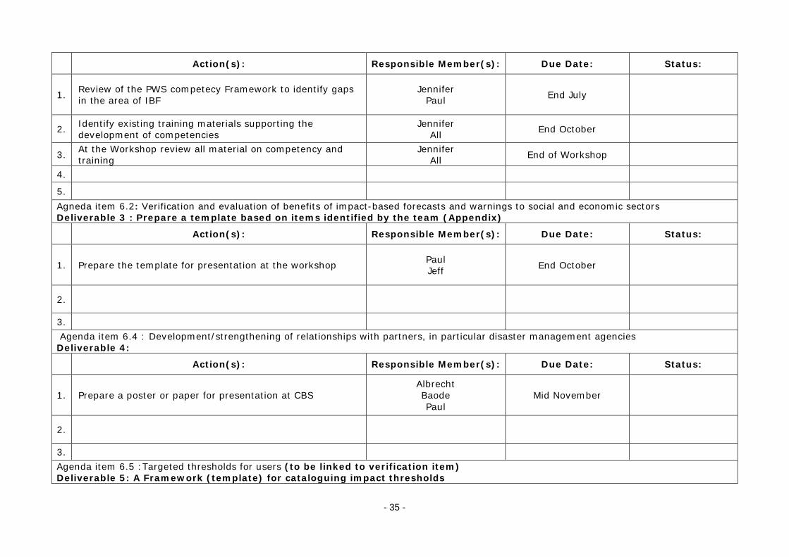
- 35 -
Action(s): Responsible Member(s): Due Date: Status:
1. Review of the PWS competecy Framework to identify gaps in the area of IBF
Jennifer Paul End July
2. Identify existing training materials supporting the development of competencies
Jennifer All End October
3. At the Workshop review all material on competency and training
Jennifer All End of Workshop
4.
5. Agneda item 6.2: Verification and evaluation of benefits of impact-based forecasts and warnings to social and economic sectors Deliverable 3 : Prepare a template based on items identified by the team (Appendix)
Action(s): Responsible Member(s): Due Date: Status:
1. Prepare the template for presentation at the workshop Paul Jeff End October
2.
3. Agenda item 6.4 : Development/strengthening of relationships with partners, in particular disaster management agencies Deliverable 4:
Action(s): Responsible Member(s): Due Date: Status:
1. Prepare a poster or paper for presentation at CBS Albrecht Baode Paul
Mid November
2.
3. Agenda item 6.5 :Targeted thresholds for users (to be linked to verification item) Deliverable 5: A Framework (template) for cataloguing impact thresholds

- 36 -
Action(s): Responsible Member(s): Due Date: Status:
1. Draft to be developed for inclusion into the implementation plan
Eli To be reviewed by all July 2017
2.
Agenda item 6.7 : Science and technology requirements to support impact-based forecasting and warning services Deliverable 6: Keep track of requirements from modellers and research
Action(s): Responsible Member(s): Due Date: Status:
1. Establish initial contacts with relevant TCs, NMHSs and WMO Programmes to make sure requirements are collected and taken into consideration (HiWeather, forecasting)
Haleh All End October
2.
3.
Deliverable 7
Action(s): Responsible Member(s): Due Date: Status:
1.
2.
__________

- 37 -
Appendix VI
A concept of how to translate weather information such as NWP products into impact/risk information
Weather and climate extremes
Weather analyses& forecast data
Hurricane track,size, & intensity
Implementation ofevacuation &
recovery plans
Reducing risk &response scenarios
Mitigation strategies
Affected population& infrastructure,
disruption of services,damages due to wind
& water, etc.
ImpactEstimation
Placing intosituational context
Storm surge, flooding,inundated areas
WeatherTranslation to
hazards
Extraction ofrelevant information
to predict hazards
A concept of how to translate weather information such as NWP products into impact/risk information, and using the aforementioned information to response/mitigate potential hazards is generally involved in the following four stages: Weather analyses and forecast data, extraction of relevant information to predict hazards, situational context and mitigation strategies. An illustration of the four steps in the context of Typhoons is presented in the diagram above. The following section provides a summary of the four stages of impact based forecasting: 1) Weather analyses and forecast data. Gathering the best NWP products, particularly
assembling NWP outputs, collecting observations and identifying event-related weather forecasts from available forecast products.
- The High-resolution NWP model is getting better at predicting the type of events such
as storms. However, it may not be able to predict the exact location where a storm will be and on occasions its intensity. The ensemble modelling approach, which utilizes a variety of initial/boundary conditions, along with model physics to characterize observational and model uncertainty, may help define a representative sample of potential weather scenarios that hopefully include the actual weather outcome.
- Moreover, it is possible to make use of something called a ‘time-lag’ ensemble by
combining the output from the most recent high-resolution forecast with the output from previous forecasts. By shifting the position of the forecast rain relative to the ground by some distance over which we expect the model may be in error is a means of creating an ensemble (referred to as neighbourhood method) This method will firstly generate probabilities from each forecast using the neighbourhood method and then combine those probabilities as a time-lag ensemble. This approach has the benefit of retaining the detail of the ensemble forecast used to drive downstream hazard models.

- 38 -
2) Extraction of relevant information to predict hazards Translating the weather information into hazard information by the use of weather data as inputs or external forcing for particular hazard models, such as storm surge models, flood models, etc., or directly extracting hazard-relevant characteristics from available forecast products.
- Ensemble-based weather forecasting involves handling a substantial amount of data,
and weather forecast providers aim to reduce that wealth of information by creating summary products, such as an ensemble mean, standard deviation, or likelihood of exceeding a user-relevant threshold. For certain applications, this may be appropriate. However, most of time, users of impact-based forecast require detailed information about the spatial organization and structure of an event that tends to get lost through averaging. For example, when averaging over a large enough sample of ensemble members, episodes of sporadic, local, intense rainfall across a region will appear in the ensemble mean as widespread light rain. Therefore, it has been advocated to extract hazard-relevant characteristics from each ensemble member and subsequently ensemble relevant information, rather than summarizing the wealth of information provided by the ensemble forecasts into a probabilistic weather depiction.
3) Situational context Putting the relevant information (e.g., probability of hazard,
written as hazard(x,t)) obtained from step 2) into situational context to estimate the risk of impact.
- The risk of impact includes the conditional probability and magnitude of harm attendant
on human beings, their livelihoods, and assets, due to their exposure and vulnerability to a hazard. The magnitude of harm may change due to response actions to mitigate the risk, to changes in the hazard during the course of the event, and to changes in exposure. These are most commonly written in the form
where is the union of the sets of hazards, vulnerabilities and exposures.
4) Mitigation strategies
Actions taken to reduce vulnerability/exposure will mitigate the risk Actions taken during event should mostly affect exposure and consequently alter risk of the impact
- A recent development in hydrology is the use of model predictive control (MPC) and its
integration into hydrological forecasting systems. Based on forecasted behavior of the hydrological system (e.g. flood hazard) and related impacts, control actions (water management) are taken to prevent or other reduce consequences/impacts (e.g. future flooding, optimize energy production, etc.)
______________________