work plan for environmental and geotechnical …
TRANSCRIPT

WORK PLAN FOR ENVIRONMENTAL AND GEOTECHNICAL ASSESSMENT Lignin Parcel, GP West Site, Bellingham, Washington Prepared for: RMC Architects LLC and Port of Bellingham
Project No. 190239-001-1.1 July 23, 2020 FINAL
Prepared under Integrated Planning Grant Agreement No. TCPIPG-1921-BellPo-00001

WORK PLAN FOR ENVIRONMENTAL AND GEOTECHNICAL ASSESSMENT Lignin Parcel, GP West Site, Bellingham, Washington Prepared for: RMC Architects LLC and Port of Bellingham
Project No. 190239-001-1.1 July 23, 2020 Final
Aspect Consulting, LLC
Steve Germiat, LHG, CGWP Principal Hydrogeologist [email protected]
Erik Andersen, PE Principal Geotechnical Engineer [email protected]
V:\190239 Port of Bellingham Millworks Project\Deliverables\Work Plan_Lignin Parcel\Final\Work Plan for Task 1 Env Assessment - Lignin Parcel - Final.docx
e a r t h + w a t e r Aspect Consulting, LLC 907 Harris Avenue Suite 301 Bellingham, WA 98225 360.746.8964 www.aspectconsulting.com
07/23/202007/23/2020
ASPECT CONSULTING
Project No. 190239-001-1.1 July 23, 2020 FINAL i
Contents Project Contacts ................................................................................................ iii
1 Project Overview and Goal for Assessment ............................................. 1
2 Background for Lignin Parcel .................................................................... 2 2.1 Industrial History ......................................................................................... 2 2.2 Previous Subsurface Investigations ............................................................ 3
2.2.1 Prior Environmental Investigation ......................................................... 3 2.2.2 Prior Geotechnical Investigation ........................................................... 4
2.3 Subsurface Conditions ............................................................................... 4 2.3.1 Geology ................................................................................................ 4 2.3.2 Groundwater Conditions ....................................................................... 5
2.4 Known Contaminant Conditions ................................................................. 5 2.4.1 Soil Quality ........................................................................................... 5 2.4.2 Groundwater Quality ............................................................................. 6
2.5 Current Cleanup Action Plan ...................................................................... 7
3 Environmental Assessment Scope of Work ............................................. 8 3.1 Sampling and Analysis ............................................................................... 8
3.1.1 Inadvertent Discovery Plan ................................................................... 8 3.2 Environmental Data Analysis ...................................................................... 9
4 Geotechnical Assessment Scope of Work ................................................ 9
5 Reporting ................................................................................................... 10
6 References ................................................................................................. 10
Limitations ......................................................................................................... 11

ASPECT CONSULTING
ii FINAL PROJECT NO. 190239-001-1.1 JULY 23, 2020
List of Tables 1 Existing Soil Quality Data for Lignin Parcel
2 Existing Groundwater Quality Data for Lignin Parcel
List of Figures 1 Known Soil Contamination and Proposed Explorations
2 Historical Site Diagram – Lignin Parcel Area
List of Appendices A Sampling and Analysis Plan and Quality Assurance Project Plan
B Inadvertent Discovery Plan

ASPECT CONSULTING
Project No. 190239-001-1.1 July 23, 2020 FINAL iii
Project Contacts This Work Plan is prepared in accordance with Integrated Planning Grant Agreement No. TCPIPG-1921-BellPo-00001 between Washington State Department of Ecology and Port of Bellingham. Contacts for the Integrated Planning Grant Project are as follows:
Port of Bellingham Project Manager: Brian Gouran
Port of Bellingham Billing Contact: Alan Birdsall
Department of Ecology Project Manager: Margo Thompson
Department of Ecology Financial Manager: Lydia Lindwall
Department of Ecology Technical Advisor: Michael Warfel
Department of Ecology GP West Site Manager: John Guenther

ASPECT CONSULTING
PROJECT NO. 190239-001-1.1 JULY 23, 2020 FINAL 1
1 Project Overview and Goal for Assessment In early 2019, the Washington State Department of Ecology (Ecology) selected the Port of Bellingham (Port) as a recipient of a Toxics Cleanup Healthy Housing Integrated Planning Grant (IPG) to fund early project planning efforts for the approximately 3-acre Lignin Parcel located at the comer of Cornwall and Laurel Streets within the Bellingham Waterfront District (Figure 1). The Lignin Parcel is part of the former Georgia-Pacific mill property, which is now the Georgia-Pacific West (GP West) cleanup site (Site) that requires remediation under the Model Toxics Control Act (MTCA) prior to redevelopment. The Port has been conducting environmental investigation and remediation at the Site since 2009 under legal agreements with Ecology.
For the past year, the Port has been working with a local development partner (Millworks, LLC) to evaluate the feasibility of a food campus and affordable/workforce housing at the Lignin Parcel. The Millworks group envisions a campus setting that includes food retail, processing and manufacturing, aggregation and distribution as well as commercial kitchen space supporting catering and artisanal food companies. Also anticipated on the Parcel is a multi-story mixed-use building with offices, classrooms, community event space and workforce affordable housing. The project fits with the overall community goals of reactivation of the Site while providing much needed affordable housing.
The Port is using the IPG to advance the Millworks redevelopment concept by completing focused environmental investigations, site surveys, coordination with development partners and community stakeholders, and parcel layout/programming.
Task 1 of the IPG, entitled “Assessments and Remedial Investigations”, includes focused environmental assessment, geotechnical/geophysical investigation, and Parcel-specific survey with the goal of advancing environmental and geotechnical characterization of the Lignin Parcel in preparation for redevelopment for affordable housing and other intended uses. This Work Plan describes the scope work for the Task 1 assessment and includes the following Task 1 subtasks in the IPG:
1.1. Work Plan for Site
1.2. Sampling and Analysis Plan
1.3. Quality Assurance Project Plan
1.4. Inadvertent Discovery Plan
Once the assessment data are collected and analyzed, the assessment findings and recommendations will be presented and distributed as per the following IPG Task 1 subtasks:
1.5. Analytical data uploaded to Ecology’s Environmental Information Management (EIM) database

ASPECT CONSULTING
2 FINAL PROJECT NO. 190239-001-1.1 JULY 23, 2020
1.6. Report of Assessment Findings
The subsequent sections of this Work Plan are as follows:
• Section 2 - Background for Lignin Parcel
• Section 3 - Environmental Assessment Scope of Work
• Section 4 - Geotechnical Assessment Scope of Work
• Section 5 - Reporting
• Section 6 - References cited in this Work Plan.
2 Background for Lignin Parcel The approximately 3-acre Lignin Parcel is located within the 36-acre Chlor-Alkali Remedial Action Unit (RAU) of the GP West cleanup Site. The 3 acres is part of the Reserve Tract of the Waterfront Binding Site Plan and is currently not an independent tax parcel; however, the Port may create a parcel or parcels encompassing the area on a subsequent Specific Binding Site Plan. Figure 1 depicts the location of the Lignin Parcel, with an inset vicinity map providing geographic reference.
2.1 Industrial History In 1926, the San Juan Pulp Company opened the first pulp mill on 5 acres of filled tideland adjacent to Bellingham Bay. It was designed to make use of pulp logs and fiber leftovers from a local wood box plant and several lumber mills. Three years later, the business was reorganized as the Puget Sound Pulp and Timber Company. In 1958, Puget Sound Pulp and Timber acquired the adjacent tissue manufacturing operations of Pacific Coast Paper Mills. In 1963, the company merged with the Georgia-Pacific Corporation who owned and operated the mill until the Port acquired it in 2005. Georgia-Pacific operated the pulp mill until 2001 and, under lease to Port, operated the tissue mill until 2007.
The Georgia-Pacific mill manufactured bleached sulfite pulp for internal production of tissue and toweling, and for sale as market pulp. The mill contained six individual plants producing primary sulfite pulp, Permachem pulp, sulfuric acid, chlorine, sodium hydroxide, alcohol, and lignosulfonate products. Lignin materials produced as biproducts in the pulping process were converted through various production steps into commercial products including chromium-containing oil-well drilling mud thinners, vanilla flavoring, animal feeds, adhesives, pharmaceuticals, dust retardants, fuel pellets, solvents, ferromagnetic liquids, and many other products.
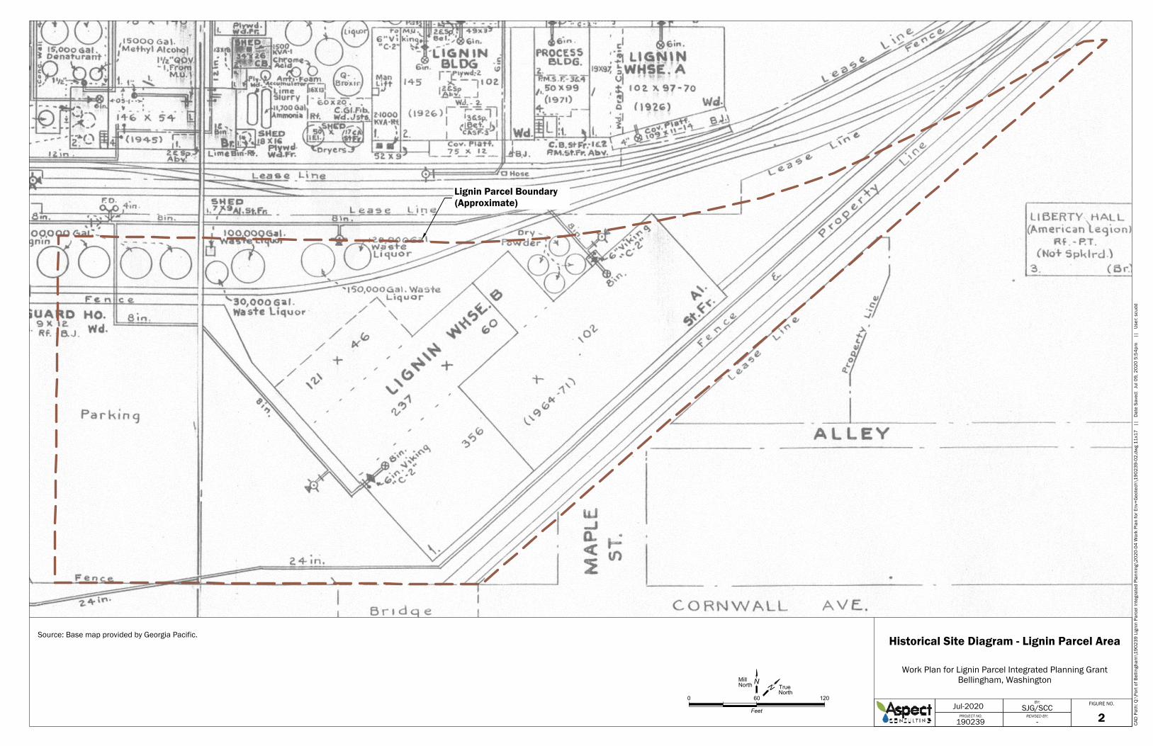
On the Lignin Parcel, the lignin warehouse1 (warehouse) was used for storage of the manufactured lignin-containing products. Figure 2, excerpted from a 1974 historical map
1 The warehouse was demolished in May 2020.

ASPECT CONSULTING
PROJECT NO. 190239-001-1.1 JULY 23, 2020 FINAL 3
of the mill prepared by Georgia-Pacific,2 shows that waste liquors from the lignin processes were stored in a series of above-ground storage tanks ranging size from 30,000 to 150,000 gallons located on the mill-north portion of the Parcel. Although materials containing hexavalent chromium were used in manufacture of lignin-based drilling mud products, all handling of those materials occurred within the Lignin Plant area north of the BNSF railroad (Aspect, 2004); there is no evidence for storage of materials containing hexavalent chromium on the Lignin Parcel, and the existing sampling data from the Parcel (described below) are consistent with that.
2.2 Previous Subsurface Investigations 2.2.1 Prior Environmental Investigation
Prior to the Port’s purchase of the entire Site, Georgia-Pacific completed a Phase 2 Environmental Site Assessment (ESA) for the Pulp and Tissue Mill portion of the Site, during which soil and groundwater sampling and analysis was completed on the Lignin Parcel3 to evaluate potential impacts associated with the spillage of dry lignin products and/or waste liquor during historical loading of rail cars and/or release of lignin products from the overhead conveyor between the warehouse and rail spur (Aspect, 2004). Figure 1 depicts the existing subsurface exploration locations on the Lignin Parcel.
The 2004 characterization of the Lignin Parcel included drilling soil borings to a depth of approximately 15 feet with soil sampling to a maximum depth of 8 feet at five locations, and collection of four surface soil samples. These explorations were designated LW-SB01 through LW-SB06 (soil borings), LW-MW01 (monitoring well); and LW-SS01 through LW-SS04 (surface samples) at the locations shown on Figure 1. Boring LW-MW01 was located within the waste liquor tank area and was also completed as a groundwater monitoring well positioned near the downgradient (mill-northern4) edge of the Parcel. Boring LW-SB01 was located mill-west of the warehouse, and LW-SB02 was located adjacent to its mill-northwest entrance. Borings LW-SB03 and LW-SB04 were located adjacent to the warehouse’s mill-northeast corner, in the vicinity of the conveyor and dry product storage tanks. Surface soil samples LW-SS01, LW-SS02, and LW-SS03 were collected along the rail spur located mill-north of the warehouse (spillage of dry products was reported in this area by former Georgia-Pacific employees), and surface soil sample LW-SS04 was collected in the northeastern corner rail entrance (Figure 1).
In total, fourteen soil samples were analyzed for total metals including hexavalent chromium, and semivolatile organic compounds (SVOCs) including polycyclic aromatic hydrocarbons (PAHs). One sample from each boring and the four surface soil samples were also analyzed for formaldehyde. Had field evidence of hydrocarbon or volatile organic compound (VOC) contamination been observed during soil sample collection, the corresponding soil samples would have been also tested for total petroleum
2 The Site Remedial Investigation (Aspect, 2013) includes the map covering the entire Site. 3 Termed the Lignin Warehouse site (Mill B) in Aspect (2004). 4 For consistency with previous environmental reports for the Site, this document uses the former Georgia-Pacific mill’s “Mill north” as its directional reference, with “Mill north” approximately 45 degrees west of true north. In the “Mill north” reference, the Whatcom Waterway is oriented east-west on the north side of the Site.

ASPECT CONSULTING
4 FINAL PROJECT NO. 190239-001-1.1 JULY 23, 2020
hydrocarbons (TPH, in the gasoline, diesel, and oil ranges), VOCs, and, if heavy oil was suspected, for polychlorinated biphenyls (PCBs). No field screening indications of hydrocarbons/VOCs was observed during the sampling, so these additional analyses were not performed (Aspect, 2004). Table 1 presents the existing soil quality data for the Lignin Parcel.
The 2004 characterization also included collection of one groundwater sample from monitoring well LW-MW01. The groundwater sample was analyzed for metals, SVOCs including PAHs, VOCs, PCBs, and a range of conventional parameters.
Following the Port’s acquisition of the property from Georgia-Pacific in 2005, groundwater samples were collected from well LW-MW01 for metals analysis in September 2009 and March 2010 as part of the Port’s Remedial Investigation (RI) for the Site. The current condition of LW-MW01 will be determined during this assessment. Table 2 presents the existing groundwater quality data for the Lignin Parcel. No additional soil sampling was conducted within the Lignin Parcel during the RI (Aspect, 2013).
2.2.2 Prior Geotechnical Investigation A geotechnical engineering study (GeoEngineers, 2007) was completed in support of a potential relocation of the BNSF railroad main line traversing the Site. As part of that study, three geotechnical soil borings—designated BB-1, BRR-1, and BRR-2 (Figure 1)—were drilled on the Lignin Parcel. These borings encountered fill; beach/intertidal deposits; and Chuckanut formation (bedrock). The geologically unconsolidated fill and beach/intertidal deposits are generally unsuitable for foundation support for a new building; the Chuckanut formation is competent and suitable for foundation support. The reported depths below ground surface to the top of the Chuckanut formation varied from 20.5, 29, and 46.5 feet, in BRR-1, BRR-2, and BB-1, respectively.
2.3 Subsurface Conditions This section describes the current understanding of the geologic and groundwater conditions underlying the Lignin Parcel based on the prior investigations.
2.3.1 Geology Geologic units beneath the Lignin Parcel include a wedge of unconsolidated materials overlying a mill-westward-sloping bedrock surface, as described below.
Unconsolidated Materials The entire Site including the Lignin Parcel is built on land formed by historical filling of a tidal flat area of the Whatcom Creek Delta starting in the early 1900s. The fill material comprising the Lignin Parcel primarily includes dredge fill placed hydraulically during 1912 and 1913 by the Corps of Engineers. Based on current information, the fill beneath the Lignin Parcel is approximately 5 to 15 feet thick and consists of silty sand and sandy silt with occasional gravel and organic material (e.g., wood).
Underlying the fill is a sequence of native marine beach/intertidal deposits ranging from 10 to more than 35 feet thick. The beach/intertidal deposits are underlain by Chuckanut formation.

ASPECT CONSULTING
PROJECT NO. 190239-001-1.1 JULY 23, 2020 FINAL 5
The previous explorations on the Lignin Parcel did not encounter the unconsolidated Glaciomarine Drift (GMD, aka Bellingham Drift) beneath the beach deposits. Collectively, the wedge of unconsolidated materials thickens from the mill-southeast to mill-northwest across the Parcel, consistent with the slope of the underlying bedrock surface.
Bedrock The unconsolidated units pinch out to the mill-south and -east of the Lignin Parcel to bedrock of the Chuckanut formation consisting of sandstone, shale, conglomerate, and coal. The Chuckanut sandstone typically has little primary porosity and limited groundwater movement is through fractures. The three 2007 geotechnical borings encountered the bedrock at progressively greater depths below grade from the mill-east to mill-west: 20.5 feet at BRR-1, 29 feet at BRR-2, and 46.5 feet at BB-1 (GeoEngineers, 2007). This is consistent with available information indicating that, across the entire Site, the bedrock surface slopes steeply toward the mill-west/northwest.
2.3.2 Groundwater Conditions Across the broader Site, the three hydrostratigraphic units of primary interest include, from surface down: a Fill Unit, a low-permeability Tidal Flat Aquitard representing the historical tide flat surface that fill was placed upon, and a Lower Sand Unit within the beach sand deposits (Aspect, 2013). The Fill Unit contains a shallow water table aquifer whereas, where the Tidal Flat Aquitard is present, the Lower Sand Unit is a confined (artesian) aquifer that is hydraulically separated from the Fill Unit aquifer by the intervening Tidal Flat Aquitard.
Depth to the water table was in the range of 4 to 5.5 feet below grade when measured in 2004, 2009, and 2010 at well LW-MW01 located near the mill-north edge of the Lignin Parcel. The water table depth is expected to be shallower on the mill-south portion of the Parcel. Groundwater in the Fill Unit and in the Lower Sand Unit flows toward the north-northwest with discharge to the Whatcom Waterway or Bellingham Bay.
2.4 Known Contaminant Conditions The current understanding of contaminant conditions for Lignin Parcel soil and groundwater is described below. The conditions are discussed relative to cleanup levels established in Ecology’s Draft Cleanup Action Plan (DCAP) for the Chlor-Alkali RAU that encompasses the Parcel (Ecology, 2020). The soil cleanup levels are for an unrestricted land use, which assume a residential child lifetime direct contact exposure and account for contaminant leaching to groundwater. Tables 1 and 2 respectively present the existing soil and groundwater data compared against corresponding cleanup levels. Detected concentrations exceeding cleanup levels are shaded in Tables 1 and 2.
2.4.1 Soil Quality Identified contaminants exceeding cleanup levels in Lignin Parcel soil include carcinogenic polycyclic aromatic hydrocarbons (cPAHs), selected metals, and, in shallow soil at the LW-SB01 location only, soil pH. Concentrations of SVOCs other than cPAHs and of formaldehyde were less than respective soil cleanup levels in each of the 15 soil

ASPECT CONSULTING
6 FINAL PROJECT NO. 190239-001-1.1 JULY 23, 2020
samples collected (Table 1). Figure 1 shows the existing soil sample locations with cPAH and metals concentrations exceeding cleanup levels, which are described briefly below.
Concentrations of total chromium (390 to 1,560 mg/kg) exceeding soil cleanup levels were detected at LW-SB03, LW-SB03, and LW-SB04 located in the vicinity of the conveyor and dry product storage tanks on the mill-north and mill-east sides of the warehouse. The highest chromium concentrations were observed in shallow soils (upper 4 feet). While total chromium concentrations are elevated at these locations, hexavalent chromium was only detected in 3 of 15 samples and the detected concentrations were at or below 0.6 mg/kg—two orders of magnitude below the 48 mg/kg soil cleanup level. The lack of detectable hexavalent chromium is consistent with it not having been handled on the Lignin Parcel. As discussed in Aspect (2004), hexavalent chromium was also not present at concentrations of concern where it was handled in the Lignin Plant, mill-north of the BNSF railroad. This is not unexpected given that hexavalent chromium (Cr+6, the most oxidized form) is rapidly reduced to trivalent chromium (Cr+3) in geochemically reducing conditions (EPA, 1994) such as exist in the dredge fill throughout the Site.
Other metals exceedances in soil, including cadmium, copper, lead, and/or zinc, are collocated with the chromium exceedances. These same metals, and a marginal nickel exceedance at one location, occur at concentrations exceeding soil cleanup levels at other locations on the Parcel (Figure 1).
No field screening evidence of petroleum was observed in any of the 2004 Lignin Parcel borings but abundant wood and other organic material was present in subsurface soils. Total cPAH (TEQ5) concentrations (0.8 to 29 mg/kg) exceeding cleanup levels were detected in soil samples collected adjacent to the railroad spur on the mill-north side of the warehouse (Figure 1). Given the lack of cPAH exceedances elsewhere on the Parcel, the elevated cPAHs are attributable to creosote-treated railroad ties on the railroad spur.
2.4.2 Groundwater Quality During the 2004 groundwater sampling of well LW-MW01, PAHs, other SVOCs, VOCs, PCBs were generally not detected, and the concentrations detected were less than numerical screening levels applied in the RI (Aspect, 2013). However, each of the heavy metals analyzed in the groundwater sample exceeded cleanup levels.6 The 2009-2010 groundwater data from well LW-MW01 showed substantial improvement in metals concentrations relative to 2004; however, total chromium exceedances persisted (Table 2).
Groundwater pH at LW-MW01 also showed a substantive decline between 2004 and 2009-2010, but the latter measurements were slightly below (8.4) and slightly above (8.9) the pH 8.5 cleanup level in the two samples. The slightly higher dissolved oxygen and lower temperature measured at the well in Spring 2010 versus Fall 2009 is likely indicative of cooler, more oxygen-rich recharge infiltrating to the Fill Unit groundwater during the intervening wet season (Table 2).
5 Total toxic equivalent concentration of benzo(a)pyrene calculated in accordance with MTCA (WAC 173-340-708(e)). 6 The reporting limit for hexavalent chromium was elevated (Aspect, 2004), but subsequent samples collected in 2009 and 2010 confirmed no concentrations above the cleanup level (Table 2).

ASPECT CONSULTING
PROJECT NO. 190239-001-1.1 JULY 23, 2020 FINAL 7
2.5 Current Cleanup Action Plan Ecology’s Draft Cleanup Action Plan (DCAP) for the Chlor-Alkali RAU includes a robust cleanup action addressing the full 36 acres including the 3-acre Lignin Parcel (Ecology, 2020). The DCAP focuses on the RAU’s primary contaminant of concern—highly concentrated mercury in the area of Georgia-Pacific’s historical chlorine plant located more than 1,000 feet mill-northwest of the Lignin Parcel. The Lignin Parcel has not been impacted by that mercury contamination.
The DCAP’s selected cleanup action for the Lignin Parcel includes two primary elements:
Capping (containment) of the PAH-contaminated soil on the mill-north side of the warehouse
Groundwater monitoring in well LW-MW01 to document performance for the natural attenuation of residual alkaline pH and associated dissolved metals concentrations in achieving cleanup levels
Because the cleanup action will contain contaminated materials throughout the RAU, an environmental covenant will be placed on the RAU including the Lignin Parcel. The covenant, similar to that in place now on the Pulp and Tissue Mill RAU immediately to the mill-north of the Parcel, will require inspection and maintenance of the environmental cap for perpetuity.
At the time of this Work Plan, Ecology is preparing the DCAP for public comment in accordance with MTCA. Ecology will then address public comments and issue a final CAP. Thereafter, the Port will conduct remedial design for the selected cleanup action, including pre-remedial design investigations (PRDI) to refine design parameters and inform constructability for cleanup of the mercury-contaminated areas of the RAU. The design process will involve preparation of PRDI Work Plan(s), PRDI Data Report(s), Engineering Design Report(s), and Construction Plans and Specifications for the Port’s competitive bidding and contracting of the construction elements of the selected cleanup action, which may be divided into multiple projects for contracting and execution. The remedial design is anticipated to be a multi-year process culminating in a Consent Decree between Ecology and the Port that requires completion of the final cleanup action design.
It may be possible to complete remediation of the Lignin Plant with a process separate from the more involved mercury cleanup activities within the Chlor-Alkali RAU, including the potential to define the Lignin Parcel as its own RAU, subject to agreement with Ecology and appropriate legal documentation.

ASPECT CONSULTING
8 FINAL PROJECT NO. 190239-001-1.1 JULY 23, 2020
3 Environmental Assessment Scope of Work
3.1 Sampling and Analysis The current environmental assessment includes supplemental soil sampling and analysis from six direct-push soil borings to a depth of 15 feet to better refine understanding of contaminant nature and extent in Lignin Parcel soil. This will include two borings advanced through the floor slab of the former warehouse (via concrete coring), which has not previously been explored, and four borings outside of it at locations depicted on Figure 1.
At each of the six boring locations, a surface soil sample will be collected from the upper 1-foot interval beneath pavement/floor slab grade. In addition, soil samples will be collected from two additional depths based on field screening information7 during drilling. In the absence of field screening indications of contamination, the soil samples will be collected from 1-foot depth intervals straddling the water table observed at time of drilling and approximately 3 to 4 feet below it.
The soil samples will be submitted to an Ecology-accredited analytical laboratory for analysis of the following constituents with documented exceedances of cleanup levels in soil or groundwater during the prior sampling:
Metals (arsenic, cadmium, chromium, copper, lead, mercury, nickel, zinc)
PAHs (low-level)
In addition, the soil samples will be analyzed for diesel-/oil-range TPH for which no data have been previously collected for the Lignin Parcel.
No groundwater sampling will be conducted in this initial assessment. Rather, groundwater monitored natural attenuation (MNA) performance monitoring will be conducted in accordance with a monitoring plan to be developed and approved by Ecology following finalization of the CAP.
Appendix A includes the Sampling and Analysis Plan (SAP) and Quality Assurance Project Plan (QAPP) that respectively define field sampling procedures and analytical laboratory quality control and quality assurance procedures to be followed for the environmental data collection effort. Prior to execution of the field work, Aspect will prepare a site-specific Health and Safety Plan that includes hygiene and social distancing protocols specific to COVID-19.
3.1.1 Inadvertent Discovery Plan The entire Site is located within an archaeologically sensitive area of former tidal flats adjacent to the mouth of Whatcom Creek and to the bluffs to the south. Prior to the filling and development of the Site area, the Bellingham Bay shoreline was located generally along the bottom of the bluffs south of the Site. The ancestors of the Lummi Nation
7 Visual and olfactory observations, and photoionization detector (PID) readings, as described in the SAP (Appendix A).

ASPECT CONSULTING
PROJECT NO. 190239-001-1.1 JULY 23, 2020 FINAL 9
inhabited and used the area and appear to have established seasonal fishing encampments near the mouth of Whatcom Creek.
The Lignin Parcel, located relatively near the historical pre-fill shoreline, lies within zones of moderate to high probability for encountering archaeological materials, as determined by Northwest Archaeological Associates as part of the Waterfront District New Whatcom Environmental Impact Statement (Appendix M to Blumen and Associates, 2008). Figure 4-7 in the Site RI (Aspect, 2013) reproduces Northwest Archaeological Associates’ mapping of the archeological probability zones. If present, archaeological materials would be expected near the top of the native beach/tideflat deposits which underly the fill.
Appendix B is the Inadvertent Discovery Plan (IDP), developed from Ecology’s template, that defines the stop-work and notification procedures for Aspect’s geologist to perform in the event of discovering potential archaeological materials while completing the subsurface explorations for this assessment.
3.2 Environmental Data Analysis Aspect will conduct independent quality assurance validation of the newly generated analytical data to ensure data usability. Tables of the environmental data (combined prior and new) will be prepared that compare detected concentrations against soil cleanup levels defined in the RAU’s CAP. Using the full dataset, the refined estimated extents of soil contamination will be also mapped.
The Port and Ecology can use the collective information to formulate initial strategies for integrating cleanup of the Lignin Parcel with the planned redevelopment project as it progresses, to optimize protectiveness for the future use and cost-effectiveness. For example, depending on the outcome of the supplemental sampling and initial earthwork concepts for the redevelopment, it may prove to be practicable to remove some or all of the contaminated soil during redevelopment instead of capping it as currently contemplated under the RAU’s DCAP. Such an action would increase the permanence of the RAU’s cleanup remedy and have an added benefit of limiting long-term institutional controls on the Lignin Parcel. However, changing from soil containment to removal would represent a change to the RAU’s DCAP and thus would require close coordination with Ecology as the project’s planning progresses.
4 Geotechnical Assessment Scope of Work For the current project, no additional deep geotechnical explorations are planned. Rather, Aspect will utilize existing and new environmental data acquired (as discussed in Section 3.1) for the Parcel to develop a conceptual model of site soil and groundwater conditions. Using this data, Aspect will complete preliminary geotechnical engineering analyses related to seismic hazards; feasible building foundation types (e.g., driven piles bearing on the Chuckanut formation); temporary shoring for any below-ground parking structures; construction dewatering considerations; and ground improvement methods (if

ASPECT CONSULTING
10 FINAL PROJECT NO. 190239-001-1.1 JULY 23, 2020
necessary). Aspect will then develop conceptual geotechnical recommendations for the proposed building development, as envisioned at the time by the project team, and will provide input to preliminary estimates of construction cost as requested.
5 Reporting Following completion of the data collection and analysis, a Report of Findings (Report) will be prepared to describe the environmental and geotechnical assessment methods and findings. The Report will also identify remaining environmental and geotechnical data gaps with respect to planning of the redevelopment project and will provide recommendations to address them.
A draft Report will be submitted for Ecology review. Ecology comments will be resolved and then incorporated into a final Report that will be transmitted to Ecology and other stakeholders. In addition, the validated analytical data from the environmental data collection will be uploaded to Ecology’s EIM system.
6 References Aspect Consulting, LLC (Aspect), 2004, Phase II Environmental Assessment, Georgia-
Pacific Bellingham Operations, September 3, 2004.
Aspect Consulting, LLC (Aspect), 2013, Remedial Investigation, Georgia-Pacific West Site, Bellingham, August 5, 2013, Volume 1 of RI/FS.
Blumen and Associates, 2008, New Whatcom Redevelopment Project Draft Environmental Impact Statement, Prepared for the Port of Bellingham, January 2008.
GeoEngineers Inc., 2007, Geotechnical Engineering Services, City of Bellingham Railroad Relocation Feasibility Analysis Project, Bellingham, Washington, July 17, 2007. Appendix D to Washington State, Bellingham Waterfront Rail Relocation Project, Final Report, prepared by HDR Inc., October 2007.
United States Environmental Protection Agency (EPA), 1994, Natural Attenuation of Hexavalent Chromium in Groundwater and Soils, EPA Ground Water Issue, EPA/540-5-94/505, October 1994.
Washington State Department of Ecology (Ecology), 2020, Draft Cleanup Action Plan, Chlor-Alkali Remedial Action Unit, Georgia-Pacific west Site, Bellingham, Washington, in preparation.
ASPECT CONSULTING
PROJECT NO. 190239-001-1.1 JULY 23, 2020 FINAL 11
Limitations Work for this project was performed for RMC Architects Inc. (Client), and this report was prepared in accordance with generally accepted professional practices for the nature and conditions of work completed in the same or similar localities, at the time the work was performed. This report does not represent a legal opinion. No other warranty, expressed or implied, is made.
All reports prepared by Aspect Consulting for the Client apply only to the services described in the Agreement(s) with the Client. Any use or reuse by any party other than the Client is at the sole risk of that party, and without liability to Aspect Consulting. Aspect Consulting’s original files/reports shall govern in the event of any dispute regarding the content of electronic documents furnished to others.

TABLES
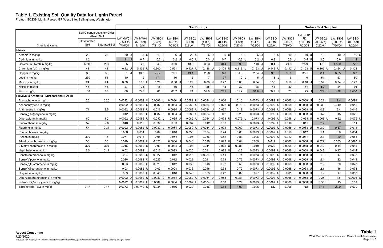
Table 1. Existing Soil Quality Data for Lignin ParcelProject 190239, Lignin Parcel, GP West Site, Bellingham, Washington
Unsaturated Soil Saturated Soil
MetalsArsenic in mg/kg 20 20 30 U 6 U 10 U 6 U 20 U 6 U 6 U 5 U 5 U 6 U 10 U 10 U 10 10 U 10 UCadmium in mg/kg 1.2 1 11 J 0.7 J 0.6 U 0.2 U 0.6 U 0.3 U 0.7 0.2 U 0.2 U 0.3 0.5 U 0.5 U 1.0 0.6 1.4Chromium (Total) in mg/kg 5,200 260 35 25 43 39.0 48.9 35.3 844 390 J 140 J 60.4 J 24.9 25.9 173 1,560 722 Chromium (VI) in mg/kg 48 48 0.12 U 0.132 U 0.600 0.521 0.127 U 0.138 U 0.121 U 0.116 U 0.123 U 0.146 U 0.112 U 0.108 U 0.105 U 0.124 U 0.123Copper in mg/kg 36 36 31 J 13.7 J 72.7 29.1 49.1 20.8 58.0 31.3 J 23.4 J 39.0 J 36.6 35.1 88.4 66.5 53.3Lead in mg/kg 250 81 40 9 171 16 15 7 97 19 J 5 J 13 J 6 6 54 53 80Mercury in mg/kg 24 24 0.08 0.06 U 0.25 J 0.08 J 0.23 J 0.08 J 0.27 0.08 0.04 0.06 0.19 J 0.18 J 0.57 J 0.34 J 0.29 JNickel in mg/kg 48 48 27 25 46 35 46 25 48 32 28 41 30 34 52 24 36Zinc in mg/kg 100 85 66 33.5 61 J 61.7 J 74 J 37.6 J 251 81.9 J 91.8 J 58.9 J 71 J 75 J 377 J 489 J 1,450 J
Polycyclic Aromatic Hydrocarbons (PAHs)Acenaphthene in mg/kg 5.2 0.26 0.0092 U 0.0082 U 0.0082 U 0.0084 U 0.0089 U 0.0084 U 0.066 0.10 0.0073 U 0.0092 U 0.0068 U 0.0068 U 0.24 2.4 0.0091Acenaphthylene in mg/kg 0.0092 U 0.0082 U 0.0082 U 0.0084 U 0.0089 U 0.0084 U 0.022 U 0.0076 U 0.0073 U 0.0092 U 0.0068 U 0.0068 U 0.039 0.049 0.015Anthracene in mg/kg 71 3.5 0.0092 U 0.0082 U 0.016 0.0084 U 0.0089 U 0.0084 U 0.067 0.18 0.0073 U 0.0092 U 0.0068 U 0.0068 U 0.3 2.4 0.046Benzo(g,h,i)perylene in mg/kg 0.012 0.0082 U 0.0082 U 0.0084 U 0.0089 U 0.0084 U 0.2 0.23 0.0073 U 0.0092 U 0.0068 U 0.0068 U 0.57 15 0.022Dibenzofuran in mg/kg 80 80 0.0092 U 0.0082 U 0.082 U 0.085 U 0.089 U 0.084 U 0.073 U 0.075 U 0.073 U 0.092 U 0.068 U 0.068 U 0.068 U 0.22 0.075 UFluoranthene in mg/kg 52 2.6 0.048 0.015 0.037 0.03 0.037 0.012 0.68 0.9 0.0073 U 0.0092 U 0.016 0.011 2.7 22 0.11Fluorene in mg/kg 7.4 0.37 0.0092 U 0.0082 U 0.0082 U 0.0084 U 0.0089 U 0.0084 U 0.024 0.069 0.0073 U 0.0092 U 0.0068 U 0.0068 U 0.082 0.57 0.011Phenanthrene in mg/kg 0.066 0.014 0.09 0.048 0.053 0.024 0.24 0.63 0.0073 U 0.0092 U 0.018 0.012 1.1 8.8 0.084Pyrene in mg/kg 330 16 0.071 0.018 0.08 0.054 0.05 0.016 0.52 0.81 0.025 0.0092 U 0.012 0.0081 2.3 20 0.0851-Methylnaphthalene in mg/kg 35 35 0.029 0.0082 U 0.026 0.0084 U 0.046 0.026 0.022 U 0.04 0.009 0.012 0.0068 U 0.0068 U 0.022 0.063 0.0076 U2-Methylnaphthalene in mg/kg 320 320 0.046 0.0082 U 0.03 0.0084 U 0.08 0.041 0.022 U 0.088 0.019 0.022 0.0068 U 0.0068 U 0.042 0.14 0.015Naphthalene in mg/kg 3.5 0.17 0.02 0.0091 0.012 0.0093 0.025 0.011 0.022 U 0.3 0.0073 U 0.0092 U 0.0068 U 0.0068 U 0.048 0.17 0.014Benz(a)anthracene in mg/kg 0.024 0.0082 U 0.027 0.012 0.016 0.0084 U 0.41 0.71 0.0073 U 0.0092 U 0.0068 U 0.0068 U 1.8 17 0.038Benzo(a)pyrene in mg/kg 0.026 0.0082 U 0.025 0.012 0.022 0.011 0.63 0.76 0.0073 U 0.0092 U 0.0068 U 0.0068 U 2.4 22 0.049Benzo(b)fluoranthene in mg/kg 0.03 0.0082 U 0.026 0.012 0.036 0.016 0.62 0.59 0.0073 U 0.0092 U 0.0068 U 0.0068 U 2.2 20 0.073Benzo(k)fluoranthene in mg/kg 0.03 0.0082 U 0.02 0.0093 0.036 0.016 0.53 0.72 0.0073 U 0.0092 U 0.0068 U 0.0068 U 2.1 16 0.073Chrysene in mg/kg 0.059 0.0082 U 0.048 0.018 0.046 0.023 0.42 0.69 0.027 0.0092 U 0.01 0.0068 U 1.9 17 0.053Dibenzo(a,h)anthracene in mg/kg 0.0092 U 0.0082 U 0.0082 U 0.0084 U 0.0089 U 0.0084 U 0.058 0.081 0.0073 U 0.0092 U 0.0068 U 0.0068 U 0.25 1.5 0.0076 UIndeno(1,2,3-cd)pyrene in mg/kg 0.0092 U 0.0082 U 0.0082 U 0.0084 U 0.0089 U 0.0084 U 0.18 0.24 0.0073 U 0.0092 U 0.0068 U 0.0068 U 0.56 13 0.02Total cPAHs TEQ in mg/kg 0.14 0.14 0.0373 0.00742 U 0.034 0.016 0.032 0.016 0.81 1.00 0.006 ND 0.005 ND 3.11 29.0 0.070
Soil Borings Surface Soil Samples
LW-SB02(0-4 ft)7/21/04
LW-SS04(0-0.5 ft)7/20/04
LW-SS03(0-0.5 ft)7/20/04
LW-SS02(0-0.5 ft)7/20/04
LW-SS01(0-0.5 ft)7/20/04
LW-SS01 FD
(0-0.5 ft)7/20/04
LW-SB04(4-8 ft)7/22/04
LW-SB04(0-4 ft)7/22/04
LW-SB03(4-8 ft)7/23/04
LW-SB03(0-4 ft)7/23/04
LW-SB02(4-8 ft)7/21/04Chemical Name
LW-SB01(4-8 ft)7/21/04
Soil Cleanup Level for Chlor-Alkali RAU
LW-MW01(2.5-4 ft)7/16/04
LW-MW01(5-6.5 ft)7/16/04
LW-SB01(0-4 ft)7/21/04
Aspect Consulting7/23/2020V:\190239 Port of Bellingham Millworks Project\Deliverables\Work Plan_Lignin Parcel\Final\Attach\T1 - Existing Soil Data for Lignin Parcel
Table 1Work Plan for Environmental and Geotechnical Assessment
Page 1 of 3

Table 1. Existing Soil Quality Data for Lignin ParcelProject 190239, Lignin Parcel, GP West Site, Bellingham, Washington
Unsaturated Soil Saturated Soil
Soil Borings Surface Soil Samples
LW-SB02(0-4 ft)7/21/04
LW-SS04(0-0.5 ft)7/20/04
LW-SS03(0-0.5 ft)7/20/04
LW-SS02(0-0.5 ft)7/20/04
LW-SS01(0-0.5 ft)7/20/04
LW-SS01 FD
(0-0.5 ft)7/20/04
LW-SB04(4-8 ft)7/22/04
LW-SB04(0-4 ft)7/22/04
LW-SB03(4-8 ft)7/23/04
LW-SB03(0-4 ft)7/23/04
LW-SB02(4-8 ft)7/21/04Chemical Name
LW-SB01(4-8 ft)7/21/04
Soil Cleanup Level for Chlor-Alkali RAU
LW-MW01(2.5-4 ft)7/16/04
LW-MW01(5-6.5 ft)7/16/04
LW-SB01(0-4 ft)7/21/04
Other Semivolatile Organics1,2,4-Trichlorobenzene in mg/kg 0.26 0.013 0.092 U 0.49 U 0.082 U 0.085 U 0.089 U 0.084 U 0.073 U 0.075 U 0.073 U 0.092 U 0.068 U 0.068 U 0.068 U 0.073 U 0.075 U1,2-Dichlorobenzene in mg/kg 0.77 0.039 0.092 U 0.49 U 0.082 U 0.085 U 0.089 U 0.084 U 0.073 U 0.075 U 0.073 U 0.092 U 0.068 U 0.068 U 0.068 U 0.073 U 0.075 U1,3-Dichlorobenzene in mg/kg 0.092 U 0.49 U 0.082 U 0.085 U 0.089 U 0.084 U 0.073 U 0.075 U 0.073 U 0.092 U 0.068 U 0.068 U 0.068 U 0.073 U 0.075 U1,4-Dichlorobenzene in mg/kg 1 0.051 0.092 U 0.49 U 0.082 U 0.085 U 0.089 U 0.084 U 0.073 U 0.075 U 0.073 U 0.092 U 0.068 U 0.068 U 0.068 U 0.073 U 0.075 U2,4,5-Trichlorophenol in mg/kg 1900 93 0.46 U 2.5 U 0.41 U 0.42 U 0.44 U 0.42 U 0.37 U 0.38 U 0.37 U 0.46 U 0.34 U 0.34 U 0.34 U 0.37 U 0.38 U2,4,6-Trichlorophenol in mg/kg 0.3 0.015 0.46 U 2.5 U 0.41 U 0.42 U 0.44 U 0.42 U 0.37 U 0.38 U 0.37 U 0.46 U 0.34 U 0.34 U 0.34 U 0.37 U 0.38 U2,4-Dichlorophenol in mg/kg 3.8 0.2 0.28 U 1.5 U 0.24 U 0.25 U 0.27 U 0.25 U 0.22 U 0.23 U 0.22 U 0.28 U 0.2 U 0.2 U 0.2 U 0.22 U 0.23 U2,4-Dimethylphenol in mg/kg 14 0.73 0.28 U 1.5 U 0.24 U 0.25 U 0.27 U 0.25 U 0.22 U 0.23 U 0.22 U 0.28 U 0.2 U 0.2 U 0.2 U 0.22 U 0.23 U2,4-Dinitrophenol in mg/kg 5.6 0.4 0.92 U 4.9 U 0.82 U 0.85 U 0.89 U 0.84 U 0.73 U 0.75 U 0.73 U 0.92 U 0.68 U 0.68 U 0.68 U 0.73 U 0.75 U2-Chloronaphthalene in mg/kg 6,400 6,400 0.092 U 0.49 U 0.082 U 0.085 U 0.089 U 0.084 U 0.073 U 0.075 U 0.073 U 0.092 U 0.068 U 0.068 U 0.068 U 0.073 U 0.075 U2-Chlorophenol in mg/kg 4.8 0.24 0.092 U 0.49 U 0.082 U 0.085 U 0.089 U 0.084 U 0.073 U 0.075 U 0.073 U 0.092 U 0.068 U 0.068 U 0.068 U 0.073 U 0.075 U2-Methylphenol in mg/kg 4,000 4,000 0.092 U 0.49 U 0.082 U 0.085 U 0.089 U 0.084 U 0.073 U 0.075 U 0.073 U 0.092 U 0.068 U 0.068 U 0.068 U 0.073 U 0.075 U2-Nitroaniline in mg/kg 800 800 0.46 U 2.5 U 0.41 U 0.42 U 0.44 U 0.42 U 0.37 U 0.38 U 0.37 U 0.46 U 0.34 U 0.34 U 0.34 U 0.37 U 0.38 U2-Nitrophenol in mg/kg 0.46 U 2.5 U 0.41 U 0.42 U 0.44 U 0.42 U 0.37 U 0.38 U 0.37 U 0.46 U 0.34 U 0.34 U 0.34 U 0.37 U 0.38 U2,4-Dinitrotoluene in mg/kg 0.12 0.01 0.46 U 2.5 U 0.41 U 0.42 U 0.44 U 0.42 U 0.37 U 0.38 U 0.37 U 0.46 U 0.34 U 0.34 U 0.34 U 0.37 U 0.38 U2,6-Dinitrotoluene in mg/kg 80 3,500 0.46 U 2.5 U 0.41 U 0.42 U 0.44 U 0.42 U 0.37 U 0.38 U 0.37 U 0.46 U 0.34 U 0.34 U 0.34 U 0.37 U 0.38 U3,3'-Dichlorobenzidine in mg/kg 0.47 0.1 0.46 U 2.5 U 0.41 U 0.42 U 0.44 U 0.42 U 0.37 U 0.38 U 0.37 U 0.46 U 0.34 U 0.34 U 0.34 U 0.37 U 0.38 U3-Nitroaniline in mg/kg 0.55 U 3 U 0.49 U 0.51 U 0.53 U 0.51 U 0.44 U 0.45 U 0.44 U 0.55 U 0.41 U 0.41 U 0.41 U 0.44 U 0.45 U4,6-Dinitro-2-methylphenol in mg/kg 0.92 U 4.9 U 0.82 U 0.85 U 0.89 U 0.84 U 0.73 U 0.75 U 0.73 U 0.92 U 0.68 U 0.68 U 0.68 U 0.73 U 0.75 U4-Bromophenyl phenyl ether in mg/kg 0.092 U 0.49 U 0.082 U 0.085 U 0.089 U 0.084 U 0.073 U 0.075 U 0.073 U 0.092 U 0.068 U 0.068 U 0.068 U 0.073 U 0.075 U4-Chloro-3-methylphenol in mg/kg 0.18 U 0.98 U 0.16 U 0.17 U 0.18 U 0.17 U 0.15 U 0.15 U 0.15 U 0.18 U 0.14 U 0.14 U 0.14 U 0.15 U 0.15 U4-Chloroaniline in mg/kg 5 5 0.28 U 1.5 U 0.24 U 0.25 U 0.27 U 0.25 U 0.22 U 0.23 U 0.22 U 0.28 U 0.2 U 0.2 U 0.2 U 0.22 U 0.23 U4-Chlorophenyl phenyl ether in mg/kg 0.092 U 0.49 U 0.082 U 0.085 U 0.089 U 0.084 U 0.073 U 0.075 U 0.073 U 0.092 U 0.068 U 0.068 U 0.068 U 0.073 U 0.075 U4-Methylphenol in mg/kg 400 400 0.092 U 0.49 U 0.082 U 0.085 U 0.089 U 0.084 U 0.073 U 0.075 U 0.073 U 0.092 U 0.068 U 0.068 U 0.068 U 0.073 U 0.075 U4-Nitroaniline in mg/kg 0.46 U 2.5 U 0.41 U 0.42 U 0.44 U 0.42 U 0.37 U 0.38 U 0.37 U 0.46 U 0.34 U 0.34 U 0.34 U 0.37 U 0.38 U4-Nitrophenol in mg/kg 0.46 U 2.5 U 0.41 U 0.42 U 0.44 U 0.42 U 0.37 U 0.38 U 0.37 U 0.46 U 0.34 U 0.34 U 0.34 U 0.37 U 0.38 UBenzoic acid in mg/kg 320,000 320,000 0.92 U 4.9 U 0.82 U 0.85 U 0.89 U 0.84 U 0.73 U 0.75 U 0.73 U 0.92 U 0.68 U 0.68 U 0.68 U 0.73 U 0.75 UBenzyl alcohol in mg/kg 8,000 8,000 0.46 U 2.5 U 0.41 U 0.42 U 0.44 U 0.42 U 0.37 U 0.38 U 0.37 U 0.46 U 0.34 U 0.34 U 0.34 U 0.37 U 0.38 UBenzyl butyl phthalate in mg/kg 1.6 0.079 0.092 U 0.49 U 0.082 U 0.085 U 0.089 U 0.084 U 0.073 U 0.075 U 0.073 U 0.092 U 0.068 U 0.068 U 0.068 U 0.073 U 0.075 UBis(2-chloro-1-methylethyl) ether in mg/kg 14 14 0.082 U 0.085 U 0.089 U 0.084 U 0.073 U 0.075 U 0.073 U 0.092 U 0.068 U 0.068 U 0.068 U 0.073 U 0.075 UBis(2-chloroethoxy)methane in mg/kg 0.092 U 0.49 U 0.082 U 0.085 U 0.089 U 0.084 U 0.073 U 0.075 U 0.073 U 0.092 U 0.068 U 0.068 U 0.068 U 0.073 U 0.075 UBis(2-chloroethyl) ether in mg/kg 0.015 0.01 0.18 U 0.98 U 0.16 U 0.17 U 0.18 U 0.17 U 0.15 U 0.15 U 0.15 U 0.18 U 0.14 U 0.14 U 0.14 U 0.15 U 0.15 UBis(2-ethylhexyl) phthalate in mg/kg 35 1.8 0.092 U 0.49 U 0.082 U 0.085 U 0.089 U 0.084 U 1.0 0.98 0.073 U 0.092 U 0.068 U 0.068 U 0.36 1.4 0.14Carbazole in mg/kg 0.092 U 0.49 U 0.082 U 0.085 U 0.089 U 0.084 U 0.073 U 0.075 U 0.073 U 0.092 U 0.068 U 0.068 U 0.14 1.1 0.075 UDiethyl phthalate in mg/kg 22 1.2 0.092 U 0.49 U 0.082 U 0.085 U 0.089 U 0.084 U 0.073 U 0.075 U 0.073 U 0.092 U 0.068 U 0.068 U 0.068 U 0.073 U 0.075 UDimethyl phthalate in mg/kg 0.092 U 0.49 U 0.082 U 0.085 U 0.089 U 0.084 U 0.073 U 0.075 U 0.073 U 0.092 U 0.068 U 0.068 U 0.37 0.073 U 0.075 U
Aspect Consulting7/23/2020V:\190239 Port of Bellingham Millworks Project\Deliverables\Work Plan_Lignin Parcel\Final\Attach\T1 - Existing Soil Data for Lignin Parcel
Table 1Work Plan for Environmental and Geotechnical Assessment
Page 2 of 3

Table 1. Existing Soil Quality Data for Lignin ParcelProject 190239, Lignin Parcel, GP West Site, Bellingham, Washington
Unsaturated Soil Saturated Soil
Soil Borings Surface Soil Samples
LW-SB02(0-4 ft)7/21/04
LW-SS04(0-0.5 ft)7/20/04
LW-SS03(0-0.5 ft)7/20/04
LW-SS02(0-0.5 ft)7/20/04
LW-SS01(0-0.5 ft)7/20/04
LW-SS01 FD
(0-0.5 ft)7/20/04
LW-SB04(4-8 ft)7/22/04
LW-SB04(0-4 ft)7/22/04
LW-SB03(4-8 ft)7/23/04
LW-SB03(0-4 ft)7/23/04
LW-SB02(4-8 ft)7/21/04Chemical Name
LW-SB01(4-8 ft)7/21/04
Soil Cleanup Level for Chlor-Alkali RAU
LW-MW01(2.5-4 ft)7/16/04
LW-MW01(5-6.5 ft)7/16/04
LW-SB01(0-4 ft)7/21/04
Di-n-butyl phthalate in mg/kg 72 3.6 0.092 U 0.49 U 0.082 U 0.085 U 0.089 U 0.084 U 0.073 U 0.075 U 0.073 U 0.092 U 0.068 U 0.068 U 0.068 U 0.073 U 0.075 UDi-n-octyl phthalate in mg/kg 5,300 270 0.092 U 0.49 U 0.082 U 0.085 U 0.089 U 0.084 U 0.073 U 0.075 U 0.073 U 0.092 U 0.068 U 0.068 U 0.068 U 0.073 U 0.075 UHexachlorobenzene in mg/kg 0.63 0.26 0.092 U 0.49 U 0.082 U 0.085 U 0.089 U 0.084 U 0.073 U 0.075 U 0.073 U 0.092 U 0.068 U 0.068 U 0.068 U 0.073 U 0.075 UHexachlorobutadiene in mg/kg 3.5 0.17 0.18 U 0.98 U 0.16 U 0.17 U 0.18 U 0.17 U 0.15 U 0.15 U 0.15 U 0.18 U 0.14 U 0.14 U 0.14 U 0.15 U 0.15 UHexachlorocyclopentadiene in mg/kg 480 480 0.46 U 2.5 U 0.41 U 0.42 U 0.44 U 0.42 U 0.37 U 0.38 U 0.37 U 0.46 U 0.34 U 0.34 U 0.34 U 0.37 U 0.38 UHexachloroethane in mg/kg 1.9 0.096 0.18 U 0.98 U 0.16 U 0.17 U 0.18 U 0.17 U 0.15 U 0.15 U 0.15 U 0.18 U 0.14 U 0.14 U 0.14 U 0.15 U 0.15 UIsophorone in mg/kg 11 0.62 0.092 U 0.49 U 0.082 U 0.085 U 0.089 U 0.084 U 0.073 U 0.075 U 0.073 U 0.092 U 0.068 U 0.068 U 0.068 U 0.073 U 0.075 UNitrobenzene in mg/kg 29 1.5 0.092 U 0.49 U 0.082 U 0.085 U 0.089 U 0.084 U 0.073 U 0.075 U 0.073 U 0.092 U 0.068 U 0.068 U 0.068 U 0.073 U 0.075 UN-Nitroso-di-n-propylamine in mg/kg 0.01 0.01 0.18 U 0.98 U 0.16 U 0.17 U 0.18 U 0.17 U 0.15 U 0.15 U 0.15 U 0.18 U 0.14 U 0.14 U 0.14 U 0.15 U 0.15 UN-Nitrosodiphenylamine in mg/kg 1.6 0.079 0.092 U 0.49 U 0.082 U 0.085 U 0.089 U 0.084 U 0.073 U 0.075 U 0.073 U 0.092 U 0.068 U 0.068 U 0.068 U 0.073 U 0.075 UPentachlorophenol in mg/kg 0.58 0.1 0.46 U 2.5 U 0.41 U 0.42 U 0.44 U 0.42 U 0.37 U 0.38 U 0.37 U 0.46 U 0.34 U 0.34 U 0.34 U 0.37 U 0.38 UPhenol in mg/kg 2,900 160 0.18 U 0.98 U 0.16 U 0.17 U 0.18 U 0.17 U 0.15 U 0.15 U 0.15 U 0.18 U 0.14 U 0.14 U 0.14 U 0.15 U 0.15 U
Conventional Chemistry Parameters (including other metals)Formaldehyde in mg/kg 16,000 16,000 261 6.51 36.4 19.7 150 J 9.26 11.1 18.1 15.8 11.7Iron in mg/kg 56,000 56,000 11500 13900 18,400 20,300 32,800 16,100 26,000 20,300 18,600 26,600 25,600 28,500 39,500 42,400 29,500Manganese in mg/kg 11,000 11,000 265 174 2,780 611 481 286 585 450 318 518 452 500 544 461 468pH in pH units 2.5 - 11 2.5 - 11 8.51 7.67 11.85 10.38 8.06 8.05 7.45 10.36 7.58 8.44 7.00 6.85 7.49 5.21 7.76
Notes:Blank Cell - Not analyzed. Concentrations in shaded cells indicate value exceeds respective soil cleanup level.U - Analyte was not detected at or above the reporting limit. J - Analyte was positively identified, but the reported result is an estimate.FD - Field duplicate sample. ND - No individual cPAH compound was detected, so the total cPAH concentration is reported as not detected.
Aspect Consulting7/23/2020V:\190239 Port of Bellingham Millworks Project\Deliverables\Work Plan_Lignin Parcel\Final\Attach\T1 - Existing Soil Data for Lignin Parcel
Table 1Work Plan for Environmental and Geotechnical Assessment
Page 3 of 3

Table 2. Existing Groundwater Quality Data for Lignin ParcelProject 190239, Lignin Parcel, GP West Site, Bellingham, Washington
Chemical Name
Groundwater Cleanup Level for Chlor-Alkali
RAUDissolved Metals
Dissolved Arsenic in ug/L 5 17 17.0 3.95 2.3Dissolved Cadmium in ug/L 8.8 12 11.1 0.074 0.047Dissolved Chromium (Total) in ug/L 260 1,170 1,110 633 792Dissolved Chromium (VI) in ug/L 50 224 U 224 U 50 U 50 UDissolved Copper in ug/L 3.1 75 78 3.08 2.99Dissolved Lead in ug/L 8.1 34 32 0.132 0.133Dissolved Mercury in ug/L 0.059 0.3 0.2 0.00197 0.00225Dissolved Nickel in ug/L 8.2 64 63 5.53 5.11Dissolved Zinc in ug/L 81 110 100 4.4 3.3
Polycyclic Aromatic Hydrocarbons (PAHs)Acenaphthene in ug/L 3.3 0.10 U 0.10 UAcenaphthylene in ug/L 0.10 U 0.10 UAnthracene in ug/L 9.6 0.10 0.10 UBenzo(g,h,i)perylene in ug/L 0.10 U 0.10 UFluoranthene in ug/L 3.3 0.10 U 0.10 UFluorene in ug/L 3 0.15 0.10 UPhenanthrene in ug/L 0.10 U 0.10 UPyrene in ug/L 15 0.10 U 0.10 U1-Methylnaphthalene in ug/L 0.10 U 0.10 U2-Methylnaphthalene in ug/L 0.11 0.10 UNaphthalene in ug/L 1.4 0.10 U 0.10 UBenz(a)anthracene in ug/L 0.10 U 0.10 UBenzo(a)pyrene in ug/L 0.10 U 0.10 UBenzo(b)fluoranthene in ug/L 0.10 U 0.10 UBenzo(k)fluoranthene in ug/L 0.10 U 0.10 UChrysene in ug/L 0.10 U 0.10 UDibenzo(a,h)anthracene in ug/L 0.10 U 0.10 UIndeno(1,2,3-cd)pyrene in ug/L 0.10 U 0.10 UTotal cPAHs TEQ in ug/L 0.02 ND ND
Other Semivolatiles1,2,4-Trichlorobenzene in ug/L 1.0 U 1.0 U1,2-Dichlorobenzene in ug/L 1.0 U 1.0 U1,3-Dichlorobenzene in ug/L 1.0 U 1.0 U1,4-Dichlorobenzene in ug/L 1.0 U 1.0 U2,4,5-Trichlorophenol in ug/L 5.0 U 5.0 U2,4,6-Trichlorophenol in ug/L 5.0 U 5.0 U2,4-Dichlorophenol in ug/L 3.0 U 3.0 U2,4-Dimethylphenol in ug/L 3.0 U 3.0 U2,4-Dinitrophenol in ug/L 25 U 25 U2-Chloronaphthalene in ug/L 1.0 U 1.0 U2-Chlorophenol in ug/L 1.0 U 1.0 U2-Methylphenol in ug/L 1.0 U 1.0 U2-Nitroaniline in ug/L 5.0 U 5.0 U2-Nitrophenol in ug/L 5.0 U 5.0 U2,4-Dinitrotoluene in ug/L 5.0 U 5.0 U2,6-Dinitrotoluene in ug/L 5.0 U 5.0 U3,3'-Dichlorobenzidine in ug/L 5.0 U 5.0 U3-Nitroaniline in ug/L 6.0 U 6.0 U4,6-Dinitro-2-methylphenol in ug/L 15 U 15 U4-Bromophenyl phenyl ether in ug/L 1.0 U 1.0 U
LW-MW0110/01/09
LW-MW0107/27/04
LW-MW01FD
07/27/04LW-MW0103/30/10
Aspect Consulting7/23/2020V:\190239 Port of Bellingham Millworks Project\Deliverables\Work Plan_Lignin Parcel\Final\Attach\T2 - Existing GW data for Lignin Parcel_rev
Table 2Work Plan for Environmental and Geotechnical Assessment
Page 1 of 4
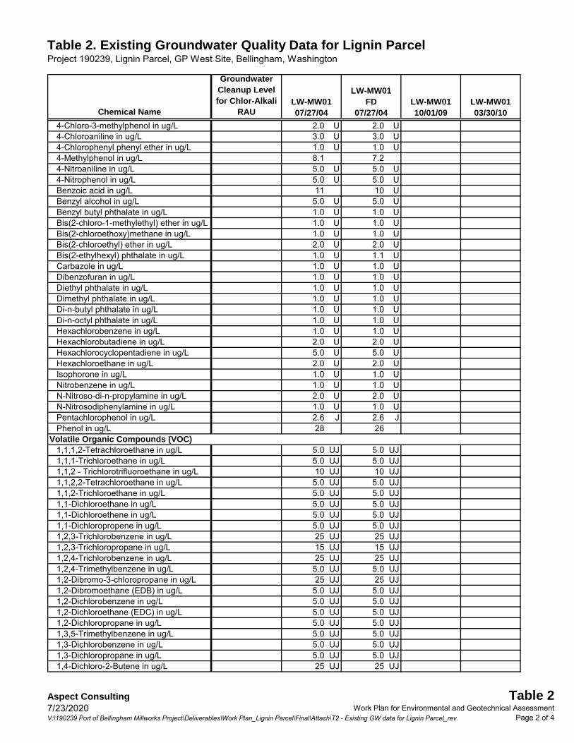
Table 2. Existing Groundwater Quality Data for Lignin ParcelProject 190239, Lignin Parcel, GP West Site, Bellingham, Washington
Chemical Name
Groundwater Cleanup Level for Chlor-Alkali
RAULW-MW0110/01/09
LW-MW0107/27/04
LW-MW01FD
07/27/04LW-MW0103/30/10
4-Chloro-3-methylphenol in ug/L 2.0 U 2.0 U4-Chloroaniline in ug/L 3.0 U 3.0 U4-Chlorophenyl phenyl ether in ug/L 1.0 U 1.0 U4-Methylphenol in ug/L 8.1 7.24-Nitroaniline in ug/L 5.0 U 5.0 U4-Nitrophenol in ug/L 5.0 U 5.0 UBenzoic acid in ug/L 11 10 UBenzyl alcohol in ug/L 5.0 U 5.0 UBenzyl butyl phthalate in ug/L 1.0 U 1.0 UBis(2-chloro-1-methylethyl) ether in ug/L 1.0 U 1.0 UBis(2-chloroethoxy)methane in ug/L 1.0 U 1.0 UBis(2-chloroethyl) ether in ug/L 2.0 U 2.0 UBis(2-ethylhexyl) phthalate in ug/L 1.0 U 1.1 UCarbazole in ug/L 1.0 U 1.0 UDibenzofuran in ug/L 1.0 U 1.0 UDiethyl phthalate in ug/L 1.0 U 1.0 UDimethyl phthalate in ug/L 1.0 U 1.0 UDi-n-butyl phthalate in ug/L 1.0 U 1.0 UDi-n-octyl phthalate in ug/L 1.0 U 1.0 UHexachlorobenzene in ug/L 1.0 U 1.0 UHexachlorobutadiene in ug/L 2.0 U 2.0 UHexachlorocyclopentadiene in ug/L 5.0 U 5.0 UHexachloroethane in ug/L 2.0 U 2.0 UIsophorone in ug/L 1.0 U 1.0 UNitrobenzene in ug/L 1.0 U 1.0 UN-Nitroso-di-n-propylamine in ug/L 2.0 U 2.0 UN-Nitrosodiphenylamine in ug/L 1.0 U 1.0 UPentachlorophenol in ug/L 2.6 J 2.6 JPhenol in ug/L 28 26
Volatile Organic Compounds (VOC)1,1,1,2-Tetrachloroethane in ug/L 5.0 UJ 5.0 UJ1,1,1-Trichloroethane in ug/L 5.0 UJ 5.0 UJ1,1,2 - Trichlorotrifluoroethane in ug/L 10 UJ 10 UJ1,1,2,2-Tetrachloroethane in ug/L 5.0 UJ 5.0 UJ1,1,2-Trichloroethane in ug/L 5.0 UJ 5.0 UJ1,1-Dichloroethane in ug/L 5.0 UJ 5.0 UJ1,1-Dichloroethene in ug/L 5.0 UJ 5.0 UJ1,1-Dichloropropene in ug/L 5.0 UJ 5.0 UJ1,2,3-Trichlorobenzene in ug/L 25 UJ 25 UJ1,2,3-Trichloropropane in ug/L 15 UJ 15 UJ1,2,4-Trichlorobenzene in ug/L 25 UJ 25 UJ1,2,4-Trimethylbenzene in ug/L 5.0 UJ 5.0 UJ1,2-Dibromo-3-chloropropane in ug/L 25 UJ 25 UJ1,2-Dibromoethane (EDB) in ug/L 5.0 UJ 5.0 UJ1,2-Dichlorobenzene in ug/L 5.0 UJ 5.0 UJ1,2-Dichloroethane (EDC) in ug/L 5.0 UJ 5.0 UJ1,2-Dichloropropane in ug/L 5.0 UJ 5.0 UJ1,3,5-Trimethylbenzene in ug/L 5.0 UJ 5.0 UJ1,3-Dichlorobenzene in ug/L 5.0 UJ 5.0 UJ1,3-Dichloropropane in ug/L 5.0 UJ 5.0 UJ1,4-Dichloro-2-Butene in ug/L 25 UJ 25 UJ
Aspect Consulting7/23/2020V:\190239 Port of Bellingham Millworks Project\Deliverables\Work Plan_Lignin Parcel\Final\Attach\T2 - Existing GW data for Lignin Parcel_rev
Table 2Work Plan for Environmental and Geotechnical Assessment
Page 2 of 4

Table 2. Existing Groundwater Quality Data for Lignin ParcelProject 190239, Lignin Parcel, GP West Site, Bellingham, Washington
Chemical Name
Groundwater Cleanup Level for Chlor-Alkali
RAULW-MW0110/01/09
LW-MW0107/27/04
LW-MW01FD
07/27/04LW-MW0103/30/10
1,4-Dichlorobenzene in ug/L 5.0 UJ 5.0 UJ2,2-Dichloropropane in ug/L 5.0 UJ 5.0 UJ2-Butanone in ug/L 25 UJ 25 UJ2-Chloroethyl Vinyl Ether in ug/L 25 UJ 25 UJ2-Chlorotoluene in ug/L 5.0 UJ 5.0 UJ2-Hexanone in ug/L 25 UJ 25 UJ4-Chlorotoluene in ug/L 5.0 UJ 5.0 UJ4-Methyl-2-pentanone in ug/L 25 UJ 25 UJAcetone in ug/L 55 J 51 JAcrolein in ug/L 250 UJ 250 UJAcrylonitrile in ug/L 5.0 UJ 5.0 UJBenzene in ug/L 5.0 UJ 5.0 UJBromobenzene in ug/L 5.0 UJ 5.0 UJBromochloromethane in ug/L 5.0 UJ 5.0 UJBromodichloromethane in ug/L 5.0 UJ 5.0 UJBromoethane in ug/L 10 UJ 10 UJBromoform in ug/L 5.0 UJ 5.0 UJBromomethane in ug/L 5.0 UJ 5.0 UJCarbon disulfide in ug/L 5.0 UJ 5.0 UJCarbon tetrachloride in ug/L 5.0 UJ 5.0 UJChlorobenzene in ug/L 5.0 UJ 5.0 UJChloroethane in ug/L 5.0 UJ 5.0 UJChloroform in ug/L 5.0 UJ 5.0 UJChloromethane in ug/L 5.0 UJ 5.0 UJcis-1,2-Dichloroethene (DCE) in ug/L 5.0 UJ 5.0 UJcis-1,3-Dichloropropene in ug/L 5.0 UJ 5.0 UJDibromochloromethane in ug/L 5.0 UJ 5.0 UJDibromomethane in ug/L 5.0 UJ 5.0 UJDichlorodifluoromethane in ug/LEthylbenzene in ug/L 5.0 UJ 5.0 UJHexachlorobutadiene in ug/L 25 UJ 25 UJIsopropylbenzene in ug/L 5.0 UJ 5.0 UJMethylene chloride in ug/L 10 UJ 10 UJMethyliodide in ug/L 5.0 UJ 5.0 UJn-Butylbenzene in ug/L 5.0 UJ 5.0 UJn-Propylbenzene in ug/L 5.0 UJ 5.0 UJp-Isopropyltoluene in ug/L 5.0 UJ 5.0 UJsec-Butylbenzene in ug/L 5.0 UJ 5.0 UJStyrene in ug/L 5.0 UJ 5.0 UJtert-Butylbenzene in ug/L 5.0 UJ 5.0 UJTetrachloroethene (PCE) in ug/L 5.0 UJ 5.0 UJToluene in ug/L 5.0 UJ 5.0 UJtrans-1,2-Dichloroethene in ug/L 5.0 UJ 5.0 UJtrans-1,3-Dichloropropene in ug/L 5.0 UJ 5.0 UJTrichloroethene (TCE) in ug/L 5.0 UJ 5.0 UJTrichlorofluoromethane in ug/L 5.0 UJ 5.0 UJVinyl acetate in ug/L 25 UJ 25 UJVinyl chloride in ug/L 5.0 UJ 5.0 UJXylenes (total) in ug/L 5.0 UJ 5.0 UJNaphthalene in ug/L 25 UJ 25 UJ
Aspect Consulting7/23/2020V:\190239 Port of Bellingham Millworks Project\Deliverables\Work Plan_Lignin Parcel\Final\Attach\T2 - Existing GW data for Lignin Parcel_rev
Table 2Work Plan for Environmental and Geotechnical Assessment
Page 3 of 4

Table 2. Existing Groundwater Quality Data for Lignin ParcelProject 190239, Lignin Parcel, GP West Site, Bellingham, Washington
Chemical Name
Groundwater Cleanup Level for Chlor-Alkali
RAULW-MW0110/01/09
LW-MW0107/27/04
LW-MW01FD
07/27/04LW-MW0103/30/10
Polychlorinated Biphenyls (PCBs)Aroclor 1016 in ug/L in ug/L 0.10 UJ 0.10 UJAroclor 1221 in ug/L 0.10 UJ 0.10 UJAroclor 1232 in ug/L 0.10 UJ 0.10 UJAroclor 1242 in ug/L 0.10 UJ 0.10 UJAroclor 1248 in ug/L 0.10 UJ 0.10 UJAroclor 1254 in ug/L in ug/L 0.10 UJ 0.10 UJAroclor 1260 in ug/L in ug/L 0.10 UJ 0.10 UJTotal PCBs in ug/L in ug/L ND ND
Conventional Chemistry Parameters (including other metals)Dissolved Calcium in mg/L 55.9Dissolved Iron in mg/L 19.8 20.4 0.311Dissolved Magnesium in mg/L 5.49Dissolved Manganese in mg/L 0.381 0.404 0.141Dissolved Potassium in mg/L 7.25Dissolved Sodium in mg/L 308Formaldehyde in ug/L 6 U 7 UNitrate + Nitrite in mg/L 0.500 U 0.500 UNitrate as Nitrogen in mg/L 0.500 U 0.500 UNitrite as Nitrogen in mg/L 0.500 U 0.500 USulfate in mg/L 233 216Total Suspended Solids in mg/L 56.2 42.7
Field ParametersConductivity in us/cm 2,850 1,476 1,175Dissolved Oxygen in mg/L 1.62 0.43 0.6Eh (ORP) in mVolts -418.3 -365.5 -306.3pH in pH units >6.2 and <8.5 10.8 8.4 8.9Practical Salinity (Calculated) in PSU 1.5 0.7 0.6Temperature in deg C 17.52 18 11.54Turbidity in NTU 252 10 20
Notes:Blank Cell - Not analyzed. Concentrations in shaded cells indicate value exceeds groundwater cleanup level.U - Analyte was not detected at or above the reporting limit. J - Analyte was positively identified, but the reported result is an estimate.FD - Field duplicate sample. ND - No individual cPAH or PCB compound was detected, so the total concentration is reported as not detected.
Aspect Consulting7/23/2020V:\190239 Port of Bellingham Millworks Project\Deliverables\Work Plan_Lignin Parcel\Final\Attach\T2 - Existing GW data for Lignin Parcel_rev
Table 2Work Plan for Environmental and Geotechnical Assessment
Page 4 of 4

FIGURES

")
")")
")
")
")
")
")
")")
")
")
")
")")") ")
")
")
")
")")
!.
!.
!.
!.&(&(
&(
&(
&<A&<A
@?
@?
@?!.
!.
!.
!.
!.
!.
Lignin Parcel Boundary(Approximate)
Building Removedin May 2020
LW-MW01
LW-SB01
LW-SB02
LW-SB03LW-SB04LW-SS01 LW-SS02
LW-SS03
LW-SS04
BB-1
BRR-1
BRR-2
LW-SB101
LW-SB102
LW-SB103LW-SB104
LW-SB105
LW-SB106
FIGURE NO.
1
PROJECT NO.
190239SJG
PPW
SCC
DATE:
DESIGNED BY:
DRAWN BY:
REVISED BY:
0 60 12030
Feet
Jul 2020
Path
: T:\p
roje
cts_
8\Po
rt_of
_Bel
lingh
am\D
eliv
ered
\Lig
nin
Parc
el In
tegr
ated
Pla
nnin
g\K
now
nSoi
lCon
tam
andP
ropo
sedE
xplo
r.mxd
Known Soil Contamination and Proposed Explorations Work Plan for Lignin Parcel Integrated Planning Grant
Bellingham, WashingtonTRUE
NORTH
MILLNORTH
]]45̊
!. Proposed Soil BoringExisting Explorations@? Geotechnical Soil Boring&<A Monitoring Well!. Soil Boring
&( Surface Soil Sample
Soil Contaminants Exceeding Cleanup Levels") Metals
") cPAHs
Note:Soil cleanup levels for unrestricted use, saturated soil, from Chlor-Alkali RAU Draft Cleanup Action Plan. Refer to Table 1 for soil data and cleanup levels.
Lignin Parcel Boundary(Approximate)
Feet
0 12060
NNMillNorth True
North
CAD
Pat
h: Q
:\Po
rt of
Bel
lingh
am\1
9023
9 Li
gnin
Par
cel I
nteg
rate
d Pl
anni
ng\2
020-
04 W
ork
Plan
for E
nv+G
eote
ch\1
9023
9-02
.dw
g 11
x17
||
Dat
e Sa
ved:
Jul
09,
202
0 5:
54pm
|
| U
ser:
scud
d
Work Plan for Lignin Parcel Integrated Planning GrantBellingham, Washington
2BY:
SJG/SCC
Historical Site Diagram - Lignin Parcel Area
Jul-2020REVISED BY:
-PROJECT NO.
190239
FIGURE NO.
Source: Base map provided by Georgia Pacific.

APPENDIX A
Sampling and Analysis Plan and Quality Assurance Project Plan

ASPECT CONSULTING
Project No. 190239-001-1.1 July 23, 2020 FINAL A-1
A. Sampling Analysis Plan and Quality Assurance Project Plan
This Appendix includes the Sampling and Analysis Plan (SAP) and Quality Assurance Project Plan (QAPP) that together provide procedural details for conducting the environmental assessment described in the main body of this Work Plan. The main body of this Work Plan describes the locations and rationale for the proposed sampling and analyses, and that information is not reiterated here.
The SAP defines field exploration, sampling, and sample handling protocols for the assessment. The QAPP defines analytical protocols for the samples collected, including laboratory analytical methods, sample containers, sample holding times, and data quality assurance requirements.
The purpose of the combined SAP and QAPP is to ensure that field sample collection, handling, and laboratory analysis conducted during the assessment will generate data to meet project-specific data quality objectives in accordance with the Model Toxics Control Act (MTCA) requirements (WAC 173-340-350). It is the responsibility of the Aspect Consulting, LLC (Aspect) personnel and subcontracted analytical laboratory personnel performing the sampling and analysis activities to adhere to the requirements of the SAP and QAPP.
The SAP (Section A.1) and QAPP (Section A.2) are presented below.
A.1. Sampling and Analysis Plan The following sections describe field sampling and sample handling procedures.
A.1.1. Direct Push Soil Borings Aspect will subcontract with a Washington-licensed resource protection well driller to complete soil borings using a direct push (i.e., Geoprobe) rig with collection of continuous soil core from which soil samples will be collected. Each boring will be advanced to collect samples at depth intervals specified in the Work Plan or as determined by field screening. The soil core will be retrieved from the borehole in disposable 1.5-inch-diameter plastic liners (4- or 5-foot lengths). The liners will be opened by the driller using a stainless-steel blade to access the soil core. Once complete, each soil boring will be decommissioned with bentonite in accordance with Chapter 173-160 WAC.
A geologist from Aspect will oversee the drilling activities and preparation of geologic logs for each of the explorations completed. The field representative will visually classify the soils in accordance with ASTM Method D2488 and record soil descriptions, field screening results, and other relevant details (e.g., staining, debris, odors, etc.) on a boring log form. In addition to visual and olfactory observations, the field representative will

ASPECT CONSULTING
A-2 FINAL PROJECT NO. 190239-001-1.1 JULY 23, 2020
screen each soil sample using a PID to monitor the presence of volatile organic compounds (VOCs).
The soil samples will be removed from the sampler using a stainless-steel spoon and placed in a stainless-steel bowl for homogenization with the stainless-steel spoon. Gravel-sized material greater than approximately 0.5 inch will be removed from the sample during mixing. A representative aliquot of the homogenized soil will be placed into certified-clean jars supplied by the analytical laboratory.
Each soil boring will be properly decommissioned with hydrated granular bentonite.
A.1.1.1. Soil Sample Identification To readily distinguish the current explorations from the historical explorations on the parcel, the borings will be designated beginning with LW-B-101. While the sampling is being done in the Lignin Parcel, the “LP-“ prefix was used for the Lignin Plant in prior environmental investigations onsite, while LW-“ was used for explorations on the Lignin (Warehouse) Parcel.
Each soil sample collected for chemical analysis will be assigned a unique sample identification number including the boring number and the depth from which the sample was collected. For example, the soil sample collected from boring LW-B-102 at a depth of 7 to 8 feet below ground surface (bgs) would be identified as LW-B-102-7-8.
A.1.2. Sample Custody and Field Documentation A.1.2.1. Sample Custody
Upon collection, samples will be placed upright in a cooler. Ice or blue ice will be placed in each cooler to meet sample preservation requirements. Inert cushioning material will be placed in the remaining space of the cooler as needed to limit movement of the sample containers. If the sample coolers are being shipped, not hand carried, to the laboratory, the chain of custody (COC) form will be placed in a waterproof bag taped to the inside lid of the cooler for shipment.
After collection, samples will be maintained in Aspect’s custody until formally transferred to the analytical laboratory. For purposes of this work, custody of the samples will be defined as follows:
In plain view of the field representatives
Inside a cooler that is in plain view of the field representative
Inside any locked space such as a cooler, locker, car, or truck to which the field representative has the only immediately available key(s)
A COC record provided by the laboratory will be initiated at the time of sampling for all samples collected. The record will be signed by the field representative and others who subsequently take custody of the sample. Couriers or other professional shipping representatives are not required to sign the COC form; however, shipping receipts will be collected and maintained as a part of custody documentation in project files. A copy of the COC form with appropriate signatures will be kept by Aspect’s project manager.

ASPECT CONSULTING
Project No. 190239-001-1.1 July 23, 2020 FINAL A-3
Upon sample receipt, the laboratory will fill out a cooler receipt form to document sample delivery conditions and verify that the COC form matches the samples received. The laboratory will notify the Aspect project manager, as soon as possible, of any issues noted with the sample shipment or custody.
A.1.2.2. Field Documentation While conducting field work, the Aspect field representative will document pertinent observations and events, specific to each activity, on field forms (e.g., boring log form) and/or in a field notebook, and, when warranted, provide photographic documentation of specific sampling efforts. Field notes will include a description of the field activity, sample descriptions, and associated details such as the date, time, and field conditions.
A.1.3. Decontamination and Investigative-Derived Waste Management
All non-disposable sampling equipment (stainless-steel spoons and bowls) will be decontaminated before collection of each sample. The decontamination sequence consists of a scrub with a non-phosphate (Alconox) solution, followed by tap water (potable) rinse, and finished with thorough spraying with deionized or distilled water.
Investigation-derived waste (IDW) including soil cuttings from borings and any disposable personal protective equipment (PPE) will be placed in labeled Department of Transportation (DOT)-approved drums pending the analytical results to determine appropriate disposal. Each drum will be labeled with the following information:
Non-Classified IDW
Content of the drum (soil, water, PPE) and its source (i.e., the exploration[s] from which the contents came)
Date IDW was generated
Name and telephone number of the contact person.
The drums of IDW will be temporarily consolidated on-site, profiled (in accordance with applicable waste regulations) based on available analytical data, and disposed of appropriately at a permitted off-Site disposal facility. Documentation for off-Site disposal of IDW will be maintained in the project file. The small volume of decontamination water generated will be containerized and discharged to the Port’s on-property pump station for the aerated stabilization basin.

ASPECT CONSULTING
A-4 FINAL PROJECT NO. 190239-001-1.1 JULY 23, 2020
A.2. Quality Assurance Project Plan This QAPP identifies quality control (QC) and quality assurance (QA) procedures and criteria required to ensure that laboratory analytical data collected during the environmental assessment are of known quality and acceptable to achieve project objectives as defined in the main body of this Work Plan. Specific protocols and criteria are also set forth in this QAPP for data quality evaluation to determine the level of completeness and usability of the data collected. This QAPP was prepared in accordance with Ecology’s Guidelines for Preparing Quality Assurance Project Plans for Environmental Studies (Ecology, 2016).
OnSite Environmental in Redmond, Washington, is the Ecology-accredited analytical laboratory for the environmental assessment.
A.2.1. Personnel Responsibilities The project consultant team involved with data generation includes representatives from Aspect and OnSite Environmental. Key personnel and their responsibilities on this project are as follows:
Field Investigation Manager—Steve Germiat, Aspect (206-619-6743). The investigation manager is responsible for the successful completion of all aspects of the field investigation, including day-to-day management, liaison with the Port, RMC, and regulatory agencies, and coordination with the project team members. The Aspect project manager is also responsible for resolution of non-conformance issues and is the lead author on environmental-related portions of project plans and reports.
Field Manager—Aaron Fitts, Aspect (207-650-6191). The field manager is responsible for conducting the field sampling program outlined in this plan, including directing the drilling subcontractor, collecting representative samples, and ensuring that they are handled properly prior to transfer of custody to the project laboratory. The field manager will manage procurement of necessary field supplies, assure that monitoring equipment is operational and calibrated in accordance with the specifications provided herein, and act as the Site Health and Safety Officer.
Data Quality Manager—Jason Yabandeh, Aspect (425-463-7212). The data quality manager is responsible for coordinating with the analytical laboratory, overseeing laboratory performance, approving QA/QC procedures, and conducting QA validation of the analytical data reports received from the project laboratory.
Laboratory Project Manager—David Burmeister, OnSite Environmental (206-550-2483). The laboratory project manager is responsible for ensuring that all laboratory analytical work for soil and water media complies with project requirements, and acting as a liaison with the project manager, field manager, and data quality manager to fulfill project needs on the analytical laboratory work. This responsibility applies to analytical work the laboratory subcontracts to another laboratory, if any.

ASPECT CONSULTING
Project No. 190239-001-1.1 July 23, 2020 FINAL A-5
A.2.2. Analytical Methods and Reporting Limits Analytical methodologies for chemical analysis of samples collected during the environmental assessment are in accordance with the following documents:
USEPA SW Methods – USEPA Test Methods for Evaluating Solid Waste, Physical/Chemical Methods, SW-846, Third Edition, December 1996.
Standard Methods for the Examination of Water and Wastewater, American Public Health Association, 20th Edition, 1995.
Ecology Analytical Methods for Petroleum Hydrocarbons. Publication No. ECY 97-602, June 1997.
Table A-1 lists the laboratory analytical methods for soil and groundwater analyses to be performed during the assessment, along with samples containers, preservation, and analytical holding times for each analysis.
A.2.2.1. Method Detection Limit and Method Reporting Limit The method detection limit (MDL) is the minimum concentration of a compound that can be measured and reported with a 99% confidence that the analyte concentration is greater than zero. MDLs are established by the laboratory using prepared samples, not samples of environmental media.
The method reporting limit (RL) is defined as the lowest concentration at which a chemical can be accurately and reproducibly quantified, within specified limits of precision and accuracy, for a given environmental sample. The RL can vary from sample to sample depending on sample size, sample dilution, matrix interferences, moisture content, and other sample-specific conditions. As a minimum requirement for organic analyses, the RL should be equivalent to or greater than the concentration of the lowest calibration standard in the initial calibration curve. The expected MDLs and RLs are summarized in Table A.2.
A.2.3. Data Quality Objectives DQOs, including the Measurement Quality Indicators (MQIs)—precision, accuracy, representativeness, comparability, completeness, and sensitivity (i.e. PARCCS parameters) —and sample-specific RLs are dictated by the data quality objectives, project requirements, and intended uses of the data. For this project, the analytical data must be of sufficient technical quality to determine whether contaminants are present and, if present, whether their concentrations are greater than or less than applicable screening criteria based on protection of human health and the environment. Definitions of these parameters and the applicable QC procedures are presented below.
A.2.3.1. Precision Precision measures the reproducibility of measurements under a given set of conditions. Specifically, it is a quantitative measure of the variability of a group of measurements compared with their average values. Analytical precision is measured through matrix spike/matrix spike duplicate (MS/MSD) samples and laboratory control

ASPECT CONSULTING
A-6 FINAL PROJECT NO. 190239-001-1.1 JULY 23, 2020
samples/laboratory control sample duplicate (LCS/LCSD) for organic analysis and through laboratory duplicate samples for inorganic analyses.
Analytical precision is quantitatively expressed as the relative percent difference (RPD) between the LCS/LCSD, MS/MSD, or laboratory duplicate pairs and is calculated with the following formula:
( ) 2/100(%)
DSDS
RPD+
−×=
where:
S = analyte concentration in sample D = analyte concentration in duplicate sample
Analytical precision measurements will be carried out at a minimum frequency of 1 per 20 samples for each matrix sampled, or one per laboratory analysis group. Laboratory precision will be evaluated against laboratory’s quantitative RPD performance criteria for specific analytical methods and sample matrices as identified in their standard operating procedure (SOP) for each method. If the control criteria are not met, the laboratory will supply a justification of why the limits were exceeded and implement the appropriate corrective actions. The RPD will be evaluated during data review and validation. The data reviewer will note deviations from the specified limits and will comment on the effect of the deviations on reported data.
A.2.3.2. Accuracy Accuracy measures the closeness of the measured value to the true value. The accuracy of chemical test results is assessed by “spiking” samples with known standards (surrogates, blank spikes, or matrix spikes) and establishing the average recovery. Accuracy is quantified as the %R. The closer the %R is to 100%, the more accurate the data.
Surrogate recovery will be calculated as follows:
100(%)Recovery ×=SCMC
where:
SC = spiked concentration MC = measured concentration
MS percent recovery will be calculated as follows:
100(%)Recovery ×−
=SC
USCMC
where:
SC = spiked concentration MC = measured concentration USC = unspiked sample concentration

ASPECT CONSULTING
Project No. 190239-001-1.1 July 23, 2020 FINAL A-7
Accuracy measurements on MS samples will be carried out at a minimum frequency of 1 in 20 samples per matrix analyzed. Blank spikes will also be analyzed at a minimum frequency of 1 in 20 samples (not including QC samples) per matrix analyzed. Surrogate recoveries for organic compounds will be determined for each sample analyzed for respective compounds. Laboratory accuracy will be evaluated against the performance criteria defined in the laboratory’s SOP for each method. If the control criteria are not met, the laboratory will supply a justification of why the limits were exceeded and implement the appropriate corrective actions. Percent recoveries will be evaluated during data review and validation, and the data reviewer will comment on the effect of the deviations on the reported data.
A.2.3.3. Representativeness Representativeness measures how closely the measured results reflect the actual concentration or distribution of the chemical compounds in the matrix sampled. The FSP sampling techniques and sample handling protocols (e.g., homogenizing, storage, preservation, and use of duplicates and blanks) have been developed to ensure representative samples. Only representative data will be used in the assessment. Sampling locations for assessment activities are described in the main body of the Work Plan. The field sampling procedures are described in the SAP (Section A.1).
The representativeness of a data point is determined by assessing the integrity of the sample upon receipt at the laboratory (e.g., consistency of sample ID and collection date/time between container labels vs. COC forms, breakage/leakage, cooler temperature, preservation, headspace for VOA containers, etc.); compliance of method required sample preparation and analysis holding times; and the conditions of blanks associated with the sample.
A.2.3.4. Comparability Comparability is a qualitative parameter expressing the confidence with which one data set can be compared with another. This goal will be achieved through the use of standard techniques to collect samples, USEPA-approved standard methods to analyze samples, and consistent units to report analytical results. Data comparability also depends on data quality. Data of unknown quality cannot be compared.
A.2.3.5. Completeness Completeness is defined as the percentage of measurements made that are judged to be valid. Results will be considered valid if the precision, accuracy, and representativeness objectives are met and if RLs are sufficient for the intended uses of the data. Completeness is calculated as follows:
100(%) ×=PVssCompletene
where: V = number of valid measurements P = number of measurements taken

ASPECT CONSULTING
A-8 FINAL PROJECT NO. 190239-001-1.1 JULY 23, 2020
Valid and invalid data (i.e., data qualified with the R flag [rejected]) will be identified during data validation. The target completeness goal for this project is 95%.
A.2.3.6. Sensitivity Sensitivity depicts the level of ability an analytical system (i.e., sample preparation and instrumental analysis) of detecting a target component in a given sample matrix with a defined level of confidence. Factors affecting the sensitivity of an analytical system include: analytical system background (e.g., laboratory artifact or method blank contamination), sample matrix (e.g., mass spectrometry ion ratio change, co-elution of peaks, or baseline elevation), and instrument instability.
A.2.4. Quality Control Procedures Field and laboratory QC procedures are outlined below.
A.2.4.1. Field Quality Control Beyond use of standard sampling protocols defined in the SAP, field QC procedures include maintaining the field instrumentation used. Field instruments (e.g., PID for evaluating presence of VOCs in soil samples) are maintained and calibrated regularly prior to use, in accordance with manufacturer recommendations.
A.2.4.2. Laboratory Quality Control The laboratory’s analytical procedures must meet requirements specified in the respective analytical methods or approved laboratory SOPs (e.g., instrument performance check, initial calibration, calibration check, blanks, surrogate spikes, internal standards, and/or labeled compound spikes). Specific laboratory QC analyses required for this project will consist of the following at a minimum:
Instrument tuning, instrument initial calibration, and calibration verification analyses as required in the analytical methods and the laboratory SOPs.
Laboratory and/or instrument method blank measurements at a minimum frequency of 5% (1 per 20 samples) or in accordance with method requirements, whichever is more frequent.
Accuracy and precision measurements at a minimum frequency of 5% (1 per 20 samples) or in accordance with method requirements, whichever is more frequent. In cases where a pair of MS/MSD or MS/laboratory duplicate analyses are not performed on a project sample, a set of LCS/LCSD analyses will be performed to provide sufficient measures for analytical precision and accuracy evaluation.
The laboratory’s QA officers are responsible for ensuring that the laboratory implements the internal QC and QA procedures appropriate to each analysis.

ASPECT CONSULTING
Project No. 190239-001-1.1 July 23, 2020 FINAL A-9
A.2.5. Corrective Actions If routine QC audits by the laboratory result in detection of unacceptable conditions or data, actions specified in the laboratory SOPs will be taken. Specific corrective actions are outlined in each SOP used and can include the following:
Identifying the source of the violation
Reanalyzing samples if holding time criteria permit
Resampling and analyzing
Evaluating and amending sampling and analytical procedures
Accepting but qualifying data to indicate the level of uncertainty
If unacceptable conditions occur, the laboratory will contact Aspect’s environmental assessment manager to discuss the issues and determine the appropriate corrective action. Corrective actions taken by the laboratory during analysis of samples for this project will be documented by the laboratory in the case narrative associated with the affected samples.
In addition, the project data quality manager will review the laboratory data generated for this investigation to ensure that project DQOs are met. If the review indicates that non-conformances in the data have resulted from field sampling or documentation procedures or laboratory analytical or documentation procedures, the impact of those non-conformances on the overall project data usability will be assessed. Appropriate actions, including re-sampling and/or re-analysis of samples may be recommended to the project manager to achieve project objectives.
A.2.6. Data Reduction, Quality Review, and Reporting All data will undergo a QA/QC evaluation at the laboratory which will then be reviewed by the Aspect database manager and the project data quality manager. Initial data reduction, evaluation, and reporting at the laboratory will be carried out in full compliance with the method requirement and laboratory SOPs. The laboratory internal review will include verification (for correctness and completeness) of electronic data deliverable (EDD) accompanied with each laboratory report. The Aspect database manager will verify the completeness and correctness of all laboratory deliverables (i.e., laboratory report and EDDs) before releasing the deliverables for data validation.
A.2.6.1. Minimum Data Reporting Requirements The following sections specify general and specific requirements for analytical data reporting to provide sufficient deliverables for project documentation and data quality assessment.
General Requirements The following requirements apply to laboratory reports for all types of analyses:

ASPECT CONSULTING
A-10 FINAL PROJECT NO. 190239-001-1.1 JULY 23, 2020
A laboratory report will include a cover page signed by the laboratory director, the laboratory QA officer, or his/her designee to certify the eligibility of the reported contents and the conformance with applicable analytical methodology.
Definitions of abbreviations, data flags, and data qualifiers used in the report.
Cross reference of field sample names and laboratory sample identity for all samples in the SDG.
Completed COC document signed and dated by parties of acquiring and receiving.
Completed sample receipt document with record of cooler temperature and sample conditions upon receipt at the laboratory. Anomalies such as inadequate sample preservation, inconsistent bottle counts, and sample container breakage, and communication record and corrective actions in response to the anomalies will be documented and incorporated in the sample receipt document. The document will be initialed and dated by personnel that complete the document.
Case narrative that addresses any anomalies or QC outliers in relation to sample receiving, sample preparation, and sample analysis on samples in the sample delivery group (SDG). The narrative will be presented separately for each analytical method and each sample matrix.
All pages in the report are to be paginated.
Any resubmitted or revised report pages will be submitted to Aspect with a cover page stating the reason(s) and scope of resubmission or revision, and signed by laboratory director, QA officer, or the designee.
Specific Requirements The following presents specific requirements for laboratory reports:
Sample results: sample results will be evaluated and reported down to the MRLs. For analyses other than metals, detections at levels greater than the MDLs but less than the RLs will be reported and flagged with “J.” Results less than the MDLs will be reported at the RLs and flagged with “U.” All soil sample results will be reported on a dry-weight basis. The report pages for sample results (namely Form 1s) will, at minimum, include sample results, RLs, unit, proper data flags, dates of sample collection, preparation, and analysis, dilution factor, percent moisture (for solid samples), and sample volume (used for analysis).
Instrument run log: the run log will list, in chronological order, all analytical runs on field samples, QC samples, calibrations, and calibration verification analyses in the SDG with data file name (and/or legible laboratory codes) and analysis date/time for each analytical run.
Original sample preparation and analyst worksheet: initialed and dated by analyst and reviewer.
GC/MS and inductively coupled plasma (ICP)/MS tune report: including ion abundance ratios and criteria for all required ions.

ASPECT CONSULTING
Project No. 190239-001-1.1 July 23, 2020 FINAL A-11
Initial calibration summary: including data file name for each calibration standard file; response factor (RF) or calibration factor (CF) for each calibration standard and each target and surrogate compound; average RF or CF, percent relative standard deviation (%RSD), correlation coefficient, or coefficient of determination; and absolute and relative retention times and ion ratios for HRGC/HRMS methods for each target compound and surrogate (labeled) compounds. As applicable and if required by the methods, initial calibrations should be verified with a second-source standard (namely the initial calibration verification [ICV]) at the mid-point concentration of the initial calibration. ICV results should be reported as part of the initial calibration.
Calibration verification summary: including true amount, calculated amount, and percent difference (%D), or percent drift (%Df) as applicable, for target compounds.
Method blank and calibration blank (as applicable such as metals analyses) results.
LCS and LCSD (if matrix spike duplicate analysis is not performed) results with laboratory acceptance criteria for %R and RPD.
Surrogate spike results with laboratory acceptance criteria for %R.
MS and MSD results with laboratory acceptance criteria for %R and RPD. In cases where MS/MSD analyses were not performed on a project sample, LCS/LCSD analyses should be performed and reported instead.
Internal standard (as applicable) results: internal standard absolute retention times and response areas in field samples, QC analyses, and associated calibration verification analyses.
Labeled compound (HRGC/HRMS methodology only) results, ion abundance ratios, and recovery.
A.2.7. Data Quality Validation Reported analytical results will be qualified by the laboratory to identify QC concerns in accordance with the specifications of the analytical methods. Additional laboratory data qualifiers may be defined and reported by the laboratory to more completely explain QC concerns regarding a particular sample result. All data qualifiers will be defined in the laboratory’s narrative reports associated with each case.
Aspect will perform an independent Stage 2a data quality validation on all analytical data collected during the assessment. The data validation will examine and verify the following parameters against the method requirements and laboratory control limits specific to an analysis, which may include:
Sample management and holding times
Instrument performance check, calibration, and calibration verification

ASPECT CONSULTING
A-12 FINAL PROJECT NO. 190239-001-1.1 JULY 23, 2020
Laboratory blank results
Detection and reporting limits
Laboratory replicate results
MS/MSD results
LCS and/or standard reference material results
Surrogate spike recovery (organic analyses only)
Internal standard recovery (internal calibration methods only)
Inter-element interference check (ICP analyses only)
Serial dilution (metals only)
The validation will follow the procedures documented in the analytical methods, National Functional Guidelines for Organic Data Review (USEPA, 2008) and National Functional Guidelines for Inorganic Data Review (USEPA, 2010).
Data qualifiers will be assigned based on outcome of the data validation. Data qualifiers are limited to and defined as follows:
U - The analyte was analyzed for but was determined to be non-detect above the reported sample quantitation limit, or the quantitation limit was raised to the concentration found in the sample due to blank contamination.
J - The analyte was positively identified; the associated numerical value is the approximate concentration of the analyte in the sample.
UJ - The analyte was not detected above the reported quantitation limit. However, the reported quantitation limit is approximate and may or may not represent the actual limit of quantitation necessary to accurately and precisely measure the analyte in the sample.
R - The sample results are rejected due to serious deficiencies in the ability to analyze the sample and meet QC criteria. The presence or absence of the analyte cannot be verified.
DNR - Do not report from this analysis; the result for this analyte is to be reported from an alternative analysis.
In cases of multiple analyses (such as an undiluted and a diluted analysis) performed on one sample, the laboratory will report all results, but only the valid result (meeting QC requirements) will be reported and used by Aspect.
The scope and findings of the data validation will be documented and discussed in Aspect’s Data Validation Report(s), which will be appended to Aspect’s report for the assessment.
A.2.8. Preventative Maintenance Procedures and Schedules

ASPECT CONSULTING
Project No. 190239-001-1.1 July 23, 2020 FINAL A-13
Preventative maintenance in the laboratory will be the responsibility of the laboratory personnel and analysts. This maintenance includes routine care and cleaning of instruments and inspection and monitoring of carrier gases, solvents, and glassware used in analyses. Details of the maintenance procedures are addressed in the respective laboratory SOPs.
Precision and accuracy data are examined for trends and excursions beyond control limits to determine evidence of instrument malfunction. Maintenance will be performed when an instrument begins to change as indicated by the degradation of peak resolution, shift in calibration curves, decrease in sensitivity, or failure to meet one or another of the method-specific QC criteria.
Maintenance and calibration of instruments used in the field for sampling will be conducted regularly in accordance with manufacturer recommendations prior to use.
A.2.9. Performance and System Audits The Aspect project manager has responsibility for reviewing the performance of the laboratory QA program; this review will be achieved through regular contact with the analytical laboratory’s project manager. To ensure comparable data, all samples of a given matrix to be analyzed by each specified analytical method will be processed consistently by the same analytical laboratory.
A.2.10. Data and Records Management Records will be maintained documenting all activities and data related to field sampling and chemical analyses.
A.2.10.1. Field Documentation Raw data received from the analytical laboratory will be reviewed, entered into a computerized database, and verified for consistency and correctness. The database will be updated based on data review and independent validation if necessary.
The following field data will be included in the database:
Sample location coordinates
Sample type (i.e., soil)
Soil sampling depth interval
A.2.10.2. Analytical Data Management Raw data received from the analytical laboratory will be reviewed, entered into a computerized database, and verified for consistency and correctness. The database will be updated based on data review and independent validation if necessary. Data will be submitted to Ecology’s Environmental Information Management (EIM) database once data have been reviewed and validated.

ASPECT CONSULTING
A-14 FINAL PROJECT NO. 190239-001-1.1 JULY 23, 2020
A.3. References for Appendix A United States Environmental Protection Agency (USEPA), 2008, Contract Laboratory
Program National Functional Guidelines for Superfund Organic Methods Data Review, Office of Superfund Remediation and Technical Innovation, U.S. Environmental Protection Agency, June 2008, USEPA-540-R-08-01.
United States Environmental Protection Agency (USEPA), 2010, Contract Laboratory Program National Functional Guidelines for Inorganic Superfund Data Review, Office of Superfund Remediation and Technical Innovation, U.S. Environmental Protection Agency, January 2010, USEPA 540/R-10/011.
Washington State Department of Ecology, 2016, Guidelines for Preparing Quality Assurance Project Plans for Environmental Studies, Ecology Publication No. 04-03-030, revised December 2016.
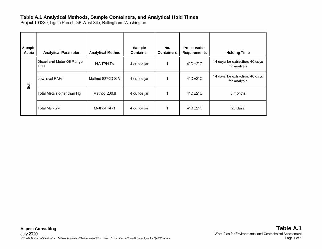
Table A.1 Analytical Methods, Sample Containers, and Analytical Hold TimesProject 190239, Lignin Parcel, GP West Site, Bellingham, Washington
Sample Matrix Analytical Parameter Analytical Method
Sample Container
No. Containers
Preservation Requirements Holding Time
Diesel and Motor Oil Range TPH NWTPH-Dx 4 ounce jar 1 4°C ±2°C 14 days for extraction; 40 days
for analysis
Low-level PAHs Method 8270D-SIM 4 ounce jar 1 4°C ±2°C 14 days for extraction; 40 days for analysis
Total Metals other than Hg Method 200.8 4 ounce jar 1 4°C ±2°C 6 months
Total Mercury Method 7471 4 ounce jar 1 4°C ±2°C 28 days
Soil
Aspect ConsultingJuly 2020V:\190239 Port of Bellingham Millworks Project\Deliverables\Work Plan_Lignin Parcel\Final\Attach\App A - QAPP tables
Table A.1Work Plan for Environmental and Geotechnical Assessment
Page 1 of 1

Table A.2 Analytical Reporting Limits for Soil SamplesProject 190239, Lignin Parcel, GP West Site, Bellingham, Washington
Analyte Name MDL MRL Metals by EPA 200.8 (mg/kg)
Arsenic n/a 10Cadmium n/a 0.5Chromium (Total) n/a 0.5Copper n/a 1.0Lead n/a 5.0Nickel n/a 2.5Zinc n/a 2.5
Mercury by EPA 7471 (mg/kg)Mercury 0.00043 0.25
Polycyclic Aromatic Hydrocarbons by SW8270D-SIM (mg/kg)1-Methylnaphthalene 0.000407 0.00672-Methylnaphthalene 0.000437 0.0067Acenaphthene 0.000319 0.0067Acenaphthylene 0.000223 0.0067Anthracene 0.000298 0.0067Benzo[a]anthracene 0.000182 0.0067Benzo[a]pyrene 0.000174 0.0067Benzo[b]fluoranthene 0.000179 0.0067Benzo[g,h,i]perylene 0.000209 0.0067Benzo[j,k]fluoranthene 0.000128 0.0067Chrysene 0.000192 0.0067Dibenz[a,h]anthracene 0.000271 0.0067Fluoranthene 0.000240 0.0067Fluorene 0.000300 0.0067Indeno(1,2,3-c,d)pyrene 0.000255 0.0067Naphthalene 0.000735 0.0067Phenanthrene 0.000882 0.0067Pyrene 0.000234 0.0067
Diesel and Motor Oil Range Hydrocarbons by NWTPH-Dx (mg/kg)Diesel Range Hydrocarbons 7.7 25Oil Range Hydrocarbons 30 50
Notes:Vaues from OnSite Environmental, Redmond, Washington.
mg/kg - milligram per kilogramn/a - not applicable
MDL - Method detection limit. MRL - Method reporting limit. Metals are not reported below the MRL. Values subject to change based on sample matrix.
Aspect ConsultingJuly 2020V:\190239 Port of Bellingham Millworks Project\Deliverables\Work Plan_Lignin Parcel\Final\Attach\App A - QAPP tables
Table A.2Work Plan for Environmental and Geotechnical Assessment
Page 1 of 1

APPENDIX B
Inadvertent Discovery Plan

ECY 070-560 (09/2016) - 1 -
PLAN AND PROCEDURES FOR THE UNANTICIPATED DISCOVERY OF CULTURAL RESOURCES AND HUMAN
SKELETAL REMAINS1
PROJECT TITLE: Lignin Parcel Environmental/Geotechnical Investigation COUNTY WASHINGTON: Whatcom Section, Township, Range: Section 30 T38N R3E
1. INTRODUCTION The following Inadvertent Discovery Plan (IDP) outlines procedures to perform in the event of discovering archaeological materials or human remains, in accordance with state and federal laws.
2. RECOGNIZING CULTURAL RESOURCES
A cultural resource discovery could be prehistoric or historic. Examples include: a. An accumulation of shell, burned rocks, or other food related materials. b. Bones or small pieces of bone. c. An area of charcoal or very dark stained soil with artifacts. d. Stone tools or waste flakes (i.e. an arrowhead. or stone chips). e. Clusters of tin cans or bottles, logging or agricultural equipment that appears to be
older than 50 years. f. Buried railroad tracks, decking, or other industrial materials.
When in doubt, assume the material is a cultural resource.
3. ON-SITE RESPONSIBILITIES STEP 1: Stop Work. If any employee, contractor or subcontractor believes that he or she has uncovered a cultural resource at any point in the project, all work must stop immediately. Notify the appropriate party(s). Leave the surrounding area untouched, and provide a demarcation adequate to provide the total security, protection, and integrity of the discovery. The discovery location must be secured at all times by a temporary fence or other onsite security. STEP 2: Notify Archaeological Monitor or Licensed Archaeologist. If there is an Archaeological Monitor for the project, notify that person. If there is a monitoring plan in place, the monitor will follow the outlined procedure.
1 If you need this document in a format for the visually impaired, call Water Quality Reception at Ecology, (360) 407-6600. Persons with hearing loss can call 711 for Washington Relay Service. Persons with a speech disability can call 877-833-6341.

ECY 070-560 - 2 -
STEP 3: Notify the Project Manager of this project and contact the Ecology Staff Project Manager, or other applicable contacts: Project Manager: Name: Brian Gouran Phone: 360-676-2500 Email: [email protected]
Ecology Staff Project Manager Name: John Guenther Phone: 360-255-4381 Email: [email protected]
Assigned Alternates: Assigned Project Manager Alternate: Name: Gina Stark Phone: 360-676-2500 Email: [email protected]
Ecology Cultural Resource Specialist (Alternate): Name: Phone: email:
The Project Manager or applicable staff will make all calls and necessary notifications. If human remains are encountered, treat them with dignity and respect at all times. Cover the remains with a tarp or other materials (not soil or rocks) for temporary protection and to shield them from being photographed. Do not call 911 or speak with the media. Do not take pictures unless directed to do so by DAHP. See Section 5.
4. FURTHER CONTACTS AND CONSULTATION
A. Project Manager’s Responsibilities:
• Protect Find: The Project Manager is responsible for taking appropriate steps to protect the discovery site. All work will stop immediately in a surrounding area adequate to provide for the complete security of location, protection, and integrity of the resource. Vehicles, equipment, and unauthorized personnel will not be permitted to traverse the discovery site. Work in the immediate area will not resume until treatment of the discovery has been completed following provisions for treating archaeological/cultural material as set forth in this document.
• Direct Construction Elsewhere on-Site: The Project Manager may direct construction away from cultural resources to work in other areas prior to contacting the concerned parties.
• Contact Senior Staff: If the Senior Staff person has not yet been contacted, the Project Manager must do so.
B. Senior Staff Responsibilities:
• Identify Find: The Senior Staff (or a delegated Cultural Resource Specialist), will ensure that a qualified professional archaeologist examines the area to determine if there is an archaeological find.

ECY 070-560 - 3 -
o If it is determined not to be of archaeological, historical, or human remains, work may proceed with no further delay.
o If it is determined to be an archaeological find, the Senior Staff or Cultural Resource Specialist will continue with all notifications.
o If the find may be human remains or funerary objects, the Senior Staff or Cultural Resource Specialist will ensure that a qualified physical anthropologist examines the find. If it is determined to be human remains, the procedure described in Section 5 will be followed.
• Notify DAHP: The Senior Staff (or a delegated Cultural Resource Specialist) will contact the involved federal agencies (if any) and the Washington Department of Archaeology and Historic Preservation (DAHP).
• Notify Tribes: If the discovery may be of interest to Native American Tribes, the DAHP and Ecology Supervisor or Coordinator will coordinate with the interested and/or affected tribes.
General Contacts
Federal Agencies: State Agencies:
Department of Archaeology and Historic Preservation: Dr. Allyson Brooks State Historic Preservation Officer 360-586-3066 Assigned Alternate:
Rob Whitlam, Ph.D. Staff Archaeologist 360-586-3050 Assigned Alternate:
The DAHP or appropriate Ecology Staff will contact the interested and affected Tribes for a specific project.
Tribes consulted on this project are: Tribe: Lummi Nation Tribe: Upper Skagit Tribe
Name: Lena Tso Name: Scott Schuyler
Title: THPO Title: Cultural Resources
Phone: 360-312-2257 Phone: 360-854-7009
Email: [email protected] Email: [email protected]
Agency: Name Title Number Email
Agency: Name Title Number Email
ECY 070-560 - 4 -
Tribe: Swinomish Tribal Community Tribe: Nooksack Tribe
Name: Larry Campbell Name: Trevor Delgado
Title: THPO Title: THPO
Phone: 360-466-7314 Phone: 360-592-5176 ext. 32234
Email: [email protected] Email: [email protected]
Further Activities
• Archaeological discoveries will be documented as described in Section 6. • Construction in the discovery area may resume as described in Section 7.
5. SPECIAL PROCEDURES FOR THE DISCOVERY OF HUMAN SKELETAL MATERIAL Any human skeletal remains, regardless of antiquity or ethnic origin, will at all times be treated with dignity and respect. Do not take photographs by any means, unless you are pre-approved to do so. If the project occurs on federal lands or receives federal funding (e.g., national forest or park, military reservation) the provisions of the Native American Graves Protection and Repatriation Act of 1990 apply, and the responsible federal agency will follow its provisions. Note that state highways that cross federal lands are on an easement and are not owned by the state.
If the project occurs on non-federal lands, the Project Manager will comply with applicable state and federal laws, and the following procedure:
A. In all cases you must notify a law enforcement agency or Medical Examiner/Coroner’s Office:
In addition to the actions described in Sections 3 and 4, the Project Manager will immediately notify the local law enforcement agency or medical examiner/coroner’s office. The Medical Examiner/Coroner (with assistance of law enforcement personnel) will determine if the remains are human, whether the discovery site constitutes a crime scene, and will then notify DAHP.
Enter contact information below: City of Bellingham Police Department 360-778-8800
B. Participate in Consultation:
Per RCW 27.44.055, RCW 68.50, and RCW 68.60, DAHP will have jurisdiction over non-forensic human remains. Ecology staff will participate in consultation.

ECY 070-560 - 5 -
C. Further Activities: • Documentation of human skeletal remains and funerary objects will be agreed
upon through the consultation process described in RCW 27.44.055, RCW 68.50, and RCW 68.60.
• When consultation and documentation activities are complete, construction in the discovery area may resume as described in Section 7.
6. DOCUMENTATION OF ARCHAEOLOGICAL MATERIALS Archaeological deposits discovered during construction will be assumed eligible for inclusion in the National Register of Historic Places under Criterion D until a formal Determination of Eligibility is made. Project staff will ensure the proper documentation and field assessment will be made of any discovered cultural resources in cooperation with all parties: the federal agencies (if any), DAHP, Ecology, affected tribes, and a contracted consultant (if any). All prehistoric and historic cultural material discovered during project construction will be recorded by a professional archaeologist on a cultural resource site or isolate form using standard and approved techniques. Site overviews, features, and artifacts will be photographed; stratigraphic profiles and soil/sediment descriptions will be prepared for minimal subsurface exposures. Discovery locations will be documented on scaled site plans and site location maps. Cultural features, horizons and artifacts detected in buried sediments may require further evaluation using hand-dug test units. Units may be dug in controlled fashion to expose features, collect samples from undisturbed contexts, or to interpret complex stratigraphy. A test excavation unit or small trench might also be used to determine if an intact occupation surface is present. Test units will be used only when necessary to gather information on the nature, extent, and integrity of subsurface cultural deposits to evaluate the site’s significance. Excavations will be conducted using state-of-the-art techniques for controlling provenience, and the chronology of ownership, custody and location recorded with precision. Spatial information, depth of excavation levels, natural and cultural stratigraphy, presence or absence of cultural material, and depth to sterile soil, regolith, or bedrock will be recorded for each probe on a standard form. Test excavation units will be recorded on unit-level forms, which include plan maps for each excavated level, and material type, number, and vertical provenience (depth below surface and stratum association where applicable) for all artifacts recovered from the level. A stratigraphic profile will be drawn for at least one wall of each test excavation unit. Sediments excavated for purposes of cultural resources investigation will be screened through 1/8-inch mesh, unless soil conditions warrant ¼-inch mesh.

ECY 070-560 - 6 -
All prehistoric and historic artifacts collected from the surface and from probes and excavation units will be analyzed, catalogued, and temporarily curated. Ultimate disposition of cultural materials will be determined in consultation with the federal agencies (if any), DAHP, Ecology and the affected tribes. Within 90 days of concluding fieldwork, a technical report describing any and all monitoring and resultant archaeological excavations will be provided to the Project Manager, who will forward the report for review and delivery to Ecology, the federal agencies (if any), DAHP, and the affected tribe(s). If assessment activity exposes human remains (burials, isolated teeth, or bones), the process described in Section 5 will be followed.
7. PROCEEDING WITH WORK Work outside the discovery location may continue while documentation and assessment of the cultural resources proceed. A professional archaeologist must determine the boundaries of the discovery location. In consultation with Ecology, DAHP and any affected tribes, the Project Manager will determine the appropriate level of documentation and treatment of the resource. If there is a federal nexus, Section 106 consultation and associated federal laws will make the final determinations about treatment and documentation. Work may continue at the discovery location only after the process outlined in this plan is followed and the Project Manager, DAHP, any affected tribes, Ecology (and the federal agencies, if any) determine that compliance with state and federal law is complete.
8. RECIPIENT/PROJECT PARTNER RESPONSIBILITY The Project Recipient/Project Partner is responsible for developing an IDP. The IDP must be immediately available onsite, be implemented to address any discovery, and be available by request by any party. The Project Manager and staff will review the IDP during a project kickoff or pre-construction meeting. We recommend that you print images in color for accuracy.

Implement the IDP / UDP if …
You see chipped stone artifacts.
1 Stone Artifacts from Oregon
ECY 070-560
• Glass-like material
• Angular
• “Unusual” material for area
• “Unusual” shape
• Regularity of flaking
• Variability of size

Implement the IDP / UDP if …
You see ground or pecked stone artifacts.
2 Artifacts from Unknown Proveniences
ECY 070-560
• Striations or scratching
• Unusual or unnatural shapes
• Unusual stone
• Etching
• Perforations
• Pecking
• Regularity in modifications
• Variability of size, function, and complexity

Implement the IDP / UDP if …
You see bone or shell artifacts.
3 Bone Awls from Oregon and Bone Wedge from California
ECY 070-560
• Often smooth
• Unusual shape
• Carved
• Often pointed if used as a tool
• Often wedge shaped like a “shoehorn”

Implement the IDP / UDP if …
You see bone or shell artifacts.
4 Tooth Pendant and Bone Pendants from Oregon and Washington
ECY 070-560
• Often smooth
• Unusual shape
• Perforated
• Variability of size
Implement the IDP / UDP if …
5 Artifacts from Mud Bay, Olympia, Washington
ECY 070-560
You see fiber or wood artifacts.
• Wet environments needed for preservation
• Variability of size, function, and complexity
• Rare

Implement the IDP / UDP if …
6 Artifacts from Downtown Seattle, Alaskan Way Viaduct (Upper Left and Lower) and Unknown Site (Upper Right)
ECY 070-560
Paragraph head 16 pt. Paragraph head 16 pt. Paragraph head 16 pt.
Paragraph text 14 pt. Paragraph text 14 pt. Paragraph text 14 pt.
You see historic period artifacts.

Implement the IDP / UDP if …
You see strange, different or interesting looking dirt, rocks, or
7 Unknown Sites
ECY 070-560
• Human activities leave traces in the ground that may or may not have artifacts associated with them
• “Unusual” accumulations of rock (especially fire-cracked rock)
• “Unusual” shaped accumulations of rock (e.g., similar to a fire ring)
• Charcoal or charcoal-stained soils
• Oxidized or burnt-looking soils
• Accumulations of shell
• Accumulations of bones or artifacts
• Look for the “unusual” or out of place (e.g., rock piles or accumulations in areas with few rock)

Implement the IDP / UDP if …
You see strange, different or interesting looking dirt, rocks, or
8 Site on Muckleshoot Indian Reservation, near WSDOT ROW along SR 164
ECY 070-560
• “Unusual” accumulations of rock (especially fire-cracked rock)
• “Unusual” shaped accumulations of rock (e.g., similar to a fire ring)
• Look for the “unusual” or out of place (e.g., rock piles or accumulations in areas with few rock)
Implement the IDP / UDP if …
You see strange, different or interesting looking dirt, rocks, or
ECY 070-560
Site located within WSDOT ROW near Anacortes Ferry Terminal 9
Layers of shell midden
• Often have a layered or “layer cake” appearance
• Often associated with black or blackish soil
• Often have very crushed and compacted shells
Historic Debris

ECY 070-560 45KI924, In WSDOT ROW for SR 99 Tunnel
Implement the IDP I UDP if ...
You see historic foundations or buried structures.
10