winter across country - ext.soelden.comext.soelden.com/oetztal/pdf/erlebniswinter_oetztal_en.pdf ·...
TRANSCRIPT

GB
oetztal.comsoelden.comobergurgl.com
Winter Across Country
Cross-country skiing, winter walking, ice skating, tobogganing, snowshoe hiking,ski mountaineering and a lot more.

Freizeit Arena
Turm-museum
Fundstelle"Ötzi"
Bozen - Meran
I
Innsbruck - Salzburg -Wien - München
Imst- Fernpaß -München - Zürich
A
D CH
D
Ötz ta l e
r Ach
e
Ö t z t a l e r Ache
Po
l le
sba
ch
Ven t er A
che
Gu
rgle
r A
che
Ö t z t a l e r A c h e
Inn
I n n
Schönwieshütte2266 m
Langtalereck Hütte2430 m
Amberger Hütte2136 m
Winnebachseehütte2361 m
Schweinfurter Hütte2028 m
Stabele-Brunnenberg Alm
1972 m
Moos Alm1448 m
Kleble Alm1983 m
Stallwies Alm1842 m
Stableinalm2356 m
Hochjoch Hospiz2413 m
Vernagt Hütte2755 m
Martin-Busch-Hütte2501 m
Nisslalm2051 m
Unterlehnerhof1454 m
Sulztalalm1898 m
Wurzbergalm1575 m
Brand1385 m
Pollesalm1776 m
GH Feuerstein1505 mGrubealm
1687 m
Bichl1550 m
WaldcafeStuböbele
Wiesle1500 m
Larstigalm1777 m
Similaunhütte3019 m
Schöne Aussicht2846 m
Hinte re i s fe rner
Gepat s chferner
Kesse lwand fer ner
Vernagt fe rner
E i sfe rne r
Seeka r l e s fe r ner
Mi t te lbergfe rner
Marzel l fe rn
er
Gurg le r ferne
r
See lenfern
er
Ga i sbergferner
Sch
aufe
l fe rn
e r
Daunkoge l fe rner
Lä
ng
en
tal f
ern
er
Ba
chfa
l le
nfe
rner
Gra s ta l f e rner
La
rst i
gfe
rne r
Gle
i rs c
he r fe rn
e r
Zis
chg
enfe
rner
D iemferner
Sch
warz
enberg-
fe
rne r
Lat s chfe rner
S tock fe rne r
Sp iegel fe rner
Tie fenbachfe rne r
Mit te lbe rgferner
Tas chachferner
Hoch jo chfe rner
Nied
er joch ferner
Sulz ta l fe rne r
B ockko ge l fe rne r
Alp
e iner
fern
er
Zwie se lbachfe rner
Kraspes fe rner
Scha l ffe rne r
S te in ig lehnfern er
Langta le r fe rner
Rotmoos ferne r
Gus la r fe rne r
P i r ch lkar fe rner
P lod er fe rner
Pol l ta l -
fe rn er
Rettenbach
fern
er
Vordere Tumpenalm
Vordere FundusalmLeierstalalm
Hintere Fundusalm
Hintere Tumpenalm
Gehsteigalm
Maisalpe
Feldringalm
Rauhes Joch2926 m
Sattel joch
2735 m
Lehnerjoch
Breitlehnjoch
Taschachjoch
Pitztaler Jöchl
Hochjoch
Timmelsjoch
2509 m
W IN T E R -S P E R R E
Ramoljoch3189 m
Niederjoch
Finstertaler
Scharte
Zwieselbach-
joch
Gurgler
Eis joch
Langtaler
Joch
Rotmoosjoch
Gamskogl2813 m
Lochkogel3044 m
Reichenkarspitze2971 m
Kuhscheibe3188 m
Putzenkarschneid3129 m
Geißlehnkogel3052 m
Murkarspitze3150 m
LängentalerWeißer Kogel
3217 mWildes
Hinterbergl3288 m
Schrandele3392 m
Breiter Grieskogel3287 m
Hemerkogel2759 m
Hörndle2985 m
Strahlkogel3168 m
Nederkogel2755 m
Larstigspitze3172 m
Larstiggrat3087 m
GleirscherFernerkogel
3189 mGrubenwand
3173 m
Zischgeles3004 m
ZwieselbacherRosskogel
3081 m
Gleischer2994 m
ZwieselbacherGrieskogel
3055 m
Sonnenwand3106 m
Sulzkogel3016 m
Gamskogel2985 m
Gamskögele2912 m
Zwölferkogel2988 m
Hohe Wasserfalle3003 m
Poschachkogel2574 m
Hochreichkopf3010 m
Hochbrunnachkogel2889m
Acherkogel3007 m
Wörgegratspitze2716 m
Roter Kogel2827 m
Pockkogel2807 m
Gaiskogel2820 m
Hochwanner2488 m
HintereKarlesspitze
2641 m
VordereKarlesspitze
2574 m
Wetterkreuzkogel2591 m
Hahnenkamm2497 mMittlerer
Karkopf2607 m
Weiter Karkopf2774 m
Murmenten-karspitze2770 m
Brechkogel2936 m
Wildgrat2971 m
Schafhimmel2820 m
Kreuzjöchlspitze2980 m
Fundusfeiler3079 m
Leierskopf2812 m
Wenderkogel2200 m
Blockkogel3097 m
Rotpleiskopf2884 m
Langer Grieskögel2884 m
Hinterer Daunkopf 3225 m
WindacherDaunkogel
3348 m
Wilde Leck3359 m
Wütenkarspitzen3219 m
Rotkogel2894 m
Söldenkogel2902 m
Nederkogel3163 m
Grieskogel3107 m
Stockkogel3278 m
Gampleskogel3399 m
GrosserRamolkogel
3549 m
ÄussereSchwarze Schneid
3255 m
Felderkogel3071 m Reiserkogel
3082 m
Luibiskogel3110 m
Hundstalkogel3080 m
ÄussererHahlkogel
2734 m
InnererWartkogel
2692 m
Hohe Geige3392 m
Puitkogel3343 m
Wassertalkogel3252 m
Wildes Mannle3063 m
Karleskogel3106 m
InnereSchwarze Schneid
3367 m
Tiefenbachkogel3307 m
Wildspitze3774 m
Vorderer Brochkogel3592 m
Hohe Seite2852 m
Firmisanschneid3490 m
Festkogl3038 m
Königskogl3050 m
Wurmkogl3082 m
Schermerspitze3116 m
Kirchenkogel3113 m
Gurgler Schartl2932 m
Hohe Mut2670 m
Hangerer3020 m
Eiskögele3233 m
Seelenkogel3470 m
Granatenkogel3318 m
Hochfirst3403 m
Lodnerspitze3228 m
Kolbenspitze2868 m
Schrankogel3497 m
Schwarzenberg-spitzen3379 m
Kraspesspitze2954 m
Steintalspitzen2741 m
Haidenspitze2975 m
Räuhengrat2814 m
Rietzer Grieskogel2884 m
Kreuzjochkogel2746 m
Hochalter2678 m
Hochalter2678 m
Pirchkogel2828 m
Predigtstuhl2283 m
Hochwanner2456 m
Faltegartenköpfl2184 m
Tonigenkogel3011 m
Östlicher Daunkogel3330 m
Westlicher Daunkogel3301 m
Nördlicher Daunkogel3075 m
Bockkogel3095 m
Stubaier Wildspitze3341 m
Schussgrubenkogel3211 m
Gransteinkopf2800 m
Grieskogel2911 m
Schwarzkogel3016 m
Rotkogel2947 m
Gaislachkogel3056 m
Breiter Kogel3293 m
Feuerkogel2954 m
Kans2980 m
Plattigkogel3089 m
Hauerkogel2491 m
Kreuzjochspitze2675 m
Hochkogel2728 m
Blosse2536 m
Hoher Karkopf2686 m
Erster Karkopf2513 m
Gänsekragen2914 m
HoherSeeblaskogel
3235 m
Bachfallenkopf3178 m
Narrenkogel2309 m
Wechnerkogel2954 m
WildeRötespitze
2966 m
Wannenkogel3089 mSchraakogel
3137 m
KleinerRamolkogel
3549 m
NördlicherRamolkogel
3427 m
Kreuzspitze3455 m
Saykogel3355 m
Talleitspitze3408 m
Weißer Kogel3407 m
Brunnenkogel3438 m
Mittagskogel3159 m
Schuchtkogel3471 m
Rechter Fernerkogel3300 m
Linker Fernerkogel3277 m
Hochvernagtspitze3535 m
Pitztaler Urkund3197 m
Ölgrubenspitzen3295 m
Bliggspitze3453 m
Watzespitze3532 m
Verpeilspitze3423 m
Rofelwand3353 m
Seekarlesschneid3207 m
Hapmesköpfe3289 m
Grubenkopf2821 m
Fluchtkogel3497 m
Kesselwandspitze3414 m
Guslarspitzen3147 m
Weißkugel3739 m
Hochvernagtwand3433 m
Innere Quellspitze3514 m
Finailspitze3516 m
Similaun3606 m
Mutmalspitze3522 m
Rötenspitze3393 m
Hintere Schwärze3624 m
Vorderer Diemkogel3368 m
Schalfkogel3537 m
Karlesspitze3462 m
Falschunggspitze3361 m
Hochwilde3480 m
Mar
zellk
amm
Bodenegg
Rofen2014 m
Heiligkreuz
Aschbach1260 m
UnterriedDorf
Oberried
Astlehn
WinklenAu
Köfels1401 m
Farst1482 m
Östen
Tumpen937 m
Habichen
Piburg970 m
Oetzerau1016 m
Haderlehn
Ambach
Roppen724 m
Hochoetz2020 m
Mittelberg1736 m
Mandarfen1670 m
Burgstein1424 m
Pill
Oetzerberg1420 m
Mareil1740 m
Marlstein1802 m
Haimingerberg1013 m Schlierenzau
Sattele1690 m
Magerbach
HOCHGURGL2154 m
SÖLDEN1377 m
VENT1900 m
LÄNGENFELD1180 m
Huben1180 m
Gries1569 m
Niederthai1550 m
UMHAUSEN1036 m
OETZ820 m
SAUTENS812 m
Ötztal-Bahnhof704 m
HAIMING670 m
Kühtai2017 m
Ochsengarten1538 m
Zwieselstein1427 m
Hochsölden2090 m
OBERGURGL1930 m
Hauersee
SpeicherFinstertal
SpeicherLängental
Piburger See
Stuibenfall
N a t u r p a r k Ö t z t a lN a t u r p a r k Ö t z t a l
A12
A12
9
Ötztal Panorama Map
Haiming-Ochsengarten / Sautens / Oetz
Umhausen-Niederthai
Längenfeld / Huben / Gries
Sölden / Hochsölden / Zwieselstein
Obergurgl-Hochgurgl
Vent
Getting Here, Imprint
02
04 – 13
14 – 23
24 – 33
34 – 39
40 – 43
44 – 51
52Cross-country skiing Snowshoe hiking Winter walking Tobogganing
Ski mountaineering Ice skating Ice curling Ice climbing
Index

HAIMING-OCHSeNGArteN / SAUteNS / OetZ | 05
Changing Room Gasthof BurkertOchsengarten 34, 6433 OetzT +43 (0) 5252 6947
ParkingOchsengarten Circular Track: Ochsengarten school
OCHSeNGArteN CIrCULAr trACKLength: 3 km, skating, classic styleDegree of difficulty: easyStart at Ochsengarten school –> along the brook towards Kühtai –> cross Nederbach brook and the federal road at the height of „Stopfer Bridge“ –> back to starting point. Also suitable for winter walkers and snowshoe hikers.
Rental & Cross-country Skiing InstructionSki-Snowboard-Rennschule Fritz Gufler6433 Oetz / OchsengartenT +43 (0) 5252 6777www.gufler.co.at
CrOSS-COUNtrY SKIING
HAIMING-OCHSeNGArteN / SAUteNS / OetZ | 5
Haiming-Ochsengarten 670 m – 1,542 m
Sautens 810 m Oetz 820 m
Snowshoe Hike by Day and NightWhen: weeklyNo minimum number of participantsTime: approx. 2 - 3 hrsOrganizer: Ötztal Tourismus Booking: Ötztal Tourismus, Haiming-Ochsengarten / Sautens / Oetz
SNOWSHOe HIKING

6 | HAIMING-OCHSeNGArteN / SAUteNS / OetZ HAIMING-OCHSeNGArteN / SAUteNS / OetZ | 7
rOteS WANdL Hochoetz ski area –> turn left next to Acherkoglbahn top station –> across the underpass to the kids‘ area –> following the trail through the forest you reach „Rotes Wandl“ vantage point at 2,000 m –> back to starting point on the same route. (Time: 50 min)
OCHSeNGArteN CIrCULAr WALKStart at Sattele (1,690 m) –> above Ochsengarten you head towards Feldring-alm mountain inn –> across Feldringerböden meadows to Marlstein –> back again to Sattele area. (Time: 3 hrs)
FOreSt trAIL tO MArLSteIN From Sattele (1,690 m) you head towards Feldringalm –> after 500 m you turn right in direction of Marlstein. Return on the same route. (Time: 3 hrs)
HAIMING APPLe rOAd From Information Haiming (670 m) to Magerbach along the Apple Road to Silz. Return to Haiming via Pirchetwald forest. (Time: 2.5 hrs)
HAIMING – SCHLIereNZAU – HAIMING From Information Haiming (670 m) via Unterriedern to Riedern –> across the suspension bridge to Schlierenzau –> along Inntal Cycle Path back to Haiming. (Time: 2.5 hrs)
tOUr OF VILLAGeS From your accommodation you can explore the scenic villages (Haiming, Ötz-tal Bahnhof, Sautens, Oetz, Tumpen) on easy and well-groomed winter hiking trails, leading from Haiming via Sautens to Tumpen.(Time: 5 hrs)
WINter WALKING dreI-KIrCHeNBLICK CIrCULAr trAIL From Information Sautens past the church to Drei-Kirchenblick vantage point –> along the forest trail to the edge of Sautens –> on the main road back to the village center. (Time: 1 hr)
MedINGer LOOP trAIL: SAUteNS – OetZ – SAUteNS From Information Sautens or Oetz along Medinger Weg Trail to Oetz/Sautens and back to Sautens/Oetz on the other shore of the river. (Time: 1 hr)
eLSINGer trAIL: LAKe PIBUrGer See – PIBUrG From the village center of Oetz across Piburger Bridge –> turn left after the carpenter‘s house –> along the forest trail (Elsinger Trail) up to lake Piburger See. Along the left lakeshore to the hamlet of Piburg. Back to Oetz along the road. (Time: 2 hrs)
eLSINGer trAIL – HABICHeN From the village center of Oetz across Piburger Bridge –> turn left after the carpenter‘s house –> along the forest trail (Elsinger Trail) to Kohlstatt. Along Randweg Trail to Habichen and back to Oetz. (Time: 1.5 hrs)
ANdreAS HOFer trAIL From the village center of Oetz southwards along the Ötztaler Ache river. At the fork-off you have three alternatives:
a) turn left, walk across the forest until you reach the hamlet of Habichen, then back to Oetz. (Time: 1.5 hrs)
b) straight ahead to Weller Bridge, across the forest to Habichen and back to Oetz. (Time: 1 hr)
c) straight ahead to Weller Bridge, further on to lake Piburger See and Piburg (steeply rising trail at the beginning), back to Oetz along the federal road. (Time: 2 hrs)
8 | HAIMING-OCHSeNGArteN / SAUteNS / OetZ HAIMING-OCHSeNGArteN / SAUteNS / OetZ | 9
Opening Times Haimingflexible opening hours, floodlit Where: next to sports center (Wiesreinstraße)Ice skate rental: not availableCurling stone rental: call in advance, contact Mr. Kapeller (T +43 (0) 664 4245373)
Opening Times Ötztal Bahnhofflexible opening hours, floodlitWhere: behind train station, next to children‘s playgroundIce skate rental: not available
Opening Times Oetz12.00 noon - 8.00 pm, floodlit Where: Oetz center, next to car parkIce skate rental: Schuhe Plattner
Opening Times PiburgNatural ice skating on the lake, certain ice layer required! Also accessible for walkers
Where: Piburger See – natural lakeIce skate rental: Schuhe Plattner
ICe SKAtING and ICe CUrLING
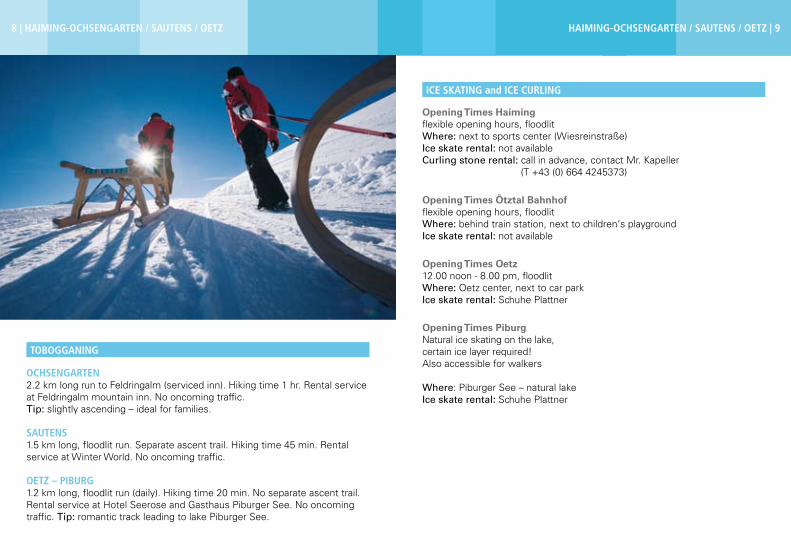
OCHSeNGArteN2.2 km long run to Feldringalm (serviced inn). Hiking time 1 hr. Rental service at Feldringalm mountain inn. No oncoming traffic.Tip: slightly ascending – ideal for families.
SAUteNS 1.5 km long, floodlit run. Separate ascent trail. Hiking time 45 min. Rental service at Winter World. No oncoming traffic.
OetZ – PIBUrG1.2 km long, floodlit run (daily). Hiking time 20 min. No separate ascent trail. Rental service at Hotel Seerose and Gasthaus Piburger See. No oncoming traffic. Tip: romantic track leading to lake Piburger See.
tOBOGGANING

10 | HAIMING-OCHSeNGArteN / SAUteNS / OetZ HAIMING-OCHSeNGArteN / SAUteNS / OetZ | 11
Important Information Ötztal Tourismus does not accept any responsibility for the listed tours. It is strongly recommended to book a local and certified mountain guide. Glacier crossings are only possible with rope and in a group. Before setting out on a tour you should always inform someone about your destination and when you plan to be back. You should always take an avalanche transceiver with you.
Mountaineering Guides, Snow and Avalanche Reports Ski-Snowboard-Rennschule Fritz Gufler6433 Oetz / OchsengartenT +43 (0) 5252 6777www.gufler.co.at
Igloo building workshops and igloo overnight stays at 2,020 m.Available from mid December through early April!
ContactSchneedorf GmbHDorfstraße 7 6432 SautensT +43 (0) 5252 20157www.schneedorf.com
Unlimited fun and adventures also in winter! Daily from mid December through early April on prior arrangement. Highlight: Night Fly with Torchlight
ContactÖtztaler OutdoorparcoursDorfstraße 7 6432 SautensT +43 (0) 5252 20157www.outdoor-parcours.com
SKI MOUNtAINeerING
HOCHOetZ SNOW VILLAGe
ÖtZtAL OUtdOOr COUrSe – HIGH rOPe PArK
Ski tour recommendationsPIrCHKOGeL (2,828 m)From Gasthof Marlstein eastwards across a small ski slope until you reach the forest trail and its fifth sharp turn –> past the bench in north-eastern direction, crossing steep slopes up to 2,400 m (Steinmandl) –> a level trail takes you westwards to Schafjoch at 2,593 m –> follow the small ridge until you get to the northern rock faces of Pirchkogel –> cross the rock face on the northern side –> from the north-west you reach a lovely basin, located between two summits, and head towards the high-est peak (no summit cross). Ascent approx. 3 - 4 hours. Easy downhill route. Best time between February and May.
Refreshment StopFeldring AlmNeurauter Lois6433 Ochsengarten / OetzT +43 (0) 5252 6203www.marlstein.com
WetterKreUZ (2,591 m) From the car park across the forest towards Issalm –> in south-western direction through the sparse forest of Wörgetal –> past the Mining House, along the valley up to 2,250 m –> bypass a steep section with a left and right loop before you reach the peak slope –> follow the slope up to the ridge, keeping to the left in the upper part –> head towards the summit on the left. Ascent approx. 2.5 - 3 hours. Easy to intermediate downhill route. Best time between December and April.

12 | HAIMING-OCHSeNGArteN / SAUteNS / OetZ HAIMING-OCHSeNGArteN / SAUteNS / OetZ | 13
SCOOBY dOO, GHOStBUSter 1, GHOStBUSter 2Activity: Waterfall climbing Description: Short waterfalls ideal for practicingDifficulty: WI 2+ / 5-Pitches: approx. 1-2 pitches, height 15-35m Facing to: South-westParking: From Oetz towards Ochsengarten –> right after Taxegg (bridge)Access: Walking through the forest you reach the forest trail, follow the descending trail which takes you right to the waterfall (Time: 5 min) Descent: Abseiling down along the route by using ice anchors, hooks and trees (Time: 0.5 hr)
eIS AM StIeLActivity: Waterfall climbingDescription: Short waterfallDifficulty: WI 4 / 4+Pitches: approx. 1 pitch, height 50m Facing to: NorthParking: From Oetz towards Ochsengarten –> cross the bridge at Taxegg area (800m)Access: Heading towards the bridge located in the upper part and crossing Nederbach brook, you are on the way up to the waterfall (Time: 15 min) Abstieg: Abseiling down along the route by using ice anchors, hooks and trees (Time: 0.5 hr)
ASterIx, OBeLIxActivity: Waterfall climbingDescription: Short waterfallsDifficulty: WI 2 / 3-
ICe CLIMBING
Pitches: approx. 2 pitches, height 75m Facing to: NorthParking: From Oetz towards Ochsengarten –> right after Taxegg (bridge)Access: Walking through the forest you reach the forest trail; follow the ascending trail which takes you right to the waterfall (Time: 0.5 hr) Descent: Abseiling down along the route by using ice anchors, hooks and trees (Time: 0.5 hr)
Liability: Ice climbing is at your own risk. The ice climbing routes are neither maintained nor closed in case of danger!

UMHAUSeN-NIedertHAI | 15
Umhausen 1,036 m
Niederthai 1,550 m Changing Room Gasthof TauferbergNiederthai 12, 6441 UmhausenT +43 (0) 5255 5509
ParkingNiederthai: Ötztal Tourismus Niederthai, hamlet of Lehen (football field),hamlet of TölderbodenUmhausen: Murplatz, BischofsplatzTumpen/Lehn-Platzl: Engelswand climbing area (car park)Köfels: Alpengasthof Köfels
Nordic Track Description - NiederthaiNiederthai received the Tirolean Quality Seal for its well-maintained tracks.
SONNeNPLAteAU rOUte Length: 6 km, skating & classic styleDegree of difficulty: easyAccess at the car park of Ötztal Tourismus, Information Niederthai.The 6 km cross-country skiing track leads - slightly rising - right to the heart of Niederthai‘s sunny plateau –> descending route across fields. Past the houses of Niederthai or along the forest edge you can enjoy uninterrupted panoramic views.
HOrLACHtAL rOUte Length: 10 km, skating & classic styleDegree of difficulty: intermediateAccess at the car park of Ötztal Tourismus, Information Niederthai. Ascending route for the first kilometer –> after a smooth downhill section and a level part you cross Horlachbach brook –> continue uphill for 1 km across Horlachtal valley –> downhill route across Horlachbach brook. After a short but steeply ascending section you return to the sunny plateau of Niederthai.
CrOSS-COUNtrY SKIING
16 | UMHAUSeN-NIedertHAI UMHAUSeN-NIedertHAI | 17
MAtAU rOUte Length: 3 km, skating & classic styleDegree of difficulty: intermediateAccess next to the church. Slightly descending for 1 km until you reach Gasthof Stuibenfall –> follow the shores of Horlachbach brook. Return route: 2 slightly rising kilometers towards Niederthai‘s sunny plateau. Short downhill track back to the starting point.
tAUFerBerG rOUte Length: 3 km, skating & classic styleDegree of difficulty: challengingAccess at the car park of Ötztal Tourismus, Information Niederthai. Across the forest –> the first 1.5 km feature 100 m of altitude gain. A speedy downhill track with some steep sections and hairpin bends takes you back to he starting point –> real experts can choose the alternative downhill track via Wolfsegg lift.
Nordic Track Description – Umhausen / Tumpen / Köfels
StUIBeNFALL rOUte Length: 6 km, skating & classic styleDegree of difficulty: intermediateAccess at the car park of the swimming lake. Below the Ötzi Village you continue across the forest and towards the wide open fields of Umhausen. This attractive nordic track has both easy and challenging parts but no steep downhill sections.
tAUFerPUIt LOOP Length: 2 km, skating & classic styleDegree of difficulty: easyAccess at the car park of the swimming lake. Ideal for short-track sprinters and cruisers thanks to slightly ascending and descending stages.
ÖtZI dOrF LOOP (floodlit by night) Length: 1 km, classic styleDegree of difficulty: intermediatePast the enclosure of Ötzi Village, across the level fields. Floodlit (1 km) every Monday, Wednesday and Friday.
tUMPeN/LeHN-PLAtZL Length: 5 km, classic styleDegree of difficulty: easyAccess next to the Engelswand climbing area (car park). Very easy cross-country skiing track along the valley bottom. Ideal also for beginners –> discover the picturesque fields of Tumpen and Lehn-Platzl.
KÖFeLS HIGH ALtItUde trACK Length: 3 km, classic styleDegree of difficulty: intermediateFrom the car park in Köfels you follow Tirol‘s biggest water wheel. Beautiful route across gently sloping meadows –> insider tip for passionate classic-style cross-country skiers. Rental ServiceSport Grüner6441 Niederthai / UmhausenT +43 (0) 5255 5420www.schischule-niederthai-umhausen.com
Josl’s Ski- und Langlaufverleih6441 Niederthai / UmhausenT +43 (0) 664 27 044 76
Cross-country Skiing InstructionSkischule Niederthai-Umhausen6441 Niederthai / UmhausenT +43 (0) 5255 5420www.schischule-niederthai-umhausen.com

UMHAUSeN-NIedertHAI | 1918 | UMHAUSeN-NIedertHAI
When: daily on requestMinimum number of persons: 5Time: 2 hrsOrganizer & Advance booking: Skischule Niederthai (one the eve)
SNOWSHOe HIKING
Umhausen
UMHAUSeN – StUIBeN FALLS – StePPSteIG – rOSSLACH From St. Vitus parish church in Umhausen you head towards Niederthai –> leave the road at Bischofsplatz car park and the Kneipp area, following the
WINter HIKING
forest trail –> continue towards the foothill of the waterfalls –> return via „Stuiböbele“ mountain inn and „Stuiben Nannele“ wayside statue –> level trail along Steppsteig Footpath to Rosslach –> back to the village and the parish church. (Time: 2.5 hrs)
UMHAUSeN – ÖtZtALer ACHe – ÖSteN – HOPFGArteN ANd BACK From St. Vitus parish church in Umhausen you head towards Neudorf and An-tonius chapel –> along the Ötztaler Ache river to Fundustal/Leierstal –> cross the bridge and follow the level trail in direction Östen-Hopfgarten through the forest –> cross the wooden bridge and turn right before you get to the football field –> along the forest trail back to the bridge (Fundustal/Leierstal), the village and the parish church. (Time: 1.5 hrs)
„MUre“ – FArSterWeG – FArSt „tHe eAGLe‘S eYrIe ABOVe eNGeLSWANd“ From St. Vitus parish church in Umhausen you head towards the ice skating rink and the „Mure“ area, crossing the bridge –> follow the road to Farst andthe foothill of the mountain –> from here experienced hikers can reach the scenic mountain farms (1,482 m, serviced all year round) within a one-hour climb. (Time: 2 – 3 hrs)
UMHAUSeN – OLd FederAL rOAd tO NIedertHAI At the Information Umhausen you walk to the left –> cross the bridge hea-ding towards the hamlet of Rosslach –> following the trail past the houses, you reach the fork-off and the old road to Niederthai –> continuing on this ascending road you get to Niederthai. (Time: 2 hrs)
UMHAUSeN – HÖHeNWeG – NIedertHAI At the Information Umhausen you walk to the left –> cross the bridge towards the hamlet of Rosslach and the fork-off to the old federal road to Niederthai –> continue straight ahead –> leaving behind the legendary Hirsch-berg area you reach Niederthai. The effort will be rewarded with stunning views of Umhausen and the Alpine scenery. Return on the old federal road to Niederthai. (Time: 2.5 hrs)

20 | UMHAUSeN-NIedertHAI UMHAUSeN-NIedertHAI | 21
Niederthai
NIedertHAI – HOrLACHtAL CIrCULAr HIKeFrom Information Niederthai you keep to the right towards the hamlet of Ennebach –> continue in direction of Grastal –> along Horlachtal valley until you reach Larstigalm mountain inn (1,770 m, 2 hrs for both ways). Alternative: continue further on to Schweinfurter Hütte (2,028 m, another 1.5 hrs). Return on foot via Bergmahderweg or head towards Niederthai on a toboggan.
NIedertHAI – St. ANtONIUS CHAPeL – HÖFLe – „BICHL“ Starting point is Antonius Chapel or Information Niederthai –> turn left and cross the wooden bridge heading in the direction of Höfle –> continue on this trail and admire the really breathtaking views of the valley and Köfels (located opposite). Take a break at the „Bichl“ snack station. (Time: 1 hr)
NIedertHAI – BerGMAHderWeG – LArStIGALM (1,777 m)Starting point is Information Niederthai –> turn left and cross the wooden bridge heading in the direction of Höfle –> turn right after 200 m into Bergmahder-weg trail which takes you along Horlachtal valley to Larstigalm snack station. Return to Niederthai on foot or on a toboggan along the winter hiking trail. (Time: 2 hrs)
NIedertHAI – WIeSLe Leave your car at Information Niederthai –> walk in the direction of Enne-bach/Überfeld/Lehen –> turn left at the football field in the hamlet of Lehen –> ascend to Mauslasattel saddleback –> downhill trail to Wiesle snack station (not serviced). (Time: 1 hr)
Köfels
KÖFeLS – WUrZBerGALM Start the hike in Köfels at 1,400 m. At the village edge you pass the old sawmill –> follow „Stubenweg“ trail –> enter the forest and continue to Wurz-bergalm snack station (Waldesruhe at 1,575 m). Tobogganing is possible. (Time: 1 hr)
NIedertHAI – HOrLACHtAL 5–7 km long run without floodlights. Hiking times: 60 min to Larstigalm, 120 min to Schweinfurter Hütte. Rental service at Sport Grüner or Josl’s Skiver-leih, Larstigalm and Schweinfurter Hütte. No traffic.
NIedertHAI – tAUFerBerG2 km long run, floodlit on Tuesdays and Thursdays. Hiking time 30 min. Separate ascent trail. Rental service at Sport Grüner or Josl’s Skiverleih. No traffic. Tobogganists‘ hut (starting point and end) serviced on Tuesdays and Thursdays. Toboggan run open daily.
UMHAUSeN – StUBÖBeLe2 km long, floodlit run. Hiking time 45 min. Separate ascent trail to Waldcafé Stuböbele. Rental service at Waldcafé Stuböbele (starting point). No oncoming traffic.
tOBOGGANING
Tumpen
tUMPeN – LeHN/PLAtZL – „MArIA SCHNee“ – ÖSteN – UMHAUSeN From Gasthof Acherkogel across the bridge towards the Engelswand clim-bing area and Lehn/Platzl –> continue past the idyllic „Maria Schnee“ chapel and southwards towards Umhausen –> cross another small bridge and the Ötztal federal road –> leave the football field behind and proceed to the scenic villages of Östen, Neudorf and Umhausen. (Time: 2 hrs)

22 | UMHAUSeN-NIedertHAI UMHAUSeN-NIedertHAI | 23
Opening Times Umhausen10.00 am - 10.00 pm, floodlit Where: Murplatz area, UmhausenIce skate and curling stone rental on the spot
Opening Times Tumpen10.00 am - 10.00 pm, floodlitWhere: children‘s playgroundIce skate and curling stone rental on the spot
ICe SKAtING and ICe CUrLING
SKI tOUr reCOMMeNdAtIONS - NIedertHAIKrASPeSSSPItZe (2,954 m)From Information Niederthai you head 7 km along Horlachtal Trail to Schweinfurter Hütte –> turn left before you get to Schweinfurter Hütte, following a steeply climbing slope in direction Weites Kar –> continue on the trail until you reach the fork-off –> turn left in direction Finstertaler Scharte and Schartenkogel peak –> or turn right across the slope up to Kraspesspitze summit.Ascent: 4 hours. Intermediate downhill route.Best time between December and April.
HOCHreICHKOPF (3,010 m) Ascent from Information Niederthai along Horlachtal Trail (7 km) in direction Schweinfurter Hütte –> leaving behind Klein Horlachalm (1,900 m) you take the climbing trail on the left to Finstertaler Sennhütte (2,147 m) –> follow the valley bottom, heading towards the eastern basin and the summit –> finally you reach the mountain ridge –> continue on the trail until you get to its highest point (ski depot available).Ascent: 4 hours. Intermediate downhill route.Best time between December and April.
SPIder, eL GrINGO, FIx & FOxIActivity: Waterfall climbing Description: Splendid ice surface with a quite difficult part at the endDifficulty: WI 2 / 5+Pitches: approx. 3-4 pitches, height 70-190m Facing to: EastParking: Volksschule Tumpen (school)Access: Heading towards the lower valley, you turn left at the farmhouse and proceed to the waterfall (Time: 0.5 hr)Descent: Along the route by abseiling with ice anchors and on trees (Time: 1 hr)
MeISter PrOPer tUMPeNActivity: Waterfall climbing Description: A short but very difficult waterfallDifficulty: WI 5+ / 6-Pitches: approx. 3-4 pitches, height 70mFacing to: EastParking: Volksschule Tumpen (school) Access: Heading towards the lower valley, you pass the church in direction Gestigalm and proceed to the waterfall (Time: 0.5 hr) Descent: Along the route by abseiling with ice anchors and on (Time: 1 hr)
KrISeILAActivity: Waterfall climbingDescription: Long waterfall with challenging sections in the upper partDifficulty: WI 4+Pitches: approx. 6 pitches, height 240m Facing to: WestParking: Tumpen, Engelswand car parkAccess: Past the Engelswand Climbing Garden, across the birch wood forest to the icefall (Time: 0.5 hr)Descent: Abseiling down along the route by using ice anchors, hooks and trees (Time: 1.5 hrs)
Liability: Ice climbing is at your own risk. The ice climbing routes are neither maintained nor closed in case of danger!
ICe CLIMBING

LäNGeNFeLd / HUBeN / GrIeS | 025LäNGeNFeLd / HUBeN / GrIeS | 25
Längenfeld 1,180 m
Huben 1,180 m
Gries 1,600 m
Changing Room Not available
ParkingLängenfeld: Längenfeld sports field and AQUA DOMEHuben: Fun Park and entrance to the village (north, south) Winklen: car park at Geological Theme TrailGries: large car par at the edge of Gries; daily shuttle bus to Längenfeld for € 2.00 (return ride)
HUBeN – FLOOdLIt NIGHt trACKLength: 2.5 kmDegree of difficulty: easy Start at the Huben Fun Park –> easy uphill and downhill stretches. Accessible all winter long as the area is not exposed to direct sunlight.
LäNGeNFeLd – HUBeN SKAtING trACKLength: 13 km, skating Degree of difficulty: easy From Camping Ötztal across the footbridge in direction of Oberried –> slightly ascending trail to the Plague Chapel until you reach the loop trail again next to the footbridge –> the parallel skating track leads towards the southern part of Längenfeld. The return route takes you across gently sloping areas to the bridge in Runhof –> for the last kilometers you follow the same track back to Camping Ötztal.
LäNGeNFeLd AULength: 3 km, classic style Degree of difficulty: easyFrom the car park of Hotel Bergwelt in Au you follow the level track to Nößlach –> here the circular route travels slightly ascending and descending across wonderful pasturelands –> back to the starting point. Please check snow conditions due to the very sunny location.
CrOSS-COUNtrY SKIING

26 | LäNGeNFeLd / HUBeN / GrIeS LäNGeNFeLd / HUBeN / GrIeS | 27
NOrdIC trACK IN GrIeS (HIGH ALtItUde)Length: 10 km, skating & classic styleDegree of difficulty: intermediateFrom the car park at the edge of the village you follow the sloping terrain for 10 km before you return to the starting point. A warm-up track with almost no change in altitude is available as well.
LäNGeNFeLd NOrd – FLOOdLIt NIGHt trACKLength: 9 km, classic styleDegree of difficulty: easyFrom Camping Ötztal the track leads along the forest and via meadows to the federal road towards Oberried –> cross the road and continue to Dorf-Espan on the right river shore –> enter the idyllic birch forest and continue on the slightly rising track to the turning point at the bridge in Winklen (connecting point to Au Track) –> southwards along the Ötztaler Ache river. The Oberried loop continues southwards to the Plague Chapel –> after a short descent you cross the footbridge and return to the campsite.
LäNGeNFeLd SÜdLength: 11 km, skating & classic styleDegree of difficulty: easyFrom Camping Ötztal across the bridge over the Fischbach and along a level route to the hamlet of Astlehn and the bridge in Runhof –> cross the Ötztaler Ache river and proceed southwards in direction of Huben –> at the turning point in Huben you cross the small road to the Huben Fun Park –> through the lovely forest you continue on the sloping track until you get again to the bridge in Runhof. At the height of Astlehn you change to the other side of the river –> across a romantic forest you return to the footbridge and back to the campsite.
Rental ServiceSporthütte Längenfeld6444 LängenfeldT +43 (0) 5253 5188 60www.sporthuette.at
Intersport Riml6444 LängenfeldT +43 (0) 5253 6375www.sportriml.com
Cross-country Skiing InstructionSkischule Aktiv6444 LängenfeldT +43 (0) 5253 6313 www.skiaktiv.at
Skischule Sölden/Hochsölden6444 Huben bei LängenfeldT +43 (0) 5253 6493 www.skischule-soelden.com
Sportshop AqUA DOME 6444 LängenfeldT +43 (0) 5253 6400 571www.sportshopaquadome.com
Skischule Norbert Schöpf6444 Gries bei LängenfeldT +43 (0) 5253 5132
Skischule Yellow Power6444 Längenfeld T +43 (0) 5253 65166 www.yellowpower.at
Schuh- und SporthausGrüner Ewald6444 LängenfeldT +43 (0) 5253 5336
28 | LäNGeNFeLd / HUBeN / GrIeS LäNGeNFeLd / HUBeN / GrIeS | 29
WINter HIKING
Längenfeld
FISCHBACH – INFANGWeGFrom the Fischbach bridge in Oberlängenfeld along the embankment of the Fischbach brook towards Sulztal valley until you reach a small wooden bridge –> cross it and follow the trail westwards –> cross the main road and proceed along the left shore of the Fischbach brook until you reach the next wooden bridge –> then cross the bridge over the Ötztaler Ache river in the direction of Oberried and the road –> cross the Ötztaler Ache river again at the power station –> return along the broad trail, continuing on the river shore which takes you back to the campsite. (Time: 1 hr)
AUeNWeGFrom Camping Ötztal in Unterlängenfeld towards the road bridge to Oberried –> do not cross the bridge but follow the road to Längenfeld for some 150 meters until you reach the country road in the direction of Dorf, Espan and Au. The return path travels towards Winkelbrücke bridge –> after the bridge you continue along the Ötztaler Ache river shore until you get to the footbridge –> cross the river next to the Plague Chapel and return to the starting point. (Time: 3 hrs)
When: Tuesdays, 9.15 amMinimum number of persons: 4 Time: full-day hikeOrganizer: Ötztal Tourismus Booking: Ötztal Tourismus, Information Längenfeld (on the eve)
SNOWSHOe HIKING LäNGeNFeLd – HUBeN WALKFrom the river mouth next to the Plague Chapel towards the Ötztaler Ache river –> past AQUA DOME Spa –> towards the village center to the small wooden bridge –> cross the bridge and continue on wide open meadows in southern direction past the hamlet of Astlehn to Runhof –> along the Ötztaler Ache river to the road bridge in Huben –> cross the bridge and follow again the river shore to the Runhof bridge –> continue on the right river shore until you get back to the starting point. (Time: 3 hrs)
HUBeN CIrCULAr trAILFrom the Huben parish church towards the Fun Park –> southwards across the wooden bridge –> past the sports field to the next hamlet –> past the houses to the fire department –> from the road bridge along the left river shore back to the parish church in Huben. (Time: 1.5 hrs)
rIederSeIte LOOP trAILFrom the bus stop in Winklen you follow the signposts to Wurzberg Alm –> along the even trail past the hamlets of Unterried, Lehn and Oberried –> a slightly rising section takes you up to the Plague Chapel –> return via Auenweg trail past the hamlet of Lehner Au to Winklen. (Time: 3 hrs)
FrOM HUBeN tO ASCHBACHFrom the bridge over the Ötztaler Ache river (southern end of Huben) you follow the right river shore for some 200 meters –> cross the federal road and continue along the Ötztal Mountain Bike Trail via the hamlets of Winklen and Bruggen to Aschbach –> back on the same route. (Time: 3 hrs)
LäNGeNFeLd – BUrGSteIN CIrCULAr WALKFrom the Spar market in the village center along a broad and rising trail to the hamlet of Burgstein –> across the small village towards the hamlet of Runhof, along the narrow asphalt road –> follow loop trail no. 3 back to the starting point. (Time: 3 hrs)

LäNGeNFeLd / HUBeN / GrIeS | 31
LäNGeNFeLd – BrANdFrom Fischbach bridge you follow the Klammweg trail along a broad, rising path to the Brand snack station –> back on foot or toboggan. (Time: 1.5 hrs)
WINKLeN – WUrZBerG ALM ANd BACKFrom the hamlet of Winklen you continue along trail no. 5 to the gate –> follow the rising forest trail to Wurzberg Alm (4 km) –> weather permitting, the trail is also a toboggan run –> back on foot or toboggan. (Time: 3.5 hrs)
HUBeN – ALPeNGAStHOF AM FeUerSteINFrom the Huben sports field on the slightly ascending trail to Alpengasthof (3 km), the trail is also a toboggan run, floodlit at night. (Time: 2 hrs)
GeOLOGICAL LOOP trAILFrom Winklen bus stop across Märchenwald fairytale forest to lake Winkel-bergsee –> descent via trail no. 9. (Time: 2 hrs)
Gries
GrIeS – SULZtALALM – AMBerGer HÜtteFrom the car park at the edge of Gries you continue on the level trail across meadows to the wooden bridge across the Fischbach brook –> slightly rising trail (hiking time: approx. 1.5 hrs.) leading up to the serviced Sulztalalm mountain hut –> proceed for another 2 km to the serviced Amberger Hütte –> back on the same route, on foot or toboggan. Toboggan rental in both huts. (Time: 5 hrs)
GrIeS – NISSLALMFrom the car park at the edge of Gries you follow the route of the previous tour –> later you turn right into the broad forest trail leading to the serviced Nisslalm hut (toboggan rental) –> back on the same route, on foot or toboggan. (Time: 4 hrs)

32 | LäNGeNFeLd / HUBeN / GrIeS LäNGeNFeLd / HUBeN / GrIeS | 33
Opening Times Gries 10.00 am - 10.00 pm, floodlit Ice skate rental: Gasthof SchöpfIce curling: once a week, curling stone rental
Opening Times Längenfeld10.00 am - 9.00 pm, floodlit Ice skate and curling stone rental: contact Mr. Frank T +43 (0) 664 1268472
ICe CLIMBING BY NIGHt WItH FLOOdLIGHtS When: weeklyWhere: LängenfeldNo minimum number of personsEquipment: Ski boots or sturdy hiking bootsOrganizer & Advance booking: activsport alpin
ICe SKAtING and ICe CUrLING
ICe CLIMBING
BrANd ALM (OPeN)1.5 km long run, no floodlights. Hiking time 45 min. No separate ascent trail. No rental service. Oncoming traffic in the morning and at night. Wonderful panoramic views.
WUrZBerG ALM (OPeN)4 km long run, no floodlights. Hiking time 90 min. Ascent in part on the toboggan track. Rental available. Transfer on request.
ALPeNGAStHOF AM FeUerSteIN (OPeN)3.3 km long, floodlit run. Hiking time 80 min. Separate ascent trail. Rental available. Shuttle service (check schedule). Transfer vehicles on the toboggan track (check times).
GrIeS – SULZtALALM (OPeN)3 km long run, no floodlights. Hiking time 80 min. No separate ascent trail. Rental available. No traffic (except snowmobiles).
GrIeS – AMBerGer HÜtte (OPeN)6 km long run, no floodlights. Hiking time 3 hours. No separate ascent trail. Rental available. No traffic (except snowmobiles).
GrIeS – NISSLALM (OPeN)5 km long run, no floodlights. Hiking time 90 min. No separate ascent trail. Rental available. No traffic (except snowmobiles).
tOBOGGANING

SÖLdeN | 035
Sölden 1,377 m
Hochsölden 2,090 m
Zwieselstein 1,427 m
SÖLdeN / HOCHSÖLdeN / ZWIeSeLSteIN | 35
Changing Room Hotel Sunny SöldenRechenaustraße 41, 6450 SöldenT +43 (0) 5254 2491
Hotel Castello FalknerOberwindaustraße 19, 6450 SöldenT +43 (0) 5254 2600
Gasthof BrückenwirtGurglerstraße 18, 6450 SöldenT +43 (0) 5254 2769
ParkingSölden: Postplatz car park and Freizeit ArenaZwieselstein: near Gasthof Brückenwirt, Zwieselstein sports field
UNterSÖLdeNLength: 5 km, classic styleDegree of difficulty: intermediateAccess behind Hotel Sölderhof or Hotel Sunny Sölden –> the track leads abo-ve the lovely hamlets of Rechenau and Schmiedhof to Kaisers and back again, across wonderful meadows. The intermediate trail also features some slightly ascending and descending sections.
HOFer-BÖdeN Length: 3 km, skating & classic styleDegree of difficulty: easyAccess in the south of Central Spa Hotel –> easy track across level meadows and fields towards the Hofer-Böden area –> crossing the little bridge over the Ötztaler Ache river you reach the meadows of Windau before you cross the bridge again and return to the starting point.
CrOSS-COUNtrY SKIING

36 | SÖLdeN / HOCHSÖLdeN / ZWIeSeLSteIN SÖLdeN / HOCHSÖLdeN / ZWIeSeLSteIN | 37
ZWIeSeLSteIN Length: 7 km, skating & classic styleDegree of difficulty: intermediateAccess in the south of Gasthof Brückenwirt –> the nordic track is suitable for both classic-style and skating up to the Zwieselstein sports field. The scenic route continues above the Venter Ache brook to the hamlet of Bodenegg –> crossing a bridge you reach the other side of the valley where you return to Zwieselstein across the forest. In cold but sunny weather you can admire breathtaking areas covered with white frost.
Rental Service Sport4You6450 SöldenT +43 (0) 5254 30610www.sport4you.at
Sport Riml6450 SöldenT +43 (0) 5254 501www.riml.com
Sport Brugger6450 SöldenT +43 (0) 5254 30062www.sport-brugger.at
Sport Glanzer 6450 Sölden T +43 (0) 5254 2223 www.glanzer.at
Sporthütte6450 SöldenT +43 (0) 5254 5222 20www.sporthuette.at
Sport Sunup6450 SöldenT +43 (0) 5254 2255www.sunup.at
Snowshoe hiking tours are available only on prior arrangement and can be booked at the local Ski & Mountaineering Schools.
SNOWSHOe HIKING
HIKING tOUr tO GAISLACHALM/SILBertAL/SONNeCK (SerVICed) From the Sölden church along the teeply rising trail behind the church leading up to Außerwaldstrasse (hamlet of Außerwald) –> cross the ski run and follow Innerwaldstrasse until you reach the glacier road –> continue along the glacier road to the „Gaislachalm/Silbertal/Sonneck“ turnoff (traffic zone: N3). (Time: 2 hrs)
HIKING trAIL tO BrUNNeNBerGALM (NOt SerVICed)Start from Freizeit Arena Sölden and follow Dorfstrasse towards traffic zone G (Auweg) –> further on to Plattestrasse (hamlet of Platte) and Moosalmstras-se –> always in direction Brunnenbergalm. (Time: 2 hrs)
PANOrAMA trAILFrom the church you take the steeply rising path towards Außerwaldstraße –> turn right at the first fork-off –> keep to the left at the playground, then turn right into Panoramaweg trail –> further on to Rettenbach road (Stiegele) –> back to Sölden. (Time: 1.5 hrs)Or further on to Gaislach –> turn left at the fork-off (gate) –> along the forest trail to the helicopter base/trade area –> back to Sölden by skibus.(Time: 2 hrs)
SÖLdeN WALKING trAIL ALONG ÖtZtALer ACHeTime: 45 min
HIKING PAtH tO StALLWIeSALM (SerVICed)From Freizeit Arena Sölden you follow Granbichlstraße (hamlet of Granbichl), heading towards Windachtal valley. (Time: 1.5 hrs)
WALKING trAIL tO MOOSALM (SerVICed)From Freizeit Arena Sölden along Dorfstrasse towards traffic zone G (Auweg) –> further on to Plattestrasse (hamlet of Platte) and Moosalmstrasse. (Time: 45 min)
WINter HIKING

38 | SÖLdeN / HOCHSÖLdeN / ZWIeSeLSteIN
HIKING rOUte tO HOCHSÖLdeNBehind the Sölden church you take the steeply rising trail leading up to Außer- waldstrasse (hamlet of Außerwald) –> cross the ski run and follow Innerwald-strasse until you reach the Ötztal Glacier Road –> continue along the glacier road to the fork-off to Hochsölden. Refreshment stop in Hochsölden. (Time: 1.5 hrs)
WALKING PAtH tO GrANSteINFrom the Sölden church you follow the steep trail leading up to traffic zone H1 –> along Panoramastrasse to Sonnleithenweg (hamlet of Anreitl) and further on to Schönblickweg (hamlet of Leithe) –> continue on the forest trail (not cleared) to Granstein. Refreshment stop at Gasthof Granstein. (Time: 1.5 hrs)
Opening Times2.00 pm - 9.00 pm, floodlit Where: Sölden sports field Ice skate and curling stone rental on the spotClosed on Saturdays!
5 km long, floodlit toboggan run. Open until 11.00 pm. Minibus shuttle service from Sölden to Gaislachalm (Tuesdays, Thursdays) or Gasthof Silbertal (Mon-days, Fridays). Toboggan rental available.Advance booking: Hotel Alpenland T +43 (0) 5254 2365 or Gasthof Silbertal T +43 (0) 5254 2987
ICe SKAtING and ICe CUrLING
tOBOGGANING
WALKING trAIL tO reCHeNAUFrom Freizeit Arena Sölden you follow Gemeindestraße on the right –> towards Waldele and Rechenaustraße until you reach Haus Trofana (north-wards) –> turn right into the forest trail and continue on the forest trail towards Kaisers.(Time: 50 min)
WALKING rOUte FrOM ZWIeSeLSteIN tO BOdeNeGGFrom Gasthof Brückenwirt you walk along the cross-country skiing track.(Time: 40 min)
SÖLdeN / HOCHSÖLdeN / ZWIeSeLSteIN | 39

OBerGUrGL-HOCHGUrGL | 41
Obergurgl 1,930 m
Hochgurgl 2,150 m Changing Room Obergurgl, Pill/Angern track: at Hotel Jagdhof Advance booking required - Hotel Jagdhof T +43 (0) 5256 6431
ParkingPill/Angern high altitude track: Hochgurglbahn base terminalObergurgl practicing track: Festkogl mountain gondola (for free) and in the center (parking fee)Hochgurgl practicing track: in the village of Hochgurgl
PILL / ANGerN / POSCHACH HIGH ALtItUde trAILLength: 7 km, skating & classic styleDegree of difficulty: intermediateAccess at the base terminal of Hochgurgl gondola. Level route along the valley bottom of Pill/Angern –> easy to intermediate ascent via the meadows of Isse to the hamlets of Königsrain and Alt-Poschach –> along the right shore of the Ötztaler Ache river back to the car park past Hotel Jagdhof.
PrACtICING trACK IN tHe CeNter OF OBerGUrGLLength: 3 km, skating & classic styleDegree of difficulty: easyAccess at Bobo‘s Kids Club or below the church, Schalfkoglweg. Two level cross-country skiing loops connected to the track along the Ötztaler Ache in direction of Bobo‘s Playground –> across the brook –> back via Bartebene area.
HOCHGUrGL PrACtICING trACK Length: 2 km, skating & classic styleDegree of difficulty: easyAccess above the chapel in Hochgurgl, next to the ski run. Level loop trail ac-ross picture-book landscapes towards the timberline, in direction of Königstal valley. A part of the track is equipped with floodlights and features a separate winter walking path.
CrOSS-COUNtrY SKIING

42 | OBerGUrGL-HOCHGUrGL OBerGUrGL-HOCHGUrGL | 43
Rental Service Sport Lohmann6456 ObergurglT +43 (0) 5256 6372www.lohmann.at
Intersport Riml6456 ObergurglT +43 (0) 5256 6216www.dergurgler.com
Nordic Skiing & Ski Mountaineering InstructionSkischule Obergurgl6456 ObergurglT +43 (0) 5256 6305www.skischule-obergurgl.com
When: Wednesday night and Thursday afternoon Minimum number of persons: 2 (at night: 4 persons)Time: 2 hoursOrganizer: Skischule Obergurgl Advance booking: Ötztal Tourismus, Information Obergurgl-Hochgurgl (on the eve) and Skischule Obergurgl
SNOWSHOe HIKING
Sport Scheiber6456 ObergurglT +43 (0) 5256 6223 704www.scheibersport.com
Skischule HochgurglA-6456 ObergurglT +43 (0) 5256 6265www.tophochgurgl.com
HOCHGUrGL rOMANtIC rOUte (PArtLY FLOOdLIt)Access above the chapel in Hochgurgl, next to the ski run –> level circuit trail across picture-book landscapes towards the timberline, in direction of Königs-tal valley. A part of the track is equipped with floodlights.(Time: 30 min)
WINter WALKING
Opening TimesFrom Christmas: daily 8.00 pm - 11.00 pmUntil mid January: daily 4.30 pm - 11.00 pmAfterwards: Monday - Friday 4.30 pm - 11.00 pmWhere: Hotel EnzianIce skate and curling stone rental on the spot
NeW!!! HOCHGUrGL – PILL3 km long, floodlit run. Ascent with Hochgurglbahn mountain gondola. No oncoming traffic.
ICe SKAtING and ICe CUrLING
tOBOGGANING
ZIrBeNWALd NAtUre trAILFrom Obergurgl to the University Center –> keep to the right towards David‘s Hütte and the fork-off to Zirbenwald stone pine trail. Return to Obergurgl across Zirbenwald bridge, following Imfong trail on the left.(Time: 1 hr)
GUrGLertAL WINter HIKING trAILAccess at the base terminal of Hochgurgl gondola –> level route along the valley bottom of Pill/Angern –> easy to intermediate ascent via the meadows of Isse to the hamlets of Königsrain and Alt-Poschach –> along the right shore of the Ötztaler Ache river back to the car park past Hotel Jagdhof.(Time: 1 hr)

VeNt | 045VeNt | 45
Vent 1,900 m
Changing Room Not available
ParkingBase terminal of T-bar lift – free of charge
eBeNLe trAILLength: 2 km, classic styleDegree of difficulty: intermediateThe cross-country skiing route can be found on the way to the Rofenhöfe farms (exit P9), after 200 m on the left. This intermediate, gently sloping nor-dic track is located at 1,950 m above sea level, snow is always guaranteed.
VeNt PrACtICING trACKLength: 500 m, classic styleDegree of difficulty: easyLovely route in slightly ascending and descending terrain at the entrance to the village, below the church. Ideal for beginners.
Rental Service Venter Kaufhäusl6458 VentT +43 (0) 5254 8153www.venter.at
Nordic Skiing InstructionSchischule Vent6458 VentT +43 (0) 5254 8123www.schischule-vent.com
Sportalm6458 VentT +43 (0) 5254 8130www.hotel-vent.at
CrOSS-COUNtrY SKIING

46 | VeNt VeNt | 47
VeNt – rOFeN – VeNt From the church through the village –> across the bridge, turn right towards Wiesenweg and the suspension bridge to Rofen –> the 2 km long trail takes you to the picturesque Rofenalm (not serviced). Back to Vent along the federal road. Stopover at Gasthof Rofenhof. (Time: 1.5 hrs)
VeNt LOOP trAILFrom the church through the village –> across the bridge, turn left towards Haus Reinstadler –> along the edge of the forest for approx. 1 km until you reach the bridge –> back to Vent (2 km). Stopover at various inns and restaurants in Vent. (Time: 2 hrs)
WINter WALKING
When: every Tuesday - Vent and Ötztal Nature ParkMinimum number of persons: 3Time: approx. 3 hoursOrganizer: Ötztal Nature Park Advance booking: Ötztal Tourismus, Information Vent (by 5.00 pm the day before)
When: every Thursday – alternating snowshoe hike or ski mountaineering, Vent Mountain SchoolMinimum number of persons: 3Costs: € 10.00 per person incl. guide and snowshoe or mountaineering ski rental Organizer: Vent Mountain Guide OfficeAdvance booking: Ötztal Tourismus, Information Vent (by 5.00 pm the day before)
SNOWSHOe HIKING
VeNt – tOBOGGAN rUN – StABLeINALMFrom the church through the village –> turn right before you reach the bridge –> turn right again after 500 m –> a broad and level trail takes you up to Stableinalm (approx. 5 km). Back on foot or toboggan or with the double chair lift. Toboggan rental at Kaufhäusl, Sportalm or at the mountain restaurant. Stopover at Stablein mountain restaurant or various inns and restaurants in Vent. (Time: 1.5 hrs)
VeNt – NIedertAL Through the village –> turn right after the bridge –> across the bridge to Ochsenkopf lift –> further on towards the ski lift top station –> turn left into the trail to Niedertal (approx. 1 hour towards the upper valley). After 1 hour back to Vent as the cleared trail ends here. Stopover at various inns and restaurants in Vent. (Time: 2.5 hrs)

tOBOGGANING
VeNt – StABLeINALM 5 km long run without floodlights. Hiking time 90 min. No separate ascent trail. Rental at Venter Kaufhäusl and Sportalm. Transfer via Wildspitze double chair lift possible. No oncoming traffic.
Tip: night tobogganing incl. skidoo transfer every Monday at 9.00 pm(approx. 3 km), campfire, hot drink and downhill ride at torchlight.
VeNt | 49
Important Information Ötztal Tourismus does not accept any responsibility for the listed tours. It is strongly recommended to book a local and certified mountain guide. Glacier crossings are only possible with rope and in a group. Before setting out on a tour you should always inform someone about your destination and when you plan to be back. You should always take an avalanche transceiver with you.
Mountaineering & Ski Guides, Snow & Avalanche Reports Vent Mountain Guide OfficeKilian Scheiber6458 VentT +43 (0) 5254 8106www.bergfuehrer-vent.at
AlpinerlebnisDietmar Wimmler & Wendelin Klotz6458 VentT +43 (0) 5254 8108www.alpinerlebnis.at
SKI MOUNtAINeerING

50 | VeNt
Ski Mountaineering ToursIndulge in the scenic Ötztal mountains and experience pure nature at its finest: untouched slopes, bizarre rock formations, icy summits, majestic gla-ciers and endless peace. The most beautiful peak tours, the most pleasurable corn snow and powder stashes are waiting for you. Vent offers a perfect blend of trendy sports and traditional mountaineering. A unique paradise for passionate ski mountaineers.
Vent - Ramolalm - Vent 2,218 m Hiking time approx. 1.5 hrsVent - Stableinalm 2,356 m Hiking time approx. 1.5 hrsVent - Chapel in Niedertal 2,120 m Hiking time approx. 1.5 hrsVent - Breslauer Hütte (lift ride) 2,848 m Hiking time approx. 1 hrVent - Vernagthütte 2,755 m Hiking time approx. 4 hrsVent - Martin-Busch-Hütte 2,501 m Hiking time approx. 3 hrsVent - Similaunhütte 3,019 m Hiking time approx. 5 hrsRamoljoch 3,186 m Hiking time approx. 4 hrsSpiegelkogel 3,426 m Hiking time approx. 5 hrsTaufkarkogel (lift ride) 3,367 m Hiking time approx. 3 hrsPlateikogel (lift ride) 3,427 m Hiking time approx. 4 hrsWildspitze (lift ride) 3,774 m Hiking time approx. 5 hrsGuslarspitze 3,126 m Hiking time approx. 5 hrsFluchtkogel 3,500 m Hiking time approx. 7 hrsHochvernagtspitze 3,539 m Hiking time approx. 7 hrsHauslabkogel 3,403 m Hiking time approx. 6.5 hrsFinailspitze 3,516 m Hiking time approx. 7 hrsSimilaun 3,606 m Hiking time approx. 7.5 hrsHintere Schwärze 3,628 m Hiking time approx. 7.5 hrs
VeNt | 51
tipVeNt SKI MOUNtAINeerING LOOPThe Vent Loop Trail for ski mountaineers ranks among the truly outstan-ding highlights and „hautes routes“ in the Eastern Alps. The challenging 5-day ski mountaineering tour starts in Vent, leading across the central area of the Ötztal Alps. Some of Tirol‘s most attractive and demanding 3000-meter high peaks are climbed in the course of this outstanding tour: Similaun (3,606 m), Fineilspitze (3,514 m), Weißkugel (3,739 m), Fluchtkogel (3,500 m) and Wildspitze (3,774 m).
More detailed information: Vent Mountain Guide Office T +43 (0) 5254 8106Alpinerlebnis T +43 (0) 5254 8108
MOUNtAIN HUtS OPeN FrOM MId MArCH tO MId MAYMartin-Busch-Hütte T +43 (0) 5254 8130 [email protected]ütte T +39 0 473 669711 [email protected]öne Aussicht T +39 0 473 662140 [email protected] M +43 7203 47821 [email protected]ütte T +43 (0) 664 1412119 [email protected] all other huts run by the Austrian Alpine Association the winter rooms are open!
Less experienced ski mountaineers are strongly recommended to book a local and certified mountain guide. Glacier crossings are only possible with ropes and in a group. Before setting out on a tour you should always inform someone about your destination and when you plan to be back. You should always check the latest snow and avalanche reports before you start a tour!

OCHSENGARTENInnsbruck
Arlberg
HAIMING
Zirl
A12
A12A12
Telfs
Timmelsjoch/Wintersperre
Imst
Fernpass
OETZ
UMHAUSENNIEDERTHAI
GRIESLÄNGENFELD
HOCHSÖLDEN
SÖLDEN
HUBEN
ZWIESELSTEIN
HOCHGURGL
OBERGURGLVENT
SAUTENSSalzburg/Wien
ÖTZTAL BHF.
Kühtai
München
D
München
D
Friedrichshafen
D
ITALIEN
I
CH
SCHWEIZ
ÖtZtAL tOUrISMUS
Gemeindestraße 46450 Sölden, AustriaT +43 (0) 57200 F +43 (0) 57200 [email protected] www.oetztal.com
Imprint: Responsible for the contents: Ötztal Tourismus; Concept / Layout: Zimmermann & Pupp • Werbeagentur, Innsbruck; Picture credits: Ötztal Tourismus - Bernd Ritschel, Ernst Lorenzi, Alexander Riml, Ewald Holzknecht