wildland fire risk assessment and mitigation reference ... · wildland fire risk assessment and...
TRANSCRIPT

Wildland Fire Risk Assessment and Mitigation Reference Manual
in support of the Provincial Policy Statement, 2014

Disclaimer: The Ontario Ministry of Natural Resources and Forestry and the Crown accept no responsibility for any loss or damage that any person may sustain as a result of the information in, or anything done or omitted in reliance on this Manual and any personal injury or bodily injury, including death, and any loss or damage caused by a wildfire to insured or uninsured structures and/or property where FireSmart principles have been applied.
How to cite this manual:Ontario Ministry of Natural Resources and Forestry. August 2017. Wildland Fire Assessment and Mitigation Reference Manual in support of Provincial Policy Statement, 2014. Toronto: Queen’s Printer for Ontario.

Contents
PART IUnderstanding Wildland Fire 5
Chapter
1Purpose and role of this document 5
1.1 Purpose of guidance material 5
1.2 Intended audience of the Manual 6
1.3 Structure of the Manual 6
Chapter
2Understanding wildland fire and it’s policy context 7
2.1 What is wildland fire? 7
2.2 Wildland fire fuels 7
2.3 Climate change and the wildland fire environment 7
2.4 Development encroachment into wildland areas 8
2.5 Legislative and policy framework 8
2.5.1 Forest Fires Prevention Act and Emergency Management and Civil Protection Act 8
2.5.2 Ontario’s FireSmart Program 9
2.5.3 The Planning Act and PPS, 2014 10
Chapter
3Wildland fire land use planning policies overview 11
3.1 Wildland fire policy explanation and goal 11
3.2 Wildland fire policy definitions 12
3.3 Other related PPS, 2014 policies 13
3.3.1 Relationship with 2.1 Natural Heritage 14
3.3.2 Relationship with 2.6 Cultural Heritage and Archaeology 14
3.3.3 Relationship with provincial plans 14
Part 2Wildland Fire Assessment and Wildland Fire Mitigation Techniques 15
Chapter
4Wildland fire behaviour and characteristics of hazardous forest types 15
4.1 How wildland fire threatens values 15
4.1.1 Types of wildland fire 15
4.1.2 Structural ignitions from wildland fire 15
4.1.3 Characteristics of wildland fire forest types 17
Wildland Fire Risk Assessment and Mitigation Reference Manual 1
Chapter
5Wildland fire assessment 19
5.1 MNRF generalized wildland fire hazard mapping 19
5.2 Broad-level/municipal-wide wildland fire assessment 20
5.3 Site-level wildland fire assessment 21
5.3.1 General recommendations for site-level wildland fire assessments 22
5.3.2 Level 1 site assessment 23
5.3.3 Level 2 site assessment 23
5.3.4 Summary of wildland fire assessment tools 23
Chapter
6Mitigation of wildland fire risk: Principles and techniques 26
6.1 Mitigation principles 26
6.2 Mitigation approaches and techniques 28
6.2.1 Planning and design mitigation approaches 28
6.2.2 Vegetation/fuel management mitigation techniques 28
6.2.3 Structural mitigation techniques 30
Part 3Land Use Planning to Minimize Risks Associated with Wildland Fire 31
Chapter
7Land use planning implementation strategies and tools 31
7.1 General approaches to implementation through land use planning 32
7.1.1 Wildland fire policy development 32
7.1.2 Early consultation/pre-consultation 32
7.1.3 Complete applications 32
7.2 Official plans 33
7.2.1 Background study: Wildland fire assessment 33
7.2.2 Official plan goals and objectives 33
7.2.3 Designations to achieve appropriate land use patterns 34
7.2.4 Approaches to official plan policies 34
7.2.5 Official plan schedules 36
7.3 Zoning by-laws 36
7.3.1 Zoning categories and permitted uses 37
7.3.2 Zoning provisions/standards 38
7.4 Site development controls 38
7.4.1 Community planning permit system 38
7.4.2 Site plan control areas 39
7.5 Planning Act applications 40
7.5.1 General considerations for site-specific Planning Act applications 41
7.5.2 Considerations for land severances and plans of subdivision or condominiums 43
7.5.3 Considerations for minor variances 46
Glossary 47
Report Notes 49
2 Wildland Fire Risk Assessment and Mitigation Reference Manual

APPENDICESAppendix 1Legislation and policy related to wildland fire and municipal planning 50
Appendix 2Sample images of hazardous forest types for wildland fire 53
Appendix 3Forest condition characteristics of hazardous f orest types for wildland fire 56
Appendix 4Simple Sequential Evaluation Matrix 58
Appendix 5Background on the Canadian Forest Fire Behavior Prediction System 60
Appendix 6Wildland Fire Risk and Hazard Assessment Form 61
Appendix 7Sample images of hazardous site conditions within priority zone 1 63
Notes 65
Annotated Bibliography 70
Works Cited 76
LIST OF FIGURESFigure 2-1. The interface and intermix areas that constitute the wildland-urban interface 8
Figure 2-2. A comparison of wildland fire land use planning policies of the PPS, 2014 and Ontario’s FireSmart Program 9
Figure 4-1. Effect of embers from the adjacent wildland fire landing on the roof of a structure and surrounding vegetation, resulting in further ignition of spot fires25 16
Figure 4-2. Burning trees and shrubs producing flames that result in direct contact with siding and roofing of adjacent structure28 16
Figure 4-3. Radiant energy/heat transfers from burning trees to the side of the structure30 17
Figure 5-1. Proposed development within a forested area. The presence of hazardous forest types for wildland fire needs to be determined through wildland fire assessment. This assessment can be used to evaluate the merits of proposed development. 21
Figure 5-2. Typical succession stages through which a forest transitions, increasing the hazard level for wildland fire over time36 22
Figure 7-1. The vegetation around a home within the three priority zones before the application of vegetation management techniques to establish defensible space (not to scale)71 43
Figure 7-2. The vegetation around a home within the three priority zones after the application of vegetation management techniques to establish defensible space (not to scale)72 43
Figure A1-1. The fire region as set out in regulation (O. Reg. 332/15, s. 7), under the Forest Fires Prevention Act
Figure A2-1. Spruce forest with dense conifer vegetation arrangement and ladder fuels 53
Figure A2-2. Dense conifer-dominant vegetation arrangement and ladder fuels 53
Figure A2-3. Dense boreal spruce forest 53
Figure A2-4. Dense spruce forest (bird’s eye view) 53
Figure A2-5. Mixedwood forest (composed of 75% conifer species) 54
Figure A2-6. Mixedwood forest (composed of more than 50% conifer species) 54
Wildland Fire Risk Assessment and Mitigation Reference Manual 3

Figure A2-7. Storm damage in a coniferous forest creating continuous fuels due to ground fuel accumulation 54
Figure A2-8. Slash from harvesting operation resulting in ground fuel accumulation 54
Figure A2-9. Pine plantation with understory resulting in ladder fuels 54
Figure A2-10. Insect damage in a coniferous forest (bird’s-eye view) 54
Figure A2-11. High density of crowns in a coniferous forest 55
Figure A2-12. High density coniferous forest 55
Figure A2-13. Unmanaged pine plantation with ground fuel accumulation (i.e., dry grass, dead fallen trees) and understory creating ladder fuels 55
Figure A2-14. Immature, dense conifer plantation creating continuous fuels (bird’s-eye view) 55
Figure A2-15. Immature, dense conifer plantation with dead standing trees, creating continuous fuels 55
Figure A2-16. Immature conifer natural stand intermixed with some mature conifer trees, resulting in ladder fuels 55
Figure A3-1. Tree crowns before and after spacing and thinning 56
Figure A3-2. Crowns and understory before and after spacing, thinning and pruning 56
Figure A3-3. Fire pathway with intact ladder fuel and ladder fuel removed. 57
Figure A7-1. High-density forest with continuous and ladder fuels close to a structure (priority zone 1) 63
Figure A7-2. High-density forest with continuous and ladder fuels close to a structure (priority zone 1) 63
Figure A7-3. Conifer fuels overhanging a stucture and deck (priority zone 1) 63
Figure A7-4. High-density forest directly against a structure (priority zone 1) 63
Figure A7-5. Vegetation in priority zone 1 converted to non-flammable or low-flammable fuels such as deciduous species 64
Figure A7-6. Vegetation in priority zone 1 converted to non-flammable fuels (e.g., trimmed grass); vegetation in priority zone 2 has been thinned and pruned, and debris has been removed 64
Figure A7-7. Application of vegetation management measures have been applied in priority zones 1 and 2, including conversion to non-flammable vegetation (priority zone 1), and spacing, thinning and pruning of trees and other vegetation (priority zone 2) 64
Figure A7-8. Application of vegetation management measures in priority zones 1 and 2, including spacing, thinning, pruning and removal of flammable ground fuels and debris 64
Figure A7-9. Application of vegetation management measures (i.e., thinning and pruning) in priority zone 2 64
4 Wildland Fire Risk Assessment and Mitigation Reference Manual

Part IUnderstanding Wildland Fire
CHAPTER 1Purpose and role of this document
Across Canada wildland fires, also referred to as wildfires or forest fires, are the second most frequent type of reported natural disaster, next to flooding. However, in a given year wildland fires happen more often than floods and, unlike flooding, can strike quickly in random multiple areas when conditions are right, leaving little time to prepare. Part of the mandate for the Ministry of Natural Resources and Forestry (MNRF) includes the responsibility to lead the prevention and mitigation of, preparedness for, response to, and recovery from wildland fires.1 On average, MNRF responds to more than 1000 wildland fires each year, and 90 per cent of wildland fires that occur within 3 kilometres of Ontario communities are caused by human activities.2 When communities expand into forested areas (known as the wildland-urban interface), the manner in which development occurs affects the level of risk to human life and values that is associated with wildland fire.
1.1 Purpose of guidance material
The purpose of this document, Wildland Fire Risk Assessment and Mitigation: Reference Manual in support of the Provincial Policy Statement, 2014 (referred to throughout as “the Manual”) is to:
• outline how wildland fire, a natural hazard, can be addressed in the municipal land use planning process in a manner that achieves consistency with the Provincial Policy Statement, 2014 (PPS, 2014), including policy 3.1.8;
• provide background information regarding hazardous forest types for wildland fire and the risks they pose;
• identify “wildland fire assessment and mitigation standards” as referred to and defined in the PPS, 2014;
• provide techniques for implementing wildland fire policies through municipal planning policies and processes including official plans, zoning by-laws and site-specific applications, as well as other municipal planning tools; and
• recognize that land use planning is a critical part of the province’s framework for managing emergencies.
Wildland Fire Risk Assessment and Mitigation Reference Manual 5

2.1 What is wildland fire?
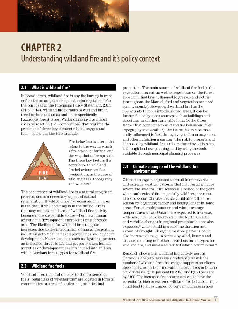
In broad terms, wildland fire is any fire burning in treed or forested areas, grass, or alpine/tundra vegetation.3 For the purposes of the Provincial Policy Statement, 2014 (PPS, 2014), wildland fire pertains to wildland fire in treed or forested areas and more specifically, hazardous forest types. Wildland fires involve a rapid chemical reaction (i.e., combustion) that requires the presence of three key elements: heat, oxygen and fuel— known as the Fire Triangle.
Fire behaviour is a term that refers to the way in which a fire starts, or ignites, and the way that a fire spreads. The three key factors that contribute to wildland fire behaviour are fuel (vegetation, in the case of wildland fire), topography and weather.4
The occurrence of wildland fire is a natural ecosystem process, and is a necessary aspect of natural regeneration. If wildland fire has occurred in an area in the past, it will occur again in the future. Areas that may not have a history of wildland fire activity become more susceptible to fire when new human activity and development encroaches on a forested area. The likelihood for wildland fires to ignite increases due to the introduction of human recreation, industrial activities, damaged power lines and adjacent development. Natural causes, such as lightning, present an increased threat to life and property when human activities or development are introduced into an area with hazardous forest types for wildland fire.
2.2 Wildland fire fuels
Wildland fires respond quickly to the presence of fuels, regardless of whether they are located in forests, communities or areas of settlement, or individual
OXYGENFUEL
HEATFIRE
The Manual represents the province’s recommended technical criteria and approaches for assessing risk, and in areas where hazardous forest types are present, assessing and determining the environmentally appropriate measures to mitigate those risks for proposed development.
1.2 Intended audience of the Manual
The Manual is a reference tool for municipalities, planning boards and other approval authorities (referred to throughout as “planning authorities”). Landowners, proponents/developers, staff of conservation authorities and other organizations, and the public also play important roles in planning and will want to consult the Manual when seeking to implement wildland fire policies of the PPS, 2014.
People involved in the development and review of policy documents and the review and approval of development applications should consult the Manual.
1.3 Structure of the Manual
Part 1 of this Manual identifies the purpose of the document, the context and drivers for addressing wildland fire risk through provincial land use planning policy and as a provincial interest, and the legislative and policy framework regarding wildland fire as it relates to municipal land use planning. Part 2 discusses wildland fire assessment and wildland fire mitigation techniques to prevent the creation of new hazardous situations, while Part 3 describes the techniques and tools for implementing PPS, 2014 wildland fire policies through municipal planning processes and documents. It also outlines municipal planning tools that are potentially suitable to implement the wildland fire policies of the PPS, 2014.
6 Wildland Fire Risk Assessment and Mitigation Reference Manual
CHAPTER 2Understanding wildland fire and it’s policy context
2.1 What is wildland fire?
In broad terms, wildland fire is any fire burning in treed or forested areas, grass, or alpine/tundra vegetation.3 For the purposes of the Provincial Policy Statement, 2014 (PPS, 2014), wildland fire pertains to wildland fire in treed or forested areas and more specifically, hazardous forest types. Wildland fires involve a rapid chemical reaction (i.e., combustion) that requires the presence of three key elements: heat, oxygen and fuel— known as the Fire Triangle.
Fire behaviour is a term that refers to the way in which a fire starts, or ignites, and the way that a fire spreads. The three key factors that contribute to wildland fire behaviour are fuel (vegetation, in the case of wildland fire), topography and weather.4
The occurrence of wildland fire is a natural ecosystem process, and is a necessary aspect of natural regeneration. If wildland fire has occurred in an area in the past, it will occur again in the future. Areas that may not have a history of wildland fire activity become more susceptible to fire when new human activity and development encroaches on a forested area. The likelihood for wildland fires to ignite increases due to the introduction of human recreation, industrial activities, damaged power lines and adjacent development. Natural causes, such as lightning, present an increased threat to life and property when human activities or development are introduced into an area with hazardous forest types for wildland fire.
2.2 Wildland fire fuels
Wildland fires respond quickly to the presence of fuels, regardless of whether they are located in forests, communities or areas of settlement, or individual
properties. The main source of wildland fire fuel is the vegetation present, as well as vegetation on the forest floor including brush, flammable grasses and debris, (throughout the Manual, fuel and vegetation are used synonymously). However, if wildland fire has the opportunity to move into developed areas, it can be further fueled by other sources such as buildings and structures, and other flammable fuels. Of the three factors that contribute to wildland fire behaviour (fuel, topography and weather), the factor that can be most easily influenced is fuel, through vegetation management and other mitigation measures. The risk to property and life posed by wildland fire can be reduced by addressing it through land use planning, and by using the tools available through municipal planning processes.
2.3 Climate change and the wildland fire environment
Climate change is expected to result in more variable and extreme weather patterns that may result in more severe fire seasons. Fire season is a period of the year when outbreaks of fire, especially wildfires, are most likely to occur. Climate change could affect the fire season by beginning earlier and lasting longer in some areas. For example, summer and winter average temperatures across Ontario are expected to increase, with more noticeable increases in the North. Smaller and variable changes in regional precipitation are also expected,5 which could increase the duration and extent of drought. Changing weather patterns could also increase damage to forests by wind, insects and disease, resulting in further hazardous forest types for wildland fire, and increased risk to Ontario communities.6
Research shows that wildland fire activity across Ontario is likely to increase significantly as will the number of wildland fires that escape suppression efforts. Specifically, projections indicate that total fires in Ontario could increase by 15 per cent by 2040, and by 50 per cent by 2100. The increased fire occurrences would have the potential for high to extreme wildland fire behaviour that could lead to an estimated 30 per cent increase in fires
OXYGENFUEL
HEATFIRE
Wildland Fire Risk Assessment and Mitigation Reference Manual 7

escaping initial suppression efforts by 2040, and an 80 per cent increase by 2100 (assuming that current suppression resource capability is maintained).7 It is expected that it will be challenging for fire agencies across Ontario to meet this need.8 Land use planning can be a proactive measure to prevent or limit the spread of wildland fire once it has been ignited. Over-reliance on fire suppression to manage wildland fire may contribute to more frequent, costly and severe localized disasters (e.g., Timmins, 2012—see callout box).
Timmins 9 fire, 2012The Timmins 9 fire ignited and traveled at unprecedented rates of spread during the afternoon and late evening hours of May 20, 2012. Fire spread rates between 65 and 80 metres per minute were observed and the fire traveled almost 50 kilometres in one burning period toward the City of Timmins. The fire was a continuous crown fire and spot fires were ignited up to 2 kilometres ahead of the main fire and forced many evacuations along Highway 144. Smoke and ash fall were observed by residents in the City of Timmins and as far away as Cochrane.
2.4 Development encroachment into wildland areas
Wildland fire hazard and associated risks are created when human activity and development intersect with forested areas. These areas, where residential, commercial and/or industrial development is located close to wildland or forested areas, are known as the wildland-urban interface. The wildland-urban interface is any point where the fuel feeding a wildland fire changes from natural (wildland) fuel to human-made fuel.9
The wildland-urban interface is composed of interface areas, in which development and wildland (vegetation/fuels) meet at a well-defined boundary; and/or intermix areas, where development and wildland fuels intermingle with no clearly defined boundary or separation. Interface and intermix areas are typically found outside of settlement areas where new development extends into undeveloped, forested areas. However, the interior of a community can also have large tracts of forested areas, such as community or managed forests.
Wildland fires can start or ignite in the wildland urban interface (WUI) in two ways;
i) Fires burning in adjacent forested areas may spread into developed areas within the WUI. When uncontrolled, these fires can burn intensely in areas adjacent to development resulting in risk to life and property.
ii) Fires can ignite in developed areas within the WUI, (e.g., burning buildings, activities such as garbage incineration, etc.) and then spread from communities out into surrounding wildland forests, threatening ecological and other values such as resource-based industry.10 Figure 2-1 illustrates the interface and intermix areas.
2.5 Legislative and policy framework
2.5.1 Forest Fires Prevention Act and Emergency Management and Civil Protection Act
Wildland fire has the potential to damage property and infrastructure, and put the health and safety of Ontario’s residents at risk. The key components of the legislative framework regarding wildland fire are the Forest Fires Prevention Act (FFPA) and the Emergency Management and Civil Protection Act (EMCPA). The FFPA sets out the authority for wildland fire management and applies to the fire regions as set out in regulation (see Appendix 1 for further description of the FFPA and the fire region).
The EMCPA requires that each municipality develop and implement an emergency management program including a coordinated process to improve public safety. The EMCPA also requires every municipality to identify and assess the various hazards and risks to public safety,
Figure 2-1. The interface and intermix areas that constitute the wildland-urban interface
8 Wildland Fire Risk Assessment and Mitigation Reference Manual

and identify facilities and other elements of the infrastructure that are at risk for emergencies. Appendix 1 provides further descriptions of these legislative and policy tools that set the overarching framework for the protection of public health and safety. These tools and requirements could help in the implementation of PPS wildland fire policies. Ontario’s FireSmart Program, described below, offers tools to address the requirements of the EMCPA as it relates to wildland fire hazards.
2.5.2 Ontario’s FireSmart ProgramThe FireSmart Program was established in 1999, and fire agencies across Canada, (including Ontario), and in Australia and New Zealand have adopted its standards to address wildland-urban interface fire issues in their jurisdictions. The program focuses on engaging property owners, planning authorities and industry in reducing the threat of wildland fire to human life and communities through application of principles for development within the wildland-urban interface.11 The principles dealing with vegetation management and development considerations are the most relevant to land use planning. These principles form the basis of the recommended standards outlined in this Manual; they can be applied to land use planning decisions in order to implement the wildland fire policies of the PPS, 2014. Figure 2-2 illustrates the way in which Ontario’s FireSmart Program relates to and supports land use planning.
A component of the overall FireSmart planning process for protecting communities from wildland fire12 includes the completion of a “wildland fire hazard assessment.” This involves the identification of areas at risk from wildland fire through to the delineation of geographic zones within a community.13 It also includes describing aspects of the community. These include values that could be at risk, such as property; infrastructure (e.g., roads, driveways, bridges and culverts, utilities); natural resources and economic values; existing preventive measures (i.e., tools in place, such as by-laws, that would affect wildland fire); and land uses (to identify areas that could become sources of ignition of wildland fire).
The FireSmart assessment process also evaluates the capacity of many of the factors listed above relative to their ability to accommodate needs in emergency situations (e.g., whether access routes are sufficient to accommodate emergency vehicles, and/or evacuate people should a wildland fire occur). This information is used to determine appropriate mitigation measures and, finally, to plan for response to wildland fires (which is outside of the scope of the implementation of PPS, 2014 wildland fire policy, but is needed where new development is allowed in high-risk areas).
Figure 2-2.A comparison of wildland fire land use planning policies of the PPS, 2014 and Ontario’s FireSmart Program
Wildland Fire Risk Assessment and Mitigation Reference Manual 9

2.5.3 The Planning Act and PPS, 2014The Planning Act sets out the legislative framework for land use planning in Ontario. The Planning Act includes the following among its stated purposes “to provide for a land use planning system led by provincial policy” and “to integrate matters of provincial interest in provincial and municipal planning decisions.” Section 2 states that planning authorities shall have regard to matters of provincial interest, including the protection of public health and safety, and section 3 says that policy statements may be issued on matters relating to municipal planning that are of provincial interest.
The PPS, 2014 provides policy direction on matters of provincial interest related to land use planning
and development, and sets the policy foundation for regulating the development and use of land. It provides for appropriate development while protecting resources of provincial interest, public health and safety, and the quality of the natural and built environment.14 Decisions made in respect of land use planning matters must be consistent with the policies of the PPS, 2014, the PPS is to be read in its entirety, and all relevant policies are to be applied to each situation. The Planning Act also requires that when planning authorities consider draft plans of subdivision and consents (severances), they shall have regard to the effect of the development of the proposed subdivision/consent on matters of provincial interest in section 2 of the Act.15 The wildland fire policies are in policy 3.1.8 of the PPS, 2014.
10 Wildland Fire Risk Assessment and Mitigation Reference Manual

CHAPTER 3Wildland fire land use planning policies overview
The Provincial Policy Statement, 2014 (PPS, 2014) recognizes wildland fire as a natural hazard, and policies regarding wildland fire hazards are identified in 3.0 Protecting Public Health and Safety. The recognition of wildland fire in the PPS 2014 (policy 3.1.8) is an important step in acknowledging the increased risks associated with wildland fire and the key role that land use planning plays in the protection of public health and safety and prevention of loss of property and/or other values due to wildland fire. The preamble to section 3.0 of the PPS, 2014 states, “development shall be directed away from areas of natural or human-made hazards where there is an unacceptable risk to public health or safety or of property damage.” More specifically, policy 3.1.8 states the following:
Development shall generally be directed to areas outside of lands that are unsafe for development due to the presence of hazardous forest types for wildland fire.
Development may however be permitted in lands with hazardous forest types for wildland fire where the risk is mitigated in accordance with wildland fire assessment and mitigation standards.16
3.1 Wildland fire policy explanation and goal
Wildland fire policies (policy 3.1.8) were included in the PPS, 2014 to ensure that communities consider and plan for avoiding and mitigating catastrophic (or smaller) losses to their communities due to wildland fire. The goal of these policies is that land use planning decisions made under the Planning Act contribute to reducing the loss of life or injury, or property damage due to wildland fire.
While the policy priority is that development shall generally be directed away from areas associated with the risk of high to extreme wildland fire, there is some leeway. Where the proposed development cannot be relocated, it may be acceptable for development to occur on lands affected by the hazardous forest types, if the risk is mitigated to moderate to low. This could include a combination of measures at various scales. If the hazardous forest type is determined to be in the moderate to low risk for wildland fire, policy 3.1.8
would not be triggered. The definition of hazardous forest types for wildland fire in the next section explains the risk rating.
The policies contained within the PPS, 2014 represent minimum standards. Planning authorities may be interested in requiring broader application of wildland fire mitigation measures for applications under the Planning Act within their jurisdiction. In developing official plan policies and when making decisions on planning matters, the PPS, 2014 is not intended to prevent planning authorities and decision makers from going beyond the minimum standards established in specific policies, unless doing so would conflict with any other policy of the PPS, 2014.
There may be additional ways to implement policy 3.1.8 of the PPS, 2014 beyond the approaches set out in this Manual. In all cases, however, planning authorities shall make decisions and provide comments that are consistent with the PPS, 2014.
Wildland Fire Risk Assessment and Mitigation Reference Manual 11

3.2 Wildland fire policy definitions
The PPS, 2014 defines those terms italicized in the policy. These include development; hazardous forest types for wildland fire; and wildland fire assessment and mitigation standards, which are shown and described below. For terms that are not defined within the PPS, 2014, the normal meaning of the word applies. The PPS, 2014 does not define the term “hazard” but it can be understood as a source of danger or something that can cause harm. Likewise, the PPS, 2014 does not define “risk” as used in policy 3.1.8, but it can be understood as the possibility of loss or injury and/or exposure to a hazard17 or the likelihood (for example, extreme, high, moderate or low likelihood) that a hazard will actually cause harm. In the context of wildland fire, the hazard is the hazardous forest type enabling high to extreme wildland fire behaviour. This hazard poses a risk to public health and safety and to property.
Definition of developmentThe PPS, 2014 defines development as:
the creation of a new lot, a change in land use, or the construction of buildings and structures requiring approval under the Planning Act, but does not include:
a) activities that create or maintain infrastructure authorized under an environmental assessment process;
b) works subject to the Drainage Act; or
c) for the purposes of policy 2.1.4(a), underground or surface mining of minerals or advanced exploration on mining lands in significant areas of mineral potential in Ecoregion 5E, where advanced exploration has the same meaning as under the Mining Act. Instead, those matters shall be subject to policy 2.1.5(a).18
This definition is critical to policy 3.1.8 because the policy is triggered when development, as defined above, is proposed in or within the vicinity of forested areas. Reciprocally, the wildland fire policies of the PPS, 2014 do not apply if a proposal does not meet the definition of development. An example of this could be a proposal that complies with existing planning instruments and only requires a permit under the Building Code Act. Where construction that does not meet the definition of development is occurring or has occurred, planning authorities may, however,
have other processes in place that may work to achieve the same objectives as those of policy 3.1.8. Land use planning is one tool, but not the only tool, that can be used to achieve avoidance or mitigation of wildland fire risk. An example of another tool is the creation and implementation of a community wildland fire plan through voluntary programs such as FireSmart.
Definition of hazardous forest types for wildland fireThe PPS, 2014 describes hazardous forest types for wildland fire as:
forest types assessed as being associated with the risk of high to extreme wildland fire using risk assessment tools established by the Ontario Ministry of Natural Resources [and Forestry], as amended from time to time.19
This means that under dry conditions, should a fire ignite, these forests would likely exhibit high to extreme wildland fire behaviour. These forest types pose a risk to public health and safety, including damage of property. They are generally treed or forested areas of certain species and conditions. Forest vegetation, or fuel types, that are associated with the risk of high to extreme wildland fire include: natural conifer forests and unmanaged conifer plantations that can include spruce (black or white), jack pine and balsam fir tree species; immature red and white pine; and mixedwood forests with more than 50 per cent conifers (jack pine, spruce, balsam fir and immature red or white pine). Forest conditions that are associated with the risk of high to extreme wildland fire include vegetation that has sustained storm or insect damage or is diseased, trees that are close to one another (high density) within conifer forests, and an abundance of ground fuel accumulation (e.g., large amount of woody debris, branches and or needle litter on the ground).
Definition of wildland fire assessment and mitigation standardsWildland fire assessment and mitigation standards is defined by the PPS, 2014 as:
the combination of risk assessment tools and environmentally appropriate mitigation measures identified by the Ontario Ministry of Natural Resources [and Forestry] to be incorporated into the design, construction and/or modification of buildings, structures, properties and/or communities to reduce the risk to public safety, infrastructure and property from wildland fire.20
12 Wildland Fire Risk Assessment and Mitigation Reference Manual

In cases where development cannot be relocated to areas outside of lands where hazardous forest types are present, policy 3.1.8 of the PPS, 2014 allows development if the risk is reduced through the application of mitigation tools according to standards set by Ministry of Natural Resources and Forestry. Wildland fire assessment and mitigation standards are based on the principle of reducing the hazard level and associated risk from high or extreme (i.e., on lands where hazardous forest types for wildland fire are present), to moderate or, ideally, low, in order for proposed development to be appropriate from a wildland fire perspective.
Wildland fire assessment is one of two key components that form these standards. Wildland fire assessment is necessary to determine the presence or absence of forest types associated with the risk of high to extreme wildland fire. If an assessment determines that hazardous forest types for wildland fire are not present on or in the vicinity of proposed development (i.e., generally, within 100 m), it can be concluded that policy 3.1.8 does not apply to that situation. See Chapter 5: Wildland fire assessment.
The second key component involves the planning and implementation of mitigation measures to reduce the risk to moderate or low (where forest types associated with the risk of high to extreme wildland fire have been determined to be present through assessment). Altering forest attributes and conditions (via ongoing vegetation management) based on the principle of maintaining defensible space around structures is the most effective approach to wildland fire risk mitigation at the site level. This is implemented through priority zones for vegetation management (also known as FireSmart priority zones).
3.3 Other related PPS, 2014 policies
The PPS, 2014 should be read in its entirety and the relevant policies are to be applied in each situation. When more than one policy is relevant, planning authorities should consider all of the relevant policies to understand how they work together. There are specific policies in the PPS, 2014 that set the broader context for the wildland fire policies. For instance, policy 1.1.1 of the PPS, 2014 is particularly relevant with respect to promoting development outside of areas that pose risk to public health and safety and that considers the impact of climate change (see callout box).
PPS, 2014, policy 1.1.1 promotes the intent of wildland fire policies, by stating that:
“ Healthy, liveable and safe communities are sustained by:
…
c) avoiding development and land use patterns which may cause environmental or public health and safety concerns;
…
h) promoting development and land use patterns that conserve biodiversity and consider the impacts of a changing climate.”
Provincial Policy Statement, 2014
Wildland Fire Risk Assessment and Mitigation Reference Manual 13

3.3.1 Relationship with 2.1 Natural HeritageWithin the definition of wildland fire assessment and mitigation standards, the concept of “environmentally appropriate mitigation measures” is intended to address the relationship between wildland fire policies and natural heritage protection policies in the PPS, 2014. As required by policies in 2.1 Natural Heritage, development and site alteration is not permitted within any protected natural heritage features, except where the “negative impacts” test in the PPS, 2014 applies and it has been demonstrated that there will be no negative impact on the feature or its ecological functions. This particular exception does not apply to specific types of natural heritage features (e.g. significant coastal wetlands) listed in PPS policies 2.1.4 and 2.1.7.
The implication for wildland fire policies is that if wildland fire mitigation measures such as vegetation manipulation are proposed, and they would result in negative impacts, then such mitigation measures cannot be applied. If there are no mitigation measures that would avoid negative impacts on the feature or its ecological functions resulting from proposed development, development on the subject lands should not be permitted in order to be consistent with both natural heritage and wildland fire policies in the PPS, 2014. In situations where the significance of a natural heritage feature governs whether it is protected by the PPS, 2014, and has not been determined, an evaluation of the significance of the feature must first be undertaken to identify available options for mitigating the wildland fire risk (policy 4.7).
Planning authorities may find opportunities and should encourage proponents to coordinate site assessment processes related to natural heritage policies (e.g., undertaking an environmental impact study) with wildland fire assessment as discussed in this Manual.
3.3.2 Relationship with 2.6 Cultural Heritage and Archaeology
Policies in 2.6 of the PPS, 2014 outline protection to built heritage resources and cultural heritage landscapes. Areas of cultural and/or spiritual significance to Indigenous communities should be protected from potential adverse impacts associated with wildland fire mitigation measures. Early involvement of local First Nations and Métis communities in wildland fire hazard assessment and mitigation planning (if needed) can help identify these areas and communities’ concerns and interests regarding their protection. Early participation of local First Nations and Métis communities may also lead to the identification of other opportunities for involvement in hazard assessment, mitigation planning and implementation.
3.3.3 Relationship with provincial plansA number of provincial plans guide and regulate land use planning for specific areas in Ontario. Some of these include Niagara Escarpment Plan (2005), Oak Ridges Moraine Conservation Plan (2002), Greenbelt Plan (2005) and the Growth Plans for the Greater Golden Horseshoe (2006) and for Northern Ontario (2011). For information on accessing these plans, please visit ontario.ca. The provincial plans build on the PPS but provide further substantial policy direction of the protection of natural heritage features. It is essential that planning authorities and other users of this manual consult all relevant provincial plans and corresponding guidance materials when addressing land use planning matters that fall within the jurisdiction of any of those plans. However, in general, where the provincial plans and the PPS, 2014 conflict, provincial plans take precedence over the PPS as specified in policy 4.12 of the PPS, 2014. Likewise, the PPS, 2014 provides policy direction (i.e., in the case of wildland fire (new policy 3.1.8)) on topics that the provincial plans do not address.
14 Wildland Fire Risk Assessment and Mitigation Reference Manual

Part 2Wildland Fire Assessment and Wildland Fire Mitigation Techniques
CHAPTER 4Wildland fire behaviour and characteristics of hazardous forest types
4.1 How wildland fire threatens values
Hazardous forest types for wildland fire are forest types that are associated with the risk of high to extreme wildland fire. Understanding the factors contributing to the hazard of these forest types is necessary to effectively reduce the risks that wildland fires pose to values.
4.1.1 Types of wildland fireThe three types of wildland fires are differentiated by the way they burn (behaviour). Ground fires move through the ground, specifically the duff layer, which contains organic soils and woody material, that exists beneath the forest floor. These fires burn slowly, are persistent and are difficult to extinguish. Surface fires burn needles, twigs and branches that are on the forest floor, as well as young trees and lower branches of standing trees. High wind conditions are a key factor in the spread of surface fires. Finally, crown fires are those that burn in upper foliage and branches, in addition to burning surface and ground fuels. Ladder fuels provide vertical continuity between (or connect) surface vegetation and tree crowns; and promotes the
upward spread of surface fires into the upper foliage. When high-intensity surface fires spread, or climb upward through foliage into tree canopies, they become crown fires, which are influenced by wind and upper atmospheric conditions. Crown fires travel quickly and are difficult to control.21
4.1.2 Structural ignitions from wildland fire Fires can ignite and/or spread by three modes: convection, resulting in flying embers or firebrands; conduction (direct flame contact); and radiation (radiant heat). Mitigation techniques recommended in this Manual22 are based on scientific research, and are designed to disrupt the combustion process (or break the Fire Triangle) by eliminating two of the three necessary elements of fire (heat, oxygen and fuel). They do so by minimizing the opportunity for ignition of new fires from embers; reducing the potential for direct flame contact from approaching wildland fires; and reducing the effects of radiant heat from an approaching wildland fire by reducing the opportunity for crown fire potential.
Wildland Fire Risk Assessment and Mitigation Reference Manual 15

Convection and embers
Convection is a method of heat transfer that occurs due to the upward movement of heated gases, such as oxygen. During wildland fires, convection pre-heats and dries vegetation and other fuels above/near the fire, resulting in increased opportunity for fire to climb into tree crowns. Convection may also carry upward ignited debris, such as leaves, branches and conifer needles and cones. These embers (or fire-brands) may land in forested areas ahead of and beside the fire, especially in areas where topography is sloped, resulting in ignition of secondary fires (spot fires).23 Flying embers can be carried significant distances (i.e., more than a kilometre depending on wind conditions), and can land on or near structures, potentially igniting them. The risk of this occurring increases with the presence of risk factors such as debris accumulation up against a structure (see Figure 4-1).24
Conduction – direct flame contact
Conduction occurs when heat moves through fuels. Fire can spread when ignited fuels come in direct contact with new fuels. This is of particular concern when the arrangement of vegetation within a forested area is dense (i.e., trees are touching each other), and where there is continuous flammable vegetation in direct contact with structures26 (see Figure 4-2). Direct flame contact with structures can increase the temperature of building materials enabling them to ignite. Under certain wind conditions, crown fires can generate flames extending up to 10 metres outward. This makes it critical to ensure that measures are in place to prevent a crown fire from advancing to within 15 metres of a structure in order to avoid direct contact of flames, and that areas within 10 metres of a structure are maintained in a low- or non-combustible state.27
Figure 4-1. Effect of embers from the adjacent wildland fire landing on the roof of a structure and surrounding vegetation, resulting in further ignition of spot fires25
Figure 4-2. Burning trees and shrubs producing flames that result in direct contact with siding and roofing of adjacent structure28
16 Wildland Fire Risk Assessment and Mitigation Reference Manual

Radiation – radiant heat
Radiant heat is the energy that is released as a fire burns, and can increase the temperature of objects around it, including vegetation and structures.29 This heating effect increases vulnerability for ignition if direct flame contact occurs, and certain building materials may ignite by radiant heat alone, if temperature and exposure time are adequate. Vegetation/fuels within the vicinity of a structure can increase the risk of structural ignition, as they are more likely to ignite should they come into direct contact with flame or embers. Radiant heat can generate temperatures high enough to cause windows to break, allowing embers to enter a structure (see Figure 4-3). Figure 4-3.
Radiant energy/heat transfers from burning trees to the side of the structure30
4.1.3 Characteristics of wildland fire forest typesThe hazard level of a treed or forested area and risks associated with high or extreme wildland fire are determined by two key factors: forest composition (i.e., species present) and forest condition. Forests containing more than 50 per cent conifer species are more likely to result in risks associated with high to extreme wildland fire. Conifer trees are prone to torching and crowning fires while hardwoods generally have a higher water content, making them better able to resist fire ignitions and spread31 under all but extreme conditions.
When a forested area containing greater than 50 per cent conifer species has certain characteristics, such as high density of trees and/or large ground accumulations of forest debris, high to extreme wildland fire risk is expected under dry conditions. Table 4-1 outlines the species and forest condition characteristics that are expected to produce high to extreme fire behaviour
and moderate to low fire behaviour. Appendix 2 contains images that are examples of hazardous forest types for wildland fire, including various species compositions and forest conditions. Appendix 3 illustrates these forest condition characteristics and the effects of the application of mitigation techniques. These images can be used for reference purposes when undertaking wildland fire assessments as discussed in Chapter 5.
Pine forests and pine plantations are unique because their hazard level is generally determined by their condition and successional stage—more so than other forest types. Typically mature pine forests are a moderate to low hazard; however, immature pine stands or unmanaged plantations could be rated high to extreme, and would therefore be associated with the risk of high to extreme wildland fire. Therefore, it is necessary to assess pine forests to determine the condition of the forest.
Wildland Fire Risk Assessment and Mitigation Reference Manual 17

Table 4-1. Characteristics of hazardous forest types: Forest species composition and forest condition attributes
WILDLAND FIRE RISK LEVEL
FOREST SPECIES COMPOSITION
FOREST CONDITION: COMPOSITION AND ARRANGEMENT
FOREST CONDITION: HEALTH
FOREST CONDITION: DENSITY AND STRUCTURE
FOREST CONDITION: GROUND FUEL ACCUMULA-TION AND LADDER FUELS
EXTREME/HIGH
Extreme:Immature jack pine; boreal spruce; black or white spruce; balsam fir; immature red, white pine
High: Mature jack pine; mixed-wood with >50% conifer species (jack pine, spruce, balsam fir, immature red or white pine)
In southern Ontario, red cedar and ground juniper are highly flammable
Large portion of immature conifer trees mixing into canopy
Fine fuels such as leaves, needles, twigs from branches up to 5 cm in diameter mixed with larger fuels (branches of 5–10 cm)
Natural conifer forests and unmanaged conifer plantations
Storm-damaged, insect-damaged or diseased fuels indicated by:
– forest fuels lying horizontally on the ground
– full conifer trees lying on ground or tops of conifer trees broken off and lying on the ground
– dead standing conifer trees with red or brown needles inter-mixed with immature conifer trees
Within immature conifer stands/ plantations, trees are close to one another with no crown (tree top) separation
Within continuous conifer trees (standing timber and crowns): high stand density; trees not spaced; conifer tree crowns touch or overlap
Large amount of woody debris /slash build-up and branches on the ground
Large build-up of flammable surface materials: cured grasses, needle litter or forest debris (i.e., branches, fallen trees, etc.)
Forest fuels from thinning or logging operations lying horizontally on the ground with accumulation of fine fuels from conifer tree tops and branches
Conifer trees have ladder branches (<2 m from ground)
MODERATE TO LOW
Mixedwood forests ranging from 25% (low) to 50% (moderate) conifer composition
Mature red, white and Scots pine
Hardwood/deciduous forests composed of maple, birch, oak, poplar, ash, etc.
Typically standing cedar, hemlock and tamarack are low risk
Mature red, white and Scots pine with clean or deciduous understory are low risk
Managed/maintained conifer plantations or stands, and managed red or white pine stands
Small pockets of conifer trees separated by hardwood/ deciduous trees
Shrub layer
Conifer trees scattered evenly with hardwood/deciduous trees
Mature red/white pine stands
Small areas of insect- or diseased trees
Separated trees (standing timber and crowns)
Moderate stand density with noticeable gaps
Some overlapping conifer tree crowns mixed with hardwood/deciduous trees
Conifer tree crowns mostly separated (up to 10% crown overlap)
Up to 10% scattered branches (low)
No immature conifer trees mixing with tree crowns (low)
Minimal understory such as light cured grass, light needle litter with scattered debris covering <50% of area; scattered branches, small immature conifer trees or shrubs; up to 10% immature conifer trees extending into mature crowns
Range from no ladder fuels to scattered trees with ladder fuels
No heavy build-up of debris/slash (low)
Light needle litter (low)
Conifer trees pruned up to 7 m from the ground (low)
18 Wildland Fire Risk Assessment and Mitigation Reference Manual

CHAPTER 5Wildland fire assessment
Wildland fire assessment is the evaluation of an area to determine risks associated with wildland fire. Assessment will determine:
1. if there is a potential risk (i.e., are the lands forested or in the vicinity (generally, within 100 m) of a forested area?); and
2. what the level of risk may be (i.e., are hazardous forest types for wildland fire present?).
Wildland fire assessment will help to inform planning authorities when they should direct development away from areas, and when it may be appropriate to consider mitigation as the hazard management response. Wildland fire assessment also helps to guide the selection of environmentally appropriate measures, if necessary (i.e., hazardous forest types for wildland fire are found to be present), to mitigate the risks to a moderate to low level.
Wildland fire assessment should usually include a review of generalized Ministry of Natural Resources and Forestry (MNRF) wildland fire hazard mapping (described further in 5.1), planning authority mapping, broad level site assessment, if available, and/or additional information accompanying a Planning Act application (as discussed in Part 3). There is no minimum forest size to trigger an assessment. In all cases, an appropriate level of site-specific assessment for wildland fire risk needs to confirm whether a hazardous forest type is present.
Where there has been no municipal level assessment, development proposals in forested areas need to include an assessment of the forest fuel hazard to determine the risk that those forest fuels represent should a wildland fire occur. In cases where initial screening determines that lands proposed for development do not contain forest cover or the forest cover is determined not to be a hazardous forest type for wildland fire, no further assessment is required. If it is determined that hazardous forest types for wildland fire are present on and/or in the vicinity (i.e., generally, within 100 m) of the
subject lands, further assessment would be required to determine the most appropriate mitigation measures to apply. This is completed to reduce the risk level of the forest from high or extreme, to moderate or low in order to permit development. The images in Appendices 2 and 3 provide examples of hazardous forest types for wildland fire, including various forest conditions and species, and can be used for reference purposes when undertaking wildland fire assessments. Appendix 4 provides a simple sequential evaluation matrix to help walk planning authorities through the overall process for wildland fire assessment and mitigation.
5.1 MNRF generalized wildland fire hazard mapping
MNRF has produced province-wide generalized wildland fire hazard data, which is available in the Land Information Ontario (LIO) warehouse.32 The name of the data set is “Fire—Potential Hazardous Forest Types for Wildland Fire.” Local MNRF district offices may be able to provide hard-copy maps where planning authorities do not have geographical information systems capabilities to make use of the spatial data from LIO.
The data set is an amalgamation of the most current Forest Resource Inventory and LandSat data, which has been converted to fuel type categories established by the Canadian Forest Fire Behavior Prediction system. (This system is described, for information purposes only, in Appendix 5).
Wildland Fire Risk Assessment and Mitigation Reference Manual 19

Make a Map: Natural Heritage Areas Mapping Application
The Make a Map: Natural Heritage Areas mapping application provides the public and planning authorities with access to natural heritage information. It displays topographic information such as roads, rivers and contours, and natural heritage data that includes provincial parks and conservation reserves, wetlands, woodlands/forest cover, Areas of Natural and Scientific Interest, and Natural Heritage Information Centre information. The application also includes the boundaries, land use designations and natural heritage systems associated with the Oak Ridges Moraine Conservation Plan, Greenbelt Plan and Niagara Escarpment Plan. Ontario assessment parcels are also part of the application.
This mapping application provides public access to natural heritage infor-mation without the need for geographic information system capability. It allows users to view and identify natural heritage features, add text to the map, mark areas of interest, and create and print maps. The application can be accessed at: Make a Map: Natural Heritage Areas Mapping Application.
The generalized wildland fire hazard dataset, which is available province-wide, provides a coarse scale assessment of areas with the greatest potential for risks associated with high to extreme wildland fire. The map represents a snapshot in time, and may not account for changes in the forest. The data set does not represent a complete assessment of wildland fire hazards. Assessment of risk and determination of mitigation measures can be done with confidence only on a site-specific basis. Lands not identified through this mapping as having high to extreme wildland fire hazards (i.e., being associated with the risk of high to extreme wildland fire) still require some level of site assessment, as described above.
Planning authorities are not required to use MNRF’s mapping as an assessment tool. A planning authority’s assessment of wildland fire risk for other purposes, such as emergency management planning, could be used as an example of other assessment information that would inform an understanding of wildland fire hazardous forest types and risk level. Another example would be relevant information submitted to the planning authority by an applicant as part of a complete application. Any one of these mapping/assessment products, or all of them together, could inform a Planning Act application decision.
The “Fire—Potential Hazardous Forest Types for Wildland Fire” dataset can be downloaded directly from LIO, via the LIO Metadata Management Tool by accessing Ontario.ca and proceeding as follows:
1. In the Ontario.ca search box, type “Land Information Ontario.”
2. Click on the “metadata tool” link under “How to find data” on the LIO page.
3. In the “WHAT?” box, type “wildland fire” and click the “Search” button.
4. When the aggregate results display, click on the “Download” button.
5. Complete the requested information in the popup dialogue box.
6. Check for an email in the account you provided for a link to the data for download.
5.2 Broad-level/municipal-wide wildland fire assessment
MNRF’s generalized wildland fire hazard data does not confirm the presence of hazardous forest types, but it can be used as a starting point for a more detailed assessment. It is recommended that local planning authorities undertake a broad-level/municipal-wide wildland fire assessment. The benefits to undertaking this level of assessment include further refining the generalized data described above to gain a more accurate picture of where the hazardous forest types exist within the jurisdiction of the planning authority. This could assist a planning authority in considering the most appropriate areas for expansion, and help to define areas that may not be suitable for development. Broad-level assessment may also better equip individual proponents to undertake site-level assessment and planning authorities to review site-level assessments. This tactic enables a strategic and consistent approach to risk identification, and is further supported by FireSmart Program tools. In territory without municipal organization (unorganized territory), MNRF generalized wildland fire hazard data may be the only broad-scale assessment available.33
A municipal-wide assessment could use the generalized data as a starting point, along with aerial photography and/or other forest inventory information (see Figure 5-1). All forested areas within the jurisdiction could then be assessed to determine the existing level of risk associated with the forest cover, independent of development proposals or applications. Site-level assessment would still be necessary at the time of a development application to confirm site-specific
20 Wildland Fire Risk Assessment and Mitigation Reference Manual

conditions.34 This approach may show that woodlands previously identified through a municipal assessment have changed and are no longer hazardous forest types as defined by the Provincial Policy Statement, 2014 (PPS, 2014). MNRF’s “Make a Map: Natural Heritage Areas” mapping application is one tool that can offer easy access to natural heritage information, and imagery data, particularly for those without access to geographic information system capabilities (see callout box). Note that the generalized data discussed above remains the best source of forest cover information for the purposes of wildland fire assessments, as the forest cover data contained in the Make a Map: Natural Heritage Areas application does not (as of fall 2016) include the level of analysis that has been applied for the generalized data.
Figure 5-1. Proposed development within a forested area. The presence of hazardous forest types for wildland fire needs to be determined through wildland fire assessment. This assessment can be used to evaluate the merits of proposed development.
Factors that should be taken into account in a broad-level/municipal-wide wildland fire assessment include tree and vegetation species and forest condition to determine the presence of hazardous forest types, and presence of water bodies, road patterns and historic patterns of wildland fire. This information will assist in determining the most appropriate mitigation measures within the planning area.
It is recommended that local planning authorities coordinate and integrate with neighbouring planning authorities when considering areas that are located close to or at municipal boundaries. Local planning authorities are encouraged to coordinate with Indigenous communities during the wildland fire assessment process, in keeping with policy 1.2.2 of the PPS, 2014. It is important that planning authorities engage with First Nations and Métis communities to understand the communities’ concerns and interests regarding economic, ecological, cultural and heritage values that may need to be protected. Early participation of local First Nations and Métis communities may also lead to the identification of other opportunities for involvement.
The broad-level/municipal-wide wildland fire assessment process is based on the FireSmart wildland fire hazard assessment process for community wildland fire planning (described in Chapter 2). Therefore, planning authorities that undertake an assessment as part of Ontario’s FireSmart Program can use the resulting assessment to fulfil the broad-level/municipal-wide assessment component of the wildland fire assessment for the purposes of municipal planning.35
5.3 Site-level wildland fire assessment
Over time, forests typically transition through natural succession stages (see Figure 5-2); it is possible that its characteristics can naturally transition over time (e.g., from one that would produce moderate to low fire behaviour should a wildland fire occur, to one that would produce from high to extreme behaviour). It is important to evaluate (and document) the physical attributes of a forested area at the site level to determine its current hazard level. Other activities, such as tree harvesting or changes resulting from storm or insect damage, for example, can also result in modifications to forest characteristics. Regardless of the cause of changes to a forested area, a site-level assessment is necessary to confirm its current and anticipated future condition and hazard level, and to support applications under the Planning Act (i.e., plans of subdivision or condominiums, land severances and minor variances, and official plan and zoning by-law amendments).
MNRF recommends the two-step process (Levels 1 and 2) described in 5.3.2 and 5.3.3 for site-level wildland fire assessment in all cases. The intensity of investigation related to site-level wildland fire assessments will vary based on the information available and site-specific circumstances. Site-level assessments are especially important in unorganized territories given that these areas may not have been subject to a broad-level assessment.
Wildland Fire Risk Assessment and Mitigation Reference Manual 21

Figure 5-2.Typical succession stages through which a forest transitions, increasing the hazard level for wildland fire over time36
5.3.1 General recommendations for site-level wildland fire assessments
5.3.1.1 Timing for site-level assessmentWildland fire assessments should be conducted during snow-free conditions to gain a more accurate understanding of the potential risks of lands being assessed, such as the state of the forest understory and presence of ground fuel accumulation. Undertaking assessments at this time of year would also better enable coordination with other studies that are required to be completed at this time of year, such as environmental impact studies.
5.3.1.2 Proponent and planning authority roles Both the development proponent and the planning authority have roles regarding site-level assessments. Generally, they are as follows:
The proponent:
• consults with the planning authority to determinerequirements regarding wildland fire assessments;
• determines whether there is existing informationavailable regarding the presence of hazardousforest types for wildland fire on and in the vicinity(i.e., generally, within 100 m) of the lands subjectto the proposed development (i.e., MNRF hazarddata or broad-level assessment undertakenby the planning authority);
• undertakes any necessary wildland fire assessmentfor the site, which may include seeking furtherassistance as described below); and
• submits all required information regarding thepresence of hazardous forest types and proposedmitigation measures, as appropriate, to theplanning authority.
The planning authority:
• includes adequate policies in official plansrequiring wildland fire assessment, and identifiesinformation requirements and processes necessaryto accompany a planning application;
• makes information available to the proponent thatis applicable to the planning application, such asany spatial data regarding hazardous forest typesfor wildland fire (e.g., results from broad-levelassessment undertaken by the planning authority);
• identifies opportunities for the proponent tocoordinate wildland fire assessment with otherrequired assessment processes (e.g., completionof assessment to support environmentalimpact studies);
• reviews wildland fire assessment and mitigationplans accompanying planning applications, anddetermines whether any further information isrequired (e.g., completeness of the assessment,description of hazardous forest types, thoroughnessof the assessment, adequacy of proposed mitigationmeasures); and
• as part of the decision regarding the proposeddevelopment and in approving applications, makesuse of suitable planning tools to implement wildlandfire mitigation measures.
The wildland fire assessment processes and tools provided in this Manual are intended to be completed by a property owner or proponent of an application
22 Wildland Fire Risk Assessment and Mitigation Reference Manual

under the Planning Act and are intended to provide the information needed to undertake adequate wildland fire assessments and determine appropriate mitigation approaches. However, a planning authority and/or proponent may wish to engage an individual who has forestry, arboriculture or related knowledge to appropriately evaluate (and document) the physical attributes (species and condition) of a forested area at the site level to determine its current hazard and risk level. MNRF has developed supporting material and offers workshops from time to time about Ontario’s FireSmart Program and its principles to interested individuals including municipal staff, forestry and arboriculture professionals, and property owners which could assist those undertaking wildland fire assessment work.
MNRF is available to provide technical explanations of relevant data and resource considerations. Proponents and planning authorities may wish to seek advice from the local MNRF district office, which has access to MNRF experts regarding wildland fire assessment and mitigation.
5.3.2 Level 1 site assessmentThe level 1 assessment involves a simple screening of sites for the presence of forest cover in the area. Planning application proponents and planning authorities can use online mapping tools and data, such as the Make a Map: Natural Heritage Areas mapping application, current aerial photography and site inspections for this screening. Applicants for development can submit basic information about the subject lands and lands in the vicinity, (i.e., generally, within 100 m) to inform the planning authority whether there is a potential risk. The level 1 assessment determines whether a more detailed assessment is required (i.e., level 2). A level 1 assessment may be all that is required if forest cover is not present in the area. This could include lands that are not forested, agricultural areas, lands that are dominated by hardwood/deciduous species, and wetland areas. Such areas are more likely in southern Ontario (i.e., Ecoregions 6E and 7E).
5.3.3 Level 2 site assessmentThe purpose of a level 2 assessment is to evaluate the forest characteristics that may make a site unsafe for development from a wildland fire perspective. A level 2 assessment, if necessary (i.e., forest cover present), should consider and document the following factors for subject lands and lands in the vicinity (to the extent possible) and/or within 100 metres of the proposed building locations, if possible:
• forest composition and predominant vegetation(fuel types), particularly those that are associatedwith the risk of high to extreme wildland fire;
• forest condition (e.g., presence of disease, storm orinsect damage);
• forest arrangement and density (i.e., trees closeto each other); and
• presence of ladder fuels (e.g., conifer species withbranches within 2 m of the ground) and ground fuelaccumulation.
When undertaking a site assessment in any forested area, it is important to walk into the forest stand and determine the type of trees and surface vegetation growing in the forest stand. Often conifer trees begin to grow on the outside edges of a forest giving the impression that the forest is at a high or extreme hazard level, when that may not actually be the case.
If hazardous forest types for wildland fire are present, and it is determined that the risk can be mitigated, appropriate steps need to be taken in order to permit development (i.e., application of environmentally appropriate mitigation measures). The FireSmart Canada hazard assessment form is designed for assessing generalized wildland fire risk conditions for existing or planned development areas. The assessment evaluates the proposed or actual structural components, the surrounding forest and surface vegetation present, and the general neighbourhood factors that affect public safety. See Appendix 6 for assessment form.
Municipalities can conduct a complete hazard forest assessment for all of their forested areas and assign the level of wildland fire risk for each forest area. This proactive approach will help identify where wildland fire hazard risks are in relation to new development proposals submitted for review. Level 2 site assessments should still be conducted for the immediate proposed development area to ensure nothing has happened to the forest that may have changed the wildland fire hazard rating.
5.3.4 Summary of wildland fire assessment toolsThis Manual describes a number of tools that can support a wildland fire assessment. As indicated in Table 5-1, this Manual contains some tools, while others are available elsewhere (e.g., tools that support Ontario’s FireSmart Program).
Wildland Fire Risk Assessment and Mitigation Reference Manual 23

Table 5-1.
Tools to support wildland fire assessment
WILDLAND FIRE ASSESSMENT TOOL ROLE IN SUPPORTING WILDLAND FIRE ASSESSMENT LOCATION/ACCESS
“FIRE—POTENTIAL HAZARDOUS FOREST TYPES FOR WILDLAND FIRE” Data Set
This data set can serve as a starting point for more detailed municipal wildland fire assessment, which could further refine the generalized data. It can also be a starting point for wildland fire assessment for applications under the Planning Act if more detailed information is not available; however, the data set does not repre-sent a complete assessment of wildland fire hazards (which can be done with confidence only on a site-specific basis).
The “Fire—Potential Hazardous Forest Types for Wildland Fire” data set can be downloaded directly from the Land Information Ontario Metadata Management Tool by accessing Ontario.ca. A descrip-tion of the data set and process for obtaining it is included in Chapter 5 of this Manual.
TABLE 4-1: Characteristics of Hazardous Forest Types: Forest Species Composition and Forest Condition Attributes
This table summarizes the forest species and forest condition characteristics of hazardous forest types for wildland fire (high- to extreme- risk forests) and moderate- to low-risk forests.
It can be used with the sample images and species fact sheets (described in this table) to identify forest types and determine the presence of hazardous forest types for wildland fire as part of the wildland fire assessment process.
In Chapter 4 of this Manual
APPENDIX 2: Hazardous Forest Types for Wildland Fire: Sample Images
Images illustrate examples of hazardous forest types for wildland fire, including various conditions and species characteristics of hazardous forest types for wildland fire.
These images can be used for reference, and potential compari-son when undertaking assessment to determine the presence of hazardous forest types for wildland fire, and for identifying possible measures to mitigate the risk, as part of the wildland fire assessment process.
Appendix 2 of this Manual
APPENDIX 3: Forest Condition Characteristics of Hazardous Forest Types for Wildland Fire
Images illustrate the various forest condition characteristics and the way in which they can be addressed through mitigation.
These images can be used for reference, and potential compari-son when undertaking assessment to determine the presence of hazardous forest types for wildland fire, and for identifying possible measures to mitigate the risk, as part of the wildland fire assessment process.
Appendix 3 of this Manual
APPENDIX 7: Hazardous Site Conditions Within Priority Zone 1: Sample Images
Images illustrate examples of hazardous site conditions before and after the application of vegetation management mitigation techniques, within priority zone 1.
These images can be used for reference, and potential comparison when undertaking an assessment to determine the presence of hazardous forest types for wildland fire, and for identifying possible measures to mitigate the risk, as part of the wildland fire assessment process.
Appendix 7 of this Manual
SPECIES FACT SHEETS Fact sheets are available for species including black spruce, white spruce, red pine, white pine, jack pine and balsam fir. They provide images of the species and information regarding size and form, as well as fire and safety hazards for each species.
These sheets can assist with species identification when undertaking an assessment to determine the presence of hazardous forest types for wildland fire as part of the wildland fire assessment process.
Available from MNRF on request
24 Wildland Fire Risk Assessment and Mitigation Reference Manual

WILDLAND FIRE ASSESSMENT TOOL ROLE IN SUPPORTING WILDLAND FIRE ASSESSMENT LOCATION/ACCESS
MNRF COMMUNITY WILDLAND FIRE PROTECTION PLAN – Guidance Document
This document outlines specific steps for undertaking community wildland fire planning.
This process can guide broad-level/municipal-wide assessment as recommended in this Manual.
Available from MNRF on request37
FIRESMART MANUAL – Protecting Your Community from Wildfire
This manual provides detailed descriptions of wildland fire hazard assessment and mitigation techniques and approaches.
The assessment forms in the manual can be used to document wildland fire assessments as recommended in this Manual.
FireSmart Manual - Protecting Your Community from Wildfire38
THE HOME OWNER’S FIRESMART MANUAL: Protect Your Home from Wildfire
This manual provides descriptions of mitigation approaches in FireSmart priority zones for vegetation management. It includes the Home & Site Hazard Assessment form.
The assessment form (Appendix 6) can be used to document risk factors for wildland fire assessments as recommended in this Manual.
The Homeowner’s FireSmart Manual: Protect Your Home from Wildfire39
FIRESMART LANDSCAPING: A Guideto Protecting Your Home from Wildfire
This brochure provides an overview of landscaping options to mitigate the risks associated with wildland fire.
FireSmart Landscaping: A Guide To Protecting Your Home from Wildfire40
Wildland Fire Risk Assessment and Mitigation Reference Manual 25

CHAPTER 6Mitigation of wildland fire risk: Principles and techniques
6.1 Mitigation principles
If it has been determined that the proposed development cannot be relocated to areas of lesser risk, mitigation measures have been proven to reduce the risk and improve the defensibility of property and structures against the threat of wildland fires. Mitigation approaches can include managing forest fuels, improving construction design and incorporating fire safety standards into community services. Land
use planning techniques and tools covered in Part 3 of this Manual can be used to implement various techniques and measures to mitigate wildland fire risk. The following outlines the principles of the recommended approach to wildland fire mitigation, followed by a description of the specific techniques that could apply. The overriding principle is that wildland fire mitigation must be consistent with all applicable policies in the Provincial Policy Statement, 2014 (PPS, 2014).
Principle 1 – Environmentally appropriate mitigation measuresWildland fire mitigation measures that would result in negative impacts on natural heritage features are not permitted as per PPS, 2014 Natural Heritage policies (does not apply to policy 2.1.4). If through the planning process, it is determined that negative impacts will
result, development on the subject lands may be deemed inappropriate and not approved, in order to be consistent with natural heritage and wildland fire policies in the PPS, 2014.
Principle 2 – Mitigating future riskIn implementing policy 3.1.8 of the PPS, 2014, the planning authority should be satisfied that it is possible to implement, at the appropriate time, adequate measures to mitigate the risk. As a result, the planning authority may require the proponent to demonstrate that implementation measures can be applied (i.e., at a future point), rather than requiring the implementation of the
mitigation prior to a decision on a planning application. Municipal planning tools can be designed and used to prompt future mitigation actions. An example of this is a requirement that a long-term vegetation management plan be prepared as a condition of approval (see Table 5-1 for a list of resources).
26 Wildland Fire Risk Assessment and Mitigation Reference Manual
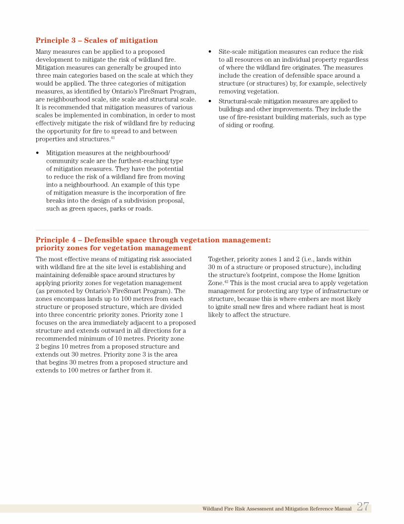
Principle 3 – Scales of mitigationMany measures can be applied to a proposed development to mitigate the risk of wildland fire. Mitigation measures can generally be grouped into three main categories based on the scale at which they would be applied. The three categories of mitigation measures, as identified by Ontario’s FireSmart Program, are neighbourhood scale, site scale and structural scale. It is recommended that mitigation measures of various scales be implemented in combination, in order to most effectively mitigate the risk of wildland fire by reducing the opportunity for fire to spread to and between properties and structures.41
• Mitigation measures at the neighbourhood/community scale are the furthest-reaching typeof mitigation measures. They have the potentialto reduce the risk of a wildland fire from movinginto a neighbourhood. An example of this typeof mitigation measure is the incorporation of firebreaks into the design of a subdivision proposal,such as green spaces, parks or roads.
• Site-scale mitigation measures can reduce the riskto all resources on an individual property regardlessof where the wildland fire originates. The measuresinclude the creation of defensible space around astructure (or structures) by, for example, selectivelyremoving vegetation.
• Structural-scale mitigation measures are applied tobuildings and other improvements. They include theuse of fire-resistant building materials, such as typeof siding or roofing.
Principle 4 – Defensible space through vegetation management: priority zones for vegetation managementThe most effective means of mitigating risk associated with wildland fire at the site level is establishing and maintaining defensible space around structures by applying priority zones for vegetation management (as promoted by Ontario’s FireSmart Program). The zones encompass lands up to 100 metres from each structure or proposed structure, which are divided into three concentric priority zones. Priority zone 1 focuses on the area immediately adjacent to a proposed structure and extends outward in all directions for a recommended minimum of 10 metres. Priority zone 2 begins 10 metres from a proposed structure and extends out 30 metres. Priority zone 3 is the area that begins 30 metres from a proposed structure and extends to 100 metres or farther from it.
Together, priority zones 1 and 2 (i.e., lands within 30 m of a structure or proposed structure), including the structure’s footprint, compose the Home Ignition Zone.42 This is the most crucial area to apply vegetation management for protecting any type of infrastructure or structure, because this is where embers are most likely to ignite small new fires and where radiant heat is most likely to affect the structure.
Wildland Fire Risk Assessment and Mitigation Reference Manual 27

Principle 5 – When risk cannot be mitigatedIn most cases implementing recommended vegetation management within priority zones 1 and 2 will reduce the hazard risk level to a moderate to low risk, assuming building design that follows FireSmart principles has been incorporated.43 However, in situations where risk cannot be mitigated appropriately, it is important to direct development elsewhere. Factors that may be present in such situations could include:
• subject lands are entirely within and surroundedby hazardous forest types for wildland fire and the
development area is not large enough for adequate mitigation within the priority zones;
• the planning authority determines that normalmitigation standards are not sufficient to providea basis for approving the type of development inquestion, such as a day care centre or long-termcare home; or
• the presence of a natural heritage feature on oradjacent to the subject lands would not allowmitigation because there may be negative impactson that feature or its ecological functions.
6.2 Mitigation approaches and techniques
The variety of wildland fire mitigation techniques generally fall in two categories: planning and design, and vegetation/fuel management. The techniques can be applied at various mitigation scales as discussed in Principle 3, and are further explained below.
6.2.1 Planning and design mitigation approachesPlanning and design mitigation approaches can be applied to communities and their infrastructure, and to specific sites. For proposed development, they focus on appropriate and strategic siting of various design elements in order to reduce the risks associated with a high or extreme wildland fire hazard rating.
Relocating proposed developments to alternative, lower risk sites (i.e., areas outside hazardous forest types for wildland fire) should be the preferred approach. Of particular consideration are sensitive land uses, such as those associated with vulnerable populations. These land uses should not be permitted within hazardous forest types for wildland fire. Examples are hospitals or day care centres, as well as structures for large populations or uses where people congregate, such as churches, arenas or community centres. Uses that involve the storage of flammable materials (such as gas stations) should also be restricted in areas associated with the risk of high to extreme wildland fire.44
Relocating development to an area where hazardous forest types are not present would avoid the associated risks, and further measures may not be necessary. If, after review of proposed development, relocating development to lower risk areas is determined not to be an option, the application of other planning and design mitigation approaches to the proposed development will be necessary. These approaches could be incorporated into subdivision design standards and other tools as discussed in Chapter 7.
6.2.2 Vegetation/fuel management mitigation techniques
Vegetation, or fuel, management involves the modification of a forest’s structure/composition to reduce fuel accumulations available to burn in a wildland fire. It is also commonly referred to as wildland fire hazard reduction or wildland fire mitigation. The main goal of fuel management is to improve public safety through the reduction of wildland fire intensity by reducing the potential for crown fires. Fuel management will also serve to improve success of wildland fire suppression, firefighter safety and forest resistance to damage from wildland fires.
Fuel management focuses on the management or manipulation of surface vegetation and ladder fuels, using various techniques within the vegetation management priority zones discussed in Principle 4. Appendices 3 and 7 illustrate these forest condition characteristics and the effects of the application of various mitigation techniques, and Chapter 7 describes the way these techniques can be applied within the priority zones when Planning Act applications are being considered.
6.2.2.1 Surface fuel reductionSurface vegetation takes a variety of forms, such as dead and down woody debris (including logs, branches, and twigs), grasses, small shrubs, and immature trees less than 2.5 metres high. Concentrations of surface fuels will sustain high-intensity surface fires and can initiate crown fires. Dry surface fuels resulting from drought, for example, can create continuous surface fuels that extend up to and under wooden decks, and are therefore particularly hazardous.
Reducing the amount and arrangement of the surface fuels will reduce wildland fire intensities and the rate of spread of a fire. The finer, dry fuels such as needles,
28 Wildland Fire Risk Assessment and Mitigation Reference Manual

twigs, cured grasses and brush, and spacing and pruning debris should be targeted for surface fuel treatments45. Some municipalities apply the principles of surface fuel reduction through property standards by-laws, although for different purposes. These by-laws may require that property owners maintain their property in good condition (e.g., keeping grass cut, removing garbage) in order to avoid pests and for urban design and visual appeal purposes. These by-laws may function as another vehicle for enforcing vegetation/fuel management techniques at the municipal level.
Surface fuels ignite easily and burn readily, enabling wildland fires to spread. Techniques for reducing surface fuel can include manual/mechanical piling, burning, mulching, chipping, and hauling, or a combination of these methods.46 Some larger downed material, called coarse woody debris (CWD), should be retained as it provides nutrients, and value such as wildlife habitat and diversity to a site, without contributing significantly to wildland fire rate of spread. Retained CWD should be well spaced out (i.e., not left in piles, criss-crossed or elevated). Tree service companies can provide good options for surface fuel reduction for a development area. While the recommended amount of CWD to be retained cannot be quantified because it depends on site-specific circumstances, the Forest Management Guide for Conserving Biodiversity at the Stand and Site Scales47 provides some guidance for appropriate surface fuel reduction.
The type and amount of vegetation surrounding a structure plays an important role in determining the level of risk. Surface fuel reduction is very important in the area immediately surrounding a structure (i.e., within priority zone 1) to prevent flames from directly contacting the structure. Properly managed vegetation increases structural protection from approaching wildland fires, and also reduces the chance that a building fire will spread to the adjacent wildland areas.48
6.2.2.2 Spacing and thinningSpacing involves the partial or selected removal of conifer trees from a forested area. The effect of spacing is to remove a portion of the forest canopy and lower canopy closure or crown density, reducing the overall volume of crown material. This reduces the opportunities for crown fires to move quickly and easily from tree to tree through a forest stand. For the spacing treatment to be effective, the felled trees including branches and tops (debris/slash) must be removed from the site to avoid the accumulation of ground fuel.
There are many types of thinning operations. Thinning from below removes intermediate and suppressed trees from the lower crown, and is the most common treatment for fire hazard reduction. This can reduce crown fire initiation and the potential for wildland fire to spread through the crowns of trees. Common spacing standards include reductions to 40 per cent canopy closure, or inter-tree distances of 1.5 times the crown width.49
Source: County official from Missoula, Montana.
Wildland Fire Risk Assessment and Mitigation Reference Manual 29

Deciduous trees such as aspen, birch and maple are water-based and are less flammable than conifer trees, which are oil-based. Therefore, deciduous trees should be the target species types for retention during spacing operations in areas associated with the risk of high to extreme wildland fire. They could also be maintained as fire breaks. Forest stands dominated by deciduous trees will greatly reduce the overall wildland fire hazard to an adjacent community, and across the landscape. It is not necessary to remove all dead or dying trees/vegetation, which provide value as wildlife habitat, for example, as long as those that remain do not create additional hazardous conditions.50
6.2.2.3 Pruning of ladder fuelsLadder fuels are shrubs, immature trees and branches that extend to within 2 metres of the ground. Ladder fuels provide surface fires a pathway to the upper canopies of conifer trees (see Figure A3-3 in Appendix 3). Removal of ladder fuels reduces the likelihood of crown fire, which reduces fires intensity, and the generation of firebrands (embers).
Pruning is often conducted after spacing has been undertaken so that lower branches that are too close to the debris accumulated on the ground (surface fuels) are noticeable. Pruning has the effect of raising the crown base height in a forest stand, reducing the opportunity for surface fires to move upward into the tree crowns where they are difficult to control and pose the greatest risk to structures and public safety. By preventing a wildland fire from burning into tree crowns, the amount of embers transported through the air toward a structure is reduced. Trees should be pruned at least 2 metres from the ground, while maintaining at least 40 per cent of the live crown to protect the health of the tree.51
6.2.3 Structural mitigation techniquesIn most cases, vegetation management in the priority zones using the techniques described above will reduce the risk posed by wildland fire to moderate or low. However, this does not necessarily reduce the risk posed by ember ignitions for those structures that have poor building design or a high number of areas that can accumulate fine fuels, such as leaf litter or pine needles. Building design and structural modifications will enhance the effect of vegetation management efforts that have been completed within the priority zones. In areas where vegetation fuels cannot be managed into priority zone 2 (i.e., the parcel is too small), it is recommended that the building design include fire-resistant exterior building materials that are better able to withstand the effects of radiant heat and possible flame contact from a wildland fire.
Several building design considerations can further protect structures from wildland fire. These include building materials and additional installations, as follows:
• use of fire resistant construction materials forroofing and siding, and for enclosing decks andporches (which will serve to prevent accumulation ofdebris)—this includes ancillary buildings/structures;
• gutter design that takes into account fireprevention (i.e., design options that do not allowthe accumulation of leaves or debris);
• installation of ember-resistant attic vents, screensor spark arresters for chimneys, sprinkler systems,and fire-resistant mesh coverings for attic vents,eaves and soffits to prevent embers from movinginto attics and double-paned windows; and
• installation of an exterior sprinkler system thatcan be turned on when a wildland fire threatensthe area.52
30 Wildland Fire Risk Assessment and Mitigation Reference Manual

Part 3Land Use Planning to Minimize Risks Associated with Wildland Fire
CHAPTER 7Land use planning implementation strategies and tools
Municipal land use planning is undertaken with certain objectives in mind, including achieving a community’s vision for strong, resilient communities, a clean and healthy environment, and economic vitality. Land use planning policy and decision-making can be informed by the presence of natural hazards such as lands with hazardous forest types along with many other planning considerations. Municipal planning processes provide opportunities for the assessment of wildland fire risk, the relocation or shifting of proposed development to areas not affected by hazardous forest types, and/or the use of planning tools to achieve mitigation measures to reduce the risk.
As protecting public health and safety, including from risks associated with wildland fire, is a matter of provincial interest, it is important to identify and plan appropriately and mitigate the risks associated with this natural hazard. There are aspects of the municipal planning process, and several planning tools and documents, such as official plans, zoning by-laws and site development controls, that can and should be used for this purpose. There are also considerations that can be incorporated at the site-specific scale when planning authorities are contemplating applications under the Planning Act. Where the Ministry of Municipal Affairs (MMA) is the approving authority under the Planning Act, proposed actions or decisions may engage the duty to consult and, where appropriate, accommodate
established or asserted Aboriginal and treaty rights. In these situations, ministry staff would seek information and advice, as appropriate.
There may be additional ways to implement the Provincial Policy Statement, 2014 (PPS, 2014) beyond the approaches set out in this Manual. Ultimately, planning authorities will determine the most suitable tools/options for implementing risk mitigation requirements. As will be discussed in this chapter, certain tools can be designed and used to prompt future mitigation actions. In all cases, however, the decisions planning authorities make shall be consistent with the PPS, 2014.
Wildland Fire Risk Assessment and Mitigation Reference Manual 31

Many land use planning issues, including planning for natural hazards, can cross municipal boundaries. When developing official plans and regulatory tools (e.g., zoning) aimed at managing natural hazards that cross municipal boundaries, planning authorities should take a coordinated, integrated and comprehensive approach.
7.1 General approaches to implementation through land use planning
7.1.1 Wildland fire policy developmentEstablishment of a multi-disciplinary team is recommended, if possible, to encourage involvement in various stages of planning as it relates to wildland fire. These could include, but are not limited to, the design of studies and collection of information to support official plan policy development, the development of official plan policies, and the review of site-specific planning applications, as necessary. Such a team could include various municipal departments in addition to the planning department, such as building, engineering, transportation, public works, emergency services, and local fire departments and fire protection agencies. Planning authorities could also involve foresters and ecologists either on staff or hired on contract. Planning authorities are also encouraged to involve First Nations and Métis communities and the public in policy development teams. This enables a broad sense of ownership and the opportunity to coordinate wildland fire prevention and mitigation efforts.
7.1.2 Early consultation/pre-consultationEarly consultation can occur for both site-specific applications under the Planning Act as well as broader applications such as the comprehensive review of official plans. Proponents of a development proposal should consult with the relevant planning authority, which may include the municipal office, planning board and/or the MMA municipal services office, as early in the planning process as possible. Early consultation has a number of benefits and provides opportunities for both proponents and planning authorities:
• Proponent/applicant should explain the proposalup front and obtain preliminary comments,including advice on appropriate design/approachesto the application, from the planning authority(ideally, including all relevant departments asdiscussed above).
• A planning authority should obtain information,including spatial data, to help make an informeddecision and guide the applicant on the approvalprocess.53
• Information gaps should be identified or newinformation that may be available can be sharedregarding the presence of hazardous forest typesfor wildland fire.
• A planning authority should explain the importanceof public health and safety and wildland firemitigation, including the expectations for wildlandfire assessment and supporting documentation.
• A proponent/applicant should obtain adviceand information on the appropriate level ofeffort associated with wildland fire assessment,including the possibility of coordinating wildlandfire assessment with other studies, such asenvironmental impact studies.
• Where applicable, a proponent/applicant shouldobtain advice regarding Aboriginal rights andinterests, as First Nations and Métis communitiesmay have interests, concerns and informationrelevantto planning for wildland fire risks. Earlyengagement of local First Nations and Metiscommunities may also identify other opportunitiesrelated to mitigation planning and implementation.
Proponents may wish to contact the local Ministry of Natural Resources and Forestry (MNRF) district office for technical explanations of relevant data and resource considerations.
7.1.3 Complete applicationsThe Planning Act and its regulations prescribe the requirements for information and material (requirements for a “complete application”) for planning applications. These requirements can be established for planning applications including plans of subdivision and consents, and amendments to official plans and zoning by-laws that are made to planning authorities or the Minister of Municipal Affairs.54 Full details of all provincial requirements are set out in regulations under the Planning Act. Examples of some of the prescribed information include applicant contact information and application details such as date of application, reason for request, and description of subject land as well as a sketch, and existing designation, zoning and uses.
In addition to the prescribed application requirements, planning authorities can establish their own list of required information or material needed to assess planning applications. This provides an opportunity to require that specific studies that are relevant to the proposed development, such as wildland fire assessments, form part of a complete application. These additional complete application requirements must be identified in the municipal official plan policies and it is up to the municipality to determine which studies or plans will be required to deem an application complete. Some examples of such additional
32 Wildland Fire Risk Assessment and Mitigation Reference Manual

information requirements include hydrogeological reports, archaeological assessments, land use compatibility studies and environmental impact studies.
Identifying wildland fire assessments as a complete application requirement in official plans may assist in ensuring that these assessments are undertaken and form part of a planning application. As described in Part 2, in all cases, an appropriate level of site-specific assessment for wildland fire risk will be needed to confirm the presence of a hazardous forest type. Wildland fire ssessment includes consideration of the effect of mitigation measures and will therefore enable planning authorities to make informed decisions regarding wildland fire risk in a timely fashion.
7.2 Official plans
Policy 4.7 of the PPS, 2014 describes the importance of official plans for comprehensive, integrated and long-term implementation of the PPS, 2014. In its direction about matters to be addressed in official plans, the PPS, 2014 includes the identification of provincial interests and setting out appropriate land use designations and policies.
Subsection 3(5) of the Planning Act requires that decisions on Planning Act matters shall be consistent with policy statements that are in effect on the date of the decision.
As part of implementing the wildland fire policies of the PPS, 2014, planning authorities should design their official plans to do the following (as detailed further in the 7.2 subsections):
• promote appropriate land use patterns (e.g.,directing development away from lands that areunsafe due to the presence of hazardous foresttypes for wildland fire);
• promote the avoidance of uses and activities thatmay represent an unacceptable risk to public healthand safety;
• identify areas of known and potential hazardousforest types for wildland fire in a mannerthat corresponds to level of confidence in theinformation source;
• provide a clear and reasonable mechanism forassessing at the development application stagewhether hazardous forest types for wildland fire arepresent; and
• provide a clear and reasonable mechanism fordetermining at the development application stageenvironmentally appropriate measures to mitigate therisk from high or extreme, to bring it to moderateor low.
7.2.1 Background study: Wildland fire assessmentPlanning authorities should use the best available data and information sources to prepare in-house documentation identifying the location of potential hazardous forest types for wildland fire, including spatial data prepared by MNRF (“Fire—Potential Hazardous Forest Types for Wildland Fire” data set available in Land Information Ontario). A planning authority may wish to undertake an assessment of its jurisdiction to refine the information provided in the MNRF data set. This could be done by using the recommended approach for broad-level/municipal-wide wildland fire assessment as outlined in Chapter 5.
Planning authorities need to determine the best approach to maintaining up-to-date data/mapping regarding hazardous forest types for wildland fire within their jurisdiction. Considerations for using the mapped results of a planning authority’s broad-level assessment of its jurisdiction for hazardous forest types in the official plan are covered in 7.2.4.
The benefits of undertaking a broad-level assessment are discussed in Chapter 5. Although a broad-level assessment can refine the generalized MNRF wildland fire hazard mapping, it generally does not eliminate the need for a more detailed site-specific assessment to support a planning application.
7.2.2 Official plan goals and objectivesGoals and objectives regarding wildland fire are statements that identify the planning authority’s commitment to maintaining public health and safety. They also identify commitments to the appropriate consideration of the potential for risk associated with wildland fire, resulting from land use change within hazardous forest types for wildland fire.
Goals and objectives should be incorporated into the official plan that identify a commitment to:
• direct development away from areas of naturalor human-made hazards where there is anunacceptable risk to public health or safety orof property damage, and not create or aggravateexisting hazards; and
• generally direct development to areas outside oflands that are unsafe for development due to thepresence of hazardous forest types for wildlandfire, and allow development in such areas onlywhere the risk can be mitigated in accordance withwildland fire assessment and mitigation standards.55
Wildland Fire Risk Assessment and Mitigation Reference Manual 33

7.2.3 Designations to achieve appropriate land use patterns
Land use patterns that support wildland fire planning goals are encouraged. This can be achieved by recognizing the linkage between wildland fire policies and housing and density policies. For example, policies could direct development away from both the wildland-urban interface and intermix areas, and discourage high-density development in areas associated with the risk of high to extreme wildland fire. Additionally, land uses associated with vulnerable populations (e.g., seniors) should be restricted in these areas.56 For lands subject to a Planning Act application that are adjacent to Crown land in areas associated with the risk of high to extreme wildland fire, policies can identify that MNRF will be contacted in these cases.
7.2.4 Approaches to official plan policiesOfficial plans should include a suite of policies that a) recognize wildland fire as a natural hazard posinga risk to public health and safety and b) promoteplanning measures for dealing with the hazard. Thepolicy should be directing development to areas thatare outside of lands that are unsafe for developmentdue to the presence of hazardous forest types forwildland fire. Wildland fire policies are most likely tobe situated within the public health and safety and/ornatural hazards policies of an official plan. Integrationof wildland fire considerations into additional sectionsof official plans where possible, is encouraged. Thefollowing official plan policy topics/approaches cancontribute to achieving the outcomes intended by therelevant policies of the PPS, 2014.
7.2.4.1 Assessing land use changes for wildland fire riskPlanning authorities should include policies in the official plan describing how the risks associated with wildland fire will be covered when dealing with proposals for development. These policies could include:
• the type of approvals required (e.g., amendment tothe official plan, zoning by-law);
• the need for early consultation with the planningauthority and applicable emergency managementdepartment/agencies to discuss ideas and concerns;
• the criteria for assessing applications; and
• the types (and timing) of additional informationthat will be required in support of applications.
7.2.4.2 Options for complete application requirements for wildland fire
Planning authorities should ensure that proponents provide sufficient information to enable the assessment of proposed land use changes as they relate to hazardous forest types for wildland fire. As already discussed, the planning authority may determine that such information is required as part of a complete application, in which case the official plan would need to list the two types of assessments within their complete applications section. Generally, a statement of the way policy 3.1.8 has been applied should be included as a complete application requirement. Policy 3.1.8 of the PPS, 2014 applies province-wide, and therefore needs to be considered in the review of all applications made under the Planning Act. Such
34 Wildland Fire Risk Assessment and Mitigation Reference Manual

a statement could confirm that risks associated with wildland fire have been considered and addressed, as appropriate, and the manner in which they have been addressed. For example:
Complete application requirements for level 1 site assessment:
• mapping that illustrates whether lands are treed/forested, and a statement concluding whether alevel 2 assessment is necessary (i.e., whether landsare treed/forested).
Complete application requirements for level 2 site assessment:
• identification of the presence/absence of hazardousforest types on and/or in the vicinity of the subjectlands;
• description of the characteristics of the hazardousforest types (i.e., forest composition and condition);
• location of proposed buildings/structures;
• mitigation techniques to be applied to mitigatethe risks associated with wildland fire (includingproposed landscaping within 100 m of proposedbuildings/structures); and
• any known history of wildland fire in the area.
7.2.4.3 Community design: Secondary plans, plans of subdivision The information resulting from the recommended broad-level/municipal-wide wildland fire assessment will provide insight regarding appropriate locations for community design elements with respect to reducing risks associated with wildland fire. Roads, trails and open spaces such as parks can provide defensible space by functioning as fire breaks- design features that can protect a developed area from encroachment of wildland fire. Roads can also be incorporated in a manner that addresses access considerations for proposed development, such as ensuring that there is more than one point of access. Water bodies, such as lakes, rivers and storm water ponds, can also function as fire breaks, while at the same time providing water sources for fire suppression purposes should a wildland fire occur.
Official plan policies and the use of land use designations can encourage safety-supportive community design including the strategic placement of the noted features in areas that contain hazardous forest types for wildland fire.57
The provision of defensible space, vegetation/fuel management and selection of fire-resistant building materials can be incorporated into community design;
however, these measures tend to be site-specific in their application. Potential tools under the Planning Act that can be used to implement wildland fire mitigation measures are site plan control, community planning permit systems (see 7.4) and holding symbol provisions (see 7.3.2). For a planning authority to employ these mechanisms/tools, official plan policies must be in place and the official plan (and associated by-law) must be in effect. The manner in which these and other tools can be applied within the context of wildland fire mitigation is described later in this chapter.
7.2.4.4 Integration with other official plan policiesNatural heritage policies in official plans should recognize that lands subject to a Planning Act application that are within areas of hazardous forest types for wildland fire may also contain or be adjacent to natural heritage features as identified within 2.1 Natural Heritage of the PPS, 2014. In such cases, policies in 2.1 Natural Heritage will be applicable. Official plan policies could promote environmentally appropriate mitigation measures. Policies could be considered for all natural heritage features and areas described in 2.1 Natural Heritage of the PPS, 2014, in which development is permitted.
Opportunities may exist to coordinate the requirements to fulfill the “negative impacts” test, as applicable (e.g., through the completion of an environmental impact study), with wildland fire assessment and determination of recommended mitigation measures. This would allow for an evaluation of whether proposed wildland fire mitigation measures would result in a negative impact on a protected natural heritage feature or its ecological function. Vegetation manipulation (e.g., spacing, thinning, and pruning of vegetation in order to create defensible space) is part of many of the measures to mitigate the risks associated with wildland fire from high or extreme to moderate or low. If it is determined that proposed mitigation measures would result in a negative impact, the mitigation measures cannot be applied.
Policies regarding transportation systems, infrastructure (including water and storm water), and parks and recreation/open spaces can recognize the important role that these facilities offer with regard to mitigating risks associated with wildland fire (e.g., by acting as fire breaks) and supporting fire suppression efforts. Access routes, safety zones and requirements for road design (e.g., limiting the number and length of one-way roads), including evacuation routes, can be identified in policies and on official plan schedules.58
Wildland Fire Risk Assessment and Mitigation Reference Manual 35

7.2.4.5 Official plan policies: Summary of basic best practices• Direct development to areas outside of lands that
are unsafe for development due to the presence ofhazardous forest types for wildland fire.
• Ensure development does not create new oraggravate existing hazards.
• Describe the applicability of official plan mapschedules or other maps that show potentialhazardous forest types for wildland fire.
• Consider risk evaluations conducted as part ofmunicipal emergency management programs.
• As determined appropriate by the planningauthority, allow development to be permitted inlands with hazardous forest types for wildland firewhere the risk is mitigated in accordance withwildland fire assessment and mitigation standards.
• Establish the requirement that mitigation measuresare to be environmentally appropriate.
• Establish suitable complete applicationrequirements.
• Specify that applicants may be required to undertakea site review to assess (to the extent possible) thelevel of wildland fire hazard and associated risk onand in the vicinity of the subject lands.
• Specify that applicants pursuing development inlands with hazardous forest types may be requiredto identify measures that need to be taken tomitigate the risk in accordance with standards.
• Enable the use of site plan control on lands withhazardous forest types for wildland fire, andidentify mitigation measures such as fire-resistantlandscaping and exterior design of buildings.
• Enable the use of the holding symbol as a tool toachieve the implementation of mitigation measures.
• Enable the use of community planning permits, ifappropriate, to achieve implementation of mitigationmeasures.
• Engage and consult with Indigenous communitiesin the assessment area and on adjacent lands toensure that land use planning and wildland firepolicy development reflects Indigenous interestsand concerns with respect to preventing fires,mitigating fire risk, and protecting ecological,economic, cultural, social and traditionalIndigenous values.
7.2.5 Official plan schedulesIdentification of hazardous forests for wildland fire as a land use designation on official plan schedules may not be appropriate and is not recommended due to the dynamic nature of forested areas. The condition of hazardous forest types for wildland fire is not static (i.e., changes over time), as discussed earlier in this Manual, and will need to be updated on an ongoing
basis. The following approaches could be used either alone or in combination:
• Show relevant information on an appendix map, tobe updated as new information becomes available.
• Prepare and maintain information or screeningmaps to be referenced in the official plan butnot form part of the official plan. These could beused by municipal planning staff when reviewingplanning applications.
The mapped results of a planning authority’s broad-level/municipal-wide assessment of its jurisdiction for hazardous forest types are recommended to be used as information or screening maps (to be updated on a regular basis) to be referenced but not form part of the official plan. Planning authorities could also use MNRF mapping as a reference external to the official plan to support policy implementation.
7.3 Zoning by-laws
A zoning by-law, which must conform to the policies of the official plan, implements the objectives and policies of the official plan by regulating and controlling specific land uses. The Planning Act empowers local planning authorities to pass zoning by-laws that restrict uses within specific areas, including prohibiting the erection of buildings or structures on hazardous lands as per subsection 34(1)3. Subsection 34(3) also enables a planning authority to regulate minimum lot size and the minimum and maximum density of development in the areas defined in the by-law. Zoning by-laws must be updated no later than three years after the five-year update of an official plan coming into effect. This ensures that the zoning by-law is up to date with the most current official plan policies. Zoning by-laws provide the opportunity to define potentially hazardous forest types for wildland fire in a more precise and specific manner than an official plan or secondary plan allows.
Planning authorities may wish to treat hazardous forest types for wildland fire treatment similarly to other natural hazards in zoning by-laws (e.g., environmental protection category). However, it is important that planning authorities seek up-to-date wildland fire hazard information in which they are confident, before restricting development of lands through zoning because they contain or may contain potential hazardous forest types for wildland fire. Although, it would not be appropriate to base zoning solely on the MNRF generalized wildland fire hazard mapping, a planning authority could augment this data with information collected from municipal-wide wildland fire assessments done by the planning authority (such assessments could be focused on treed/forested areas having potential for risks associated with high to extreme wildland fire).
36 Wildland Fire Risk Assessment and Mitigation Reference Manual

Planning authorities determine what approaches work best for their decision-making on development proposals in order to be consistent with the PPS, 2014. When planning authorities become aware of the presence of hazardous forest types, they may consider amending existing zone categories by limiting existing permitted uses or modifying zone provisions (i.e., setbacks), either through a comprehensive zoning by-law update or zoning by-law amendment precipitated by a development application. Alternatively, approaches could include added general provisions in the zoning by-law, site plan approval, or community planning permit approval if suitable criteria are in the official plan. Any areas zoned for development in proximity to dynamic forested areas should be subject to other planning tools to ensure up-to-date evaluation at the time of construction, and ongoing obligations to maintain mitigation requirements.
Zoning by-laws should not be amended to allow development in or in the vicinity of areas identified as having hazardous forest types for wildland fire until the conditions and requirements of the official plan regarding these hazards are satisfied. In areas of the province where an official plan does not exist, the PPS, 2014 can be used as the basis for assessing impacts of land use changes on risk levels associated with hazardous forest types for wildland fire in relation to amendments to zoning by-laws or zoning orders.
Subsections 7.3.1 and 7.3.2 describe some possible approaches and considerations for zoning for hazardous forest types for wildland fire.
7.3.1 Zoning categories and permitted uses• If an official plan contains policies and designations,
there by ensuring an appropriate level of wildlandfire assessment accompanies an application underthe Planning Act, lands containing or near knownhazardous forest types could be placed into a zoningcategory that does not specifically identify theforest types, but allows only low intensity uses.These uses could include forestry, some forms ofagriculture and passive recreation so that almost anytype of development would require approval underthe Planning Act.
• Lands in or near hazardous forest types for wildlandfire could be placed in a zoning category that has thespecific purpose of delaying development, (e.g. theuse of the holding symbol as discussed in 7.3.3), untilthe risk can be reduced by the application ofmitigation measures.
– Permitted uses as of right would be those thatwould not result in the loss of property or life if a wildland fire were to occur. This approach assumes that the location of hazardous forest types are known or can be determined through available information sources.
Wildland Fire Risk Assessment and Mitigation Reference Manual 37

• Sensitive land uses could be restricted throughzoning in areas of hazardous forest types forwildland fire. Such land uses include those related tovulnerable populations, and should not be permittedin areas associated with the risk of high to extremewildland fire until such time as the level of risk canbe reduced, or if the risks cannot be mitigated.59
• Defensible space should be established throughprovisions in site-specific zoning (particularly iflarger setbacks are required than current zoneprovisions) when such zoning is required for newdevelopments or construction or for alterationto or change in use of existing residential orcommercial structures.60
7.3.2 Zoning provisions/standards• Lot line setbacks, minimum distances from lands
with hazardous forest types for wildland fire, and lotcoverage standards could be used to provide for theestablishment of defensible space around buildingsor structures. These could be based on wildland fireassessments undertaken by a planning authority.
• Provisions for setbacks from a lot line or minimumdistances between buildings or between a buildingand the mid line of a street can be used to achieveappropriate locations for buildings and structures.
• Larger minimum lot sizes could be required inzones considered to be within or in the vicinity oflands with hazardous forest types for wildland fire,to accommodate the implementation of necessarymitigation measures such as establishing defensiblespace on a property.61 Planning authorities may wantto explore the full range of zoning powers undersubsection 34(1)4 of the Planning Act.
• Maximum densities could be defined to discouragethe establishment of high-density development inareas of hazardous forest types for wildland fire.However, it should also be recognized that effectiveimplementation of on-site mitigation may be moredifficult to achieve for low- and medium-densitydevelopments where ongoing monitoring of siteconditions may be difficult. Planning authoritiesmay also wish to identify low-risk areas wherehigher-density development is permitted(or supported).
• Planning authorities may wish to consider howother aspects of section 34 of the Planning Actcould be used to mitigate the risk associated withthe presence of hazardous forest types for wildlandfire in given situations.
• Section 36 of the Planning Act enables a planningauthority to pass a zoning by-law that employs aholding symbol (“H”) provision, provided thatpolicies are in place within the official plan to allow
for this. Holding symbol provisions allow a planning authority to restrict future uses until the conditions for removing the holding symbol have been met, and an application to remove the holding symbol would be required in order to enact the proposed use. Holding symbols can help ensure that preconditions are met before a change in land use can occur. They allow for more detailed planning and design work to be done on a site-by-site basis after completion of site-specific wildland fire assessments (i.e., establish appropriate setbacks not known at the time of zoning and a vegetation management plan for each site, implemented in a site plan or other agreement registered on title to mitigate the risk). The holding symbol may also help to ensure that adequate community infrastructure, including community-wide wildland fire mitigation, is in place before development can proceed.62
7.4 Site development controls
Site development controls are important tools that can be used in establishing and implementing measures for mitigating the risk of wildland fire. The two main site development control tools are community planning permit systems and site plan control areas. To be able to employ these tools, required official plan policies and the associated by-law must be in effect to designate the area for site plan control or as a community planning permit system area.
7.4.1 Community planning permit systemThe community planning permit system (CPPS) as established through section 70.2 of the Planning Act and Ontario Regulation 173/16 (Community Planning Permits), is a streamlining planning tool that combines zoning, site plan, and minor variance processes into one application and approvals process. For a CPPS to be established, official plan policies must be in place and a by-law must be passed.
Once a planning authority establishes a CPPS for an area within its jurisdiction, a range of conditions can be imposed that must be met before a community planning permit is issued. A CPPS could be established for areas of hazardous forest types for wildland fire. A suite of conditions may be applied for the development permit area(s), such as requiring that wildland fire assessment be undertaken and submitted as part of the application for a community planning permit, and that a vegetation management plan be prepared and implemented in order to establish and maintain adequate defensible space around buildings and structures.
38 Wildland Fire Risk Assessment and Mitigation Reference Manual

In addition to identifying permitted uses, a community planning permit by-law may also identify uses that may be permitted without a by-law amendment, subject to meeting specified criteria. For example, uses can be allowed subject to establishing that the proposed use will not be at high or extreme risk for wildland fire after assessment is undertaken and mitigation measures identified through the assessment are implemented, including use of fire-resistant building materials and ongoing vegetation management. Such criteria would likely be accompanied by a condition limiting development in accordance with a corresponding site plan and a condition that the owner enter into an agreement with the planning authority to provide for the implementation of the identified mitigation measures, such as ongoing vegetation management requirements after construction.
7.4.2 Site plan control areasSection 41 of the Planning Act identifies site plan control as a tool that planning authorities may choose to use (except where this power is superseded by similar powers under other legislation, such as the Aggregate Resources Act), in order to specify site design aspects.63 More specifically it provides a planning authority with the added ability to control the design and development of a site, such as the building location, layout of parking and service areas, public access areas, and landscaping and exterior design, including the character, scale, appearance and design features of buildings, subject to appropriate official plan provisions being in place. These controls can be established by requiring plans or drawings and are normally accompanied by a site plan agreement registered on title to the property, which can contain provisions for ongoing site maintenance.
Due to the dynamic nature of forested areas, it may not be appropriate to undertake the physical actions required to mitigate the risk associated with hazardous forest types for wildland fire before a decision is made on a planning application, unless this is deemed the most appropriate action by the planning authority. In this vein, site plan control can be an effective tool to ensure the implementation of mitigation measures occurs at the appropriate time. The following outlines some approaches to using site plan control to achieve this purpose:
• For site plan control areas established for thepurposes of addressing wildland fire hazards,base boundaries on the results of municipal-widewildland fire assessments that identify hazardousforest types for wildland fire.
• Within site plan control areas that are establishedusing the above approach, ensure the official plancontains policies to ensure the following mattersare incorporated into site plan approvals:
– identify appropriate placement of buildings,parking facilities and access driveways (structures should be discouraged in areas where the slope exceeds 30%, and or in ravines or valleys);64
– implement exterior design control to regulate building exteriors where appropriate;
– require that defensible space be established around all buildings and structures by identifying the location of buildings and landscaping;
– apply conditions of approval to require the establishment and maintenance of site landscaping (e.g., establish a long-term vegetation management or landscaping plan);
– require that physical and legal access to all lots in a proposed development be provided by a minimum of two approach routes to allow for access by emergency response and evacuation by occupants;
– regulate minimums and standards for roads, including roadside fuel reduction, grading, bridges and culverts, gates and signage;65
– include in the site plan agreement a requirement that the owner ensure that flammable vegetation is cleared around structures in order to maintain defensible space (through ongoing vegetation management in priority zones); and
– for condominiums, ensure that mitigation features are contained within common elements as defined in the description and declaration and that they are identified in the site plan agreement as matters to be maintained by the condominium corporation.
Wildland Fire Risk Assessment and Mitigation Reference Manual 39

7.5 Planning Act applications
To determine whether a site-specific application under the Planning Act is or likely can be carried out in a manner consistent with the policies of the PPS, 2014, including policy 3.1.8 regarding wildland fire, it would first be necessary to identify which information and studies are required. These studies may be determined by reference to this Manual or, where the planning authority has incorporated appropriate policies in its official plan to implement policy 3.1.8, these studies would be set out in the official plan to form part of the complete application. In the case of wildland fire assessment, this would involve determining whether a level 1 site assessment is adequate, or if a level 2 site assessment is required (see Chapter 5 for details regarding site assessment). The proposal would then need to be assessed against the applicable official plan policies and any requirements related to wildland fire in the zoning by-law, zoning order of the Minister of Municipal Affairs or community planning permit by-law, as well as and any site plan approval requirements, to determine if these are satisfied and whether the development is considered appropriate.
In areas of the province where an official plan does not exist, the PPS, 2014 can be used as the basis for assessing planning applications for impacts of land use changes on risk levels associated with hazardous forest types for wildland fire. Consultation with MNRF for additional information and technical advice may be necessary.66
Wildland fire assessment for site-specific planning applicationsWildland fire assessment is a component of project site design. Much of the information submitted to form part of a development application is also helpful in assessing the risk for wildland fire. An assessment should generally include the following:
• identification of the area to be assessed (subject lands);
• distance of subject lands from any hazardous forest types (mapswould be useful tools to illustrate these points);
• predominant vegetation types, ideally within 100 metres of anyproposed structures, but at least within 30 metres of any proposed structures;
• other risk factors including topography/slope and aspect;
• description of proposed land use(s), including layout and density, location of proposed structures, and access (including external roadaccess and internal traffic circulation for subdivisions);
• fire suppression infrastructure (water supply, fire departments)and utilities (location of hydro lines);
• proposed mitigation measures, at neighbourhood, siteand structural scale; and
• resulting risk after mitigation measures have been applied.
40 Wildland Fire Risk Assessment and Mitigation Reference Manual

7.5.1 General considerations for site-specific Planning Act applications
The following outlines some preliminary considerations for planning authorities when reviewing applications under the Planning Act in areas of hazardous forest types for wildland fire. It also discusses opportunities to apply wildland fire mitigation techniques at the site-specific level within vegetation management priority zones.
• Not all land use controls are available orappropriate for all development scenarios. Planningauthorities are encouraged to consult with MMA forguidance where needed.
• Prioritize the relocation of proposed developmentsto alternative, lower risk sites (should be first builtinto the community structure through official plandesignations and policies but also discussed as partof early consultation on development applicationsand considered at the time of decision making).
• Carry out and/or require site-specific wildlandfire assessments to determine whether there arehazardous forest types for wildland fire, and ifmitigation measures are needed (see callout box).Appendix 4 provides a simple sequential evaluationmatrix to help walk a planning authority throughthe overall process for wildland fire assessmentand mitigation.
• Like other documents where the municipality feelsthat it does not have the expertise or the capacityto review and evaluate an assessment report, itcould be considered that a fee for service peerreview be incorporated into the development/planning application process with the cost paid bythe property owner.
• Use site-specific zoning categories to control landuses and provisions, such as setbacks and minimumyard requirements, to mitigate risk.
• Recognize that techniques for mitigation andopportunities to use Planning Act tools to achievemitigation may differ with the scale or nature ofproposed development (e.g., approval related toundeveloped site versus existing building).
• Involve the appropriate municipal departmentsin the review of development proposals. Theseshould include the building department, emergencyresponse coordinators and fire departments, andcould also include departments dealing with waterservices, transportation and roads, and health, aswell as flood control authorities.67
• Plan for mitigation measures such as ongoingvegetation and fuel management, by addingconditions to an approval or including provisionsin a subdivision/consent agreement (e.g., thinning,selected removal of vegetation, removal of woodydebris, etc.).68
7.5.1.1 Application of vegetation management techniques on a site-specific basis
Chapter 6 introduced the concept of creating defensible space through vegetation management. At the site scale, vegetation management is most effectively applied within vegetation management priority zones, as promoted by FireSmart, in order to reduce the opportunity for wildland fire to spread by embers, direct flame contact and/or radiant heat. In most cases, implementing vegetation/fuel management in all three priority zones (0–100 m from a structure) will reduce the level of risk associated with wildland fire from high or extreme to moderate or low.
The preparation of a vegetation management plan or strategy provides an opportunity to document the mitigation techniques proposed within the priority zones. Vegetation management plans are intended to be long-term strategies outlining the vegetation management techniques that will be applied in order to prevent a site from reverting to a pre-application site condition. A key component of a vegetation management plan is the inclusion of a long-term, ongoing schedule of the application of vegetation management techniques.
Vegetation management in priority zone 1The main objective of vegetation management in priority zone 1, which is the area within 10 metres of a structure or proposed structure, is to prevent a surface fire from coming in contact with the structure. It is necessary to create an environment that will not support fire of any kind, by eliminating flammable vegetation surrounding structures or modifying vegetation to less flammable species. Poor defensible space could allow embers to ignite vegetation in outlying areas and spread fire through continuous vegetation that leads to a structure. Developing a 10 metre non-combustible or low-combustible zone immediately adjacent to structures is critical. Figures 7-1 and 7-2, and Appendix 7, illustrate examples of the application of site and structural mitigation within priority zone 1.
In some situations, priority zone 1 may be the only zone or area in which ongoing vegetation management is necessary. Modifying or removing the combustible fuels within priority zone 1 greatly reduces the risk of embers igniting new fires near a structure, or fire directly reaching the structure.69 Vegetation can be managed in priority zone 1 by undertaking the following treatments within the zone:
• Prune shrubs and trees.
• Remove deadfall and relocate woodpiles outsidepriority zone 1.
• Mow and water grass.
Wildland Fire Risk Assessment and Mitigation Reference Manual 41

• Prune conifer branches to remove any that overhangroofs or that are within 2 metres of the ground.
• Replace conifer trees and shrubs with nativedeciduous/hardwood species.
• Use non-combustible landscaping products (e.g.,mulch) and shrubs, including manicured lawns,rock gardens, and cement or rock walkways.
• Apply fire-resistant landscaping options asconstruction sites are being rehabilitated.
For lands subject to proposed development that do not extend up to 30 metres from a structure/proposed structure (i.e., the property is too small to contain the full extent of priority zones 1 and 2), it may be necessary to enlarge the priority zone 1 surrounding a structure/proposed structure from 10 metres to 15 metres in order to reduce potential impacts from crown fires. The application of structural mitigation techniques will likely be necessary in these scenarios.
Vegetation management in priority zone 2The main objective of vegetation management within priority zone 2 is to create an environment that will support only fires of lower intensity and rate of spread, by further reducing flammable vegetation. Direct flame contact, radiant heat and flying embers from fires in this zone may ignite a structure. Preventing high-intensity and crowning fires from advancing within 30 metres of any structure greatly reduces the effects of radiant heat on the structure, since radiant heat from high-intensity fires can ignite some types of building materials from up to 20 metres.
To reduce the effects of radiant heat, fuel management within priority zone 2 should reduce an approaching crown fire down to the lowered intensity of a surface fire, and prevent it from advancing within 10 metres of a structure. The following treatments are recommended for priority zone 2:
• Space the crowns of conifer trees at least3–6 metres apart to reduce continual ignitionof tree crowns.
• Plant native hardwood species when replantingtrees in this zone.
• Remove dead woody debris, thick shrubbery andmature trees that might provide the opportunityfor a ground fire to climb up into the forest canopy(i.e., ladder fuels). In developments involvingmultiple structures, a vegetated privacy curtaincomposed of mostly hardwood trees can beretained between buildings.
In most cases, implementing the recommended fuel modifications (vegetation management) within priority zones 1 and 2 will reduce the hazard risk level to a moderate to low risk.
Vegetation management in priority zone 3Vegetation management in priority zone 3 (30—100 m from a structure) may be needed only in specific cases, when high or extreme hazard levels resulting from heavy continuous forest vegetation and steep topography cannot be reduced enough by vegetation management in priority zone 2.70 The objective of vegetation management in priority zone 3 is to thin conifer trees and remove some of the ground fuels in the area, and create space within the forest stand that will interrupt the ability of a fire to spread upward into the forest canopy. This will reduce the intensity at which a forest burns, allowing it to be more easily extinguished.
It may not be possible for vegetation management to occur in priority zone 3, as the land ownership may not extend out this far (i.e., parcel may be too small). Ideally, however, the following recommended vegetation management would be applied:
• Thin or reduce shrubs and trees that make upthe understory, while retaining fire-resistantdeciduous trees.
• Space conifer trees such that crowns are at least3–6 metres apart, to reduce the potential for acrown fire.
Vegetation management in all three priority zones is not always necessary. In some cases it may be necessary only in priority zone 1, while in others vegetation management may be necessary in all of the priority zones. This will be determined through wildland fire assessment, and should be considered in conjunction with other recommended mitigation techniques.
42 Wildland Fire Risk Assessment and Mitigation Reference Manual

7.5.2 Considerations for land severances and plans of subdivision or condominiums
The processes associated with the subdivision of land provide several opportunities and tools to the planning authority for addressing the wildland fire policies of the PPS, 2014.
7.5.2.1 Relocation of development to avoid the riskFor both land severances and plans of subdivision or condominiums, the aim should be to identify the areas that have hazardous forest types for wildland fire, and adapt the proposed development in a manner that will mitigate the wildland fire risk.
To determine which implementation tools are applicable to applications for land severances or plans of subdivision, it is necessary to first determine whether hazardous forest types for wildland fire are present on or
in the vicinity of the proposed development site, through a wildland fire assessment (as described in Part 2 and in the callout box in 7.5). If they are present, appropriate mitigation techniques need to be considered; where mitigation techniques are considered effective to reduce an extreme or high risk to a moderate or low risk, they should be required as a condition of approval and the planning authority should employ implementation tools to ensure that mitigation measures are applied, such as site development controls.
For land severances, the first opportunity is the consideration of the location and the size of the proposed lot(s). This should be considered relative to risk factors (i.e., the presence of hazardous forest types for wildland fire), and to the size of lands in the vicinity that are part of the same holding. For example, consideration should be given to the possibility of enlarging the lot to be severed to allow for necessary mitigation.
Figure 7-1. The vegetation around a home within the three priority zones before the application of vegetation management techniques to establish defensible space (not to scale)71
Figure 7-2. The vegetation around a home within the three priority zones after the application of vegetation management techniques to establish defensible space (not to scale)72
Wildland Fire Risk Assessment and Mitigation Reference Manual 43

If it is determined that proposed development can be relocated to avoid hazardous forest types for wildland fire, the act of relocating would avoid the risks associated with wildland fire, and further measures may not be necessary.
7.5.2.2 Adaptation of design If relocation of a proposed development is not possible, additional mitigation will be necessary. For both land severances and subdivisions, consideration of the location of proposed development/building envelopes relative to risk factors can be explored during early consultation. Consideration can also be given to the location of existing and proposed buildings and structures, and the proposed design can be modified in a manner that would allow for the application of appropriate measures to mitigate the wildland fire risk, (i.e., community protection fuel/firebreaks around perimeter of the subdivision).
Additionally, tools such as subdivision layout and design standards, and conditions on consent or draft approval of subdivisions, as described below, may be useful in ensuring the implementation of such measures. Involvement of local fire departments and/or emergency management coordinators in these reviews is recommended.
7.5.2.3 Subdivision design and standardsThe design stage of a plan of subdivision is an opportunity to explore options for configuring the subdivision layout, and selecting appropriate development/building envelopes. Ideally this should be explored during early consultation, with the goal of designing and/or adapting the proposed subdivision plan to avoid hazardous forest types for wildland fire, and/or to incorporate design elements that will mitigate the risk of wildland fire. Planning authorities may review proposed plans of subdivision to improve the impact of design aspects and layout in terms of their role in mitigating the risk of wildland fire.
Subdivision design standards/guidelines, which outline the basic requirements established by a planning authority for all subdivision applications, can be updated to explicitly incorporate wildland fire risk mitigation into subdivision design. Design standards can address aspects of subdivision design, such as overall subdivision layout and shape, density, phasing and staging, and specific design elements such as roads and access, fire protection infrastructure, and vegetation management.73
Layout and shape• Design the lot shape, size and orientation in a
manner that avoids or minimizes the placementof structures in hazardous areas that exist withinspecific areas of a community or proposedsubdivision.74
• Minimize development perimeters by incorporatinga subdivision/lot shape that reduces the creation ofnew wildland fire interface areas.
• Incorporate community protection fuel/fire breaksto function as fire protection zones around theperimeter of the development.75
– Natural features (e.g., rocky formations,streams/rivers) and/or human-made features such as open spaces, public use areas (e.g., parks, recreation fields, etc.), roads, pedestrian walkways, utility rights-of-way, and storm water management ponds can perform this function.
• Avoid development patterns that create areas ofcongestion (bottleneck or hourglass shapes), orthat isolate pockets of development, such as longcul-de-sacs.
• Avoid locating structures in areas where the slopeexceeds 30 per cent, as measured before alteration,and in ravines or valleys.76
Density• Encourage high parcel density in lower-risk areas,
consisting of fire-resistant structures.
• Design development so that it is clustered toencourage the grouping of dwellings on smallerlots to reserve more community open space. Thisshould be done in conjunction with adequatelyspaced buildings and ongoing vegetationmanagement.77
• Incorporate building separation distances of at least15–20 metres between dwellings, and larger distancesto separate buildings located on slopes, in order toavoid the spread of fire.78
Phasing and staging• Prioritize the installation of subdivision
infrastructure that is required by the subdivisionplan, as these features could also function as fireprotection features. These features, which includewater sources, wells, draft sites, hydrants, firebreaks and access routes, should be installed priorto the construction of any structures within thesubdivision.
• Encourage early stages of initial development to bein those areas along the interface perimeter of the
44 Wildland Fire Risk Assessment and Mitigation Reference Manual
subdivision, to minimize risk of wildland fire to the entire subdivision by reducing the interface area as quickly as possible.
• Where appropriate, establish at least two accessroutes that are available during each phase ofdevelopment of a subdivision.79
• Ensure that the proponent/developer provides fireprevention and protection measures throughout theentire lifespan of the development project.80
Accessibility and safety considerations• Roads and access
– Give special attention to transportation designand road connectivity, including internal road patterns (e.g., length of cul-de-sacs, vehicle turnarounds, etc.) and points of access to subdivisions and other development projects.
– Design road transportation networks that provide multiple access points for simultaneous access for emergency equipment and evacuation of residents.
– Adhere to minimums and standards for plans of subdivision and site plans, to accommodate fire-fighting equipment and vehicles, for the following:81
› roadway and driveway widths, surfaces, curvature, fuel reduction, and grades (i.e., limit road grades to 10–15%);82 and
› bridges and culverts.
• Fire protection infrastructure and tools
– Include, as part of plans, current and projectedfire protection needs including fire emergency services facilities.
– Signage should be non-combustible, and should identify address, be visible (i.e., well located) and be easy to read; dead-end roads should be marked.
– Incorporate water sources (hydrants, natural water sources and other sources such as wells, swimming pools, etc.) into the design, including sources for emergency firefighting purposes during construction phases of approved development.
• Vegetation management
– Define building envelopes and establishminimum defensible space for each lot, prior to approval.
– Incorporate fire breaks/buffers (i.e., areas that are free of vegetation) to break the continuity of vegetation around the perimeter of the
development to slow or stop the spread of a fire. These areas also provide additional access for firefighting and evacuation.
– Incorporate standards related to landscaping, such as tree spacing and location, through the establishment of a vegetation management/landscaping plan.83
7.5.2.4 Implementing mitigation measures through conditions of approval
Subsections 51(25) and 53(12) of the Planning Act enable the planning authority to impose any condition to a draft subdivision approval or to a provisional consent, as long as the planning authority believes the condition is reasonable, in the context of the nature of the development proposed.84 Details of such conditions are further described below.
Consents A severance approval may have certain conditions attached to it, which must be met within one year. Such conditions could include requirements for road widenings or a rezoning (or minor variance) to allow a new land use. In addition, the property owner may be required to enter into an agreement with the planning authority to provide future services or facilities.85 With respect to wildland fire, this could include the establishment and maintenance of defensible space around buildings or structures to be constructed at a future date (i.e., after approval has been granted). The following are sample conditions requiring a vegetation management/ landscaping plan that could form part of severance approval:
• Applicants will prepare a landscaping plan tothe satisfaction of the municipal fire departmentshowing all landscaping on site and, in particular,the location of trees and vegetation removed andpreserved and added on site, as well as limitationson the type and location of fencing and other siteimprovements; vegetation management should bemaintained, particularly adjacent to streets, roads(within 1.5 m of either side of roads) and driveways.
• A vegetation management plan shall be preparedby the applicant to the satisfaction of the municipalfire department and shall be implemented priorto any new construction or the alteration, movingor change of use of an existing residential orcommercial structure on an existing lot.86
• The owner shall enter into an agreement to beregistered on title that shall ensure the ongoingmaintenance of the landscaping and vegetationmanagement plans.
Wildland Fire Risk Assessment and Mitigation Reference Manual 45

Subdivisions/condominiumsThe planning authority may provide draft approval, in which case an applicant will be advised of the conditions that need to be met to obtain final approval and registration. Conditions of draft approval may include: road widenings, the naming of streets, parkland requirements, rezoning of the area to reflect the new uses in the subdivision and any other municipal requirements. Draft approval may also establish a time frame within which the conditions must be satisfied or the draft approval lapses. Draft approval amounts to a commitment to go ahead with the subdivision, once all the conditions of draft approval have been met, at which point, final approval is given and the plan of subdivision is registered. Considerable time may pass between draft approval and actual registration of the plan. However, the planning authority has the power to determine that draft approval will lapse after three years, and it has the power to give a further extension to draft approval.87
The applicant may be required to sign a detailed subdivision agreement, which is generally registered on the title of the property and legally binds future owners to its conditions.88 This could be a useful tool as it relates to wildland fire mitigation considerations, since the measures generally need be implemented on an ongoing basis (such as establishing and maintaining defensible space through vegetation management).
Conditions of draft approval and subdivision agreements—as per subsections 51(25), (26) of the Planning Act—can be used as tools to require the implementation of measures to mitigate the risk of wildland fire. They should aim to protect life and property, reduce potential for a fire to spread into hazardous forest types and/or to spread into property, structures, or to or from adjacent lands.89
Conditions could require, for example, that a wildland fire hazard assessment be undertaken, which would include proposed mitigation measures and the manner in which they are to be applied (such as the requirements necessary to establish and maintain defensible space around structures). Conditions could also require the preparation of a vegetation management plan, which is guided by the findings of a wildland fire assessment. These conditions could also stipulate the timeframe in which wildland fire assessment and mitigation work should be completed, as well as address the ongoing nature of mitigation measures, if applicable, to ensure that the risks associated with wildland fire remain low (e.g., ongoing vegetation management). Such conditions could be modeled on the following:
• A vegetation management plan should be preparedfor all properties, roads, and open spaces (to reducefuel loading and ensure continuous maintenance); avegetation management plan, including mechanismsfor its implementation, should be prepared prior tofinal subdivision approval.90
7.5.3 Considerations for minor variancesA minor variance could be described as a small variation from the requirements of the zoning by-law. Its approval is a certificate of permission, as it allows a proponent to obtain a building permit even though the subject lands do not comply precisely with the zoning by-law. Subsection 45(1) of the Planning Act sets out four tests that a proposal must meet in order for it to be considered for a minor variance:
1. Is the application minor?
2. Is the application desirable for the appropriatedevelopment of the lands in question?
3. Does the application conform to the generalintent of the zoning by-law?
4. Does the application conform to the generalintent of the official plan?91
A minor variance requires approval under the PlanningAct. Consideration of whether the minor variance would result in new or increased risk to the public should be taken into account in determining whether or not the variance should be approved. Determination of the presence of hazardous forest types for wildland fire is necessary, and this may be done by undertaking a site-level wildland fire assessment. One consideration will be the planning history of the site and whether the proposal would penetrate areas identified for defensible space in an earlier approval.
Measures such as maintenance of defensible space through vegetation management will likely be adequate to mitigate risks; however additional measures may be necessary. As discussed with respect to severances and subdivisions/condominiums, adding conditions to the approval may be an appropriate approach to ensuring the implementation of measures to mitigate the risk. Such an application may also provide an opportunity to implement mitigation techniques on existing sites as a condition of further development where the need is reasonably related to the new development.
46 Wildland Fire Risk Assessment and Mitigation Reference Manual

Glossary
Conifer: “A tree belonging to the order Coniferae, usually evergreen with cones, needle-shaped leaves and producing wood known commercially as ‘softwood’.”92
Crown fires: fires that burn in the upper foliage and branches in addition to surface and ground fuels. Crown fire occurs when high-intensity surface fire spreads or “ladders upward through lower foliage into the canopy above. Driven by wind or influenced by upper-atmosphere disturbances, crown fires travel quickly and are difficult to control.”93
Crown: the branches and foliage of a tree94
Deciduous: trees (commonly broad-leaved trees) that drop all their leaves sometime during the year95
Defensible space: the area around a structure where fuels and vegetation have been treated, reduced or cleared, to provide separation and slow the spread of a wildland fire to a structure, and from a structure to surrounding vegetation96
Development: “means the creation of a new lot, a change in land use, or the construction of buildings and structures requiring approval under the Planning Act, but does not include:
a) activities that create or maintain infrastructureauthorized under an environmental assessmentprocess;
b) work subject to the Drainage Act; or
c) for the purposes of policy 2.1.4(a) “[ofthe Provincial Policy Statement, 2014],”underground or surface mining of mineralsor advanced exploration on mining lands insignificant areas of mineral potential inEcoregion 5E, where advanced explorationhas the same meaning as under the MiningAct. Instead, those matters shall be subjectto policy 2.1.5(a)” [of the Provincial PolicyStatement, 2014]97
Fire [fuel] break: an obstacle to the spread of fire, such as a strip of open space in a forest.
Fuels: Wildland vegetation materials that can burn. While usually referring to above-ground living and dead wildland surface vegetation, roots and organic soils such as peat are often included.98
Fuel loading: the overall amount of fuel99
Ground fires: Fires that creep through the duff layer (organic soil) and decaying woody material beneath the forest floor. They are persistent, slow burning, and difficult to detect and extinguish.100
Hardwood species: generally, one of the botanical group of trees that have broad leaves, in contrast to the needle-bearing conifers. Also, wood produced by broad-leaved trees, regardless of texture or density.101
Hazard reduction: A treatment of dead or dying forest fuels to diminish the chance of fire starting, and to lessen the potential rate of spread and resistance to control.102
Hazardous forest types for wildland fire: “means forest types assessed as being associated with the risk of high to extreme wildland fire using risk assessment tools established by the Ontario Ministry of Natural Resources [and Forestry], as amended from time to time”103
Immature conifer stand: a conifer stand (i.e., composed of more than 50% conifer trees) of which greater than 50 per cent is composed of young trees or new growth
Intermix areas: areas where development and forest fuels intermingle with no clearly defined boundary or separation from the forest stand104
Ladder fuels: shrubs, immature trees and branches extending near the ground (e.g., within 2 m) that give surface fires a pathway to the upper canopies of the trees105
Wildland Fire Risk Assessment and Mitigation Reference Manual 47

Mature conifer stand: a conifer stand (i.e., composed of more than 50% conifer trees) of which greater than 50 per cent is composed of mature trees. Mature conifers are trees that have reached their maximum height and new growth occurs to the diameter of the stem.
Slash: debris (i.e., stems, branches, tree tops with needles) lying on the ground resulting from tree harvesting activities
Stand: an aggregation of trees occupying a specific area and uniform enough in composition (species), age and arrangement to be distinguishable from the forest in adjoining areas106
Stand density: the number of trees usually expressed on a per hectare basis107
Suppression: all activities concerned with controlling and extinguishing a fire following its detection108
Surface fires: fires that burn needles, twigs, branches on the forest floor, young trees, and the lower branches of standing timber. Surface fires are spread more quickly by wind.109
Understory: the portion of trees or other vegetation in a forest stand below the forest canopy110
Values: the specific or collective set of natural resources and human-made development/ improvements that have measurable or intrinsic worth and that may be destroyed or otherwise altered by fire in any given area111
Wildland fire assessment and mitigation standards: “means the combination of risk assessment tools and environmentally appropriate mitigation measures identified by the Ontario Ministry of Natural Resources [and Forestry] to be incorporated into the design, construction and/or modification of buildings, structures, properties and/or communities to reduce the risk to public safety, infrastructure and property from wildland fire”112
Wildland fire: any fire burning in forest, grass, or alpine/tundra vegetation—synonymous with forest fire and wildfire113
Wildland-urban interface: areas where residential, commercial and industrial development is located close to wildland areas114
48 Wildland Fire Risk Assessment and Mitigation Reference Manual

Notes
Wildland Fire Risk Assessment and Mitigation Reference Manual 49

Appendices
APPENDIX 1Legislation and policy related to wildland fire and municipal planning
Emergency Management and Civil Protection Act
The Emergency Management and Civil Protection Act requires each municipality to develop, implement and maintain an emergency management program to improve public safety through a coordinated and pre-identified process for responding to critical situations. An effective emergency management program will assist in protecting lives, infrastructure and property; protect the environment; promote economic stability; and help ensure the continuance of critical assets and government. One requirement under the Act is that each municipality must designate a community emergency management coordinator who coordinates the development, implementation and maintenance of the community’s emergency management program. Section 2 of the Act deals with hazard and risk assessment, and requires that, “In developing its emergency management program, every municipality shall identify and assess the various hazards and risks to public safety that could give rise to emergencies and identify the facilities and other elements of the infrastructure that are at risk of being affected by emergencies.”115
Forest Fires Protection Act
Authority relative to wildland fire management comes from the Forest Fires Prevention Act, which applies to the fire region as set out in regulation (see Figure A1-1). The Act establishes the fire season; where and when fire permits are required; penalties for contravention of the Act and regulations; provision for implementing restricted fire zones where outdoor burning can be restricted; declaration of emergency areas and orders for fire suppression and the safety and
evacuation of persons; and the responsibilities of planning authorities with respect to the suppression of wildland fires within their jurisdiction. Fire protection outside the fire region is also regulated by the Forest Fires Prevention Act.116
Outside Fire Region
Fire Region
Outside Fire Region
Fire Region
WGS 1984 Web Mercator
0 120 240 360 48060km
Figure A1-1. The fire region as set out in regulation (O. Reg. 332/15, s. 7), under the Forest Fires Prevention Act
50 Wildland Fire Risk Assessment and Mitigation Reference Manual

Wildland Fire Management Strategy
Ontario’s Wildland Fire Management Strategy provides strategic direction for the Ministry of Natural Resources and Forestry’s management of wildland fire within the province of Ontario. Wildland fire management goals are to prevent loss of human life and injury; prevent and mitigate losses, economic disruption and social disruption, and promote the understanding of the ecological role of fire and use of fire to benefit resource management. The objectives are:
• prevention by diminishing the threat to people andvalues by reducing the number of human-causedwildland fires;
• mitigation by property owners and land managerstaking action to mitigate the undesirable impactsof wildland fires on their property or other values;
• response by assessing all fires and respondingappropriately;
• understanding by the people of Ontario throughtheir awareness of and support for the ecologicalrole of wildland fire; and
• application of wildland fires and prescribedburns safely and effectively to reduce wildlandfire hazards and meet ecological and resourcemanagement objectives.
The strategy renews commitment for wildland fire prevention and mitigation actions, which also help to achieve the wildland fire management goals of protecting public safety and reducing losses.117
Building Code
The Building Code Act, 1992, governs the construction, renovation, change of use and demolition of buildings. It also provides specific powers for inspectors and rules for the inspection of buildings, and allows planning authorities to establish property standard by-laws.
The Building Code is a regulation made under the Building Code Act. It sets out objectives and requirements for new construction, and its primary focus is to ensure public safety in newly constructed buildings.118
Planning authorities are responsible for enforcing the Building Code Act and the Building Code within their local jurisdictions. Their responsibilities include reviewing/issuing building permits; conducting inspections during construction to ensure work is in compliance with the Building Code and building permits; setting fees for building permits; and enforcing compliance through inspections, and if necessary, issuing orders (e.g., stop work orders and orders to comply).
Under the Act, planning authorities also have the ability to develop property standards by-laws that address how buildings and surrounding properties (e.g., landscape) must be maintained.119
As discussed in Part 1, policy 3.1.8 of the Provincial Policy Statement, 2014 applies to activities requiring approval under the Planning Act. However, it does not apply to the issuance of building permits, which falls under the jurisdiction of the Building Code. However, building permits are important to the implementation of planning controls as they must be in conformity with all “applicable law,” which includes some but not necessarily all planning controls. Local building codes offer opportunities to implement wildland fire mitigation measures that focus on individual structures and properties immediately surrounding them, such as the design and selection of construction materials for buildings. The application of such measures to new buildings in wildland-urban interface areas, as recommended through Ontario’s FireSmart Program, aims to lessen the vulnerability of a building by protecting against radiant heat, the intrusion of flames and contact by embers projected during a wildland fire. Local building codes can also act to enhance broader mitigation efforts within the vegetation management priority zones (i.e., within up to 100 m of a structure). Building design and structural measures are discussed in Chapter 6 (subsection 6.2.3) of this document, and various FireSmart guidance material as outlined in Table 5-1 (in Chapter 5) can offer more detail.
Wildland Fire Risk Assessment and Mitigation Reference Manual 51

Municipal Act
Part III Specific Municipal Powers offers some additional options for planning authorities to address wildland fire through by-laws.
Health, Safety and Nuisance
Dangerous places (Section 123)
Section 123 of the Municipal Act empowers municipalities to regulate dangerous places for the purposes of public safety. This section specifically mentions cliffs, pits and deep waters, but also includes “other dangerous places.” Under this provision, municipalities could regulate areas that are dangerous due to the presence of hazardous forest types for wildland fire.120
Refuse and debris (Section 127)
A municipality has the ability under section 127 of the Municipal Act to require that a property owner or occupant of land, “clean and clear the land … or to clear refuse or debris from the land,” and to regulate when and how these activities are undertaken. This provision can be applied as a means of requiring that wildland fire mitigation measures—particularly those involving ongoing vegetation management are implemented.121
Natural Environment – Tree By-laws (Section 135)
A municipality may pass a by-law under section 135 of the Municipal Act, to prohibit or regulate the destruction or injuring of trees. Municipalities could consider the use of this tool to regulate the manner by which the removal of trees occurs when mitigation measures for wildland fire risk are being implemented. This tool would be appropriate only for cases where there are no existing conditions to the approval of a site plan, plan of subdivision or consent, approval or agreements, or no requirements of a site plan agreement or subdivision agreement or conditions to a development permit or associated agreement as required under the Planning Act.
52 Wildland Fire Risk Assessment and Mitigation Reference Manual

APPENDIX 2Sample images of hazardous forest types for wildland fire:
The following images illustrate examples of hazardous forest types for wildland fire (high- to extreme-risk), including various forest conditions and species composition.
Species composition of high- and extreme-risk forests
(Photo courtesy of Ministry of Natural Resources and Forestry)
Figure A2-1. Spruce forest with dense conifer vegetation arrangement and ladder fuels
(Photo courtesy of Ministry of Natural Resources and Forestry)
Figure A2-3. Dense boreal spruce forest
(Photo courtesy of Ministry of Natural Resources and Forestry)
Figure A2-2. Dense conifer-dominant vegetation arrangement and ladder fuels
(Photo courtesy of Ministry of Natural Resources and Forestry)
Figure A2-4. Dense spruce forest (bird’s eye view)
Wildland Fire Risk Assessment and Mitigation Reference Manual 53

(Photo courtesy of Ministry of Natural Resources and Forestry)
Figure A2-5. Mixedwood forest (composed of 75% conifer species)
(Photo courtesy of Ministry of Natural Resources and Forestry)
Figure A2-6. Mixedwood forest (composed of more than 50% conifer species)
High- and extreme-risk forest conditions
(Photo courtesy of Ministry of Natural Resources and Forestry)
Figure A2-7. Storm damage in a coniferous forest creating con-tinuous fuels due to ground fuel accumulation
(Photo courtesy of Ministry of Natural Resources and Forestry)
Figure A2-9.Pine plantation with understory resulting in ladder fuels
(Photo courtesy of Ministry of Natural Resources and Forestry)
Figure A2-8. Slash from harvesting operation resulting in ground fuel accumulation
(Photo courtesy of Ministry of Natural Resources and Forestry)
Figure A2-10. Insect damage in a coniferous forest (bird’s-eye view)
54 Wildland Fire Risk Assessment and Mitigation Reference Manual

(Photo courtesy of Ministry of Natural Resources and Forestry)
Figure A2-11.High density of crowns in a coniferous forest
(Photo courtesy of Ministry of Natural Resources and Forestry)
Figure A2-13. Unmanaged pine plantation with ground fuel accumulation (i.e., dry grass, dead fallen trees) and understory creating ladder fuels
(Photo courtesy of Ministry of Natural Resources and Forestry)
Figure A2-15. Immature, dense conifer plantation with dead standing trees, creating continuous fuels
(Photo courtesy of Ministry of Natural Resources and Forestry)
Figure A2-12. High density coniferous forest
(Photo courtesy of Ministry of Natural Resources and Forestry)
Figure A2-14. Immature, dense conifer plantation creating continuous fuels (bird’s-eye view)
(Photo courtesy of Ministry of Natural Resources and Forestry)
Figure A2-16. Immature conifer natural stand intermixed with some mature conifer trees, resulting in ladder fuels
Wildland Fire Risk Assessment and Mitigation Reference Manual 55
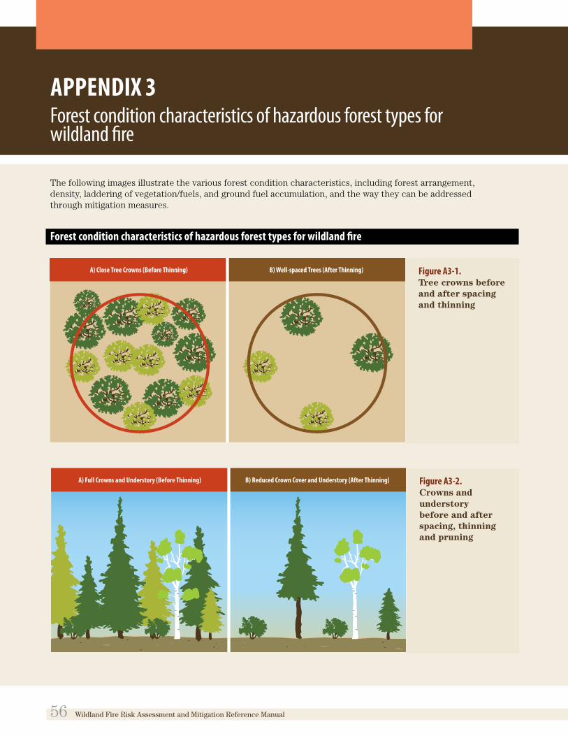
APPENDIX 3Forest condition characteristics of hazardous forest types for wildland fire
The following images illustrate the various forest condition characteristics, including forest arrangement, density, laddering of vegetation/fuels, and ground fuel accumulation, and the way they can be addressed through mitigation measures.
Forest condition characteristics of hazardous forest types for wildland fire
Figure A3-1. Tree crowns before and after spacing and thinning
Figure A3-2. Crowns and understory before and after spacing, thinning and pruning
56 Wildland Fire Risk Assessment and Mitigation Reference Manual

Figure A3-3. Fire pathway with intact ladder fuel and ladder fuel removed. When the ladder fuels are intact, they allow fire to travel upward into the tree crowns, resulting in an intense crown fire. When the ground fuel is thinned and the lower branches are pruned (i.e., within 2 m of the ground), the pathway for fire to travel up-ward is removed.122
Wildland Fire Risk Assessment and Mitigation Reference Manual 57

APPENDIX 4Simple Sequential Evaluation Matrix
The evaluation matrix indicates a simple step-by-step process for implementation of policy 3.1.8 of the PPS, 2014.
continued on next page
58 Wildland Fire Risk Assessment and Mitigation Reference Manual

The evaluation matrix indicates a simple step-by-step process for implementation of policy 3.1.8 of the PPS, 2014.
Wildland Fire Risk Assessment and Mitigation Reference Manual 59

APPENDIX 5Background on the Canadian Forest Fire Behavior Prediction System
(Note: This description of the Canadian Forest Fire Behavior Prediction System is included for information purposes only).
The Canadian Forest Fire Behavior Prediction (FBP) system is a system of fuel type categories that are developed by amalgamating the most current Forest Resource Inventory data with the most current LandSat data. The FBP system is used by wildland fire agencies across Canada, and identifies the hazard levels based on the expected behaviour of a wildland fire, should one occur, for the identified fuel types. The FBP system models the rate of spread of a wildland fire, fuel consumption, fire intensity and fire growth for up to 16 benchmark fuel types, nationally. The fuel types listed are those associated with the risk of high to extreme wildland fire, which are considered hazardous forest types for wildland fire, as defined by the Provincial Policy Statement, 2014.
Table A4-1.
Forest fuel types (species) and corresponding FBP codes that are used to assess the forest hazard rating in Ontario.
FOREST FUEL TYPE EXPECTED WILDLAND FIRE BEHAVIOUR
C-2 Boreal spruce
C-3 Mature jack pine
C-4 Immature jack pine
Torching and crown fire
Surface and crown fire
Almost always crown fire
C-5 Mature red or white pine immature
C-6 Conifer plantation immature/unmanaged
Surface and torching
Surface, torching and crown fire
D-1 Leafless hardwoods Always surface fire
M-1 Boreal mixedwood leafless >50% conifer
M-2 Boreal mixedwood green > 50% conifer
Surface, torching and crown fire
Surface, torching and crown fire
S-1 Jack pine slash
S-2 Spruce/balsam fire slash
Always intense surface fire
Always intense surface fire
60 Wildland Fire Risk Assessment and Mitigation Reference Manual

APPENDIX 6Wildland Fire Risk and Hazard Assessment Form
Pre or Post Development
This hazard assessment form is designed for assessing generalized wildfire risk conditions for existing or planned development areas. The assessment evaluates the proposed or actual structural components, the surrounding forest and surface vegetation present, and the general neighbourhood factors that affect public safety.
To utilize the assessment sheet on new developments, the developer must assume that the buildings have been completed. Once the hazard value has been established the developer or landowner can evaluate areas that can be modified to reduce the high- or extreme-risk value to a low- or moderate-risk value. This can be achieved through vegetation management, building modifications, or infrastructure upgrades.
To assist completing the assessment sheet, the FireSmart Protecting Your Community from Wildfire Manual is available online at FireSmart Canada.
Wildland Fire Risk Assessment and Mitigation Reference Manual 61

62 Wildland Fire Risk Assessment and Mitigation Reference Manual

APPENDIX 7Sample images of hazardous site conditions within priority zone 1
The following images illustrate examples of hazardous site conditions before and after the application of vegetation management mitigation measures within priority zone 1 (whithin 0–10 m of structures).
Before vegetation management mitigation measures are applied in priority zone 1, resulting in high- to extreme-risk, should a wildland fire occur.
(Photo courtesy of Ministry of Natural Resources and Forestry)
Figure A7-1. High-density forest with continuous and ladder fuels close to a structure (priority zone 1)
(Photo courtesy of Ministry of Natural Resources and Forestry)
Figure A7-3. Conifer fuels overhanging a stucture and deck (priority zone 1)
(Photo courtesy of Ministry of Natural Resources and Forestry)
Figure A7-2. High-density forest with continuous and ladder fuels close to a structure (priority zone 1)
(Photo courtesy of Ministry of Natural Resources and Forestry)
Figure A7-4. High-density forest directly against a structure (priority zone 1)
Wildland Fire Risk Assessment and Mitigation Reference Manual 63

After vegetation management mitigation measures have been applied in priority zone 1 (and 2), reducing the risk to moderate or low, should a wildland fire occur
(Photo courtesy of Ministry of Natural Resources and Forestry)
Figure A7-5. Vegetation in priority zone 1 converted to non-flammable or low-flammable fuels such as deciduous species
(Photo courtesy of Ministry of Natural Resources and Forestry)
Figure A7-7. Application of vegetation management measures have been applied in priority zones 1 and 2, in-cluding conversion to non-flammable vegetation (priority zone 1), and spacing, thinning and prun-ing of trees and other vegetation (priority zone 2)
(Photo courtesy of Ministry of Natural Resources and Forestry
Figure A7-9. Application of vegetation management measures (i.e., thinning and pruning) in priority zone 2
(Photo courtesy of Ministry of Natural Resources and Forestry)
Figure A7-6. Vegetation in priority zone 1 converted to non-flammable fuels (e.g., trimmed grass); vegetation in priority zone 2 has been thinned and pruned, and debris has been removed
(Photo courtesy of Ministry of Natural Resources and Forestry
Figure A7-8. Application of vegetation management measures in priority zones 1 and 2, including spacing, thinning, pruning and removal of flammable ground fuels and debris
64 Wildland Fire Risk Assessment and Mitigation Reference Manual

Notes
1 Ontario Ministry of Natural Resources and Forestry. 2014. Wildland Fire Management Strategy. Toronto: Queen’s Printer for Ontario.
2 J. Murphy. Personal communication. December, 2015.
3 Ontario Ministry of Natural Resources and Forestry. 2014. Wildland Fire Management Strategy. Toronto: Queen’s Printer for Ontario.
4 Partners in Protection. 2003. FireSmart: Protecting Your Community from Wildfire. Second Edition. Edmonton: Capital Colour Press, Ltd.
5 This prediction is based on the Global Circulation Model climate projections in: S. J. Colombo, D. W. McKenney, K. M. Lawrence and P. A. Gray. 2007. Climate change projections for Ontario: practical information for policymakers and planners. Climate Change Research Report CCRR-05. Sault Ste. Marie, Ontario: Ministry of Natural Resources.
6 Ontario Ministry of Natural Resources and Forestry. 2014. Wildland Fire Management Strategy. Toronto: Queen’s Printer for Ontario.
7 B. M. Wotton and B. J. Stocks, 2006. Fire management in Canada: vulnerability and risk trends. In: Canadian Council of Forest Ministers. Canadian Wildland Fire Strategy: Background synthesis, analysis, and perspectives. K. Hirsch and P. Fuglem (eds). Canadian Council of Forest Ministers. Natural Resources Canada, Canadian Forest Service, Northern Forestry Centre: Edmonton, Alberta. 49–55.
8 B. M. Wotton, D. L. Martell and K. A. Logan. 2003. Climate change and people-caused forest fire occurrence in Ontario. In: Climatic Change 60. Netherlands. Kluwer Academic Publishers. p. 275–295
9 C. P Butler, 1974. The urban/wildland fire interface. In: Proceedings of Western States Section/The Combustion Institute papers, vol. 74, no. 15; 1974 May 6–7; Spokane, Washington. Pullman,
Washington: Washington State University. 1–17.
10 Partners in Protection. 2003. FireSmart: Protecting Your Community from Wildfire. Second Edition. Edmonton: Capital Colour Press, Ltd.
11 See FireSmart website: About FireSmart Canada
12 The FireSmart planning process for protecting communities from wildland fire is described in detail in the FireSmart: Protecting Your Community from Wildfire manual published by Partners in Protection, and in the Draft FireSmart Community Wildfire Planning Guidance Document published by the Ministry of Natural Resources and Forestry.
13 The steps described for undertaking a community-wide, or broad-level/municipal-wide wildland fire assessment in: Ontario Ministry of Natural Resources and Forestry. 2015. Community Wildland Fire Protection Plan – Guidance Document. (Unpublished).
14 Ontario Ministry of Municipal Affairs and Housing. 2014. Provincial Policy Statement 2014. (Preamble). Toronto: Queen’s Printer for Ontario.
15 Planning Act, R. S. O. 1990, Section 51(24). Criteria for considering draft plan of subdivision.
16 The terms that are italicized within policy 3. 1. 8 are further defined in the Provincial Policy Statement, 2014.
17 The definitions of hazard and risk were taken from Merriam-Webster Online Dictionary while the explanation of their relationship to one another was taken from https: //worksmart. org. uk/health-advice/health-and-safety/hazards-and-risks/what-difference-between-hazard-and-risk.
18 Ontario Ministry of Municipal Affairs and Housing. 2014. 2014 Provincial Policy Statement. 6. 0 Definitions. Toronto: Queen’s Printer for Ontario. 41.
Wildland Fire Risk Assessment and Mitigation Reference Manual 65

19 Ontario Ministry of Municipal Affairs and Housing. 2014. 2014 Provincial Policy Statement. 6. 0 Definitions. Toronto: Queen’s Printer for Ontario. 42.
20 Ontario Ministry of Municipal Affairs and Housing. 2014. 2014 Provincial Policy Statement. (6. 0 Definitions). Toronto: Queen’s Printer for Ontario. 50.
21 Partners in Protection. 2003. FireSmart: Protecting Your Community from Wildfire. Second Edition. Edmonton: Capital Colour Press, Ltd.
22 Mitigation measures recommended in this document are based on those recommended as part of the Ontario FireSmart Program.
23 C. Randall. 2003. Fire in the Wildland-Urban Interface: Understanding Fire Behavior. Gainesville, Florida: University of Florida, Institute of Food and Agricultural Services and United States Department of Agriculture Forest Service, Southern Research Station, Southern Centre for Wildland-Urban Interface Research and Information.
24 G. Nader, E. Smith and L. Quarles. 2012. How Wildfire Threatens a House. eXtension.org.
25 G. Nader, E. Smith and L. Quarles. 2012. How Wildfire Threatens a House. eXtension.org. Illustration adapted from graphics used with permission from the University of Nevada Cooperative Extension.
26 C. Randall. 2003. Fire in the Wildland-Urban Interface: Understanding Fire Behavior. Gainesville, Florida. University of Florida, Institute of Food and Agricultural Services and USDAUnited States Department of Agriculture Forest Service, Southern Research Station, Southern Centre for Wildland-Urban Interface Research and Information.
27 G. Nader, E. Smith and L. Quarles. 2012. How Wildfire Threatens a House. eXtension.org.
28 G. Nader, E. Smith and L. Quarles. 2012. How Wildfire Threatens a House. eXtension.org. Illustration adapted from graphics used with permission from the University of Nevada Cooperative Extension.
29 C. Randall. 2003. Fire in the Wildland-Urban Interface: Understanding Fire Behavior. Gainesville, Florida: University of Florida, Institute of Food and Agricultural Services and United States Department of Agriculture Forest Service, Southern Research Station, Southern Center for Wildland-Urban Interface Research and Information.
30 G. Nader, E. Smith and L. Quarles. 2012. How Wildfire Threatens a House. eXtension.org. Illustration adapted from graphics; used with permission from the University of Nevada Cooperative Extension.
31 Partners in Protection. 2003. FireSmart: Protecting Your Community from Wildfire. Second Edition. Edmonton: Capital Colour Press, Ltd.
32 Land Information Ontario (LIO) is a Government of Ontario initiative that manages geospatial data for use in mapping and geographic information systems. LIO includes a variety of online tools and services to support the sharing of geospatial data through a web-accessible centralized data warehouse. The warehouse contains more than 250 spatial data layers from a variety of organizations and is the primary method for the dissemination of MNR geospatial data. (Ontario Ministry of Natural Resources. 2010. Natural Heritage Reference Manual. 171).
33 Broad assessment by a planning authority would not be required for areas of Crown land.
34 Without landowner permission, detailed assessment may not be possible out to 100 metres, therefore analysis could be based on aerial photography as part of an appropriate level of assessment by the planning authority.
35 Ontario’s FireSmart Program also offers processes for undertaking site-level assessment, which address, in large part, the assessment of existing buildings and structures, and corresponding mitigation options. Since municipal land use planning is the process for assessing future development (i. e. , in many cases at the stage of assessment to support planning, structures have not yet been built), the site-level assessment guidance in this document is, in large part, focused on property and holdings, versus structures.
36 Image adapted from: U. S. Fish and Wildlife Service. 2010. Boreal Forest Succession. In: Role of fire in Alaska: Unit 1 Forest and Tundra Ecology. US Fish and Wildlife Service, Alaska Region Division of Information Management and External Affairs.
37 Ontario Ministry of Natural Resources and Forestry. 2015. Community Wildland Fire Protection Plan – Guidance Document. Unpublished.
38 Partners in Protection. 2003. FireSmart: Protecting Your Community from Wildfire. Second Edition. Edmonton: Capital Colour Press, Ltd.
39 Ontario Ministry of Natural Resources. (n. d. ) The Homeowner’s FireSmart Manual: Protect Your Home from Wildfire.
66 Wildland Fire Risk Assessment and Mitigation Reference Manual

40 Wisconsin Department of Natural Resources. 2008. FireSmart Landscaping – A Guide to Protecting Your Home from Wildfire. Board of Regents of the University of Wisconsin System.
41 It is recognized that not all planning processes under the Planning Act will allow for the application of mitigation measures at the structural scale.
42 The Home Ignition Zone is a FireSmart term that has also been adopted by Ontario’s FireSmart Program. Note that this zone is intended to apply to all structures and is not limited to residential structures.
43 Ontario’s FireSmart Program provides more detail regarding appropriate building design.
44 Western Australian Planning Commission and Fire and Emergency Services Authority. 2010. Planning for Bushfire Protection – Guidelines (Edition 2). Perth, Australia.
45 Partners in Protection. 2003. FireSmart: Protecting Your Community from Wildfire. Second Edition. Edmonton: Capital Colour Press, Ltd.
46 Partners In Protection. 2003. FireSmart: Protecting Your Community from Wildfire Second Edition. Edmonton: Capital Colour Press, Ltd.
47 Ontario Ministry of Natural Resources. 2010. Forest Management Guide for Conserving Biodiversity at the Stand and Site Scales. Toronto: Queen’s Printer for Ontario.
48 Partners in Protection. 2003. FireSmart: Protecting Your Community from Wildfire. Second Edition. Edmonton: Capital Colour Press, Ltd.
49 Partners in Protection. 2003. FireSmart: Protecting Your Community from Wildfire. Second Edition. Edmonton: Capital Colour Press, Ltd.
50 Partners in Protection. 2003. FireSmart: Protecting Your Community from Wildfire. Second Edition. Edmonton: Capital Colour Press, Ltd.
51 Partners in Protection. 2003. FireSmart: Protecting Your Community from Wildfire. Second Edition. Edmonton: Capital Colour Press, Ltd.
52 Partners in Protection. 2003. FireSmart: Protecting Your Community from Wildfire. Second Edition. Edmonton: Capital Colour Press, Ltd.
53 Ontario Ministry of Municipal Affairs and Housing. 2011. Understanding the Consent Application Process: Your Step-By-Step Guide for Consent-Granting Authorities. Toronto: Queen’s Printer for Ontario.
54 Complete application requirements are addressed in sections 22(5), 34(10. 2), 51(18) and 53(3) of the Planning Act. To view the regulations, go to e-Laws and type in the regulation number (e. g. , 543/06).
55 Ontario Ministry of Municipal Affairs and Housing. 2014. 2014 Provincial Policy Statement. Toronto: Queen’s Printer for Ontario.
56 National Fire Protection Association. 2013. Community Wildfire Safety Through Regulation: A Best Practices Guide for Planners and Regulators. Quincy, Massachusetts.
57 California Department of Forestry and Fire Protection. 2000. Structural Fire Prevention Field Guide for Mitigation of Wildland Fires.
58 California Department of Forestry and Fire Protection. 2000. Structural Fire Prevention Field Guide for Mitigation of Wildland Fires.
59 Western Australian Planning Commission and Fire and Emergency Services Authority. 2010. Planning for Bushfire Protection – Guidelines (Edition 2). Perth, Australia.
60 Montana Department of Natural Resources and Conservation. 2009. Guidelines for Development Within the Wildland-Urban Interface.
61 C. Miller, K. S. Blonski and C. L Rice. 2010. You Too Can Prevent Wildfires: Smokey Bear Turned 65. In: The Environmental Monitor, Fall 2010. Association of Environmental Professionals.
62 Ontario Ministry of Municipal Affairs and Housing. 2009. Building Blocks for Sustainable Planning – 4 in a Series of 12: Holding By-Law (s. 36). Toronto: Queen’s Printer for Ontario.
63 Policies must already be in place in municipal official plans and zoning by-laws in order for a planning authority to apply site plan control.
64 Montana Department of Natural Resources and Conservation. 2009. Guidelines for Development Within the Wildland-Urban Interface.
65 Montana Department of Natural Resources and Conservation. 2009. Guidelines for Development Within The Wildland-Urban Interface.
66 Ontario Ministry of Municipal Affairs and Housing. 2011. Understanding the Consent Application Process: Your Step-By-Step Guide for Consent-Granting Authorities. Toronto: Queen’s Printer for Ontario.
67 Partners in Protection. 2003. FireSmart: Protecting Your Community from Wildfire. Second Edition. Edmonton: Capital Colour Press, Ltd.
Wildland Fire Risk Assessment and Mitigation Reference Manual 67

68 Ontario’s FireSmart Program can guide mitigation on an ongoing basis. More information is available online at Ontario’s FireSmart Program.
69 J. D. Cohen. 1999. Reducing the Wildland Fire Threat to Homes: Where and How Much?. In: United States Department of Agriculture Forest Service General Technical Report. PSW-GTR-173. Albany, California: Pacific Research Station, Forest Service, U. S. Department of Agriculture.
70 Partners in Protection. 2003. FireSmart: Protecting Your Community from Wildfire. Second Edition. Edmonton: Capital Colour Press, Ltd.
71 G. Nader, E. Smith and L. Quarles. 2012. How Wildfire Threatens a House. eXtension.org. Illustration adapted from graphics; used with permission from the University of Nevada Cooperative Extension.
72 G. Nader, E. Smith and L. Quarles. 2012. How Wildfire Threatens a House. eXtension.org. Illustration adapted from graphics; used with permission from the University of Nevada Cooperative Extension.
73 Ontario Ministry of Municipal Affairs and Housing. 2009. InfoSheet: Planning for Community Design. Toronto: Queen’s Printer for Ontario.
74 Ontario Ministry of Municipal Affairs and Housing. 2009. InfoSheet: Planning for Community Design. Toronto: Queen’s Printer for Ontario.
75 Partners in Protection. 2003. FireSmart: Protecting Your Community from Wildfire. Second Edition. Edmonton: Capital Colour Press, Ltd.
76 Montana Department of Natural Resources and Conservation. 2009. Guidelines for Development Within the Wildland-Urban Interface.
77 National Fire Protection Association. 2013. Community Wildfire Safety Through Regulation: A Best Practices Guide for Planners and Regulators. Quincy, Massachusetts.
78 Partners in Protection. 2003. FireSmart: Protecting Your Community from Wildfire. Second Edition. Edmonton: Capital Colour Press, Ltd.
79 Partners in Protection. 2003. FireSmart: Protecting Your Community from Wildfire. Second Edition. Edmonton: Capital Colour Press, Ltd.
80 California Department of Forestry and Fire Protection. 2000. Structural Fire Prevention Field Guide for Mitigation of Wildland Fires.
81 Partners in Protection. 2003. FireSmart: Protecting Your Community from Wildfire. Second Edition. Edmonton: Capital Colour Press, Ltd.
82 National Fire Protection Association. 2013. Community Wildfire Safety Through Regulation: A Best Practices Guide for Planners and Regulators. Quincy, Massachusetts.
83 Partners in Protection. 2003. FireSmart: Protecting Your Community from Wildfire. Second Edition. Edmonton: Capital Colour Press, Ltd.
84 Ontario Ministry of Municipal Affairs and Housing. 2011. Understanding the Subdivision & Condominium Application Process: Your Step-By-Step Guide for Approval Authorities. Toronto: Queen’s Printer for Ontario.
85 Ontario Ministry of Municipal Affairs and Housing. 2010. Citizens’ Guide: Land Severances (Paper 5). Toronto: Queen’s Printer for Ontario.
86 Montana Department of Natural Resources and Conservation. 2009. Guidelines for Development Within the Wildland-Urban Interface.
87 Ontario Ministry of Municipal Affairs and Housing. 2010. Citizens’ Guide: Subdivisions (Paper 4). Toronto: Queen’s Printer for Ontario.
88 Ontario Ministry of Municipal Affairs and Housing. 2010. Citizens’ Guide: Subdivisions (Paper 4). Toronto: Queen’s Printer for Ontario.
89 Montana Department of Natural Resources and Conservation. 2009. Guidelines for Development Within the Wildland-Urban Interface.
90 Montana Department of Natural Resources and Conservation. 2009. Guidelines for Development Within the Wildland-Urban Interface.
91 City of Cambridge. 2015. Frequently Asked Questions (Development and Infrastructure Questions): What is a Minor Variance? Cambridge, Ontario: City of Cambridge.
92 Ontario Ministry of Natural Resources. 2000. A Silvicultural Guide to Managing Southern Ontario Forests, Ver. 1. 1. Toronto: Queen’s Printer for Ontario.
93 Partners in Protection. 2003. FireSmart: Protecting Your Community from Wildfire. Second Edition. Edmonton: Capital Colour Press, Ltd.
94 Ontario Ministry of Natural Resources. 2000. A Silvicultural Guide to Managing Southern Ontario Forests, Ver. 1. 1. Toronto: Queen’s Printer for Ontario.
95 Ontario Ministry of Natural Resources. 2000. A Silvicultural Guide to Managing Southern Ontario Forests, Ver. 1. 1. Toronto: Queen’s Printer for Ontario.
68 Wildland Fire Risk Assessment and Mitigation Reference Manual

96 A. Rogstad. 2002. Creating Wildfire-Defensible Space for Your Home and Property. Cooperative Extension, College of Agriculture & Life Sciences, University of Arizona.
97 Ontario Ministry of Municipal Affairs and Housing. 2014. Provincial Policy Statement 2014. 6. 0 Definitions. Toronto: Queen’s Printer for Ontario.
98 Ontario Ministry of Natural Resources and Forestry. 2014. Wildland Fire Management Strategy. Toronto: Queen’s Printer for Ontario.
99 Partners in Protection. 2003. FireSmart: Protecting Your Community from Wildfire Manual. Second Edition. Edmonton: Capital Colour Press, Ltd.
100 Partners in Protection. 2003. FireSmart: Protecting Your Community from Wildfire. Second Edition. Edmonton: Capital Colour Press, Ltd.
101 Ontario Ministry of Natural Resources. 2000. A Silvicultural Guide to Managing Southern Ontario Forests, Ver. 1. 1. Toronto: Queen’s Printer for Ontario.
102 Ontario Ministry of Natural Resources and Forestry. 2014. Wildland Fire Management Strategy. Toronto: Queen’s Printer for Ontario.
103 Ontario Ministry of Municipal Affairs and Housing. 2014. Provincial Policy Statement 2014. 6. 0 Definitions. Toronto: Queen’s Printer for Ontario.
104 Partners in Protection. 2003. FireSmart: Protecting Your Community from Wildfire. Second Edition. Edmonton: Capital Colour Press, Ltd.
105 Partners in Protection. 2003. FireSmart: Protecting Your Community from Wildfire. Second Edition. Edmonton: Capital Colour Press, Ltd.
106 Ontario Ministry of Natural Resources. 2000. A Silvicultural Guide to Managing Southern Ontario Forests, Ver. 1. 1. Toronto: Queen’s Printer for Ontario.
107 Ontario Ministry of Natural Resources. 2000. A Silvicultural Guide to Managing Southern Ontario Forests, Ver. 1. 1. Toronto: Queen’s Printer for Ontario.
108 Ontario Ministry of Natural Resources and Forestry. 2014. Wildland Fire Management Strategy. Toronto: Queen’s Printer for Ontario.
109 Partners in Protection. 2003. FireSmart: Protecting Your Community from Wildfire. Second Edition. Edmonton: Capital Colour Press, Ltd.
110 Ontario Ministry of Natural Resources and Forestry. 2014. Wildland Fire Management Strategy. Toronto: Queen’s Printer for Ontario.
111 Ontario Ministry of Natural Resources and Forestry. 2014. Wildland Fire Management Strategy. Toronto: Queen’s Printer for Ontario.
112 Ontario Ministry of Municipal Affairs and Housing. 2014. Provincial Policy Statement 2014. Toronto: Queen’s Printer for Ontario.
113 Ontario Ministry of Natural Resources and Forestry. 2014. Wildland Fire Management Strategy. Toronto: Queen’s Printer for Ontario.
114 Ontario Ministry of Natural Resources and Forestry. 2014. Wildland Fire Management Strategy. Toronto: Queen’s Printer for Ontario.
115 Ontario. Emergency Management and Civil Protection Act, R. S. O. 1990, c. E. 9 .
116 Ontario Ministry of Natural Resources and Forestry. 2014. Wildland Fire Management Strategy. Toronto: Queen’s Printer for Ontario.
117 Ontario Ministry of Natural Resources and Forestry. 2014. Wildland Fire Management Strategy. Toronto: Queen’s Printer for Ontario.
118 Ontario Ministry of Municipal Affairs and Housing. 2014. Fact Sheet – Building Code Overview. Toronto: Queen’s Printer for Ontario.
119 Ontario Ministry of Municipal Affairs and Housing. 2014. Fact Sheet – Ontario’s Building Regulatory Roles – Municipal and Provincial. Toronto: Queen’s Printer for Ontario.
120 Ontario. Municipal Act, 2001, S. O. 2001, c. 25
121 Ontario. Municipal Act, 2001, S. O. 2001, c. 25
122 Images in Appendix 3 are adapted from those originally appearing in: Partners in Protection. 2003. FireSmart: Protecting Your Community from Wildfire Second Edition. Edmonton: Capital Colour Press, Ltd.
Wildland Fire Risk Assessment and Mitigation Reference Manual 69

Annotated Bibliography
This bibliography is a selection of studies, guidelines and other publications regarding the role of land use planning and associated tools in the prevention and mitigation of wildland fire risks. The selection includes material from Canada, the United States and other jurisdictions.
Blonski, K., C. Miller, and C. Rice. 2010. 2010. Managing Fire in the Urban Wildland Interface. Point Arena, California: Solano Press Books.
This comprehensive guide covers a wide range of topics related to community fire management in the wildland-urban interface, with a focus on the United States. Part 1 discusses the threat of fire in the wildland-urban interface, and Part 2 focuses on hazard and threat assessment. The final two parts identify practical solutions to mitigate fire, as well as strategies to overcome the challenges associated with implementing these solutions.
Land use designation and zoning ordinances are identified as powerful tools when used together. Zoning regulates development through specific standards regarding lot size, building setbacks, maximum building size and allowable uses. It is also recommended to regulate new development, rather than existing development where possible, as this makes it easier for the community to adopt the new regulations. “Pre-zoning” should consider density and its impact on emergency services, structure setbacks and appropriate uses.
Other tools identified in this guide include: guidelines, standards, codes and local ordinances; project planning and review processes; land use planning policies; subdivision ordinances; and development agreements.
Burby, R. J., R. E. Deyle, D. R. Godschalk, and R. B. Olshansky. 2000. Creating Hazard Resilient Communities Through Land-Use Planning. Natural Hazards Review 1(2):99–106.
This article provides a broad overview of land use planning within the context of hazard mitigation. Topics covered include hazard mitigation plans, hazard assessment and development management. In terms of land use planning, several tools that are available to manage development and create hazard-resilient communities are listed, including: zoning regulations that restrict the location, type and intensity of new development; building codes that require buildings to meet certain standards; critical and public facilities policies that limit the placement of public facilities in hazardous locations, or in areas where they would facilitate growth into hazardous areas; acquisition of hazard areas, with the goal of converting them to less hazardous uses; and relocation of existing development at risk.
When using land use planning to mitigate hazards such as wildland fire, it is important to ensure that hazard-free land is available for development. This gives cities areas to grow, while reducing development pressures in hazardous locations. Other strategies that can help promote successful management of development include restricting land use before land is subdivided, offering incentives to encourage developers to locate projects outside of hazardous areas, using project-specific design approaches, and using post-disaster windows of opportunity to encourage individual owners to relocate or retrofit.
Buxton, M., and R. Haynes. 2010. Land Use Planning for Bushfire Protection. 2009 Victorian Bushfires Royal Commission. This report aims to provide advice on questions put forward by the Victorian Bushfires Royal Commission relating to land use planning and bushfire protection in Victoria, Australia. These questions address issues such
70 Wildland Fire Risk Assessment and Mitigation Reference Manual

as the role of land use planning in bushfire risk management; the impacts of increasing populations in fire-prone areas; the balance between risk mitigation measures and conservation of native vegetation; and the integration of bushfire risk management strategies.
The report provides details on both strategic and statutory land use planning processes that are essential parts of risk management. Strategic planning deals with the development of generic principles and provisions, while statutory rules enforce these broad principles. Among the statutory elements identified are tenement controls, zone controls and subdivision controls.
Special attention is given to the Victoria Planning Provisions, which comprise a variety of zones, overlays, and specific and general provisions. While effective in theory, the report suggests that the discretionary nature of the system has resulted in limited achievement of objectives. The tools provided to municipalities are effective if used properly, but too often they are not used to their full effect. For example, councils often exhibit reluctance toward using the strictest zones. The report also cites the weak quality of overlay controls over development due to vague wording that constrains the effectiveness of the Victoria Planning Provisions. It is concluded that tension between permissive planning and land use control is limiting the effectiveness of the current planning system in Victoria, as is the inconsistent and inadequate use of regulatory controls.
County Fire Authority. 2012. Planning for Bushfire Victoria. Country Fire Authority, Burwood East, Victoria, Australia.
Available at: Planning for Bushfire Victoria
This document is designed to support the implementation of the Bushfire Management Overlay (BMO), which identifies the highest bushfire risk areas in Victoria, Australia. To develop or subdivide land in the BMO, a permit is often required. This document explains the details of the BMO and describes how to apply the required planning provisions when assessing planning permit applications in the BMO. It provides guidelines outlining how bushfire protection measures in the region should be achieved. It consists of three sections that discuss bushfire risk and house loss; building and works; and subdivisions in the BMO. The BMO and subsequent permit process is one of the primary tools to control bushfire risk through land use planning in the region.
Groenhart, L., A. March, and M. Holland. 2012. Shifting Victoria`s emphasis in land-use planning for bushfire: towards a place-based approach. Australian Journal of Emergency Management 27(4):33–37.This article discusses the need for land use planning to play an increased role in the reduction of bushfire risk in Victoria, Australia. It suggests that urban planners in this region have typically relied on fire agencies to provide advice and make decisions on these matters, without using statutory mechanisms in a proactive and complementary manner. The article emphasizes place-based planning that uses planning mechanisms to deliver site-specific responses to bushfire risk. Place-based planning is defined as planning that identifies specific physical, natural and human values of a geographic area, as well as the ways in which we build, live in and manage them. Approaching planning from this perspective is different, and often more effective, than a one-size-fits-all mechanism. The importance of planning processes, such as hazard mapping and specific multi-tiered responses that divide areas into different zones based on fire risk, is also emphasized and discussed.
Kelowna, City of. 2011. Community Wildfire Protection Plan. Policy and Planning Department, Kelowna, British Columbia.
Available at: City of Kelowna Community Wildfire Protection Plan
This report outlines the state of wildfire protection in Kelowna, British Columbia, and provides recommendations for future community planning and design in the wildland-urban interface. Most of the strategies focus on areas outside of land use planning, such as emergency preparedness, public education and interagency co-operation. However, regulatory land use tools that are identified include by-laws, Wildland Fire Hazard Development Permit areas, road standards, and policies regulating vegetation management, water sources and construction. Through its recommendations, the report highlights the importance of planning for wildland fires, particularly in areas like Kelowna where development into the interface is projected to continue in the future.
Wildland Fire Risk Assessment and Mitigation Reference Manual 71
Labossiere, L., and T. K McGee. 2013. Survey of Wildfire Mitigation Techniques Employed by Local Governments in Alberta and British Columbia. Edmonton, Alberta: University of Alberta.
Available at: Survey of Wildfire Mitigation Techniques Employed by Local Governments in Alberta and British Columbia
This study surveyed 65 municipalities in Alberta and British Columbia to identify how local governments in these provinces are currently mitigating wildland fire risks. It was found that providing information to residents was the most common way to reduce these risks. Half of the municipalities surveyed were also involved in vegetation management, while fewer governments (approximately 25%) conducted hazard assessment and incorporated mandatory wildland fire mitigation requirements.
When making land use decisions, 57 per cent of the municipalities took wildland fire risk into consideration. Land use mitigation measures generally involved zoning, such as the establishment of local wildland fire zones that influence planning decisions. Other municipalities had policies requiring all proposed developments to be reviewed by the local fire department to determine risk before proceeding with the development plans. As well, 42 per cent of the municipalities required developers to incorporate wildfire mitigation into their development plans, through the selection of building materials to reduce wildfire risk, policies to ensure sufficient access to water supply, and requirements making a professional forester’s report mandatory before starting development. Despite the widespread consideration of wildland fire risks in land use planning decisions, only 11 per cent of the municipalities restricted development in any form in identified high-risk areas.
Mesa County. 2013. Mesa County Master Plan. Mesa County, Colorado: Planning Division.
Available at: Mesa County Master Plan
This land use plan for Mesa County, Colorado, outlines the land use goals, policies and implementation strategies for rural land development in the county. It discusses policies and goals in eight main areas:
1. Land Use and Growth Management;
2. Community Character and Image;
3. Agriculture;
4. Conservation and the Environment;
5. Open Lands and Trails;
6. Parks and Recreation;
7. Community Services/Facilities and Intergovernmental Coordination; and
8. Community/Area Plans.
One of the primary Conservation and the Environment goals of the plan is to protect Mesa County from the effects of human-made and natural hazards, including wildland fire. The plan includes several policies related to this goal, which require hazard identification, hazard mitigation, and development that addresses the hazard risk in an appropriate manner. It is suggested that these policies should be implemented through the identification of “critical and sensitive lands” (such as wildland fire hazards), and then adopting these identified lands as an overlay and part of the Development Code. Additionally, several other goals and policies highlight the importance of requiring appropriate infrastructure in subdivisions, such as water sources for fire suppression, safely designed roads, and appropriate densities.
Montana Department of Natural Resources and Conservation. 2009. Guidelines for Development within the Wildland-Urban Interface. Helena, Montana. Available at: Guidelines for Development within the Wildland-Urban Interface
This document provides guidelines for development in the wildland-urban interface of Montana. The two main regulatory mechanisms that are identified are subdivision regulations and zoning regulations. The report goes into detail explaining guidelines for implementing both of these mechanisms. It recommends that subdivision and zoning regulations incorporate requirements addressing:
1. Wildland Fuel Mitigation (defensible space and vegetation management plans);
2. Site Development (steep slopes; “fire chimneys”; construction of residential, commercial or accessory structures; and improvements prior to construction);
3. Fuelbreaks;
4. Means of Access (streets and roads; gates; and signage);
5. Water Supply; and
6. Alternative Development.
72 Wildland Fire Risk Assessment and Mitigation Reference Manual

Moore, H. E. 1981. Protecting Residences from Wildfires: a guide for homeowners, lawmakers, and planners. General Technical Report PSW-50. Berkeley, California: United States Department of Agriculture, Forest Service, Pacific Southwest Forest and Range Experiment Station. Available at: Protecting Residences from Wildfires: a guide for homeowners, lawmakers, and planners
This comprehensive guide from the United States provides a variety of recommendations on how to reduce losses of residences due to wildland fires. It includes recommendations in the areas of land use planning and zoning, property development, structural design and construction, landscaping, accessories, occupant activities, and financial incentives.
Land use planning is identified as a critical aspect of fire protection and public safety. The author notes that land use planning has achieved significant degrees of fire safety in the areas where it has been enforced. This guide goes on to provide land use planning recommendations that municipalities can use within the context of wildland fire protection. These include:
• using zoning to establish fire hazard severity zoneson the basis of a graded Fire Hazard SeverityClassification System; and
• adopting zoning ordinances that containcomprehensive requirements relating to wildlandfire protection. Ordinances should recognizevarying degrees of wildland fire hazard andestablish standards for each degree, includingminimum spacing and building density standards.
Muller, B., and S. Schulte. 2004. Wildfire Mitigation and Private Lands: Managing Long-Term Vulnerabilities. Monitoring Science and Technology Symposium: Unifying Knowledge for Sustainability in the Western Hemisphere. Proceedings 1–14, September 20–24, Denver, Colorado.
This article examines wildfire mitigation strategies in the Western United States through a survey of 300 forested counties in the region, with the goals of identifying and assessing the land use planning tools adopted throughout the region and understanding the problems associated with using these tools. Programs in these counties either focused on the mitigation
of existing development or the mitigation of new development, with the former being less common and more difficult to implement. Furthermore, regulatory tools were more commonly used (and more strictly enforced) when dealing with subdivisions than individual lot development. Some of the regulatory tools identified by the article include subdivision (and individual property) regulations to regulate emergency access, defensible space, building standards, building site location and firefighting water supply.
The article suggests that regulatory tools are less developed and effective for individual lots than for subdivisions. This is because of the lack of time available to implement regulations on individual properties, the “anti-regulation” political culture of the region, the lack of public demand for more wildland fire regulation, and the fact that large parcels are often exempt from subdivision review. It is concluded that while the identified tools are effective in some instances, they continue to be constrained in some areas. This has led to weak regulation of existing development, and weak regulation of new developments outside of subdivisions.
National Fire Protection Association. 2013. Community Wildfire Safety through Regulation: A Best Practices Guide for Planners and Regulators. Quincy, Massachusetts.
Available at: Community Wildfire Safety Through Regulation: A Best Practices Guide for Planners and Regulators
This guide from the United States provides an overview of the role of land use planning in wildland fire mitigation. It summarizes the importance of land use planning, and also covers the various ways that wildland fire regulation can be adopted at various scales. Some of the tools available at each scale include:
• community scale (hazard mapping, zoning overlays,and restriction of sensitive or hazardous uses);
• neighbourhood/subdivision scale (subdivisionlayout standards, structure location standards,density modification/reduction requirements andwater supply requirements);
• individual lot scale (defensible spacerequirements); and
• building scale(structural protection regulations).
The guide goes on to discuss whether wildland fire mitigation regulations should apply to existing
Wildland Fire Risk Assessment and Mitigation Reference Manual 73
development, in addition to new development. Attempts to apply mitigation regulations to existing properties are rare, as they are generally unpopular and expensive. The main exception to this is defensible space requirements, which do not affect existing structures. The guide ends by providing some key insights from fire-prone communities that have experience with wildland fire safety regulations.
National Open Space Conservation Group. 2014. Planning for Urban Forests. Planning for Growth and Open Space Conservation Webinar Series. United States Department of Agriculture, Forest Service. Available at: Planning for Urban Forests. Planning for Growth and Open Space
This document from the Planning for Growth and Open Space Conservation Webinar Series based in the United States is divided into three sections that focus on understanding homeowners and wildland fire, land use planning for wildland fire, and developing fire-adapted communities. The second section, which has particular relevance to land use planning, discusses the role of community planners, types of community planning, elements of fire that can be addressed through planning, and the tools that can be used by planners to achieve fire mitigation goals. Some of the planning tools identified in this document include: land use designation and zoning ordinances; guidelines, standards, codes and local ordinances; subdivision ordinances; and development agreements.
Various types of plans are also identified as important components of fire mitigation, as are public education, project planning and review processes, community design practices, and emergency services. It also notes that while planning tools are generally effective at regulating new developments, fewer solutions are available for existing developments.
Partners in Protection. 2003. FireSmart: Protecting Your Community from Wildfire. Second Edition. Edmonton: Capital Colour Press, Ltd.
Available at: FireSmart: Protecting Your Community from Wildfire
This comprehensive manual outlines background information regarding development in the wildland-urban interface followed by the wildland hazard assessment system and the factors that should be considered as part of assessment. Mitigation approaches are described, as well as the role of public education. The manual includes a chapter on the role of land use
planning including challenges that can be addressed by applying various land use planning approaches. This manual includes several tools to support hazard assessment and diagrams to illustrate the application of mitigation.
Schwab, J., S. Meck, and J. Simone. 2005. Planning for Wildfires. American Planning Association, Planning Advisory Service, Report No. 529/530, Chicago, Illinois.
This report outlines the various aspects of wildland mitigation planning. It begins with two chapters discussing the importance of planning for wildland fires and the history of wildland fires in the United States. It also examines the science of wildland fires, including the ecological roles and implications of wildland fires. Chapter 4 is particularly relevant to land use planning, as it examines some of the regulatory tools that can be used by planners. The final chapter discusses perceptions, behaviours and attitudes toward wildland fire, as well as the institutional, legal and political barriers to effective wildland fire planning.
The main regulatory tools identified in this report are codes, standards and local ordinances. The report provides examples of various wildland fire mitigation ordinances in place in states such as Florida, Oregon, California, Washington, Arizona, and Colorado. Ordinance provisions can relate to:
• designation of the wildland-urban interface (including criteria);
• administration of permits;
• enforcement;
• appeals;
• requirements for application;
• vegetation management plans;
• fire control plans;
• public disclosure and information requirements;
• incentives; and
• standards, including those for access, fuel reduction, water supply and construction.
74 Wildland Fire Risk Assessment and Mitigation Reference Manual

State of California. 2003. General Plan Guidelines. Governor’s Office of Planning and Research, Sacramento, California.
This document provides guidelines for preparing local general plans in California. It includes basic elements, as well as a number of other required and optional elements that must form part of a plan. Plans must also incorporate goals and policies related to sustainable development and environmental justice.
One of the required elements of local plans is the safety element, which aims to reduce the risk of death, injuries and damage resulting from hazards such as fires, floods, earthquakes and landslides. This element requires the identification of hazards and hazard mitigation provisions to guide local decisions. The report identifies strategic fire defence system zoning, subdivision regulations and Fire Safe ordinances as three important mechanisms that can be used by local governments to mitigate fire risk through land use planning. In California, the State Board of Forestry has also adopted Fire Safe regulations for counties with State Responsibility Areas, which focus on pre-fire loads. These statewide regulations include road standards, signage standards, minimum water supply reserves and defensible space requirements.
Western Australian Planning Commission. 2010. Planning for Bush Fire Protection: Guidelines. Western Australia Department of Planning.
This report by the Western Australia Planning Commission addresses bushfire risk and mitigation in Western Australia. The report consists of eight guidance statements for strategic plans and structural schemes, as well as 12 guidance statements for subdivision and development applications, which seek to give effect to principles and objectives of bushfire protection. These guidance statements address hazard assessment, hazard mitigation and planning considerations. Zoning is identified as the key land use regulatory control, and many of the statements address how zoning should be conducted, particularly in the most high-risk areas. Other regulatory tools identified include water supply requirements, fire service access requirements and other subdivision regulations.
Western Australian Planning Commission. 2015. Guidelines for Planning in Bushfire Prone Areas. Western Australia Department of Planning.
Available at: Planning for Bush Fire Protection: Guidelines
These Guidelines provide information for decision-makers, planners and landowners in the implementation of State Planning Policy 3.7. Specifically, the Guidelines assist in determining appropriate land use planning in relation to bushfire prone areas across the State of Western Australia. The document specifies the requirements to be met at each state of the planning process and discussed the necessary bushfire protection measure to be incorporated into development. The document provides advice on how bushfire risk is to be addressed when planning, designing, or assessing a planning proposal within a bushfire prone area. It is to be used during the consideration of strategic planning proposals, subdivisions and development applications.
Wildland Fire Risk Assessment and Mitigation Reference Manual 75

Works Cited
Butler, C.P. 1974. The urban/wildland fire interface. In: Proceedings of Western states section/Combustion Institute papers, vol. 74, no. 15; 1974 May 6–7; Spokane, Washington. Pullman, Washington: Washington State University. 1–17.
California Department of Forestry and Fire Protection. 2000. Structural Fire Prevention Field Guide for Mitigation of Wildland Fires.
City of Cambridge. 2015. Frequently Asked Questions (Development and Infrastructure Questions): What is a Minor Variance? Cambridge, Onatrio.
Cohen, J.D. 1999. Reducing the Wildland Fire Threat to Homes: Where and How Much?. In: United States Department of Agriculture Forest Service General Technical Report. PSW-GTR-173. Albany, California: Pacific Research Station, Forest Service, U.S. Department of Agriculture.
Colombo, S.J., McKenney, D.W., Lawrence, K.M., and Gray, P.A. 2007. Climate change projections for Ontario: practical information for policymakers and planners. Climate Change Research Report CCRR-05. Sault Ste. Marie, Ontario: Ministry of Natural Resources.
Emergency Management Ontario. 2009. Preface – Part One: The Emergency Management and Civil Protection Act. Toronto: Queen’s Printer for Ontario.
Miller, C., Blonski, K.S., and Rice, C.L. 2010. You Too Can Prevent Wildfires: Smokey Bear Turned 65. In: The Environmental Monitor, Fall 2010. Association of Environmental Professionals.
Available at: You Too Can Prevent Wildfires: Smokey Bear Turned 65
Montana Department of Natural Resources and Conservation. 2009. Guidelines for Development Within the Wildland- Urban Interface.
Available at: Guidelines for Development Within the Wildland-Urban Interface
Nader, G., Smith, E. and Quarles, L. 2012. How Wildfire Threatens a House. eXtension.org.
Available at: How Wildfire Threatens a House
National Fire Protection Association. 2013. Community Wildfire Safety Through Regulation: A Best Practices Guide for Planners and Regulators. Quincy, Massachusetts.
Ontario. Municipal Act, 2001, S.O. 2001.
Available at: Municipal Act
Ontario. Planning Act, R.S.O. 1990, Subsection 51(24).
Available at: Planning Act
Ontario Ministry of Municipal Affairs and Housing. 2009. Building Blocks for Sustainable Planning – 4 in a Series of 12: Holding By-Law (s. 36). Toronto: Queen’s Printer for Ontario.
Available at: Building Blocks for Sustainable Planning— Holding By-law (S.36)
Ontario Ministry of Municipal Affairs and Housing. 2009. InfoSheet: Planning for Community Design. Toronto: Queen’s Printer for Ontario.
Available at: InfoSheet: Planning for Community Design
Ontario Ministry of Municipal Affairs and Housing. 2010. Citizens’ Guide: Land Severances (Paper 5). Toronto: Queen’s Printer for Ontario.
Available At: Citizens’ Guide 5: Land Severances
Ontario Ministry of Municipal Affairs and Housing. 2010. Citizens’ Guide: Subdivisions (Paper 4). Toronto: Queen’s Printer for Ontario.
Available At: Citizen’s Guide 4: Subdivisions
Ontario Ministry of Municipal Affairs and Housing. 2011. Understanding the Consent Application Process: Your Step-By-Step Guide for Consent-Granting Authorities. Toronto: Queen’s Printer for Ontario.
Available at: Understanding the Consent Application Process
76 Wildland Fire Risk Assessment and Mitigation Reference Manual

Ontario Ministry of Municipal Affairs and Housing. 2011. Understanding the Subdivision & Condominium Application Process: Your Step-By-Step Guide for Approval Authorities. Toronto: Queen’s Printer for Ontario.
Available at: Understanding the Subdivision & Condominium Application Process
Ontario Ministry of Municipal Affairs and Housing. 2014. Fact Sheet – Building Code Overview. Toronto: Queen’s Printer for Ontario.
Available at: Fact Sheet – Building Code Overview
Ontario Ministry of Municipal Affairs and Housing. 2014. Fact Sheet – Ontario’s Building Regulatory Roles – Municipal and Provincial. Toronto: Queen’s Printer for Ontario.
Available at: Fact Sheet – Ontario’s Building Regulatory Roles
Ontario Ministry of Municipal Affairs and Housing. 2014.Provincial Policy Statement, 2014. Toronto: Queen’s Printer for Ontario.
Available at: Provincial Policy Statement, 2014
Ontario Ministry of Natural Resources. 2000. A Silvicultural Guide to Managing Southern Ontario Forests, Ver. 1.1. Toronto: Queen’s Printer for Ontario.
Available at: Silvicultural Guide: Southern Ontario
Ontario Ministry of Natural Resources and Forestry. 2015. Community Wildland Fire Protection Plan – Guidance Document. (unpublished).
Ontario Ministry of Natural Resources. 2010. Natural Heritage Reference Manual for Natural Heritage Policies of the Provincial Policy Statement, 2005. Second Edition. Toronto: Queen’s Printer for Ontario.
Available at: Natural Heritage Reference Manual
Ontario Ministry of Natural Resources. 2010. Forest Management Guide for Conserving Biodiversity at the Stand and Site Scales. Toronto: Queen’s Printer for Ontario.
Available at: Forest Management Guide for Conserving Biodiversity at the Stand and Site Scales
Ontario Ministry of Natural Resources. (n.d.) The Homeowner’s FireSmart Manual: Protect Your Home from Wildfire.
Available at: The Homeowner’s FireSmart Manual
Ontario Ministry of Natural Resources and Forestry. 2014. Wildland Fire Management Strategy. Toronto: Queen’s Printer for Ontario.
Available at: Wildland Fire Management Strategy
Partners in Protection. 2003. FireSmart: Protecting Your Community from Wildfire. Second Edition. Edmonton: Capital Colour Press, Ltd.
Available at: FireSmart: Protecting Your Community from Wildfire
Randall, C. 2003. Fire in the Wildland-Urban Interface: Understanding Fire Behavior. Gainesville, Florida. University of Florida, Institute of Food and Agricultural Services and United States Department of Agriculture Forest Service, Southern Research Station, Southern Centre for Wildland-Urban Interface Research and Information.
Available at: Fire in the Wildland-Urban Interface: Understanding Fire Behavior
Rogstad. A. 2002. Creating Wildfire-Defensible Space for Your Home and Property.Cooperative Extension, College of Agriculture & Life Sciences, University of Arizona.
Available at: Creating Wildfire-Defensible Space for Your Home and Property
Western Australian Planning Commission and Fire and Emergency Services Authority. 2010. Planning for Bushfire Protection Guidelines (Edition 2). Perth, Australia.
U.S. Fish and Wildlife Service. 2010. Boreal Forest Succession. In: Role of fire in Alaska: Unit 1 Forest and Tundra Ecology. U.S. Fish and Wildlife Service, Alaska Region Division of Information Managementand External Affairs. 58–60.
Wisconsin Department of Natural Resources. 2008. FireSmart Landscaping – A Guide to Protecting Your Home from Wildfire. Board of Regents of the University of Wisconsin System.
Available at: FireSmart Landscaping – A Guide to Protecting Your Home from Wildfire
Wotton, B.M., Martell, D.L. and Logan, K.A. 2003. Climate change and people-caused forest fire occurrence in Ontario. In: Climatic Change 60. Netherlands: Kluwer Academic Publishers. 275–295.
Wotton, B.M., and Stocks, B.J. 2006. Fire management in Canada: vulnerability and risk trends. In: Canadian Council of Forest Ministers. Canadian Wildland Fire Strategy: Background synthesis, analysis, and perspectives. K. Hirsch and P. Fuglem (eds.). Edmonton, Alberta: Natural Resources Canada, Canadian Forest Service, Northern Forestry Centre: 49-55.
Wildland Fire Risk Assessment and Mitigation Reference Manual 77

Tel: 1-800-667-1940TTY: 1-866-686-6072
Ministry of Natural Resources and Forestry Information Centre300 Water StreetPeterborough, Ontario K9J 8M5
ISBN 978-1-4606-9991-1 (Print) ISBN 978-1-4606-9993-5 (PDF)
© 2017, Queen’s Printer for Ontario