whose land is it anyway? contesting urban fringe nature...
TRANSCRIPT

Whose Land is it Anyway? Contesting Urban FringeNature-based Tourism and Recreation in Western
Australia
MICHAEL HUGHES, MARIAN TYE and ROY JONES
Abstract: Urban fringe natural areas on public land are important resources for tourism andrecreation use. However these contested areas are also in demand for a range of other land uses.How the land is managed can strongly influence opportunities for nature-based tourism andrecreation, and the benefits that these bring to participants and host communities. This paperexamines the case of tourism and recreation access to the forested urban fringe of Perth, WesternAustralia (WA) using a typology of land occupancy and management priorities originally devisedfor private land use. A review of legislation and policy relating to tourism and recreation accessto land in WA was conducted. Tourism and recreation groups and land managers associatedwith access to the Perth urban fringe natural areas were interviewed regarding their perceptions ofland access management. Most land in the WA study area is publically owned and is thereforetechnically accessible to the public. In regions dominated by multiple private land owners such asEurope and the UK, varying approaches to land-use management may be classified according toa predictable land occupancy typology that tends to be consistently applied. By contrast, thesingle public land holder in this area of WA, the state government, lacks consistency in itsapproach to recreational and tourist access to land. This creates both public and governmentaluncertainty and confusion regarding where and how land may be accessed on the Perth urbanfringe.
Keywords: land access management; land occupancy; urban fringe; natural area; WesternAustralia.
TOURISM RECREATION RESEARCH VOL. 38(1), 2013: 29–42ISSN (print): 0250–8281/ISSN (online): 2320–0308©2013 Tourism Recreation Researchhttp://www.trrworld.org
MICHAEL HUGHES is Senior Lecturer at the School of Marketing, Curtin University, GPO Box U1987, Perth, WA 6845,Australia. e-mail: [email protected] TYE is Director, Centre for Sport Recreation Research, Curtin University, Australia. e-mail: [email protected] JONES is Emeritus Professor at the Faculty of Humanities, Curtin University, Australia. e-mail: [email protected]
Introduction
This paper examines the management of touristand recreational access to public land in WesternAustralia within the broader context of land-usemanagement regimes. In particular, this paperconsiders claims by WA recreation and tourismadvocates that public access to the peri-urban areasof the state’s capital city is being significantlyreduced despite the growing demand for this typeof access to public land. This reduction of access isseen by these groups to have importantconsequences for the future of nature-based tourismand recreational activity and opportunities in thisregion.
Nature-based experiences are a significantcomponent of tourism and recreation activityglobally (Hughes and Carlsen 2009; Jennings 2007).In particular, fringe areas under natural vegetationand adjacent to urban development are an importantand accessible resource for nature based tourismand recreation (Mann et al. 2010; Newsome et al.2002). However, the expansion of urban areas andthe growth in urban populations are generatingincreased pressures for the provision of a range ofresources and uses on these locations (Garrod et al.2006; Millward 1991; Urquhart et al. 2012).According to Holmes (2006), land use patterns onthe urban fringe are complex because of the rangeand type of occupancy modes that occur in these

Urban Fringe and Nature-based Tourism: Hughes et al.
30 Tourism Recreation Research Vol. 38, No. 1, 2013
areas. Holmes (2006) identified key ‘land occupancemodes’ associated with the urban fringe in whichthe broad land-use categories of production,consumption and protection exist in close proximity.In this context, rapid urban expansion, combinedwith associated increased demand for outdoortourism and recreation activity on the urban fringe,has exacerbated the land-use conflicts that are, inany case, characteristic of such areas (Hughes andIngram 2009; Laing et al. 2008a).
Many Scholars (Jenkins and Prin 1998;McIntyre et al. 2001; Urquhart et al. 2012) observedthat there is a considerable body of research intopublic access to land for various forms of recreationand tourism. Furthermore, Butler et al. (1998),Hultman et al. (2011) and Urquhart et al. (2012)consider that peri-urban and rural tourism havereceived greater recognition by managers andpolicy-makers over recent decades, in line with theirgrowth, as a significant and valuable land-use.While there has been a shift towards suchmultifunctional land-use, how this is operational-ized depends significantly on who manages theland and what they prioritize in terms of the threeoccupancy modes of production, consumption andprotection (Garrod et al. 2006).
In this context, although public access to peri-urban areas for recreation and tourism is generallyreported to have increased priority in developednations, it is still often considered as an impositionby land managers and owners. A range of issuesmay contribute to this including landowner andmanager sense of exclusive ownership, concernsabout public liability and the ordering of land-usepriorities that places tourism and recreation belowother preferred uses (Millward 1991). For example,although government management of public landincludes recognition of tourism and recreation as alegitimate use, in practice, management tends tofavour productive values that include timberextraction, mining and agriculture, as well asconservation (Pigram and Jenkins 1999; Haukeland2010). This often clashes with the Western traditionin rural areas of free access to public land for varioususes including recreation (Williams 2001).
In this vein, Urquhart et al. (2012) developed a
typology of land-use functionality based on aconsiderable body of published research in the UK,US and Europe. This typology is based onmanagement of woodlands as areas in significantdemand for a range of uses by land managers andthe public, including tourism and recreation. Table1 summarizes the four different occupancy modetypes identified and their woodland managementpriorities as identified by Urquhart et al. (2012).
Occupance Mode Core Attributes
Multi-functional
Entrepreneurial approach that includes timber production, conservation, public access for recreation and tourism. Includes a profit motive.
Individualist
Strong emphasis on exclusive property rights. Tend to focus on extractive uses and provision of ecosystem services. Against public access.
Hobby Conservationist
Strong emphasis on protecting natural habitat. Wary of public access due to potential impacts on nature values.
The Custodian
Maintain natural resource for future generations. Includes extractive uses and conservation. Wary of public access due to risk and liability concerns.
Source: Authors
These various modes of land occupancy reflectvarying levels of acceptance of access for recreationand tourism in a complex setting of land ownershipand management. In Urquhart et al.’s (2012)particular case, this variation is generated by thepatchwork of distinct private tenures which areowned and managed by individuals for a range ofpurposes. The preponderance of privately ownedland in the UK and Europe dominates the debateregarding tourism and recreation access in theseregions (Garrod et al. 2006). By contrast, given therelatively large proportion of publicly owned,naturally vegetated land in Western Australia, ascompared with the UK, Europe and the UnitedStates, the management of access to this land isgenerally dominated by government (Hall 2011;Hughes and Ingram 2010). Perhaps because of this,
Table 1. Typology of Woodland OccupanceModes from Urquhart et al. (2012)
Tourism Recreation Research Vol. 38, No. 1, 2013 31
Urban Fringe and Nature-based Tourism: Hughes et al.
there is currently no specific legislation in Australiathat directly defines rights of access to land foroutdoor tourism and recreation, as is now the casein the UK, continental Europe and other countries(Hughes et al. 2010). This is because public land ismore likely to be seen as generally accessible to thepublic, on whose behalf the government managesthe land.
However, even with the government as thesingle, dominant land manager, there is still avariable and often conflicting approach to themanagement of public land. This ischaracteristically based on differences within andbetween government departments (Hall 2011).Furthermore, there is still a limited supply of suchland while pressure from competing modes of accessto it is increasing. Since government, for economicand environmental reasons respectively, tends toprioritize land uses associated with production andconservation, this can constrain levels of access fornon-productivist modes of land-use, includingtourism and recreation. As a result, opportunitiesfor nature-based tourism and recreation on theurban fringe may be restricted while growing urbanpopulations, with increased disposable timeand income, are fuelling a growing demand fortourism and recreation access (Williams and Shaw2009).
This paper examines the case of tourism andrecreation access to the urban fringe of Perth, WesternAustralia with reference to the typologies of landoccupancy described by Urquhart et al. (2012) andHolmes (2006). The metropolitan area of Perth(population 1.7 million) is growing rapidly with anassociated increase in demand for nature-basedtourism and recreation in the publicly owned andgovernment managed natural areas adjacent to thecity’s inland eastern fringe. The majority of land inthis region is managed by various arms of theWestern Australian State Government for a rangeof purposes. Access for tourism and recreation isseen by recreation user groups to be increasinglyrestricted in favour of other public land occupancymodes. This paper examines the public landmanagement context of the Perth urban fringe andits relationship with nature-based recreation andtourism access management.
Darling Range Tourism and RecreationThe Darling Range is an area of hills,
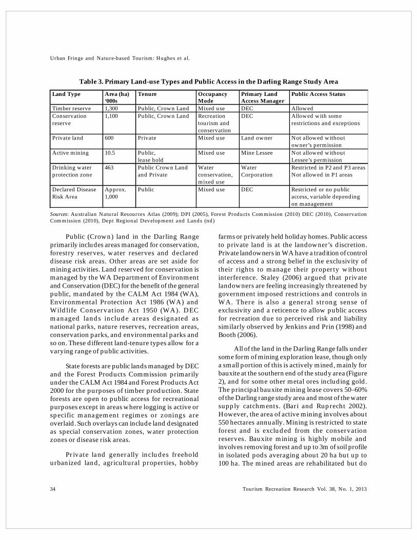
woodlands, forests, rivers, farms and water bodies(mainly reservoirs and dams for stock) situatedalong the eastern fringe of the metropolitan area ofPerth, the capital of Western Australia (WA). Therange comprises about 30,000 km2 of various landtenures and jurisdictions in the southwest of WA(Williamson and Mitchell 2001). About 65% of thearea is public land, managed by the WA StateGovernment for a range of land uses includingnature conservation, timber production, drinkingwater catchment, mining and tourism andrecreation (Conservation Commission 2010). Publicland in the Darling Range varies in terms of typeand extent of public access, depending on theapplied management regime (Table 3). Private landin the region is used for various types of agriculture,semi-rural retreats urban development and somemining.
Over the past 60 years, the population of thePerth Metropolitan Area has grown considerablyfrom approximately 310,000 in 1950 to more than1.7 million in 2012 (Weller 2009; ABS 2012). Theamount of disposable income and time available tothe population has also increased over this period.Consequently, the Darling Range, as Perth’s inland‘playground’, has experienced an increase indemand for its resources, including access fortourism and recreation (Advisory Committee onPurity of Water 1977; Williamson and Mitchell 2001;Jennings 2007; Ingram and Hughes 2009). Themetropolitan area and associated urban corridorshave expanded along the coastal plain.Consequently, the adjacent areas of the DarlingRange are in demand for a range of recreation andtourism activities. This has resulted in anincreasingly complex land-use managementenvironment within which competing land-uses viefor a limited area of available land. For more thanfive decades, intervention through a series of plansand policies has been accepted as the mostappropriate means of resolving the potentialconflicts by the land-use and conservation agenciesin Western Australia (Moir 1995).
The Darling Range has been a focus for tourismand recreation since the early 20th century (Ingram
Urban Fringe and Nature-based Tourism: Hughes et al.
32 Tourism Recreation Research Vol. 38, No. 1, 2013
and Hughes 2009). A 1977 report on public accessto water catchments in the Southwest of WesternAustralia noted that access was mainly related to‘passive pursuits’ including: tourism, barbeques,picnics, photography and ‘nature study’(Advisory Committee on Purity of Water 1977: 2). Alater report included an expanded list of more activepursuits including many water-based activitiessuch as canoeing, water skiing, white water racing,rowing, power boating, fishing and swimming(Martinick and Associates 1991). A 2001 report ontourism and recreation included 13 types of water-based and land- based active and passiverecreational activities (Muench, 2001). Finally, areport published in 2009 detailed 20 different typesof tourism and recreation activities across theDarling Range area (Hughes and Ingram 2009). Thepattern shows that over time, both the types ofactivity and the number of people accessing theDarling Range for tourism and recreation haveincreased significantly. In this regard, recreationand tourism is an important occupancy mode inthe Darling Range.
Method
This paper presents some of the results fromtwo pieces of research on land management andrecreation and tourism access in the Darling Rangearea. These were a desktop research exercisereviewing Western Australian land accesslegislation and policy and a series of interviews withrecreation user groups (Hughes et al. 2010; Hughesand Ingram 2009). The aims of the research were: toidentify the main issues regarding access to publicland in the Darling Range for tourism and recreation;the perceived extent of any problems emanatingfrom such access; and the extent to which both theaccess levels and any resultant problems wereinfluenced by the policy and managementenvironment.
Review of Legislation and Access to Land
A desktop literature review of the documentedlegislative and management contexts for managingaccess to land in Western Australia and specificallyin the Darling Range was conducted in 2010. Onlineresources, reports, and academic publications were
used. In addition to reviewing the literature,legislation and government documentation on land-use management, 15 representatives from thevarious state government agencies responsible formanaging land were interviewed over the course ofthe research. These included senior managers andmiddle management staff responsible forformulating policy and implementing land-usemanagement regimes. This phase providedinformation on the policy and management contextin terms of legislative, policy and accessmanagement responsibilities associated with theDarling Range area.
Tourism and Recreational Land Use
This component of the research gathered dataabout recreational and tourist use of the DarlingRange. Various Perth based recreation clubs andassociation representatives participated in in-depthinterviews regarding when, where and how theyaccessed and used the area. A total of 80representatives of various recreation and tourismclubs and associations based in the Perth regionwere interviewed over the course of the researchbetween 2009 and 2011. This information gatheringexercise included face-to-face interviews withrepresentatives based on a semi-structured interviewformat using open-ended questions to obtainopinions about recreation and tourism access (Table2). Public land managers were also interviewedregarding their management of public access toland for tourism and recreation. E-mailconversations were used to gather supplementaryinformation.
The following section discusses the findingsfrom the desktop review and the interviews withland managers and recreation and tourism usergroups.
Land Management and Policy Perspectives
The modern era of public land managementin Western Australia arguably began in 1984 withthe establishment of the Department of Conservationand Land Management (CALM), mandated by theCALM Act (1984). The CALM Act (1984)represented a shift towards a more integrated
Tourism Recreation Research Vol. 38, No. 1, 2013 33
Urban Fringe and Nature-based Tourism: Hughes et al.
approach to management of public land in WA. Priorto this, responsibility for different public land-usemodes was divided among various governmentagencies. CALM’s ancestry lies in the establishmentof the WA Forests Department in 1916, a body withthe prime responsibility of identifying andconserving forest areas for timber production. Aseries of local park reserves boards were establishedduring the early 20th century with responsibility forpublic recreation and tourism access and theconservation of ‘natural oddities’ (Rundle 1996).
A 1970 campaign by a consortium of WAconservation groups focused government attentionon setting aside more land for conservationpurposes. Consequently, in 1971, the WA StateGovernment undertook a series of legislative reformsthat led to the Environmental Protection Act 1973(WA) and the establishment of a single entity forparks management in WA, the National ParkAuthority, in 1976 (Rundle 1996). A 1983 review ofnatural resource management was then undertakenby the state government with a view to makingfurther reforms to bring about more efficient
management. As a result, CALM was formedthrough the amalgamation of the ForestsDepartment, the National Park Authority and thewildlife component of the Department of Fisheriesand Wildlife, as mandated by the Conservation andLand Management Act (1984). The CALM Actincluded a mandate for conservation of nature,providing public access to nature for recreation andtourism, and management of forests for timberproduction as a means of more integratedmanagement.
Since 1984, the Department of CALM has beensignificantly restructured twice. In 2000, the forestryproduction element of CALM was separated out tobecome the Forest Products Commission. At the timeit was perceived by conservation advocates that themanagement of the forests by a single agency forboth timber production and conservation was aconflict of interest. The alternative view was thathaving one agency responsible for timber productionand conservation enabled more effective integrationof these activities as well as providing an incomestream from logging that could fund conservation,recreation and tourism-related management andinfrastructure (Shea personal communication 2002)
In 2006, CALM was amalgamated with theDepartment of Environment to become theDepartment of Environment and Conservation(DEC). The number one stated key objective of DECis biodiversity conservation while the managementand facilitation of public recreational and touristaccess to parks comes fourth among eight objectives,reflecting an increased focus on conservation as thepreferred land-use mode (DEC 2007). The WAgovernment is currently in the process of developinga Biodiversity Conservation Act that appears toinclude a slightly greater emphasis on tourism,recreation and Indigenous cultural land-use modes,relative to conservation imperatives. These changesover time represent, in principle, a move towardsmore integrated management of public land throughthe establishment of a single agency with multipleresponsibilities.
In terms of the Darling Range specifically,Table 3 outlines the main types of land-use typesand management regime.
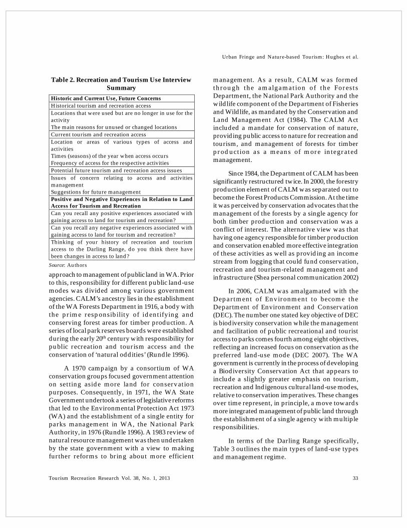
Table 2. Recreation and Tourism Use InterviewSummary
Historic and Current Use, Future ConcernsHistorical tourism and recreation accessLocations that were used but are no longer in use for the activityThe main reasons for unused or changed locationsCurrent tourism and recreation accessLocation or areas of various types of access and activities Times (seasons) of the year when access occursFrequency of access for the respective activitiesPotential future tourism and recreation access issuesIssues of concern relating to access and activities managementSuggestions for future management Positive and Negative Experiences in Relation to Land Access for Tourism and RecreationCan you recall any positive experiences associated with gaining access to land for tourism and recreation?Can you recall any negative experiences associated with gaining access to land for tourism and recreation?Thinking of your history of recreation and tourism access to the Darling Range, do you think there have been changes in access to land?
Source: Authors
Urban Fringe and Nature-based Tourism: Hughes et al.
34 Tourism Recreation Research Vol. 38, No. 1, 2013
Table 3. Primary Land-use Types and Public Access in the Darling Range Study Area
Land Type Area (ha)‘000s
Tenure Occupancy Mode
Primary Land Access Manager
Public Access Status
Timber reserve 1,300 Public, Crown Land Mixed use DEC AllowedConservation reserve
1,100 Public, Crown Land Recreation tourism and conservation
DEC Allowed with some restrictions and exceptions
Private land 600 Private Mixed use Land owner Not allowed without owner’s permission
Active mining 10.5 Public,lease hold
Mixed use Mine Lessee Not allowed without Lessee’s permission
Drinking water protection zone
463 Public Crown Land and Private
Water conservation, mixed use
Water Corporation
Restricted in P2 and P3 areasNot allowed in P1 areas
Declared Disease Risk Area
Approx.1,000
Public Mixed use DEC Restricted or no public access, variable depending on management
farms or privately held holiday homes. Public accessto private land is at the landowner’s discretion.Private landowners in WA have a tradition of controlof access and a strong belief in the exclusivity oftheir rights to manage their property withoutinterference. Staley (2006) argued that privatelandowners are feeling increasingly threatened bygovernment imposed restrictions and controls inWA. There is also a general strong sense ofexclusivity and a reticence to allow public accessfor recreation due to perceived risk and liabilitysimilarly observed by Jenkins and Prin (1998) andBooth (2006).
All of the land in the Darling Range falls undersome form of mining exploration lease, though onlya small portion of this is actively mined, mainly forbauxite at the southern end of the study area (Figure2), and for some other metal ores including gold.The principal bauxite mining lease covers 50–60%of the Darling range study area and most of the watersupply catchments. (Bari and Ruprecht 2002).However, the area of active mining involves about550 hectares annually. Mining is restricted to stateforest and is excluded from the conservationreserves. Bauxite mining is highly mobile andinvolves removing forest and up to 3m of soil profilein isolated pods averaging about 20 ha but up to100 ha. The mined areas are rehabilitated but do
Public (Crown) land in the Darling Rangeprimarily includes areas managed for conservation,forestry reserves, water reserves and declareddisease risk areas. Other areas are set aside formining activities. Land reserved for conservation ismanaged by the WA Department of Environmentand Conservation (DEC) for the benefit of the generalpublic, mandated by the CALM Act 1984 (WA),Environmental Protection Act 1986 (WA) andWildlife Conservation Act 1950 (WA). DECmanaged lands include areas designated asnational parks, nature reserves, recreation areas,conservation parks, and environmental parks andso on. These different land-tenure types allow for avarying range of public activities.
State forests are public lands managed by DECand the Forest Products Commission primarilyunder the CALM Act 1984 and Forest Products Act2000 for the purposes of timber production. Stateforests are open to public access for recreationalpurposes except in areas where logging is active orspecific management regimes or zonings areoverlaid. Such overlays can include land designatedas special conservation zones, water protectionzones or disease risk areas.
Private land generally includes freeholdurbanized land, agricultural properties, hobby
Sources: Australian Natural Resources Atlas (2009); DPI (2005), Forest Products Commission (2010) DEC (2010), ConservationCommission (2010), Dept Regional Development and Lands (nd)

Tourism Recreation Research Vol. 38, No. 1, 2013 35
Urban Fringe and Nature-based Tourism: Hughes et al.
not return to the original ecological state withsignificantly altered topography, hydrology andbiodiversity (Majer in press). Public access intoactively mined leases is not allowed without thelessee’s permission. Previously mined areas andareas under lease but yet to be mined are open topublic access. The shifting character of bauxitemining and the reduce ecological quality ofpreviously mined areas was identified by somerecreation groups as reducing the quality ofrecreation and a disincentive to access in theseareas.
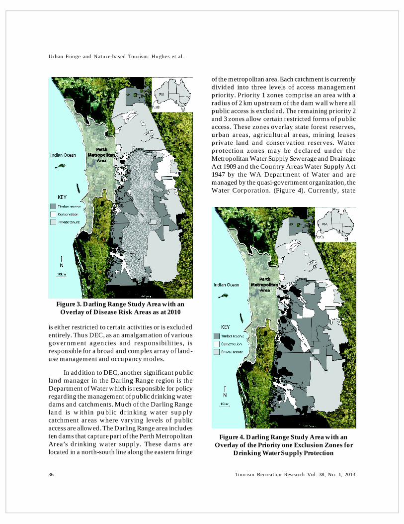
Die Back (Phytophthora cinnamomi) which attacks arange of plant species including the dominantJarrah tree (Eucalyptus marginata) and therebyadversely effects the entire forest and woodlandecosystem. This pathogen can be spread by peopleor vehicles carrying infected soil from one forestedarea to another. To manage the spread of thepathogen, part VII of the CALM Act 1984 and theForest Management Regulations 1993 (WA) enableDEC to establish ‘Disease Risk Areas’ (DRAs) thatrestrict public access and certain activities withinthese areas (Figure 3). This can include banningvehicle and machinery access or a blanket ban onall public access for periods of time. The DRA canoverlay other occupancy modes on public land. Thecurrent DRA includes a significant portion of theDarling Range study area meaning that public access
Figure 1. Map of the Darling Range Study AreaShowing Private Tenure, Conservation Reserves
and Timber Reserves
As part of its biodiversity conservation remit,DEC also manages land in the Darling Range forcontrol of a soil-borne plant pathogen known as
Figure 2. Darling Range Study Area with anOverlay of the Active Bauxite Mining Leases
Urban Fringe and Nature-based Tourism: Hughes et al.
36 Tourism Recreation Research Vol. 38, No. 1, 2013
is either restricted to certain activities or is excludedentirely. Thus DEC, as an amalgamation of variousgovernment agencies and responsibilities, isresponsible for a broad and complex array of land-use management and occupancy modes.
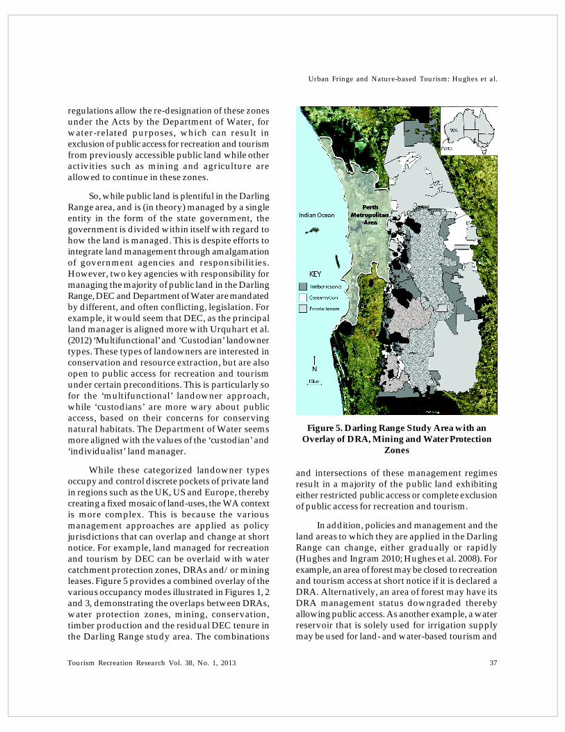
In addition to DEC, another significant publicland manager in the Darling Range region is theDepartment of Water which is responsible for policyregarding the management of public drinking waterdams and catchments. Much of the Darling Rangeland is within public drinking water supplycatchment areas where varying levels of publicaccess are allowed. The Darling Range area includesten dams that capture part of the Perth MetropolitanArea’s drinking water supply. These dams arelocated in a north-south line along the eastern fringe
of the metropolitan area. Each catchment is currentlydivided into three levels of access managementpriority. Priority 1 zones comprise an area with aradius of 2 km upstream of the dam wall where allpublic access is excluded. The remaining priority 2and 3 zones allow certain restricted forms of publicaccess. These zones overlay state forest reserves,urban areas, agricultural areas, mining leasesprivate land and conservation reserves. Waterprotection zones may be declared under theMetropolitan Water Supply Sewerage and DrainageAct 1909 and the Country Areas Water Supply Act1947 by the WA Department of Water and aremanaged by the quasi-government organization, theWater Corporation. (Figure 4). Currently, state
Figure 3. Darling Range Study Area with anOverlay of Disease Risk Areas as at 2010
Figure 4. Darling Range Study Area with anOverlay of the Priority one Exclusion Zones for
Drinking Water Supply Protection
Tourism Recreation Research Vol. 38, No. 1, 2013 37
Urban Fringe and Nature-based Tourism: Hughes et al.
regulations allow the re-designation of these zonesunder the Acts by the Department of Water, forwater-related purposes, which can result inexclusion of public access for recreation and tourismfrom previously accessible public land while otheractivities such as mining and agriculture areallowed to continue in these zones.
So, while public land is plentiful in the DarlingRange area, and is (in theory) managed by a singleentity in the form of the state government, thegovernment is divided within itself with regard tohow the land is managed. This is despite efforts tointegrate land management through amalgamationof government agencies and responsibilities.However, two key agencies with responsibility formanaging the majority of public land in the DarlingRange, DEC and Department of Water are mandatedby different, and often conflicting, legislation. Forexample, it would seem that DEC, as the principalland manager is aligned more with Urquhart et al.(2012) ‘Multifunctional’ and ‘Custodian’ landownertypes. These types of landowners are interested inconservation and resource extraction, but are alsoopen to public access for recreation and tourismunder certain preconditions. This is particularly sofor the ‘multifunctional’ landowner approach,while ‘custodians’ are more wary about publicaccess, based on their concerns for conservingnatural habitats. The Department of Water seemsmore aligned with the values of the ‘custodian’ and‘individualist’ land manager.
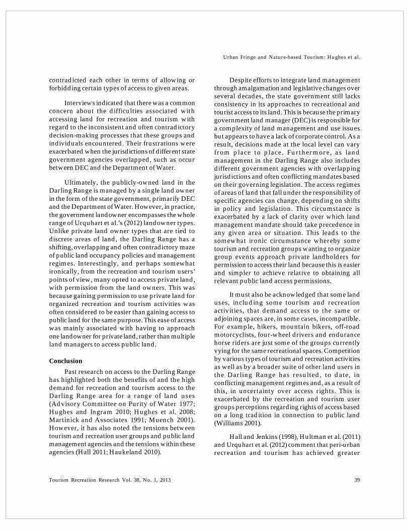
While these categorized landowner typesoccupy and control discrete pockets of private landin regions such as the UK, US and Europe, therebycreating a fixed mosaic of land-uses, the WA contextis more complex. This is because the variousmanagement approaches are applied as policyjurisdictions that can overlap and change at shortnotice. For example, land managed for recreationand tourism by DEC can be overlaid with watercatchment protection zones, DRAs and/or miningleases. Figure 5 provides a combined overlay of thevarious occupancy modes illustrated in Figures 1, 2and 3, demonstrating the overlaps between DRAs,water protection zones, mining, conservation,timber production and the residual DEC tenure inthe Darling Range study area. The combinations
and intersections of these management regimesresult in a majority of the public land exhibitingeither restricted public access or complete exclusionof public access for recreation and tourism.
In addition, policies and management and theland areas to which they are applied in the DarlingRange can change, either gradually or rapidly(Hughes and Ingram 2010; Hughes et al. 2008). Forexample, an area of forest may be closed to recreationand tourism access at short notice if it is declared aDRA. Alternatively, an area of forest may have itsDRA management status downgraded therebyallowing public access. As another example, a waterreservoir that is solely used for irrigation supplymay be used for land- and water-based tourism and
Figure 5. Darling Range Study Area with anOverlay of DRA, Mining and Water Protection
Zones

Urban Fringe and Nature-based Tourism: Hughes et al.
38 Tourism Recreation Research Vol. 38, No. 1, 2013
recreation activities. If that reservoir then has aportion of its water allocated to the urban drinkingwater supply, all tourism and recreation activitiesare totally excluded within 2 km upstream of thewater body in order to protect water quality. Thissituation can occur at short notice (see for example,Hughes et al. 2008). Furthermore, while Priority Onewater protection zones prohibit public access fortourism and recreation, they may overlap withmining areas, agriculture and timber productionareas. Mining, agriculture and timber harvestingare permitted to continue in these circumstanceswhile, paradoxically, tourism and recreation areexcluded to protect water quality. This fluid state ofpolicy and management combined with theoverlapping jurisdictions causes tensions betweenand within government agencies as to which landoccupancy mode should take primacy and whatshould be allowed when and where. This alsocauses confusion for the public as to when andwhere they can access land for which forms oftourism and recreation.
Tourism and Recreation Users’ Perspectives
Interviews with recreation clubs andassociations (80 interviews) documented 13 generaltypes of recreation and tourism activity which werewidely distributed across the length and breadth ofthe Darling Range. Many of these activities includedseveral sub-categories. For example, mountainbiking included down-hill, cross-country and long-distance riding. Bushwalking included day walks,extended overnight walks and on-track and off-trackhiking. Four wheel driving included day trips,extended overnight excursions, and preferences foraccess to a range of terrain from rough to mild. Thisindicates not just a diversity in terms of the range ofrecreation and tourism activity types, but alsodiversity within each type in terms of publicexpectations and requirements.
In terms of what types of land are accessed,the interview respondents indicated that they mostcommonly accessed conservation reserves (86%),state forest (timber) reserves (84%) and waterprotection reserves (58%). Interestingly, a significantnumber also indicated they regularly accessedprivate land (51%). Only a small fraction indicated
access to mining reserves (7%). These results showthat most recreation and tourism activity undertakenin the Darling Range by Perth-based groups isprimarily on public land managed for eitherconservation, water production or timberproduction. That is, these groups commonly useland set aside for production and conservation aswell as recreation and tourism.
When asked to recall positive experiencesassociated with the process of gaining access to landfor tourism and recreation, about 64% ofrespondents could do so, while 14% could not. Whenasked whether they could recall any negativeexperiences, about 33% could, while 42% could not.Further investigation revealed that the positiveexperiences tended to be associated with personalinteractions with individual government agencystaff (such as park rangers) as part of an informal,independent recreation and tourism experience onpublic land. Alternatively, positive experiences wereassociated with relationships built up betweenrecreation and tourism groups and individualprivate land holders. Negative experiences tendedto be associated with organizational and systemicissues regarding access to public land. Negativeexperiences were also mainly associated withobtaining permission for organized group activitiesand events on public land. This explains the higherproportion of people able to recall positiveexperiences because obtaining informal andindependent access was a more common type ofactivity than was seeking access for organized largegroup events.
Commonly, there was confusion regardingwhich authority to approach for a permit to conductorganized group activities such as orienteering,rogaining and endurance horse riding events thattend to range across large areas of public land. Thesetypes of organized events include a combination ofpeople involved in competitive multi-day activitiesand spectators who travel to the region and stayovernight. Interviews revealed that the process ofgaining permission for such access generally tookan extended length of time and required formalapproval from several different governmentrepresentatives. Some of the land manager decisions
Tourism Recreation Research Vol. 38, No. 1, 2013 39
Urban Fringe and Nature-based Tourism: Hughes et al.
contradicted each other in terms of allowing orforbidding certain types of access to given areas.
Interviews indicated that there was a commonconcern about the difficulties associated withaccessing land for recreation and tourism withregard to the inconsistent and often contradictorydecision-making processes that these groups andindividuals encountered. Their frustrations wereexacerbated when the jurisdictions of different stategovernment agencies overlapped, such as occurbetween DEC and the Department of Water.
Ultimately, the publicly-owned land in theDarling Range is managed by a single land ownerin the form of the state government, primarily DECand the Department of Water. However, in practice,the government landowner encompasses the wholerange of Urquhart et al.’s (2012) landowner types.Unlike private land owner types that are tied todiscrete areas of land, the Darling Range has ashifting, overlapping and often contradictory mazeof public land occupancy policies and managementregimes. Interestingly, and perhaps somewhatironically, from the recreation and tourism users’points of view, many opted to access private land,with permission from the land owners. This wasbecause gaining permission to use private land fororganized recreation and tourism activities wasoften considered to be easier than gaining access topublic land for the same purpose. This ease of accesswas mainly associated with having to approachone landowner for private land, rather than multipleland managers to access public land.
Conclusion
Past research on access to the Darling Rangehas highlighted both the benefits of and the highdemand for recreation and tourism access to theDarling Range area for a range of land uses(Advisory Committee on Purity of Water 1977;Hughes and Ingram 2010; Hughes et al. 2008;Martinick and Associates 1991; Muench 2001).However, it has also noted the tensions betweentourism and recreation user groups and public landmanagement agencies and the tensions within theseagencies (Hall 2011; Haukeland 2010).
Despite efforts to integrate land managementthrough amalgamation and legislative changes overseveral decades, the state government still lacksconsistency in its approaches to recreational andtourist access to its land. This is because the primarygovernment land manager (DEC) is responsible fora complexity of land management and use issuesbut appears to have a lack of corporate control. As aresult, decisions made at the local level can varyfrom place to place. Furthermore, as landmanagement in the Darling Range also includesdifferent government agencies with overlappingjurisdictions and often conflicting mandates basedon their governing legislation. The access regimesof areas of land that fall under the responsibility ofspecific agencies can change, depending on shiftsin policy and legislation. This circumstance isexacerbated by a lack of clarity over which landmanagement mandate should take precedence inany given area or situation. This leads to thesomewhat ironic circumstance whereby sometourism and recreation groups wanting to organizegroup events approach private landholders forpermission to access their land because this is easierand simpler to achieve relative to obtaining allrelevant public land access permissions.
It must also be acknowledged that some landuses, including some tourism and recreationactivities, that demand access to the same oradjoining spaces are, in some cases, incompatible.For example, hikers, mountain bikers, off-roadmotorcyclists, four-wheel drivers and endurancehorse riders are just some of the groups currentlyvying for the same recreational spaces. Competitionby various types of tourism and recreation activitiesas well as by a broader suite of other land users inthe Darling Range has resulted, to date, inconflicting management regimes and, as a result ofthis, in uncertainty over access rights. This isexacerbated by the recreation and tourism usergroups perceptions regarding rights of access basedon a long tradition in connection to public land(Williams 2001).
Hall and Jenkins (1998), Hultman et al. (2011)and Urquhart et al. (2012) comment that peri-urbanrecreation and tourism has achieved greater

Urban Fringe and Nature-based Tourism: Hughes et al.
40 Tourism Recreation Research Vol. 38, No. 1, 2013
recognition as an important land use by managersand policy-makers over recent decades. However,this case demonstrates that while it may berecognized as significant, it is often relegated to alower priority of importance and facesinconsistencies in management on the ground.
It seems that, in this instance, an integratedapproach to multifunctional land-use is yet to beeffectively achieved despite at least three decades ofwork towards this goal. As noted in the literature,effective management would ideally include theengagement of both the various government agenciesand the community-based organizations andindustries with interests in accessing natural areasfor various types of activity (Mitchell and Hollick1993; Hall 2011). To achieve this end, the sharing ofresources, mutual influence, transparency,commitment, trust and respect, active participationand accountability through cross-sectorialinteractions over an extended period of time is anideal approach (Laing et al. 2008a; Laing et al.2008b).
In the case of the public land managed bygovernment in WA, this is undermined by a lack ofconsistent decision-making by DEC at the local level,a lack of effective cooperation between DEC and the
Department of Water and a lack of trust or perhapsrespect between recreation users and land managersat the organizational level. This is a function of thesocial and political history of these agencies withland management traditions focusing variously onprotection, production and consumption.
It would appear that the perception byrecreation and tourism user groups thatopportunities for access are being restricted onpublic land are true to a certain extent, but perhapsmainly owing to perceived and real powerdifferentials (Hall 2011) and a lack of trulyintegrated management rather than an general driveto exclude this type of land use. This is combinedwith a shifting matrix of complex land managementpriorities and a perception by interviewed users ofthe right to access public land for recreation andtourism (Williams 2001). It appears that a culturalshift is required more than changes in managementstructure, legislation and policy. In the mean time,there is irony in WA with its wealth of public landbut a tendency for tourism and recreation groups toapproach individual private landholders for sometypes of access (usually organized events), ratherthan navigate the complex and shifting bureaucracyassociated with accessing public land in manyinstances.
ReferencesABS (2012). Regional Population Growth, Australia, 2011: Western Australia. Available at http://www.abs.gov.au – Accessed
on 15 November 2012.ADVISORY COMMITTEE ON PURITY OF WATER (1977). A Study of Catchments and Recreation in Western Australia.
Perth, WA. Government of Western Australia.AUSTRALIAN NATURAL RESOURCES ATLAS (2009). Land Use – Australia. Available at http://www.anra.gov.au/topics/
land/landuse – Accessed on 10 June 2010.BARI, M. and RUPRECHT, J. (2002). Water Yield Response to Land Use Change in South-West Western Australia. Report for the
Department of Environment. Perth. Government of Western Australia.BOOTH, K. (2006). Public Rights of Access to the Countryside (PhD Thesis). New Zealand. University of Otago.BUTLER, R., HALL, C. M. and JENKINS, J. (1998). Introduction. In Butler, R., Hall, C.M. and Jenkins, J. (Eds) Tourism and
Recreation in Rural Areas. Chichester, UK. John Wiley & Sons: 3–16.CONSERVATION COMMISSION (2010). Annual Report 2009-10. Available at http://www.conservation.wa.gov.au/ – Access
on 15 November 2012.DEC (2007). WA Department of Environment and Conservation Corporate Plan 2007–2009. Available at http://www.dec.wa.gov.au
– Accessed on 20 November 2012.DEC (2010). Management and Protection. Available at http://www.dec.wa.gov.au – Accessed on 20 November 2012.DEPARTMENT OF REGIONAL DEVELOPMENT AND LANDS (nd). State Lands. Available at http://rdl.wa.gov.au –
Accessed on 10 June 2010.DPI (2005). Crown Land Management. Available at http://www.dpi.wa.gov.au/crown_management0905.pdf – Accessed on
20 November 2012.

Tourism Recreation Research Vol. 38, No. 1, 2013 41
Urban Fringe and Nature-based Tourism: Hughes et al.
FOREST PRODUCTS COMMISSION (2010). Native Forests: South West. Available at http://www.fpc.wa.gov.au – Accessedon 20 November 2012.
GARROD, B., WORNELL, R. and YOUELL, R. (2006). Re-coneptualising Rural Resources and Countryside Capital: The Case ofRural Tourism. Journal of Rural Studies 22: 117–128.
HALL, C. M. (2011). A Typology of Governance and its Implications for Tourism Policy Analysis. Journal of Sustainable Tourism19(4&5): 437–457.
HULTMAN, J., HALL, C. M. and GOSSLING, S. (2011). Tourism Mobility, Locality and Sustainable Rural Development. InMacleod, D. and Gillespie, S. (Eds) Sustainable Tourism in Rural Europe: Approaches to Development. Milton Park, UK. Routledge:28–42.
HAUKELAND, J.V. (2010). Tourism Stakeholders’ Perceptions of National Park Management in Norway. Journal of SustainableTourism 19(2): 133–153.
HOLMES, J. (2006). Impulses Towards a Multifunctional Transition in Rural Australia: Gaps in the Research Agenda. Journal ofRural Studies 22(2): 142–160.
HUGHES, M. and CARLSEN, J. (2009). Developing a Knowledge Platform on Value of Parks for Tourism. Proceedings of theBEST EN Think Tank IX: The Importance of Values in Sustainable Tourism. James Cook University. Singapore, June 15-18, 2009.
HUGHES, M. and INGRAM, C. (2009). Where People Play: Recreation in the Southern Darling Range, Western Australia. Perth,Western Australia. Department of Sport and Recreation.
HUGHES, M. and INGRAM, C. (2010). Recreational Access to Urban Water Supplies. In Crase, L. and O’Keefe, S. (Eds) WaterPolicy, Tourism and Recreation. New York. RFF Press: 132–147.
HUGHES, M., TYE, M. and ZULFA, M. (2010). The Right to Roam: A Review of Policy and Management of Public Access to Land. Perth,Western Australia. Department of Sport and Recreation.
HUGHES, M., ZULFA, M. and CARLSEN, J. (2008). A Review of Recreation in Public Water Catchments in the Southwest Regionof Western Australia. Perth, Western Australia. Department of Sport and Recreation and Department of Environment andConservation.
INGRAM, C. and HUGHES, M. (2009). Where People Play: Recreation in the Southern Darling Range, Western Australia. Perth WA.Report for the WA Department of Sport and Recreation.
JENKINS, J. M. and PRIN, E. (1998). Rural Landholder Attitudes: The Case of Public Recreational Access to ‘Private’ RuralLands. In Butler, R., Hall, C.M. and Jenkins, J. (Eds) Tourism and Recreation in Rural Areas. Chichester, UK. John Wiley & Sons:179–196.
JENNINGS, G. (2007). Water-based Tourism, Sport, Leisure and Recration Experiences. Burlington, USA. Elsiever.LAING, J., WEGNER, A., MOORE, S. and WEILER, B. (2008a). Identifying Success Factors Behind Partnerships for Managing
Recreation and Tourism in Urban Fringe Parks. Annals of Leisure Research 11(1&2): 101–122.LAING, J., WEGNER, A., MOORE, S., WEILER, B., PFUELLER, S., LEE, D. and LOCKWOOD, M. (2008b). Understanding
Partnerships for Protected Area Tourism: Learning from the Literature. Gold Coast, Australia. Sustainable Tourism CRC.MANN, C., POUTA, E., GENTIN, S. and JENSEN, F. (2010). Outdoor Recreation in Forest Policy and Legislation: A European
Comparison. Urban Forestry and Urban Greening 9(4): 303–312.MAJER, J. (in press 2013). Mining and Biodiversity: Are They Compatible? In Brueckner, M. and Pforr, C. (Eds) Resource Curse
or Cure? New York. Springer.MARTINICK AND ASSOCIATES (1991). A Review of the Water Based Recreation in Western Australia. Perth, WA: Ministry of Sport
and Recreation and Western Australian Water Resources Council.MCINTYRE, N., JENKINS, J. and BOOTH, K. (2001). Global Influences on Access: The Changing Face of Access to Public
Conservation Lands in New Zealand. Journal of Sustainable Tourism 9(5): 434–450.MILLWARD, H. (1991). Public Recreational Access in the Countryside: Concepts and Measures of Physical Rigour. Journal of
Rural Studies 7(3): 241–251.MOIR, J. (1995). Regional Parks in Western Australia. Australin Planner 32(2): 88–95.MUENCH, R. (2001). Southern Darling Range Regional Recreation Study. Perth, WA: Department of Conservation and Land
Management, Water Corporation and Water and Rivers Commission.NEWSOME, D., MOORE, S. and DOWLING, R. (2002). Natural Area Tourism: Ecology, Impacts and Management. Clevedon.
Channel View Publications.PIGRAM, J. and JENKINS, J. (1999). Outdoor Recreation Management. London. Routledge.RUNDLE, G. (1996). History of Conservation Reserves in the South-west of Western Australia. Journal of the Royal Society of
Western Australia 79: 225–240.SHEA, S. (2002). Forest Management and Water Catchments. (personal communication) March 15, 2002. University of Notre
Dame, Fremantle, Western Australia.
Urban Fringe and Nature-based Tourism: Hughes et al.
42 Tourism Recreation Research Vol. 38, No. 1, 2013
STALEY, L. (2006). Property Rights in Western Australia: Time for a Changed Direction Occasional Paper presneted at theInstitute of Public Affairs, WA Australia.
URQUHART, J., COURTNEY, P. and SLEE, B. (2012). Private Woodland Owners Perspectives on Multifunctionality in EnglishWoodlands. Journal of Rural Studies 28: 95–106.
WELLER, R. (2009). Boomtown 2050: Scenarios for a Rapidly Growing City. Perth, Western Australia. UWA Press.WILLIAMS, D. (2001). Sustainability and Public Access to Nature: Contesting the Right to Roam. Journal of Sustainable Tourism
9(5): 361–371.WILLIAMS, A. and SHAW, G. (2009). Future Play: Tourism, Recreation and Land Use. Land Use Policy 265: S326–S335WILLIAMSON, K. and MITCHELL, D. (2001). Jarrah Forest: JF1 (Northern Jarrah Forest Subregion). A Biodiversity Audit Report
of Western Australia’s 53 Biogeographical Sub-regions in 2002. Report for the WA Conservation Commission. Perth, Governmentof Western Australia.
Submitted: December 3, 2012Accepted: February 5, 2013