where is the terraced house? on the use of … · where is the terraced house? on the use of...
TRANSCRIPT
Where is the Terraced House? On the Use of Ontologies for Recognition of Urban Concepts in Cartographic Databases
Patrick Lüscher*1, Robert Weibel1 and William A. Mackaness2
1 Department of Geography, University of Zurich, Winterthurerstrasse 190, 8057 Zurich, Switzerland * [email protected]
2 Institute of Geography, School of GeoSciences, University of Edinburgh Drummond St, Edinburgh EH8 9XP, Scotland, UK
Abstract
In GIS datasets, it is rare that building objects are richly attributed. Yet having semantic information (such as tenement, terraced, semi-detached) has real practical application (in visualisation and in analysis). It is often the case that we can infer semantic information simply by visual inspec-tion – based on metric and topological properties for example. This paper explores the application of pattern recognition techniques as a way of auto-matically extracting information from vector databases and attaching this information to the attributes of a building. Our methodology builds upon the idea of an ontology-driven pattern recognition approach. These ideas are explored through the automatic detection of terraced houses (based on Ordnance Survey MasterMap® vector data). The results appear to demon-strate the feasibility of the approach. In conclusion we discuss the benefits and difficulties encountered, suggest ways to deal with these challenges, and propose short and long term directions for future research.
Keywords: cartographic databases, ontologies, ontology-driven pattern recognition, building types, geographical characterisation
1 Introduction
Spatial databases currently in use typically have been originally designed and produced in the 1990s. They are rich in geometry, most often include topological structuring, yet they are usually poor in semantics. Those ex-ceptional databases that are semantically rich are restricted to rather nar-row purposes – vehicle navigation being a prominent example, where rich additional information on the logics of traffic flow (e.g. one-way streets, pedestrian zones etc.), average speed and speed limits are coded onto the geometry. However, the majority of GIS applications make use of general purpose topographic databases produced either by national mapping agen-cies (NMAs) or by private companies (e.g. Tele Atlas, NAVTEQ). These general purpose databases are poor in semantics in particular with regards to the representation of higher order semantic concepts that extend beyond the semantics of individual, discrete objects.
This under-representation of semantics limits the utility of the database. The research community has called for methods to automatically ‘enrich’ such databases. What is required are methods that make explicit the spatial relationships and semantic concepts implicitly contained in spatial data-bases. Probably the first research community to call for ‘data enrichment’ was the map generalisation community (Ruas and Plazanet 1996; Heinzle and Anders 2007). In map generalisation, the special semantics embedded in spatial relations, hierarchical relations, and spatial patterns and struc-tures are critical to modelling the context in which cartographic decisions are made. The map generalisation process utilises information linked to pattern and structure recognition (Brassel and Weibel 1988; Mackaness and Ruas 2007). For example, the decision as to whether to visualise a building on a map will partially depend on contextual information. If it is small yet isolated in a rural area, then the building may be retained and slightly enlarged; if it is in an urban area, it may be eliminated; and if it happens to be a special type of building such as a hospital, it may be re-placed by a special symbol (Steiniger 2007).
Generalisation is not the only area where enriched semantics and hence cartographic pattern recognition are crucial. Building types such as tene-ments or terraced, semi-detached, and detached houses are rarely coded into existing spatial databases, yet, they would provide important semantic information in many practical applications: They give essential clues to prospective house buyers as to what to expect when reading through real estate advertisements (King 1994); information concerning house type is important in planning when trying to develop the right balance between different residential forms in a particular neighbourhood, in quantity sur-
veying or in the recycling of building materials (Müller 2006; Bergsdal et al. 2007). Additionally, enriched semantics can be used to associate urban patterns with urban evolution processes and urban morphology (Camacho-Hübner and Golay 2007); or they may assist adaptation in pedestrian navi-gation services by considering spatial contexts specified in the database (Winter 2002).
In this paper, we present a novel approach to cartographic pattern rec-ognition. In addition to the more ‘traditional’ approaches that directly rely on statistical methods and/or geometric algorithms, our approach utilises ontologies to better inform the pattern recognition process and to ‘glue’ such algorithms together. The paper begins by explaining why ontology-driven pattern recognition has the potential to overcome some of the limi-tations of traditional approaches and describes the proposed methodology (§ 2). We demonstrate how this approach affords automatic identification of terraced houses from among urban buildings represented in vector form. After presenting an ontology of terraces (§ 3), we explain how the con-cepts of this ontology can be transformed into an automatic recognition procedure, and we present results of this procedure using Ordnance Survey MasterMap data (§ 4). The paper goes on to identify the benefits and limi-tations of this technique and suggests ways of overcoming these limita-tions (§ 5). The conclusion reflects on future research, short and long-term.
2 Ontology-driven Cartographic Pattern Recognition
2.1 Why ontologies are useful in cartographic pattern recognition
Many specialised pattern recognition algorithms have been developed for the detection of structures and patterns specifically in an urban context (e.g. Regnauld 1996; Barnsley and Barr 1997; Anders et al. 1999; Boffet 2001; Christophe and Ruas 2002; Heinzle and Anders 2007; Steiniger et al. 2008). These techniques focus on rather specific patterns that are linked to particular generalisation operations, for instance where we wish to group buildings or to detect alignments in support of aggregation or typifi-cation operations (Regnauld 1996; Christophe and Ruas 2002). As there is often an element of fuzziness involved in pattern definitions, these algo-rithms are often coupled with statistical methods. It remains doubtful whether such algorithms, or a collection thereof, will be sufficient to ex-tract more general, higher order semantic concepts such that we could comprehensively describe the semantics of the morphology of a city. There has to be something additional that enables broader synoptic description of
the city form. It has been pointed out by Mackaness (2006) that abstraction from large-scale databases to highly generalised ones requires that the roles of individual features and patterns be understood and modelled ex-plicitly. Dutton and Edwardes (2006), Kulik (2005) and Redbrake and Raubal (2004) show the importance of semantic modelling of geographic features in maps to guide user adaptation during generalisation.
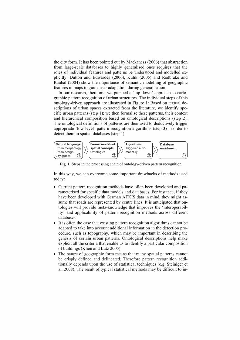
In our research, therefore, we pursued a ‘top-down’ approach to carto-graphic pattern recognition of urban structures. The individual steps of this ontology-driven approach are illustrated in Figure 1: Based on textual de-scriptions of urban spaces extracted from the literature, we identify spe-cific urban patterns (step 1); we then formalise these patterns, their context and hierarchical composition based on ontological descriptions (step 2). The ontological definitions of patterns are then used to deductively trigger appropriate ‘low level’ pattern recognition algorithms (step 3) in order to detect them in spatial databases (step 4).
Fig. 1. Steps in the processing chain of ontology-driven pattern recognition
In this way, we can overcome some important drawbacks of methods used today:
• Current pattern recognition methods have often been developed and pa-rameterised for specific data models and databases. For instance, if they have been developed with German ATKIS data in mind, they might as-sume that roads are represented by centre lines. It is anticipated that on-tologies will provide meta-knowledge that improves the ‘interoperabil-ity’ and applicability of pattern recognition methods across different databases.
• It is often the case that existing pattern recognition algorithms cannot be adapted to take into account additional information in the detection pro-cedure, such as topography, which may be important in describing the genesis of certain urban patterns. Ontological descriptions help make explicit all the criteria that enable us to identify a particular composition of buildings (Klien and Lutz 2005).
• The nature of geographic form means that many spatial patterns cannot be crisply defined and delineated. Therefore pattern recognition addi-tionally depends upon the use of statistical techniques (e.g. Steiniger et al. 2008). The result of typical statistical methods may be difficult to in-

terpret, however, as the relations that are inferred between pattern vari-ables are purely statistical rather than revealing causes and conse-quences. Ontologies, on the other hand, represent the concepts that are modelled, as well as the relations between them in an explicit way. Thus, they are inherently more transparent than statistical methods and have potentially more explanatory power.
2.2 Ontologies for cartographic pattern recognition
The term ‘ontology’ is defined from an engineering science perspective and is defined as an explicit specification of a shared conceptualisation (Gruber 1993). It is thus an attempt to capture the knowledge in a certain domain in a systematic way by breaking it down into the types of entities (concepts) that exist and the relations that hold between them. Ontologies can be classified according to the degree of formalisation into informal (written in natural language), semi-formal (restricted language), and for-mal (artificial language) ontologies (Agarwal 2005). An alternate classifi-cation is one that conforms to the degree of specialisation and is divided into top-level, domain, and task ontologies, the last being the most specific one (Guarino 1998). While a key application of ontologies is to improve the interoperability between information systems (Fonseca et al. 2002), on-tologies are also employed as a method of eliciting knowledge that exists in a domain (Agarwal 2005).
In this research we seek to explain complex urban phenomenon in terms of other, possibly simpler phenomena, such that the meaning of the con-cept is derived from the meaning of the related concepts. We refer to the first kind as a ‘higher order concept’, and to the second kind as a ‘lower order concept’. The lower order concepts may themselves be composite concepts, in which case they have to be broken down further into still lower order concepts. Alternatively they might be simple in the sense that they can be directly related to cartographic measures or a cartographic structure recognition algorithm.
2.3 Data enrichment using ontologies
The concept above constitutes an ideal prototype (a template). Real occur-rences of a concept will normally comply only to a certain degree with the template. Hence, a value which expresses the degree of congruence be-tween reality and the ideal prototype of the concept has to be calculated: where con(Ci, Rj) = 0 when a realisation Rj differs completely from a tem-plate Ci, and con(Ci, Rj) = 1 when they match perfectly.
For low order concepts con(Ci, Rj) is extracted by a cartographic pattern recognition algorithm. For composite concepts, which are defined by their relations to lower order concepts, con(Ci, Rj) has to be inferred from the congruence values of their constituting concepts. Here we distinguish be-tween two types of relationships:
• Some relationships, such as the subclass relationship, translate to strict exclusions:
0),(0),( =→= kjki RCconRCcon (1)
If Cj is a subclass of Ci. For example, if a spatial object is not a building then it cannot be a terraced house, regardless of the congruence values of the other constituting concepts, since terraced houses are a subclass of buildings.
• For other relationships, congruence values of the constituting values ha-ve to be intersected. One possibility for combining single similarity val-ues to an overall value is by calculating a weighted linear average:
∑∑= jkjjki wRCconwRCcon )),((),( (2)
Where con(Cj, Rk) is the congruence value of a constituent concept of Ci and the weight wj is an influence value of the subconcept. For reasons of simplicity, all weights were equated to 1 for this study.
Thus, the calculation of congruence values starts with the patterns at the bottom and then propagates iteratively to higher order concepts. This is similar to forward reasoning in description logics. At the end of this proc-ess, spatial objects can be annotated with the congruence value for the concepts defined in the ontology.
2.4 Related work
Our review of related work will be brief and will focus exclusively on ap-proaches that use explicit semantic models for the recognition of spatial patterns in vector databases, ignoring the literature related to image inter-pretation and computer vision.
Sester (2000) and Anders and Sester (1997) built semantic models for the automatic interpretation of large-scale vector databases. They extracted different types of houses, streets, parcels and built-up areas from polygon data. The inductive machine learning algorithm ID3 is used to discover relevant spatial properties and relations in manually tagged data. An ap-proach for combining spatial reasoning with description logics to formalise spatial arrangements is presented by Haarslev et al. (1994).

Many spatial concepts are inherently vague. Santos et al. (2005) used supervaluation semantics to integrate vagueness into logical reasoning. They show a prototype implementation in Prolog that classifies water bod-ies according to an ontology of inland water features.
Ontologies are a means to achieve semantic interoperability in a distrib-uted environment. In this context, Klien and Lutz (2005) discuss the auto-matic annotation of existing datasets with concepts defined in an ontology. Their approach emphasises spatial relations between features rather than individual feature properties. Thomson (2006) sought to build land use maps from OS MasterMap data. Her intention was to use ontologies to model land use categories according to the specific spatial configurations, compositions, and relations. This is somewhat similar to a project at the Ordnance Survey which sought to identify fields such as farming land or pasture in OS MasterMap data, using ontologies (Kovacs and Zhou 2007).
We conclude our review with a few observations. First, the amount of work using semantic models for pattern recognition in cartographic vector databases is much smaller than the literature on purely algorithmic ap-proaches. Second, much of the research reviewed in this subsection is re-stricted to a selected set of spatial patterns; the extensibility and the poten-tial generality of these approaches is rarely discussed. And finally, few references have actually gone into details of instantiating the proposed on-tology definitions and of implementing a prototype to prove the validity of the approach; many stay at the more theoretical level.
3 An ontology of terraced houses
«Beyond the mills … were the rows of terraces – mean little houses, with low ceil-ings and dark cramped rooms.» — Jane Rogers, Her Living Image. In this section we want to show how textual descriptions of urban concepts can be formalised and thus serve as a basis for their detection. The con-cepts in this study were collected from texts on urban morphology, which is “the study of the physical (or built) fabric of urban form, and the people and processes shaping it” (Jones and Larkham 1991). The hypothesis of urban morphology is that economic and social significance of a town finds its expression in the physiognomy, which is a combination of town plan, pattern of building forms, and pattern of urban land use (Conzen 1969). Concept descriptions were complemented using dictionaries such as the Oxford English Dictionary (Simpson and Weiner 1989). By way of exam-ple, Figure 2 shows residential house types identified in the urban mor-phology literature.

Fig. 2. Urban residential house types extracted from the glossary of urban form (Jones and Larkham 1991)
While ‘terraced house’ is generally a synonym for ‘row house’ and may therefore have different features depending on culture and construction pe-riod, the prototype for our formalisation is the characteristic terrace house settlement in the UK of the late Victorian and Edwardian period. It is linked to the Public Health Act of 1875, established to improve urban liv-ing conditions and resulted in re-housing of population from slum clear-ance areas (Conzen, 1969). The demand for cheap mass housing was met by creating rows of unified buildings sharing sidewalls. Because of the low social status of the dwellers, lot sizes and room footprints were small.
Fig. 3. An ontology of terraced houses
They usually have small front-gardens and possibly attached sculleries and a yard at the rear. Often, multiple rows of houses form an area of a highly regular plot pattern. The ontology extracted from these descriptions is shown in Figure 3.
4 Experiment
In order to assess the data enrichment performance of the ontology-driven approach in general and the terraced house ontology in particular an ex-periment was carried out using OS MasterMap data for Edinburgh, Scot-land, UK. OS MasterMap provides a planar topology, that is, space subdi-vided into polygons such that no polygons overlap, and every location is covered by exactly one polygon. The ontology was realised in a prototype for ontology-driven pattern recognition programmed in Java, tough the current prototype does not yet implement the concepts ‘small garden(s)’ and ‘narrow roads’.
4.1 Extraction and composition of low order concepts
As described in § 2.3, low order concepts can be mapped to cartographic measures. For the terraced house ontology, the following low order con-cepts have been implemented:
• The concept ‘building’ can be trivially extracted from OS MasterMap; an attribute encodes whether a polygon represents open land, transporta-tion or a building.
• ’20m2 < footprint < 150m2’ was obtained using a crisp threshold for building areas.
• Since OS MasterMap does not contain any information on the height of buildings, the concept ‘made up of two floors’ had to be omitted.
• For the concept ‘row of houses’, groups of buildings were created. The-re are several methods that calculate alignments of buildings (see Burg-hardt and Steiniger 2005 for an overview). We derived the degree of a-lignment by grouping buildings sharing a common wall and then connecting the centroids of the buildings for groups containing at least three buildings, so that a path representing the general form of the group was formed (Figure 4a). The form of the path was assessed using the compactness of the area covered by the path. We also rated homogenei-ty of buildings within groups by means of the standard deviation of the building areas. Finally, the form of the path and the homogeneity of

buildings were averaged to obtain the congruence value of building groups to alignments. Figure 4b shows the congruence values for an ex-tract of our study area: Linearly arranged, homogeneous blocks in the northwest of the extract achieve high congruence values, whereas ‘pe-rimeter-block development’-like blocks receive low congruence values.
(a) (b)
Fig. 4. (a) Paths to qualify the general form of building groups (b) Congruence of buildings to the concept ‘row of houses’. Light values denote low, dark values de-note high similarity. OS MasterMap data Ordnance Survey © Crown Copyright. All rights reserved.
• The concept ‘multiple terraces’ was derived by identifying the main a-xes of building groups and clustering these groups using the direction of the axes. The clusters were then qualified by means of the homogeneity of axes directions, length of axes, and homogeneity of buildings within the clusters. To this end, standard deviations were calculated and avera-ged as previously discussed. Figure 5 shows an example of the clusters found. Note that in the right hand part of the figure, there are two ar-eas – marked (1) and (2) – with regular rows of buildings that have not been classified as ‘multiple terrace’. This is because the footprints of the building areas are too large and hence they correspond rather to tene-ments than to terraced houses. The two rows marked as (3) have not been detected as being ‘regular’ because we defined that there must be at least three approximately parallel rows of houses for this condition to be met.
Finally, the congruence value of ‘terraced house’ was calculated by inter-secting ‘building’, ’20m2 < footprint < 150m2’, ‘row of houses’, and ‘mul-tiple terraces’ as explained in § 2.3.
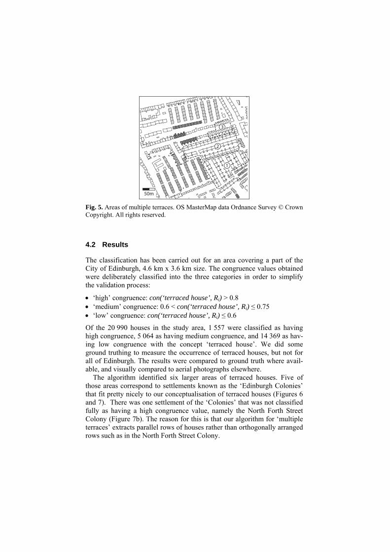
Fig. 5. Areas of multiple terraces. OS MasterMap data Ordnance Survey © Crown Copyright. All rights reserved.
4.2 Results
The classification has been carried out for an area covering a part of the City of Edinburgh, 4.6 km x 3.6 km size. The congruence values obtained were deliberately classified into the three categories in order to simplify the validation process:
• ‘high’ congruence: con(‘terraced house’, Ri) > 0.8 • ‘medium’ congruence: 0.6 < con(‘terraced house’, Ri) ≤ 0.75 • ‘low’ congruence: con(‘terraced house’, Ri) ≤ 0.6
Of the 20 990 houses in the study area, 1 557 were classified as having high congruence, 5 064 as having medium congruence, and 14 369 as hav-ing low congruence with the concept ‘terraced house’. We did some ground truthing to measure the occurrence of terraced houses, but not for all of Edinburgh. The results were compared to ground truth where avail-able, and visually compared to aerial photographs elsewhere.
The algorithm identified six larger areas of terraced houses. Five of those areas correspond to settlements known as the ‘Edinburgh Colonies’ that fit pretty nicely to our conceptualisation of terraced houses (Figures 6 and 7). There was one settlement of the ‘Colonies’ that was not classified fully as having a high congruence value, namely the North Forth Street Colony (Figure 7b). The reason for this is that our algorithm for ‘multiple terraces’ extracts parallel rows of houses rather than orthogonally arranged rows such as in the North Forth Street Colony.
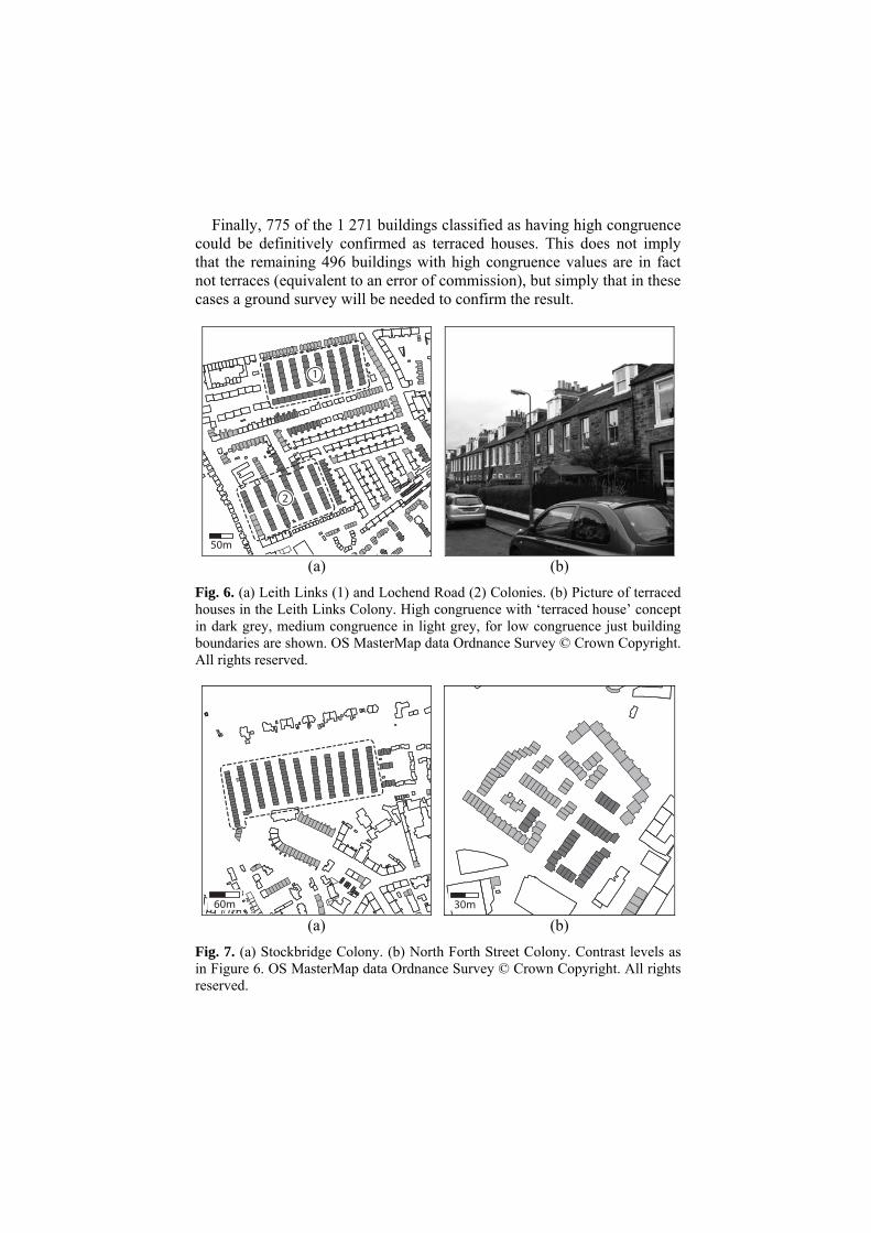
Finally, 775 of the 1 271 buildings classified as having high congruence could be definitively confirmed as terraced houses. This does not imply that the remaining 496 buildings with high congruence values are in fact not terraces (equivalent to an error of commission), but simply that in these cases a ground survey will be needed to confirm the result.
(a) (b)
Fig. 6. (a) Leith Links (1) and Lochend Road (2) Colonies. (b) Picture of terraced houses in the Leith Links Colony. High congruence with ‘terraced house’ concept in dark grey, medium congruence in light grey, for low congruence just building boundaries are shown. OS MasterMap data Ordnance Survey © Crown Copyright. All rights reserved.
(a) (b)
Fig. 7. (a) Stockbridge Colony. (b) North Forth Street Colony. Contrast levels as in Figure 6. OS MasterMap data Ordnance Survey © Crown Copyright. All rights reserved.
5 Discussion
5.1 Benefits
In general, the results generated are plausible. This research has shown how textual descriptions of urban patterns can be used to define an ontol-ogy that in turn can be used to inform the detection of these patterns, thus enabling enrichment of existing vector cartographic databases. Since the ontology makes the concepts and relations defining a spatial pattern ex-plicit, it can also be used to generate graphical representations such as the one seen in Figure 3 as well as textual descriptions (or metadata) about the extracted patterns. And finally, it follows trivially from Figure 3 that it would be easy to modify concepts in the ontology of the higher order con-cept ‘terraced house’, or add further low order concepts to it. For instance, it would be possible to accommodate cultural differences between proto-typical terraces in different regions or countries. Our ultimate aim is to ex-tend this framework such that a domain expert can define his/her concep-tualisation of any urban pattern as an ontology and has a useful set of low order patterns at hand that can be used to perform the detection process.
5.2 Difficulties
Operationalisation of concepts: The operationalisation of lower order patterns is not necessarily easy. One example is the concept ‘multiple ter-races’, which means that a larger number of rows of terraces are arranged regularly. Regularity itself is a loose term, and there are several ways of measuring it. We defined a regular arrangement of terraces as a group of at least three approximately parallel rows of houses. The generation of such groups involves creating a buffer to both sides of each main axis and inter-secting this buffer with other main axes. This works well for typical ter-raced houses (Figure 5), but more general definitions may be needed when different concepts are to be detected.
Another example is the derivation of alignments of houses. There exist various methods for grouping houses into alignments (Burghardt and Steiniger 2005; Christophe and Ruas 2002; Boffet 2001). They assume dif-ferent conceptualisations of the constitution of alignments and hence pro-duce different results. Therefore, the influence of the choice of implemen-tation of the low order concepts to the inference workflow and to the recognition performance has to be investigated in detail.
Thresholds: Some of the concepts involved setting a threshold (e.g. the area of the footprint of a building). Such crisp thresholds are rather unde-

sirable and could be improved using fuzzy membership functions (Ladner et al., 2003).
Defining a processing order: For complex concepts like terraced houses, a processing hierarchy has to be identified. The hierarchy defines the order of the inference of lower level concepts and their composition into higher level concepts. This is made difficult by the fact that lower level concepts in different sub-branches sometimes depend on each other. For example, the detection of areas of multiple terraces assumes that terraces have al-ready been detected, but in turn also inform the detection process of ter-raced houses. Since we turned our ontology manually into a detection process, these interdependencies could be accounted for. With respect to a more automated operationalisation process (which is desirable because domain experts are usually not experts in programming), we need more re-search on how we can formally model such interdependencies.
Alternative ways of concept inference: The method to calculate congru-ence values of composite concepts was given in § 2.3. The strengths are its simplicity, the fact that the output is a similarity (congruence) value in-stead of a hard classification, and the high level of transparency of the re-sults. Fuzzy logic would offer a similar but more complex approach.
Supervised classification methods (Steiniger et al. 2008) use training data to define characteristic properties of different classes, and hence there is no need to set thresholds. On the other hand, the performance of super-vised classification depends largely on the quality of the training samples used. Furthermore, it is our opinion that using ontologies can better inte-grate structural knowledge about concepts into the reasoning process and hence is better adapted to detecting complex concepts.
6 Conclusions
In this paper, we have advocated the use of ontologies to better inform the recognition of spatial patterns and structures in the urban environment from cartographic vector databases. We have explained how we envisage ontology-driven cartographic pattern recognition as a novel complement to traditional algorithmic and statistical pattern recognition. For the example of terraced houses, we have developed an ontology, implemented the cor-responding recognition procedure in Java, and validated it using OS Mas-terMap data.
There are several insights that can be gained from this work. Ontologies definitely render the recognition process more flexible (and extensible),

enable greater self-documentation, and make us better equipped to com-pose complex concepts from simple concepts as opposed to traditional al-gorithmic techniques. Despite the great potential of ontology-driven ap-proaches, they still represent a relatively unfamiliar approach in this application domain and hence pose a series of challenges for future re-search. Among the difficulties encountered in our study (§ 5) are the op-erationalisation of concepts; the proper way of dealing with thresholds and fuzziness; dealing with concept interdependencies when integrating simple to complex concepts; and alternative ways of concept inference.
In the short term we plan the following extensions to this study: Com-plete ground truthing to completely validate our results; application of the procedure to other study areas; modification and/or extension of the ontol-ogy of terraced houses (e.g. to accommodate cultural differences); experi-ments using people to study where and how they visually detect terraces; and development and implementation of ontologies of other house types (semi-detached, detached, tenement). In the mid term we envisage first in-tegrating the different building ontologies to a ‘house’ ontology, and later to an ontology of even higher order concepts such as ‘residential area’. And in the long term we hope to develop methods for the automated ‘de-ployment’ of ontologies, which will facilitate the application of ontology-driven pattern recognition for domain experts.
Acknowledgements
Funding of the first author by the Swiss State Secretariat for Education and Research (SER) through COST Action C21 (project ORUS, grant no. C05.0081) is gratefully acknowledged. The OS MasterMap data used in this study were made available to the University of Edinburgh through Digimap. We are also grateful to the Institute of Geography for hosting an extended stay of the Zurich researchers during November 2007.
References
Agarwal P (2005) Ontological Considerations in GIScience. International Journal of Geographical Information Science 19(5):501–536
Anders K-H, Sester M (1997) Methods of Data Base Interpretation – Applied to Model Generalization from Large to Medium Scale. In: Förstner W, Plümer L (eds) Semantic Modeling for the Acquisition of Topographic Information from Images and Maps: SMATI 97. Birkhäuser, Basel, pp 89–103

Anders K-H, Sester M, Fritsch D (1999) Analysis of Settlement Structures by Graph-Based Clustering. SMATI’99 - Semantic Modelling for the Acquisition of Topographic Information from Images and Maps, 7th September, Munich, Germany
Barnsley MJ, Barr SL (1997) Distinguishing Urban Land-use Categories in Fine Spatial Resolution Land-cover Data using a Graph-based, Structural Pattern Recognition System. Computers, Environment and Urban Systems 21(3–4):209–225
Bergsdal H, Brattebø H, Bohne RA, Müller DB (2007) Dynamic Material Flow Analysis of Norway’s Dwelling Stock. Building Research & Information 35(5):557–570
Boffet A (2001) Méthode de création d'informations multi-niveaux pour la généra-lisation cartographique de l'urbain. Ph.D. thesis, Université de Marne-la-Vallée
Brassel KE, Weibel R (1988) A Review and Conceptual Framework of Auto-mated Map Generalization. International Journal of Geographical Information Systems 2(3):229–244
Burghardt D, Steiniger S (2005) Usage of Principal Component Analysis in the Process of Automated Generalisation. Proceedings of the 22nd International Cartographic Conference, 11–16 July, A Coruna, Spain
Camacho-Hübner E, Golay F (2007) Preliminary Insights on Continuity and Evo-lution of Concepts for the Development of an Urban Morphological Process Ontology. In: Teller J, Lee JR, Roussey C (eds) Ontologies for Urban Devel-opment. Studies in Computational Intelligence, Vol. 61. Springer, Berlin Hei-delberg New York, pp 95–108
Christophe S, Ruas A (2002) Detecting Building Alignments for Generalisation Purposes. In: Richardson DE, van Oosterom P (eds) Advances in Spatial Data Handling (10th International Symposium on Spatial Data Handling). Springer, Berlin Heidelberg New York, pp 419–432
Conzen MRG (1969) Alnwick, Northumberland: A Study in Town-plan Analysis. Institute of British Geographers, London
Dutton G, Edwardes A (2006) Ontological Modeling of Geographical Relations for Map Generalization. Proceedings of the 9th ICA Workshop on Generalisa-tion and Multiple Representation, 25th June, Portland, USA
Fonseca FT, Egenhofer MJ, Agouris P, Câmara G (2002) Using Ontologies for In-tegrated Geographic Information Systems. Transactions in GIS 6(3):231–257
Gruber TR (1993) A Translation Approach to Portable Ontology Specifications. Knowledge Acquisition 5(2):199–220
Guarino N (1998) Formal Ontology and Information Systems. In: Guarino N (ed) Formal Ontology in Information Systems. Proceedings of FOIS'98. IOS Press, Amsterdam, pp 3–15
Haarslev V, Möller R, Schröder C (1994) Combining Spatial and Terminological Reasoning. In: KI-94: Advances in Artificial Intelligence: 18th German An-nual Conference on Artificial Intelligence. Lecture Notes in Artificial Intelli-gence 861. Springer, Berlin Heidelberg New York, pp 142–153
Heinzle F, Anders K-H (2007) Characterising Space via Pattern Recognition Techniques: Identifying Patterns in Road Networks. In: Mackaness WA, Ruas A, Sarjakoski LT (eds) Generalisation of Geographic Information: Carto-graphic Modelling and Applications. Elsevier Science, Amsterdam et al., pp 233–253
Jones AN, Larkham PJ (1991) Glossary of Urban Form. Historical Geography Re-search Series no.26. Institute of British Geographers, London
King AD (1994) Terminologies and Types: Making Sense of Some Types of Dwellings and Cities. In: Franck KA, Schneekloth LH (eds) Ordering Space – Types in Architecture and Design. Van Nostrand Reinhold, New York et al., pp 127–144
Klien E, Lutz M (2005) The Role of Spatial Relations in Automating the Semantic Annotation of Geodata. In: Cohn AG, Mark DM (eds) Spatial Information Theory, International Conference, COSIT 2005. Lecture Notes in Computer Science 3693. Springer, Berlin Heidelberg New York, pp 133–148
Kovacs K, Zhou S (2007) Key Challenges in Expressing and Utilising Geospatial Semantics at Ordnance Survey. Presentation held at the European Geoinfor-matics Workshop, 7–9 March, Edinburgh, UK. http://www.nesc.ac.uk/action/esi/download.cfm?index=3411 Accessed 22.01.2008
Kulik L, Duckham M, Egenhofer MJ (2005) Ontology-Driven Map Generaliza-tion. Journal of Visual Languages and Computing 16(3):245–267
Ladner R, Petry FE, Cobb MA (2003) Fuzzy Set Approaches to Spatial Data Min-ing of Association Rules. Transactions in GIS 7(1):123–138
Mackaness WA (2006) Automated Cartography in a Bush of Ghosts. Cartography and Geographic Information Science 33(4):245–256
Mackaness WA, Ruas A (2007) Evaluation in the Map Generalisation Process. In: Mackaness WA, Ruas A, Sarjakoski LT (eds) Generalisation of Geographic Information: Cartographic Modelling and Applications. Elsevier Science, Amsterdam, pp 89–111
Müller DB (2006) Stock Dynamics for Forecasting Material Flows – Case Study for Housing in The Netherlands. Ecological Economics 59(1):142–156
Redbrake D, Raubal M (2004) Ontology-Driven Wrappers for Navigation Ser-vices. In: Toppen F, Prastacos P (eds) AGILE 2004, 7th Conference on Geo-graphic Information Science. Crete University Press, Heraklion, pp. 195–205
Regnauld N (1996) Recognition of Building Clusters for Generalization. In: Kraak MJ, Molenaar M (eds) Advances in GIS Research II: Proceedings of the Sev-enth International Symposium on Spatial Data Handling. Taylor & Francis, London, pp 4B.1–4B.14
Ruas A, Plazanet C (1996) Strategies for Automated Generalization. In: Kraak MJ, Molenaar M (eds) Advances in GIS Research II: Proceedings of the Sev-enth International Symposium on Spatial Data Handling. Taylor & Francis, London, pp 6.1–6.17
Santos P, Bennett B, Sakellariou G (2005) Supervaluation Semantics for an Inland Water Feature Ontology. Proceedings of the Nineteenth International Joint

Conference on Artificial Intelligence, July 30 – August 5, Edinburgh, Scot-land
Sester M (2000) Knowledge Acquisition for the Automatic Interpretation of Spa-tial Data. International Journal of Geographical Information Science 14(1):1–24
Simpson J, Weiner E (1989) The Oxford English Dictionary. Oxford University Press, Oxford
Steiniger S (2007) Enabling Pattern-aware Automated Map Generalization. Ph.D. thesis, University of Zurich
Steiniger S, Lange T, Burghardt D, Weibel R (2008) An Approach for the Classi-fication of Urban Building Structures Based on Discriminant Analysis Tech-niques. Transactions in GIS 12(1):31–59
Thomson T (2006) Cartographic Data Analysis and Enhancement. Objective 1: Analysis of Functional Information – Needs & Opportunity Analysis, User Requirements, and Use Case. Technical Report, Dept. of Geomatics Eng., University College London
Winter S (2002) Ontologisches Modellieren von Routen für mobile Navigations-dienste. In: Kelnhofer F, Lechthaler M (eds) TeleKartographie und Location-Based Services. Schriftenreihe der Studienrichtung Vermessungswesen und Geoinformation, Technische Universität Wien, pp 111–124