where is that satellite? - exo.netpauld/workshops/spacescience/satellite scale.pdf · surface of...
TRANSCRIPT

Linda ShoreExploratorium Teacher Institute
page 1© 2008 Exploratorium, all rights reserved
Where Is That Satellite?Lots of stuff orbits the Earth. Do you know where they are? This activity will help your studentsbetter understand the size and scale of the various satellites in space that they use everyday.
Materials Needed• A 12 inch diameter earth globe• Rulers, tape measures, and meter sticks• Calculators
What To Do:• Show student the 12-inch (30 cm) diameter
Earth globe. Remind the students that theEarth has a diameter of about 12,700 km. Sowe are going to be working with a scale where
12,700 km/ 30 cm = X/1 cmX = 12700 km (1cm/30cm)
X = 12,700 km/30X = 423 kmX ~ 400 km
So, in this activity, where the Earth is the size of theglobe, 1 cm = 400 km .
• The table below describes the orbits of several satellites. Assign groups of students to one of theorbiting satellites and pass out the flash card attached. Their task will be to show, using theglobe, where the satellite orbits (or, in the case of Sputnik 1, used to orbit) the earth.
Satellite Distance From Earth’sSURFACE
#Orbitsin 24 hrs
Orbit Type/Notes
Sputnik 1
InternationalSpace Station
Hubble SpaceTelescope
Satcom 1
RadioStat
Molniya 1-4
GeostationaryOperationalEnvironmentalSatellite (GOES)
130 km –600 km
350 km
600 km
36,000 km
24,000 km – 47,000 km
1500 km – 40,000 km
36,000 km
15.0
15.8
14.8
1.0
1.0
2.0
1.0
Was in a low earth, elliptical orbitwith an eccentricity of 0.05
In low earth, circular orbit witheccentricity of 0.
In low earth, circular orbit witheccentricity of 0.
In geostationary orbit; responsible forthe broadcast of cable television.Launched in 1975. Eccentricity = 0.
In highly elliptical tundra orbit;broadcasts “Sirius Satellite Radio”;Eccentricity = 0.27
In highly elliptical molniya orbit.Responsible for military and televisioncommunication in Russia. Eccentricity= 0.70
In geostationary orbit; weathersatellite used by the National WeatherService for imaging, data collection,and meteorological research.Eccentricity = 0.

Linda ShoreExploratorium Teacher Institute
page 2© 2008 Exploratorium, all rights reserved
• Once student teams have determined the scaled distance that their satellite orbits above thesurface of the earth globe, have each group show the rest of the class where the satellite islocated in space.
What Else Can You Do?• The table also lists the eccentricities of the orbits of these satellites. Some orbits are very
elliptical (oval shaped with eccentricities near 1.0) while some are circular (eccentricities =0). Have students draw the shapes of these orbits, placing the earth at one of the foci of theellipse (see attached handout, “Orbits of the Planets and Satellites”)
• Have student groups conduct research on the satellites they were assigned. Have groupswrite reports, develop multimedia presentations, or create poster boards that describe thehistory of the satellite, its purpose, and its orbital characteristics.
What’s Going On?Students may be surprised by three things after doing this activity: (1) that some satellites orbit veryclose to the earth’s surface while others orbit very far, (2) that satellite orbits are not always circular;some are noticeably elliptical, and (3) some satellites orbit once every 24 hours along the equator(hovering above one geographical location on the earth). How a satellite orbits the earth haseverything to do with its purpose. For example, weather satellites that take films of the planet’scloud cover need to hover above a fixed point on the earth. These satellites need to have ageosynchronous orbit parallel to the earth’s equator.
Communications satellites that service extreme northern latitudes, like Russia, do not function wellin geosynchronous orbits that would place them very low in the Russian sky where signalinterference would be a problem. Instead, Russians place their satellites in very elliptical orbits,called “Molniya” orbits. Their satellites pass close to the earth (where they travel at high speeds) andtravel far from the earth (where they travel at very slow speeds). For eight out of the 12 hours thatit takes these satellites to complete one orbit, these objects are in a nearly stationary position aboveRussian land; the other four hours are spent whipping past the earth. Three Molniya Satellites, takingturns at farthest approach, are used to cover communications in a 24-hour period. The figurebelow shows a Molniya orbit and a geosynchronous (also called a geostationary) orbit.
So What?Source: http://sattechnology.wordpress.com/
“A satellite can be defined as any object, either manmade or naturally occurring, that orbits aroundsomething else. For example, the moon orbits around Earth and is thus a satellite. The Earth orbitsaround the sun and is a satellite of the sun. Other examples of naturally occurring satellites includecomets, stars, asteroids, and other planets.
Most are more familiar with the term satellite in relationship to the many satellites that circulate theearth. Sputnik was the first artificial satellite, launched in 1957 by the Soviet Union. The launchingof Sputnik is almost analogous for the beginning of the Space Race that followed between the USand the USSR. In today’s climate, however, many countries have found that a cooperative effort ismore successful in space exploration and studies. The International Space Station, a satellite that

Linda ShoreExploratorium Teacher Institute
page 3© 2008 Exploratorium, all rights reserved
orbits earth, is currently the largest manmade satellite in Space, and represents the cooperativeeffort of numerous countries.
Manmade satellites are classified by types, and there are over ten types. Some of the main types ofsatellite used today include astronomical satellites, communication satellites, earth observationsatellites, weather satellites and space stations. Other types of satellites include those used tomonitor earth from a military standpoint, and biosatellites, which may carry animals or otherlifeforms for the purpose of research on earth lifeforms in space. Navigational satellites are nowpopular and form a vital part of the global positioning system (GPS) now available in many cars.A manmade satellite can serve many purposes. We currently use many different types of satellitesystems to track things like weather, to make our cell phones work, to find out how to getsomewhere and to gather more information about earth, and about the galaxy.
About 5000 manmade satellites currently orbit earth, and on clear dark nights, it’s often possible tosee one in the night sky. Of course, viewing a planet, the stars, or comets is also viewing a satellite.We also must remember, we live on a satellite, and are not stationary in the sky.”
Linda ShoreExploratorium Teacher Institute
page 4© 2008 Exploratorium, all rights reserved
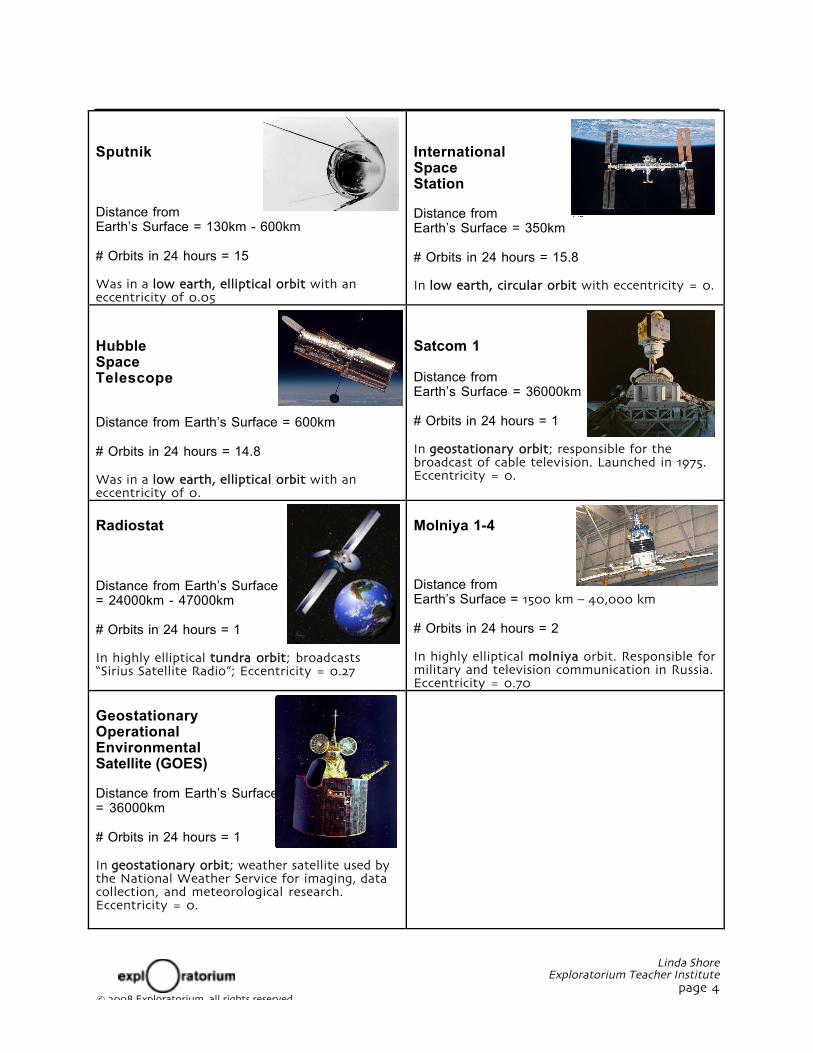
Sputnik
Distance fromEarth’s Surface = 130km - 600km
# Orbits in 24 hours = 15
Was in a low earth, elliptical orbit with aneccentricity of 0.05
InternationalSpaceStation
Distance fromEarth’s Surface = 350km
# Orbits in 24 hours = 15.8
In low earth, circular orbit with eccentricity = 0.
HubbleSpaceTelescope
Distance from Earth’s Surface = 600km
# Orbits in 24 hours = 14.8
Was in a low earth, elliptical orbit with aneccentricity of 0.
Satcom 1
Distance fromEarth’s Surface = 36000km
# Orbits in 24 hours = 1
In geostationary orbit; responsible for thebroadcast of cable television. Launched in 1975.Eccentricity = 0.
Radiostat
Distance from Earth’s Surface= 24000km - 47000km
# Orbits in 24 hours = 1
In highly elliptical tundra orbit; broadcasts“Sirius Satellite Radio”; Eccentricity = 0.27
Molniya 1-4
Distance fromEarth’s Surface = 1500 km – 40,000 km
# Orbits in 24 hours = 2
In highly elliptical molniya orbit. Responsible formilitary and television communication in Russia.Eccentricity = 0.70
GeostationaryOperationalEnvironmentalSatellite (GOES)
Distance from Earth’s Surface= 36000km
# Orbits in 24 hours = 1
In geostationary orbit; weather satellite used bythe National Weather Service for imaging, datacollection, and meteorological research.Eccentricity = 0.

Linda ShoreExploratorium Teacher Institute
page 5© 2008 Exploratorium, all rights reserved
Orbits of the Planets and SatellitesThink the orbits of the planets are cigar shaped ellipses? Think satellite orbits are always circular?Think again.
Materials Needed (for every student)• push pins• thread or thin string• butcher paper (or other large sheet)• ruler• pencil or pen• Styrofoam board or thick cardboard
BackgroundWhat is an ellipse? An ellipse is a curve for which the sum of the distances from any point along thecurve to each foci inside the ellipse are always equal. Figure 1 below shows the geometry of anellipse. Note that ellipses have two foci, a semi-major axis (a), and a major axis (2a). The eccentricity(e) of an ellipse is the ratio of the distance between the two foci and the length of the major axis.
e = (Distance between the foci) ÷ (Length of the major axis)
We will use this information to investigate the eccentricity (e) of orbits of objects in our solarsystem.
a
aefocusfocus
length of string = 2a(1 + e)
Figure 1
What To Do• Pick one of the planets, comets, or satellites listed in Table 1.
• Note that the table lists some of the dimensions in astronomical units. One astronomical unitequals the average distance between the earth and the sun. If you try to draw your ellipse toscale, you will have a problem finding enough paper. So, you should choose a scale so that youcan easily fit your ellipse on a piece of butcher paper. You can try 10 cm = 1 A.U. for the innerplanets (Mercury to Mars). For the outer planets and the comets (Jupiter to Pluto) you mightwant to try 1 cm = 1 A.U.
• The satellite dimensions are given in kilometers. For these objects you might want to pick ascale where 1cm = 1000km.
• Place a sheet of butcher paper on the Styrofoam board. Using the information supplied belowfor your planet/comet and the scaling factor you chose, place pins a distance of 2ae apart andcut a length of string equal to 2a + 2ae.

Linda ShoreExploratorium Teacher Institute
page 6© 2008 Exploratorium, all rights reserved
• Put the loop around the pins. Using a pencil as shown in Figure 2, sketch out the shape of theorbit.
Figure 2
• Compare the orbit of your planet/comet to the other orbits drawn by pother members of theclass. How elliptical is your orbit? Is it cigar shaped? An oval? Or is your orbit nearlycircular? Are you surprised?
What’s Going On?Because of misleading diagrams often seen in books other astronomy reference materials, mostpeople believe that the orbits of the planets are highly elliptical – almost cigar shaped. In fact, theorbits of the planets are very nearly circular.
The problem with this misconception about planetary orbits is that it leads many students toerroneously believe that the cause of the earth’s seasons has something to do with changing distanceto the sun. After all, if the earth’s orbit were as elliptical as these students believe, we would in factbe much closer to the sun during certain times of the year and much further away at other times.
The fact is that the earth’s orbit is very close to being circular. At our closest approach to the sun,we are 147,000,000 kilometers away. At farthest approach to the sun, we are 152,000,000 kilometersaway. Our distance from the sun varies by only 3% – not enough to account for changes in how theearth is heated by the sun during the year.
Another misconception held by some students is that all man-made satellites (e.g. those used forcommunications or science research) have circular orbits around the earth. Some do, but many donot. Some satellites need to hover above the exact same geographical point above the surface of theEarth, for example the satellites used by the National Weather Service to image the Earth. Thesesatellites are in geosynchronous orbit, meaning that the orbital periods are equal to (or “in synch”)with the earth’s spin (it takes these satellites 24 hours to complete one orbit around the earth).Satellites in geosynchronous orbit have circular orbits with eccentricities = 0. Examples of satellitesin geosynchronous orbit include SATCOM 1 (used to broadcast cable television), and GeostationaryOperational Environmental Satellite (GOES).
Some satellites take advantage of the orbital properties of highly elliptical orbits to hover above acertain region of the earth. When a satellite orbits in an elliptical orbit, it’s speed will be slowestwhen the satellite is furthest from the focus (the earth); fastest when the satellite is closest to earth.The higher the eccentricity, the flatter the ellipse and larger the differences in orbital speed. RussianMolniya Satellites (used in communications) orbit in these kinds of highly elliptical orbits. They passvery close to the earth (where they travel at high speeds) and travel very far from the earth (wherethey travel at very slow speeds). About 8-hours of these 12-hour orbits are spent far from the earthin nearly stationary positions above Russian land; the other 4-hours are spent whipping past theearth. Three Molniya Satellites, taking turns at farthest approach, are used to cover communicationsin a 24-hour period.

Linda ShoreExploratorium Teacher Institute
page 7© 2008 Exploratorium, all rights reserved
Table 1: Orbital dimensions of some objects in our solar system
Name ofBody
eeccentricity
a(A.U.)
2ae = dist between foci(A.U.)
2a+2ae = string length(A.U.)
OBJECTSORBITING SUN
Mercury
Venus
Earth
Mars
AsteroidApollo
AsteroidEros
Jupiter
Saturn
Uranus
Neptune
Halley’s Comet
Pluto
OBJECTSORBITINGEARTH
Sputnik 1
InternationalSpace Station
Hubble SpaceTelescope
Satcom 1
RadioStat 1-4
Molniya 1-4
GOES
0.200
0.001
0.017
0.093
0.56
0.22
0.048
0.056
0.047
0.008
0.97
0.250
eeccentricity
0.05
0
0
0
0.27
0.70
0
0.38
0.72
1.00
1.52
1.47
1.46
5.20
9.54
19.18
30.06
17.90
39.44
a(km)
7000
6700
6700
42000
42000
27000
42000
0.150
0.001
0.034
0.283
1.65
0.64
0.499
1.068
1.803
0.481
34.73
19.72
2ae = dist between foci(km)
700
0
0
0
22680
38000
0
0.91
1.44
2.03
3.32
4.59
3.56
10.90
20.15
40.16
60.60
70.53
98.60
2a+2ae = string length(km)
14700
13400
13400
84000
77000
92000
84000

Linda ShoreExploratorium Teacher Institute
page 8© 2008 Exploratorium, all rights reserved