when good lawyers write bad history: unreliable evidence...
TRANSCRIPT
When Good Lawyers Write Bad History: Unreliable Evidence andthe South China Sea Territorial Dispute
Bill Hayton
Asia Programme, Chatham House, London, United Kingdom
ARTICLE HISTORYReceived 18 July 2016Accepted 5 September 2016
ABSTRACTThe recent award by an arbitral tribunal in a case brought by thePhilippines against China gives lawyers reason to reexamine thehistorical evidence put forward by claimants in the South China Seadisputes. While the Tribunal was barred from considering territorial orboundary questions, it did cast doubt on the historical narrative rulethat China has asserted in support of its claims. Fresh evidence fromother sources also suggests that discussions of these matters need tomove beyond arguments put forward in a small number of paperspublished more than thirty years ago. A close examination of thereferences used in those papers shows that they relied upon highlypartisan Chinese sources. Recent historical research has produced newfacts about the development of the competing territorial claims in theSouth China Sea, but international legal discourse has yet to take thesefindings into account. This article examines some of the key works inthe field and calls for them to be reassessed and for future discussionof the disputes to be based upon verifiable and contextualizedevidence rather than on nationalist assertions.
KEYWORDSHistoric evidence; SouthChina disputes; sovereigntyclaims
Introduction
The South China Sea disputes involve some of the most vexed interstate territorial argu-ments of the early twenty-first century. The disputes involve competing territorial claims torocks and reefs asserted by China (both the Republic of China and People’s Republic ofChina), Malaysia, the Philippines, Vietnam, and Brunei. These are complicated by furtherdisputes over the maritime entitlements of certain features; the delimitation of maritimezones; and whether states can restrict the operation of military vessels in national waters.
The disputes are particularly critical because of the strategic importance of the SouthChina Sea to China, the United States, and other states. Some observers have calculated thatmore than $5 trillion worth of trade passes through the South China Sea each year.1 Thearea is also a vital transit route for military vessels between Asia, the Middle East, andEurope. In the eyes of many Western analysts, the South China Sea has also become a criticaltesting ground for China’s emergence as a great power. They regard China’s attitude to the
CONTACT Bill Hayton [email protected] Asia Programme, Chatham House, 10 St James’s Square, London SW1Y4LE, United Kingdom.
Color versions of one or more of the figures in this article can be found online at www.tandfonline.com/uodl.© 2017 Taylor & Francis Group, LLC
OCEAN DEVELOPMENT & INTERNATIONAL LAW2017, VOL. 48, NO. 1, 17–34http://dx.doi.org/10.1080/00908320.2017.1265362

1982 United Nations Convention on the Law of the Sea (UNCLOS)2 as a test of whether thecountry’s leadership will, in the future, follow the existing rules of the international systemor challenge them.3
In an effort to try to simplify the disputes, the Republic of the Philippines brought acase against the People’s Republic of China to an arbitral tribunal constituted underAnnex VII of UNCLOS. While the tribunal was unable to rule on matters of territoryor maritime delimitation, it did clarify the question of whether China could assert “his-toric rights” in the South China Sea. According to the Award, issued on 12 July 2016:“The Tribunal considers the text and context of the Convention to be clear in supersed-ing any historic rights that a State may once have had in the areas that now form partof the exclusive economic zone and continental shelf of another State.”4 In other words,China has no claim to rights over the resources of the sea beyond those provided for inUNCLOS. This direct negation of the historic narrative that underpins China’s ambigu-ous maritime claim in the South China Sea should be a spur for a more critical reex-amination of that narrative.
The South China Sea disputes only began to take shape in the 1900s. While the modernclaimants may assert earlier evidence in support of their cases, it is clear that there was nostate-to-state dispute over any of the islands before the twentieth century. This article showsthat the first such dispute arose in early 1909 between Qing China and Japan over PratasIsland, following the discovery of a Japanese merchant engaged in mining guano there. Thisresulted in China buying out the merchant and Japan recognising China’s claim in late 1909.The episode also led China to stake a claim to at least some of the Paracel Islands in June1909.5 The dispute expanded in the 1920s and 1930s, with France, various Chinese authori-ties, and Japan pursuing competing claims initially in the Paracels and later the SpratlyIslands.
The history of the disputes is strongly disputed by the rival claimants, and this hasaffected academic analysis of the claims. The search for a clear narrative has been hinderedby government secrecy, poor access to archives, and language barriers. Debate within theinternational law and international relations communities has suffered from a lack ofengagement with other disciplines; in particular, the insights from historical research havebeen neglected. However, digitization has made many hitherto inaccessible archives easilyavailable for the first time, and it is now relatively simple for researchers to critically investi-gate previously asserted narratives.
In attempting to understand the origins of the disputes, many legal writers havetaken texts produced by one side or other in the early twentieth century to be proof offacts. This article argues that many of those texts should be better understood asattempts to create a claim rather than as proof of preexisting claims. In trying to cometo a full understanding of the origins of the disputes it is necessary to remain skepticalof evidence put forward by all sides. This article shows, through detailed analysis of thereferences used in some of the key academic papers and comparison with the findingsfrom recent historical research, that foundational references for discussion of the SouthChina Sea within the international law communities have major evidential failings.These failings led those authors, “good lawyers,” to write “bad history”—accounts thatare at odds with verifiable evidence. They have adopted unsupported arguments thatowe more to nationalist wishful thinking than neutral consideration. This “bad history”has led them to a series of erroneous conclusions.
18 B. HAYTON
The first English-language analyses
There was little or no English-language academic analysis of the South China Sea disputesbefore 1974. The first writings appeared only after the “Battle of the Paracels” in January1974, when Chinese forces invaded the Vietnamese-occupied western half of the ParacelIslands. The first legal works were written by Chinese academics working in the UnitedStates: Tao Cheng in the student-edited Texas International Law Journal in 1975,6 andHungdah Chiu, who worked with his Korean colleague, Choon-Ho Park, on a paper pub-lished in this journal the same year.7 These papers are still influential today. Most subsequentlegal works on the South China Sea disputes either refer to them directly or rely on worksbased upon them. Their significance can be judged from the fact that a 2014 study of theSouth China Sea disputes produced by the U.S. Center for Naval Analyses, a federally fundedresearch and development center in the United States, quoted Cheng 26 times and Chiu andPark more than 60 times.8
In subsequent years, other academics joined the discourse—notably the German sinolo-gist Dieter Heinzig9 and the American geographer Marwyn Samuels.10 These texts set theagenda for almost all the subsequent writing on the South China Sea disputes within the dis-ciplines of political science, international relations, and international law. Google Scholarcalculates that Chiu and Park’s paper has been cited by 79 others, and Samuels’s book by143. A second round of writing in the 1990s—following China’s occupation of six of theSpratly Islands in 1988 and of Mischief Reef in 1994—tended to use the earlier works as theirmain sources of historical background. Works that quote these authors include one by BrianMurphy from 199411 and those by Jianming Shen in 199712 and 200213, which are, in turn,quoted by 34 and 35 others, respectively, and by Chi-kin Lo, whose 1989 book14 is cited by111 other works. These references are probably the tip of the iceberg since some descendentworks have been re-cited hundreds of times. For example, the 2014 book by Stefan Talmonand Jia Bing Bing on the case brought by the Philippines against China15 also ascribes keyelements of historical evidence to references from all of the books and papers just decribed.
What these texts all have in common is that they used, as their basic references, Chinesemedia articles that were published at times when discussion about the South China Sea washighly politicized. They were not works of historical scholarship but partisan assertions ofclaim with minimal referencing. Cheng’s 1975 paper16 relied primarily upon Chinese sourceswith additional information from U.S. news media. The most important were editions of theShanghai-based Wai Jiao Ping Lun [Wai Chiao P’ing Lun] (Foreign Affairs Review) from1933 and 1934 and Xin Ya Xiya yue kan [Hsin-ya-hsi-ya Y€ueh-k’an] (New Asia Monthly)from 1935. These were supplemented by material from a 1974 edition of the Hong Kong-based news magazine Ming Pao Monthly. Other newspapers quoted included a 1933 editionof Guo Wen Zhou Bao [Kuo Wen Chou Pao] (National News Weekly), published in Shang-hai, Renmin Ribao [Jen Ming Jih Pao] (People’s Daily), and the New York Times. Cheng didnot reference any French, Vietnamese, or Philippine sources, with the exception of a 1933article from La Geographie that had been translated and reprinted inWai Jiao Ping Lun.
The 1975 paper by Hungdah Chiu and Choon-Ho Park17 relied upon similar sources. Incrucial sections it quotes evidence based upon articles published in 1933 in Wai Jiao PingLun18 and Wai Jiao Yue Bao [Wai-chiao y€ueh-pao] (Diplomacy Monthly),19 and Fan ZhiYue Kan [Fan-chih y€ueh-k’an] (Geography Monthly) from 1934,20 as well as Guo Wen ZhouBao and the Chinese government’s own Wai Jiao Bu Gong Bao [Wai-chiao-pu kung-pao]
OCEAN DEVELOPMENT & INTERNATIONAL LAW 19

(Gazette of the Ministry of Foreign Affairs).21 It supplements this information with materialgathered by a geographer employed by the Republic of China Ministry of the Interior, ZhengZiyue [Cheng Tzu-y€ueh], and published as Nanhai Zhudao Dili Zhilue [Nan-hai chu-tao ti-lichih-lueh] (General Records on the Geography of Southern Islands) in 194722 and Republic ofChina government statements from 195623 and 1974.24
Chiu and Park use some Vietnamese references, notably eight press releases or fact sheetsprovided by the Embassy of the Republic of Vietnam in Washington. They also refer tosome “unpublished material in the possession of the authors.” However, the vast majority oftheir sources are from the Chinese media.
Writing a year later, Heinzig25 relied, in particular, on editions of two Hong Kong-basedpublications published in the aftermath of the Paracels incident and written in support ofChina’s claim: Qishi Niandai [Ch’i-shih nien-tai] (Seventies Monthly) and Ming Bao [MingPao] Monthly,26 published in March and May 1974, respectively. The pattern set by Cheng,Chiu and Park, and Heinzig was then repeated in Marwyn Samuels’s book. Samuels himselfacknowledges the Chinese bias of his sources in the book’s introduction, when he states:
this is not a study primarily either in Vietnamese or Philippine maritime history, ocean policyor interests in the South China Sea. Rather, even as the various claims and counterclaims aretreated at length, the ultimate concern here is with the changing character of Chinese oceanpolicy.27
Compounding the issues, Samuels acknowledges that his Asian research was primarily inTaiwanese archives. However, crucial records relating to the Republic of China’s actions inthe South China Sea in the early twentieth century were only declassified in 2008/2009, longafter his work was published.28
The context of these sources is critical. The year 1933 was when France formally annexedseveral features in the Spratly Islands—provoking widespread anger in China. The monthsafter the French announcement, on 14 July 1933,29 was the point when Chinese intellectualsand government officials began a concerted effort to try to define and establish evidence fora claim to the features in the South China Sea. In 1956 a Philippine businessman, TomasCloma, claimed most of the Spratlys for his own independent country of “Freedomland”—provoking counterclaims by the Republic of China, the People’s Republic of China, and theRepublic of Vietnam; and 1974 was the year of the Paracels incident. Newspaper articlespublished during these three periods cannot be assumed to be neutral and dispassionatesources of factual evidence. Rather, they should be expected to be partisan advocates of par-ticular national viewpoints. This is not to say they are incorrect, but it would be prudent toverify their claims with primary sources. This is not something that the authors just citedappear to have done.
Over the past four decades, new sources of information about the history of the SouthChina Sea have been tapped and new evidence has come to light. As a result, it is now clearthat all the works mentioned in the preceding suffer from major problems. Although excel-lent lawyers, these authors were not good historians. They relied upon untrustworthy sour-ces and failed to take the context and meaning of certain texts into account when they drewconclusions. Bad or incomplete history led to poor analysis. These problems were subse-quently reproduced and propagated in many more analyses and to some extent have becomethe orthodox account of the development of the disputes. It is time that they werereexamined.
20 B. HAYTON

Pre-nineteenth-century history
There is not space here to cover all the claims the writers made about events before the nine-teenth century. In summary, the accounts by Cheng, Chiu and Park, and Samuels share thecommon assumption that China was always the dominant naval, trading, and fishing powerin the South China Sea. Cheng, for example, writes: “It has been an important part of the searoute from Europe to the Orient since the 16th century, a haven for fishermen from theHainan Island, and the gateway for Chinese merchants from south China to Southeast Asiasince earlier times.”30
Recent empirically based histories of the South China Sea suggest the situation was muchmore complex. Works by the historians Leonard Bluss�e,31 Derek Heng,32 Pierre-Yves Man-guin,33 Roderich Ptak,34 Angela Schottenhammer,35 Nicholas Tarling,36, and Geoff Wadeand Li Tana37 have revealed a much more heterogeneous usage of the South China Sea inthe premodern period. Chinese vessels and merchants played almost no role in seabornetrade until the 10th century, and even after that were never dominant but shared the areawith Malays, Indians, Arabs, and Europeans. A recent paper by an expert maritime archaeol-ogist, reviewing the history of discovered wrecks in the South China Sea and Southeast Asia,states:
The Southeast Asians, in their lashed-lug ships, gained many centuries of knowledge of theislands and reefs in the South China Sea before other seafarers ventured into these waters.Towards the end of the first millennium, Arab and Indian traders voyaged through the SouthChina Sea, probably under the guidance of Southeast Asian pilots. It was not until the 11th cen-tury that Chinese junks took to the high seas to trade directly with Southeast Asian polities.38
Evidence from Chinese navigational instructions from the 15th and 17th centuries dem-onstrate that Chinese vessels deliberately avoided the reefs and islands in the center of theSouth China Sea. For example, a Chinese manuscript from the early Ming period, Shun FengXiang Song [Shun Feng Hsiang Sung] (Fair Winds for Escort), contains sailing instructionsfor about 100 voyages between China and points in East and Southeast Asia. This is thoughtto have been composed around 1430, toward the end of the Ming Dynasty’s naval epoch.This was the era when several navigators, including the most famous, Zheng He, sailed fromChina as far as East Africa. The routes laid down in Shun Feng Xiang Song clearly show thatnavigators avoided the center of the sea both for safety and in order to visit trading portsalong the coasts of what are now Vietnam, Malaysia, Brunei, and the Philippines.39 Therecently rediscovered “Selden Map,” thought to have been drawn in either Southeast Asia orcoastal China around 1620, shows almost exactly the same arrangement of routes. The chart,which covers most of East and Southeast Asia, is remarkably accurate in many respects butdistorted by a lack of measurements in the center of the South China Sea.40
Research by Francois-Xavier Bonnet41, Ulises Granados,42 and Stein Tonnesson43 showshow similar patterns persisted into the twentieth century. Contemporary accounts from theearly twentieth century demonstrate that the Chinese state had great trouble controlling itsown coast and was completely unable to project authority to islands hundreds of miles off-shore. For example, the inability of the Chinese authorities to control piracy in the WestRiver, inland from Canton/Guangzhou, prompted moves by the British authorities to estab-lish their own patrols in early 1908.44 A 1909 article in the Australian newspaper The Exam-iner relates that foreigners (“two Germans, one Japanese, and several Malays”) had begunmining operations on Hainan Island without the authorities finding out until much later. It
OCEAN DEVELOPMENT & INTERNATIONAL LAW 21
also records the presence of foreigners on the Paracels who had carved their names intotrees.45 Empirically based histories demonstrate that until the mid twentieth century theSouth China Sea was essentially ungoverned, except for the occasional interventions offoreign powers against piracy.
It was only in 1909, following the scandal surrounding the occupation of Pratas Island bya Japanese guano entrepreneur, Nishizawa Yoshiji, that the Chinese authorities becameinterested in the offshore islands.46 The discovery of his guano-mining venture on the island,in the context of antiforeigner feeling in China at the time, led to large-scale protests in sev-eral cities. Eventually, after consultations with the Japanese consul, the Chinese governmentpaid Mr. Nishizawa 130,000 Canton silver dollars to abandon his activities and he handedthe island over to Chinese control.47 The story was reported in detail throughout 1909 bythe North China Herald, South China Morning Post, and Singapore-based Straits Times,among other sources.48
Nineteenth- and twentieth-century evidence
There is more to be written about sources for the pre-modern history of the South ChinaSea, but the remainder of this article focuses on particular episodes in the modern period,since the late nineteenth century, examining the assertions made in the papers under reviewand testing them against new evidence.
The ambassador’s claim, 1876
To demonstrate how assertions based on unreliable evidence have passed down through theliterature, one need only examine what is sometimes said to be the earliest modern officialact of administration of any of the disputed South China Sea islands. In their 1997 bookSharing the Resources of the South China Sea, Valencia, Van Dyke, and Ludwig state: “In1876, the first formal act of a sovereignty claim was made, when China’s ambassador to Eng-land claimed the Paracel Islands as Chinese territory.”49 The authors reference a 1993 paperby Jon M. Van Dyke and Dale L. Bennett, which attributes the two claims to Samuels’sbook.50 Samuels, in turn, attributes this to two articles published in Ming Pao Monthly inMay 1974.51
However, an examination of the journal of the ambassador, Guo Songtao, which wastranslated and published in English by J. D. Frodsham in 1974, tells a different story. Theepisode comes early in his Shi Xi Ji Cheng (Travel Notes of an Envoy to the West), which waswritten to inform the Chinese imperial court about life outside China. After leaving HongKong on a P&O steamer, the Travancore, he writes, “Not far away to port [the left] lay theP’ai-la-su [Paracel] Islands which produce sea slugs, and coral, though not of the best qual-ity. These islands belong to China, but they are barren and uninhabited.”52 There are severalthings to note here. The most important is that this was an entry in the ambassador’s diary,not a formal diplomatic claim by a government. Second, he observes that the Paracels areuninhabited, and third, he uses a transliteration of the English name for the Paracels—because the modern Chinese name for the islands, Xisha, had not been coined at this point.Xisha (meaning West Sand) is a twentieth-century neologism. It also appears that everythinghe noted about the islands he learned from the passengers and crew of the Travancore, not
22 B. HAYTON

from Chinese sources. Indeed, the fact that Guo felt it necessary to mention the existence ofthe islands suggests that the Qing court was not previously aware of their existence.
The authors of the 1974 article in Ming Pao Monthly removed all these key elements ofthe passage from their text, thus changing its meaning entirely. The bowdlerized version wasadopted by Samuels, and then Van Dyke and Bennett, and then Valencia et al., and deployedin support of China’s claim to the islands. A detailed examination of the text shows that itdoes not support the conclusions that have subsequently been drawn from it—that theChinese government formally asserted a territorial claim to the Paracels in 1876.
The protest against German surveys of the Paracel Islands, 1883
According to Chiu and Park, “In 1883, the German government tried to survey the SpratlyIslands, but stopped when China protested.”53 They attribute this to a statement by theKuangtung [Guangdong] Provincial government in 1933, fifty years after the events inquestion. The reference was Cho Min, “The Triangular Relationship Among China, Franceand Japan and the Question of Nine Islands,” published in Wai Jiao Yue Bao (DiplomacyMonthly), vol. 3, no. 3 (Peiping [Beijing], September 15, 1933), p. 82, note 4.
It is clear from contemporary archive sources that the statement is erroneous. Germanrecords show that the two naval ships, SMS Freya and SMS Iltis, were not engaged in survey-ing the Spratly Islands. They were surveying the Paracels. At the time, Germany was lookingfor potential coaling stations for its embryonic East Asian empire. The Freya and Iltis sur-veyed the islands for three months a year between 1881 and 1883. A Chinese source refer-enced by the French historical geographer Francois-Xavier Bonnet attests that they did sowithout either seeking the permission of or incurring protest by the Chinese government.54
The German Admiralit€at subsequently published, in 1885, a detailed and comprehensivechart of the Paracels,55 which was copied and republished in the same year by the Britishand French hydrographic services.56 There is no contemporary evidence that the Germansurveyors changed their plans because of objections from the Chinese authorities. The claimthat an 1883 protest was an assertion of Chinese sovereignty over the Spratly Islands is notsupported by any archival evidence.
The Sino–French convention, 1887
According to Chiu and Park:
After Vietnam (Annam) became a protectorate of France in 1884, a Convention respecting theDelimitation of the Frontier between China and Tonkin (Vietnam) was signed on June 26,1887.Article 3 of the Convention provided:Au Kouang-Tong…. Les ıles qui sont a Test de meridien de Paris 105� 43, de longitude est,c’est-a-dire de la ligne nord-sud passant par la pointe orientale de l’ıle de Tch’a Kou ou Ouan-chan (Tra-co) et formant la frontiere sont egalement attribu�ees a la Chine. Les ıles Gotho et lesautres ıles qui sont a l’ouest du ce m�eridien appartiennent a 10Annam.Chinese government spokesmen and independent writers have on a number of occasionspointed out that both the Paracels and the Spratlies [sic] lie east of the delimitation line as pro-vided in the 1887 Convention and are therefore Chinese territory.57
The references provided are accounts from 50 or even 70 years after the events: ShaoHsun-cheng, “Chinese Islands in the South China Sea” People’s China, no. 13 (Peking,
OCEAN DEVELOPMENT & INTERNATIONAL LAW 23
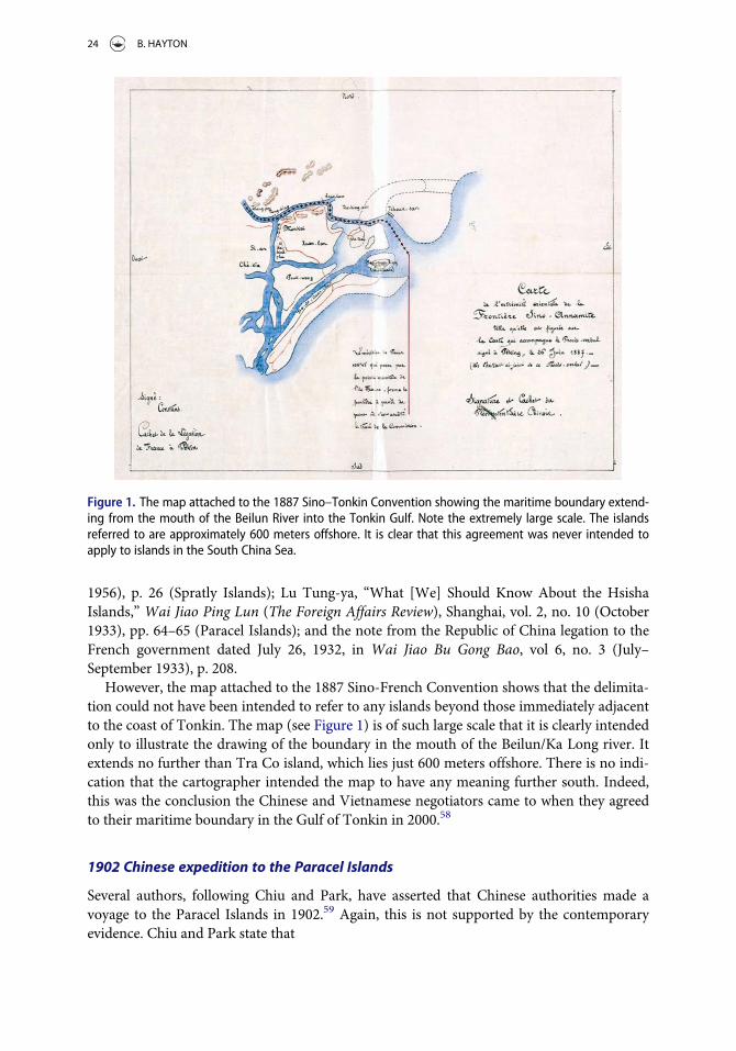
1956), p. 26 (Spratly Islands); Lu Tung-ya, “What [We] Should Know About the HsishaIslands,” Wai Jiao Ping Lun (The Foreign Affairs Review), Shanghai, vol. 2, no. 10 (October1933), pp. 64–65 (Paracel Islands); and the note from the Republic of China legation to theFrench government dated July 26, 1932, in Wai Jiao Bu Gong Bao, vol 6, no. 3 (July–September 1933), p. 208.
However, the map attached to the 1887 Sino-French Convention shows that the delimita-tion could not have been intended to refer to any islands beyond those immediately adjacentto the coast of Tonkin. The map (see Figure 1) is of such large scale that it is clearly intendedonly to illustrate the drawing of the boundary in the mouth of the Beilun/Ka Long river. Itextends no further than Tra Co island, which lies just 600 meters offshore. There is no indi-cation that the cartographer intended the map to have any meaning further south. Indeed,this was the conclusion the Chinese and Vietnamese negotiators came to when they agreedto their maritime boundary in the Gulf of Tonkin in 2000.58
1902 Chinese expedition to the Paracel Islands
Several authors, following Chiu and Park, have asserted that Chinese authorities made avoyage to the Paracel Islands in 1902.59 Again, this is not supported by the contemporaryevidence. Chiu and Park state that
Figure 1. The map attached to the 1887 Sino–Tonkin Convention showing the maritime boundary extend-ing from the mouth of the Beilun River into the Tonkin Gulf. Note the extremely large scale. The islandsreferred to are approximately 600 meters offshore. It is clear that this agreement was never intended toapply to islands in the South China Sea.
24 B. HAYTON

Recently a Hong Kong magazine published a photograph, presumably supplied by the PRC,showing a stone marker on an islet of the Paracels. The Chinese inscription on it says ‘Hs€un-yueh chi-nien’ [In commemoration of inspection], and is dated 1902 (Ch’i-shih nien-tai [TheSeventies], no. 3 [March 1973], p.39). The exact year of this inspection cannot be determined bythe authors.60
However, a survey of contemporaneous newspapers finds no mention of a voyage to theislands in 1902. In fact, information from Chinese archives demonstrates that evidence of aChinese expedition to the Paracels in 1902 was faked by an expedition 35 years later, in June1937. Francois-Xavier Bonnet found an account of that mission written by its commander,the chief of Chinese Administrative Region Number 9, Huang Qiang.61 His role was partlyto check whether there was Japanese activity in the islands, but he had another missiontoo—which a secret annex to his report makes clear. An excerpt of the annex was publishedin Chinese in 1987 by the Committee of Place Names of Guangdong Province.62 HuangQiang’s boat was loaded with 30 stone markers taken from sites on the mainland, somedated 1902, others 1912, and others 1921. On North Island, they buried two markers from1902 and four from 1912; on Lincoln Island, the team buried one marker from 1902, onefrom 1912, and one from 1921; and on Woody Island, two markers from 1921. Finally, onRocky Island, they deposited a single marker, dated 1912. The markers were forgotten until1974 when, after the Paracels incident, they were found and the “discovery” was trumpetedin Hong Kong newspapers, such as Ming Pao Monthly and the English-language Hong KongStandard.63 The nonexistent 1902 expedition then entered the history books. Only recentlyhas the story been discredited.64
The first officially documented Chinese expedition to the Paracels thus far discoveredtook place in 1909. According to the account of the Chinese commander who led the voyage,Admiral Li Zhen [Li Chun], it was prompted by the discovery of the Japanese entrepreneur,Mr. Nishizawa, on Pratas. It was only after Admiral Li traveled to Pratas that he learned ofthe existence of the Paracels, far to the west. After this expedition, plans were made by theGuangdong provincial authorities to formally claim the Paracels. This was carried out duringa brief three-day visit to the islands in June 1909, the first recorded official assertion ofauthority made there by any Chinese government.65
There is some confusion about the year of this expedition, with several sources assertingthat it took place in 1907.66 This appears to be a mistake based upon the versions of theaccount of Admiral Li that were published in Chinese newspapers in 1933 (see later discus-sion). These asserted that the year of the expedition was 1907. However, examinations ofcontemporary sources—editions of the South China Morning Post and other newspapers—show no evidence of an expedition in 1907, only in 1909.
China’s protest to France against the French annexation of several of the SpratlyIslands, 1933
An argument that is key to China’s claim to the Spratlys is the oft-repeated assertion that theRepublic of China made a formal protest to the government of France following the latter’sannexation of several features in the Spratly Islands in July 1933.67 It is true that the annex-ation provoked consternation in government and nationalist anger among the Chinese pub-lic. But was a formal protest ever lodged?
OCEAN DEVELOPMENT & INTERNATIONAL LAW 25

Cheng references an article in Xinya Xiya Yuekan [Hsin-ya-hsi-ya ’y€ueh kan] (New AsiaMonthly) from two years later, 1935.68 Chiu and Park state in a footnote that “there is proofthat China also protested.”69 They reference an article in Wai Jiao Yue Bao (DiplomacyMonthly) by Cho Min,70 and the 1947 book by Zheng Ziyue, Nanhai Zhudao Dili Zhilue.71
However, they concede that
The date of the Chinese note was not reported in Cheng’s book, nor is it mentioned in the‘Memorandum on Four Large Archipelagoes of the Republic of China in South Sea,’ issued bythe ROC Ministry of Foreign Affairs in February 1974. See Lien-ho-pao [United daily news],overseas edition, February 25, 1974, p. 3.72
There are no mentions of a formal protest being issued in the pages of the Chinese-language, Shanghai-based Shen Bao [Shun Pao] newspaper during July–September 1933 andno author has been able to cite a reference to a protest document in any governmentarchives. Although it is impossible to completely prove a negative, it seems much more likelythat no official protest was ever delivered to France by the Chinese government. All there ison record are statements of a possible intention to issue a protest. According to Chiu andPark, “On August 4, 1933, the ROC government notified the French government that, pend-ing a thorough investigation of the matter, it ‘reserved its rights’ with respect to the saidFrench occupation.”73 Chiu and Park’s source is very contemporary—an edition of Wai JiaoBu Gung Bao (Gazette of the Ministry of Foreign Affairs), vol. 6, no. 3 (July-September 1933),p. 219. This source is, indeed, correct. But it only mentions the Chinese government “reserv-ing its rights” while it considers how to respond. There is no mention of a 1933 protest inrelation to the Spratlys, only a 1932 protest relating to the Paracels.
However, other contemporary newspaper reports and archives reveal a more complexhistory. At the time there was a rival government in China, known as the Southwest PoliticalCouncil, based in Guangdong Province. According to the historian John Hunter Boyle:
Embracing the provinces of Kwantung and Kuangsi, the Southwest Political Council was nomi-nally an arm of the Nanking Government. Its armies were likewise nominally a part of theNational Army, but in fact the authority of Nanking reached the southwestern provinces onlyto the extent that the self-appointed leaders of the Southwestern Political Council tolerated it.In all except name it was a separatist regime. … The regime in the south could, and did, embar-rass the Central Government by condemning its temporizing policies toward Japan.74
The Council was at odds with the central government in Nanjing over many issues,notably over how to respond to alleged infringements of Chinese sovereignty by Japanand other powers. It is clear from contemporaneous reports in Shen Bao and theEnglish-language North China Herald (the principal English-language newspaper pub-lished in China during this period) that immediately after the French governmentannounced the annexation of the Spratlys, on Bastille Day, July 14, 1933, there wasconfusion in the Chinese government and population over where the islands were. Sev-eral articles asserted that the islands were the Paracels and therefore belonged toChina.75 Bonnet has found U.S. records showing that the Nanjing authorities had toask their consul in Manila, Mr. Kuan-ling Kwong, to ask the American colonial author-ities there for a map showing the location of the Spratly Islands.76
A North China Herald report, dated August 1, 1933, and attributed to the Kuo Minnews agency, states that the Foreign Ministry received a telegram from the ChineseConsulate-General in Manila confirming that the islands annexed by France lie about
26 B. HAYTON

600 miles northwest of Palawan in the Philippines. “Earlier reports that these islandscorrespond to what in Chinese are known as the Sisha islands [the Paracels] are statedto be incorrect.”77 Only then was the government in Nanjing able to understand thatthese islands were not in the Paracels and then decide not to issue any formal protest.78
An article published in French by a Taiwanese scholar, Chen Hsin-chih, in 2001 cor-roborates this version of events.79
According to Bonnet, the reason is evident from minutes of a meeting of the Republic ofChina’s Military Council on September 1, 1933, “All our professional geographers say thatTriton Island [in the Paracels] is the southernmost island of our territory.”80 The Republicof China decided that it had no claim in the Spratly Islands at that point and therefore hadnothing to protest against. However, the rival “government” of the Southwest PoliticalCouncil was not convinced by the new evidence and maintained that the French hadannexed the Paracels or, if they had not, that whatever they had annexed belonged toChina.81 This confusion fed into public discussion of the islands in 1933 and continues tohaunt the literature to this day.
The episode just described gives an excellent insight into the discussions within theChinese governing circles around this time. It is clear from contemporary documents thatthere were confusion and misunderstanding about China’s claims in the South China Sea in1933. No official or civilian expert was sure about which features should be claimed norwhat evidence China might deploy in order to assert those claims. The outpouring of officialand journalistic articles from the summer of 1933 and into 1934 is evidence of a deliberateprocess of searching through old documents by diplomats, civil servants, academics, andjournalists to try to find anything that might support such claims and allow the state toclarify its position.
It should be noted that this activity took place within the context of a much wider debateabout the nature of China’s frontiers. The geographer William Callahan has described howthe new government of the Republic of China was unable to formally define the country’sborders after it took power in 1911. Its 1911 Constitution simply asserted: “The sovereignterritory of the Republic of China continues to be the same as the domain of the formerEmpire.”82 However, a process of defining the extent of that “sovereign territory” was notbegun until the Republic of China constituted its “Inspection Committee for Land andWater Maps” on June 7, 1933.83
Despite the lack of an official protest to France in 1933, the Canadian researcher Chris-topher Chung has found evidence that by the time the Republic of China governmentcame to discuss the Spratly Islands again in 1946, following the Japanese surrender at theend of the Second World War, a belief had taken root among Chinese officials that theRepublic of China did protest to France 13 years before.84 What may have happened isthat these officials confused genuine protests made by the Chinese government againstFrench activities in the Paracels in 1932 and 1938 with a nonexistent protest againstFrench activities in the Spratlys in 1933. According to Chiu and Park, “On July 27, 1932,the ROC foreign ministry instructed its legation in Paris to protest to the French Quaid’Orsay, rejecting the French claim over the Paracel Islands.”85 Given the chaos of theSecond World War it is perhaps unsurprising that government records and officials’ mem-ories may not have been clear. However, this belief in an earlier assertion of a claim to theSpratlys became, at least internally, the Chinese justification to reclaim the islands fromJapan after the Second World War.
OCEAN DEVELOPMENT & INTERNATIONAL LAW 27

Naming of the islands
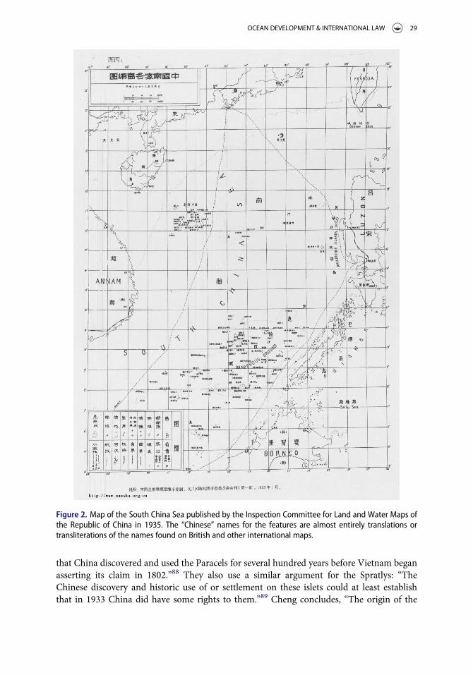
Chiu and Park assert: “After the establishment of the republican government in 1912, theSpratly Islands were referred to as Tuansha ch’€un-tao [A heap of sand archipelago], but asearly as 1934, China began to call them Nansha ch’€un-tao and finally in 1947 the ROCgovernment decided to adopt this name for the Spratlies.”86 Their sources are Hsien-chenKuang-tung fen-hsien ming-his-tu [Pocket detailed country map of Kuangtung Province](Shanghai: Pai hsin shu tien, 1941) and the map in Hu Han-yung, “The Southern Sea IslandsCoveted by France and Japan,”Wai-chiao p’ing lun [The Foreign Affairs Review], vol. 3, no. 5(May 1934).
This brief paragraph obscures a much more complex story. What actually happened, as alist of island names published by the Hainan Institute for South China Sea Studies in 1996makes clear, is that the Chinese names for the islands evolved over the twentieth century.87
In January 1935 the Republic of China’s “Inspection Committee for Land and Water Maps”published a list of Chinese names for the island features. However, these were simply trans-lated or transliterated from the English names found on British maps. For example, in theParacels, Antelope Reef (named after the British ship that surveyed it) became Ling YanJiao—a direct translation. Money Island (named after William Taylor Money, the Superin-tendent of the Bombay Marine) became Jin Yin Dao—again, a direct translation of hisname. In the Spratlys, North Danger became Bei Xian—another translation—and SpratlyIsland became Si-ba-la-tuo—a transliteration of the name of the English sea captain, RichardSpratly. The same was true for the other features given official Chinese names. At this pointthe Spratlys were known as the Tuansha—which means “chaotic sand”—a literal translationof the phrase “Dangerous Ground” that appeared on British maps of the time. Importantly,the committee gave the name Nansha—the southern sands—to the Macclesfield Bank, a sub-merged feature that lies in the center of the South China Sea. The committee chose this namebecause it was the southernmost feature claimed by China.
These names were subsequently printed on a map of the South China Sea published bythe committee in April 1935; see Figure 2. However, when, in 1946/1947, the Republic ofChina extended its claim further south, to include the Spratly Islands, the name Nansha wasmoved south, to refer to the Spratlys, and Macclesfield Bank became the Zhongsha—orcentral sands.
The island names were further revised in 1947. Spratly became Nanwei (Noble South) in1947 and Luconia Shoals, which had been initially dubbed Lo-kang-ni-a in 1935, becameKang. The word kang means health, but the derivation is from the original transliteration.Some names were revised again in 1982. Scarborough Shoal was originally transliterated asSi ge ba luo in 1935 (Scarbough Shoal). In 1947 it was renamedMin’zhu—Democracy—Reefby the Nationalist government. A further round of renaming, by the Communist govern-ment in Beijing in 1982, included revising the Chinese name for Scarborough Shoal to theless politically sensitive Huangyan (Yellow Rock).
Cheng, Chiu and Park’s conclusions
It is not surprising that, having relied extensively on evidence from Chinese publications, theauthors whose works are reviewed here subsequently wrote histories of the disputes thatleaned very much toward the Chinese position. Chiu and Park asserted: “There is no doubt
28 B. HAYTON
that China discovered and used the Paracels for several hundred years before Vietnam beganasserting its claim in 1802.”88 They also use a similar argument for the Spratlys: “TheChinese discovery and historic use of or settlement on these islets could at least establishthat in 1933 China did have some rights to them.”89 Cheng concludes, “The origin of the
Figure 2. Map of the South China Sea published by the Inspection Committee for Land and Water Maps ofthe Republic of China in 1935. The “Chinese” names for the features are almost entirely translations ortransliterations of the names found on British and other international maps.
OCEAN DEVELOPMENT & INTERNATIONAL LAW 29

Chinese claim goes back to a few centuries before the emergence of the principle of discov-ery-occupation.”90 However, as this article has outlined, independent archaeologists and his-torians of the South China Sea reject the notion that the Chinese state “discovered” or thatonly Chinese people “used” the islands before the twentieth century. Historians such asLeonard Bluss�e describe the sea as “ungoverned” before very recent times.91
Cheng progresses from unreliable evidence to conclude:
It is probably safe to say that the Chinese position in the South China Sea islands dispute is a‘superior claim’, to borrow the expression of the Permanent Court of International Justice. BothChinese contentions are strong: the ancient title based on ‘immemorial possession’ or discov-ery-occupation and the confirmation of the title repeatedly by subsequent internationalagreements.92
Chiu and Park’s understanding of what actually happened in the South China Sea during thetwentieth century was limited and confined to the partisan accounts that they discovered in Chi-nese newspapers and magazines. For example, when they assert that “Assuming that France didvalidly establish sovereignty over these islands for Vietnam in the 1930s, one can hardly under-standwhy it neither tried to take them over after the Japanese defeat in 1945 nor protested China’staking them over in 1946”93 they are demonstrating their lack of knowledge of the French expedi-tion to the Spratly Islands in October 1946 by the FR Chevreuil and to the Paracels by the Tonki-nois in January 1947. Stein Tonnesson has provided a full account of these events.94 Chiu andPark’s lack of knowledge of these episodes allows them to write: “The only logical reason toexplain this must be that France either considered its acquisition of the Paracels and the Spratliesas invalid in international law or, if it were valid at all, decided to relinquish its claim.”95Moreover,“In view of the foregoing analysis, it appears that China has a stronger claim to the sovereignty ofthe Paracels and the Spratlies than does Vietnam.”96 Better historical research would have pre-vented themmaking such an assessment.
Researchers continue to make new discoveries about the history of the South China Seaand interactions between Southeast Asia and China. Much of what has been asserted as sup-port by claimants to sovereignty over the islands is turning out to be at odds with theevidence. In summary, at present, historians and archaeologists can find no evidence of anyofficial Chinese act of administration in the Paracel Islands before June 1909 and none inthe Spratlys before the Republic of China Navy visited Itu Aba on December 12, 1946.
Conclusion
There is more research to be done into the history of the islands of the South China Sea inthe first half of the twentieth century. However, the evidence that is available negates muchof what has been published in the English-language accounts common within the disciplinesof international law and international relations. There is more to be discovered. The Repub-lic of China archives in Taiwan are largely untapped, as are contemporaneous Chinese andinternational newspaper accounts. Any work on the twentieth-century history of the SouthChina Sea that relies on the evidence put forward in the works under review needs to bereevaluated to determine whether the arguments stand in the light of the new informationbecoming available.
Cheng, Chiu and Park, Heinzig, and Samuels were specialists in international law, politi-cal science, and geography, respectively—not Asian maritime historians. They did not
30 B. HAYTON

conduct independent investigations of archive sources but relied on texts printed much laterin highly partisan sources, almost exclusively Chinese, to write their histories of the SouthChina Sea. It is also worth noting that Cheng and Chiu were Chinese born. Cheng graduatedwith an LLB from Peking University and Chiu from National Taiwan University. It is rea-sonable to assume they were more familiar with Chinese documents and the Chinese pointof view. Both Samuels and Heinzig were scholars of China.
In 1933, 1956, 1974, and again today, histories of the islands have been written andrewritten. During each diplomatic or military crisis, advocates of the Chinese position havepublished new versions of history that recycle earlier mistakes and sometimes added more.By the time these accounts leapt the language barrier into English in the mid 1970s theirshaky foundations appeared solid to those exploring the history for the first time. They wereprinted in Western academic journals and “became fact.” But a review of the sources of the“facts” reveals their inherent weakness. As a result, forty years of discussion and debate onthe South China Sea territorial disputes have been skewed in favor of a Chinese narrativethat has little basis in fact. This has had implications well beyond academia, right to thehighest levels of government decision making. It is time for a new generation of legal expertsto reexamine the evidence and reach fresh conclusions.
Notes
1. B. S. Glaser, “Armed Clash in the South China Sea: Contingency Planning Memorandum Update”(2015), Council on Foreign Relations, www.cfr.org/sasia-and-pacific/conflict-south-china-sea/p36377.
2. U.N. Convention on the Law of the Sea, 1833 U.N.T.S. 397.3. A. S. Erickson, “America’s Security Role In The South China Sea,” Naval War College Review 69
(2016): 7–20.4. In the Matter of the South China Arbitration (the Philippines and China), Award, 12 July 2016,
para. 247, on the website of the Permanent Court of Arbitration, www.pca-cpa.org.5. B. Hayton, The South China Sea: The Struggle for Power in Asia (New Haven, CT: Yale University
Press, 2014), 65.6. Cheng Tao, “Dispute over the South China Sea Islands,” Texas International Law Journal 10
(1975): 265–277.7. H. Chiu and C. H. Park, “Legal Status of the Paracel and Spratly Islands,” Ocean Development &
International Law 3 (1975): 1–28.8. Pete Pedrozo, “China Versus Vietnam: An Analysis of the Competing Claims in the South China
Sea,” Center for Naval Analyses, August 2014, at www.cna.org/sites/default/files/research/IOP-2014-U-008433.pdf.
9. D. Heinzig, Disputed islands in the South China Sea: Paracels, Spratlys, Pratas, Macclesfield Bank,(Hamburg: Institut f€ur Asienkunde, 1976).
10. Marwyn S. Samuels, Contest for the South China Sea (New York, NY: Methuen, 1982).11. Brian K. Murphy, “Dangerous Ground: the Spratly Islands and International Law,” Ocean and
Coastal Law Journal 1 (1994): 187–212.12. Jianming Shen, “International Law Rules and Historical Evidence Supporting China’s Title to the
South China Sea Islands,” Hastings International and Comparative Law Review 21 (1997–1998):1–75.
13. Jianming Shen, “China’s Sovereignty over the South China Sea Islands: A Historical Perspective,”Chinese Journal of International Law 1 (2002): 94–157.
14. Chi-kin Lo, China’s Policy Towards Territorial Disputes: The Case of the South China Sea Islands(London: Routledge, 1989).
15. S. Talmon and B. B. Jia, The South China Sea Arbitration: A Chinese Perspective (London:Bloomsbury Publishing, 2014).
OCEAN DEVELOPMENT & INTERNATIONAL LAW 31

16. Cheng, supra note 6.17. Chiu and Park, supra note 7.18. Wai Jiao Ping Lun [Wai-chiao p’ing-lun/The Foreign Affairs Review], Shanghai, vol. 2, no. 10
(October 1933): 64–65.19. Wai Jiao Yue Bao [Wai-chiao y€ueh-pao/Diplomacy Monthly], vol. 3, no. 3 (Peiping [Peking], Sep-
tember 15, 1933): 78.20. Fanzhi Yuekan [Fan-chih y€ueh-k’an/Geography Monthly], vol. 7, no. 4 (Nanking, April 1, 1934): 2.21. Wai Jiao Bu Gongbao [Wai-chiao-pu kung-pao/Gazette of the Ministry of Foreign Affairs] vol. 6,
no. 3 (July–September 1933), 208.22. Zheng Ziyue [Cheng Tzu-y€ueh], Nanhai Zhudao Dili Zhilue [Nan-hai chu-tao ti-li chih-l€ueh]
(A Brief Geography of the South Sea Islands) (Shanghai: Shang wu yin shu guan [Shang-wu ying-shu-kuan], 1947).
23. Statement made by the ROC Foreign Ministry on June 10, 1956, summarized in “VietnameseClaim of Sovereignty Refuted,” Free China Weekly, June 26, 1956, p. 3; Chung-yang jih-pao, June11, 1956, p. 6; and Shao Hsun-cheng, “Chinese Islands in the South China Sea,” People’s China,no. 13 (Peking, 1956), Foreign Languages Press.
24. Lien-ho-pao [United Daily News], overseas edition, February 25, 1974, p. 3; “Memorandum onFour Large Archipelagoes” ROC Ministry of Foreign Affairs (February 1974).
25. Heinzig, supra note 9.26. Ming Pao Y€ueh-k’an, no. 101, May 1974.27. M. Samuels, supra note 10, p. xii.28. C. P. C. Chung, “Since Time Immemorial”: China’s Historical Claim in the South China Sea, MA
Thesis (University of Calgary, 2013), 8.29. The public announcement was followed by notices published in the Journal Officiel de la Republi-
que Francaise on July 25, 1933, p. 7794, and July 26, 1933, p. 7837.30. Cheng, supra note 6, p. 266.31. Leonard Bluss�e, “Chinese Century: The Eighteenth Century in the China Sea Region,” Archipel 58
(1996): 107–130.32. Derek Heng, “Trans-Regionalism and Economic Co-Dependency in the South China Sea: The
Case of China and the Malay Region (tenth to fourteenth centuries AD),” The International His-tory Review 35 (2013): 486–510.
33. Pierre-Yves Manguin, “The Southeast Asian Ship: An Historical Approach,” Journal of SoutheastAsian Studies 11 (1980): 266–276.
34. Roderich Ptak, “The Northern Trade Route to the Spice Islands: South China Sea–Sulu Zone–North Moluccas (14th to Early 16th Century),” Archipel 43 (1992): 27–56.
35. Angela Schottenhammer, “The ‘China Seas’ in World History: A General Outline of the Role ofChinese and East Asian Maritime Space From Its Origins to c. 1800,” Journal of Marine andIsland Cultures 1 (2012): 63–86.
36. Nicholas Tarling, The Cambridge History of Southeast Asia (Cambridge University Press, 1999).37. Geoff Wade and Li Tana (eds.), Anthony Reid and the Study of the Southeast Asian Past (Institute
of Southeast Asian Studies, Singapore, 2012).38. M. Flecker, “Early Voyaging in the South China Sea: Implications on Territorial Claims,”
Nalanda-Sriwijaya Centre Working Paper No 19 (Singapore: Institute of Southeast Asian Studies,2015), p. 48.
39. J. V. Mills, “Chinese Navigators in Insulinde,” Archipel 18 (1979): 69–93.40. T. Brook, Mr. Selden’s Map of China: Decoding the Secrets of a Vanished Cartographer (London,
UK: Bloomsbury, 2013), and Robert K. Batchelor, London: The Selden Map and the Making of aGlobal City, 1549–1689 (University of Chicago Press, 2014). Note that the two authors have dif-ferent hypotheses about the location of the map’s cartographer.
41. F.-X. Bonnet, “Geopolitics of Scarborough Shoal,” Discussion Paper 14 (2012), Research Instituteon Contemporary Southeast Asia, Bangkok.
42. U. Granados, “As China Meets the Southern Sea Frontier: Ocean Identity in the Making, 1902–1937,” Pacific Affairs 78 (2005): 443–461.
32 B. HAYTON

43. S. Tonnesson, “The South China Sea in the Age of European Decline,” Modern Asian Studies 40(2006): 1–57; S. Tonnesson (2001), “An International History of the Dispute in the South ChinaSea,”Working Paper No. 71 (Singapore: East Asia Institute).
44. “Chinese Foreign Relations,” The Times, January 18, 1908, p. 5, and “The Recent Piracy in CantonWaters,” The Times, January 25, 1908, p. 5.
45. “China and Her Islands—Keeping an Eye on Foreign Nations,” The Examiner (Launceston, Tas-mania), June 12, 1909, p. 8.
46. See Granados, supra note 42, p. 447.47. Ibid., p. 448.48. “China to Receive Island Back on Certain Terms,” Straits Times, October 28, 1909, p. 7.49. Mark J. Valencia, Jon M. Van Dyke, and Noel A. Ludwig, Sharing the Resources of the South
China Sea (University of Hawaii Press, 1997), 21.50. Jon M. Van Dyke and Dale L. Bennett, “Islands and the Determination of Ocean Space in the
South China Sea,” Ocean Yearbook 10 (1993): 52.51. Samuels, supra note 10, p. 52.52. J. D. Frodsham, The First Chinese Embassy to the West; The Journals of Kuo-Sung-Tʻao, Liu Hsi-
Hung and Chang Te-yi (Oxford: Clarendon Press, 1974), 11.53. Chiu and Park, supra note 7, p. 11.54. Bonnet, supra note 41, p. 14.55. Deutsche Seewarte, Annalen der Hydrographie und maritimen Meteorologie (Berlin: E.S. Mittler
und Sohn, 1889), X.56. D. Hancox and V. Prescott, “A Geographical Description of the Spratly Islands and an Account of
Hydrographic Surveys Amongst Those Islands,” Maritime Briefing, vol. 1, no. 6 (1996), Interna-tional Boundaries Research Unit, University of Durham, p. 36.
57. Chiu and Park, supra note 7, p. 11.58. H.T. Nguyen, “Maritime Delimitation and Fishery Cooperation in the Tonkin Gulf,” Ocean
Development & International Law 36 (2005): 25–44.59. Chiu and Park, supra note 7, p. 25; Samuels, supra note 10, p. 53; and Pavin Chachavalpongpun
(ed.), Entering Uncharted Waters?: ASEAN and the South China Sea (Institute of Southeast AsianStudies, Singapore, 2014).
60. Chiu and Park, supra note 7, p. 25.61. Francois-Xavier Bonnet, “Archaeology and Patriotism: Long Term Chinese Strategies in the
South China Sea,” paper presented at the Southeast Asia Sea conference, Ateneo Law Center,Makati, Manila. March 27, 2015, see opinion.inquirer.net/84307/a-chinese-strategy-manipulat-ing-the-record.
62. Committee of Place Names of the Guangdong Province [Guangdong sheng di ming wei yuan hui](1987), Compilation of References of the Names of all the South Sea Islands [Nan Hai zhu dao diming zi liao hui bian], Guangdong Map Publishing Company [Guangdong sheng di tu chu banshe], p. 289.
63. “Tablet Proves Ancient Rights,” Hong Kong Standard, March 6, 1979, p. 5.64. Bonnet, supra note 61.65. “Paracels Islands: Chinese Official Mission Returns,” South China Morning Post, June 10, 1909.66. Samuels, supra note 10, p. 53; Valencia, Van Dyke, and Ludwig, supra note 50, p. 21; and Sam
Bateman and Ralf Emmers (eds.), Security and International Politics in the South China Sea:Towards a Co-operative Management Regime (Routledge, 2008), p. 43.
67. Teh-Kuang Chang, “China’s Claim of Sovereignty Over Spratly and Paracel Islands: A Historicaland Legal Perspective,” Case Western Reserve Journal of International Law 23 (1991): 412.
68. Cheng, supra note 6, p. 268, cites Lu, Hsi-sha Ch’in-tao Chih-yao [A Brief Note on the ParacelIslands], 9 Hsin Ya Hsi Ya Yueh Kan no. 6 (June 1935), at 50–54.
69. Chiu and Park, supra note 7, p. 24 fn. 31; Cheng, supra note 6, p. 269; Michael Bennett, “The Peo-ple’s Republic of China and the Use of International Law in the Spratly Islands Dispute,” StanfordJournal of International Law 28 (1991–1992): 437; and Lee G. Cordner, “The Spratly Islands Dis-pute and the Law of the Sea,” Ocean Development & International Law 25 (1994): 64.
OCEAN DEVELOPMENT & INTERNATIONAL LAW 33

70. Cho Min, “The Triangular Relationship Among China, France and Japan and the Question ofNine Islands in South Sea,” Wai-chiao y€ueh-pao [Diplomacy Monthly], vol. 3, no. 3 (Peiping[Peking], September 15, 1933), p. 78.
71. Cheng Tzu-y€ueh, Nan-hai chu-tao ti-li chih-l€ueh [General Records on the Geography of SouthernIslands] (Shanghai: Shang-wu ying-shu-kuan, 1948), p. 80.
72. Chiu and Park, supra note 7, p. 25, fn. 59.73. Ibid., p. 12.74. J. H. Boyle, China and Japan at War, 1937–1945: The Politics of Collaboration (Stanford, CA:
Stanford University Press, 1972), 42.75. “French Claim to Nine Pacific Islands,” North China Herald, August 2, 1933, p. 162.76. Bonnet, supra note 41, p. 16.77. “Canton’s Claim on Islands,” North China Herald, August 9, 1933, p. 202.78. Bonnet, supra note 41, p. 17.79. Chen Hsin-chih, “La Reponse Chinoise a l’Occupation Francaise des Iles Spratly En 1933,”
Guerres mondiales et conflits contemporains, no. 199 (Juillet 2001): 5–24.80. Wai Jiao bu nan hai zhu dao dang an hui bian [Compilation by the Department of Foreign Affairs of
All the Records Concerning the Islands in the South Sea], Vol. 1 (Taipei, 1995), pp. 47–49, quoted inBonnet, supra note 41, p. 99.
81. “Island Dispute—Nanking Orders an Investigation,” South China Morning Post, August 1, 1933,p. 14.
82. W.A. Callahan, “The Cartography of National Humiliation and the Emergence of China’s Geo-body,” Public Culture 21 (2009): 141–173.
83. Granados, supra note 42, p. 452.84. See Chung, supra note 28, p. 5 (plus personal communication) and Republic of China Ministry of
Foreign Affairs, “Nansha Qundao [南沙群島, or the “Spratly Archipelago”],” The HistoricalArchives of the Department of Modern History in the Academia Sinica [Zhongyang YanjiuyuanJindaishi Yanjiusuo Dang’an Guancang中央研究院近代史研究所檔案館藏], file series 019.3/0012, file 031. This ROC official telegram is dated August 24, 1946. See also Ministry of ForeignAffairs, “Nansha Qundao [南沙群島, or the “Spratly Archipelago”],” The Historical Archives ofthe Department of Modern History in the Academia Sinica [Zhongyang Yanjiuyuan JindaishiYanjiusuo Dang’an Guancang中央研究院近代史研究所檔案館藏], file series 019.3/0012, file145–146. This ROC official telegram is dated to 1946 (the month is unclear).
85. Chiu and Park, supra note 7, p. 12.86. Ibid., at p. 11.87. Chen Keqin, General Editor, Zhong guo Nan hai Zhu do [China’s Southern Sea Islands] (Hainan
guoji xinwen chuban zhongxin, 1996).88. Chiu and Park, supra note 7, p. 17.89. Ibid., p. 18.90. Cheng, supra note 6, p. 276.91. Leonard Bluss�e, “China as a Maritime Power: the Historical Perspective,” paper given at “Mari-
time Governance in 21st Century Asia: Historical Precedents, Legal Foundations, and RegionalInstitutions in Addressing Common Security Challenges,” The Centre for Rising Powers, Univer-sity of Cambridge, September 10, 2014, plus personal communication.
92. Cheng, supra note 6, p. 277.93. Chiu and Park, supra note 7, p. 19.94. Tønnesson (2006), supra note 43.95. Chiu and Park, supra note 7, p. 19.96. Ibid., p. 20.
34 B. HAYTON