what’s it all about? - village of manchestervillageofmanchester.org/docs/manchester gateway path...
TRANSCRIPT

VILLAGE OF MANCHESTER
The ‘Manchester Gateway’ Pedestrian/Bicycle Pathway System
WHAT’S IT ALL ABOUT?
Facility Details
1. A 1.5 mile bike/ped. pathway from NY Rte 96 to Clifton St. in the Village, then continuing south to Water St. with southern trailhead near Bliss Shurfine parking lot.
2. Pedestrian staircase from eastern edge of the Main St. Municipal Parking Lot down to pathway level approx. 40 ft. below.
3. Sidewalk on NY Rte. 96, from the 21/96 intersection to “Friendly Village” MHP and northern Pathway terminus.
4. Benches, trash receptacles, cautionary and interpretive signage, and information signs. Also, two historical interpretation kiosks by the fire hall and near the legendary railroad trestle overpass on Canandaigua Outlet. (Visit the trestle to find out why it’s legendary!)
5. Environmentally appropriate landscaping to restore and enhance the natural beauty of the streambank habitat. This will be a beautiful pathway!
6. Pamphlet available at village office. This pathway will be a teaching tool for all ages!
Project Development Status Update
Proposal SUBMITTED, 6/30/06: The Village submitted a Transportation Enhancements Program (TEP) application to NYSDOT on 6/30/06 (amended 7/27/06). Total estimated project cost: $750,000. TEP funding requested: $600,000, with remaining project costs (20%) being covered by Village and Town of Manchester.
Project funding AWARDED, 11/1/06: NYSDOT Region 4 announces TEP award in the amount of $607,924 for the Manchester Gateway Path System.
Completed pathway INAUGURATED, 6/2/12: What a perfect way to observe National Trails Day 2012 in the heart of Manchester!!
Purpose
This facility provides local transportation and recreation opportunities for all bicycles and pedestrians in harmony with the natural environment, and in furtherance of the Village’s Master
Plan vision of creating a more livable, sustainable community for Manchester residents.
This exciting facility provides multiple benefits to Village residents and neighboring populations,
including: alternative transportation and access benefits; safety benefits; local economic development;
property value enhancement; recreational benefits; environmental protection; modal choice benefits;
educational and health benefits. It is the product of a concerted local planning effort which enjoyed
broad-based public participation.
THANK YOU
FOR YOUR
SUPPORT!!
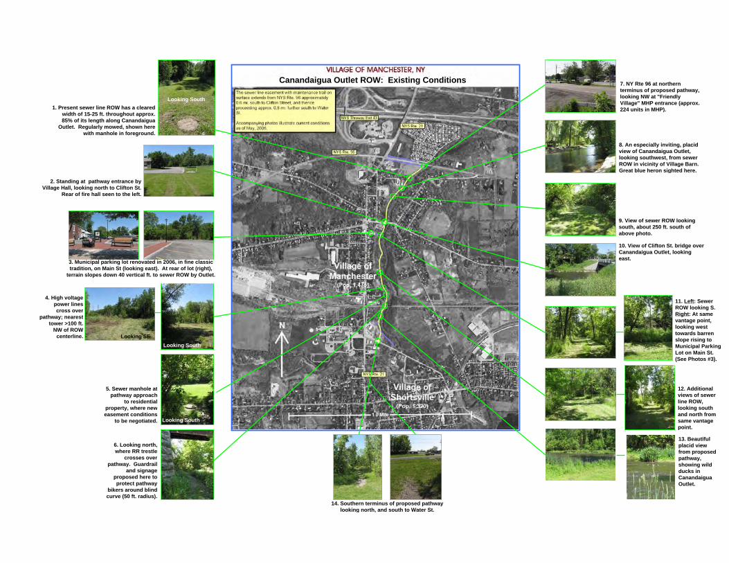
1. Present sewer line ROW has a clearedwidth of 15-25 ft. throughout approx.85% of its length along Canandaigua
Outlet. Regularly mowed, shown herewith manhole in foreground.
2. Standing at pathway entrance byVillage Hall, looking north to Clifton St.
Rear of fire hall seen to the left.
3. Municipal parking lot renovated in 2006, in fine classictradition, on Main St (looking east). At rear of lot (right),
terrain slopes down 40 vertical ft. to sewer ROW by Outlet.
4. High voltagepower linescross over
pathway; nearesttower >100 ft.
NW of ROWcenterline. Looking SE
Looking South
5. Sewer manhole atpathway approach
to residentialproperty, where neweasement conditions
to be negotiated. Looking South
Looking South
7. NY Rte 96 at northernterminus of proposed pathway,looking NW at "FriendlyVillage" MHP entrance (approx.224 units in MHP).
8. An especially inviting, placidview of Canandaigua Outlet,looking southwest, from sewerROW in vicinity of Village Barn.Great blue heron sighted here.
9. View of sewer ROW lookingsouth, about 250 ft. south ofabove photo.
10. View of Clifton St. bridge overCanandaigua Outlet, lookingeast.
11. Left: SewerROW looking S.Right: At samevantage point,looking westtowards barrenslope rising toMunicipal ParkingLot on Main St.(See Photos #3).
12. Additionalviews of sewerline ROW,looking southand north fromsame vantagepoint.
13. Beautifulplacid viewfrom proposedpathway,showing wildducks inCanandaiguaOutlet.
14. Southern terminus of proposed pathwaylooking north, and south to Water St.
6. Looking north,where RR trestle
crosses overpathway. Guardrail
and signageproposed here toprotect pathway
bikers around blindcurve (50 ft. radius).
Canandaigua Outlet ROW: Existing Conditions


VILLAGE OF MANCHESTER, NY
Proposed Bicycle/Pedestrian Facilities
Conceptual Layout (1:40000)
NYS Thruway Exit 43
"Friendly Village" MHP(224 units)
Central Business District
N
Red Jacket CentralSchool
NYS Rte. 96
NYS Rte. 21
NYS Rte. 21
Supermarket, Pharmacy, Bank,Post Office & Laundramat
V. ShortsvilleMunicipal Park
Canandaigua Outlet
Village ofManchester
(Pop. 1,475)
Village ofShortsville
(Pop. 1,320)
1.0 Mile
The 'Manchester Gateway'Bike/Ped. Pathway System
Proposed shared-use pathway(shown in pale yellow, with accesspoints shown as circular nodes) willfollow western banks of CanandaiguaOutlet, within sewer ROW. (Approx.1.2 mi.) Sidewalks (approx. 0.5 mi.,total) and access stairs/trails shown inbright yellow.
Main trip origins/destinationscaptioned in light blue.
Pizzeria, Convenience Store,Am. Legion & Ice Cream Shop
Restaurant & Conv. Store
Village Hall
The 'Manchester Gateway' Pedestrian/Bicycle Pathway SystemTRANSPORTATION CONTEXT: TRIP ORIGINS & DESTINATIONS
Scale = approx. 1:40,000
Central Business District
Churches
Proposed ShoppingFacilities (old school)
(2) GlassFactories

Public Participation in the Planning Process
With expert assistance, the Village of Manchester held multiple strategic planning work sessions in 2005. Scenes at left are from a dynamic “Assets & Liabilities” session where 40 local citizens working in small groups helped map out Manchester’s future.Chief among the public’s recommendations: improve pedestrian access, create a ped./bike pathway along Canandaigua Outlet, and revitalize the Village’s Central Business District. These goals, now part of the Village’s Strategic Plan, are founded upon an overall Comprehensive Plan vision of “build[ing] a livable andsustainable community that is positioned to meet the challenges of the twenty-first century.”
