what can gis + 3d mean for landscape archaeology?
TRANSCRIPT

University of Nebraska - LincolnDigitalCommons@University of Nebraska - Lincoln
Anthropology Faculty Publications Anthropology, Department of
2017
What can GIS + 3D mean for landscapearchaeology?Heather Richards-RissettoUniversity of Nebraska-Lincoln, [email protected]
Follow this and additional works at: http://digitalcommons.unl.edu/anthropologyfacpub
Part of the Archaeological Anthropology Commons, Geographic Information SciencesCommons, Human Geography Commons, Latin American Languages and Societies Commons, andthe Social and Cultural Anthropology Commons
This Article is brought to you for free and open access by the Anthropology, Department of at DigitalCommons@University of Nebraska - Lincoln. Ithas been accepted for inclusion in Anthropology Faculty Publications by an authorized administrator of DigitalCommons@University of Nebraska -Lincoln.
Richards-Rissetto, Heather, "What can GIS + 3D mean for landscape archaeology?" (2017). Anthropology Faculty Publications. 147.http://digitalcommons.unl.edu/anthropologyfacpub/147

1. Introduction
Until recently, Geographic Information Systems (GIS) have held center stage in the archaeologist’s geospatial toolkit, and there is no doubt that archaeologists have moved beyond the map – but into what? Old questions persist and new questions arise as we push boundaries and explore new horizons – questions such as: Is GIS more than a tool? Is GIS contributing to theoretical advancements in archaeology? These are big questions. To nar-row the scope, I have set forth four objectives: (1) briefly sum-marize criticisms of GIS as “environmentally-deterministic”, (2) provide some approaches archaeologists have used to attempt to overcome such criticisms, (3) bring 3D technologies into the discussion, and (4) finally explore what GIS + 3D can mean for landscape archaeology.
GIS allow us to capture, store, manipulate, analyze, and vi-sualize geographic data. Since 1960 with the development of the first operational GIS, i.e., Canada Geographic Information System (Tomlinson and Toomey, 1999), people have been us-ing GIS to integrate seemingly disparate data sets and generate new data as well as perform complex spatial analysis resulting in new knowledge. At first glance, GIS seems tailor-made for archaeology because the discipline is inherently spatial; and in fact, archaeologists were some of the earliest adopters of the technology. In the late 1980s and early 1990s, archaeologists in-creasingly used GIS as a part of their toolkit, not only to manage
archaeological data, but also to identify spatial patterns that po-tentially correlate to human behavior (e.g., Allen et al., 1990; Lock and Stancic, 1995). Early analytical applications adhered to processual goals such as predictive modeling – using GIS to calculate the probability of locating archaeological sites and correlating variables to human behavior (e.g., Kvamme, 1999; Lock and Harris, 2006; Wescott and Brandon, 1999). However, soon GIS became criticized for being environmentally determin-istic; predictive models were criticized because they tended to rely on environmental variables at the expense of “social” vari-ables (Cope and Elwood, 2009; Daly and Lock, 2004; Gaffney and van Leusen, 1995; Kwan, 2002; Schuurman, 1999; Thomas, 1996). In defense of these early applications, GIS tend to pref-erence environmental criteria for two reasons. First, GIS was developed as quantitative software; however, many of the cul-tural data with which archaeologists deal are qualitative in na-ture (e.g., Allen et al., 1990; Lock and Harris, 2000; Leszczyn-ski, 2009). Second, GIS-ready environmental data (e.g., soil, geology, vegetation, hydrology, and terrain) are more readily available. In contrast, social data must be collected, classified, and then converted and/or linked to GIS data before it can be used – and this process is never straightforward often requir-ing new GIS tool development (e.g., Agugiaro et al., 2011; von Schwerin et al., 2013).
In the 1990s, post-processualism raised questions about the sterility, so to speak, of processual approaches.
Published in Journal of Archaeological Science 84 (2017), pp. 10–21. doi:10.1016/j.jas.2017.05.005 Copyright © 2017 Elsevier Ltd. Used by permission. Submitted 16 December 2016; revised 23 April 2017; accepted 10 May 2017; published online 22 May 2017.
What can GIS + 3D mean for landscape archaeology? Heather Richards-Rissetto
University of Nebraska–Lincoln, United States
Email: [email protected] or [email protected]
AbstractUntil recently Geographic Information Systems (GIS) have held center stage in the archaeologist’s geospatial toolkit, and there is no doubt that archaeologists have moved beyond the map – but into what? In the early years, criticisms voicing GIS as environmentally-deterministic were abundant. What methods and tool have archaeologists used to overcome these criticisms? New geospatial technologies such as airborne LiDAR and aerial photogrammetry are allowing us to acquire inordinate amounts of georeferenced 3D data – but do these 3D technologies help overcome criticisms of environmental determinism? Together – GIS + 3D – can link geo-referenced 3D models to underlying data adding a ground-based humanistic perspective lacking in the bird’s eye view of traditional GIS. This paper situates GIS and 3D within a semiotic framework to offer some ideas on using 3DGIS to intertwine environmental and cultural factors to work toward new approaches for land-scape archaeology.
Keywords: Geographic Information Systems (GIS), 3D modeling, Landscape archaeology, Semiotics, Ancient Maya, Visibility, Accessibility
10
digitalcommons.unl.edu

What can GIS + 3D mean for landscape archaeology? 11
Post-processualism sought to bring human agency, symbolism, cosmology, indigenous perspective, gender, cognition, and more interpretative aspects into archaeological studies (e.g., Conkey and Gero, 1991; Hodder, 1985; Trigger, 2006). Along these lines, phenomenological approaches to landscape began to take shape that contrasted first-person experience through self-reflective bodily experience to a bird’s eye view so typical of GIS (Tilley, 1994); in a sense, bringing the qualitative vs. quantitative de-bate to the forefront. Visibility analysis in GIS proved ground-breaking to integrate computational approaches with phe-nomenological goals affording more reflexive and experiential methodologies (Van Leusen, 1999; Wheatley, 1993). However, GIS practitioners made obvious that GIS has its limitations in regard to human perception because it tends to create abstract realities that reduce human complexity (Gaffney and van Le-usen, 1995; Gillings and Goodrick, 1996; Stead, 1995). For ex-ample, viewshed applications “critically confuse the concept of ‘vision’ with that of ‘perception’, and in so doing simplify once again the full complexity of people-place relations and dynam-ics” (Gillings and Goodrick, 1996). To counter such shortcom-ings of GIS, Gillings and Goodrick (1996) proposed integrating GIS with VRML (Virtural Reality Modeling Language) to facili-tate “a sensual and experiential mode of engagement with the material remains of the past.”
More recently, Marcos Llobera (2012:504–505) tackles this problem in his article “Life on a Pixel: Challenges in the Devel-opment of Digital Methods Within an “Interpretive Landscape Archaeology Framework”. To overcome, or move beyond, criti-cisms that the quantitative nature of GIS divorces archaeology from human experience, Llobera contends that we need mid-dle ground/ bridging concepts to: (1) situate models and meth-ods within context-rich narratives, (2) explore how processes play out within particular contexts rather than seek universal norms of behavior, (3) shorten the gap between empirical infor-mation and narratives, and (4) generate multiple scenarios as feedback to results. In other words, as archaeologists we cannot simply use GIS as a deductive tool but rather we must also use GIS as part of an inductive PROCESS, where we tack back and forth between various data and methods to formulate new hy-potheses and as a consequence provide fertile ground to drive theoretical growth (Daly and Evans, 2006; Landau et al., 2014).
Some GIS approaches can be rightly criticized for being en-vironmentally deterministic and overly quantitative due to both practical issues involving data and software availability, and the underlying theoretical assumptions driving research objectives. Some of these limitations, however, can be overcome and cultural information can be integrated into GIS analyses if they are ex-plicitly grounded in archaeological and/or social theory and in-terpreted within a society‘s particular historical, sociopolitical, and ideological circumstances (Llobera, 1996; Lock, 2000; Lock and Harris, 2006). To overcome these shortcomings, archaeolo-gists cannot employ GIS as an unbiased tool. Instead, they need to think of GIS as a form of practice that must be situated within archaeological theory; they need to use theory-inspired cultural variables in GIS – realizing that places are socially created as well as linked to both space and time (Tschan et al., 2000).
2. Semiotics: a bridging concept for landscape archaeology
Space is often defined as locations with no social connections; in contrast, places are imbued with human meaning(s) (Relph, 1976; Tuan, 1977). However, space is not a blank canvas serv-ing as a neutral backdrop for human action (Tilley, 1994), we all transform spaces into places in relation to physical surround-ings and cultural/ personal experience (Hu, 2012; Wheatley and Gillings, 2000). Early social theorists such as Morgan, Dur-kheim, and Mauss posited evolutionary and functional theories
to explain the roles of bounded spaces and built forms (i.e., built environment) in social life (Durkheim and Mauss, 1963; Mor-gan, 1965). In reaction to these theories, symbolic approaches such as structuralism emerged that understood architecture and space as reflecting cultural rules (Lawrence and Low, 1990; Lévi-Strauss, 1963). Pierre Bourdieu (1977) and Giddens (1979, 1984), posited practice-oriented perspectives to insert human agency into the production and reproduction of social mean-ing and relations; however, such approaches continue to treat spaces as neutral backdrops for social practice (A. Smith, 2003). Semiotics – a theoretical framework that views cultural phe-nomena (including built forms and bounded spaces) as sys-tems of signs or social configurations that convey culturally constructed meaning (Burks 1949) – seeks to make space an ac-tive agent in cultural re(production).
In this article, I explore the potential of semiotics, as one way, to explicitly link GIS data and methods to social actions. Semiotics is grounded in the belief that to understand the what, it is necessary to understand the how. This means that archaeol-ogists must investigate the mechanisms that were used to send specific messages – whether ideological, political, economic, etc. – and GIS provides some of the tools for such analysis. Ac-cording to Charles Sanders Peirce (Buchler, 1978), a triadic re-lation exists among signs, objects, and interpretant. In this rela-tionship objects become signs when, and only when, individuals assign meaning to them. This means that for archaeologists to reconstruct the meanings of ancient signs, they must take into account who is creating these signs and whom these signs are targeting. Senders, or addressers, send messages via signs to re-ceivers, or addressees (Goffman, 1983; Jakobson, 1980; Parmen-tier, 1987; Silverstein, 1976). Archaeological remains provide evidence to help identify the identity of both senders and re-ceivers; however, identifying senders is often more straightfor-ward than identifying receivers, particularly across vast land-scapes. GIS provides tools to identify receivers and ultimately to better understand how people communicate with one another.
Furthermore, semiotics asserts that people have interactive relationships with the built environment – comprised of build-ing forms and bounded spaces – both creating their surround-ings and simultaneously finding their behavior influenced by them; the ways in which different groups of people respond to these “signs” influences how they interact in a landscape. Along these lines, semiotics provides two fundamental concepts – au-dience and indexicality that can be used to bridge GIS and social theory. The concept of audience is important because culturally constructed messages are created with a particular audience in mind, which means that people are targeted. One way this can be accomplished and identified in the archaeological record, for example, is via architecture in the form of barriers and facili-tators that either inhibit or facilitate social interaction among different social groups.
The concept of indexicality is relevant because it provides an ideal perspective for investigating how architectural arrange-ments worked together to convey messages and direct socio-political interaction. Indexicality is based on the concept that adjacency and spatiotemporal context are critical elements in communication. Architectural indexes are signs that help to structure how people negotiate their physical surroundings (Bu-chler, 1978; Gardin and Peebles, 1992; Jakobson, 1980; Parmen-tier, 1987; Preucel and Bauer, 2001). Components of the built environment such as buildings, roads, walls, and stairs are often aggregated and organized into spatial configurations (indexes) that convey meaning. These components can be arranged in different ways; however, their meanings change depending on what is placed next to what and on their larger spatial context.
These ideas strongly relate to a structuration approach (Llobera, 1996, 2001; Daly and Lock, 2004) focused on how
12 H. Richards-Rissetto in Journal of Archaeological Science 84 (2017)
landscapes can structure and characterize cultural practices, and using GIS to analyze social spaces on the landscape to study past human meanings and practices. By examining how mes-sages were being communicated, we can better understand what messages were being sent, to whom they were being sent, and why they were being sent. Using this knowledge, we can iden-tify patterns of communication between social groups (Rapo-port, 1969, 1988, 1990), which will in turn help us to study how groups of people interacted and how social roles might have been defined. Ultimately, connections can be made between communicative patterns and the roles landscapes played in structuring human interaction, and in turn linked to the differ-ent social, political, ideological, etc. roles played by ancient in-habitants. Thus, semiotics can serve as a framework in which to study sociopolitical interaction and the transmission of cultur-ally meaningful messages to particular social groups; in Llobera (2012) terms it can serve as a bridging or middle ground ap-proach to begin to overcome criticisms that the quantitative na-ture of GIS divorces archaeology from human experience.
3. Grounding GIS in semiotics
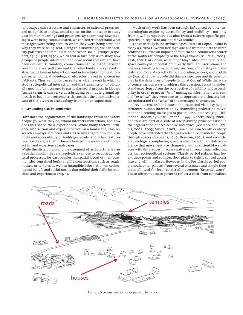
How does the organization of the landscape influence where people go, what they do, whom interacts with whom, and how does this shape their experiences? While many factors influ-ence interaction and experience within a landscape, this re-search employs semiotics and GIS to investigate how the visi-bility and accessibility of buildings, roads, and other features function as signs that influence how people move about, inter-act in, and experience landscapes. While the distribution and arrangement of architecture leaves a spatial imprint that archaeologists can use to reconstruct cul-tural processes, for past peoples the spatial layout of their com-munities contained both tangible constructions such as roads, houses, or temples as well as intangible information on cosmo-logical beliefs and social norms that guided their daily interac-tions and experiences (Fig. 1).
Much of my work has been strongly influenced by other ar-chaeologists exploring accessibility and visibility – not only from a GIS perspective but also from a culture-specific per-spective in regard to ancient Maya studies.
The case study is the archaeological “site” of Copan – what is today a UNESCO World Heritage site but from the fifth to ninth centuries CE, was an important cultural and commercial center at the southeast periphery of the Maya world (Bell et al., 2004; Fash, 2001). At Copan, as at other Maya sites, architecture and space conveyed information directly through inscriptions and imagery, building form, building function, and quality of mate-rials, and more abstractly through location, access, and visibil-ity (Fig. 2). But what role did this architecture and its position play in the daily lives of people living at Copan? While there are of course various ways to address this question, I want to under-stand experience from the perspective of visibility and accessi-bility in order to get at “how” messages/information was sent and “to whom” they were sent as an approach to ultimately bet-ter understand the “what” of the messages themselves.
Previous research indicates that access and visibility help to structure human interaction by channeling pedestrian move-ment and sending messages to particular audiences (e.g., Hill-ier and Hanson, 1984; Hillier et al., 1993; Llobera, 2003, 2006), and thus are part of a suite of site-planning principles used in the organization of architecture and space (Ashmore and Sabl-off, 2002, 2003; Smith, 2007). Since the nineteenth century, people have contended that Maya architecture channeled people through spaces (Stephens, 1969; Houston, 1998). And recently, archaeologists, employing space syntax, found quantitative ev-idence that movement was channeled within ancient Maya pal-aces with differences in access patterns through time reflecting distinct sociopolitical systems. Classic period palaces had few entrance points and complex floor plans to tightly control access into and within palaces. However, in the Postclassic period peo-ple could enter palaces from several entrances and simple floor plans allowed for less restricted movement (Stuardo, 2003). These different access patterns reflect a shift from centralized
Fig. 1. 3D reconstruction of Copan’s urban core.

What can GIS + 3D mean for landscape archaeology? 13
rule under divine kingship to a more decentralized rule under a council of nobles. Other research – both qualitative and quanti-tative – has shown that sculptural motifs differed based on ac-cessibility (Sanchez, 1997). For example, at Palenque in Mexico, rulers placed public imagery portraying rulers as authoritative in spaces where access was less controlled; in contrast, private portraiture depicted rulers dressed in simple costume and sub-ordinate to deities (Parmington, 2011).
Iconographic studies indicate that for the ancient Maya sight was multi-faceted. Protruding eyeballs indicate that sight was projective and procreative suggesting that for the Maya “the act of seeing” actually affected and changed the world. In other words, people were not passive recipients – the ancient Maya believed that what they saw affected what they did, how they felt, and how they interacted with the world around them (Houston et al., 2006). In terms of visibility, deciphered hiero-glyphs indicate that “seeing” afforded high status, and sight had an authorizing gaze and witnessing function (similar to Foucault’s Panoptic gaze) where those who were all-seeing in a sense were all-knowing (Foucault, 1979). In order to be all-see-ing or to give such an impression, however, Maya rulers needed to be seen, and so often located themselves in physically high and easily visible places or built tall temples that dominated the landscape as can be seen at the ancient Maya site of Tikal in Guatemala.
If we look at how visibility is materialized in the landscape, at the Late Classic site of La Milp in Belize, archaeologists Ham-mond and Tourtellot (1999), identified lines-of-sight between stelae located on hilltops in the periphery and a large temple in the city’s center. They argue that these lines-of-sight served as visual reminders to people living in the periphery of the rul-er’s power as well as their ties and obligations to the city cen-ter. More recent research by Doyle et al. (2011) suggests that visibility played an important role in establishing territorial boundaries between the Classic Maya sites of El Zotz and Tikal. Visual boundaries seem to correlate to territorial boundaries and the two sites’ main temples were in view of one another–patterns reflecting the Maya notion that all-seeing is all-know-ing. This information about ancient Maya concepts of accessi-bility and visibility provides cultural context to develop, apply, and appropriately interpret GIS methods.
4. GIS methods
4.1. Measuring accessibility
To measure accessibility, I grounded my analysis in the notion of movement in contrast to access points, which prior to GIS was a more common approach, e.g. space syntax (Hillier and Hanson, 1984; Parmington, 2011; Stuardo, 2003). To do this, I used GIS
Fig. 2. Map of Copan’s location.
14 H. Richards-Rissetto in Journal of Archaeological Science 84 (2017)
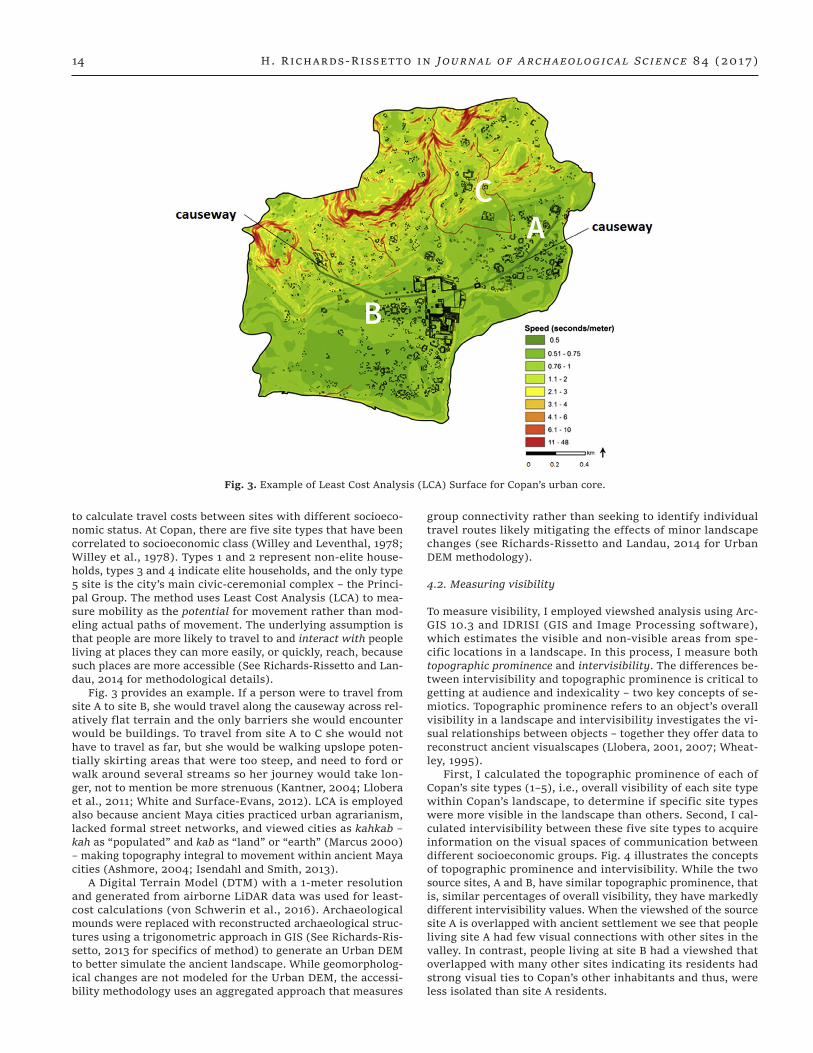
to calculate travel costs between sites with different socioeco-nomic status. At Copan, there are five site types that have been correlated to socioeconomic class (Willey and Leventhal, 1978; Willey et al., 1978). Types 1 and 2 represent non-elite house-holds, types 3 and 4 indicate elite households, and the only type 5 site is the city’s main civic-ceremonial complex – the Princi-pal Group. The method uses Least Cost Analysis (LCA) to mea-sure mobility as the potential for movement rather than mod-eling actual paths of movement. The underlying assumption is that people are more likely to travel to and interact with people living at places they can more easily, or quickly, reach, because such places are more accessible (See Richards-Rissetto and Lan-dau, 2014 for methodological details).
Fig. 3 provides an example. If a person were to travel from site A to site B, she would travel along the causeway across rel-atively flat terrain and the only barriers she would encounter would be buildings. To travel from site A to C she would not have to travel as far, but she would be walking upslope poten-tially skirting areas that were too steep, and need to ford or walk around several streams so her journey would take lon-ger, not to mention be more strenuous (Kantner, 2004; Llobera et al., 2011; White and Surface-Evans, 2012). LCA is employed also because ancient Maya cities practiced urban agrarianism, lacked formal street networks, and viewed cities as kahkab – kah as “populated” and kab as “land” or “earth” (Marcus 2000) – making topography integral to movement within ancient Maya cities (Ashmore, 2004; Isendahl and Smith, 2013).
A Digital Terrain Model (DTM) with a 1-meter resolution and generated from airborne LiDAR data was used for least-cost calculations (von Schwerin et al., 2016). Archaeological mounds were replaced with reconstructed archaeological struc-tures using a trigonometric approach in GIS (See Richards-Ris-setto, 2013 for specifics of method) to generate an Urban DEM to better simulate the ancient landscape. While geomorpholog-ical changes are not modeled for the Urban DEM, the accessi-bility methodology uses an aggregated approach that measures
group connectivity rather than seeking to identify individual travel routes likely mitigating the effects of minor landscape changes (see Richards-Rissetto and Landau, 2014 for Urban DEM methodology).
4.2. Measuring visibility
To measure visibility, I employed viewshed analysis using Arc-GIS 10.3 and IDRISI (GIS and Image Processing software), which estimates the visible and non-visible areas from spe-cific locations in a landscape. In this process, I measure both topographic prominence and intervisibility. The differences be-tween intervisibility and topographic prominence is critical to getting at audience and indexicality – two key concepts of se-miotics. Topographic prominence refers to an object’s overall visibility in a landscape and intervisibility investigates the vi-sual relationships between objects – together they offer data to reconstruct ancient visualscapes (Llobera, 2001, 2007; Wheat-ley, 1995).
First, I calculated the topographic prominence of each of Copan’s site types (1–5), i.e., overall visibility of each site type within Copan’s landscape, to determine if specific site types were more visible in the landscape than others. Second, I cal-culated intervisibility between these five site types to acquire information on the visual spaces of communication between different socioeconomic groups. Fig. 4 illustrates the concepts of topographic prominence and intervisibility. While the two source sites, A and B, have similar topographic prominence, that is, similar percentages of overall visibility, they have markedly different intervisibility values. When the viewshed of the source site A is overlapped with ancient settlement we see that people living site A had few visual connections with other sites in the valley. In contrast, people living at site B had a viewshed that overlapped with many other sites indicating its residents had strong visual ties to Copan’s other inhabitants and thus, were less isolated than site A residents.
Fig. 3. Example of Least Cost Analysis (LCA) Surface for Copan’s urban core.

What can GIS + 3D mean for landscape archaeology? 15
5. GIS results
5.1. Accessibility results
The valley-wide (24 km2) accessibility results have been pub-lished elsewhere (Richards-Rissetto, 2010) and the urban core accessibility results were published in the Journal of Archaeo-logical Science (Richards-Rissetto and Landau 2014). The results mirror social order at Copan. The royal precinct, comprising all of Copan’s type 5 sites, was located in the most accessible lo-cation in the city. People from all socio-economic classes were channeled to the city center to witness the king’s power – fur-ther evidenced by the city’s only two sacbeob (causeways) lead-ing into the open Great Plaza that housed bleachers for over a thousand spectators.
Type 4 elite sites were located at highly accessible locations; in contrast, type 1 non-elite sites were often situated in less ac-cessible places. For example, in the urban core travel it took on average seven minutes less for the elite (type 4) to walk to an-other elite site (type 4) than for people living at type 1 sites to walk to other type 1 sites. Within a semiotic framework, these results may reflect intentional intragroup segregation of Copan’s lower status residents as well as and channeling of lower status residents to type 4 complexes; thus, providing data to support the hypothesis that accessibility helped to establish and rein-force differences between ancient Maya social groups.
5.2. Visibility results
The visibility data reinforce the accessibility results indicating a visual hierarchy at Copan where higher status sites are gener-ally more visible than lower status sites. The topographic prom-inence results indicate that from 76% of Copan’s sites people could see the royal precinct. The residences of the wealthiest elites, living at type 4 sites, could be seen from 48% of sites, whereas, in contrast, the houses of the city’s poorest inhabit-ants could be seen by less than 35% of sites. As for the intervis-ibility results, they indicate that 88% of the city’s elite lived in sight of the royal precinct, whereas only 60% of non-elite could see the ruler’s domain from their homes. Other intervisibility results provide quantitative data reflecting communication ties between specific groups and social segregation between others. For example, higher status residents had stronger visual ties to other high status households than did lower status residents
who experienced greater visual segregation from other low sta-tus households. People living at sites of higher socioeconomic status had greater visual connectivity to the city’s inhabitants than people living at sites of lower socioeconomic status. These visual data indicate a greater sense of social segregation and isolation among lower status “communities” as well as a sense that they were being “watched over” by the occupants of higher status sites; like the accessibility results helping to establish and reinforce differences between ancient Maya social groups (Richards-Rissetto, 2017).
Together, the accessibility and visibility data indicate that the elite of highest socioeconomic status, constructed their houses in the most accessible and visible locations. Interpret-ing these results within our understanding of ancient Maya ide-ology and a semiotic framework, the channeling of people past their elaborate complexes and constructing taller houses, in highly visible places enabled the elite to target specific audi-ences. Through the concept of indexicality, we can argue that the elite situated themselves adjacent to and in proximity of partic-ular built forms and bounded spaces with the topographic land-scape to send messages of status, wealth, and power as well as let the non-elite know that they were they were being ‘watched over’ linking back to ancient Maya core beliefs about vision. In contrast, while people of the lowest socioeconomic status were the most numerous, they were in some sense the most isolated because were they situated in places of low accessibility and had fewer visual ties to the city’s other residents of a similar socio-economic class (Richards-Rissetto and Landau, 2014; Richards-Rissetto, 2010, 2012).
While GIS analyses of accessibility and visibility offer quan-titative data illustrating that visibility and accessibility played fundamental roles in the daily lives of the ancient Maya by not simply expressing royal power but also indicating that lesser elite also employed accessibility and visibility to send messages of power, wealth, and authority – thus linking daily experience to the ancient Maya belief that to be “all seeing” is to be “all-knowing”. But are these GIS data sufficient for examining acces-sibility and visibility in ancient Maya landscape? How well can we truly embed these GIS results within a semiotic framework?
While the concept of audience is brought to the foreground from the GIS data, the concept of indexicality remains in the background. Yes, we can use the GIS data to identify “what is next to what”, or in this case, how “close in proximity” things are to each other; however, we are missing a critical component
Fig. 4. Viewsheds from Copan illustrating Topographic Prominence and Intervisibility.

16 H. Richards-Rissetto in Journal of Archaeological Science 84 (2017)
– what did these “things” look like? Viewshed analyses mea-sure objects (represented as pixels) as visible or non-visible and while we can employ, for example, Higuchi viewsheds (Higuichi, 1983; Richards-Rissetto, 2010; Wheatley and Gillings, 2000), to account for diminishing vision over distance, other factors af-fecting visual acuity such as background clarity and color are absent (Bernardini et al., 2013; Wheatley and Gillings, 2000). Yes, we can use a database to code the presence/absence or types of, for example, iconography or hieroglyphs, but the con-cept of indexicality extends to the third dimension. Where on a wall was a glyph inscribed? Was it next to another glyph or some other motif? And, who could see them, for example, if at-tending a ritual event? To answer these questions and many more, we must turn to 3D or rather we should use an iterative process that brings together GIS and 3D.
6. Potentiality of 3D technologies
GIS offers locational precision that allows us to use maps to ex-amine relationships between buildings, or between buildings and landscape features, and thus more accurately carry out spa-tial analysis. In contrast to GIS, 3D models allow us to create complex architectural visualizations and explore, for example, building interiors. They give us a sense of mass and space more closely attuned with human perception and this allows us to more intuitively interact with our data. New 3D geospatial tech-nologies such as airborne LiDAR and aerial photogrammetry are allowing us to acquire inordinate amounts of georeferenced 3D data of what exists today, but do such 3D technologies help over-come criticisms of GIS – do they help us link GIS to theory and narratives. While they allow us to do fantastic things like re-veal sites beneath dense canopy, such as you see here from the airborne LiDAR data commissioned by the MayaArch3D Proj-ect at Copan, 3D technologies offer much more (von Schwerin et al., 2016) (Fig. 5).
We are not limited to reality-based 3D data acquisition but as archaeologists we can also employ 3D modeling and visu-alization to find new ways to simulate and explore our data. I have argued elsewhere in a paper on “From mounds to maps to models” that a key part to archaeological inquiry is the actual modeling process from GIS to 3D, where we acquire knowledge and formulate new questions that we can then go back to GIS to re(test), and ideally link these 3D models/visualizations to associated archaeological data via 3D GIS or other approaches (Richards-Rissetto, 2013; von Schwerin et al., 2013, 2016). For example, Fig. 6 shows GIS data from Copan converted into 3D models and situated in a georeferenced terrain derived from airborne LiDAR with a virtual reality environment (i.e. Unity – a 3D gaming platform). Using, in particular, recent immersive technologies such as the Oculus Rift, we are exploring the po-tential of immersive VR for visibility analysis using GIS-based data (Richards-Rissetto et al., 2016a,b). For example, using eye-tracking we can measure what objects within a landscape – based on distance, background, and color – draw the eye, or not. However, the quantitative phase of our VR research is in its formative stages.
These 3D data offer a different perspective than traditional 2D or 2.5D maps. 2.5D maps extrude objects as pixels based on a height attribute field leading to two problems. First, large pixel sizes lead to data loss, for example, if our pixel size (spatial res-olution) is greater than one meter, important architectural fea-tures such as individual steps are often lost. Second, 2.5D cre-ates blocky, schematic objects because they are limited to pixels, and therefore, architectural details such as sculpture and mold-ing are not represented leading to a loss of aesthetic details that are critical to human perception and experience. Moreover, with 3D we can see the mass and scale as well as the relationships
(indexicality) of buildings to each other and the landscape. We can also integrate more refined 3D models produced in, for ex-ample, 3D Studio Max or SketchUp, and link these models to de-scriptive and/or paradata to inform users about not only what they are looking at but also how modeling decisions were made and the data sources used to make those decisions.
7. 3D + GIS – from ground to sky and back again
3D modeling and visualization offer a ground-based perspec-tive with a sense of mass and scale as well as aesthetic details such as sculptured facades or painted doorways. However, 3D archaeological reconstructions often forgo the natural environ-ment. Hills, streams, and plants, when present, often serve as a backdrop rather than active agents in cultural transformation – the antithesis to semiotics where space is not a neutral back-drop and plants, water, and other environmental features are integral to anthropomorphic landscapes because they reflect not only cultural “land-use” practices but also in a more tech-nical way – our GIS analyses. The debate about the impact of vegetation, landform, etc. on visibility and accessibility is not new by any means (Wheatley and Gillings, 2000); however, the focus here is cultural interpretation rather than methodology.
To counter these shortcomings, the MayaCityBuilder Proj-ect – a project using 3D + GIS to develop a library of 3D models and new tools to study ancient Maya landscapes – is using late eighth century Copan as a case study. In working toward the project’s long-term goals, we have developed an interactive 3D visualization of Copan’s ancient buildings that is situated within georeferenced terrain. This 3D environment enables students and scholars to explore Copan from a ground-based perspective – moving us beyond traditional 2.5D GIS; however, 3D architec-ture and terrain are not sufficient. Therefore, we are also work-ing with paleoenvironmental and ethnobotanical data to create a database of images and 3D models linked to descriptive attri-butes that inform on plant habitat, for example, elevation range, cultural affiliation, time period, etc. (Fig. 7). The objective is to create GIS and 3D data that allow scholars to interchange not only georeferenced architectural models but also environmen-tal models within a 3D environment. Georeferenced 3D archi-tectural, vegetation, hydrological, and topographic data bring together the locational precision of GIS with the human percep-tion of 3D allowing researchers to explore archaeological and other data from the ground to the sky and back again. In this way, GIS becomes less “environmentally-deterministic” and we continue to move towards the development of new GIS methods in landscape archaeology (Richards-Rissetto et al., 2016a,b).
8. Conclusions and looking forward
Is GIS more than a tool? Is GIS contributing to theoretical ad-vancements in archaeology? In reality, GIS can be more than a tool and it can contribute to theory depending on how it is ap-plied. If GIS is considered a form of practice that is situated in archaeological theory, then theory-inspired cultural variables can be employed to bridge quantitative and qualitative data. Se-miotics with its concepts of audience and indexicality offers a potential theoretical framework to directly situate accessibility and visibility – proxy measurements in GIS – to acquire quanti-tative data that can be interpreted within specific cultural cir-cumstances. However, GIS alone is not enough to bridge the gap between processual and postprocessual approaches.
In the 1990s, archaeologists were quite hopeful about the potential for GIS to help us understand ancient perception and cognition, but in reality GIS approaches by themselves tend to fall short – in part because we unavoidably ignore human per-ception with our flat, bird’s eye view maps (Gaffney et al., 1996;

What can GIS + 3D mean for landscape archaeology? 17
Wheatley, 1993; Whitley, 2004; Zubrow, 1994). While 3D mod-eling and visualization help us to obtain a sense of mass and space and arguably then a sense of place (Forte and Siliotti, 1997; Forte and Kurillo, 2010; Forte and Bonini, 2010; Frischer and Dakouri-Hild, 2008; Paliou, 2013, 2014; Dell Unto et al., 2015), newer technologies such as Oculus Rift – an immersive headset – and gesture-based technologies such as LEAP Motion and Microsoft Kinect – are allowing us to experience these an-cient places in potentially ground-breaking new ways (Fig. 8) (Richards-Rissetto et al., 2013).
And if we continue to tack back and forth between GIS + 3D as we move forward also into the immersive with gesture,
touch, sound, and smell, we can begin to interact with these georeferenced data in new synesthetic ways. We can begin to record eye movement and brain reaction to specific “experi-ences” that have potential to further unlock GIS for cognition studies, albeit by tacking back and forth – iteratively moving from GIS to 3D to 3D GIS, back to GIS and so on… to continue to move GIS beyond the map and to contribute to theoretical ad-vancements as archaeologists applying and developing GIS have been doing for the past several decades. GIS doesn’t give us an-swers per se, but enables us to see” links among our data that provide footing to ask even more questions, and that in and of itself advances archaeology.
Fig. 5. Airborne LiDAR from Copan: First Return showing canopy (top), Post-processed bare-ground with archaeological structures (bot-tom) [Courtesy MayaArch3D Project].

18 H. Richards-Rissetto in Journal of Archaeological Science 84 (2017)
Fig. 6. Georeferenced 3D Architectural Models in LiDAR landscape, Copan.
Fig. 7. Example Photos and 3D Models (generated using SpreedTree) of Copan’s Plants.

What can GIS + 3D mean for landscape archaeology? 19
Acknowledgments — UNL students Zachary Day, Shane Bolan, Chelsey Pounds, and Lauren Vagts helped to collect plant data and develop 3D models and interactive visualizations. Middlebury Col-lege students Jack Kerby-Miller and Shona Sanford- Long assisted in pilot exploration for integrating environmental data into the 3D visualizations for Copan. I want to thank the MayaArch3D Project and the German Archaeological Institute for access to the airborne LiDAR data used for the visibility analysis. This research would not be possible without permission for the Honduran Institute of An-thropology and History (IHAH). A Layman Award from the Univer-sity of Nebraska-Lincoln helped to support part of this research. The College of Arts and Sciences provided funding to travel to the 2016 SAA in Orlando to present an original version of this paper. A spe-cial thanks to Marieka Brower-Burg and Meghan Howey for orga-nizing the SAA session in Orlando, Florida. I am grateful to session discussants Gary Lock, John Kantner, and Marcos Llobera for their comments and reflections and especially for all of their contribu-tions in continuing to move GIS beyond the map. Finally, I thank the anonymous reviewers for their insightful comments.
References
Agugiaro, G., Remondino, F., Girardi, G., von Schwerin, J., Richards-Rissetto, H., De Amicis, R., 2011. A web-based interactive tool for multi-resolution 3D models of a Maya archaeological site. In: Proceedings of the 4th ISPRS International Workshop 3D-ARCH 2011: “3D Virtual Reconstruction and Visualization of Complex Architectures”. International Archives of Photogrammetry, Re-mote Sensing and Spatial Information Sciences, XXXVIII-5/W16.
Allen, K., Green, S., Zubrow, E. (Eds.), 1990. Interpreting Space: GIS and Archaeology. Taylor and Francis, London and New York.
Ashmore, W., 2004. Classic Maya landscapes and settlement. In: Hendon, J., Joyce, R. (Eds.), Mesoamerican Archaeology: Theory and Practice. Blackwell Publishing, Oxford, pp. 169–191.
Ashmore, Wendy, Sabloff, Jeremy A., 2002. Spatial orders in Maya civic plans. Lat. Am. Antiq. 13 (02), 201–215.
Ashmore, Wendy, Sabloff, Jeremy A., 2003. Interpreting ancient Maya civic plans: reply to Smith. Lat. Am. Antiq. 14 (02), 229–236.
Bell, E., Canuto, M., Sharer, R. (Eds.), 2004. Understanding Early Classic Copan. University of Pennsylvania Museum of Archae-ology and Anthropology, Philadelphia.
Bernardini, Wesley, Barnash, Alicia, Kumler, Mark, Wong, Martin, 2013. Quantifying visual prominence in social landscapes. J. Ar-chaeol. Sci. 40 (11), 3946–3954.
Bourdieu, Pierre, 1977. Outline of a Theory of Practice. Translated by Richard Nice. Cambridge University Press, Cambridge and New York.
Buchler, J., 1978. Philosophical Writings of Peirce. Dover Publica-tions, New York.
Burks, Arthur, 1949. Icon, index, symbol. Philos. Phenomenol. Res. 9 (4), 673–689.
Conkey, M., Gero, J. (Eds.), 1991. Engendering Archaeology: Women and Prehistory. Oxford, Basil Blackwell.
Cope, M., Elwood, S., 2009. Critical GIS: a Mixed Methods Approach. SAGE Publications.
Daly, P., Evans, T. (Eds.), 2006. Digital Archaeology: Bridging Method and Theory. Routledge. Taylor and Francis, New York and London.
Daly, P., Lock, G., 2004. Time, space and archaeological landscapes: establishing connections in the first millennium BC. In: Good-child, M., Janelle, D. (Eds.), Spatially Integrated Social Science. Oxford University Press, Oxford, pp. 349–365.
Dell’Unto, N., Landeschi, G., Leander, T., Leander Toutati, A., Del-lepiane, M., Callieri, M., Ferdani, D., 2015. J. Archaeol. Method Theory 23 (1), 73–94.
Doyle, J., Garrison, T., Houston, S., 2011. Watchful realms: integrat-ing GIS analysis and political history in the southern Maya low-lands. Antiquity 86 (333), 792–807.
Durkheim, E., Mauss, M., 1963. Primitive Classification. University of Chicago Press, Chicago.
Fash, William, 2001. Scribes, Warriors, and Kings: the City of Copan and the Ancient Maya. Thames and Hudson, London.
Forte, M., Bonini, E., 2010. Embodiment and enaction: a theoreti-cal overview for cybercommunities. In: Heritage in the Digital Era. Multi-Science Publishing, Essex, pp. 45–56.
Forte, M., Kurillo, G., 2010. Cyberarchaeology: experimenting with teleimmersive archaeology. In: 16th International Conference
Fig. 8. Illustrating use of Oculus Rift and LEAP Motion to explore ancient Copan.

20 H. Richards-Rissetto in Journal of Archaeological Science 84 (2017)
on Virtual Systems and Multimedia, Oct 20-23, 2010, Seoul, South Korea.
Forte, M., Siliotti, A., 1997. Virtual Archaeology. Thames and Hud-son, London.
Foucault, M., 1979. Discipline and Punish: the Birth of the Prison. Vintage Books, New York.
Frischer, B., Dakouri-Hild, A., 2008. Beyond Illustration: 2D and 3D Digital Technologies as Tools for Discovery in Archaeology. Ar-chaeopress, Oxford.
Gaffney, V., van Leusen, P.M., 1995. Postscript – GIS, environmen-tal determinism and archaeology. In: Lock, G., Stancic, Z. (Eds.), Archaeology and Geographical Information Systems. Taylor & Francis, London, pp. 367–382.
Gaffney, V., Stancic, Z., Watson, H., 1996. Moving from catchments to cognition: tentative steps toward a larger archaeological con-text for GIS. In: Aldenderfer, M., Maschner, H.D.G. (Eds.), An-thropology, Space and Geographic Information Systems. Oxford University Press, New York, NY, pp. 132–154.
Gardin, J., Peebles, C., 1992. Introduction. In: Gardin, J., Peebles, C. (Eds.), Representations in Archaeology. Indiana University Press, Bloomington, pp. 1–11.
Giddens, A., 1979. Central Problems in Social Theory: Action, Struc-ture and Contradiction in Social Analysis. University of Califor-nia Press, Berkeley.
Giddens, A., 1984. The Constitution of Society: Outline of the The-ory of Structuration. University of California Press, Berkeley.
Gillings, M., Goodrick, G.T., 1996. Sensuous and reflexive GIS: ex-ploring visualisation and VRML. Internet Archaeol. 1 (1).
Goffman, E., 1983. Forms of Talk. University of Pennsylvania Press, Philadelphia.
Hammond, N., Tourtellot, G., 1999. In: Shifting Axes: Spatial Ex-pressions of Power at La Milpa. Paper Presented at the 64th An-nual Meeting, Society for American Archaeology. Chicago, IL. March 27th.
Higuichi, T., 1983. The Visual and Spatial Structure of Landscapes. MIT Press, Cambridge, MA.
Hillier, B., Hanson, J., 1984. The Social Logic of Space. Cambridge University Press, Cambridge and New York.
Hillier, B., Penn, A., Hanson, J., Grajewski, T., Xu, J., 1993. Natural movement: or, configuration and attraction in urban pedestrian movement. Environ. Plan. B Plan. Des. 20 (1), 29–66.
Hodder, I., 1985. Postprocessual archaeology. In: Advances in Ar-chaeological Method and Theory, vol. 8. Springer, pp. 1–26.
Houston, S., 1998. Finding function and meaning in classic Maya architecture. In:
Houston, S. (Ed.), Function and Meaning in Classic Maya Architec-ture. Dumbarton Oaks Research Library and Collection, Wash-ington D.C, pp. 519–538.
Houston, S., Stuart, D., Taube, K., 2006. The Memory of Bones: Body, Being, and Experience Among the Classic Maya. Univer-sity of Texas Press.
Hu, D., 2012. Advancing Theory? Landscape archaeology and geo-graphical information systems. Pap. Inst. Archaeol. 21 (0), 80–90. doi:10.5334/pia.381.
Isendahl, Christian, Smith, Michael E., 2013. Sustainable agrarian urbanism: the low-density cities of the Mayas and Aztecs. Cit-ies 31, 132–143.
Jakobson, R., 1980. The Framework of Language. University of Mich-igan, Ann Arbor.
Kantner, John, 2004. Geographical Approaches for Reconstructing Past Human Behavior from Prehistoric Roadways. Spatially In-tegrated Social Science. Oxford University Press New York, pp. 323–344.
Kvamme, K., 1999. Recent directions and developments in geograph-ical information systems. J. Archaeol. Res. 7 (2), 153–201.
Kwan, Mei-Po, 2002. Is GIS for Women? Reflections on the criti-cal discourse in the 1990s. Gend. Place & Cult. 9 (3), 271–279.
Landau, Kristin, Richards-Rissetto, H., Wolf, M., 2014. Tacking back and forth: using 3D tools to guide archaeological excavation, analysis & interpretation. In: Paper Presented at 79th Annual
Society for American Archaeology Meeting, April 23-27, 2014, Austin, Texas.
Lawrence, D., Low, S., 1990. The built environment and spatial form. Annu. Rev. Of Anthropol. 19, 453–505.
Leszczynski, Agnieszka, 2009. Quantitative limits to qualitative en-gagements: GIS, its critics, and the philosophical Divide*. Prof. Geogr. 61 (3), 350–365.
Lévi-Strauss, C., 1963. Structural Anthropology. Doubleday Anchor Books. Garden City, New Jersey.
Llobera, Marcos, 1996. Exploring the topography of mind: GIS, so-cial space and archaeology. Antiquity 70 (269), 612–622.
Llobera, Marcos, 2001. Building past landscape perception with GIS: understanding topographic prominence. J. Archaeol. Sci. 28 (9), 1005–1014.
Llobera, M., 2003. Extending GIS-based visual analysis: the concept of visualscapes. Int. J. Geogr. Inf. Sci. 17 (1), 25–48.
Llobera, M., 2006. What you see is what you get?: Visualscapes, vi-sual genesis and hierarchy. In: Daly, P., Evans, T. (Eds.), Digital Archaeology: Bridging Method and Theory. Routledge, Taylor and Francis, New York and London, pp. 148–167.
Llobera, M., 2007. Reconstructing visual landscapes. World Ar-chaeol. 39 (1), 51–69.
Llobera, M., 2012. Life on a pixel: Challenges in the development of digital methods within an “interpretive” landscape archae-ology framework. J. Archaeol. Method Theory 19 (4), 495–509.
Llobera, M., Fábrega-Álvarez, P., Parcero-Oubiña, C., 2011. Order in movement: a GIS approach to accessibility. J. Archaeol. Sci. 38 (4), 843–851.
Lock, G., Harris, T., 2000. Introduction. In: Lock, G. (Ed.), Beyond the Map: Archaeology and Spatial Technologies. IOS Press, Amsterdam.
Lock, G. (Ed.), 2000. Beyond the Map. Archaeology and Spatial Tech-nologies, Amsterdam.
Lock, G., Stancic, Z. (Eds.), 1995. Archaeology and Geographic In-formation Systems: a European Perspective. Taylor and Francis.
Lock, G., Harris, T., 2006. Enhancing predictive archaeological mod-elling: integrating location, landscape and culture. In: “Meher, M., Westcott, K. (Eds.), GIS and Archaeological Predictive Mod-elling: Large-scale Approaches to Establish a Baseline for Site Location Models. Taylor and Francis, London, pp. 41–61.
Marcus, J., 2000. Toward an archaeology of communities. In: Ca-nuto, M., Yaeger, J. (Eds.), The Archaeology of Communities: a New World Perspective. Routledge, London and New York, pp. 231–242.
Morgan, L., 1965. House and House-life of the American Aborigi-nes. University of Chicago Press, Chicago (Orig. published 1881).
Paliou, E., 2013. Reconsidering the concept of visualscapes: recent advances in three-dimensional visibility analysis. In: Bevan, A., Lake, M. (Eds.), Computational Approaches to Archaeological Spaces. Left Coast Press, Walnut Creek, pp. 243–264.
Paliou, E., 2014. Visibility analysis in 3D spaces: a new dimension to the understanding of social space. In: Paliou, Eleftheria, Lieber-wirth, Undine, Topoi, Silvia Polla (Eds.), Spatial Analysis and Social Spaces: Interdisciplinary Approaches to the Interpreta-tion of Prehistoric and Historic Built Environments, pp. 91–113. Berlin Studies of the Ancient World, De Gruyter.
Parmentier, R., 1987. The Sacred Remains: Myth, History, and Polity in Belau. The University of Chicago Press, Chicago and London.
Parmington, Alexander, 2011. Space and Sculpture in the Classic Maya City. Cambridge University Press.
Preucel, Robert, Bauer, Alexander, 2001. Archaeological pragmat-ics. Nor. Archaeol. Rev. 34 (2), 85–96.
Rapoport, Amos, 1969. House Form and Culture. Prentice-Hall, En-glewood Cliffs.
Rapoport, Amos, 1988. Levels of meaning in the built environment. In: Poyatos, F. (Ed.), Cross-cultural Perspectives in Non-verbal Communication, pp. 317–336. C.J. Hogrefe, Toronto.
Rapoport, Amos, 1990. The Meaning of the Built Environment: a Nonverbal Communication Approach. Sage Publications, Bev-erly Hills.

What can GIS + 3D mean for landscape archaeology? 21
Relph, E., 1976. Place and Placelessness. Pion Press, London. Richards-Rissetto, H., 2010. Exploring Social Interaction at the An-
cient Maya City of Copán, Honduras: a Multi-scalar Geographic Information Systems (GIS) Analysis of Access and Visibility. PhD Dissertation. University of New Mexico. ISBN: 9781124068374.
Richards-Rissetto, H., 2012. Studying social interaction at the an-cient Maya site of Copán, Honduras: a least cost approach to configurational analysis. In: Devin, A. White, Surface-Evans, Sarah (Eds.), Least Cost Analysis of Social Landscapes: Archae-ological Case Studies. University of Utah Press, Salt Lake City, pp. 194–231.
Richards-Rissetto, H., 2013. From mounds to maps to models: visu-alizing ancient architecture across landscapes. In: Proceedings of Digital Heritage International Congress, Marseille, France, Oct. 28-Nov.1, 2013.
Richards-Rissetto, H., 2017. An iterative 3DGIS analysis of the role of visibility in ancient Maya landscapes: a case study from Co-pan, Honduras. In: Digital Scholarship Humanities 2017, p. fqx014. doi:10.1093/llc/fqx014.
Richards-Rissetto, Heather, Landau, Kristin, 2014. Movement as a means of social (re)production: using GIS to measure social in-tegration across urban landscapes. J. Archaeol. Sci. 41, 365–375.
Richards-Rissetto, H., Robertsson, J., Remondino, F., Agugiaro, G., von Schwerin, J., Galibri, G., 2013. Geospatial virtual heritage: an interactive, gesture-based 3D GIS to engage the public with ancient Maya archaeology. In: Proceedings of Computer Appli-cations and Quantitative Methods in Archaeology, Southamp-ton, United Kingdom, March 26–29.
Richards-Rissetto, H., Day, Z., Bolan, S., 2016. In: MayaCityBuilder: Workflows for Integrating Georeferenced Multi-format and Multi-resolution Data to Explore Ancient Maya Cityscapes. Ad-vanced Challenges in Theory and Practice in 3D Modeling of Cultural Heritage Sites, NEH Summer Institute, UCLA, June 21, 2016.
Richards-Rissetto, H., Sanford-Long, S., Kirby-Miller, J., 2016. 3D Tool Evaluation and Workflow for an Ecological Approach to Visualizing Ancient Socio-Environmental Landscapes: A Case Study from Copan, Honduras. In Digital Methods and Remote Sensing in Archaeology: Archaeology in the Age of Sensing. Springer International Publishing. Series. In: Forte, M., Cam-pana, S. (Eds.), Quantitative Methods in the Humanities and So-cial Sciences. doi:10.1007/978-3-319-40658-9.
Sanchez, Julia Lynn, 1997. Royal Strategies and Audience: an Anal-ysis of Classic Maya Monumental Art. University of California, Los Angeles. Unpublished Ph.D. Dissertation.
Schuurman, N., 1999. Critical GIS: theorizing an emerging science. Cartographica 36 (4).
Silverstein, Michael, 1976. Shifters, linguistic categories, and cul-tural description. In: Basso, K., Selby, H. (Eds.), Meaning in An-thropology. School of American Research Advanced Seminar Se-ries, Santa Fe, pp. 11–56.
Smith, A., 2003. The Political Landscape: Constellations of Authority in Early Complex Polities. University of California Press, Berke-ley and Los Angles.
Smith, M.E., 2007. Form and meaning in the earliest cities: a new approach to ancient urban planning. J. Plan. Hist. 6 (1), 3–47.
Stead, S., 1995. Humans and PETS in space. In: Lock, G., Stancic, Z. (Eds.), Archaeology and Geographical Information Systems. Taylor & Francis, London, pp. 313–318.
Stephens, J., 1969. Incidents of Travel in Central America, Chiapas, and Yucatan. Dover Publications.
Stuardo, Rodrigo Liendo, 2003. Access patterns in Maya royal pre-cincts. In: Joyce Christie, Jessica (Ed.), Maya Palaces and Elite Residences: an Interdisciplinary Approach. University of Texas Press, Austin, pp. 184–203.
Thomas, J., 1996. Time, Culture and Identity. Routledge, London. Tilley, C., 1994. A Phenomenology of Landscape: Places, Paths and
Monuments. Berg, Oxford. Tomlinson, R., Toomey, M., 1999. In: McGrath, G., Sebert, L. (Eds.),
GIS and LIS in Canada,” in Mapping a Northern Land: the Survey of Canada 1947–1994. McGill-Queen’s University Press.
Trigger, B., 2006. A History of Archaeological Thought, second ed. Cambridge University Press, New York.
Tschan, P., Raczkowski, W., Latalowa, M., 2000. Perception and viewsheds: are they mutually inclusive. In: Lock, G. (Ed.), Be-yond the Map: Archaeology and Spatial Technologies. IOS Press, Amsterdam, pp. 28–48.
Tuan, Y., 1977. Space and Place: the Perspective of Experience. Uni-versity of Minnesota, Minneapolis.
Van Leusen, M., 1999. Viewshed and Cost Surface Analysis Using GIS (Cartographic Modelling in a Cell-based GIS II). BAR Inter-national Series, vol. 757, pp. 215–224.
von Schwerin, J., Richards-Rissetto, H., Remondino, F., Agugiar, G., 2013. The MayaArch3D Project: a 3D WebGIS for Analyzing Ancient Maya Architecture and Landscapes at Copan, Hondu-ras. Literary and Linguistic Computing 2013. Oxford University Press. doi:10.1093/llc/fqt059.
von Schwerin, Jennifer, Richards-Rissetto, Heather, Remondino, Fa-bio, Spera, Maria Grazia, Auer, Michael, Billen, Nicolas, Loos, Lukas, Stelson, Laura, Reindel, Markus, 2016. Airborne LiDAR acquisition, post-processing and accuracy-checking for a 3D We-bGIS of Copan, Honduras. J. Archaeol. Sci. Rep. 5, 85–104.
Wescott, K., Brandon, J., 1999. Practical Applications of GIS for Ar-chaeologists: a Predictive Modelling Toolkit. CRC Press.
Wheatley, D., 1993. Going over old ground: GIS, archaeological the-ory and the act of perception. In: Andersen, J., Madsen, T., Scol-lar, I. (Eds.), Computing the Past: Computer Applications and Quantitative Methods in Archaeology. Aarhus University Press, Aarhus, pp. 133–138.
Wheatley, D., 1995. Cumulative viewshed analysis: a GIS-based method for investigating intervisibility, and its archaeological application. In: Lock, G., Stancic, Z. (Eds.), Archaeology and Geographical Information Systems: a European Perspective. Taylor and Francis, London, pp. 171–185.
Wheatley, D., Gillings, M., 2000. Vision, perception and GIS: devel-oping enriched approaches to the study of archaeological visi-bility. In: Lock, G. (Ed.), Beyond the Map: Archaeology and Spa-tial Technologies. IOS Press, Amsterdam, pp. 1–27.
White, D., Surface-Evans, S. (Eds.), 2012. Least Cost Analysis of Social Landscapes: Archaeological Case Studies. University of Utah Press.
Whitley, Thomas G., 2004. Spatial variables as proxies for model-ing cognition and decision-making in archaeological settings: a theoretical perspective. Internet Archaeol. 16.
Willey, G., Leventhal, R., 1978. Maya settlement in the Copan val-ley. Archaeology 31 (4), 32–43.
Zubrow, E., 1994. Knowledge representation and archaeology: a cog-nitive example using GIS. In: Renfrew, C., Zubrow, E. (Eds.), The Ancient Mind: Elements of Cognitive Archaeology. Cambridge University Press, Cambridge, pp. 107–118.