wfp southern africa seasonal update
TRANSCRIPT

WFP Southern Africa Seasonal Update
Regional Bureau for Southern Africa (RBJ)
As early as July, the CPC/IRI* issued a La Niña Watch and
in early October, it was reported that La Niña conditions
have re-emerged for the 2021/22 season. The CPC/IRI’s
latest official forecast indicates 87% chance of La Niña
conditions persisting in December 2021 - February 2022,
and at its peak could reach a moderate strength La Niña
(Box 1).
This year’s La Niña conditions come on the back of a
moderate La Niña in the 2020/21 season, which was
characterized by 12 named tropical storms in the South-
West Indian Ocean, of which 7 were tropical cyclones. 5
tropical systems made landfall, primarily affecting
countries such as Mozambique, Madagascar, Zimbabwe
and Malawi. As a result, parts of the region experienced
severe weather and flooding last year, calling for close
monitoring and preparedness this year.
On a positive note, above average rainfall likely implies
another year of good cereal production for the region. As
seen in the previous season, above average rainfall across
much of the region led to favourable end of maize harvest
conditions (exceptional in South Africa, Zimbabwe and
Malawi, and favourable in Zambia, Tanzania, Mozambique,
Eswatini and Lesotho, Figure 1). Favourable livestock
conditions were also reported across most of the region.
Although there is reason to be cautiously optimistic that a
similar scenario could unfold again this season, potential
issues such as possible outbreaks of African Migratory
Locust (AML) as the weather gets warmer and outbreaks
of Avian influenza require continued monitoring. Key
La Niña Outlook
October 2021 Page 1
Highlights
• Latest El Niño Southern Oscillation (ENSO) updates indicate that La Niña conditions have re-emerged for the
second consecutive year. As of October, ENSO forecasts expect these conditions to continue with 87% chance
of La Niña in December 2021- February 2022.
• Taking into account oceanic and atmospheric factors and the La Niña occurrence, the bulk of the Southern
Africa region is expected to experience above-average rainfall in the 2021/22 season. While this may portend
well for overall regional crop production, close monitoring and preparedness is needed as some areas may
experience high cyclonic activities, severe weather events and flooding similar to last year. Measures also
need to be put in place to ensure the positive outlook can be maximized.
• Key areas of concern for normal to below normal rainfall throughout the October-November-December
(OND) and January-February-March (JFM) periods are parts of western Angola and potentially western
Namibia according to the regional SARCOF Seasonal Forecast.
• WFP VAM activities to prepare for the season include: 1) data preparedness (e.g. spatial data infrastructure
for the 72 hour assessment approach), 2) high frequency monitoring of rainfall, tropical systems, seasonal
progress and 3) partnerships for enhanced monitoring and disaster risk intelligence .
Box 1 La Nina Southern Oscillation (ENSO)
• One of the main climate phenomenona that affects weather patterns in the southern Africa region. La Niña is typically associated with bringing a cool and wet season to the bulk of the Southern Africa region.
• The latest IRI/CPC official probabilistic ENSO forecasts indicate approximately 87% chance of a La Niña conditions persisiting into December 2021 - February 2022.
Source: IRI/CPC
Figure 1 Final Maize End of Season Map (May 2021)
*U.S. National Oceanic and Atmospheric Administration (NOAA) Climate Prediction Center and
Columbia University’s Earth Institute, International Research Institute
Early-October 2021 CPC/IRI Official Probabilistic ENSO Forecasts ENSO state based on NINO 3.4 SST Anomaly
Neutral ENSO: -0.5°C to 0.5°C

2021/22 Regional Rainfall Season Outlook
The Southern Africa Regional Climate Outlook Forum
(SARCOF) forecasts the bulk of the region to receive
normal to above normal rainfall during the initial October-
November-December (OND) period and also during the
final January-February-March (JFM) period (Figure 2).
Exceptions to this during the OND period are the north-
western part of Angola, bulk of DRC, western and southern
Madagascar, northern Malawi, northern Mozambique,
western fringes of Namibia and South Africa, south-
western Tanzania and north-eastern Zambia; these areas
are expected to receive normal to below normal rainfall.
During the JFM period, the south-western fringes of Angola
and the western parts of Namibia and South Africa are
expected to receive normal to below normal rainfall.
During the middle of the season, parts of the region are
expected to receive above normal rainfall. In the
November-December-January (NDJ) period, large areas
across DRC and northern Angola, Zambia, Zimbabwe,
eastern Botswana, southern and central Mozambique,
Eswatini, Lesotho and eastern South Africa are forecast to
receive above normal rainfall. During the December-
January-February (DJF) period, eastern Botswana, north-
eastern South Africa, Eswatini and the southern fringe of
Zimbabwe are also forecast to receive above normal
rainfall.
Figure 2 SARCOF Rainfall Outlook 2021/2022
Oct-Dec. Nov-Jan.
Source: Statement from the 25nd Annual Southern Africa Regional Climate Outlook Forum
(SARCOF-25), September 2021
2021/22 Rainfall Season Outlook by Country
areas of concern for normal to below normal rainfall
throughout the October-November-December (OND)
and January-February-March (JFM) periods are parts of
western Angola and potentially western Namibia
according to the regional SARCOF Seasonal Forecast.
Dec-Feb. Jan-Mar.
ANGOLA
From October to December, Angola’s National Institute of
Meteorology and Geophysics (INAMET) forecasts that the
northern and western parts of the country will receive
below normal rainfall, the central part will receive close to
average rainfall, and the south-eastern fringe will receive
above normal rainfall (Figure 3).
From January to March, large areas of the north central
part of the country is forecast to receive below normal
rainfall; the north-western corner and much of the south
central part of the country is forecast to receive close to
average rainfall; the south-eastern corner is again
forecast to receive above normal rainfall.
Figure 3 Angola: Rainfall Outlook 2021/22
Oct-Dec. Jan-Mar.
Source: INSTITUTO NACIONAL DE METEOROLOGIA E
GEOFÍSICA, PROJECÇÃO DA ÉPOCA CHUVOSA
2021/2022 PARA O PERÍODO – OUTUBRO-
NOVEMBRO-DEZEMBRO DE 2021 E JANEIRO-
FEVEREIRO-MARÇO DE 2022 EM TODO TERRITÓRIO
NACIONAL, October 2021
ESWATINI
Eswatini is forecast to receive normal to above normal
rainfall from December 2021 – March 2022 across the
entire country (Figure 4). In the OND period, normal to
above normal rainfall ranging between 200 - 500mm is
expected, while during the JFM period, normal to above
normal rainfall ranging between 300 - 500mm is
expected.
Source: Swaziland Meteorological Service, Seasonal Forecast Outlook September 2021
Figure 4 Eswatini: Rainfall Outlook Oct. 2021 - Mar. 2022
LESOTHO
Lesotho is projected to receive normal to above normal
rainfall throughout October 2021 to March 2022 (Figure 5)
with normal to below normal temperatures. For the NDJ
period, however, above normal rainfall is forecast for the
entire country. Onset of rainfall is expected towards the
end of October in the highlands, and in mid-November in
the lowlands. Against the backdrop of climate change,
occurrences of strong winds, lightning, severe
thunderstorms, flash floods and hailstorms could increase
in frequency and intensity during the season, and close
monitoring of potential weather hazards is needed.
Source: Ministry of Energy and Meteorology, Climate Outlook for October 2021 to March 2022, September 2021
Figure 5 Lesotho: Rainfall Outlook Oct. 2021 - Mar. 2022
MADAGASCAR
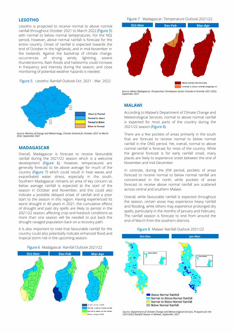
Overall, Madagascar is forecast to receive favourable
rainfall during the 2021/22 season which is a welcome
development (Figure 6). However, temperatures are
generally forecast to be above average for much of the
country (Figure 7) which could result in heat waves and
exacerbated water stress, especially in the south.
Southern Madagascar remains an area of key concern as
below average rainfall is expected at the start of the
season in October and November, and this could also
indicate a possible delayed onset of rainfall and a poor
start to the season in this region. Having experienced its
worst drought in 40 years in 2021, the cumulative effects
of drought and past dry spells are likely to persist in the
2021/22 season, affecting crop and livestock conditions as
more than one season will be needed to put back the
drought ravaged population back on a recovery path.
It is also important to note that favourable rainfall for the
country could also potentially indicate enhanced flood and
tropical storm risk in the upcoming season.
Source: Meteo Madagascar, Perspectives Climatiques Saison Chaude et Humide 2021-2022, September 2021
Figure 7 Madagascar: Temperature Outlook 2021/22
Oct-Nov Dec-Feb Mar-Apr
MALAWI
According to Malawi’s Department of Climate Change and
Meteorological Services, normal to above normal rainfall
is expected for most parts of the country during the
2021/22 season (Figure 8).
There are a few pockets of areas primarily in the south
that are forecast to receive normal to below normal
rainfall in the OND period. Yet, overall, normal to above
normal rainfall is forecast for most of the country. While
the general forecast is for early rainfall onset, many
places are likely to experience onset between the end of
November and mid-December.
In contrast, during the JFM period, pockets of areas
forecast to receive normal to below normal rainfall are
concentrated in the north, while pockets of areas
forecast to receive above normal rainfall are scattered
across central and southern Malawi.
Overall, while favourable rainfall is expected throughout
the season, certain areas may experience heavy rainfall
and flooding, while others may experience prolonged dry
spells, particularly in the months of January and February.
The rainfall season is forecast to end from around the
end of March from the southern districts.
Mar-Apr
Figure 6 Madagascar: Rainfall Outlook 2021/22
Dec-Feb Oct-Nov
Figure 8 Malawi: Rainfall Outlook 2021/22
Source: Department of Climate Change and Meteorological Services, Prospects for the 2021/2022 Rainfall Season in Malawi, September 2021
Oct-Dec. Jan-Mar.

MOZAMBIQUE
According to the Mozambique National Meteorology
Institute (INAM), normal to above normal rainfall is
projected for much of the country during the 2021/22
season (Figure 9).
In the OND period, there is a higher likelihood of normal to
above normal rainfall in the provinces of Maputo, Gaza,
Inhambane, Manica, Sofala and a large extension of the
province of Tete and the districts to the south of the
province of Zambézia. In the JFM period, there is a higher
likelihood of normal to below normal rainfall in the
districts north of Cabo Delgado, the coastal strip of Gaza
and parts of the province of Maputo. Throughout the
season, due to oceanic and atmospheric conditions, the
northern part of the country could experience long dry
spells (i.e. periods without rainfall or below normal rainfall).
Source: Instituto Nacional de Meteorologia de Mocambique, Previsão Climática Sazonal para a Época chuvosa 2021/2022, September 2021
Figure 9 Mozambique: Rainfall Outlook 2021/22
Oct-Dec Nov-Jan Dec-Feb Jan-Mar
Normal to above normal
Normal
Normal to below normal
Below normal to normal
In terms of temperature, parts of northern Mozambique is
forecast to experience normal to below temperatures
throughout the season, while parts of central and
southern Mozambique are forecast to see normal to
above normal temperatures during different periods of the
season (Figure 10).
During the OND period, there is a higher likelihood of
warmer than normal temperaturs in the southern
districts of Gaza province and Maputo province. In the
JFM period, there is a higher likelihood of warmer than
normal temperatures in the southwestern districts of
Niassa, central and southwestern Zambézia, the province
of Tete, the central and northern districts of Manica and
Sofala.
According to Mozambique’s National Directorate of Water
Resources Management (DNGRH), in terms of
hydrological forecasts, in the OND period, the Maputo,
Umbeluzi, Incomáti, Limpopo, Inhanombe, Mutamba,
Búzi, Zambeze and Savane basins are at moderate risk
(25-50%) and in the JFM period, the Futi, Inharrime, In-
hanombe, Mutamba, Save, Zambeze, Namacurra, Mega-
ruma, Montepuez and Messalo basins are at moderate
risk while the Maputo, Umbeluzi, Incomáti, Limpopo, Búzi,
Púngoé, Savane and Licungo basins are at moderate to
high risk (50-75%) (Figure 11). The forecast of possible
areas of impact are: Maputo, Umbeluzi, Incomáti and
Limpopo in the south, Save, Búzi and Pungue in the cen-
tral region and Licungo and Zambeze in the central-north
region.
Figure 11 Mozambique: Hydrological Forecast 2021/22
Oct-Dec. Jan-Mar.
Source: Reuniao de Preparacao para Epoca Chuvosa 2021-22, September 2021
SOUTH AFRICA
According to the South African Weather Service, mostly
above normal rainfall is forecast for the north-eastern
half of the country (i.e. main maize production area)
between the September-October-November (SON)
period and the NDJ period (Figure 12). The south-western
parts of the country are expected to receive below nor-
mal rainfall for the OND period and above normal rain-
fall for the NDJ period. Across South Africa, above-normal
minimum and maximum temperatures are expected
throughout from the SON period to NDJ period.
Low (15-25%)
Moderate (25-50%)
Moderate to High (50-75%)
High (75-100%)
Risk
Figure 10 Mozambique: Temperature Outlook 2021/22
Oct-Dec Nov-Jan Dec-Feb Jan-Mar
Source: Instituto Nacional de Meteorologia de Mocambique, Previsão Climática Sazonal para a Época chuvosa 2021/2022, September 2021
Normal to above normal
Normal
Normal to below normal
Figure 12 South Africa: Rainfall Outlook 2021/22
Oct-Dec Nov-Jan
Source: South African Weather Service, Seasonal Climate Watch September 2021 to January 2022, September 2021

TANZANIA
According to the Tanzania Meteorological Agency, the
‘Vuli’ rain season (Oct-Dec in bimodal rainfall areas:
northeast highlands, northern coast, Dar es Salaam and
Tanga, as well as the islands of Unguja and Pemba, Lake
Victoria Belt and northern Kigoma region) is expected to
begin in earnest in the latter half of October. In general,
below average to average rainfall and long dry spells (i.e.
erratic distribution of rainfall) are expected (Figure 13),
along with periods of extreme heat. In these areas, there
is concern of depletion of soil moisture, disease out-
breaks due to shortage of clean/safe water, possible
emergence of conflicts between pastoralists and other
land users due to lack of feed and water, and possible
occurrences of forest fires.
Figure 13 Tanzania: Rainfall Outlook Oct - Dec 2021
Source: Tanzania Meteorology Authority, Mwelekeo Wa Msimu Wa Mvua Za Oktoba-Disemba 2021 (Vuli), September 2021
WFP VAM: KEY ACTIONS IN PREPARATION FOR THE SEASON
WFP VAM activities to prepare for the 2021/22 season
center around data preparedness, high frequency
monitoring and partnerships for enhanced monitoring
and disaster risk intelligence.
Figure 14 Zambia: Rainfall Outlook 2021/22
Oct-Dec Nov-Jan
Dec-Feb Jan-Mar
Source: Zambia Meteorological Department, Zambia Seasonal Rainfall Forecast for 2021/2022 season, September 2021
Average to below average
Below average to average
Forecast to be released in Oct.
Figure 15 Zimbabwe: Rainfall Outlook 2021/22
ZIMBABWE
The Meteorological Services Department of Zimbabwe
forecasts normal to above normal rainfall across the
whole country for the 2021/22 season (Figure 15).
Possible implications of this outlook include heavy
storms followed by periods of elevated temperatures,
flash floods, spilling of dams, increase in livestock
diseases and soil leaching among others. Based on
historical data analysis by WFP, La Niña’s effect of
bringing higher rainfall is more pronounced in a region
extending along a line Chiredzi-Masvingo-Gweru-
Bulawayo-Francistown. Despite the forecast for normal
to above normal rainfall, the possibility of prolonged dry
spells also remains in parts of the south.
Source: Meteorological Services Department, 2021/2022 Seasonal Rainfall Forecast for Zimbabwe, September 2021
ZAMBIA
For the 2021/22 rainfall season, Zambia’s Meteorological
Department forecasts normal to above normal rainfalls
across much of the country with the exception of the
north-eastern region which is forecast to receive normal
to below normal rainfall throughout the season (Figure
14). This could affect crop production in the northeast,
which forms part of the country’s cassava belt and
require close monitoring during the season.
DATA PREPAREDNESS
• 72 Hour Assessment Approach / Spatial Data Infrastructure
• Data Standardization and Data Library
HIGH FREQUENCY MONITORING
As the season starts in earnest,
• Weekly rainfall forecast
• High frequency tropical storm/cyclone monitoring (multiple updates per day when on watch a tropical system is approaching)
• Seasonal progress monitoring (e.g. rainfall, vegetation, crop conditions)
PARTNERSHIPS
With
• Cloud to Street: flood mapping, analysis of local flood exposure and near real-time monitoring of floods
• PDC Global for disaster risk intelligence (early warning and preparedness)