western range mine closure plan final
TRANSCRIPT

Hamersley Iron Pty. Limited
ABN: 49 004 558 276
Western Range Closure Plan
September 2019 Mineral Field 47 – West Pilbara
IODMS No: RTIO-HSE-0181647
Contact details:
Chantal Latham
Rio Tinto
Level 10, Central Park
152-158 St Georges Tce, Perth WA 6000
T: 0428 211 541
W: http://www.riotinto.com

Western Range Mine Closure Plan September 2019
Page i
EXECUTIVE SUMMARY Overview
The Western Range Project is located in the Pilbara region of Western Australia, approximately 20 km southwest from the town of Paraburdoo in the Shire of Ashburton. The mine is located within the traditional lands of the Yinhawangka People. The Western Range deposits in combination with Paraburdoo, Eastern Range are known as the Greater Paraburdoo Iron Ore Hub. The Western Range deposit is 100% Rio Tinto (Hamersley Iron Pty Limited) owned but is subject to a sublease as part of the Bao-Hi Ranges Joint Venture (JV) arrangements (Rio Tinto 54% and Baowu 46%). It is anticipated that the proposed Western Range Project will be operated by Hamersley Iron Pty Limited.
Ore will be extracted using conventional open pit, drill-and-blast and load-and-haul mining methods. Run of mine ore will be tipped into the primary crusher prior to being discharged to the primary stockpile. Ore will be reclaimed from the stockpile and conveyed to the nearby Paraburdoo mine plant area where it will be combined with other Greater Paraburdoo ore, crushed and screened into lump and fine product, then transported via the existing rail network to either Dampier or Cape Lambert ports for shipping. Completion of mining at Western Range is currently scheduled for 2042, although additional deposits may be proposed in the future and subject to relevant approvals may extend mining post this date.
Mineral waste generated by mining will be placed in a number of external waste dumps. The site is expected to encounter minor quantities of highly erodible materials, which will be used for pit backfill or placed in external waste dumps with appropriate stable rehabilitation parameters, which may include conservative lift heights and/or shallower batter angles. The site has been assessed as having a low geochemical risk. Tailings will not be produced at Western Range, and therefore is not discussed within this Western Range Closure Plan.
Purpose
This closure plan has been developed to support the Greater Paraburdoo Iron Ore Hub Proposal referred to the Environmental Protection Authority (EPA) under the Section 38 (s38) of the Environmental Protection Act 1986 (EP Act) and the Department of the Environment and Energy (DotEE) (Cwth) under the Environmental Protection and Biodiversity Act 1999 (EPBC Act). The Western Range Project is presently under pre-feasibility study (PFS) by Rio Tinto. Due to the early stage of the project, baseline characterisation information has been used to help develop closure strategies and these will be refined as further information becomes available.
Scope
The Western Range Closure Plan first completed in 2012 for internal business purposes only. This document, titled ‘Western Range Closure Plan September 2019’, represents the most recent closure plan for the proposed Western Range operations and supersedes previous internal Rio Tinto closure plans. This closure plan addresses the proposed development of the Western Range deposits and associated mine site infrastructure. This closure plan does not include the nearby Paraburdoo, Channar or Eastern Range mine sites or Paraburdoo town.
Post-mining land use
Post-mining land use options in the Pilbara are generally limited due to the remote location. As a result of the nature of the mining activity undertaken, the final landform will include large voids and waste dumps, and will therefore be unlikely to support pastoral activities in the immediate disturbed areas. However, it is recognised that surrounding areas are likely to remain subject to pastoral activity.
The proposed post-mining land use assumes that the site will be rehabilitated to create a safe, stable and non-polluting landscape vegetated with native vegetation of local provenance, to maximise environmental and cultural heritage outcomes and ensure the site minimises adverse impacts on the current surrounding land use. The post-mining land use will be confirmed prior to closure, during final planning phases and in consultation with relevant stakeholders.

Western Range Mine Closure Plan September 2019
Page ii
Closure objectives
The following closure objectives have been developed for the Western Range Project:
cultural heritage values have been preserved where possible; public health and safety hazards have been appropriately managed; contamination risks have been appropriately managed; the final landform is stable and considers hydrological factors; vegetation on rehabilitated land is self-sustaining and compatible with the post-mining land use; the Western Range population of Aluta quadrata is not significantly impacted by closure activities;
and infrastructure has been appropriately managed.
Indicative completion criteria have been proposed for each of these objectives; however, these have not been the subject of consultation with stakeholders at this point, which is considered appropriate given the long timeframe for mining operations for this site.
Anticipated closure outcome
Groundwater is predicted to recover to pre-mining levels in most areas. Below water table pits will be backfilled to prevent the formation of permanent pit lakes, although this conservative approach will be revisited once enough information has been collected to predict if leaving pit lakes will provide an acceptable environmental outcome.
Waste dumps will be reshaped to be stable based on their physical material characteristics. It is assumed that all infrastructure will be removed, but this will be subject to negotiation with the Western Australian State Government as per the Iron Ore (Hamersley Range) Agreement Act 1968 (Paraburdoo) (WA) obligations. All other disturbed areas, except the pit voids, will be rehabilitated. Rehabilitation practices generally include application of topsoil (or an alternative suitable growth medium) where available and spreading of native seed of local provenance with the aim of creating self-sustaining ecosystems.
The area around pit voids may be unstable as pit walls are expected to collapse over time, and inadvertent access will be restricted by the use of physical barriers (e.g. abandonment bunds) or the use of natural topography. Strategies for managing safety risks will be developed as the site approaches closure, but will need to consider the potential for ongoing public access resulting from a portion of the mining area being underlain by pastoral stations and access requirements of local Traditional Owner groups.

Western Range Mine Closure Plan September 2019
Page iii
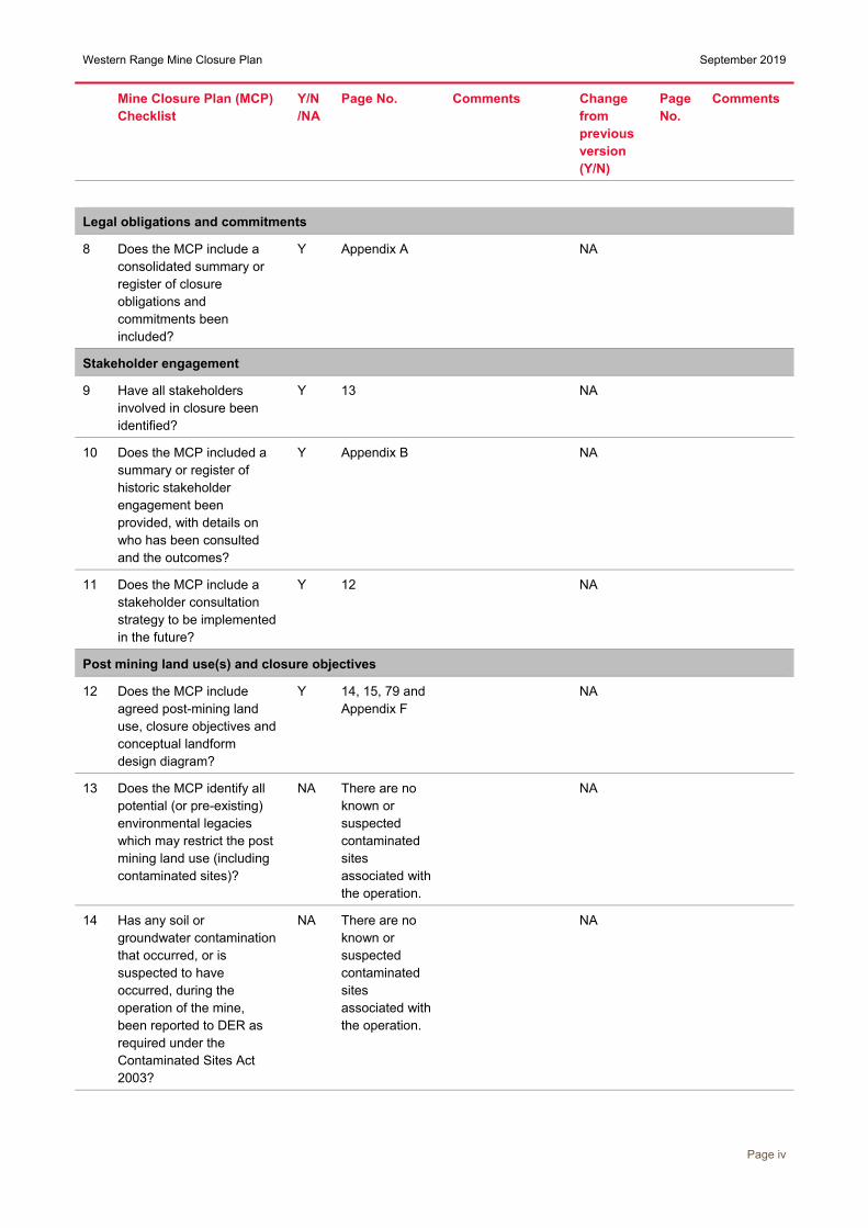
CLOSURE PLAN CHECKLIST The following table provides cross reference to the requirements of the Department of Mines and Petroleum / Environmental Protection Authority Guidelines for Preparing Mine Closure Plans (2015).
Mine Closure Plan (MCP) Checklist
Y/N/NA
Page No. Comments Change from previous version (Y/N)
Page No.
Comments
1 Has the Checklist been endorsed by a senior representative within the operating company?
Y viii
Public Availability
2 Are you aware that from 2015 all MCPs will be made publically available?
Y NA
3 Is there any information in this MCP that should not be publicly available?
N
4 If “Yes” to Q3, has confidential information been submitted in a separate document / section?
NA
Cover page, table of contents
5 Does the MCP cover page include: Project Title, Company Name, Contact Details (including telephone numbers and email address) Document ID and version number, Date of submission (needs to match the date of this checklist)
Y
Scope and purpose
6 State why the MCP is submitted (e.g. as part of a Mining Proposal, a reviewed MCP or to fulfil other legal requirement)
Y 1 To support the Greater Paraburdoo Iron Ore Hub environmental approval
NA Noprevious version
Project overview
7 Does the project summary include land ownership details, location of the project, comprehensive site plans and background information on the history and status of the project?
Y 5-59 NA
Western Range Mine Closure Plan September 2019
Page iv
Mine Closure Plan (MCP) Checklist
Y/N/NA
Page No. Comments Change from previous version (Y/N)
Page No.
Comments
Legal obligations and commitments
8 Does the MCP include a consolidated summary or register of closure obligations and commitments been included?
Y Appendix A NA
Stakeholder engagement
9 Have all stakeholders involved in closure been identified?
Y 13 NA
10 Does the MCP included a summary or register of historic stakeholder engagement been provided, with details on who has been consulted and the outcomes?
Y Appendix B NA
11 Does the MCP include a stakeholder consultation strategy to be implemented in the future?
Y 12 NA
Post mining land use(s) and closure objectives
12 Does the MCP include agreed post-mining land use, closure objectives and conceptual landform design diagram?
Y 14, 15, 79 and Appendix F
NA
13 Does the MCP identify all potential (or pre-existing) environmental legacies which may restrict the post mining land use (including contaminated sites)?
NA There are no known or suspected contaminated sites associated with the operation.
NA
14 Has any soil or groundwater contamination that occurred, or is suspected to have occurred, during the operation of the mine, been reported to DER as required under the Contaminated Sites Act 2003?
NA There are no known or suspected contaminated sites associated with the operation.
NA

Western Range Mine Closure Plan September 2019
Page v
Mine Closure Plan (MCP) Checklist
Y/N/NA
Page No. Comments Change from previous version (Y/N)
Page No.
Comments
Development of completion criteria
15 Does the MCP include an appropriate set of specific completion criteria and closure performance indicators?
Y 16 NA
Collection and analysis of closure data
16 Does the MCP include baseline data (including pre-mining studies and environmental data)
Y 20 and Appendix C
NA
17 Has materials characterisation been carried out consistent with applicable standards and guidelines (e.g. GARD Guide)?
Y 28 NA
18 Does the MCP identify applicable closure learnings from benchmarking against other comparable mine sites?
Y Appendix C NA
19 Does the MCP identify all key issues impacting mine closure objectives and outcomes (including potential contamination impacts)?
Y 62 NA
20 Does the MCP include information relevant to mine closure for each domain or feature?
Y 74 NA
Identification and management of closure issues
21 Does the MCP include a gap analysis / risk assessment to determine if further information is required in relation to closure of each domain or feature?
Y 60 and Appendix D
NA

Western Range Mine Closure Plan September 2019
Page vi
Mine Closure Plan (MCP) Checklist
Y/N/NA
Page No. Comments Change from previous version (Y/N)
Page No.
Comments
22 Does the MCP include the process, methodology and has the rationale been provided to justify identification and management of the issues?
Y 60 and Appendix D
NA
Closure Implementation
23 Does the MCP include a summary of closure implementation strategies and activities for the proposed operations or for the whole site?
Y 76 NA
24 Does the MCP include a closure work program for each domain or feature?
Y 76 To be refined prior to closure
NA
25 Does the MCP contain site layout plans to clearly show each type of disturbance as defined in Schedule 1 of the MRF Regulations?
Y 75 State agreement site not subject to MRF
NA
26 Does the MCP contain a schedule of research and trial activities?
Y Appendix E NA
27 Does the MCP contain a schedule of progressive rehabilitation activities?
Y 6 Indicative closure schedule provided in Table 1 and Table 2. Opportunities for rehabilitation assessed annually. Other areas proposed for end of mine life.
NA
28 Does the MCP include details of how unexpected closure and care and maintenance will be handled?
Y 80 NA
29 Does the MCP contain a schedule of decommissioning activities?
N To be refined prior to closure
NA

Western Range Mine Closure Plan September 2019
Page vii
Mine Closure Plan (MCP) Checklist
Y/N/NA
Page No. Comments Change from previous version (Y/N)
Page No.
Comments
30 Does the MCP contain a schedule of closure performance monitoring and maintenance activities?
Y 81 To be refined prior to closure
NA
Closure monitoring and maintenance
31 Does the MCP contain a framework, including methodology, quality control and remedial strategy for closure performance monitoring including post-closure monitoring and maintenance?
Y 81 To be refined prior to closure
NA
Financial provisioning for closure
32 Does the MCP include costing methodology, assumptions and financial provision to resource closure implementation and monitoring?
Y 82 NA
33 Does the MCP include a process for regular review of the financial provision?
Y 82 NA
Management of information and data
34 Does the MCP contain a description of management strategies including systems and processes for the retention of mine records?
Y 83 NA


Western Range Mine Closure Plan September 2019
Page ix
Table of Contents Executive summary .......................................................................................................................................... i Closure Plan Checklist ................................................................................................................................... iii Abbreviations ................................................................................................................................................ xiv Purpose and Scope ......................................................................................................................................... 1
1 Purpose.................................................................................................................................................. 1 2 Scope ..................................................................................................................................................... 1
2.1 Closure Planning Process ............................................................................................................. 4 Project Overview .............................................................................................................................................. 5
3 Description of the operation ................................................................................................................... 5 3.1 Ownership ...................................................................................................................................... 5 3.2 Location ......................................................................................................................................... 5 3.3 Mine Operations ............................................................................................................................ 5
Identification of closure obligations and commitments ............................................................................ 11 4 Legal obligations .................................................................................................................................. 11
Stakeholder Engagement ............................................................................................................................. 12 5 Stakeholder engagement..................................................................................................................... 12
5.1 Engagement process ................................................................................................................... 12 Post-mining land use and closure objectives ............................................................................................ 14
6 Land use .............................................................................................................................................. 14 6.1 Proposed post-mining land use ................................................................................................... 14
7 Closure objectives ............................................................................................................................... 14 7.1 Rio Tinto vision for closure in the Pilbara .................................................................................... 14 7.2 Western Range closure objectives .............................................................................................. 15
Completion criteria ........................................................................................................................................ 16 8 Completion criteria ............................................................................................................................... 16
Collection and analysis of closure data ...................................................................................................... 20 9 Climate ................................................................................................................................................. 20
9.1 Climate and significant weather events ....................................................................................... 20 9.2 Climate and landform stability ..................................................................................................... 22 9.3 Climate and vegetation growth .................................................................................................... 23 9.4 Climate change ............................................................................................................................ 23
10 Land ..................................................................................................................................................... 23 10.1 Biogeographic overview ............................................................................................................... 23 10.2 Geological setting ........................................................................................................................ 24 10.3 Geotechnical stability of pit walls ................................................................................................. 28 10.4 Mineral waste characteristics and inventory ................................................................................ 28
10.4.1 Physical characteristics ....................................................................................................... 28
10.4.2 Geochemical characteristics ................................................................................................ 30
10.4.3 Fibrous minerals .................................................................................................................. 33
10.5 Local soils .................................................................................................................................... 33 10.6 Soil inventory ............................................................................................................................... 34 10.7 Alternative growth media ............................................................................................................. 35

Western Range Mine Closure Plan September 2019
Page x
11 Water ................................................................................................................................................... 37 11.1 Surface water ............................................................................................................................... 37 11.2 Groundwater ................................................................................................................................ 41
12 Biodiversity .......................................................................................................................................... 44 12.1 Terrestrial fauna habitat ............................................................................................................... 44 12.2 Conservation significant fauna .................................................................................................... 44 12.3 Subterranean habitat ................................................................................................................... 44 12.4 Feral animals ............................................................................................................................... 44 12.5 Conservation significant flora....................................................................................................... 48
12.5.1 Aluta quadrata...................................................................................................................... 48
12.6 Invasive flora ................................................................................................................................ 53 12.7 Priority and/or Threatened Ecological Communities ................................................................... 54
13 Progressive rehabilitation .................................................................................................................... 54 13.1 Rehabilitation planning and implementation ................................................................................ 54
13.1.1 Seed provenance and selection .......................................................................................... 55
13.2 Local reference sites .................................................................................................................... 55 13.3 Rehabilitation monitoring ............................................................................................................. 55
13.3.1 Vegetation, fauna habitat and erosion quantitative method ................................................ 56
13.3.2 Rehabilitation quality assessment ....................................................................................... 56
13.4 Waste dumps ............................................................................................................................... 56 13.5 Low impact disturbance areas, construction areas, roads .......................................................... 57
14 Contaminated sites .............................................................................................................................. 58 15 Cultural heritage .................................................................................................................................. 58
15.1 Relevant Aboriginal groups.......................................................................................................... 58 15.2 Ethnographic and archaeological values ..................................................................................... 58
16 Regional Community ........................................................................................................................... 59 17 Workforce............................................................................................................................................. 59
Identification and management of closure issues ..................................................................................... 60 18 Risk evaluation process ....................................................................................................................... 60 19 Management of key issues .................................................................................................................. 62
19.1 Challenges with progressive rehabilitation .................................................................................. 63 19.1.1 Revegetation challenges ..................................................................................................... 63
19.2 Dispersive, sodic and erosive materials ...................................................................................... 64 19.2.1 Principles of waste dump design ......................................................................................... 64
19.2.2 Western Range erodible mineral waste management ........................................................ 64
19.3 Pit lakes ....................................................................................................................................... 65 19.3.1 Closure outcomes for pit voids ............................................................................................ 65
19.3.2 Western Range pit void management ................................................................................. 66
19.4 Management of public access ..................................................................................................... 68 19.4.1 Risk of inadvertent access ................................................................................................... 68
19.4.2 Management of inadvertent public access into Western Range ......................................... 68
19.5 Flora and fauna diversity and threatened species ....................................................................... 71 19.5.1 Fauna ................................................................................................................................... 71

Western Range Mine Closure Plan September 2019
Page xi
19.5.2 Aluta quadrata population .................................................................................................... 71
19.6 Heritage issues ............................................................................................................................ 72 19.7 Alteration of the depth to water table of the local aquifer ............................................................ 72 19.8 Community ................................................................................................................................... 72
Closure implementation ................................................................................................................................ 74 20 Closure domains .................................................................................................................................. 74 21 Closure implementation strategies ...................................................................................................... 76 22 Post mining and post closure landforms .............................................................................................. 77 23 Unexpected closure ............................................................................................................................. 80
23.1 Temporary care and maintenance ............................................................................................... 80 23.2 Early permanent closure .............................................................................................................. 80
Closure monitoring and maintenance ......................................................................................................... 81 24 Closure monitoring program ................................................................................................................ 81
24.1 Phases of monitoring ................................................................................................................... 81 24.2 Indicative monitoring program ..................................................................................................... 81
24.2.1 Rehabilitation monitoring ..................................................................................................... 81
24.2.2 Water monitoring ................................................................................................................. 81
24.2.3 Heritage surveys .................................................................................................................. 81
25 Post closure maintenance ................................................................................................................... 81 Financial provision for closure .................................................................................................................... 82
26 Principles of Rio Tinto closure cost estimation .................................................................................... 82 27 Closure cost estimation methods ........................................................................................................ 82
Management of information and data .......................................................................................................... 83 28 Data and information management ..................................................................................................... 83
28.1 Iron Ore Document Management System (IODMS) .................................................................... 83 28.2 Closure knowledge base ............................................................................................................. 83 28.3 EnviroSys ..................................................................................................................................... 83
Appendix A – Register of key closure obligations ....................................................................................... 84 Appendix B – Communications register ....................................................................................................... 88 Appendix C – Closure knowledge database (Confidential) ......................................................................... 90 Appendix D – Closure risk assessment ........................................................................................................ 105 Appendix E – Task, research and trial activities schedule ......................................................................... 111 Appendix F – Landform design criteria ......................................................................................................... 113

Western Range Mine Closure Plan September 2019
Page xii
Tables Table 1: Indicative mining schedule .................................................................................................................. 6 Table 2: Waste landform inventory .................................................................................................................... 6 Table 3: Stakeholder list .................................................................................................................................. 13 Table 4: Western Range closure objectives .................................................................................................... 15 Table 5: Indicative completion criteria ............................................................................................................. 17 Table 6: Waste material erodibility characterisation by type ........................................................................... 30 Table 7: Waste material erodibility characterisation summary ........................................................................ 30 Table 8 Summary of static ABA for Greater Paraburdoo area rock types associated with black shale ......... 31 Table 9 Summary of static ABA and short-term liquid extract tests completed on Greater Paraburdoo-area samples ........................................................................................................................................................... 31 Table 10: AMD risk ratings – summary of the analysis of waste drillhole samples from Western Range deposits ........................................................................................................................................................... 32 Table 11: Comparison between local soils and typical Pilbara soil parameters .............................................. 34 Table 12: Predicted LOM soil balances for Western Range (as of September 2018) .................................... 35 Table 13: Groundwater levels at Western Range pits and approximate time to recovery .............................. 41 Table 14: Description of pre-mining habitats identified at Western Range ..................................................... 44 Table 15: Significant fauna and its habitat across the Western Range area .................................................. 47 Table 16: Conservation significant flora identified at Western Range ............................................................. 48 Table 17: Weed species recorded at Western Range ..................................................................................... 54 Table 18: Relevance of potential closure and rehabilitation issues to Western Range .................................. 62 Table 19 Waste landforms rehabilitation berm and batter design specifications based on the erodibility of the waste material .................................................................................................................................................. 64 Table 20: Predicted below water table pit void conditions ............................................................................... 67 Table 21: Western Range general area implementation strategies by closure domain .................................. 76

Western Range Mine Closure Plan September 2019
Page xiii
Figures Figure 1: Western Range tenure and closure boundary ................................................................................... 3 Figure 2: Progression of closure planning ......................................................................................................... 4 Figure 3: Regional location of Western Range .................................................................................................. 7 Figure 4: Western Range Native Title Determination Areas ............................................................................. 8 Figure 5: Pastoral stations surrounding Western Range ................................................................................... 9 Figure 6: Western Range conceptual mine layout .......................................................................................... 10 Figure 7: Mean monthly temperatures, for Paraburdoo airport (007185) [1974-2018] ................................... 20 Figure 8: Mean monthly rainfall for Paraburdoo airport (007185) [1974-2018] ............................................... 21 Figure 9: Historical annual rainfall for Paraburdoo airport (007185) [1974-2018] ........................................... 21 Figure 10: Average annual pan evaporation rates across Australia ............................................................... 22 Figure 11: Interim Biogeographic Regionalisation for Australia, Version 7 ..................................................... 25 Figure 12: Stratigraphic columns of the Hamersley Group ............................................................................. 26 Figure 13: Western Range geological cross section through the 36W deposit at 10100W (excludes the Marra Mamba ridge to the north which has not been drilled) .................................................................................... 27 Figure 14: Zone of Instability of pits at Western Range .................................................................................. 29 Figure 15 Western Range conceptual mine layout (rehabilitation materials inventory) .................................. 36 Figure 16: Western Range surface hydrology ................................................................................................. 38 Figure 17: Unnamed Creek channel located at Western Range (November 2018) ....................................... 39 Figure 18: (a) A Western Range pool observed in November 2018 (b) A Western Range pool observed in February 2018 ................................................................................................................................................. 40 Figure 19: Conceptual hydrogeological cross section of Western Range. Cross section location shown in Figure 20 .......................................................................................................................................................... 42 Figure 20: Hydrogeological map of the Western Range area, illustrating location of monitoring and production bores and the conceptual hydrogeology cross section ................................................................. 43 Figure 21: Terrestrial fauna habitats of Western Range ................................................................................. 45 Figure 22: Western Range terrestrial fauna surveys ....................................................................................... 46 Figure 24: Aluta quadrata habitat and foliage ................................................................................................. 49 Figure 23: Flora and vegetation surveys over Western Range ....................................................................... 50 Figure 25: Aluta quadrata populations located at Western Ranges, Paraburdoo and Channar ..................... 51 Figure 26: Known locations of Western Range Aluta quadrata population ..................................................... 52 Figure 27: Channar East 3 waste dump rehabilitation (left) and reference site (right) monitoring transects .. 57 Figure 28: Channar 84E5 WD East rehabilitation in 2011 (left) and in 2018 (right) ........................................ 57 Figure 29: Risk matrix based on consequence and likelihood ........................................................................ 61 Figure 30: Zones of geotechnical instability around pits (pink line). Conceptual abandonment bund locations are indicated by the blue lines ......................................................................................................................... 70 Figure 31: Western Range closure domains ................................................................................................... 75 Figure 32: Conceptual layout of the site at completion of mining .................................................................... 78 Figure 33: Conceptual layout of the site at completion of rehabilitation activities (reshaping and backfill) .... 79
Western Range Mine Closure Plan September 2019
Page xiv
Abbreviations
ABA Acid Base Accounting
AMD Acid and/or Metalliferous Mine Drainage
ANC Acid Neutralising Capacity
ANZECC Australian and New Zealand Minerals Environment Conservation Council
AWT Above Water Table
BIF Banded Iron Formation
BOM Bureau of Meteorology
BS Black Shale
BWT Below Water Table
DBCA Department of Biodiversity Conservation and Attractions
DG Dales Gorge
DER Department of Environmental Regulation (Part of DWER)
DET Detritals
DIR Department of Industry and Resources
DMIRS Department of Mine, Industry Regulation and Safety
DMP Department of Mines and Petroleum (now DMIRS)
DOR Dolerite
DotEE Department of the Environment and Energy (Federal)
DPLH Department of Planning, Lands and Heritage
DSI Detailed site investigation
DWER Department of Water and Environmental Regulation
EC Electrical conductivity
ENSO El Niño Southern Oscillation
EPA Environmental Protection Authority (Part of DWER)
EP Act Environmental Protection Act 1986 (WA)
EPBC Act Environmental Protection and Biodiversity Act 1999
ESP Exchangeable Sodium Percentage
FIFO Fly-in Fly-out
FMMP Fibrous Minerals Management Plan
FWZ Footwall zone
GAI Global Abundance Index
HI Hamersley Iron
HYD Hydrated zone
IBRA Interim Biogeographic Regionalisation for Australia
ILUA Indigenous Land Use Agreements
IOD Indian Ocean Dipole
IODMS Iron Ore Document Management System

Western Range Mine Closure Plan September 2019
Page xv
JOF Joffre
JV Joint venture
m3 Meters cubed
MCA Minerals Council of Australia
MCS Mount McRae Shale
MPA Maximum Potential Acidity
mRL Metres above Relevant Level (Sea Level)
MS Ministerial Statement
MTS Mt Sylvia Formation
NPR Neutralisation Potential Ratio
NVCP Native Vegetation Clearing Permits
PA Participation Agreement
PAF Potentially Acid Forming
PEC Priority Ecological Community
PFS Pre-feasibility study
PCO Present Closure Obligation
RL Relative Level
RQA Rehabilitation Quality Assessments
SCARD Spontaneous Combustion and Acid Rock Drainage
TEC Threatened Ecological Community
TPC Total Projected Closure
TSF Tailing storage facility
WD Wittenoom Formation-Dolomite
WF Wittenoom Formation
WS Whaleback Shale
WW Weeli wolli
YS Yandicoogina Shale
ZOI Zone of Instability

Western Range Mine Closure Plan September 2019
Page 1
PURPOSE AND SCOPE
1 Purpose Planning for closure of a site is a critical business process that demonstrates Rio Tinto‘s commitment to sustainable development. This closure plan follows the format and content requirements for mine closure plans as recommended in the Department of Mines and Petroleum (DMP) / Environmental Protection Authority (EPA) Guidelines for Preparing Mine Closure Plans (2015).
The Western Range Closure Plan has been prepared to achieve the following goals:
to support an application under Part IV of the Environmental Protection Act 1986 (WA) (EP Act) fordevelopment of the Western Range Project as part of the Greater Paraburdoo Iron Ore Hub;
to reflect the current knowledge and requirements for closure of the proposed Western RangeProject and identify future requirements to continue to progress towards a planned and managedclosure of the site;
to meet the internal requirements of the Rio Tinto Closure Standard (2015) mandated for all RioTinto businesses; and
to inform the development of closure provisions.
Closure plans are generally updated every three years, in line with the DMP/EPA Guidelines for Preparing Mine Closure Plans (2015).
2 Scope This closure plan covers the proposed development of the Western Range deposits (the Western Range Project). The current footprint boundary is depicted in Figure 1. This plan is applicable to areas and mine development features within the following lease and other boundaries1:
Mineral Lease 246SA (AML70/00246) granted under the Iron Ore (Hamersley Range) AgreementAct 1968 (Paraburdoo) (WA). The closure boundary separating Western Range and Paraburdoo isbased according to the Bao-HI Ranges Joint Venture sub-lease boundary; and
A crusher and overland conveyor for the transportation of ore from Western Range to theParaburdoo processing plant located on Mineral Lease 246SA.
The plan excludes the following:
potential future deposits within the Western Range area that are not included in the Part IVapplication currently under assessment, although these may be subsequently incorporated intofuture updates of this closure plan;
other mines in the nearby area including Paraburdoo, Eastern Range and Channar, which aresubject to separate closure plans;
exploration areas and exploration infrastructure as these will be rehabilitated as part of explorationactivities;
access tracks and roads that will be used for construction only as these roads will be rehabilitated aspart of construction activities and will not require treatment at closure;
the processing plant and power generation facilities located at Paraburdoo which are included in theParaburdoo Closure Plan;
other support infrastructure and the rail loop located at Paraburdoo mine which are addressed in theParaburdoo Closure Plan;
explosives storage facilities located at Paraburdoo as no explosives will be stored at WesternRange, which will be addressed in the Paraburdoo closure plan;
the landfill facilities located at Paraburdoo will be utilised by Western Range operations. Thesefacilities are addressed in the Paraburdoo Closure Plan;
accommodation facilities as personnel for Western Range will be housed in the Paraburdoo townsite;
tailings and tailings production infrastructure. Tailings are produced and managed at Paraburdoomine and addressed in the Paraburdoo Closure Plan;
Land Administration Act 1997 (WA) (Land Administration Act):
1 Note that the scope of the closure plan has been aligned to tenure boundaries, which may differ from the footprint approved or referred under Part IV of the Environmental Protection Act 1986.

Western Range Mine Closure Plan September 2019
Page 2
o Easement L478326 issued for Turee Creek and Channar borefields (production and monitoringbores) which are located to the south of Channar mine and supply water to Channar, EasternRange and Paraburdoo mine sites. This area has been included in the Paraburdoo Closure Plan.Water from this borefield will potentially also be utilised by Western Range;
town of Paraburdoo and associated town infrastructure and roads; and linear infrastructure that is connected to an integrated network (e.g. power, communications), which
are subject to a separate closure plan.

Western Range Mine Closure Plan September 2019
Page 3 Figure 1: Western Range tenure and closure boundary

Western Range Mine Closure Plan September 2019
Page 4
2.1 Closure Planning Process Closure planning is an iterative process that commences during the planning phase of the mine development and is regularly updated and refined during the operational phase (Figure 2). Closure plans are updated to account for changes resulting from:
amendments to the mine plan; improvements of the site closure knowledge base (e.g. through daily activities, technical studies and
research actions, progressive rehabilitation); new or amended regulation; changes to surrounding land uses; and evolving stakeholder expectations.
The review brings specialists together to discuss current performance, proposed mine changes and opportunities to improve closure outcomes. At the end of the review, improvement actions are assigned and the closure plan is updated.
A key output of closure planning is the development of a closure cost estimate. Closure provisions are subsequently integrated into our business planning processes to ensure funds will be available to close the site effectively.
The detail of each closure plan increases as the knowledge base develops. When the site approaches scheduled closure, studies will be completed to define how infrastructure, decontamination, rehabilitation, the workforce and communications will be managed throughout the mine closure period (and beyond). Stakeholder engagement and endorsement of completion criteria is conducted at this time.
In the final closure plan, location specific management plans are provided for each closure domain. These detailed plans cover the physical closure, dismantling and subsequent rehabilitation implementation requirements. The supporting technical reports that have been used to predict the post closure outcomes are appended to the final closure plan.
Figure 2: Progression of closure planning

Western Range Mine Closure Plan September 2019
Page 5
PROJECT OVERVIEW
3 Description of the operation
3.1 Ownership The Western Range Mine is subleased by Hamersley Iron (HI) to the Bao-HI Ranges Joint Venture, and hereafter referred to as Rio Tinto. The Bao-HI Ranges Joint Venture comprises:
Ranges Mining Pty Ltd (54% participating interest) – a subsidiary of Rio Tinto; and Baosteel Australia Mining Company Pty Ltd (46% participating interest) – a subsidiary of the
Shanghai Baosteel Group Corporation.
Ranges Management Pty Ltd is the Manager of the Joint Venture, and HI will operate the Western Ranges Project.
3.2 Location The Western Range deposits are located in the Pilbara region of Western Australia (Figure 3), approximately 980 km north east of Perth (direct line) and falls within the local authority of the Shire of Ashburton. The deposits are located approximately 20 km southwest from the town of Paraburdoo. Tenure associated with the proposed mining activities is shown in Figure 1.
Western Range is located within the traditional lands of the Yinhawangka People (Figure 4). The nearest Aboriginal community is located at Bellary Springs, which is approximately 30 km from the town of Paraburdoo.
The Western Range deposits in combination with two other mine sites (Paraburdoo and Eastern Range) are referred to as the Greater Paraburdoo Iron Ore Hub (Greater Paraburdoo). The Paraburdoo mine is the ore processing hub for Greater Paraburdoo and lies approximately 12 km east from Western Range. Channar operations are also located 9 km to the east of Eastern Range and are also processed in the Greater Paraburdoo processing plant.
The Western Range Project area is located on State Agreement Mining Mineral Lease 246SA and is underlain predominantly by the pastoral lease Mininer Pastoral Station (N049718) as presented in Figure 5. A portion of the Western Range footprint is underlain by Rocklea Pastoral Station (N050372) and Ashburton Downs Pastoral Station (N050036). Rocklea Station is currently leased and managed by Rocklea Station Pty Limited (a subsidiary of Rio Tinto) and is used for cattle grazing activities. Mininer and Ashburton Downs Stations are leased and operated by third parties external to Rio Tinto. A portion of the mining area located to the north is underlain by unallocated crown land.
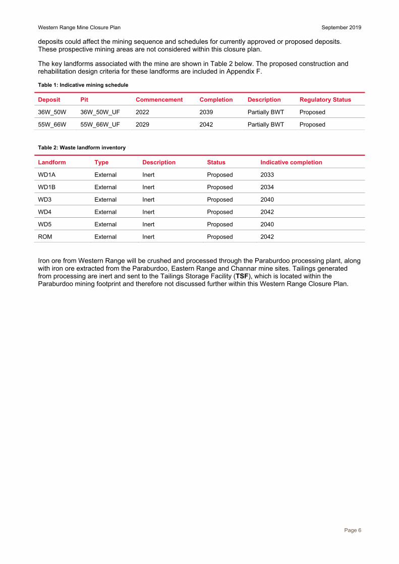
3.3 Mine Operations Western Range is proposed to be an open cut operation utilising conventional drill-and-blast and load-and-haul mining methods. Ore will be crushed on-site before being conveyed to Paraburdoo for further processing. After processing, ore will be transported via rail from Paraburdoo to Dampier or Cape Lambert ports for shipping. Significant waste rock volumes will be permanently stored in waste dumps. The orebody consists of deposits 36W_50W and 55W_66W spanning an area of approximately 12 km along the Western Range ridgeline. Two main pits will be mined within these deposits and mining will be predominately (99.6%) above the water table (AWT), except for two locations (36W and 66W) which will be below water table (BWT). The conceptual mine layout is shown in Figure 6.
This closure plan has been developed to support the Greater Paraburdoo Hub Proposal referred under Section 38 (s38) of the Environmental Protection Act 1986 (EP Act). The current mining schedule is presented in Table 1 below, however should be considered indicative only. The mine schedules and plans are subject to regular review to ensure optimised performance of the operations and are therefore subject to change.
The Western Range mine currently has an operational life of approximately 20 years with mining scheduled to commence in 2022 and completion of mining scheduled for 2042. It should be noted that there is the potential for further ongoing development of additional deposits. Should these exploration areas be developed, mining at Western Range could continue longer than indicated in Table 1. The addition of new
Western Range Mine Closure Plan September 2019
Page 6
deposits could affect the mining sequence and schedules for currently approved or proposed deposits. These prospective mining areas are not considered within this closure plan.
The key landforms associated with the mine are shown in Table 2 below. The proposed construction and rehabilitation design criteria for these landforms are included in Appendix F.
Table 1: Indicative mining schedule
Deposit Pit Commencement Completion Description Regulatory Status
36W_50W 36W_50W_UF 2022 2039 Partially BWT Proposed
55W_66W 55W_66W_UF 2029 2042 Partially BWT Proposed
Table 2: Waste landform inventory
Landform Type Description Status Indicative completion
WD1A External Inert Proposed 2033
WD1B External Inert Proposed 2034
WD3 External Inert Proposed 2040
WD4 External Inert Proposed 2042
WD5 External Inert Proposed 2040
ROM External Inert Proposed 2042
Iron ore from Western Range will be crushed and processed through the Paraburdoo processing plant, along with iron ore extracted from the Paraburdoo, Eastern Range and Channar mine sites. Tailings generated from processing are inert and sent to the Tailings Storage Facility (TSF), which is located within the Paraburdoo mining footprint and therefore not discussed further within this Western Range Closure Plan.

Western Range Mine Closure Plan September 2019
Page 7 Figure 3: Regional location of Western Range

Western Range Mine Closure Plan September 2019
Page 8 Figure 4: Western Range Native Title Determination Areas

Western Range Mine Closure Plan September 2019
Page 9 Figure 5: Pastoral stations surrounding Western Range
Western Range Mine Closure Plan September 2019
Page 10 Figure 6: Western Range conceptual mine layout

Western Range Mine Closure Plan September 2019
Page 11
IDENTIFICATION OF CLOSURE OBLIGATIONS AND COMMITMENTS
4 Legal obligations A closure obligations register is presented as Appendix A. It contains details of legal obligations from the following instruments:
Iron Ore (Hamersley Range) Agreement Act 1968 (Paraburdoo), which is the Third Scheduleof the Iron Ore (Hamersley Range) Agreement Act 1963; and
mineral leases issued under the Mining Act 1978 pursuant to the Iron Ore (HamersleyRange) Agreement Act 1963.
The register also identifies legislation, standards and guidelines that may not apply to this site specifically, but that may be relevant to closure of mine sites generally.
Operations at Western Range are carried out under the Iron Ore (Hamersley Range) Agreement Act, 1968 (Paraburdoo), (Paraburdoo Agreement) which is the Third Schedule of the Iron Ore (Hamersley Range) Agreement Act, 1963 (Hamersley Range State Agreement). This Act requires the Company to only undertake activities that are authorised and consistent with the purpose (mining) of the State Agreement.
This closure plan has been prepared in support of a referral under s38 of the EP Act. It is expected a Ministerial Statement will be issued for the Western Range Project (as part of the Greater Paraburdoo Iron Ore Hub Proposal), which will contain conditions relevant to the closure of Western Range. These will be documented in the next iteration of the Western Range Closure Plan.
At this stage it is assumed that the Health, Safety, Environmental and Quality Management System process utilised during operations will continue to be employed to govern closure implementation and the post closure monitoring period prior to relinquishment.

Western Range Mine Closure Plan September 2019
Page 12
STAKEHOLDER ENGAGEMENT
5 Stakeholder engagement
5.1 Engagement process Stakeholder engagement is a key part of mine closure planning as it ensures that the expectations of stakeholders are understood by the mine operator and these can be considered and managed during the planning and implementation phase of closure. Rio Tinto has established processes for consultation with stakeholders which are imbedded in both the Rio Tinto Mine closure standard (2015) and Community and social performance standard (2015). These standards are aligned with principles from the Australian and New Zealand Minerals and Energy Council and the Minerals Council of Australia (2000). Consultation commences at appropriate times during the early stages of exploration planning and will continue until the final relinquishment of the site.
As part of this process all likely impacted stakeholders are identified and recorded in a register, a summary of which is shown below in Table 3. This register is used to ensure relevant and timely communications are held with stakeholders across a broad range of topics relevant to the mining operations, including closure. This register is regularly reviewed and updated to maintain currency. Regular consultation is conducted with a wide range of stakeholders via a variety of forums, for example various State and Local Government agency briefing meetings and Traditional Owner consultation forums established under Indigenous Land Use Agreements. Discussions regarding closure and related activities are included in these meetings as appropriate. The level of closure specific content and detail will increase as closure approaches (see Figure 2).
A communications register specifically for closure of Western Range will be maintained and a copy as at the time of writing is included in Appendix B. To date, the closure related consultations have occurred as part of the approval applications process. This register is used to ensure stakeholder feedback is tracked and monitored to ensure that appropriate actions are taken to address these issues in a timely manner.

Western Range Mine Closure Plan September 2019
Page 13
Table 3: Stakeholder list
Category Stakeholder
Commonwealth Department of the Environment and Energy (DotEE) Civil Aviation Safety Authority
State Department of Water and Environmental Regulation (DWER) Department of Mines, Industry Regulation and Safety (DMIRS) Department of Jobs, Tourism, Science and Innovation (JTSI) Department of Biodiversity Conservation and Attractions (DBCA) Department of Planning, Lands and Heritage (DPLH) Department of Primary Industries and Regional Development Department of Health
Local Shire of Ashburton WA Police – Pilbara Main Roads Western Power/Horizon Pilbara Development Commission WA Country Health Service
Community Yinhawangka group Yinhawangka Aboriginal Corporation Mininer, Rocklea and Ashburton Downs owners/managers Paraburdoo residents Bellary Springs residents
Internal Rio Tinto employees and contractors
Western Range Mine Closure Plan September 2019
Page 14
POST-MINING LAND USE AND CLOSURE OBJECTIVES
6 Land use The lands surrounding the Western Range Project are the traditional lands recognised as belonging to the Yinhawangka People. Determination of native title for the Yinhawangka People occurred on 18 July 2017 when they were formally recognised as native title holders by the Federal Court of Australia. Since European settlement, land uses in the region have included cattle grazing, exploration, mining and conservation. Aside from mining activity and associated infrastructure, the Western Range area is largely undeveloped. Pastoral activity in the region has historically been limited to grazing of cattle. The Western Range Project conceptual footprint is generally on areas of rugged terrain of low pastoral land value and as such, minimal cattle grazing or mustering has occurred directly in the Western Range area. There are other mines currently operating in the immediate vicinity, these being Paraburdoo, Eastern Range and Channar mines.
6.1 Proposed post-mining land use Options for post-mining land use are limited in the Pilbara region, with mining and pastoralism the only industries that have historically proven viable. Inland regions are sparsely populated, with the largest inland towns (such as Tom Price, Paraburdoo and Newman) established specifically to support the mining industry. Beneficial uses for the mining area (e.g. recreation or aquaculture) that might have potential in areas supported with a higher population base are unlikely to be viable.
The proposed post-mining land use assumes that the site will be rehabilitated to create a safe, stable and non-polluting landscape vegetated with native vegetation of local provenance, to maximise environmental and cultural heritage outcomes and ensure the site minimises adverse impacts on the current surrounding land use. The post-mining land use will be finalised prior to closure during final planning phases and in consultation with relevant stakeholders.
Due to the nature of the mining activity undertaken, the final landform will include large voids and waste dumps, and will therefore present challenges for effective pastoral operations. However, it is recognised that surrounding flat areas are likely to remain subject to pastoral activity and that Western Range closure needs to be undertaken in such a manner that minimises impacts to surrounding land uses.
7 Closure objectives
7.1 Rio Tinto vision for closure in the Pilbara Closure objectives have been developed with consideration of Rio Tinto’s general vision for closure, which is to:
relinquish its mineral leases to the Western Australian State Government; preserve, protect and manage the cultural heritage values of the area in cooperation with the
Traditional Owners and other stakeholders; develop and implement strategies for closure that consider the implications on local
communities; achieve completion criteria that have been developed with stakeholders and agreed with the
Western Australian State Government; develop landforms that are safe, stable, and compatible with the surrounding environment
and post-mining land use; achieve environmental outcomes that are compatible with the surrounding environment; implement a workforce strategy that addresses the impacts of closure on employees and
contractors; and achieve successful closure in a cost effective manner.

Western Range Mine Closure Plan September 2019
Page 15
7.2 Western Range closure objectives The ultimate goal of mine closure at Western Range is to relinquish the site to the State Government. This goal will be achieved once the government and community agree that the condition of the site is compatible with the agreed post-mining land use. Closure objectives reflect the aspects of the closure plan that the government and community stakeholders have indicated are key to evaluating the site condition.
The site specific closure objectives that are proposed for Western Range Project are shown in Table 4. As approval to operate the Western Range Project is still pending, these objectives have yet to beagreed with key stakeholders and are likely to evolve in future versions of this plan as operations commence and knowledge of closure issues progress which will inform detailed closure discussions.
Table 4: Western Range closure objectives
Number Objective
1 Cultural heritage values have been preserved where possible.
2 Public health and safety hazards have been appropriately managed.
3 Contamination2 risks have been appropriately managed.
4 The final landform3 is stable and considers ecological and hydrological factors.
5 Vegetation on rehabilitated land is self-sustaining and compatible with the post-mining land use.
6 The Western Range population of Aluta quadrata is not significantly impacted by closure activities.
7 Infrastructure has been appropriately managed.
Note that these objectives do not represent the full range of issues that need to be addressed upon closure of Western Range; rather they represent the key objectives against which the ability to relinquish will be assessed.
Indicative completion criteria and measurement tools have been drafted for each of these objectives, and are discussed further in Section 8.
2 Contamination – in relation to land, water or a site, means having a substance present in or on that land, water or site at above background concentrations that presents, or has the potential to present, a risk of harm to human health, the environment or any environmental value. 3 ‘Landform’ includes all post mining constructed features: waste dumps, tailing storage facilities, abandonment bunds and mine voids.

Western Range Mine Closure Plan September 2019
Page 16
COMPLETION CRITERIA
8 Completion criteria Completion criteria are defined as the indicators used to determine whether closure objectives have been met. They are used to measure the success of closure implementation against objectives, and to facilitate relinquishment of mining tenure.
Indicative completion criteria, as detailed in Table 5, have been developed in consideration of the predicted closure outcomes. Measurement processes and the associated supporting data (evidence and / or metrics), that could be used to evaluate the success of closure are also described in Table 5.
The completion criteria are subject to ongoing review and update, informed by the outcome from studies, monitoring and ongoing stakeholder consultation. Given the number of years until scheduled closure, the completion criteria contained in this plan should be considered indicative only. As the site approaches scheduled closure, the completion criteria will contain more measurable and time-bound parameters.

Western Range Mine Closure Plan September 2019
Page 17
Table 5: Indicative completion criteria
Objective Indicative completion criteria Verification process/method Evidence
Cultural heritage values have been preserved where possible
Safe access to site/s of culturalsignificance is implemented in consultationwith key stakeholders.
Key heritage sites have not been impactedby closure implementation.
Closure strategies have been developed inconsultation with Traditional Ownerrepresentatives.
The final landform is deemed suitable froma visual amenity perspective.
Designated access pathways have beenidentified and communicated.
Abandonment bund restriction areas havebeen communicated.
Heritage survey, ethnographic survey and/orsite inspection confirms heritage sites ofsignificance have not been impacted.
Stakeholder consultation. Visual impact assessment.
Maps of designated accesspathways.
Maps of abandonment bundlocations and restriction areas.
Heritage and ethnographicsurvey report.
Consultation register. Visual impact assessment
report.
Public safety hazards have been appropriately managed.
Health and safety risks have beenidentified.
Measures to mitigate the identified publichealth and safety hazards have beenagreed with key stakeholders and havebeen implemented.
Transfer of any residual liabilities is agreedwith stakeholders.
Risk assessment conducted and mitigationactions implemented.
Relevant stakeholders have been engagedon risk mitigation measures to be employed.
Independent audit(s)/review to confirm thathazard mitigation measures have beenimplemented.
Process for transfer of residual liabilities isdocumented.
Risk assessment report. Audit report to confirm that
agreed hazard mitigationmeasures have beenimplemented.
Records of stakeholderengagement.
Liability transfer agreement/s.
Contamination risks have been appropriately managed.
Requirements under the ContaminatedSites Act 2003 (WA) have been met for theidentification, recording, management,remediation and transfer of anycontaminated sites as appropriate.
The site has been appropriately assessedfor the presence of suspected or knowncontaminated sites.
Suspected or known contaminated siteshave been appropriately reported under theContaminated Sites Act 2003.
Appropriate management measures toaddress contamination have beenimplemented.
Process for transfer of residual liabilities isdocumented.
Contaminated sitesinvestigation report/s.
Reports submitted to theDWER (if required).
Liability transfer agreement/s (ifrequired).

Western Range Mine Closure Plan September 2019
Page 18
Objective Indicative completion criteria Verification process/method Evidence
The final landform is stable and considers hydrological factors.
Final landforms have been rehabilitated todesign specifications derived from localclimatic conditions and physicalcharacterisation of the mineral waste typeswithin them.
There are no erosion features thatcompromise landform integrity, and ifpresent, erosion features are stable.
The final landform was designed andconstructed with consideration given to itsstability during intense rainfall and largeflood events.
Final landforms are located outsidepredicted zones of instability of pits.
Rehabilitation monitoring program includingquantitative evaluation of behaviour of rillsand gullies (if required) over time.
Analysis of aerial imagery to providequalitative analysis of landform stability.
Post closure landform review to confirm thatrisks have been appropriately managed.
Mineral waste physical characterisation.
Rehabilitation monitoringresults.
Post closure landformevaluation report.
Remote sensing dataassessment.
Characterisation data andbatter selector tool
Vegetation on rehabilitated land is self-sustaining and compatible with the post-mining land use.
Seed used in rehabilitation works is oflocal provenance4.
Native plants within rehabilitated areas areobserved to flower and/or fruit.
Recruitment of native perennial plants isobserved.
Species richness5 of native perennialplants within rehabilitated areas is not lessthan reference sites.
Any weed species recorded withinrehabilitation areas are present within thelocal area.
Seed management procedures. Rehabilitation monitoring/site inspections. Analysis of historical monitoring data.
Rehabilitation seed list. Seed database. Rehabilitation monitoring
reports.
4 Some seed used in rehabilitation predates accurate recording of collection area. Local is defined as Pilbara Interim Biogeographic Regionalisation for Australia (IBRA). 5 Richness is defined as the number of different species in the defined area.

Western Range Mine Closure Plan September 2019
Page 19
Objective Indicative completion criteria Verification process/method Evidence The Western Range population of Aluta quadrata is not significantly impacted by closure activities.
No Aluta quadrata individuals aredisturbed as a result of closure activitiesbeing implemented without prior approval.
Landforms have been rehabilitated tominimised direct and indirect impacts onAluta quadrata.
Baseline flora surveys. Approvals request clearing process. Rehabilitation management.
Flora survey data. Approvals request permits. Rehabilitation design memos
and close out reports.
Infrastructure has been appropriately managed.
Legal agreement to transfer residualliability completed (if required).
Where transfer of liability is notestablished, infrastructure has beendecommissioned and removed.
Appropriate agreements and transferprocesses in place and communicated forany infrastructure remaining post closure.
Decommissioning and demolition.
Agreements in place with partyassuming liability forinfrastructure.
Close out report. Visual inspection.

Western Range Mine Closure Plan September 2019
Page 20
COLLECTION AND ANALYSIS OF CLOSURE DATA
The closure knowledge base (Appendix C) is a collection of baseline studies, models and interpretations, which are used to inform the closure planning process presented in this closure plan. The knowledge may be specific to the site or generally applicable to the Pilbara region; and includes information on the performance of closure-related trials completed at other Pilbara mining operations (when appropriate). At this stage of the closure plan development, only summaries of these reports are provided and the relevant information is summarised in this section. The relevant knowledge base reports will be included in the final closure plan.
9 Climate The closest official Bureau of Meteorology (BOM) weather recording station is at Paraburdoo Airport (station 007185). Climatic information has been captured from this site since 1974. In addition to the BOM weather station, Rio Tinto maintains automatic weather stations, including a station at Paraburdoo mine. Data from this station is not included in this closure plan due to limited records available for long-term trends.
9.1 Climate and significant weather events The climate in the area can be characterised as arid tropical with two distinct seasons, hot wet summers and cooler dry winters. Mean daily maximum temperatures range from 41°C in summer to 25°C in winter (Figure 7).
Figure 7: Mean monthly temperatures, for Paraburdoo airport (007185) [1974-2018]
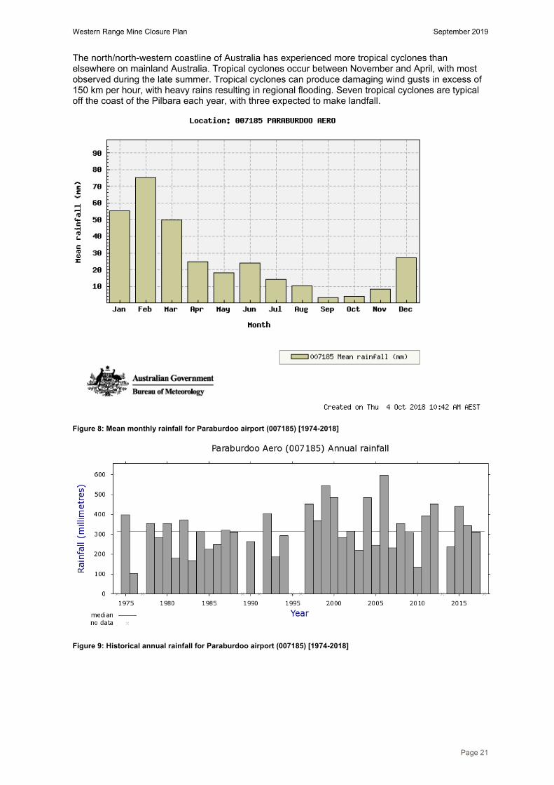
Precipitation is driven by summer cyclonic activity, with the months of September, October and November having the lowest average rainfall, and January, February and March recording the highest average rainfall (Figure 8). Annual rainfall is also highly variable (Figure 9). Evaporation rates in the region greatly exceed rainfall, which is typical for similar climate conditions around Australia. Average annual pan evaporation rate is 3200-3600 mm/year (Figure 10).
Western Range Mine Closure Plan September 2019
Page 21
The north/north-western coastline of Australia has experienced more tropical cyclones than elsewhere on mainland Australia. Tropical cyclones occur between November and April, with most observed during the late summer. Tropical cyclones can produce damaging wind gusts in excess of 150 km per hour, with heavy rains resulting in regional flooding. Seven tropical cyclones are typical off the coast of the Pilbara each year, with three expected to make landfall.
Figure 8: Mean monthly rainfall for Paraburdoo airport (007185) [1974-2018]
Figure 9: Historical annual rainfall for Paraburdoo airport (007185) [1974-2018]

Western Range Mine Closure Plan September 2019
Page 22
Figure 10: Average annual pan evaporation rates across Australia
9.2 Climate and landform stability The heavy, intense rainfall experienced in the Pilbara makes rainfall the key climatic factor that influences surface stability in built landforms. Rainfall erosivity (measured in mega joule-millimetre, per hectare, per hour, per year - MJ.mm/ha/hr/yr) is the term used to describe the erosive force of rain. For Pilbara sites, long-term annual erosivity values range from ~1,000-1,600 MJ.mm/ha/hr/yr. Rainfall in the Pilbara is typically more erosive than Perth’s rainfall, even though it only receives on average half the rainfall that Perth receives on an annual basis. For comparison, average annual erosivity values for Perth are ~1,000 MJ.mm/ha/hr/yr from an average of 780 mm of rain a year.
Rainfall erosivity is highly variable for each rainfall event. Studies of Pilbara rainfall concluded that at Tom Price, for example, erosivity for the period 1998 to 2009 ranged from 212 – 6,349 MJ.mm/ha/hr/yr. A review of data in the Channar area indicates that the most erosive year recorded was 2007, where 421 mm fell during February, with only a further 283 mm during the rest of that year. This singular rain period embodied 11,994 MJ.mm/ha/hr/yr of erosive force, or 89% of the entire erosivity of rain for that year. Given the pattern of intense and infrequent rainfall events in the Pilbara, it can be expected that only a few events every year (~1-3 events) will generate the majority of runoff and erosion of that occurs each year.
The studies showed a rapid decline in erosion or sediment yield occurs when annual rain decreases below about 300 mm per year, due to a corresponding decline in rainfall volumes and rainfall erosivity. However, when annual rainfall increases above ~300 mm, vegetation growth increases and becomes increasingly effective in controlling soil erosion. Hence, there is a point of maximum erosion potential at an annual rainfall value of ~200-400 mm such that surface (vegetation) cover is low due to lack of rain and ineffective for controlling erosion, yet rainfall erosivity is sufficiently high to cause erosion, as observed in the Pilbara. Outcomes from these studies have informed development of the Rio Tinto Iron Ore (WA) Landform Design Guidelines for achieving stable waste dumps.

Western Range Mine Closure Plan September 2019
Page 23
9.3 Climate and vegetation growth Water is generally the limiting factor for plant growth in the Pilbara’s arid environment. Due to the hot temperatures, high evaporative demand and infrequent and irregular rainfall, much of the vegetation displays xeromorphic adaptations (plant structural adaptations for survival in dry conditions). These adaptations include the ability to regulate water loss from leaves, extract water from very dry soils and match reproductive strategies with wetter periods. Many species are ephemeral and persist in soil seed banks in between wetter periods.
The adaptive capacity of Pilbara species implies a degree of resilience to changes to hydrological regimes. However, the impacts to Pilbara vegetation due to climate change are not clear. Changes in vegetation density and water use will alter the amount of runoff that occurs after a rainfall event, which in turn will alter creek flows and groundwater recharge.
Some initial studies within the wider Pilbara are underway to understand how the presence and absence of water affects vegetation growth within riparian corridors. The outcomes from these studies and other evolving research on climate change will be monitored and integrated into future closure studies to inform assumptions on climate influences and impacts.
9.4 Climate change The understanding of how climate will change in the future in the Pilbara is guided by the outcomes of climate modelling, commissioned privately by Rio Tinto and other Australian government agencies. The main climate drivers for the Pilbara are the El Niño Southern Oscillation (ENSO) and Indian Ocean Dipole (IOD) ocean currents. However, these ocean currents are not well represented in most global climate models, and as a result, climate predictions for the northwest of Western Australia vary significantly. Consequently, the impact of climate change, the change in water availability and influence on ecosystems, in the Pilbara is still unclear.
The ENSO and IOD ocean currents are currently being researched by Commonwealth Scientific and Industrial Research Organisation. At the same time, modelling is being progressively improved by various Australian Government agencies to expand our understanding of the climate drivers in the southern hemisphere, to understand the associated impacts on water availability and to predict changes to existing ecosystems.
From the modelling completed to date, our understanding of Pilbara climate change suggests the region will experience the following climate trends:
A shift in the historical tropical cyclone season, with an earlier start and potentially laterfinish.o For the period 2051 to 2099, compared to present day, tropical cyclone frequency could
decrease by half, and the duration of a given tropical cyclone by 0.6 days on average.Projections also suggest that tropical cyclones could increase in size and intensity
Continuation of the highly variable multi-decadal scale rainfall trends.o Projected rainfall reductions range from 1 to 24 percent for mid-century, and 9 to 24
percent for the end of the century A significant warming trend, influencing maximum temperatures, with the largest changes
during the January to March period.o On average, maximum temperatures are expected to increase by 2.1 to 3.2˚C by mid-
century and by a total range of 3.8 to 4.6˚C by the end of the century. For minimumtemperatures the corresponding averaged increases are 1.9 to 2.4˚C (mid-century) and4.1 to 4.6˚C (end of the century).
These changes, if realised as modelled, are likely to make successful rehabilitation in the Pilbara more challenging. Current landform designs are undertaken with inbuilt conservancy that allows for increased erosion factors, however lower average rainfall will affect the ability to establish vegetative cover.
10 Land
10.1 Biogeographic overview The Interim Biogeographic Regionalisation for Australia (IBRA version 7) divides the Australian continent into 89 bioregions and 419 subregions. The IBRA regions represent a landscape-based approach to classifying the land surface, including attributes of climate, geomorphology, landform,

Western Range Mine Closure Plan September 2019
Page 24
lithology, and characteristic flora and fauna. Western Range occurs on the boundary of the Pilbara and Gascoyne bioregions, where it occupies the Hamersley subregion and the Ashburton subregion, as defined by IBRA (Figure 11).
The Hamersley subregion (PIL03) is described as “Mountainous area of Proterozoic sedimentary ranges and plateaus, dissected by gorges (basalt, shale and dolerite). Mulga low woodland over bunch grasses on fine textured soils in valley floors, and Eucalyptus leucophloia over Triodia brizoides on skeletal soils of the ranges”.
The Ashburton subregion (GAS01) is described as “Mountainous range country divided by broad flat valleys associated with Ashburton River Catchment of the Ashburton Basin (shales, sandstones and conglomerates) and the north-western part of Bangemall Basin (sandstone, shale, carbonates) Mulga/snakewood low woodlands occur on shallow earthy loams over hardpan on the plains. With mulga scrub and Eremophila shrublands on the shallow stony loams of the ranges. Low mixed shrublands on hills with other areas supporting larges areas of Triodia”.
10.2 Geological setting The Western Range Project area consists of two parallel ridges running predominantly northwest-southeast, with the southern-most ridge being composed of Brockman Iron Formation members and the northern of Marra Mamba Formation members. Elevation in the area ranges from approximately 360 m RL (Relative Level) on the plane to the south side of the range and rises to approximately 570 m RL towards the eastern end of the range. The area has been extensively eroded and is cut by a number of major gullies.
Western Range forms part of the southern limb of the south-easterly plunging Bellary Anticline. Extensive but patchy bedded mineralisation occurs along the range to the west of a local water feature known as Ratty Springs. The area is comprised of six main deposits: 36W, 44W, 50W, 55W, 61W and 66W and extends from approximately 25 to 15 km west of the Paraburdoo mine. Mineralisation occurs within both the Joffre and the Dales Gorge members of the Brockman Iron Formation, and within the Newman and Nammuldi members of the Marra Mamba Formation. Minor detrital mineralisation also occurs as shallow fan shaped deposits to the south of the range.
Figure 12 shows the dominant geological units for the Western Range deposits, while Figure 13 shows the general landscape position of the stratigraphy and associated mineralisation. Mineral waste, which will be mined in conjunction with the mineralisation, is subsequently categorised with respect to the geological origins of the material, namely:
Detritals; Dolerite; Hydrated Zone; Joffre; Whaleback Shale; Dales Gorge; Footwall Zone; Mt Sylvia Formation ; Wittenoom Formation; Weeli Wolli; Yandicoogina Shale; and Mount McRae Shale.
These waste types are discussed in more detail in Section 10.4.

Western Range Mine Closure Plan September 2019
Page 25
Figure 11: Interim Biogeographic Regionalisation for Australia, Version 7

Western Range Mine Closure Plan September 2019
Page 26
Figure 12: Stratigraphic columns of the Hamersley Group

Western Range Mine Closure Plan September 2019
Page 27
Figure 13: Western Range geological cross section through the 36W deposit at 10100W (excludes the Marra Mamba ridge to the north which has not been drilled)

Western Range Mine Closure Plan September 2019
Page 28
10.3 Geotechnical stability of pit walls Preliminary zones of geotechnical instability (ZOI) have been identified around most pits covered within the scope of this closure plan (Figure 14). Determining the ZOI is based on the angle method described in the Department of Industry and Resources (DIR) Safety Bund Walls around Abandoned Open Pit Mines (1997), using the conservative assumption that all pit walls are constructed in weathered rock (i.e. the polygons are lines drawn at a 25º angle from the base of the pit). Further geotechnical evaluation will be undertaken throughout mine life and the ZOI will be refined with pit design, backfill design and mine plan changes.
Conceptual abandonment bund locations have been developed based on natural topography greater than 35° acting as a natural barrier and abandonment bunds being constructed in all other areas, this is discussed further in Section 19.4. Further geotechnical evaluation will be undertaken throughout mine life and the ZOI will be refined with pit design, backfill design and mine plan changes.
Rio Tinto plans to partially backfill some pit voids at Western Range; however, significant voids will remain after closure. Aside from pits that are opportunistically backfilled close to or above ground level, there is no intent to reshape or rehabilitate in-pit areas, and the remaining pit walls will be retained in the same configuration as when mining ceases. It is recognised that there will be some degree of geotechnical instability, and that walls will have the potential to collapse in some areas.
10.4 Mineral waste characteristics and inventory Developing a comprehensive understanding of the types and volumes of materials that will remain at the completion of mining at Western Range is critical for the effective design, construction and rehabilitation of the mining landforms. Rio Tinto has a well-developed process for the collection and analysis of this data that is developed from early exploration works and continues through the life of the mine. Long-term material behaviour can also be predicted through characterisation of representative waste types and correlation to similar waste materials present at other sites.
This will be verified with site-specific geophysical test work once mining commences and samples can be accessed.
10.4.1 Physical characteristics The erodibility potential of waste types at Western Range have been assessed using extrapolation from equivalent material at similar sites. Table 6 lists the waste material types by erodibility class and percentage of total mineral waste predicted to be generated during operations. This information is used to inform the landform design and management strategies during operations and closure. Volumes are based on current mining models and are subject to change.
The majority of the Western Range waste material is predicted to be low erodibility (competent) (Table 7). The management of these dumps is addressed further in Section 19.2. The erosion classification of individual landforms is included in Appendix F.

Western Range Mine Closure Plan September 2019
Page 29
Figure 14: Zone of Instability of pits at Western Range

Western Range Mine Closure Plan September 2019
Page 30
Table 6: Waste material erodibility characterisation by type
Waste material type Erodibility Total waste (t) Total waste (%)
Detritals (DET) High 8,764,709 2%
Dales Gorge (DG) Low 59,173,602 14%
Dolerite (DOR) High 38,767,145 9%
Footwall Zone (FWZ) Low 9,995,335 2%
Hydrated Zone (HYD) Low 70,825,428 17%
Joffre (JOF) Low 78,417,840 19%
Mount McRae Shale (MCS) Moderate 16,381,134 4%
Mt Sylvia Formation (MTS) Moderate 4,116,697 1%
Rock Low 8,482,237 2%
Wittenoom Formation-Dolomite (WD) High 2,839,347 1%
Whaleback Shale (WS) Moderate 113,995,176 27%
Weeli Wolli (WW) Low 1,245,123 0%
Yandicoogina Shale (YS) High 5,095,365 1%
Total 418,099,138 100%
Table 7: Waste material erodibility characterisation summary
Erodibility Total waste (kt) Total waste (%)
High 55,466,566.2 13%
Moderate 134,493,006.6 32%
Low 228,139,565.2 55%
10.4.2 Geochemical characteristics
10.4.2.1 Pits and deposits
Rio Tinto has undertaken an extensive program of geochemical testing over several years to understand the potential for acidification and/or metalliferous drainage (AMD) to occur as a result of exposing various waste rock types common to mining operations in the Pilbara. The geochemical characterisation process aims to assess sulfur content as an indicator of acid generation potential, and to undertake static (acid base accounting [ABA]) and, if appropriate, kinetic testing of materials. This information is applied to the geological block model and subsequent mining model, to ensure materials posing potential geochemical risks are identified prior to mining and managed appropriately. This work is in accordance with the Rio Tinto Iron Ore (WA) Mineral Waste Management Plan for Undeveloped Resources and Studies and the Rio Tinto Iron Ore (WA) Spontaneous Combustion and Acid Rock Drainage (SCARD) Management Plan.
The most significant geochemical risk in Pilbara iron ore deposits is associated with sulfides, such as pyrite (FeS2), which can form sulfuric acid when exposed to oxygen and water. Black Mount McRae Shale (MCS) is the rock type most commonly associated with AMD in the Pilbara, however pyrite can also occur within other stratigraphies, including black shale in the Mount Sylvia Formation (MTS) as well as in the Wittenoom Formation (WF). Sulfate minerals such as alunite and jarosite can also pose a geochemical risk, albeit the risk of this “elevated-sulfur” material is lower due to self-limiting chemical processes.
The measured acid neutralising capacity (ANC) of material, along with the maximum potential acidity (MPA) of that material (which is calculated from measured total sulfur content and the likely sulfur forms present), can be used to calculate the ANC/MPA ratio; this ratio is frequently used as a means

Western Range Mine Closure Plan September 2019
Page 31
of assessing the risk of acid generation from mine waste materials. This ratio is also known as the Neutralisation Potential Ratio (NPR). In general, an ANC/MPA ratio (or NPR) of 2 or more signifies there is a high probability that the material will remain circum-neutral in pH. The use of total sulfur to estimate the MPA is a conservative approach which assumes measured sulfur content occurs as pyrite (rather than the sulfate minerals such as alunite and jarosite).
Black shale is not expected to be exposed during mining based on the current pit shells, however, black MCS and MTS do underlie the deposit based on drillhole data within the Western Range Project area. The data in Table 8 is compiled from a subset of MCS, MTS and WF samples from the Greater Paraburdoo area, where there has typically been a bias toward elevated-sulfur samples; the ANC/MPA ratios represent the samples tested, where the average sulfur value is notably higher than what may be expected to present during mining (i.e. for oxidised MCS and MTS).
Table 8 Summary of static ABA for Greater Paraburdoo area rock types associated with black shale
Waste Type
Number of ABA samples6
Likely sulfur forms
Median Average
S (%) content
ANC (kg H2SO4/t)
NPR7 S (%) content
ANC (kg H2SO4/t)
NPR7
MCS (ox) 47 sulfates 0.01 2.6 5.3 0.44 12.3 83
MCS (cold and hot BS)
111 sulfates and sulfides
0.47 5.0 0.3 2.50 16.1 7
MTS (ox) 6 sulfates 0.01 4.5 21 0.17 4.2 23
MTS (cold BS)
15 sulfates and sulfides
0.45 11.2 1 1.24 67.4 10
WF (cold BS)
8 sulfates and sulfides
0.05 21.0 16 0.38 18.5 17
Static ABA tests have been completed on a total of 302 samples from the Greater Paraburdoo area (including Western Range, Paraburdoo, Channar and Eastern Range), while short-term liquid extract tests have been completed on 306 samples (Table 9). In addition, comprehensive kinetic tests have been undertaken on analogous material deemed to pose a significant geochemical risk (e.g. black MCS from Tom Price). Based on ABA test work, a value of 0.1% total sulfur concentration has been adopted as the boundary value to denote potentially acid forming (PAF) material from inert/non-acid forming (NAF) material.
Table 9 Summary of static ABA and short-term liquid extract tests completed on Greater Paraburdoo-area samples
Waste Material type Number of samples with ABA data
Number of samples that have liquid extract data
Tailings 19 7
Detritals (CAL) 7 0
Detritals (DET) 0 7
Dolerite (DOR) 22 21
Weeli Wolli Formation (WW) 10 16
Yandicoogina Shale Member (YS) 4 11
Joffre Member (JOF) 11 38
Whaleback Shale Member (WS) 7 22
6 Samples which have been tested for acid neutralising capacity (ANC) are considered “ABA samples”. 7 Neutralisation Potential Ratio (NPR) median/average value is calculated from individual ABA samples within indicated rock type

Western Range Mine Closure Plan September 2019
Page 32
Waste Material type Number of samples with ABA data
Number of samples that have liquid extract data
Dales Gorge Member (DG) 12 45
Footwall Zone (FWZ) 12 11
MCS (oxidised) 48 38
MCS (black) 111 29
MTS (oxidised) 6 7
MTS (black) 15 7
Wittenoom Formation (WF) 11 9
West Angelas Member (ANG)* 0 1
Marra Mamba Iron Formation (MM)* 2 32
Fortescue Group (FOR)* 5 5
Total 302 306 Note: * Waste types not present at Western Range deposits. Geochemical testing complete for all Greater Paraburdoo operations waste types and therefore have been included in table.
An update to the Western Range AMD risk assessment was undertaken in 2019. Based on all Western Range drillhole samples assayed for sulfur (75,100), approximately 2% have sulfur content greater than 0.1%. Likewise, when the proposed final pit shells are considered, 2% of all in-pit samples have sulfur content greater than 0.1% (less than 0.5% have sulfur content greater than 0.3%).
In general, mining within the current pit shell designs at Western Range is considered low risk in terms of developing AMD. A summary of the drillhole sample analysis (focusing on waste) is provided in Table 10, which takes into account an assessment of the calculated ANC/MPA ratios based on waste drillhole samples located within the current pit shell designs.
Table 10: AMD risk ratings – summary of the analysis of waste drillhole samples from Western Range deposits
Mining Area Total area waste samples In-pit waste samples Geochemical Risk
Approx. number of samples assayed for S
Rel.% with S>0.1%
Rel.% with S>0.3%
Rel.% with S>0.1%
Rel.% with S>0.3%
36W-50W & 55W-66W
44,000 3 1 2 1 Low
Black MCS is not expected to be exposed during mining based on the current pit shells, however, the presence of elevated-sulfur material is indicated by drillhole data within the Western Range Project area. Here, elevated-sulfur material refers to material that is not sulfidic, but has a sulfur content greater than 0.1% and may contain the potentially acid forming sulfate mineral alunite. The assessment of this material is inherently conservative because of the assumption that all sulfur is present as alunite (KAl3(SO4)2(OH)6), where sulfur is likely also derived from other non-acid forming minerals such as gypsum (CaSO4). The acidity potential of elevated-sulfur waste rock expected to be mined from Western Range was found to be negligible compared to the neutralising capacity of co-disposed waste rock. In summary elevated-sulfur material, specifically associated with oxidised MCS and dolerite (DOR), may be considered as inert waste for storage.
On-going geochemical test work is required to validate this assessment; further test work will be completed during the feasibility study, as well as during operations as per the Iron Ore (WA) Mineral Waste Management Plan and the Iron Ore (WA) SCARD Management Plan for Operations, respectively. The aim of this test work is to assess the potential for neutral mine drainage, and also to confirm that potential low levels of acid release from elevated-sulfur waste rock will be effectively buffered by the inherent neutralising capacity of the expected surrounding inert waste rock.
Western Range Mine Closure Plan September 2019
Page 33
Up to 76,900 drillhole samples from Western Range have been analysed for the major chemical element suite of Al, Ca, Fe, K, Mg, Mn, Na, P, S and Ti, as well as As, Ba, Co, Cr, Cu, Mo, Ni, Pb, Sn, Sr, V, Zn and Zr. The extent of enrichment of a sample can be reported as the Global Abundance Index (GAI), which relates the actual concentration with average crustal abundance. A GAI value of zero indicates the element is present at a concentration similar to, or less than, the average crustal abundance, and a GAI value of 6 indicates approximately a 100-fold enrichment above the average crustal abundance. The main purpose of the GAI is to provide an indication of elemental enrichment that may be of environmental importance. As a general rule, a GAI of 3 or greater signifies enrichment that warrants further examination, while a GAI of 1 or 2 indicates the element may be elevated. The average concentrations from drillhole samples were also contrasted with Ecological Investigation Levels and Health Investigation Levels provided in the Contaminated Sites Management Series Assessment Levels for Soil, Sediment and Water as well as US EPA Ecological Soil Screening Levels.
As part of the supplemental ABA test work, and to support the liquid extract analyses, select samples from Greater Paraburdoo have also been analysed for Ag, B, Be, Cd, F, Hg, Mo, N, Sb, Se, Th and U, while liquid extracts are analysed for the following parameters: pH, electrical conductivity, Ag, Al, As, B, Ba, Ca, Cd, Cl, Co, Cr, Cu, F, Fe, HCO3, Hg, K, Mg, Mn, Mo, Na, Ni, NO3, Pb, Sb, Se, SO4, U and Zn.
The following elements have been identified as being enriched or commonly elevated in Western Range rock types: As, Cl, Fe, Co, Cr, Cu, Mn, Pb, S, Sb, Se, Sn, V and Zn. Leach testing on low-sulfur drillhole samples generally resulted in leachates with most trace elements (including nitrate) measured at concentrations that were close to or below the limits of detection.
10.4.3 Fibrous minerals Naturally occurring silicate minerals can have fibrous characteristics. These minerals can be associated with iron ore deposits in the Pilbara. Fibrous minerals pose a risk when fibres of a respirable size become airborne and are inhaled. Respirable fibres of concern are defined as being approximately 6 microns. The most common mineral associated with fibrous minerals encountered within the iron formations present in the Western Range area is riebeckite. Riebeckite is usually found in fresh (unweathered) Banded Iron Formation (BIF). The asbestiform variety of riebeckite is crocidolite, or blue asbestos. The presence of riebeckite does not necessarily pose a fibrous mineral risk but it is a precursor mineral to crocidolite, therefore, there exists a likelihood of encountering crocidolite.
If present, crocidolite seams would primarily occur within the unmineralised BIF that surrounds the ore deposit. In addition, crocidolite may also occur in clasts found within overlying alluvium cover or within dolerite.
Crocidolite has not been intersected to-date in any drillholes within the Western Range Project area based on drillhole information to November 2018.
If in the future fibrous minerals were to be mined the Rio Tinto Iron Ore (WA) Fibrous Minerals Management Plan (FMMP) describes guidelines for the management of fibrous minerals encountered during mine production and at closure, such as the encapsulation of intersected fibrous mineral waste in 2 m thickness of non-fibrous mineral waste within a waste dump.
As fibrous minerals are not predicted to be mined at Western Range this risk is not discussed further within this closure plan.
10.5 Local soils Topsoil is recognised as an important factor in achieving high quality rehabilitation. Characterisation of soils provides an indication of soil properties and their potential impacts on vegetation establishment, growth and landform stability; although it is important to recognise they may be altered as part of mining processes. Appropriate characterisation can also help ensure soils with adverse properties are avoided in landform design.
In the Pilbara, hills and rock ridges have extensive areas without topsoil cover. The soils that do occur are shallow and skeletal. Rocks of this formation weather very slowly, and any soil which does form tends to be transported into the surrounding valleys and plains as a result of the sparse vegetation cover and erosion force of heavy rains derived from thunderstorms and cyclones. The soils on slopes, although having had more time to develop than the soils of the adjacent ridges, are
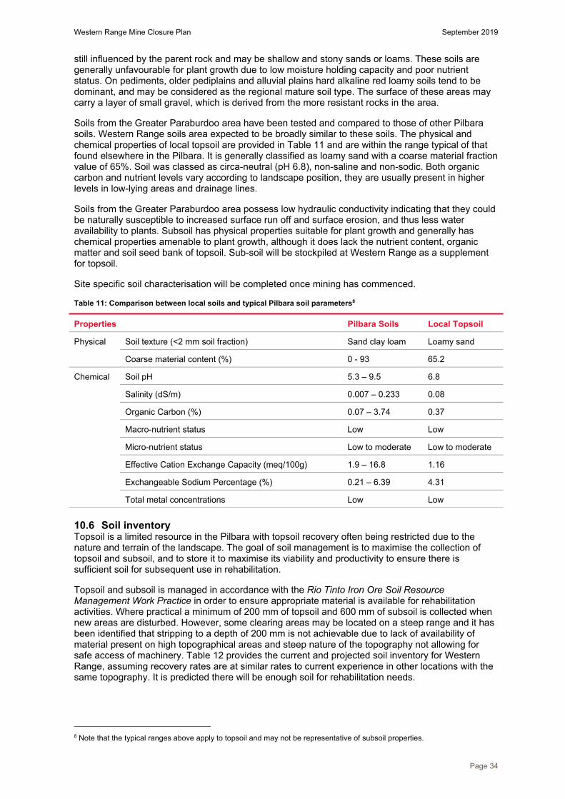
Western Range Mine Closure Plan September 2019
Page 34
still influenced by the parent rock and may be shallow and stony sands or loams. These soils are generally unfavourable for plant growth due to low moisture holding capacity and poor nutrient status. On pediments, older pediplains and alluvial plains hard alkaline red loamy soils tend to be dominant, and may be considered as the regional mature soil type. The surface of these areas may carry a layer of small gravel, which is derived from the more resistant rocks in the area.
Soils from the Greater Paraburdoo area have been tested and compared to those of other Pilbara soils. Western Range soils area expected to be broadly similar to these soils. The physical and chemical properties of local topsoil are provided in Table 11 and are within the range typical of that found elsewhere in the Pilbara. It is generally classified as loamy sand with a coarse material fraction value of 65%. Soil was classed as circa-neutral (pH 6.8), non-saline and non-sodic. Both organic carbon and nutrient levels vary according to landscape position, they are usually present in higher levels in low-lying areas and drainage lines.
Soils from the Greater Paraburdoo area possess low hydraulic conductivity indicating that they could be naturally susceptible to increased surface run off and surface erosion, and thus less water availability to plants. Subsoil has physical properties suitable for plant growth and generally has chemical properties amenable to plant growth, although it does lack the nutrient content, organic matter and soil seed bank of topsoil. Sub-soil will be stockpiled at Western Range as a supplement for topsoil.
Site specific soil characterisation will be completed once mining has commenced.
Table 11: Comparison between local soils and typical Pilbara soil parameters8
Properties Pilbara Soils Local Topsoil
Physical Soil texture (<2 mm soil fraction) Sand clay loam Loamy sand
Coarse material content (%) 0 - 93 65.2
Chemical Soil pH 5.3 – 9.5 6.8
Salinity (dS/m) 0.007 – 0.233 0.08
Organic Carbon (%) 0.07 – 3.74 0.37
Macro-nutrient status Low Low
Micro-nutrient status Low to moderate Low to moderate
Effective Cation Exchange Capacity (meq/100g) 1.9 – 16.8 1.16
Exchangeable Sodium Percentage (%) 0.21 – 6.39 4.31
Total metal concentrations Low Low
10.6 Soil inventory Topsoil is a limited resource in the Pilbara with topsoil recovery often being restricted due to the nature and terrain of the landscape. The goal of soil management is to maximise the collection of topsoil and subsoil, and to store it to maximise its viability and productivity to ensure there is sufficient soil for subsequent use in rehabilitation.
Topsoil and subsoil is managed in accordance with the Rio Tinto Iron Ore Soil Resource Management Work Practice in order to ensure appropriate material is available for rehabilitation activities. Where practical a minimum of 200 mm of topsoil and 600 mm of subsoil is collected when new areas are disturbed. However, some clearing areas may be located on a steep range and it has been identified that stripping to a depth of 200 mm is not achievable due to lack of availability of material present on high topographical areas and steep nature of the topography not allowing for safe access of machinery. Table 12 provides the current and projected soil inventory for Western Range, assuming recovery rates are at similar rates to current experience in other locations with the same topography. It is predicted there will be enough soil for rehabilitation needs.
8 Note that the typical ranges above apply to topsoil and may not be representative of subsoil properties.

Western Range Mine Closure Plan September 2019
Page 35
Table 12: Predicted LOM soil balances for Western Range (as of September 2018)
Current balance Total at Closure
Topsoil volume stockpiled (m3) 0 2,019,726
Subsoil volume stockpiled (m3) 0 2,771,998
Total soil volume (m3) 0 4,791,724
Total disturbance area (ha) 0 1,728
Pit areas not rehabilitated (ha) 0 644
Completed rehabilitation (ha) 0 0
Area requiring topsoil (ha) 0 1,084
Soil volume required 200mm (m3) 0 2,168,000
Soil Deficit/Surplus (m3) 0 2,623,724
Soil Deficit/Surplus (%) 0 221 (surplus)
Reconciliations of topsoil volumes are undertaken to confirm that sufficient material is available to spread across the rehabilitated area, assuming a spreading depth of 200mm. Conceptual locations for soil stockpiles have been identified and incorporated into the mine plan, these are shown in Figure 15. Topsoil stockpiles are planned to be up to one haul truck paddock dump high to maintain viability, and will be used to rehabilitate areas cleared for mining and infrastructure.
Whilst it is predicted that Western Range will have sufficient soil resources to complete rehabilitation works at closure, each progressive rehabilitation project is assessed to determine the type and amount of soil used. This could include:
soil inventory at the time of rehabilitation; landform and rehabilitation type; potential for trials; distance to soil stockpiles; or potential upcoming rehabilitation projects.
10.7 Alternative growth media In 2010, Rio Tinto commissioned a study into use of mine waste materials as an alternative rehabilitation growth medium. The study reviewed soil, tailings and mineral waste characteristics from select Pilbara mining operations, to identify material combinations that may be suitable as a topsoil substitute or supplement in cases where topsoil may be insufficient for rehabilitation requirements. In these cases, topsoil would be applied to high priority areas such as waste landforms first and lower priority areas such as laydown areas may receive alternative growth media.
The study showed plant-available nutrients held within the waste materials, although variable, was characteristically low and comparable to natural soils in the region. The majority of the waste materials had macro and micro nutrient concentrations within the range or above the levels measured in benchmark Pilbara topsoil and rehabilitated soils. The pH and phosphorus-buffering index of most waste materials were also comparable to that of the benchmark topsoil materials.
In general, Pilbara mineral wastes were non-saline and non-sodic, with no sample presenting above the 15% threshold for exchangeable sodium percentage (ESP), the indicator of high sodicity. The soil structure of waste materials were relatively stable, with only slight or no dispersion upon re-moulding, indicating a relatively stable structure that is not easily degraded, and were not prone to hard setting. However, estimated plant available water content of the waste materials ranged from <3% to >25%.

Western Range Mine Closure Plan September 2019
Page 36
Figure 15 Western Range conceptual mine layout (rehabilitation materials inventory)

Western Range Mine Closure Plan September 2019
Page 37
Rio Tinto is continuing its search for alternative growth material. In 2017 detrital material mined from the 64 East 5 Pit at Channar mine was identified as a suitable growth medium, and as such this material has been stockpiled for future rehabilitation purposes. Trials on alternative growth media have extended across a range of landforms and these include Tom Price landfill (2017), Channar weather station (2017) and Tom Price MMW4 waste dump (2018). In addition to this, no growth medium has been trialled at the Channar 84E5 waste dump (2011), the Tom Price MME waste dump (2018) and at the 94E8 waste dump at Channar (2019). Although it is expected alternative growth media will not be required at Western Range due to a predicted surplus of soil, performance of these trials will help inform the business in the instance whereby a deficit is encountered.
In summary, alternative growth media options are available for consideration in Western Range rehabilitation, should a shortfall of available topsoil and subsoil be encountered. The need for utilising alternative growth media will be considered as the site approaches closure.
11 Water
11.1 Surface water Western Range deposits are located on an elevated ridgeline, along the catchment divide of Six Mile and Seven Mile Creek sub-catchments of the Ashburton River Basin, West Pilbara. Six Mile and Seven Mile Creek sub-catchments cover an area of approximately 1345 km2 and 2575 km2 respectively. The majority of the Western Range tenure boundary is within the Seven Mile Creek catchment (Figure 16).
Six Mile and Seven Mile Creeks sub-catchments present dendritic drainage systems hosting the following named creek systems; Six Mile Creek, Ram Hole Creek; Tableland Creek; Bellary Creek, Pirrabudu Creek and Seven Mile Creek. These drainage systems are ungauged and ephemeral in nature, flowing after prolonged periods of wet weather, or extreme rainfall.
Six Mile Creek, Pirraburdu Creek and Seven Mile Creek are the closest named creeks to the Western Range project area. A major ephemeral unnamed creek, which is a tributary of Six Mile Creek, flows in a southerly direction on the western perimeter of the Western Range Project area, and is presented in Figure 16 and Figure 17.
Within the Western Range Project area the surface water regime is influenced by the steeply incised gullies hosted within the ridgeline. These gullies form headwaters to Six Mile and Pirraburdu Creek tributaries, in a radial drainage pattern, with majority flowing in a southerly direction (Figure 16). Due to the steep topography, surface water runoff in the gullies is expected to have a relatively high velocity.
Numerous ephemeral or intermittent pools within these gullies are supported by surface runoff. The persistence of the pools will vary with season and local site characteristics (e.g. substrate) (Figure 18).
Rio Tinto continue to gather data on the Western Range surface water features, having installed monitoring cameras, salinity loggers, and pressure transducers in 2018 to capture hydrological information.
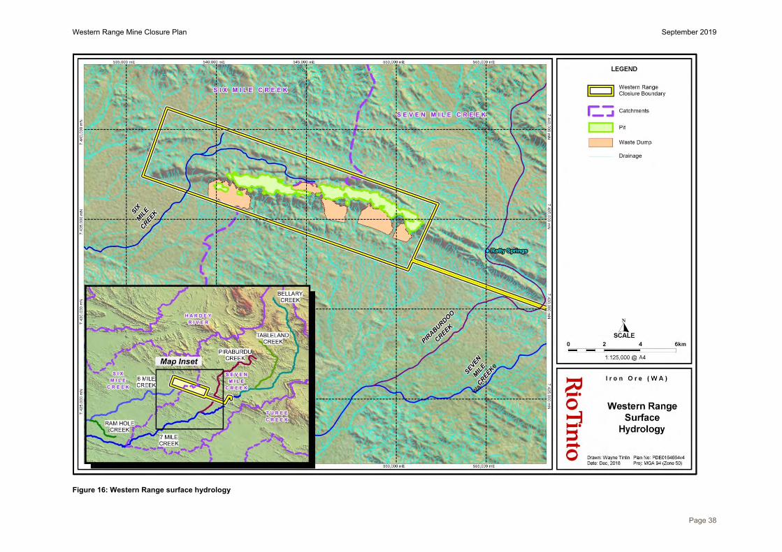
Western Range Mine Closure Plan September 2019
Page 38
Figure 16: Western Range surface hydrology

Western Range Mine Closure Plan September 2019
Page 39
Figure 17: Unnamed Creek channel located at Western Range (November 2018)

Western Range Mine Closure Plan September 2019
Page 40
(a) (b)
Figure 18: (a) A Western Range pool observed in November 2018 (b) A Western Range pool observed in February 2018

Western Range Mine Closure Plan September 2019
Page 41
11.2 Groundwater The groundwater at Western Range extends from the Pirraburdu Creek located to the east near the Paraburdoo Mine to Six Mile Creek located to the west, which flow perpendicular to the strike of Brockman Iron Formation where mining will occur. Approximately 99.6% of mining is predicted to be above the pre-mining groundwater level. Hydrogeological drilling at Western Range has been undertaken in 2012 and 2018, resulting in the installation of five production bores, three of which are operational, and eight monitoring bores (Figure 20).
Groundwater level in the Brockman Iron Formation is approximately 320mRL with a hydraulic gradient to the south into the Wyloo Group, which are overlain by 10-30m of saturated alluvial. Groundwater in the Fortescue Group is around 40m higher as the result of a hydraulic barrier. Groundwater within the Fortescue Group travels in a westerly direction before flowing through a narrow gorge in the Brockman Iron Formation created by Six Mile Creek. A conceptual hydrogeology cross section is illustrated in Figure 19. Groundwater quality is anticipated to be relatively fresh, with measured salinity ranging from 450 to 1200 mg/L.
Drilling and testing results suggest the Wyloo Group and Wittenoom Formation are the most productive aquifers. Constant rate testing in the Wittenoom Formation sustained 20L/s for 5 days, whilst in the Wyloo Group constant rate testing ranged from 8-17L/s for 3 days. These aquifers will be used to supply water to the Western Range infrastructure requirements. If local groundwater supply is not sufficient, a pipeline will be constructed from Paraburdoo to meet the site water demands.
Minor groundwater abstraction to facilitate BWT mining will be undertaken at Western Range. Dewatered groundwater will be used on site for ore crushing and dust suppression, and any water that is surplus to operational requirements will be discharged to the environment.
The pre-mining groundwater levels are presented in Table 13. At the time of writing this closure plan the post closure groundwater recovery levels and recovery timeframes had not been calculated. Continued groundwater monitoring and drilling will provide more information on aquifer properties and water levels at Western Range and information will be included in subsequent closure plan updates. Assuming no pit backfill were to occur pit lakes of approximately 30m and 15m depth are estimated post closure.
Table 13: Groundwater levels at Western Range pits and approximate time to recovery
Deposit Pit Section Pre-mining water level (mRL)
Post-mining pit floor (mRL)
Recovery level (mRL)
36W_50W 36W 320 290 320*
55W_66W 66W 320 305 320* Note: * Currently the post closure groundwater recovery level has not been calculated. For the purpose of estimating groundwater depth recovery the groundwater level has been assumed to be the same as the pre-mining level. This level will be updated in future closure plans as more hydrological information becomes available.
There are no known groundwater fed springs located within the Western Range conceptual footprint. The closest groundwater fed spring is known as Ratty Springs and is situated within the Paraburdoo mining area within Pirraburdu Creek. It is understood there is no hydraulic connectivity between groundwater located at Western Range and Ratty Springs.
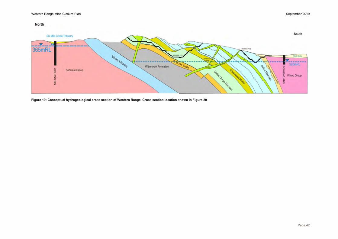
Western Range Mine Closure Plan September 2019
Page 42
Figure 19: Conceptual hydrogeological cross section of Western Range. Cross section location shown in Figure 20

Western Range Mine Closure Plan September 2019
Page 43
Figure 20: Hydrogeological map of the Western Range area, illustrating location of monitoring and production bores and the conceptual hydrogeology cross section

Western Range Mine Closure Plan September 2019
Page 44
12 Biodiversity
12.1 Terrestrial fauna habitat There are seven main habitat types identified at Western Range. These habitats include drainage line, gorges/gullies, breakaway, rocky hill, low hill, alluvial hill and stony plain (Figure 21). Characteristics of these habitat types are provided in Table 14.
The gorge/gully and breakaway habitats are of high value due to the diversity of microhabitats and potential to support conservation significant fauna species. In contrast, cleared habitat, created through mine disturbance, provides little food, shelter, water or any other life essential and is considered to have little to no habitat value.
Table 14: Description of pre-mining habitats identified at Western Range
Landform Basic description Drainage line Open drainage areas on stony soils. Water bodies only present during times of heavy
inundation
Gorges/gullies Shallow gullies and deep open gorges, sometimes with ephemeral or semi-permanent pools
Breakaway Breakaway or ridge line, falling away to steep scree slope or drainage line
Rocky Hill Stony hills on high ranges with dissected valleys and gorges
Low Hill Low stony hills and slopes with dissected valleys and drainage on stony soils
Alluvial Plain Flood plain surrounding drainage areas
Stony Plain Broad flat low lying plains to undulating plain on soft loamy soils
12.2 Conservation significant fauna Terrestrial fauna survey coverage is shown in Figure 22. Five species of conservation significance fauna have been recorded within the Western Range area and these are listed in Table 15. The mining footprint will impact fauna habitat. Ecosystem restoration activities and reintroduction of fauna are not planned as part of rehabilitation activities; however, habitat features such as logs and rocks will be incorporated into rehabilitation where possible. This is discussed further in Section 19.5.
12.3 Subterranean habitat Subterranean fauna are animals that inhabit underground habitats and include:
Stygofauna – obligate, groundwater dwelling aquatic fauna; and Troglofauna – obligate, subterranean dwelling fauna occurring in the unsaturated profile
above the water table.
Stygofauna and troglofauna surveys have occurred across the Greater Paraburdoo Iron Ore Hub and have covered an area of approximately 17,422 ha. Survey of the Western Range project (as depicted by the yellow boundary in Figure 24) identified 21 troglofauna taxa and two stygofauna taxa. The two stygofauna are considered widespread and occur beyond the proposed mining area. Ten troglofauna species are only known from within the impact area (proposed pit boundaries). These species are classified as having a low to moderate risk level due to 3D modelling indicating suitable and continuous habitat will remain post mining either below the proposed pits and/or extensively beyond the pit boundaries.
12.4 Feral animals Five introduced species have been identified within the Western Range area: House Mouse (Mus musculus), Red Fox (Vulpes vulpes), Cat (Felis catus), Horse (Equus caballus) and European Cattle (Bos taurus). Feral carnivores (e.g. cats, dogs, foxes) can create locally increased predation pressure on native fauna as well as increase competition with native species for resources such as space (territory), water and food. Feral herbivores (e.g. cattle, camels, donkeys) can also have a significant impact in Rangeland areas, such as the Pilbara. In dry times, grazing pressure reduces the abundance of palatable native species, impacting biodiversity and can create conditions that encourage weeds to grow. Foot traffic impacts the soil conditions, and in combination with over grazing, can encourage erosion. Foot traffic has also been the cause of damage to cultural landmarks and Aboriginal sites. Overgrazing and damaged soils has a flow-on effect to native fauna species that rely on this vegetation for food and shelter.

Western Range Mine Closure Plan September 2019
Page 45
Figure 21: Terrestrial fauna habitats of Western Range

Western Range Mine Closure Plan September 2019
Page 46
Figure 22: Western Range terrestrial fauna surveys
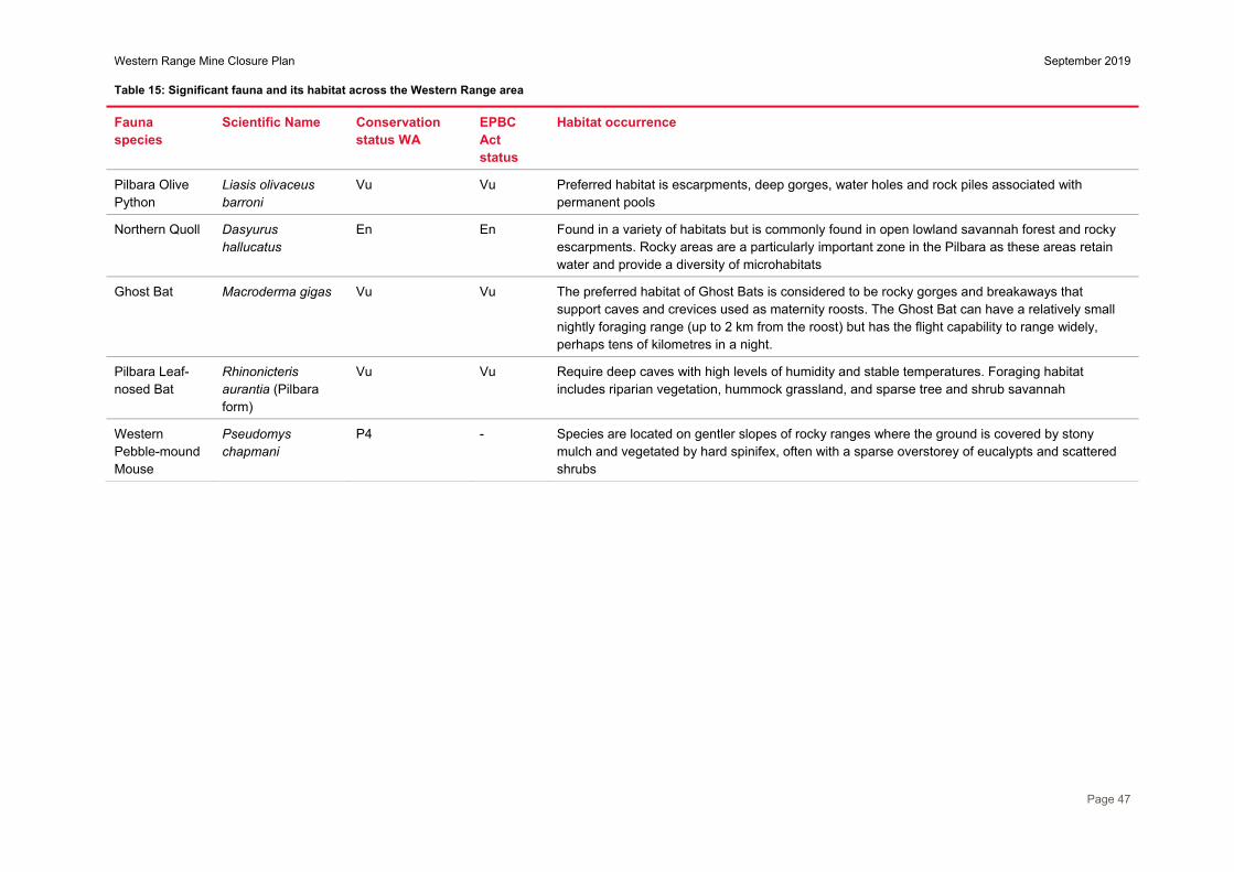
Western Range Mine Closure Plan September 2019
Page 47
Table 15: Significant fauna and its habitat across the Western Range area
Fauna species
Scientific Name Conservation status WA
EPBC Act status
Habitat occurrence
Pilbara Olive Python
Liasis olivaceus barroni
Vu Vu Preferred habitat is escarpments, deep gorges, water holes and rock piles associated with permanent pools
Northern Quoll Dasyurus hallucatus
En En Found in a variety of habitats but is commonly found in open lowland savannah forest and rocky escarpments. Rocky areas are a particularly important zone in the Pilbara as these areas retain water and provide a diversity of microhabitats
Ghost Bat Macroderma gigas Vu Vu The preferred habitat of Ghost Bats is considered to be rocky gorges and breakaways that support caves and crevices used as maternity roosts. The Ghost Bat can have a relatively small nightly foraging range (up to 2 km from the roost) but has the flight capability to range widely, perhaps tens of kilometres in a night.
Pilbara Leaf-nosed Bat
Rhinonicteris aurantia (Pilbara form)
Vu Vu Require deep caves with high levels of humidity and stable temperatures. Foraging habitat includes riparian vegetation, hummock grassland, and sparse tree and shrub savannah
Western Pebble-mound Mouse
Pseudomys chapmani
P4 - Species are located on gentler slopes of rocky ranges where the ground is covered by stony mulch and vegetated by hard spinifex, often with a sparse overstorey of eucalypts and scattered shrubs

Western Range Mine Closure Plan September 2019
Page 48
12.5 Conservation significant flora Flora and vegetation survey coverage is shown in Figure 24. A total of 291 flora taxa from 131 genera, belonging to 47 families have been recorded at Western Range, with Eremophila and Acacia being the key genera.
Table 16 describes the Threatened and Priority flora that have been identified at the Western Range Project area and have biodiversity value based on their conservation status. To date, six species of conservation significant flora have been recorded within this area.
Table 16: Conservation significant flora identified at Western Range
Flora taxon Conservation status WA
Habitat comments
Aluta quadrata T Grows on the edge of creek beds, in gullys and at the base of cliffs
Goodenia sp. East Pilbara (A.A. Mitchell PRP 727)
P3 Red-brown clay soil, calcrete pebbles. Low undulating plain, swampy plains, stony plains and hillslopes
Grevillea saxicola P3 Red-brown sandy loam with ironstone pebble cover. Low rocky hills, steep scree slopes
Nicotiana umbratica P3 Shallow soils. Rocky outcrops
Ptilotus trichocephalus P4 Sandy soils, colluvial plains
Sida sp. Barlee Range (S. van Leeuwen 1642)
P3 Skeletal red soils pockets. Steep slopes
12.5.1 Aluta quadrata Aluta quadrata is a shrub between 0.8 m and 2.6 m high with white flowers appearing in June and fruits in September (Figure 23). Aluta quadrata is listed as Threatened under the Biodiversity Conservation Act 2016 (WA). This species is restricted to the Greater Paraburdoo locality with three genetically distinct populations (Figure 25) known at Western Range, Paraburdoo (Pirraburdu Creek) and Channar (Howie’s Hole). The preferred habitat of A. quadrata is understood to comprise narrow steep sided valleys, extending onto adjacent rocky hillsides and downstream creeks, on the southern flank of ranges.
Cumulative flora survey efforts have identified a total of 41,136 individuals within the three Greater Paraburdoo populations, with 28,684 individuals within the Western Range population, 1,017 individuals located at Pirraburdu Creek and 11,435 at Howie’s Hole.
The Western Range mine plan avoids, as far as practical, impacts to A. quadrata, whilst still enabling resource extraction. A small proportion of the Western Range population will be directly impacted by mine pits (Figure 26). No individuals will be directly impacted by waste dumps, roads or other infrastructure. An additional number of individuals are located within close proximity to the conceptual footprint of the proposal and it is possible these individuals will be indirectly impacted by mining operations. Potential indirect impacts may include sediment and localised changes in surface water hydrology. These aspects will be managed during operations and will be detailed within the Western Range Environmental Management Plan.

Western Range Mine Closure Plan September 2019
Page 49
Figure 23: Aluta quadrata habitat and foliage

Western Range Mine Closure Plan September 2019
Page 50 Figure 24: Flora and vegetation surveys over Western Range

Western Range Mine Closure Plan September 2019
Page 51 Figure 25: Aluta quadrata populations located at Western Ranges, Paraburdoo and Channar

Western Range Mine Closure Plan September 2019
Page 52 Figure 26: Known locations of Western Range Aluta quadrata population

Western Range Mine Closure Plan September 2019
Page 53
Rio Tinto has engaged specialist organisations since 2007 to undertake research on A. quadrata including:
seed provenance studies to understand how genetically similar the known populations of A. quadrataare:o results found that there was moderate to high genetic differentiation between the three locations,
and low differentiation within the population at each location. seed science studies and germination trials, including understanding how to collect and germinate
seed, and undertaking viability and germination testing of seed:o seed collection programs have indicated late September appears to be the optimal time to
collect seed from the three populations; ando the application of certain pre-treatments can increase the germination of A. quadrata seeds.
Maximum germination was recorded from manually excising seed out of the indehiscent fruit,though this treatment is not recommended due to the high labour intensity and abnormalseedlings with poor survival rates. The current recommended pre-treatment for germination ofseeds is Smoke Water.
propagation trials to assess whether A. quadrata can be successfully reproduced from cuttings:o three separate trials were conducted, each employing standard nursery propagation techniques
and prior learnings. Trials showed that propagation via cuttings was possible using standardnursery techniques, but success rates were extremely low. As a result application of thesepropagation techniques in a field based capacity was not viewed as a viable option withoutimprovement in methodologies.
predictive habitat modelling to develop an understanding of the preferred habitat of A. quadrata.o the objective of this work was to enhance understanding of known and potential habitat
distributions, with a view to utilise outcomes to guide future targeted survey efforts. additional targeted surveys for A. quadrata using the information obtained from predictive habitat
modelling. field trial that involved planting A. quadrata seedlings into the Hamersley Agricultural Project Native
Pivot area:o the primary objective was to determine whether native species (including A. quadrata) could be
established and grown under large-scale irrigation pivots;o the project involved a series of scientific trials investigating the effect of fertigation (fertiliser
application via irrigation) on the growth, health and reproduction of native plant species;o Aluta quadrata showed low survival rates in the pivots, with only 10% remaining by the end of
the first year’s trial period; ando one individual of Aluta quadrata went into flower and fruit during the trial period. The fruits were
harvested and a total of 22 seeds were produced. No seeds were viable, but it is possible thatthis was due to an early harvest. The individual continues to survive today.
As described above, propagation studies have indicated that the species cannot be readily propagated from cuttings. Seed germination trials have been conducted with limited success. However, laboratory trials have demonstrated that seed from this species can be germinated if the seed is manually excised from the indehiscent fruit. Seeds germinated in this manner have been successfully grown on to the seedling stage in pot trials. However, initial attempts to establish seedlings into the Pilbara environment have been largely unsuccessful. Manually excising seed is not practical on the large scale required for rehabilitation.
Review of the available information highlights gaps in the understanding of A. quadrata, and the requirement for further research, particularly regarding seed biology and appropriate seed dormancy breaking treatments. Rio Tinto intend to undertake further research to address knowledge gaps, this is discussed in more detail in Section 19.5. Outcomes of this research will be applied to closure planning for Western Range.
12.6 Invasive flora Flora and vegetation surveys have recorded a total of nine introduced flora species (weeds) in the Western Range area. These species are listed in Table 17 and typically occur at higher densities in the drainage lines and associated floodplains. None of these species are listed as Weeds of National Significance or declared plants for the Pilbara region under the Biosecurity and Agriculture Management Act 2007 (WA).
The Department of Biodiversity, Conservation and Attractions (DBCA) Weed Species Ranking takes into account the potential distribution, current distribution, ecological impact, invasiveness and feasibility of control to derive a final broad qualitative weed species ranking corresponding to specific management actions.

Western Range Mine Closure Plan September 2019
Page 54
Table 17: Weed species recorded at Western Range
Scientific Name Common Name Ecological Impact Invasiveness
Aerva javanica Kapok bush High Rapid
Bidens bipinnata Bipinnate beggartick Unknown Rapid
Cenchrus ciliaris Buffel Grass High Rapid
Cenchrus setiger Birdwood Grass High Rapid
Datura leichhardtii Native Thornapple Unknown Unknown
Flaveria trinervia Speedy Weed Unknown Unknown
Malvastrum americanum Spiked Malvastrum High Rapid
Rumex vesicarius Ruby Dock High Rapid
Setaria verticillata Whorled Pigeon Grass High Rapid
Weeds are managed during operations in accordance with the Iron Ore (WA) Pilbara Weed Management Strategy, and include strategies such as periodic spraying and equipment hygiene.
12.7 Priority and/or Threatened Ecological Communities The majority of vegetation communities in the Western Range area are considered to be widespread and representative of the Pilbara bioregion, and the majority of vegetation is in very good to excellent condition. There are no listed Threatened Ecological Communities under either the Biodiversity Conservation Act 2016 or the EPBC Act located within or near the vicinity of the site. No Priority Ecological Communities as listed by DBCA are located within or near the vicinity of the site.
13 Progressive rehabilitation Regular reviews of the mine plan are used to identify disturbed areas of the site where mining activity has been completed. These areas are then reviewed for the potential to undertake progressive rehabilitation works. Lessons learnt during these activities and from subsequent monitoring campaigns are used to inform and update our standard management practices and provide input into suitability of final closure criteria for the site.
Mining has not commenced at Western Range and as such, there are no rehabilitation areas in the project area. However, rehabilitation has occurred at other nearby Rio Tinto Pilbara operations, such as Channar, Eastern Range and Paraburdoo, and these are used as examples of possible outcomes.
13.1 Rehabilitation planning and implementation Rio Tinto has formal processes for identifying areas which are no longer required for operational activity and are therefore available for rehabilitation. However, mine plans are dynamic and subject to continuous revision, and rehabilitation may need to be re-disturbed for mining or operational use. Progressive rehabilitation opportunities are reassessed regularly as part of the planning process.
Rehabilitation is conducted in accordance with the Rio Tinto Iron Ore Rehabilitation Handbook, which is reviewed and updated periodically to reflect changes in industry standards, reflect new knowledge obtained through research and development, and to adopt learnings from ongoing rehabilitation projects. The Handbook addresses:
soil resource management; rehabilitation techniques; local provenance species seeding practices; records and data management; and on-going monitoring.
Rehabilitation typically involves:
removal of rubbish, redundant equipment and infrastructure and ensuring the area is notcontaminated;
reshaping and contouring land to blend with natural relief to manage drainage to ensure stability;

Western Range Mine Closure Plan September 2019
Page 55
ensuring that appropriate controls are in place to manage hazardous mineral wastes, includingencapsulation of PAF and fibrous wastes, and installation of store and release covers whererequired;
installation of abandonment and drainage management bunds where required; application of soil to a depth of 200mm where practical to promote vegetation growth; deep rip to an appropriate depth prior to seeding; seeding to ensure a suitable vegetation cover and composition, generally using a mechanical
seeder; recording rehabilitated areas on internal GIS databases; and inclusion within the rehabilitation monitoring program where appropriate.
13.1.1 Seed provenance and selection Locally collected seed is needed to assist in revegetation and the creation of a self-sustaining ecosystem. Over time the viability of seeds in stockpiled topsoil decreases, and thus the quality of the topsoil deteriorates. In addition the topsoil that was salvaged prior to disturbance may not contain seeds of all the target species of its new location / habitat.
Seed mixes for rehabilitation are of local provenance. Specific seed mixes are selected to provide a range of species appropriate to the desired habitat, taking into consideration landscape position and slope. In areas where erosion risks are identified, seed mixes may be modified to include or increase the portion of species that provide rapid cover.
Rio Tinto purchases seeds from commercial seed suppliers, with emphasis on ensuring that there are appropriate local provenance seeds available for rehabilitation of each of its sites. Seeds are stored in purpose-built, climate controlled storage facilities to maximise long-term viability.
The inclusion of rare and threatened species in rehabilitation programmes is limited by:
habitat preference (preference for drainage lines, gullies, calcretes or other habitat not suitable orsimilar to those likely to be present in the rehabilitation landscapes);
abundance – very few populations or small populations from which to source seed; difficult taxonomy / unresolved taxonomy issues and thus status of species highly uncertain; growth form – e.g. short lived annual species with preference for growth under woodland canopies; seed production – some species do not regularly produce seed; propagation methods – some species are not able to germinate from seed and cuttings are required
which is not a suitable method for broad scale application in an arid environment; availability of seed at the time when rehabilitation occurs; and/or seed dormancy.
Given these issues, the main focus of rehabilitation programs is to restore vegetation complexes that include the more common species present in the particular habitat type, and to achieve a diverse range of strata. Seed mixes may include species of conservation significance if they are available, but presence of these species in rehabilitation areas is more likely to result from natural recruitment from surrounding areas.
13.2 Local reference sites Reference sites are used when assessing the progress of rehabilitation works carried out at Rio Tinto (WA) sites. Reference sites are usually representative of the ‘natural’ undisturbed landscape surrounding the mine site or rehabilitated area. Such sites should consist of the target vegetation community and terrain and provide an example of what the rehabilitated area may achieve over time. Reference site data also assists in planning further rehabilitation programmes i.e. seed lists, and in the development of completion criteria.
Reference sites have not yet been installed at Western Range; however, sites will be installed in a variety of strategic locations at Western Range, that will meet current and future landform types, a range of vegetation types and structures, and be spread across the extent of potential disturbance whilst remaining in areas unlikely to be disturbed. Reference sites have been installed at the nearby Paraburdoo, Channar and Eastern Range mine sites and these can also be used to inform Western Range rehabilitation and monitoring requirements.
13.3 Rehabilitation monitoring The objective of the rehabilitation monitoring programme is to evaluate successional development of the rehabilitation, and thereby provide useful feedback for the improvement of rehabilitation techniques, and to help assess progress towards long term rehabilitation goals. Monitoring also provides information which can

Western Range Mine Closure Plan September 2019
Page 56
be used to set realistic and achievable completion criteria. This objective can be achieved by examining changes in key parameters over time, and comparing results from the rehabilitation with those from corresponding reference sites in undisturbed areas.
Rehabilitation monitoring will be completed in the cooler months (June to September) each year. The monitoring programme design (i.e. monitoring technique and frequency) for each rehabilitated area will consider the following factors:
the level of complexity of the rehabilitation and therefore rehabilitation quality risk i.e. waste dumpsare high risk; exploration rehabilitation is low risk;
regulatory monitoring requirements; rehabilitation age; rehabilitation quality; rehabilitation area size; is it a rehabilitation trial area; natural disturbance i.e. fire, cyclonic rainfall; safe access for monitoring personnel; and efficient use of monitoring resources.
A number of rehabilitation monitoring techniques are used at other nearby Rio Tinto mine sites and will be employed at Western Range. The technique used is usually matched to the level of rehabilitation quality risk. For example, the intensive quantitative method is used on high-risk waste dump areas. The techniques used are summarised below.
13.3.1 Vegetation, fauna habitat and erosion quantitative method Vegetation monitoring involves permanent transects up to 100 m in length, comprised of 2 m x 2 m quadrats at intervals of 5 m. Within each quadrat, numbers of all native perennial plant species and weeds are counted, and their percentage cover estimated. Total native perennial plant cover is assessed by dividing the 2 m section along the transect baseline into eight, 25 cm sections and recording the number of these that have no cover of any native perennial plant species. A subjective assessment of total native perennial plant cover (%), for plants rooted within the quadrat, is also recorded for each quadrat. Notes are taken of the general condition of the rehabilitation, including new disturbance and fire damage. A photograph is taken from both the start and end point of each transect.
Fauna and habitat monitoring involves estimating litter cover, noting rocks and logs in each quadrat along the same transect, and then doing a whole of transect assessment of grazing extent, native animal scats, ant numbers present, and indicators of native animal activity.
Erosion monitoring involves identifying gullies (i.e. rills greater than 30 cm deep) along the same transect, but extended to 150 m, recording the location of each gully and measuring their total width and depth at the deepest point. If erosion is identified elsewhere in the rehabilitation area then an erosion specific transect would be installed on a representative section of the gully and total width and depth at the deepest point recorded. A photograph is taken of each measured gully.
13.3.2 Rehabilitation quality assessment Rehabilitation Quality Assessments (RQAs) are used on low to medium risk areas, historical rehabilitation with no monitoring history, or on areas too small for transects. They can also be used in combination with the above transect methods on large rehabilitation areas to manage monitoring resources efficiently. The purpose is to gain an overview of the rehabilitation quality including erosion, growth medium, vegetation cover, species richness, vegetation structure, plant density, weed presence and general condition. Each characteristic is compared between the rehabilitation and local undisturbed native vegetation, and given a score according to the RQA field book guidelines. A representative photograph is taken of both the rehabilitation and reference areas.
13.4 Waste dumps Rehabilitation techniques have improved markedly over the last decade, and the following paragraphs discuss recent rehabilitation projects undertaken at the neighbouring Channar mine site. The conditions at the Channar mine site are very similar to those expected at Western Range. These techniques and learnings will be transferred to future rehabilitation projects at Western Range.
Rehabilitation of the Channar East 3 waste dump (CHE3) was completed in 2007, and included topsoiling and seeding. Monitoring was last undertaken in 2016 and results indicate the rehabilitation areas are

Western Range Mine Closure Plan September 2019
Page 57
performing well with native plant species richness, plant density, spinifex density and plant cover all within, or above, the range found in the reference sites (Figure 27). The rehabilitation at this site is likely to become similar to the reference sites in terms of floristic structure, density and composition. Erosion monitoring of the CHE3 waste dump identified one gully and this has been scheduled for future monitoring.
Figure 27: Channar East 3 waste dump rehabilitation (left) and reference site (right) monitoring transects
Rehabilitation of the Channar 84 East 5 waste dump (84E5 WD) occurred in 2011 and is a good example of a rehabilitation area performing well without addition of a growth medium (i.e. not topsoiled) (Figure 28). The success of the rehabilitation area is largely due to improved earthwork practices and quality control. During earthworks the lifts were completed in a top to bottom sequence and the final surface was finished to a high specification before moving to the next area. This ensured that the final surfaces were very close to the design and all windrows were finished and in place with each lift. Topsoil was unavailable; ripping was completed after all surfaces were re-profiled. Ripping was via a winged tyne and the dozer undertaking the ripping had machine guidance GPS installed to ensure accuracy to the contour. The most recent rehabilitation monitoring assessment undertaken in 2016 suggests rehabilitation has developed well. Plant species richness, density and cover were generally found to be within the range of the reference sites. Minor erosion features were present in some areas; however, they do not threaten overall landform stability. Some weeds, predominantly Buffel Grass and Kapok Bush, were present but only at low densities.
Figure 28: Channar 84E5 WD East rehabilitation in 2011 (left) and in 2018 (right)
13.5 Low impact disturbance areas, construction areas, roads The Paraburdoo mine is located adjacent to Western Range and the old Paraburdoo airstrip and the truck training ground were rehabilitated in 2014. These areas were earth worked to compliment surrounding undisturbed ground, deep ripped on the contour and machine seeded. Topsoil was not applied due to limited resource availability at Paraburdoo and high risk areas such as waste dump slopes having priority over low disturbance and flat areas. To date the rehabilitation performance of these areas is developing well for their age with most vegetation parameters within the range recorded from the reference sites. Floristically the Truck Training Ground recorded a composition similar to the reference sites and species richness was high. Whilst perennial cover had not increased substantially since 2015, the cover of Spinifex increased three-fold between 2016 and 2017. Varied strata consisting of Spinifex, over-storey shrubs and trees had also

Western Range Mine Closure Plan September 2019
Page 58
developed. In terms of surface stability, both areas were flat and appeared stable. The Old Airstrip recorded no erosion in 2017 and the rip lines were still evident. A single erosion gully was noted on one transect of the Truck Training Ground and four weed species were noted in the area.
14 Contaminated sites Rio Tinto maintains registers for potentially contaminating activities and known or suspected contaminated sites which have been formally reported under s11 of the Contaminated Sites Act 2003 (WA). The registers are informed by regular review of operations and where required preliminary or detailed site investigations to assess contaminants associated with such activities and assess their risk of harm to human health, the environment and environmental values. Potentially contaminating activities and land uses as described in the 2014 Department of Environmental Regulation guideline ‘Assessment and management of contaminated sites’, that may be associated with mining activities onsite include, but not limited to:
automotive repair workshops (light and heavy machinery); substations and transformers; fertiliser and explosives storage; landfill sites; mineral processing, mining, screening and crushing facilities; rail transport corridors; hydrocarbon storage, handling and dispensing facilities; sewage waste water treatment plants and irrigation areas; and disturbance of potentially acid forming materials during the course of mining.
As a greenfields project, there have been no documented potentially contaminating activities undertaken at Western Range. A register will be established during construction and maintained throughout operations to document all potentially contaminating activities and land uses. As part of the Rio Tinto closure study process, a contaminated site assessment will be undertaken prior to closure. Based on this assessment, specific plans will be developed to remediate or manage contaminants, where required, to support the final land use.
15 Cultural heritage Rio Tinto recognises and respects the significance of Australia’s cultural heritage, and in particular the cultural heritage of Aboriginal people who have traditional ownership of, and/or cultural connections to, the land on which we operate. Extensive archaeological and ethnographic surveys have been undertaken in the Western Range Project area, and these surveys help to inform the heritage values of the area. We take all reasonable and practicable measures to prevent harm to cultural heritage sites, this includes during works associated with rehabilitation and closure. Where this is not possible, steps are taken to minimise or mitigate impacts and ensure required statutory approvals are obtained. Closure works consider issues such as post closure access requirements to culturally significant sites and appropriate return of any materials salvaged during mining operations.
15.1 Relevant Aboriginal groups The Yinhawangka People are the traditional custodians of the land identified in this closure plan. The Yinhawangka People have native title rights over the areas covered by the Yinhawangka People native title determination area (WCD2017/003). The extent of the Yinhawangka country in relation to Western Range is shown in Figure 4.
On 31 January 2013 Rio Tinto executed a Claim Wide Participation Agreement (PA) and subsequently executed an Indigenous Land Use Agreement (ILUA), with the Yinhawangka People (collectively the Agreements), with the latter being registered with the National Native Title Tribunal on 5 July 2013. Pursuant to the Agreements, forums have been established for consultation and ongoing engagement with the native title holders on processes such as: land access; tenure acquisition; heritage surveys and environmental management relating to Rio Tinto’s operations.
15.2 Ethnographic and archaeological values Archaeological and ethnographic surveys have been undertaken and are currently scheduled, with nominated Yinhawangka People representatives at the Western Range proposal area.
A significant cultural heritage site located within the Western Range project is an ochre quarry (WR01-A20, DPLH ID: 22,484). In addition numerous sites of cultural importance have also been recorded in the Western Range area and include artefact scatters, rockshelters, scarred trees and camp sites. Some of these heritage places contain heritage features that are under-represented in the Pilbara archaeological record and

Western Range Mine Closure Plan September 2019
Page 59
are considered to be of high archaeological significance to the Yinhawangka People. These include walled features within rockshelters, modified wooden artefacts and grinding patches. Rio Tinto is committed to avoiding sites of high ethnographic and/or archaeological significance to Traditional Owners wherever practical at its Pilbara operations.
Rio Tinto will minimise potential disturbance to sites within the Western Range Project area wherever practical, however some sites are likely to be disturbed by mining activities. Rio Tinto will request heritage approvals under sections 16 and 18 of the Aboriginal Heritage Act 1972 (WA) where disturbance to sites cannot be avoided. Cultural material contained within those sites which cannot be avoided will be mitigated in accordance with the approval conditions set by the Minister of Aboriginal Affairs and in consultation with the Yinhawangka Traditional Owners.
Consultation with Yinhawangka People traditional owners will be maintained in established forums throughout the life of the operation to ensure that proposed closure strategies address cultural requirements, and to ensure closure objectives for the site remain appropriate.
Closure works consider issues such as post closure access requirements to culturally significant sites and appropriate return of any materials salvaged during mining operations. High level discussions have commenced however specific planning for these artefacts post closure has not been discussed with Yinhawangka People group members to date and will be undertaken in the future. Whilst this Western Range closure plan does not include specific strategies for maintaining or restoring cultural values, it does recognise that post closure access to some of these sites may be required and that the area will need to be made safe for this purpose (Section 19.4).
16 Regional Community The town of Paraburdoo is located approximately 20 kilometres to the north-east of the Western Range Project. Paraburdoo was established in 1972 specifically to support the adjacent Paraburdoo mine. A large proportion of the Paraburdoo, Channar and Eastern Range mines workforce reside in the town. The 2016 Australian Bureau of Statistics Census recorded a population of 1,380 in the town 9. While the communities associated with Paraburdoo are specifically excluded from the scope of this closure plan they are considered in separate planning processes, detailed workforce planning, baseline studies and social impact assessments which will be undertaken during the study phases of the project to determine potential social impact to these communities as a result of closure of Western Range Project. This study work will inform the development of mitigation strategies to limit impacts. The closest pastoral leases are Rocklea and Mininer stations, which partially overlap a portion of the mine lease. Turee Creek station is located south of Channar mine and Ashburton Downs neighbours the Greater Paraburdoo Operations. There are no permanent Aboriginal communities in close proximity to Western Range. The closest Aboriginal community is Bellary Springs, located 30 km from the town of Paraburdoo.
17 Workforce It is anticipated the construction phase of Western Range will take approximately two to three years with the workforce being housed in a purposely built camp near the Paraburdoo mining operation, located to the north of the 5W mining area. During the operational phase it is anticipated that the workforce will be a combination of both Fly-in Fly-out (FIFO) workers and a residential workforce residing in the town of Paraburdoo. The majority of FIFO staff will be flown directly from Perth to the Paraburdoo airport, with smaller numbers also flying directly from regional centres. The FIFO personnel will be housed in fully serviced accommodation facilities. The residential workforce resides in company and privately owned houses in Paraburdoo.
Without mining new deposits, present mining activities are anticipated to discontinue at Greater Paraburdoo Operations after the Western Range mine ceases to operate in 2042. It is anticipated/possible mining activities will continue at a similar rate across the wider Pilbara region after the Western Range mine ceases to operate. Thus regional employment opportunities and mine related services are not anticipated to be significantly impacted by closure of the Western Range Project. The existing workforce will be managed through a transition plan that will be developed as part of the detailed closure planning work Rio Tinto undertakes as each asset approaches the end of its mine life.
9 Australian Bureau of Statistics 2016 Census QuickStats – Paraburdoo. Released 23 October 2017.

Western Range Mine Closure Plan September 2019
Page 60
IDENTIFICATION AND MANAGEMENT OF CLOSURE ISSUES
18 Risk evaluation process A closure risk assessment was completed to identify and assess closure issues for Western Range. The risk assessment is included in Appendix D. The assessment was completed by an internal panel of multi-disciplinary subject matter experts with the aim of:
identifying hazards, aspects and opportunities that could influence the successful closure of the site; evaluating the resulting risks to people, property and the environment; and defining the actions required to reduce the risk to below the risk acceptance threshold.
Risk was evaluated on the basis of the maximum reasonable outcome consequence and the likelihood of that consequence occurring. Risks were evaluated inclusive of current management and commitments, and represent current residual risk.
Issues are assessed against the following consequence criteria:
costs: economic impacts if the risk were to eventuate ranging from low to very high, determined as apercentage of the projected closure cost for the operation;
health: reversible health effects of little concern (very low) to multiple fatalities (very high); personal safety: inconvenient first aid treatments (very low) to multiple fatalities (very high); environment: reversible impact (very low) to widespread, long-term impacts (very high). These risks
are separated into two categories – during decommissioning/active closure implementation or postclosure;
community trust: mistrust amongst a small section of the wider community (very low) towidespread mistrust with key stakeholders (very high). Also includes potential heritage impactsranging from reparable damage to a site of low cultural significance (very low) through to irreparabledamage to a site of international cultural significance (very high); and
compliance: non-conformance to internal requirements (very low) to prosecution for breach ofregulatory licence(s) (very high).
Risks are classified by the risk matrix in Figure 29 and as follows:
low (Class I): Risks that are below the risk acceptance threshold and do not require furthermanagement;
moderate (Class II): Risks that lie on the risk acceptance threshold and require regular review toensure management remains adequate and fit-for-purpose;
high (Class III): Risks that, based on the current level of knowledge, could exceed the riskacceptance threshold and require proactive management and / or resolution of knowledge gaps; and
critical (Class IV): Risks that, based on the current level of knowledge, will exceed the riskacceptance threshold and need urgent and immediate attention to develop an alternative approach.
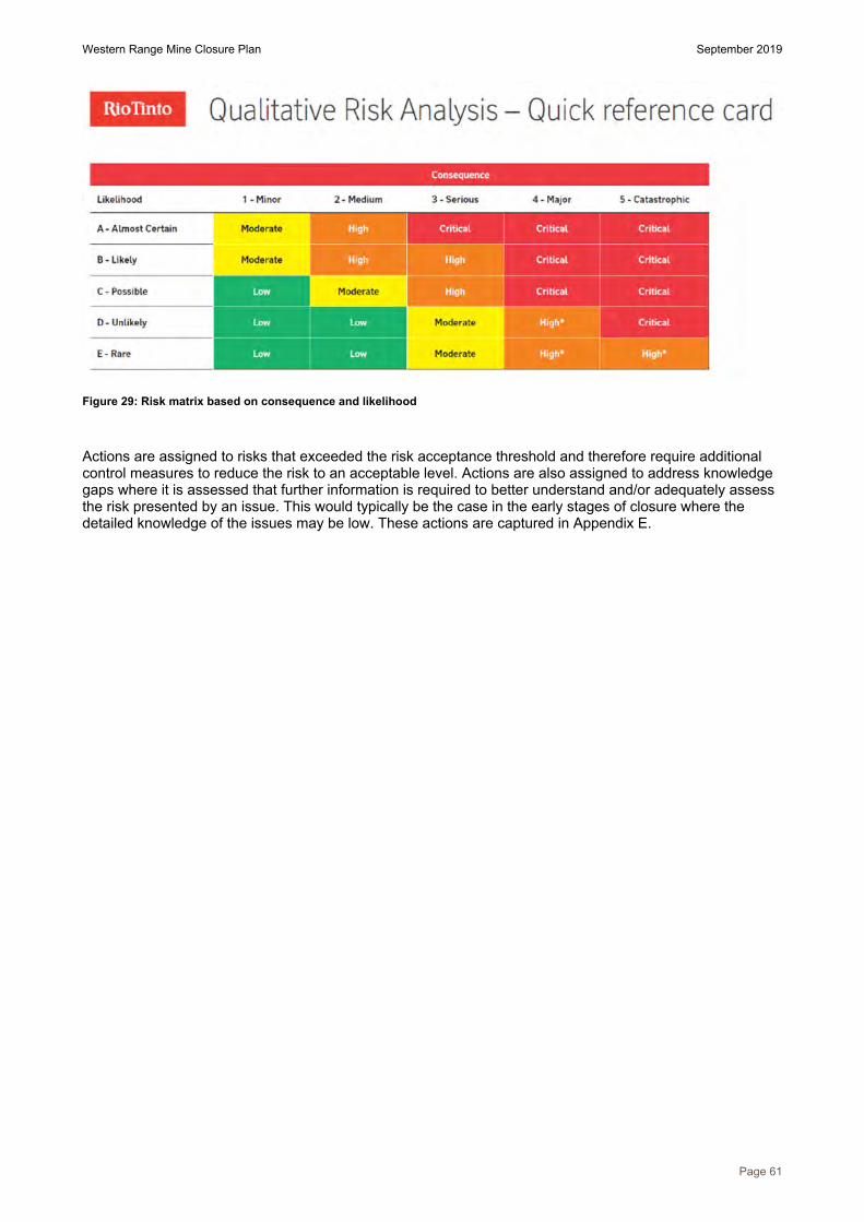
Western Range Mine Closure Plan September 2019
Page 61
Figure 29: Risk matrix based on consequence and likelihood
Actions are assigned to risks that exceeded the risk acceptance threshold and therefore require additional control measures to reduce the risk to an acceptable level. Actions are also assigned to address knowledge gaps where it is assessed that further information is required to better understand and/or adequately assess the risk presented by an issue. This would typically be the case in the early stages of closure where the detailed knowledge of the issues may be low. These actions are captured in Appendix E.

Western Range Mine Closure Plan September 2019
Page 62
19 Management of key issues The DMP/EPA Guidelines for Preparing Mine Closure Plans lists a number of rehabilitation and closure issues that may be relevant for mine sites, including five that are identified as key issues at Western Range. An evaluation of the relevance of each of these issues is presented in Table 18. The information in this table is intended to compliment that contained in the risk assessment presented as Appendix D.
Table 18: Relevance of potential closure and rehabilitation issues to Western Range
Issue Evaluation of relevance to Western Range Further discussion
Acid and metalliferous drainage
Geochemical studies have identified a low AMD risk for Western Range.
Not addressed further in this chapter.
Challenges associated with rehabilitation and revegetation
Western Range is situated in an area of challenging topography. Learnings from nearby successful mining rehabilitation areas will be transferred to Western Range.
Section 19.1
Dispersive, sodic and erosive materials
Western Range mineral waste has been physically characterised and some is predicted to be highly erodible but majority of waste has low or moderate erodibility.
Section 19.2
Radioactivity Not a significant issue for this site. Not addressed further in this chapter.
Mine pit lakes Based on the current mine plan there will be no pit lakes present at closure.
Section 19.3
Geotechnical instability All waste dumps are located outside of the zone of geotechnical instability.
Not addressed further in this chapter.
Inadvertent public access Abandonment bunds and natural topography (>35 degrees) will be required to restrict inadvertent public access to high-risk areas such as mine voids.
Section 19.4.
Hazardous materials Hazardous materials (e.g. hydrocarbons, ammonium nitrate) will be removed prior to, or during, decommissioning to the extent reasonably necessary.
Not addressed further in this chapter.
Hazardous and unsafe facilities
All infrastructure will either be demolished during decommissioning, or handed to the State in accordance with State Agreement requirements.
Not addressed further in this chapter.
Contaminated sites There are no reportable contaminated sites. Not addressed further in this chapter.
Fibrous materials Fibrous mineral waste is not expected within the Western Range proposal area.
Not addressed further in this chapter.
Non-target metals and target metal residues in mine wastes
No chemical processing occurs at the site. Not addressed further in this chapter.
Adverse impacts on surface and groundwater quality
There are not predicted to be any regional surface or groundwater quality impacts.
Not addressed further in this chapter.
Design and management of surface water structures
Surface water diversions will not be required. Not addressed further in this chapter.

Western Range Mine Closure Plan September 2019
Page 63
Issue Evaluation of relevance to Western Range Further discussion
Dust emissions Dust management will continue to be managed during closure implementation in accordance with operational dust control measures and monitoring requirements. Dust is not expected to be a risk from the post closure landform.
Not addressed further in this chapter.
Flora and fauna diversity/threatened species
A population of Aluta quadrata, a Threatened flora species, is located within the mining tenure boundary. Five Priority flora are known from the Western Range study area. Five species of conservation significance fauna have been recorded within the Western Range study area.
Section 19.5
Visual amenity This is not considered to be a significant closure issue for the site due to its remote location.
Not addressed further in this chapter
Heritage issues Management of cultural heritage values is considered through processes established under the Indigenous Land Use Agreement, and strategies incorporated into the Cultural Heritage Management Plan.
Section 19.6
Alteration of the direction of groundwater flow
Alteration of regional groundwater flows is not expected. Not addressed further in this chapter
Alteration of the depth to water table of the local aquifer
Depth to groundwater table is not anticipated to be significantly impacted. Mining will predominately be above water table.
Section 19.7
Alteration of the hydrology and flow of surface waters
Alteration to the hydrology and flow of surface waters are expected to be localised and not significant.
Not addressed further in this chapter
The key issues assessed during the site risk assessment as requiring management at Western Range are:
public safety post closure (class III); vegetation establishment (class III); flora and fauna with conservation status (class IV); downstream ecosystem function (class III); and local communities (class III).
The proposed strategies for the management of these issues and those identified in Table 18 are discussed in the following sections.
19.1 Challenges with progressive rehabilitation
19.1.1 Revegetation challenges The use of topsoil in rehabilitation is generally linked to improved revegetation outcomes. The seed bank quality within the stockpiled soil is known to reduce over time. Given the long mine schedules in Rio Tinto operations it is anticipated that the soil quality may be reduced. Field trials have been undertaken in the business to gauge results of using reduced soil quality, no soil or alternative growth media. It is likely that the reduced viability of the seed bank is a key concern in achieving the range of key species desired in the rehabilitation in a cost effective process.
Supplementary seeding is commonly undertaken in rehabilitation of medium and high disturbance areas. The ability to meet seed requirement volumes for closure is captured as a risk in achieving successful revegetation. A long-term seed procurement strategy requires development to ensure sufficient volumes of seed are available for use when required. Seed used in rehabilitation is local provenance where possible, and availability can be limited by seasonal variation and a lack of suitable collectors. Currently seed procurement is focused on meeting the requirements of progressive rehabilitation targets.

Western Range Mine Closure Plan September 2019
Page 64
As discussed in Section 10.6 there is predicted to be enough topsoil and subsoil material at Western Range to meet rehabilitation requirements at closure.
Feral flora and fauna management will continue to be managed during closure implementation in accordance with operational control measures and monitoring requirements.
19.2 Dispersive, sodic and erosive materials
19.2.1 Principles of waste dump design Mineral waste dumps located on mine sites that are operated by Rio Tinto are designed and rehabilitated in accordance with internal Landform Design Guidelines, which provides guidance on:
the objectives of waste dump design, which is to achieve dumps that are:o safe;o stable;o aesthetically compatible with the surrounding landscape;o vegetated;o non-polluting;o compatible with the agreed post-mining land use; ando progressively rehabilitated;
appropriate locations for the siting of waste dumps; appropriate shapes and designs of waste dumps; appropriate surface treatments; and links to other relevant internal and external guidance material.
These Guidelines are updated on a regular basis to incorporate learnings from research, studies and rehabilitation implementation projects. The most significant update occurred in 2012 to provide design criteria for waste dumps based on the specific waste types present. This was the result of several years of materials testing and landform evolution modelling studies of wastes typically found in the Pilbara, with design recommendations based on the assumption that an average erosion rate of 5/ha/year (with a maximum of 10/ha/year) will be acceptable. Further studies have since been undertaken on additional waste types, and this resulted in further minor updates in 2014 and 2016.
It should be noted that erosion modelling is conducted on the conservative assumption that slopes are not vegetated. However, vegetation is expected to establish on all slopes, thereby further reducing the erosion potential.
19.2.2 Western Range erodible mineral waste management The primary landform design approach proposed across the Western Range Project is the battering down of waste dumps to achieve a batter and berm style landform. The slope angle, berm width and batter height proposed has been based on the erodibility and physical characteristics of the dominant waste type/s within the landform.
The Landform Design Guidelines indicate that if competent material (i.e. low and medium erodibility) is present in appreciable volumes within a waste landform, or is used to cap the outer surface, then a linear berm and batter design with specifications as presented in Table 19 should lead to the dump being appropriately stable at Western Range. Specifications are outlined for low and medium erodibility material.
Table 19 Waste landforms rehabilitation berm and batter design specifications based on the erodibility of the waste material
Design Specifications Low erodibility material Medium erodibility material
Maximum height of lifts 20m 10m
Maximum slope angle of lift 20° 20°
Minimum berm width 10m 15m
Minimum berm angle 11° (backsloping) 3° (backsloping)

Western Range Mine Closure Plan September 2019
Page 65
The majority of mineral waste from Western Range is classified as having low (55%) or medium (32%) erodibility and therefore the above design specifications are considered appropriate for these landforms.
A portion of Western Range waste is comprised of geological units that are generally classified as being of high erodibility (approximately 13%). Management options for highly erodible waste material have been reviewed with respect to the mine sequence, considering frequency of occurrence of highly erodible waste material, availability of pits for in-pit backfill, availability of materials for capping and stockpile requirements for capping.
Highly erodible waste may employ one or more of the following closure management approaches:
selective handling of wastes to ensure encapsulation of more erodible waste; placement of material into exhausted pits; and/or placement of low erodibility material on the outer surface of the landform (wrapping).
No rehabilitation of in-pit waste dumps or in-pit landbridges is proposed where the waste landform has no potential to impact on the external environment (i.e. any sediment generated will be fully contained within an internally draining pit) and the dump contains only inert material. No re-profiling of pit walls or rehabilitation of pit floors is proposed.
Low grade ore will be stockpiled on site for future sale, however market conditions change over time and there is potential that the stockpiles will remain on the completion of mining. Therefore, Rio Tinto is managing the stockpiles as if they are waste dumps to ensure resources, such as funds and competent wrapping material, are available to rehabilitate them if required.
Conceptual closure landform rehabilitation designs are detailed in Appendix F and are based on a site specific assessment of materials. A multi-disciplinary pit and waste dump design sign-off process is conducted; which considers landform design guidelines and provides rehabilitation designs where appropriate. Performance of rehabilitation designs will be reviewed during the life of the mine.
19.3 Pit lakes
19.3.1 Closure outcomes for pit voids There is an array of different closure outcomes that can be achieved for mine voids, depending on the local environment and social values. In the Pilbara environment, mine void closure outcomes are determined by the following key environmental and social aspects:
depth of water above the base of the mine void, and proportion of deep and shallow areas, waterdepth fluctuation, frequency and range;
presence of potential acid and / or metalliferous drainage or other contaminants; connection of the mine void to creek / catchment runoff and / or established riparian system, in order
to supply the lake with water, sediment, nutrients, seeds and weeds, as a means of sustaining /recolonising an ecosystem;
potential for an ecosystem within the mine void to interact with the local environment, i.e. to sustainaquatic life, form part of the local food web, and potential for bioaccumulation and / orbiomagnification of harmful elements;
potential for cultural use i.e. fishing, hunting, camping, medicinal sources etc.; potential for general public interaction e.g. proximity of public roads, tourism or recreation use; and potential for other hazardous conditions to develop, i.e. rock falls (wall instability), ongoing exposure
of fibrous materials etc.
There are five typical mine void closure outcomes for Rio Tinto’s Pilbara operations:
void: The mine void is isolated from all major creek systems. Mining does not occur below thenatural water table, although ephemeral pools may form in the wet season and dissipate seasonally;
pit lake: A permanent open water body is sustained by groundwater within the mine void. The pitgeology is not expected to create significant water quality issues, although salinisation may occur asa consequence of evapo-concentration of salts carried by the groundwater;
impacted lake: As with a pit lake, a permanent open water body is sustained by groundwater withinthe mine void. However, pit geology, emplaced backfill or waste dumps within the catchment area ofthe mine void have the potential to create significant water quality issues. This also includes lakeswhere locally impacted or contaminated groundwater may flow into the mine void. A contaminantplume may extend outside the mine void;

Western Range Mine Closure Plan September 2019
Page 66
evaporative basin: An ephemeral open body of water, fluctuating between wet (lake) and dryconditions, where the lake exists for more than a year each wet-dry cycle. The lake may besustained by surface water, groundwater or a temporally variable combination of both or either.When a lake is formed the water quality is highly variable, changing over time and dependent on thefrequency and magnitude of preceding lake events. Salts or metals may build up in the base of themine void during dry periods; and
wetland: A permanent open water body connected to an established riparian zone which contributeswater to the void either regularly or periodically during floods. The mine void may overtop, sendingwater back into the local environment.
19.3.2 Western Range pit void management Pits that extend below the water table, and that are not scheduled for backfill, could be expected to form pit lakes post closure. With respect to Western Range, mining will be below water table (BWT) in section 36W of pit 36W_50W_UF and section 66W of pit 55W_66W_UF (Table 20). These pits have a low AMD risk and as such there is low risk of a low pH lake forming. Due to limited baseline hydrogeological information the conceptual groundwater model is uncertain and as such pit lake behaviour is still to be confirmed, however based on analogous pits in the region it is expected a sink with high salinity would form. On the cessation of dewatering the degree and rate of recovery of the local aquifer systems are difficult to predict.
There are two possible closure scenarios for the 36W and 66W pits: backfill the pits to a level that prevents the formation of a permanent pit lake; or to allow the groundwater level to recover naturally and form a pit lake. Until further hydrogeological information is collected and pit lake conditions can be predicted the closure strategy is conservative and involves backfilling the pits to prevent a permanent pit lake. Based on the current waste sequencing 66W will be backfilled during operations with waste creating a free standing waste dump (WD4), and 36W is late in the mining sequence and is expected to be backfilled to above the predicted post closure groundwater level at closure. This is subject to change depending on future mine plan updates. Further work is planned to determine if leaving a pit lake will provide an acceptable environmental outcome.

Western Range Mine Closure Plan September 2019
Page 67
Table 20: Predicted below water table pit void conditions
Pit Pit Section Natural ground level range (mRL)
Pre-mining water level (mRL)
Post-mining pit floor (mRL)
Predicted post closure water level (mRL)
Proposed backfill level (mRL)
Predicted post closure pit lake depth (m)
36W_50W 36W 430- 560 320 290 320* 325 0
55W_66W 66W 464- 570 320 305 320* 490 0 Note: *Currently the post closure groundwater recovery level has not been calculated. For the purpose of estimating groundwater depth recovery the groundwater level has been assumed to be the same as the pre-mining level. This level will be updated in future closure plans as more hydrological information becomes available.

Western Range Mine Closure Plan September 2019
Page 68
19.4 Management of public access
19.4.1 Risk of inadvertent access For the majority of Rio Tinto operations the issue of public safety is mainly related to the potential for the public to inadvertently access pit voids (or areas of potential instability surrounding pits). Open pits are designed to be stable during the life of the mining operations, but may not be stable in the long term as materials weather and erode, leading to instability of sections of the pit walls. These failures would pose significant risks to people if they were to access these areas in vehicles or on foot where risk mitigation measures are not in place.
As with waste landforms, designs for restricting public access need to be considered on a case by case basis after considering a range of factors such as:
accessibility of the site (e.g. proximity to towns/major roads/areas of interest); nature of surrounding landscape (e.g. pits abutting steep natural slopes, floodplains, water courses); availability of suitable material to construct structures (e.g. material for abandonment bunds/ rock
structures); pit geology and geometry (e.g. natural stability of the pit, pit backfill, pit lake post closure); post closure landuse (e.g. pastoral areas may require exclusion of cattle from pit voids); and location of heritage sites (e.g. sites may require access post closure).
The Western Range Project is situated in a remote location, with the nearest town being Paraburdoo, which is located approximately 20 kilometres to the north-east. The primary route for vehicular access to the Western Range Project will be via the access road through Paraburdoo mine. Additional tracks are located to the south and north of the mining footprint to facilitate exploration activities. Public access into the site is likely to be limited due to its remoteness and the implementation of measures to actively discourage access.
In order to mitigate the risk of inadvertent public access, the following conceptual measures are proposed, with details to be agreed with the Resources Safety Division of the DMIRS as the site approaches closure:
rehabilitation of tracks that are not required for monitoring and/or maintenance post closure, andinstallation of physical barriers (e.g. earthen bunds) where appropriate to prevent access;
rehabilitation of all access roads prior to relinquishment and installation of physical barriers (e.g.earthen bunds), unless the State wishes the roads to remain accessible for whatever reason;
installation of a locked gate on the main access road (and the alternative unsealed access road if itis required to remain post closure) for the duration of the post closure monitoring and maintenanceperiod; and
a review of the potential visitors to access the site, and installation of additional control measures,including abandonment bunding around pits, where appropriate.
The DMP Abandonment Bund Guidelines require a 5 meter wide by 2 meter high abandonment bund be placed around a completed pit outside the zone of instability. The purpose of the guidelines is to reduce the likelihood of a fatality should a person inadvertently access the pit. Abandonment bunds will be established to limit access to pit voids. Abandonment bunds will only be placed in areas with potential access exposure and in conjunction with the following alternative methods for limiting access to pits:
remove or block roads where appropriate (e.g. windrows); use of large rocks to prevent vehicular access but allowing surface water flows; enable safe access to specific areas where required (e.g. sites of cultural heritage significance); install gates along roads that need to be accessed (e.g. to facilitate monitoring); and/or install appropriate signage.
19.4.2 Management of inadvertent public access into Western Range At this stage there is uncertainty about the precise location of final pit shells for current deposits and the potential for further deposits to be developed. Due to the nature of mining at Western Range it is often impossible to construct abandonment bunds around pit crests. Pits often daylight at the natural ridge line and there is no level ground present outside the zone of instability in which to place bunds. This forces bunds to be placed on the undisturbed plains beneath the ridge and will require extensive clearing for suitable waste to be carted in and for the bund footprint.
Conceptual abandonment bund locations have been developed based on the current mine plan and are presented in Figure 30. The locations have considered natural topography greater than 35 degrees acting as

Western Range Mine Closure Plan September 2019
Page 69
a natural barrier, particularly to areas located to the north, and abandonment bunds being constructed in all other areas. It should be noted that rugged terrain will impede safe access and constructability of abandonment bunds in some areas, and the locations and methods employed will require further consideration. The Ochre Quarry, which is a significant cultural heritage site, has also been considered in the development of these locations and access to this site will be in place post closure. These bund locations should be considered indicative only and they will continue to be refined throughout mine life.

Western Range Mine Closure Plan September 2019
Page 70
Figure 30: Zones of geotechnical instability around pits (pink line). Conceptual abandonment bund locations are indicated by the blue lines

Western Range Mine Closure Plan September 2019
Page 71
19.5 Flora and fauna diversity and threatened species
19.5.1 Fauna The re-introduction or translocation of native fauna into rehabilitated areas is not proposed as part of this closure plan. Instead, natural migration of fauna species into rehabilitated land is encouraged by creating habitats with similar composition to pre-mining communities adjacent to existing natural habitats. Habitat elements that are considered as part of the rehabilitation design to encourage fauna use include:
the use of local provenance seed; retaining and replacing woody debris where present; retention of leaf litter using small-scale topography (e.g. furrows created from ripping); introducing or leaving in situ rocky features such as oversized waste burden or scree slopes; providing areas with friable soil (or suitable mineral wastes) to encourage burrowing fauna; maintaining the quality of adjacent unmined habitats; and during the operational period and post closure monitoring period, managing feral predators
and herbivores across both reference and rehabilitated areas.
The gorge/gully and breakaway habitats at Western Range are considered high value due to the diversity of microhabitats and potential to support conservation significant fauna species. Surface water is more likely to persist as pools in the gorge habitats after it has evaporated elsewhere, providing a water source and refuge for fauna. Conservation significant fauna including the Northern Quoll, Pilbara Leaf-nosed Bat and Ghost Bat have been recorded at Western Range and the gorge/gully habitat present is also considered suitable to the Pilbara Olive Python. The gorge/gully and breakaway habitat types will continue to be present post-mining and are not restricted at the local, subregional or bioregional scale.
The local surface water system will be permanently altered due to mining. Steps will be taken at closure to re-instate surface water flows where possible to ensure surface water pools are maintained. Landforms are designed to avoid and minimise as far as practicable, impacts on surface water pools. Minor drainage works will be required to reinstate natural flow paths through disturbed areas prior to revegetation and post infrastructure removal, and may include:
removing culverts and diversions; reinstating minor drainage lines / surface water flow systems, preferable along pre-
disturbance flow paths; undertaking minor landscaping to recreate appropriate creek bed slopes and banks; and implementing localised surface water controls on large flat disturbed areas, to manage
incident rainfall and local catchment run-on / run-off.
19.5.2 Aluta quadrata population As discussed in Section 12, a small proportion of the Western Range A. quadrata population will be directly impacted by the mining footprint. Management of the A. quadrata population during operations will be detailed within the proposed monitoring and management plan for Aluta quadrata (EMP).
The majority of the Aluta quadrata population will be protected during the operational and closure phases through the imposition of ground disturbance exclusion zones, and associated controls to avoid clearing of these areas. Rio Tinto’s internal ground disturbance permit system ensures that proposed clearing boundaries are checked for potential interactions with exclusion zones prior to any clearing activities being authorised.
Closure and rehabilitation designs will be refined as the site approaches closure. Final rehabilitation footprints and placement of abandonment bunds will consider the location of A. quadrata plants and will align with any Ministerial Statement conditions. Rehabilitation strategies proposed within this document are not expected to have a direct impact on A. quadrata plants. It is noted however that some plants will be located in close vicinity to rehabilitated landforms and pits (refer to Figure 26) and indirect impacts, such as changes in surface hydrology, may affect some plants. Rio Tinto will undertake research to further understand habitat requirements for A. quadrata, and based on this information will better define possible impacts and potential mitigation measures.

Western Range Mine Closure Plan September 2019
Page 72
Based on the information gathered and research completed to date it is unconfirmed if A. quadrata can be successfully established in rehabilitation. Factors that may influence the establishment of A. quadrata include:
soil and substrate characteristics. Aluta quadrata naturally grows in rock fractures, thissubstrate will not be present in rehabilitated soil profiles;
seed viability; seed dormancy and seed dormancy breaking treatments; local hydrology; aspect; fire history; herbivory from fauna; and competition from other flora species such as weeds.
Therefore Rio Tinto cannot, under this Mine Closure Plan, commit to the re-introduction of A. quadrata at Western Range, however Rio Tinto is committed to continue research to determine if this goal can be achieved.
Outcomes of A. quadrata research will be taken into consideration in ongoing closure planning for Western Range.
19.6 Heritage issues Management of cultural heritage values will be conducted through processes established under the Claim Wide Participation Agreement and strategies incorporated into Cultural Heritage Management Plans. Closure planning will consider how salvaged artefacts will be managed long term, however the intent for artefact material salvaged has not been determined at this point.
Although considered during landform design and planning, which includes rehabilitation designs, heritage sites may also be impacted as a result of closure implementation (i.e. footprint encroachment). As options on engineering and rehabilitation designs are narrowed approaching closure, any potential for sites to be impacted will be identified and managed in accordance with appropriate procedures. Heritage surveys, and any future assessments or clearances that are required to facilitate closure implementation will be conducted in collaboration with the Yinhawangka People in alignment with the Cultural Heritage Management Plan.
As detailed in Section 19.4, conceptual abandonment bund locations at Western Range have been proposed. These locations have considered post closure access to the Ochre Quarry (WR01-A20, DPLH ID: 22,484) and is shown in Figure 30. Post closure access requirements will be refined during mine life and changes will be communicated in updates to the closure plan.
19.7 Alteration of the depth to water table of the local aquifer Whilst mining will leave the regional groundwater system intact, dewatering activities and borefield abstraction may impact the local aquifer system. Dewatering of BWT pits creates a cone of depression in the water table which can extend beyond the area dewatered. Within the Western Range mining footprint, two areas are currently planned to be mined BWT (66W and 36W) and these areas will require active dewatering during operations. Groundwater is expected to recover to pre-mining water table levels once dewatering has ceased, based on predicted low volumes of water required to be dewatered during operations, and observations from monitoring bores of groundwater recharge during intense rainfall events. This recovery assumption will be investigated in the future as the understanding of the aquifer behaviour increases.
Supply water used for infrastructure requirements will be abstracted from groundwater located within the Wittenoom Formation and Wyloo Group at Western Range. Recharge of these aquifers is via infiltration from rainfall runoff, which is enhanced along local drainage channels. Given recharge from rainfall, it is anticipated groundwater levels will recover close to pre-mining levels upon closure. This recovery assumption will be investigated in the future as the understanding of groundwater understanding increases.
19.8 Community Rio Tinto recognises the close relationship between the Paraburdoo town and the Greater Paraburdoo mining operations. A Pilbara Town Strategy is currently under development. Once finalised the strategy will inform future town planning strategies.

Western Range Mine Closure Plan September 2019
Page 73
Communities associated with Western Range are specifically excluded from the scope of this mine closure plan. Detailed workforce planning, baseline studies and social impact assessments will be undertaken to determine potential social impact to these communities during future town planning strategies
Western Range Mine Closure Plan September 2019
Page 74
CLOSURE IMPLEMENTATION
Rio Tinto uses closure domains to group areas with common features, rehabilitation and decommissioning requirements at closure. Detailed closure strategies for the rehabilitation and decommissioning of individual closure domains, beyond those of current standard management practices, will be documented in the final closure plan as the site approaches closure. The closure measures identified below consider the methods used to manage key risks as discussed in the previous section.
20 Closure domains The distribution of closure domains are illustrated in Figure 31. Western Range domains include:
Pits;o above water table inert pits (no backfill required); ando below water table inert pit (backfill proposed).
Waste dumps;o inert external waste dumps (low – medium erodibility); ando stockpiles.
Disturbed areas – all areas of disturbance that are not categorised by any of the abovelandform domain categories.

Western Range Mine Closure Plan September 2019
Page 75
Figure 31: Western Range closure domains

Western Range Mine Closure Plan September 2019
Page 76
21 Closure implementation strategies Proposed closure measures for each of the closure domains are included in Table 21. Designs and key criteria for all major landforms are included in Appendix F.
Table 21: Western Range general area implementation strategies by closure domain
Domain class Domains Closure measures
Pits
Below water table (BWT) pit Low geochemical risk Backfill proposed
36W_50W Eastern side of pit 36W_50W_UF will be mined BWT (36W).BWT section of pit will be backfilled with waste to prevent apermanent pit lake forming at closure.
Remainder of pit 36W_50W will be AWT, and no backfill isproposed.
Undertake opportunistic backfill during operations or postclosure to:
prevent the formation of pit lakes; minimise the volume of waste remaining in ex-pit waste
landforms. No rehabilitation proposed within pit footprint (unless backfilled
to near or above surface). Prior to final closure, appropriate evaluation and
implementation of measures to restrict public access will beundertaken.
Construct abandonment bunds around pit perimeters, outsideof the zone of geotechnical instability, as required.
Above water table (AWT) pit Low geochemical risk No backfill proposed
55W_66W South western side of pit 55W_66W_UF will be mined BWT(66W). BWT section of pit planned to be backfilled with wasteduring operations (waste dump WD4).
Remainder of pit 55W_66W will be mined AWT. Undertake opportunistic backfill during operations or post
closure to: minimise the volume of waste remaining in ex-pit waste
landforms. No rehabilitation proposed within pit footprint (unless backfilled
to near or above surface). Prior to final closure, appropriate evaluation and
implementation of measures to restrict public access will beundertaken.
Construct abandonment bunds around pit perimeters, outsideof the zone of geotechnical instability, as required.
Waste dumps and stockpiles
Inert waste dumps and low grade stockpiles Low geochemical risk
WD1A One section of WD4 will be built over BWT pit located south of66W during operations;
Reshaping outer slopes to appropriate angles/profiles based ondesign criteria suitable for waste type (Appendix F).
Apply a 200 mm layer of growth medium, where practical. Rip and seed using appropriate provenance species.
WD1B
WD3
WD4
WD5
Stockpiles ROM stockpile
Stockpiles are generally planned to be removed prior to orduring closure activities.
Rehabilitate final surface in accordance with standard

Western Range Mine Closure Plan September 2019
Page 77
Domain class Domains Closure measures procedures (as per infrastructure areas).
Stockpiles not removed at closure are rehabilitated as a wastedump domain above.
Other domains
Haul roads Haul roads Install cross bunds where appropriate (at approximately 50 mintervals if the gradient of the reshaped road corridor is greaterthan 10 degrees).
Rehabilitate final surfaces in accordance with standardprocedures (as per inert waste dumps).
ROM pad ROM pad Remove all structures and footings that are above surface orwithin 1 m of the final land surface.
Rehabilitate final surface in accordance with standardprocedures (as per inert waste dumps).
Infrastructure areas Crusher Retain or remove infrastructure in accordance with StateAgreement requirements and stakeholder engagement.
Where infrastructure requires removal, remove all structuresand footings that are above surface or within 1 m of the finalland surface.
Drain pipelines and remove hazardous materials (frompipelines and elsewhere across the site) in accordance withControlled Waste Regulations.
Where linear infrastructure is removed, reinstate drainage lineswhere appropriate.
Actively seek reuse and recycling opportunities fordecommissioned infrastructure.
Dispose of inert materials that are not retained, reused orrecycled in an inert landfill area (may be a used pit area).
Undertake contaminated sites assessment and remediationmeasures, if required.
Rehabilitate final surface in accordance with standardprocedures, which includes:
Apply a 200 mm layer of growth medium; Deep rip the surface where required to address compaction;
and Rip and seed using appropriate provenance species.
Maintenance
Buildings
Roads
Laydown
Conveyors
(etc.)
22 Post mining and post closure landforms The post mining landform is the landform that would be generated as a result of implementation of the mine plan assuming no progressive rehabilitation activities on closure are conducted. A conceptual image of the post mining landform is shown in Figure 32.
The post closure landform is the final expected landform at the completion of the closure measures outlined in Table 21 above. A conceptual image of landforms for Western Range is presented in Figure 33.

Western Range Mine Closure Plan September 2019
Page 78
Figure 32: Conceptual layout of the site at completion of mining

Western Range Mine Closure Plan September 2019
Page 79
Figure 33: Conceptual layout of the site at completion of rehabilitation activities (reshaping and backfill)

Western Range Mine Closure Plan September 2019
Page 80
23 Unexpected closure Closure implementation may be influenced by factors outside of the current mine plan. These factors include:
suspension of operations under care and maintenance: this could occur if production costsexceed product value e.g. due to commodity price changes;
unexpected closure: this could occur if there was major change in global demand for iron ore; and future proposals: these could occur if iron ore deposits of appropriate quality are identified adjacent
to the existing deposits.
Whilst Rio Tinto considers the risk of unexpected closure to be minimal, there are numerous factors that could force early closure of one or several sites. Even if some level of contraction were to occur, it is reasonable to assume that the company would continue to operate in the Pilbara and that it could continue to manage closure of its sites.
23.1 Temporary care and maintenance In the event of temporary closure, measures will be undertaken to transfer the site from operations into a care and maintenance regime and relevant authorities notified. A Care and Maintenance Plan would be developed prior to the care and maintenance period which demonstrates how on-going environmental obligations associated with the site will continue to be met during the period of care and maintenance. Social obligations and responsibilities will also be addressed in this plan.
23.2 Early permanent closure The Western Range Closure Plan will naturally become more detailed as time progresses, but may not be of sufficient detail to facilitate closure implementation if the site closes unexpectedly. This would be the case particularly if the proposed closure strategies rely on the full mining sequence, and need to be revised accordingly. If sudden and unexpected closure occurs, the site would effectively be placed on a period of care and maintenance whilst studies and plans are developed to facilitate effective closure implementation. Final completion criteria would also be agreed with stakeholders during this period. Closure could be expected to be delayed by several years if production ceases unexpectedly.
Notwithstanding this, the most likely early closure scenario would involve a decision to cease production made several years in advance of the event, which would provide time for the closure plan to be updated sufficiently to facilitate more timely closure implementation.

Western Range Mine Closure Plan September 2019
Page 81
CLOSURE MONITORING AND MAINTENANCE
24 Closure monitoring program The primary purpose of closure monitoring is to assess whether closure criteria have been met for Western Range. A specific monitoring program will be finalised as the site approaches closure, and this current plan outlines the principles that will be employed rather than specific details.
24.1 Phases of monitoring For the purposes of this plan, monitoring is assumed to be conducted in several phases including:
Baseline monitoring, which is conducted as operations expand into new mining areas. Results thatare relevant to closure are summarised in the environment knowledge base;
Operational monitoring, which occurs throughout the life of the mine, in line with regulatoryrequirements and the Rio Tinto operational standards. Results that are relevant to closure areincorporated in the environment knowledge base when it is reviewed;
Pre-closure monitoring, which occurs as the site approaches closure to underpin assessment of postclosure performance;
Closure monitoring, which is conducted during the period of active site closure (approximately twoyears following the cessation of mining); and
Post closure monitoring, which is conducted on a regular basis until either:o There is a demonstration that closure criteria have been met and that the site is able to be
relinquished; oro Parameters being monitored reach a steady state.
This plan considers pre-closure, closure and post closure monitoring.
24.2 Indicative monitoring program The monitoring program will be finalised during the detailed closure planning stages as the site approaches closure. Specific and appropriate monitoring will be conducted to ensure data is obtained to allow assessment of performance against completion criteria (Section 8). The monitoring programme is likely to contain specific monitoring of the following key areas, as a minimum.
24.2.1 Rehabilitation monitoring The purpose of the rehabilitation monitoring program is to evaluate successional development of rehabilitation areas and thereby provide useful feedback for the improvement of rehabilitation techniques, and to help assess progress towards long term rehabilitation objectives.
Rehabilitation monitoring also provides vital information which can be used to set realistic and achievable completion criteria. This can be achieved by examining changes in key parameters over time, and by comparing results from the rehabilitation with those from corresponding reference sites. Reference sites, also known as Controls or Analogues, are positioned within local areas of uncleared native vegetation.
Rehabilitation monitoring occurs on a scheduled basis, aimed at establishing trends for the locations return to self-sustaining status. The rehabilitation development is compared to the reference site values. Data analysis is undertaken to assess progress towards an acceptable outcome and a report produced to document findings.
24.2.2 Water monitoring Water monitoring during closure will focus on confirming groundwater recovery levels, water quality, pit lake modelling predictions and identification of any AMD issues. A specific program of monitoring will be developed prior to decommissioning.
24.2.3 Heritage surveys Heritage assessments are undertaken prior to closure to ascertain potential cultural heritage impacts of closure implementation, and inform the development of alternative strategies if required. Assessments are also undertaken post closure to confirm that implementation has been undertaken in an appropriate manner.
25 Post closure maintenance Post closure, maintenance will continue as required until it is determined that the closure objectives have been met or it is otherwise agreed with Government to allow relinquishment of the site.

Western Range Mine Closure Plan September 2019
Page 82
FINANCIAL PROVISION FOR CLOSURE
Rio Tinto considers specifics of the closure cost estimate to be commercially sensitive information. This section outlines the general process used to develop the closure cost estimate.
26 Principles of Rio Tinto closure cost estimation Closure cost estimates are determined based on methods outlined in the Rio Tinto Closure Standard and the Rio Tinto Accounting Policy. Closure costs are considered in two formats:
a Present Closure Obligation (PCO) which is indicative of costs associated with closure of the minegiven its current footprint, this accounts for the progressive development of a site over time; and
a Total Projected Closure (TPC) cost which predicts the cost (in current terms) associated withclosure at the end of the life of the mine. The TPC includes areas that are not currently approved,but that feature within the life of mine plan and that are considered likely to be developed in thefuture.
The cost estimates consider the following components10:
pre-closure studies; decommissioning (i.e. removal of infrastructure)11; final landform construction; rehabilitation and biodiversity management; heritage management; workforce management (i.e. training costs and redundancy payments)12; monitoring costs; costs associated with the development of the final closure plan; costs associated with undertaking a final shutdown of operations; allowance for failed rehabilitation or pollution that may necessitate rework of rehabilitation areas; assignment of indirect costs in accordance with Rio Tinto Accounting Policy; and a contingency factor.
27 Closure cost estimation methods The closure cost estimation methodology is based on methods outlined in the Rio Tinto Closure Standard and Rio Tinto Accounting Policy, with the level of accuracy increasing as the site approaches closure13. The closure cost estimates are conducted based on the most recent information of mine plans and infrastructure. Closure cost estimates are generally undertaken by specialist external consultants. The PCO estimate for each site is revised on an annual basis to account for incremental mine development during the year. The TPC estimate is revised whenever a formal closure plan review is conducted (usually 3-yearly) to capture any changes to life of mine design. As part of Rio Tinto assurance processes these costs are audited by external financial auditors annually to ensure adequate closure provisions are maintained. Note that for commercial reasons the actual estimate is not documented in this closure plan.
10 Costs associated with decontamination are assessed during closure plan development but are costed separately as they are classified as operating costs, not closure costs. 11 The decommissioning cost estimate assumes that infrastructure will be demolished and buried on site. The site is sufficiently remote that deconstruction for the purposes of materials salvage and recycling is likely to be cost prohibitive. However; opportunities for salvage and recycling will be sought as the site approaches closure. 12 Workforce management costs have only been included in the TPC. 13 The level of accuracy applied to Rio Tinto estimates is as follows:
greater than 10 years from closure: ±30%;
between 10 years and 5 years from closure: ±20%; and
less than 5 years from closure: ±15%.

Western Range Mine Closure Plan September 2019
Page 83
MANAGEMENT OF INFORMATION AND DATA
28 Data and information management
28.1 Iron Ore Document Management System (IODMS) Rio Tinto operates a comprehensive document management system, with electronic records of all key information and data. The document system, known as Iron Ore Document Management System (IODMS) is linked to other business units within the Rio Tinto group of companies, and processes are in place to ensure that the data contained within this system is appropriately backed up and protected. Each document stored within this system is given a unique document number which identifies the document and enables it to be accessed. This system will continue to operate following site closure, and all relevant data will be retained according to appropriate data retention requirements.
An audit will be conducted prior to closure to ascertain whether there is any additional information stored in hard copy form at the site. Such data will be scanned and entered into IODMS to ensure that it is appropriately retained post closure.
28.2 Closure knowledge base The closure knowledge database is a knowledge management process designed to bring closure related research and monitoring outcomes together into one searchable location. It uses a single entry form to capture where the report is stored, and how and where the research can be applied for all new ongoing and completed closure related studies. This information is then managed by the Closure team within a secure database.
28.3 EnviroSys EnviroSys is an environmental database that is used by Rio Tinto to manage environmental and hydrogeological data. The tool is used to store, monitor and analyse those parameters and report trends on data collections.
Data collected currently includes:
groundwater – biological, chemical, field, levels, production; marine water – biological, chemical, field; rehabilitation monitoring; soil chemistry; surface water – biological, chemical, field, levels, production; tonnes and moisture; water meters; and weather (rainfall, temperatures etc.).
EnviroSys is used to support the building of closure knowledge bases, as well as ensure compliance with operating licenses pertaining to data management. At closure this data would be appropriately stored to allow for review of post closure completion criteria.

Western Range Mine Closure Plan September 2019
Page 84
Appendix A – Register of key closure obligations

Ministerial Statement Condition No. Closure conditions NIL NIL
Part V Licence Condition No. Closure conditions NIL NIL
Iron Ore (Hamersley Range) Agreement Act 1963 incorporated through Clause 8 of the Iron Ore (Hamersley Range) Agreement Act 1968 (Paraburdoo) Clause No. Closure obligations 11 (e) On the cessation or determination of any lease license or easement granted hereunder by the State to the Company or (except as otherwise agreed by the
Minister) to an associated company or other assignee of the Company under clause 20 hereof of land for the Company’s wharf for any installation within the harbour for the Company’s railway or for housing at the port or port townsite the improvements and things erected on the relevant land and provided for in connection therewith shall remain or become the absolute property of the State without compensation and freed and discharged from all mortgages and encumbrances and the Company will do and execute such documents and things (including surrenders) as the State may reasonably require to give effect to this provision. In the event of the Company immediately prior to such expiration or determination or subsequent thereto deciding to remove its locomotives rolling stock plant equipment and removable buildings or any of them from any land it shall not do so without first notifying the State in writing of its decision and thereby granting to the State the right or option exercisable within three months thereafter to purchase at valuation in situ the said plant equipment and removable buildings or any of them. Such valuation shall be mutually agreed or in default of agreement shall be made by such competent valuer as the parties may appoint or falling agreement as to such appointment then by two competent valuers one to be appointed by each party or by an umpire appointed by such valuers should they fail to agree.
Mining Act 1978 Tenement No. AML70/00246 (Hamersley Range) Condition No. Closure conditions NIL NIL
Page 85

Relevant Legislation Closure planning and implementation requires consideration of general legislative requirements beyond those that apply to a specific site. A list of potentially relevant legislation is provided below, but is not necessarily exhaustive. A comprehensive legal review will be required as closure approaches to ensure that all relevant legislative requirements are identified. Australian Commonwealth Legislation Western Australian State Legislation Environmental Protection and Biodiversity Conservation Act 1999 Environmental Protection Act 1986 Native Title Act 1993 Environmental Protection Regulations 1987 Aboriginal and Torres Strait Islander Heritage Protection Act 1984 Environmental Protection (Controlled Waste) Regulations 2004 Workplace Relations Act 1996 Environmental Protection (Unauthorised Discharges) Regulations 2004
Contaminated Sites Act 2003 Contaminated Sites Regulations 2006 Conservation and Land Management Act 1984 Mining Act 1978 Mining Regulations 1981 Parks and Reserves Act 1895 Rights in Water and Irrigation Act 1914 Biodiversity Conservation Act 2016 Aboriginal Heritage Act 1972 Aboriginal Affairs Planning Authority Act 1972 Mines Safety and Inspection Act 1994 Mines Safety and Inspection Regulations 1995 Occupiers Liability Act 1985 Criminal Code Compilation Act 1913
Page 86

Relevant Guidelines and Standards Closure planning and implementation requires consideration of relevant guidelines and standards, some of which may have regulatory consequence through being referenced in regulatory documents. A list of key guidelines and standards that are routinely considered is provided below, but is not exhaustive due to the breadth of the closure planning discipline. This closure plan has been prepared so as to be considered with relevant content of these guidelines and standards. Guideline or Standard Author Guidelines for the Preparation of Mine Closure Plans (2015) Western Australian Department of Mines and Petroleum and Environmental Protection
Authority Mine Closure: Leading Practice Sustainable Development Program for the Mining Industry (2016)
Commonwealth Department of Industry, Innovation and Science
Mine Rehabilitation Handbook (1998) Minerals Council of Australia Guideline for the Assessment of Environmental Factors: Rehabilitation of Terrestrial Ecosystems (2006)
Western Australian Environmental Protection Authority
Australian and New Zealand Guidelines for Fresh and Marine Water Quality (2000) Agriculture and Resource Management Council of Australia and New Zealand and the Australian and New Zealand Environment and Conservation Council
Mine Void Water Resource Issues in Western Australia (2003) Western Australian Water and Rivers Commission Contaminated Sites guideline series Western Australian Department of Environment Regulation Environmental Notes on Mining: Acid Mine Drainage (2009) Western Australian Department of Mines and Petroleum Environmental Notes on Mining: Waste Rock Dumps (2009) Western Australian Department of Mines and Petroleum Safety Bund Walls Around Abandoned Open Pit Mines (1997) Western Australian Department of Industry and Resources Global Acid Rock Drainage Guide (2014) International Network for Acid Prevention Australian Standard 2601: The Demolition of Structures (2001) Standards Australia Australian Standard 4976: The Removal of Underground Petroleum Storage Tanks (2008) Standards Australia Demolition Work Code of Practice (2015) Safe Work Australia
Page 87

Western Range Mine Closure Plan September 2019
Page 88
Appendix B – Communications register

Stakeholder Date Subject Summary of discussion relevant to closure ResponseDepartment of Environment and
Conservation (DEC)
Mar‐11 Informal discussion regarding
proposed studies for Aluta quadrataRio Tinto committed to undertake propagation studies for Aluta quadrata (using seed and cuttings) to understand how to collect the seed and trial propagation of the species for establishment in rehabilitation areas. The outcomes of propagation trials will support progressive rehabilitation in the
Paraburdoo area, and particularly at Western Range, and will be incorporated into future versions of this closure plan
Office of the Environmental
Protection Authority (EPA)
Nov‐11 Communication in relation to Part IV
referral to the EP
Preliminary consultation undertaken to discuss the proposal, including project components, significant environmental factors, and potential level of
assessment. EPA advised that disturbance of Aluta quadrata was identified as high significance. Any outcomes of the referral to and assessment by the
EPA that are relevant to closure will be incorporated into subsequent versions of this closure plan
Environmental Protection Authority
(EPA)
Mar‐12 Withdrawal of the Western Range
proposal (referral under Section 38
of the EP Act 1986)
Hamersley Iron formally referred the Western Range Proposal to the Office of the Environmental Protection Authority under Section 38 of the
Environmental Protection Act 1986 on 30 September 2011. The documents were submitted to allow the OEPA to determine the requirements of formal
assessment for the Proposal. Hamersley Iron subsequently requested that the OEPA defer the assessment of the proposal until advised.
The EPA responded in a letter (21 June 2012) advising they had received the Hamersley Iron withdrawal of the Western
Range proposal referred to the EPA on the 30 September 2011. The EPA would not be considering the referral further. Any
subsequent plan to progress the proposal through an environmental impact assessment process would require a fresh
referral to the EPA under section 38 of the Environmental Protection Act 1986.
Yinhawangka Aboriginal Corporation Oct‐18 Yinhawangka and Rio Tinto Iron Ore
Heritage and Environment
Committee Meeting (October 2018)
PowerPoint presentation detailed information:
• review of 2018 surveys undertaken at Greater Paraburdoo and West Angelas.
• proposed mine layout for Western Range and 4EE project, areas surveyed and heritage sites.
• overview of 14W and 20W and views of the pre‐mining and post mining landscapes.
• Greater West Angelas update.
Key discussion points:
• increased focus on conducting surveys at the Western Range project in 2019.
• detailed overview of the Western Range/ 4EE project (waste dumps, pits, haul roads, conveyor) and their location in relation to the known heritage
sites. Positive feedback provided by YHW representatives regarding location of conveyor and infrastructure corridor to the south of the project and
away from Ratty Springs.
• large areas of Aluta quadrata populations at WR will be avoided.
• protective measures of the Red Ochre Quarry will be undertaken during mining i.e. protection buffer zone and modifications of the mine design.
• closure of pits 14W, 20W in relation to Pirraburdu Creek.
• NLC and 4EE dewatered during mining. Areas mined below the water table at NLC will be back‐filled to above water table.
• Construction of a landbridge at 42 EE and 47E.
• ER and Channar closure and the concept of pit lakes. YHW request to continue conversation on potential tourism activities for pit lakes.
DBCA's (Parks and Wildlife Services
and Botanic Gardens and Parks
Authority) Assistant Director, Science
and Botanic Gardens and Parks
Authority
Jan‐19 Current gaps in the knowledge base
of Aluta quadrata and identify areas for potential research opportunities.
The purpose of this meeting was to discuss and ensure a coordinated approach to the proposed research options for Aluta quadrata being undertaken by RTIO, Parks and Wildlife Services and Botanic Gardens and Parks Authority.
Research options discussed included:
• Aluta quadrata genetics study• Aluta quadrata fire history study• Aluta quadrata ecology study• Aluta quadrata seed germination trials
Department of Water and
Environmental Regulation (DWER);
Department of Jobs, Tourism,
Science and Innovation (JTSI);
Environmental Protection Authority
and Department of Mines, Industry,
Regulation and Safety (DMIRS)
Apr‐19 Greater Paraburdoo Hub closure
update
PowerPoint presentation on the Paraburdoo, Western Range and Eastern Range closure plan updates, which will be submitted as part of the Part IV
approval for the Greater Paraburdoo Iron Ore Hub. Information presented included key closure risks, and the proposed closure and rehabilitation
strategies.
Yinhawangka Aboriginal Corporation Mar‐19 Yinhawangka and Rio Tinto Local
Implementation Committee Meeting
(March 2019)
PowerPoint presentation detailed information:
• review of 2019 surveys undertaken at Greater Paraburdoo and West Angelas.
• proposed mine layout for Western Range and 4EE project, areas surveyed and heritage sites.
• preparation of Western Range Closure Plan to support the Part IV.

Western Range Mine Closure Plan September 2019
Page 90
Appendix C – Closure knowledge database

Rio Tinto Western Range closure knowledge databaseThe closure knowledge database is a summary of the technical reports that directly or indirectly contribute to thedevelopment of the closure plan. These documents do not form part of the report and are for indicative purposes only.
The knowledge and understanding of closure issues and management strategies evolve and improve over time,coincident with the development of the mining operation. As a result, some components of some reports and studiesmay be superseded by new research or studies. While the closure plan addresses the current state of understandingand strategy for closure, the closure knowledge database captures the historical development of closure knowledge,and demonstrates how experience and knowledge developed at other Rio Tinto sites has been considered during thedevelopment of the closure plan and across the life of the operation. Accordingly, some information presented in theclosure knowledge database may be obsolete.
Technical reports supporting the closure of the operation will be presented as part of the last plan produced prior to theimplementation of closure (also known as the Decommissioning Plan).
CONFIDENTIALClimate
This study was undertaken to provide a future climate analysis, spanning the period from 2000 to 2060 for the inland west Pilbara region of Western Australia, with particular emphasis given to the Tom Price region.
Over the coming decades out to the year 2060, the numbers of tropical cyclones do not appear to changedramatically, with the magnitude of the inter-decadal climate variability overshadowing the slight changes inthe frequency of the total numbers of tropical cyclones for this region. The modelling points to an increasedlikelihood of more intense tropical cyclones forming over the waters off the Pilbara coast. Extreme maximumtemperatures are expected to rise by at least 4.4oC for the summer season. Annual rainfall is predicted todecline by 30% from 1970 values. The impact is likely to increase the frequency of drier years, but with furtherextreme heavy rainfall events. The lengthening of the return periods for the extreme rainfalls can be attributedto the predicted gradual decline in the frequency of tropical cyclone events near this location and a reductionin the frequency of the middle level cloud bands during the autumn and winter months. Potential for increasedsevere thunderstorm activity, particularly in the form of severe wind squalls was also identified.
Climate Change Adaptation Project, Rio Tinto Climate Change Impacts in the Tom Price – Paraburdoo Region of the Pilbara, Western Australia
2007
Internal reference:RTIO-HSE-0046946
Geochemical characterisation
This report contains a general overview of acid base accounting and a summary of the geochemical test work that has been previously completed for various sites and lithologies.
There are large discrepancies in the total sulfur concentration measured using XRF and LECO machines. TheXRF machine underestimates the sulfur concentration at values greater than 2%. Materials with total sulfurconcentrations less than 0.1% can contain low capacity PAF material, however, it is considered only to be lowadditional acid and metalliferous risk if the boundary for inert material and potentially acid forming material isshifted from 0.02%S to 0.1%S. A paste pH result of less than 7 should be sent to the black shale dump and apaste pH result of greater than 7 can be sent to an inert material waste dump.
Review of Waste Rock Geochemistry a) General Overview of Acid Base Accounting 2006Internal reference:RTIO-PDE-0021130
Quantitative mineralogy (QEM-Scan) for samples of rock collected from Tom Price, Channar, West Angelas, Brockman, Paraburdoo (4 East Extension), Western Turner Syncline and Hope Downs 1 North was undertaken. Comparisons were made between two methodologies use to characterise potentially acid forming materials; acid base accounting and mineralogical analysis.
All samples contained elevated total sulfur concentrations and the lithologies were either shale, banded ironformation or dolomite. Pyrite was the dominant mineral contributing to acidity and the dominant sulfatesecondary mineralisation consisted of alunite and jarosite.
Mineralogical Analysis of Potentially Acid Forming Materials 2008Internal reference:RTIO-PDE-0053725
This report investigates the use of mineralogy to predict acid and metalliferous drainage potential. Analysis of numerous rocks was undertaken using QEM-SCAN.
Areas of waste rock which have underdone oxidation can be identified where sulfur-bearing minerals varybetween samples in the form of pyrite, alunite and jarosite. The variability of gangue mineral phases suggestthat some areas of composite waste rock pile may provide some neutralising potential while other areas willhave no neutralising potential. Variable textural and mineralogical controls on sulfide mineral occurrenceresult in decreased accessibility of pyrite to oxidising fluids.
Determination of ARD potential of Rio Tinto Iron Ore (WA) Waste Rock Samples 2008Internal reference:RTIO-PDE-0051613
Thursday, 26 September 2019 Page 1 of 14Geochemical characterisation

CONFIDENTIAL
The available leach extract data and information pertaining to the distribution of metals and metalloids in non sulfur materials at neutral pH was reviewed. Based on this review conceptual models for controls on their leaching and mobility were developed.
The review found that contaminant leaching from non-sulfidic materials was generally very limited. Usually thepH in leach tests was near-neutral (pH 6 to 8), and dissolved contaminant concentration were at or belowdetection limits. It is believed that a primary leachable contaminant source is the oxidation of sulfide minerals.Release from oxidising sulfides leads to release of soluble reaction products. Under neutral pH conditions,there is the potential for release of these contaminants when those products dissolve.
Contaminant Leaching from Non-Sulfidic Waste Material 2011Internal reference:RTIO-HSE-0145041
This report includes information about Selenium geochemistry, distribution in the environment, occurrence in rocks in the Pilbara and potential risks to the environment.
The Selenium (Se) content of shales containing significant pyrite should be recorded as part of the overall riskassessment for acid and metalliferous mine drainage. However, it should also be noted Se solubility is farless constrained by pH than in the case of metals and near neutral drainage may contain significant Seconcentrations in solution. It would be most useful to study the Selenium budget of the wetlands in the Pilbaraas, apart from the chance poisoning of livestock from the consumption of plants that have taken up highconcentrations of Selenium, impacts are most likely to be felt in wetlands receiving mine site drainage.
Environmental Status of Selenium (Se) in the Pilbara Region of Western Australia – Potential Risk from Iron Ore Mining
2011
Internal reference:RTIO-PDE-0103857
RTIO’s Geochemical Database was reviewed and based upon this data, conceptual models for controls on the leaching and mobility of a range of metals and metalloids were developed. This summary also describes potential controls on the amount of dissolved element that may be released. This is a summary of a comprehensive report RTIO-PDE-0100104.
For most contaminants, dissolved concentrations at circum neutral pH (pH 6 to 8) were very low, typically ator below detection limit. Geochemical modelling indicates that water-rock interactions are controlled byequilibrium, for salt, carbonates and sulphates this equilibrium is often source term limited whilst hydroxyl-sulphates and hydroxides are solubility controlled. Results also indicate that sorption plays an important rolein solute concentration; weak (but detectable) sorption occurred for selenium and zinc whilst the strongestsorption was evident for cobalt. The review suggested that storage waste facilities containing low-sulfurmaterials pose a low level of environmental risk however, there is a small risk of increased in mobility of somecontaminants if acidic conditions arise. Acidic conditions can sometimes arise from the interactions betweeniron and aluminium hydroxyl-sulphates and hydroxides.
Contaminant Leaching from Low-Sulphur Waste Minerals (Summary) 2011Internal reference:RTIO-PDE-0090689
This report presents the results from geochemical testing and saline solution extraction of tailings samples from Yandi, Paraburdoo, Tom Price, Brockman 4 and Mesa J deposits.
Overall the tailings from these operations are unlikely to generate acid and are not expected to leachsignificant levels of metals under oxidising or saline conditions.
Geochemical Assessment of Tailings from Yandi, Paraburdoo, Tom Price, Brockman 4 and Mesa J 2014Internal reference:RTIO-PDE-0123030
Dewatering and removing the water table may result in de-saturation of sulphide-bearing lithologies. This study was undertaken to review how oxygen ingress and consequent sulphide oxidation of Mount McRae Shales could impact water quality when the groundwater table rebounds after mining.
Oxidation and solute accumulation in dewatered pit wall rocks 2014Internal reference:RTIO-PDE-0109045
Large scale column experiments have been constructed to examine the reactivity of hot and cold black shale material in an operational environment. The memo describes the construction of the columns and the first geochemistry data collected after small rainfall events at Rhodes Ridge.
Initial results suggest that effluent water retains the chemistry of the incident rainfall. Constituents to note inthe initial chemistry include nitrate and ammonia detected in the hot black shale effluent. This study providesan important comparison between laboratory characterisation studies and field reactivity of waste rock. Datafrom the large scale column tests can be applied to reactivity of in pit waste/talus as well as waste rockdumps. It can be used as an intermediate to predict long term reactivity of waste rock.
Large Scale Column Construction Procedure and Initial Chemistry 2014Internal reference:RTIO-PDE-0123894
Thursday, 26 September 2019 Page 2 of 14Geochemical characterisation

CONFIDENTIAL
The purpose of this study was to understand and compare potential surface water and groundwater quality risks from pits with areas of exposed Mount McRae Shale (MCS) at Tom Price, Brockman Syncline 4 and Hope Downs 4 operations.
The annual (approximate wet season) black MCS exposures in South East Prongs (SEP) pit at Tom Pricehave been modelled as part of this exercise. The maximum black MCS surface area within the SEP pit (from2000-2010) is modelled to be 200,000 m2 (2010), representing approximately 9% of the SEP pit catchmentarea. It is noted that acid water was first observed in a SEP groundwater bore in 2001, when total black MCSsurface areas were modelled to be 68,500 m2 (3% of total pit shell catchment area). Acidic water withingroundwater was observed in 2001, approximately three years after dewatering of the SEP pit commenced in1998 via a number of in-pit dewatering bores. It is possible that surface water may have been acidic earlierthan 2001. The significant accumulation and pooling of water within the SEP pit during large successiverainfall events, particularly Cyclone Monty in 2004 (representing a 12 year ARI (average recurrence interval)at Tom Price), likely caused acidity within the in-pit groundwater bores. In subsequent years, the pH had anincreasing trend in many of the bores, however groundwater remained acidic for at least four years followingCyclone Monty.
Tom Price – Historical black shale exposures in SEP Pit compared to expected black shale exposures at BS4 and HD4
2017
Internal reference:RTIO-PDE-0149285
The purpose of this work was to investigate the leaching kinetics of six low-sulfur waste rock samples collected from Tom Price, Hope Downs 1 and Hope Downs 4. Static testing was conducted to provide a 'snapshot' of the geochemical characteristics of each waste rock sample. These tests were completed to screen all samples before commencing more detailed leach column tests. The geochemical test program was designed to assess the degree of risk from the presence of reactive sulfides, acid generation and leaching of soluble metals/metalloids and salts in accordance with relevant mine waste geochemistry and mine closure guidelines.
The results from the geochemical assessment indicate the samples have negligible to low-sulfur content, lowbut generally sufficient ANC and are generally classified as non-acid forming. The amount of potential aciditythat could be generated from the samples is expected to be negligible to low, with all samples having lowreactivity; there is a high factor of safety and low risk of any significant acid generation from these materials.Waste rock materials represented by these samples are likely to generate pH neutral surface runoff andseepage with low salinity and generally low concentrations of dissolved metals(loids) (excluding the TomPrice black MCS sample where elevated manganese was measured in the leachate).
Geochemical Characterisation of mine waste from Tom Price, Hope Downs 1 and Hope Downs 4 2018Internal reference:RTIO-PDE-0159203
The acid and metalliferous drainage (AMD) risk assessment for Western Range takes into account total sulfur content and logging data for drillhole samples, to indicate the presence of sulfide or sulfate minerals. The assessment also considers the measured acid neutralising capacity of rock types to assess the overall risk of acid generation from waste exposed in each area. The in-pit analysis of waste rock types to be mined from each area, as well as the estimated tonnes and sulfur grades, have been compiled; that data are used to validate the assessment of inherent acid drainage risk determined using all mining-area drillhole data. The exposures of potentially acid forming (PAF) material against the final pit walls have also been examined, along with all geochemical data, to identify enriched concentrations of elements that may pose an environmental risk. This assessment supports the current (2018/2019) prefeasibility study (PFS) and should be used to focus future budget and resources into areas that are deemed to pose a greater relative risk of AMD during operations and upon closure.
Drillhole data across the Western Range project area, as well as drillhole samples located within theproposed pit shells, have been assessed for total sulfur. The calculated Neutralisation Potential Ratio (NPR),which relates the neutralising capacity to the maximum potential acidity which could be generated, was usedto assess the inherent risk of acid generation from waste rock.Mining in the Western Range area poses a low AMD risk based on the following findings:• The overall and in-pit calculated NPR values (>3) indicates the presence of inherent acid buffering for wasterock types intersected.• The current proposed pit shells (36w_50w_cf10 and 55w_66w_cf02) avoid the exposure of black MCS.
With regards to chemical enrichment, the following elements have been identified as being enriched invarious rock types across the Western Range project area: As, Cl, Fe, Mn, S, Sb, Se and Sn. Leach testingon low-sulfur drillhole samples generally resulted in leachates with most trace elements (including nitrate)measured at concentrations that were close to or below the limits of detection.
Western Range AMD Risk Assessment 2019Internal reference:RTIO-PDE-0096491
Physical characterisation
This work was conducted to verify the central design concept of store-and-release covers over sulfidic above water table waste dumps that is, whether limiting net percolation volume through the cover results in a lesser sulfate and acidity load being realised generated and passing through the dump.
The results from this thesis project confirm that the central aim of store-and-release covers to reduce netpercolation volume is a valid measure for reducing the net loading of sulfate and acidity. The mechanismthrough which decreasing net percolation (applied water volume) results in a lesser sulfate and acidity loadwas identified, however further work in a site context is needed to assess how this relationship betweenpercolation volume and loading persists in the real-world environment.
Net solute load response to the installation of infiltration limiting dry cover systems over acid formingwaste piles
2014
Internal reference:RTIO-PDE-0128431
Thursday, 26 September 2019 Page 3 of 14Physical characterisation

CONFIDENTIAL
This report provides an interpretation of material characterisation data for a total of 53 potential growth media samples made up of 34 samples for which data has been previously collected by Outback Ecology Services on behalf of Rio Tinto, 11 samples for which data has been previously collected by Landloch on behalf of Rio Tinto as part of previous erosion studies and 8 additional samples collected and analysed as part of this project. Based on this characterisation, each material was classified as either suitable or not suitable for use as a growth medium.
Properties tested for included pH1:5 (water), salinity (EC1:5, EC1:2), exchangeable cations (K+, Ca2+, Mg2+,Na+, Al3+), effective cation exchange capacity (ECEC), exchangeable sodium percentage (ESP), particle sizedistribution (fine fraction<2mm), coarse fraction (> 2mm), particle size distribution (all material), texture,emerson class, dispersion potential rating, rock particle density, rock water absorption and rock cover of rain-armoured surface. A classification scheme for key parameters was then developed to classify a material assuitable or unsuitable. Several materials have properties that were invariably suitable. In some cases,materials have some properties that are suitable and others unsuitable. In others, several of the propertiesare problematic. Suitable materials represent those that have base properties that are not likely to impedevegetation. Marginal materials are those that are likely to support vegetation but that have some propertiesthat may limit establishment and growth. Unsuitable materials are those that have properties that are likely tosignificantly impact on vegetation growth either through being saline, prone to dispersion, and having pHvalues quite different to those typically observed. Of the 53 samples, 21 were recommended as suitablegrowth media, 25 were assessed as marginal growth media and 8 were not recommended as growth media.Samples which were recommended were sourced from Yandicoogina, Channar, Mesa J, Mesa K, EasternRange, Paraburdoo and Parker Point. Marginal samples were sourced from Brockman 4, Brockman2/Nammuldi, Mesa A, Mesa J, Channar, Eastern Range, Paraburdoo, Yandicoogina and Hope Downs 4.Samples which were not recommended were sourced from areas at Greater Paraburdoo (Paraburdoo andEastern Range), West Angelas, Western Turner Syncline and Parker Point.
Growth Media Characterisation 2018Internal reference:RTIO-HSE-0324326
Groundwater
This report describes the hydrogeological setting of the proposed Western Range mining area in order to support water supply abstraction and minor dewatering to achieve dry mining conditions for the associated mining operations.
Western Range hosts a number of Brockman Iron formation deposits along the 15km range. The majority(99.6%) of the deposit is above the water table, however minor dewatering will be required to achieve themine plan in two areas (36W and 66W mining pits). Groundwater abstraction of up to 2.5GL/a will be requiredfor dewatering and operational supply. Based on the analytical modelling, groundwater levels in andsurrounding the dewatering operations will be lowered with no known groundwater dependant sites inside thearea of influence. Ratty Springs has no hydraulic connection to the Brockman Iron Formation aquifer, and isalso out of the area of influence of groundwater abstraction. The water abstracted from the Western Rangewill be used as a supply source for local mining operations for uses such as dust suppression and oreprocessing. Monitoring bores will be commissioned with data loggers for continuous monitoring of the waterlevel. Selected bores will have monitoring devices that will also read salinity changes over time to furtherunderstand groundwater recharge process. Ongoing groundwater observations will be analysed to determinethe extent of the dewatering cone of depression.
4 East Extension and Western Range. Hydrogeological Assessments. Part 2: Basic HydrogeologicalAssessment: Western Range
2018
Internal reference:
Surface water
This report evaluates historical and current geochemical data from surface water and groundwater monitoring locations in the Greater Paraburdoo region, including at the Paraburdoo, Eastern Ranges and Channar mine sites. The aim of the report is to monitor for signs of acid and metalliferous drainage (AMD) development or changes in water quality associated with dewatering or other mining activities. Groundwater quality has been reviewed from production and monitoring bores regionally and within the Paraburdoo and Channar mine sites, with a focus on areas with AMD risk. The Eastern Range mining area is AWT and there are no groundwater bores due to its high elevation. Surface water quality was evaluated from monitoring sites in pools and creeks, within the Seven Mile Creek and Turee Creek catchments. The previous water quality review for Greater Paraburdoo was conducted in 2011 and therefore, the focus is on water quality data between 2012 and 2016.
Groundwater at Greater Paraburdoo was circum-neutral in 2012-2016 and ranged from 7.3 to 8.6 pH.Excluding the groundwater surrounding the Paraburdoo tailings dam, groundwater was fresh and TDS rangedbetween 150 and 1800 mg/L, with a median of 870 mg/L. CHE3, 4E and 4W pits pose moderate to highpotential AMD risk due to PAF exposures and PAF waste storage in-pit. Ratty Springs bores were monitoredduring 2011-2013 and displayed generally low salinity (median TDS = 680 mg/L). Regular monitoring isrecommended across the site to make it easier to identify changes in water quality. Surface water within theGreater Paraburdoo region was fresh to brackish (TDS: 32 to 3900 mg/L) and neutral to mildly alkaline, withpH ranging from 6.8 to 9.2 for the 2012-2016 period. In general, surface water quality is relatively stable overtime within the Greater Paraburdoo region, although there are some gaps in water quality data. This ispartially due to the ephemeral nature of many of the water bodies, such as Howie’s Hole and Python Pool, where the pools were dry when monitoring was undertaken.
2016 review of Existing Water Quality Data Greater Paraburdoo 2017Internal reference:RTIO-PDE-0154092
Thursday, 26 September 2019 Page 4 of 14Surface water

CONFIDENTIALWater interactions and pit lakes
A field experiment was conducted at the Tom Price mine in two small temporary pit lakes (‘West’ and ‘East’ Lakes). Water-damaged hay produced by Rio Tinto Iron Ore in the Pilbara was used to treat the West Lake, with the East Lake kept untreated. A laboratory-based microcosm experiment was conducted in order to determine if bio-physical processes that occur in microcosms (a classic method in mine water treatment experiments) represent field conditions. A laboratory-based microcosm pilot experiment containing acidic lake water was conducted for 60 days. Results from the pilot demonstrated that (relative to controls) microcosms containing hay become more neutral to pH >6. Review of the pilot experiment resulted in a range of improvements in the design and execution of the microcosm experiment in order to better mimic conditions in the field trial.
The West Lake controls exhibited a slight improvement in pH over the course of the experiment, whereas theEast Lake controls did not. The likely contamination of the water and sediment by hay prior to the experiment(due to collection of in situ water after the field experiment commenced) indicates that the carbon that leachedfrom the hay may have been sufficient to increase pH in the microcosms. The main observable effect of lakewater source appeared to be that chemical composition of West Lake was such that the hay - while effectiveat reducing dissolved oxygen concentrations - was not as effective in driving oxidation reduction potential tolevels that classically are considered necessary to support sulphate reducing bacteria. A seasonal algalbloom in East Lake indicated that pit lakes are subject to the same processes as natural lakes; the specificcause of the bloom is currently unclear but likely seasonal. The main risk associated with the use of organicmatter to treat acidity in pit lakes is the potential for release of problematic quantities of gases such asmethane, carbon dioxide or hydrogen sulphide. Due to a lack of within-lake replication the effect of hay onmicrobial assemblages could not be determined for the field trial. Further research is needed on gas flux andthe microbes responsible associated with organic matter treatments in pit lakes to better understand potentialrisks associated with gas flux on closure.
Testing hay as an in situ remediation option for acidic pit lakes in the Pilbara 2017Internal reference:RTIO-PDE-0159196
Flora
This study obtained baseline information on various parameters from unmined hillslopes in the West Pilbara areas of Marandoo, Tom Price and Paraburdoo, to facilitate comparison of vegetation established on sloping rehabilitation areas.
Vegetation on hillslopes fell into three broad structural groups: slopes dominated by a spinifex hummockgrassland with an open cover of scattered shrubs; slopes supporting a relatively dense shrubland over amoderate amount of spinifex; or slopes supporting a tall shrubland (usually dominated by Mulga) over largeamounts of annual grasses with little or no spinifex. There was considerable variability in the floristiccomposition of unmined hillslope vegetation, with none of the transects showing any particular trend. Fireappears to be the dominant influence, with unburnt transects grouping out as dissimilar from burnt transects.
Monitoring of unmined hillslope vegetation at Tom Price, Paraburdoo and Marandoo 2001Internal reference:RTIO-HSE-0016088
As part of continuing development of mining at Greater Paraburdoo, searches for flora of conservation significance in the 66 West area, which forms part of the Western Ranges was undertaken. The searches were to identify any Declared Rare or Priority flora, as well as any apparently undescribed or otherwise unusual flora.
No Declared Rare flora were recorded during the field survey of the 66 West study area.
66 West (Western Ranges) Rare Flora Survey 2003Internal reference:RTIO-HSE-0011109
This report describes the flora of the Paraburdoo Gas Pipeline route from September 2003, with the focus to record locations of any rare or unknown flora specimens (and take voucher specimens). Biological Survey IDs: 2003-105 and 2003-540.
Nine general vegetation types identified. Over 150 taxa of vascular flora were recorded, but the focus of thestudy was on rare or unusual flora. No Declared Rare Flora (DRF) were recorded, including no evidence ofLepidium catapycnon. A single Priority flora species was recorded: Ptilotus trichocephalus (P1), which is asmall annual herb found in small patches of up to 25 individuals. Six introduced weed species were recordedfrom the pipeline corridor: Acetosa vesicaria (Ruby Dock), Aerva javanica (Kapok), Cenchrus ciliaris (BuffelGrass), Cenchrus setigerus (Birdwood Grass), Malvastrum americanum (Spiked Malvastrum) and Solanumnigrum (Black Berry Nightshade).
Paraburdoo Gas Pipeline Rare Flora Survey 2003Internal reference:RTIO-HSE-0011107
A regional survey was conducted, targeting three flora species, namely Aluta quadrata, Ptilotus subspinescens (formerly Ptilotus sp. Brockman) and Geijera salicifolia (formerly Geijera aff. salicifolia).
The survey proved successful for two of the target species (Ptilotus sp. Brockman and Geijera aff. Salicifolia),as well as a number of other Priorityflora. In reference to Aluta quadrata, no new populations were identified and one erroneous species recordwas removed from the dataset – reducing its known range.
Regional Survey for Ptilotus sp. Brockman, Aluta quadrata and Geijera aff.Salicifolia 2007Internal reference:RTIO-HSE-0039999
Thursday, 26 September 2019 Page 5 of 14Flora

CONFIDENTIAL
To undertake a baseline study of Western Range to collate information suitable for a future Environmental Impact Assessment (EIA) of the project, with the initial stage comprising a supporting document for a NativeVegetation Clearing Permit (NVCP). This study comprised a desktop review of existing information relevant to the Western Range, along with a field survey of the study area.
No TECs or PECs occur in the Western Range study area. Units EcEvAamMgCYPv, EvAcMgCE and EvTErare considered to be of Moderateconservation significance. The remainder of the vegetation types are considered to be of Low conservationsignificance, representing units that are likely to be widespread and relatively well representedin the locality given the extent of suitable habitat. No DRF species have been recorded from the WesternRange study area and three Priority species are known from the Western Range study area.
Western Range Phase I: Vegetation and Flora Summary Report 2009Internal reference:RTIO-HSE-0081749
This report describes the flora and vegetation for the Paraburdoo Magazine, including the tailings dam stage 3 and the access track to Stony Creek . Biological Survey ID: 2011-1365
144 taxa from 40 families were iedntified at Stony Creek, across seven vegetation types. No DRF or PriorityFlora were identified. Four introduced weed species were identified.77 taxa from 27 families were identifiedont eh access tract to Stony Creek, acorss eight vegetation types. No DRF or or Priority Flora were identified,although confirmation is required for a sighting of Eremophila coacta (P1). Four introduced weed specieswere identified.
Flora and Vegetation Surveys for the Paraburdoo Magazine and the Tom Price PowerlineInfrastructure Areas
2011
Internal reference:RTIO-HSE-0109585
Western Botanical implemented an Aluta quadrata seed collection program from August to October 2011. Primary objectives were to gain an understanding of the phenology and seed development of Aluta quadrata, to collect seed from known populations and to determine and implement a seed cleaning method.
Conclusions recommended that initial seed collection should be undertaken from exposed, north-facingareas, as these plants were first to shed their fruit. The week up to the 30th September 2011 was an optimumtime for seed collection at Howie’s Hole. By the 4th October optimum seed collection time at Western Range appeared to have passed.
Aluta quadrata (P1) Seed Phenology & Collection Program 2011Internal reference:
This survey, commissioned to support a new clearing permit, combined background research with a detailed field survey, provides: an inventory of species of biological and conservation significance, vegetation types and flora species, vertebrate fauna, vegetation types, fauna habitats and a review of previous surveys.
Two priority flora species were recorded: Aluta quadrata (P1) and Ptilotus trichocephalus (P3). 22 vegetationunits were described. 284 terrestrial vertebrate fauna species potentially occur area, including: 33 native andseven introduced mammal species, 140 bird species, 100 reptile species and four amphibian species. Thereare 23 fauna species of conservation significance. A roost cave for the Pilbara Leaf‐nosed Bat was identified.
Paraburdoo Botanical & Vertebrate Fauna Survey (2012) 2012Internal reference:RTIO-HSE-0133972
This report presents a desktop review of existing information relevant to Western Range, along with the results of the second phase of the field survey, which was undertaken by Biota in May 2011.
Twenty-two vegetation units were described from the combined Phase 1 and Phase 2 surveys. Units D7 andD8 (EcEvAamMgCYPv and EvAcMgCEspp respectively) are considered to be of Moderate conservationsignificance. The remainder of the vegetation types are considered to be of Low conservation significance,representing units that are likely to be widespread and relatively well-represented in the locality given theextent of suitable habitat. Four Priority species have been recorded from the Western Range locality to date:Aluta quadrata, Goodenia sp. East Pilbara, Sida sp. Barlee Range, Ptilotus trichocephalus. Fifteen weedspecies have been recorded from the Western Range study area during Phase 1 and 2, all of which arewidespread and common weeds of the Pilbara bioregion.
Western Range Phase 2: Vegetation and Flora Report 2012Internal reference:RTIO-HSE-0139755
Biota was commissioned to undertake a baseline survey to extend the initial survey areas by approximately 4,423 ha. The study comprised a desktop review of existing information relevant to Western Range, including previous studies undertaken in 2009 and 2012, as well as a field survey component.
A total of 22 vegetation units were described for the study area. Overall, the vegetation of the Western Rangestudy area was in excellent to very good condition. None of the vegetation types represent TECs or PECs. Atotal of 326 taxa of native vascular flora, belonging to 135 genera from 47 families, have been recorded fromthe study area. Seventeen introduced (weed) species were also recorded during the survey. No Threatenedflora species were recorded. Two Priority Flora species were recorded.
Western Range Additional Area: Vegetation and Flora Report 2012Internal reference:RTIO-HSE-0139756
Thursday, 26 September 2019 Page 6 of 14Flora

CONFIDENTIAL
This flora and vegetation assessment was conducted for the Turee Creek pipeline upgrade (TCPU) and the town feeder one line (TFOR) locations near Paraburdoo. Biological Survey IDs: 2012-2061; 2012-2062
The vegetation and flora of the study area is considered to be represented in nearby areas. There are noTECs within the study area. Families with the highest amount of taxa include Fabaceae, Poaceae, Malvaceaeand Scrophulariaceae. No threatened species were recorded. Two species of priority flora were recorded fromTCPU: Hibiscus sp. (P1) and Goodenia sp. (P3). Restriction zones will be placed around the location of thesespecies. Five introduced (weed) species were recorded in TFOR; seven weeds in TCPU. Desktopassessment shows the study area may provide habitat to 15 conservation significant terrestrial vertebratefauna species. The fauna habitats of TFOR are common and widespread and does not include significantfauna habitat (eg. caves, rock piles, waterholes, termite mounds, sandy banks or tree hollows). WhereasTCPU contains a water body likely to provide important habitat for native fauna, but there are no othersignificant fauna habitats.
Flora and Vegetation Assessment - Turee Creek Water Pipeline Upgrade and Paraburdoo TownFeeder One Line Replacement
2012
Internal reference:RTIO-HSE-0147662
Nuts about Natives were commissioned to investigate propagation of Aluta quadrata via cuttings. Three separate trials were conducted, each employing standard nursery propagation techniques and prior learnings.
Trials showed that propagation of Aluta quadrata via cuttings was possible using standard nurserytechniques, but success rates were extremely low. Over the entire trial period only 6 out of the 896 (0.7%)cuttings showed positive root development. As a result, use and/or application of these propagationtechniques in a field based capacity was not viewed as a viable option; and further small-scale laboratorytrials would be required to develop/improve methodologies.
Propagation of Aluta quadrata via cuttings 2012Internal reference:
Western Botanical’s SeedLab (WBSL) was engaged by Rio Tinto Iron Ore (RTIO) to investigate seed quality and germination biology of Aluta quadrata. Seed lots were collected in 2011, from the Howie’s Hole, Western Range and Pirraburdoo Creek populations.
On the whole, all seed lots were considered to have a high purity, ranging 96.50% to 99.92% . Viability ofseed lots ranged from 9% to 25% and results were considered to be within the expected range for this genus.Germination trials found that the application of certain pre-treatments can increase the germination of A.quadrata seeds. Maximum germination was recorded from manually excising seed out of the indehiscent fruit,though this treatment is not recommended due to the high labour intensity and abnormal seedlings with poorsurvival rates. The current recommended pre-treatment for germination of A. quadrata seeds is Smoke
Seed testing of Aluta quadrata seed lots 2012Internal reference:
To further the understanding of Aluta quadrata a literature review on the biology and distribution was conducted. The objective of this work was to enhance understanding of known and potential habitat distributions, with a view to utilising outcomes to guide future targeted survey efforts.
Outcomes of the predictive models identified the following potential relationships with known Aluta quadratalocations: mid to high elevations of moderately rugged terrain; low to mid topographic positions of gullies andmid-slopes; low average annual rainfall (approx. 270 mm); vegetation classified as Triodia open hummockgrassland; and land system types of hills and ranges.
Knowledge Review and Predictive Species Habitat Modelling 2012Internal reference:
The primary objective was to determine whether native plants required in mine site rehabilitation could be established and grown under large-scale irrigation pivots; for the purpose of producing harvestable quantities of seeds. Trials were located within two irrigation pivots at the Hamersley Agricultural Project (HAP) near Rio Tinto’s Marandoo Mine.
Twelve native species were planted and grown in the pivot trials. Of these species, Aluta quadrata seedlingsfrom the seed propagation trials were translocated and incorporated into the study in May 2013. Alutaquadrata showed low survival rates in the pivots, with only 10% remaining by the end of the first year’s trial period. Low survival rates more than likely reflected atypical substrate conditions, competition from invasivespecies and accidental clearing by machinery. It is noted that seed for this translocation trial was collectedprior to Aluta quadrata being listed as Declared Rare Flora; therefore no approved translocation program wasrequired.
Marandoo Native Pivot Trial Harvesting and Monitoring 2015 2016Internal reference:
Astron Environmental Services were commissioned to undertake a detailed two phase flora and vegetation assessment of the Greater Paraburdoo Development Envelope, covering a survey area of 11,203 hectares.
Twenty-one vegetation units were recorded in the survey area, none of which represent a threatenedecological community or priority ecological community. All vegetation units are considered well representedbeyond the survey area and do not support assemblages of species that are unique, located on restrictedlandforms, or of high conservation significance. Vegetation condition ranged from Excellent to CompletelyDegraded. An estimated 41.1% of the survey area was rated between Very Good and Excellent, 17.9% wasrated as Good and 10.4% was rated between Poor and Degraded. An estimated 30.6% of the survey areawas cleared and rated as Completely Degraded. When combined with the previous site data from within thesurvey area a total of 470 taxa have been recorded. Twenty-two introduced flora species (weeds) wererecorded during the current survey, none of which are listed as Weeds of National Significance or as declaredpests.
Greater Paraburdoo Detailed Flora and Vegetation Survey 2018Internal reference:RTIO-HSE-0330744
Thursday, 26 September 2019 Page 7 of 14Flora

CONFIDENTIALFauna
To conduct an initial troglofauna survey at Western Range.
In total, 96 bores were successfully sampled for troglofauna at Western Range during the 2009 samplingregime providing a good spatial coverage of the deposit. Two polyxenid millipedes and a single pauropodwere the only potentially troglobitic animals collected during the study. The results appear to indicate a lowrisk that a troglobitic community occurs in the Western Range study area. Over 99% of the collectedspecimens from Western Range were not troglobitic, and the remaining three animals may prove to becomponents of the soil fauna.
Western Range Troglofauna Survey 2009 2009Internal reference:
To collect data on presence and levels of activity of the two bat species in the Turee Syncline project area in order to define the type of usage of particular habitats, and from this make assumptions about the importance of such habitats to the species. The design approximates a Before–After–Control–Impact, and includes sites for comparison from the Eastern Ranges and near Channar where the Pilbara leaf-nosed bat has been recorded previously.
The Pilbara leaf-nosed bat was present at four sites in the Turee Syncline (TS) area and one site in theEastern Ranges (ER) on the present survey. Activity levels were greatest at the two sites with pools of water:ER1 (32E pools) and TS5. The latter site was discovered and added during the present survey based onobservations of activity over the pool of ER1 (32E Pools) part way through the survey. Pools of water, ratherthan roost sites, might be the most important resource to the Pilbara leaf-nosed bat in the Eastern Ranges,Channar, and Turee Syncline areas. This is supported by observations of the greatest activity over pools, andthe virtual absence of activity at cave entrances and areas where pools have disappeared in the past fewyears (Channar, HH1). However, roost sites are likely to be somewhere within the range system. Thepresence of the Pilbara leaf-nosed bat consistently over two surveys in 2009 in a gorge in the EasternRanges was a significant observation given its close proximity to mining infrastructure since 2004.
Turee Syncline Bat Monitoring 2009 2010Internal reference:RTIO-HSE-0206241
To summarise data on presence of the Pilbara Leaf Nosed Bat at Eastern Range and surrounds. Summary of efforts conducted to find the PLNB roost.
Area 1 (32E pools) appears to provide some kind of important, possibly limited resource to the PLNB. Thissite demonstrates the persistence of the species despite nearby mining and habitat degradation. Pools andsuitable roost sites are important, and possibly limited resources in the area around Paraburdoo. The EasternRanges area has been searched extensively on several occasions for roosts of the Pilbara leaf-nosed bat andghost bat between May 1997 and July 1999. None were found. Pilbara leaf-nosed bats have been noted aspresent in Area 1 (32E pools) during every visit made between June 1998 and November 2009.
Summary of Pilbara Leaf Nosed Bat occurances at Eastern Range and surrounds 2010Internal reference:RTIO-HSE-0206242
To determine whether the Pilbara leaf-nosed bat continues to use the Eastern Ranges project area during mining, and assess the level and types of mining activity that might have detectable effects on the species in comparison to natural environmental factors.
The continued presence of the species in the gorge within which 32E Site 3 ('ER1' on previous surveys) islocated has been recorded. Access to this gorge is somewhat restricted by a rock face upstream and infill tocreate the haul roads downstream, and the pool was completely dry during the survey, however the Pilbaraleaf-nosed bat was still present. No unambiguous calls of this species were detected. There have been noreliable records of the ghost bat in the Eastern Ranges and no roost sites have been located.
Presence and activity of Pilbara Leaf nosed bat at Eastern Ranges 2013Internal reference:RTIO-HSE-0206244
Astron Environmental Services were commissioned to undertake a Level 1 and targeted conservation significant fauna assessment of the Channar Development Envelope which is 7,305 hectares in size.
There were 74 vertebrate fauna species recorded within the survey area, comprising one amphibian, eightreptiles, 49 birds and 16 mammals (including three introduced species). The fauna species assemblagerecorded during the survey was considered typical of the Hamersley Range subregion. One vertebratespecies of conservation significance: the Pilbara Leaf-nosed Bat was recorded within the survey area duringthe current survey, with the majority of the survey area (65%) considered suitable foraging habitat. Thisspecies was recorded at five locations within the survey area, with one location Howie’s Hole recording ‘very high’ activity (approximately 2,500 calls), which is expected given the presence of water. However, the timing of calls also indicated that at least one Pilbara Leaf-nosed Bat roosted overnight in a satellite cave close toHowie’s Hole. An additional seven conservation significant fauna species have been assessed as highly likely to occur given previous records in the vicinity and suitable habitat within the survey area: Pilbara OlivePython, Grey Falcon (Falco hypoleucos) (Vulnerable), Peregrine Falcon (Falco peregrinus) (Other SpeciallyProtected Fauna), Northern Quoll, Long-tailed Dunnart (Sminthopsis longicaudata) (Priority 4), Ghost Bat andWestern Pebble-mound Mouse (Pseudomys chapmani) (Priority 4). The Night Parrot (Pezoporus occidentalis)(Endangered; Critically Endangered) was considered unlikely to occur within the survey area due to a lack ofpotential shelter and foraging habitat and no calls being recorded during the current survey.
OEPA Level 1 and Targeted Conservation Significant Fauna Assessment 2018Internal reference:RTIO-HSE-0326666
Thursday, 26 September 2019 Page 8 of 14Fauna

CONFIDENTIAL
Astron Environmental Services were commissioned to undertake a Level 2 fauna and Short Range Endemic assessment of the Greater Paraburdoo Development Envelope which is 11,203.4 hectares in size.
Seven broad fauna habitat types were recorded in the survey area: Riverine, Drainage Line, Gorge,Breakaway, Rocky Hill, Low Hill, and Stony Plain. Areas of cleared habitat were prevalent throughout thecentral portion of the survey area where mining infrastructure and operations are concentrated. The Gorge,Riverine and Breakaway habitats in the survey area are considered important for fauna due to themicrohabitats they provide such as caves and permanent water pools. The Gorges and Breakaways inparticular contain a high diversity of microhabitats. There were 154 vertebrate fauna species recorded withinthe survey area, comprising two amphibians, 34 reptiles, 94 birds and 24 mammals (including four introducedspecies). The fauna species assemblage recorded during the survey is considered typical of the HamersleyRange subregion. Four of the seven recorded conservation listed species are classified under theEnvironment Protection and Biodiversity Act 1999 as ‘Matters of National Environmental Significance’ species: the Pilbara Olive Python, Northern Quoll, Ghost Bat and Pilbara Leaf-nosed Bat. The Pilbara OlivePython has been previously recorded in the Riverine habitat of the survey area at Seven Mile Creek. TheNorthern Quoll was recorded twice during the first phase of the current survey in the form ofindividual scats in the Breakaway and Gorge habitats. The Pilbara Leaf-nosed Bat was recorded at seven ofthe 16 bat detector locations; all were deemed to be at low activity levels. The Pilbara Leaf Nosed Bat recordswere from foraging individuals in Breakaway, Drainage Line and Riverine habitats. One previously identifiedroost within the survey area that is close to Ratty Springs is a confirmed permanent diurnal/maternal roost.The Ghost Bat was recorded once (two possible calls) during the current survey through an acousticrecording in the Breakaway habitat. A targeted fauna survey, specifically to assess the presence of theNorthern Quoll, was undertaken within certain gorges in the Eastern Ranges portion of the survey area. Noconservation significant fauna were recorded as part of this targeted fauna survey.
Greater Paraburdoo Level 2 Fauna Survey April 2018 2018Internal reference:RTIO-HSE-0328335
Biologic Environmental Survey Pty Ltd (Biologic) was commissioned to undertake a survey and assessment for subterranean fauna (troglofauna and stygofauna) throughout a Study Area encompassing the Greater Paraburdoo Iron Ore Hub.
The 2018 survey sampled a total of 312 bores and drill holes throughout the Study Area. A total of 1510subterranean fauna specimens were recorded comprising 165 troglofauna and 1345 stygofauna specimens.In combination with previous records, a total of 171 troglofauna specimens representing 40 species/ specieslevel taxa and nine higher level indeterminate taxa are known to occur within the Study Area. In combinationwith previous records, a total of 1355 stygofauna specimens representing 72 species/ morphospecies andnine higher level indeterminate taxa are known to occur within the Study Area.
Greater Paraburdoo Subterranean Fauna Survey 2019Internal reference:RTIO-HSE-0334994
Biodiversity improvement studies
This study reviewed the physical and chemical properties of soil, tailing and mineral waste from select Pilbara mining operations, to identify waste material and material combinations for use as a topsoil substitute or supplement.The study showed plant-available nutrients held within the waste materials, although variable, wascharacteristically low and comparable to natural soils in the region. The majority of the wastematerials had macro and micro nutrient concentrations within the range or above the levelsmeasured in benchmark Pilbara topsoil and rehabilitated soils. The pH and phosphorus bufferingindex of most waste materials were also comparable to that of the benchmark topsoil materials.However, some of the waste types and tailings may need to be mixed withrocky material due to poor physical / erodibility characteristics.
Evaluation of mine waste materials as alternative rehabilitation growth medium 2010Internal reference:RTIO-HSE-0109961
This study was undertaken to define the provenance seed collection zones for a common species of the Pilbara, Eucalyptus leucophloia (Snappy Gum). This report details information on genetic analysis conducted on E. leucophloia. Collections of E. leucophloia were made from 20 populations across the Pilbara bioregion and genetic analysis was conducted using microsatellite markers.
Genetic diversity in E. leucophloia was high and was typical of that found in other eucalypt species with widespread distributions. Across the species the level of population differentiation was low and the majority of thediversity was maintained within populations with only 6% of variation partitioned between populations. Geneticvariation in E. leucophloia showed little structure across the Pilbara with no clustering of populations based onany geographical proximity or in association with obvious topographical, physiogeographical or geologicalfeatures such as the Hamersley or Chichester Ranges. Populations towards the edges of the speciesdistribution within the Pilbara showed greater levels of differentiation from populations within the species mainrange. The high levels of genetic diversity and low levels of differentiation within E. leucophloia implies thatseed resources for rehabilitation can be selected from a wide range within the Pilbara.
Genetic diversity in Eucalyptus leucophloia across the Pilbara: Provenance zone implications 2011Internal reference:RTIO-HSE-0108843
Thursday, 26 September 2019 Page 9 of 14Biodiversity improvement studies

CONFIDENTIAL
This study was undertaken to define the provenance seed collection zones for Acacia ancistrocarpa (Fitzroy Wattle). This report details information on genetic analysis conducted on Acacia ancistrocarpa. Collections were made from 24 populations across the Pilbara bioregion and genetic analysis was conducted on 16 populations using microsatellite markers.
Genetic diversity in A. ancistrocarpa was high but lower than that in E. leucophloia, another widespreadspecies in the Pilbara. Across the species Pilbara range the level of population differentiation was low and themajority of the diversity was maintained within populations with only 3% of variation partitioned betweenpopulations. Genetic variation in A. ancistrocarpa showed little structure across the Pilbara with no clusteringof populations based on geographical proximity or in association with obvious topographical,physiogeographical or geological features. Populations towards the edges of the species distribution withinthe Pilbara showed greater levels of differentiation from populations within the species main range. The highlevels of genetic diversity and low levels of differentiation within A. ancistrocarpa implies that seed resourcesfor land rehabilitation and mine-site revegetation programs can be selected from a wide range within thePilbara
Genetic diversity in Acacia ancistrocarpa across the Pilbara: Provenance zone implications 2011Internal reference:RTIO-HSE-0119260
This study examined partial root zone drying (PRD) responses of Melaleuca argentea.
The results demonstrate that PRD can induce rapid changes in root hydraulic conductance and aquaporinexpression in roots, which may play a role in short-term water uptake adjustments, particularly in speciesadapted to heterogeneous water availability.
Root hydraulic conductance and aquaporin abundance respond rapidly to partial root-zone dryingevents in a riparian Melaleuca species
2011
Internal reference:RTIO-HSE-0252171
Commencing in 2011 (and still ongoing), a trial irrigated seed orchard was established at the Hamersley Agriculture Project (Marandoo). The purpose of the trial was to identify an alternate method of addressing seed deficits. If successful, the project may be implemented at other Rio Tinto operations, such as the Nammuldi agriculture project.
Hay Project – Native Seed Orchard 2012Internal reference:RTIO-HSE-0141263
In 2011 a fauna survey was conducted within established rehabilitation areas at Brockman 2 and Tom Price mine sites, with the aim of identifying whether fauna is recolonising rehabilitation sites in assemblages comparable to reference sites.
The study found that at least 85 species of native vertebrate fauna, as well as representatives from each ofsix major groups of invertebrate fauna, are using rehabilitation areas at Brockman 2 and Tom Price, withspecies compositions that were broadly similar to reference sites. Ant collections were typical of the Pilbarabioregion, with an absence of invasive ant species. The study found greater data correlation betweenmonitoring sites at a particular mine site (Tom Price or Brockman 2) than between rehabilitation and referencesites, indicating the importance of selecting local reference sites. The study concluded that the bestcandidates for bio-indicators are ants and reptiles.
Baseline Terrestrial Fauna Assessment of Pilbara Rehabilitation Areas 2012Internal reference:RTIO-HSE-0134168
This study was undertaken to define the provenance seed collection zones for Aluta quadrata. This report details information on genetic analysis conducted on Aluta quadrata. Collections were made from 8 populations across the Pilbara bioregion and genetic analysis was conducted using microsatellite markers.
Genetic diversity in A. quadrata was moderate and lower than in the other two more widespread Pilbaraspecies, E. leucophloia and A. ancistrocarpa. The findings suggest that its populations may have fluctuatedsignificantly in size over time with genetic drift and possibly inbreeding resulting in a reduction in geneticvariability, particularly in rare alleles. Despite the narrow geographic range, the level of populationdifferentiation in A.quadrata was relatively high with 25% of the genetic variation maintained betweenpopulations and 19% due to differences between the three different locations. This significant geneticstructure indicates that A. quadrata consists of three conservation or management units, Western Ranges,Pirraburdoo and Howie's Hole.
Genetic diversity in Aluta quadrata:Implication for management and provenance zone 2012Internal reference:RTIO-HSE-0156732
This study was undertaken to define the provenance seed collection zones for Acacia atkinsiana (Atkins wattle). This report details information on genetic analysis conducted on Aluta quadrata. Collections were made from 16 populations across the Pilbara bioregion and genetic analysis was conducted using microsatellite markers.
Genetic diversity in A. atkinsiana was low and lower than that observed in its congener Acacia ancistrocarpa,a widespread species across northern Australia. The level of population differentiation was high and 30% ofthe diversity was partitioned between populations across the range of A. atkinsiana. Genetic variation in A.atkinsiana showed some structure across the Pilbara with clustering of populations in the western part of thedistribution and from the Hamersley Range, along with other populations that were divergent from thesegroups. The low levels of genetic diversity and high levels of differentiation within A. atkinsiana implies thatseed for land rehabilitation and mine-site revegetation programs should be restricted to specific zones. Forrehabilitation of sites within the Hamersley Range we recommend seed collections be restricted to that region.Similarly, for rehabilitation in the part of the distribution west of Pannawonica, seed collections should berestricted to that area.
Genetic diversity in Acacia atkinsiana across the Pilbara: Provenance zone implications 2012Internal reference:RTIO-HSE-0187256
Thursday, 26 September 2019 Page 10 of 14Biodiversity improvement studies

CONFIDENTIAL
Western Australia has no formal process to measure habitat quality and as such RTIO has needed to design its own customised metrics. Vegetation condition scoring has previously been developed by RTIO through a Biodiversity Net Positive Impact Assessment, but a more precise metric was needed. The Rehabilitation Quality Metric (RQM) project was developed to provide a repeatable method to assess rehabilitation quality against pre-determined reference sites, on a site by site basis, to predict rehabilitation ecosystem quality at the time of relinquishment.
The RQM methodology employs seventeen parameters to characterise the landscape, includingvegetation, fauna habitat, fauna presence, erosion, and ecosystem function. Parameters aretailored to be an applicable measure for both rehabilitation and native vegetation (reference sites).Parameters are scored, based on measured or observed characteristics, with a value between 0and 1, with 1 being functional (terrestrial ecosystem is functioning for the maintenance ofbiodiversity values at a local or property scale) and 0 being dysfunctional (terrestrial ecosystem isfailing; indicators of ecosystem function have scored below acceptable levels). Both rehabilitationareas and reference sites are scored. Scores are subsequently determined for the entire minelease, based on the condition of the land before mining (extrapolated from the reference sites, areaweighted) and the likely post-mining conditions (extrapolated from the rehabilitation areas andexpected closure domain distribution, area weighted, ie pits with no rehabilitation score 0). Thedifference between the pre-mining and post-mining scores represents the residual impact of mining.
Rehabilitation Quality Metric (RQM) Project 2012Internal reference:RTIO-HSE-0164020
Triodia has often been observed to have very poor establishment from broadcast seed. This project investigated alternatives to growing Triodia (spinifex) from seed, focussing on ways to propagate seedlings from wild harvested material.
The project found the most successful propagating material was stolons. Greatest propagation success wasachieved when Triodia were collected when semi to fully dormant (mid Winter-Spring). The ‘Moist RootInduction Method’ recommended by previous researchers was less successful than the standard propagation techniques employed in this project. Success varied notably between populations. Consequently, any futurecollections of propagating material should target multiple populations to maximise potential for success.
Propagation of Pilbara spinifex (Triodia sp.) 2012Internal reference:RTIO-HSE-0169744
Undertaken between 2009-2012, this seed research investigated germination, biology, dormancy classification and treatments for dormancy alleviation for a range of species from the Pilbara.
The Acacia atkinsiana, Indigofera monophylla and Sida echinocarpa seed lots have physical dormancy. Heattreatments and mechanical scarification improved germination on dormant seeds, however, heat treatmentskilled non-dormant seeds. The treatments used for Goodenia stobbsiana seeds failed to overcome dormancy,suggesting deep physiological dormancy. The Hakea lorea/ chordophylla seed lots were found to be non-dormant, with very high germination results in the controls. As such, they will not require any pre-treatmentsprior to direct seeding. The florets surrounding the Triodia pungens and T. wiseana seeds were found torestrict germination, however, many of the freshly extracted seeds out of the florets were found to bephysiologically dormant. Treatments for dormancy include mechanical scarifier to rupture seed coat, hotwater (noting potential damage to immature or non-dormant seeds) and increases to germinationthrough wet / dry cycling and / or temperature cycling.
Pilbara Seed Science Project, Part 2 Final Report Jan 2012 2013Internal reference:RTIO-HSE-0174944
The aim of this honours thesis was to determine and quantify the extent of morphological variation present in M. australis and relate this to environmental variables, which will provide the first step to understanding howthe species copes with environmental change.
This results of this thesis found that there was limited evidence that fish morphology correlated with environmental variables
Morphological variation in the western rainbowfish (Melanotaenia australis) among habitats of thePilbara region of northwest Australia.
2013
Internal reference:RTIO-HSE-0252169
This thesis examines the water use physiology of the riparian tree Melaleuca argentea, and the ways in which this species may respond to anthropogenic disturbances to hydrologic processes.
M. argentea displays highly plastic root-level responses to heterogeneous water availability and towaterlogging, facilitating high rates of water use and growth in the riparian wetland habitats of the Pilbara.Mature M.argentea trees appear to tolerate groundwater drawdown of at least several metres, most likely byemploying the same plastic root strategies to access deeper water. M.argentea can also withstand shortperiods of severe drought, by adopting a 'waiting' strategy of ceasing growth and shedding leaves to avoidmoisture loss, a state from which they can then recover. M. argentea populations are unlikely to thrive underlarge and prolonged reductions in water availability.
Patterns of water use by the riparian tree Melaleuca argentea in semi-arid northwest Australia 2013Internal reference:RTIO-HSE-0249538
Thursday, 26 September 2019 Page 11 of 14Biodiversity improvement studies

CONFIDENTIAL
This study investigated the quality and germination biology of a range of priority and keystone (Triodia) plant species from the Pilbara.
Eremophila magnifica subsp. Magnifica has physical & physiological dormancy. Propagation methods otherthan seed may be more successful. Geijera salicifolia and Olearia mucronata has physiological dormancy.Temperature cycling may be required to stimulate germination. Indigofera ixiocarpa and Indigofera sp.Bungaroo Creek has physical dormancy or is non-dormant. Mechanical scarification may be required. Ptilotussubspinescens is non-dormant and will germinate easily without removal from the perianth sheath. However,seed is likely to lose viability with a few years. Sida echinocarpa and Sida sp. Barlee Range has physicaldormancy. Seeds should be removed from the mericarp and then scarified in order to germinate. Triodiapungens has T. wiseana non-deeep or deep physiological dormancy. Germination of de-husked seeds can beimproved by applying gibberellic acid or 1% smoke water and wet/dry cycling.
Priority Species Seed Quality and Germination Final Report 2013Internal reference:RTIO-HSE-0207487
This study investigated physiological and morphological response to flooding and recovery in Eucalyptus camaldulensis subsp. Refulgens, a riparian tree species from a dryland region prone to intense episodic flood events.
E. camaldulensis subsp. Refulgens underwent considerable morphological changes during flooding, includingextensive adventitious root production, increased root porosity and stem hypertrophy. Physiologically, netphotosynthesis and stomatal conductance were maintained for at least 2 weeks of flooding before declininggradually. Despite moderate flood-tolerance during flooding and presumably high environmental selectionpressure, recovery of reduced root mass after flooding was poor.
Early physiological flood-tolerance and extensive morphological changes are followed by slow post-flooding root recovery in the dryland tree Eucalyptus camaldulensis subsp. Refulgens
2014
Internal reference:RTIO-HSE-0252170
The Priority Species Project, initiated in 2012, aims to improve knowledge of priority plant species and develop methods to successfully germinate and establish priority species, to enable priority plant species to be integrated into Rio Tinto rehabilitation programmes. This work is being undertaken in conjunction with the Department of Parks and Wildlife.
13 plant species were selected as being potentially suitable for establishment in rehabilitation: Eremophilamagnifica subsp. magnifica, Indigofera sp. Bungaroo Creek, Indigofera sp. gilesii, Acacia bromilowiana, Sidasp. Barlee Range, Ptilotus subspinescens, Ptilotus mollis, Acacia subtiliformis, Isotropis parviflora, Grevilleasp. Turee, Hibiscus sp. Canga, Themeda sp. Hamersley Station, and Aluta quadrata. Indigofera sp.Bungaroo Creek and Ptilotus subspinescens were found to readily germinate in laboratory conditions, and afield trial was established at Brockman 4 late in 2013.
Priority Species Project Progress Report 2013 2014Internal reference:RTIO-HSE-0207486
This study aimed to characterise and document natural, background metal concentrations in freshwater fishes from different locations across the Pilbara in order to understand how local geology may affect baseline metal levels in fish tissues and surface waters. Metal concentrations were analysed from water, sediment and muscle and liver tissues from fish collected from up to 13 sites as yet unimpacted by mining across the Pilbara during October (dry season) of 2012.
Levels of dissolved metals from water samples were generally low. However, some elevated concentrationsof Boron, Copper and Zinc were recorded. Concentrations of heavy metals in sediments were variable acrossthe Pilbara. Generally, sediment concentrations were well below the Interim Sediment Quality Guidelines(ISQG). However, metal concentrations in excess of ISQG TVs were recorded for Chromium and Copper atsome sites. There was no relationship between metal concentrations in sediment and those in water. Metalconcentrations in fish tissue (muscle and liver) varied between species with some significantly higher in someparticular species. The study concluded that variation in metal concentrations in water, sediment and fishacross pools in the Pilbara was likely to be mainly dictated by the local geological setting in which the pooloccurs.
Regional Variation in Metal Concentrations of Pilbara Fish in Relation to Concentrations in Water andSediments
2014
Internal reference:RTIO-HSE-0216967
This three year Australian Research Council linkage Project commenced in 2013 and aims to increase understanding of the effects of altered stream flows on the Pilbara freshwater aquatic environment. Project aims: 1. Quantifying fish biodiversity and population structure in relation to hydrological and environmental parameters to identify thresholds of ecological concern for water management; 2. Determine the fundamental physiological, morphological and behavioural adaptations of fishes to variations in water quality using experimental manipulations; and 3. Examine spatial scales of gene flow to determine if increased flows increase genetic connectivity relative to natural-flow sites.
To date work has focuses on characterisation of baseline physicochemical parameters across aquatichabitats within the Fortescue River catchment (Aim 1), analysis of variation in rainbow fish morphometrics andmechanosensory lateral line systems in response to geographic region and water management regime (Aim2), and extraction of DNA samples from 17 populations across the Fortescue River catchment (Aim 3). Theproject will culminate in the development of a predictive model for stream restoration relevant to future closurescenarios for above and below-groundwater mines. Results from an honours thesis indicate that rainbow fishbody shape varies according to geographic region but fish from a dewatered site (WW Ck) were morestreamlined than other populations from the upper Fortescue catchment. This statement of results has beensuperseded by the results of the actual thesis report RTIO-HSE-0252169.
Progress Report 2014, Ecological responses of native fishes to dynamic water flows in northwestarid Australia
2014
Internal reference:RTIO-HSE-0246021
Thursday, 26 September 2019 Page 12 of 14Biodiversity improvement studies

CONFIDENTIAL
This report outlines the process followed to implement rehabilitation of potentially acid forming material at the Channar CHE3 pit at Greater Paraburdoo, which was identified as not meeting the SCARD Management Plan requirements. Natural occurring Black Shale (BS) exposures were identified in the floor of the pit and on areas of the wall. Also BS exposures were visible in the surface of the ‘ready for rehabilitation’ waste dumps, suggesting inadequate encapsulation during dump construction.
Rehabilitation earthworks took place between March and November 2016. The total footprint arearehabilitated was 33.75 Ha over the project, which includes the CHE3 dumps, inert areas and CHE1 reworkarea. The project was significant in scale; in order to achieve the required rehabilitation design that wouldleave an encapsulated, safe and stable landform, approximately 2.2 million cubic meters of material wasmoved by a load and haul operation. Topsoil (~63,000 m3) was hauled from CH64E5 stockpiles, but onlyapplied to the encapsulated waste dumps, not inert areas. Two native seed mixes were created for theproject; one for the encapsulation dumps which contained predominantly shallow rooted species, and asecond mix for the inert areas which reflected a normal format seed mix. The seed was sown on the samepass as ripping using a mechanical seeder. The project involved an estimated 50,650 manhours with norecorded Lost Time Injuries. Instrumentation has been installed on the dumps containing encapsulated BS tomonitor for any changes to water quality.
Rehabilitation Close Out Report: CHE3 AMD Encapsulation 2017Internal reference:RTIO-HSE-0315087
Landform design
This study assessed the potential for rock mulches to be stripped from the soil surface by overland flows.
Although 150-300mm diameter BIF was not removed by simulated overland flows, even for 100mm/hrsimulated runoff on 55% gradients, considerable scour of the spoil between the rocks was observed,indicating potential for long-term development of rills or gullies if the level of rock cover was less than 100%.Large reductions in sediment concentrations were observed when finer rocks were mixed with BIF. The dataindicate that it is crucial for any rock mulch to cover a wide range of particle diameters, including a componentof finer rocks. The resulting mixed rock created a framework of large rocks that resist movement by flows,while the smaller rocks reduce erosion being anchored within the larger (framework) rock. For rock mulcheswith a mixture of rock diameters, 80% cover produced acceptable erosion rates. Sediment loads were slightlyhigher for 40% cover by rock of mixed diameters, and it was speculated that this may also achieve acceptableerosion rates with the addition of vegetation.
Results of flume investigations of the stability of rock mulches 1998Internal reference:RTIO-HSE-0109221
Rio Tinto Iron Ore WA have historically designed closure landforms for waste materials with berms ~10 m, lifts ~20 m and ad hoc alterations to batter gradients where erosion rates have been perceived to be unacceptably high. This report integrates recent advances in characterisation and modelling of materials, climate and erosion processes to provide appropriate final landform batter characteristics for key Pilbara mineral wastes and soils.
Material properties of mineral wastes were assessed and classified for the range of mineral wastes foundacross Rio Tinto Pilbara sites. Climate sequences were used to model and test potential erosion rates for arange of batter configurations (shapes (linear, concave), heights, gradients, berm capacity) and validatedagainst existing slopes for which material and climate data were available. This information was used todevelop a searchable waste dump batter database for all major mineral wastes and soils, intended for useduring mine planning design.
Final Landform Design Criteria for Use During Mine Planning 2012Internal reference:RTIO-PDE-0159989
This report details the results of the assessment of the impact of 1000 year and 2000 year return interval storms (24-hour duration) on rehabilitated landform batter profile shapes, berm sizes and crest bund sizes for materials at Greater Paraburdoo. The assessment involved creating 1000 and 2000 year water erosion prediction project (WEPP) climate sequences for Greater Paraburdoo and using this information to undertake erosion simulations and assessment of runoff predictions in order to develop landform design parameter recommendations for materials found at Greater Paraburdoo operations that would deliver an acceptable rate of erosion in these larger rainfall events.
Seven materials were included in the assessment including Dales Gorge, Joffre, Footwall Zone, WhalebackShale, Hydrated Zone, Calcrete and McRae Shale. A range of design options were recommended. For lowerodibility materials (Dales Gorge, Joffre and Footwall Zone) it was determined that the current parametersrecommended for 1 in 100 year ARI events remain appropriate for these larger events due to conservancybuilt into the existing design tool.
Assessment of 1000 and 2000 year return interval storms on a rehabilitated landform batter profileshape, berm size and crest size for Greater Paraburdoo materials
2018
Internal reference:RTIO-HSE-0324327
Contamination
The likely issues associated with the use of nitrogen based explosives on mineral waste and any leachate water are explored in this report. The amounts of explosives used on site are described, along with nitrogen chemistry and toxicity. Nitrogen concentrations for various mine sites and specific lithologies are presented which includes concentration in rock assays and liquid extracts.
It was concluded that the largest risk of nitrogen contamination is likely to arise from the discharge of surfacewaters that have been in contact with blasted materials and are discharged off site into creeks or waterways.This becomes a more significant issue if the water is also acidic. Algae (ie cyanobacteria) plumes have beenidentified in acidic water at Tom Price
Impact of Nitrogen from Explosives on Mine Site Water Quality 2008Internal reference:RTIO-PDE-0054638
Thursday, 26 September 2019 Page 13 of 14Contamination

CONFIDENTIAL
Desktop study of potential strategies to manage exposed sulfidic materials and find viable options for management was conducted with a focus on the Hope Downs 1 and Tom Price sites.
Chemical treatments have the potential to be effective only in the short-term and only for minor water qualityissues. Grouting of the pit walls is expected to have limited applicability, although grout curtains behind thewall may have success (untested). Cover technologies have the greatest potential to be effective over thelong term, but would need to be resistant to puncture by underlying rocks, resistant to weathering and UVdamage ie shotcrete, geomembranes. For long term performance the exposed surface need to be as stableand free of loose material as possible. Treatment effectiveness will also depend on the site conditions, egchemical less effective at Tom Price.
Control Measures for Potentially Acid Forming Pit Wall Rocks 2010Internal reference:RTIO-PDE-0079541
This is a summary of a workshop held to determine the risks of dewatering sulphides within the pit wall. The outcomes from this workshop will be used to develop models to estimate the mass of sulfate produced as a consequence of dewatering activities.
There are many processes that contribute to poor pit water quality. Most of these processes are known andaccounted for in existing models. However, the science of fluid flow in fractured rock is not well developed andthis lack of knowledge restricts the outcomes of studies on pit water quality. There is a general lack ofempirical data for estimating parameters used in models, creating a large degree of uncertainty in predictivemodels. Sensitivity analysis can be used to overcome some of these challenges.
Workshop Summary and Desktop Review: Dewatering and Sulfate Accumulation 2012Internal reference:RTIO-PDE-0101903
Mine dewatering and the consequent lowering of the water table may result in desaturation of sulfide bearing lithologies. The objective of this work was to develop a conceptual model of the associated processes: where sulphide bearing rock intersects the pit walls, and where the sulphide bearing rock is located behind the pit walls but not directly exposed on the pit wall face.
The conceptual model developed estimates the mass of sulfate produced as a consequence of dewateringactivities, considering processes during operations and after operations cease, and using sensitivity analysiswhere parameter inputs are uncertain. The model output provides the basis for an assessment of potentialimpacts on water quality for general risk assessment applications. Further work was identified to improveparameterisation of the model, including the collection of additional empirical data for pit wall fracturing,saturation of pit wall fractures and sulfide oxidation rates in talus and on pit walls.
Development of a conceptual model: Sulfate accumulation as a consequence of pit dewateringactivities, memo
2012
Internal reference:RTIO-PDE-0101903
Ethnographic or archaeological values
Water resources are vital to Indigenous identities, beliefs, environmental philosophies and livelihoods. This report provides a broad-scale scoping study of Indigenous relationships to water in the Pilbara and considers the potential impacts of Indigenous water values.
Indigenous belief systems perceive water as an elemental part of the broader cultural landscape, held andmanaged under customary systems of law. Water sources were derived during the Dreaming and are themost important features in the Pilbara cultural landscape. Interviews raised issues of long term drying,obstruction of water flow, over-extraction, inappropriate discharge from de-watering and access restrictions.
Water and Indigenous People in the Pilbara: A Preliminary Study, CSIRO: Water for a Healthy Country 2011
Internal reference:RTIO-HSE-0218222
Thursday, 26 September 2019 Page 14 of 14Ethnographic or archaeological values

Western Range Mine Closure Plan September 2019
Page 105
Appendix D – Closure risk assessment

Rehab and Closure
Western Range Closure Risk Assessment 2018
Kelly Pang
4/10/2018
Risk DescriptionEvaluated 16 of 20 risks (4
Remaining)
Threat Title
Non AMD contaminated site(s)
lead(s) to a social, environmental or
financial impact.
• Poor use or uncontrolled use of chemicals and
hydrocarbons during operations.
• Inadequate housekeeping practice and
maintenance of work areas and equipment.
• Contaminated sites have not been identified.
• Inadequate clean-up of contamination.
• Potential contamination source has not been
addressed.
• The full nature and extent of reportable
contaminated sites have not been adequately
determined.
• Lag contamination events from historical waste
disposal practices.
• Changes in regulatory expectations and
continually developing regulatory understanding of
emerging contaminates of concern.
• Regular maintenance / inspection / audit of work place
procedures.
• Spill management kits readily available.
• Sites are reviewed annually and areas of potential
environmental concern are captured on the Rio Tinto
Iron Ore internal Potentially Contaminated Sites
Register, which represents potentially contaminating
activities and sites which are assessed in accordance
with the Contaminated Sites Act 2003 requirements.
• Prescribed premises and appropriate operation of
licenced facilities.
• Water treatment facilities for sewerage and oily water
prior to discharge to defined areas.
• Management system and operational control
procedures (i.e. the management system).
A reportable contaminated site
is found during the closure
phase that requires
remediation or management.
Assumption: Clean up and low
level ongoing management
required (e.g. pumping of
bores).
II WR1. Undertake detailed site
investigation prior to closure to identify,
risk assess and classify potential
contaminated sites.
WR2. Ensure post-mining land use
planning considers the impacts of any
known or suspected contaminated
sites.
Acid, metalliferous or neutral mine
drainage creates a contaminated site.
• Interaction of water and mineral waste could
generate acid / alkaline levels that leach metals /
salts from the mineral waste or local environment.
• Presence of temporary or permanent open water
bodies, enabling evapoconcentration to occur with
creation of alkaline / hypersaline water quality.
• Ability of metals / salts to move through
environment to impact a sensitive receptor, to meet
definitions in Contaminated Sites Act 2003.
• Poor management of PAF material in waste
dumps.
• Leaching from tailings facilities.
• Geochemical characterisation of mineral waste
material.
• Mineral Waste Management Plan in place to guide
ongoing identification, management and monitoring of
mineral waste risks throughout studies and operations.
• Spontaneous Combustion and Acid Rock Drainage
management plan in place governing the presentation
of Potentially Acid Forming mineral waste material
should it present during operations.
• Groundwater operating management plan in place
governing the monitoring of groundwater quality.
PAF material is not adequately
identified during operations,
requiring management at
closure and leading to an
increase in closure costs.
II WR3. Undertake further geochemical
test work during the project feasibility
study to confirm that potential low
levels of acid release from elevated-
sulfur waste rock will be effectively
buffered by the inherent neutralising
capacity of the expected surrounding
inert waste rock
Closure strategy prevents or limits
future access to resources.
• Backfill or waste dumping strategies sterilise ore
resources.
• Access is cut off to remaining ore resources as a
result of rehabilitation strategy.
• Infrastructure is removed or tenure is
relinquished which could have been used to
access other nearby deposits.
• Economic review of ore reserves prior to backfill.
• Pit sterilisation memo and sign off prior to backfill.
Future resource is sterilised
through pit backfill completed
as part of closure works.
Assumption: Future change in
grade cut-off or ore price
results in some minor reserves
being deemed economic, had
backfill not occurred.
II
Pit wall stability compromises closure
outcomes.
• Influence of erosion, subsidence, seismicity, wall
slip.
• Influence of groundwater recovery and surface
water flows on stability.
• Creek system neighbouring or within zone of
instability, potential stream capture.
• Geotechnical assessment incorrectly defines the
zone of instability.
• Built landforms (waste dumps/landbridges) within
potentially unstable pit edge zone.
• Geotechnical assessments for wall stability and zone
of collapse undertaken as part of mine design reviews,
as required.
• Pit walls design factor of safety 1.3, geotechnical
assessment show zone of collapse for high risk
locations (near creeks, infrastructure etc.).
• Landforms not to be constructed within the zone of
instability
Pit wall collapses. Waste dump
or other constructed feature,
positioned inside the zone of
instability, subsides into pit.
Assumption: Subsided
material is contained within the
pit.
II WR6. Refine zones of instability based
on the structural geological and
geotechnical properties of the pit wall.
Waste fines storage facility is not
closed effectively.
• Inappropriate design leads to deterioration of
WFSF wall.
• Engineering solutions are not effective post-
closure.
• WFSF not operated in accordance with design
criteria resulting in compromised structure.
• Specific closure design considerations to be built into
the design of WFSFs.
• Local hydrology management addressed in design
and construction phases i.e. run on from adjacent
natural landforms.
• Landform design guidelines to be implemented i.e.
physical characterisation of the mineral waste on the
outer surface.
• Internal tailings closure guideline has been developed.
• Independent and internal reviews of closure design.
• D5 standard requiring design for large rainfall events
and Maximum Credible Earthquake seismic event.
No WFSF at Western Range.
Not evaluated - not considered
a reasonable credible threat.
Human health impacts arise from
fibrous material exposures.
• Hazardous fibres exposed in situ by mining,
mined and moved to encapsulation areas or
naturally present in soils disturbed by mining /
rehabilitation activities.
• Erosion of materials containing hazardous fibres
post-closure.
• Inadequate encapsulation of fibrous material.
• Physical materials characterisation - sampling regime
has determined a small volume of fibres are present in
mineral waste materials and has quantified anticipated
sources and volumes.
• Fibrous Materials Management Plan enacted.
Not evaluated - not considered
a reasonable credible threat.
Health & safety
Waste disposal
Geotechnical
Resource
Ris
k M
an
ag
em
en
tC
lass
Tenure
Proposed Action Titles
Causes
(Triggers / Indicators) Evaluation RationaleExisting Controls
Page 1 of 5Closure Risk Register 2018 WR Rev 1_formatted for submission
Threats Commercial-in-Confidence

Rehab and Closure
Western Range Closure Risk Assessment 2018
Kelly Pang
4/10/2018
Risk DescriptionEvaluated 16 of 20 risks (4
Remaining)
Threat Title Ris
k M
an
ag
em
en
tC
lass
Proposed Action Titles
Causes
(Triggers / Indicators) Evaluation RationaleExisting Controls
Access to the area post-closure
poses a public safety/liability risk.
• Post-closure access / land-use requirements, e.g.
for stock/pastoralism, people, heritage,
environmental monitoring, adjacent mining
activities.
• Potential for general public to create their own
access if appropriate access not provided.
• Long term integrity of abandonment bunds.
• Decommissioning of infrastructure not
implemented effectively.
• Some roads will be retained for post-closure
access.
• Complete removal of infrastructure excluding buried
services below 1m depth.
• Abandonment bunds where appropriate.
Closure controls fail to prevent
inadvertent access to unstable
or unsafe ground.
Assumption: Single fatality or
impairment
III WR7. Finalise the controls for
preventing inadvertent access to the
pits, refine geotechnical zones of
instability, topography and placement
of abandonment bunds.
Page 2 of 5Closure Risk Register 2018 WR Rev 1_formatted for submission
Threats Commercial-in-Confidence

Rehab and Closure
Western Range Closure Risk Assessment 2018
Kelly Pang
4/10/2018
Risk DescriptionEvaluated 16 of 20 risks (4
Remaining)
Threat Title Ris
k M
an
ag
em
en
tC
lass
Proposed Action Titles
Causes
(Triggers / Indicators) Evaluation RationaleExisting Controls
Inability to achieve closure strategy
(objectives and criteria) due to
impacts from third parties.
• Regional approach not taken.
• No forum currently available for sharing
information with other mining companies.
• Assumptions may be incorrect about closure
outcomes for adjacent mines.
• Adjacent land uses have potential to impact on
closure outcomes i.e. weed management, fire,
grazing.
• Development of a business policy is underway to allow
Rio Tinto to discuss rehabilitation and closure with third
parties.
Not assessed - not
considered a credible threat
Closure costs are not adequately
estimated or provisioned.
• Costs are underestimated due to risks not being
identified.
• Costs are underestimated because closure
strategies fail and require rework.
• Stakeholder expectations evolve over time.
• Annual process for generation of provisions.
• Closure risk identification process (risk assessment)
with key subject matter experts should identify any key
gaps in knowledge or process.
• Closure process within Rio Tinto calls for OoM, PFS
and FS studies as the site approaches closure, which
go to increasing levels of detail and ensure that
appropriate provisions are allowed for.
Closure costs exceed closure
provisions.
II
Closure outcomes as contained in the
final closure plan are not achieved.
• Water recovery and/or quality (in BWT
pits/springs/pools) is different to what was
predicted.
• Material characterisation assumptions are
incorrect.
• Monitoring results are not as expected or
reflective of prior modelling.
• Incorrect assumptions or understanding of
technical aspects underpinning the closure
strategy.
• Climatic conditions or changes impact outcomes.
• Integration of closure plan with Life of Mine Plan.
• Involvement of a broad range of internal stakeholders
in the development of the closure plan.
Regulator identifies an
inconsistency in closure
implementation.
II
Adverse environmental impacts to
offsite areas or loss of land for
beneficial uses offsite.
• Unplanned post-closure impacts occur as a result
of migration of a contaminant (e.g. sediment, AMD)
off-site.
• Diversion or catchment of important surface
water flows on-site, impacting on downstream
areas off-site.
• Regional groundwater impacts not well
understood.
• Failure to understand or consider cumulative
impacts on off-site areas.
• Changes to environmental conditions due to
cessation of operational or artificial support /
mitigation activities, e.g. dewatering, water
supplementation.
• Physical materials characterisation completed for
common waste types.
• Multi-disciplinary pit and waste dump design sign-off
process exists (MDAS), considers landform design
guidelines and provides rehabilitation designs where
appropriate.
• Rehabilitation design criteria are based on landform
stability without vegetation cover (cover provides
additional stability).
• Areas of potential environmental concern are captured
on the RTIO internal Potentially Contaminated Sites
Register, which presents potentially contaminating
activities and sites, and will be assessed in time taking
into account a risk based approach.
Closure strategy results in a
significant off-site impact that
has economic or reputational
impacts for Rio Tinto.
II
Pit lake has undesirable
environmental impacts.
• Open water bodies in Pilbara naturally attract
fauna (feral and native species) for food/ water/
refuge, safe access to water required.
• Concentration of natural groundwater or mineral
waste derived salts through evapoconcentration in
open water bodies.
• Release of metals from natural geology or mineral
waste into water (infiltration or groundwater flow).
• Water provides opportunity for plant /weed
growth, good and bad (toxic algal blooms, noxious
weeds).
• Certain plant / animal species bio-accumulate /
magnify toxic metals.
• Instability associated with saturated,
unconsolidated ground can be increased by high
traffic volumes.
• Groundwater flow through pit lake or mineral
waste with connection to regional aquifer.
• Density driven saline groundwater flow from
groundwater sink-style pit lakes.
• Downstream groundwater users (people, plants
or animals).
• Rio Tinto Iron Ore Void Closure Management
Guidance.
• Environmental surveys include regional groundwater
dependent ecosystem.
• Geochemical waste characterisation, good
understanding of water chemistry / reaction chemistry.
• Physical waste characterisation.
• Rio Tinto Iron Ore Rehabilitation handbook.
• Rio Tinto Iron Ore Landform Design Guidance.
A saline pit lake forms and
impacts regional groundwater
quality leading to corrective
actions and additional costs
being required during the post-
closure phase.
II WR8 Develop a conceptual
hydrogeological model.
WR9 Develop a conceptual pit lake
model that predicts lake behaviour and
water quality for 36W BWT pit.
Closure
Vision
Land use
Hydro-geological / hydrology
Cost estimation
Other environment
Page 3 of 5Closure Risk Register 2018 WR Rev 1_formatted for submission
Threats Commercial-in-Confidence

Rehab and Closure
Western Range Closure Risk Assessment 2018
Kelly Pang
4/10/2018
Risk DescriptionEvaluated 16 of 20 risks (4
Remaining)
Threat Title Ris
k M
an
ag
em
en
tC
lass
Proposed Action Titles
Causes
(Triggers / Indicators) Evaluation RationaleExisting Controls
Vegetation on rehabilitated areas
does not meet completion criteria.
• Vegetation established, but does not re-seed in
same abundance.
• Weed competition.
• Species selection / insufficient species diversity.
• Animal interference i.e. feral animals eating new
growth.
• Changes to soil water conditions e.g. salinity,
water logging.
• Vegetation does not provide suitable habitat for
local fauna.
• Availability of top soil/poor stockpile
management/failure to collect soils during ground
disturbing activities.
• Low moisture retention i.e. hydrophobic soils
development, very rocky materials.
• Chemical properties of materials on waste dump /
rehab surface e.g. salt circulation, alkalinity.
• Completion criteria are currently indicative only
and therefore final requirements/expectations are
not yet understood or agreed.
• The entire area has not yet been subject to
environmental surveys.
• Physical and geochemical materials characterisation
complete. Material is inert and general expected to be
acceptable growth media.
• Rehabilitation handbook provides direction on surface
treatment options and provides guidance on seed
selection for appropriate diversity.
• Soil resource management procedure governing the
planning and recovery of soil resources during ground
disturbance.
• Topsoil stockpiles provide seed bank.
• Seeds tested for germination as per standard. Seeds
sourced from reliable suppliers.
• Seeds research and development programs carried
out.
• Rehabilitation monitoring carried out to determine
progress of rehabilitation towards completion criteria.
Vegetation fails to meet agreed
completion criteria at a site
level (not at a single dump),
and requires remediation
above what is allowed for in
closure cost provision.
III WR10 Forecast closure seed
requirements and reconcile against
present stocks based on final landform
knowledge. Develop strategy to
address any predicted shortfall in seed
availability.
Closure strategy implementation
results in adverse impact to flora or
fauna with conservation status or
wider regional impact to high value
environment.
• Scheduled, listed or declared rare and / or
threatened species of flora or fauna present
in/adjacent to site.
• Downstream regional area of high value.
• Regional groundwater impacts not well
understood.
• Environmental conditions post-closure differ
significantly from pre-mining conditions.
• Post-mining land use differs from pre-mining land
use.
• Failure to understand or consider cumulative
impacts on off-site areas.
• Changes to environmental conditions due to
cessation of operational or artificial support /
mitigation activities, e.g. dewatering, water
supplementation.
• Baseline biological / ecosystem and groundwater
monitoring used to evaluate post-mining impacts.
Aluta quadrata population
suffers unforeseen impact as a
result of the closure strategy
(e.g. via direct clearing).
IV WR11. Ensure Aluta quadrata
locations are considered when
developing detailed rehabilitation
designs.
WR12. Ensure controls are in place to
prevent impacts on Aluta quadrata
plants when undertaking rehabilitation
earthworks.
WR13. Investigate the proposed
change (natural conditions Vs closure
scenario) in surface water conditions
where significant flora and habitat is
located.
WR14. Undertake a habitat
assessment of Aluta quadrata to
gather information on its
ecohydrological requirements.
Void has undesirable impacts on
downstream ecosystem function.
• Capture of surface water flows.
• Overtopping of pits causing unplanned
discharges of poor quality water.
• Diversion or catchment of important surface
water flows on-site, impacting on downstream
areas off-site.
• Multi-discipline review of new pit and dump designs
(MDAS), includes review by surface water team
• Approvals request process includes review and sign
off by biodiversity/environmental disciplines.
Pits intercept local surface
water flows reducing
downstream flows.
II
Built landforms (excluding mine void
areas) erode and/or collapse.
• Physical material properties not adequately
considered in design.
• Poor drainage and erosion management.
• Landforms including waste dumps, landbridges,
diversions not constructed to contemporary
closure design requirements.
• Design does not consider significant rainfall
events.
• Multi-disciplinary pit and waste dump design sign-off
processes, considers landform design guidelines and
provides rehabilitation design parameters where
appropriate.
• Rio Tinto Iron Ore Rehabilitation handbook used for
general rehabilitation activities.
• Rehabilitation designed to be stable without
vegetation.
Built landform subsides due to
excessive erosion.
II WR15. Review surface water
impoundment potential of closure
landforms and associated geotechnical
risks.
Heritage site / cultural value is
degraded as a result of implementing
the closure strategy.
• Previously unidentified heritage sites or cultural
heritage values, not considered in existing
assessment, discussions, agreements or with no
authority to disturb.
• Changes to landforms at closure have potential to
alter conditions at downstream sites, e.g. consider
drainage, landform footprint, erosion implications.
• Cessation of maintenance of / access to heritage
site.
• Cultural values not considered in rehabilitation
strategies.
• The presence of several heritage sites in close
proximity to mining areas.
• Plans for repatriation of salvaged artefacts not
well understood.
• Downstream regional area of high value to
multiple Traditional Owner groups.
• Changes to environmental conditions due to
cessation of operational or artificial support /
mitigation activities, e.g. dewatering, water
supplementation.
• Unplanned impact to known heritage site from
machinery activity/material movement.
• Archaeological and ethnographic surveys prior to
clearing land.
• Internal ground disturbance approval request system.
• GIS system includes results from heritage surveys.
• Heritage sites within mine area subject to appropriate
approvals prior to disturbance.
• Ongoing consultation with Traditional Owners.
• Mine plan (pit shells, dump locations) have been
designed to avoid direct disturbance of several heritage
sites.
• Cultural Heritage Management Plan (in draft).
• Environmental and groundwater monitoring regime in
place during operations.
Landscape changes linked to
the closure landform impact
cultural heritage values in the
area.
II WR16. Undertake surveys and
consultation with TOs to further the
understanding of the heritage value of
surface water pools at Western Range.
WR17. Consider proximity to culturally
sensitive sites during the design of
mine landforms to minimise post
closure impacts.
Geology & soil
Maintenance
Flora & fauna
Biodiversity & ecosystems
Page 4 of 5Closure Risk Register 2018 WR Rev 1_formatted for submission
Threats Commercial-in-Confidence

Rehab and Closure
Western Range Closure Risk Assessment 2018
Kelly Pang
4/10/2018
Risk DescriptionEvaluated 16 of 20 risks (4
Remaining)
Threat Title Ris
k M
an
ag
em
en
tC
lass
Proposed Action Titles
Causes
(Triggers / Indicators) Evaluation RationaleExisting Controls
A stakeholder's expectations do not
align with that of another stakeholder,
causing delays to plan approval and /
or closure implementation.
• Conflicting stakeholder expectations or areas of
authority e.g. different regulators for environment,
heritage, health, economic, tourism.
• Conflicting legal obligations e.g. State Agreement
and EPA.
• Interactions between catchment land uses,
including mining developments, at different points
in time.
• Rio Tinto Iron Ore stakeholder engagement practice
with key stakeholders.
Stakeholder requirements for
environmental management
conflict, and one stakeholders
needs can't be met.
II WR18. Establish a closure consultation
strategy with key regulators.
Closure outcomes do not meet
stakeholder(s) expectations.
• Absence of rehabilitation trial or data to support
predicted outcomes, closure activities fail to
achieve completion criteria.
• Communication of anticipated closure outcomes
and post-closure land use needs i.e. wrong plant
species established.
• Unrealistic expectations for economic potential
opportunities / post-closure land use capability.
• Consultation fails to identify stakeholder
concerns.
• Large number of stakeholders in the project.
• Clarity of explanation / prediction of closure
outcomes, communication styles, long term
engagement of agreed outcomes through
generational change.
• Stakeholder expectations change over time, due
to changing global benchmarks for mine
rehabilitation success, intergenerational change,
regulatory changes etc.
• Stakeholders do not endorse site closure as their
issues / concerns were not addressed.
• Post closure access expectations not met e.g.
safe access to key heritage sites/springs not
provided.
• Final landform design (e.g. location of
abandonment bunds, aesthetics, pit lakes) deemed
unacceptable.
• Stakeholder expectations not met eg the
condition of the localised catchment (surface flow)
and ground water level at closure.
• RTIO stakeholder engagement with key stakeholders.
• Monitoring established for water and rehabilitation
areas.
• Annual environmental reporting.
Relinquishment is delayed
because agreed completion
criteria no longer meet
stakeholder expectations.
II WR19. Develop an engagement
strategy for the closure study that
incorporates engagement with
regulators, local government,
Traditional Owners, Pastoralists &
community stakeholders.
Mine closure has an unacceptable
impact on local communities.
• Local communities receive support for some
basic community services e.g. water, power, waste
services, community support services.
• Significant proportion of the community are
directly or indirectly employed by the operation.
• Inadequate stakeholder engagement.
• Planning for closure considers impacts on local
community.
Reputational damage as a
result of community outrage
associated with impact to local
business and services.
III WR20. Undertake stakeholder
engagement when the town closure
strategy is developed.
WR21. Develop a human resource skill
retention strategy for closure
implementation.
End of record
Socio-economic
Page 5 of 5Closure Risk Register 2018 WR Rev 1_formatted for submission
Threats Commercial-in-Confidence

Western Range Mine Closure Plan September 2019
Page 111
Appendix E – Task, research and trial activities schedule

Reference Task Completion Date
WR1 Undertake detailed site investigation prior to closure to identify, risk assess and classify potential contaminated sites
During and/or prior to decommissioning study (5 years prior to closure)
WR2 Ensure end land use planning considers the impacts of any known or suspected contaminated sites
During and/or prior to decommissioning study (5 years prior to closure)
WR3 Undertake further geochemical test work during the project feasibility study to assess the potential for neutral mine drainage, and also to confirm that potential low levels of acid release from elevated-sulfur waste rock will be effectively buffered by the inherent neutralising capacity of the expected surrounding inert waste rock
Before next closure plan update
WR4 Review opportunities for backfill of pits during life of operations Before next closure plan update
WR5 Integrate closure requirements into the mine plan Before next closure plan update
WR6 Refine zones of instability based on the structural geological and geotechnical properties of the pit wall
Before next closure plan update
WR7 Finalise the controls for preventing inadvertent access to the pits, refine geotechnical zones of instability, topography and placement of abandonment bunds
During and/or prior to decommissioning study (5 years prior to closure)
WR8 Develop a conceptual hydrogeological model Before next closure plan update
WR9 Develop a conceptual pit lake model that predicts lake behaviour and water quality for 36W BWT pit
Post completion of hydrogeology monitoring
WR10 Forecast closure seed requirements and reconcile against present stocks based on final landform knowledge. Develop strategy to address any predicted shortfall in seed availability
During and/or prior to decommissioning study (5 years prior to closure)
WR11 Ensure Aluta quadrata locations are considered when developing detailed rehabilitation designs
During and/or prior to decommissioning study (5 years prior to closure)
WR12 Ensure controls are in place to prevent impacts on Aluta quadrata plants when undertaking rehabilitation earthworks
During and/or prior to decommissioning study (5 years prior to closure)
WR13 Investigate the proposed change (natural conditions Vs closure scenario) in surface water conditions where significant flora and habitat is located.
Before next closure plan update
WR14 Undertake a habitat assessment of Aluta quadrata to gather information on its ecohydrological requirements
Before next closure plan update
WR15 Review surface water impoundment potential of closure landforms and associated geotechnical risks.
Before next closure plan update
WR16 Undertake surveys and consultation with TOs to further the understanding of the heritage value of surface water pools at Western Range
Before next closure plan update
WR17 Consider proximity to culturally sensitive sites during the design of mine landforms to minimise post closure impacts.
Before next closure plan update
WR18 Establish a closure consultation strategy with key regulators. Before next closure plan update
WR19 Develop an engagement strategy for the closure study that incorporates engagement with regulators, local government, Traditional Owners, Pastoralists & community stakeholders.
During and/or prior to decommissioning study (5 years prior to closure)
WR20 Undertake stakeholder engagement when the Pilbara Town Strategy is developed
During and/or prior to decommissioning study (5 years prior to closure)
WR21 Develop a human resource skill retention strategy for closure implementation
During and/or prior to decommissioning study (5 years prior to closure)
Page 112

Western Range Mine Closure Plan September 2019
Page 113
Appendix F – Landform design criteria
The following tables provide summaries of the key design criteria (where available) of the waste landforms associated with Western Range.
Please note that these are conceptual rehabilitation designs and will be refined as the dump approaches rehabilitation.
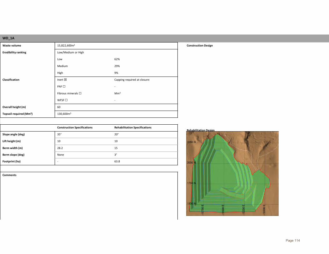
WD_1A
Waste volume 15,822,600m3 Construction Design
Erodibility ranking Low/Medium or High
Rehabilitation Design
Low 62%
Medium 29%
High 9%
Classification Inert ☒ Capping required at closure:
PAF ☐ -
Fibrous minerals ☐ Mm3
WFSF ☐ -
Overall height (m) 60
Topsoil required (Mm3) 130,600m3
Construction Specifications Rehabilitation Specifications
Slope angle (deg) 35° 20°
Lift height (m) 10 10
Berm width (m) 28.2 15
Berm slope (deg) None 3°
Footprint (ha) - 63.8
Comments
Page 114

WD_1B
Waste volume 84,596,100m3 Construction Design
Erodibility ranking Low/Medium or High
Rehabilitation Design
Low 62%
Medium 29%
High 9%
Classification Inert ☒ Capping required at closure:
PAF ☐ -
Fibrous minerals ☐ Mm3
WFSF ☐ -
Overall height (m) 85
Topsoil required (Mm3) 396,595m3
Construction Specifications Rehabilitation Specifications
Slope angle (deg) 35° 20°
Lift height (m) 10 10
Berm width (m) 28.2 15
Berm slope (deg) None 3°
Footprint (ha) - 195
Comments
Page 115

WD_3
Waste volume 45,939,900m3 Construction Design
Erodibility ranking Low/Medium or High
Rehabilitation Design
Low 62%
Medium 29%
High 9%
Classification Inert ☒ Capping required at closure:
PAF ☐ -
Fibrous minerals ☐ Mm3
WFSF ☐ -
Overall height (m) 100
Topsoil required (Mm3) 255,620m3
Construction Specifications Rehabilitation Specifications
Slope angle (deg) 35° 20°
Lift height (m) 10 10
Berm width (m) 28.2 15
Berm slope (deg) None 3°
Footprint (ha) - 125
Comments
Page 116

WD_4
Waste volume 98,714,276m3 Construction Design
Erodibility ranking Low/Medium or High
Rehabilitation Design
Low 58%
Medium 28%
High 14%
Classification Inert ☒ Capping required at closure:
PAF ☐ -
Fibrous minerals ☐ Mm3
WFSF ☐ -
Overall height (m) 100
Topsoil required (Mm3) 501,556m3
Construction Specifications Rehabilitation Specifications
Slope angle (deg) 35° 20°
Lift height (m) 10 10
Berm width (m) 28.2 15
Berm slope (deg) None 3°
Footprint (ha) - 247
Comments
Page 117

WD_5
Waste volume 16,806,350m3 Construction Design
Erodibility ranking Low/Medium or High
Rehabilitation Design
Low 58%
Medium 28%
High 14%
Classification Inert ☒ Capping required at closure:
PAF ☐ -
Fibrous minerals ☐ Mm3
WFSF ☐ -
Overall height (m) 45
Topsoil required (Mm3) 118,650m3
Construction Specifications Rehabilitation Specifications
Slope angle (deg) 35° 20°
Lift height (m) 10 10
Berm width (m) 28.2 15
Berm slope (deg) None 3°
Footprint (ha) - 59
Comments
Page 118
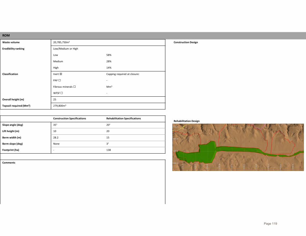
ROM
Waste volume 20,785,750m3 Construction Design
Erodibility ranking Low/Medium or High
Rehabilitation Design
Low 58%
Medium 28%
High 14%
Classification Inert ☒ Capping required at closure:
PAF ☐ -
Fibrous minerals ☐ Mm3
WFSF ☐ -
Overall height (m) 25
Topsoil required (Mm3) 279,800m3
Construction Specifications Rehabilitation Specifications
Slope angle (deg) 35° 20°
Lift height (m) 10 20
Berm width (m) 28.2 15
Berm slope (deg) None 3°
Footprint (ha) - 138
Comments
Page 119