west virginia fishing regulations - wvca - home regulations 2004.pdf · west virginia fishing...
TRANSCRIPT
W e s t V i r g i n i a D i v i s i o n o f N a t u r a l R e s o u r c e s
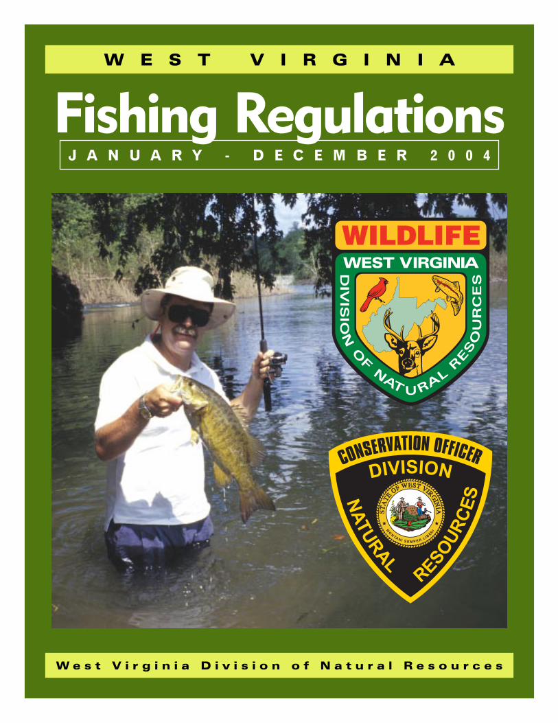
W E S T V I R G I N I A
Fishing RegulationsJ A N U A R Y - D E C E M B E R 2 0 0 4

Visit www.wvdnr.gov for more information on
Fishing • Hunting • Trapping • DNR activitiesOther wildlife-associated recreation
DISTRICT
OFFICES
District OfficesMain Office - Charleston, WV 25305State Capitol Complex, Building 3Warmwater Management - Bret Preston (304) 558-2771Law Enforcement - Lt. Col. Bill Daniel (304) 558-2784
District I - Fairmont, WV 265541304 Goose Run Road (304) 367-2720Fisheries Management - Frank JernejcicLaw Enforcement - Capt. Kaven Ransom
District II - Romney, WV 267571 Depot Street (304) 822-3551Fisheries Management - Gerald LewisLaw Enforcement - Capt. B.K. Chambers
District IIIWV State Wildlife CenterP.O. Box 38 • French Creek, WV 26218Fisheries Management - Kevin Yokum (304) 924-6211
Law Enforcement - Capt. Mike Pizzino (304) 637-0245P.O. Box 67 • Elkins, WV 26241
District IV - Beckley, WV 258012006 Robert C. Byrd Drive (304) 256-6947Fisheries Management - Jim ReedLaw Enforcement - Capt. Daniel Farley
District VMcClintic WMARt. 1, Box 484 • Pt. Pleasant, WV 25550Fisheries Management - Zack Brown (304) 675-0871
696 Winfield Road • St. Albans, WV 25177Law Enforcement - Capt. Steve Stewart (304) 759-0703
District VI - Parkersburg, WV 261012311 Ohio Avenue (304) 420-4550Fisheries Management - Scott MorrisonLaw Enforcement - Capt. Tom Wasmer
Operations Center - Elkins, WV 26241Ward Road, P.O. Box 67Coldwater Management - Mike Shingleton (304) 637-0245
Investment in a Legacy---------------------------West Virginia’s anglers enjoy a rich sportfishing legacy and conservation ethic that is maintainedthrough their commitment to our state’s fishery resources. Recognizing this commitment, theDivision of Natural Resources endeavors to provide a variety of quality fishing opportunities to meetincreasing demands, while also conserving and protecting the state’s valuable aquatic resources. Oneway that DNR fulfills this part of its mission is through its fish hatchery programs. Many anglers areaware of the successful trout stocking program and the seven coldwater hatcheries that support thisimportant fishery in West Virginia. The warmwater hatchery program, although a little less wellknown, is still very significant to West Virginia anglers.
West Virginia’s warmwater hatchery program has been instrumental in providing fishing opportunitiesto anglers for more than 60 years. For most of that time, the Palestine State Fish Hatchery was the state’s primary facility dedicated to theproduction of warmwater fish. Millions of walleye, muskellunge, channel catfish, hybrid striped bass, saugeye, tiger musky, and largemouthand smallmouth bass have been raised over the years at Palestine and stocked into streams, rivers, and lakes across the state.
A recent addition to the DNR’s warmwater hatchery program is the Apple Grove State Fish Hatchery in Mason County. Construction of thehatchery was completed in 2003. It was a joint project of the U.S. Army Corps of Engineers and the DNR as part of a mitigation agreementfor the modernization of the Robert C. Byrd Locks and Dam on the Ohio River. This new facility, along with existing production at Palestine,enhances the DNR’s warmwater fish production capabilities. Anglers will benefit from continued stocking of important sportfish, and DNRwill have opportunities to expand and develop fisheries restoration projects in the state.
The DNR looks forward to future fisheries management challenges and the opportunity to invest in the sportfishing legacy of West Virginia’sanglers. So, do your part and spend some time fishing this year with family and friends.
I think you will agree that it is a wise investment in our future.
Ed Hamrick, DirectorDivision of Natural Resources
TABLE
OF
CONTENTS
New for 2004Creel and Possession LimitCreel and possession limit of zero for shovelnose sturgeon and lake sturgeon. (See page 2)
Maryland Regulation ChangesAnglers are reminded to check Maryland’s 2004 fishing regulations for changes applying to the North Branch of the Potomacand Potomac rivers, and Jennings Randolph Lake.
Trophy Citation ChangesAnglers are reminded that changes have been made to the Trophy Citation program. (See page 6)
Release Of Fish Into Public Waters (See page 4)Anglers should be aware of new requirements in state law governing the release or movement of fish into public waters.
Burches Run LakeThe lake level has been lowered because of concerns over the safety of the dam. Trout will not be stocked, but it is open topublic fishing.
Table of Contents -----------------------------Regulations Summary ........................................................ 2
Other Methods of Fishing ................................................... 3
Trophy Fish Citation Program ............................................ 4
State Fish Records ............................................................... 5
Special Area Regulations ................................................... 6
Trout Stream Stocking Schedule ...................................... 9
Public Fishing Lakes and Ponds ..................................... 10
Fishing Favorites ................................................................ 11
Waters and Streams ......................................................... 11
Float Trips .......................................................................... 11
Guide to Your Health .......................................................... 12
License Information ........................................................... 13
Fish Identification Chart ................................................... 14
Regulations Meeting Schedule--------------March 22, 2004: Charleston, North Bend State Park, Summersville
March 23, 2004: Elkins, Franklin, Glen Dale, Huntington,Pipestem Resort State Park, Spencer
March 24, 2004: Fairmont, Lewisburg, Martinsburg, Parkersburg
March 25, 2004: Logan, Moorefield, Twin Falls Resort State Park
Bob Wise, GovernorState of West Virginia
Ed Hamrick, DirectorDivision of Natural Resources
Curtis I. Taylor, ChiefWildlife Resources
James D. Fields, ChiefLaw Enforcement Section
CommissionersJeffrey S. Bowers - Sugar Grove
Carl E. Gainer - Richwood
Charles R. Hooten - Charleston
Twila S. Metheney - Morgantown
David M. Milne - Bruceton Mills
James C. Smith - Elkview
Ken Wilson - Chapmanville
Landowner - Sportsmen RelationsWest Virginia anglers are indebted to local landowners throughout the state. Without their consent and generosity, fishing would be restricted to state and federal lands. Theopportunity for continued use of private porperty is largely dependent upon angler’s attitudes and conduct. Most stream closures are the result of disrespect for private property.
Statement of Policy Relative to Public Use of FacilitiesIt is the policy of the Division of Natural Resources to provide its facilities, accommodations, services and programs to all persons. Complaints should be mailed to:Director, Division of Natural Resources, State Capitol Complex, Charleston, WV 25305, or to the Office of Human Resources, U.S. Department of the Interior, Fish andWildlife Service, Hadley, MA 01035-9589. The Division of Natural Resources is an equal opportunity employer.
REGULATIONS
SUMMARY
2
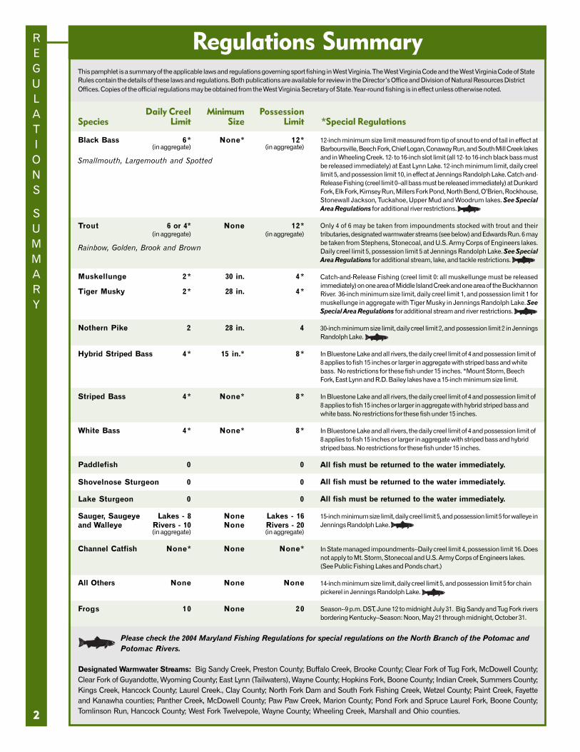
Regulations SummaryThis pamphlet is a summary of the applicable laws and regulations governing sport fishing in West Virginia. The West Virginia Code and the West Virginia Code of StateRules contain the details of these laws and regulations. Both publications are available for review in the Director’s Office and Division of Natural Resources DistrictOffices. Copies of the official regulations may be obtained from the West Virginia Secretary of State. Year-round fishing is in effect unless otherwise noted.
Daily Creel Minimum PossessionSpecies Limit Size Limit *Special Regulations
Black Bass 6* None* 12*(in aggregate) (in aggregate)
Smallmouth, Largemouth and Spotted
Trout 6 or 4* None 12*(in aggregate) (in aggregate)
Rainbow, Golden, Brook and Brown
Muskellunge 2* 30 in. 4*
Tiger Musky 2* 28 in. 4*
Nothern Pike 2 28 in. 4
Hybrid Striped Bass 4* 15 in.* 8*
Striped Bass 4* None* 8*
White Bass 4* None* 8*
Paddlefish 0 0
Shovelnose Sturgeon 0 0
Lake Sturgeon 0 0
Sauger, Saugeye Lakes - 8 None Lakes - 16and Walleye Rivers - 10 None Rivers - 20
(in aggregate) (in aggregate)
Channel Catfish None* None None*
All Others None None None
Frogs 10 None 20
Please check the 2004 Maryland Fishing Regulations for special regulations on the North Branch of the Potomac andPotomac Rivers.
Designated Warmwater Streams: Big Sandy Creek, Preston County; Buffalo Creek, Brooke County; Clear Fork of Tug Fork, McDowell County;Clear Fork of Guyandotte, Wyoming County; East Lynn (Tailwaters), Wayne County; Hopkins Fork, Boone County; Indian Creek, Summers County;Kings Creek, Hancock County; Laurel Creek., Clay County; North Fork Dam and South Fork Fishing Creek, Wetzel County; Paint Creek, Fayetteand Kanawha counties; Panther Creek, McDowell County; Paw Paw Creek, Marion County; Pond Fork and Spruce Laurel Fork, Boone County;Tomlinson Run, Hancock County; West Fork Twelvepole, Wayne County; Wheeling Creek, Marshall and Ohio counties.
12-inch minimum size limit measured from tip of snout to end of tail in effect atBarboursville, Beech Fork, Chief Logan, Conaway Run, and South Mill Creek lakesand in Wheeling Creek. 12- to 16-inch slot limit (all 12- to 16-inch black bass mustbe released immediately) at East Lynn Lake. 12-inch minimum limit, daily creellimit 5, and possession limit 10, in effect at Jennings Randolph Lake. Catch-and-Release Fishing (creel limit 0--all bass must be released immediately) at DunkardFork, Elk Fork, Kimsey Run, Millers Fork Pond, North Bend, O’Brien, Rockhouse,Stonewall Jackson, Tuckahoe, Upper Mud and Woodrum lakes. See SpecialArea Regulations for additional river restrictions.
Only 4 of 6 may be taken from impoundments stocked with trout and theirtributaries, designated warmwater streams (see below) and Edwards Run. 6 maybe taken from Stephens, Stonecoal, and U.S. Army Corps of Engineers lakes.Daily creel limit 5, possession limit 5 at Jennings Randolph Lake. See SpecialArea Regulations for additional stream, lake, and tackle restrictions.
Catch-and-Release Fishing (creel limit 0: all muskellunge must be releasedimmediately) on one area of Middle Island Creek and one area of the BuckhannonRiver. 36-inch minimum size limit, daily creel limit 1, and possession limit 1 formuskellunge in aggregate with Tiger Musky in Jennings Randolph Lake. SeeSpecial Area Regulations for additional stream and river restrictions.
30-inch minimum size limit, daily creel limit 2, and possession limit 2 in JenningsRandolph Lake.
In Bluestone Lake and all rivers, the daily creel limit of 4 and possession limit of8 applies to fish 15 inches or larger in aggregate with striped bass and whitebass. No restrictions for these fish under 15 inches. *Mount Storm, BeechFork, East Lynn and R.D. Bailey lakes have a 15-inch minimum size limit.
In Bluestone Lake and all rivers, the daily creel limit of 4 and possession limit of8 applies to fish 15 inches or larger in aggregate with hybrid striped bass andwhite bass. No restrictions for these fish under 15 inches.
In Bluestone Lake and all rivers, the daily creel limit of 4 and possession limit of8 applies to fish 15 inches or larger in aggregate with striped bass and hybridstriped bass. No restrictions for these fish under 15 inches.
All fish must be returned to the water immediately.
All fish must be returned to the water immediately.
All fish must be returned to the water immediately.
15-inch minimum size limit, daily creel limit 5, and possession limit 5 for walleye inJennings Randolph Lake.
In State managed impoundments--Daily creel limit 4, possession limit 16. Doesnot apply to Mt. Storm, Stonecoal and U.S. Army Corps of Engineers lakes.(See Public Fishing Lakes and Ponds chart.)
14-inch minimum size limit, daily creel limit 5, and possession limit 5 for chainpickerel in Jennings Randolph Lake.
Season--9 p.m. DST, June 12 to midnight July 31. Big Sandy and Tug Fork riversbordering Kentucky--Season: Noon, May 21 through midnight, October 31.
Except as authorized below, it is illegal to take fish by any meansother than by rod, line and hooks.
Other Methods of Fishing OTHER
METHODS
OF
FISHING
3
It is illegal to:• use a firearm, crossbow, dynamite or any like explosive,
or a poisonous mixture placed in the water for thepurpose of killing or taking fish, frogs, aquatic turtles orother forms of aquatic life.
• fish with more than two (2) lines or poles in animpoundment stocked with trout by the DNR fromJanuary 1 - May 31.
Bow Fishing ---------------------Carp may be taken by bow year-round; other nongame fishmay be taken by bow during all months of the year exceptMay and June. Residents must have a valid fishing licenseand nonresidents must have a valid hunting license in orderto fish using a bow. All persons using a bow to fish mustobserve all applicable fishing regulations.
It is illegal to:• use an arrow having an explosive head or shaft or an
arrow dipped in or smeared with poison or otherchemicals.
Dipping --------------------------Dipping for nongame fish is legal from February 1 tomidnight April 30 with a valid WV fishing license. A dipnet may not exceed 36 square feet in overall area, and itsmesh may not be smaller than one-fourth (1/4) inch.
Gigging, Snagging and SnaringSuckers, carp, fallfish and creek chubs may be taken bysnaring year-round. Other nongame fish, turtles and eelsmay be taken by gigging, snagging, or snaring fromJanuary 1 - May 15 and from July 15 - December 31,except that snagging and gigging shall be prohibitedwithin 100 feet of all U.S. Army Corps of Engineers Locksand Dams and their appurtenances. Snagging of gamefish is prohibited.
Hatchery Fish Removal -------It is illegal to take fish, frogs, aquatic turtles, or otheraquatic life from a state fish hatchery.
Ice Fishing ----------------------Holes cut for ice fishing must be no larger than 10 inchesin diameter. This applies to public waters where ice fishingis allowed.
Seining for Minnows /Minnow Traps ------------------Game fish may not be seined or trapped. A seine may beused to obtain minnows for use as bait provided the seineis not longer than six (6) feet nor deeper than four (4) feet.A thrownet may be used provided the diameter is nolarger than six (6) feet and mesh size no larger than three-eighths (3/8) inch. Minnow traps may be used providedthe openings are not larger than one (1) inch in diameter.A person may have in his possession no more than 50minnows nor more than a total of 100 aquatic animal lifeunless obtained from a licensed dealer and a bill of sale isprovided. Possession of mussels or any parts thereof isprohibited. A valid WV fishing license is needed to collectminnows and other aquatic life.
Trotlines and Droplines -------Trotlines and droplines must be attached to the bank or a treethereon, must bear an identification tag that is legible andwaterproof, and must be attended every 24 hours. Wire orcable lines and hooks with more than one point are prohibited.
It is illegal to:• fish with trotlines and droplines in state-managed
impoundments except Stonecoal, Hawks Nest, Mt.Storm and U.S. Army Corps of Engineers lakes. (Seechart on page 10 for state-managed lakes.)
• attach a trotline to public piers and docks or within 50feet of dam appurtenances.
• use droplines on the Elk River, Hughes River, LittleKanawha River, Middle Island Creek, and South Forkof Hughes River.
• jug fish.
Report Fish and Game Law Violations:Toll-free: 1-800-638-4263 (1-800-NET GAME)
Report Stream Pollution or Fish Kills:Toll-free: 1-800-642-3074
Open Fishing Tournament SponsorsA permit is required from the Division of NaturalResources to hold a tournament that is open to thepublic or awards cash or prizes. Club tournaments,which are restricted to members competing forpoints, do not require a permit. Tournament permitrequests should be made to West Virginia Division ofNatural Resources, Wildlife Resources Section, 1900Kanawha Blvd., E., Bldg. 3, Charleston, WV 25305.Call (304) 558-2771 for information.
The West Virginia TrophyFish Citation Program .......The trophy fish citation program was initiated torecognize outstanding fishing achievement. The colorprints of fish portrayed on the citations are reproductionsof original paintings by artist Duane Raver. Personsinterested in registering their trophy fish can obtain anapplication from any license agent or Wildlife ResourcesSection office or visit www.wvdnr.gov. A $5 fee mustaccompany the application.
Reporting Procedures• Fish must be caught on rod and reel in West Virginia.
• Fish must meet or exceed the minimum weightor length.
• Fish certified by weight must be weighed on a scalecertified by the West Virginia Division of Labor or atany office of the West Virginia Wildlife ResourcesSection. Fish must be weighed in the presence of awitness who must sign the application form.
• Fish certified by length must be measured in thepresence of a witness who must sign theapplication form, or fish must be measured and aphotograph must accompany the application.
• Measure total length of fish to nearest 1/8 inchfrom tip of snout to end of tail. Lay the fish on topof a ruler on a flat surface. Close the mouth of thefish and squeeze the tail fin lobes together. Donot measure along the curvature of the fish’s body.
• A clear side view photograph of the fish is desirable.
• Nonresidents and residents are eligible fortrophy citations.
• Applications must be submitted within 60 days ofthe date of catch.
• $5 fee must accompany each application. Make checksor money orders payable to the West Virginia DNR.
Minimum SizesTroutBrook .............. 1.5 lbs ... 15 inBrown ................ 4 lbs ... 21 inRainbow ............ 4 lbs ... 21 inGolden ............... 4 lbs ... 21 in
BassLargemouth ...... 5 lbs ... 21 inSmallmouth ...... 4 lbs ... 20 inSpotted ........... 1.5 lbs ... 14 inRock .................. 1 lbs ... 11 inStriped ............... 7 lbs ... 25 inHybrid Striped .. 7 lbs ... 24 inWhite ................. 2 lbs ... 15 in
Muskellunge ... 15 lbs ... 40 in
Tiger Musky .... 15 lbs ... 40 in
METHODS
OF
FISHING
4
Methods of Fishing continued . . .
Spearfishing and Diving ------1. Nongame fish may be taken by spearfishing from
July 1 - September 30 during daylight hours only.
2. Spearfishing is prohibited on the following:a. Elk River, from Sutton Dam downstream to the U.S.
Route 19 bridge at Sutton;b. New River, from Bluestone Dam downstream to the
lower bridge at Hinton.
3. Spearguns may be discharged only beneath thesurface of the water.
4. It is illegal to use a bolt having an explosive head orshaft or a bolt dipped in or smeared with poison orother chemicals.
5. A diver may not spearfish in such a manner as tointerfere with other anglers.
6. A diver may not spearfish in heavily-traveled boat lanes,marked swimming areas, or marked waterskiing areas.
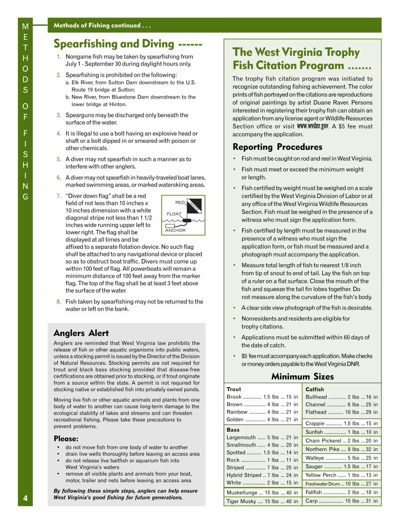
7. “Diver down flag” shall be a redfield of not less than 10 inches x10 inches dimension with a whitediagonal stripe not less than 1 1/2inches wide running upper left tolower right. The flag shall bedisplayed at all times and beaffixed to a separate flotation device. No such flagshall be attached to any navigational device or placedso as to obstruct boat traffic. Divers must come upwithin 100 feet of flag. All powerboats will remain aminimum distance of 100 feet away from the markerflag. The top of the flag shall be at least 3 feet abovethe surface of the water.
8. Fish taken by spearfishing may not be returned to thewater or left on the bank.
CatfishBullhead ............. 2 lbs ... 16 inChannel .............. 6 lbs ... 25 inFlathead ........... 10 lbs ... 29 in
Crappie ............ 1.5 lbs ... 15 in
Sunfish ................ 1 lbs ... 10 in
Chain Pickerel .. 2 lbs ... 20 in
Northern Pike .... 8 lbs ... 32 in
Walleye ............... 5 lbs ... 25 in
Sauger ............. 1.5 lbs ... 17 in
Yellow Perch ...... 1 lbs ... 13 in
Freshwater Drum ... 10 lbs ... 27 in
Fallfish ................. 2 lbs ... 18 in
Carp .................. 15 lbs ... 31 in
Anglers AlertAnglers are reminded that West Virginia law prohibits therelease of fish or other aquatic organisms into public waters,unless a stocking permit is issued by the Director of the Divisionof Natural Resources. Stocking permits are not required fortrout and black bass stocking provided that disease-freecertifications are obtained prior to stocking, or if trout originatefrom a source within the state. A permit is not required forstocking native or established fish into privately owned ponds.
Moving live fish or other aquatic animals and plants from onebody of water to another can cause long-term damage to theecological stability of lakes and streams and can threatenrecreational fishing. Please take these precautions toprevent problems.
Please:• do not move fish from one body of water to another• drain live wells thoroughly before leaving an access area• do not release live baitfish or aquarium fish into
West Virginia’s waters• remove all visible plants and animals from your boat,
motor, trailer and nets before leaving an access area
By following these simple steps, anglers can help ensureWest Virginia’s good fishing for future generations.
STATE
FISH
RECORDS
5
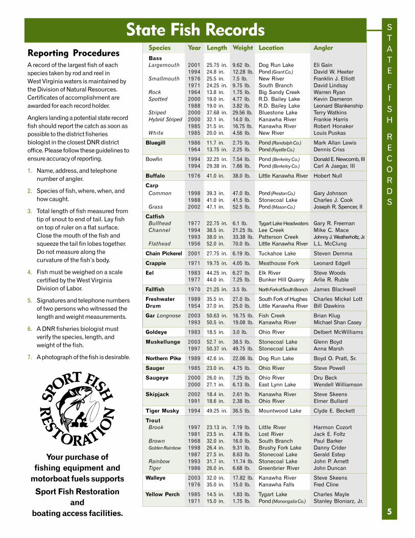
Species Year Length Weight Location Angler
BassLargemouth 2001 25.75 in. 9.62 lb. Dog Run Lake Eli Gain
1994 24.8 in. 12.28 lb. Pond (Grant Co.) David W. HeeterSmallmouth 1976 25.5 in. 7.5 lb. New River Franklin J. Elliott
1971 24.25 in. 9.75 lb. South Branch David LindsayRock 1964 13.8 in. 1.75 lb. Big Sandy Creek Warren RyanSpotted 2000 19.0 in. 4.77 lb. R.D. Bailey Lake Kevin Dameron
1988 19.0 in. 3.82 lb. R.D. Bailey Lake Leonard BlankenshipStriped 2000 37.68 in. 29.56 lb. Bluestone Lake Terry WatkinsHybrid Striped 2000 32.1 in. 14.0 lb. Kanawha River Frankie Harris
1985 31.5 in. 16.75 lb. Kanawha River Robert HonakerWhite 1985 20.0 in. 4.56 lb. New River Louis Puskas
Bluegill 1986 11.7 in. 2.75 lb. Pond (Randolph Co.) Mark Allan Lewis1964 13.75 in. 2.25 lb. Pond (Fayette Co.) Dennis Criss
Bowfin 1994 32.25 in. 7.54 lb. Pond (Berkeley Co.) Donald E. Newcomb, III1994 29.38 in. 7.66 lb. Pond (Berkeley Co.) Carl A Jaegar, III
Buffalo 1976 41.0 in. 38.0 lb. Little Kanawha River Hobert Null
CarpCommon 1998 39.3 in. 47.0 lb. Pond (Preston Co.) Gary Johnson
1988 41.0 in. 41.5 lb. Stonecoal Lake Charles J. CookGrass 2002 47.1 in. 52.5 lb. Pond (Mason Co.) Joseph R. Spencer, II
CatfishBullhead 1977 22.75 in. 6.1 lb. Tygart Lake Headwaters Gary R. FreemanChannel 1994 38.5 in. 21.25 lb. Lee Creek Mike C. Mace
1993 38.0 in. 33.38 lb. Patterson Creek Johnny J. Weatherholtz, Jr.Flathead 1956 52.0 in. 70.0 lb. Little Kanawha River L.L. McClung
Chain Pickerel 2001 27.75 in. 6.19 lb. Tuckahoe Lake Steven Demma
Crappie 1971 19.75 in. 4.05 lb. Meathouse Fork Leonard Edgell
Eel 1983 44.25 in. 6.27 lb. Elk River Steve Woods1977 44.0 in. 7.25 lb. Bunker Hill Quarry Arlie R. Ruble
Fallfish 1970 21.25 in. 3.5 lb. North Fork of South Branch James Blackwell
Freshwater 1989 35.5 in. 27.0 lb. South Fork of Hughes Charles Mickel LottDrum 1954 37.0 in. 25.0 lb. Little Kanawha River Bill Dawkins
Gar Longnose 2003 50.63 in. 16.75 lb. Fish Creek Brian Klug1993 50.5 in. 19.08 lb. Kanawha River Michael Shan Casey
Goldeye 1983 18.5 in. 3.0 lb. Ohio River Delbert McWilliams
Muskellunge 2003 52.7 in. 38.5 lb. Stonecoal Lake Glenn Boyd1997 50.37 in. 49.75 lb. Stonecoal Lake Anna Marsh
Northern Pike 1989 42.6 in. 22.06 lb. Dog Run Lake Boyd O. Pratt, Sr.
Sauger 1985 23.0 in. 4.75 lb. Ohio River Steve Powell
Saugeye 2000 26.0 in. 7.25 lb. Ohio River Dru Beck2000 27.1 in. 6.13 lb. East Lynn Lake Wendell Williamson
Skipjack 2002 18.4 in. 2.61 lb. Kanawha River Steve Skeens1991 18.6 in. 2.38 lb. Ohio River Elmer Bullard
Tiger Musky 1994 49.25 in. 36.5 lb. Mountwood Lake Clyde E. Beckett
TroutBrook 1997 23.13 in. 7.19 lb. Little River Harmon Cozort
1981 23.5 in. 4.78 lb. Lost River Jack E. FoltzBrown 1968 32.0 in. 16.0 lb. South Branch Paul BarkerGolden Rainbow 1998 26.4 in. 9.31 lb. Brushy Fork Lake Danny Crider
1987 27.5 in. 8.63 lb. Stonecoal Lake Gerald EstepRainbow 1993 31.7 in. 11.74 lb. Stonecoal Lake John P. ArnettTiger 1986 26.0 in. 6.68 lb. Greenbrier River John Duncan
Walleye 2003 32.0 in. 17.82 lb. Kanawha River Steve Skeens1976 35.0 in. 15.0 lb. Kanawha Falls Fred Cline
Yellow Perch 1985 14.5 in. 1.83 lb. Tygart Lake Charles Mayle1971 15.0 in. 1.75 lb. Pond (Monongalia Co.) Stanley Bloniarz, Jr.
State Fish RecordsReporting ProceduresA record of the largest fish of eachspecies taken by rod and reel inWest Virginia waters is maintained bythe Division of Natural Resources.Certificates of accomplishment areawarded for each record holder.
Anglers landing a potential state recordfish should report the catch as soon aspossible to the district fisheriesbiologist in the closest DNR districtoffice. Please follow these guidelines toensure accuracy of reporting.
1. Name, address, and telephonenumber of angler.
2. Species of fish, where, when, andhow caught.
3. Total length of fish measured fromtip of snout to end of tail. Lay fishon top of ruler on a flat surface.Close the mouth of the fish andsqueeze the tail fin lobes together.Do not measure along thecurvature of the fish’s body.
4. Fish must be weighed on a scalecertified by the West VirginiaDivision of Labor.
5. Signatures and telephone numbersof two persons who witnessed thelength and weight measurements.
6. A DNR fisheries biologist mustverify the species, length, andweight of the fish.
7. A photograph of the fish is desirable.
Your purchase offishing equipment and
motorboat fuels supports
Sport Fish Restorationand
boating access facilities.
SPECIAL
AREA
REGULATIONS
6
Catch-and-Release Streams --------------------------------------------
North Branch of Potomac River, Grant and Mineral countiesCheck the 2004 Maryland Fishing Regulations for special regulationson the North Branch of the Potomac and Potomac Rivers.
North Fork of Cherry River, Nicholas County1.8-mile section extending upstream from Richwood’s water supplydam to first state Route 39 bridge. Access by state Route 39.
North Fork of Cranberry River, Pocahontas County.25-mile section from the mouth upstream to the limestonetreatment dam. Access by foot on National Forest Route 76.
North Fork of the South Branch, Pendleton County.75-mile section at the mouth of Seneca Creek near SenecaRocks Visitors Center. Access by county Route 28/3 atjunction of state Route 28 and U.S. Route 33 at Seneca Rocks.
Paint Creek, Fayette County2-mile section from mouth of Skitter Creek upstream tomouth of Milburn Creek. Access is by county Route 15.
Shavers Fork of Cheat River, Randolph County5.5-mile section in the Monongahela National Forest, north ofU. S. Route 250, from the mouth of Whitmeadow Rundownstream to the mouth of McGee Run. Access by NationalForest Route 92, which intersects U.S. Route 250 four mileswest of Cheat Bridge.
Slatyfork section of Elk River, Pocahontas County3.6-mile section from the junction of Big Spring and Old Fieldforks downstream to the railroad bridge. Access by foot fromcounty routes 219/2 on the north and 219/12 on the south.
South Branch of the Potomac River, Pendleton County1-mile section beginning 2 miles below U.S. Route 220 at EagleRock and extending downstream. Access by county Route 2.
Williams River, Pocahontas County2-mile section beginning 2 miles below Tea Creek andextending downstream. Access by National Forest Route 86.
Special Area RegulationsSeason is year-round unless otherwise noted.
Trout Streams1. Fishing permitted during daylight hours only.
2. Only artificial flies and lures made of metal, wood,feathers, hair, or synthetic material may be used orpossessed on “catch-and-release” trout streamsduring the catch-and-release season.
3. Multiple hook lures must have barbless hooks.
4. Single hook lures may have barbed hooks.
5. To release a deeply hooked or gill-hooked fish, theleader should be cut 5 to 6 inches above the lure.
6. All trout caught must be returned to the water at once.
7. No trout shall be in the angler’s possession while onstream sections designated as catch-and-release streams.
*Powerbait is considered to be illegal under this section andmay not be used or possessed on catch-and-release streams.
Back Fork of Elk River, Webster County4-mile section beginning 2 miles upstream from Webster Springsand extending upstream. Access by county routes 24 and 24/3.
Blackwater River, Tucker County3.5-mile section from the county Route 29/1 bridge inBlackwater Falls State Park downstream to the mouth of theNorth Fork.
Clear Fork of the Guyandotte River, Wyoming County1-mile section from the R.D. Bailey Wildlife ManagementArea manager’s residence downstream to the state Route 6bridge. Season: March 1 - May 31. General regulationsapply June 1 - February 28.
Cranberry River, Webster and Pocahontas / Nicholas counties1. 4.3-mile section from the junction of the North and South
forks downstream to the low water bridge at DogwayFork. Access by foot on National Forest Route 76 from theCranberry Glades parking area.
2. Nicholas County - 1.2-mile section from the WoodbineRecreation Area downstream to Camp Splinter (JakemanRun). Access by National Forest Route 76 from Richwood.
Elk River, Randolph County2-mile section from the Elk Springs Campground downstreamto the Rose Run bridge. Access by county Route 49 off stateRoute 15 about 4 miles west of Valley Head.
Glade Creek of New River, Raleigh County3-mile section from the mouth upstream to the National Park Servicefoot bridge. Access by Glade Creek Road off state Route 41.
Middle Wheeling Creek, Ohio County1.2-mile section from just above the upper limits of MiddleWheeling Creek Lake upstream to mouth of Gillespie Run.Access by county Route 39/6. Season: February 1 - May31. General regulations apply June 1 - January 31.
Boating Education Requirement ...Anyone born after December 31, 1986, must successfullycomplete a N.A.S.B.L.A.-approved Boating EducationCourse before operating a motorboat in the waters ofWest Virginia. Contact a Conservation Officer for anavailable course near you.
Fishing Licenses available online
SPECIAL
AREA
REGULATIONS
Special Area Regulations continued . . .
7
Catch-and-Release Streamscontinued------------------------Bass Streams1. All black bass (smallmouth, spotted and largemouth)
caught must be returned to the water at once.
2. No black bass shall be in the angler’s possession whileon the stream within designated catch-and- release areas.
3. To release a deeply hooked or gill-hooked fish, the lineshould be cut 5 to 6 inches above the lure.
New River, Fayette, Raleigh and Summers counties12-mile section from the I-64 bridge at Sandstonedownstream to NPS Grandview Sandbar access site nearQuinnimont. Access by state Route 41 at Quinnimont andstate Route 20 at Sandstone.
South Branch of Potomac River, Hardy and Hampshire countiesArea 1 8-mile section in Hardy County from 3 miles east
of Petersburg at the routes 28, 55 and 220 bridge(Petersburg Gap bridge) downstream to the countyRoute 13 bridge (Fisher bridge).
Area 2 9.5-mile section in Hampshire County from the routes28 and 50 bridge (Romney bridge) downstream to thestate Route 28 bridge (Blue Beach bridge).
Muskellunge Streams1. All muskellunge caught must be returned to the
water at once.
2. No muskellunge shall be in the angler’s possessionwhile on stream sections designated ascatch-and-release streams.
Buckhannon River, Upshur County6.5-mile section beginning at the City of Buckhannon’s watersupply dam and continuing upstream to the first riffle.Included in this area is the section of French Creek from itsmouth to the first riffle. The entire stream section iscommonly referred to as Buckhannon Pool.
Middle Island Creek, Tyler County6-mile section beginning at the state Route 18 bridge nearCenterville and continuing downstream to the low water bridgenear the Jug WMA. Included in this area are sections of IndianCreek and McElroy Creek from their mouth to their first riffle.
Handling and Release ProceduresWhen practicing catch-and-release fishing, survival of thereleased fish can be greatly enhanced by following thesesimple guidelines.
1. Time is important - play and release the fish as quicklyas possible to reduce unnecessary stress.
2. Keep the fish in the water as much as possible and use apair of forceps or needle-nosed pliers to remove the hook.
3. Handle the fish with bare, wet hands. Do not squeeze thefish, put your fingers in the eyes or gills, or cause scale loss.
4. When releasing the fish, hold it gently in the wateruntil the fish is ready to swim off on its own.
Fly-fishing-Only TroutStreams--------------------------1. Fishing permitted during daylight hours only.
2. Only artificial flies and streamers may be used or inpossession on any of the fly-fishing-only streams.
3. Only conventional fly fishing tackle may be used. Open-and closed-face spinning or spincast reels are prohibited.
4. All fish caught must be returned to water at once.
5. No trout shall be in the angler’s possession while onstream sections designated as fly-fishing-only streams.
Buffalo Creek of New River, Fayette CountyMain stream and all tributaries of Buffalo Creek. Access byfoot from county Route 25.
Dogway Fork of the Cranberry, Webster, Pocahontas andGreenbrier countiesMain stream and all tributaries of Dogway Fork. Access byfoot on National Forest Route 78.
Milligan Creek, Greenbrier CountyMarked area about 1 mile north of U.S. Route 60 from thecounty Route 60/15 bridge extending downstream about .33mile to a fence crossing.
Red Run of Dry Fork, Tucker CountyMain stream and all tributaries of Red Run. Access by footfrom state Route 72 and National Forest Route 13.
Second Creek, Greenbrier and Monroe countiesMarked 1.5-mile section on the Monroe/Greenbrier countyline at Rodgers Mill.
Thorn Creek, Pendleton CountyMarked .5-mile section beginning approximately 3 milesabove the mouth. Access is by county Route 20.
Slot-Limit Bass Stream -------1. All black bass (smallmouth, spotted and largemouth)
from 12 to 20 inches must be returned to the waterat once.
2. Daily creel limit of one black bass over 20 inchescaught within the slot limit area. Black bass under 12inches may be harvested. All black bass harvested mustbe in accordance with the daily creel limit regulation.
3. To release a deeply hooked or gill-hooked fish, cut theline 5 to 6 inches above the lure.
Greenbrier River, Greenbrier County6-mile section beginning at the U.S. Route 60 bridge nearCaldwell extending downstream to the U.S. Route 219 bridgeat Ronceverte.
Free Fishing DaysJune 12-13, 2004
SPECIAL
AREA
REGULATIONS
8
Special Area Regulations continued . . .
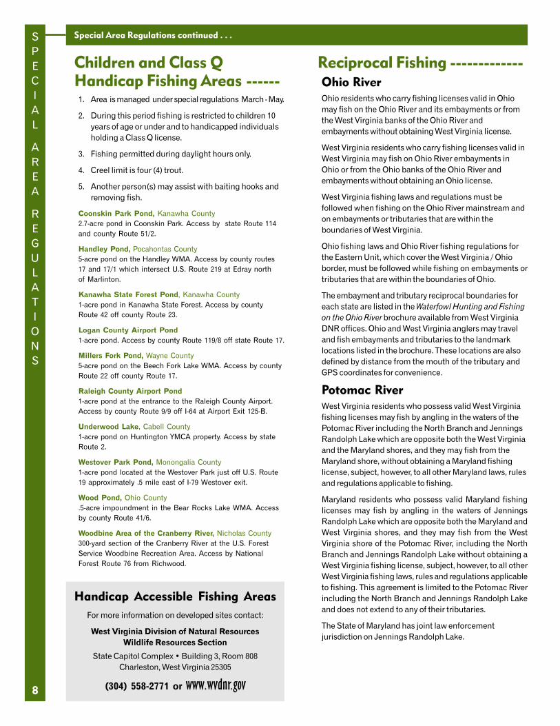
Reciprocal Fishing -------------Ohio RiverOhio residents who carry fishing licenses valid in Ohiomay fish on the Ohio River and its embayments or fromthe West Virginia banks of the Ohio River andembayments without obtaining West Virginia license.
West Virginia residents who carry fishing licenses valid inWest Virginia may fish on Ohio River embayments inOhio or from the Ohio banks of the Ohio River andembayments without obtaining an Ohio license.
West Virginia fishing laws and regulations must befollowed when fishing on the Ohio River mainstream andon embayments or tributaries that are within theboundaries of West Virginia.
Ohio fishing laws and Ohio River fishing regulations forthe Eastern Unit, which cover the West Virginia / Ohioborder, must be followed while fishing on embayments ortributaries that are within the boundaries of Ohio.
The embayment and tributary reciprocal boundaries foreach state are listed in the Waterfowl Hunting and Fishingon the Ohio River brochure available from West VirginiaDNR offices. Ohio and West Virginia anglers may traveland fish embayments and tributaries to the landmarklocations listed in the brochure. These locations are alsodefined by distance from the mouth of the tributary andGPS coordinates for convenience.
Potomac RiverWest Virginia residents who possess valid West Virginiafishing licenses may fish by angling in the waters of thePotomac River including the North Branch and JenningsRandolph Lake which are opposite both the West Virginiaand the Maryland shores, and they may fish from theMaryland shore, without obtaining a Maryland fishinglicense, subject, however, to all other Maryland laws, rulesand regulations applicable to fishing.
Maryland residents who possess valid Maryland fishinglicenses may fish by angling in the waters of JenningsRandolph Lake which are opposite both the Maryland andWest Virginia shores, and they may fish from the WestVirginia shore of the Potomac River, including the NorthBranch and Jennings Randolph Lake without obtaining aWest Virginia fishing license, subject, however, to all otherWest Virginia fishing laws, rules and regulations applicableto fishing. This agreement is limited to the Potomac Riverincluding the North Branch and Jennings Randolph Lakeand does not extend to any of their tributaries.
The State of Maryland has joint law enforcementjurisdiction on Jennings Randolph Lake.
Children and Class QHandicap Fishing Areas ------1. Area is managed under special regulations March - May.
2. During this period fishing is restricted to children 10years of age or under and to handicapped individualsholding a Class Q license.
3. Fishing permitted during daylight hours only.
4. Creel limit is four (4) trout.
5. Another person(s) may assist with baiting hooks andremoving fish.
Coonskin Park Pond, Kanawha County2.7-acre pond in Coonskin Park. Access by state Route 114and county Route 51/2.
Handley Pond, Pocahontas County5-acre pond on the Handley WMA. Access by county routes17 and 17/1 which intersect U.S. Route 219 at Edray northof Marlinton.
Kanawha State Forest Pond, Kanawha County1-acre pond in Kanawha State Forest. Access by countyRoute 42 off county Route 23.
Logan County Airport Pond1-acre pond. Access by county Route 119/8 off state Route 17.
Millers Fork Pond, Wayne County5-acre pond on the Beech Fork Lake WMA. Access by countyRoute 22 off county Route 17.
Raleigh County Airport Pond1-acre pond at the entrance to the Raleigh County Airport.Access by county Route 9/9 off I-64 at Airport Exit 125-B.
Underwood Lake, Cabell County1-acre pond on Huntington YMCA property. Access by stateRoute 2.
Westover Park Pond, Monongalia County1-acre pond located at the Westover Park just off U.S. Route19 approximately .5 mile east of I-79 Westover exit.
Wood Pond, Ohio County.5-acre impoundment in the Bear Rocks Lake WMA. Accessby county Route 41/6.
Woodbine Area of the Cranberry River, Nicholas County300-yard section of the Cranberry River at the U.S. ForestService Woodbine Recreation Area. Access by NationalForest Route 76 from Richwood.
Handicap Accessible Fishing AreasFor more information on developed sites contact:
West Virginia Division of Natural ResourcesWildlife Resources Section
State Capitol Complex • Building 3, Room 808Charleston, West Virginia 25305
(304) 558-2771 or www.wvdnr.gov
9
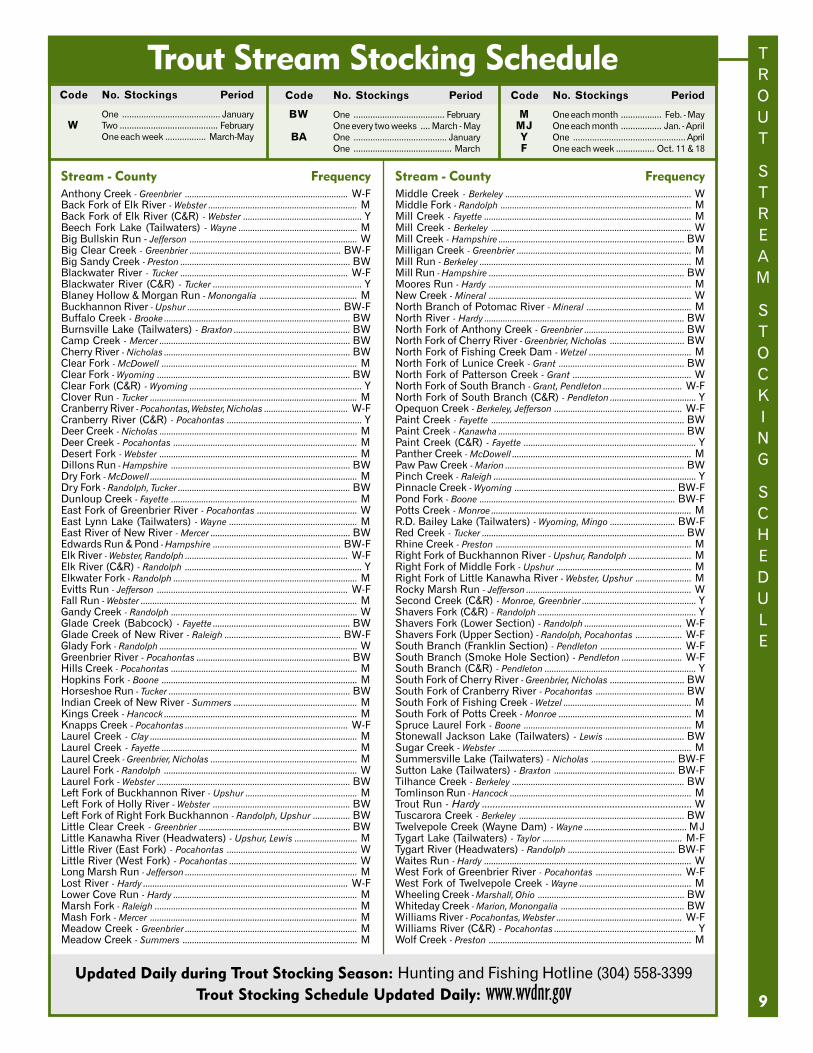
Stream - County FrequencyAnthony Creek - Greenbrier ...................................................................... W-FBack Fork of Elk River - Webster ................................................................ MBack Fork of Elk River (C&R) - Webster ................................................... YBeech Fork Lake (Tailwaters) - Wayne ................................................... MBig Bullskin Run - Jefferson ........................................................................ WBig Clear Creek - Greenbrier ................................................................. BW-FBig Sandy Creek - Preston ......................................................................... BWBlackwater River - Tucker ........................................................................ W-FBlackwater River (C&R) - Tucker ................................................................ YBlaney Hollow & Morgan Run - Monongalia .......................................... MBuckhannon River - Upshur .................................................................. BW-FBuffalo Creek - Brooke ................................................................................ BWBurnsville Lake (Tailwaters) - Braxton .................................................. BWCamp Creek - Mercer .................................................................................. BWCherry River - Nicholas ................................................................................ BWClear Fork - McDowell .................................................................................... MClear Fork - Wyoming ................................................................................... BWClear Fork (C&R) - Wyoming .......................................................................... YClover Run - Tucker ......................................................................................... MCranberry River - Pocahontas, Webster, Nicholas .................................... W-FCranberry River (C&R) - Pocahontas .......................................................... YDeer Creek - Nicholas ..................................................................................... MDeer Creek - Pocahontas ............................................................................... MDesert Fork - Webster ..................................................................................... MDillons Run - Hampshire ............................................................................. BWDry Fork - McDowell ......................................................................................... MDry Fork - Randolph, Tucker .......................................................................... BWDunloup Creek - Fayette ................................................................................ MEast Fork of Greenbrier River - Pocahontas ........................................... WEast Lynn Lake (Tailwaters) - Wayne ....................................................... MEast River of New River - Mercer ............................................................ BWEdwards Run & Pond - Hampshire ....................................................... BW-FElk River - Webster, Randolph ...................................................................... W-FElk River (C&R) - Randolph ............................................................................ YElkwater Fork - Randolph ............................................................................... MEvitts Run - Jefferson .................................................................................. W-FFall Run - Webster ............................................................................................. MGandy Creek - Randolph ................................................................................ WGlade Creek (Babcock) - Fayette ........................................................... BWGlade Creek of New River - Raleigh .................................................. BW-FGlady Fork - Randolph ..................................................................................... WGreenbrier River - Pocahontas .................................................................. BWHills Creek - Pocahontas ................................................................................ MHopkins Fork - Boone .................................................................................... MHorseshoe Run - Tucker .............................................................................. BWIndian Creek of New River - Summers ..................................................... MKings Creek - Hancock ................................................................................... MKnapps Creek - Pocahontas ...................................................................... W-FLaurel Creek - Clay ......................................................................................... MLaurel Creek - Fayette .................................................................................... MLaurel Creek - Greenbrier, Nicholas ............................................................... MLaurel Fork - Randolph ................................................................................... WLaurel Fork - Webster ................................................................................... BWLeft Fork of Buckhannon River - Upshur ................................................ MLeft Fork of Holly River - Webster ........................................................... BWLeft Fork of Right Fork Buckhannon - Randolph, Upshur ................ BWLittle Clear Creek - Greenbrier ................................................................. BWLittle Kanawha River (Headwaters) - Upshur, Lewis ........................... MLittle River (East Fork) - Pocahontas ........................................................ WLittle River (West Fork) - Pocahontas ....................................................... WLong Marsh Run - Jefferson .......................................................................... MLost River - Hardy ........................................................................................ W-FLower Cove Run - Hardy ............................................................................... MMarsh Fork - Raleigh ....................................................................................... MMash Fork - Mercer ......................................................................................... MMeadow Creek - Greenbrier .......................................................................... MMeadow Creek - Summers ........................................................................... M
Stream - County FrequencyMiddle Creek - Berkeley ................................................................................ WMiddle Fork - Randolph .................................................................................. MMill Creek - Fayette ......................................................................................... MMill Creek - Berkeley ...................................................................................... WMill Creek - Hampshire ................................................................................ BWMilligan Creek - Greenbrier ........................................................................... MMill Run - Berkeley ........................................................................................... MMill Run - Hampshire .................................................................................... BWMoores Run - Hardy ....................................................................................... MNew Creek - Mineral ....................................................................................... WNorth Branch of Potomac River - Mineral ............................................. MNorth River - Hardy ...................................................................................... BWNorth Fork of Anthony Creek - Greenbrier ........................................... BWNorth Fork of Cherry River - Greenbrier, Nicholas ................................ BWNorth Fork of Fishing Creek Dam - Wetzel ............................................ MNorth Fork of Lunice Creek - Grant ...................................................... BWNorth Fork of Patterson Creek - Grant ................................................... WNorth Fork of South Branch - Grant, Pendleton .................................. W-FNorth Fork of South Branch (C&R) - Pendleton ..................................... YOpequon Creek - Berkeley, Jefferson ....................................................... W-FPaint Creek - Fayette ................................................................................... BWPaint Creek - Kanawha ................................................................................ BWPaint Creek (C&R) - Fayette .......................................................................... YPanther Creek - McDowell ............................................................................. MPaw Paw Creek - Marion ............................................................................. BWPinch Creek - Raleigh ....................................................................................... YPinnacle Creek - Wyoming ..................................................................... BW-FPond Fork - Boone .................................................................................... BW-FPotts Creek - Monroe ...................................................................................... MR.D. Bailey Lake (Tailwaters) - Wyoming, Mingo ............................ BW-FRed Creek - Tucker ....................................................................................... BWRhine Creek - Preston .................................................................................... MRight Fork of Buckhannon River - Upshur, Randolph ........................... MRight Fork of Middle Fork - Upshur .......................................................... MRight Fork of Little Kanawha River - Webster, Upshur ........................ MRocky Marsh Run - Jefferson ....................................................................... WSecond Creek (C&R) - Monroe, Greenbrier ................................................. YShavers Fork (C&R) - Randolph .................................................................... YShavers Fork (Lower Section) - Randolph .......................................... W-FShavers Fork (Upper Section) - Randolph, Pocahontas .................... W-FSouth Branch (Franklin Section) - Pendleton ................................... W-FSouth Branch (Smoke Hole Section) - Pendleton .......................... W-FSouth Branch (C&R) - Pendleton ................................................................. YSouth Fork of Cherry River - Greenbrier, Nicholas ................................ BWSouth Fork of Cranberry River - Pocahontas ...................................... BWSouth Fork of Fishing Creek - Wetzel ....................................................... MSouth Fork of Potts Creek - Monroe ......................................................... MSpruce Laurel Fork - Boone ........................................................................ MStonewall Jackson Lake (Tailwaters) - Lewis .................................. BWSugar Creek - Webster ................................................................................... MSummersville Lake (Tailwaters) - Nicholas .................................... BW-FSutton Lake (Tailwaters) - Braxton .................................................... BW-FTilhance Creek - Berkeley .......................................................................... BWTomlinson Run - Hancock .............................................................................. MTrout Run - Hardy ............................................................................... WTuscarora Creek - Berkeley ....................................................................... BWTwelvepole Creek (Wayne Dam) - Wayne ............................................ MJTygart Lake (Tailwaters) - Taylor ............................................................ M-FTygart River (Headwaters) - Randolph .............................................. BW-FWaites Run - Hardy ......................................................................................... WWest Fork of Greenbrier River - Pocahontas ..................................... W-FWest Fork of Twelvepole Creek - Wayne ................................................ MWheeling Creek - Marshall, Ohio ............................................................... BWWhiteday Creek - Marion, Monongalia ..................................................... BWWilliams River - Pocahontas, Webster ...................................................... W-FWilliams River (C&R) - Pocahontas ............................................................. YWolf Creek - Preston ....................................................................................... M
Code No. Stockings Period
One ......................................... JanuaryW Two ......................................... February
One each week ................. March-May
Code No. Stockings Period
BW One ...................................... FebruaryOne every two weeks .... March - May
BA One ....................................... JanuaryOne ......................................... March
Code No. Stockings Period
M One each month ................. Feb. - MayMJ One each month ................. Jan. - AprilY One ............................................... AprilF One each week ................ Oct. 11 & 18
Trout Stream Stocking Schedule
Updated Daily during Trout Stocking Season: Hunting and Fishing Hotline (304) 558-3399Trout Stocking Schedule Updated Daily: www.wvdnr.gov
TROUT
STREAM
STOCKING
SCHEDULE
PUBLIC
FISHING
:
LAKES
AND
PONDS
10
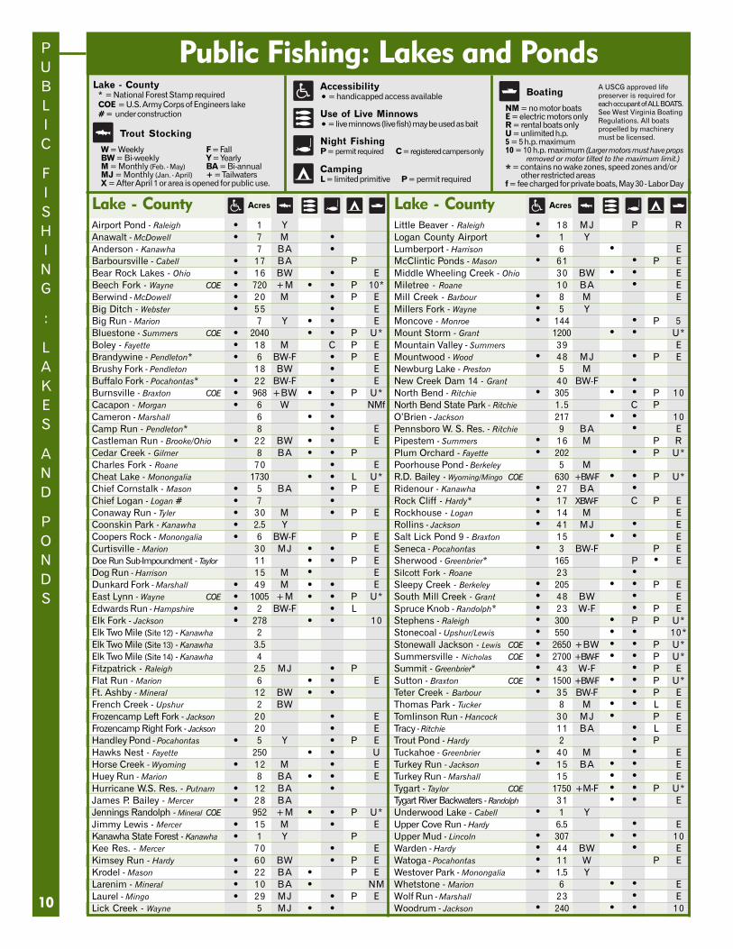
Lake - CountyAirport Pond - Raleigh • 1 YAnawalt - McDowell • 7 M •Anderson - Kanawha 7 BA •Barboursville - Cabell • 17 BA PBear Rock Lakes - Ohio • 16 BW • EBeech Fork - Wayne COE • 720 +M • • P 10*Berwind - McDowell • 20 M • P EBig Ditch - Webster • 55 • EBig Run - Marion 7 Y • • EBluestone - Summers COE • 2040 • • P U*Boley - Fayette • 18 M C P EBrandywine - Pendleton* • 6 BW-F • P EBrushy Fork - Pendleton 18 BW • EBuffalo Fork - Pocahontas* • 22 BW-F • EBurnsville - Braxton COE • 968 +BW • • P U*Cacapon - Morgan • 6 W • NMfCameron - Marshall 6 • •Camp Run - Pendleton* 8 • ECastleman Run - Brooke/Ohio • 22 BW • • ECedar Creek - Gilmer 8 BA • • PCharles Fork - Roane 70 • ECheat Lake - Monongalia 1730 • • L U*Chief Cornstalk - Mason • 5 BA • P EChief Logan - Logan # • 7 •Conaway Run - Tyler • 30 M • P ECoonskin Park - Kanawha • 2.5 YCoopers Rock - Monongalia • 6 BW-F P ECurtisville - Marion 30 MJ • • EDoe Run Sub-Impoundment - Taylor 11 • • P EDog Run - Harrison 15 M • EDunkard Fork - Marshall • 49 M • • EEast Lynn - Wayne COE • 1005 +M • • P U*Edwards Run - Hampshire • 2 BW-F • LElk Fork - Jackson • 278 • • 10Elk Two Mile (Site 12) - Kanawha 2Elk Two Mile (Site 13) - Kanawha 3.5Elk Two Mile (Site 14) - Kanawha 4Fitzpatrick - Raleigh 2.5 MJ • PFlat Run - Marion 6 • • EFt. Ashby - Mineral 12 BW • •French Creek - Upshur 2 BWFrozencamp Left Fork - Jackson 20 • EFrozencamp Right Fork - Jackson 20 • EHandley Pond - Pocahontas • 5 Y • P EHawks Nest - Fayette 250 • • UHorse Creek - Wyoming • 12 M • EHuey Run - Marion 8 BA • • EHurricane W.S. Res. - Putnam • 12 BA •James P. Bailey - Mercer • 28 BAJennings Randolph - Mineral COE 952 +M • • P U*Jimmy Lewis - Mercer • 15 M • EKanawha State Forest - Kanawha • 1 Y PKee Res. - Mercer 70 • EKimsey Run - Hardy • 60 BW • P EKrodel - Mason • 22 BA • P ELarenim - Mineral • 10 BA • NMLaurel - Mingo • 29 MJ • P ELick Creek - Wayne 5 MJ • •
Public Fishing: Lakes and Ponds
Acres
Lake - County* = National Forest Stamp requiredCOE = U.S. Army Corps of Engineers lake# = under construction
AcresLake - CountyLittle Beaver - Raleigh • 18 MJ P RLogan County Airport • 1 YLumberport - Harrison 6 • EMcClintic Ponds - Mason • 61 • P EMiddle Wheeling Creek - Ohio 30 BW • • EMiletree - Roane 10 BA • EMill Creek - Barbour • 8 M EMillers Fork - Wayne • 5 YMoncove - Monroe • 144 • P 5Mount Storm - Grant 1200 • • U*Mountain Valley - Summers 39 EMountwood - Wood • 48 MJ • P ENewburg Lake - Preston 5 MNew Creek Dam 14 - Grant 40 BW-F •North Bend - Ritchie • 305 • • P 10North Bend State Park - Ritchie 1.5 C PO’Brien - Jackson 217 • • 10Pennsboro W. S. Res. - Ritchie 9 BA • EPipestem - Summers • 16 M P RPlum Orchard - Fayette • 202 • P U*Poorhouse Pond - Berkeley 5 MR.D. Bailey - Wyoming/Mingo COE 630 +BW-F • • P U*Ridenour - Kanawha • 27 BA •Rock Cliff - Hardy* • 17 XBW-F C P ERockhouse - Logan • 14 M ERollins - Jackson • 41 MJ • ESalt Lick Pond 9 - Braxton 15 • • ESeneca - Pocahontas • 3 BW-F P ESherwood - Greenbrier* 165 P • ESilcott Fork - Roane 23 •Sleepy Creek - Berkeley • 205 • • P ESouth Mill Creek - Grant • 48 BW • ESpruce Knob - Randolph* • 23 W-F • P EStephens - Raleigh • 300 • P P U*Stonecoal - Upshur/Lewis • 550 • • 10*Stonewall Jackson - Lewis COE • 2650 +BW • • P U*Summersville - Nicholas COE • 2700 +BW-F • • P U*Summit - Greenbrier* • 43 W-F • P ESutton - Braxton COE • 1500 +BW-F • • P U*Teter Creek - Barbour • 35 BW-F • P EThomas Park - Tucker 8 M • • L ETomlinson Run - Hancock 30 MJ • P ETracy - Ritchie 11 BA • L ETrout Pond - Hardy 2 • PTuckahoe - Greenbrier • 40 M • ETurkey Run - Jackson • 15 BA • • ETurkey Run - Marshall 15 • • ETygart - Taylor COE 1750 +M-F • • P U*Tygart River Backwaters - Randolph 31 • • EUnderwood Lake - Cabell • 1 YUpper Cove Run - Hardy 6.5 • EUpper Mud - Lincoln • 307 • • 10Warden - Hardy • 44 BW • EWatoga - Pocahontas • 11 W P EWestover Park - Monongalia • 1.5 YWhetstone - Marion 6 • • EWolf Run - Marshall 23 • EWoodrum - Jackson • 240 • • 10
CampingL = limited primitive P = permit required
Boating
NM = no motor boatsE = electric motors onlyR = rental boats onlyU = unlimited h.p.5 = 5 h.p. maximum10 = 10 h.p. maximum (Larger motors must have props
removed or motor tilted to the maximum limit.)
* = contains no wake zones, speed zones and/orother restricted areas
f = fee charged for private boats, May 30 - Labor Day
Night FishingP = permit required C = registered campers only
A USCG approved lifepreserver is required foreach occupant of ALL BOATS.See West Virginia BoatingRegulations. All boatspropelled by machinerymust be licensed.Trout Stocking
W = Weekly F = FallBW = Bi-weekly Y = YearlyM = Monthly (Feb. - May) BA = Bi-annualMJ = Monthly (Jan. - April) + = TailwatersX = After April 1 or area is opened for public use.
Accessibility• = handicapped access available
Use of Live Minnows• = live minnows (live fish) may be used as bait
FISHING
FAVORITES
11
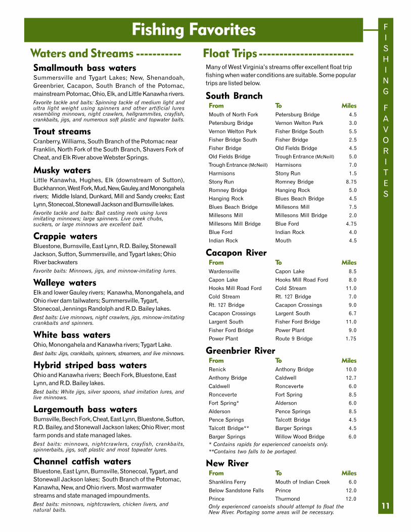
Fishing FavoritesWaters and Streams -----------Smallmouth bass watersSummersville and Tygart Lakes; New, Shenandoah,Greenbrier, Cacapon, South Branch of the Potomac,mainstream Potomac, Ohio, Elk, and Little Kanawha rivers.Favorite tackle and baits: Spinning tackle of medium light andultra light weight using spinners and other artificial luresresembling minnows, night crawlers, hellgrammites, crayfish,crankbaits, jigs, and numerous soft plastic and topwater baits.
Trout streamsCranberry, Williams, South Branch of the Potomac nearFranklin, North Fork of the South Branch, Shavers Fork ofCheat, and Elk River above Webster Springs.
Musky watersLittle Kanawha, Hughes, Elk (downstream of Sutton),Buckhannon, West Fork, Mud, New, Gauley, and Monongahelarivers; Middle Island, Dunkard, Mill and Sandy creeks; EastLynn, Stonecoal, Stonewall Jackson and Burnsville lakes.Favorite tackle and baits: Bait casting reels using luresimitating minnows; large spinners. Live creek chubs,suckers, or large minnows are excellent bait.
Crappie watersBluestone, Burnsville, East Lynn, R.D. Bailey, StonewallJackson, Sutton, Summersville, and Tygart lakes; OhioRiver backwatersFavorite baits: Minnows, jigs, and minnow-imitating lures.
Walleye watersElk and lower Gauley rivers; Kanawha, Monongahela, andOhio river dam tailwaters; Summersville, Tygart,Stonecoal, Jennings Randolph and R.D. Bailey lakes.Best baits: Live minnows, night crawlers, jigs, minnow-imitatingcrankbaits and spinners.
White bass watersOhio, Monongahela and Kanawha rivers; Tygart Lake.Best baits: Jigs, crankbaits, spinners, streamers, and live minnows.
Hybrid striped bass watersOhio and Kanawha rivers; Beech Fork, Bluestone, EastLynn, and R.D. Bailey lakes.Best baits: White jigs, silver spoons, shad imitation lures, andlive minnows.
Largemouth bass watersBurnsville, Beech Fork, Cheat, East Lynn, Bluestone, Sutton,R.D. Bailey, and Stonewall Jackson lakes; Ohio River; mostfarm ponds and state managed lakes.Best baits: minnows, nightcrawlers, crayfish, crankbaits,spinnerbaits, jigs, soft plastic and most topwater lures.
Channel catfish watersBluestone, East Lynn, Burnsville, Stonecoal, Tygart, andStonewall Jackson lakes; South Branch of the Potomac,Kanawha, New, and Ohio rivers. Most warmwaterstreams and state managed impoundments.Best baits: minnows, nightcrawlers, chicken livers, andnatural baits.
Float Trips -----------------------Many of West Virginia’s streams offer excellent float tripfishing when water conditions are suitable. Some populartrips are listed below.
South BranchFrom To MilesMouth of North Fork Petersburg Bridge 4.5
Petersburg Bridge Vernon Welton Park 3.0
Vernon Welton Park Fisher Bridge South 5.5
Fisher Bridge South Fisher Bridge 2.5
Fisher Bridge Old Fields Bridge 4.5
Old Fields Bridge Trough Entrance (McNeill) 5.0
Trough Entrance (McNeill) Harmisons 7.0
Harmisons Stony Run 1.5
Stony Run Romney Bridge 8.75
Romney Bridge Hanging Rock 5.0
Hanging Rock Blues Beach Bridge 4.5
Blues Beach Bridge Millesons Mill 7.5
Millesons Mill Millesons Mill Bridge 2.0
Millesons Mill Bridge Blue Ford 4.75
Blue Ford Indian Rock 4.0
Indian Rock Mouth 4.5
Cacapon RiverFrom To MilesWardensville Capon Lake 8.5
Capon Lake Hooks Mill Road Ford 8.0
Hooks Mill Road Ford Cold Stream 11.0
Cold Stream Rt. 127 Bridge 7.0
Rt. 127 Bridge Cacapon Crossings 9.0
Cacapon Crossings Largent South 6.7
Largent South Fisher Ford Bridge 11.0
Fisher Ford Bridge Power Plant 9.0
Power Plant Route 9 Bridge 1.75
Greenbrier RiverFrom To MilesRenick Anthony Bridge 10.0
Anthony Bridge Caldwell 12.7
Caldwell Ronceverte 6.0
Ronceverte Fort Spring 8.5
Fort Spring* Alderson 6.0
Alderson Pence Springs 8.5
Pence Springs Talcott Bridge 4.5
Talcott Bridge** Barger Springs 4.5
Barger Springs Willow Wood Bridge 6.0* Contains rapids for experienced canoeists only.**Contains two falls to be portaged.
New RiverFrom To MilesShanklins Ferry Mouth of Indian Creek 6.0
Below Sandstone Falls Prince 12.0
Prince Thurmond 12.0Only experienced canoeists should attempt to float theNew River. Portaging some areas will be necessary.
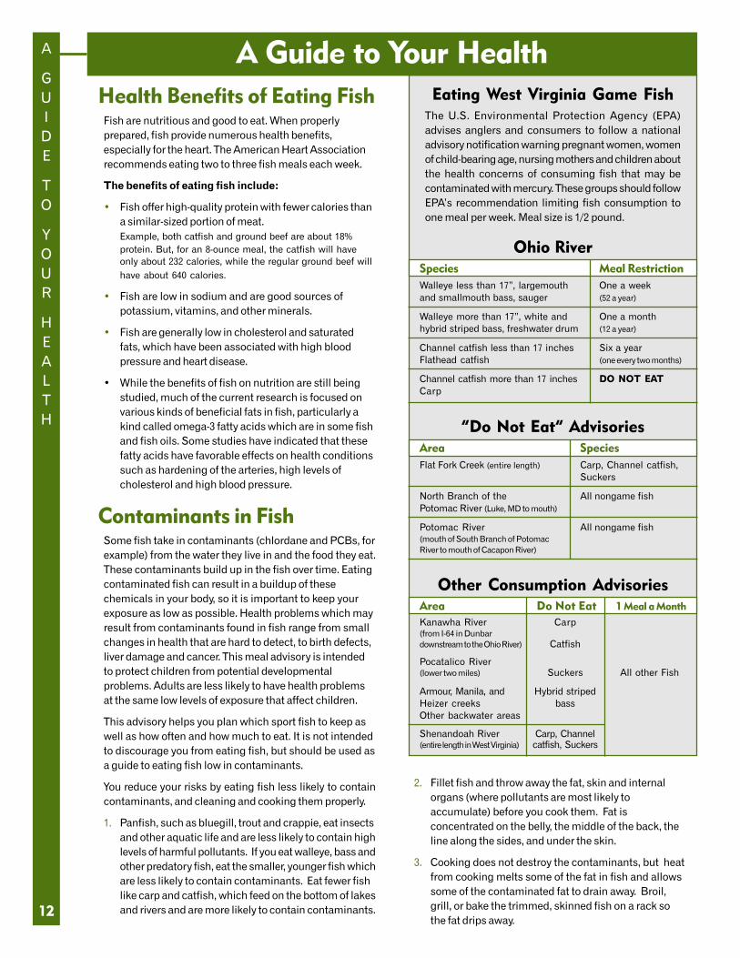
Eating West Virginia Game FishThe U.S. Environmental Protection Agency (EPA)advises anglers and consumers to follow a nationaladvisory notification warning pregnant women, womenof child-bearing age, nursing mothers and children aboutthe health concerns of consuming fish that may becontaminated with mercury. These groups should followEPA’s recommendation limiting fish consumption toone meal per week. Meal size is 1/2 pound.
Ohio RiverSpecies Meal RestrictionWalleye less than 17”, largemouth One a weekand smallmouth bass, sauger (52 a year)
Walleye more than 17”, white and One a monthhybrid striped bass, freshwater drum (12 a year)
Channel catfish less than 17 inches Six a yearFlathead catfish (one every two months)
Channel catfish more than 17 inches DO NOT EATCarp
“Do Not Eat” AdvisoriesArea SpeciesFlat Fork Creek (entire length) Carp, Channel catfish,
Suckers
North Branch of the All nongame fishPotomac River (Luke, MD to mouth)
Potomac River All nongame fish(mouth of South Branch of PotomacRiver to mouth of Cacapon River)
Other Consumption AdvisoriesArea Do Not Eat 1 Meal a MonthKanawha River Carp(from I-64 in Dunbardownstream to the Ohio River) Catfish
Pocatalico River(lower two miles) Suckers All other Fish
Armour, Manila, and Hybrid stripedHeizer creeks bassOther backwater areas
Shenandoah River Carp, Channel(entire length in West Virginia) catfish, Suckers
A
GUIDE
TO
YOUR
HEALTH
12
A Guide to Your HealthHealth Benefits of Eating FishFish are nutritious and good to eat. When properlyprepared, fish provide numerous health benefits,especially for the heart. The American Heart Associationrecommends eating two to three fish meals each week.
The benefits of eating fish include:
• Fish offer high-quality protein with fewer calories thana similar-sized portion of meat.Example, both catfish and ground beef are about 18%protein. But, for an 8-ounce meal, the catfish will haveonly about 232 calories, while the regular ground beef willhave about 640 calories.
• Fish are low in sodium and are good sources ofpotassium, vitamins, and other minerals.
• Fish are generally low in cholesterol and saturatedfats, which have been associated with high bloodpressure and heart disease.
• While the benefits of fish on nutrition are still beingstudied, much of the current research is focused onvarious kinds of beneficial fats in fish, particularly akind called omega-3 fatty acids which are in some fishand fish oils. Some studies have indicated that thesefatty acids have favorable effects on health conditionssuch as hardening of the arteries, high levels ofcholesterol and high blood pressure.
Contaminants in FishSome fish take in contaminants (chlordane and PCBs, forexample) from the water they live in and the food they eat.These contaminants build up in the fish over time. Eatingcontaminated fish can result in a buildup of thesechemicals in your body, so it is important to keep yourexposure as low as possible. Health problems which mayresult from contaminants found in fish range from smallchanges in health that are hard to detect, to birth defects,liver damage and cancer. This meal advisory is intendedto protect children from potential developmentalproblems. Adults are less likely to have health problemsat the same low levels of exposure that affect children.
This advisory helps you plan which sport fish to keep aswell as how often and how much to eat. It is not intendedto discourage you from eating fish, but should be used asa guide to eating fish low in contaminants.
You reduce your risks by eating fish less likely to containcontaminants, and cleaning and cooking them properly.
1. Panfish, such as bluegill, trout and crappie, eat insectsand other aquatic life and are less likely to contain highlevels of harmful pollutants. If you eat walleye, bass andother predatory fish, eat the smaller, younger fish whichare less likely to contain contaminants. Eat fewer fishlike carp and catfish, which feed on the bottom of lakesand rivers and are more likely to contain contaminants.
2. Fillet fish and throw away the fat, skin and internalorgans (where pollutants are most likely toaccumulate) before you cook them. Fat isconcentrated on the belly, the middle of the back, theline along the sides, and under the skin.
3. Cooking does not destroy the contaminants, but heatfrom cooking melts some of the fat in fish and allowssome of the contaminated fat to drain away. Broil,grill, or bake the trimmed, skinned fish on a rack sothe fat drips away.
LICENSES
AND
FEES
FOR
2004
13
Licenses and Fees for 2004Resident Licenses -----------------------
Conservation Stamp (Class CS) Required for alllicensed anglers except holders of Class X, XJ,BL, B-L-I, AB-L, and AB-L-I licenses .................................... $3
Hunting & Trapping (Class A) .............................................. $11Fishing (Class B) ...................................................................... $11Sportsman Hunting/Fishing/Trapping (Class X)
for ages 18 through 64 .......................................................... $25Junior Sportsman Hunting/Fishing/Trapping
(Class XJ) for ages 15 through 17 ...................................... $15
Nonresident Licenses ------------------Conservation Stamp (Class CS) Required for all
licensed anglers ...................................................................... $5Law Enforcement Stamp (Class LE) Required for all
licensed anglers ...................................................................... $5Statewide Fishing (Class F) .................................................. $30Statewide Bow or Gun Hunting (Class E) ...................... $100Statewide Tourist Fishing (Class K)
Three consecutive days .......................................................... $5
Resident and Nonresident Licenses --Trout Fishing Stamp (Class O) Required in
addition to a Class B, AB-L, AB-L-I, B-L, B-L-I,F, G, K, Q, X, or XJ licensesResident ............................................................................. $7.50Nonresident ........................................................................... $10
National Forest Hunting/Trapping/Fishing (Class I)Required on National Forests in addition to aClass B, F, E, Q, or K ............................................................... $2
License Issuing Fee (in addition to licenses)License agents ........................................................................ $1County Clerks .................................................................... $0.75
Only one issuing fee will be charged for licenses and/orstamps purchased at the same time in one name. Purchaseof additional licenses will again be subject to an issuing fee.
Lifetime Licenses ------------------------Combination Hunting, Trapping and Fishing
(Class AB-L)* ..................................................................... $570Combination Hunting, Trapping and Fishing - Infant
(Class AB-L-I)* ................................................................... $285Fishing (Class B-L)* ............................................................. $325Fishing - Infant (Class B-L-I)* ............................................ $163Trout Fishing (Class O-L)** ................................................ $150Trout Fishing - Infant (Class O-L-I)** .................................. $75
* Class I, U, V, W licenses and Conservation Stamp not required.** Valid only when accompanied by a Class B, AB-L, AB-L-I, B-L,
B-L-I, X, or XJ license.
Point System for Violations ---------Persons making false application for a license will havetheir license privileges suspended for one (1) year.
Points assigned for other hunting & fishing violations:
- 10 points for use of explosives or poison materialin taking fish
- 6 points for illegal possession or sale of wildlife - 4 points for all other violations
When a violator accumulates 10 points, his / her license(s) willbe revoked for a period of two (2) years. Points will be removedon their second anniversary or upon restoration of the license(s).
Fishing License Not Required for----a. Residents who are totally blind. A physician’s statement
or certificate must be carried while fishing.
b. Residents 65 years of age or older. Such persons shallcarry a WV driver’s license or photo ID card issued by theWV Division of Motor Vehicles while fishing.
c. Nonresidents or residents under 15 years of age.
d. Residents on active duty in the U. S. armed forces whileon military leave. Leave papers shall be carried while fishing.
e. Resident landowners or their resident children, residentparents, or bonafide resident tenants of such land may fishon their own land during open seasons in accordance withthe laws and regulations applying to such fishing.
f. Residents permanently disabled in lower extremities.A Class Q (free) license must be carried while fishing.
g. Residents honorably discharged from the U. S. armedforces receiving total permanent service-connecteddisability benefits or former prisoners of war asdetermined by the Veterans Administration or residentdisabled veterans who qualify under West Virginia Code17A-10-8 and are exempted from payment of any motorvehicle registration fee by the Commissioner of MotorVehicles. Such persons must carry a card issued by the DNR.
h. Residents or in-patients of any state mental hospital, healthor benevolent institution. Such persons must be under propersupervision and carry a written statement or certificatesigned by the superintendent of the institution or facility.
i. Developmentally disabled residents. A DDFL card issuedby the DNR must be carried while fishing.
Definition of ResidentA U.S. citizen who has been a domiciled residentcontinuously in West Virginia for 30 consecutive days ormore immediately prior to the date of application for alicense or permit. This includes members of the U.S. armedforces stationed outside the state who were WV residents atthe time of entry into the service and any full-time student ofa college or university of this state.
Purchasing a License -------------------Licenses may be obtained as follows:
1. At over 400 retail agent locations throughout the state.($1.00 issuing fee)
2. At all county clerks offices statewide. ($0.75 issuing fee)
3. Over the Internet at www.wvfish.com.(Official DNR website - No issuing fee.)
4. Directly from the Hunting and Fishing License Unit byphoning (304) 558-2758. (No issuing fee.)
For additional information please contact theHunting and Fishing License Unit:
West Virginia Division of Natural ResourcesState Capitol Complex, Building 3, Room 624
Charleston, West Virginia 25305
(304) 558-2758 • [email protected]
Walleye Sauger Carp
WEST
VIRGINIA
SPORT
FISH
14
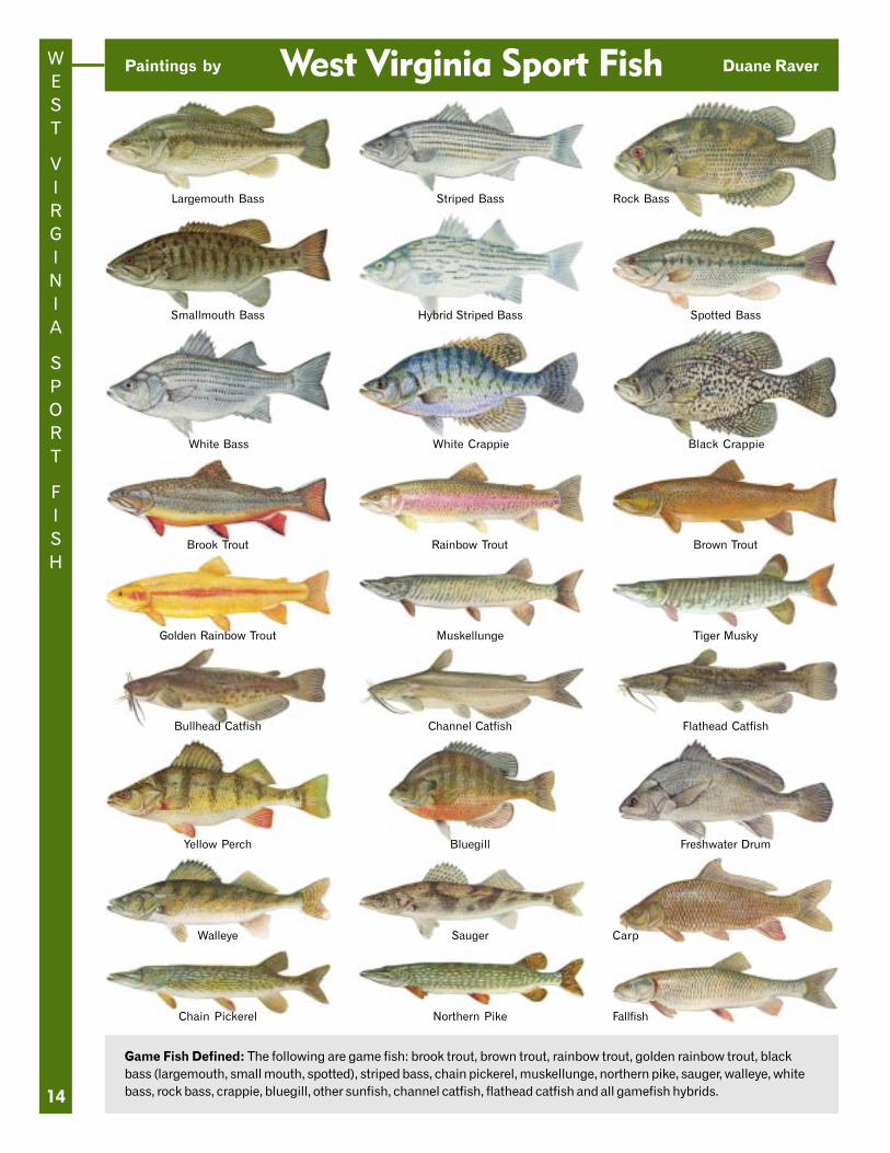
West Virginia Sport Fish
Game Fish Defined: The following are game fish: brook trout, brown trout, rainbow trout, golden rainbow trout, blackbass (largemouth, small mouth, spotted), striped bass, chain pickerel, muskellunge, northern pike, sauger, walleye, whitebass, rock bass, crappie, bluegill, other sunfish, channel catfish, flathead catfish and all gamefish hybrids.
Largemouth Bass Striped Bass Rock Bass
Smallmouth Bass Hybrid Striped Bass Spotted Bass
White Bass White Crappie Black Crappie
Brook Trout Rainbow Trout Brown Trout
Golden Rainbow Trout Muskellunge Tiger Musky
Bullhead Catfish Channel Catfish Flathead Catfish
Yellow Perch Bluegill Freshwater Drum
Chain Pickerel Northern Pike Fallfish
Paintings by Duane Raver