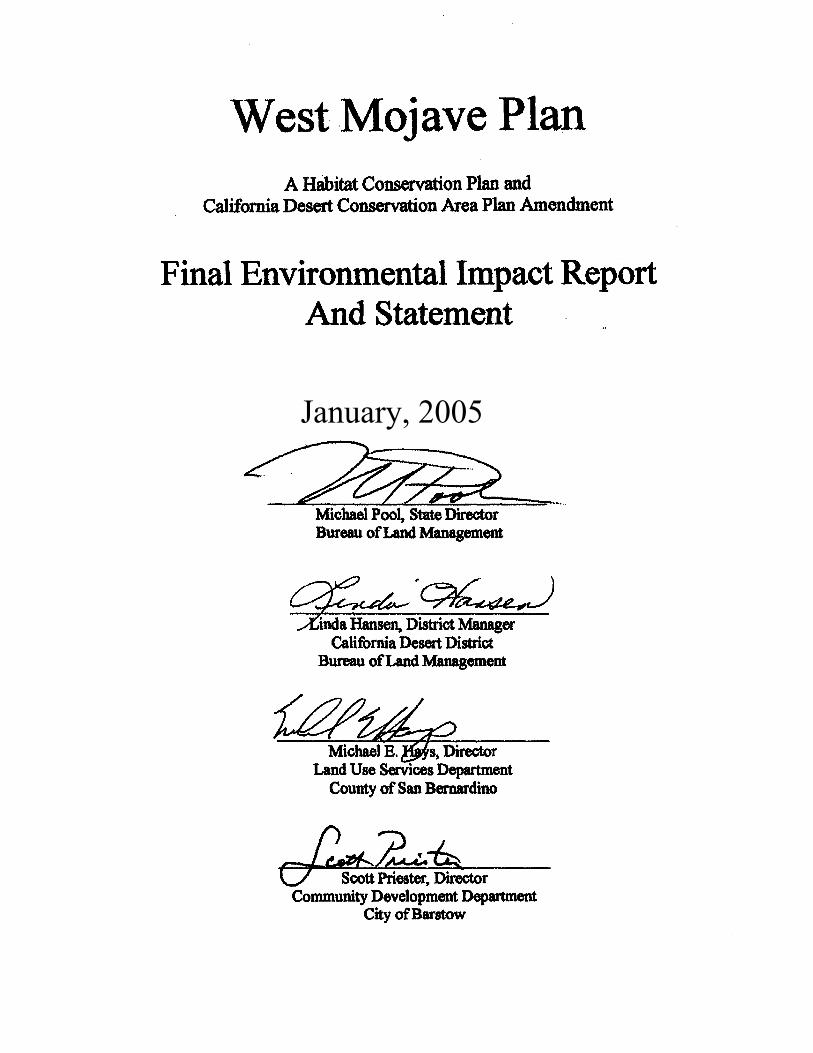
west mojave plan - bureau of land management. department of the interior bureau of land management...
TRANSCRIPT
U.S. Department of the InteriorBureau of Land ManagementCalifornia Desert District22835 Calle San Juan De Los LagosMoreno Valley, CA 92553
January 2005
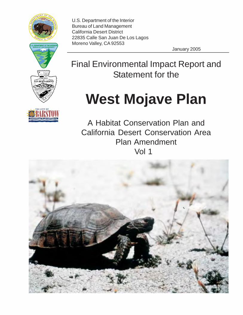
Final Environmental Impact Report andStatement for the
West Mojave Plan
A Habitat Conservation Plan andCalifornia Desert Conservation Area
Plan AmendmentVol 1
BLM/CA/ES-2004-005 + 1790 -1600
United States Department of the Interior
BUREAU OF LAND MANAGEMENT 22835 Calle San Juan De Los Lagos
Moreno Valley, CA 92553
January, 2005 Dear Reader:
Enclosed is the Final Environmental Impact Report and Statement (Final EIR/S) for the West Mojave Plan. The Bureau of Land Management (BLM), the federal lead agency, has prepared the Final EIR/S in accordance with the National Environmental Policy Act (NEPA). The County of San Bernardino and the City of Barstow, the California lead agencies, have prepared the Final EIR/S in accordance with the California Environmental Quality Act (CEQA).
This Final EIR/S is a comprehensive environmental analysis of seven alternatives
(including the No Action Alternative) that address compliance with the federal and California endangered species acts (FESA and CESA, respectively).
The purpose of the West Mojave Plan is to develop management strategies for the desert tortoise, Mohave ground squirrel and over 100 other sensitive plants and animals that would conserve those species throughout the western Mojave Desert, while at the same time establishing a streamlined program for compliance with the regulatory requirements of FESA and CESA. Agencies, local jurisdictions and others with a stake in the future of the western Mojave Desert have collaborated in the development of the West Mojave Plan.
The public devoted substantial effort to providing in-depth review and input on the Draft
EIR/S. During the 90-day public review of the Draft EIR/S, which ended on September 12, 2003, commentators submitted nearly 300 letters. These offered numerous suggestions, comments and opinions concerning the Draft EIR/S. Responses to comments are presented in Chapter 6 of the Final EIR/S, and copies of all letters received can be found on the attached compact disk.
The text of the Final EIR/S includes a number of changes and corrections suggested by
commentators. Where the text of the Final EIR/S differs from that presented in the Draft EIR/S, a vertical black line in the left-hand margin indicates the location of the modified or clarified text. A summary of these modifications follows. Because most of the changes consisted of minor modifications, only a selection is presented below.
• Conservation Area adjustments
o Pisgah Crater (western portion dropped, expansion to northeast) o North Edwards (some lands excluded) o Alkali Mariposa Lily (realigned to capture the Amargosa Creek drainage, drop

interim conservation areas) • Biological Transition Areas eliminated (portions added to DWMA) • New biological objectives for several species • Tortoise Survey Zones – minor modifications • Fee Zones – minor modifications • BLM DWMA Multiple Use Class M Lands changed to Class L • Revised Monitoring and Adaptive Management Table • Additional discussion of cumulative impacts • Appendix C.1 (Implementation Tasks, Costs and Priorities) Revision • Compact Disk Additions – species accounts, vegetation map, Draft EIR/S comment
letters • BLM Route Designation
o Adoption of Competitive “C” Routes Northwest of Spangler Open Area o Route Openings in Summit Range o Route closures in Fremont Kramer Tortoise DWMA to Offset “C” Routes o Selected closures in small conservation areas o Revised Juniper Subregion route network o “No Action” route network is BLM June 30, 2003 Decision Record
The West Mojave Plan proposes a number of amendments to the BLM’s California
Desert Conservation Area Plan. The BLM planning process includes an opportunity for administrative review through a plan protest to the BLM Director should a previous commentator on the plan believe that the decision has been issued in error. Only those persons or organizations that participated in the planning process may protest. Protests from parties having no previous involvement will be denied without further review. A protesting party may raise only those issues that were submitted for the record during the planning process. New issues raised in the protest period should be directed to the BLM, California Desert District Manager, 22835 Calle San Juan De Los Lagos, Moreno Valley, CA 92553 for consideration in plan implementation, as potential plan amendments, or as otherwise appropriate. The period for filing protests begins when the EPA publishes in the Federal Register its Notice of Receipt of the West Mojave Plan Final EIR/S. To be considered “timely” the protest must be postmarked no later than the last day of the 30-day protest period. Also, although not a requirement, it is recommended that the protest be sent by certified mail, return receipt requested. E-mail protests will not be accepted. Faxed protests will be considered as potential valid protests provided (1) that the signed faxed letter is received by the BLM Washington Office protest coordinator by the closing date of the protest period and (2) that the protesting party also provides the original letter by either regular or overnight mail postmarked by the close of the protest period. Please direct faxed protests to “BLM Protest Coordinator” at 202-452-5112. Please direct the follow-up letter to the appropriate address provided below.
Protest must be filed in writing to: Director (210), Attention: Brenda Williams, P.O. Box 66538, Washington, D.C. 20035, or by overnight mail to: Director (210), Attention: Brenda Williams, 1620 L Street, N.W., Suite 1075, Washington, D.C. 20036. In order to be considered complete, the protest must contain, at a minimum, the following information:

Proposed West Mojave Plan Final Environmental Impact Report and Statement
Federal Lead Agency: U.S. Department of the Interior Bureau of Land Management California Desert District Office California Lead Agencies: County of San Bernardino Land Use Services Department City of Barstow Community Development Department Project Location: Portions of San Bernardino, Inyo, Kern and Los Angeles
Counties, California For Further Information: Linda Hansen, Bureau of Land Management California Desert District Office 22835 Calle San Juan De Los Lagos Moreno Valley, CA 92553 Randy Scott, County of San Bernardino Land Use Services Department 385 North Arrowhead Avenue San Bernardino, CA 92415 Scott Priester, City of Barstow Community Development Department 220 East Mountain View Street Barstow, CA 92311-2888 Abstract The West Mojave Plan (Plan) is a habitat conservation plan and
federal land use plan amendment that presents a comprehensive strategy to conserve and protect the desert tortoise, the Mohave ground squirrel and nearly 100 other sensitive plants and animals and the natural communities of which they are a part, while providing a streamlined program for complying with the requirements of the California and federal Endangered Species Acts (CESA and FESA, respectively). The planning area includes 3.2 million acres of public land and 3.0 million acres of private land. This document was produced through a collaborative effort of state and federal agencies and local jurisdictions.
January, 2005
Table of Contents 1
TABLE OF CONTENTS
EXECUTIVE SUMMARY E.1 INTRODUCTION ES-1 E.2 ALTERNATIVES ES-2 E.3 SUMMARY OF IMPACTS ES-3 E.4 BIOLOGICAL GOALS AND OBJECTIVES: WOULD THEY BE MET? ES-5 E.4.1 Desert Tortoise ES-5 E.4.2 Mohave Ground Squirrel ES-9 E.4.3 Other Species ES-10
CHAPTER ONE INTRODUCTION
1.1 OVERVIEW 1-1 1.1.1 Site Location and Description 1-1 1.1.2 Environmental Impact Statement 1-2 1.1.3 Program Environmental Impact Report 1-3 1.1.4 Incidental Take Permits 1-7 1.1.5 EIR/S Organization 1-8 1.1.6 Use of EIR/S by Agencies and Jurisdictions 1-8 1.1.7 Modifications to be Found in the Final EIR/S 1-10 1.2 PURPOSE AND NEED 1-10 1.3 RELATIONSHIP BETWEEN THE WEST MOJAVE PLAN AND THE
EXPANSION OF FORT IRWIN 1-12 1.4 HISTORY OF THE PLANNING PROCESS 1-13 1.4.1 Planning Issues 1-13 1.4.2 1992 Memorandum of Understanding 1-13 1.4.3 1997 Equitable Precepts 1-14 1.4.4 Data Base 1-15 1.4.5 Biological Evaluation 1-18 1.4.6 Task Groups Develop the Conservation Strategy 1-19 1.4.7 Public Review of DEIR/S 1-20 1.5 NECESSARY DECISIONS AND APPROVALS 1-20 1.5.1 Agency and Jurisdiction Decisions and Approvals 1-20 1.5.2 Relationship to Statutes, Regulations and Policies 1-21 1.5.3 Relationship to Other Regional Plans 1-21
Table of Contents 2
CHAPTER TWO ALTERNATIVES
2.1 INTRODUCTION 2-1 2.1.1 Overview 2-1 2.1.2 Biological Goals and Objectives 2-2 2.2 ALTERNATIVE A: PROPOSED ACTION: HABITAT CONSERVATION
PLAN 2-9 2.2.1 Habitat Conservation Area 2-11 2.2.1.1 Structure and Components 2-12 2.2.1.1.1 Overview 2-12 2.2.1.1.2 Desert Tortoise Component of HCA 2-13 2.2.1.1.3 Mohave Ground Squirrel Component of HCA 2-14 2.2.1.1.4 Other Conservation Areas 2-14 2.2.1.1.5 Open Space Corridors 2-17 2.2.1.1.6 Special Review Areas (SRA) 2-18 2.2.1.2 Miscellaneous BLM Management Issues 2-19 2.2.1.2.1 BLM Multiple Use Class Changes 2-19 2.2.1.2.2 California Desert Protection Act Non-Wilderness 2-21 2.2.1.2.3 BLM Areas of Critical Environmental Concern 2-22 2.2.1.2.4 Rand Mountains – Fremont Valley Management Plan 2-22 2.2.1.2.5 Afton Canyon Natural Area 2-25 2.2.1.2.6 Harper Dry Lake 2-25 2.2.1.2.7 Western Mojave Land Tenure Adjustment Project 2-29 2.2.1.2.8 Mojave River Wild and Scenic River Eligibility Determination 2-29 2.2.1.2.9 Inyo County Land Disposal Tracts 2-30 2.2.1.3 Allowable Ground Disturbance (AGD) 2-32 2.2.2 Compensation Framework 2-33 2.2.2.1 Administrative Structure 2-33 2.2.2.2 Mitigation Fee 2-34 2.2.2.3 Habitat Rehabilitation Credits 2-39 2.2.3 Incidental Take Permits 2-43 2.2.3.1 Covered Activities and Terms of Permits 2-43 2.2.3.2 Treatment of Unlisted Species and Federal “No Surprises” Assurances 2-44 2.2.3.3 Take Authorized by Incidental Take Permits 2-45 2.2.3.4 Military Lands 2-52 2.2.4 Species Conservation Measures 2-52 2.2.4.1 Species Conservation Measures Applicable Throughout the HCA 2-53 2.2.4.2 Desert Tortoise 2-57 2.2.4.2.1 Take-Avoidance Measures 2-57 2.2.4.2.2 Survey and Disposition Protocols 2-61 2.2.4.2.3 Proactive Tortoise Management Programs 2-66 2.2.4.3 Mohave Ground Squirrel 2-76 2.2.4.3.1 Take-Avoidance Measures 2-76 2.2.4.3.2 Pre-Construction Surveys 2-76

Table of Contents 3
2.2.4.3.3 Proactive MGS Management Programs 2-76 2.2.4.4 Mojave River Bioregion 2-77 2.2.4.5 Bats 2-78 2.2.4.6 Other Mammals 2-81 2.2.4.6.1 Bighorn Sheep 2-81 2.2.4.6.2 Yellow-Eared Pocket Mouse 2-82 2.2.4.7 Raptors 2-82 2.2.4.7.1 Generally Applicable Raptor Prescriptions 2-82 2.2.4.7.2 Burrowing Owl 2-83 2.2.4.7.3 Ferruginous Hawk 2-85 2.2.4.7.4 Golden Eagle 2-85 2.2.4.7.5 Long-eared Owl 2-86 2.2.4.7.6 Prairie Falcon 2-86 2.2.4.8 Other Birds 2-87 2.2.4.8.1 Bendire’s Thrasher 2-87 2.2.4.8.2 Gray Vireo 2-88 2.2.4.8.3 Inyo California Towhee 2-90 2.2.4.8.4 LeConte’s Thrasher 2-90 2.2.4.8.5 Western Snowy Plover 2-91 2.2.4.9 Reptiles 2-91 2.2.4.9.1 Mojave Fringe-toed Lizard 2-91 2.2.4.9.2 Panamint Alligator Lizard 2-93 2.2.4.9.3 San Diego Horned Lizard 2-93 2.2.4.9.4 Southwestern Pond Turtle 2-94 2.2.4.10 Plants 2-94 2.2.4.10.1 Southern Sierra Plants 2-94 2.2.4.10.2 Carbonate Endemic Plants 2-95 2.2.4.10.3 Alkali Wetland Plants 2-98 2.2.4.10.4 Alkali Mariposa Lily 2-99 2.2.4.10.5 Barstow Woolly Sunflower 2-100 2.2.4.10.6 Charlotte’s Phacelia 2-103 2.2.4.10.7 Crucifixion Thorn 2-104 2.2.4.10.8 Desert Cymopterus 2-104 2.2.4.10.9 Flax-like Monardella 2-106 2.2.4.10.10 Kelso Creek Monkeyflower 2-106 2.2.4.10.11 Kern Buckwheat 2-107 2.2.4.10.12 Lane Mountain Milkvetch 2-108 2.2.4.10.13 Little San Bernardino Mountains Gilia 2-108 2.2.4.10.14 Mojave Monkeyflower 2-109 2.2.4.10.15 Mojave Tarplant 2-112 2.2.4.10.16 Ninemile Canyon Phacelia 2-113 2.2.4.10.17 Parish’s Phacelia 2-113 2.2.4.10.18 Red Rock Poppy 2-114 2.2.4.10.19 Red Rock Tarplant 2-114 2.2.4.10.20 Reveal’s Buckwheat 2-114 2.2.4.10.21 Short-joint Beavertail Cactus 2-115
Table of Contents 4
2.2.4.10.22 Triple-ribbed Milkvetch 2-115 2.2.4.10.23 White-margined Beardtongue 2-116 2.2.5 Public Land Livestock Grazing Program 2-118 2.2.5.1 Regional Public Land Health Standards and Guidelines for Grazing
Management 2-118 2.2.5.2 Cattle Grazing Outside Tortoise Habitat and the MGS
Conservation Area 2-125 2.2.5.3 Cattle Grazing Within Tortoise Habitat and the MGS
Conservation Area 2-125 2.2.5.3.1 Management under Existing Federal Biological Opinions 2-126 2.2.5.3.2 New Management Prescriptions 2-126 2.2.5.3.3 Health Assessments 2-127 2.2.5.4 Cattle Grazing Within DWMAs 2-127 2.2.5.4.1 Proposed Management Prescriptions 2-127 2.2.5.4.2 Health Assessments 2-127 2.2.5.5 Sheep Grazing Within All Allotments 2-127 2.2.5.5.1 Management under Existing Federal Biological Opinions 2-129 2.2.5.5.2 Proposed Management Prescriptions 2-129 2.2.5.5.3 Health Assessments 2-129 2.2.5.6 Sheep Grazing Within the MGS and the Mojave Monkeyflower Conservation
Areas 2-130 2.2.5.7 Sheep Grazing Within DWMAs 2-131 2.2.5.8 Voluntary Relinquishment of Cattle and Sheep Allotments 2-133 2.2.6 Public Land Motorized Vehicle Access Network 2-136 2.2.6.1 Background 2-136 2.2.6.2 Criteria 2-138 2.2.6.3 Route Designation Methodology 2-141 2.2.6.4 Take-Avoidance Measures 2-156 2.2.6.5 Competitive Event Corridors and Race Courses 2-157 2.2.6.6 El Paso Collaborative Access Planning Area 2-157 2.2.6.7 Juniper Subregion 2-159 2.2.6.8 Other Route Network Modifications 2-162 2.2.6.9 California Back Country Discovery Trail 2-163 2.2.6.10 Implementation 2-163 2.2.6.11 Modification of Route Network 2-167 2.2.7 Education Program 2-168 2.2.7.1 Goals 2-168 2.2.7.2 Targets 2-169 2.2.7.3 Delivery 2-169 2.2.7.4 Means 2-169 2.2.8 Monitoring and Adaptive Management 2-172 2.2.8.1 Alkali Wetland Communities Supplementary Discussion 2-197 2.2.8.2 Desert Tortoise Supplementary Discussion 2-197 2.3 ALTERNATIVE B: BLM ONLY 2-203 2.3.1 Overview 2-203 2.3.2 Habitat Conservation Area 2-203
Table of Contents 5
2.3.3 Compensation Framework 2-204 2.3.4 Incidental Take Permits 2-204 2.3.5 Species Conservation Measures 2-204 2.3.6 Monitoring, Adaptive Management and Implementation 2-205 2.4 ALTERNATIVE C: TORTOISE RECOVERY PLAN 2-206 2.4.1 Overview 2-206 2.4.2 Habitat Conservation Area 2-206 2.4.3 Compensation Framework and Incidental Take Permits 2-207 2.4.4 Species Conservation Measures 2-207 2.4.4.1 Desert Tortoise Take-Avoidance Measures 2-207 2.4.4.2 Desert Tortoise Survey and Disposition Protocols 2-208 2.4.4.3 Proactive Tortoise Management Programs 2-208 2.4.5 Public Land Livestock Grazing Program 2-209 2.4.6 Public Land Motorized Vehicle Access Network 2-209 2.4.7 Education Program 2-210 2.4.8 Monitoring, Adaptive Management and Implementation 2-210 2.5 ALTERNATIVE D: ENHANCED ECOSYSTEM PROTECTION 2-211 2.5.1 Overview 2-211 2.5.2 Habitat Conservation Area 2-211 2.5.3 Compensation Framework 2-211 2.5.4 Species Conservation Measures 2-212 2.5.5 Public Land Livestock Grazing Program 2-215 2.5.6 Public Land Motorized Vehicle Access Network 2-215 2.6 ALTERNATIVE E: ONE DWMA – ENHANCED RECREATION
OPPORTUNITIES 2-217 2.6.1 Overview 2-217 2.6.2 Habitat Conservation Area 2-217 2.6.3 Compensation Framework 2-218 2.6.4 Recreation Program 2-218 2.6.5 Species Conservation Measures 2-218 2.6.6 Public Land Livestock Grazing Program 2-219 2.7 ALTERNATIVE F: NO DWMA – AGGRESSIVE DISEASE AND RAVEN
MANAGEMENT 2-220 2.7.1 Overview 2-220 2.7.2 Habitat Conservation Area 2-220 2.7.3 Compensation Framework 2-220 2.7.4 Species Conservation Measures 2-221 2.7.5 Public Land Livestock Grazing Program 2-222 2.8 ALTERNATIVE G: NO ACTION 2-222 2.8.1 Overview 2-222 2.8.2 Habitat Conservation Area 2-222 2.8.3 Compensation Framework 2-223 2.8.4 Incidental Take Permits 2-223 2.8.5 Species Conservation Measures 2-223 2.8.6 Public Land Livestock Grazing Program 2-224 2.8.6.1 Objective A - Implement Standards 2-224
Table of Contents 6
2.8.6.2 Objective B – Conform Grazing Activities 2-224 2.8.7 Public Land Motorized Vehicle Access Network 2-225 2.8.8 Education Program 2-226 2.9 ALTERNATIVES EVALUATED BUT ELIMINATED FROM DETAILED
CONSIDERATION 2-226 2.10 ALTERNATIVE DROPPED FROM CONSIDERATION 2-228 2.11 COMPARISON OF ALTERNATIVES 2-230
CHAPTER THREE AFFECTED ENVIRONMENT
3.1 PLANNING AND REGULATORY FRAMEWORK 3-1 3.1.1 Bureau of Land Management 3-1 3.1.1.1 California Desert Conservation Area Plan 3-1 3.1.1.2 Areas of Critical Environmental Concern 3-3 3.1.1.3 Wilderness Areas 3-8 3.1.1.4 Land Tenure Adjustment Program 3-10 3.1.2 Other State and Federal Agencies 3-11 3.1.2.1 United States National Park Service 3-11 3.1.2.2 California Department of Fish and Game 3-11 3.1.2.3 California Department of Parks and Recreation 3-12 3.1.2.4 California Department of Transportation 3-13 3.1.3 Local Jurisdictions 3-13 3.1.3.1 Inyo County 3-13 3.1.3.2 Kern County 3-14 3.1.3.3 Los Angeles County 3-15 3.1.3.4 San Bernardino County 3-19 3.1.3.5 City of Adelanto 3-21 3.1.3.6 Town of Apple Valley 3-21 3.1.3.7 City of Barstow 3-22 3.1.3.8 City of California City 3-23 3.1.3.9 City of Hesperia 3-24 3.1.3.10 City of Lancaster 3-25 3.1.3.11 City of Palmdale 3-26 3.1.3.12 City of Ridgecrest 3-27 3.1.3.13 City of Twentynine Palms 3-27 3.1.3.14 City of Victorville 3-28 3.1.3.15 Town of Yucca Valley 3-28 3.1.4 Federal Endangered Species Act 3-29 3.1.4.1 Background 3-29 3.1.4.2 Listed Species 3-29 3.1.4.3 Recovery Plans 3-30 3.1.4.4 Critical Habitat 3-32
Table of Contents 7
3.1.4.5 Exceptions to FESA’s Take Prohibition 3-32 3.1.5 California Endangered Species Act 3-37 3.1.5.1 Background 3-37 3.1.5.2 Listed Species 3-37 3.1.5.3 Incidental Take Permit 3-37 3.1.6 Acquiring Incidental Take Permits: Procedures and Costs 3-38 3.2 AIR QUALITY, SOILS AND WATER 3-43 3.2.1 Climate and Air Quality 3-43 3.2.1.1 Climate 3-43 3.2.1.2 Air Quality 3-45 3.2.2 Geology and Soils 3-55 3.2.3 Water 3-60 3.2.3.1 Groundwater Basins 3-60 3.2.3.2 Mojave River 3-63 3.3 BIOLOGICAL RESOURCES 3-64 3.3.1 Natural Communities 3-65 3.3.2 Desert Tortoise 3-69 3.3.2.1 Regulatory Status 3-69 3.3.2.2 Tortoise Habitat Designations 3-69 3.3.2.3 Tortoise Life History 3-73 3.3.2.4 Tortoise Populations 3-76 3.3.2.4.1 Permanent Study Plots 3-76 3.3.2.4.2 Desert Tortoise Field Surveys 3-78 3.3.2.4.3 Desert Tortoise Distribution 3-91 3.3.2.5 Threats to Tortoises: Mortality Factors 3-95 3.3.2.5.1 Direct and Indirect Anthropogenic Mortality Factors 3-95 3.3.2.5.2 Natural Mortality Factors 3-102 3.3.2.5.3 Older and Newer Die-off Regions 3-113 3.3.2.6 Tortoises and Off Highway Vehicles 3-119 3.3.2.6.1 Dispersed Casual OHV Use 3-119 3.3.2.6.2 Direct Impacts of OHVs on Desert Tortoise Populations 3-120 3.3.2.6.3 Direct Impacts of OHVs on Desert Tortoise Habitat 3-125 3.3.2.6.4 Indirect Impacts of OHVs on Desert Tortoises and Habitat 3-127 3.3.2.6.5 Off-Highway Vehicle Open Areas 3-128 3.3.2.6.6 Organized Competitive OHV Events 3-135 3.3.2.7 Current Effectiveness of Existing Protected Areas 3-137 3.3.3 Mohave Ground Squirrel 3-144 3.3.3.1 Mohave Ground Squirrel Range 3-144 3.3.3.2 Life History 3-146 3.3.3.2.1 Species Description 3-146 3.3.3.2.2 Seasonal Activity 3-147 3.3.3.2.3 Substrate Affinities and Burrow Use 3-147 3.3.3.2.4 Home Ranges 3-147 3.3.3.2.5 Reproduction 3-147 3.3.3.2.6 Dispersal 3-148 3.3.3.3 Winterfat, Spiny Hopsage, and MGS Occurrence 3-148
Table of Contents 8
3.3.3.4 MGS Associations with Regional Plant Communities 3-155 3.3.3.5 Threats 3-157 3.3.3.6 Regulatory Protection of the Mohave Ground Squirrel 3-167 3.3.4 Bats 3-169 3.3.5 Other Mammals 3-170 3.3.5.1 Bighorn Sheep 3-170 3.3.5.2 Mojave River Vole 3-172 3.3.5.3 Yellow-eared Pocket Mouse 3-172 3.3.6 Birds 3-173 3.3.6.1 Bendire’s Thrasher 3-173 3.3.6.2 Brown-crested Flycatcher 3-173 3.3.6.3 Burrowing Owl 3-174 3.3.6.4 Ferruginous Hawk 3-174 3.3.6.5 Golden Eagle 3-175 3.3.6.6 Gray Vireo 3-175 3.3.6.7 Inyo California Towhee 3-176 3.3.6.8 LeConte’s Thrasher 3-177 3.3.6.9 Long-Eared Owl 3-177 3.3.6.10 Prairie Falcon 3-178 3.3.6.11 Southwestern Willow Flycatcher 3-178 3.3.6.12 Summer Tanager 3-179 3.3.6.13 Vermilion Flycatcher 3-179 3.3.6.14 Western Snowy Plover 3-180 3.3.6.15 Western Yellow-billed Cuckoo 3-181 3.3.6.16 Yellow-breasted chat 3-181 3.3.6.17 Yellow Warbler 3-181 3.3.7 Reptiles 3-182 3.3.7.1 Mojave Fringe-Toed Lizard 3-182 3.3.7.2 San Diego Horned Lizard 3-183 3.3.7.3 Southwestern Pond Turtle 3-183 3.3.7.4 Panamint Alligator Lizard 3-184 3.3.8 Plants 3-184 3.3.8.1 Alkali Mariposa Lily 3-184 3.3.8.2 Barstow Woolly Sunflower 3-185 3.3.8.3 Carbonate Endemics (Cushenbury Buckwheat, Cushenbury Milkvetch,
Cushenbury Oxytheca and Parish's Daisy) 3-186 3.3.8.4 Charlotte’s Phacelia 3-186 3.3.8.5 Crucifixion Thorn 3-187 3.3.8.6 Desert Cymopterus 3-187 3.3.8.7 Kelso Creek Monkeyflower 3-188 3.3.8.8 Kern Buckwheat 3-189 3.3.8.9 Lane Mountain Milkvetch 3-189 3.3.8.10 Little San Bernardino Mountains Gilia 3-190 3.3.8.11 Mojave Monkeyflower 3-190 3.3.8.12 Mojave Tarplant 3-191 3.3.8.13 Parish's Alkali Grass 3-191

Table of Contents 9
3.3.8.14 Parish’s Phacelia 3-192 3.3.8.15 Parish’s Popcorn Flower 3-192 3.3.8.16 Red Rock Poppy 3-193 3.3.8.17 Red Rock Tarplant 3-193 3.3.8.18 Salt Springs Checkerbloom 3-193 3.3.8.19 Shockley’s Rock Cress 3-194 3.3.8.20 Short-joint Beavertail Cactus 3-194 3.3.8.21 Triple-ribbed Milkvetch 3-195 3.3.8.22 White-Margined Beardtongue 3-195 3.4 SOCIO-ECONOMIC 3-196 3.4.1 Regional Economic Profile 3-196 3.4.1.1 Regional Environment 3-197 3.4.1.2 Study Area Demographics 3-199 3.4.1.3 Study Area Growth Capacity 3-204 3.4.1.4 Study Area Market Share 3-205 3.4.1.5 Study Area Property Valuation 3-207 3.4.1.5.1 Subarea Valuation 3-207 3.4.1.5.2 Habitat Conservation Area Valuation 3-209 3.4.2 Livestock Grazing 3-210 3.4.3 Mineral Potential and Development 3-217 3.4.3.1 Mineral Potential 3-217 3.4.3.2 Strategic and Critical Minerals 3-224 3.4.3.3 Identified Resources by Commodity 3-227 3.4.3.4 Current and Historic Mineral Commodity Production 3-229 3.4.3.5 Coolgardie Mesa 3-237 3.4.3.6 Reclamation and Restoration Procedures 3-238 3.4.3.7 State Designated Regionally Significant Construction Aggregate
Resources 3-238 3.4.4 Recreation 3-239 3.4.4.1 Patterns of Use 3-239 3.4.4.2 Trends 3-244 3.4.4.3 Off-Highway Vehicle Use 3-246 3.4.4.3.1 Driving OHVs for Recreation 3-246 3.4.4.3.2 Driving OHVs to Access Other Recreation 3-249 3.4.4.4 Economic Contribution of OHV Recreation 3-250 3.4.5 Circulation and Landfills 3-253 3.4.5.1 Circulation Element 3-253 3.4.5.1.1 Transportation Methods 3-253 3.4.5.1.2 West Mojave Planning Area Roads 3-255 3.4.5.2 Landfills 3-257 3.5 MOTORIZED VEHICLE ACCESS NETWORK 3-264 3.5.1 Policies and Legislation 3-264 3.5.1.1 Federal Land Policy and Management Act (FLPMA) 3-264 3.5.1.2 Executive Order No. 11644 3-265 3.5.1.3 Federal Regulations (43 CFR 8342.1) 3-265 3.5.1.4 California Desert Conservation Area Plan 3-265
Table of Contents 10
3.5.1.5 Route Designation Definitions 3-267 3.5.2 Motorized Vehicle Access 3-267 3.5.2.1 Motorized Vehicle Access Needs 3-268 3.5.2.2 Off Road Vehicle Designations Prior to 2002 3-269 3.5.2.3 OHV Route Subregions and BLM 2001-2 Route Inventory 3-272 3.6 ENERGY PRODUCTION AND TRANSMISSION 3-274 3.6.1 Powerlines, Pipelines and Fiberoptic Cables 3-274 3.6.2 Energy Generation Plants 3-277 3.7 CULTURAL RESOURCES 3-279 3.7.1 Archaeological, Historical, Paleontological and Ethnographic Resources 3-279 3.7.1.1 Area of Effect 3-279 3.7.1.2 Existing Database 3-279 3.7.1.3 Regional Overview: Prehistoric 3-280 3.7.1.4 Regional Overview: Historic 3-281 3.7.1.5 Known Significant Sites 3-282 3.7.1.6 Potentially Significant Areas 3-284 3.7.1.7 Ethno-historic Overview 3-287 3.7.1.8 Significant Paleontological Localities 3-288 3.7.2 Tribal Governments and Policies 3-293 3.7.3 BLM Consultation Procedures 3-293
CHAPTER FOUR ENVIRONMENTAL CONSEQUENCES
4.1 INTRODUCTION 4-1 4.2 ALTERNATIVE A: PROPOSED ACTION 4-4 4.2.1 Air Quality, Soils and Water 4-4 4.2.1.1 Air Quality 4-4 4.2.1.2 Soils 4-8 4.2.1.3 Water Quality 4-9 4.2.2 Biological Resources 4-12 4.2.2.1 Natural Communities 4-12 4.2.2.2 Desert Tortoise 4-14 4.2.2.3 Mohave Ground Squirrel 4-45 4.2.2.4 Bats 4-50 4.2.2.5 Other Mammals 4-51 4.2.2.5.1 Bighorn Sheep 4-51 4.2.2.5.2 Mojave River Vole 4-53 4.2.2.5.3 Yellow-eared Pocket Mouse 4-53 4.2.2.6 Birds 4-54 4.2.2.6.1 Bendire’s Thrasher 4-54 4.2.2.6.2 Brown-crested Flycatcher 4-55
Table of Contents 11
4.2.2.6.3 Burrowing Owl 4-55 4.2.2.6.4 Ferruginous Hawk 4-56 4.2.2.6.5 Golden Eagle 4-57 4.2.2.6.6 Gray Vireo 4-57 4.2.2.6.7 Inyo California Towhee 4-58 4.2.2.6.8 LeConte’s Thrasher 4-59 4.2.2.6.9 Long-eared Owl 4-59 4.2.2.6.10 Prairie Falcon 4-60 4.2.2.6.11 Southwestern Willow Flycatcher 4-60 4.2.2.6.12 Summer Tanager 4-61 4.2.2.6.13 Vermilion Flycatcher 4-62 4.2.2.6.14 Western Snowy Plover 4-62 4.2.2.6.15 Western Yellow-Billed Cuckoo 4-63 4.2.2.6.16 Yellow-Breasted Chat 4-63 4.2.2.6.17 Yellow Warbler 4-64 4.2.2.7 Reptiles 4-64 4.2.2.7.1 Mojave Fringe-Toed Lizard 4-64 4.2.2.7.2 Panamint Alligator Lizard 4-66 4.2.2.7.3 San Diego Horned Lizard 4-66 4.2.2.7.4 Southwestern Pond Turtle 4-67 4.2.2.8 Plants 4-68 4.2.2.8.1 Alkali Mariposa Lily 4-68 4.2.2.8.2 Barstow Woolly Sunflower 4-68 4.2.2.8.3 Carbonate Endemic Plants 4-69 4.2.2.8.4 Charlotte’s Phacelia 4-70 4.2.2.8.5 Crucifixion Thorn 4-71 4.2.2.8.6 Desert Cymopterus 4-71 4.2.2.8.7 Flax-like Monardella 4-72 4.2.2.8.8 Kelso Creek Monkeyflower 4-72 4.2.2.8.9 Kern Buckwheat 4-73 4.2.2.8.10 Lane Mountain Milkvetch 4-73 4.2.2.8.11 Little San Bernardino Mountains Gilia 4-74 4.2.2.8.12 Mojave Monkeyflower 4-75 4.2.2.8.13 Mojave Tarplant 4-75 4.2.2.8.14 Parish’s Alkali Grass 4-76 4.2.2.8.15 Parish’s Phacelia 4-76 4.2.2.8.16 Parish’s Popcorn Flower 4-77 4.2.2.8.17 Red Rock Poppy 4-77 4.2.2.8.18 Red Rock Tarplant 4-77 4.2.2.8.19 Reveal’s Buckwheat 4-78 4.2.2.8.20 Salt Springs Checkerbloom 4-78 4.2.2.8.21 Shockley’s Rock Cress 4-78 4.2.2.8.22 Short-joint Beavertail Cactus 4-78 4.2.2.8.23 Triple-ribbed Milkvetch 4-79 4.2.2.8.24 White-margined Beardtongue 4-79 4.2.3 Socio-Economics 4-80
Table of Contents 12
4.2.3.1 HCP Program Components Affecting Urban Growth and Fiscal Revenue 4-80
4.2.3.1.1 Urban Growth 4-84 4.2.3.1.2 Fiscal Revenue 4-91 4.2.3.2 Employment & Income 4-93 4.2.3.3 Livestock Grazing 4-97 4.2.3.3.1 Regional Public Land Health Standards and Guidelines for Grazing
Management 4-97 4.2.3.3.2 Cattle Grazing Outside Tortoise and MGS Habitat 4-97 4.2.3.3.3 Cattle Grazing Within Tortoise Habitat and MGS
Conservation Area 4-98 4.2.3.3.4 Cattle Grazing Within DWMAs 4-99 4.2.3.3.5 Sheep Grazing in All Allotments 4-100 4.2.3.3.6 Sheep Grazing In MGS and Mojave Monkeyflower
Conservation Areas 4-101 4.2.3.3.7 Sheep Grazing in DWMAs 4-101 4.2.3.3.8 Voluntary Relinquishment of Grazing Allotments 4-102 4.2.3.4 Mineral Development 4-103 4.2.3.4.1 General Discussion 4-103 4.2.3.4.2 Regional Mineral Development 4-105 4.2.3.4.3 Mineral Development Within Specific Conservation Areas 4-106 4.2.3.4.4 Mineral Impacts: Conclusion 4-110 4.2.3.5 Regional Recreation Opportunities 4-111 4.2.3.6 Regional Transportation System 4-116 4.2.3.7 Visual Resources 4-116 4.2.4 Motorized Vehicle Access Network 4-117 4.2.5 Cultural Resources 4-125 4.2.5.1 Activities That Would Affect Cultural Resources 4-125 4.2.5.2 Regional Analysis: Potential Areas of Conflict 4-126 4.2.5.3 Off Road Vehicle Route Designation 4-127 4.2.5.3.1 Effects Of Networks: Ridgecrest Field Office 4-128 4.2.5.3.2 Effects Of Networks: Barstow Field Office 4-133 4.2.6 Mojave River Wild and Scenic River Eligibility Determination 4-134 4.2.7 Cumulative Impacts 4-135 4.3 ALTERNATIVE B: BLM ONLY 4-141 4.3.1 Air Quality, Soils and Water 4-141 4.3.2 Biological Resources 4-142 4.3.2.1 Natural Communities 4-142 4.3.2.2 Desert Tortoise 4-145 4.3.2.3 Mohave Ground Squirrel 4-151 4.3.2.4 Mojave River Bioregion 4-154 4.3.2.5 Bats 4-155 4.3.2.6 Other Mammals 4-155 4.3.2.7 Birds 4-156 4.3.2.8 Reptiles 4-159 4.3.2.9 Plants 4-160

Table of Contents 13
4.3.3 Socio-Economics 4-162 4.3.3.1 Livestock Grazing 4-162 4.3.3.2 Mineral Development 4-163 4.3.4 Cultural Resources 4-163 4.4 ALTERNATIVE C: TORTOISE RECOVERY PLAN 4-164 4.4.1 Air Quality 4-164 4.4.2 Biological Resources 4-164 4.4.2.1 Natural Communities 4-164 4.4.2.2 Desert Tortoise 4-166 4.4.2.3 Mohave Ground Squirrel 4-170 4.4.2.4 Bats 4-174 4.4.2.5 Other Mammals 4-174 4.4.2.6 Birds 4-174 4.4.2.7 Reptiles 4-174 4.4.2.8 Plants 4-175 4.4.3 Socio-Economics 4-176 4.4.3.1 Livestock Grazing 4-176 4.4.3.2 Mineral Development 4-177 4.4.4 Cultural Resources 4-178 4.4.5 Cumulative Impacts 4-178 4.5 ALTERNATIVE D: ENHANCED ECOSYSTEM PROTECTION 4-179 4.5.1 Air Quality 4-179 4.5.2 Biological Resources 4-179 4.5.2.1 Natural Communities 4-179 4.5.2.2 Desert Tortoise 4-181 4.5.2.3 Mohave Ground Squirrel 4-188 4.5.2.4 Bats 4-193 4.5.2.5 Other Mammals 4-193 4.5.2.6 Birds 4-193 4.5.2.7 Reptiles 4-194 4.5.2.8 Plants 4-194 4.5.3 Socio-Economics 4-196 4.5.3.1 Livestock Grazing 4-196 4.5.3.2 Mineral Development 4-197 4.5.3.3 Recreation 4-197 4.5.4 Cultural Resources 4-198 4.5.5 Cumulative Impacts 4-198 4.6 ALTERNATIVE E: ONE DWMA, ENHANCED RECREATION 4-199 4.6.1 Air Quality 4-199 4.6.2 Biological Resources 4-200 4.6.2.1 Natural Communities 4-200 4.6.2.2 Desert Tortoise 4-202 4.6.2.3 Mohave Ground Squirrel 4-217 4.6.2.4 Bats 4-220 4.6.2.5 Other Mammals 4-220
Table of Contents 14
4.6.2.6 Birds 4-220 4.6.2.7 Reptiles 4-220 4.6.2.8 Plants 4-220 4.6.3 Socio-Economics 4-221 4.6.3.1 Livestock Grazing 4-221 4.6.3.2 Mineral Development 4-221 4.6.3.3 Regional Recreation Opportunities 4-222 4.6.4 Cultural Resources 4-222 4.6.5 Cumulative Impacts 4-222 4.7 ALTERNATIVE F: NO DWMA – AGGRESSIVE DISEASE AND RAVEN
MANAGEMENT 4-223 4.7.1 Air Quality 4-223 4.7.2 Biological Resources 4-223 4.7.2.1 Natural Communities 4-223 4.7.2.2 Desert Tortoise 4-223 4.7.2.3 Mohave Ground Squirrel 4-247 4.7.2.4 Bats 4-249 4.7.2.5 Other Mammals 4-249 4.7.2.6 Birds 4-249 4.7.2.7 Reptiles 4-249 4.7.2.8 Plants 4-250 4.7.3 Socio-Economics 4-251 4.7.3.1 Livestock Grazing 4-251 4.7.3.2 Mineral Development 4-251 4.7.4 Cultural Resources 4-251 4.7.5 Cumulative Impacts 4-251 4.8 ALTERNATIVE G: NO ACTION 4-252 4.8.1 Air Quality 4-252 4.8.2 Biological Resources 4-252 4.8.2.1 Natural Communities 4-252 4.8.2.2 Desert Tortoise 4-253 4.8.2.3 Mohave Ground Squirrel 4-260 4.8.2.4 Bats 4-262 4.8.2.5 Other Mammals 4-262 4.8.2.5.1 Bighorn Sheep 4-262 4.8.2.5.2 Mojave River Vole 4-262 4.8.2.5.3 Yellow-eared Pocket Mouse 4-263 4.8.2.6 Birds 4-263 4.8.2.6.1 Bendire’s Thrasher 4-263 4.8.2.6.2 Brown-crested Flycatcher 4-263 4.8.2.6.3 Burrowing Owl 4-263 4.8.2.6.4 Ferruginous Hawk 4-264 4.8.2.6.5 Golden Eagle 4-264 4.8.2.6.6 Gray Vireo 4-264 4.8.2.6.7 Inyo California Towhee 4-264 4.8.2.6.8 LeConte’s thrasher 4-265

Table of Contents 15
4.8.2.6.9 Long-eared Owl 4-265 4.8.2.6.10 Prairie Falcon 4-265 4.8.2.6.11 Southwestern Willow Flycatcher 4-265 4.8.2.6.12 Summer tanager 4-265 4.8.2.6.13 Vermilion flycatcher 4-266 4.8.2.6.14 Western Snowy Plover 4-266 4.8.2.6.15 Western Yellow-billed Cuckoo 4-266 4.8.2.6.16 Yellow-breasted Chat 4-266 4.8.2.6.17 Yellow Warbler 4-267 4.8.2.7 Reptiles 4-267 4.8.2.7.1 Mojave Fringe-toed Lizard 4-267 4.8.2.7.2 Panamint Alligator Lizard 4-268 4.8.2.7.3 San Diego Horned Lizard 4-268 4.8.2.7.4 Southwestern Pond Turtle 4-268 4.8.2.8 Plants 4-269 4.8.2.8.1 Alkali Mariposa Lily 4-269 4.8.2.8.2 Barstow Woolly Sunflower 4-265 4.8.2.8.3 Carbonate Endemic Plants 4-269 4.8.2.8.4 Charlotte’s Phacelia 4-269 4.8.2.8.5 Crucifixion Thorn 4-270 4.8.2.8.6 Desert Cymopterus 4-270 4.8.2.8.7 Flax-like Monardella 4-270 4.8.2.8.8 Kelso Creek Monkeyflower 4-270 4.8.2.8.9 Kern Buckwheat 4-271 4.8.2.8.10 Lane Mountain Milkvetch 4-271 4.8.2.8.11 Little San Bernardino Mountains Gilia 4-271 4.8.2.8.12 Mojave Monkeyflower 4-272 4.8.2.8.13 Mojave Tarplant 4-272 4.8.2.8.14 Parish’s Alkali Grass 4-272 4.8.2.8.15 Parish’s Phacelia 4-272 4.8.2.8.16 Parish’s Popcorn Flower 4-273 4.8.2.8.17 Red Rock Poppy 4-273 4.8.2.8.18 Red Rock Tarplant 4-273 4.8.2.8.19 Reveal’s Buckwheat 4-273 4.8.2.8.20 Salt Springs Checkerbloom 4-273 4.8.2.8.21 Shockley’s Rock Cress 4-274 4.8.2.8.22 Short-joint Beavertail Cactus 4-274 4.8.2.8.23 Triple-ribbed Milkvetch 4-274 4.8.2.8.24 White-margined Beardtongue 4-274 4.8.3 Socio-Economics 4-275 4.8.3.1 Livestock Grazing 4-275 4.8.3.2 Mineral Development 4-276 4.8.4 Motorized Vehicle Access Network 4-279 4.8.5 Cultural Resources 4-280 4.8.6 Cumulative Impacts 4-280
Table of Contents 16
CHAPTER FIVE STATUTORY SECTIONS
5.1 RELATIONSHIP BETWEEN LOCAL SHORT-TERM USES OF THE
ENVIRONMENT AND THE MAINTENANCE AND ENHANCEMENT OF LONG-TERM PRODUCTIVITY 5-1
5.2 IRREVERSIBLE AND IRRETRIEVABLE COMMITMENT OF RESOURCES 5-2
5.3 GROWTH-INDUCING EFFECTS OF THE PROPOSED ACTION 5-3 5.4 ENERGY CONSUMPTION AND CONSERVATION 5-3 5.5 ENVIRONMENTAL JUSTICE CONSIDERATIONS 5-3 5.5.1 Introduction 5-3 5.5.2 Composition of the Affected Community 5-4 5.5.3 Public Participation Strategies 5-4 5.5.4 Tribal Representation In The Process 5-4 5.5.5 Health and Services 5-5 5.5.6 Community Character 5-5 5.6 LIST OF PREPARERS 5-6 5.7 ACCRONYMS AND GLOSSARY 5-8 5.7.1 West Mojave Planning Terms (Terms created for the West Mojave Plan) 5-10 5.7.2 Agency Terminology 5-13 5.7.3 Conservation Biology Terms 5-24 5.8 LIST OF REFERENCES 5-26
CHAPTER SIX PUBLIC COMMENTS AND RESPONSES
6.1 OVERVIEW 6-1 6.2 TOPICAL RESPONSES 6-7 6.2.1 Topical Comment 1: How Will the West Mojave Plan be Funded? 6-7 6.2.2 Topical Comment 2: Proposed Pisgah ACEC Modifications 6-8 6.2.3 Topical Comment 3: Route Designation in the Juniper Subregion 6-9 6.2.4 Topical Comment 4: El Mirage Valley Motorized Vehicle Access 6-9 6.2.5 Topical Comment 5: Motorized Vehicle Access Policy Concerns 6-10 6.2.6 Topical Comment 6: Motorized Vehicle Access Analysis Concerns 6-12 6.2.7 Topical Comment 7: Site-Specific Motorized Vehicle Access Concerns 6-14 6.2.8 Topical Comment 8: Cumulative Impacts 6-16 6.3 SPECIFIC COMMENTS 6-17 6.3.1 Letter 9: Mr. Jim Wilson, Lost Coyotes Motorcycle Club 6-17 6.3.2 Letter 10: Mr. Greg Herring, President, First Class Miners 6-18

Table of Contents 17
6.3.3 Letter 60: Mr. Dave Fisher, Shield F Ranch 6-18 6.3.4 Letter 61: City of Lancaster 6-23 6.3.5 Letter 65: County of San Bernardino, Department of Public Works 6-24 6.3.6 Letter 126: Kern County Wool Growers Association 6-24 6.3.7 Letter 127: Sierra Club, Mojave Group 6-25 6.3.8 Letter 128: Mr. Billy Mitchell 6-26 6.3.9 Letter 129: Ms. Jenny Wilder 6-27 6.3.10 Letter 134: Quail Unlimited, Chapter 457 6-27 6.3.11 Letter 155: Mr. Lee Turrini 6-31 6.3.12 Letter 165: Ms. Carol Wiley 6-31 6.3.13 Letter 170: Mr. Jeff Leonard 6-32 6.3.14 Letter 172: U. S. Borax, Inc. 6-32 6.3.15 Letter 173: Ms. Cathey Smith, Harper Lake Allotment 6-32 6.3.16 Letter 176: Los Angeles County, Department of Regional Planning 6-35 6.3.17 Letter 180: Kern County Waste Management Department 6-36 6.3.18 Letter 181: Mr. Gerald E. Hillier, Public Land Users Services 6-39 6.3.19 Letter 182: Center for Biological Diversity 6-53 6.3.20 Letter 183: American Motorcyclist Association, et al 6-71 6.3.21 Letter 184: Sierra Club, San Gorgonio Chapter 6-98 6.3.22 Letter 185: Ms. Marie Brashear 6-102 6.3.23 Letter 186: California Cattlemen’s Association 6-106 6.3.24 Letter 187: Defenders of Wildlife 6-106 6.3.25 Letter 188: Desert Tortoise Preserve Committee, Inc. 6-117 6.3.26 Letter 189: DeathValley.com 6-126 6.3.27 Letter 190: California Native Plant Society 6-127 6.3.28 Letter 191: Lucerne Valley Economic Development Association 6-155 6.3.29 Letter 192: Mojave Desert Resource Conservation District 6-160 6.3.30 Letter 208: Mr. Marion Ely 6-161 6.3.31 Letter 209: City of Ridgecrest 6-163 6.3.32 Letter 215: Mr. Tom and Ms. Jeanne Wetterman 6-164 6.3.33 Letter 219: Mr. Pedro Indacochea 6-165 6.3.34 Letter 225: Ms. Jaqueline Campo, Victorville Industrial Minerals, Inc. 6-165 6.3.35 Letter 228: United States Marine Corps, Marine Corps Air Ground Combat
Center 6-166 6.3.36 Letter 231: San Diego Gas and Electric 6-167 6.3.37 Letter 236: County Sanitation Districts of Los Angeles County 6-168 6.3.38 Letter 237: City of Los Angeles, Los Angeles World Airports 6-170 6.3.39 Letter 238: Mr. Paul Condon 6-170 6.3.40 Letter 239: United States Environmental Protection Agency 6-172 6.3.41 Letter 244: Lounsbery Ferguson Altona & Peak LLP 6-173 6.3.42 Letter 245: Jeffer Mangels Butler & Marmaro 6-183 6.3.43 Letter 246: Mr. Freddie Iturriria 6-183 6.3.44 Letter 271: County of Kern, Planning Department 6-183 6.3.45 Letter 275: Gerald E. Hillier, Public Land Users Services 6-187 6.3.46 Letter 276: Cushenbury Mine Trust 6-187 6.3.47 Letter 277: Dave Fisher 6-187
Table of Contents 18
6.3.48 Letter 278: California Department of Fish and Game 6-188 6.4 PUBLIC HEARING RESPONSES 6-254 6.4.1 Lone Pine Public Hearing 6-254 6.4.2 Ridgecrest Public Hearing 6-256 6.4.3 Redlands Public Hearing 6-258 6.4.4 Yucca Valley Public Hearing 6-260 6.4.5 Palmdale Public Hearing 6-262 6.4.6 Barstow Public Hearing 6-265
APPENDICES Appendix A 1992 Memorandum of Understanding Appendix B Measures Applicable to Each Jurisdiction Appendix C Implementation Plan Appendix D New and Revised ACEC Management Plans Appendix E Wilderness Areas Appendix F Mojave River Wild and Scenic River Eligibility Report Appendix G Incidental Take Permit Background Data Appendix H Climate and Air Quality Appendix I Best Management Practices for New Construction in Tortoise
Habitat Appendix J Boarman Threats Analysis Appendix K Kryzsik Trilogy Appendix L Additional Tortoise Background Data Appendix M Mohave Ground Squirrel Background Data Appendix N Economics Appendix O Livestock Grazing Appendix P Minerals Appendix Q Utilities: Existing Biological Opinions Appendix R Route Designation Appendix S Carbonate Habitat Management Strategy and Reclamation
Standards (partially on CD) Appendix T Recreation Appendix U Cultural Resources Appendix V CEQA Scoping Meetings and Comments Appendix W Caltrans Maintenance Activities Appendix X Biological Transition Areas Dropped from Further Consideration Appendix Y Species Addressed by the Plan

Table of Contents 19
MAPS 1-1 Planning Area 1-4 1-2 Regional Planning Efforts 1-5 2-1 Alternative A Conservation Areas Oversize and on CD 2-2 Alternative A Multiple Use Classes Oversize and on CD 2-3 Rand Mountains CDCA Plan Amendments 2-24 2-4 Afton Canyon CDCA Plan Amendments 2-26 2-5 Harper Dry Lake CDCA Plan Amendment 2-27 2-6 New Land Tenure Adjustment Project Zones 2-28 2-7 Inyo County Land Disposal Tracts 2-31 2-8 Fee Compensation Areas 2-36 2-9 Tortoise Survey and No Survey Zones 2-62 2-10 Lane Mountain Milkvetch Conservation Areas 2-89 2-11 Carbonate Endemic Plants CDCA Plan Amendment 2-97 2-12 Alkali Mariposa Lily Conservation Areas 2-101 2-12A North Edwards Conservation Area 2-105 2-12B Pisgah CDCA Plan Amendment 2-117 2-13 Cattle Allotments With Grazing Exclusions 2-129 2-14 Portions of Sheep Allotments Not Available for Sheep Grazing 2-134 2-14A Route Subregions 2-143 2-15 Alternative B Conservation Areas Oversize and on CD 2-16 Alternative C Conservation Areas Oversize and on CD 2-17 Alternative D Conservation Areas Oversize and on CD 2-18 Alternative D Multiple Use Classes On CD 2-19 Alternative E Conservation Areas Oversize and on CD 2-20 Alternative E Multiple Use Classes On CD 2-21 Alternative F Conservation Areas Oversize and on CD 3-1 Political Boundaries and Land Ownership Oversize and on CD 3-2 Air Basins 3-47 3-3 Air Quality Management Districts 3-48 3-4 Federal PM10 Planning Area 3-49 3-5 Federal Ozone Planning Area 3-50 3-6 Tortoise Sign Count Surveys Since 1988 3-82 3-7 1984 Tortoise Range and Density Map 3-83 3-8 Higher Density Tortoise Sign Counts 3-85 3-9 Distribution of Live Tortoises Observed Relative to Higher Density Sign Count
Areas 3-90 3-10 2002 Tortoise Range Map 3-92 3-11 Total Corrected Tortoise Sign (TCS) Distribution 1990-2002 On CD 3-12 Tortoise Carcass Distribution 3-106 3-13 Tortoise Die-Off Regions 3-114 3-14 Distribution of Recreational and Residential Vehicle Impact Regions (1998 –
2002) 3-121

Table of Contents 20
3-15 Range of Mohave Ground Squirrel 3-145 3-16 1998 Mohave Ground Squirrel Transects 3-151 3-17 Vehicle Disturbances and Mohave Ground Squirrel Habitat 3-164 3-18 Grazing Allotments 3-213 3-19 Mineral Potential, Active and Inactive Mines, and Mining Claim Density –
Fremont-Kramer DWMA 3-218 3-20 Mineral Potential, Active and Inactive Mines, and Mining Claim Density –
Superior-Cronese DWMA 3-219 3-21 Mineral Potential, Active and Inactive Mines, and Mining Claim Density – Ord-
Rodman DWMA 3-220 3-22 Mineral Potential, Active and Inactive Mines, and Mining Claim Density –
Pinto DWMA 3-221 3-23 Natural Communities and Landforms On CD

Executive Summary ES-1
EXECUTIVE SUMMARY E.1 INTRODUCTION
The West Mojave Plan (Plan) is a habitat conservation plan and federal land use plan amendment that (1) presents a comprehensive strategy to conserve and protect the desert tortoise, the Mohave ground squirrel (MGS) and nearly 100 other sensitive plants and animals and the natural communities of which they are a part, and (2) provides a streamlined program for complying with the requirements of the California and federal Endangered Species Acts (CESA and FESA, respectively).
The Plan is being prepared through the collaborative effort of cities, counties, state and
federal agencies having jurisdiction over lands within the region. The Plan will allow streamlined project permitting at the local level, equitable sharing of costs among participants, and shared stewardship of biotic resources. The collaborators include:
• Local Jurisdictions: The cities of Adelanto, Barstow, California City, Hesperia, Lancaster, Palmdale, Ridgecrest, Twentynine Palms, and Victorville, and the towns of Apple Valley and Yucca Valley; the Counties of Inyo, Kern, Los Angeles and San Bernardino; and the Indian Wells Valley Water District.
• State of California: The California Department of Fish and Game and California Department of Transportation
• Federal: The Bureau of Land Management and the United States Fish and Wildlife Service.
These agencies and local jurisdictions are cooperating with a variety of non-
governmental organizations, including businesses, environmental organizations, user groups and others with a stake in the future management of the planning area, to develop the West Mojave Plan. Over 100 non-governmental organizations (NGO) have participated in this process. Representatives of the agencies, jurisdictions and NGOs comprise the West Mojave Supergroup.
The 9,359,070-acre planning area is located to the north of the Los Angeles metropolitan
area. The Plan’s conservation program applies to both public and private lands within this area. These lands include 3,263,874 acres of BLM-administered public lands, 3,029,230 acres of private lands and 102,168 acres of lands administered by the State of California. This Executive Summary is organized as follows:
• A brief description of each of the seven alternatives analyzed by this Environmental Impact Report and Statement (EIR/S).
• A summary of the impacts that would result from implementing each alternative. • A discussion of the relative likelihood that each of the seven alternatives would achieve
the biological goals and objectives established for each of nearly 100 sensitive species addressed by this plan.
Executive Summary ES-2
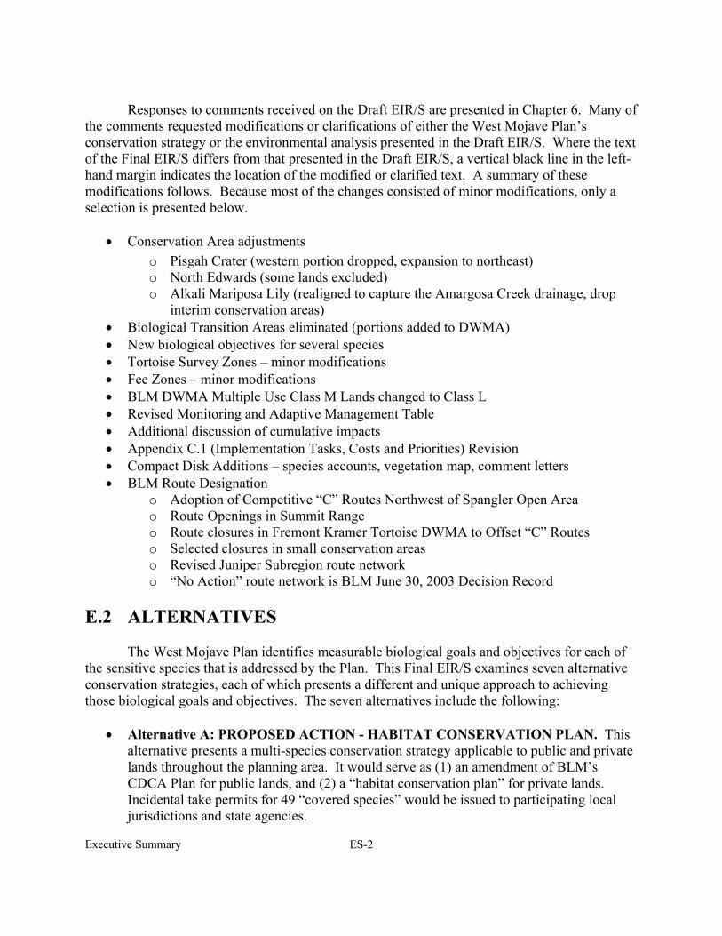
Responses to comments received on the Draft EIR/S are presented in Chapter 6. Many of
the comments requested modifications or clarifications of either the West Mojave Plan’s conservation strategy or the environmental analysis presented in the Draft EIR/S. Where the text of the Final EIR/S differs from that presented in the Draft EIR/S, a vertical black line in the left-hand margin indicates the location of the modified or clarified text. A summary of these modifications follows. Because most of the changes consisted of minor modifications, only a selection is presented below.
• Conservation Area adjustments
o Pisgah Crater (western portion dropped, expansion to northeast) o North Edwards (some lands excluded) o Alkali Mariposa Lily (realigned to capture the Amargosa Creek drainage, drop
interim conservation areas) • Biological Transition Areas eliminated (portions added to DWMA) • New biological objectives for several species • Tortoise Survey Zones – minor modifications • Fee Zones – minor modifications • BLM DWMA Multiple Use Class M Lands changed to Class L • Revised Monitoring and Adaptive Management Table • Additional discussion of cumulative impacts • Appendix C.1 (Implementation Tasks, Costs and Priorities) Revision • Compact Disk Additions – species accounts, vegetation map, comment letters • BLM Route Designation
o Adoption of Competitive “C” Routes Northwest of Spangler Open Area o Route Openings in Summit Range o Route closures in Fremont Kramer Tortoise DWMA to Offset “C” Routes o Selected closures in small conservation areas o Revised Juniper Subregion route network o “No Action” route network is BLM June 30, 2003 Decision Record
E.2 ALTERNATIVES The West Mojave Plan identifies measurable biological goals and objectives for each of the sensitive species that is addressed by the Plan. This Final EIR/S examines seven alternative conservation strategies, each of which presents a different and unique approach to achieving those biological goals and objectives. The seven alternatives include the following:
• Alternative A: PROPOSED ACTION - HABITAT CONSERVATION PLAN. This alternative presents a multi-species conservation strategy applicable to public and private lands throughout the planning area. It would serve as (1) an amendment of BLM’s CDCA Plan for public lands, and (2) a “habitat conservation plan” for private lands. Incidental take permits for 49 “covered species” would be issued to participating local jurisdictions and state agencies.
Executive Summary ES-3
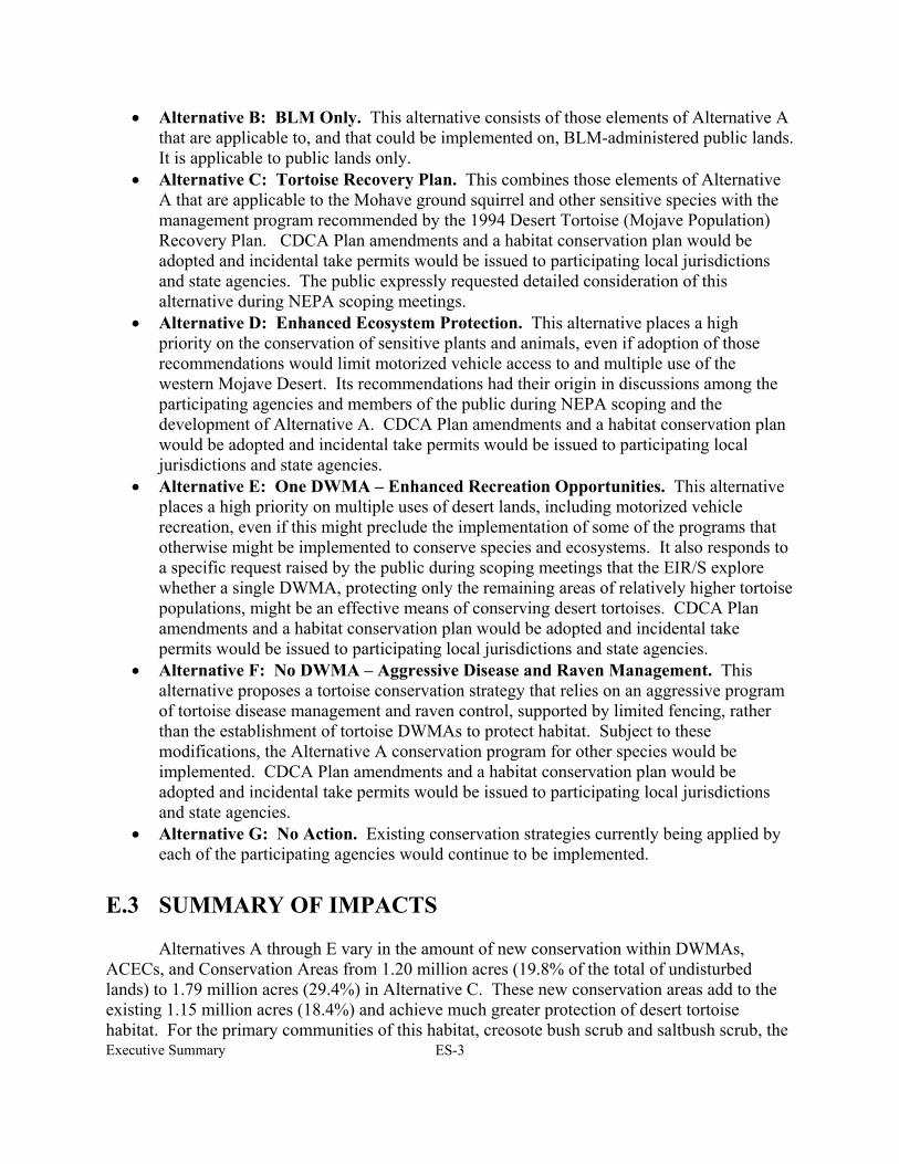
• Alternative B: BLM Only. This alternative consists of those elements of Alternative A that are applicable to, and that could be implemented on, BLM-administered public lands. It is applicable to public lands only.
• Alternative C: Tortoise Recovery Plan. This combines those elements of Alternative A that are applicable to the Mohave ground squirrel and other sensitive species with the management program recommended by the 1994 Desert Tortoise (Mojave Population) Recovery Plan. CDCA Plan amendments and a habitat conservation plan would be adopted and incidental take permits would be issued to participating local jurisdictions and state agencies. The public expressly requested detailed consideration of this alternative during NEPA scoping meetings.
• Alternative D: Enhanced Ecosystem Protection. This alternative places a high priority on the conservation of sensitive plants and animals, even if adoption of those recommendations would limit motorized vehicle access to and multiple use of the western Mojave Desert. Its recommendations had their origin in discussions among the participating agencies and members of the public during NEPA scoping and the development of Alternative A. CDCA Plan amendments and a habitat conservation plan would be adopted and incidental take permits would be issued to participating local jurisdictions and state agencies.
• Alternative E: One DWMA – Enhanced Recreation Opportunities. This alternative places a high priority on multiple uses of desert lands, including motorized vehicle recreation, even if this might preclude the implementation of some of the programs that otherwise might be implemented to conserve species and ecosystems. It also responds to a specific request raised by the public during scoping meetings that the EIR/S explore whether a single DWMA, protecting only the remaining areas of relatively higher tortoise populations, might be an effective means of conserving desert tortoises. CDCA Plan amendments and a habitat conservation plan would be adopted and incidental take permits would be issued to participating local jurisdictions and state agencies.
• Alternative F: No DWMA – Aggressive Disease and Raven Management. This alternative proposes a tortoise conservation strategy that relies on an aggressive program of tortoise disease management and raven control, supported by limited fencing, rather than the establishment of tortoise DWMAs to protect habitat. Subject to these modifications, the Alternative A conservation program for other species would be implemented. CDCA Plan amendments and a habitat conservation plan would be adopted and incidental take permits would be issued to participating local jurisdictions and state agencies.
• Alternative G: No Action. Existing conservation strategies currently being applied by each of the participating agencies would continue to be implemented.
E.3 SUMMARY OF IMPACTS
Alternatives A through E vary in the amount of new conservation within DWMAs, ACECs, and Conservation Areas from 1.20 million acres (19.8% of the total of undisturbed lands) to 1.79 million acres (29.4%) in Alternative C. These new conservation areas add to the existing 1.15 million acres (18.4%) and achieve much greater protection of desert tortoise habitat. For the primary communities of this habitat, creosote bush scrub and saltbush scrub, the
Executive Summary ES-4
increase in habitat conservation is 23-34%. The proportional increase is similar for the Mohave ground squirrel. In addition to increasing the quantity of habitat conserved, the Plan focuses on protecting the highest quality tortoise and ground squirrel habitat, as defined by highest sign counts and live tortoises and persistent capture locations for the Mohave ground squirrel. The alternatives incorporating private land conservation (A, C, D, E) create large habitat blocks capable of sustaining ecosystem processes, landform diversity, all trophic levels and populations large enough to be viable in the face of fluctuations caused by the extreme desert environment. For the desert tortoise, maintenance of conserved habitat with a high carrying capacity is necessary for recovery after the disease runs its course or a cure is found, and after raven predation is reduced. The Plan presents significant cumulative impacts, both positive and negative to most of the covered species. The beneficial cumulative impacts include the establishment of large, unfragmented habitat blocks, measures to reduce tortoise mortality, measures to minimize disturbance impacts to conserved lands and measures addressing unique components of diversity, such as endemic species, disjuncts and habitat specialists. The provision of incidental take areas where permitting is streamlined accommodates development of large acreages of disturbed lands and degraded habitat. The developed lands put increasing pressure on the conserved lands, from resource extraction, incidental land uses such as utilities and from recreation. The allowable loss of habitat exceeds conservation in all alternatives. Cumulatively this loss would reduce populations of many common species in a very substantial way. As long as the covered species, which are the rarest and those with known declines, are adequately conserved in the Habitat Conservation Area, the cumulative impact would not be significant or adverse. The more common species would survive within the HCA and are present in abundance outside the west Mojave as well.
Although large acreages are available as incidental take areas, not all of these lands would be developed or even disturbed during the term of the Plan. The growth projections for urban development can be accommodated on a small fraction of the land within the ITA. Many areas without water, utilities, or easy access would remain undeveloped, even from rural residences. The monitoring and adaptive management aspects of the Plan would track the success of the conservation measures, and these undeveloped lands would remain available if alterations are needed in the quantity of conserved lands in the future. They are also available for future recreation areas and for developments such as mining or energy production that can be pursued in remote areas. The allocation of lands for different uses achieved by the West Mojave Plan should not be considered as the final determination of land use for the planning area. It is rather a dynamic process of utilizing the best available science and land use planning to achieve conservation of the species and communities known to be in jeopardy. Technologies of the future can and are expected to alter provisions of the Plan to improve upon the implementation of its objectives.
Motorized Vehicle Access Network Mileage: Alternative A proposes minor
modifications of a BLM route network adopted on June 30, 2003 that includes 2,265 miles of open routes within a “redesign area”, 159 miles within the Ord Pilot region, 406 miles within
Executive Summary ES-5
ACECs for which route networks were designated after 1980, and 2,268 miles of remaining 1985-87 designations, or 5,098 miles overall, a total that includes single-track motorcycle routes. Proposed mileage of non-motorcycle routes in higher density tortoise population areas would be 384, a decrease from the 439 miles that were open prior to June 30, 2003. The 406 miles within the ACECs would be less than the pre-June 30, 2003 total of 427. Within the Juniper subregion, a redesigned network consisting of 73 miles of open routes and 25 miles of routes limited to use by single-track vehicles (e.g. motorcycles) would replace the 152 miles of open routes adopted on June 30, 2003. E.4 BIOLOGICAL GOALS AND OBJECTIVES: WOULD
THEY BE MET? E.4.1 Desert Tortoise
This section considers the four biological goals and associated objectives identified for desert tortoise conservation by the USFWS and CDFG in 1998 during biological evaluation meetings (U.S. Bureau of Land Management 1999). The goals and objectives are reiterated, and followed by tables that indicate for each alternative whether the goals and objectives are met or not. Generalized summary statements follow indicating why certain objectives are met or not.
Alternatives are reiterated as follows:
• Alternative A: Proposed Action – Habitat Conservation Plan • Alternative B: BLM Only • Alternative C: Tortoise Recovery Plan • Alternative D: Enhanced Ecosystem Protection • Alternative E: One DWMA – Enhanced Recreation Opportunities • Alternative F: No DWMA – Aggressive Disease and Raven Management • Alternative G: No Action
Goal 1: Protect sufficient habitat to ensure long-term tortoise population viability (see Table
ES-1). Objective 1.1: Establish a minimum of three, preferably four, Desert Wildlife Management Areas that would be managed for the long-term survival and recovery of the desert tortoise, and which would also benefit other special-status plant and animal species. Objective 1.2: Ensure that at least one DWMA exceeds 1,000 square miles in size Objective 1.3: Design DWMAs so that they are well distributed across the recovery unit, edge-to-area ratios are minimized, impediments to the movement of tortoises are avoided, and (where feasible) boundaries are contiguous.

Executive Summary ES-6
Table ES-1 Tortoise Biological Goal 1
BIOLOGICAL GOAL 1 SEVEN ALTERNATIVES UNDER CONSIDERATION OBJECTIVES A B C D E F G
1.1 Establish 3 or 4 DWMAs Yes Yes Yes Yes No No No 1.2 At least one DWMA 1,000 mi2 Yes No Yes Yes Yes No No 1.3 Good reserve design Yes No Yes Yes No No No Alternatives A through D share the common characteristics of establishing four DWMAs, with at least one that is 1,000 mi2, and incorporating the appropriate reserve design criteria given in Objective 1.3. This is not true for the BLM-only alternative. Although the alternative maintains the external, larger DWMA boundary, private lands are excluded, undermining the adequate DWMA size and configuration (i.e., lack of conservation on private land, checkerboard ownership pattern within the DWMA would undermine conservation efforts). Although Alternative E would result in the establishment of a single 1,000 mi2 DWMA, it fails to meet Objectives 1.1 and 1.3. Alternatives F and G would fail to establish any DWMAs, and therefore would fail to meet any of the three criteria.
Goal 2: Establish an upward or stationary trend in the tortoise population of the West Mojave Recovery Unit for at least 25 years (see Table ES-2).
Objective 2.1: Achieve population growth rates (lamdas) within DWMAs of at least 1.0. Objective 2.2: Attain a minimum average population density of 10 adult female tortoises per square mile within each DWMA. Objective 2.3: Establish a program for tortoise population monitoring that would detect an increase, decrease, or stable trend in tortoise population densities, and include an information feedback loop that ensures that necessary changes would be made in management.
Table ES-2
Tortoise Biological Goal 2 BIOLOGICAL GOAL 2 SEVEN ALTERNATIVES UNDER CONSIDERATION
OBJECTIVES A B C D E F G 2.1 Achieve stable populations Unk Unk Unk Unk No No No 2.2 Achieve 10 females/mi2 Unk Unk Unk Unk No No No 2.3 Population monitoring No No No No No No No There are limited means of assessing the seven alternatives in their efficacy to meet Goal 2 and its objectives. Success would be measured in terms of the population’s response to implementing proactive conservation programs identified in each alternative. Achieving stable populations and a certain density of tortoises per square mile is unknown for the first four alternatives. Although Alternative E would result in the establishment of a single DWMA, even if the objectives were met for so small an area, poor reserve design, including very high surface area to boundary ratio, would effectively undermine the efficacy of conservation. Failure to establish DWMAs under Alternatives F and G would exacerbate rather than facilitate attaining these objectives.
Executive Summary ES-7
Unfortunately, the ability to realize Goal 2, for all alternatives, is hampered by the
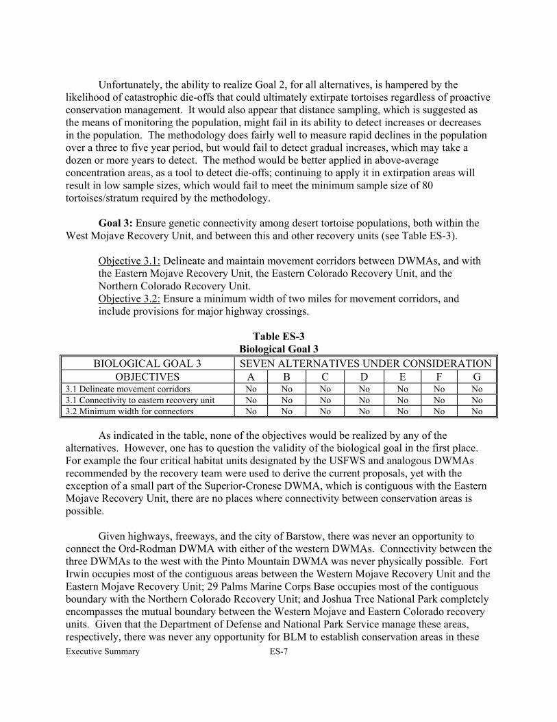
likelihood of catastrophic die-offs that could ultimately extirpate tortoises regardless of proactive conservation management. It would also appear that distance sampling, which is suggested as the means of monitoring the population, might fail in its ability to detect increases or decreases in the population. The methodology does fairly well to measure rapid declines in the population over a three to five year period, but would fail to detect gradual increases, which may take a dozen or more years to detect. The method would be better applied in above-average concentration areas, as a tool to detect die-offs; continuing to apply it in extirpation areas will result in low sample sizes, which would fail to meet the minimum sample size of 80 tortoises/stratum required by the methodology. Goal 3: Ensure genetic connectivity among desert tortoise populations, both within the West Mojave Recovery Unit, and between this and other recovery units (see Table ES-3).
Objective 3.1: Delineate and maintain movement corridors between DWMAs, and with the Eastern Mojave Recovery Unit, the Eastern Colorado Recovery Unit, and the Northern Colorado Recovery Unit. Objective 3.2: Ensure a minimum width of two miles for movement corridors, and include provisions for major highway crossings.
Table ES-3
Biological Goal 3 BIOLOGICAL GOAL 3 SEVEN ALTERNATIVES UNDER CONSIDERATION
OBJECTIVES A B C D E F G 3.1 Delineate movement corridors No No No No No No No 3.1 Connectivity to eastern recovery unit No No No No No No No 3.2 Minimum width for connectors No No No No No No No As indicated in the table, none of the objectives would be realized by any of the alternatives. However, one has to question the validity of the biological goal in the first place. For example the four critical habitat units designated by the USFWS and analogous DWMAs recommended by the recovery team were used to derive the current proposals, yet with the exception of a small part of the Superior-Cronese DWMA, which is contiguous with the Eastern Mojave Recovery Unit, there are no places where connectivity between conservation areas is possible.
Given highways, freeways, and the city of Barstow, there was never an opportunity to connect the Ord-Rodman DWMA with either of the western DWMAs. Connectivity between the three DWMAs to the west with the Pinto Mountain DWMA was never physically possible. Fort Irwin occupies most of the contiguous areas between the Western Mojave Recovery Unit and the Eastern Mojave Recovery Unit; 29 Palms Marine Corps Base occupies most of the contiguous boundary with the Northern Colorado Recovery Unit; and Joshua Tree National Park completely encompasses the mutual boundary between the Western Mojave and Eastern Colorado recovery units. Given that the Department of Defense and National Park Service manage these areas, respectively, there was never any opportunity for BLM to establish conservation areas in these
Executive Summary ES-8
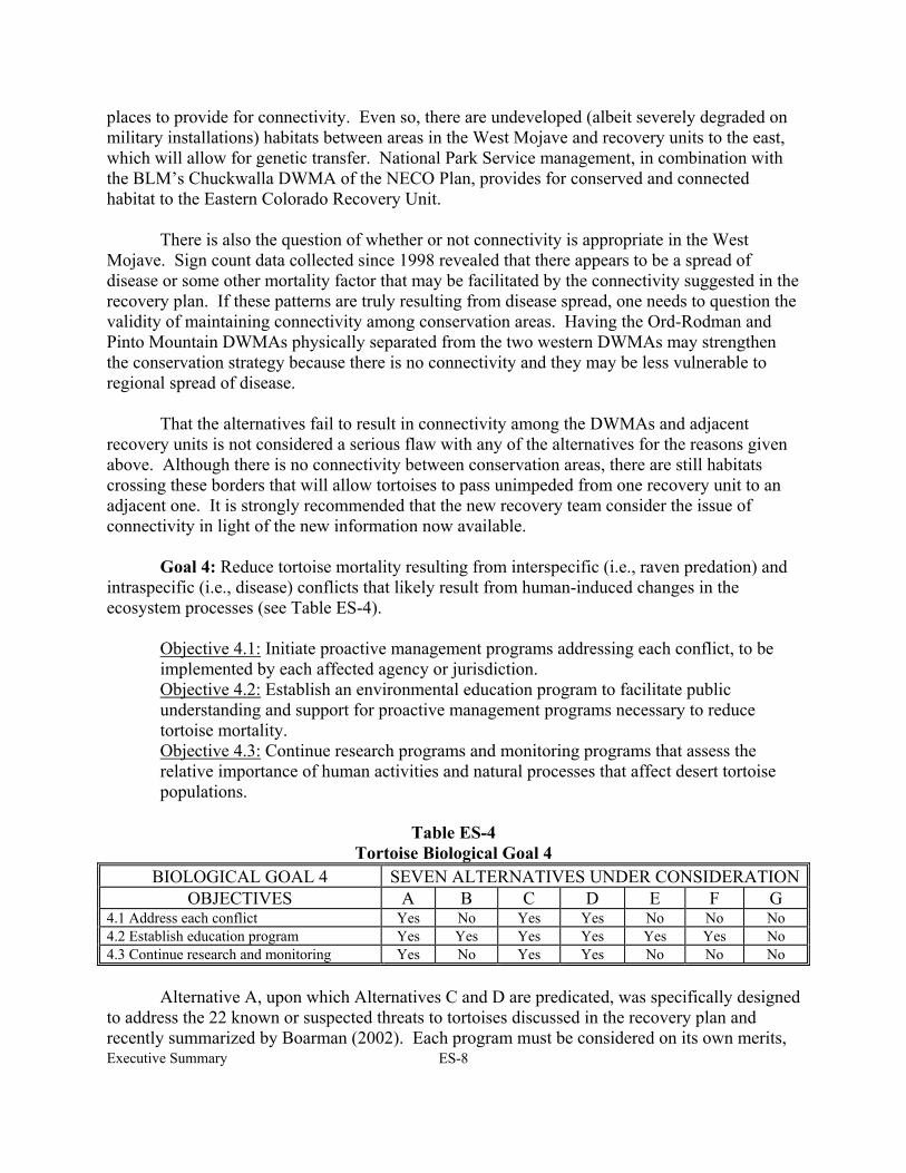
places to provide for connectivity. Even so, there are undeveloped (albeit severely degraded on military installations) habitats between areas in the West Mojave and recovery units to the east, which will allow for genetic transfer. National Park Service management, in combination with the BLM’s Chuckwalla DWMA of the NECO Plan, provides for conserved and connected habitat to the Eastern Colorado Recovery Unit. There is also the question of whether or not connectivity is appropriate in the West Mojave. Sign count data collected since 1998 revealed that there appears to be a spread of disease or some other mortality factor that may be facilitated by the connectivity suggested in the recovery plan. If these patterns are truly resulting from disease spread, one needs to question the validity of maintaining connectivity among conservation areas. Having the Ord-Rodman and Pinto Mountain DWMAs physically separated from the two western DWMAs may strengthen the conservation strategy because there is no connectivity and they may be less vulnerable to regional spread of disease. That the alternatives fail to result in connectivity among the DWMAs and adjacent recovery units is not considered a serious flaw with any of the alternatives for the reasons given above. Although there is no connectivity between conservation areas, there are still habitats crossing these borders that will allow tortoises to pass unimpeded from one recovery unit to an adjacent one. It is strongly recommended that the new recovery team consider the issue of connectivity in light of the new information now available. Goal 4: Reduce tortoise mortality resulting from interspecific (i.e., raven predation) and intraspecific (i.e., disease) conflicts that likely result from human-induced changes in the ecosystem processes (see Table ES-4).
Objective 4.1: Initiate proactive management programs addressing each conflict, to be implemented by each affected agency or jurisdiction. Objective 4.2: Establish an environmental education program to facilitate public understanding and support for proactive management programs necessary to reduce tortoise mortality. Objective 4.3: Continue research programs and monitoring programs that assess the relative importance of human activities and natural processes that affect desert tortoise populations.
Table ES-4
Tortoise Biological Goal 4 BIOLOGICAL GOAL 4 SEVEN ALTERNATIVES UNDER CONSIDERATION
OBJECTIVES A B C D E F G 4.1 Address each conflict Yes No Yes Yes No No No 4.2 Establish education program Yes Yes Yes Yes Yes Yes No 4.3 Continue research and monitoring Yes No Yes Yes No No No Alternative A, upon which Alternatives C and D are predicated, was specifically designed to address the 22 known or suspected threats to tortoises discussed in the recovery plan and recently summarized by Boarman (2002). Each program must be considered on its own merits,
Executive Summary ES-9
but in general, Alternatives A, C, and D were designed with these threats in mind, and are intended to meet Objective 3.1. Their efficacy is susceptible to limited funding, public support, and many other factors that are not easily foreseeable or controlled. Effective conservation must necessarily rely on cooperation among all land managers, and include both private and public lands. Alternative B would fail to implement Objective 3.1 for this reason. Alternative E could work to implement Objective 3.1 in the 1,000 mi2 area, but its relatively small size and high area to edge ratio fatally flaws it as providing for regional tortoise conservation. The focus on disease and raven management is too narrow to allow Alternative F to accomplish the objective. Establishing an education program is often touted as important to regional conservation plans yet is seldom realized or implemented. In spite of this ubiquitous problem, each of the alternatives (excepting Alternative G, No Action) proposes some form of enhanced education. For this objective to be realized, managers must take a different, proactive look at regional education, or the conservation strategy is likely to be undermined. Research and monitoring (Objective 4.3) are strongly encouraged for Alternatives A, C, and D but are missing, or only partially applied (Alternative F), in the remaining alternatives. It is difficult (and questionable) to assign limited funds to continued research when there are numerous, costly conservation programs that need to be implemented. Monitoring is essential, but the efficacy of distance sampling to function as intended is questionable. E.4.2 Mohave Ground Squirrel Table ES-5 presents an overview of the likely success of each alternative in meeting the biological goals established by the West Mojave Plan for the threatened Mohave ground squirrel.
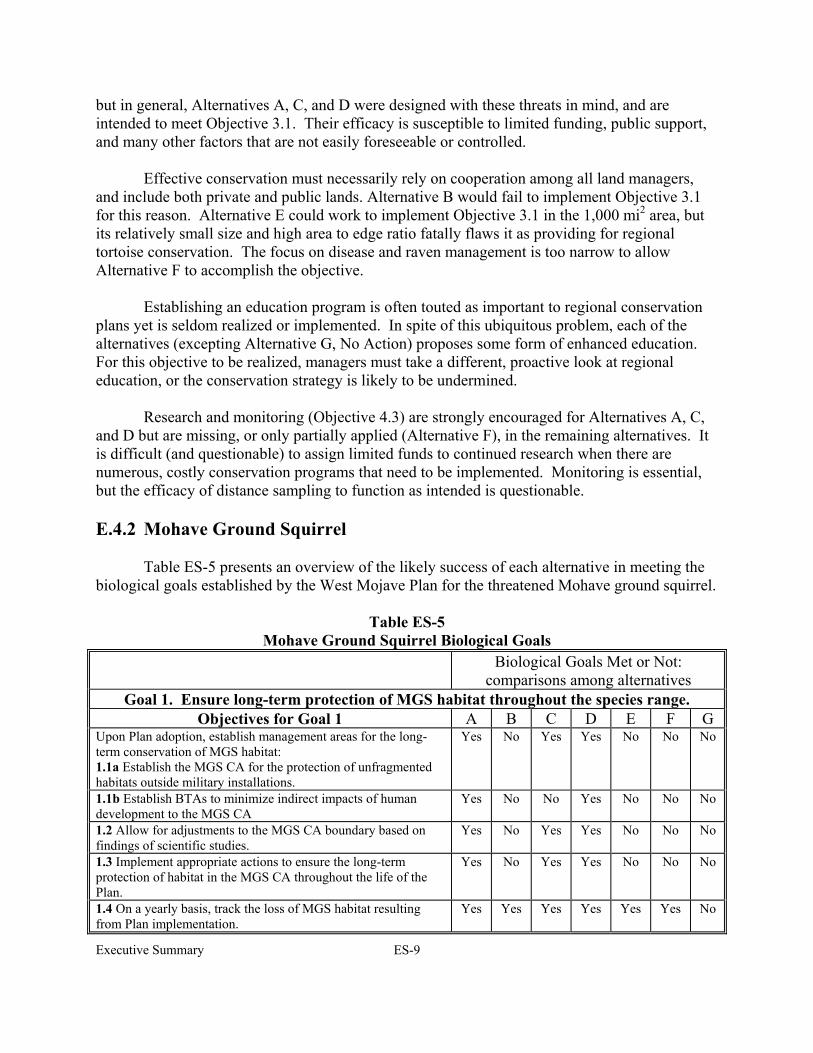
Table ES-5
Mohave Ground Squirrel Biological Goals Biological Goals Met or Not:
comparisons among alternatives Goal 1. Ensure long-term protection of MGS habitat throughout the species range.
Objectives for Goal 1 A B C D E F G Upon Plan adoption, establish management areas for the long-term conservation of MGS habitat: 1.1a Establish the MGS CA for the protection of unfragmented habitats outside military installations.
Yes No Yes Yes No No No
1.1b Establish BTAs to minimize indirect impacts of human development to the MGS CA
Yes No No Yes No No No
1.2 Allow for adjustments to the MGS CA boundary based on findings of scientific studies.
Yes No Yes Yes No No No
1.3 Implement appropriate actions to ensure the long-term protection of habitat in the MGS CA throughout the life of the Plan.
Yes No Yes Yes No No No
1.4 On a yearly basis, track the loss of MGS habitat resulting from Plan implementation.
Yes Yes Yes Yes Yes Yes No
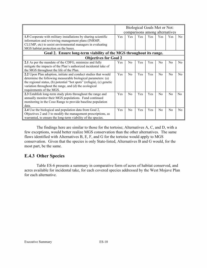
Executive Summary ES-10
Biological Goals Met or Not: comparisons among alternatives
1.5 Cooperate with military installations by sharing scientific information and reviewing management plans (INRMP, CLUMP, etc) to assist environmental managers in evaluating MGS habitat protection on the bases.
Yes Yes Yes Yes Yes Yes No
Goal 2. Ensure long-term viability of the MGS throughout its range. Objectives for Goal 2
2.1 As per the mandate of the CDFG, minimize and fully mitigate the impacts of the Plan’s authorized incidental take of the MGS throughout the life of the Plan.
Yes No Yes Yes No No No
2.2 Upon Plan adoption, initiate and conduct studies that would determine the following measurable biological parameters: (a) the regional status, (b) potential “hot spots” (refugia), (c) genetic variation throughout the range, and (d) the ecological requirements of the MGS.
Yes No Yes Yes No No No
2.3 Establish long-term study plots throughout the range and annually monitor their MGS populations. Fund continued monitoring in the Coso Range to provide baseline population data.
Yes No Yes Yes No No No
2.4 Use the biological and population data from Goal 2, Objectives 2 and 3 to modify the management prescriptions, as warranted, to ensure the long-term viability of the species.
Yes No Yes Yes No No No
The findings here are similar to those for the tortoise; Alternatives A, C, and D, with a few exceptions, would better realize MGS conservation than the other alternatives. The same flaws identified with Alternatives B, E, F, and G for the tortoise would apply to MGS conservation. Given that the species is only State-listed, Alternatives B and G would, for the most part, be the same. E.4.3 Other Species Table ES-6 presents a summary in comparative form of acres of habitat conserved, and acres available for incidental take, for each covered species addressed by the West Mojave Plan for each alternative.

Executive Summary ES-11
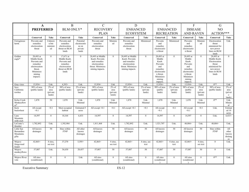
Table ES-6 Acreage of Conservation and Incidental Take of Covered Species in Each Alternative.
A PREFERRED
B BLM ONLY*
C RECOVERY
PLAN
D ENHANCED ECOSYSTEM
E ENHANCED
RECREATION
F DISEASE
AND RAVEN
G NO
ACTION*** Conserved Take Conserved Take Conserved Take Conserved Take Conserved Take Conserved Take Conserved Take
Desert tortoise
1,477,630 See text for ITA
1,023,329 454,301 in DWMA.
See text for ITA
1,514,847 See text for ITA
1,505,494 4,393 See text for
ITA
715,424 4,393 in DWMA.
See text for ITA
See text – different approach
DTNA, Cat 1 habitat
Unk.
Mohave ground squirrel
1,701,947 See text for ITA
1,280,106 See text for ITA
1,701,947 See text for ITA
1,701,947 See text for ITA
1,701,947 See text for ITA
1,701,947 See text for ITA
0 Unk.
Alkali Mariposa Lily
Permanent = 3,500+
Isolated sites
40,861 0 40,861 Permanent = 3,500+
Isolated sites
40,861 Permanent = 3,500+
Isolated sites
40,861 Permanent = 3,500+ Isolated
sites
40,861 Permanent = 3,500+ Isolated
sites
40,861 0** 68,171
Barstow Woolly Sunflower
50,548+ 50 17,682+ 32,872 50,548+ 50 50,548+ 50 50,548+ 50 50,548+ 50 0 Unk., estimated at
32,872+
Bats All significant roosts
< 25 bats at
any one site
All significant roosts
No t limited All significant roosts
< 25 bats at
any one site
All significant roosts
< 25 bats at any one site
All significant
roosts
< 25 bats at any one site
All significant
roosts
< 25 bats at
any one site
Roosts gated on case-by-case basis
Unk.
Bendire’s Thrasher*
132,497 3,973 132,497 3,973 132,497 3,973 132,497 3,973 132,497 3,973 132,497 3,973 106,710 29,760
Brown-crested
flycatcher
All sites (conditional)
0 All sites (conditional)
0 All sites (conditional)
0 All sites (conditional)
0 All sites (conditional
)
0 All sites (conditional
)
0 Big Morongo ACEC
Unk.
Burrowing owl
Unk. No mortalit
y. Limited.
Occurrences on BLM lands
No mortality. Limited.
Unk. No mortalit
y. Limited.
Unk. No mortality. Limited.
Unk. No mortality. Limited.
Unk. No mortalit
y. Limited.
0** Unlimited
Carbonate Endemic Plants
5,169 Minimal 4,393 776 5,169 Minimal 5,169 Minimal 5,169 Minimal 5,169 Minimal 0 Unk.
Charlotte’s phacelia
All known sites
50 30 of 37 sites 7 sites All known sites 50 All known sites 50 All known sites
50 All known sites
50 30 of 37 sites 7 sites
Crucifixion thorn
All known sites
50 All known sites
50 All known sites 50 All known sites 50 All known sites
50 All known sites
50 0 Unk.
Desert cymopterus
Most occupied habitat
50 Most occupied habitat
50 Most occupied habitat
50 Most occupied habitat
50 Most occupied habitat
50 Most occupied habitat
50 0 Unk. Estimat
ed at 14,343
Executive Summary ES-12
A PREFERRED
B BLM ONLY*
C RECOVERY
PLAN
D ENHANCED ECOSYSTEM
E ENHANCED
RECREATION
F DISEASE
AND RAVEN
G NO
ACTION*** Conserved Take Conserved Take Conserved Take Conserved Take Conserved Take Conserved Take Conserved Take
Ferruginous hawk
Prevents and remedies
electrocution threat
Unknown but
minimized
Prevents and remedies
electrocution threat on BLM
lands
Potential electrocutio
ns on private lands
Prevents and remedies
electrocution threat
Minimized
Prevents and remedies
electrocution threat
Minimized Prevents and
remedies electrocutio
n threat
Minimized Prevents and
remedies electrocutio
n threat
Minimized
Electrocution threat
minimized for new power
lines on BLM lands
Unk.
Golden eagle*
20,495 at Middle Knob. Prevents and
remedies electrocution
threat. Minimizes
mining impacts.
0 17,671 at Middle Knob. Prevents and
remedies electrocution
threat on BLM lands
0 20,495 at Middle Knob. Prevents and remedies electrocution
threat. Minimizes mining impacts.
0 20,495 at Middle Knob. Prevents and remedies electrocution
threat. Minimizes mining impacts.
0 20,495 at Middle Knob.
Prevents and
remedies electrocutio
n threat. Minimizes
mining impacts.
0 20,495 at Middle Knob.
Prevents and
remedies electrocutio
n threat. Minimizes
mining impacts.
0 20,495 at Middle Knob. Electrocution
threat minimized for
new power lines on BLM
lands
0
Gray vireo 15,954+ Unk. 4,393+ Unk. 15,954+ Unk. 15,954+ Unk. 15,954+ Unk. 15,954+ Unk. 0** Unk. Inyo California towhee
98% of area (public lands)
2% of area
(private lands)
98% of area (public lands)
2% of area (private lands)
98% of area (public lands)
2% of area
(private lands)
98% of area (public lands)
2% of area (private lands)
98% of area (public lands)
2% of area (private lands)
98% of area (public lands)
2% of area
(private lands)
98% of area (public lands)
2% of area
(private
lands) Kelso Creek Monkeyflower*
1,870 50 1,870 Unk. Minimal
1,870 Unk. Minimal
1,870 Unk. Minimal
1,870 Unk. Minimal
1,870 Unk. Minimal
0** Unk. Minim
al Kern buckwheat
All except <0.1
<0.1 Most occupied habitat
Estimated 5 acres
All except <0.1 <0.1 All except <0.1 <0.1 All except <0.1
<0.1 All except <0.1
<0.1 Unk. Estimated 10 acres
Lane Mountain milkvetch
14,597 0 10,164 4,433 14,597 0 14,597 0 14,597 0 14,597 0 Unk. 4,433+
LeConte’s thrasher
1,782,892 Unk. 1,392,984 Unk. 1,811,468 Unk. 1,782,892 Unk. 1,521,707 Unk. 48,804+ Unk. 48,804+ Unk.
Little San Bernardino Mountains gilia
All known drainages
50 Sites within JTNP
All other known
drainages
All known drainages
50 All known drainages
50 All known drainages
50 All known drainages
50 Sites within JTNP
All other
known drainag
es Mojave fringe-toed lizard
42,865+ 4 sites, see text
37,270 5,595+ 42,865+ 4 sites, see text
42,865+ 4 sites, see text
42,865+ 4 sites, see text
42,865+ 4 sites, see text
0 Unk.
Mojave monkeyflower
57,087 Unk. 36,630 20,457 57,087 50 57,087 50 57,087 50 57,087 50 0 Unk.
Mojave River vole
All sites (conditional)
0 0 Unk All sites (conditional)
0 All sites (conditional)
0 All sites (conditional
)
0 All sites (conditional
)
0 0** Unk.

Executive Summary ES-13
A PREFERRED
B BLM ONLY*
C RECOVERY
PLAN
D ENHANCED ECOSYSTEM
E ENHANCED
RECREATION
F DISEASE
AND RAVEN
G NO
ACTION*** Conserved Take Conserved Take Conserved Take Conserved Take Conserved Take Conserved Take Conserved Take
Mojave tarplant
All occupied habitat
50 (new location
s)
All occupied habitat
Unk. All occupied habitat
50 (new location
s)
All occupied habitat
50 (new locations)
All occupied habitat
50 (new locations)
All occupied habitat
50 (new location
s)
All occupied habitat
Unk.
Parish’s alkali grass
All of single known site
0 0 Unk. 0 All of single known
site
0 All of single
known site
0 All of single
known site
0 All of single known
site
0 Unk.
Parish’s phacelia
898 50 512 376 898 50 898 50 898 50 898 50 0 Unk.
Parish’s popcorn flower
All of single known site
0 0 Unk. All of single known site
0 All of single known site
0 All of single
known site
0 All of single
known site
0 Unk. Unk.
Prairie falcon 20,495 at Middle Knob.
Minimizes mining
impacts.
0 17,671 at Middle Knob.
Minimizes mining
impacts.
0 20,495 at Middle Knob. Minimizes mining impacts.
0 20,495 at Middle Knob. Minimizes mining impacts.
0 20,495 at Middle Knob.
Minimizes mining
impacts.
0 20,495 at Middle Knob.
Minimizes mining
impacts.
0 20,495 at Middle Knob.
Minimizes mining
impacts.
Unk.
Red Rock poppy
All occupied habitat
50 All occupied habitat
Minimal All occupied habitat
50 All occupied habitat
50 All occupied habitat
50 All occupied habitat
50 Most habitat Unk.
Red Rock tarplant
All occupied habitat
50 All occupied habitat
Minimal All occupied habitat
50 All occupied habitat
50 All occupied habitat
50 All occupied habitat
50 Most habitat Unk.
Salt Springs checkerbloom
All of single known site
0 0 Unk. All of single known site
0 All of single known site
0 All of single
known site
0 All of single
known site
0 0 Unk.
San Diego horned lizard
15,954+ Unk. 4,393+ Unk. 15,954+ Unk. 15,954+ Unk. 15,954+ Unk. 15,954+ Unk. 0** Unk.
Shockley’s rock-cress
5,169 0 4,393 776 5,169 0 5,169 0 5,169 0 5,169 0 4,393 but no added
management
776
Short-joint beavertail cactus
10,785 50 0 All 10,785 50 10,785 50 10,785 50 10,785 50 Existing SEAs and 1,590
scattered BLM parcels
0**
Southwestern pond turtle
All known sites
(conditional at some)
Unk. Selected sites Unk. All known sites (conditional at
some)
Unk. All known sites (conditional at
some)
Unk. All known sites
(conditional at some)
Unk. All known sites
(conditional at some)
Unk. Selected sites Unk.
Southwestern willow flycatcher
All sites (conditional)
0 All sites (conditional)
0 All sites (conditional)
0 All sites (conditional)
0 All sites (conditional
)
0 All sites (conditional
)
0 Big Morongo ACEC
Unk.
Summer tanager
Mojave River sites
(conditional)
Unk. Selected sites Unk. Mojave River sites (conditional
Unk. Mojave River sites (conditional
Unk. Mojave River sites
(conditional
Unk. Mojave River sites
(conditional
Unk. Selected sites – see text
Unk.
Triple-ribbed milkvetch
All known sites
0 Sites on public land
Unk. All known sites 0 All known sites 0 All known sites
0 All known sites
0 Sites on public land
Unk.

Executive Summary ES-14
A PREFERRED
B BLM ONLY*
C RECOVERY
PLAN
D ENHANCED ECOSYSTEM
E ENHANCED
RECREATION
F DISEASE
AND RAVEN
G NO
ACTION*** Conserved Take Conserved Take Conserved Take Conserved Take Conserved Take Conserved Take Conserved Take
Vermilion flycatcher
All sites (conditional)
0 All sites (conditional)
0 All sites (conditional)
0 All sites (conditional)
0 All sites (conditional
)
0 All sites (conditional
)
0 Selected sites – see text
Unk.
Western snowy plover
All known sites
0 All known sites
0 All known sites 0 All known sites 0 All known sites
0 All known sites
0 Most known sites
Unk.
White-margined beardtongue
All known sites
50 Most known sites
Unk. All known sites 50 All known sites 50 All known sites
50 All known sites
50 0 Minimal
Yellow-eared pocket mouse
Unk Unk Selected ACECs
Unk Unk Unk Unk Unk Unk Unk Unk Unk Selected ACECs
Unk
Yellow warbler
All sites (conditional)
0 All sites (conditional)
0 All sites (conditional)
0 All sites (conditional)
0 All sites (conditional
)
0 All sites (conditional
)
0 Selected sites – see text
Unk.
Western yellow-billed cuckoo
All sites (conditional)
0 All sites (conditional)
0 All sites (conditional)
0 All sites (conditional)
0 All sites (conditional
)
0 All sites (conditional
)
0 Unk. Unk.
Yellow-breasted chat
Mojave River sites
(conditional) 10,785 (Big Rock Creek)
0 Mojave River sites
(conditional)
0 Mojave River sites (conditional) 10,785 (Big Rock
Creek))
0 Mojave River sites (conditional) 10,785 (Big Rock
Creek)
0 Mojave River sites
(conditional)
10,785 (Big Rock
Creek)
0 Mojave River sites
(conditional)
10,785 (Big Rock
Creek)
0 Selected sites – see text
Unk.
See also Table 2-11. Unk. = Unknown.
* Acreages are for BLM managed lands only ** Los Angeles County may expand its SEA boundaries, providing some conservation for this species. *** See text for potential conservation of the No Action Alternative. Continued review of projects under CEQA, by BLM in Category 1 habitat, and by FWS in occupied and critical habitat will result in some conservation by provision of compensation lands or set-asides.

Chapter 1 1-1
CHAPTER ONE INTRODUCTION
1.1 OVERVIEW
The West Mojave Plan (Plan) is a habitat conservation plan and federal land use plan amendment that (1) presents a comprehensive strategy to conserve and protect the desert tortoise, the Mohave ground squirrel (MGS) and over 100 other sensitive plants and animals and the natural communities of which they are a part, and (2) provides a streamlined program for complying with the requirements of the California and federal Endangered Species Acts (CESA and FESA, respectively).
The Plan is being prepared through the collaborative effort of cities, counties, state and
federal agencies having jurisdiction over lands within the region. The Plan will allow streamlined project permitting at the local level, equitable sharing of costs among participants, and shared stewardship of biotic resources. The collaborators include:
• Local Jurisdictions: The cities of Adelanto, Barstow, California City, Hesperia, Lancaster, Palmdale, Ridgecrest, Twentynine Palms, and Victorville, and the towns of Apple Valley and Yucca Valley; the Counties of Inyo, Kern, Los Angeles and San Bernardino; and the Indian Wells Valley Water District.
• State of California: The California Department of Fish and Game and California Department of Transportation (Caltrans)
• Federal: The Bureau of Land Management and the United States Fish and Wildlife Service.
These agencies and local jurisdictions are cooperating with a variety of non-governmental
organizations, including businesses, environmental organizations, user groups and others with a stake in the future management of the planning area, to develop the West Mojave Plan. Over 100 non-governmental organizations (NGO) have participated in this process. Representatives of the agencies, jurisdictions and NGOs comprise the West Mojave Supergroup. 1.1.1 Site Location and Description The 9,357,929-acre planning area is located to the north of the Los Angeles metropolitan area (See Maps 1-1 and 1-2 and Table 1-1). The Plan’s conservation program applies to both public and private lands within this area. These lands include 3,263,874 acres of BLM-administered public lands, 3,029,230 acres of private lands and 102,168 acres of lands administered by the State of California. The Plan will be consistent with the integrated natural resource management plans that have been adopted for 2,667,445 acres of military lands, and with programs being implemented on nearly 300,000 acres of lands within Joshua Tree National Park.
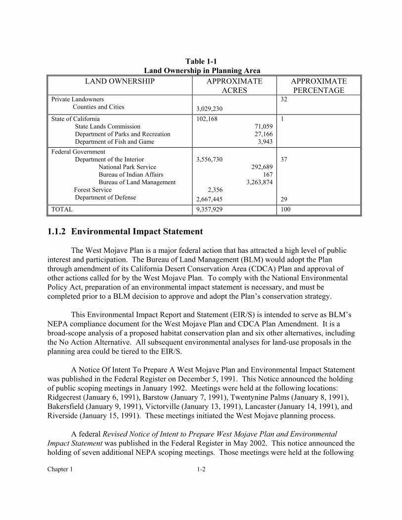
Chapter 1 1-2
Table 1-1
Land Ownership in Planning Area LAND OWNERSHIP APPROXIMATE
ACRES APPROXIMATE PERCENTAGE
Private Landowners Counties and Cities
3,029,230
32
State of California State Lands Commission Department of Parks and Recreation Department of Fish and Game
102,168 71,059 27,166
3,943
1
Federal Government Department of the Interior
National Park Service Bureau of Indian Affairs Bureau of Land Management
Forest Service Department of Defense
3,556,730
292,689 167
3,263,874 2,356 2,667,445
37 29
TOTAL 9,357,929 100 1.1.2 Environmental Impact Statement
The West Mojave Plan is a major federal action that has attracted a high level of public interest and participation. The Bureau of Land Management (BLM) would adopt the Plan through amendment of its California Desert Conservation Area (CDCA) Plan and approval of other actions called for by the West Mojave Plan. To comply with the National Environmental Policy Act, preparation of an environmental impact statement is necessary, and must be completed prior to a BLM decision to approve and adopt the Plan’s conservation strategy.
This Environmental Impact Report and Statement (EIR/S) is intended to serve as BLM’s
NEPA compliance document for the West Mojave Plan and CDCA Plan Amendment. It is a broad-scope analysis of a proposed habitat conservation plan and six other alternatives, including the No Action Alternative. All subsequent environmental analyses for land-use proposals in the planning area could be tiered to the EIR/S.
A Notice Of Intent To Prepare A West Mojave Plan and Environmental Impact Statement
was published in the Federal Register on December 5, 1991. This Notice announced the holding of public scoping meetings in January 1992. Meetings were held at the following locations: Ridgecrest (January 6, 1991), Barstow (January 7, 1991), Twentynine Palms (January 8, 1991), Bakersfield (January 9, 1991), Victorville (January 13, 1991), Lancaster (January 14, 1991), and Riverside (January 15, 1991). These meetings initiated the West Mojave planning process.
A federal Revised Notice of Intent to Prepare West Mojave Plan and Environmental
Impact Statement was published in the Federal Register in May 2002. This notice announced the holding of seven additional NEPA scoping meetings. Those meetings were held at the following
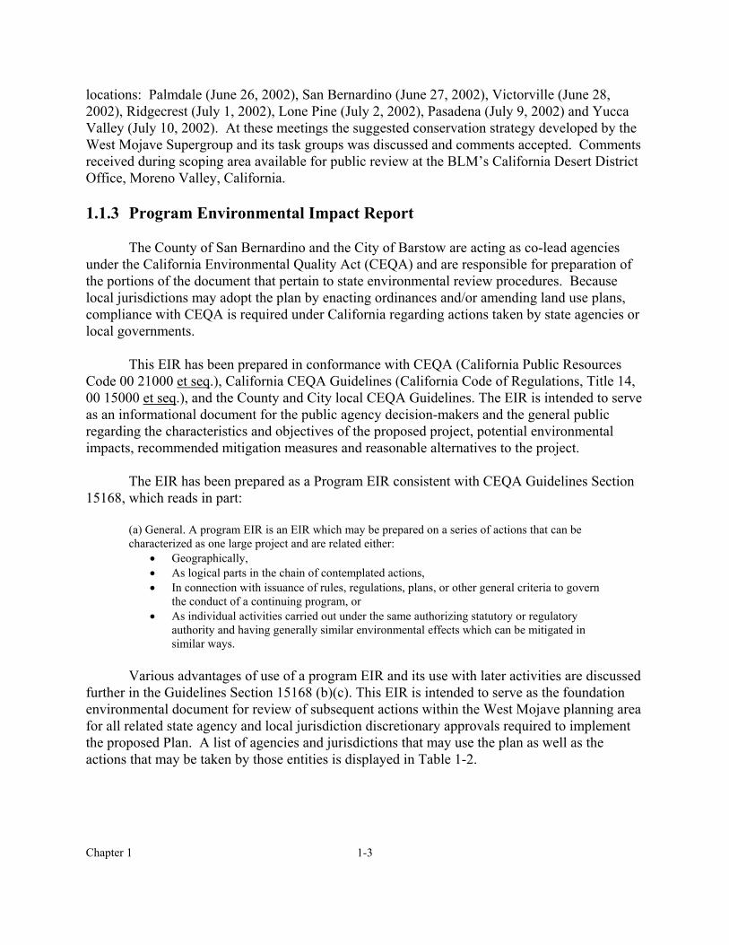
Chapter 1 1-3
locations: Palmdale (June 26, 2002), San Bernardino (June 27, 2002), Victorville (June 28, 2002), Ridgecrest (July 1, 2002), Lone Pine (July 2, 2002), Pasadena (July 9, 2002) and Yucca Valley (July 10, 2002). At these meetings the suggested conservation strategy developed by the West Mojave Supergroup and its task groups was discussed and comments accepted. Comments received during scoping area available for public review at the BLM’s California Desert District Office, Moreno Valley, California.
1.1.3 Program Environmental Impact Report
The County of San Bernardino and the City of Barstow are acting as co-lead agencies
under the California Environmental Quality Act (CEQA) and are responsible for preparation of the portions of the document that pertain to state environmental review procedures. Because local jurisdictions may adopt the plan by enacting ordinances and/or amending land use plans, compliance with CEQA is required under California regarding actions taken by state agencies or local governments.
This EIR has been prepared in conformance with CEQA (California Public Resources
Code 00 21000 et seq.), California CEQA Guidelines (California Code of Regulations, Title 14, 00 15000 et seq.), and the County and City local CEQA Guidelines. The EIR is intended to serve as an informational document for the public agency decision-makers and the general public regarding the characteristics and objectives of the proposed project, potential environmental impacts, recommended mitigation measures and reasonable alternatives to the project.
The EIR has been prepared as a Program EIR consistent with CEQA Guidelines Section
15168, which reads in part: (a) General. A program EIR is an EIR which may be prepared on a series of actions that can be characterized as one large project and are related either:
• Geographically, • As logical parts in the chain of contemplated actions, • In connection with issuance of rules, regulations, plans, or other general criteria to govern
the conduct of a continuing program, or • As individual activities carried out under the same authorizing statutory or regulatory
authority and having generally similar environmental effects which can be mitigated in similar ways.
Various advantages of use of a program EIR and its use with later activities are discussed
further in the Guidelines Section 15168 (b)(c). This EIR is intended to serve as the foundation environmental document for review of subsequent actions within the West Mojave planning area for all related state agency and local jurisdiction discretionary approvals required to implement the proposed Plan. A list of agencies and jurisdictions that may use the plan as well as the actions that may be taken by those entities is displayed in Table 1-2.
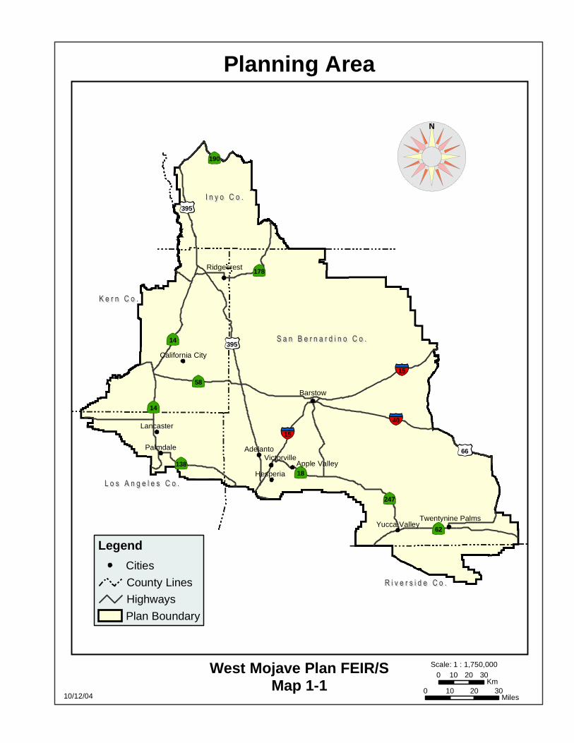
Barstow
Adelanto
Hesperia
Palmdale
Lancaster
Ridgecrest
VictorvilleApple Valley
Yucca Valley
California City
Twentynine Palms
I n y o C o .I n y o C o .
S a n B e r n a r d i n o C o .S a n B e r n a r d i n o C o .
K e r n C o .K e r n C o .
R i v e r s i d e C o .R i v e r s i d e C o .
L o s A n g e l e s C o .L o s A n g e l e s C o .
58
14
14
18
62
66
40
15
15
190
395
138
178
247
395
Planning Area
Map 1-110/12/04
West Mojave Plan FEIR/S
Legend
Cities
County Lines
Highways
Plan Boundary
Scale: 1 : 1,750,000
0 10 20 30Miles
0 10 20 30Km
N
I n yo C o
Sa n Be r na r d i n o Co
Ke r n Co
R ive r s i de Co
Tu la r e Co
Imp e r i a l CoSa n D ie go Co
Lo s An g e le s Co
Mo no Co
Ora n g e Co
Regional Planning Efforts
Map 1-210/1/04
West Mojave Plan
West Mojave Plan FEIR/S
Legend
County Lines
CDCA Boundary
West Mojave Plan
Northern and Eastern Mojave Plan (BLM)
NPS (Death Valley, Mojave Preserve)
Northern and Eastern Colorado Plan (BLM)
Coachella Valley Plan (CVAG/BLM)
Western Colorado Desert Plan (BLM)
Imperial Sand Dunes Plan (BLM)
Lower Colorado River Plan (BoR)
So. California Province Forest Plan (USFS)
Scale: 1 : 3,000,000
0 20 40 60Miles
0 40 80 120Km
N
Chapter 1 1-6
Scope of the EIR: The scope of the EIR has been established through the various public meetings that have been held by the BLM over the last 10 years, but more extensively since 1997 when a re-structured planning effort was initiated by the participating agencies, led by the BLM. More recently, by the CEQA co-lead agencies conducted public scoping as required by CEQA to ensure that issues affecting the local jurisdictions and affected communities were addressed. The renewed planning effort by the BLM, as described in Sections 1.4.3 through 1.4.6, established a “Super Group” of interested stakeholders and a Steering Committee. In addition, Task Groups were convened that were open to any interest group or member of the public, which functioned as working groups to develop key elements of the plan. As described above, the BLM conducted formal scoping meetings pursuant to NEPA requirements during June and July of 2002. Subsequently, the CEQA co-lead agencies were identified and public scoping meetings as required by the CEQA Guidelines, were conducted to provide additional opportunities for the pubic to comment on the issues to be addressed in the EIR/S. The CEQA public scoping meetings were held during the public comment period for the Notice of Preparation of the EIR covering the plan. Written comments received in response to the NOP were also considered in establishing the scope of the EIR/S.
On December 27, 2002, a Notice of Preparation of Environmental Impact Report for the West Mojave Plan on 6.4 Million Acres Located In California Desert Conservation Area (NOP) was published by the San Bernardino County Land Use Services Department and the Kern County Planning Department. The NOP indicated that the counties would be coordinating the development of a programmatic EIR for the West Mojave Plan as co-lead agencies. The Notice of Preparation announced the holding of three CEQA scoping meetings. These meetings were held at the following locations: Bakersfield (January 9, 2003), Ridgecrest (January 10, 2003), and San Bernardino (January 16, 2003).
Due to additional interest in San Bernardino County’s role as co-lead agency, on January
24, 2003 the County of Kern and the County of San Bernardino released an Extension Of Comment Period And Addition Of Second Public Scoping Meeting In San Bernardino County. The additional scoping meeting was held in Victorville on February 5, 2003.
A Revised NOP was issued on April 9, 2003, which indicated that the City of Barstow
would join San Bernardino County as co-lead agency instead of Kern County. Following the announcement by Kern County on March 10, 2003, that it no longer would act in the capacity of CEQA co-lead agency, the City agreed to serve in that capacity to represent the various cities that may participate in the West Mojave Plan.
Appendix U presents a summary of the comments received on the NOP and during the
public scoping meetings. The issues to be addressed and the areas of controversy surrounding the West Mojave Plan are listed in the Section 1.4.1 of this document.

Chapter 1 1-7
1.1.4 Incidental Take Permits To allow the incidental take of federally listed species on private lands, the United States
Fish and Wildlife Service (USFWS) would issue incidental take permits to local jurisdictions under the authority of Section 10(a)(1)(B) of FESA (Section 10(a) permits). To allow incidental take of state-listed species, the California Department of Fish and Game (CDFG) would issue incidental take permits to local jurisdictions under the authority of Section 2081 of CESA (Section 2081 permits). The Plan would function as the “habitat conservation plan” (HCP) required by FESA as a precondition to the issuance of its Section 10(a) permit, and would indicate how the permit issuance criteria for both the Section 10(a) and Section 2081 permits would be met. The term of those permits would be thirty years.
A critical component of the Section 10(a) permit is the Implementing Agreement (IA).
The IA defines the roles and obligations of each party (permitter and permittee(s)) and provides a common understanding of actions that will be undertaken to minimize and mitigate the effects on the subject listed and unlisted species and their habitats. The agreement legally binds the permittees to the requirements and responsibilities of a conservation plan and Section 10(a) permit. It may also assign the responsibility for planning, approving, and implementing the mitigation measures under the HCP.
The USFWS has established guidance on the preparation of HCPs and associated IAs in
the form of the Habitat Conservation Planning Handbook (November 1996) and an Addendum (June 2000). While the Handbook is intended primarily as internal agency guidance, it has been used extensively by entities seeking an Incidental Take Permit. The Handbook identifies the specific components of an HCP that must be addressed to satisfy the criteria for issuance of an incidental take permit along with the key elements that an IA must contain.
Because many of the multi-species HCPs that have been prepared in California involve
state listed species, the convention has been to use a single HCP document to address both state and federal requirements. Both the USFWS and the CDFG have recognized the advantages of utilizing one document to address both agencies’ requirements for issuance of the respective incidental take permits. The Draft EIR/S for the West Mojave Plan described both the proposed HCP and amendments to the BLM’s CDCA Plan. The Final EIR/S has been revised in response to comments received from the public on the Draft EIR/S as well as from discussions with both USFWS and CDFG.
In order to satisfy the specific requirements of the USFWS and the CDFG with regards to the Section 10(a) and 2081 permit procedures, a final HCP and IA must be submitted along with formal applications by local government. This is a subsequent action that is contemplated as part of the program addressed in this EIR/S. The final HCP will reflect the selected alternative as adopted by the local government lead agencies. The final HCP will be a stand-alone document that incorporates the relevant sections from the EIR/S that meet USFWS and CDFG technical guidance to satisfy the submittal requirements for the incidental take permits. Any further

Chapter 1 1-8
environmental review associated with incidental take permit procedures will comply with the requirements of NEPA and CEQA. 1.1.5 EIR/S Organization
The EIR/S is organized into the following parts:
• Chapter One - Introduction provides an overview of the Plan, the reasons for its preparation, applicable statutes, regulations, and policies, and the history of the planning process.
• Chapter Two - Alternatives describes the seven alternative conservation strategies examined in detail by this document. A tabular comparison of these alternatives is provided. This chapter also describes other suggested strategies that were discussed during the planning process but ultimately eliminated from detailed consideration by the EIR/S.
• Chapter Three - Affected Environment describes those aspects of the natural and human environment that are likely to be affected by the adoption of the alternatives described in Chapter 2. These include the region’s biological, recreation and cultural resources, a social and economic profile of the western Mojave Desert, energy production and transmission, and a discussion of motorized vehicle access to public lands.
• Chapter Four - Environmental Consequences presents an analysis of the effects that adoption of each of the alternatives could have on the natural and human environment.
• Chapter Five addresses the relationship between local short-term uses of the environment and the maintenance and enhancement of long-term productivity, irreversible and irretrievable commitments of resources, growth inducing effects, energy consumption and conservation, environmental justice considerations, and effects found not to be significant. It includes references cited, a list of preparers and a table of acronyms.
• Chapter Six presents a summary of comments received during the scoping process. • Appendices that include supporting technical materials and studies.
1.1.6 Use of EIR/S by Agencies and Jurisdictions
The EIR/S would be used by many of the collaborating agencies and local jurisdictions in making decisions concerning the West Mojave Plan. These entities are listed in Table 1-2 along with the possible uses of the EIR. Public agencies (i.e., Responsible and Trustee Agencies) that may use this EIR in their decision-making or permit processing, will consider the information in this EIR along with other information that may be presented during the CEQA process. The role of a state or local public entity acting as a responsible agency under CEQA is described in Section 15096 of the CEQA Guidelines.
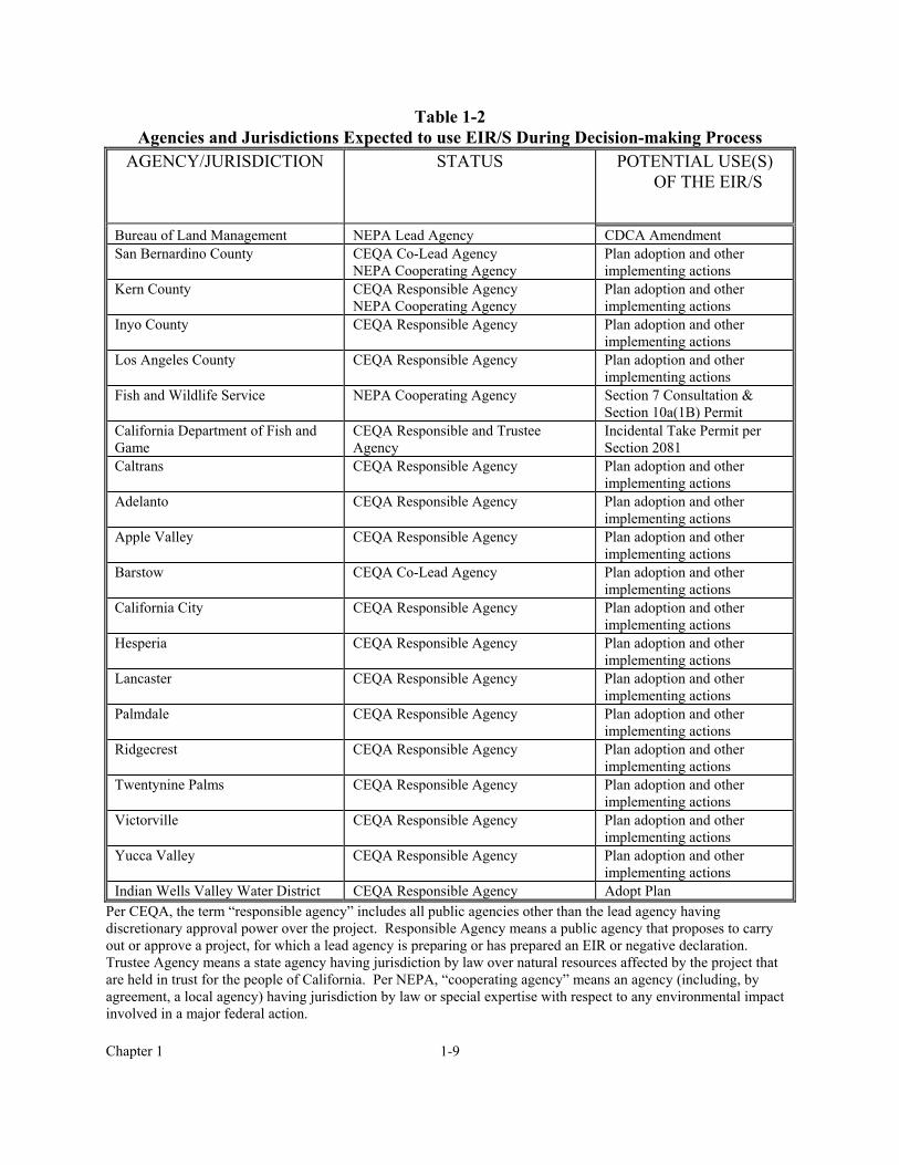
Chapter 1 1-9
Table 1-2 Agencies and Jurisdictions Expected to use EIR/S During Decision-making Process
AGENCY/JURISDICTION STATUS POTENTIAL USE(S) OF THE EIR/S
Bureau of Land Management NEPA Lead Agency CDCA Amendment San Bernardino County CEQA Co-Lead Agency
NEPA Cooperating Agency Plan adoption and other implementing actions
Kern County CEQA Responsible Agency NEPA Cooperating Agency
Plan adoption and other implementing actions
Inyo County CEQA Responsible Agency Plan adoption and other implementing actions
Los Angeles County CEQA Responsible Agency Plan adoption and other implementing actions
Fish and Wildlife Service NEPA Cooperating Agency Section 7 Consultation & Section 10a(1B) Permit
California Department of Fish and Game
CEQA Responsible and Trustee Agency
Incidental Take Permit per Section 2081
Caltrans CEQA Responsible Agency Plan adoption and other implementing actions
Adelanto CEQA Responsible Agency Plan adoption and other implementing actions
Apple Valley CEQA Responsible Agency Plan adoption and other implementing actions
Barstow CEQA Co-Lead Agency Plan adoption and other implementing actions
California City CEQA Responsible Agency Plan adoption and other implementing actions
Hesperia CEQA Responsible Agency Plan adoption and other implementing actions
Lancaster CEQA Responsible Agency Plan adoption and other implementing actions
Palmdale CEQA Responsible Agency Plan adoption and other implementing actions
Ridgecrest CEQA Responsible Agency Plan adoption and other implementing actions
Twentynine Palms CEQA Responsible Agency Plan adoption and other implementing actions
Victorville CEQA Responsible Agency Plan adoption and other implementing actions
Yucca Valley CEQA Responsible Agency Plan adoption and other implementing actions
Indian Wells Valley Water District CEQA Responsible Agency Adopt Plan Per CEQA, the term “responsible agency” includes all public agencies other than the lead agency having discretionary approval power over the project. Responsible Agency means a public agency that proposes to carry out or approve a project, for which a lead agency is preparing or has prepared an EIR or negative declaration. Trustee Agency means a state agency having jurisdiction by law over natural resources affected by the project that are held in trust for the people of California. Per NEPA, “cooperating agency” means an agency (including, by agreement, a local agency) having jurisdiction by law or special expertise with respect to any environmental impact involved in a major federal action.
Chapter 1 1-10
1.1.7 Modifications to be Found in the Final EIR/S
Responses to comments received on the Draft EIR/S are presented in Chapter 6. Many of the comments requested modifications or clarifications of either the West Mojave Plan’s conservation strategy or the environmental analysis presented in the Draft EIR/S. Where the text of the Final EIR/S differs from that presented in the Draft EIR/S, a vertical black line in the left-hand margin indicates the location of the modified or clarified text. A summary of these modifications follows. Because most of the changes consisted of minor modifications, only a selection is presented below.
• Conservation Area adjustments
o Pisgah Crater (western portion dropped, expansion to northeast) o North Edwards (some lands excluded) o Alkali Mariposa Lily (realigned to capture the Amargosa Creek drainage, increase
size and drop interim conservation areas) • Biological Transition Areas eliminated (portions added to DWMA) • New biological objectives for several species • Tortoise Survey Zones – minor modifications • Fee Zones – minor modifications • BLM DWMA Multiple Use Class M Lands changed to Class L • Revised Monitoring and Adaptive Management Table • Additional discussion of cumulative impacts • Appendix C.1 (Implementation Tasks, Costs and Priorities) Revision • Compact Disk Additions – species accounts, vegetation map, Draft EIR/S comment
letters • BLM Route Designation
o Adoption of Competitive “C” Routes Northwest of Spangler Open Area o Route Openings in Summit Range o Route closures in Fremont Kramer Tortoise DWMA to Offset “C” Routes o Selected closures in small conservation areas o Revised Juniper Subregion route network o “No Action” route network is BLM June 30, 2003 Decision Record
1.2 PURPOSE AND NEED
The West Mojave planning area is rich in biological diversity because of its varied vegetation communities and landforms and because of its location adjacent to the Transverse Ranges, the Sierra Nevada, the Colorado Desert and the Great Basin. With its proximity to the rapidly growing cities of the Los Angeles basin, the West Mojave planning area is subject to increasing demand for community development, recreation and resource utilization. One result is an increasing loss of species habitat.
Loss or degradation of species habitat along and beyond the urban interface can lead to the listing of plants and animals as threatened or endangered by the USFWS and/or the CDFG.

Chapter 1 1-11
USFWS has listed thirteen western Mojave species; CDFG has listed eleven; six are listed by both agencies (see Table 1-3). It was the listing of the desert tortoise by USFWS and CDFG in 1990 and 1989, respectively, that was the impetus for the preparation of the West Mojave Plan. Several dozen other plants and animals are at risk of listing in the next few decades, unless proactive conservation steps are taken. Table 1-3 Special Status Species Summary
CATEGORY LISTED PROPOSED OTHER TOTAL Fish 1 0 0 1 Amphibians 3 0 0 3 Reptiles 1 0 4 5 Birds 7 0 30 37 Mammals 1 0 13 14 Plants 8 0 55 63 TOTAL 21 0 102 123
Because species are interdependent, the steps necessary to conserve species cannot be taken in isolation. Species exist naturally as members of a network of varying connections to other species and their habitats. The inherent interdependence of species and ecosystems makes it difficult to protect any given plant or animal without taking into account factors that may apply to many species. Both species and natural communities must be considered.
Once a species is listed, federal agencies such as the BLM are required to ensure that declining populations recover to levels sufficient to ensure their long-term survival. Any new development project on public lands that may affect a listed species can proceed only after the agency “consults” with USFWS and receives a biological opinion finding that the project would not jeopardize the continued existence of the species in the wild. Once recovery is attained, the species can be delisted.
CESA and FESA impose special requirements on private lands as well. In most cases, persons may not take a species listed as threatened or endangered. This protection extends to the listed species’ habitat. Take is permitted, however, if a landowner obtains an incidental take permit. Such permits are required from the agency that listed the species (USFWS and/or CDFG). Obtaining these permits can be a time-consuming and expensive process. Permitting delays will only increase if unattended biological problems lead to more species being listed.
This situation has led to two unmet needs, for: (1) a regional biological strategy to conserve plant and animal species and their habitats and prevent future listings; and (2) an efficient, equitable and cost-effective process for complying with threatened and endangered species laws.
The purpose of the West Mojave Plan is to satisfy both of these needs. The Plan includes a conservation strategy which would allow state and federal land management agencies to implement their mandates under FESA and CESA to recover listed species and their habitats,
Chapter 1 1-12
and to conserve natural communities. At the same time, it proposes a streamlined program which would significantly reduce the time and expense involved in obtaining biological opinions and incidental take permits. 1.3 RELATIONSHIP BETWEEN THE WEST MOJAVE PLAN
AND THE EXPANSION OF FORT IRWIN The National Training Center at Fort Irwin provides a battlefield environment for training brigade-sized units of the United States Army. It is the Department of the Army’s premier combat training center. Due to changes in technology and tactics, the Army has sought to include additional lands within the boundaries of the installation to enable it to conduct training that meets the future combat needs of the Army. To this end, the Army has been examining possible base expansion scenarios for more than a decade.
In December 1996 the BLM, as lead federal agency due to its role as administrator of public lands likely to be included in any base expansion, published a draft Environmental Impact Statement titled “Army’s Land Acquisition Project for the National Training Center, Fort Irwin California, and Proposed Amendment to the California Desert Conservation Area Plan.” The DEIS examined several potential alternative base expansion scenarios, and was released for a 90-day public review.
In December 2001, Congress enacted the Fort Irwin Military Land Withdrawal Act. This
statute withdrew approximately 110,000 acres of public lands adjacent to Fort Irwin and transferred jurisdiction from BLM to the Army. While the purpose of the transfer was to provide the lands necessary for expanded training at Fort Irwin, the Army was precluded from using the lands for that purpose until it completed the steps necessary to comply with NEPA and the federal endangered species act. Completion of these steps will require the preparation of a supplemental draft EIS (SDEIS) and a final EIS, and a Section 7 consultation with USFWS. Fort Irwin has assumed federal lead responsibility for preparation of the base expansion SDEIS, because the critical NEPA question has become the use of these lands by Army rather than their transfer to Army. The supplemental draft EIS was published in April 2004.
The Fort Irwin Military Land Withdrawal Act requires that “the analysis [of the Fort
Irwin base expansion] shall be coordinated, to the extent practicable and appropriate, with the review of the West Mojave Coordinated Management Plan that, as of the date of the enactment of this Act, is being undertaken by the Bureau of Land Management.” Accordingly, the preparation of this final EIR/S has been coordinated with the Army’s base expansion planning team so that the information presented in each document is consistent and the potential and cumulative impacts of the projects are adequately addressed.

Chapter 1 1-13
1.4 HISTORY OF THE PLANNING PROCESS 1.4.1 Planning Issues
The issues to be addressed by the West Mojave Plan have been identified through a ten-year public involvement process that began with a first round of scoping meetings (held in January 1992), increasingly frequent Supergroup meetings, several dozen meetings of task groups established by the Supergroup between December 1999 and May 2002, a final round of NEPA scoping meetings held in June and July 2002, and most recently concluding with CEQA scoping meetings held in January and February 2003 and an opportunity to comment on the Notice of Preparation for the EIR. A summary of the most important issues is presented in Table 1-4. Table 1-4 Planning Issues ISSUE DISCUSSION Desert Tortoise Identify conservation areas and adopt conservation strategies that minimize
take on private land and recover populations on public land. Mohave Ground Squirrel Identify conservation areas and adopt conservation strategies that minimize
take on private land and recover populations on public land. Other Listed and Sensitive Species Adopt conservation strategies that minimize take on private land, recover
populations on public land, and prevent future listings of unlisted species. Streamlined Endangered Species Act Compliance
Develop a streamlined process that would allow applicants for city, county, state and federal permits and authorizations to accelerate existing costly and time-consuming permit issuance procedures.
Motorized Vehicle Access Network for Public Lands
Provide appropriate motorized vehicle access to public lands for commercial, recreational and other purposes in a manner that is compatible with species conservation.
Expansion of Fort Irwin Develop conservation strategies that will be effective even if expanded military training programs are implemented on lands transferred in 2001 to Fort Irwin.
Standards and Guidelines for Public Lands
Develop rangeland standards for managing ecosystem health and guidelines for managing domestic livestock uses.
Regional Economic Growth Promote economic growth within the planning area.
1.4.2 1992 Memorandum of Understanding
The West Mojave planning process was formally initiated in 1992 by the execution of a Memorandum of Understanding By and Between the U.S. Bureau of Land Management and the Undersigned Participating Agencies (MOU; see Appendix A). Recognizing that CESA and FESA direct the parties to “protect certain species of concern and their habitats from adverse effects resulting from public and private development and actions” and acknowledging that “the private sector cannot now be assured that project review will be timely or that mitigation, compensation, and other requirements will be consistent among the participating agencies” (MOU, page 1), the MOU identified the following “Purposes of the Plan”:
Chapter 1 1-14
1. Protection of Species of Concern: To conserve and protect species of concern and the ecosystem on which they depend within the western Mojave Desert.
2. Provide Equity in Regulation: To provide a comprehensive means to coordinate and standardize mitigation and compensation requirements so that public and private actions will be regulated equally and consistently, reducing delays, expenses, and regulatory duplication. It is intended that the Plan will eliminate uncertainty in developing private projects and will prescribe a system to ensure that the costs of compensation/mitigation are applied equitably to all agencies and parties.
3. Reduce Cumulative Impacts: To prescribe mitigation measures for private development and agency actions to lessen or avoid cumulative impacts to the species of concern and eliminate, whenever possible, case-by-case review of impacts of projects when consistent with the mitigation and compensation requirements prescribed by the Plan. [MOU, page 2]
The MOU provided that the Plan “will function as the Habitat Conservation Plan for the
[incidental take] permit applications” by participating local governments. 1.4.3 1997 Equitable Precepts
In mid-1997 the participating agencies, led by the BLM, restructured the planning process to ensure (1) greater public participation in developing a conservation strategy that would meet the needs of the participants, and (2) collection and use of the best science reasonably available, including recent field surveys. As a first step in this restructuring, on September 10, 1997, the West Mojave Supergroup adopted Equitable Precepts to guide the preparation of the West Mojave Plan. These consisted of the Mission Statement and Principles set forth below:
Mission Statement
The West Mojave Plan will provide an improved and streamlined process which minimizes the need for individual consultations with the United States Fish and Wildlife Service (USFWS) and the California Department of Fish and Game (CDFG) while providing better science for species conservation. The [West Mojave] Plan will allow projects to be approved and signed-off rapidly. Project proponents will know the mitigation measures that will be required of them before the project is presented to the local government or, in the case of public land, presented to the state or federal agency.
Principles
1. The ultimate goal of the [West Mojave] Plan will be based on specified measures to
enable project proponents to comply with the requirements of CESA and FESA.
2. The [West Mojave] Plan will be equitable, predictable and compatible with local, state and federal agency permitting procedures so as to be easily administered.
3. The mitigation strategy will be responsive to the needs and unique characteristics of the
many diverse industries and activities in the program area on both public and private land while allowing compatible growth.
4. Project proponents shall have a choice of utilizing the conservation program or working

Chapter 1 1-15
directly with the CDFG or USFWS to address Endangered Species Act compliance.
5. The [West Mojave] Plan will incorporate realistic fiscal considerations, with identified sources, i.e. federal, state, local, public and private.
6. The [West Mojave] Plan will ensure that no one group of desert users will be singled out
to disproportionately bear the burden of the [West Mojave] Plan implementation.
7. The [West Mojave] Plan will have the flexibility to respond to future legislative, regulatory and judicial requirements.
1.4.4 Data Base
The West Mojave Plan is based upon the best science reasonably available. To meet this standard, data were reviewed to identify pertinent life history information, assess threats to covered species, and provide the most appropriate management prescriptions to address those threats. Where existing information was considered incomplete, species experts were consulted to fill in the data gaps. The planning team consulted 8 botanists, 13 ornithologists, 3 mammalogists, and 4 herpetologists to ensure that data for those taxa were the most complete and accurate information available. For the desert tortoise, this meant collecting and digitizing existing transect data and performing new surveys over approximately 3,615 square miles that had not been recently surveyed. Previous planning for Mohave ground squirrel conservation (Remple 1991, Clark 1993) and recent studies (Leitner and Leitner 1989, 1990, 1996a, 1996b; Leitner et al. 1995, 1997) were important for designing reserves and determining appropriate management prescriptions. New field surveys were conducted in the spring of 2001 for sensitive birds and plants.1
Biological data for the Plan were obtained from a variety of sources. The data were compiled, analyzed, and stored to support various components of the Plan preparation and implementation process. The sources of data include known location information for covered species and habitats. These data were complied from various sources, including the following:
• California Natural Diversity Data Base (NDDB) records. Data from the NDDB were from 1999 and have been updated periodically since then.
• CDFG, BLM, Army and USFWS data. • Data collected from biologists knowledgeable about the plan area and/or a given species.
This included records from consultants and non-profit organizations (e.g. California Native Plant Society, Point Reyes Bird Observatory, Mojave Desert Bird Club).
• Data from individual biologists obtained during planning meetings. • Location data from voucher specimens held in museums and herbaria. • Published records and species distribution information from peer-reviewed journal
articles, where information on species has been described at an appropriate scale. • Presence-absence tortoise survey data resulting from studies required by county and local
government since the 1990 listing. 1 See Chapter 3 for a more detailed discussion of these data.

Chapter 1 1-16
Dr. William Boarman prepared a survey of the threats adversely affecting the desert tortoise for the West Mojave planning effort. This was the peer-reviewed Threats to the Desert Tortoise: A Critical Review of the Scientific Literature (attached as Appendix J). Dr. Boarman’s threats analysis was instrumental in identifying potential conservation measures to address each known threat adversely affecting the tortoise.
Species Accounts: For each plant or animal addressed by the Plan, a Species Account was prepared. A wildlife biologist or botanist possessing recognized expertise concerning the species in question authored each of these documents. The accounts described the general status, habitat, life history, distribution, biological goals, and threats faced by each species, as well as a detailed bibliography. All species accounts were peer reviewed. GIS maps were created for each species showing known occurrences and general distribution, and all cited papers and reports were obtained and copies filed.
Current Management Situation: In March 1999, a report was published detailing the Current Management Situation of Special Status Species in the West Mojave Planning Area (CMS). This report identified existing policies and management actions being applied by each of the participating agencies with respect to each of the species being addressed by the Plan.
Geographic Information System Database: A digital library of over 300 geographic data layers was assembled, displaying biological, political, topographic and other critical planning information.
Motorized Vehicle Access Network Field Survey: Between September 2001 and March 2002, thirteen field crews inventoried nearly 8,000 miles of motorized vehicle access routes within the western Mojave Desert. Both four wheel drive and motorcycle crews participated in the survey. Routes were recorded using global positioning system technology. The nature of the route (graded gravel, good dirt, motorcycle trail) was recorded, and nearly two-dozen types of pertinent desert features mapped (including campsites, mines, trailheads, and water sources). This information was transferred into the planning team’s digital GIS library. In addition, data collected by BLM field survey crews in 1985 and 1987, and during the preparation of BLM management plans for areas of critical environmental concern between 1980 and the late 1990s, was digitized and stored in the GIS database. This data was supplemented by data digitally collected from aerial photography taken in 1995 and 1996, and covering most public lands within the planning area. In response the many comments on the Juniper subregion, an inventory of existing routes of travel was performed in October 2003. Using this new database, comment clarification letters and comments at three meetings held to discuss this subregion, BLM revised the route designations in the Juniper subregion to provide a more accurate and effective transportation network.
Development of the List of Species Addressed by the Plan: The list of species to be addressed by the Plan was based on wildlife agency compilations of threatened, endangered, vulnerable, and declining species. Species addressed by the plan include both those for which

Chapter 1 1-17
private land incidental take permit coverage would be sought (“covered species”), and those for which a public land conservation strategy would be adopted and implemented by the BLM through its California Desert Conservation Area Plan.
Criteria for inclusion on the list included the following:
• Species listed as threatened or endangered by the state and federal governments. • Species proposed for listing by the federal government. • Species designated as candidates for listing by the state and federal government. • “Species of Special Concern” on the Department’s “Special Animals” list. • Plants included on the Department’s “Special Plants” list. • Plants and animals on the BLM “sensitive species” list. • Plants included on List 1B or List 2 of the California Native Plant Society’s Inventory of
Rare and Endangered Plants of California.
The Supergroup approved the list of 98 plant and animal species to be addressed by the Plan in 1996. The USGS then contracted with experts on each species, who prepared the species accounts for use in development of the Plan.
On May 5, 1997 and April 3, 1998, local botanists submitted a list of plants and animals
seen at Middle Knob and in surrounding areas. These records were examined, and those species found within the West Mojave Plan area were included. On September 1 1998, the California Native Plan Society submitted a list of fourteen rare plants within the West Mojave and requested their addition to the Plan list. This list was reviewed and species with sufficient information were added to the list of species to be addressed by the West Mojave Plan. The Current Management Situation of Special Status Species in the West Mojave Planning Area was published March 31, 1999. This document detailed existing conservation measures in place for each jurisdiction for each of the original 98 species.
Using the species accounts and the Current Management Situation, West Mojave Plan biologists met with the wildlife agencies to prepare an evaluation. The evaluation team reviewed all species on the Supergroup list along with the proposed additions. Fifty-eight species were dropped from the list and were not further addressed by the Plan because of insufficient data, because they were being separately addressed by other Habitat Conservation Plans and Biological Opinions already in place or underway, because they were too common, or for other reasons. The Evaluation Report of September 22, 1998 discussed the reasons for retention or deletion of species from the covered species list.
Changes were made in the federal, state and CNPS lists between 1998 and now. The
Inventory of Rare and Endangered Plans of California was revised in August 2001, and plants that were added to List 1B and List 2 were added to the West Mojave list if sufficient information was available to prepare conservation plans. Plants that were deleted from the earlier edition were deleted from the West Mojave list. Similarly, CDFG’s list of “Special Animals” changed over time, and these changes were incorporated into the West Mojave list.

Chapter 1 1-18
The final list of species was completed on June 26, 2002. This list was provided to members of the Task Groups and Supergroup and all interested stakeholders. As this list was reviewed by the local jurisdictions, a few additional changes were made, such as deletion of Kelso Creek monkeyflower, mountain plover and Bendire’s thrasher from the request for incidental take coverage.
In response to comments on the West Mojave Plan, other species were deleted from the
request for incidental take coverage. Concerns expressed by CDFG resulted in deletion of nine species because of insufficient information or for other reasons. These are bighorn sheep, spotted bat, pallid bat, long-legged myotis, Western mastiff bat, golden eagle, Panamint alligator lizard, Reveal’s buckwheat, and flax-like monardella.
The Plan now lists 49 species as covered species proposed for receipt of incidental take
permits under the Section 10(a) and 2081 permits. Wildlife agency review of this document and the Implementing Agreement may result in the exclusion of other species from permit coverage. The list of all species addressed by the Plan, along with the scientific names, is included as Appendix Y. 1.4.5 Biological Evaluation
Following the assembly of the database, a “Biological Evaluation” was conducted in a series of meetings between March 1998 and June 2000. Participants included biologists from the West Mojave planning team, USFWS, CDFG and invited experts. Biologists evaluated the effectiveness of current management, identified management shortfalls, and suggested measures to address those shortfalls. Evaluation meetings were structured around the following seven questions:
• How important is the planning area to the species as a whole? • Does the planning area contain essential habitat for the species to complete its life
history? • Why was the species placed on the special status list? What is the concern? • Is current management adequate to protect the species? • Is the geographical size and location of conservation areas adequate to protect the
species? If not, what additional areas need to be committed to assure protection of the species?
• Is the management of proposed conservation areas adequate to protect the species? If not, what management improvements could be implemented to assure protection of the species within the target conservation areas?
• Is management of lands outside conservation areas adequate to protect the species? If not, what management improvements could be implemented to assure protection of the species outside conservation areas?
An Evaluation Report addressing the Desert Tortoise, mammals, birds, fish, reptiles and
amphibians was published on September 22, 1999 and distributed to the Supergroup. A Mohave

Chapter 1 1-19
ground squirrel Evaluation Report was completed and distributed on September 14, 2000. Finally, an Evaluation Report addressing rare plants was completed and distributed on October 15, 2001. 1.4.6 Task Groups Develop the Conservation Strategy
In November 1999, the West Mojave Supergroup established four task groups to develop components of the West Mojave Plan. Task group members were not appointed; rather, any organization or individual could attend and participate in a task group meeting. All meetings were open to the public and, at one time or another, a representative of nearly every Supergroup entity attended a task group session. Task groups were not established to make decisions for the participating agencies and jurisdictions, nor were they intended to function as formal appointed advisory bodies. Rather, the task groups provided an informal public forum to allow collaborative interagency and stakeholder planning and information gathering, as an extension of public scoping efforts. These Task Groups included:
• Task Group 1, Conservation Strategy • Task Group 2, Motorized Vehicle Access Network • Task Group 3, Regulatory Issues • Task Group 4, Plan Implementation
A 14-member Steering Committee was established by the Supergroup to resolve deadlocks and provide guidance to the task groups. Task groups met 47 times between December 1999 and May 2002. On two occasions task groups deadlocked on issues. Six meetings of the Steering Committee successfully resolved these deadlocks.
Numerous issues were too complex or controversial to resolve at a single task group meeting. In such cases, subcommittees composed of volunteers were asked to discuss the issue and return with a proposed solution at the following task group meeting. Task Group 1 formed over a dozen subcommittees that dealt with issues as diverse as the expensive tortoise fencing program, desert recreation, mitigation fees and compensation structure, and “best management practices” to apply as standard take-avoidance measures. To assist Task Group 2 and the route designation process, two subcommittees were formed: a field survey advisory group and a route designation technical committee. A subcommittee might meet once or, once established, be recalled on numerous occasions to address difficult issues. Over 50 subcommittee meetings were held in addition to task group meetings.
As the task group process evolved, certain issues would emerge that would result in considerable public interest or controversy, including the design of the motorized vehicle access network and the role of equestrians in desert planning. When this occurred, public information meetings were held throughout the desert on an irregular basis. About a dozen of these meetings, attended by up to 250 persons, were held during the task group process. Many persons who first became involved through these meetings later joined one or another of the task groups.

Chapter 1 1-20
1.4.7 Public Review of DEIR/S A Draft EIR/S was released for a 90-day public review that began on June 13, 2003 and ended on September 12, 2003. Public hearings were held in Victorville (July 15, 2003), Lone Pine (July 16, 2003), Ridgecrest (July 17, 2003), Redlands (July 22, 2003), Yucca Valley (July 23, 2003), Palmdale (July 24, 2003) and Barstow (July 30, 2003). Responses to written and oral comments received from the public are presented in Chapter 6 of this Final EIR/S. Chapters 1 through 5, as well as the appendices, include changes made in response to those comments. 1.5 NECESSARY DECISIONS AND APPROVALS 1.5.1 Agency and Jurisdiction Decisions and Approvals
Bureau of Land Management Implementation of the West Mojave Plan on public lands would require approval of the Plan by the BLM’s California State Director through a Record of Decision (ROD). This approval process would include the amendment of the CDCA Plan to ensure consistency with the provisions of the West Mojave Plan. By executing the ROD, BLM will adopt both the West Mojave Plan and any necessary CDCA Plan amendments. The amendments that would be necessary to implement each alternative are listed in Chapter 2, beginning with Section 2.2.10, the amendments associated with Alternative A.
The West Mojave Plan Record of Decision would also amend 25 existing Area of Critical
Environmental Concern (ACEC) management plans, and would serve as the ACEC management plan for 14 newly-designated ACECs. These new and revised ACEC management plans may be found in Appendix D. The BLM Record of Decision will be issued after the final environmental impact report and statement is published, and after any protests are submitted and resolved.
Cities and Counties: Adoption of the West Mojave Plan by cities and counties would not require amendments to local jurisdiction general plan land use elements. Modifications of city and county conservation elements may occur, however, to provide reference to the West Mojave Plan and associated conservation strategies. Certain jurisdictions may also amend their zoning and development ordinances to provide consistency with the HCP’s conservation strategies. Local jurisdictions adopting the West Mojave Plan would need to adopt a fee ordinance in order to implement the mitigation fee described in Chapter 2.
Measures applicable to each jurisdiction are identified in Appendix B.
United States Fish and Wildlife Service: For the West Mojave Plan’s streamlined
FESA compliance procedures to be implemented, USFWS would have to issue an incidental take permit under Section 10(a) of FESA to the participating cities and counties, and to Caltrans. This could include the issuance of “no surprises” assurances for unlisted species. A biological
Chapter 1 1-21
opinion prepared pursuant to Section 7 of FESA would have to be issued to the BLM and any other participating federal agencies.
California Department of Fish and Game: CDFG would issue an incidental take permit under Section 2081 of CESA to the participating cities, counties and Caltrans. 1.5.2 Relationship to Statutes, Regulations and Policies All decisions and approvals would be consistent with applicable federal and California statutes, regulations and policies, including but not limited to the following:
• Federal Endangered Species Act • California Endangered Species Act • National Environmental Policy Act • California Environmental Quality Act • California Fish and Game Code • California Planning Statutes • Federal Land Policy and Management Act • National Historic Preservation Act • California Desert Protection Act • Clean Water Act • Clean Air Act • Wilderness Act • Taylor Grazing Act • Sikes Act • Mining and Minerals Policy, and National Materials and Minerals Research and
Development Acts • Mining, Mineral Leasing, Material Disposal and Reclamation Acts • Federal Executive Orders and Congressional Mandates
This plan recognizes that unforeseen national security measures may require immediate
compliance by utilities to operate or construct features designed to secure and protect energy and communication systems. Should the Department of Homeland Security, Federal Energy Commission, California Energy Commission or California Public Utility Commission proclaim the necessity of such measures, utilities will be allowed to implement said measures. Appropriate mitigation and plan compliance shall be sought “after the fact.” Where variance to the Plan is required, parties shall negotiate to accomplish the spirit of the Plan. 1.5.3 Relationship to Other Regional Plans
Southern California and southern Nevada are the sites of a number of important regional planning efforts, many of which are addressing the same issues that are being considered by the West Mojave Plan (see Map 1-2). These include regional habitat conservation plans, natural community conservation plans and federal land use plans and amendments. In fact, most of the

Chapter 1 1-22
land surface between Las Vegas, Nevada and San Diego, California lies within the scope of an ecosystem-planning program.
The following is a brief summary of major planning efforts being undertaken
immediately adjacent to or within the West Mojave planning area. Coachella Valley Multiple Species Habitat Conservation Plan (CVMSHCP): The lead for this plan is the Coachella Valley Association of Governments. The planning area includes most of the urban and urbanizing area of the Coachella Valley as well as the Santa Rosa Mountains, and portions of Joshua Tree National Park, all within Riverside County. This MSHCP lies adjacent to and southeast of the West Mojave planning area. The plan addresses issues of urbanization on private and state lands. As part of this planning effort, BLM has prepared a separate CDCA plan amendment applicable to federal lands within the Coachella Valley plan area. Both CVMSHCP and the West Mojave Plan are developing conservation strategies for species whose range overlaps both planning areas. These include the management of the Little San Bernardino Mountains gilia, the triple-ribbed milkvetch, the Whitewater and Big Morongo Canyon ACECs and, to a minor degree, the desert tortoise. A Record of Decision for the BLM Coachella Valley CDCA Plan Amendments was signed in December 2002. Northern and Eastern Mojave Plan (NEMO): The BLM’s NEMO plan addressed recovery of the desert tortoise and management of a few additional species of concern on public lands. NEMO addressed only BLM programs, and only the BLM’s CDCA Plan was amended; private lands and other federal agencies were not affected. The NEMO planning area lies to the northeast of the western Mojave Desert, in the area that generally lies between Death Valley National Park and the Mojave National Preserve. The most important cross-boundary issues that affect both NEMO and West Mojave involve the management of a small Mojave ground squirrel population northeast of Trona, and ensuring that CDCA Plan Amendments are consistent. A Record of Decision for NEMO was signed in December 2002.
Northern and Eastern Colorado Plan (NECO): The NECO plan, like NEMO, primarily concerned the management of BLM lands located to the east and southeast of the West Mojave planning area, although a broader-based planning program was conducted in collaboration with the Marine Corps, the National Park Service and local governments. NECO’s decisions affected federal lands only. The most important cross-boundary issues that affect both NEMO and West Mojave involve the management of the Mojave fringe toed lizard (two thirds of the known range lies within the West Mojave, and one third within NECO), as well as ensuring that CDCA Plan Amendments are consistent. A Record of Decision for NECO was signed in December 2002.
Southern California Province Forest Plan: This plan is being prepared by four National Forests located in Southern California, including the Angelus and San Bernardino National Forests, which are adjacent to and south of the West Mojave planning area. Decisions reached by the Southern California Province Plan will affect National Forest lands only. The most important cross-boundary issues that affect both the Forest Service planning efforts and the West Mojave Plan involve the implementation of the Carbonate Habitat Management Strategy;
Chapter 1 1-23
developing conservation programs for the San Diego horned lizard, the short-joint beavertail cactus, the gray vireo and the arroyo toad; and the coordination of motorized vehicle access networks. Military Integrated Resource Management Plans (INRMPs): Each of the five military bases located within the West Mojave planning area has prepared, or is preparing, an INRMP to guide the management of natural resources on each base. The INRMPs affect military lands only. The most important cross-boundary issues that affect both the West Mojave Plan and INRMPs follow: (1) For Edwards Air Force Base, management of the desert tortoise, Mohave ground squirrel, alkali mariposa lily, desert cymopterus and Barstow woolly sunflower; (2) for China Lake Naval Air Weapons Station, the management of the desert tortoise, Mohave ground squirrel, Townsend’s big-eared bat, bighorn sheep, and Inyo California towhee; (3) for Fort Irwin, management of desert tortoise and the Lane Mountain milkvetch; (4) for the Marine Corps Air Ground Combat Center at Twentynine Palms, the management of the desert tortoise, California leaf-nosed bat, bighorn sheep, Mojave fringe-toed lizard and white-margined beardtongue; and (5) for the Marine Corps Logistics Base near Barstow, the management of the desert tortoise.