welcome to the open house - culturalcapital.surrey.ca filegrandview heights neighbourhood concept...
TRANSCRIPT
Grandview Heights Neighbourhood Concept Plan Area #3
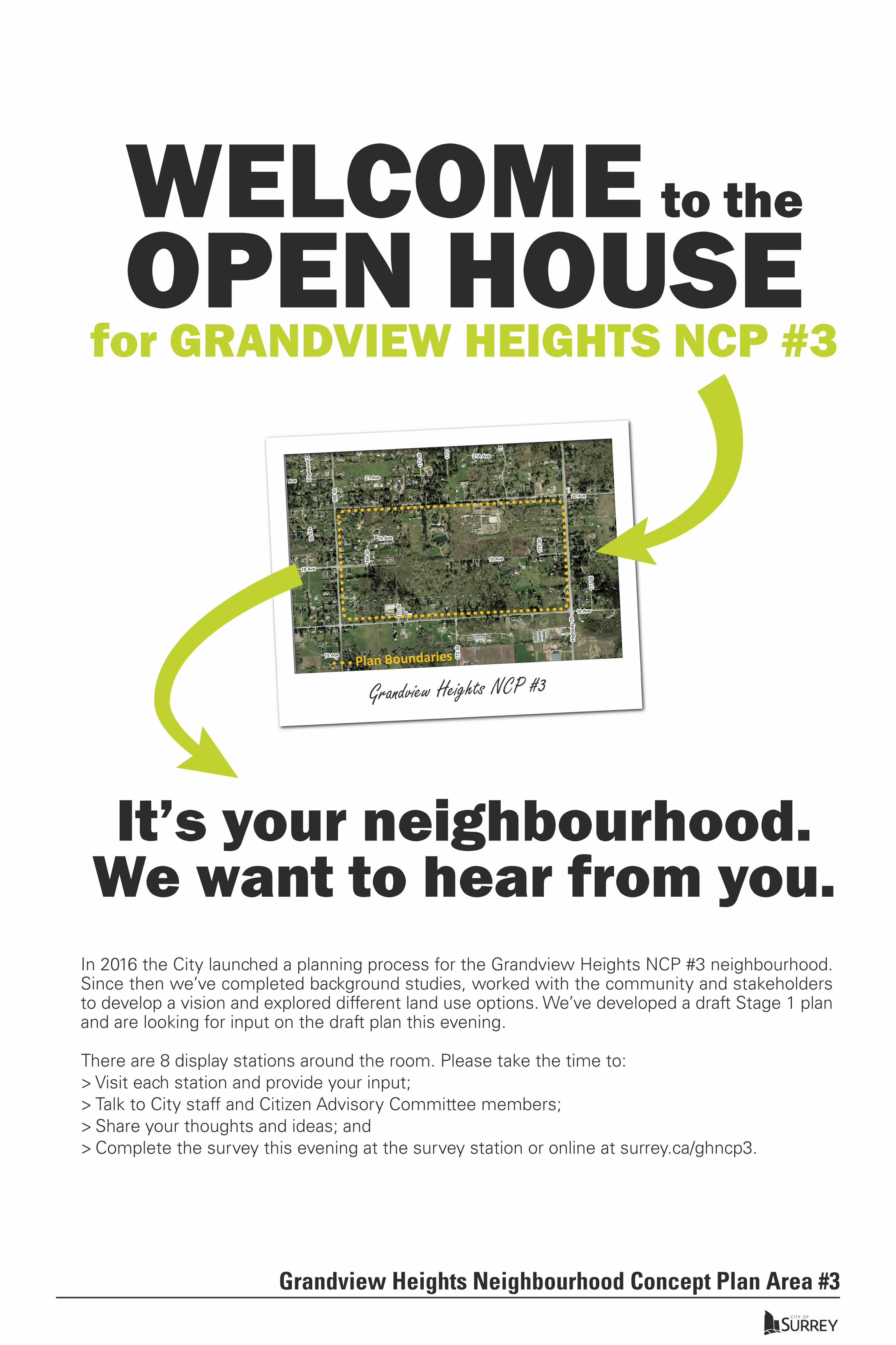
In 2016 the City launched a planning process for the Grandview Heights NCP #3 neighbourhood. Since then we’ve completed background studies, worked with the community and stakeholders to develop a vision and explored different land use options. We’ve developed a draft Stage 1 plan and are looking for input on the draft plan this evening.
21 Ave
22 Ave
167 St
15 Ave
21 Ave
171
St16
9 S
t
22 Ave21A Ave
172
St
Edge
woo
d D
r167
St
16 Ave
20 Ave
168
St
Hig
hway
15
18 Ave
14 Ave
174
St
166
St
177
St
169
St
19 Ave
170
St
175
St
18 Ave
172
St
´Grandview Heights NCP #3
100MetersScale
LegendGrandview Heights NCP #3
Plan Boundaries
It’s your neighbourhood. We want to hear from you.
WELCOME to the
OPEN HOUSE for GRANDVIEW HEIGHTS NCP #3
There are 8 display stations around the room. Please take the time to: > Visit each station and provide your input;> Talk to City staff and Citizen Advisory Committee members;> Share your thoughts and ideas; and> Complete the survey this evening at the survey station or online at surrey.ca/ghncp3.
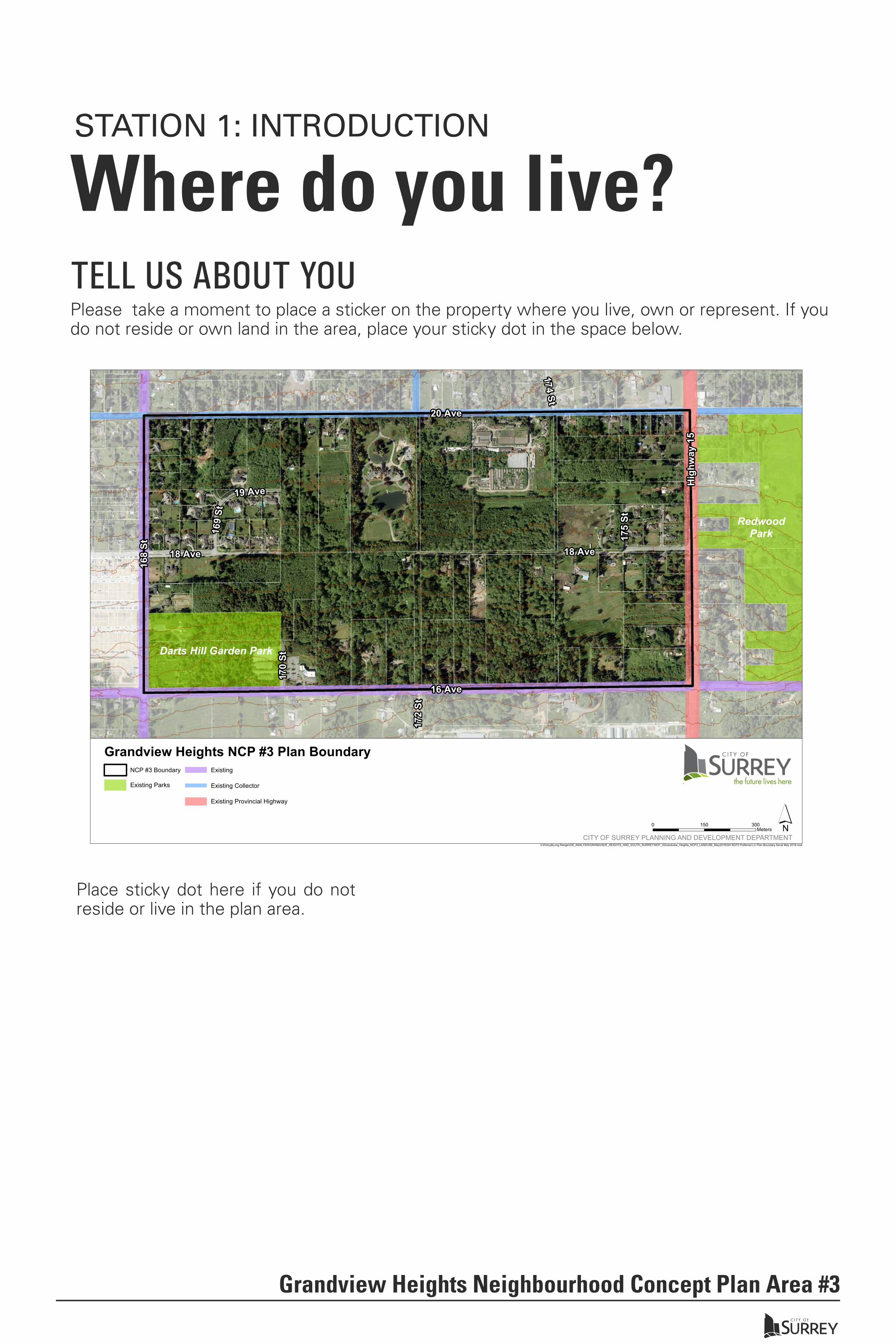
TELL US ABOUT YOU
STATION 1: INTRODUCTION
Grandview Heights Neighbourhood Concept Plan Area #3
Darts Hill Garden Park
RedwoodPark16
9 St
Hig
hway
15
174 St
175
St
168
St
172
St
18 Ave
170
St
16 Ave
19 Ave
18 Ave
20 Ave
V:\Policy&Long Range\GIS_ANALYSIS\GRANDVIEW_HEIGHTS_AND_SOUTH_SURREY\NCP_3\Grandview_Heights_NCP3_LANDUSE_May2018\GH NCP3 Preferred LU Plan Boundary Aerial May 2018.mxd
NCP #3 Boundary
Existing Parks
Existing
Existing Collector
Existing Provincial Highway
Grandview Heights NCP #3 Plan Boundary
0 300150Meters
CITY OF SURREY PLANNING AND DEVELOPMENT DEPARTMENT́
Where do you live?Please take a moment to place a sticker on the property where you live, own or represent. If you do not reside or own land in the area, place your sticky dot in the space below.
Place sticky dot here if you do not reside or live in the plan area.

WHAT’S BEEN DONE SO FAR?
HOW CAN I HELP SHAPE THE PLAN?
This new neighbhourhood plan will support the City’s Official Community Plan vision of a greener, more compact and connected city that is safer, healthier, more inclusive and vibrant.
The draft plan includes the protection of creeks and environmentally sensitive areas, the creation of new parks, residential neighbourhoods, roads, pathways, a school, commercial areas and mixed use developments. The purpose of the plan is to:
The City wants your feedback. Provide your input during the Open House and by completing the survey at surrey.ca/surveys. This input will help inform the creation of a Neighbourhood Concept Plan for the area. You can also contact staff for more information.
A�end Open Houses
- Share your ideas and input.
Stage 1 Stage 2
Winter 2016 - Spring 2017 Summer 2018 Spring 2017 - Winter 2017 Fall 2018 - Fall 2019
Purpose of the Plan
Contact UsYou can email us informa�on at [email protected] and stay updated by regularly visi�ng the website surrey.ca/ghncp3
STATION 1: INTRODUCTION
Grandview Heights Neighbourhood Concept Plan Area #3
• Guide future development of the neighbourhood; and• Advance the planning principles related to green spaces, habitat protection, housing
choice, mobility, quality of life, and more.
Conduct background studies
Develop vision and principles
Explore land use options Develop servicing and financing plansFine tune land use map as neededDraft plan document
Identify preferred plan featuresDevelop draft land use mapBring draft land use map forward to Council for consideration and approval
Ge�ngStarted
Exploring Op�ons
Developingthe Plan
Refining the Plan
Complete SurveyGo online and complete the survey. Encourage your neighbours to complete it as well. surrey.ca/surveys
We are here

NCP Area #3 and #2 (Sunnyside Heights) are adjacent and share sewer and drainage infrastructure. From a servicing and financing perspective, Area #3 is the natural next step in servicing the Grandview Heights area.
NCP Area #3 is bounded by 16 Avenue and 20 Avenue, and 168 Street and 176 Street. It abuts the Agricultural Land Reserve to the south of 16 Avenue and 176 Street to the East.
The NCP area covers 121 Hectares (approximately 300 acres) of land and consists of approximately 75 properties except the City-owned Darts Hill Garden Park properties.
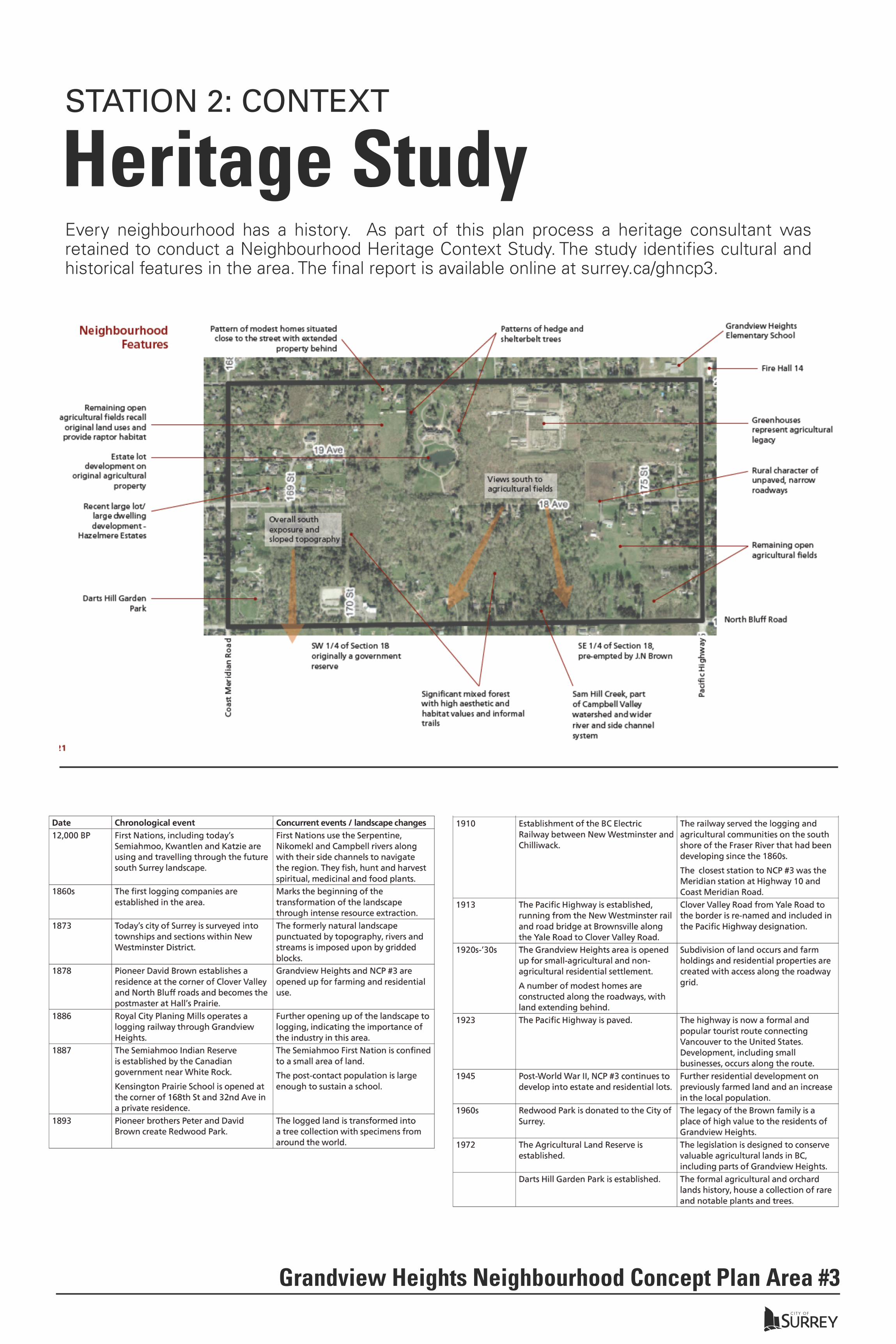
STATION 2: CONTEXT
Grandview Heights Neighbourhood Concept Plan Area #3
Darts Hill Garden Park
ALR ALR
RedwoodPark16
9 St
Hig
hway
15
174 St
175
St
168
St
172
St
18 Ave
170
St
16 Ave
19 Ave
18 Ave
20 Ave
Upp
erSa
mH
illC
rk
Sam
Hill Crk
Sam Hill Crk
Sa mH
illC
rk
Upper Sam H illCrk
V:\Policy&Long Range\GIS_ANALYSIS\GRANDVIEW_HEIGHTS_AND_SOUTH_SURREY\NCP_3\Grandview_Heights_NCP3_LANDUSE_May2018\GH NCP3 Preferred LU Plan Boundary Context Aerial May 2018.mxd
NCP #3 Boundary
Existing Parks
Agricultural Land Reserve
A Fish Classifications
AO Fish Classifications
B Fish Classifications
C Fish Classifications
Existing Arterial
Existing Collector
Existing Provincial Highway
Grandview Heights NCP #3 Plan Boundary Context
0 300150Meters
CITY OF SURREY PLANNING AND DEVELOPMENT DEPARTMENT́
GRANDVIEW HEIGHTS GENERAL LAND USE PLAN
NCP Area ContextIn 2005, Surrey City Council approved the Grandview Heights General Land Use Plan (GLUP). It provides the framework for more detailed planning processes for neighbhourhood plans, such as Grandview Heights NCP Area #3.

STATION 2: CONTEXT
Environmental StudyEnvironmental Study FindingsThe City of Surrey retained Associated Engineering Consulting Ltd. to complete an Integrated Stormwater Management Plan (Stage 1 ISMP) and Environmental Study. The final report is available online at surrey.ca/gh3ncp. The study findings provide context and environmental analysis for the plan, including:
• Watercourse classifications and recommended setbacks;
• Vegetation and wildlife analysis (including species at risk (SAR);
• Terrestrial Ecosystem Mapping (TEM) with rankings of vegetation values and significant trees;
• Wildlife habitat suitability mapping;
• Mapping of soils and terrain; and
• Conservation recommendations and enhancement opportunities for a wildlife corridor.
Grandview Heights Neighbourhood Concept Plan Area #3
Steep Slopes Water Course Classifications
Wildlife Corridor Habitat Analysis Vegetation Analysis

Grandview Heights Neighbourhood Concept Plan Area #3
STATION 2: CONTEXT
Existing Parks & Watercourses
CITY OF SURREY WATERCOURSE CLASSIFICATION SYSTEMSClassification Symbol Setback Description
Darts Hill Garden Park
169
St
18 Ave
16 Ave
18 Ave
20 Ave
175
St
168
St
170
St
174 St
172
St
19 Ave
Hig
hway
15
Upp
erS
amH
illC
rk
SamHill Crk
Sam
Hill
Crk
Sam Hill Crk
Sa mH
illC
rk
Upper Sam H illCrk
·0 300150Meters
V:\Policy&Long Range\GIS_ANALYSIS\GRANDVIEW_HEIGHTS_AND_SOUTH_SURREY\NCP_3\Public Open House Maps\GH3 Green Infrastructure Areas.mxd
Legend
NCP #3 Boundary
AO Fish Classifications
B Fish Classifications
C Fish Classifications
Existing Park
Riparian Area
Grandview Heights NCP #3 Green Infrastructure AreasCITY OF SURREY PLANNING AND DEVELOPMENT DEPARTMENT FOR COMMENT
*Setbacks are from top-of-bank. Setbacks are based on the City’s Streamside Protection setbacks within the Zoning Bylaw (Section 7A), and Sensitive Ecosystem - Riparian Development Permit Area (DPA).
Grandview Heights Neighbourhood Concept Plan Area #3
STATION 2: CONTEXT
Heritage StudyEvery neighbourhood has a history. As part of this plan process a heritage consultant was retained to conduct a Neighbourhood Heritage Context Study. The study identifies cultural and historical features in the area. The final report is available online at surrey.ca/ghncp3.

TOP 3 PRIORITIES
SCHOOL
Community Amenities &
Schools
Healthy, Protected & Maintained Ecosystems
Recreation & Park
Opportunities
56% Several small parks
44% 1-2 large parks
19 people participated in the first survey and 464 in the second.
Highway oriented - 8%Neighbourhood - 46%
Mixed use - 37%None/other - 10%
FUTURE COMMERCIAL?
Detached Single Family
Semi-Detached Townhouse Apartment
37% 24% 21% 19%
WHAT TYPES OF HOUSING? HAZELMERE ESTATES
WHAT TYPE OF PARKS?
As part of the NCP planning process, the future redevelopment of Hazelmere Estates is being explored. Participants were asked what type of development they felt was appropriate.
26% 22% 45% 7%
Stage 1 Stage 2
We are here!
the future lives here.
TOP 3 THINGS PEOPLEWANT TO SEEAt the start of the NCP process participants were asked to identify the top 3 things they hoped to see as part of this NCP.
1. Provide appropriate housing/densities2. Consider changing transportation needs3. Develop new parks, natural spaces and trail systems
Participants preferred the idea of creating several park sites over the plan area, rather than creating one or two large parks.
Participants were asked to select the form of commercial development they felt most suited the future community.
Participants were asked to select the proportion of each type of residential building they would like to see in the overall community once it’s developed.
Participants were asked to rank the nine planning priorities developed with the Citizen Advisory Committee.
NEW HABITAT CORRIDORThe City’s Biodiversity Conservation Strategy identified the need for an east-west wildlife corridor connecting Darts Hill and Redwood Park. Survey participants preferred a central habitat corridor.
OtherAllUrban
PartUrban
StatusQuo
Grandview Heights NCP #3 NCP Planning Process
WHO PARTICIPATED90 people attended the first open house and115 attended the second.
This is what WE HEARD Grandview Heights NCP #3Work on a new neighbourhood concept plan (NCP) for Grandview Heights #3 area began in the Summer of 2016 with preparation, background studies and preliminary consultation. Throughout the process, we’ve been looking to the community to generate ideas and explore possibilities for this new neighbourhood. As part of the consultation we held two open houses (November 23, 2016 and November 27, 2017) and conducted two surveys. The following is an overview of what we’ve heard so far.
What We’ve Heard Work on a new neighbourhood plan for Grandview Heights NCP #3 began in the summer of 2016. We started with background studies and formation of a Citizen Advisory Committee (CAC). We also met with Hazelmere Estates area residents to discuss long term plans for the suburban estate area.
Throughout the process, we’ve been looking to the community to generate ideas and explore possibilities for this neighbourhood. As part of the consultation we held two open houses and conducted two surveys. The community input from these engagement processes influenced the land use concept options that were developed and reviewed previously and played a role in the draft plan being presented today.
Grandview Heights Neighbourhood Concept Plan Area #3
STATION 3: WHAT WE HEARD
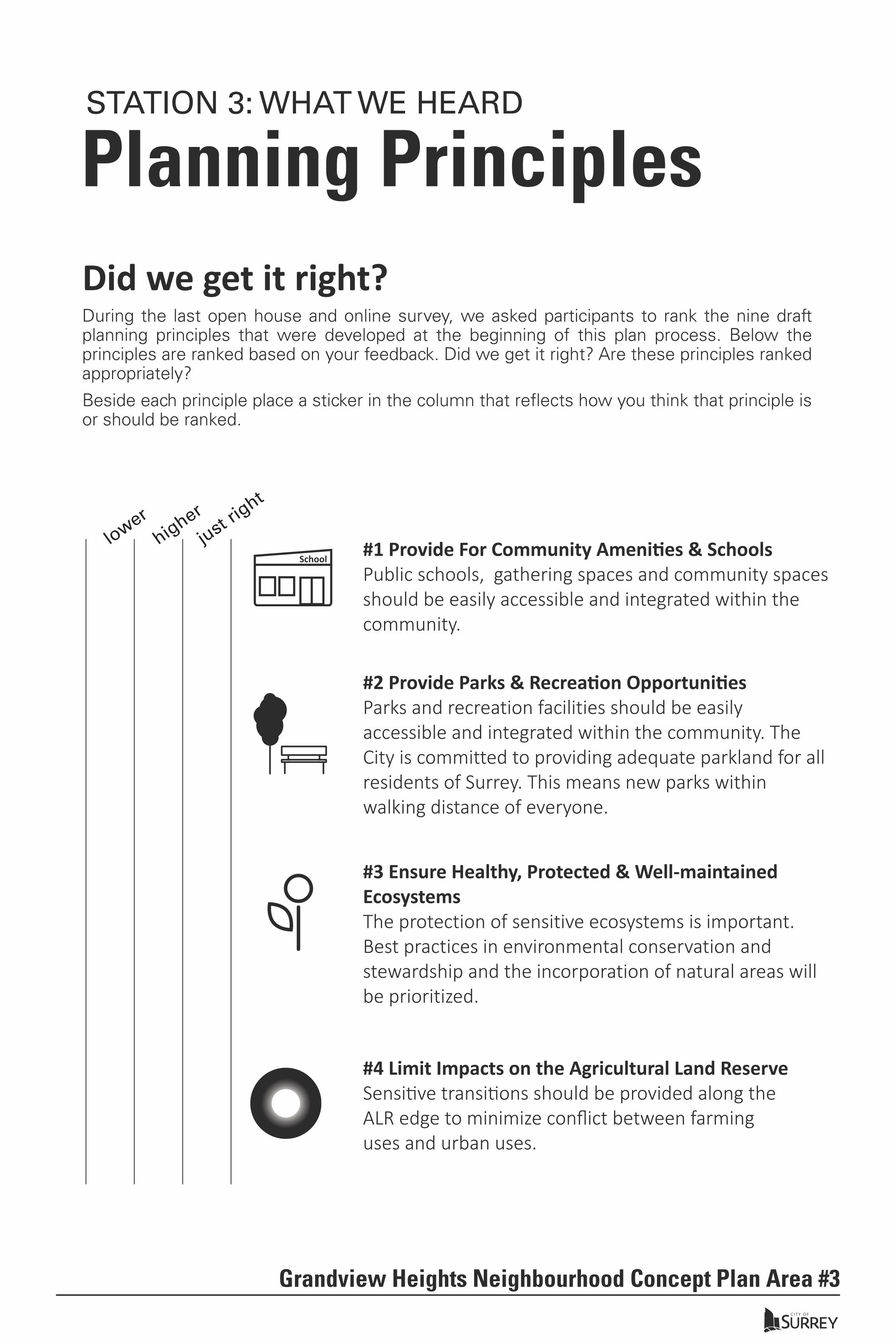
Planning PrinciplesDid we get it right?During the last open house and online survey, we asked participants to rank the nine draft planning principles that were developed at the beginning of this plan process. Below the principles are ranked based on your feedback. Did we get it right? Are these principles ranked appropriately?
Beside each principle place a sticker in the column that reflects how you think that principle is or should be ranked.
#1 Provide For Community Ameni�es & SchoolsPublic schools, gathering spaces and community spaces should be easily accessible and integrated within the community.
#3 Ensure Healthy, Protected & Well-maintained EcosystemsThe protection of sensitive ecosystems is important. Best practices in environmental conservation and stewardship and the incorporation of natural areas will be prioritized.
#2 Provide Parks & Recrea�on Opportuni�esParks and recreation facilities should be easily accessible and integrated within the community. The City is committed to providing adequate parkland for all residents of Surrey. This means new parks within walking distance of everyone.
#4 Limit Impacts on the Agricultural Land ReserveSensi�ve transi�ons should be provided along the ALR edge to minimize conflict between farming uses and urban uses.
higher
just rig
ht
lower
Grandview Heights Neighbourhood Concept Plan Area #3
STATION 3: WHAT WE HEARD
School
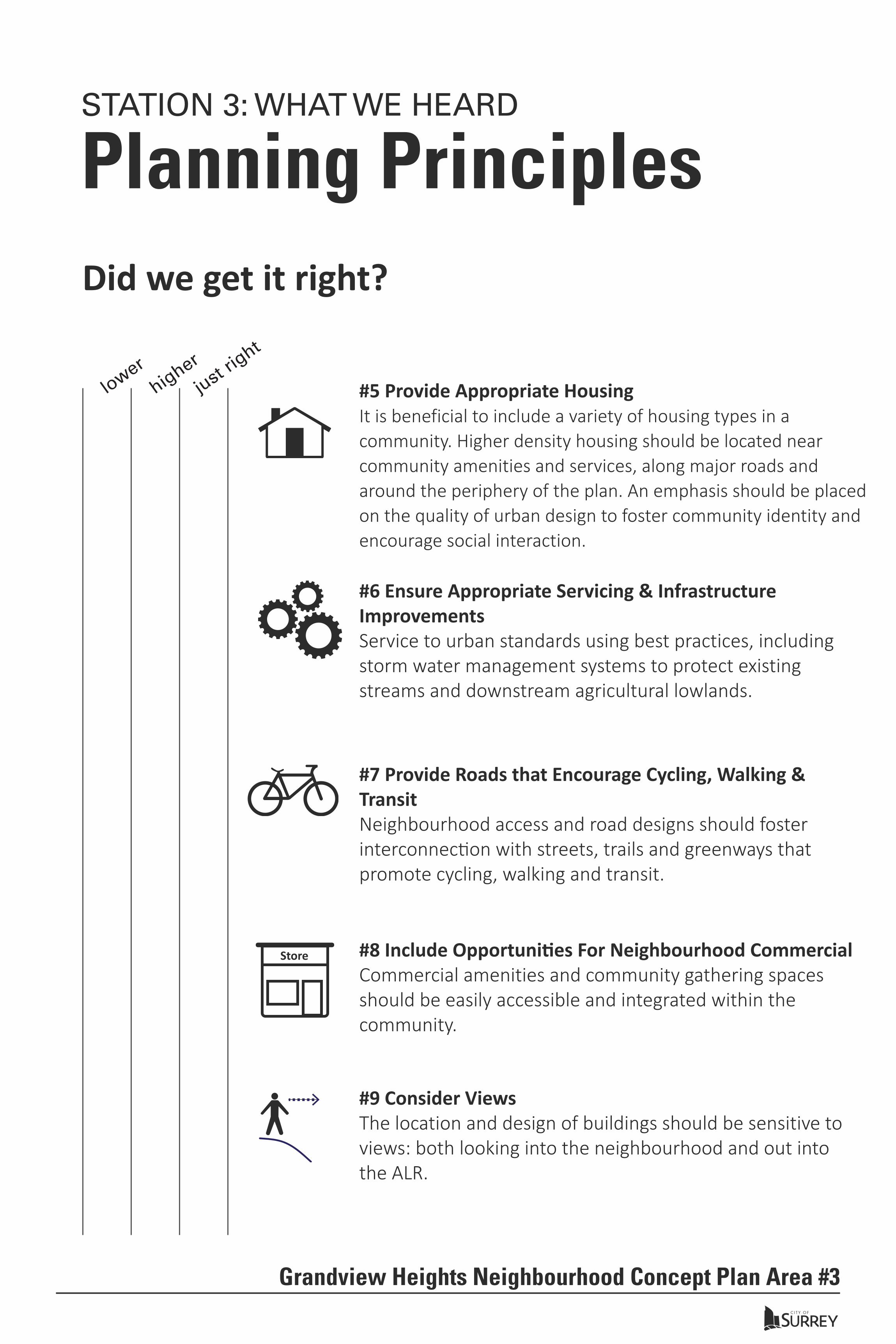
#5 Provide Appropriate HousingIt is beneficial to include a variety of housing types in a community. Higher density housing should be located near community amenities and services, along major roads and around the periphery of the plan. An emphasis should be placed on the quality of urban design to foster community identity and encourage social interaction.
Planning PrinciplesDid we get it right?
#7 Provide Roads that Encourage Cycling, Walking & TransitNeighbourhood access and road designs should foster interconnec�on with streets, trails and greenways that promote cycling, walking and transit.
#6 Ensure Appropriate Servicing & Infrastructure ImprovementsService to urban standards using best practices, including storm water management systems to protect existing streams and downstream agricultural lowlands.
#8 Include Opportuni�es For Neighbourhood Commercial Commercial amenities and community gathering spaces should be easily accessible and integrated within the community.
#9 Consider ViewsThe location and design of buildings should be sensitive to views: both looking into the neighbourhood and out into the ALR.
higher
just rig
ht
lower
Grandview Heights Neighbourhood Concept Plan Area #3
STATION 3: WHAT WE HEARD
Store
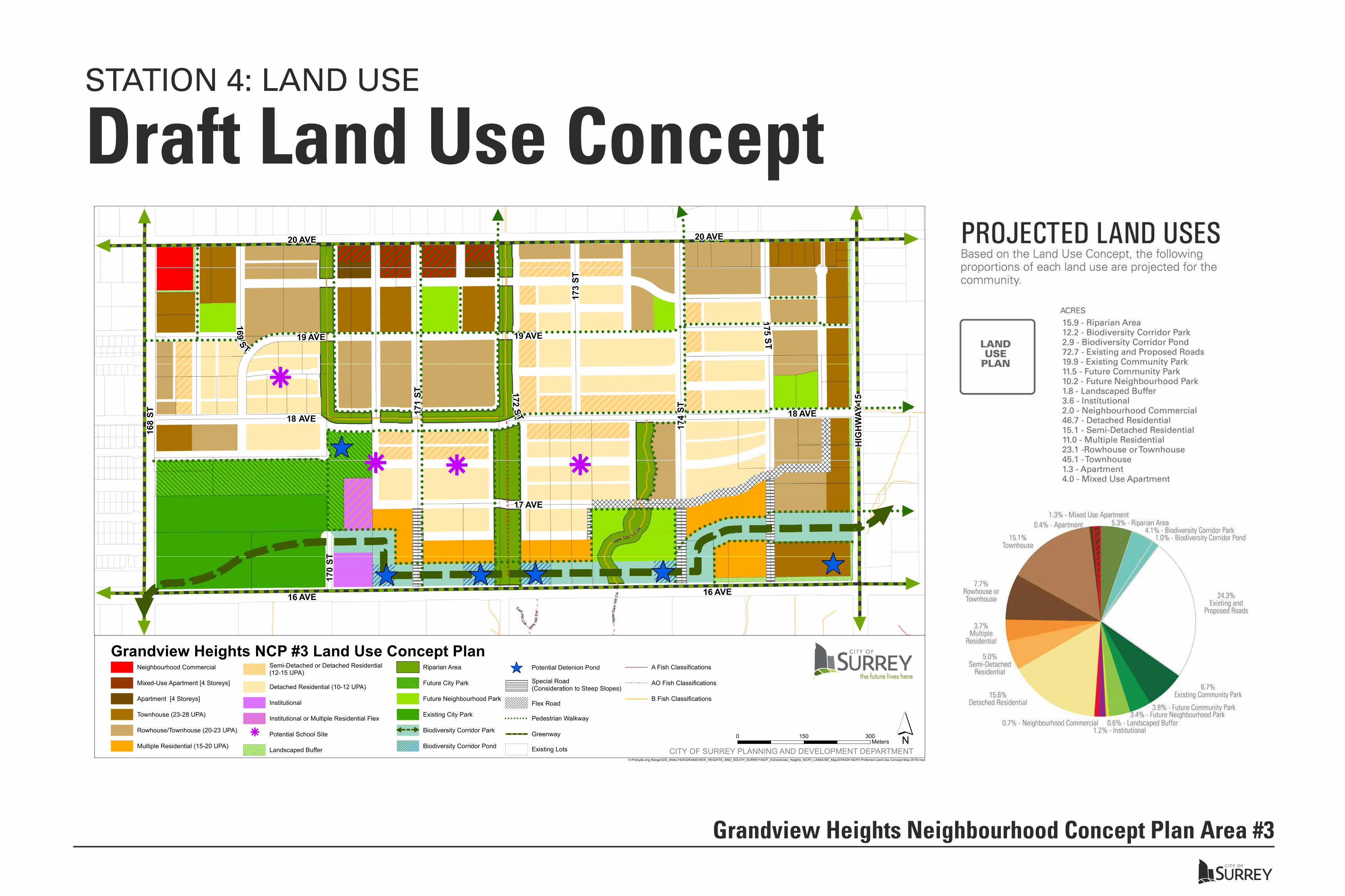
Draft Land Use Concept
Grandview Heights Neighbourhood Concept Plan Area #3!
!!
!!
!!
!!
!!
!!
!!
!!
!!
!!
!!
!!
!!
!
!!
!!
!!
!!
!!
!!
!!
!!
!!
!!
!!
!!
!!
!!
!!
!!!! ! ! ! ! ! ! ! ! ! ! ! ! ! ! ! ! ! ! ! ! ! ! ! ! ! ! ! ! ! ! ! ! ! ! ! ! ! ! ! ! ! ! !
! ! ! ! ! ! ! ! ! ! ! ! ! ! ! ! ! ! ! ! ! ! ! ! ! !
!!
!!
!!
!!
!!
!!
!!
!!
!
!!!!!!!!!!!!!!!!!!!!!!!!!!!!!!!
!!
!!
!!
!!
!!
!!
!!
!!!
!!
!!
!!
!!
!!
!!
!!
!!
!!
!!
!!
!!
!!
!!
!
! ! ! ! ! ! ! ! ! ! ! ! ! ! ! ! ! !
!!
!!
!!
!!
!!
!!
!!
!!
!
!!
!!
!!
!!
!!
!!
!!
!!
!!
!!
!!
!!
!!
!!
!!
!!
!!
!!
!!
!!
!!
!!
!!
!!
!!
!!
!!
!!
!!
!!
!
!!
! !
!!
!!
! ! ! ! ! ! ! ! ! ! ! ! ! !
!
! ! ! ! ! ! ! ! ! ! ! ! ! ! ! ! ! ! ! ! ! ! ! ! ! ! ! ! ! ! ! ! ! ! ! ! ! ! ! ! ! ! ! ! ! ! ! ! ! ! ! ! ! ! ! ! ! !!
! ! ! ! ! ! ! ! ! ! ! ! ! ! ! ! ! ! ! ! ! ! ! ! !! ! ! ! !
! ! ! ! ! ! ! ! ! ! ! ! ! ! ! ! ! ! ! ! ! ! ! ! ! ! ! ! ! ! ! !!
!!
!!
!!
!
!!
!!
!!
!!
!!
!!
! ! ! ! ! ! ! ! ! ! ! !
!!
!!
!!
! ! ! ! ! ! ! ! ! ! ! ! ! ! ! ! ! ! ! ! ! ! ! ! ! ! ! ! ! ! ! ! ! ! ! !!
!!
!!
!!
!! ! ! ! ! ! ! ! ! ! ! ! ! ! ! !
!!
!!
!!
!!
!!
!!
!
!!!!!!!!!
!!
!!
!!
!!
!!
!!
!!
!
! ! ! ! ! !!
!!
!!
!!
!!
!!
!!
!!
!!
!!
!!
!!
!!
!!
!!
!!
!!
!!
!!
!!
!!
!!
!!
!!
! ! ! ! ! ! ! ! !
! ! ! ! ! ! ! ! ! ! ! ! ! ! ! ! ! ! ! ! ! ! ! ! ! !
!!
!!
!!
!
!!! ! ! ! ! ! ! ! ! ! ! ! ! ! ! ! ! ! ! ! ! ! !
!!!!!!!!!!!!!!!!!!!!!!!!!!!!!!!!!!!
!!
!!!)
) ) ) ))
/
/ / /
170
ST
169ST
19 AVE
172ST
173
ST175
ST
17 AVE
19 AVE
171
ST
174
ST
18 AVE 18 AVE
168
ST
HIG
HW
AY 1
5
20 AVE 20 AVE
16 AVE 16 AVE
Sa
m
Hill
Crk
Upp
erS
amHi
llCr
k
SamH
il l Crk
Upper Sam H illCrk
0 300150Meters
CITY OF SURREY PLANNING AND DEVELOPMENT DEPARTMENT́V:\Policy&Long Range\GIS_ANALYSIS\GRANDVIEW_HEIGHTS_AND_SOUTH_SURREY\NCP_3\Grandview_Heights_NCP3_LANDUSE_May2018\GH NCP3 Preferred Land Use Concept May 2018.mxd
Neighbourhood Commercial
Mixed-Use Apartment [4 Storeys]
Apartment [4 Storeys]
Townhouse (23-28 UPA)
Rowhouse/Townhouse (20-23 UPA)
Multiple Residential (15-20 UPA)
Semi-Detached or Detached Residential(12-15 UPA)
Detached Residential (10-12 UPA)
Institutional
Institutional or Multiple Residential Flex
Potential School Site
Landscaped Buffer
Riparian Area
Future City Park
Future Neighbourhood Park
Existing City Park
Biodiversity Corridor Park
Biodiversity Corridor Pond
) Potential Detenion Pond
Special Road(Consideration to Steep Slopes)
Flex Road
! ! ! ! ! ! ! ! Pedestrian Walkway
Greenway
Existing Lots
A Fish Classifications
AO Fish Classifications
B Fish Classifications
Grandview Heights NCP #3 Land Use Concept Plan
/
STATION 4: LAND USE

Grandview Heights Neighbourhood Concept Plan Area #3
Land UsesLand Use Plan Designation
Detached Residential
Semi-Detached or Detached Residential
Multiple Residential
Row House/ Townhouse
Townhouse Apartment Mixed Use Apartment
Neighbourhood Commercial
Density range 10-12 UPA
12-15 UPA
15-20 UPA
20-23 UPA
23-28 UPA
Up to 1.5 FAR
Up to 1.5 FAR
Up to 0.5 FAR
Type of Ownership
Fee Simple
Fee Simple Strata Fee Simple or Strata
Strata Strata or Rental Strata or Rental N/A
Building Forms Types
Front Access Detached Lot or
Lane Access Detached Lot
Smaller Detached lots
with lane access; or Semi-
Detached lots with lane access.
Attached Residential
Townhomes, Duplex, Triplex,
or Quadplex
2 - 2 ½ Storey Townhouse
(Wide)
3 Storey Townhomes
(Narrow)
4 Storey Apartments
4 Storey 1st Floor
Commercial/ Retail
1 to 2 Storey Commercial / Retail and/or
Office
Typical Zones RF-13, RF-10, CD
RF-10, RF-SD RM-15, RM-23, CD
RM-23, RM-30, CD
RM-30, CD RM-45, RM-70, CD
RM-70, C-15 C-5, CD
Illustrative Example(s)
Concept Design Illustration
Photo Example's
STATION 4: LAND USE
HOW IT MAY LOOK - EXAMPLES OF FUTURE BUILDING FORMS

Residential & Mixed UseSTATION 4: LAND USE
Grandview Heights Neighbourhood Concept Plan Area #3
170
ST
169ST
19 AVE
172ST
173
ST175
ST
17 AVE
19 AVE
171
ST
174
ST
18 AVE 18 AVE
168
ST
HIG
HW
AY 1
5
20 AVE 20 AVE
16 AVE 16 AVE
Sa
m
Hill
Crk
Upp
erS
amHi
llCr
kSam
Hil l C
rk
Upper Sam H illCrk
0 300150Meters
CITY OF SURREY PLANNING AND DEVELOPMENT DEPARTMENT́V:\Policy&Long Range\GIS_ANALYSIS\GRANDVIEW_HEIGHTS_AND_SOUTH_SURREY\NCP_3\Grandview_Heights_NCP3_LANDUSE_May2018\GH NCP3 Preferred Land Use Concept May 2018_Aerial.mxd
Neighbourhood Commercial
Mixed-Use Apartment [4 Storeys]
Apartment [4 Storeys]
Townhouse (23-28 UPA)
Rowhouse/Townhouse (20-23 UPA)
Multiple Residential (15-20 UPA)
Semi-Detached or Detached Residential(12-15 UPA)
Detached Residential (10-12 UPA)
Institutional
Institutional or Multiple Residential Flex
Potential School Site
Landscaped Buffer
Riparian Area
Future City Park
Future Neighbourhood Park
Existing City Park
Biodiversity Corridor Park
Biodiversity Corridor Pond
) Potential Detenion Pond
Special Road(Consideration to Steep Slopes)
Flex Road
! ! ! ! ! ! ! ! Pedestrian Walkway
Greenway
Existing Lots
A Fish Classifications
AO Fish Classifications
B Fish Classifications
Grandview Heights NCP #3 Land Use Concept Plan
/
The draft land use plan focuses on locating residential development around the periphery of the NCP area along major roads and future transit served roads such as 20 Avenue, 168 Street and Highway 15. The density varies to provide a sensitive transition between different residential building forms (e.g. single family homes, townhouses). Densities generally transition from higher to lower housing forms.A neighbourhood village node is proposed at 177 Street and 20 Avenue. This node would include higher densities such as townhouses and 4-storey mixed use buildings (retail/commercial on the ground level and residential above).
Row House Example Detached Residentia (Front Access) Example Townhouse Example
Mixed Use Residential Example Semi-Detached Example Detached Residential (Rear Access) Example
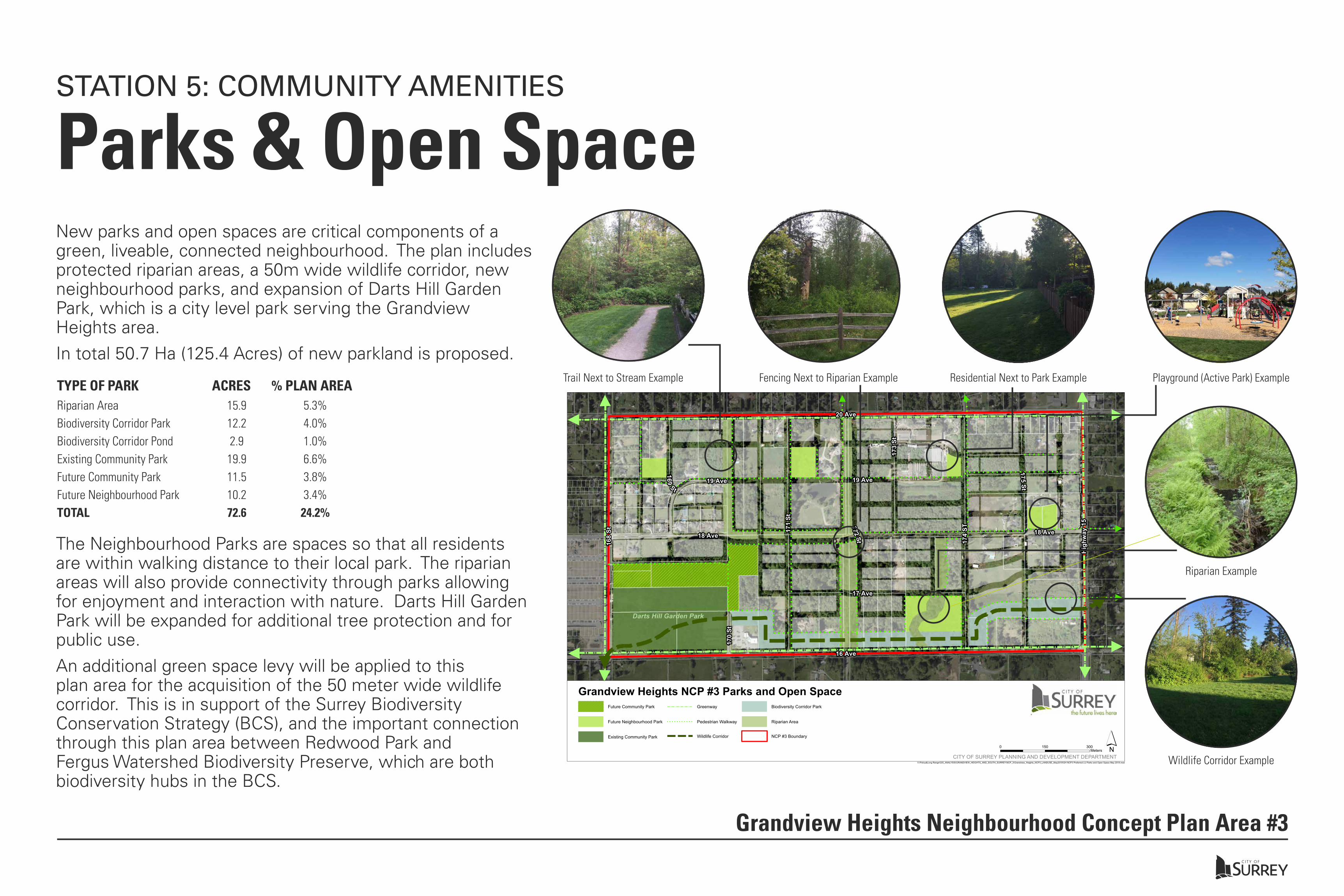
Parks & Open SpaceSTATION 5: COMMUNITY AMENITIES
Grandview Heights Neighbourhood Concept Plan Area #3
New parks and open spaces are critical components of a green, liveable, connected neighbourhood. The plan includes protected riparian areas, a 50m wide wildlife corridor, new neighbourhood parks, and expansion of Darts Hill Garden Park, which is a city level park serving the Grandview Heights area. In total 50.7 Ha (125.4 Acres) of new parkland is proposed.
!!
!!
!!
!!
!!
!!
!!
!!
!!
!!
!!
!
!!
!!
!!
!!
!!
!!
!!
!!
!!
!!
!!
!!
!
!!! ! ! ! ! ! ! ! ! ! ! ! ! ! ! ! ! ! ! ! ! ! ! ! ! ! ! ! ! ! ! ! ! ! ! !
! ! ! ! ! ! ! ! ! ! ! ! ! ! ! ! ! ! ! ! !
!!
!!
!!
!!
!!
!!
!!
!!!!!!!!!!!!!!!!!!!!!!!!
!!
!!
!!
!!
!!
!!
!!
!!
!!
!!
!!
!!
!
!!
!!
!!
!!
!!
!!
!!
! ! ! ! ! ! ! ! ! ! ! ! ! ! !
!!
!!
!!
!!
!!
!!
!!
!!
!!
!!
!!
!!
!!
!!
!!
!!
!!
!!
!!
!!
!!
!!
!!
!!
!!
!!
!!
!!
!!
!!
!!
!!
!! !
!
!!
! ! ! ! ! ! ! ! ! ! ! ! ! ! ! ! ! ! ! ! ! ! ! ! ! ! ! ! ! ! ! ! ! ! ! ! ! ! ! ! ! ! ! ! ! ! ! ! ! ! ! ! ! ! ! ! ! ! ! !
!! ! ! ! ! ! ! ! ! ! ! ! ! ! ! ! ! ! ! !
! ! ! !
! ! ! ! ! ! ! ! ! ! ! ! ! ! ! ! ! ! ! ! ! ! ! ! ! !
!!
!!
!!
!
!!
!!
!!
!!
!!
! ! ! ! ! ! ! ! ! ! !!
!!
!
! ! ! ! ! ! ! ! ! ! ! ! ! ! ! ! ! ! ! ! ! ! ! ! ! ! ! ! !
!!
!!
!!
!
! ! ! ! ! ! ! ! ! ! ! ! !
!!
!!
!!
!!
!!
!
!!!!!!!
!
!!
!!
!!
!!
!!
! ! ! ! !
!!
!!
!!
!!
!!
!!
!!
!!
!!
!!
!!
!!
!!
!!
!!
!
!
!
!
!
!!
!!
!! ! ! ! ! !
!
! ! ! ! ! ! ! ! ! ! ! ! ! ! ! ! ! ! ! ! !
!!
!!
!
!!
! ! ! ! ! ! ! ! ! ! ! ! ! ! ! ! ! !
!!
!!!!!!!!!!!!!!!!!!!!!!!!!!!!
!!
!
Darts Hill Garden Park
170
St
169St
19 Ave172St
173
St
175St
17 Ave
19 Ave
171
St
174
ST
18 Ave 18 Ave
168
St
Hig
hway
15
20 Ave
16 Ave
V:\Policy&Long Range\GIS_ANALYSIS\GRANDVIEW_HEIGHTS_AND_SOUTH_SURREY\NCP_3\Grandview_Heights_NCP3_LANDUSE_May2018\GH NCP3 Preferred LU Parks and Open Space May 2018.mxd
Future Community Park
Future Neighbourhood Park
Existing Community Park
Greenway
! ! ! ! ! ! ! ! ! ! ! Pedestrian Walkway
Wildlife Corridor
Biodiversity Corridor Park
Riparian Area
NCP #3 Boundary
Grandview Heights NCP #3 Parks and Open Space
0 300150Meters
CITY OF SURREY PLANNING AND DEVELOPMENT DEPARTMENT́
The Neighbourhood Parks are spaces so that all residents are within walking distance to their local park. The riparian areas will also provide connectivity through parks allowing for enjoyment and interaction with nature. Darts Hill Garden Park will be expanded for additional tree protection and for public use.An additional green space levy will be applied to this plan area for the acquisition of the 50 meter wide wildlife corridor. This is in support of the Surrey Biodiversity Conservation Strategy (BCS), and the important connection through this plan area between Redwood Park and Fergus Watershed Biodiversity Preserve, which are both biodiversity hubs in the BCS.
Riparian AreaBiodiversity Corridor ParkBiodiversity Corridor PondExisting Community ParkFuture Community ParkFuture Neighbourhood ParkTOTAL
15.912.22.9
19.911.510.272.6
5.3%4.0%1.0%6.6%3.8%3.4%
24.2%
TYPE OF PARK ACRES % PLAN AREATrail Next to Stream Example Fencing Next to Riparian Example Residential Next to Park Example Playground (Active Park) Example
Riparian Example
Wildlife Corridor Example
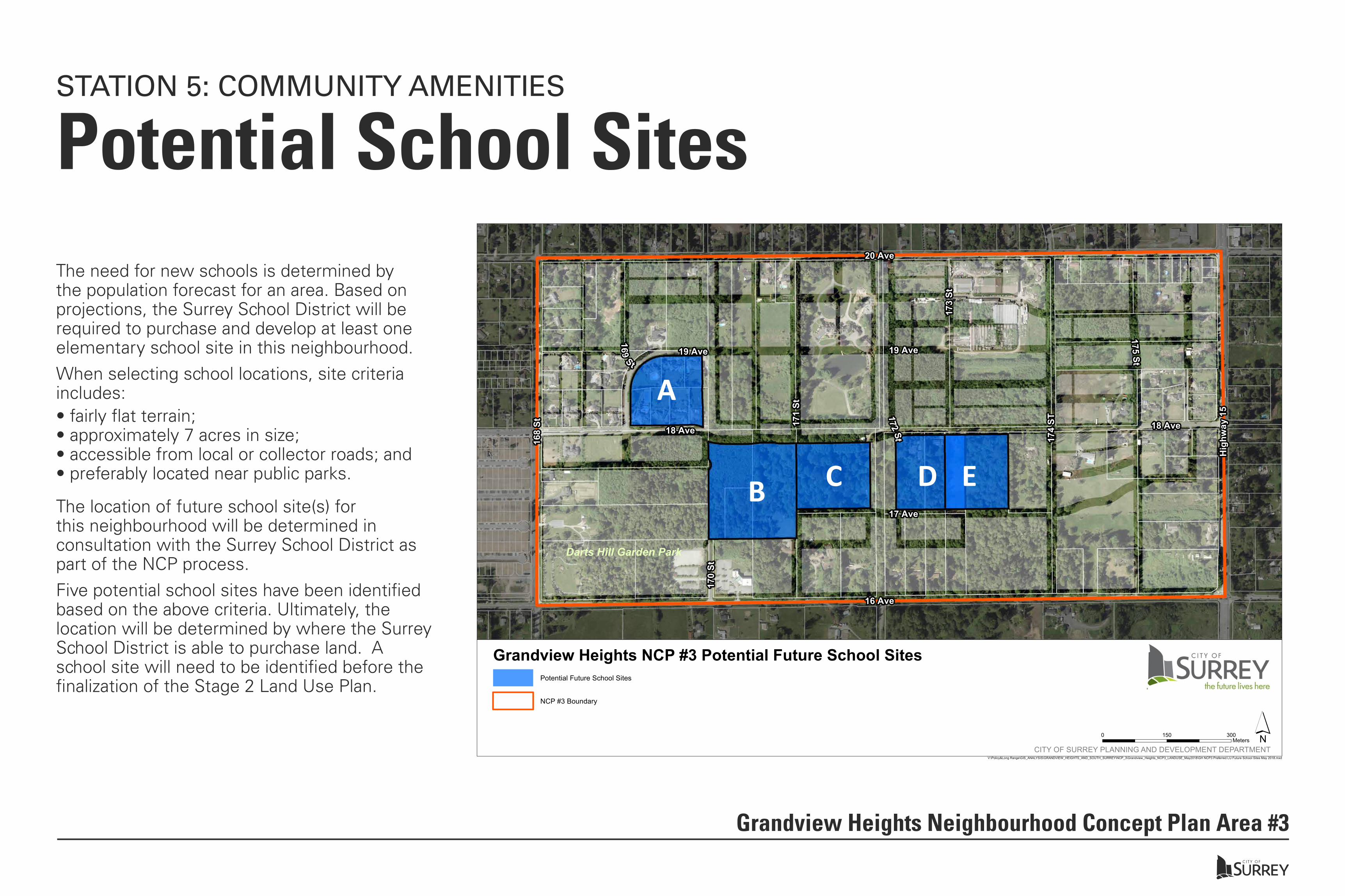
Potential School SitesSTATION 5: COMMUNITY AMENITIES
Grandview Heights Neighbourhood Concept Plan Area #3
The need for new schools is determined by the population forecast for an area. Based on projections, the Surrey School District will be required to purchase and develop at least one elementary school site in this neighbourhood.When selecting school locations, site criteria includes:
Darts Hill Garden Park
170
St169
St19 Ave
172St
173
St
175St
17 Ave
19 Ave
171
St
174
ST
18 Ave 18 Ave
168
St
Hig
hway
15
20 Ave
16 Ave
V:\Policy&Long Range\GIS_ANALYSIS\GRANDVIEW_HEIGHTS_AND_SOUTH_SURREY\NCP_3\Grandview_Heights_NCP3_LANDUSE_May2018\GH NCP3 Preferred LU Future School Sites May 2018.mxd
Potential Future School Sites
NCP #3 Boundary
Grandview Heights NCP #3 Potential Future School Sites
A
B C D E
0 300150Meters
CITY OF SURREY PLANNING AND DEVELOPMENT DEPARTMENT́
• fairly flat terrain;• approximately 7 acres in size;• accessible from local or collector roads; and• preferably located near public parks.
The location of future school site(s) for this neighbourhood will be determined in consultation with the Surrey School District as part of the NCP process.Five potential school sites have been identified based on the above criteria. Ultimately, the location will be determined by where the Surrey School District is able to purchase land. A school site will need to be identified before the finalization of the Stage 2 Land Use Plan.
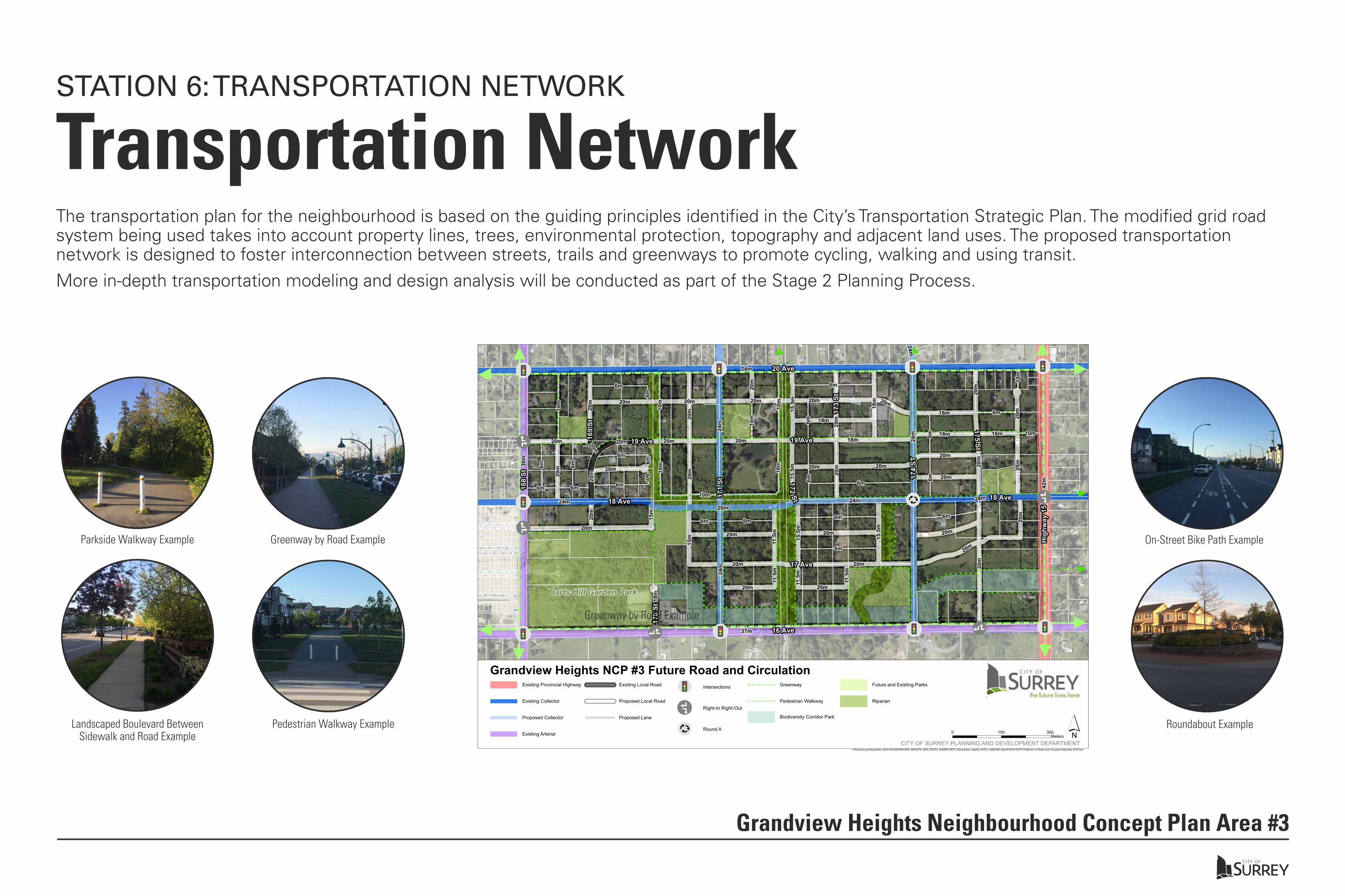
Transportation NetworkSTATION 6: TRANSPORTATION NETWORK
Grandview Heights Neighbourhood Concept Plan Area #3
The transportation plan for the neighbourhood is based on the guiding principles identified in the City’s Transportation Strategic Plan. The modified grid road system being used takes into account property lines, trees, environmental protection, topography and adjacent land uses. The proposed transportation network is designed to foster interconnection between streets, trails and greenways to promote cycling, walking and using transit.More in-depth transportation modeling and design analysis will be conducted as part of the Stage 2 Planning Process.
!!
!!
!!
!!
!!
!!
!!
!!
!!
!!
!!
!
!!
!!
!!
!!
!!
!!
!!
!!
!!
!!
!!
!!
!
!!! ! ! ! ! ! ! ! ! ! ! ! ! ! ! ! ! ! ! ! ! ! ! ! ! ! ! ! ! ! ! ! ! ! ! !
! ! ! ! ! ! ! ! ! ! ! ! ! ! ! ! ! ! ! ! !
!!
!!
!!
!!
!!
!!
!!
!!!!!!!!!!!!!!!!!!!!!!!!
!!
!!
!!
!!
!!
!!
!!
!!
!!
!!
!!
!!
!
!!
!!
!!
!!
!!
!!
!!
! ! ! ! ! ! ! ! ! ! ! ! ! ! !
!!
!!
!!
!!
!!
!!
!!
!!
!!
!!
!!
!!
!!
!!
!!
!!
!!
!!
!!
!!
!!
!!
!!
!!
!!
!!
!!
!!
!!
!!
!!
!!
!! !
!
!!
! ! ! ! ! ! ! ! ! ! ! ! ! ! ! ! ! ! ! ! ! ! ! ! ! ! ! ! ! ! ! ! ! ! ! ! ! ! ! ! ! ! ! ! ! ! ! ! ! ! ! ! ! ! ! ! ! ! ! !
!! ! ! ! ! ! ! ! ! ! ! ! ! ! ! ! ! ! ! !
! ! ! !
! ! ! ! ! ! ! ! ! ! ! ! ! ! ! ! ! ! ! ! ! ! ! ! !!
!!
!!
!!
!
!!
!!
!!
!!
!!
! ! ! ! ! ! ! ! ! ! !!
!!
!
! ! ! ! ! ! ! ! ! ! ! ! ! ! ! ! ! ! ! ! ! ! ! ! ! ! ! ! !
!!
!!
!!
!
! ! ! ! ! ! ! ! ! ! ! ! !!
!!
!!
!!
!!
!
!!!!!!!
!!
!!
!!
!!
!!
!!
! ! ! ! !
!!
!!
!!
!!
!!
!!
!!
!!
!!
!!
!!
!!
!!
!!
!!
!!
!
!
!
!!
!!
! ! ! ! ! ! !
! ! ! ! ! ! ! ! ! ! ! ! ! ! ! ! ! ! ! ! !
!!
!!
!
!!
! ! ! ! ! ! ! ! ! ! ! ! ! ! ! ! ! ! !
!!
!!!!!!!!!!!!!!!!!!!!!!!!!!
!!
!!
!
¬¬Ä!!!!!!
¬¬Ä!!!!!!
¬¬Ä!!!!!!
¬¬Ä!!!!!!
¬¬Ä!!!!!!
¬¬Ä!!!!!!
¬¬Ä!!!!!!
!
á
á
!
á
á
!
á
á
!á
á!á
á
¬¬Ä!!!!!!
¬¬Ä!!!!!!
¬¬Ä!!!!!!
¬¬Ä!!!!!!
!!=
=
=
Darts Hill Garden Park
6m
6m
20m
6m
10m
15m
11.5
m
11.5
m
11.5
m
24m10m
20m
6m
20m
6m6m
20m
10m
6m
18m
20m
20m
8m
18m
6m
20m
6m
20m
20m
6m6m
20m20
m
20m
11.5
m
6m
10m
6m
20m
20m
10m
15m
6m
6m
20m
20m
20m
6m15.5
m
18m
15.5
m
15.5
m
20m
18m
20m
6m
20m
20m
20m
20m
20m
10m
20m
10m
20m
20m
18m
15.5
m
10m20m
20m
20m
6m
20m
6m
6m
18m
20m
20m
20m
20m
6m
20m
10m24m
18m
24m
20m
20m 20m
24m
20m
24m
24m 24m
30m
42m
24m
37m
170
St
169
St
19 Ave
172St
173
St
175St
17 Ave
19 Ave
171
St
174
ST
18 Ave 18 Ave
168
St
Hig
hway
15
20 Ave
16 Ave
V:\Policy&Long Range\GIS_ANALYSIS\GRANDVIEW_HEIGHTS_AND_SOUTH_SURREY\NCP_3\Grandview_Heights_NCP3_LANDUSE_May2018\GH NCP3 Preferred LU Roads and Circulation Map May 2018.mxd
Grandview Heights NCP #3 Future Road and CirculationExisting Provincial Highway
Existing Collector
Proposed Collector
Existing Arterial
Existing Local Road
Proposed Local Road
Proposed Lane
¬¬Ä!!!!!!
Intersections
!
á
á Right-In Right-Out
!!=
=
= Round A
Greenway
! ! ! ! ! ! ! ! ! ! ! Pedestrian Walkway
Biodiversity Corridor Park
Future and Existing Parks
Riparian
0 300150Meters
CITY OF SURREY PLANNING AND DEVELOPMENT DEPARTMENT́
Landscaped Boulevard Between Sidewalk and Road Example
Parkside Walkway Example
Pedestrian Walkway Example Roundabout Example
Greenway by Road Example
Greenway by Road Example
On-Street Bike Path Example
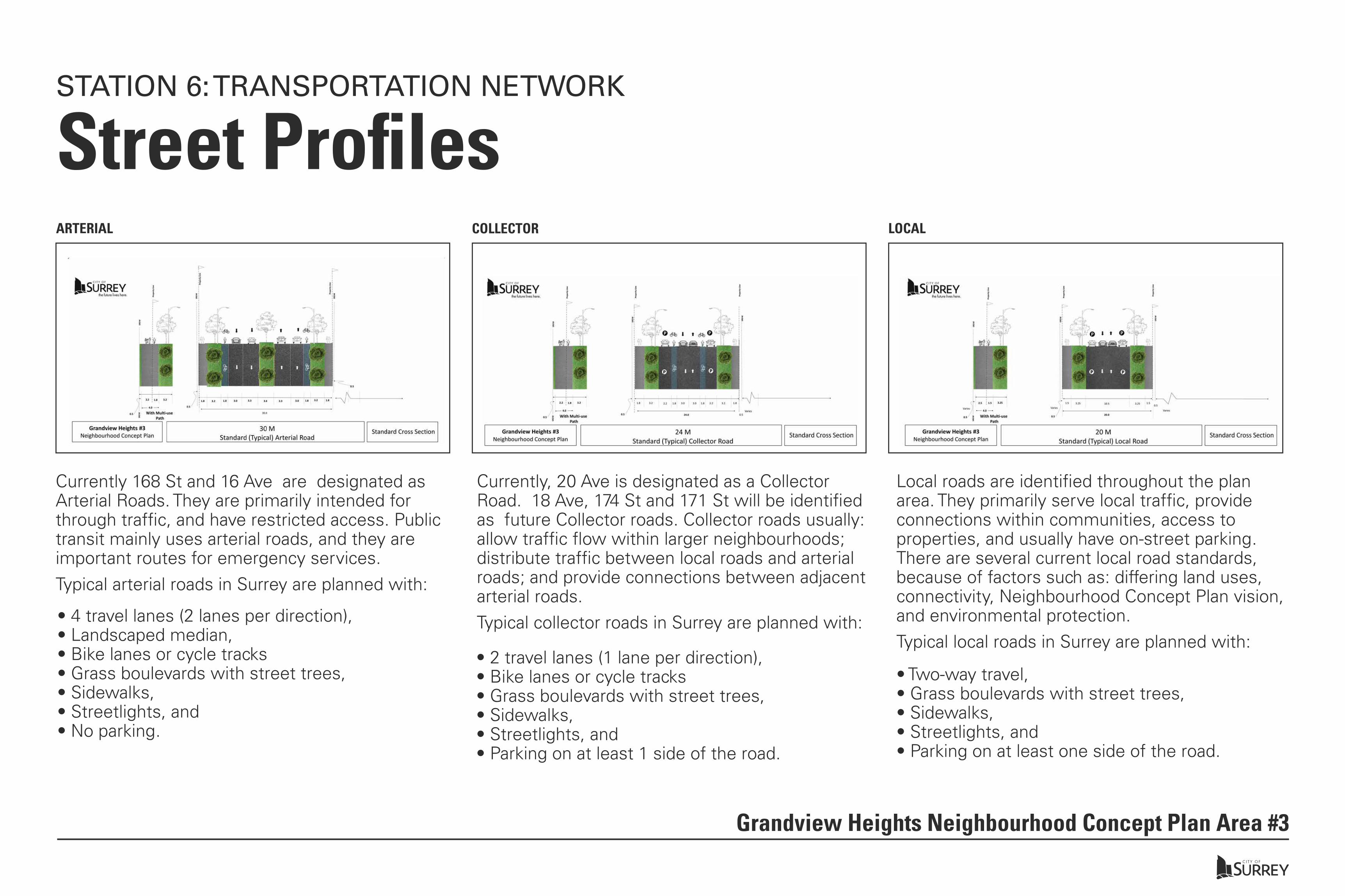
Street ProfilesSTATION 6: TRANSPORTATION NETWORK
Grandview Heights Neighbourhood Concept Plan Area #3
Currently 168 St and 16 Ave are designated as Arterial Roads. They are primarily intended for through traffic, and have restricted access. Public transit mainly uses arterial roads, and they are important routes for emergency services.Typical arterial roads in Surrey are planned with:
• 4 travel lanes (2 lanes per direction), • Landscaped median, • Bike lanes or cycle tracks• Grass boulevards with street trees, • Sidewalks, • Streetlights, and • No parking.
• 2 travel lanes (1 lane per direction), • Bike lanes or cycle tracks• Grass boulevards with street trees, • Sidewalks, • Streetlights, and • Parking on at least 1 side of the road.
• Two-way travel, • Grass boulevards with street trees, • Sidewalks, • Streetlights, and • Parking on at least one side of the road.
Currently, 20 Ave is designated as a Collector Road. 18 Ave, 174 St and 171 St will be identified as future Collector roads. Collector roads usually: allow traffic flow within larger neighbourhoods; distribute traffic between local roads and arterial roads; and provide connections between adjacent arterial roads.Typical collector roads in Surrey are planned with:
Local roads are identified throughout the plan area. They primarily serve local traffic, provide connections within communities, access to properties, and usually have on-street parking. There are several current local road standards, because of factors such as: differing land uses, connectivity, Neighbourhood Concept Plan vision, and environmental protection.Typical local roads in Surrey are planned with:
ARTERIAL COLLECTOR LOCAL

Stormwater ManagementSTATION 7: UTILITIES & SERVICING
Grandview Heights Neighbourhood Concept Plan Area #3
Area #3 is located within the Sam Hill Creek watershed, which contains fish-bearing streams that drain through the agricultural lowlands to the little Campbell River. To mitigate potential drainage problems and protect these important streams, an integrated stormwater management plan (ISMP) is under way. It is expected that as part of the ISMP recommendations future dentention ponds will be required to support future development in Area 3.The Land Use Plan shows several potential locations where stormwater management ponds may be required. The size, number and exact location of the ponds will be determined as part of the Stage 2 Engineering and Servicing review (only after a preferred land use concept plan is approved by City Council in Stage 1).
)
) ) ) ))Darts Hill Garden Park
170
St
169St
19 Ave
172St
173
St
175St
17 Ave
19 Ave
171
St
174
ST
18 Ave 18 Ave
168
St
Hig
hway
15
20 Ave
16 Ave
V:\Policy&Long Range\GIS_ANALYSIS\GRANDVIEW_HEIGHTS_AND_SOUTH_SURREY\NCP_3\Grandview_Heights_NCP3_LANDUSE_May2018\GH NCP3 Preferred LU Detention Ponds May 2018.mxd
) Potential Detenion Pond Facility Sites
Future and Existing Parks
Biodiversity Corridor Park
Riparian Area
NCP #3 Boundary
Grandview Heights NCP #3 Potential Detention Ponds
0 300150Meters
CITY OF SURREY PLANNING AND DEVELOPMENT DEPARTMENT́
Detention Pond Example
Park Pond Example
Natural Drainage Example
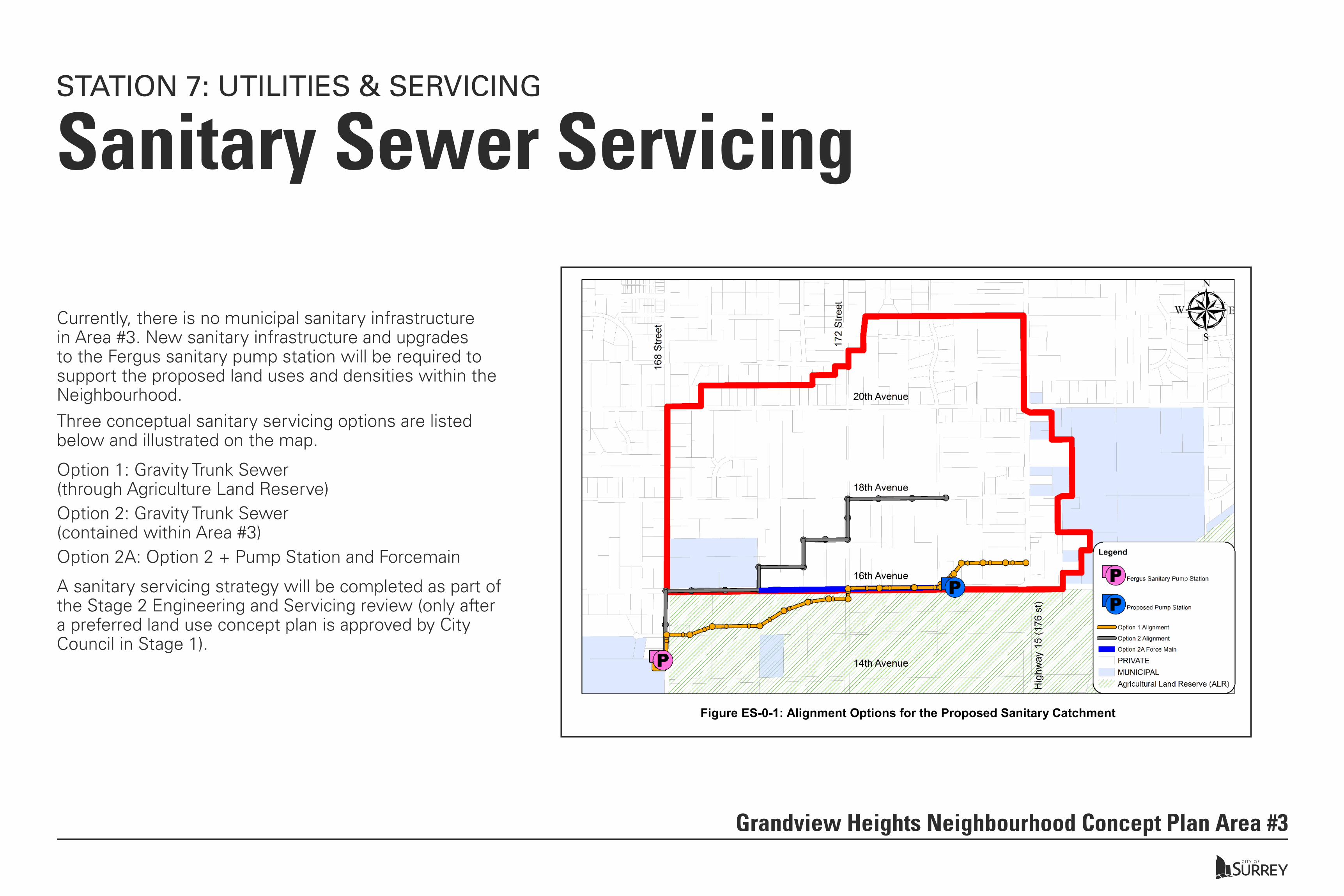
Sanitary Sewer ServicingSTATION 7: UTILITIES & SERVICING
Grandview Heights Neighbourhood Concept Plan Area #3
Currently, there is no municipal sanitary infrastructure in Area #3. New sanitary infrastructure and upgrades to the Fergus sanitary pump station will be required to support the proposed land uses and densities within the Neighbourhood. Three conceptual sanitary servicing options are listed below and illustrated on the map.
Option 1: Gravity Trunk Sewer (through Agriculture Land Reserve) Option 2: Gravity Trunk Sewer (contained within Area #3)Option 2A: Option 2 + Pump Station and Forcemain
GRANDVIEW HEIGHTS AREA #3 – SANITARY SEWER FUNCTIONAL DESIGN
www.opusinternational.ca ©OPUS INTERNATIONAL CONSULTANTS (CANADA) LTD | MARCH 2018 PAGE 1 OF 24
Executive SummaryIn preparation for the upcoming development of Grandview Heights Neighbourhood Concept Plan (NCP) Area #3 (Area #3), a functional design for a community sanitary sewer trunk was prepared. The functional design takes into account the existing site conditions, desktop reviews of the environmental and geotechnical conditions, and projected land use of the area. Two primary options were prepared for consideration: Option 1 is a gravity sewer that maximises gravity collection, but is partially routed through the Agricultural Land Reserve (ALR); and Option 2 is a gravity sewer that avoids the Agricultural Land Reserve (ALR) completely. A variation of option 2 was also developed, that included the addition of a pump station and forcemain (Option 2A).
Figure ES-0-1: Alignment Options for the Proposed Sanitary Catchment
At the time of this assignment, land use concepts are still in the early development stage, and the population estimates provided by the City are high level. The total population projection for the area is in the range of 9,000 to 13,000 people.
The options were evaluated using various criteria, namely, functionality, capital cost, and a Triple Bottom Line (TBL) analysis. The TBL analysis was used to evaluate less intangible factors such as environmental, social, and economic criteria.
From a functionality point of view, Option 1 is the preferred option as it has the potential for gravity collection forup to 95% of the area. Option 2 is the least preferred as its potential for gravity collection is only around 70% of the area.
A sanitary servicing strategy will be completed as part of the Stage 2 Engineering and Servicing review (only after a preferred land use concept plan is approved by City Council in Stage 1).
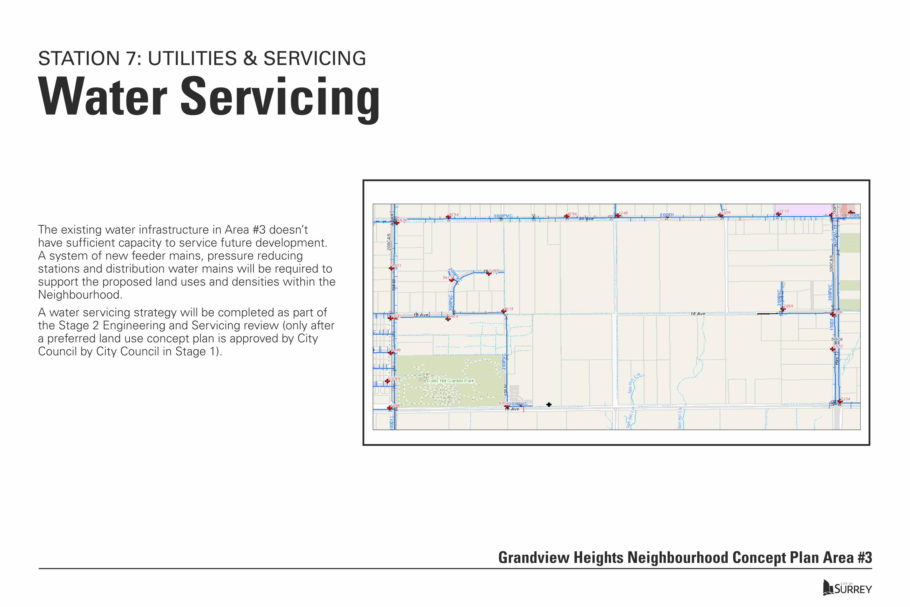
Water ServicingSTATION 7: UTILITIES & SERVICING
Grandview Heights Neighbourhood Concept Plan Area #3
The existing water infrastructure in Area #3 doesn’t have sufficient capacity to service future development. A system of new feeder mains, pressure reducing stations and distribution water mains will be required to support the proposed land uses and densities within the Neighbourhood. A water servicing strategy will be completed as part of the Stage 2 Engineering and Servicing review (only after a preferred land use concept plan is approved by City Council by City Council in Stage 1).
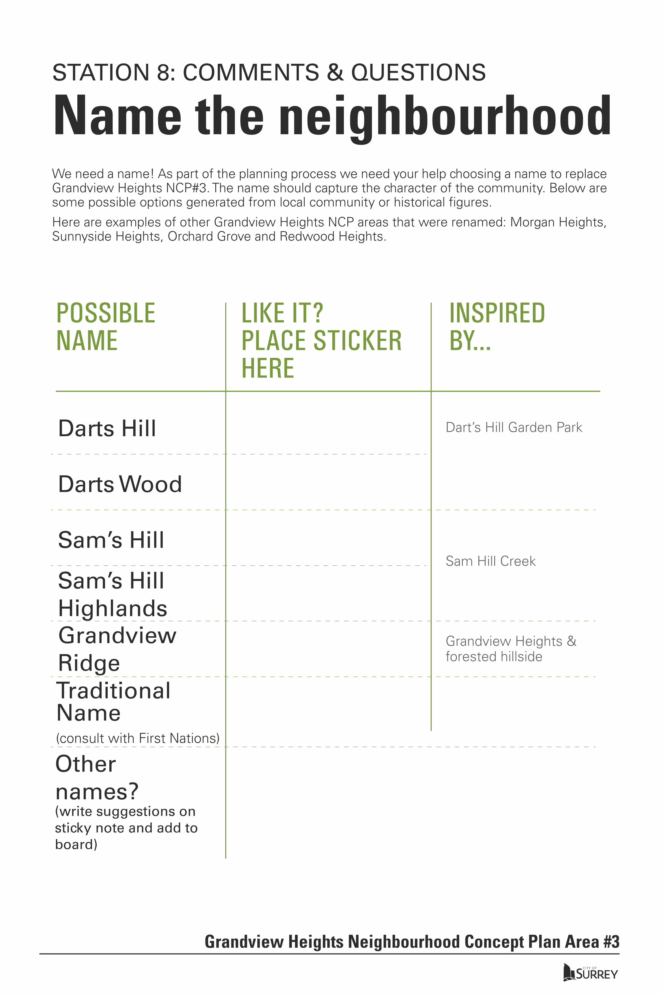
Name the neighbourhood We need a name! As part of the planning process we need your help choosing a name to replace Grandview Heights NCP#3. The name should capture the character of the community. Below are some possible options generated from local community or historical figures.
Here are examples of other Grandview Heights NCP areas that were renamed: Morgan Heights, Sunnyside Heights, Orchard Grove and Redwood Heights.
INSPIREDBY...
POSSIBLENAME
LIKE IT?PLACE STICKERHERE
Darts Hill Dart’s Hill Garden Park
Sam Hill Creek
Grandview Heights & forested hillside
Darts Wood
Sam’s Hill
Sam’s HillHighlandsGrandviewRidgeTraditional Name(consult with First Nations)
Other names?(write suggestions on sticky note and add to board)
Grandview Heights Neighbourhood Concept Plan Area #3
STATION 8: COMMENTS & QUESTIONS

www.surrey.ca/city-services/20607.aspx.
Grandview Heights Neighbourhood Concept Plan Area #3
Name the neighbourhood FOR SHARING YOUR FEEDBACK
Thank-you
NEXT STEPS - PROJECTED TIMELINE*
After reviewing the boards, let us know what you think. Complete the online questionnaire at our survey stations or at home by going to surrey.ca/surveys.
Spring 2018 - Review public feedback and refine planSummer 2018 - Draft Stage 1 Report to Council for consideration & approvalFall 2018 - If Stage 1 is approved by Council, staff will initiate Stage 2*Timeline may change as NCP proceeds.
This evening:
fill out the online questionnaire at a survey station.
At home:
fill out the online questionnaire by going to the website.
FOR MORE INFORMATIONVisit the website: www.surrey.ca/ghncp3
Email: [email protected]
STATION 8: COMMENTS & QUESTIONS
Provide your feedback by comple�ng the online survey at www.surrey.ca/surveys. The survey will be available un�l June 22, 2018.