welcome to the first virtual student
TRANSCRIPT

1
1
Welcome to the first virtual Student World Water Forum!
Join us at unrwater.com
Water is humankind’s most essential resource and influences all aspects of life on the planet. Since 2003, the Student World Water Forum has
been an event for students –both undergraduate and graduate alike –to present their work, share ideas, and collaborate with others on water
issues. The Forum also serves as a venue for students to gain public speaking experience, as well as receive critique on their presentations from evaluators on campus and throughout the community. It is our hope that the Forum will raise awareness of local, regional, national,
and global water issues, and will act as a catalyst for future developments in our community and around the world.
Thank you for joining our 17th year!
Organized by
Danielle C Miles, EECB Program Ellen Wilson, Biology
Karli Lubin-Bresee, Geography Kate A Berry, Geography
2
Thank you to our professional evaluators for dedicating time and effort toward the success of the SWWF 2020
Dr. Braimah Apambire, Desert Research Institute Mr. Tim Bardsley, NOAA National Weather Service Mr. Eric Berg, Atkins Global Inc. Mr. Steve Bradhurst, Central Nevada Regional Water Authority, retired Mr. Greg Burst, HDR Inc. Dr. Kevin Carman, UNR Office of the Provost Dr. Joe Cline, Retired, UNR Office of the Provost Ms. Shayne Del Cohen, Independent Consultant Ms. Marianne Denton, Nevada Division of Environmental Protection Mr. Michael Drinkwater, City of Sparks Mr. John Enloe, Truckee Meadows Water Authority Dr. Jia Feng, UNR Geography Department Ms. Sonia Folsom, Truckee Meadows Water Authority Dr. Louis Forline, UNR Anthropology Department Dr. Mae Gustin, UNR Natural Resources & Environmental Science Department Mr. John Hadder, Great Basin Resource Watch Ms. Chelsey Hand, Great Basin Resource Watch Ms. Lisa Holan, UNR Natural Resources & Environmental Sciences Department Dr. Atani Itani, UNR Office of Research & Innovation Ms. Sierra Jickling, greenUP! Dr. Scott Kelley, UNR Geography Department Dr. Tanya Kelley, UNR Office of Undergraduate Research Ms. Jasmine Kleiber, Nevada Department of Wildlife Dr. Elizabeth Koebele, UNR Political Science Department Dr. Alexandra Lutz, Desert Research Institute Dr. Eric Marchand, UNR Civil & Environmental Engineering Department Dr. Stephanie McAfee, UNR Geography Department Ms. Geraldine McCarroll, City of Sparks, retired Dr. Glenn Miller, UNR Natural Resources & Environmental Science Dept., emeritus Mr. Jon Mittelstad, NOAA National Weather Service Mr. Taha Mokaddem Mr. Kameron Morgan, Pyramid Lake Paiute Tribe Dr. Christine Olson, Nevada Division of Environmental Protection Dr. Kerri Jean Ormerod, UNR Geography Department Ms. Melyssa Navis, US Forest Service Dr. Kenneth Nussear, UNR Geography Department Dr. Ania Panorska, UNR Mathematics & Statistics Department Mr. Ben Peterson, McGinley & Associates Inc. Dr. Dave Prudic, Independent Consultant Mr. Will Raymond, Truckee Meadows Water Authority Dr. Michael Rosen, US Geological Survey Dr. William Rowley, UNR History Department, emeritus Mr. Kyle Roerink, Great Basin Water Network Mr. Dan Saftner, Desert Research Institute Dr. Mary Siders, Nevada Division of Environmental Protection Mr. Chris Smallcomb, NOAA National Weather Service Mr. Michael Stewart, State of Nevada Legislative Counsel Bureau Ms. Julie Stoughton, UNR Natural Resources & Environmental Sciences Department Dr. Aleksey Telyakovskiy, UNR Mathematics & Statistics Department Dr. Regina Tempel, UNR College of Science Dr. Scott Tyler, UNR Geological Sciences Department Mr. Dave Wathen, US Water Masters Office Dr. Laura Wilhelm, Truckee Meadows Community College Dr. Kristin Van der Molen, Desert Research Institute Dr. Frank Yang, UNR Civil and Environmental Engineering
Please conduct reviews of poster presentations online.
3
Keynote Presentation in partnership with the UNR Geography Colloquium
Dr. Sophia Layser Borgias
Sophia Borgias is a human-environment geographer whose work focuses on water and environmental governance in the arid Americas. She
recently completed her PhD at the University of Arizona and is now a National Science Foundation SBE Postdoctoral Research Fellow
affiliated with the Geography Department at UNR.
Wednesday November 18, 2020 at 4:00pm Public Interest, Indigenous Rights,
and the Los Angeles Aqueduct
This presentation will provide a critical reassessment of the emblematic water conflict over the Los Angeles Aqueduct, one of the first large
rural-to-urban water transfers in the American West. Drawing on three years of in-depth archival, ethnographic, and collaborative research, Sophia will discuss how public, private, and tribal interests have been weighed in decision-making about this transfer over time amid social,
regulatory, and environmental change. She will address gaps in the history of the water conflict, demonstrating how Indigenous rights were
impacted by the transfer, and discuss how that history continues to shape the ongoing water conflicts in the Eastern Sierra as well as
growing movements for water justice across the West.
4
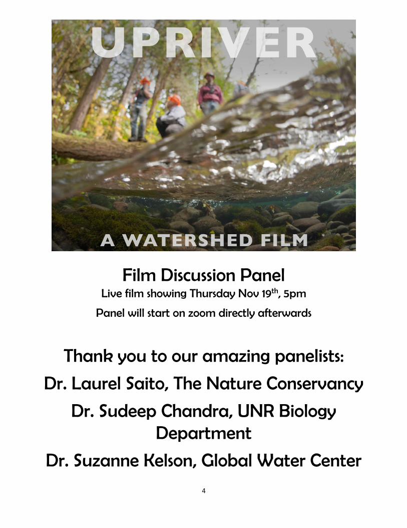
Film Discussion Panel Live film showing Thursday Nov 19th, 5pm
Panel will start on zoom directly afterwards
Thank you to our amazing panelists:
Dr. Laurel Saito, The Nature Conservancy
Dr. Sudeep Chandra, UNR Biology Department
Dr. Suzanne Kelson, Global Water Center

5
Schedule of Events Wednesday November 18
• 4-5pm – Keynote Presentation • Zoom link:
https://unr.zoom.us/j/92815610458?pwd=R0t6cThVNG10RmJlalo2Qm9ETDBRQT09
• Zoom meeting ID: 928 1561 0458 • Zoom passcode: GeoSpeak
Thursday November 19
• 5-6pm - Feature film showing of Upriver by Freshwaters Illustrated • Find the movie link and access code through unrwater.com
• 6-7pm – Live panel discussion on Upriver • Zoom link:
https://unr.zoom.us/j/89847635539?pwd=aVgzNVUrbzJLUFNNdVA4VngyZVBRZz09
• Zoom meeting ID: 898 4763 5539 • Zoom passcode: 315222
Friday November 2020
• Zoom link for entire day of sessions (8:30am-5:30pm): https://unr.zoom.us/j/83470493731?pwd=ZVNBdk9OWWFHaXRidmkwR1FlOUZCQT09
• Zoom meeting ID: 834 7049 3731 • Zoom passcode: 720656
6
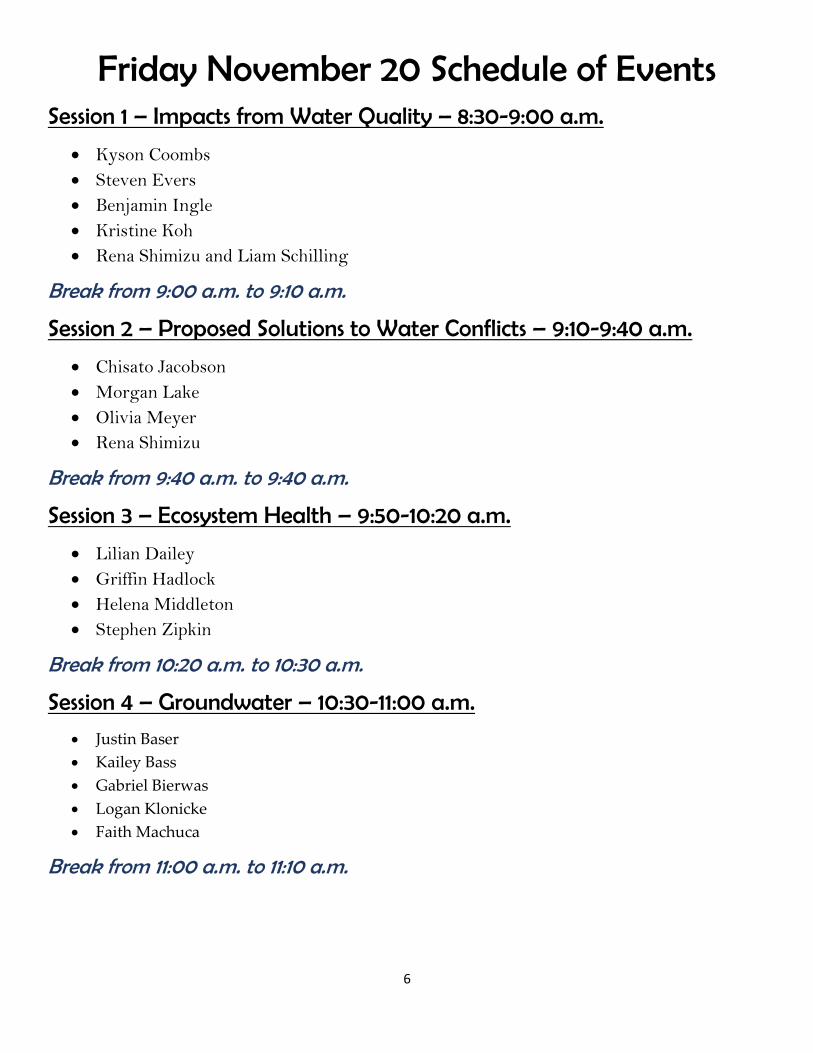
Friday November 20 Schedule of Events Session 1 – Impacts from Water Quality – 8:30-9:00 a.m.
• Kyson Coombs
• Steven Evers
• Benjamin Ingle
• Kristine Koh
• Rena Shimizu and Liam Schilling
Break from 9:00 a.m. to 9:10 a.m.
Session 2 – Proposed Solutions to Water Conflicts – 9:10-9:40 a.m.
• Chisato Jacobson
• Morgan Lake
• Olivia Meyer
• Rena Shimizu
Break from 9:40 a.m. to 9:40 a.m.
Session 3 – Ecosystem Health – 9:50-10:20 a.m.
• Lilian Dailey
• Griffin Hadlock
• Helena Middleton
• Stephen Zipkin
Break from 10:20 a.m. to 10:30 a.m.
Session 4 – Groundwater – 10:30-11:00 a.m.
• Justin Baser
• Kailey Bass
• Gabriel Bierwas
• Logan Klonicke
• Faith Machuca
Break from 11:00 a.m. to 11:10 a.m.

7
Friday November 20 Schedule of Events Session 5 – Approaches to Alternative Water Supplies – 11:10-11:40 a.m.
• Kassandra Lisenbee
• Dominic Oehler
• Emily Paris
• Thomas Tsunemoto
Break from 11:40 a.m. to 11:50 a.m.
Session 6 – Wildlife, Fisheries, and Water 11:50 a.m.-12:20 p.m.
• Evan Franklin
• Bryan Remick
• Ramon Valdez
• Ellen Wilson
Break from 12:20 p.m. to 12:30 p.m.
Session 7 – Drought and Climate Change – 12:30-1:00 p.m.
• Jacob Boomsma
• Hannah Hoyos
• Destiny Poulson
• Molly Willoughby
• Uriel Cholula Rivera and Manuel A. Andrade
Break from 1:00 p.m. to 1:10 p.m.
Session 8 – Public Health and Water Supplies – 1:10-1:40 p.m.
• Edgar Hernandez
• Austin Johnson
• Matthew Schibetta
• Mackenzie Scruggs
• Hannah Williams
Break from 1:40 p.m. to 1:50 p.m.

8
Friday November 20 Schedule of Events Session 9 – Islands and Water – 1:50-2:20 p.m.
• David Camberos
• Josiah Marquez
• Mads Miller
• Molly Willoughby; Jeremy Benik; Evan Franklin; and Jacob Boomsma
Break from 2:20 p.m. to 2:30 p.m.
Session 10 – Mountain Hydrology – 2:30-3:00 p.m.
• Jeremy Benik
• Arielle Koshkin
• Amanda Wray
• Joshua Culpepper; Rina Schumer; and Sudeep Chandra
Break from 3:00 p.m. to 3:10 p.m.
Session 11 – Dams -- 3:10-3:40 p.m.
• Alex Bajao
• Holland Conner
• Jeff Niemann
• Heath Pate
Break from 3:40 p.m. to 3:50 p.m.
Session 12 – Water Infrastructure – 3:50-4:20 p.m.
• Clayton Apalategui
• Chloe Dodge
• Jacqueline Keating
• Benjamin Khoh
Break from 4:20 p.m. to 4:30 p.m.
Session 13 – Irrigated Agriculture – 4:30-5:00 p.m.
• Shane Andrews
• Austin Lunderstadt
• Travis Miller
• Ashley Strang

9
Friday November 20 Schedule of Events
Break from 5:00 p.m. to 5:10 p.m.
Session 14 – Responses to Water Quality – 5:10-5:40 p.m.
• Jeff Am-is
• Hannah Larson
• Elenora McLaughlin
• Liam Schilling
Please conduct reviews of poster presentations at https://www.unrwater.com/participate.html
10
Session 1 – Impacts from Water Quality 8:30-9:00 a.m.
Kyson Coombs – Undergraduate – Geography
Water Quality: Robinson Mine in Eastern Nevada
This poster addresses the influence of mining on groundwater quality. In particular, I examine how mining affects the quality of water supplies through discarded waste rock that has been mined for ore, the effluent then seeps from the discarded rock into water supplies. These contaminated waters are the same ones that are used as part of community water supplies near Robinson Mine, which is an internationally-owned mine in White Pine County in eastern Nevada. Robinson Mine, like many other mines, is situated in a remote area that is surrounded and supported by rural communities, in this case the communities of Ruth, McGill, and Ely, Nevada. The city of Ely is actively investing in ways to improve filtering systems and similarly, the Ruth-McGill water district is working on water filtration.
Steven Evers – Undergraduate – Environmental Science The Colorado River and the Millions of American and Mexican Lives at
Stake
Shared water sources across the globe are the source of tension between upstream and downstream countries. The Colorado River, shared by the United States and Mexico, is no exception. The water of the Colorado River has large allocations to seven US states before ever reaching Mexico downstream. In the last 50 years, there have been instances when the US has delivered contaminated water to Mexico and was held accountable for their actions. Under a water treaty made in 1944, it was mandated that the US give Mexico 1.5 million acre feet of water annually. The purpose of this treaty is to allow both Mexico and the US to manage and allocate the shared surface water. Here, I present the history of this 1944 treaty between the US and Mexico, the water quality of the Colorado River since then, and some possible solutions to help restore the river. Without urgent management changes, people will be displaced in the search for clean water and valuable natural resources will be lost. The Colorado River has a range of responsibilities from supporting the lives of millions of Americans and Mexicans as well as the ecosystems surrounding its tributaries. As populations increase so does the demand for fresh water and as climate change starts to negatively affect the river, the issues in this system need to be addressed soon.
Benjamin Ingle – Undergraduate -- Forest Ecology and Management and Environmental Science
Reclaiming the Cesspool: An Assessment of Two Major Pollution Problems in the Ganges River
The Ganges River is the largest and most religiously important river in India, yet it remains one of the most polluted rivers in the world. Two of the largest pollution sources are untreated municipal sewage and industrial waste. This poster examines the municipal sewage pollution problem and one of the main industrial polluters, the tanning industry, with an emphasis on (1) assessing the causes of this pollution, (2) scrutinizing previous failed attempts to clean up the river, and (3) exploring possible solutions. The discharge of untreated sewage wastewater accounts for nearly 75% of the pollution in the river, causing the river water to contain microbial counts that make it unsafe for both drinking and bathing, while the tanning industry is a major contributor of metal pollution in the river, particularly chromium. The Indian government has recognized these pollution threats to the Ganges River, creating the Ganga Action Plan in 1985 and the National Ganga

11
River Basin Project in 2011 in an attempt to mitigate pollution and restore water quality. However, these plans have failed, mainly due to a lack of oversight, enforcement, and participation. Along with accounting for these failed plans, future solutions to these pollution problems necessitate an accurate quantification of municipal and industrial sewage loads so the appropriate sewage treatment plants can be constructed and all wastewater can be treated before being discharged into the river. Future actions must successfully protect and restore the Ganges River before millions of people are drastically affected.
Kristine Koh – Undergraduate -- Ecohydrology The Dangers of Increasing Metal Pollution in the Nile River
The Nile River is the longest river in Africa and it is also a main freshwater resource for nearby cities. The
Nile River is convenient for providing food, water, transportation, and healthy soil for growing food. Due to
an increased amount of dumping, there is an increasing amount of pollutants and metals in the river. When
the high amount of metal is consumed by humans and animals, there can be detrimental effects to both species
and the ecosystem around it. Animals like the Nile crocodile are in danger when they consume water with
high concentrations of metal because they lay eggs with thinner shells and higher concentrations of metal.
This causes an increase in deaths for the fetuses in the eggs. The high concentration of metal in the Nile river
poses a danger to humans because of the vast uses for this freshwater resource. Humans that use the Nile
River as potable water can have health related issues due to drinking water with metals in it. Here, I present
that an increased concentration of metal pollution in the Nile River is endangering the Nile crocodile and the
health of humans that use the river for freshwater, and some possible solutions to the higher metal
concentrations include reverse osmosis and adsorption. The Nile River is becoming more dangerous to
humans and the area around it because of an increasing metal content in this important freshwater resource.
Rena Shimizu and Liam Schilling -- Undergraduate –
Environmental Science Arsenic Contamination of the Indus River Basin and its Effects on
Human Health
Arsenic is a toxic water pollutant that affects between 150-200 million people worldwide. Around 35 percent
(~60 million) of those people live in the Indus River Basin. Groundwater within the basin has arsenic levels
10-25 times higher than the World Health Organization recommends. Chronic exposure to arsenic can lead to
an assortment of diseases, ranging from Type-2 diabetes to skin cancer. Arsenic contamination occurs mainly
through geological processes (leaching into groundwater through the surrounding rock), but can come to be
from human activity as well. Anthropogenic sources of arsenic mainly are produced through the application of
pesticides and the mining and smelting of metals. Due to the rural living conditions of many of the basin’s
inhabitants, cheap and readily available arsenic removal methods are needed, as expensive treatment facilities
are out of the question unless extensive government support is provided. Here, we present the challenges to
arsenic pollution in the Indus River Basin, while also suggesting Pakistan implement solutions that have
worked in Vietnam. In Northern Vietnam, where a similar problem is being faced, sand filtration units are
used to remove bacteria and arsenic from their drinking water with a 95% efficiency. These units are cheap to
construct and maintain, and only need a few minutes to work. With the growing population of people that live
in the Indus River Basin and their increasing dependency on groundwater, these “low-tech” methods can
succeed in keeping the inhabitants of the Indus River Basin safe from chronic arsenic exposure.

12
Session 2 – Proposed Solutions to Water Conflicts 9:10-9:40 a.m.
Chisato Jacobson – Undergraduate -- Political Science The La Plata Basin Treaty: A Cooperative Water Framework for
International Success
The La Plata River Basin Treaty was the first multinational water treaty that involved all nations of the Río
de la Plata. Located in the fifth largest river basin of the world, Argentina, Bolivia, Brazil, Paraguay, and
Uruguay all signed the historical water agreement in 1969. This treaty created the largest hydroelectric
project in the world in 1982, the Itaipu dam on the border of Paraguay and Brazil, as well as other accords on
hydropower development, transportation, and investment among the five countries. The La Plata River Basin
Treaty provides the critical framework for the joint management, development and preservation of the La
Plata as well as other water treaties in other regions around the world. By assessing the background and
history of the treaty, I will analyze the impacts of this cooperative water framework on water usage and
domestic policy for all five nations involved. The agreement will be evaluated for its effectiveness and
influence on other transboundary water basin treaties. As water is the most important resource in the world,
the cooperative sharing of water resources is of utmost importance to a globally connected world. Water and
politics have become interwoven between Paraguay and Brazil where hydroelectricity has been used to pay
political favors to water treaties stopping Brazilian military encroachment on the Paraná River. The La Plata
River Basin Treaty is not only a critical treaty for the five involved South American countries but a key
example for all countries in river basins worldwide.
Morgan Lake – Undergraduate -- Environmental Science Does Prior Appropriation Doctrine Encourage Water Waste in the West?
In the arid West, adequate water supply will always be a necessity. With increasing climate change and low
precipitation levels in most areas but the fastest growing urban development, the West depends on reliable
and plentiful water sources. One of these sources for many parts of the Western U.S. is the Colorado River,
where the Prior Appropriation Doctrine is used to manage water supply and distribution. There is some
controversy over how well this historical doctrine supports water conservation, particularly in the “use it or
lose it” aspect- where water rights could be permanently cut back for an individual if a certain amount of that
water is regularly unused or not put to beneficial use. With that, and especially in agriculture, it can lead to
more water being used than is necessary for the sake of keeping a right to as much water as possible. Western
droughts and dried up farmland are reasonable fears - and that is why farmers and individuals work to secure
as much water as they can for each coming year. This project will analyze if this “use it or lose it” part of the
doctrine does inadvertently “encourage” excess water use and in what ways reasonable reform of the doctrine
can take place.
Olivia Meyer – Undergraduate -- Wildlife Ecology and Conservation Approaches to Restoring the Salton Sea in California
The Salton Sea is a shallow, saline rift lake located in southern California, near the US-Mexico border. It was
originally created by accident in 1905 when the Colorado River escaped its banks during construction of
irrigation canals. The river flowed into the prehistoric basin for over a year creating a shallow lake. In recent
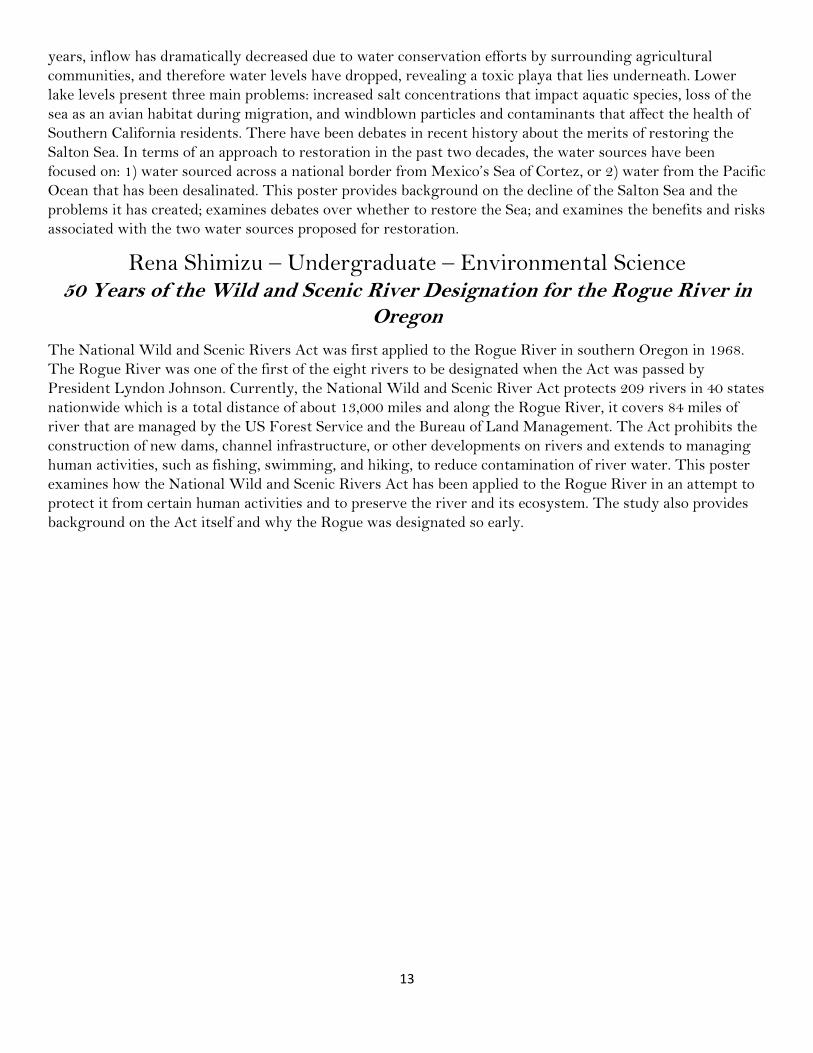
13
years, inflow has dramatically decreased due to water conservation efforts by surrounding agricultural
communities, and therefore water levels have dropped, revealing a toxic playa that lies underneath. Lower
lake levels present three main problems: increased salt concentrations that impact aquatic species, loss of the
sea as an avian habitat during migration, and windblown particles and contaminants that affect the health of
Southern California residents. There have been debates in recent history about the merits of restoring the
Salton Sea. In terms of an approach to restoration in the past two decades, the water sources have been
focused on: 1) water sourced across a national border from Mexico’s Sea of Cortez, or 2) water from the Pacific
Ocean that has been desalinated. This poster provides background on the decline of the Salton Sea and the
problems it has created; examines debates over whether to restore the Sea; and examines the benefits and risks
associated with the two water sources proposed for restoration.
Rena Shimizu – Undergraduate – Environmental Science 50 Years of the Wild and Scenic River Designation for the Rogue River in
Oregon
The National Wild and Scenic Rivers Act was first applied to the Rogue River in southern Oregon in 1968.
The Rogue River was one of the first of the eight rivers to be designated when the Act was passed by
President Lyndon Johnson. Currently, the National Wild and Scenic River Act protects 209 rivers in 40 states
nationwide which is a total distance of about 13,000 miles and along the Rogue River, it covers 84 miles of
river that are managed by the US Forest Service and the Bureau of Land Management. The Act prohibits the
construction of new dams, channel infrastructure, or other developments on rivers and extends to managing
human activities, such as fishing, swimming, and hiking, to reduce contamination of river water. This poster
examines how the National Wild and Scenic Rivers Act has been applied to the Rogue River in an attempt to
protect it from certain human activities and to preserve the river and its ecosystem. The study also provides
background on the Act itself and why the Rogue was designated so early.
14
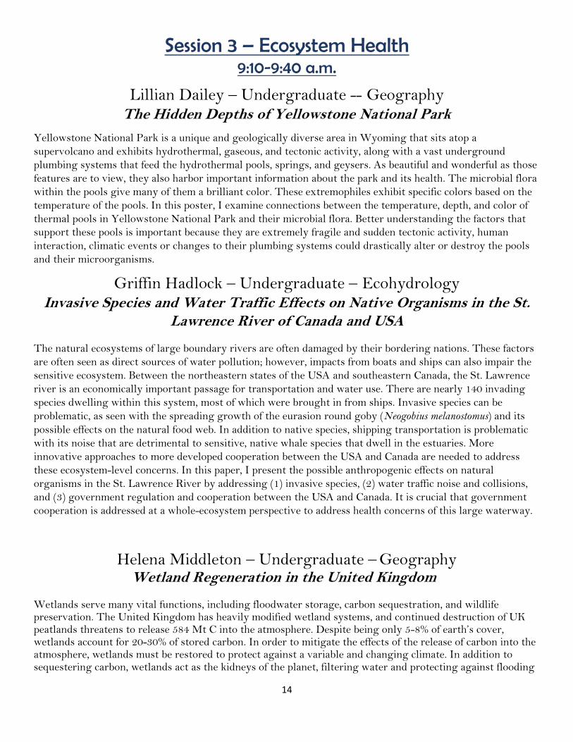
Session 3 – Ecosystem Health 9:10-9:40 a.m.
Lillian Dailey – Undergraduate -- Geography The Hidden Depths of Yellowstone National Park
Yellowstone National Park is a unique and geologically diverse area in Wyoming that sits atop a
supervolcano and exhibits hydrothermal, gaseous, and tectonic activity, along with a vast underground
plumbing systems that feed the hydrothermal pools, springs, and geysers. As beautiful and wonderful as those
features are to view, they also harbor important information about the park and its health. The microbial flora
within the pools give many of them a brilliant color. These extremophiles exhibit specific colors based on the
temperature of the pools. In this poster, I examine connections between the temperature, depth, and color of
thermal pools in Yellowstone National Park and their microbial flora. Better understanding the factors that
support these pools is important because they are extremely fragile and sudden tectonic activity, human
interaction, climatic events or changes to their plumbing systems could drastically alter or destroy the pools
and their microorganisms.
Griffin Hadlock – Undergraduate – Ecohydrology Invasive Species and Water Traffic Effects on Native Organisms in the St.
Lawrence River of Canada and USA
The natural ecosystems of large boundary rivers are often damaged by their bordering nations. These factors
are often seen as direct sources of water pollution; however, impacts from boats and ships can also impair the
sensitive ecosystem. Between the northeastern states of the USA and southeastern Canada, the St. Lawrence
river is an economically important passage for transportation and water use. There are nearly 140 invading
species dwelling within this system, most of which were brought in from ships. Invasive species can be
problematic, as seen with the spreading growth of the eurasion round goby (Neogobius melanostomus) and its
possible effects on the natural food web. In addition to native species, shipping transportation is problematic
with its noise that are detrimental to sensitive, native whale species that dwell in the estuaries. More
innovative approaches to more developed cooperation between the USA and Canada are needed to address
these ecosystem-level concerns. In this paper, I present the possible anthropogenic effects on natural
organisms in the St. Lawrence River by addressing (1) invasive species, (2) water traffic noise and collisions,
and (3) government regulation and cooperation between the USA and Canada. It is crucial that government
cooperation is addressed at a whole-ecosystem perspective to address health concerns of this large waterway.
Helena Middleton – Undergraduate – Geography Wetland Regeneration in the United Kingdom
Wetlands serve many vital functions, including floodwater storage, carbon sequestration, and wildlife preservation. The United Kingdom has heavily modified wetland systems, and continued destruction of UK peatlands threatens to release 584 Mt C into the atmosphere. Despite being only 5-8% of earth’s cover, wetlands account for 20-30% of stored carbon. In order to mitigate the effects of the release of carbon into the atmosphere, wetlands must be restored to protect against a variable and changing climate. In addition to sequestering carbon, wetlands act as the kidneys of the planet, filtering water and protecting against flooding
15
events. Fortunately, wetlands are beginning to be restored for their ecosystem functions and flood protection value, in addition to their other climate change mitigation benefits. By examining the sites of the Fenland Basin, the Tadham Moor, and the Newham Bog in the UK, this poster describes the methods by which different wetlands are being restored. These sites use combinations of water table alterations, catchment reinforcements, and growth of native plant communities to foster the regeneration of UK wetlands. Wetland restoration in degraded areas requires thoughtful consideration for sustainable land use in the future. Through innovative ideas and research into the functioning of wetlands, the UK is beginning to rebuild these valuable assets.
Stephen Zipkin – Undergraduate – Environmental Science and Wildlife Ecology
Before They All Croak: Discussing How to Help Amphibian Populations on the Decline
Amphibian populations are on the decline worldwide, and such a decline can be associated with increasing pollution of waterways from industrial, residential, and agricultural sources. Waterways in the Australian territory of Victoria have shown a particularly strong decline of amphibian populations in the presence of pollutants from sources introduced by humans. This paper will discuss major sources of pollutants, the impacts of pollutants on amphibians, and methods of mitigating pollution in Victoria. In Victoria, six amphibian species have been observed under heavy decline in part as a result of pollution of freshwater ecosystems by human sources. Specifically, heavy metal pollution from metals such as mercury and cadmium, common byproducts of mining, have been associated with decreased population sizes and species richness in many wetlands in Victoria. Amphibian habitats closest to urban and industrial areas suffered the heaviest pollution, suggesting that industrial sources such as mining and urban sources such as stormwater contributed the most to pollution leading to amphibian decline. In exposure to heavy metal pollutants, amphibians experience decreased health, reproduction, and survival. Amphibians suffer as pollutants cause both developmental issues in individual amphibians and trophic cascades via similar effects on invertebrates and algae. Solutions to these problems have already been tested in Victoria, including urban stormwater biofilters. These biofilters resemble artificial wetlands which take on toxicants before stormwater reaches freshwater ecosystems. Solutions like this are crucial in defending amphibian biodiversity.
Session 4 – Groundwater 10:30-11 a.m.
Justin Baser – Undergraduate – Environmental Science California's Sustainable Groundwater Management Act and its Application
in Mendocino County
California has struggled with declining groundwater and water quality issues, which is partially a result of a
lack of regulations and is also a concern because of a series of droughts. In recent years, California has taken a
course of action to solve this issue through the enactment of the Sustainable Groundwater Management Act
(SGMA). SGMA presents an approach to halting overdraft and bringing groundwater basins into balanced
levels of pumping and recharge. SGMA requires that local agencies develop sustainability plans for high- and
medium priority groundwater basins that include 20-year plans to ensure buffers against drought and climate
change. The policy solution SGMA enforces is a mandate on local governments and water districts to form
16
Groundwater Sustainability Agencies (GSAs). GSAs are responsible for management of land acquisitions,
recharge basins, infrastructure repair or replacement, and groundwater monitoring equipment. The result of
SGMA is when local agencies are out of compliance with these plans the state water resource control board
takes the authority to manage the basin to protect the resource. In turn, the state oversees the pumping,
recharge, monitoring including metering, and water rate setting that challenges the public's livability,
particularly in Mendocino County. This poster focuses on Mendocino County in northern California, which
does not have the vast resources and capital in comparison to some counties in Southern California. This
project examines groundwater usage in Mendocino County and how SGMA is being applied, especially as it
can provide greater security during times of water scarcity.
Kailey Bass– Undergraduate – Environmental Science Managed Aquifer Recharge Approaches in Metropolitan and
Agricultural Regions in the Southwestern United States
Managed Aquifer Recharge (MAR) is a conventional solution to pumping of groundwater that exceeds the
natural recharge rate (NRR) and is common in drier regions due to low NRR. As surface water resources
diminish, groundwater storage has also shown gradual depletion due to increased reliance. The result of
depletion is the depressurization of an aquifer system, causing subsidence and reduced water storage capacity.
Mitigation of this water issue adapts to regional demand and aims to maximize surface and groundwater
storage for consumers. By artificially increasing the recharge rate through MAR, aquifer storage and
streamflow may be positively impacted. There are evident consequences to diverting surface water to aquifer
recharge that are vital to the development of management strategies. This project examines the variability of
MAR in the metropolitan region of the Las Vegas Valley and the agricultural region of the Central Valley of
California.
Gabriel Bierwas – Undergraduate – Environmental Science Seawater Intrusion in California’s Coastal Aquifers
The objective of this poster is to compare the effects of seawater intrusion between the coastal aquifers of Los Angeles and San Diego, California. Los Angeles and San Diego are California’s two largest metropolitan areas with a combined population of roughly 15 million people. Through natural precipitation, California falls short of supplying enough water to meet the demands of these urban areas. In order to supplement this lack of rainfall, one approach to develop water supplies has been to use groundwater from coastal aquifers underneath the cities. However, both cities have over-pumped their aquifers, primarily to increase municipal water supply. Declining groundwater levels associated with overuse of groundwater has caused seawater to infiltrate into the freshwater aquifers, which has resulted in increasingly brackish groundwater. Seawater intrusion in each basin, Na+ and Cl- ion concentrations, and environmental degradation are examined for each area using existing research based on USGS well monitoring sites, the Los Angeles and San Diego water authorities, and
remote sensing. Logan Klonicke -- Undergraduate – Wildlife Ecology and Conservation
Increasing Importance of Protecting Nevada’s Groundwater and Springs
Nevada is the most arid state in the United States, so protecting the water it has is important, especially with
17
its growing population and development. Nevada’s springs and groundwater have been impacted by several
different forces, including: wild horses, excessive groundwater withdrawals, mining companies buying water
rights for groundwater, invasive species, and livestock grazing. One of goals according to the US Fish and
Wildlife Services (USFWS) is that by 2025 50% of Nevada’s 283 high priority springs and all springs in the
seven significant spring landscapes are in good or very good condition. In this poster, I examine strategies
being taken to protect groundwater-supporting springs in Nevada, such as groundwater recharging, discuss
past and present forces on Nevada’s groundwater, and talk about environmental impacts on streams
themselves from groundwater withdrawal. In addition, I will provide examples from different parts of the
state through visual images of groundwater protection sites.
Faith Machuca-- Undergraduate – Wildlife Ecology and Conservation Native American Response to Groundwater Contamination from the
Anaconda Copper Mine, Nevada
The Anaconda Copper Mine, located in Lyon County, Nevada, has had a significant detrimental impact on
groundwater quality in an aquifer shared by Yerington residents and local Native American tribes. Water has
been contaminated with uranium, arsenic, and additional heavy metals. Since ceasing mining operations, the
oversight of the environmental cleanup has switched between jurisdictions. In 2018, the mine lost Superfund
status and EPA oversight, and supervision passed to the Nevada Department of Environmental Protection
(NDEP). Both government agencies worked with Atlantic Richfield (ARCO), a private company responsible
for cleaning the pollution because they acquired the mine site. When ARCO updated the model of the
impacted groundwater plume from the mine’s contaminants after the state assumed jurisdiction, the affected
area was reduced to less than half of what was previously vetted by the EPA. The Yerington Paiute Tribe, a
local Native American tribe affected by the mine, was not included in the updated model discussions and have
since been essentially neglected in cleanup negotiations. Indigenous communities often have little opportunity
to be meaningfully involved in water governance, even if it directly impacts their water quality. Tribes are
continuously excluded from water legislation and policymaking, in addition to any regulatory decision-
making on water quality. This poster examines both the extent to which the Yerington Paiute Tribe’s
groundwater quality has been affected by the Anaconda Copper Mine and the tribe’s response to affected
groundwater quality.
Session 5 – Approaches to Alternative Water Supplies
11:10-11:40 a.m.
Kassandra Lisenbee – Undergraduate – Geography Are Harmful Toxins Produced by Algal Blooms a Threat to California’s
Ability to Use Desalination Plants as an Alternative Water Source?
As climate change continues to pose a threat to water security in the west, a new source of water is becoming
increasingly important in some places. Desalination plants have been proposed as a new source of water for
California. Opportunities include, but are not limited to, supplementing both drinking water and agricultural
irrigation and desalinized water has also been proposed to help recharge depleted aquifers. As such,
desalination facilities have the potential to improve water security along the Pacific coast. Harmful algal
blooms (HAB) or “red tides” have always posed an issue for desalination plants. HAB’s produce toxic

18
substances that can be harmful to human health and are high in biomass. These toxins and organic material
can cause increased membrane fouling rates and can contaminate water and brine solutions with high levels of
algal toxins. Research shows an increased frequency and intensity of algal blooms globally, both because of
environmental factors and anthropogenic activities. In this poster, I examine some proposed strategies to
address issues associated with large algal blooms. Strategies that could be used to protect desalination plants
in California include: early detection of algal blooms, subsurface intake pipes (if geology allows), and
pretreatment efforts. The purpose of this project is to identify and assess strategies that help reduce the
impact of algal blooms on desalination facilities and to the water these facilities produce.
Dominic Oehler – Undergraduate – Geography Comparing Fog Drip in Oregon’s Bull Run Watershed and California’s Santa Cruz Mountains
In certain watersheds, fog drip may be an important contribution to soil moisture, groundwater, or
streamflow, although it is often overlooked and is rarely measured. Fog drip occurs naturally in places where
there is lots of fog and where surfaces catch the fog, allowing the vapor to become liquid, such as parts of the
coastal mountains and in the western Cascades. This poster examines where, when, and how fog drip impacts
and influences streamflow within selected California and Oregon watersheds, more specifically, the Bull Run
Watershed east of Portland, Oregon, and the Santa Cruz Mountain Watershed in central coastal California. In
addition to focusing on how fog drip influences streamflow, I discuss the contribution of fog to soil moisture
and how this influences streamflow.
Emily Paris – Undergraduate – Environmental Science Environmental and Economic Effects of Desalination in Israel
In arid coastal countries, desalination can increase access to freshwater for citizens. However, desalination can
come with major environmental and economical side effects. Israel, a country with an average annual
precipitation of only 21 inches, relies heavily on the science of reverse osmosis desalination of seawater to
provide up to 80% of its’ municipal water supply. While Israel’s desalination plants are ranked as some of the
most energy-efficient in the world, they still have many negative side effects including (1) pollution in
Mediterranean waters, (2) cost due to energy requirements, and (3) greenhouse gas emissions. There has been
much progress in reducing these effects since the installment of desalination in Israel in 1997, however the
current consensus among engineers is that efficiency in all three areas is unlikely to improve in the near
future. Here, I compare and describe the environmental consequences of the 31 desalination plants across
Israel. I will highlight the most efficient solutions in order to decrease the three main side effects associated
with desalination. Continuing to progress the efficiency of desalination is essential for water-stressed
countries that rely on alternative water sources. By understanding the best technologies for desalination, arid
coastal regions around the world can follow in order to provide more freshwater for their citizens with less
negative side effects.
Thomas Tsunemoto – Undergraduate – Environmental Science Water Quality and Quantity Issues in Basra Iraq
The Shatt Al-Arab river of Basra Iraq has a water quality issue that stems from human intervention
domestically and abroad. Unfortunately, like many areas of the globe Basra is undergoing a water quality
crisis that is negatively affecting the health of the environment and the human population in the region. This

19
presentation will discuss how the issue of water quality is critical to this region by looking at the impact of
dams, agricultural runoff, and salinization. The use of dams in neighboring countries along with issues of poor
water management by the Iraq government has put the country in a vulnerable position regarding water
quality and security. The drainage of biproducts from agriculture puts a stress on the quality of water that
flows though the county towards the Persian Gulf. Saltwater advancement from the Persian Gulf has caused
salinization which has put a burden on the local aquatic biome. Implementation of water negotiations with
strong political will and sustainable water management practices can be the solution for the water issue that
Iraq faces as well as help stabilize the region with access to clean potable fresh water. Furthermore, this
presentation will look at how resolving this matter of water quality is essential for the restoration of the local
ecosystem since these issues have been devastating to both the local environment and the people who depend
on it. Sustainable water management practices in water scarce regions like Iraq need strong political will and
international negotiations to be resolved.
Session 6 – Wildlife, Fisheries, and Water 11:50a.m. - 12:20 p.m.
Evan Franklin – Undergraduate – Geography Impact of Water Temperatures on Fisheries in the Grand Canyon
The area between Glen Canyon Dam and Spencer Canyon, Arizona passes mostly through the Grand Canyon and is home to many different aquatic species, including eight fish native to this area, two of which, the humpback chub and razorback sucker, are listed as endangered species. Additionally these species of fish are native to warm waters so decreasing temperatures could impact their growth. Decreasing water temperatures as a result of Glen Canyon Dam have influenced the fisheries. The humpback chub benefits from releases made for warm temperatures, while non-native species such as the rainbow trout are at a disadvantage from warmer water temperatures. In this poster I show how decreasing water temperatures in the Grand Canyon section of the Colorado River have led to a decrease in the growth rate of Humpback chub and razorback suckers. I additionally show how the Glen Canyon Dam has played a role in causing these declining water temperatures and growth rates. Finally, I describe some of the steps being taken to limit this decline in growth and how effective they have been.
Bryan Remick – Undergraduate – Wildlife Ecology and Conservation
The Influence of Dam Removal on Coho and Chinook Salmon on the Klamath River Basin
The Klamath River historically supported large runs of anadromous salmonids, but due to damming of the river for hydroelectric power water temperature increases and barriers prevent access to stretches of the river that are important for spawning. Dam removal has been a method proposed to restore the declining population of salmonoids. The species of Chinook salmon and Coho salmon found on the Klamath River are both candidates for threatened species under the Endangered Species Act. The disruption of salmon spawning habitat by dams is one cause for their declining numbers. This poster examines the Klamath River basin that stretches between northern California and southwest Oregon and considers the cause of the decline for salmon populations and the influence of dam removal on these fisheries. Options and methods to bring back the number of salmon to a point they can sustain a healthy population are addressed.

20
Ramon Valdez – Undergraduate – Geography Water within the Great Basin and Its Effects on the Local Mule Deer
Population and Migration
The Great Basin holds an array of animal and plant life unique to the region; however, the most notable is the Mule Deer. One of the largest big game animals in North America, Mule Deer is a highly sought-after species by both conservation effort groups and by hunting enthusiasts. A key species to the region and a valuable commodity to the local hunting community, Mule Deer can traverse large distances searching for water and food. With changes in temperatures and reduced precipitation from climate change we are seeing less availability of water in one of the most arid states in the west, thus adaptation is key to survival. This research examines local water supplies within the Great Basin, comparing them to Mule Deer migration patterns in an effort to understand patterns of change in how the deer move across the Basin. Furthermore, the research will look at population sizes to determine if there is a correlation with water availability in different places.
Ellen Wilson – Graduate Student – Biology Devils Hole Pupfish and Community Conflict
The Devils Hole Pupfish (Cyprinodon diabolis) is an endangered species that lives in Nye County, Nevada. The
small iridescent fish only lives near the top of the Devils Hole, a pool that is 400 feet deep and 93 degrees
warm, and nowhere else in the entire world. There are around 100 individuals left, and are considered one of
the world’s rarest fish species. Because they are such a fragile species, there has been strong conservation
effort to preserve them. However, not everyone agrees with the effort or the reasons these pupfish should be
saved. The main issue surrounding the Devils Hole Pupfish is water management, and this has led to conflict
between those who use water and those who wish to protect this rare fish. In 1956, the Devils Hole was
removed from public domain and became part of the Death Valley National Monument, and in 1976, the U.S.
Department of the Interior emphasized how irrigation pumping harmed these vulnerable species, leading to
the Devils Hole Pupfish being listed as endangered. In 1976, the court case, Cappaert v. United States, ruled
that the pumping of water from the Devils Hole on the Cappaerts’ ranch be limited, even when the Cappaerts
argued for their water rights. This resulted in a backlash from ranchers and citizens, who were angry at the
government for restricting their access to water. This poster addresses the environmental, social, and political
issues that arose in the aftermath of the Cappaert litigation for the Devils Hole.
Session 7 – Drought and Climate Change
12:30-1 p.m. Jacob Boomsma – Undergraduate – Atmospheric Science
Impacts on Streamflow Temperature in the Pacific Northwest due to Climate Change
Steam temperatures are expected to rise in the Pacific Northwest over the coming decades. This warming has
the potential to affect the ecology of the rivers in this region, specifically fish habitats. Climate change will
affect precipitation and air temperature. In a warmer climate, streams and rivers fed by snowmelt will be
affected greatly due to a change in the amount of snow accumulation and how speed that the snow melts.

21
These changes affect the temperature and flow rate of streams of rivers. These changes will impact water
management in flood prone areas, reservoirs, and urban water management. The extent of the warming,
however, varies based on climate model. An overall warming is anticipated, but the degree of warming, and
with it, the effects on the ecosystem, vary based on climate model. Through comparing similar sites with
different climate change forecast methodology, the impact on a wider range of climatic conditions on stream
temperature will be evaluated.
Hannah Hoyos – Undergraduate – Natural Resources and
Environmental Science The Impacts of Drought and Land Use Change in the Parana River Basin
The Parana Basin includes land belonging to Brazil, Paraguay, Uruguay, and Argentina, and houses the
second largest river on the continent, the Parana River. The Parana River supplies 18 million people with
water for drinking and agriculture, but in the last 50 years, droughts and land use change have resulted in
decreased flow. Increasing extreme seasonal droughts compounded with the increased use of the Parana
River’s water for industry and damming of the river, have depleted the river’s resources. Communities that
rely on exports have been severely impacted by low flows as it restricts large ships from traveling in and out
of the mouth of the river. It is important that these damages causing low flows be reversed or slowed, as they
not only have negative impacts on local economies, but they also threaten food and water security. Declining
fish populations due to damming the river and droughts disrupting crop production diminish food supply for
those reliant on the Parana River and land in the basin. This presentation examines the impacts that droughts,
increased water usage, and dams in the Parana River Basin have had on resource availability to communities
in Brazil, Paraguay, Uruguay, and Argentina, then suggests strategies for improved water management.
Destiny Poulson – Undergraduate – Geography Decreased Fresh Water in Murray-Darling Basin and Ecosystem Effects
The Murray-Darling Basin in South East Australia is home to 16 significant wetlands, 35 endangered species,
and 98 different species of waterbirds. However, the basin provides 40% of agriculture produce and freshwater
use by 2.2 billion people that live in the basin as well as demands for international exports. Drought severity
has increased because of declining precipitation and increased evaporation caused by climate change. A decline
in water level increases the basins salinity and affects ecosystems that normally thrive within the region. Here
I cover water quality changes, decreasing fish and turtle populations, and sensitivity of macroinvertebrates in
response to these changes in the Murray-Darling Basin. Salinization decreases the potential of water usage in
crop growth where the salt effects the ability of absorption and transpiration through the leaves. Whereas
lower water levels have left fish and turtle populations vulnerable to invasive species that lead to loss of native
fishes and turtles. Temperature of the water also changes due to increasing salinity which shows to be lethal
to macroinvertebrates, this indirectly affects fish. The Murray-Darling Basin wetlands are a significant
resource for food and water directly and indirectly, making restoration of the waters health and availability
imperative to sustaining water species and agricultural crops that provide food for a significant amount of
people around the world.

22
Molly Willoughby – Undergraduate – Environmental Science Role of the Gila River Indian Community and Colorado River Indian Tribes
in the Arizona Drought Contingency Plan
Inter-state water planning in the American West has historically excluded participation by Tribal
representatives. While legislative frameworks and, where they are pursued and formalized, judicial
settlements may establish high-seniority reserved water rights for Tribes, larger-scale water decision-making
has generally not been inclusive of Tribal representatives. The Drought Contingency Plan (DCP) may mark a
break with this trend. DCP is a compact negotiated between the lower-basin Colorado River states and was
signed into law in 2019. In the case of Arizona’s DCP negotiations, the Gila River Indian Community (GRIC)
and Colorado River Indian Tribes (CRIT) played major roles in ensuring its viability. However, tensions are
ongoing for water negotiations between Tribal and Anglo stakeholders in the state. Many argue that it is
essential to include Tribes in these large-scale “co-governance” processes. Indeed, Tribes are entitled to 46%
of the water delivered from the Colorado River by the Central Arizona Project, and are thus highly relevant to
long-term sustainability planning. However, while Tribes are important stakeholders in these water
resources, they are also sovereign nations. Tribal members may not always benefit from involvement in co-
governance with Anglo structures for a variety of reasons. Such issues in water negotiations grow more
salient as Arizona’s water resources come under increasing stress. As such, this poster examines the role
played by GRIC and CRIT in DCP negotiations. It discusses the relationship of historical water settlement
decisions to more recent Tribal involvement in drought planning at the state level, and highlights ongoing
ecological and social challenges.
Uriel Cholula Rivera and Manuel A. Andrade – Graduate –
Agriculture, Veterinary and Rangeland Sciences Estimation of Actual Evapotranspiration Using Landsat Imagery with
the METRIC Model over an Irrigated Corn Field in Texas
Accurate estimates of evapotranspiration (ET) are essential for efficient irrigation management, especially in
arid and semi-arid regions. Optical-satellite remote sensing methods are suitable for estimating crop water use
at field and regional scales at low-cost. Additionally, these methods have the advantage of estimating the crop
actual water ET as a residual of the energy balance not requiring reference crop ET and crop coefficients. The
objective of this study was to estimate the actual evapotranspiration (ETa) over an irrigated corn field
applying the METRIC (Mapping evapotranspiration with internalized calibration) model. The experiment
was conducted at the USDA-ARS CPRL in Bushland, Texas during the summer of 2016 using a center pivot
irrigation system. Cloud-free images from the Landsat 7 Enhanced Thematic Mapper Plus (ETM+) were
processed and analyzed using the ENVI 5.6 software. Multi-temporal ETa estimates were obtained after the
application of the model. The results were compared with the ETa obtained by conventional methods that use
the reference ET and crop coefficients (Kc). Actual ET estimates of the METRIC model were similar to the
ETa calculated using the conventional methods. The application of remote sensing methods to estimate ETa
offers the possibility to improve irrigation management and conserve water.

23
Session 8 – Public Health and Water Supplies 1:10-1:40 p.m.
Edgar Hernandez – Undergraduate – Geography Naegleria fowleri:- Addressing the Recent Outbreak in Lake Jackson, Texas For a couple of years now, there has been an increasing number of reported cases of the phenomenon of brain-
eating amoeba contaminating water sources throughout the United States. The most recent case was in Lake
Jackson, Texas, where a six year old boy died after contracting the amoeba. Known as Naegleria fowleri, the
single cell is found in contaminated freshwater and soils and enters the body through the nose. Coming into
direct contact with Naegleria fowleri is fatal when the amoeba makes its way to the central nervous system.
The poster examines: how does the amoeba forms in water and how it enters and affects the body; how the
amoeba was tracked and what treatments were used for water supplies that were contaminated; an observation
on to who is responsible for informing, tracking, and cleaning up this amoeba; and the course of action that
the city officials took in Lake Jackson as well as an in- depth analysis of the management strategies that were
taken.
Austin Johnson – Undergraduate – Ecohydrology A Review of Water Safety in Sweden
Sweden has been known as a country with some of the cleanest and safest drinking water. Sweden has always
had a high supply of freshwater for its citizens, including both groundwater and surface water to supply its
citizens with enough drinking water per capita. Yet, Sweden’s water quality is declining as the presence of
bacteria and contaminants are causing illnesses among many of the country’s citizens. In 2008, a study was
published about the concern on the effects of freshwater lakes in Sweden from the result of increasingly ice-
free winters. Other studies published within the last five years are now suggesting that Sweden’s water is not
as safe as the country might claim. There has been a rise in cases of people obtaining gastrointestinal illnesses
that are drinking water related. Climate change reducing snow and ice pack paired with degrading pipe
systems and treatment plant infrastructure are related to decreased water quality. Exposure leaks from pipe
systems are leading to illnesses such as Giardia and Norovirus. Upstream land use data is collected containing
raw water quality and chemical costs for water treatment plants in municipal areas of Sweden and is then
compared to the amount of E. coli in water systems. These contaminants include E. coli, perfluoroalkyl, and
polyfluoroalkyl substances. Here, I present the challenges to Sweden’s water quality including illnesses,
causes, and solutions. Sweden has always been known for clean drinking water, but without new investments,
this status will continue to decline.
Matthew Schibetta – Undergraduate – Geography The Role of Water Resources in Preventing Zinc Deficiency
Insufficient water resources are a challenge for South Africa, and zinc deficiencies are a growing concern in
rural areas. People in these areas tend to get more water-borne infections than areas without improved water
and sanitation sources. Diets high in animal foods administer zinc in sufficient amounts, thus increasing water
access for raising livestock could help eliminate zinc deficiencies. Rural South Africa is a region rich in cereal
grains, but still requires more efficient water resources for raising livestock. Additionally, regional water
restrictions reduce means of sanitation and more people will become sick from contaminated water sources.
Zinc deficiency is likely to occur because of bacterial or viral overload from insufficient water, and children
24
will be impacted most over time. Larger loads of viruses and bacteria are known to increase the need for zinc,
making meat consumption even more necessary. Unavailable zinc is implicated in poor immune function,
delayed growth, heightened skin issues, decreased smell and taste, loss of weight, low appetite, and poor
digestion. For young children, mental development may be affected. This poster analyzes limits to
agricultural water resources in rural South Africa, the relationship between zinc deficiencies and meat
availability, and potential solutions for raising zinc consumption in water scarce communities. Rural water
quantity is limited from the South African water crisis and the availability of water for agriculture and
livestock production continues to be a dire health concern.
Mackenzie Scruggs – Undergraduate – Natural Resources and
Environmental Science Water Affecting Public Health in Kenya
Kenya is a nation of an arid climate along the eastern coast of Africa. Of Kenya’s 50 million citizens, 41% lack
access to safe drinking water and 71% lack access to basic sanitation. Here, I will show the negative impacts of
water scarcity on public health by describing sanitation and hygiene conditions and the effects on maternal
and newborn health and describe solutions to these issues. Water scarcity has been a major issue in Kenya for
decades due to the recurrent years of drought and poor water management. Their relatively high population
growth also increases water demand and further exacerbates their limited supply. This has already led to
tension, difficulties in acquiring food, and to eruptions of violence. The lack of clean and readily-available
water increases water-related disease which cause diarrhea and increased mortality, especially in children. It
has also been associated with poor health services that are affecting maternal and newborn deaths, which
remains unacceptably high in comparison to other developing countries despite efforts and commitments to
resolve this. Poor access to adequate water in health facilities have been found to be one of the major
contributors of high maternal and child morbidity and mortality since the lack of sanitation allows infectious
disease to thrive and spread. As Kenya’s population is anticipated to grow and their water crisis to only be
further exacerbated, Kenya will need to address the causes of this dilemma to mitigate its effects on the health
and livelihoods of their population.
Hannah Williams – Undergraduate – Geography
An Analysis of Livestock Production and Water Quality: The Future of Food in China
In an age where the demand for meat is higher than ever before, the impact of livestock production on water
quality and environmental health is proving to be an ignored crisis. Antibiotics are commonplace in livestock
production both for growth enhancement and preventative measures for controlling disease. The excessive
use of antibiotics in livestock production poses a threat to water quality. Use of manure for fertilizer
introduces antibiotic resistant genes (ARGs) within crop production and puts humans at risk when consuming
food products from these crops. These ARGs are still present even with standard animal waste treatment
protocols. In China, livestock waste (especially swine, cattle, and poultry) has been a considerable issue in
groundwater quality due to the presence of antibiotic resistant genes (ARGs). The presence of antibiotics and
ARGs in natural water systems as well as potable water systems is cause for concern especially involving
antibiotic resistance in bacterial organisms. Possible solutions to antibiotic use in livestock are probiotics,
which have a positive effect on water systems located near the livestock treated with Bacillus probiotics and
the health of the livestock in general. The use of biological processes has shown to reduce the presence of
antibiotics in livestock manure when paired with high temperatures (~60˚C) during composting. To better

25
manage livestock’s effect on water quality in China, stricter management of manure waste and reduction of
antibiotic use is recommended.
Session 9 – Islands and Water
1:50-2:20 p.m. David Camberos – Undergraduate – Major
Green Climate Fund for the Caribbean
Tropical islands in the Caribbean face many challenges to increasing water security. Water scarcity poses
several problems with agriculture, ecosystems, and human health. Even with large amounts of tropical
rainfall, a large portion of homes in the eastern Caribbean islands still lack improved water connections to
their home. With a population of 180,000, Saint Lucia is currently one of the eastern Caribbean islands facing
a water crisis. In order to resolve this issue, the government of Saint Lucia declared a water emergency. The
Prime Minister Allen Chastanet has stated drought conditions will continue to get worse under climate
changed within 50 years. The average rainfall is decreasing and Saint Lucia’s main reservoir has reached
critical low water levels. The Green Climate fund which is associated with the Paris Agreement is intended to
help the eastern Caribbean region by providing billions of dollars to aid with climate adaptation projects.
Here, I present the potential benefits of the Green Climate Fund focusing on the financial incentive given to
the Saint Lucia, restoration efforts and practices, and education provided for the residents. Urgent
international efforts such as the Green Climate Fund are needed to help the Caribbean respond to a
dramatically changing environment and decreased clean water availability.
Josiah Marquez – Undergraduate – Major Recharging Groundwater in Oahu, Hawai`i
The need for freshwater is an ever-growing concern for water managers for the island of Oahu. As more
people move to the island, and the ever-growing market for tourism, the need for potable water has increased
exponentially. It is estimated that from 2010 to 2030, there will be a 26% increase in the demand for
freshwater. Water managers in Oahu are concerned because, although they have seawater that surrounds all
around them, the problem is using potable water for agriculture, bathing, drinking, and other anthropogenic
uses. Here, I address the spatial distribution of groundwater on the island of Oahu and examine groundwater
recharge, seawater intrusion, and the over-pumping of groundwater on the island of Oahu. I will present
literature that examines the importance of the amount of groundwater that is available and then look at the
factors that affect it, such as seawater intrusion, and the over-pumping of groundwater, and how these factors
play a bigger part in groundwater recharge. Not only has the excessive pumping lead to groundwater mining
causing the rate of recharge to be less than the removal of groundwater, but the quality of the groundwater is
important in analyzing how potable the water is. Through examining the groundwater recharge in Oahu, as
well as the factors that contribute to quality and availability of groundwater, we can better understand the
water budget for the island of Oahu.

26
Mads Miller – Undergraduate – Environmental Science River Rehabilitation of the Marikina-Pasig River Basin, Philippines
Lack of access to water is a major issue in the Philippines, with roughly 1 in 10 people experiencing
inadequate water sources. The lack of clean water poses a health threat to the citizens of the Philippines and
impedes progress towards sustainable development. This is evident in the low-lying region of Marikina-Pasig
River Basin, where the water quality continues to decline due to pollution and climate change. This region is
known for two major rivers, the Pasig and Marikina, both having significant religious and agricultural
importance. Additionally, the Marikina runs directly through the capital city of Manilla. The Pasig and
Marikina rivers are increasingly threatened by pollution, erosion, and major flood damage directly caused by
the industrialization and conversion of agricultural lands to residential areas. River rehabilitation programs
are attempting to remedy these problems through three different processes, (1) flood mitigation, (2)
wastewater treatment, and (3) family and housing resettlement. Flood mitigation efforts include constructing
levees, installing early warning systems, and relocating local inhabitants away from high risk riverbanks. In
the late 1900’s flood damage was increasing due to large accumulations of solid waste that residents dumped
directly into the river. In 1996, a city waste management organization was established to collect and treat
solid waste before it entered the waterways. Overall, the Marikina-Pasig River Basin still struggles with flood
management and water quality, however applying these solutions will yield positive results. Using these
results as a benchmark, these aforementioned solutions could be implemented in other regions of the world.
Molly Willoughby, Jeremy Benik, Evan Franklin, and Jacob Boomsma –
Undergraduate – Geography/Natural Resources
Water Resources for Small Islands
Small islands face many unique water management challenges stemming from their constrained geography,
resource fragility, and limited institutional capacity. To understand how regional climatic and socio-cultural
patterns shape island water management, it is critical to examine the shared challenges for neighboring
islands within a region. However, valuable insights may also be offered by examining water management
contexts and needs for small islands in disparate regions, as is done here. This study examines literature on
four geographically distinct small islands: St. Barthélemy, Solomon Islands, Cape Verde, and Little Diomede.
For each, four key areas are examined: (1) hydrological and social context, (2) water use and infrastructure, (3)
water management approaches and stakeholders, and (4) challenges and potential solutions associated with
these areas. The case studies differ in their environmental and social contexts, and thus inevitably in their
dominant water sources, technologies, and governance mechanisms. Nonetheless, water management needs
discussed in the literature fall into some recurring areas. While desalination is critical for some SIS, others
have enough surface water to meet their needs. Yet in either scenario, strengthened institutional and technical
capacity are necessary to treat and deliver water to those who need it. Literature across the case studies
highlights the need for both technological and underlying institutional changes. In the former category, the
SIS case studies would benefit from improved infrastructure and strengthened technical capacity. More
fundamentally, there is the need for more holistic management approaches and institutional strengthening by
collaboration with international structures.

27
Session 10 – Mountain Hydrology 2:30-3:00 p.m.
Jeremey Benik – Undergraduate – Atmospheric Science Comparison of Wildfire-Induced Changes in Porosity and Runoff in
California and the Great Basin
Wildfires have occurred in California and the Great Basin for millennia, but somethings have changed about
wildfires. In recent decades, fires are burning more acres and have become more destructive. In the aftermath
of a fire, the area burned is scarred. In some cases, these burn scars affect soil properties, including changes to
permeability and surface flow. This poster focuses on the effects of wildfire on the soil and water properties
with various fires in the western Sierra Nevada Mountains and the Great Basin with soil type taken into
consideration to see how wildfires differentially impact soil types. Pre-fire conditions are compared to post-fire
conditions and infiltration, permeability, evapotranspiration, and runoff are evaluated. Snow water
equivalency is taken into consideration, given interannual variability in precipitation. Measurements were
taken about 6 months to a year after the fire and thereafter whenever there were precipitation events. In this
poster, I examine how wildfires change the porosity of the soil as well as examine the soil erosion from pre-
fire and post-fire in the Sierra Nevada Mountains and the Great Basin. This can help forecast flooding risks in
areas where fires occur, so people can know what to expect and take precautions to address or avoid excess
runoff and flooding.
Arielle Koshkin – Graduate – Geography Effects of a Burned Forest on Snow Albedo Directly After a Severe Fire
Seasonal snowmelt is a critical water source for much of the world and plays a vital role in the surface energy
budget in the Northern Hemisphere. With increased fire across the western US, burned forests are reducing
the albedo of snow and in turn, accelerating snowmelt and date of snow disappearance. Variability in snow
albedo during the accumulation and ablation seasons alters the amount of incident energy absorbed at the
surface, which has significant implications for the overall energy balance. Since the canopy of the forest
intercepts much of the incoming radiance from reaching the snow, forested areas have a lower snow albedo. In
2019, a lightning strike ignited the Shovel Creek Fire in Alaska that burned over 22,000 acres of the boreal
forest. To assess the changes in snow albedo after the Shovel Creek Fire, I used remote sensing techniques
with white-sky albedo products from NASA’s MODIS instrument. I compared average albedo pixel values for
March to June of winter 2019 (before the fire) to winter 2020 (after the fire) in 16-day increments. Comparing
winters directly before and after the fire allowed me to assess if snow albedo increased once there is no canopy
cover to intercept the light transmission. As fires rage across the west, it is important to understand the
effects of fire on snow albedo as one factor accelerating snowmelt rates to better comprehend the amount of
water storage in snowpacks.

28
Amanda Wray – Undergraduate – Atmospheric Science Influence of Restoring the Natural Fire Regime on Streamflow and Water
Quality in the Sierra Nevada Mountains
For decades, wildfire suppression was a longstanding public land management practice throughout much of
the western US, including in the Sierra Nevada Mountains (Sierras). One of the long-term effects of
suppressing wildfires was to increase forest density, which in turn can increase transpiration and interception
and possibly reduce annual streamflow volume. The intensity of fires and severity of burning is also likely to
be high in areas where wildfire suppression has been practiced and this has negative impacts on water quality.
In this poster, I examine how forest management practices aimed at restoring the natural fire regime in the
Sierras in California and Nevada, through forest thinning and controlled burns, can influence annual
streamflow amounts, timing of streamflow peaks, and water quality. The case studies include the Illilouette
Creek Basin in Yosemite National Park on the western slope of the Sierras in California and the Tahoe Basin
on the eastern slope of the Sierras in California and Nevada.
Joshua Culpepper, Rina Schumer, and Sudeep Chandra – Graduate –
Hydrologic Science Using Remote Sensing to Detect Ice Cover in Mountain Lakes
Winter ice cover regulates heat, controls light penetration, and affects biological activity in temperate lakes in
the Northern Hemisphere. Mountain lakes at high elevations respond quickly to climate change and show
evidence of losing ice cover. When studying ice cover, fine temporal resolution observations are needed to
capture ice-break up. Therefore, researchers commonly use remote sensing images with coarse spatial scales,
consequently ruling out lakes smaller than 1km2. Most lakes worldwide, however, are smaller than 1km2, so a
different method is required to study these important ecosystems. Using an algorithm that incorporates the
Moderate Resolution Imaging Spectroradiometer (MODIS) 250m red band reflectance, the Landsat Fmask
product, and the Modern-Era Retrospective analysis for Research and Applications, Version 2 (MERRA-2)
temperature product, it is possible to resolve ice cover in lakes as small as 0.1km2. Though this method has
been tested on a large number of lakes in Maine, I am applying this method to high-elevation lakes using the
long-term research site Castle Lake in northern California. I will pair MODIS remotely sensed images with in
situ validation of ice breakup. Validating this method on a mountain lake is a critical step to use MODIS
imagery to create a database of ice phenology on a broad spatial scale, a needed data set for lake analysis.
Session 11 – Dams
3:10-3:40 p.m.
Alex Bajao – Undergraduate – Sociology Debates over the Removal of O’Shaughnessy Dam
O’Shaughnessy Dam was constructed in 1923 to create the Hetch Hetchy Reservoir as a water supply for San
Francisco. The O'Shaughnessy Dam was originally built as a project to provide water supply and power
generation for the city of San Francisco. As Hetch Hetchy Valley is sister to the great Yosemite Valley, many

29
see the O’Shaughnessy Dam as the “Great American Mistake” and there has been a long-lasting debate about
the reservoir. Many have environmental concerns about O’Shaughnessy Dam believing it destroyed the
surrounding environment. This makes it a popular candidate for a dam removal. Although the Hetch Hetchy
Reservoir provides San Francisco with the main component of its water supply, some people today want the
dam removed to restore Hetch Hetchy Valley, while others want to continue to use the reservoir for its water
supply. Since the idea to remove the O’Shaughnessy Dam has gained traction over the years, other options for
acquiring urban water supplies have been suggested and analyses of the benefits and costs associated with
removal of the dam have been done. In this poster, I examine initiatives in the 21st century to remove the
O’Shaughnessy Dam along with the other water supply options that San Francisco has. In addition, this
project looks at how San Francisco has responded to proposals to remove the O’Shaughnessy Dam.
Holland Conner – Undergraduate – Wildlife Ecology and Conservation
Disputes Over the the Gabčíkovo-Nagymaros Dam
International freshwater disputes, specifically regarding dams, often transpire because one nation’s
development occurs at the cost of another’s. Dams gained popularity in the 1950s for their hydroelectric and
irrigation opportunities. However, their harmful environmental and social effects were later revealed, causing
political tension. A Hungarian–Czechoslovak treaty for a joint dam project was created in 1977. The treaty
was based on a desire for economic development within the Danube basin, which would be achieved through
navigation and power generation opportunities provided by the dam. Construction unexpectedly contributed
to the degradation of the Danube river and its channels, therefore forming a decades-long dispute between
two nations. Hungary did not easily adapt to political and ecological changes, leaving them unable to cope
with the current and possible future environmental consequences. The Czechoslovakia split further added to
this conflict, along with ethnic tensions between Slovaks and Hungarians. This presentation will assess the
political and social, economic, and environmental issues that led to the conflict between Hungary and Slovakia
over the Gabcikovo-Nagymaros Dam in order to analyze possible solutions. The case examines a
technological and industrial development, ushered by a communist regime, that caused water degradation and
scarcity. This natural resource conflict gave rise to social movements and opportunities for political reform,
yet the dispute remains unsettled, despite court interference. Although one nation will inevitably be
disadvantaged, by weighing the benefits and costs of certain compromises, possible solution proposals will aim
to minimize the losses one faces while protecting the interests of the majority.
Jeff Niemann – Undergraduate – Geography Impacts of the Three Gorges Dam
The increased construction of large hydroelectric dams around the world have brought many benefits along
with several negative impacts. The Three Gorges Dam has significantly impacted China in ways that no other
project had ever done before its time. The hydroelectric power produced by the Three Gorges Dam has helped
to reduce China's reliance on fossil fuels while continuing to satisfy its growing power needs. In addition, the
Three Gorges Dam has played a role in controlling the mighty Yangtze River and protecting its lower basin
from catastrophic floods and controlling seasonal flow. The impoundment of the river has created one of the
largest man-made reservoirs on the planet. Upstream, several towns have been abandoned because of the

30
filling of the reservoir, resulting in the displacement of hundreds of thousands of civilians. Along with this, the
new reservoir has submerged countless historic and archeological sites. The environmental drawbacks of the
new reservoir include the increase in landslide risk, the blocking of sediment flow, and the decrease in water
levels downstream. The presence of the dam has also interfered with the migration of countless species, which
has driven them towards extinction. This paper and presentation will highlight the hydroelectric benefits and
flood mitigation from the Three Gorges Dam as well as the environmental, ecological, and humanitarian
consequences that have arisen due to its presence. All of these impacts are common among large hydroelectric
dams around the world and show the benefits and drawbacks that a project like this can have.
Heath Pate – Undergraduate – Environmental Engineering Ecological Hazards Associated with Small Dam Removal in the Western US
Humans have dammed bodies of water for thousands of years, but in the 20th century over 80,000 dams were
completed. While these dams were built for a variety of reasons, many of them have now reached the end of
their life and no longer serve their initial purpose. Many have become economic or ecological burdens. As a
result, dam removal has increased and over 1,200 dams, mostly small dams, have now been removed, most in
the past 20 years. Public perception has shifted on dam removal as well, but removal has not been without
controversy because of the increased frequency of droughts and heavy reliance on water storage infrastructure
to address water demands is becoming an increasingly regular event. As battles are waged over whether a
dam should or should not be torn down, questions are raised about the effects sediments stored for decades,
especially about toxic contaminants stored within the sediments. Mobilizing such contaminants has the
potential to influence fish and the aquatic ecosystem. This poster analyzes the initial negative effects of dam
removal on the environment and its response in adjusting back to natural flow patterns and water quality.
This poster will also look into the human response to increase sediment and contaminants in water sources, as
well as efforts to mitigate these hazards.
Session 12 – Water Infrastructure
3:50-4:20 p.m.
Clayton Apalategui – Undergraduate – Environmental Science
Hydroelectric Power and the California State Water Project
This poster addresses the California State Water Project (CSWP) and its role in hydroelectric power
generation within California. It will also address the intra-state importation of electric power that California
employs. The CSWP is a series of interconnected reservoirs, rivers, canals, tunnels, and pumping/generating
plants. The CSWP provides sixty-five hundred gigawatts of hydroelectric power throughout the state on
average, it is however the largest consumer of electric power itself with a consumption of fifty-one hundred
gigawatts of power annually on average. Power generated by the CSWP is sold to various power utilities
throughout the state that are members of California Independent System Operator (CAISO) market. The
power output and consumption of the CSWP varies year by year depending on the relative amount of
precipitation that the basins of the CSWP collect. Hydroelectric power generation is emission free, however
thirty-five percent of the power needed to run the hydroelectric system is still supplied from fossil fuel
resources. The California Department of Water Resources is working towards providing one-hundred percent

31
emission free power generation by 2045. Due to California’s vast demand for electricity, California has
consistently been the largest importer of electricity out of all fifty states. Between 2013 and 2017 California
imported an average of ninety million megawatts of energy yearly. Hydroelectric power, in conjunction with
other renewable sources of energy such as solar and wind, have become increasingly important resources for
the state to reach its ambitious goals of zero-emission power generation in the future.
Chloe Dodge – Undergraduate – Environmental Science and
Ecohydrology
Effective Treatment and Reuse of Urban Greywater to Reduce Water Scarcity in Kuwait
Water plays an important role in the development and stability of society, especially in water stressed regions
such as the Middle East. With water scarcity becoming an increasingly common challenge faced by people
around the world, developing effective techniques to reduce our freshwater consumption is critical to solving
the issue of water resource scarcity. Reducing water stress and protecting water quality in arid regions could
be achieved by investing in water management techniques that are based on the principles of a circular
economy, which includes keeping products in use through a closed-loop system and reducing the production
of waste and pollution. Historically, water management strategies in Kuwait have focused on the extraction
and desalination of brackish groundwater for economic development, resulting in declining aquifer levels and
increased greenhouse gas emissions. Here, I explore two methods of urban greywater treatment and some
potential uses of this recycled water to reduce water scarcity in Kuwait. Gravity driven particle filtration and
biological treatment systems are two ways in which greywater can be treated and then used for agriculture,
landscaping, and toilet flushing. Focus on developing effective greywater treatment systems will help water-
scarce countries around the world face the increase in water scarcity that will be brought on by the changing
climate, increase in global population, and continued economic development. Water is our most important
natural resource and implementing sustainable water resource management systems will be vital to the
continued development and stability of society.
Jacqueline Keating – Undergraduate – Environmental Science with an
emphasis on Natural Resources Planning and Management Land Subsidence in the City of Bangkok, Thailand
The city of Bangkok is sinking 3 cm a year and could be under water as soon as the year 2030. This is the
result of climate change, excessive groundwater pumping, and ineffective stormwater management. Excessive
groundwater pumping from deep wells since the 1950s has resulted in significant disturbance in the
groundwater flow beneath the city of Bangkok. In an urban setting, an increase in impervious surfaces results
in a significant increase in stormwater run-off. The hydrological processes of surface water run-off become
unnatural and damaged due to these impervious surfaces, with less water infiltrating into the ground. Modern
water management practices can help minimize the damage to these hydrological processes. I propose three
possible Management improvements to minimize land subsidence in Bangkok: invest in pervious city parks
that are capable of water storage during precipitation events, recharge the ground water, and invest in
stormwater storage facilities. To mitigate the issue of stormwater runoff, Bangkok has focused on drainage
improvements in the form of retention ponds and large-scale rainwater. The plan for installation of
underground drainage facilities has also been gaining momentum. These facilities would exist under
32
impervious surfaces such as roads and would help to mitigate floods and stormwater run-off. Although we
focus on Bangkok, land subsidence is an issue that occurs all over the globe and continues to accelerate. The
sinking city of Bangkok must take extreme action in the form of modern water management practices in order
to slow the process of land subsidence.
Benjamin Khoh – Undergraduate – Environmental Science
Parks for Preparedness: Dual-Use Flood Infrastructure in Las Vegas, Nevada
Floods are the most common natural disaster in the United States. Whether they come from a hurricane
washing over the Gulf Coast, or a supercell thunderstorm over the Great Plains, no one can ignore flooding.
And, as projections stand, climate change is on track to increase the intensity of sudden rain events, so
discovering new strategies to mitigate the effects of flooding is important in urban planning. One city that is
not normally considered to be susceptible to flooding is the desert metropolis of Las Vegas, Nevada. Although
Las Vegas receives a negligible four inches of rain per year, most of that comes from sudden and intense rain
events during the summer months. Due to the lack of infiltration, heavy precipitation can create disastrous
flash floods that can catch citizens off guard. This is where flood infrastructure, which includes storm drains,
washes, and other diversions, comes into play. Las Vegas has developed both infrastructure and other non-
structural approaches to keep the maleffects of flooding to a minimum. In this poster, I examine flood
infrastructure that also serves the dual-purpose as a recreational facility, such as detention basins that also
serve as parks, and compare such infrastructure to that of Portland, Oregon, a city who was an early adopter
of dual-use floodworks. In doing so, the goal is to identify better approaches to flash flood mitigation, all while
improving access to urban recreational facilities.
Session 13 – Irrigated Agriculture
4:30-5:00 p.m.
Shane Andrews – Undergraduate – Wildlife Ecology Extended Drought in Australia: The Impacts on Agricultural Resources
The dramatic changes in Earth’s climate have begun to reflect across the entirety of the Australian continent, leading to a very uncertain future for both the natural ecosystems and human communities. Research carried out since the early 1900’s has concluded that Australia has been experiencing a sustained drought for over a century. In recent years, Australia has been subject record high temperatures, which have been related to water scarcity via increased evapotranspiration. Australian ecosystems and vegetation depend on rainfall to maintain survival in the arid climate. This rainfall helps replenish both above ground water catches such as streams, and accessible water stored in the soil. As drought conditions continue with increased intensity, the threats to vegetation will affect economic and food stability as large-scale agricultural crops that rely on rainfall have reduced production or failures. In the 2002-2003 drought, the Australian GDP decreased from agricultural losses by 1.6%. Economic losses from reduced crop yields and fluctuating global markets for crop exports are currently being subsidized by the Australian government. Proposals to move away from subsidies to self-reliance within local farming communities could encourage quicker transitions to drought sensitive practices. Here, I present the history of the hydrological conditions related to drought in Australia, the economic importance of rainfed agriculture, and potential improvements. Without changes in farming practices in Australia, the droughts will continue to worsen trade and unemployment related to rainfed agriculture.

33
Austin Lunderstadt – Undergraduate – Natural Resources, Forest
Management Issues Caused by Agricultural Runoff in the Waterways of New Zealand
Fertilizer is used to increase agricultural production, though its use is causing eutrophication across the globe.
Fertilizer in runoff can quickly end up in the freshwater waterways adjacent to agricultural lands. New
Zealand is no exception and waterways in New Zealand are becoming increasingly degraded as the population
continues to increase. In this poster, I will present the consequences of agricultural fertilizer and pesticide
runoff on human health, freshwater environments, and present some possible solutions that New Zealand can
use to improve these conditions. Over 95% of rivers located adjacent to farmland exceed the default guideline
value for excessive nutrients. High concentrations of nitrogen and phosphorus can be directly poisonous, as
these nutrients are meant for plants and not animals. Indirectly, nutrient runoff can lead to eutrophication by
creating an algae bloom that depletes oxygen that aquatic life need to survive. Another issue is pesticides in
the waterways that are taken in by fish. Consuming large amounts of fish that have ingested pesticides can
have serious human health effects such as cancer. Overall, there is increasing affects from pollutants on the
environment and on human populations. Possible solutions to these issues are designating important
waterways and bodies of water to protected, waterway enhancement treatments, and assisting the government
in developing water plans. Reducing the amount of fertilizer used on land adjacent to waterways would help
cut down on the amount of nutrients entering the water and the negative effects that it has on the
environment.
Travis Miller – Undergraduate – Forest Ecology and Management Reducing Water Runoff of Rain-fed Crops Utilizing Conservation
Agriculture in Semi-Arid Regions
With water scarcity steadily increasing around the world, so is the need to incorporate best management
practices to limit water loss in agriculture. In semi-arid regions that rely upon rain-fed precipitation
agriculture, the practice of conservation agriculture (CA) has taken center stage. Conservation agriculture,
which includes no-till, ridge farming tillage and stubble mulch farming tillage, can lead to lower levels of soil
erosion and water runoff. The reduced runoff and soil erosion leads to cleaner waters by lowering the number
of contaminants that are released into a watershed. Along with lower contaminant levels, conservation
agriculture uses less water for the same output. Here I present examples from China, Ethiopia and India,
where conservation agriculture is being utilized to address water runoff. All three semi-arid regions have
issues related to excessive agricultural water runoff and low water use efficiency. The three regions are unique
watersheds as are the solutions. In China and the Ethiopian Highlands, producers used a combination of tools
(no-tillage variations) which effectively decreased the amount of water runoff. In India, producers decrease
runoff by utilizing CA practices that created minimal soil disturbances, trying to encourage water infiltration,
which then lowers the amount of water runoff. Conservation agriculture practices can lead to higher N
efficiency, lower water pollution and increased yields. Rainfall farming accounts for 82% of the world crops.
Adopting CT techniques leads to positive reductions in water usage, a high value to the thousands of acres of
rain-fed croplands around the world.

34
Ashley Strang – Undergraduate Environmental Science Protecting China's Heartland: Reducing Groundwater Depletion in the
North China Plain
Around the world, increasing populations and sustainable development goals are putting pressure on
governments to better manage dwindling fresh water resources. However, the agricultural industry requires
increasingly large amounts of water to produce enough food to keep up with rising demand. In areas with
variable precipitation, irrigation often relies on groundwater stores that can be depleted more quickly than
they recharge. China’s most important agricultural region, the North China Plain, has been experiencing
overexploitation of its groundwater stores due to inefficient and unsustainable agricultural practices. Farmers
in the North China Plain have long been using water-intensive irrigation on crops that utilize less than half
the water supplied to them. This imbalance between exploitation and recharge has resulted in the North
China Plain having the fourth highest degree of overexploitation among the world’s major aquifers. To
alleviate the issue of continually decreasing groundwater levels in the North China Plain, I propose (1)
diversifying crop rotation systems, (2) employing deficit irrigation with brackish groundwater, and (3)
implementing soil management practices. The current winter wheat-summer maize double cropping system
demands much higher inputs of water compared to diversified crop systems. Brackish aquifers are largely
untapped reservoirs that can reduce fresh groundwater exploitation for irrigation if managed properly. Soil
management practices like mulching and subsoiling can increase water use efficiency and decrease soil
evaporation. Challenges for each proposal are also discussed. Tackling groundwater depletion in agricultural
areas is essential to ensure food and water security for generations to come.
Session 14 – Responses to Water Quality
5:10-5:40 p.m.
Jeff Am-is – Undergraduate – Hydrologic Sciences Water Contamination via Abandoned Wells in San Joaquin Valley, California
A characteristic of water is that it is one of Earth’s natural solvent. This means that water is able to dissolve
some minerals and other materials that it contacts. In addition, water is effective at transporting materials. In
the case of groundwater, as it flows contaminants can migrate as well. Pumping tends to accelerate the
velocity of groundwater as well as potentially change the direction of flow and this influences contaminant
transport as well. As a result, it is generally preferable to prevent groundwater from being contaminated
rather than try to remove contaminants from a groundwater system. In this poster, I examine how abandon
wells in California’s San Joaquin Valley facilitate the migration of contaminants from the surface into
groundwater and consider this within the context of the Central Valley as a whole. Patterns of contaminate
migration are examined to better understand how these contaminants migrate and which well(s) will be
affected.
Hannah Larson – Undergraduate – Hydrologic Sciences Pollution Management in Malaysia Rivers
Malaysia is a coastal nation sharing the island of Borneo and is known for their beaches, islands, and water
sources. However, with the population continuously rising rivers in Malaysia are increasingly polluted. Plastic

35
pollutants can include plastic bags, bottles, and non-recyclable materials. Human activities can negatively
affect urban rivers due to poor solid waste management, recreation and tourism, and logging. Agriculture
includes pollutants from agricultural runoff, poor irrigation systems, and livestock farming. Agriculture runoff
can add pesticides and insecticides to water sources which increases pollutants. In this presentation I will
cover river pollution in Malaysia from plastics, agriculture, and some solutions for waste management
products. Plastic pollutants can decrease if the public is educated on the issues it causes to their water
resources. Solid waste management can start in local households and progress up from there to improve urban
rivers. Stakeholders, such as farmers, the general public, and industrialists, need to make changes, and become
more involved and aware of the pollution issues in rivers. Government involvement needs to start on a local
level to educate and raise awareness to the general public and local residents, then progress to a state and
federal level to plan, implement, and enforce policies and laws for larger stakeholders, such as industrialists.
Malaysia needs better management on several different levels to reduce pollutants in urban rivers.
Elenora McLaughlin – Undergraduate – Hydrologic Sciences Nuclear Waste Remediation Efforts in the Snake River Plain Aquifer
Nuclear waste and groundwater are two things that should never cross paths. Not only does an area of
nuclear waste disposal risk contaminating soils, but because contaminates migrate in groundwater, a more
spatially expansive set of concerns is created. This is what has happened in eastern Idaho, particularly in the
Snake River Plain Aquifer. An area of 890 square miles near the small town of Idaho Falls currently known as
the Idaho National Laboratory (INL) has been a disposal site for nuclear waste since the 1950s. Nuclear waste
was created, not only from nuclear testing projects at the lab, but also sent from research centers, universities,
and hospitals. It was dumped in an area where a narrow layer of sediments and a layer of fractured basalt are
the only barriers keeping it from moving into the groundwater within the Snake River Plain Aquifer. A
nuclear power plant has recently been proposed in this area, with the waste once again disposed at the INL.
This imposes even more concerns for the 300,000 people in southeast Idaho who depend on potable water
from the aquifer. This poster addresses the history of nuclear waste contamination within the Snake River
Plain Aquifer, as well as past and current remediation initiatives that address nuclear waste contamination.
This will not only bring into focus nuclear contamination that harms the environment, but also the impacts to
people who have been living on the surrounding lands.
Liam Schilling – Undergraduate – Environmental Science Arsenic Removal Methods for Domestic Wells in Nevada and their
Effectiveness
Arsenic is a common groundwater contaminant in the United States, affecting upwards of 2.1 million people
each year. Long-term oral ingestion of arsenic can lead to skin thickening and a change in its pigmentation,
with more serious side effects including digestive tract issues and an increased risk of lung, bladder, and skin
cancer. The geogenic nature of arsenic groundwater contamination (leaching into groundwater through the
surrounding rock) can make it hard to avoid, as regulations that would limit the amount of arsenic being
released into the environment would do little to prevent the problem. This poster examines methods to
remove arsenic from water for rural Nevadans who rely upon domestic wells for potable water and discusses
their effectiveness. Methods covered include in-situ removal methods, where iron or magnesium is injected
directly into the well, forming oxides that absorb the arsenic, and ex-situ methods, like anion exchange,
coagulation filtration, and reverse osmosis. More work is recommended to identify and test effective methods
for arsenic removal from groundwater.

36
Thank you for attending!