weathering - msu billings 2008/suits/pssc... · mechanical weathering •frost action –mechanic...
TRANSCRIPT

Weathering

Weathering, Erosion, and Transportation
• Rocks exposed at Earth’s surface are constantly changedby water, air, temperature variations and other factors
• Weathering is the group of destructive processes that change physical and chemical character of rocks at or near Earth’s surface
• Erosion is physical picking up of rock particles by water, ice, or wind
• Transportation is the movement of eroded particles by water, ice, or wind

Types of Weathering
• Mechanical weathering– Physical disintegration
– Frost action, pressure-release fracturing, plant growth, burrowing animals, salt wedging, thermal cycling
• Chemical weathering– Decomposition of rock from exposure to
atmospheric gases (oxygen, water vapor and carbon dioxide)
– New chemical compounds (minerals) form
– Rate increased by increased rock surface area Spheroidal weathering

Mechanical Weathering
• Frost action– Mechanic effect of freezing (and
expanding) water on rocks
• Pressure release– Removal of overlying rock allows
expansion and fracturing
• Plant growth– Growing roots widen fractures
• Burrowing animals
• Thermal cycling– Large temperature changes fracture rocks
by repeated expansion and contraction

But mostly physical weathering is a matter of things just falling down. So in a sense, gravity, is the primary cause of physical weathering.

Figure 20.02
gravity

Figure 20.03a
Frost action: freezing water forcing rocks apart

Figure 20.04a
Roots forcing ‘rocks’ apart
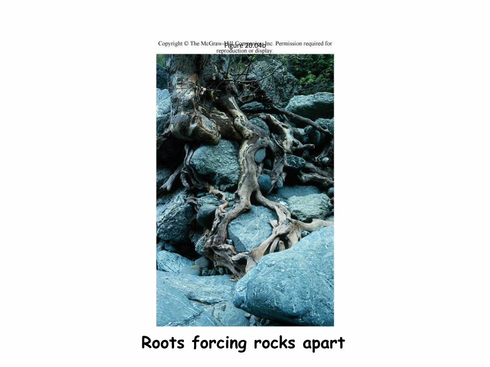
Figure 20.04b
Roots forcing rocks apart

Figure 20.05
Exfoliation of granites such as those in the Boulder Batholith

Chemical Weathering• Oxidation
– Chemically active oxygen from atmosphere
– Iron oxides are common result
• Soil and sedimentary rocks often stained
with iron oxides
• Acid dissolution– Hydrogen cations replace others in
minerals
– Carbonic acid from atmospheric CO2
dissolved in water
– Sulfuric, hydrofluoric acids emitted by volcanic eruptions
– Some minerals, such as calcite, may be totally dissolved
– Human activity, such as mining and burning of fossil fuels, produces acids
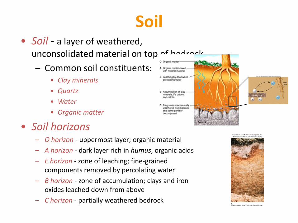
Soil• Soil - a layer of weathered,
unconsolidated material on top of bedrock
– Common soil constituents:
• Clay minerals
• Quartz
• Water
• Organic matter
• Soil horizons– O horizon - uppermost layer; organic material
– A horizon - dark layer rich in humus, organic acids
– E horizon - zone of leaching; fine-grained components removed by percolating water
– B horizon - zone of accumulation; clays and iron oxides leached down from above
– C horizon - partially weathered bedrock

Soils and Climate• Soil thickness and composition are
greatly affected by climate– Wet climates:
• More chemical weathering and thicker soils
• Soils in moderately wet climates tend to have significant clay-rich layers, which may be solid enough to form a hardpan
– Arid climates:
• Less chemical weathering and thinner soils
• Subsurface evaporation leads to build-up of salts
• Calcite-rich accumulation zones may form, cementing soil together into a hardpan
– Extremely wet climates (e.g., tropical rainforest)
• Highly leached and unproductive soils (laterites)
• Most nutrients come from thick O/A horizons
15
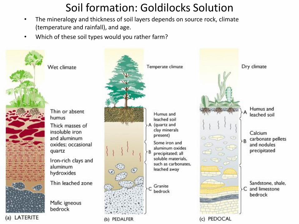
Soil formation: Goldilocks Solution• The mineralogy and thickness of soil layers depends on source rock, climate
(temperature and rainfall), and age.
• Which of these soil types would you rather farm?

“Desire Path: A term in landscape architecture used to describe a path that isn’t designed but rather is worn casually away by people finding the shortest distance between two points.” http://www.yourdailyawesome.com/
Path of desire or path of least resistance?

Running Water
• Running water is the most important
geologic agent in eroding, transporting
and depositing sediment

Hydrologic Cycle
• Hydrologic cycle - the movement and interchange of water
between the sea, air, and land
– Evaporation
• Solar radiation provides energy
– Precipitation
• Rain or snow
– Transpiration
• Evaporation from plants
– Runoff
• Water flowing over land surface
– Infiltration
• Water soaking into the ground
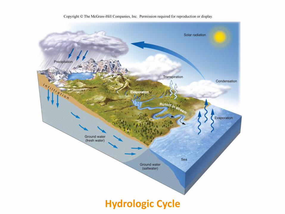
Hydrologic Cycle

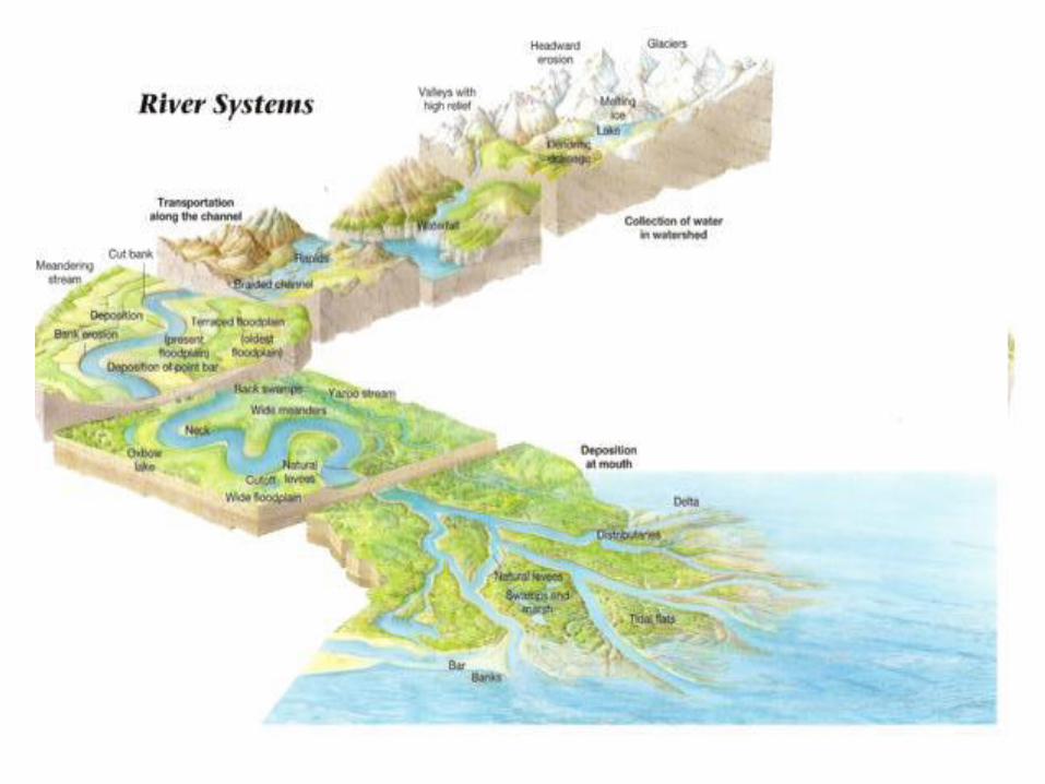
Running Water
• Stream - a body of running water, confined to a
channel, that runs downhill under the influence of gravity
– Headwaters - upper part of stream near its source in the mountains
– Mouth - place where a stream enters sea, lake or larger stream
– Delta – where sediment is dumped into the lake or ocean
– Channel - a long, narrow depression eroded by a stream into rock or sediment
– Floodplain - flat valley floor composed of sediment deposited by the stream
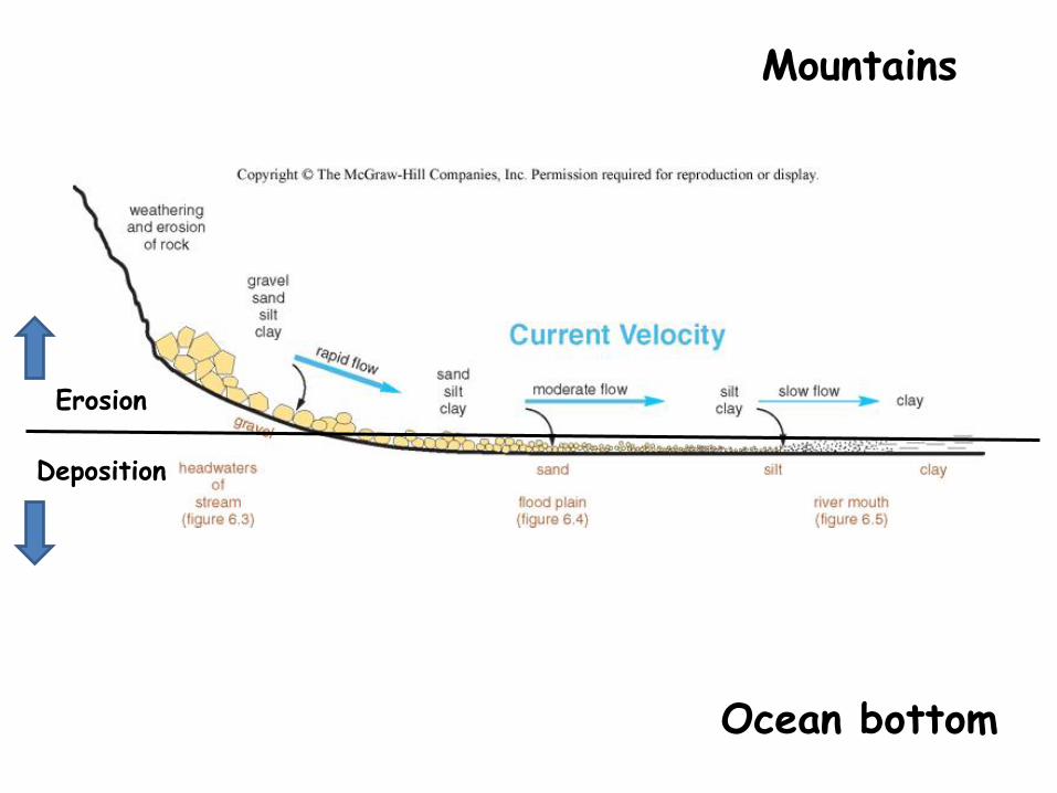
Erosion
Deposition
Mountains
Ocean bottom

Drainage Basins
• Drainage basin - the total area drained by
a stream and its tributaries
– Tributary - a small stream flowing into a larger one
• Divide - ridge or high ground that divides one
drainage basin from another
– Continental Divide separates the streams that flow into the Pacific from those that flow into the Atlantic and Gulf of Mexico
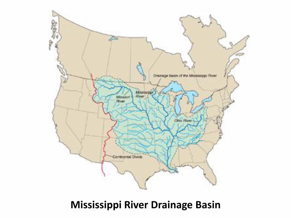
Mississippi River Drainage Basin
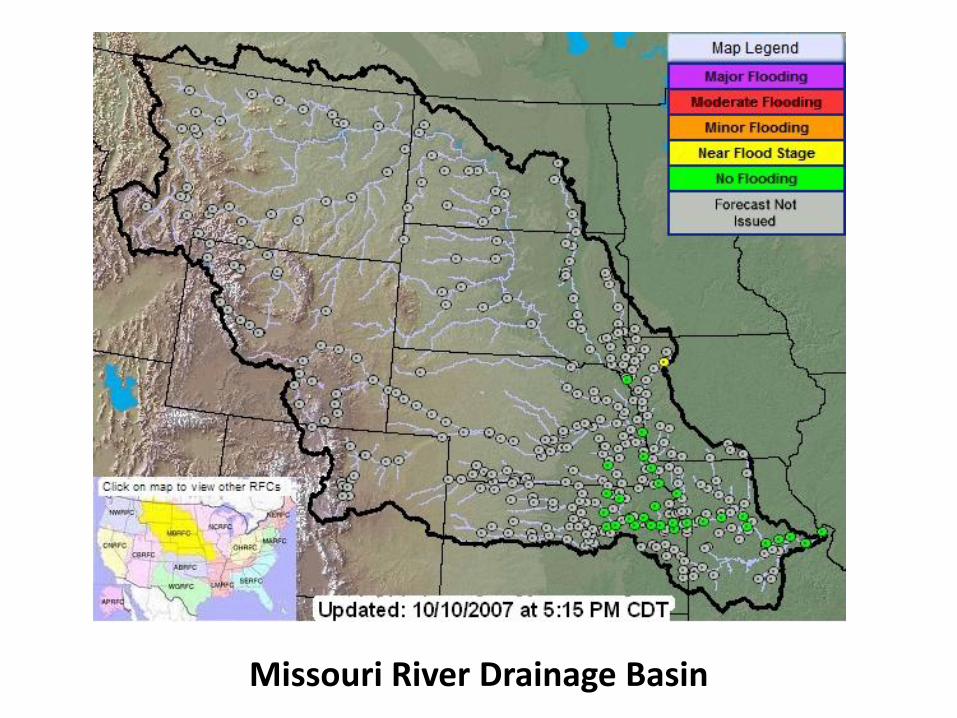
Missouri River Drainage Basin
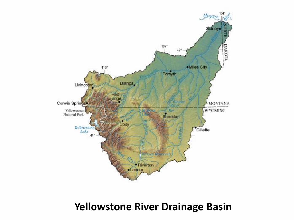
Yellowstone River Drainage Basin
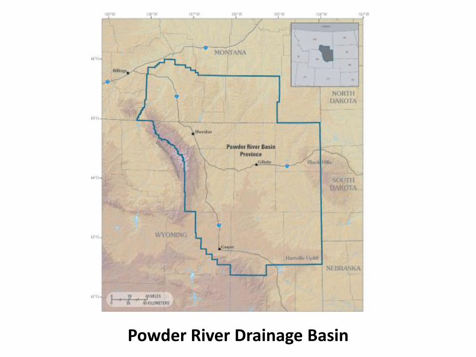
Powder River Drainage Basin
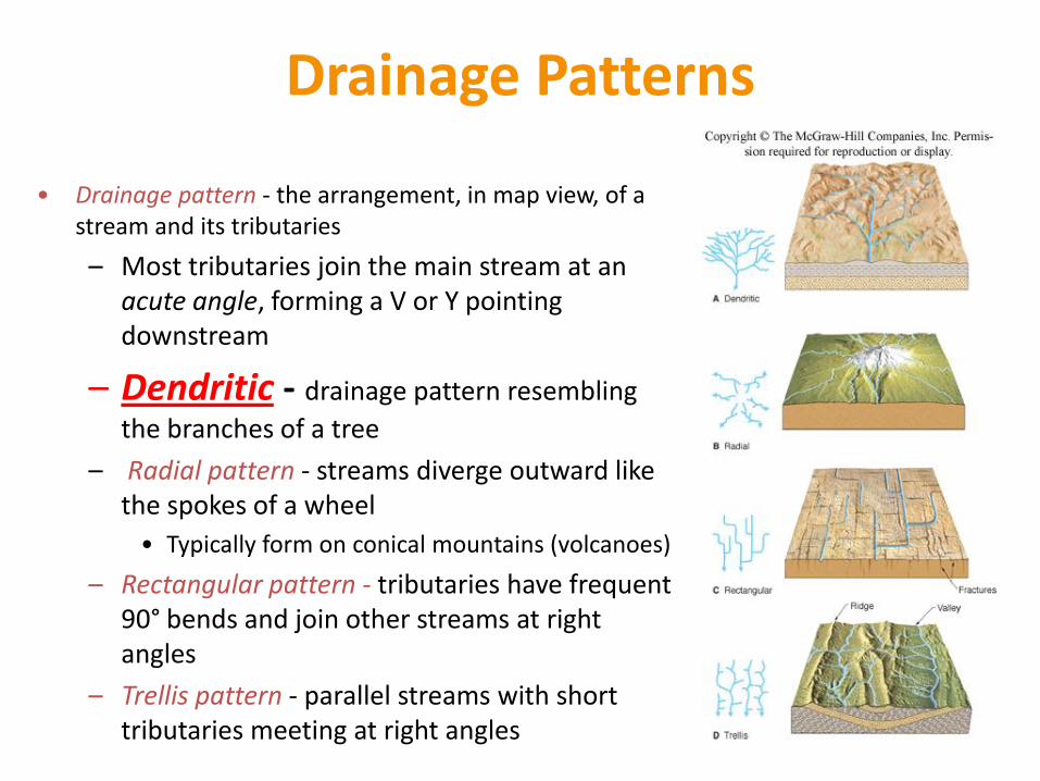
Drainage Patterns
• Drainage pattern - the arrangement, in map view, of a stream and its tributaries
– Most tributaries join the main stream at an acute angle, forming a V or Y pointing downstream
– Dendritic - drainage pattern resembling
the branches of a tree
– Radial pattern - streams diverge outward like the spokes of a wheel
• Typically form on conical mountains (volcanoes)
– Rectangular pattern - tributaries have frequent 90° bends and join other streams at right angles
– Trellis pattern - parallel streams with short tributaries meeting at right angles

Drainage Patterns

The Parana River, Brazil

The Big Sandy: a meandering stream

http://www.classzone.com/books/earth_science/terc/content/visualizations/es1306/es1306page01.cfm?chapter_no=visualization
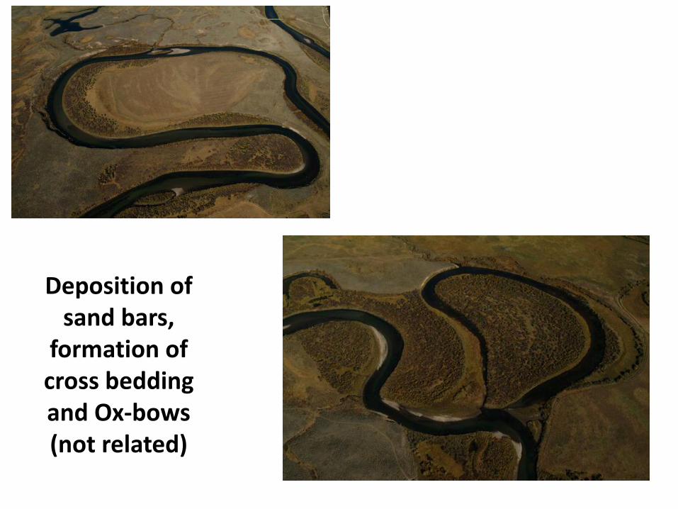
Deposition of sand bars,
formation of cross bedding and Ox-bows (not related)

Missouri River FloodplainWhere should you not build?
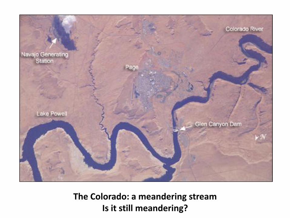
The Colorado: a meandering streamIs it still meandering?

The Colorado River in the Grand Canyon.Downcutting due to tectonic uplift
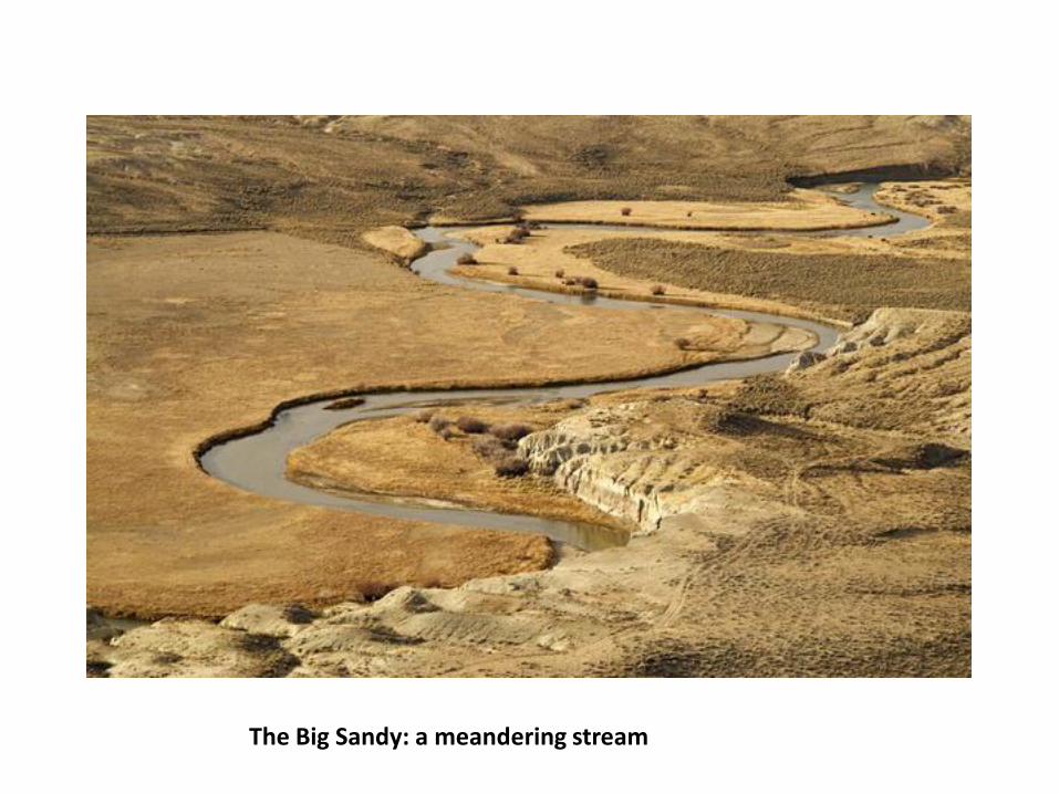
The Big Sandy: a meandering stream
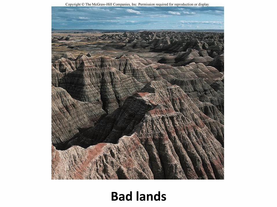
Bad lands
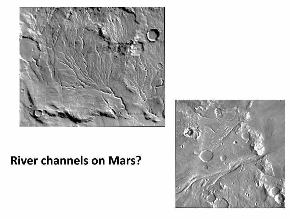
River channels on Mars?
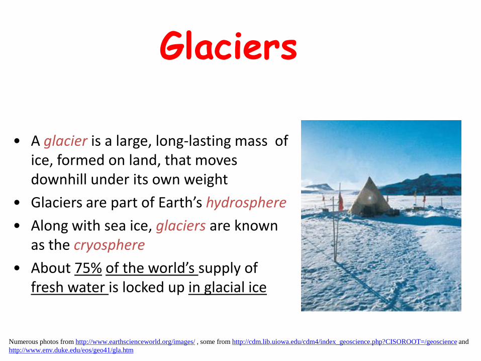
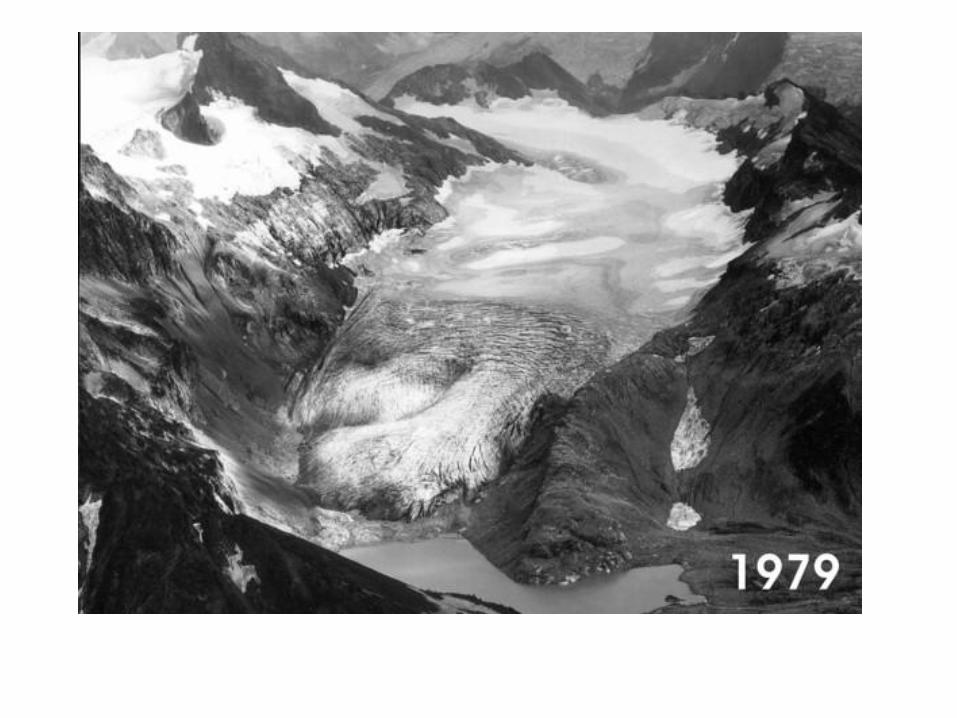
Glaciers
• A glacier is a large, long-lasting mass of ice, formed on land, that moves downhill under its own weight
• Glaciers are part of Earth’s hydrosphere
• Along with sea ice, glaciers are known as the cryosphere
• About 75% of the world’s supply of fresh water is locked up in glacial ice
Numerous photos from http://www.earthscienceworld.org/images/ , some from http://cdm.lib.uiowa.edu/cdm4/index_geoscience.php?CISOROOT=/geoscience and
http://www.env.duke.edu/eos/geo41/gla.htm
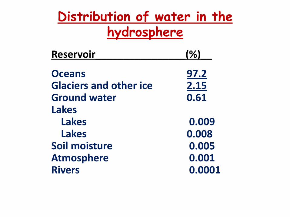
Distribution of water in the hydrosphere
OceansGlaciers and other iceGround waterLakes
LakesLakes
Soil moistureAtmosphereRivers
97.22.150.61
0.0090.0080.0050.0010.0001
Reservoir________________(%)__

Formation of Glaciers• A glacier can only form where more
snow accumulates during the winter than melts away during the spring and summer
• Two types of glaciated terrains on Earth:
– Alpine (mountain glaciers) occurs in mountainous regions in the form of valley glaciers
– Continental covers large land masses in Earth’s polar regions in the form of ice sheets, e.g. Antarctica, Arctic Ice Cap, Greenland
Alpine glacier
Continental glacier

Antarctica: continental glacier
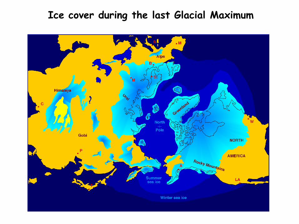
Ice cover during the last Glacial Maximum

Mountain GlaciersWhere is this? Where are other mountain glaciers?
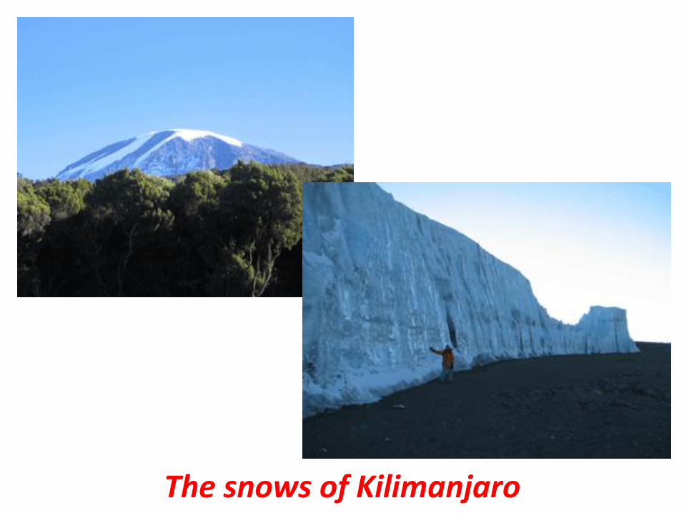
The snows of Kilimanjaro

Glacial Erosion
• Glaciers erode underlying rock by plucking of rock fragments and abrasion as they are dragged along
– Basal abrasion polishes and striates the underlying rock surface and produces abundant fine rock powder known as rock flour

Glacial striations

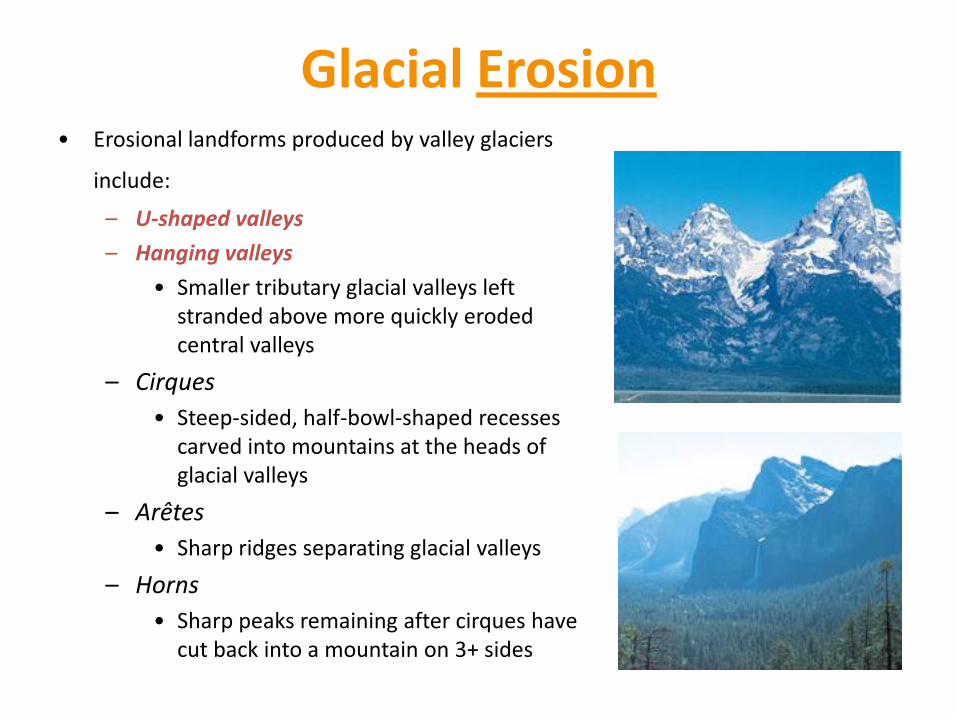
Erosional Landscapes• Erosional landforms produced by valley glaciers
include:
– U-shaped valleys
– Hanging valleys
• Smaller tributary glacial valleys left stranded above more quickly eroded central valleys
– Cirques
• Steep-sided, half-bowl-shaped recesses carved into mountains at the heads of glacial valleys
– Arêtes
• Sharp ridges separating glacial valleys
– Horns
• Sharp peaks remaining after cirques have cut back into a mountain on 3+ sides
Glacial Erosion• Erosional landforms produced by valley glaciers
include:
– U-shaped valleys
– Hanging valleys
• Smaller tributary glacial valleys left stranded above more quickly eroded central valleys
– Cirques
• Steep-sided, half-bowl-shaped recesses carved into mountains at the heads of glacial valleys
– Arêtes
• Sharp ridges separating glacial valleys
– Horns
• Sharp peaks remaining after cirques have cut back into a mountain on 3+ sides

U-shaped valleys


River cut V-shaped valleys
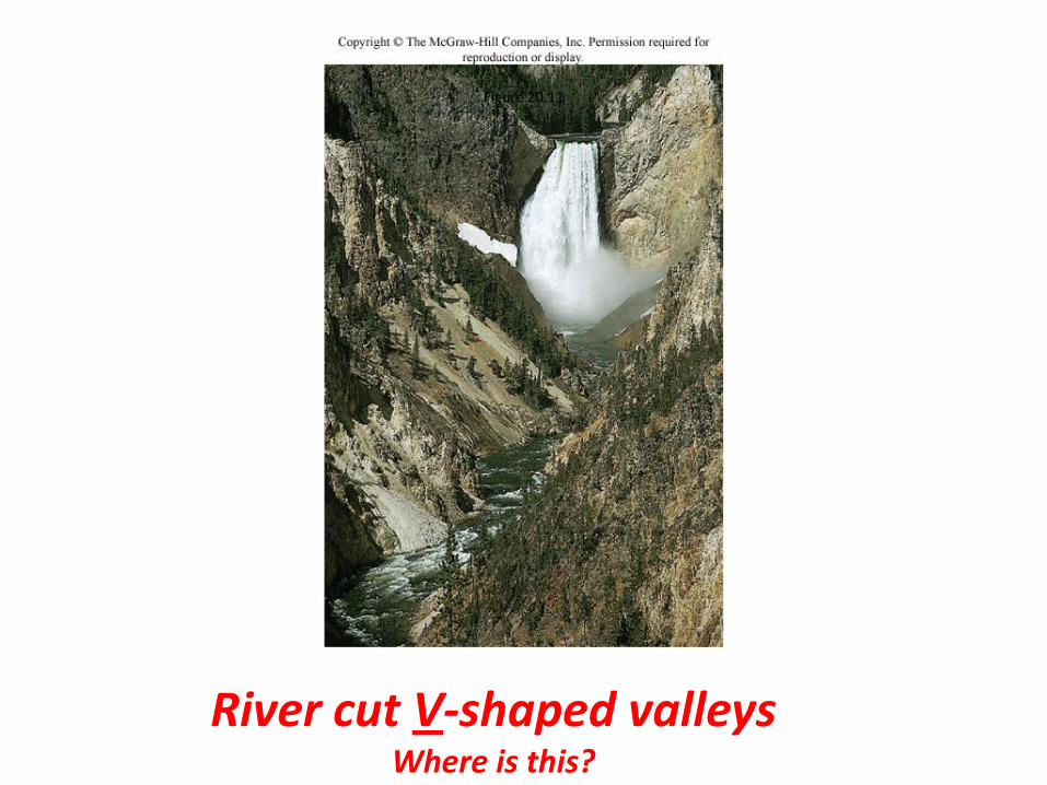
Figure 20.11
River cut V-shaped valleysWhere is this?
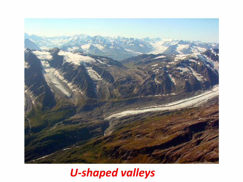
U-shaped valleys

U-shaped valleys

Hanging valleys
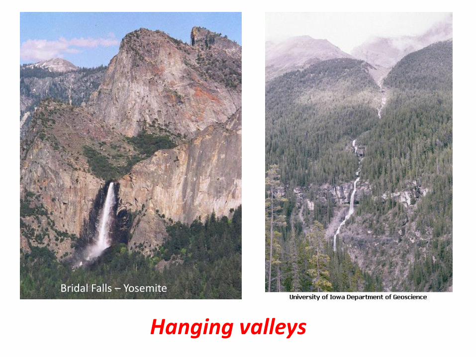
Hanging valleys
Bridal Falls – Yosemite
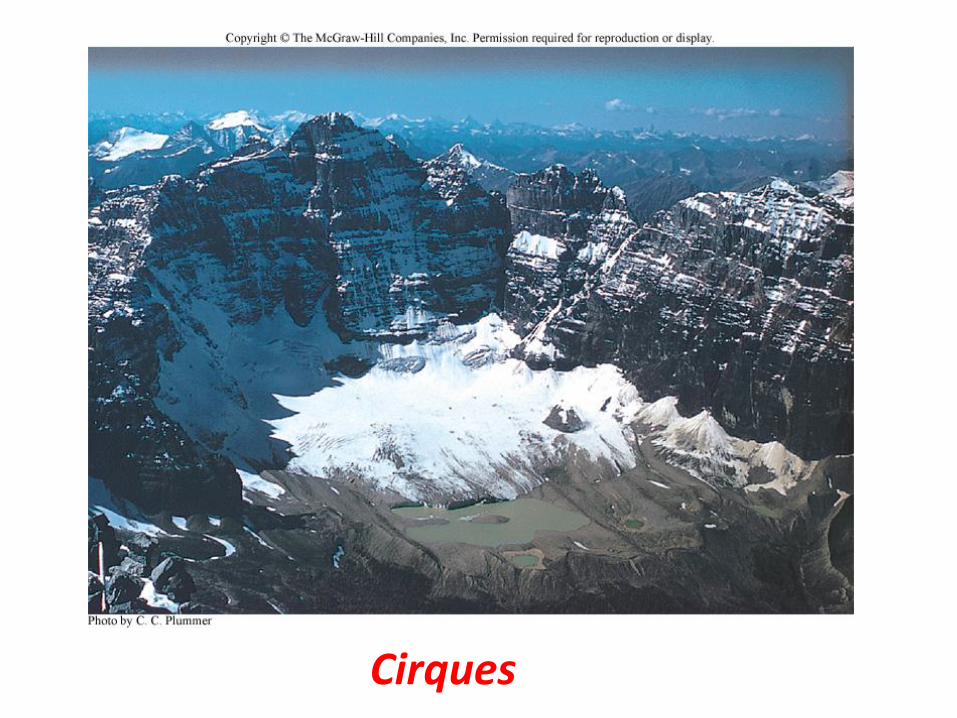
Cirques
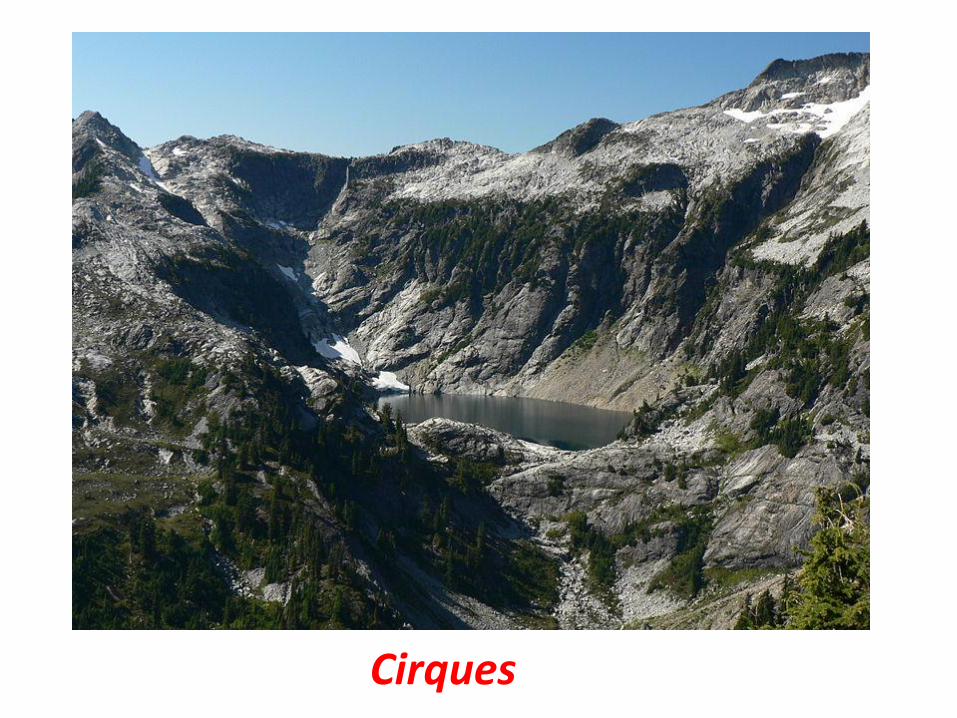
Cirques

Cirques
Wind river range
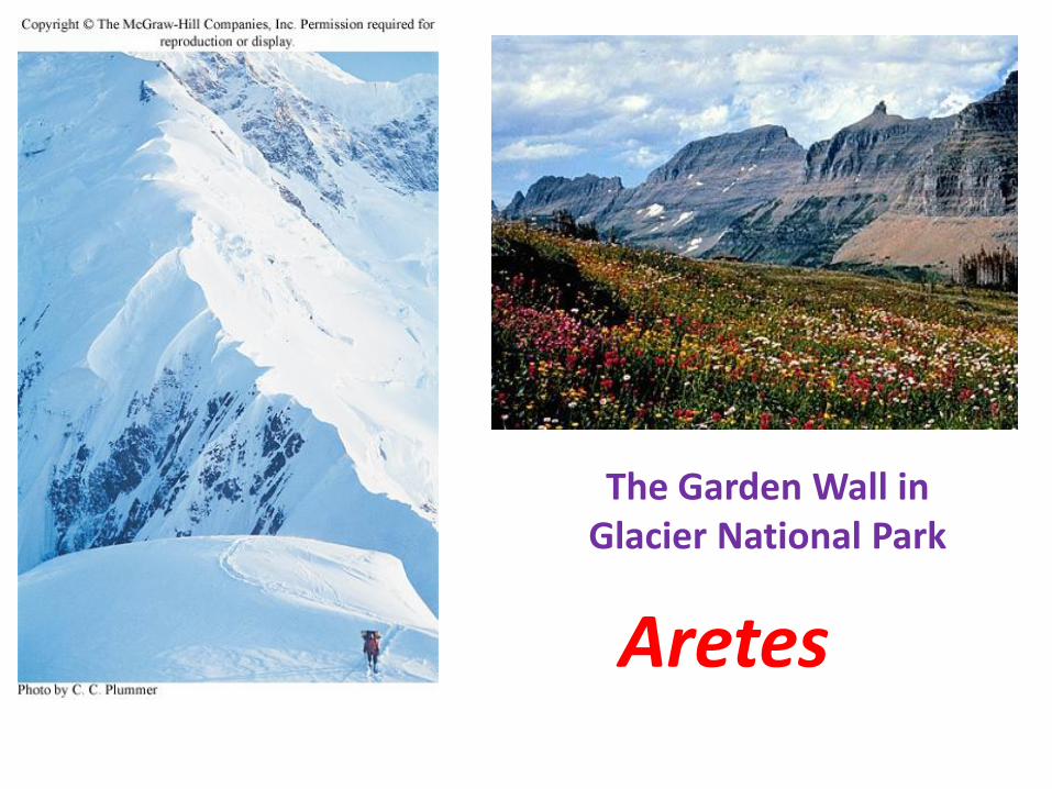
Aretes
The Garden Wall in Glacier National Park

HornsMatterhorn

Glacial Deposition
• General name for unsorted, unlayered glacial
sediment is till
– Deposits of till left behind at the sides and end of a glacier are called lateral, medial and terminal moraines, respectively
• Lateral moraines are elongate, low mounds of till along sides of valley glaciers
• Medial moraines are lateral moraines trapped between adjacent ice streams
• Terminal moraines are ridges of till piled up along the front end of a glacier
• Successive end moraines left behind by a retreating glacier are called recessional moraines
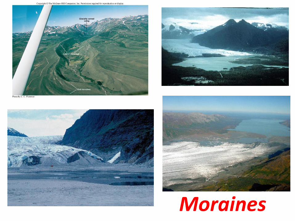
Moraines
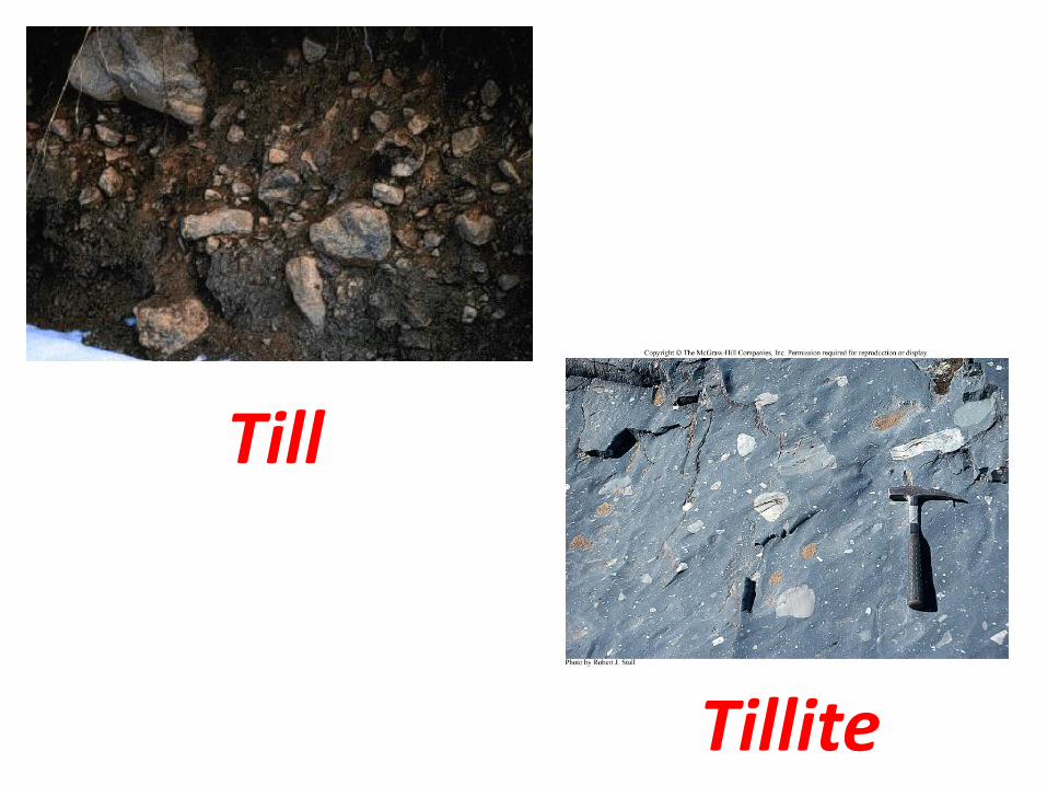
Till
Tillite

OldOld
NewNew
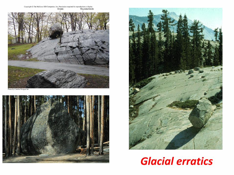
Glacial erratics

Varves
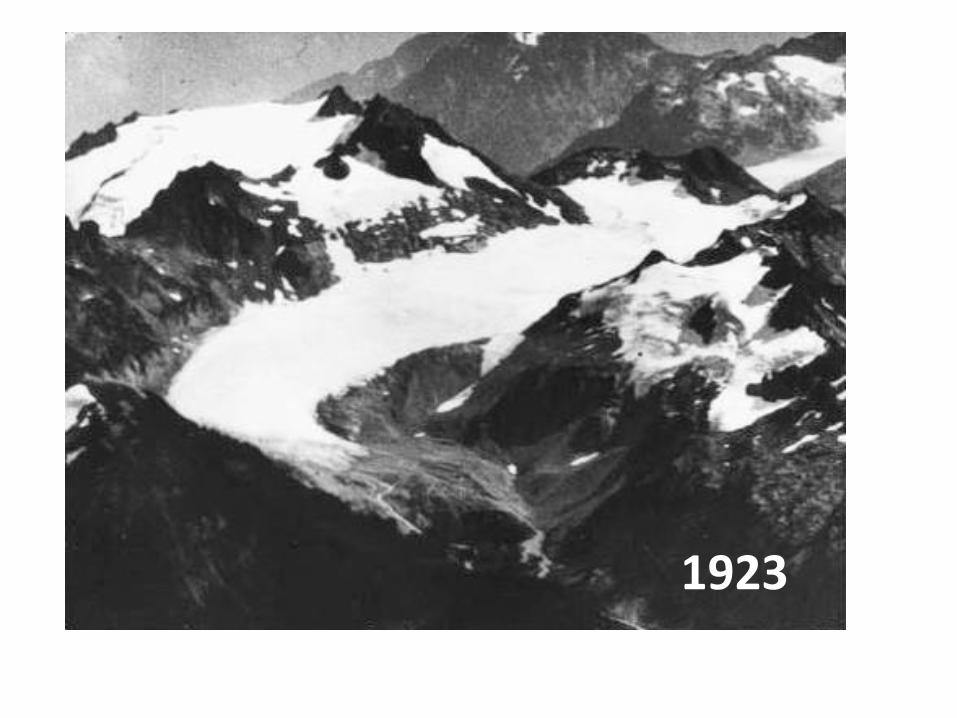
1923

2000
