wayfinding in the built environment stage 1 (final ... · pdf filethe research described in...
TRANSCRIPT

CRC for Construction Innovation
Wayfinding in the Built Environment ― Stage 1 (Final research report)
Project 2002-053-C
The research described in this report was carried out by: Project Leader: Dennis Hogan Team Members: Brian Ashe John Crawford Dale Gilbert Ron Apelt Debbie Smit Paul Smith Researchers: John Crawford, Debbie Smit, Paul Smith Project Affiliates: Maryanne Diamond (BCA), Collette O’Neil (BCA), Michael Small (HREOC),
Jo Higginson (OCGC) and Bryce Tolliday (IAS) Research Program C Delivery and management of built assets Research Project 2002-053-C Wayfinding in the Built Environment Date: 31 July 2004

Wayfinding in the Built Environment – Stage 1
Distribution List Cooperative Research Centre for Construction Innovation Authors Disclaimer The Reader makes use of this Report or any information provided by the Cooperative Research Centre for Construction Innovation at their own risk. Construction Innovation will not be responsible for the results of any actions taken by the Reader or third parties on the basis of the information in this Report or other information provided by Construction Innovation nor for any errors or omissions that may be contained in this Report. Construction Innovation expressly disclaims any liability or responsibility to any person in respect of any thing done or omitted to be done by any person in reliance on this Report or any information provided.
© 2007 Icon.Net Pty Ltd To the extent permitted by law, all rights are reserved and no part of this publication covered by copyright may be reproduced or copied in any form or by any means except with the written permission of Icon.Net Pty Ltd. Please direct all enquiries to:
Chief Executive Officer Cooperative Research Centre for Construction Innovation 9th Floor, L Block, QUT, 2 George St Brisbane Qld 4000 AUSTRALIA T: 61 7 3138 9291 F: 61 7 3138 9151 E: [email protected] W: www.construction-innovation.info

Wayfinding in the Built Environment – Stage 1
Page i
EXECUTIVE SUMMARY ........................................................................................................1
1. WAYFINDING...................................................................................................3
1.1 Community.................................................................................................................................. 4 1.1.1 Indoors vs. Outdoors ..................................................................................................... 4 1.1.2 New or Existing Buildings and Spaces – Cost .............................................................. 4 1.1.3 Accessibility and Emergency Egress ............................................................................ 5 1.1.4 Key Questions ............................................................................................................... 5
1.2 Users / Citizens ........................................................................................................................... 5 1.2.1 Maintenance and Cost ................................................................................................... 6 1.2.2 Appropriate ................................................................................................................... 6 1.2.3 Refusable, unaided assistance ....................................................................................... 6 1.2.4 Key Questions ............................................................................................................... 7
1.3 Researchers ................................................................................................................................. 7 1.3.1 Key Questions ............................................................................................................... 7
2. CONTEXT, DESIGN AND LEGISLATIVE ASPECTS...................................8
2.1 Requirements and Standards ....................................................................................................... 8 2.1.1 Background ................................................................................................................... 8 2.1.2 History of the DDA legislation in Australia.................................................................. 9 2.1.3 AS1428 Design for Access and Mobility – Draft Legislation....................................... 9 2.1.4 AS 1735.12-1999 : Lifts, escalators and moving walks - Facilities for
persons with disabilities .............................................................................................. 10 2.1.5 Premises Standard ....................................................................................................... 10 2.1.6 Wayfinding.................................................................................................................. 10 2.1.7 Government Initiatives................................................................................................ 10
2.2 Relevant Legislation.................................................................................................................. 11 2.2.1 Common Law Cases ................................................................................................... 11 2.2.2 Accessibility and Emergency Egress .......................................................................... 12 2.2.3 A summary of the Law in Australia ............................................................................ 13
2.3 International .............................................................................................................................. 14 2.3.1 United Nations Conventions, Covenants and Declarations......................................... 14 2.3.2 Europe 15 2.3.3 United Kingdom.......................................................................................................... 15 2.3.4 United States of America ............................................................................................ 15 2.3.4.2 Project Civil Access .................................................................................................... 16 2.3.4.3 US Federal Department of Justice lawsuits enforcing ADA ........................................ 16
2.4 Summary Comments for Legislative Aspects ........................................................................... 17
3. PASSIVE SYSTEMS and TECHNOLOGIES .................................................19
3.1 Tactile Ground Surface Indicators (TGSIs)............................................................................... 19 3.1.1 Warning TGSI............................................................................................................. 19 3.1.2 Directional TGSI......................................................................................................... 20 3.1.3 Detectable Orientation Surfaces.................................................................................. 20
3.2 Raised Tactile (Embossed) and Braille Signage Systems ......................................................... 21
4. DYNAMIC SYSTEMS and TECHNOLOGIES ..............................................22
4.1 Directional Compass ................................................................................................................. 22 4.1.1 Tactile Compass .......................................................................................................... 22 4.1.2 Talking Compass......................................................................................................... 22
4.2 Infrared / Ultrasonic Obstacle Locator ...................................................................................... 23 4.2.1 Sonic Pathfinder .......................................................................................................... 23 4.2.2 NavBelt 23 4.2.3 Miniguide (Audio or Tactile) ...................................................................................... 24
Wayfinding in the Built Environment – Stage 1
Page ii
4.2.4 Hand Guide ™ ............................................................................................................. 24 4.2.5 Polaron™ .................................................................................................................... 25
4.3 Enhanced / Specialist Cane ....................................................................................................... 25 4.3.1 GuideCane................................................................................................................... 25 4.3.2 UltraCane .................................................................................................................... 26
4.4 GPS Position Locator ................................................................................................................ 27 4.4.1 MoBIC project ............................................................................................................ 27 4.4.2 Drishti project.............................................................................................................. 28
4.5 Personal Digital Assistant (PDA) & Notetakers........................................................................ 29 4.5.1 Mobility Agents .......................................................................................................... 29
4.6 Talking Digital Map Systems.................................................................................................... 30 4.6.1 GPS Trekker................................................................................................................ 30 4.6.2 Atlas and BrailleNote GPS.......................................................................................... 30
4.7 Tactile Map Systems ................................................................................................................. 31 4.7.1 Wayfinding and Universal Design .............................................................................. 31 4.7.2 Urban Location Maps (TMAP) ................................................................................... 31
4.8 Mobile Phones / Communicators .............................................................................................. 31 4.8.1 Nokia, Audiovox and Samsung................................................................................... 32 4.8.2 DrishtiLite ................................................................................................................... 32
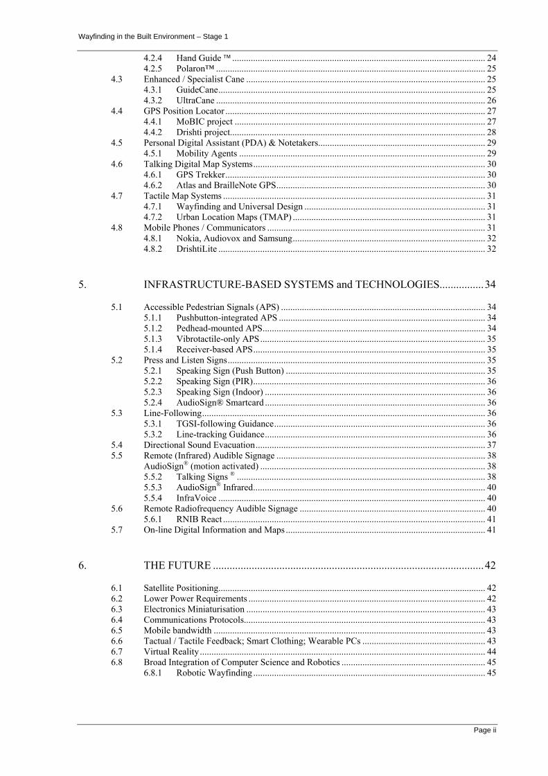
5. INFRASTRUCTURE-BASED SYSTEMS and TECHNOLOGIES................34
5.1 Accessible Pedestrian Signals (APS) ........................................................................................ 34 5.1.1 Pushbutton-integrated APS ......................................................................................... 34 5.1.2 Pedhead-mounted APS................................................................................................ 34 5.1.3 Vibrotactile-only APS................................................................................................. 35 5.1.4 Receiver-based APS.................................................................................................... 35
5.2 Press and Listen Signs............................................................................................................... 35 5.2.1 Speaking Sign (Push Button) ...................................................................................... 35 5.2.2 Speaking Sign (PIR).................................................................................................... 36 5.2.3 Speaking Sign (Indoor) ............................................................................................... 36 5.2.4 AudioSign® Smartcard ............................................................................................... 36
5.3 Line-Following.......................................................................................................................... 36 5.3.1 TGSI-following Guidance........................................................................................... 36 5.3.2 Line-tracking Guidance............................................................................................... 36
5.4 Directional Sound Evacuation................................................................................................... 37 5.5 Remote (Infrared) Audible Signage .......................................................................................... 38
AudioSign® (motion activated) ................................................................................................. 38 5.5.2 Talking Signs ® ........................................................................................................... 38 5.5.3 AudioSign® Infrared.................................................................................................... 40 5.5.4 InfraVoice ................................................................................................................... 40
5.6 Remote Radiofrequency Audible Signage ................................................................................ 40 5.6.1 RNIB React ................................................................................................................. 41
5.7 On-line Digital Information and Maps ...................................................................................... 41
6. THE FUTURE ..................................................................................................42
6.1 Satellite Positioning................................................................................................................... 42 6.2 Lower Power Requirements ...................................................................................................... 42 6.3 Electronics Miniaturisation ....................................................................................................... 43 6.4 Communications Protocols........................................................................................................ 43 6.5 Mobile bandwidth ..................................................................................................................... 43 6.6 Tactual / Tactile Feedback; Smart Clothing; Wearable PCs ..................................................... 43 6.7 Virtual Reality ........................................................................................................................... 44 6.8 Broad Integration of Computer Science and Robotics .............................................................. 45
6.8.1 Robotic Wayfinding .................................................................................................... 45

Wayfinding in the Built Environment – Stage 1
Page iii
7. CONCLUSIONS...............................................................................................47
7.1 Immediate Action...................................................................................................................... 47 7.2 Medium Term............................................................................................................................ 50 7.3 Long Term................................................................................................................................. 50
8. REFERENCES .................................................................................................51
9. INTERNET SITES ...........................................................................................54
10. GLOSSARY .....................................................................................................56
11. AUTHOR BIOGRAPHIES ..............................................................................60
12. APPENDIX 1: MATRIX FOR WAYFINDING WITHIN THE BUILT ENVIRONMENT .............................................................................................61
List of Figures
Figure 1.1 Typical Pictograms.........................................................................................................6 Figure 3.1 Typical warning tactile surface tile (ivory coloured). .........................................................19 Figure 3.2 Typical directional tactile surface tile (canary yellow coloured)..........................................20 Figure 3.3 Detectable directional guidance surface .........................................................................20 Figure 3.4 Various combinations of tactile and Braille signage .........................................................21 Figure 3.5 An ‘exploded view’ of BrailliantTouch® signage ..............................................................21 Figure 4.1 Tactile (Braille) Compass ..............................................................................................22 Figure 4.2 C2 Talking Compass ....................................................................................................23 Figure 4.3 SonicPathfinder device .................................................................................................23 Figure 4.4 Tactile and audio Miniguide devices ..............................................................................24 Figure 4.5 HandGuide™ device ....................................................................................................25 Figure 4.6 Polaron™ device .........................................................................................................25 Figure 4. 7 Early GuideCane.........................................................................................................26 Figure 4.8 UltraCane device .........................................................................................................27 Figure 4.9 Drishti wearable system................................................................................................29 Figure 4.10 Nokia 9290 Communicator device ...............................................................................32 Figure 5.1 Talking Sign Push Button system ..................................................................................36 Figure 5.2 Smoke obscured exit system.........................................................................................37 Figure 5.3 Talking Sign CalTrain installation schematic ...................................................................39 Figure 6.1 Robotic Guide..............................................................................................................45

Wayfinding in the Built Environment – Stage 1
Page 1
EXECUTIVE SUMMARY
This report sets out to identify systems and technologies that could be used to make it easier and safer for people with a sensory impairment to find their way around buildings and large public areas. Those systems and technologies should be suitable for people who have a sensory impairment including people with both a visual and a hearing impairment. This report also makes recommendations on how these technologies and systems may be incorporated, by law or otherwise, into Australia’s building and construction practice.
The “passive” systems identified in this report, such as tactile ground surface indicators consisting of square tiles with a raised surface which warn of a hazard ahead or indicate safe path of travel, are extensively used in Australia in public spaces to guide people with a visual impairment. In addition, embossed and Braille signs are readily available to supplement vision-based direction and other signs.
There are many systems identified in this report which are of a mobile portable nature but require a power source to operate to provide audio and/or tactile feedback to vision-impaired users. These “dynamic” devices are typically designed to be used by vision-impaired persons in conjunction with a traditional long cane or guide dog. Examples are tactile compasses, talking compasses, infrared or ultrasonic obstacle locators and other handheld devices which are available to assist (in particular) vision-impaired users to navigate around buildings and other spaces. These systems are essentially of a proprietary nature and are thus effectively independent of one another. However there is movement to develop communication protocols which would allow new generation devices to communicate with each other to provide multifunctional use.
In addition to the portable devices, there are a range of stand-alone inbuilt systems (that rely upon infrastructure being installed and maintained in buildings and other venues) which can assist vision-impaired users by providing them with additional audio and/or other feedback, and which have proved to be cost effective and reliable. These include audio and tactile signs - often found in lifts and in the general circulation areas of facilities such as exhibitions, conference halls, museums and other public buildings.
These stand-alone inbuilt systems do not demand the user carry interactive handheld devices but instead rely upon audio, vibration or tactile indicators. Typically these systems adapt existing systems, such as street crossing lights, exit signs and lift controls and thus do not require an additional system for the benefit of sensory impaired users only. Generally they are aimed at improving health and safety rather than improving general accessibility and have proved to be a relatively simple and cost effective adaptation to existing systems. More recently, directional sound evacuation systems have also been developed to provide a dual function of assisting vision-impaired users to find exits in an event of emergency as well as to assist non-sensory impaired users in the event of smoke obstructing the illuminated sign.
The final group of systems which are currently in general use are inbuilt electronic systems which communicate with the user via a personal handheld receiver. Typically these systems consist of inbuilt beacons located at key locations to transmit information relevant to that location to the user. For example information describing the location of an entrance to a complex, opening hours, and the location of key services within the facility may be transmitted by infrared or radio transmissions.
Wayfinding in the Built Environment – Stage 1
Page 2
For broader-scale location and orientation, there are also specialised geographic information systems (GIS) available to provide access to map-based information and other systems that are in more limited use. In addition, devices utilising information from satellite-based Global Positioning Systems (GPS) will also become more accurate for individual location tasks.
It is expected that the power requirements, physical size and costs of interactive handheld devices will be reduced so as to see greater reliance on such devices in the future, although at this time these systems are seen as offering great future potential rather than being available for immediate use.
Even further into the future it is likely that personal virtual reality devices will be available which may or may not rely on inbuilt infrastructure to guide the vision-impaired user.
The conclusions of this report are set out in Section 7, however in summary the authors are of the opinion that while individual users, as well as individual venues, may benefit from the installation and use of the more advanced systems identified in this report, including the satellite-based GPS, computer-based and wireless tracking systems, they are currently not sufficiently developed to justify general application to all buildings and public venues.
Further, systems and technologies which require handheld devices that are useful only within particular buildings and venues, and which must be provided and maintained by the building or venue manager, would also not be suitable for use in all buildings and other spaces. However the authors believe that such systems may be practicable if a suitable communication protocol or standard was developed and implemented to enable the universal use of devices in different buildings and venues. The authors believe that such a protocol should be given high priority.
The authors are of the opinion that some of the passive systems and technologies, including tactile ground surface indicators, embossed and Braille signage systems, as well as some active systems including audio/verbal information signs and digital sound evacuation systems, are currently sufficiently well developed to be introduced generally as a minimum requirement for all buildings which presently are required to have systems installed for people with no sensory impairment, and for some other venues. The authors acknowledge that these systems will only go part of the way to eliminating access barriers to people with a sensory impairment.
The extent to which these systems could or should be required to be incorporated into buildings and other venues and how the Building Code of Australia and other related legislation should be amended to take these established systems into account needs further investigation.

Wayfinding in the Built Environment – Stage 1
Page 3
1. WAYFINDING
The project objective was “to identify technologies and systems that will make it easier and safer for people who have a sensory impairment to find their way around large public areas”.
Locally, Queensland Health in their “Building Guidelines for Mental Health Facilities 1996 (Section 1 Background)” has noted wayfinding as :
“ The ease with which one proceeds and is facilitated through an environment from one point of interest to another. Wayfinding systems include such components as basic layout of building and site, interior and exterior landmarks, views to outside, signs, floor and room numbering, spoken directions, maps, directories, logical progression of spaces, colour coding. “
The US Department of Education’s NIDRR (National Institute on Disability and Rehabilitation Research) in their “Notice of Proposed Funding Priorities for Fiscal Years (FYs) 2001-2003 for three Disability and Rehabilitation Research Projects” advises :
“ Wayfinding refers to techniques used by people who are blind or visually impaired as they move from place to place independently and safely. Wayfinding is typically divided into two categories: orientation and mobility. Orientation concerns the ability for one to monitor his or her position in relationship to the environment; and mobility refers to one's ability to travel safely, detecting and avoiding obstacles and other potential hazards. In general terms, wayfinding is the ability to; know where you are, where you are headed, and how best to get there; recognize when you have reached your destination; and find your way out--all accomplished in a safe and independent manner. “
For the purposes of this project the term “Way Finding” or “Wayfinding” (either spelling appears acceptable in the literature) has been adopted to describe the process of using spatial and environmental information to find our way in the built environment, or Wayfinding can be defined as spatial problem solving. Vision-impaired is a term used locally for persons suffering blindness, while in the US and UK the term visually impaired is often used as well.
The objective of Wayfinding is to ensure that people with a sensory impairment and in particular a vision-impairment know where they are in a building or an environment, know where their desired location is, and know how to get there from their present location.
Mobile portable devices or electronic travel aids (ETAs), electronic mobility devices, mobility aids, obstacle detectors, navigational aids as well as tactile signage and other inbuilt physical features may be employed as to achieve the Wayfinding objective.
The project therefore involves consideration of systems that may be employed in both buildings and other external public places. Systems that are considered include physical electronic or tactile items that interact to perform a task, such as interactive handheld electronic devices and administrative procedures, such as building management procedures.
For example systems that may be suitable for large public external areas such as Federation Square in Melbourne or Hyde Park in Sydney and precincts around sporting venues such as the MCG or Australia Stadium require different considerations to those required for internal private and commercial spaces within buildings and the large internal public spaces of airport terminals, major train stations, large bus interchanges shopping malls, theatres and the like.

Wayfinding in the Built Environment – Stage 1
Page 4
Because of this broad scope, a substantial number of considerations arise both from the community viewpoint, as well as from the user’s viewpoint.
1.1 Community 1.1.1 Indoors vs. Outdoors
Some systems or technologies may be restricted to an indoor or undercover setting. Others may be limited to a wholly outdoors environment. For example, some electronic devices or sensors are not water-proof or robust enough to be used outdoors, while other technologies such as satellite-based GPS (Global Positioning Systems) and certain wireless transmissions used in computer communications will have sever limitations on their effectiveness when employed within or nearby a built facility.
1.1.2 New or Existing Buildings and Spaces – Cost
Within a building, various systems and technologies will require specialised power supplies or perhaps extensive computer network connections or similar. These types of systems may prove to be too costly, or too unsightly and disruptive to retrofit to existing facilities. When discussing inclusive design in their excellent handbook for building and design, Barker et al. (1995, p19) encapsulate inclusion by noting :
“Clearly, it is both commonsense and sound investment policy to design a building that is accessible to everyone, including those in wheelchairs or with sensory loss, whether required by legislation or not. This important objective should remain at the forefront of the building design strategy when considering future extensions.”
As with more traditional access systems, it makes common sense that if the systems and technologies for improved access for people who have a sensory impairment is planned for at the design stage the costs and inconvenience of installation will be much reduced.
It may therefore prove to be prudent to first concentrate on introducing changes to new buildings and spaces before extending to existing buildings and spaces, although clearly this alone would not fully meet the Wayfinding objective.
There are a number of excellent design guide documents available - both overseas and local (e.g. Barker et al., 1995, Royal Blind Society of NSW, 2003) - which set out a wide range of considerations that building and interior designers should take into account when designing to include and assist the disabled and vision-impaired population. Details are available in those documents, however it is crucial to recognise that there is a raft of design issues such as room and corridor layout alternatives; use of shorelines for navigation; use and impact of lighting; influence of wall and floor finishes including texture and colour, edging to walkways; location and use of signage; lettering sizes; use of colour contrast; etc. which should all be considered to maximize accessibility whenever design or refurbishment of built facilities is undertaken.

Wayfinding in the Built Environment – Stage 1
Page 5
1.1.3 Accessibility and Emergency Egress
As will be noted from Section 2 of this report there has been some consideration given to aiding and assisting sensory and physically disabled persons to access built facilities, both as business employees, and as citizens visiting the premises.
The building law in all States and Territories provides an opportunity to have systems installed at an early stage. All States and Territories essentially regulate, through the Building Code of Australia, new buildings and some alterations and extensions to existing buildings. However the building law generally does not regulate the external public spaces, whether it involves new work in those spaces or not.
The Building Code of Australia (“BCA”) has historically principally dealt with health and safety and amenity issues. The amenity issues being only those that relate to health and safety. However this has progressively changed by, for example, the inclusion in the BCA of energy efficiency, access for people with disabilities and other matters not principally dealing with health and safety. As a consequence the traditional inbuilt fire safety devices provided for in the BCA deal with the safe exit of people from buildings in the event of a fire and may not, in their present location and form, be suitable for adapting for Wayfinding purposes.
1.1.4 Key Questions
If the Wayfinding objective is to be fully achieved, systems or technologies must be those which are suitable for use in a variety of atmospheric conditions and settings, viz.
a. indoors;
b. outdoors; and
c. both.
Systems and technologies must also be suitable for retrofitting into existing built facilities, as well as suitable for installation during construction and be reliable in an emergency (for example, for evacuation of impaired persons and rapid egress during a fire).
Systems and technologies must be suitable for people who have a sensory impairment preferably including people with both a vision and a hearing impairment.
1.2 Users / Citizens
The system or technology should be able to be easily used by people who have a sensory impairment, but may require some initial or on-going training for the user to obtain maximum benefit. This may involve a cost and commitment by the user and perhaps the community - particularly if training is required both by the person and the owner, occupant or manager of the facility.
We have not attempted to address the broader issue of training in this Report - which is not to diminish it’s significance, but to recognise the Report’s focus is more upon the technical nature of systems and technologies. It must certainly be acknowledged that with the introduction of new systems (whether they be passive, technology-based or a blend of both

Wayfinding in the Built Environment – Stage 1
Page 6
working together), research in the human factors and occupational health fields suggests that substantial introductory and on-going Orientation and Mobility (O&M) training for some users will be crucial in ensuring that they retain confidence in, and obtain maximum benefit from, the introduction of new approaches to wayfinding.
1.2.1 Maintenance and Cost
The system or technology should ideally also be easily maintained. For example electronic devices should have easily replaced parts; appropriate battery life; easily recharged power supply; etc., or at least be able to be serviced in a straightforward manner by a servicing or distribution agent.
Portable handheld devices, if used, should be low cost or “affordable” for the bulk of users. Whether the cost is kept low by renting an appropriate device, or by a low initial purchase price, or by some form of subsidy, the cost of the system should provide maximum accessibility to people who have a sensory impairment. The cost to the community (both Government and commercial building owners) of providing necessary infrastructure, systems or devices also needs to be considered.
1.2.2 Appropriate
If the systems or technologies rely on sound to provide audio feedback to people who have a sensory impairment then persons that are hearing impaired or who are both vision and hearing impaired will not be well served. Then again, tactile feedback such as vibration may not be appropriate in all cases. Language signs may be useful to a sighted person using a wheelchair, but simple pictograms may be more useful to persons with some level of intellectual or cognitive impairment or even to persons who do not understand the language used in the signage.
Figure 1.1 Typical Pictograms
1.2.3 Refusable, unaided assistance
Australian communities are moving towards respecting increased independence and dignity for all citizens including people who have a sensory impairment by making ‘refusable, unaided assistance’ available where and when required. This means that citizens have a choice of gaining assistance if needed without drawing unnecessary attention to themselves as disabled in some sense. Hearing loops (such as audio induction or FM radio-assisted loops, or infrared ring-of-sound) in some public performance venues are examples of this type of
Wayfinding in the Built Environment – Stage 1
Page 7
‘refusable, unaided assistance’ which can be made available with or without discreet specialist receivers - at a cost to the venue, and perhaps to patrons.
1.2.4 Key Questions
Key questions for the system or technology include:
• is it easy to use, and to maintain;
• does it require substantial initial and/or on-going training;
• is it affordable for a) the user, and b) the community;
• is it reliant on a user’s other senses apart from hearing;
• is it useful for all people who have a sensory impairment;
• is it also useful for other persons with a disability including sighted persons using a wheelchair, and persons with an intellectual impairment;
• is it useful for people with no disability;
• is it intrusive for the user (does it draw unnecessary attention to the impaired person)
1.3 Researchers
1.3.1 Key Questions Taking into account the user and community requirements as set out above, then within the timeframes anticipated in the CRC for Construction Innovation plans, can the system and/or technology be successfully:
a. investigated or designed
b. tested
c. implemented on trial basis?

Wayfinding in the Built Environment – Stage 1
Page 8
2. CONTEXT, DESIGN AND LEGISLATIVE ASPECTS
2.1 Requirements and Standards
2.1.1 Background
It is likely that wayfinding would not have fitted comfortably in Australia’s state and territory building controls prior to the inception of the Building Code of Australia in 1990 (BCA 90). Prior to the BCA 90 building controls were limited to controlling health, safety and very limited amenity issues associated with building work. The limited amenity issues principally concerned such things as minimum ceiling heights and safe levels of light and ventilation. Any suggestion, at that time, that building controls could be used to require building owners to design buildings to include matters not principally required for the health and safety of the occupants of the building was vigorously opposed. However this approach led to pressures to introduce other controls outside of building regulations, thus creating a potentially complex network of overlapping legislative requirements, all of which would need to be complied with by a building owner. There was a reaction against this which led to a push for a “one stop shop” building regulation regime which could only be achieved if there was a greater acceptance of the inclusion of controls not principally related to the health and safety of the occupants of the building into the BCA.
It is possible that, if the “one stop shop” principle is to be fully achieved eventually, the BCA will become a complete code regulating all built matters relating to buildings including, for example, in-built wayfinding systems to facilitate not only the safe evacuation of people in the event of an emergency but for their normal access and use of the building.
BCA 2004 currently includes energy efficiency and other provisions for access for people with Disabilities which may be characterised as not required principally for the health and safety of the occupants of the building. However, recent drafts out for comment go one step further. They include proposals to control emerging contemporary issues of concern to the Australian public and the pressing issues of the international community. For example additional environment controls and enhanced provisions for access for people with disabilities are proposed. The inclusion in building regulations of these additional controls not arising principally from the need to safeguard the health and safety of the occupants of the building is occurring globally throughout developed countries largely through pressure exerted by the United Nations and international conventions.
The ABCB and Standards Australia issued multiple drafts for comment mid January, 2004 including BCA amendments and referenced Australian Standards for Design for access and mobility. AS1428 Parts 1 and 4 propose to include Disability Discrimination Act 1992 (DDA) objectives to –
• eliminate discrimination against people with disabilities • promote community acceptance of the principle that people with disabilities have the
same fundamental rights as all members of the community, and • ensure as far as practicable that people with disabilities have the same rights to
equality before the law as other people in the community.

Wayfinding in the Built Environment – Stage 1
Page 9
Complaints are the clearest and surest way of illustrating cases of discrimination. Complaints address inconsistencies between building law and anti-discrimination law and assist regulators, practitioners and property owners in assessing what is required and how to deliver it whilst successfully reducing conflicts with clients over access requirements.
Approximately 330 000 Australians are blind or vision-impaired and many more have some reduction in effectiveness of their sight (AS1684.4 draft dated 12/1/04) and pressure is mounting for their needs to be not just recognised but addressed. As mentioned earlier, “vision-impaired” is the term normally used in Australia for persons suffering blindness, while in the US and UK the term “visually impaired” is often used as well.
2.1.2 History of the DDA legislation in Australia
All states and territories introduced anti disability discrimination legislation in the early 1980’s. The Human Rights and Equal Opportunity Commission Act 1986 (Cth) (“HREOC Act”) established the National Human Rights and Equal Opportunities Commission (HREOC) with jurisdiction by reference to a number of international instruments, including the Declaration on the Rights of Disabled Persons. Essentially the HREOC Act established the means by which people with disabilities could be given the same rights as previously enjoyed by people without disabilities.
Throughout the 1980’s organisations representing people with disabilities lobbied for their rights to be enforced and subsequently the Disability Discrimination Act 1992 (Cth) (“DDA”) was enacted.
2.1.3 AS1428 Design for Access and Mobility – Draft Legislation
Draft Australian Standards for access and mobility were released for comment in mid January 2004. AS1428, Parts 1 and 4 seek to enhance access for new building work, interior fitouts and purpose-built buildings, outdoor access, adaptable housing and aged care facilities, communication systems to assist the hearing impaired, and tactile indicators for the vision impaired. Only AS1428.1 and 4 were released for comment.
AS1428.4 regulates tactile ground surface indicators (TGSI) - raised pavement markers at strategic places within a building. Draft changes include their provision for public areas external to buildings and public transport infrastructure.

Wayfinding in the Built Environment – Stage 1
Page 10
2.1.4 AS 1735.12-1999: Lifts, escalators and moving walks - Facilities for persons with disabilities
Sets out requirements for passenger lifts which are specifically designed to assist persons with disabilities and regulates issues such as lift car size, fittings, levelling, control buttons, information, communication systems, lighting. Cl 8.1 requires for lifts serving more than 3 floors, automatic audible information is provided; cl 8.2 provides for visible information being given by characters having a luminance factor. Tactile information is required under Table 8.3.
2.1.5 Premises Standard
The Premises Standards sets out minimum requirements for access to and within public buildings and prescribes the overall intent of the DDA to ensure those responsible for buildings provide access to all areas. This means that those responsible for building design and construction shall design buildings in a manner that does not include barriers for people with a disability, unless it is necessary for technical, cost or safety reasons, even in situations where it is allowable under the Premises Standards.
Clause 4.7 of the Premises Standard allows for and encourages innovative solutions to meet the Performance Requirements through the development of new technologies (such as those described within this report) and through the use of Alternative Solutions. Access Panels may be approached to decide on the appropriateness of an Alternative Solution. Previous decisions of Access Panels may assist others in developing Alternative Solutions.
2.1.6 Wayfinding
“Wayfinding” is a term used to describe a system, the object of which is to give unaided access to the services offered in buildings to people who are sensory impaired. The provision of tactile indicators which are well developed and available on the market is regarded as insufficient. Further it is not only a system of egress in the event of an emergency (as historically has been the focus of building control) which is required but also a system of ingress to give unaided access to buildings and services required. Presently, the complete achievement of this goal may be difficult because the technology needed may not be economically viable.
2.1.7 Government Initiatives
On 16 April 2004, Acting Disability Discrimination Commissioner Dr Sev Ozdowski welcomed the announcement by the Federal Government to inject $99 million over the next four years into providing quality services and good working conditions to people with a disability working in business services. While we have no statistics on the number of sensory impaired workers, it follows that of the 330 000 Australians with such a disability many will

Wayfinding in the Built Environment – Stage 1
Page 11
be in the workforce and would benefit by improved access to their workplace and facilities within public buildings.
2.2 Relevant Legislation
2.2.1 Common Law Cases
Common law cases provide anti-discrimination tribunals and commissions with determinations useful for interpretation of the legislation and precedent for awards for damages. Following is a snapshot of some relevant cases:
Cocks v State of Queensland (1994) QADT 3
In Cocks, it was held that “failure to provide access to the front entrance of the Brisbane Convention Centre for persons with a mobility impairment was unlawful discrimination under the Queensland Anti-Discrimination Act 1991. It was held to be “indirect discrimination on the grounds of impairment in the provision of services and in the administration of State laws and programs…..”. The Queensland Government spent approximately $100,000 on redesign and rectification work. The BCA was subsequently amended.
This was a landmark case highlighting the inadequacies of the BCA. Legislators and building surveyors realised the need for buildings to accommodate both anti-discrimination requirements and building controls to avoid costly rectification work as well as possible compensation payments to injured parties.
Grovenor v Eldridge Trading As Young Furniture Traders No. H 98/50
An action was taken against the proprietor of a business by a vision-impaired person (the “complainant”) for not allowing the complainant entry solely because she was accompanied by a guide dog. This conduct was held to amount to discrimination within the meaning of s9 DDA and unlawful conduct within the meaning of s 23(1)(a) of the Act. $1000 damages were awarded to the complainant.
Sheehan v Tin Can Bay Country Club [2002] FMCA 95, (9 May 2002)
An action was taken against a Club by a vision-impaired person for requiring a guide dog to be tethered. On the basis of the evidence of the training and disposition of the dog it was held that the guide dog may remain unleashed whilst in the direct control of the applicant. $1,500 damages was awarded to the applicant for the hurt and distress suffered.
Haar v Maldon Nominees (FMC 23 October 2000)
This involved an action taken against the proprietor of a restaurant by a vision-impaired person (the “applicant”) accompanied by a guide dog, for requiring the applicant to sit in a designated part of a McDonalds restaurant on her next visit. Judgement found unlawful discrimination pursuant to s 23 and/or s 24 of the DDA and a breach of s 23 (1)(b). $3,000 damages awarded to the applicant for injured feelings, distress and embarrassment.

Wayfinding in the Built Environment – Stage 1
Page 12
Cooper & Ors V Holiday Coast Cinema Centres Pty Ltd [1997] HREOC A 32 (20 June 1997) (Access To Premises)
This case involved a complaint alleging unlawful discrimination in the building of a new cinema in an existing complex with access being only by means of stairs. HREOC noted that this in effect imposed a condition or requirement of being able to negotiate stairs or else being prepared to be carried, and that this would be unlawful indirect discrimination unless the unjustifiable hardship defence were established.
Commissioner Keim rejected the arguments that provision of access was not permitted in the circumstances under the Building Code of Australia. The Commissioner found that to be required to install platform lifts immediately would involve unjustifiable hardship in the present financial circumstances of the respondent but to do so within five years would not. Accordingly he decided that the respondent should be required to enter into a deed undertaking to provide access by 2002.
Cooper v Human Rights & Equal Opportunity Commission [1999] FCA 180 (4 March 1999)
This decision resulted from the re-hearing of a complaint remitted by the Federal Court on the basis that the respondent Council would have to be held liable for permitting the discriminatory act of developing an inaccessible cinema unless the Council could establish that it had operated under an honest and reasonable mistake of fact.
Commissioner Carter found that in this case "the Council did little if anything to properly inform itself of the relevant matters so that its belief could be supported on reasonable grounds" and was accordingly held to be liable.
2.2.2 Accessibility and Emergency Egress
There has been much emphasis given to aiding and assisting vision-impaired and physically disabled persons to access built facilities, both as business employees, and as citizens visiting the premises.
Building law in all States and Territories provides an opportunity to have systems installed at an early stage. All States and Territories essentially regulate, through the Building Code of Australia, new buildings and alterations and extensions to existing buildings. However building law generally does not regulate the external public spaces referred to earlier, whether it involves new work in those spaces or not.
BCA 2004 requires in-built fire safety devices to facilitate the safe exit of people from buildings in the event of a fire. This requires such things as emergency lighting and exit signs to be installed in many buildings. At first blush there is some attraction to the idea of adapting these devices for wayfinding purposes. However they may not, in their present location and form, be entirely suitable for adapting for both entry/ingress and egress purposes.
This is not to say that safe exit in the event of an emergency of people with a visual impairment should not be given high priority and the first step in achieving the long term object of wayfinding may be to adapt the current in-built fire safety devices by, for example the inclusion of directional sound evacuation devices (see Section 5) in exit signs if that proves to be useful.

Wayfinding in the Built Environment – Stage 1
Page 13
2.2.3 A summary of the Law in Australia
As may be seen from the above discussion the DDA, BCA and AS1428 regulate access for people with disabilities. Under the DDA, people with disabilities have the right to make a complaint against a building owner or operator if they believe they have been discriminated against in terms of access to, or use of, any building. The HREOC attempts to conciliate and negotiate an agreement between the parties, but if that is not possible the complainant may proceed to the Federal Court or Federal Magistrates Service. The benefits for people with disabilities as stated by the HREOC in Australia are:
• A clearer definition of what the DDA requires in terms of access, • Far greater surety that access in one building will be replicated in the next, • Greater confidence that rights will not have to be pursued through complaints, and • A clearer benchmark against which to assess whether a building provides appropriate
access.
The benefits for the property sector are:
• A clearer definition of what access is required, and how to deliver it, • The surety that compliance with the requirements will protect them from successful
complaints under the DDA, • National consistency of access requirements, and • Confidence that complying with building law will ensure compliance with the DDA
for those things covered by the Standard.
The benefits for approval bodies and certifiers are:
• Significantly reducing the difficulty of second guessing what the DDA requires, • Reducing the conflicts with clients over access requirements, • A clearer set of specifications against which to assess compliance, and • Elimination of the need for several sets of compliance requirements.
As noted earlier, complaints are the clearest and surest way of highlighting and addressing the current inconsistencies between building law and anti-discrimination law - in 2002/03 there were 493 complaints made under the DDA to HREOC. Complaints under the DDA are the largest ground of complaint made to HREOC. Areas of complaint included provision of goods, services and facilities.
In 2002/03, Table 23 of the HREOC’s Annual Report states that 50 complaints were made by vision impaired or blind persons.

Wayfinding in the Built Environment – Stage 1
Page 14
2.3 International
2.3.1 United Nations Conventions, Covenants and Declarations
Australia is a signatory to many UN Conventions, covenants and declarations on human rights including the International Bill of Rights compring the Universal Declaration of Human Rights (UDHR), International Covenant on Economic, Social and Cultural Rights (ICESCR); and Declaration on the Rights of Disabled Persons. These instruments influenced the enactment of the DDA and access law within the BCA, and continue to influence laws in developed countries globally. They prohibit discrimination against persons with a disability which is a matter of international concern as follows:
• Rule 5 of the Standard Rules on the Equalisation of Opportunities for Persons with Disabilities, adopted by the Resolution of the General Assembly of the United Nations on 4 March 1994; < http://www.un.org/esa/socdev/enable/dissre00.htm>
• The Declaration on the Rights of Disabled Persons, proclaimed by the General Assembly of the United Nations on 9 December 1975 and reproduced as Schedule 5 to the HREOC Act; <http://www.unhchr.ch/html/menu3/b/72.htm>
• The proclamation by the General Assembly of the United Nations of 1981 as the International Year of Disabled Persons; General Assembly resolution 31/123; <http://www.un.org/esa/socdev/enable/disiydp.htm>
• The adoption by the General Assembly of the United Nations of the World Program of Action Concerning Disabled Persons on 3 December 1982. The United Nations notes at paragraph 6 of the Standard Rules on the Equalisation of Opportunities for Persons with Disabilities, that both the World Program of Action and the International Year of Disabled Person “emphasised the right of person with disabilities to the same opportunities as other citizens”;
• The General Assembly of the United Nations declaration of 1983-1992 as the International Decade of Disabled Persons;
• The observance of an International Day of Disabled Persons on 3 December each year, “with a view to the achievement of the full and equal enjoyment of human rights and participation in society by persons with disabilities” – United Nations High Commission for Human Rights resolution 1993/29, 5 March 1993;
• The General Assembly of the United Nations Resolution 56/168, “Comprehensive and integral international convention to promote and protect the rights of persons with disabilities”, 19 December 2001, has been given direction by the conduct of an Expert Group Meeting in Mexico City in June 2002, and the establishment of an Ad Hoc Committee, meeting in New York in August 2002;
• By Resolution 2002/61, the United Nations Commission on Human Rights recalled that “all persons with disabilities have the right to protection against discrimination”;
• The existence and role of numerous international non-governmental organisations advocating for the need for a comprehensive UN Convention on the Rights of People with Disabilities. See below for examples
o Disabled Peoples’ International has membership in 160 countries, and consultative status with the United Nation’s Economic and Social Council, the World Health Organization, United Nations Educational, Scientific and Cultural Organization (UNESCO) and International Labour Organization and other international bodies;
o The Beijing Declaration on the Rights of Persons with Disabilities in the New Century, adopted on 12 March 2000 at the World NGO Summit on Disability.

Wayfinding in the Built Environment – Stage 1
Page 15
2.3.2 Europe
The European Court of Human Rights decides complaints from individuals on the European Convention on Human Rights (ECHR). 40 signatory states in the European Union have incorporated the ECHR into their civil code legal system. The Treaty on European Union (‘Maastricht Treaty’) expressly recognises the relevance of the ECHR to the objects and functioning of the EU (article F).
2.3.3 United Kingdom
The Disability Discrimination Act 1995 (DDA) introduced measures aimed at ending discrimination against people with disabilities. Damages awarded by the Disability Rights Commission are unlimited and may be substantial (including compensation for injury to feelings).
The possible heads of claim for damages awarded by the UK Disability Rights Commission under the DDA are as follows:
• Loss of earnings and other employment related benefits to the date of hearing • Future loss of earnings and employment related benefits • Injury to feelings • Personal injury • Aggravated damages • Exemplary damages
2.3.4 United States of America
In the US, the Americans with Disabilities Act (“ADA”) outlaws discrimination against disabled people and obliges owners of buildings with public access to provide equivalent exit guidance for sighted and non-sighted citizens. The International Building Code (IBC), and International Fire Code (IFC) are currently under review and consideration is being given to the integration of anti-discrimination within these codes.
The US Federal Government Department of Justice may file lawsuits in Federal court to enforce the ADA and courts may order compensatory damages and back pay to remedy discrimination if the Department prevails. Under title III, the Department of Justice may also obtain civil penalties of up to $55,000 for the first violation and $110,000 for any subsequent violation payable to the United States Government.

Wayfinding in the Built Environment – Stage 1
Page 16
2.3.4.1 US Legislative Imperatives proposed through legislative bills
The American Council of the Blind (“ACB”) is lobbying Washington legislators to amend legislation to incorporate new technology as follows -
• Remote Infrared Audible Signage Model Accessibility Project (to be proposed as Section 3045 of Title III); of the highway reauthorization bill, HR3550, Transportation Equity Act: a Legacy for Users (TEA-LU):
• Incorporation of House Concurrent Resolution 56, which expresses the sense of Congress that states should require candidates for driver’s licenses to demonstrate an awareness of the significance of a white cane, or a guide dog, and an ability to exercise increased caution when driving in the proximity of potentially visually impaired individuals, as a prerequisite to obtaining a driver’s license;
• Appropriation of funds to the U.S. Access Board and the Federal Highway Administration for the purpose of conducting research to identify vehicle and road surface features that can generate audible indications of traffic movement;
• Video Description Restoration Act is proposed to be available to people who are blind, and that this programming will include both descriptive information during regular programming, and verbalization of critical emergency information which is commonly displayed visually for other viewers.
2.3.4.2 Project Civil Access
Project Civic Access, a wide-ranging effort to ensure that counties, cities, towns, and villages comply with the ADA by eliminating physical and communication barriers that prevent people with disabilities from participating fully in community life. The Department has conducted reviews in 50 states, as well as Puerto Rico and the District of Columbia, and is posting the agreements to help additional communities ensure compliance with the Act.
Project Civil Access requires physical modifications of facilities to improve accessibility. Facilities include city and town halls; police and fire stations and sheriff departments; courthouses; centers for health care delivery, childcare, teen and senior activities, conventions, and recreation; animal shelters; libraries; baseball stadiums; parks, sporting facilities. The agreements secure the following:
• permanent and conspicuous notice to the community of their ADA rights and the government’s ADA obligations;
• establishment of delivery systems and time frames for providing auxiliary aids (qualified sign language interpreters and alternate formats - Braille, large print, cassette tapes, etc.).
2.3.4.3 US Federal Department of Justice lawsuits enforcing ADA
Following are some examples of the Federal Court imposing physical modifications to improve accessibility imposed to enforce the ADA.

Wayfinding in the Built Environment – Stage 1
Page 17
United States Of America, Plaintiff, V Top China Buffet, Inc. 13 Nov 2003 Cause No. Ip 02-1038 C
The judgement included a requirement for signs to be erected at the Top China Buffet as follows: “Individuals with disabilities accompanied by their service animals are welcome at the Top China Buffet Restaurant.” The sign shall comply with the requirements of § 4.30 of the ADA Accessibility Guidelines for Buildings and Facilities (hereinafter referred to as the “ADAAG”) as contained in Appendix A to 28 C.F.R. Part 36, including the requirement that the message be stated in Braille. Within 120 days of the entry of this Consent Order, pursuant of § 4.30 of the ADAAG, the Defendant shall install the sign on the wall or window adjacent to the latch side of the entry door of the restaurant at a height of 60 inches from the finished floor to the centerline of the sign and provide proof of this sign to the United States Attorney for the Southern District of Indiana.
In furtherance of the public interest, the Defendant shall also pay a civil penalty to the United States of America in the amount of $2,400.00. The civil penalty shall be paid through payments of ($100.00) per month, which shall be due and payable beginning on December 5, 2003, and thereafter on the 5th of each month until the entire amount of civil penalty is fully paid except that the final installment of the entire amount due the United States under this Decree, if not sooner paid, shall be due and payable November 5, 2005.
Millikin University, Decatur, Illinois - re: campus-wide modifications to provide access to services and facilities. (3/14/02)
ADA Standards 4.30.4, 4.30.5, 4.30.6 require that signage with Braille and raised letters and/or numbers be provided on the latch side of doors to dormitory rooms, doors to dormitory lounges, and doors to dormitory laundry rooms. Millikin will make changes to the facilities in order to make certain doors compliant with Standards 4.30.4, 4.30.5, 4.30.6.
2.4 Summary Comments for Legislative Aspects
The momentum for access is now underway globally with all jurisdictions having established DDA legislation and human rights commissions to enforce them through a system of receiving complaints, awarding damages and requiring rectification of building works to permit access.
Peak organizations, such as the Australian Building Code Board, are active in submitting changes to legislation incorporating the white cane and other sensory equipment. See 2.2.6 above.
There are no international or Australian examples of specific wayfinding legislation which requires building owners and/or public bodies to build-in systems or technology to assist people with a sensory impairment to navigate around buildings and other spaces or to exit to a safe place in the event of a fire or other emergency.
There are examples of anti-discrimination legislation, Australia being one, which have the effect of making it unlawful to discriminate against a person with a disability. For example under section 23 of the Disability Discrimination Act 1992 (DDA) it is unlawful for a person to discriminate against a person on the ground of the person’s disability in relation to the provision of means of access to premises. There are some exemptions set out in the Act
Wayfinding in the Built Environment – Stage 1
Page 18
which apply on the grounds of unjustifiable hardship. However there is an argument that the DDA makes it unlawful for all new buildings not to include wayfinding measures to facilitate unaided access to people with a sensory impairment to the building itself and to all the parts of the building. There is also an argument that the DDA makes it unlawful for all new public spaces not to include wayfinding measures to facilitate unaided access to people with a sensory impairment to those spaces and to all parts of those spaces. Notwithstanding the law this is a reasonable summary of the wayfinding objective.

Wayfinding in the Built Environment – Stage 1
Page 19
3. PASSIVE SYSTEMS and TECHNOLOGIES
In the following Sections, we will merely try to illustrate the types of systems and technologies that are available, without attempting to be comprehensive in the sense of mentioning every individual product or service available. Any product brands mentioned are for illustrative purposes only and do not imply any endorsement, and no attempt is made at assessing the benefits of one over another.
We have grouped the following systems and/or technologies under a heading of “passive” in the sense that they provide feedback to vision-impaired users without using power sources or involving similar infrastructure requirements. These types of systems are widely used in Australia at traffic intersections; within and around major buildings; etc. For design guide issues, the reader is referred to an information summary produced by the Royal Blind Society of NSW (2003) which sets out a range of accessible design recommendations for designers and decorators to assist people with vision (and other) impairment - including considerations for layout; lighting; floor surfaces; Tactile Ground Surface Indicators (commonly known as “TGSIs”); handrails; etc. as well as specific recommendations regarding lettering sizes, use of Braille, use of colour contrast, etc. to ensure clear signage.
3.1 Tactile Ground Surface Indicators (TGSIs)
In Australia, these TGSIs are typically square tiles with series of regular raised areas which can be laid in various patterns at key points where ground levels or directions change. They are detectable via the sole of the foot, or with a sweep of a long cane, and they come in two types - warning and directional. Warning TGSIs indicate that there is a hazard ahead, while directional TGSIs assist in wayfinding by directing people along a safe and direct path of travel from one point to another.
3.1.1 Warning TGSI
Under the BCA, warning TGSIs must be installed at certain stairways, ramps, escalators, platform edges and around obstacles on a path of travel in compliance with the technical provisions within AS 1428.4.
Figure 3.1 Typical warning tactile surface tile (ivory coloured). Image courtesy of Granito tiles www.granito.com.au.

Wayfinding in the Built Environment – Stage 1
Page 20
3.1.2 Directional TGSI
These detectable directional systems are surface tiles which contain a series of raised parallel ridges or plateaus which indicate particular directions or orientation. They are used extensively in Australia to aid in guidance and wayfinding for vision-impaired persons both within and around building complexes. Early US counterparts were often known as “PathFinder” tiles.
Figure 3.2 Typical directional tactile surface tile (canary yellow coloured). Image courtesy of Granito tiles www.granito.com.au.
In an example of how systems and technologies may work together, directional TGSI could also be placed to provide a cue which helps direct a vision-impaired person to a point where a Raised Tactile (embossed) and/or Braille sign or map is located within a built facility. When the location of that sign is not in the expected position (perhaps not along a building ‘shoreline’, or positioned along an access pathway), these systems could work together to provide unaided assistance to the vision-impaired traveller.
3.1.3 Detectable Orientation Surfaces In the USA (see http://www.blindsigns.com/) known as Detectable Directional Guidance Systems (DDGS) and in the UK as Detectable Orientation Surfaces, these systems are in use where once again, identification and orientation of the slightly raised surface of the DDGS or 'markers' can be achieved by an average cane sweep, a touch of the foot, or through colour contrast for low vision individuals. The number of raised strips indicates to the traveller where a bus-stop is located or where a street crossing is available, or whether a change of grade (stairway) is just ahead. These DDGS are much larger in area than Australian directional TGSI’s and the raised guidance ridges are further apart than those used in Tactile Ground Surface Indicators.
see http://www.blindsigns.com
Figure 3.3 Detectable directional guidance surface

Wayfinding in the Built Environment – Stage 1
Page 21
3.2 Raised Tactile (Embossed) and Braille Signage Systems
The use of raised tactile (embossed) and Braille signage systems is becoming more widespread throughout buildings. Signs are available in aluminium and acrylic with various combination of flat or tactile/raised lettering – with or without accompanying Braille dots.
see http://www.brailletactilesigns.com.au/
Figure 3.4 Various combinations of tactile and Braille signage
Similarly, a range of specialist signs known as BrailliantTouch® Accessible signage are available locally through BrailliantTouch Australia. Incorporating optional coloured text and embossed Braille dots, these (layered) signs are available in a wide range of finishes; and can include background colours/textures and optional logos, while a variety of metal and plastic substrates for the signs can also be selected.
Figure 3.5 An ‘exploded view’ of BrailliantTouch® signage

Wayfinding in the Built Environment – Stage 1
Page 22
4. DYNAMIC SYSTEMS and TECHNOLOGIES
We have grouped the following systems and/or technologies under a heading of “dynamic systems and technologies” in the sense that they provide audio and/or tactile feedback to vision-impaired users but require (battery) power sources to operate — although no additional fixed or network infrastructure is required to be provided by the broader community. Such “dynamic devices” are designed to typically be used by a vision-impaired person in conjunction with a traditional long cane or guide dog.
4.1 Directional Compass
Several brands of directional compasses are available - ranging from larger tactile devices with Braille lettering to ones which speak the direction via a speaker or through an earpiece.
4.1.1 Tactile Compass
Typically, this specially designed compass has a raised arrow pointing North whilst the South, East and West compass points are marked with letters in Braille. Each 30 degree position is marked with a single raised dot, and the device is approximately 220 mm long by 130 mm wide, and available from the RNIB.
Figure 4.1 Tactile (Braille) Compass
4.1.2 Talking Compass
One example of such a appliance is the C2 talking compass which is a handheld device with speech output. The four major compass points North, South, East and West are spoken, as are the interim points North-East, North-West, South-East and South-West.
The user orients the compass in the required direction and interrogates the compass by pressing a button, and the appropriate compass point is then vocalised to the user.

Wayfinding in the Built Environment – Stage 1
Page 23
In this particular brand of talking compass major world languages are available, and new languages or personalized voices can be added. The compass is compact - being around 75mm by 50mm by 25 mm - and uses two N-size (ie smaller than AAA) batteries.
see http://www.sensorytools.com/c2.htm
Figure 4.2 C2 Talking Compass
4.2 Infrared / Ultrasonic Obstacle Locator
Often known simply as Electronic Travel Aids (ETAs) , such devices are designed to use light or sound wave technologies (invisible to the human eye or ear) to detect an obstacle and provide feedback as to the obstacle’s approximate location and distance from the user. Again, the locators are generally recommended for use by a vision-impaired person in conjunction with a traditional long cane or guide dog. Earlier versions of some of these systems tended to be large or somewhat clumsy, however miniaturisation and other technology improvements have allowed devices which are much more portable to be devised.
4.2.1 Sonic Pathfinder Described as a secondary mobility aid for use by people with a vision impairment, the Sonic Pathfinder (Heyes 1994) is a head-mounted pulse-echo sonar system controlled by a microcomputer. The five ultra-sonic transducers which are mounted on the head-band comprise three receivers, one pointing left, one right and one straight ahead, and two transmitters. The two transmitters are angled so as to cover the user's pathway with ultra-sonic energy. Echoes from objects lying within this pathway are caught by the three receiving transducers and this information is processed by the on-board computer. The output of the device is fed to one or other of the two ear pieces depending on whether the object is on the left or the right of the user or to both ear pieces if the object lies directly in the travel path.
Figure 4.3 SonicPathfinder device
4.2.2 NavBelt

Wayfinding in the Built Environment – Stage 1
Page 24
Based on the premise that vision-impaired humans and mobile robots face similar problems when navigating within built environments, Shoval et al. (Shoval, Borenstein and Koren, 1994) felt that technologies to assist the visually impaired such as obstacle avoidance systems - originally developed for mobile robots - may be particularly useful integrated into electronic travel aids for the visually impaired. Developed during the early 1990’s at the University of Michigan, the NavBelt was such an obstacle avoidance system based upon a wearable computer device worn around the waist which was combined with ultrasonic sensors to give the user audio feedback through headphones as obstacles were detected. It provided information in a 120 degree arc ahead of the user in a stereophonic acoustic form. Primarily because of the sheer weight and size of the necessary technology available at that time, NavBelt was ultimately judged too cumbersome for easy use, but also required substantial specialised training. 4.2.3 Miniguide (Audio or Tactile)
The Australian company describes their audio aid as “not as popular as the tactile aid, but it is extremely responsive and accurate” since it indicates the distance to the closest object via an audio tone - the higher the pitch of the tone, the closer the object. A earphone socket or earphones with an in-built volume control are available for more discreet operation.
The aid is small and light – similar in size to a matchbox. Most modes in the selectable ranges of 4m, 2m, 1m and 0.5m have a resolution of 2cm (i.e. the feedback tone changes for every 2cm change in distance).
The tactile Miniguide is slightly larger than the original audio aid, and does not have a speaker or earphone socket, but it does have a small vibration unit. The vibration unit is powered by an extra battery attached to the back of the aid. The battery is a small AAA type battery. The quick select settings that allow a user to swap between two or three preselected modes are also present.
Figure 4.4 Tactile and audio Miniguide devices
In summary; low cost, small size, multiple modes, a four metre range, and audio or tactile versions with long battery life (over 100 hours of continuous use) are offered as advantages for this range of locators.
4.2.4 Hand Guide ™

Wayfinding in the Built Environment – Stage 1
Page 25
This device is approximately the size of small torch, and is recommended to be used in conjunction with traditional cane. It uses infrared sensors to detect objects within 1.2m, and offers an audio mode that uses pitch variation, or vibration mode that quietly uses vibration variation, as well as long battery life with easy battery access.
Figure 4.5 HandGuide™ device
4.2.5 Polaron™
The Polaron is a compact mobility aid approximately the size of a large torch. The device is specially designed to allow the user to choose between its handheld and chest-mounted positions. It utilises ultrasonic technology to detect objects within 1.2, 2.4 or 4.8 metres and by the user has a choice of either an audible warning signal or a vibrating signal. At 4.8m to 2.4m distance from an object, the audible tone (or the vibration) will be steady, while within 2.4m the tone will rise in pitch (or the vibration will become steadily more pronounced) the closer you get to the object. Finally at 0 to 1.2m distance, a more rapid pitch acceleration will occur or the vibration will reach its highest intensity.
Figure 4.6 Polaron™ device
4.3 Enhanced / Specialist Cane
4.3.1 GuideCane

Wayfinding in the Built Environment – Stage 1
Page 26
Following earlier work from the NavBelt system, the GuideCane - a wheeled device - was developed around 1996 (see Ulrich I. and Borenstein J. , 2001). Again this is an ultrasonic-based obstacle location and avoidance system, however this device leads the user to avoid obstacles by steering around / away from the detected obstacle by providing tactile feedback through a rigid connecting ‘lead’. Similar in dimensions to a hand-pushed lawn mower and using an array of sensors to collect information simultaneously from a number of directions (scanning a 120-degree arc before the user), it required substantial specialised training to master and has proved bulky for use on stairs or travel on public transport so does not seem to have found ready acceptance.
Figure 4. 7 Early GuideCane
from Ulrich I. and Borenstein J. , 2001
4.3.2 UltraCane
Originally nicknamed the 'Batcane' because it was inspired by the way bats use ultrasound to navigate in total darkness, in 2003-04 a new electronic travel aid called the UltraCane has been released.
The UltraCane is based on a traditional white cane, but it uses "echolocation" to emit ultrasonic waves that reflect from objects in its path and echo back to the cane. It feeds that information through to the buttons on the handle, indicating to a user how far away the object is, and whether it is in front or at head height. This gives users more knowledge about their environment, and enables them to make decisions much more quickly than is possible with an ordinary white cane.

Wayfinding in the Built Environment – Stage 1
Page 27
Figure 4.8 UltraCane device
4.4 GPS Position Locator
The global positioning system (GPS) is based upon a series of satellites and was originally developed by the U.S. Department of Defence to provide information about the location, such as the latitude, longitude and altitude or elevation of a military target. A version is now available for public use (at reduced accuracy but still useful precision) and has been incorporated as a navigation aid into many commodities, including boats, cars, aeroplanes, laptop computers, and even telephones.
GPS technology is certainly suitable for broad scale guidance and orientation in relatively open spaces, and has been integrated into a number of location and orientation devices – both for sighted and for vision-impaired users. However GPS is not well suited for indoor navigation or for use nearby tall city buildings since it relies on direct access to at least three of the satellites to calculate correct location and orientation.
The basis of many in-car navigation systems which are becoming more widely available, often the coordinates generated by a GPS system are used in conjunction with a GIS system to help locate facilities. For use with standard or portable PC’s, these urban GIS-based digital systems are generally provided with a list of already identified local landmarks as well as the street network layouts for particular areas. Australian city street networks in digital form are usually sold for each capital city, and a list of point features or landmarks can be purchased separately.
4.4.1 MoBIC project
One of the earliest large scale projects to try and increase the mobility of the blind was the MoBIC (Mobility of Blind and Elderly People Interacting with Computers) project which was carried out from 1994 to 1996 with the support of the European Union Technology for the Integration of Disabled and Elderly People (TIDE) programme of Directorate General XIII of
Wayfinding in the Built Environment – Stage 1
Page 28
the Commission of the European Union (MoBIC, 1995). Unfortunately, the acronym MOBIC has also been adopted as an abbreviation of the MOBile Internet Community interest group.
The primary objective of the project was to increase the independent mobility of blind and elderly persons in unknown urban environments. Using intensive user needs studies, an interactive system, the MoBIC Travel Aid (MoTA) was developed with two parts:
the MoBIC Pre-Journey System (MoPS) allowing blind people to study maps and plan their journeys before setting out; an indoor system to enable a blind person to get information about an environment in preparation for a journey and to assist the user in route planning and
the MoBIC Outdoor System (MoODS) which assists blind people when they are out on their journeys using Global Positioning Satellite (GPS) technology.
To quote the project’s reports “The system has undergone extensive testing by blind and partially sighted people as well as several steps of technological refinement in the hardware and software based on the results. Particular attention was paid to aspects of training people in the use of the system.” However little follow-up work on the MoBIC project seems available from these sources.
4.4.2 Drishti project
Drishti was a University of Florida computer science research project to develop an “integrated navigation system for visually impaired and disabled” and has been supported under a Grant from software company Microsoft Research. Again the system is considered as a supplementary aid to canes and guide dogs. Described in Helal et al. (2001) as a wireless pedestrian navigation system, Drishti (meaning vision in Sanskrit) integrates several technologies including wearable computers, voice recognition and synthesis, wireless networks, Geographic Information System (GIS) and Global positioning system (GPS). The authors advise that “the system constantly guides the blind user to navigate based on static and dynamic data. Environmental conditions and landmark information queried from a spatial database along their route are provided on the fly through detailed explanatory voice cues. The system also provides capability for the user to add intelligence, as perceived by the blind user, to the central server hosting the spatial database.”
The system is based on a waist-worn computer and headset connected remotely to a map database server, and the prototype uses voice recognition and speech synthesis to accept and respond to instructions verbally. It keeps track of the user’s location while giving directions to a destination. One strength of the Drishti system is that it allows users to incorporate their preferences for some routes. The system uses a digital map-base and GIS in an outdoor environment and where GPS is unavailable, it attempts to compensate through the use of such loss with dead reckoning techniques using magnetic compass, user's average travel speed and rules specified in the GIS database.

Wayfinding in the Built Environment – Stage 1
Page 29
Figure 4.9 Drishti wearable system
The system was planned to use up-to-date building plans and locations of obstacles as “layers” in its GIS system, however the Drishti system is seeking sponsorship for further development and does not appear to have been taken further in its current form in the last few years.
4.5 Personal Digital Assistant (PDA) & Notetakers
A range of accessibility features such as on-screen text and video magnifiers, full audio prompts, etc., and more recently speech synthesis and speech recognition have become available on laptop computers and their characteristics have developed substantially. A number of systems are available in the form of assistive technology to allow input of notes etc. into PDA’s (which now have more and faster memory than previously). Through the use of speech systems such as Dragon NaturallySpeaking®, Dragon Dictate and similar products, the PDA as well as the Laptop computer can now be used to provide audio capture and playback of notes, documents, and a wide range of information. For instance, Victor Reader, the digital talking book players line developed by VisuAide, allows reading of talking books recorded in digital format, meaning fast, easy navigation through the structure of a book – see later for GPS Trekker.
4.5.1 Mobility Agents
In an NSF-backed research collaboration, the AgentSheets software company and the University of Colorado has used a powerful iPAQ handheld computer with networking ability as the basis for a device to assist disabled people when using the public transport system. By tracking buses which are GPS-equipped, the system was designed to alert disabled passengers when the correct bus is approaching; to assist the passenger to get aboard via aural and visual prompts; and to alert them when the bus is reaching their destination. For security, the system could also provide continual up-to-date information to a third party such as a care-giver about the current location of the disabled passenger.
Wayfinding in the Built Environment – Stage 1
Page 30
4.6 Talking Digital Map Systems
4.6.1 GPS Trekker As Leventhal (2003) succinctly puts it :
“ the search for a useful, portable tool to assist people who are blind or have low vision to get from one place to another has yielded few results for many years. Such a tool must be small and lightweight, and provide a significant amount of information in addition to what people get from a cane or a dog guide.”
His article presents a short review of a promising new device, Trekker, a new orientation tool from Canadian-based VisuAide which is based on global positioning satellite (GPS) technology. The Trekker is a package of a GPS receiver, speaker, and additional battery pack combined with an off-the-shelf PDA (HP iPAQ), and a Braille touch screen. As the vision-impaired traveller moves about the urban environment, the Trekker utilises a digital map-base of GPS coordinates to find street names, intersections, addresses and major landmarks or features and then uses the speech applications of the PDA to articulate them to the user. This portable and lightweight travel tool also allows the user to explore a route prior to travel. VisuAide advises that the currently available maps cover Canada and the United States, and that maps of Germany and England will be available in early 2004.
Clearly the appropriate digital map-base(s) must be available for the area(s) of interest, and the traveller must have access to these, however the system is not appropriate for indoor use because of limitations in the tracking of GPS signals indoors.
4.6.2 Atlas and BrailleNote GPS
The Sendero Group have developed a platform known as the BrailleNote GPS and recently released Version 2 of the software. BrailleNote GPS is a system that uses a small GPS satellite receiver to assist the user to receive (via a earphone plugged into a BrailleNote or VoiceNote computer system) announcements about the users current position plus information about points of interest or landmarks nearby. Atlas is a talking map system that contains a national database of most (USA) addresses and street intersections in digital form. Arrow keys allow the user to ‘navigate’ around the digital map while speech feedback is provided about the area being navigated – including street names; distances to intersections; and nearby landmarks. The system when combined with the BrailleNote GPS can also provide the user with feedback on selected routes between the person’s current position and a desired destination, as well as being programmable to accept new entries which the user wishes to add to their own list of points of interest. Pulsedata International also distribute the systems as well as the compatible VoiceNote computer system which concentrates on speech feedback rather than having the Braille interface.
These talking digital map systems appear extremely useful in an outdoors setting for vision-impaired travellers (May 2003) – provided that the relevant spatial data (ie street network and address data) is available at affordable prices. As yet, they would still appear to suffer from

Wayfinding in the Built Environment – Stage 1
Page 31
the problems of inaccuracies and weak signals when used within buildings or around many high-rise situations.
4.7 Tactile Map Systems
4.7.1 Wayfinding and Universal Design
According to Lighthouse International - a not-for profit vision-impaired assistance organisation - whose Arlene Gordon Research Institute is currently undertaking a research project on Wayfinding and Universal Design, and states :
“ This project seeks to test the feasibility of commercial development of a computer-controlled, interactive tactile map and wayfinding system to enhance the accessibility for visually impaired individuals, of office buildings and other public accommodations. The original scope of the project as a system to indicate the locations of and safe routes to a small set of building features, such as exits restrooms and telephones, has expanded. The system will now allow the user to plan a route to any room or utility feature in a building. Although the system being tested will primarily be for use by persons who are blind or partially sighted, it will also provide useful wayfinding information for the normally-sighted population. “
The research is advised as current however little else can be located about the on-going research or results thus far, except :
“ The project has recently conducted a study to compare two designs of tactile maps installed as part of the Lighthouse renovations. The study has generated several results: it has lead to the development of pre-recorded teaching instructions to use the current maps, which can be applied to the evolving map interface; derived feedback for the design of the tactile component of the system; served as a spring board for ideas from blind participants about the information desired for wayfinding and format for displaying this information; and it has tested objective and subjective measures for future wayfinding interface evaluation methodology.”
4.7.2 Urban Location Maps (TMAP)
An exciting new project known as TMAP (Tactile Map Automated Production) is also underway at the Smith-Kettlewell Eye Research Institute, and its aim is to provide tactile street maps over the Web through the use of a GIS server which hosts TIGER Line Maps produced by the US Census Bureau. It will allow individual’s the production of tactile graphics files - properly prepared for tactile output devices such as “swell paper”, standard Braille embossers, ViewPlus Tiger embossers, and the like.
The project aim is to make available via an on-line service, a tactile street map of any (USA) location – at any scale – which the user can then immediately download and print or emboss, and that customised street map will contain appropriate detail for the scale chosen, appropriate labels, and simple line figures. The adoption of standards such as the US Tiger file structure for representation of street information, or alternate standardised street data sources, may in future allow further application to non-US locations, the SKI reports.
4.8 Mobile Phones / Communicators

Wayfinding in the Built Environment – Stage 1
Page 32
4.8.1 Nokia, Audiovox and Samsung
In a series of recent articles for AccessWorld® - a publication of the American Foundation for the Blind - Burton and Uslan (2004a, 2004b) evaluated a number of cell (i.e. mobile) phones that may have potential as navigation and location aids for vision-impaired persons.
Specifically evaluated in the first article were the two Nokia devices (the 9290 Communicator and the 3650 phone) – both with added software for speech input/output, and more recently the Audiovox CDM 9950 / Toshiba VM 4050 and the Samsung SPH-a660 - both with included speech systems. The Nokia 9290 is a ‘high-end’ clamshell-type phone with keyboard and additional PDA functionality, while the 3650, Audiovox and Samsung have a more regular mobile phone form factor.
Figure 4.10 Nokia 9290 Communicator device
Neither of the tested Nokia’s had GPS capability, however both Audiovox and Samsung phones have a GPS feature that may be used to help locate users in case of an emergency, but the local emergency system must be equipped to use satellite systems. The GPS feature can also access other location-based services (such as location of restaurants, retail outlets, etc.) that may be offered by network providers in the future
4.8.2 DrishtiLite
A further University of Florida research project developed DrishtiLite - an interactive personal navigation system to aid vision-impaired people (Ran and Nagendranath, 2002). The user can give voice commands using the mobile phone, asking for directions and the system responds with distance and direction. The system works for both indoor and outdoor environments.
In order to achieve this, the authors interfaced the GPS and the Hexamite positioning systems with the Motorola Smart Phone i95cl. The Hexamite system is based upon networks of ultrasonic devices located around the facility being navigated, and the Voice API of Motorola phones were exploited to send commands to the server. This was accomplished by connecting the Hexamite positioning system to a computer through the serial port interface of the computer.

Wayfinding in the Built Environment – Stage 1
Page 33
Figure 4.10 Motorola ‘Smart’ mobile phone
So in an outdoor scenario, GPS locations and instructions are provided by the server and sent to the Smart Phone, while in an indoor situation the device gets coordinates from the Hexamite server, then sends that information to the GIS-database engine server to get the current location within the building according to the stored information. This hybrid system making use of GPS for external location plus an alternative system for indoor orientation and location takes advantage of infrastructure already in place combined the need to have some internal infrastructure supplied.
Such a mixed system would seem to have real potential for wayfinding but obviously relies on both infrastructures being available - with additional demands that accurate up-to-date indoor spatial information be made available and kept up-to-date. This approach thus spans the more standalone approach of ‘dynamic systems’ of this section as well as the ‘infrastructure-based’ systems approach of the following section where networks within buildings are required.

Wayfinding in the Built Environment – Stage 1
Page 34
5. INFRASTRUCTURE-BASED SYSTEMS and TECHNOLOGIES
The following systems and/or technologies have been grouped under the heading “infrastructure-based systems and technologies” in the sense that they require the broader community (via public and/or private facilities) to install and maintain permanent or fixed communications and/or network infrastructure which can then interact with vision-impaired users - providing them with additional audio and/or tactile feedback. The supporting infrastructure may be installed around a built-up precinct or within a building, and may consist of a series of ‘independent’ pieces of equipment, or a network of linked appliances, which can provide feedback of some form to vision-impaired users should they require it.
5.1 Accessible Pedestrian Signals (APS)
Accessible pedestrian signals (APS) are additions to the traffic signal system at crossings to provide signal information in audio, tactile, and/or vibrotactile form to the pedestrian. APS devices available today are of four general types: pushbutton integrated, pedhead-mounted, vibrotactile only, and receiver-based. These are very well documented in a Report for the Transport Research Board (Barlow et al., 2003) on Accessible Pedestrian Signals and are simply quoted below for the purposes of completeness. For transparency, a “pedhead” is the visual display cue which can display a walking pedestrian graphic and maybe the number of seconds that pedestrians have to cross the intersection.
5.1.1 Pushbutton-integrated APS
Usually have a speaker and a vibrating surface or arrow at the pedestrian button. The sound comes from the pedestrian pushbutton housing, rather than from the pedhead – the box with the traffic signals which displays visual cues. This type has been common in Europe and Australia for years and can be used at both actuated and fixed-time signal timing locations. A constant quiet locator tone, repeating once per second, provides information to the blind individual about the presence of a pedestrian pushbutton and its location. The locator tone is intended to be audible only 2 to 4 meters (6 to 12 feet) from the pole or from the building line, whichever is less. Barlow et. al 2003
5.1.2 Pedhead-mounted APS
Most commonly installed in the U.S. in the past 25 years. This type has a speaker on top of or inside the pedhead (the display box for visual cues) with a bell, buzzer, or some other tone or speech message, emitted during the walk phase of the signal only. Some models respond to ambient sound, becoming louder when the traffic noises are louder and quieter when the traffic is quiet. They are usually intended to be heard across the street and act as a beacon, and are relatively loud as a consequence. Some also have an
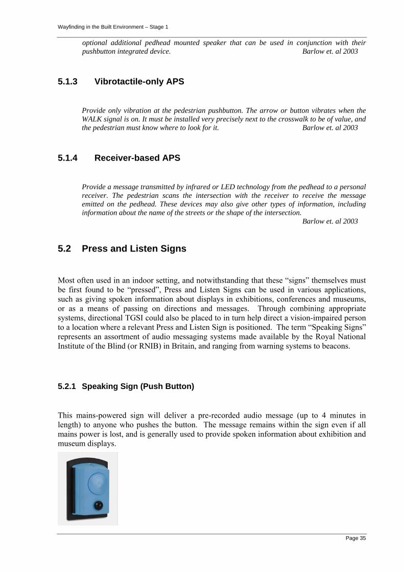
Wayfinding in the Built Environment – Stage 1
Page 35
optional additional pedhead mounted speaker that can be used in conjunction with their pushbutton integrated device. Barlow et. al 2003
5.1.3 Vibrotactile-only APS
Provide only vibration at the pedestrian pushbutton. The arrow or button vibrates when the WALK signal is on. It must be installed very precisely next to the crosswalk to be of value, and the pedestrian must know where to look for it. Barlow et. al 2003
5.1.4 Receiver-based APS
Provide a message transmitted by infrared or LED technology from the pedhead to a personal receiver. The pedestrian scans the intersection with the receiver to receive the message emitted on the pedhead. These devices may also give other types of information, including information about the name of the streets or the shape of the intersection. Barlow et. al 2003
5.2 Press and Listen Signs
Most often used in an indoor setting, and notwithstanding that these “signs” themselves must be first found to be “pressed”, Press and Listen Signs can be used in various applications, such as giving spoken information about displays in exhibitions, conferences and museums, or as a means of passing on directions and messages. Through combining appropriate systems, directional TGSI could also be placed to in turn help direct a vision-impaired person to a location where a relevant Press and Listen Sign is positioned. The term “Speaking Signs” represents an assortment of audio messaging systems made available by the Royal National Institute of the Blind (or RNIB) in Britain, and ranging from warning systems to beacons.
5.2.1 Speaking Sign (Push Button)
This mains-powered sign will deliver a pre-recorded audio message (up to 4 minutes in length) to anyone who pushes the button. The message remains within the sign even if all mains power is lost, and is generally used to provide spoken information about exhibition and museum displays.

Wayfinding in the Built Environment – Stage 1
Page 36
Figure 5.1 Talking Sign Push Button system
5.2.2 Speaking Sign (PIR)
This system is basically a obstacle warning system that uses Passive Infra-Red detector to detect body heat and alert persons or warn an approaching person of a potential danger through the playback of an appropriate pre-recorded loud high-quality audio message. It does not provide directions or wayfinding information, merely warning of dangers or greeting persons.
5.2.3 Speaking Sign (Indoor)
This speaking sign - designed solely for indoor usage - can either welcome visitors or warn travellers of obstacles, simply by altering a switch. The battery-powered sign plays pre-recorded messages of up to 20 seconds, recorded using its internal microphone.
5.2.4 AudioSign® Smartcard
Of more recent origins, and perhaps not strictly a press-and-listen sign (since a user must only be in reasonable proximity of the device), the AudioSign® Smartcard is described in private communications from the local distributors as “a device which can store and transmit the same messages in multiple languages. The correct message is selected and transmitted when triggered via a proximity device and a smartcard. The smartcard can store information about the user including preferred language and disability type. It is also possible to wire the device into a Fire Protection System so that the message being transmitted changes when the Emergency Egress System is activated.”
5.3 Line-Following
5.3.1 TGSI-following Guidance
A Korean group (Ryu et al. 2003) have recently undertaken research to devise and improve algorithms that will allow a Guiding Robot to detect, recognise and follow a series of TGSI tiles (or Braille blocks as sometimes known in Korea) in order to lead a vision-impaired user towards their destination.
5.3.2 Line-tracking Guidance

Wayfinding in the Built Environment – Stage 1
Page 37
Herald (2000) devised a sensor system mounted on a wheelchair which was able to ‘follow’ a reflective tape line marked on the floor of buildings, and variations of such line-following options have now been incorporated in many wheelchairs. In Herald’s design, the user would get an audible sound feedback when the line was being followed correctly, but if the sensors detected the chair was ‘straying’ from the line, voice feedback advised the user to steer left or right in varying degrees to correct their course. Although tested in an indoor environment, bright daylight would upset the sensors in an outdoors setting even if reflective tape was set in place. Useful for wheelchair-bound disabled persons but not generally applicable for the broader range of ambulatory, but vision-impaired persons.
5.4 Directional Sound Evacuation
An innovative guidance system for evacuation has now been developed in the UK and has been widely patented by a British company Sound Alert Technology. Although again perhaps not a (general) wayfinding system specifically for the vision-impaired, it is certainly of interest in this Report in the context of assisting the vision-impaired with emergency egress. Marketed as an audio or sound-based system for use in evacuation from buildings (as well as ships and aircraft), the company contend that thick smoke in a building often reduces visibility of traditional visible exit signage (see Figure below) and thus a localised audio-based system would be invaluable both for sighted as well as for vision-impaired building users.
Figure 5.2 Smoke obscured exit system
Known as Localiser®, the system uses Directional Sound Evacuation (DSE) beacons to produce sound in a broadband, multi-frequency (“white noise”) form. The sound source is easily and quickly located by the ears, allowing building users to be given audible guidance to their nearest exit in an emergency. In the words of the UK company,
“ In buildings equipped with modern fire detection systems conventional alarm sounders will sound to alert people to a fire. However this gives no clues as to how to find the way out. If Directional Sound Evacuation (DSE) beacons are also triggered, people are given clear audible guidance to their nearest exit. By using sophisticated analogue addressable fire panels, systems can locate the seat of the fire and decide which are preferred evacuation routes. DSE beacons can then be triggered only along these routes to direct people away from danger “.
Potential language problems are overcome as it is a solely sound-based system, and according to published information the system has already been installed in the Munich International Airport; and at BAE Systems; as well as at a Business Design Centre, London.

Wayfinding in the Built Environment – Stage 1
Page 38
5.5 Remote (Infrared) Audible Signage
There has been a substantial amount of research and development into this area of Remote Infrared Audible Signage systems over the past 15 years – mainly in the US and in the UK (Bentzen and Mitchell, 1995; Bentzen, Myers & Crandall, 1995; Loomis, Golledge and Klatzky, 1998; Golledge, Marston and Costanzo, 1998; Crandall et al. 1999).
Based upon broadcast or transmission of pre-recorded messages, key locations and corridor intersections are fitted with one or more specialist audible signs or transmitters so that users are ‘guided’ to the facility that they require simply by following the series of messages as they move throughout the building. An example of the operation of these Remote Infrared Audible Signage systems would be where a transmitter beacon is suspended from the ceiling at an intersection of two corridors, and the message either broadcast to pedestrians or transmitted to a user’s portable receiving device might be "For the sauna and spa turn right, for the gym turn left, for the swimming pool go straight ahead".
Experience suggests that a number of these Remote (Infrared) Audible Signage systems can be used in concert with more passive systems such as Raised Tactile (embossed) and Braille signage to enhance any directional cues and make available additional information for the vision-impaired traveller.
5.5.1 AudioSign® (motion activated)
The BrailliantTouch AudioSign® motion-activated system is an infrared-based accessibility and orientation option which broadcasts recorded spoken messages, and can be installed either inside or outside a building. Motion activated by an infrared beam triggered by the movement of passing pedestrians (and not relying on a receiver device that must be carried), the durable audible signage can either be battery-powered or hard-wired into place.
These specialised signs can be used ‘standalone’ to indicate the location of key points such as exits, stairs, and individual rooms, as well as being used in ‘a series’ for providing information around a venue or along a pathway for visitors. The output volume of each separate AudioSign® can be regulated, and for simplicity the timing delay in repeating the message can also be adjusted. According to information from the Australian distributor’s website, the audio units are easily installed and set-up, and provide “low cost, low maintenance operation”.
Certainly in an exhibition venue or similar, such audio signage could be an excellent service to provide verbal information about a particular location and its surroundings, but in a wayfinding role and without the sign having a directional component to it, there seems a question whether the repeated playing and replaying of the recorded message to all nearby pedestrians (whether sensory-impaired or not) constitutes an intrusion or imposition on them.
5.5.2 Talking Signs ®
The Talking Signs® technology was pioneered and developed at the Smith-Kettlewell Eye Research Institute (SKERI), Rehabilitation Engineering Research Center in San Francisco, California in the 1990’s (see http://www.ski.org/), but has since had research and development from a number of commercial sources. Patented in a number of countries and

Wayfinding in the Built Environment – Stage 1
Page 39
already installed in a large number of sites in the US, Europe and Asia, it is claimed by the US distributors Talking Signs, Inc. (http://www.talkingsigns.com/ ) to be “the first infrared system to work effectively in both interior and exterior applications. Talking Signs® may be used wherever landmark identification and wayfinding assistance are needed “.
Figure 5.3 Talking Sign CalTrain installation schematic
from http://www.geog.ucsb.edu/~marstonj/DIS/DIS_MARSTON_files/image014.jpg
Utilising infrared communication as their key mode of transmitting and receiving information, these audio systems are based upon a network or series of ceiling or wall-mounted modules permanently located at key decision points throughout a building, at street intersections, or near transport facilities such as bus-stops. Each mounted module or beacon typically contains up to four transmitters that emit a beam (or more precisely a ‘cone’) of infrared light which can be adjusted in different directions and over variable distances.
The transmitter modules store information on their location and orientation, as well as messages regarding entrances, facilities and key building features, and once a beacon’s cone of infrared light is activated by a receiver, information and messages are then wirelessly transmitted to people who are vision-impaired or those who cannot read printed signs. A user can move through the space and the messages will be triggered by the small receiver device carried by the user to scan the surrounding areas (or by a motion sensor) until one or more directional messages is detected by the receiver and played to the user – either through a speaker connected to the receiver or discreetly via a earphone connection. This broadcast is unobtrusive to humans since transmission is in the infrared light range and will only be detected by specialised receivers.
The brief (repeating) message may describe the entrance or facility, and perhaps additional information such as opening hours, and the user simply walks towards the directional source of the appropriate message sound. For instance, in an public open space such as an airport or train station, one transmitter may ‘broadcast’ the location of ticket machines; another ‘broadcasts’ the location of toilets; another the lifts; entrance gates; etc., etc., and by scanning the area with the small receiver the user can detect various of these messages coming from different directions, and move towards whichever is needed.
According to promotional literature, a substantial number of Talking Signs® installations have been undertaken ranging from Central Bus Station in Phoenix; to a recreation / office building

Wayfinding in the Built Environment – Stage 1
Page 40
in Houston for disabled people; to a number of stations on the BART (Bay Area Rapid Transit) train system in San Francisco. Extensive research has been undertaken on the use of these Remote Infrared Audible Signage systems dating back to around 1996-97, and particularly at the Research Unit on Spatial Cognition and Choice at the University of California Santa Barbara where the focus has been on the use and evaluation of audible signage in improving accessibility to public transportation for the vision impaired population (Golledge et al. 1997; Marston and Golledge, 2003).
5.5.3 AudioSign® Infrared
This new generation system transmits messages in digital rather than analogue form which means less interference and a better sound quality. The system can be networked and contain up to 256 individual messages, and the messages can be updated remotely either via the computer-based network or by telephone (see http://www.eyecatchsigns.com/infrared.htm) The transmitter can be ceiling or wall mounted, and contains four individual directional heads (each capable of providing a different message), whilst the receiving device is palm-sized, battery-powered, and worn by the user with an earpiece - not handheld. This can make orientation more precise and frees the user’s hands for other Orientation and Mobility tasks such as using a cane, holding a Guide Dog or for receiving tactual information from environmental cues. Distributors advise that the system has been installed by the CNIB (The Canadian National Institute for the Blind) and was placed throughout the Bluewater Shopping Centre in the UK by Lend Lease Ltd.
Figure 5.4 AudioSigns four-way transmitter
5.5.4 InfraVoice
The InfraVoice sign system from the RNIB is an infrared reactive wayfinding system (Whitney et al., 2004) whereby the beacons continuously transmit speech messages over an infrared beam. As with the previous systems, InfraVoice can be used to give the information that is usually available on visual signs, and beacons are placed at junctions to give information on what is ahead and left or right, or the beacons are placed in the line of travel so a sensory-impaired person automatically picks up messages whenever the receiver is on. For ease of administration, updated pre-recorded messages may be easily downloaded to any selected transmitter location via an infrared link from a PC.
5.6 Remote Radiofrequency Audible Signage

Wayfinding in the Built Environment – Stage 1
Page 41
5.6.1 RNIB React
Similar to the Infrared Signage above in the sense that it electronically provides information to vision-impaired persons, this radiofrequency signage however is designed for outdoors applications. When the user walks within range of the sign, a radio signal triggers the sign and it speaks the message through a loudspeaker. It only speaks the message when a user carrying the specialised trigger unit is nearby and units such as the RNIB React system can provide messages in up to eight different languages.
As well as speaking messages, the React system can also be used to trigger the operation of a device such as opening a door or ringing a remote bell. A study (Whitney et al., 2004) of the production and evaluation of a joint receiver capable of responding to both the RNIB’s InfraVoice and the React systems has been completed in Middlesex and such a receiver device was produced as a prototype, but further work is needed to develop it to a stage where it is more usable for the vision-impaired population.
5.7 On-line Digital Information and Maps
Most recently, new toolkits allowing software developers to customise World Wide Web (WWW) pages for vision-impaired users are becoming available, so that users can create machine readable Web pages using the syntax and grammar of extensible mark-up language (XML). This will allow computers (desktop, wearable, handheld etc.) to ‘read’ WWW pages automatically and decipher their contents for the vision-impaired population. Of particular interest is the potential for ‘on-the-fly’ spoken interpretations of map-based queries from GIS systems.
This is leading to new applications which may assist vision-impaired users in particular in their WayFinding tasks by making available information of a spatial form (either on disk or via the WWW). As described earlier, many Geographic Information Systems (GIS) already process street address information by using digital map-bases which contain information about the roads and streets in a particular area or city (for instance #4.6 Trekker and BrailleNote GPS, and #4.7.2 Tactile Map project). The digital map-base often also contains location information about many locations such as major parks, public buildings, churches, etc. and although these are currently typically held as ‘point data’ in the map-base, it is our view that increasingly more floor-plans, ‘footprint’ building data or ‘virtual models’ for public buildings will also be made available in digital form.
Whether it is feasible to download street networks and building floor-plans/models across a network to a small device as required - or whether it would be necessary to download the information in advance prior to attending the facility - will likely remain a function of the cost of transmitting the information via the mobile phone network to a speech-enabled WWW browser on the handheld device (see later references to mobile communications).

Wayfinding in the Built Environment – Stage 1
Page 42
6. THE FUTURE
Many systems and technologies which have potential application in the area of wayfinding or mobility and location assistance for vision-impaired persons are expected to mature over the next few years. One only has to consider the enormous developments made by manufacturers of mobile phone handsets to appreciate the rapid changes in characteristics such as lower power consumption; increased battery life; use of integrated audio for dialling; screen resolution and colour; etc. for handheld devices. Consider also the introduction of small handheld or palmtop devices like Hewlett Packard’s iPAQ or the PalmPilot from Palm Corporation with sufficient computer processing power and on-board storage/memory to undertake many complex tasks such as speech processing and location calculations. On the other hand, touted improvements in the provision of network infrastructure being installed by the telecommunications companies are much slower in arriving (for instance, actual network upgrades to allow higher bandwidth for delivery of information to handsets; and outright costs of using mobile phones and GPRS to give access to the WWW and Web-based information).
6.1 Satellite Positioning
The accuracy of GPS (Global Positioning Systems) used for locating positions can be improved by employing Differential GPS which allows locations to be calculated to a much higher degree of accuracy, however the restrictions on GPS regarding indoor usage still appear not to have been overcome as yet.
These technologies are now maturing, whereas further systems and technologies especially in the areas of sensors, wearable devices, tactile, tactual and haptic interfaces, learning systems, robotics and the like are being developed and should become available over the next 3-5 years. Just as GPS and various night-vision and display technologies were originally military or defence developments that “spun-off” with important applications in civilian areas, a number of these potential systems and technologies will also derive from that source, as well as from the research labs of electronics, hardware and software companies, and universities.
6.2 Lower Power Requirements
Lower power requirements of devices means longer battery life and more time between recharges – an important factor in systems and technologies for the vision-impaired. Also improvements in battery storage capacities through the use of newer materials such as hydrides of nickel and lithium mean that smaller batteries will last much longer (compare with improvements in mobile phone battery life over last 10 years).

Wayfinding in the Built Environment – Stage 1
Page 43
6.3 Electronics Miniaturisation
The decreased physical size and improved integration (that is packing and bundling together) of electronic components such as controller chips has allowed devices such as microphones, audio players, speakers, cameras, etc. to become much smaller (and often much lighter) than previously. Through the technology push of mobile telephony, microphones and cameras in particular have already become sufficiently miniaturised to be able to used most discreetly.
6.4 Communications Protocols
Improved communication protocols such as Bluetooth allow new generation devices such as computers, cameras and phones to connect together wirelessly over a short range (say up to 10m). Automatic ‘handshaking’ between these devices/transmitters/receivers is ‘negotiated’ electronically by the devices (without constant intervention by the user) - making the process ideal for mobile or travelling users to (apparently seamlessly) connect to a variety of devices, or to a sequence of the one type of device as the user moves about.
Another such protocol is the so-called Wi-Fi – which was intended to be used for wireless devices and LANs, but is now often also used for Internet access. It enables a person with a wireless-enabled computer or personal digital assistant (PDA) to connect to the Internet by moving within, for example, 15 meters of an access point, called a "hotspot".
Both these protocols have some drawbacks in terms of security of information and use of the crowded spectrum, however as communication protocols to facilitate the delivery of (public) wayfinding information from networks to mobile receivers they have real future potential.
6.5 Mobile bandwidth
Current public mobile telecoms infrastructure in Australia only allows quite small amounts of information to be quickly downloaded (unless at horrendous cost), whereas if a higher bandwidth were available to the user it would allow for the rapid download of large amounts of information – say for instance digital map data or wayfinding instructions for the current location (see #5.7).
6.6 Tactual / Tactile Feedback; Smart Clothing; Wearable PCs
Through research aimed at enhancing visualisation and incorporating Virtual Reality, a number of mechanisms for receiving feedback from sensors and generating information for computers, etc. although once considered specialised, devices are becoming much more widely available, and at somewhat lower cost. Connected by wire or wirelessly, devices such as glove-based receivers which can receive and provide multiple stimulus to the individual

Wayfinding in the Built Environment – Stage 1
Page 44
fingers, or to the hand as a whole by flexing or moving, are becoming much more commonly available and discreet.
Similarly devices such as an array of electromechanical vibrotactile transducers (tactors) are being developed and marketed by US companies such as EAI to advise the personnel wearing them of additional information in a easily comprehended format. One would expect that, as with many technological developments, the price of such devices / equipment will drop and become more affordable as the transition from military to civilian market applications is made. As EAI describe :
“A tactile situation awareness system consists of an array of tactile transducers (tactors) held in contact with the body (typically the torso) of a human operator. The tactors are organized in a manner to reflect the environment in some intuitive way. Appropriate data from the sensor, communication and/or avionics system is then fed into a computer and processed to select a particular tactor, or group of tactors to switch on or off. This data can be fed into one of EAI’s driver boards in various digital formats, and the tactor array can be driven as directed by the controller.
An example of a tactile display could be a series of tactors placed around the torso at equal intervals approximating compass positions. In a military application, a tactor may be activated at a particular orientation (e.g. NNW) to indicate a threat appearing from that direction. Whereas in a civilian application, perhaps the tactors could indicate to a disabled user in which direction an obstacle lies, or which direction is a clear path – in much the same way as the older-style sonar sensors of the bulky earlier NavBelt or GuideCane were able to.
Other exciting developments are taking place in the area of smart clothing (microsystems technology in apparel) - or clothing integrated with computing equipment - which occurs through the use of piezoelectric materials and metallic threads to create wearable electronic textiles. This will create true “wearable PCs” of a discreet nature, unlike the bulky equipment that previously had to be “worn”. As well, advances such as the use of miniaturized thermogenerators (which can exploit temperature differences between the surface of the human body and its environment by converting the heat flux into electrical energy) will possibly provide an alternate power source to batteries for mobile applications.
6.7 Virtual Reality
Other applications of Virtual Reality of particular interest to wayfinding for the vision-impaired are to provide mechanisms that allow users to “explore buildings” in some sense by accessing a virtual model of the complex and exploring that model prior to accessing the actual building.
With an increasing number of architectural design systems producing digital plans, elevations and 3D virtual models, making these models available to impaired users for prior familiarisation with the building layout and facilities should not be difficult but may have unforseen privacy or security ramifications unless the information is perhaps produced in a simplified, schematic way only. Provided that sufficient accuracy is maintained in the VR models, then the models could be used to calibrate - in advance - any ultrasonic location systems that might be used for indoor positioning in lieu of GPS systems.

Wayfinding in the Built Environment – Stage 1
Page 45
6.8 Broad Integration of Computer Science and Robotics
Much Computer Science research is undertaken in the areas of neural networks and integration of information from various sensors in order to simulate how the human brain functions in a decision-making mode for travelling. Similarly location, orientation and navigation are three fundamentals necessary for an industrial robot to undertake many meaningful spatially-related tasks, in the same way that these three features are essential to wayfinding in the built environment for the vision-impaired traveller. The combination of aspects of these two disciplines of Computer Science and Robotics then naturally lend themselves to underpin much scientific research of interest in wayfinding – both for humans and for machines which are required to rapidly evaluate options and make sensible spatial decisions.
6.8.1 Robotic Wayfinding
Some previous work in ‘line-following’ with robotic guides was briefly discussed earlier in this Report, however in their latest of a series of papers on the use of robotics for wayfinding by vision-impaired persons, researchers Kulyukin et al. (2004) from the Utah State University discuss in detail the development and laboratory trialling of an innovative assisted navigation system for use in an indoors environment. Their SANDEE robotic guide is designed to lead a vision-impaired user through a building to locate certain facilities within the building as requested by the user.
Figure 6.1 Robotic Guide
from Kulyukin et al. (2004)
The building must be fitted in advance with a series of (low-cost) radio frequency identification (RFID) tags at key points along walls, corridors and intersecting passages (at this stage the system is not suitable for uncontrolled open spaces, just walls, hallways, aisles, T- and X-intersections). These RFID tags are small and are ‘passive’ (that is, they do not require a power source), but as such they can only supply very limited information (such as their identifying number, but not their position) back to the computer. Thus the details of the layout and location of individual tags (which tag is where ?) must be input to the navigation system for storage and possible use in later calculations.

Wayfinding in the Built Environment – Stage 1
Page 46
The Robotic Guide then uses an on-board RFID reader/receiver and powerful computers to detect from the RFID tags whereabouts in a building the Guide is currently located, and uses computer software and travel information predetermined between tags to calculate how to best find its way to the required facility. The multiple RFID sensor readings are converted into attraction and repulsion vectors that are summed to decide where the robot Guide should go next. Input to control the Guide can be via a speech input system, or more likely via a small (wearable) keyboard since controlled experiments have shown that when specifying a required destination, voice recognition is not sufficiently accurate as yet.
The wayfinding Guide is built on top of a commercial robot which is a relatively large platform (with 3 wheels and 16 ultrasonic sensors), and the vision-impaired user is led by the Guide – via a rigid handheld attachment - through the building. The authors indicate that the main issues that need to be addressed by further research are : the size and weight of the Robotic Guide (currently needed to provide sufficient battery life and computational power for the tasks); its travel speed (around ½ or ⅓ the walking speed of a human); the algorithms for route calculations need improvement; as well as the tendency of the Robotic Guide to lead/pull the user in a jerky fashion because of the route finding methodology which is currently implemented.
These current issues aside and depending upon the progress achieved in miniaturisation, battery size and life, etc. mentioned earlier in this Report, in the much longer term this type of guided assistance would seem to have real potential – although it is certainly not in the category of “refusable, unaided, discreet” assistance.

Wayfinding in the Built Environment – Stage 1
Page 47
7. CONCLUSIONS
There are no international or Australian examples of specific wayfinding legislation which requires building owners and/or public bodies to build in systems or technology to assist people with a sensory impairment to navigate around buildings and other spaces or to exit to a safe place in the event of a fire or other emergency.
This project does not seek to give an answer to questions of law but rather to set out to review the current state of the national and international legislation to see if the wayfinding objective has been achieved elsewhere and if so how. The project has found that no national or international administration has found an answer to this problem. In our opinion all legislators are faced with the same problem, namely the objective is clear but how to achieve it is not.
This project has concluded that the current anti-discrimination legal framework, which is driven by complaints and prosecutions, is unsatisfactory because it does not set out the solution until possibly after the event but it is beyond the scope of this project to offer a comprehensive solution to this problem. What this project can do, and has done, is to review what is available and, by drawing on this information, make recommendations on how the wayfinding objective may be achieved over time.
The authors have come to the conclusion that with current systems and technologies the objective of universal wayfinding cannot be achieved immediately. If the view of the DDA referred to in Section 2 is correct, it means that there is a breach of the DDA and there will continue to be a breach of the DDA for a long time into the future. The authors cannot find a way around that.
In the authors opinion, with the current systems and technologies, there are things that can be done immediately to progress the wayfinding objective and to lay the foundation for the future. We have set out those things that can be done immediately in the following recommendations. Things that can be done in the medium and long term are also set out below:
7.1 Immediate Action
1.) The fire safety systems required by the Building Code of Australia should be effective in alerting people with a sensory impairment of the activation of the alarm and the location of required exits to enable those people to effect an unaided exit from the building in the event of a fire or other emergency.
Ground surface indicators as well as raised tactile (embossed) and Braille signage systems are well developed and available for immediate application to partly achieve this, while infrared audible signage (known variously as “speaking signs / audio signs / talking signs” etc.) are advanced sufficiently to assist. Transmitting beacons located (in such a way as to be protected from deliberate or inadvertent damage) at key corridor intersections and alongside / outside key facilities such as stairs, lifts, washrooms, enquiry counters, directory signs, etc. could be used.
Investigations should be made to determine if these beacons could be integrated with emergency exit signage already in place in most buildings, so that they are

Wayfinding in the Built Environment – Stage 1
Page 48
used both to assist access for vision-impaired travellers as well as to assist egress (in normal or emergency conditions).
The authors are of the opinion that systems and technologies are presently available to achieve this without unreasonable cost or unjustifiable hardship.
2.) Open spaces within the cartilage of buildings and in public spaces of buildings, to which people with a sensory impairment have access, should have inbuilt systems to guide those people along safe paths of travel to and from key entrances and exits, including for example the path from the main entrance to the lifts, if any, and to a refuge in the event of fire or other emergency.
The authors are of the view that systems and technologies are presently available to achieve this without unreasonable cost or unjustifiable hardship.
Ground surface indicators as well as raised tactile (embossed) and Braille signage systems are well developed and available for immediate application to partly achieve this.
The audible / speaking signs as referred to in recommendation 1 may be suitable.
In the outdoors environment, the radio beacon approach based on an external audible signage system would appear the best short-term approach – providing guidance to the vision-impaired user when requested, and over greater distances than that usually required in an indoors setting.
The authors believe that any system that requires a specialist receiver to be carried by the user is likely to be suitable only for particular application where a high level of supervision and maintenance is available. The authors consider that the use of active systems of this kind should, until further developed and except for some large public buildings, be a voluntary option of building owners and should not be imposed as a minimum legislation standard.
3.) The internal public circulation spaces of some large public buildings as well as some outdoor public spaces should, in addition to the requirements in recommendations 1 and 2, have in-built systems or technologies to enable people with a sensory impairment to navigate unaided from key entrances to key locations.
The authors belief is that passive systems including ground surface indicators, Braille signs, audible signage, ‘talking lifts’ and the like, which are available, would only go part of the way to achieving this.
The authors are of the opinion that more sophisticated technologies which rely on handheld devices would be suitable for some applications. In some circumstances the disadvantages of handheld devices referred to in this report will be offset by the benefits that would accrue.
The proposed further research aimed at the selection and application/development of a preferred system to be trialled as part of the 2006 Commonwealth Games in Melbourne would provide an excellent opportunity to advance this recommendation. That research and the lessons learnt from the Games will also assist in advancing the other recommendations in this report.

Wayfinding in the Built Environment – Stage 1
Page 49
4.) Australian Standards or other codes for the use of passive systems, such as ground surface indicators and inbuilt active systems, such as infrared audible signage, should be given priority.
5.) An encompassing International standard or other protocol should be prepared and adopted to provide a foundation for handheld navigation devices to interoperate with different systems.
The authors are of the opinion that active handheld navigation systems and technologies are the most practicable way of fully achieving the wayfinding objective and have significant potential for the future, but at present they appear so diverse that it is not practicable to presently require their use.
Since users would either need to purchase their own receiver device for personal use in various venues or to borrow a receiver specifically suited to a building from an enquiry counter or similar, the authors also believe that, except for special circumstances, it is not practicable for building owners to provide and maintain handheld navigation devices.
However, we are of the opinion that it would be practicable for building owners to provide inbuilt systems and technologies to assist people with a sensory impairment to navigate within buildings if such inbuilt systems could communicate with a range of personal handheld receiving devices. For preference, interoperable standards for these infrared / radiowave / wireless communications devices are needed so that systems sourced from different manufacturers might maintain interoperability with one another, in order to provide ‘refusable, unaided assistance’ when required.
Clearly a user-owned device would be preferable when considering the outdoors wayfinding scenario where the user may come to the “guided path” (where electronic wayfinding is supported) by a variety of routes – none of which may pass a convenient collection point for a loan device. At quite low cost for existing handheld receiver modules, outright purchase by the user (whether subsidised by government in one form or another) is anticipated to be manageable.
The authors believe that the objective of a widely accepted standard or protocol would help to achieve this end, although they also acknowledge that such a standard or protocol may be difficult to achieve, without the risk of stifling change and innovation.
Wayfinding in the Built Environment – Stage 1
Page 50
7.2 Medium Term
With improvements in storage devices, communications protocols, etc. plus integration with specialised sensors and improved location positioning systems, the authors expect that in the medium term information that is ‘tailored to the individual’ could be made available to individual users from inbuilt location-specific transmitters.
It is feasible that much of the necessary functionality will be already built into portable devices such as mobile phones (where small computers, personal digital assistants, and digital cameras are already integrated) but with the potential addition of a digital compass, pitch & roll indicator, accelerometer, as well as GPS-type location features, such mobile tools could converge into one (maybe costly) device, or could remain as a series of optional add-on extras - depending on how strong the demand is, and on an impaired individual’s particular needs.
However individual users may have to accept the need to be “recognised” and tracked by the system – either through carrying some identifying badge or device such as a ‘smart card’, or by the registration of their handheld receiver on a computer network (similar to what currently happens with the tracking of mobile phone handsets by base-stations of mobile telephony providers). User’s devices could even be ‘recognised’ if they have visited the building before, and ideally any floor layout changes or updated facilities information could be automatically relayed to them.
7.3 Long Term
As far as longer term predictions go, from the authors investigations and reading of the literature and despite many rapid advances in specific areas of technology, it would still appear quite a long way off before a ‘robotic guide’ of some form or similar of a sufficiently small, light, powerful yet discreet nature will be available for the sensory or vision-impaired visitor to use with confidence for orientation and navigation within the built environment.
Consequently our belief is that wayfinding guidance of the preferred refusable, unaided and discreet type may well come from feedback supplied individually and directly to the sensory-impaired user via a range of innovative and inconspicuous options such as advanced smart clothing and personal tactile devices – perhaps augmenting or replacing traditional tactual and aural sources like vibrating mechanisms and headsets/earphones.

Wayfinding in the Built Environment – Stage 1
Page 51
8. REFERENCES
Barker P., Barrick J. and Wilson R. (1995) Building Sight : A handbook of building and interior design solutions to include the needs of visually impaired people. HMSO in association with Royal National Institute for the Blind, London. ISBN 0117019933.
Barlow, J., Bentzen B., Tabor L. (2003) Accessible Pedestrian Signals: Synthesis and Guide to Best Practice. Transportation Research Board of the National Research Council.
Barlow, J., Bentzen B., Tabor L. (2000) Detectable Warnings: Synthesis of U.S. and International Practice. U.S. Access Board, Washington.
Bentzen, B. L. and Mitchell, P. A. (1995). Audible Signage as a Wayfinding Aid - Verbal Landmark versus Talking Signs. Journal of Visual Impairment and Blindness, 89(6), 494-505.
Bentzen, B. L., Myers, L., and Crandall, W. F. (1995). Talking Signs® System: Guide For Trainers (Easter Seals Project ACTION/NIAT Doc. #95-0052). Washington, DC: The Smith-Kettlewell Eye Research Institute.
Burton D. and Uslan M. (2004a). Do Cell Phones Plus Software Equal Access? Part 2. AccessWorld, Vol. 5, No. 1, January.
Burton D. and Uslan M. (2004b). We Think They Hear Us Now: Cell Phones with Speech. AccessWorld, Vol. 5, No. 3, May. see http://www.afb.org/afbpress/pub.asp?DocID=aw050306
Crandall, W., Brabyn, J., Bentzen, B., & Myers, L. (1999). Remote infrared signage evaluation for transit stations and intersections. Journal of Rehabilitation Research and Development, 36(4), 341-355.
Dusling, K. and Uslan, M. (2002) Where Are We?: A Look at Global Positioning Systems on the Market Today. AccessWorld - Technology and People with Visual Impairments. AFB Press (American Foundation for the Blind). New York, Volume 3, No.3., May.
Golledge, R.G., Marston, J.R., and Costanzo, C.M. (1997). Attitudes of visually impaired persons toward the use of public transportation. Journal of Visual Impairment and Blindness, 91(5), 446-459.
Golledge, R. G., Marston, J. R., & Costanzo, C. M. (1998). Assistive devices and services for the disabled: Auditory signage and the accessible city for blind or vision impaired travellers (California PATH Working Paper UCB-ITS-PWP- 98-18): University of California, Berkeley California PATH Program, Institute of Transportation Studies.
Wayfinding in the Built Environment – Stage 1
Page 52
Heyes A.D. (1994) Sensory alternatives and the vision impaired. Proceedings of the 7th. International Mobility Conference, Melbourne. RGDAA, Melbourne. pp. 9 - 12.
Helal, A., Moore, S.E. and Ramachandran, B. (2001). Drishti: An Integrated Navigation System for Visually Impaired and Disabled. ISWC'01 (5th International Symposium on Wearable Computers), Zurich, Switzerland, October 08 – 09.
Kulyukin, V., Gharpure, C., Sute, P., De Graw., N., and Nicholson, J. (2004). A Robotic Wayfinding System for the Visually Impaired. To appear in Proceed. of the Sixteenth Innovative Applications of Artificial Intelligence Conference (IAAI-04), San Jose, CA.
Herald, G. (2000) Wheelchair-tracking Sensor.
Leventhal, J. (2003) Getting from Here to There: A Short Review of Trekker. AccessWorld - Technology and People with Visual Impairments. AFB Press (American Foundation for the Blind). New York, Volume 4, No.4., July.
Loomis, J. M., Golledge, R. G., and Klatzky, R. L. (1998). Navigation system for the blind: Auditory display modes and guidance. Presence: Teleoperators and Virtual Environments, 7(2), 193-203.
Lopez, C.P. (2003) Meeting the Challenge: Reagan Washington National Airport’s new terminal is designed for accessibility, not just complying with codes. Paraplegia News, April.
Marston, J.R., & Golledge, R. G. (2003) The Hidden Demand for Activity Participation and Travel by People with Vision Impairment or Blindness, Journal of Visual Impairment and Blindness, 97(8), 475-488.
May, M. (2003) Accessible GPS for the Blind : What are the Current and Future Frontiers ?. California State University Northridge, Center On Disabilities, Proc. of “Technology And Persons With Disabilities Conference”, 2003
MoBIC project (1995). Mobility of Blind and Elderly People Interacting with Computers. Directorate General XIII of the Commission of the European Union see http://isgwww.cs.uni-magdeburg.de/projects/mobic/mobicuk.html
Queensland Health (1996). Building Guidelines for Queensland Mental Health Facilities. Brisbane.
Ran Y. and Nagendranath, M. (2002) DrishtiLite - A marching step towards Blind people navigation using Motorola Smart Phones. Project Report, CEN5531 Mobile Computing, University of Florida.

Wayfinding in the Built Environment – Stage 1
Page 53
Ross, D. and Blasch, B. (2000). Evaluation of orientation interfaces for wearable computers. In Proceedings of IEEE International Symposium on Wearable Computing (ISWC 2000), pages 51-58, Atlanta, GA.
Royal Blind Society of NSW and ACT (2003) Accessible design recommendations for people
Ryu J, Lee J, Lee E, Hong S, and Han Y. (2003) Adaptive Braille Block Detection of Guide Robot for the Visually Impaired. Proceedings of the World Congress on Medical Physics and Biomedical Engineering, Aug 24-29, Sydney, Australia, [CD-ROM] ISBN 1877040142.
Shoval S., Borenstein J. and Koren Y. (1994). Mobile Robot Obstacle Avoidance in a Computerised Travel Aid for the Blind. Proceedings of the 1994 IEEE Robotics and Automation Conference, San Diego, California, May 8-13, pp. 2023-2029.
UK Dept. of Transport (Access for Disabled People) http://www.dft.gov.uk/stellent/groups/dft_mobility/documents/sectionhomepage/dft_access_page.hcsp
Ulrich I. and Borenstein J. (2001) The GuideCane — Applying Mobile Robot Technologies to Assist the Visually Impaired. IEEE Transactions on Systems, Man, and Cybernetics, —Part A: Systems and Humans, Vol. 31, No. 2, March, pp. 131-136
US Department of Education (2001). “Notice of Proposed Funding Priorities for Fiscal Years (FYs) 2001-2003 for three Disability and Rehabilitation Research Projects”. Office of Special Education and Rehabilitative Services, National Institute on Disability and Rehabilitation Research (NIDRR). Federal Register: April 27, 2001 (Volume 66, Number 82), Notices, Page 21125-21129. see
Whitney, G., Keith S. and Wilson, J. (2004) The Production and Evaluation of a Joint Receiver for the RNIB REACT and InfraVoice Speaking Sign Beacons. Interaction Design Centre, School of Computing Science, Middlesex University. Technical Report: IDC-TR-2004-003, January 2004
Wayfinding in the Built Environment – Stage 1
Page 54
9. INTERNET SITES At the time of publishing, key Internet/World Wide Web sites of interest included:
Americans with Disabilities Act Home Page (ADA)
see: http://www.usdoj.gov/crt/ada/adahom1.htm
Australian Building Codes Board (ABCB) see: http://www.abcb.gov.au
Australian Human Rights and Equal Opportunity Commission (HREOC)
see: http://www.hreoc.gov.au
The Access Board is an independent Federal agency devoted to accessibility for people with disabilities see: http://www.access-board.gov/
The Access Foundation see: http://www.accessibility.com.au/
Blind Citizens Association (BCA) see: http://www.acb.org/washington/imperatives-2004.html
BlindSigns - Detectable Directional Guidance Systems (DDGS)
see: http://www.blindsigns.com/
BrailleNote-GPS see: http://www.senderogroup.com/shopgps.htm
Disability Rights Commission (UK) see: http://www.drc-gb.org/index.asp
Drishti see: http://www.harris.cise.ufl.edu/projects/publications/wearableConf.pdf
Lighthouse International (Arlene Gordon Research Institute) see: http://www.lighthouse.org
Localiser (Directional Sound Evacuation) see: http://www.soundalert.com/way-finding.htm
Joint Mobility Unit Access Partnership see: http://www.jmuaccess.org.uk/
Miniguide see: http://www.gdp-research.com.au
Mobility Agent see: http://www.agentsheets.com/

Wayfinding in the Built Environment – Stage 1
Page 55
Polaron
Royal Blind Society of NSW and ACT see: http://www.visionaustralia.org.au/info.aspx?page=795#accessibility
Signage (Raised Tactile (Embossed) and Braille) see: http://www.systech-signage.com/pages/braille.htm
Sonic Pathfinder see: http://www.sonicpathfinder.org/
Sound Alert Technology. Localiser see: http://www.soundalert.com/dse_buildings.htm
Tactile (Braille) Compass see: http://www.rnib.org.uk
Talking Compass see: http://www.sensorytools.com/c2.htm
Trekker see: http://www.visuaide.com/
United Nations see: http://www.un.org
US Federal Government Department of Justice
see: http://www.usdoj.gov/crt/ada/civicac.htm
UltraCane see: http://www.soundforesight.co.uk/media_gallery.htm
VoiceNote see: http://www.pulsedata.com
Wayfinding in the Built Environment – Stage 1
Page 56
10. GLOSSARY The following explanations are provided as a guide to acronyms and terms which may not be familiar to or readily understood by some readers. ABCB - The Australian Building Codes Board is responsible for developing and managing a nationally uniform approach to technical building requirements, embodied in the Building Code of Australia (BCA) and enabling the building industry to adopt new and innovative construction technology and practices.
Accelerometer - an instrument for measuring the acceleration of machines or persons.
Accessway - An accessway is a path of travel suitable for use by people with a disability. It is a ‘continuous accessible path of travel’. An accessway is required to provide access to, into or within buildings for people with a range of disabilities. It must not incorporate any step, stairway, turnstile, revolving door, escalator, travellator, moving walkway or other impediment which would prevent it from being safely negotiated by people with a disability.
APS - Accessible Pedestrian Signals. Additions to the traffic signal system at crossings to provide signal information in audio, tactile, and/or vibrotactile form to the pedestrian.
AS1428 - Australian Standards AS1428 Parts 1 to 9 specifies design requirements applicable to new building work in public and commercial buildings, to provide access for people with disabilities. Attention is given to the needs of people who use wheelchairs, people with ambulatory disabilities and sensory disabilities, to permit independent use of buildings. The requirements specified are intended to permit general use of buildings and facilities by people with disabilities acting independently, or where a person's usual method of operation is with an assistant, in the company of that assistant.
BCA -Building Code of Australia 2004 is a uniform set of requirements for the design and construction of buildings and other structures throughout Australia. It includes access and egress for persons with disabilities, services and equipment, and certain aspects of health and amenity.
Bluetooth - a wireless radio standard primarily designed for low power consumption, with a short range (from 10 up to 100 meters) and with a low-cost transceiver microchip in each device. Useful for connecting mobile products such as mobile computers, mobile phones, digital cameras, and other portable devices. Bluetooth should not be compared to Wi-Fi, a faster protocol requiring more expensive hardware that covers greater distances and uses the same frequency range. While Bluetooth is a cable replacement creating personal area networking between different devices, Wi-Fi is a cable replacement for local area network access. They serve different purposes.
DDA - Disability Discrimination Act 1992 seeks to eliminate, as far as possible, discrimination against persons on the ground of disability in the areas of work, accommodation, education, access to premises, clubs and sport; and the provision of goods, facilities, services and land; and to ensure, as far as practicable, that persons with disabilities have the same rights to equality before the law as the rest of the community; and to promote recognition and acceptance within the community of the principle that persons with disabilities have the same fundamental rights as the rest of the community.

Wayfinding in the Built Environment – Stage 1
Page 57
Declaration on the Rights of Disabled Persons 1975, Article 3 - A United Nations declaration enumerates those rights which are to be "used as a common basis and frame of reference" for States to improve the quality of life for people with disabilities. Signatory States are required to adopt measures to ensure people with disabilities enjoy "the same fundamental rights as their fellow citizens" and "the same civil and political rights as other human beings". Since 1975, the UN General Assembly have adopted several other related resolutions, however, a Convention concerning the elimination of discrimination against people with disabilities is yet to be realised.
Disability - A condition or state of being which is covered by the broad DDA definition. The term includes physical, sensory, psychiatric, intellectual and neurological disabilities, physical disfigurement and the presence in the body of organisms causing or capable of causing disease, such as HIV - the virus which causes AIDS.
Discrimination - Treating a person less favourably (on the basis of a disability that that person has, may have, used to have or may have in the future) than you would treat a person without that disability in the same circumstances or circumstances which are not materially different. Discrimination may be either.
Direct discrimination - treating a person less favourably because of their disability, such as a policy that people with infectious diseases may not enrol at a particular institution.
GIS - Geographic Information System - a computer system for capturing, storing, checking, integrating, manipulating, analysing and displaying spatial data (i.e. related to positions on the Earth's surface). Typically, a GIS is used for handling maps of one kind or another which might be represented as several different layers where each layer holds data about a particular kind of feature (e.g. roads).
GPS - Global Positioning System. Satellite system to provide information about any location, such as the latitude, longitude and altitude or elevation.
HREOC (Human Rights and Equal Opportunity Commission) - A Commonwealth statutory authority responsible for administering a number of pieces of Commonwealth legislation relating to human rights and anti-discrimination. The Commission also acts as a decision-making Tribunal when matters cannot be conciliated - it makes these decisions after holding formal inquiries.
Indirect discrimination - imposing a requirement or condition where that requirement or condition is one with which people with disabilities are disproportionately unable to comply, which is not reasonable having regard to all the circumstances and with which a complainant with a disability is unable to comply. For example, a student with a mobility disability which affects her capacity to write may argue that an institution requirement that all students write their responses to exam questions unassisted is indirect discrimination. There are alternative ways of assessing a person's knowledge of an area and this requirement may not be reasonable in the circumstances. It is certainly one with which the student is unable to comply and one with which students with disabilities will be disproportionately unable to comply.
ICESCR - International Covenant on Economic, Social and Cultural Rights (ICESCR) includes the universal right of all people to self determination; the right to work; to enjoy just and favourable conditions of work; and the right to an adequate standard of living, including housing.
Infrared (IR) - form of light with a wavelength between those of visible light and microwave radiation. A common use of IR is in television remote controls. In this case it is used in

Wayfinding in the Built Environment – Stage 1
Page 58
preference to radio waves because it does not interfere with other devices in adjoining rooms (IR does not penetrate walls). IR data transmission is also employed in short-range communication among computer peripherals and personal digital assistants. These devices usually conform to standards published by IrDA, the Infrared Data Association. Remote controls and IrDA devices use infrared light-emitting diodes (LEDs) to emit infrared radiation which is focused by a plastic lens into a narrow beam. The beam is modulated, i.e. switched on and off, to encode the data. The receiver converts the infrared radiation to an electric current, and responds only to the rapidly pulsing signal created by the transmitter, and filtering out slowly changing infrared radiation from sunlight, people and other warm objects.
iPAQ - small powerful handheld computer produced by Hewlett Packard, and using a version of the Microsoft Windows operating system.
Mote - Generally a small particle; speck. Technically, mote usually refers to a very small circuit or computer chip upon which a sensor can be mounted. Motes are often battery-powered, and may communicate wirelessly by broadcasting messages over radio frequency.
Peak Disability Organisations - Organisations representing groups of disability organisations. Peak organisations often liaise with government in relation to disability issues. PDA - Personal Digital Assistant. A small handheld computer typically providing calendar, contacts, and note-taking applications but may include other applications, for example a web browser and media player. Small keyboards and pen-based input systems are most commonly used for user input.
Piezoelectric material - any material which provides a conversion between mechanical and electrical energy. For a piezoelectric crystal, if mechanical stresses are applied on two opposite faces, electrical charges appear on some other pair of faces.
Premises standard (PROPOSED) - The Disability Access to Premises (Buildings) Guidelines proposes if adopted to remove discrimination on the basis of disability from access to and use of premises. Clause 4.7 of the Premises standard allows for and encourages innovative solutions to meet the Performance Requirements through the development of new technologies and through the use of Alternative Solutions.
RFID - Radio frequency identification. A method of remotely storing and retrieving data using devices called RFID tags. An RFID tag is a small object, such as an adhesive sticker, that can be attached to or incorporated into a product. RFID tags contain antennas to enable them to receive and respond to radio-frequency queries from an RFID transceiver.
RNIB - Royal National Institute of the Blind. London-based charity specialising in assistance for the visually impaired. Also RNIB Scotland, Wales and Northern Ireland.
Sensor - a device that detects, or senses, a signal. A sensor is a type of transducer, and most sensors are electrical or electronic, although other types exist. Examples are light; sound; heat; pressure; magnetism; motion; orientation sensors. Sensors are either direct indicating (e.g. a mercury thermometer or electrical meter) or are paired with an indicator so that the value sensed becomes human readable.
Smart clothing - clothes which combine fashion and technology, or business and pleasure, to protect and care for the body while facilitating the wearer’s daily routine.
Standards Australia - Standards Australia is a standards development organization and is Australia’s representative on the International Organization for Standardization [ISO]. It
Wayfinding in the Built Environment – Stage 1
Page 59
develops and maintains more than 7000 Australian Standards® including AS1428, AS 1735.12-1999 : Lifts, escalators and moving walks - Facilities for persons with disabilities and many other standards.
System - a group of interacting, interrelated, or interdependent elements forming a unified whole. A system typically consists of components (or elements) which are connected together in order to facilitate the flow of information, matter or energy.
Tactile - Information and interpretations derived from the sense of touch or contact with an object as well as sensations that approach the skin, such as pressure, wind, and temperature. The object can be accessed by Braille; vibrations; differences on texture when walked on or rolled across, including hand held devices with aided technology.
Tactual - of or relating to or proceeding from the sense of touch; "haptic data"; "a tactile reflex"
Technology - a) The application of science, especially to industrial or commercial objectives. b) The scientific method and material used to achieve a commercial or industrial objective. c) Electronic or digital products and systems considered as a group: a store specializing in office technology.
TGSI - Tactile Ground Surface Indicator. Typically square tiles (with regular, raised patterns) laid in various patterns at key points to indicate to vision-impaired persons where ground levels or directions change.
Transducer - a device for converting sound, temperature, pressure, light or other signals to or from an electronic signal. UDHR - Universal Declaration of Human Rights is part of the International Bill of Rights and recognises the inherent dignity and the equal and inalienable rights of all members of the human family.
Unjustifiable hardship - Basis upon which a respondent can defend a complaint of disability discrimination. The respondent might successfully argue that not to discriminate would impose upon him/her/it an unjustifiable hardship. In determining unjustifiable hardship, the Human Rights and Equal Opportunity Commission considers all the circumstances of the particular case, including the benefits and detriment to relevant persons, the effect of the relevant disability, financial circumstances and any Action Plan given to the Human Rights and Equal Opportunity Commission by the respondent.
Wi-Fi - a set of standards for wireless local area networks based on the IEEE 802.11 specifications. Wi-Fi was intended to be used for wireless devices and LANs, but is now often also used for Internet access. It enables a person with a wireless-enabled computer or personal digital assistant (PDA) to connect to the Internet by moving within, say 15 meters of an access point - commonly called a "hotspot".
WWW: World Wide Web - since its public introduction in 1991, an Internet client-server hypertext distributed information retrieval system. Using software known as a Web browser, users can view information held anywhere on the WWW where everything (documents, menus, indices) is represented to the browser as a hypertext object in HTML format.

Wayfinding in the Built Environment – Stage 1
Page 60
11. AUTHOR BIOGRAPHIES
Mr John Crawford CSIRO Manufacturing and Infrastructure Technology Ph +61 0408 808 544, email [email protected]
John Crawford has been a senior Scientist within the Integrated Design and Construction team at CSIRO Highett, Victoria. He has been heavily involved in design research and in working with public and private industry in the innovative usage of ICT in building, construction, and engineering for many years - most recently as a team member of the Cooperative Research Centre (CRC) for Construction Innovation research project 2001-007-C: 'Managing Information Flows with Models and Virtual Environments'. He co-authored the key Technology Review for On-Line Remote Construction Management (ORCM) report for the project - jointly supported by QUT, CSIRO and Queensland industry sponsors.
In addition, John has contributed to the new CSIRO Emerging Science initiatives in Tele-collaboration and Smart Spaces, and to an industry initiative in Geometric Data Exchange in the Australian Defence and Aerospace industries, as well as working on / leading projects for the architectural and engineering design professions regarding opportunities for High-bandwidth Design Interaction; and on Parametric Modelling at the Early Design stage.
Ms Debbie Smit Queensland University of Technology Ph +61 0410369949, email [email protected]
Debbie Smit has been a lecturer at QUT since 2001 in building law, construction and services. She is a licenced builder, building surveyor, hydraulic designer and has worked as a building certifier for 7 years checking buildings to the Building Code of Australia.
Dr Paul Smith Queensland University of Technology
Paul Smith is an architect, town planner, building surveyor and lawyer with almost 35 years experience in Queensland and the South Pacific. Paul presently works part time tutoring and carrying out research for the Queensland University of Technology while also practicing as a barrister in Queensland and the ACT, working principally in property, planning and native title law.

Wayfinding in the Built Environment – Stage 1
Page 61
12. APPENDIX 1: MATRIX FOR WAYFINDING WITHIN THE BUILT ENVIRONMENT
Compiled by Ron Apelt (9 June 2004) from DRAFT Wayfinding Report Project 2002-053-C
Editor: John Crawford Project Leader: Dennis Hogan Team Members: Brian Ashe, John Crawford, Dale Gilbert, Ron Apelt, Debbie Smit Researchers: John Crawford, Debbie Smit, Paul Smith Project Affiliates: Maryanne Diamond (BCA), Collette O’Neil (BCA), Michael Small (HREOC) Jo Higginson (OCGC), Bryce Tolliday (IAS).
( Positive Indicator
) Less Positive Indicator
: Not Easily Defined Indo
ors
Out
door
s
New
Bui
ldin
gs
Exi
stin
g B
uild
ings
Publ
ic S
pace
s
Cos
t
Mai
nten
ance
Aud
io
Vis
ual
Tac
tile
Tec
hnol
ogie
s
Syst
ems
COMMENTS
Passive systems and technologies
Tactile Ground Surface Indicators (TGSIs)
USA see http://www.blindsigns.com/) known as Detectable Directional Guidance Systems (DDGS) and in the UK as Detectable Orientation Surfaces
) ( ( ( ( : : ( ( ( Common use of TGSIs is in external environments however within atrium spaces TGSIs have been used.

Wayfinding in the Built Environment – Stage 1
Page 62
Raised Tactile (Embossed) and Braille Signage
Raised Tactile (Embossed)and Braille Signage Systems (also known as BrailliantTouch® signage)
( ( ( ( ( : : ( ( (
( Positive Indicator
) Less Positive Indicator
: Not Easily Defined Indo
ors
Out
door
s
New
Bui
ldin
gs
Exi
stin
g B
uild
ings
Publ
ic S
pace
s
Cos
t
Mai
nten
ance
Aud
io
Vis
ual
Tac
tile
Tec
hnol
ogie
s
Syst
ems
COMMENTS
Dynamic systems and technologies
Directional compasses
Tactile Compass ( ( ( ( ( : : ( ( (
Talking Compass ( ( ( ( ( : : ( ( (

Wayfinding in the Built Environment – Stage 1
Page 63
( Positive Indicator
) Less Positive Indicator
: Not Easily Defined Indo
ors
Out
door
s
New
Bui
ldin
gs
Exi
stin
g B
uild
ings
Publ
ic S
pace
s
Cos
t
Mai
nten
ance
Aud
io
Vis
ual
Tac
tile
Tec
hnol
ogie
s
Syst
ems
COMMENTS
Obstacle Locators
Infrared / Ultrasonic Obstacle Locator (Electronic Travel Aids (ETAs)
( ( ( ( ( : : ( (
Sonic Pathfinder ( ( ( ( ( : : ( (
NavBelt ( ( ( ( ( : : ( (
Miniguide (Audio or Tactile) ( ( ( ( ( : : ( ( (
Hand Guide ™ ( ( ( ( ( : : ( ( (
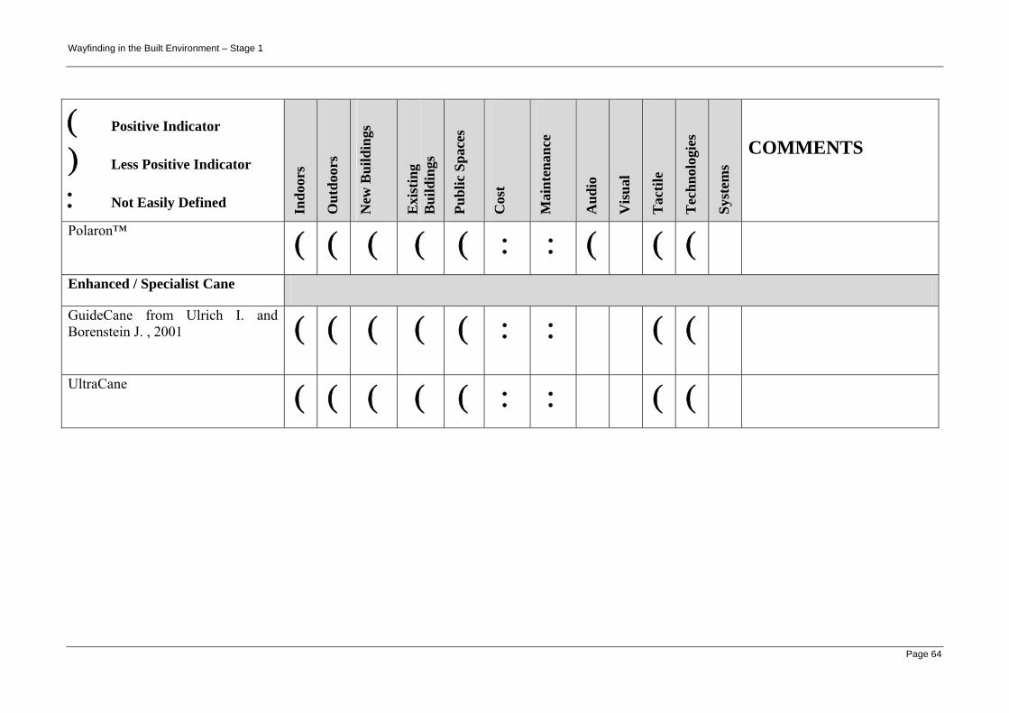
Wayfinding in the Built Environment – Stage 1
Page 64
( Positive Indicator
) Less Positive Indicator
: Not Easily Defined Indo
ors
Out
door
s
New
Bui
ldin
gs
Exi
stin
g B
uild
ings
Publ
ic S
pace
s
Cos
t
Mai
nten
ance
Aud
io
Vis
ual
Tac
tile
Tec
hnol
ogie
s
Syst
ems
COMMENTS
Polaron™ ( ( ( ( ( : : ( ( (
Enhanced / Specialist Cane
GuideCane from Ulrich I. and Borenstein J. , 2001 ( ( ( ( ( : : ( (
UltraCane ( ( ( ( ( : : ( (
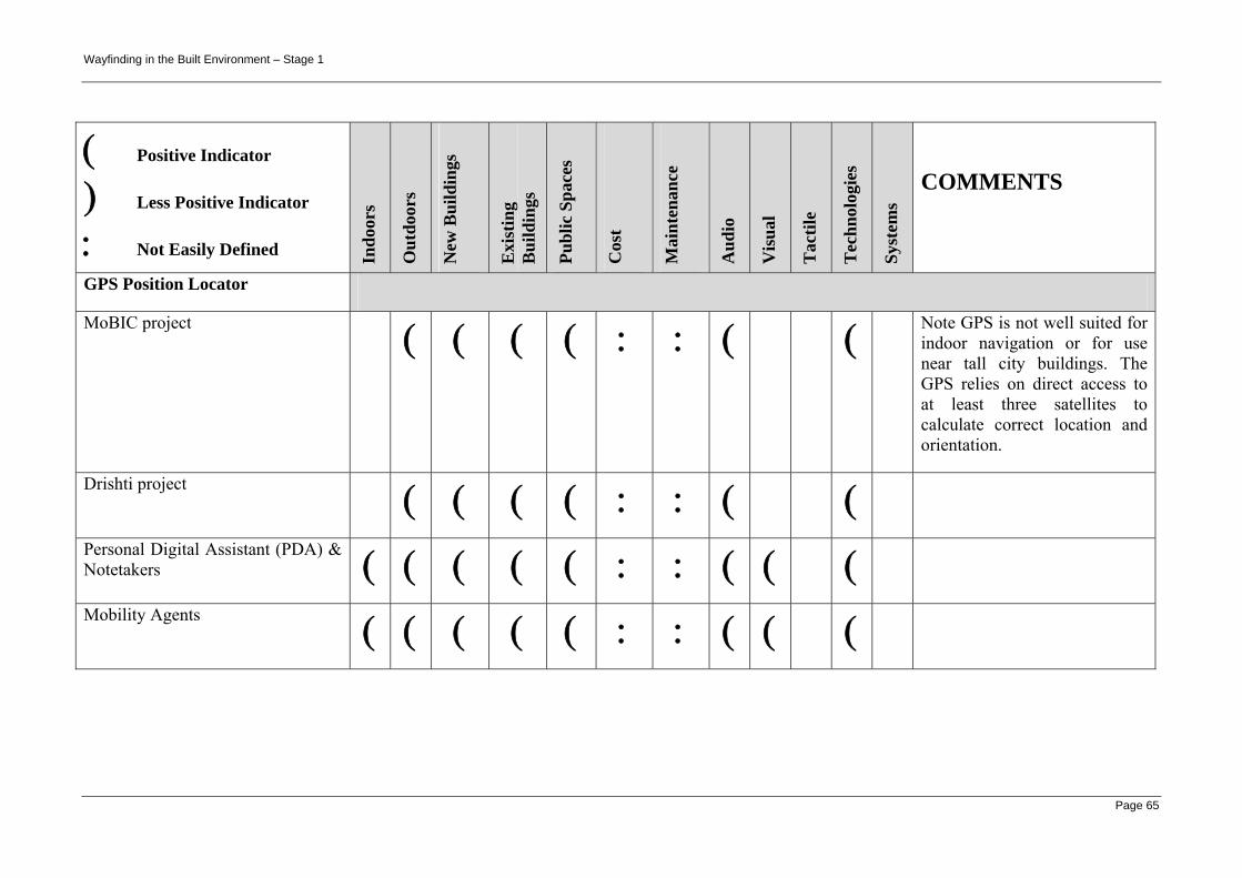
Wayfinding in the Built Environment – Stage 1
Page 65
( Positive Indicator
) Less Positive Indicator
: Not Easily Defined Indo
ors
Out
door
s
New
Bui
ldin
gs
Exi
stin
g B
uild
ings
Publ
ic S
pace
s
Cos
t
Mai
nten
ance
Aud
io
Vis
ual
Tac
tile
Tec
hnol
ogie
s
Syst
ems
COMMENTS
GPS Position Locator
MoBIC project ( ( ( ( : : ( ( Note GPS is not well suited for indoor navigation or for use near tall city buildings. The GPS relies on direct access to at least three satellites to calculate correct location and orientation.
Drishti project ( ( ( ( : : ( (
Personal Digital Assistant (PDA) & Notetakers ( ( ( ( ( : : ( ( (
Mobility Agents ( ( ( ( ( : : ( ( (

Wayfinding in the Built Environment – Stage 1
Page 66
( Positive Indicator
) Less Positive Indicator
: Not Easily Defined Indo
ors
Out
door
s
New
Bui
ldin
gs
Exi
stin
g B
uild
ings
Publ
ic S
pace
s
Cos
t
Mai
nten
ance
Aud
io
Vis
ual
Tac
tile
Tec
hnol
ogie
s
Syst
ems
COMMENTS
Talking Digital Map Systems
GPS Trekker ( ( ( ( ( : : ( ( ( ( (
Atlas GPS ( ( ( ( ( : : ( ( ( ( (
BrailleNote GPS ( ( ( ( ( : : ( ( ( ( (
Tactile Map Systems
Wayfinding and Universal Design - Lighthouse International ( ( ( ( ( : : ( ( ( ( (
Mobile Phones / Communicators
Nokia, Audiovox and Samsung ( ( ( ( ( : : ( ( ( (
DrishtiLite - Motorola Smart Phone i95cl ( ( ( ( ( : : ( ( ( ( Requires both GPS and in-
building spatial information.

Wayfinding in the Built Environment – Stage 1
Page 67
( Positive Indicator
) Less Positive Indicator
: Not Easily Defined Indo
ors
Out
door
s
New
Bui
ldin
gs
Exi
stin
g B
uild
ings
Publ
ic S
pace
s
Cos
t
Mai
nten
ance
Aud
io
Vis
ual
Tac
tile
Tec
hnol
ogie
s
Syst
ems
COMMENTS
Infrastructure-based systems & technologies
Accessible Pedestrian Signals (APS)
Pushbutton-integrated APS ( ( ( ( ( : : ( ( ( (
Pedhead-mounted APS ( ( ( ( ( : : ( ( ( (
Vibrotactile-only APS ( ( ( ( ( : : ( ( ( ( (
Receiver-based APS ( ( ( ( ( : : ( ( ( (
Press and Listen Signs ( ( ( ( ( : : ( ( ( (
Speaking Sign (Push Button) ( ( ( ( ( : : ( ( ( (

Wayfinding in the Built Environment – Stage 1
Page 68
( Positive Indicator
) Less Positive Indicator
: Not Easily Defined Indo
ors
Out
door
s
New
Bui
ldin
gs
Exi
stin
g B
uild
ings
Publ
ic S
pace
s
Cos
t
Mai
nten
ance
Aud
io
Vis
ual
Tac
tile
Tec
hnol
ogie
s
Syst
ems
COMMENTS
Speaking Sign (PIR - Passive InfraRed) ( ( ( ( ( : : ( ( ( ( PIR does not provide directions
or wayfinding information, merely warning of obstacles / dangers, or greeting persons.
Speaking Sign (Indoor) ( ( ( ( : : ( ( ( (
Line-Following
TGSI-following Guidance ( ( ( ( ( : : ( ( ( ( (
Line-tracking Guidance - Herald (2000) ( ( ( ( : : ( ( ( (
Directional Sound Evacuation
Directional Sound Evacuation - British company Sound Alert Technology
( ( ( ( : : ( ( ( ( Directional sound (only) alert; not recorded message.

Wayfinding in the Built Environment – Stage 1
Page 69
( Positive Indicator
) Less Positive Indicator
: Not Easily Defined Indo
ors
Out
door
s
New
Bui
ldin
gs
Exi
stin
g B
uild
ings
Publ
ic S
pace
s
Cos
t
Mai
nten
ance
Aud
io
Vis
ual
Tac
tile
Tec
hnol
ogie
s
Syst
ems
COMMENTS
Remote (Infrared) Audible Signage
Audio Signs ®
( ( ( ( ( : : ( ( ( ( Recorded message – motion
activated by passing pedestrian traffic.
Talking Signs ®
Talking Sign CalTrain installation schematic; from
( ) ( ( ( : : ( ( ( ( Directional spoken message(s) transmitted by IR to specialist portable receiver. Weather protected areas outdoors may be a possibility.
InfraVoice – IR reactive system ( ( ( ( ( : : ( ( ( ( Spoken message triggered by IR from specialist portable transmitter

Wayfinding in the Built Environment – Stage 1
Page 70
( Positive Indicator
) Less Positive Indicator
: Not Easily Defined Indo
ors
Out
door
s
New
Bui
ldin
gs
Exi
stin
g B
uild
ings
Publ
ic S
pace
s
Cos
t
Mai
nten
ance
Aud
io
Vis
ual
Tac
tile
Tec
hnol
ogie
s
Syst
ems
COMMENTS
Remote Radio Frequency Audible Signage
RNIB React - Whitney et al., 2004 ) ( ( ( ( : : ( ( ( ( RNIB React has been designed for outdoor application. It may have an application for indoor application.
On-Line Digital Information
On-line Digital Information and Maps ( ( ( ( ( : : ( ( ( (

Wayfinding in the Built Environment – Stage 1
Page 71
( Positive Indicator
) Less Positive Indicator
: Not Easily Defined Indo
ors
Out
door
s
New
Bui
ldin
gs
Exi
stin
g B
uild
ings
Publ
ic S
pace
s
Cos
t
Mai
nten
ance
Aud
io
Vis
ual
Tac
tile
Tec
hnol
ogie
s
Syst
ems
COMMENTS
The Future - Tactual / Tactile Feedback; Smart Clothing; Wearable PCs
DataGlove ( ( ( ( ( : : ( ( ( ( (
Electromechanical vibrotactile transducers (tactors) are being developed and marketed by US companies -see
( ( ( ( ( : : ( ( ( ( (
Miniaturized thermogenerators (can exploit temperature differences between the surface of the human body and its environment by converting heat into electrical energy) will possibly provide an alternate power source to batteries for mobile applications.
( ( ( ( ( : : ( ( ( ( Note: Miniaturized thermo-generators are possible alternate power source to batteries for mobile applications/wearable clothing.
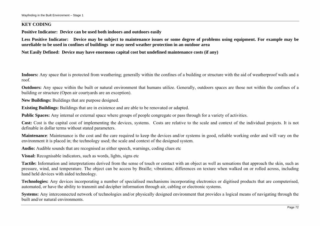
Wayfinding in the Built Environment – Stage 1
Page 72
KEY CODING
Positive Indicator: Device can be used both indoors and outdoors easily
Less Positive Indicator: Device may be subject to maintenance issues or some degree of problems using equipment. For example may be unreliable to be used in confines of buildings or may need weather protection in an outdoor area
Not Easily Defined: Device may have enormous capital cost but undefined maintenance costs (if any)
Indoors: Any space that is protected from weathering; generally within the confines of a building or structure with the aid of weatherproof walls and a roof.
Outdoors: Any space within the built or natural environment that humans utilize. Generally, outdoors spaces are those not within the confines of a building or structure (Open air courtyards are an exception).
New Buildings: Buildings that are purpose designed.
Existing Buildings: Buildings that are in existence and are able to be renovated or adapted.
Public Spaces: Any internal or external space where groups of people congregate or pass through for a variety of activities.
Cost: Cost is the capital cost of implementing the devices, systems. Costs are relative to the scale and context of the individual projects. It is not definable in dollar terms without stated parameters.
Maintenance: Maintenance is the cost and the care required to keep the devices and/or systems in good, reliable working order and will vary on the environment it is placed in; the technology used; the scale and context of the designed system.
Audio: Audible sounds that are recognised as either speech, warnings, coding clues etc
Visual: Recognisable indicators, such as words, lights, signs etc
Tactile: Information and interpretations derived from the sense of touch or contact with an object as well as sensations that approach the skin, such as pressure, wind, and temperature. The object can be access by Braille; vibrations; differences on texture when walked on or rolled across, including hand held devices with aided technology.
Technologies: Any devices incorporating a number of specialised mechanisms incorporating electronics or digitised products that are computerised, automated, or have the ability to transmit and decipher information through air, cabling or electronic systems.
Systems: Any interconnected network of technologies and/or physically designed environment that provides a logical means of navigating through the built and/or natural environments.