watersmart, reston, va, august 1-2, 2011 [email protected] steve markstrom and lauren hay national...
TRANSCRIPT

WaterSmart, Reston, VA, August 1-2, [email protected]
Comparison of Modeling Approaches Used to Estimate Streamflow at Ungaged Basins
Steve Markstrom and Lauren HayNational Research Program
Denver, CO
Jacob LaFontaineGA Water Science Center
Atlanta, GA
WaterSmart, Reston, VA, August 1-2, [email protected]
The WaterSMART initiative has identified a need for
daily streamflow time series at ungaged locations to
define ecological-flow goals, assess the effects of
hydrologic alteration on ecological services, and
understand the effects of change on water resources,
such as changes from climate and land cover.
Comparison of Modeling Approaches Used to Estimate Streamflow at Ungaged
Basins

WaterSmart, Reston, VA, August 1-2, [email protected]
A comparison of streamflow estimates for a large-scale
watershed will be made based on simulations from:
1) statistically-based methods (SBM)
2) a water balance model (WBM), and
3) a physically-based watershed model (PRMS).
General Approach

WaterSmart, Reston, VA, August 1-2, [email protected]
Water Balance Model (WBM)
1) Aggregation of the
NHD+ catchments
2) Monthly timestep
3) Natural flows
WaterSmart, Reston, VA, August 1-2, [email protected]
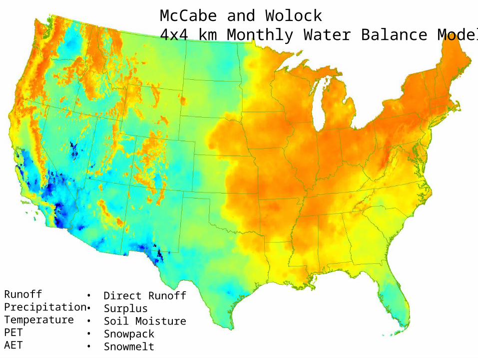
McCabe and Wolock4x4 km Monthly Water Balance Model
• Runoff• Precipitation• Temperature• PET• AET
• Direct Runoff• Surplus• Soil Moisture• Snowpack• Snowmelt

WaterSmart, Reston, VA, August 1-2, [email protected]
McCabe and Wolock4x4 km Monthly Water Balance Model
Reference basins for model calibration and evaluation

WaterSmart, Reston, VA, August 1-2, [email protected]
Calibration of the WBM in Ungaged Basins
Step 1:
For the reference basins (gaged) compute:• Hydrologic indices (basin area, LULC, slope, “wetness”, etc.)• Hydrologic response (flow statics, hydrograph separation,
etc.)• Compute regression table of the indices and the responses.Step 2:
For the ungaged basins:• Compute the hydrologic indices• Determine what the hydrologic response should be
Step 3:
For the ungaged basins:• Run Monte Carlo search (ie 10,000 runs) with randomly
generated parameter sets.• Keep parameter sets which generate “appropriate”
response.


CapillaryReservoir
Precipitation
Plant Canopy Interception
Solar Radiation
Air temperature
Evaporation
Sublimation
Preferential –FlowReservoir
Impervious-Zone Reservoir
GravityReservoir
GroundwaterReservoir
Evaporation
Surface runoff to stream
Evaporation &Transpiration Rain
Groundwater Recharge
Groundwater flow to stream
Fast Interflow to stream
Groundwater Sink
Slow Interflow to stream
Upslope Flow
Surface runoff to stream
Soil-
Zone
Res
ervo
ir
Snow Pack
Throughfall
Snowmelt
Rain
Physically-Based Watershed Model (PRMS)

Watershed Scale Response to Climate Change Across the United StatesUSGS Climate Change Conference
March 11, 2010
PRMS statvar variable name Units Description from PRMS manual
basin_cfs cfs Streamflow from basin
basin_et inches Evapotranspiration on basin including et, snow evap and interception evap for timestep
basin_gwflow_cfs cfs Basin ground-water flow for timestep
basin_gwin inches Basin area weighted average of inflow to groundwater reservoirs.
basin_gwstor inches Basin area weighted average of groundwater storage
basin_horad langleys Potential shortwave radiation for the basin centroid
basin_imperv_evap inches Basin area-weighted average for evaporation from impervious area
basin_imperv_stor inches Basin area-weighted average for storage on impervious area
basin_infil inches Basin area-weighted average for infiltration.
basin_intcp_evap inches Basin area-weighted evaporation from interception.
basin_intcp_stor inches Basin area-weighted average interception storage
basin_perv_et inches Basin area weighted average of pervious area ET. basin_pk_precip inches Basin area-weighted average precip added to snowpack basin_potet inches Basin area-weighted average of potential et
basin_potsw langleys Area-weighted average of potential shortwave radiation for the basin
basin_ppt inches Area weighted adjusted average precip for basin. basin_pweqv inches Average snowpack water equivalent for total basin areabasin_rain inches Area weighted adjusted average rain for basinbasin_snow inches Area weighted adjusted average snow for basinbasin_snowcov decimal fraction Average snow-covered area for total basin area.
basin_snowevap inches Average evaporation and sublimation for total basin area
basin_snowmelt inches Average snowmelt for total basin area
basin_soil_moist inches Basin area weighted average for soil_moistbasin_soil_rechr inches Basin area weighted average for soil_rechrbasin_soil_to_gw inches Basin average excess soil water that flows directly to groundwater reservoirs.
basin_sroff_cfs cfs Basin surface runoff for timestep
basin_ssflow_cfs cfs Basin subsurface flow for timestepbasin_ssin inches Basin weighted average for inflow to subsurface reservoirsbasin_ssr2gw inches Basin average drainage from subsurface reservoir added to groundwater
basin_ssstor inches Basin weighted average for subsurface reservoir storage
basin_storage inches Storage in basin including groundwater, subsurface storage, soil moisture, snowpack, and interception.
basin_tmax °F Basin area-weighted daily maximum temperaturebasin_tmin °F Basin area-weighted daily minimum temperature
Description of selected PRMS output variables.[“inches” are depth over the basin area per daily time step; “cfs” are mean daily cubic feet per second over the daily time step. Temperatures are instantaneous value during the day. ]
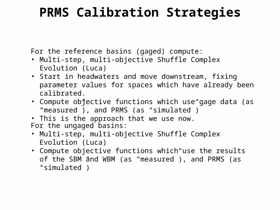
PRMS Calibration Strategies
For the reference basins (gaged) compute:• Multi-step, multi-objective Shuffle Complex Evolution (Luca)• Start in headwaters and move downstream, fixing parameter values for
spaces which have already been calibrated.• Compute objective functions which use gage data (as “measured”), and
PRMS (as “simulated”)• This is the approach that we use now.
For the ungaged basins:• Multi-step, multi-objective Shuffle Complex Evolution (Luca)• Compute objective functions which use the results of the SBM and WBM
(as “measured”), and PRMS (as “simulated”)

Products1) Develop guidelines on the advantages/disadvantages/applicability of each method to
estimate daily streamflow.2) Develop an overall approach to regionalizing WBM and PRMS model parameters for
ungaged basins across the United States. 3) A portal based on two prototypes: 1) current and future WBM output for the country (
http://runoff.cr.usgs.gov/mows/wb/) and 2) the Southeast Regional Assessment Project Data Portal for integration of environmental simulation models (http://internalbrr.cr.usgs.gov/mows/serap/ -- click on Watershed Modeling
4) Tools for defining HRUs and calibrating large areas that could be extended across the Nation.
5) Proposed publication titles: 1) “Comparison of statistically and physically based watershed models to estimate
streamflow at ungaged basins”2) “Physical and climatic explanations for the cross-correlation between streamflow time
series”
