waterproof the upper james river - imgix · the upper section of the james river ... upper james...
TRANSCRIPT

Waterproof
A Paddle Guide to the UpperThe James River originates at the confluence of the Jackson and Cowpasture rivers in Botetourt County and forms Virginia’s longest and most famous river. The upper section of the James River is very scenic with stunning Blue Ridge mountain views. Dam releases on the Jackson River flow releases ensure the upper James River is typically run able all season. The first 60 miles contain
only class I or II rapids making it ideal for canoe or kayak trips at normal water levels. The white water section below Glasgow includes a class III section for those interested in more technical water.
This paddle guide covers the upper 64 miles section from the start of the James river to the Cushaw Dam, just below Snowden. It includes everything a paddler
will need to plan a river trip. This guide includes locations of boat landings, campsites, major rapids, and unique historic points of interests along the way. This is a great resource for planning day trips as well as multi-day canoe camping expeditions.
The Upper James River
Using This Map
North indicator
These maps have been orientated so that the river always flows from the bottom of the map to the top of the map. This allows paddlers to easily orient themselves in the river in terms of river right and left while paddling downstream.
Mile markers— numbered from start of the James River counting down stream
*All land along river bank is private property unless noted otherwise.
Boat launch
Small boat launch
Commercial campground
Informal camping
Appalachian Trail
Rapids (See River Safety panel for class system)
30
Canal
Bridge
Landmark
Park*
George Washington and Jefferson National Forrest*
Hiking Trail
Rive
r flow
Distance gauge0 1mi
1km
TWIN RIVER OUTFITTERS t r o @ c a n o e v i r g i n i a . n e t • 5 4 0 - 2 61 -7 3 3 4 • 6 5 3 L o w e S t r e e t , B u c h a n a n , VA 2 4 0 6 6 • c a n o e v i r g i n i a . n e t

Day Trips
Overnight Trips
MAP 1 Lick Run to Glen Wilton - (Map Mile 0.8 to 4.0) This 3.2 mile (1 - 1.5 hours) float features quick current and impressive mountain views of Patterson Mountain on river right. This trip contains several easy class I rapids and one easy class II rapid.Glen Wilton to Gala - (Map Mile 4.0 to 11.3) This 7.3 mile (3 – 4 hours) float features numerous class I rapids as well as one class II rapid locally called “The Squeeze” and should be carefully scouted before being paddled. Gala take out up Sinking Creek under rail road bridge.Gala to Craig Creek - (Map Mile 11.3 to 15.2) This 3.9 mile (1 – 2 hours) short float has plenty of easy class I rapids to enjoy. This short trip makes for a great after work float or a good run for river tubing, take out on river right as Craig Creek enters the James River.
MAP 2Craig Creek to Horseshoe Bend - (Map Mile 15.2 to 28.9) This 13.7 mile (5 – 7 hours) float has numerous class I rapids and a few easy class II rapids along the way and is on one of the more remote parts of the river. A portion of this trip has been designated a “Virginia Scenic River” section. Named by Blue Ridge Magazine as the best class I run in the State. This trip also includes some of the most impressive remains of the historic James & Kanawha canal system.
MAP 3Horseshoe Bend to Springwood - (Map Mile 28.9 to 32.5) This 3.6 mile (1 – 2 hours) is a short and fun trip containing several class I rapids and a mod-erately challenging class II rapid known as Ritchie’s Falls about 10 minutes into the float. This entire float also has the Virginia Scenic River designation. Take out at Springwood concrete ramp on river right just below Springwood automobile bridge.Springwood to Buchanan - (Map mile 32.5 to 37.3) This 5 mile (2 hours) trip is one of the easier floats available on the Water Trail great for first time paddlers or folks fishing. This trip contains a few easy class I rapids including a ½ mile section of swift water with class I+ rapids.
MAP 4Buchanan to Arcadia - (Map Mile 37.3 to 43.5) This 6.16 mile (2 ½ hours) float is a fun float with good rapids and current. The trip includes three class II rapids that can be challenging in higher water conditions . The trip is very popular with local paddlers, normally crowded on weekends.Arcadia to Alpine - (Map Mile 43.5 to 48.0) This 4.49 mile (1 1/2– 2 hours) section contains several easy Class I rapids and two fun class II rapids at normal water levels. This part of the river is remote and has some great mountain views. This stretch is also excellent for smallmouth bass fishing.
MAP 5Alpine to Glasgow - (Map Mile 48.0 to 59.0) This 11.05 mile (4-6 hour) trip features numerous class II rapids alternating between long pools of calm water and borders miles of National Forest land on the river right. It also has some great mountain views as the James River winds its way along the base of the Blue Ridge mountains. The take out at Glasgow river left on the heavy timber steps just before Maury River confluence.
MAP 6Glasgow to Snowden - (Map Mile 59.0 to 63.7) This 4.7 mile (2-3 hour) trip features the most scenic section of the entire Upper James River. This section is also the most technical and not recommended for beginner paddlers. A rock garden starts about a mile into the float marks the beginning the white water section with a gradient of 17 feet per mile and contains dozens of class I,II,III rapids. Generally speaking, the easier route in the gorge is to take the right side of river before the balcony falls rapid and then go down the left side of the river the remaining white water section. Not recommended to be paddled above 4.5 Ft on the James River Buchanan Gauge. Becomes class VI section at higher water levels. Use caution.
BOAT LANDINGS CAMPGROUNDS
2 DAY / 1 NIGHT
3 DAY / 2 NIGHT
4 DAY / 3 NIGHT
5 DAY / 4 NIGHT
MILEMARKER
IRON GATEGLEN WILTONGALA
CRAIG CREEKHORSESHOE BEND
SPRINGWOODBUCHANANARCADIA
ALPINE
GLASGOW
SNOWDEN
0.84.011.311.815.228.829.132.537.343.543.648.056.359.060.263.7
JELLY STONE OR WILDERNESS CANOE
NATIONAL FOREST
28.01& 2
22.12& 3
21.74&5
15.75&6
36.5 32.8 26.4 58.2 48.5 62.9TOTAL TRIP DISTANCE RIVER MAP REFERENCE NUMBERS

1
.8
2
3
4
5
6 7
8
9
10
11
11.3
11.812
13
14
15.2
16
220
220
43
Eagle Rock
Gala
Glen Wilton
Craig Cr.
Patterson Cr.Map 2
Map 1
Cow
pastu
re Rv.
Jackson Rv.
Lick Run
Cow
pastu
re Rv.Clifton Forge
Sink
ing
Cr.
Mill Cr.
Trees
Holes
RockyBeach
Class II Rapid: "Surprise"
Class II Rapid: "The Squeeze"
Class II RapidEasy class II rapid, can be tricky in lower water levels.Run leftStart of James. Mile “0”
Start right of center and move far right.
River turns to the left and narrows down. Caution in high water. Scouting is recommended!
Map 1 Iron Gate—Eagle Rock Miles 0—16
Upper JAMES RIVERMILE
0.00.60.80.80.92.04.04.04.86.46.98.59.911.311.311.311.411.711.813.915.115.215.2
ENTIREJAMESRIVERMILE
346.60346.00345.81345.80345.70344.60342.60342.58341.80340.20339.75338.10336.70335.30335.30335.30335.20334.90334.80332.75331.50331.40331.41
DESCRIPTION
Start of the James RiverClass II RapidBridge - Route 220Boat landing - Lick RunRiver Gauge - Lick RunRapid - Class II- "Surprise"Bridge - Route 622 Boat Landing - Glen Wilton Small IslandClass II Rapid "The Squeeze"Bridge - Rail Road Small IslandPrices BluffSinking Creek - Under Rail Road Bridge River LeftBoat Landing - GalaKelly's Market20 ft cliffs Mill CreekCamp Ground - Gala - Twin River OutfittersBridge - US 220Bridge - Rail Road BridgeCraig CreekBoat Landing - Eagle Rock
Class I RapidsClass I+ Wave-field. After the bend, Class I rapids. Run first two left, and last one right.
Old Train Trestle Bridge
622
43
TRO Campground- GalaSee information panel
Pric
es B
luff
Rd.
Roanoke
633
Cowpasture RiverPaddlers taking a break on the Cowpasture river, a major contributory to the James river.
0 1mi
1km

16
15
15.2
14
17
18
19
20
21
22
2324
2526
27
28
28.9
29.1
2930
Map 2
Map 2
Map 3
Map 1
Salisbury
Horseshoe Bend
Eagle Rock
Craig Cr.
Catawba Cr.
Gala
Fincastle
Buchanan
220
43
43
43
Class II Rapid: "Gwynn Lock"
Class II Rapid
Old dam site. Run either channel; left in low water.
Last lock park
Long wave field. Large waves develop at higher water levels. Take the largest channels. Watch for debris.
Map 2 Eagle Rock—Horseshoe Bend Miles 14—30
UPPERJAMESRIVER
MILE
15.115.215.215.315.715.918.318.319.520.620.720.921.821.922.923.423.925.727.1
26.827.828.628.928.929.129.830.2
ENTIREJAMESRIVER
MILE
331.50331.40331.41331.30330.90330.75328.35328.34327.10
326.00325.90325.70324.80324.70323.70323.20322.70320.90319.50319.85318.80318.00317.70317.70317.50316.80316.45
DESCRIPTION
Bridge - Rail Road BridgeCraig Creek
Boat Landing - Eagle RockLast Lock Park
Bridge - James StreetOld Bridge Remains
Historic canal system remainsClass II Rapid “Gwynn Lock”
Catawba Creek IslandsCatawba Creek
Historic Canal Navigation System Remains Rail Road Tunnel
Historic Canal Navigation System Remains Class II Rapid at higher water levels
Rocky CliffsChimney Rock
Salt Peter Cave CreekTwo Stone Piers Remains
Bridge -Rail RoadGravel Shallows
Oxbow Bend IslandsWhite Farm House
Power LinesHorseshoe Bend Boat Landing
Camp Ground - Narrow Passage - Twin River OutfittersClass II Rapid “Richie’s Falls”
Bridge -Rail Road
Class I+ Rapid: “CATAWBA CREEK ISLANDS”
Class I Rapid
Class I Rapid
Take largest channel. Smaller channels may be too low and/or clogged with debris. Most water is right of first two islands. All channels can get shallow at low water levels.
Take either side of island. Shallow in late summer.
Shallow in late summer.
STONE PIERS
688
688
TRO Campground- Narrow PassageSee information panel
Cliffs
Cliffs
Cliffs
Cliffs
Cliffs
Grain silos
Cliffs
Salt Peter Cave Rd.
Old Dam Site
Rocky beach
Old Canal
Buttons Bluff Railroad BridgeView from Buttons Bluff overlook of Rail Road bridge near mile 27.
Class II Rapid: "Richie’s Falls”River-wide 1.5 ft. ledge. Run far left. Use caution. Scouting recommended.
0 1mi
1km
3029
29.1
28.9
31
32
32.5
33
34
35
36
37
3839
Buchanan
Springwood
HorseshoeBend
Map 2
Map 3
Map 3
Map 4
Map 4 Map 3
Roanoke
Blue Ridge Parkway
Eagle Rock
Lexington
Class II Rapid: "Richie’s Falls”
Class II Rapid: "Quarry Rapid”
Class II Rapid
Class I+ Rapid
Class I Rapid
River-wide 1.5 ft. ledge. Run far left. Use caution. Scouting recommended.
1/4 mile wave-field. Swift water and waves that can tip over boat. Challenging in high water.
Shallow wave-field. Becomes difficult to navigate during late summer’s low water.
Limestone Park
Run right of center.Becomes difficult in low water.
Swift water. Run center.
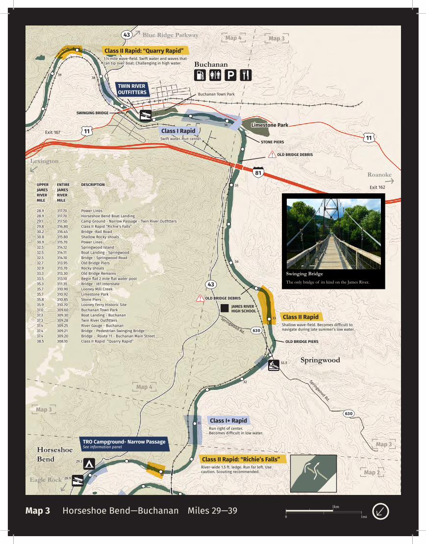
Map 3 Horseshoe Bend—Buchanan Miles 29—39
UPPERJAMESRIVERMILE
28.928.929.129.830.230.830.932.532.532.532.732.933.333.535.335.735.735.835.937.037.337.337.437.437.438.5
ENTIRE JAMESRIVERMILE
317.70317.70317.50316.80316.45315.80315.70314.12314.11314.10313.95313.70313.30313.10311.35310.90310.92310.85310.70309.60309.30309.28309.25309.21309.20308.10
DESCRIPTION
Power LinesHorseshoe Bend Boat LandingCamp Ground - Narrow Passage - Twin River OutfittersClass II Rapid “Richie’s Falls”Bridge -Rail RoadShallow Rocky shoalsPower LinesSpringwood IslandBoat Landing - SpringwoodBridge - Springwood RoadOld Bridge PiersRocky shoalsOld Bridge RemainsBegin flat 2 mile flat water poolBridge - I81 InterstateLooney Mill Creek Limestone ParkStone PiersLooney Ferry Historic Site Buchanan Town ParkBoat Landing - BuchananTwin River OutfittersRiver Gauge - BuchananBridge - Pedestrian Swinging BridgeBridge - Route 11 - Buchanan Main StreetClass II Rapid “Quarry Rapid”
43
43
1111
81
Exit 167
Exit 162
Swinging BridgeThe only bridge of its kind on the James River.
SWINGING BRIDGE
OLD BRIDGE DEBRIS
OLD BRIDGE PIERS
STONE PIERS
JAMES RIVERHIGH SCHOOL
OLD BRIDGE DEBRIS
TRO Campground- Narrow PassageSee information panel
Springwood Rd.
Springwood Rd. 630
630
TWIN RIVER OUTFITTERS Buchanan Town Park
0 1mi
1km

36
37
38
38.5
39
40
41
42
42.7
43
43.544
45
46
47
48
Map 3
Map 4
Map 4
Map 4
Map 5 Map 5
Buchanan
Arcadia
Alpine
622
614
614
43
Lexington
Roanoke
Blue Ridge Parkway
Rock Quarry Cliffs
Buchanan Town Park
Powerline
Powerlines
Rock Quarry
Rocky Run Rd
Indian Rock
Class I
Class II
Class I+ Class II Rapid: "Jennings Creek"Left channel at island is class II rapid. Ledge sticks out from left bank past first island and forces water sharply to right. Stay to right in the bend. Right channel is class I+ and typically low in summer.
Run left of center.
Shallow late summer.
Take left channel around island. Right channel typically is low in summer.
Rocky ledges across from boat landing. Run center of main channel, left of first ledge, and right of center on second ledge.
Class II Rapid
Class I Rapid
Class II Rapid
Class II Rapid
Class II Rapid: "Quarry Rapid”1/4 mile wave-field. Swift water and waves that can tip over boat. Challenging in high water.
Map 4 Buchanan—Alpine Miles 36—48
UPPERJAMES RIVERMILE
35.937.337.337.437.437.438.540.440.341.542.742.843.543.543.544.144.444.744.744.745.147.547.648.0
ENTIRE JAMESRIVERMILE
310.70309.30309.28309.25309.21309.20308.10306.20306.28305.10303.90303.80303.15303.15303.10302.50302.20301.90301.88301.87301.50299.10299.05298.65
DESCRIPTION
Looney Ferry Historical Site Boat Landing - BuchananTwin River OutfittersRiver Gauge - BuchananBridge - Pedestrian Swinging BridgeBridge - Route 11 - Buchanan Main StreetClass II Rapid “Quarry Rapid”Historic Canal Navigation System Remains Class II RapidVery Small IslandJennings Creek Class II RapidJennings CreekBridge - Arcadia RT 614Boat landing - ArcadiaCamp Ground - Arcadia - Twin River OutfittersIndian RockHousesSmall Island - Private propertyHistoric Canal Navigation System Remains Class II Rapid Power LinesPower LinesHigh CliffsBoat Landing - Alpine
81
Limestone Park
11
Exit 167
Exit 168
(Public Arcadia Hand-carry access)TRO Campground- ArcadiaSee information panel
TWIN RIVER OUTFITTERSSwinging Bridge
The James River and Kanawha CanalA canal system in Virginia intended to facilitate shipments of passengers and freight by water between the western counties and the coast of Virginia. Surveyed and planned by George Washington, the canal project was begun in 1785 as the James River Company, and later resumed under the James River and Kanawha Canal Company. Planned construction would have allowed river traffic to travel from the tidal waters below Richmond to the Ohio Valley entirely by river except for a 30 mile turnpike The canal system was only half completed by 1851, reaching Buchanan, in Botetourt County Virginia. Eventually railroads over took the canal system as a far more productive mode of transportation. Construction expansion efforts ceased, due to financial reasons, and ultimately most of the property was purchased by the rail roads. Many of the stone locks, dams, and canal remains can still be seen to this day while padding the Upper James River.
608
0 1mi
1km
48
49
50
51
52
53
54
55
56
56.3
56.957
58
5960
Map 5Map 4
Map 5
Map 5
Map 6
Map 6
Glasgow
Natural BridgeStation
Natural Bridge
Lexington
Roanoke
Alpine
81
81
Class III RapidMaury River entering James River.
Class II Rapid: "Cement Tower"
Class II Rapid: "Old Dam"
Class I+ Rapid
Start in left third and angle back to right side for best ride. Sneak is extreme left. Becomes class II+ in high water.
Old dam site. Run in center.
Double ledge run left to right between ledges.
Rocky ledges across from boat landing. Run center of main channel, left of first ledge, and right of center on second ledge.
Two foot drop. Run far left over ledge and then right.
Class II Rapid
Class II- Rapid
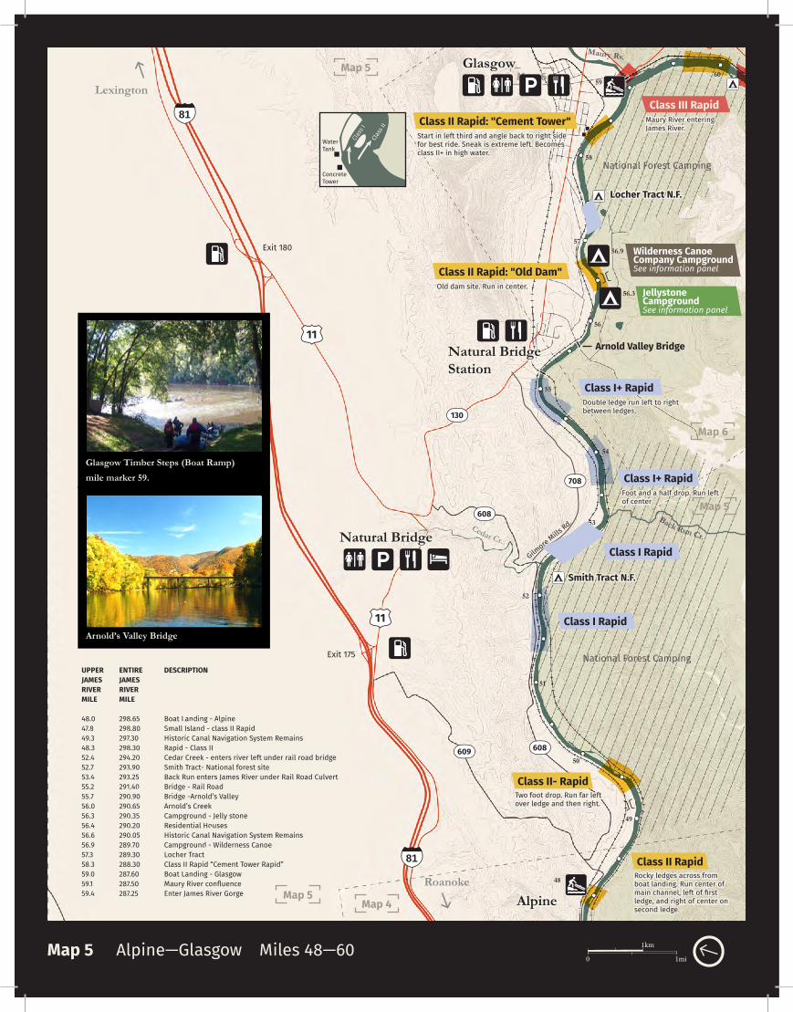
Map 5 Alpine—Glasgow Miles 48—60
UPPERJAMES RIVERMILE
48.047.849.348.352.452.753.455.255.756.056.356.456.656.957.358.359.059.159.4
ENTIRE JAMESRIVERMILE
298.65298.80297.30298.30294.20293.90293.25291.40290.90290.65290.35290.20290.05289.70289.30288.30287.60287.50287.25
DESCRIPTION
Boat Landing - AlpineSmall Island - class II RapidHistoric Canal Navigation System Remains Rapid - Class II Cedar Creek - enters river left under rail road bridgeSmith Tract- National forest siteBack Run enters James River under Rail Road CulvertBridge - Rail RoadBridge -Arnold’s ValleyArnold’s CreekCampground - Jelly stoneResidential HousesHistoric Canal Navigation System Remains Campground - Wilderness CanoeLocher TractClass II Rapid “Cement Tower Rapid”Boat Landing - GlasgowMaury River confluenceEnter James River Gorge
Concrete Tower
Clas
s II
Clas
s I
Water Tank
11
11
608
608
130
708
Exit 175
Exit 180
Cedar Cr.
Back Run Cr.
Class I+ Rapid
Class I Rapid
Class I Rapid
Foot and a half drop. Run left of center
Arnold Valley Bridge
Arnold’s Valley Bridge
Glasgow Timber Steps (Boat Ramp) mile marker 59.
Locher Tract N.F.
Smith Tract N.F.
National Forest Camping
National Forest Camping
Jellystone CampgroundSee information panel
Wilderness Canoe Company CampgroundSee information panel
Gilmore Mills
Rd.
Maury Rv.
609
0 1mi
1km

56
56.3
56.9
58
59
60
62
63
64 64.1
63.7
63.6
Glasgow
Natural BridgeStation
Snowden
Map 6
Map 5
LynchburgBlue Ridge Parkway
Buena Vista
Buchanan
Maury Rv.
501
501
501
RIVER WARNING
RIVER WARNING
Class III Rapid: "Little Balcony"
Class III Rapid
Class III Rapid: "Balcony Falls"
Class II Rapid: "Cement Tower"
Class I Rapid
Long “rock garden”. Stay far left.
Confluence of the Maury River and the James River. High water volume.
Largest rapid on the upper James River. Begins just after a large retaining wall on the left bank. Scout from rock island in middle of the river. Best route is right of center in main channel. Sneak route is against extreme far right bank.
Cushaw Dam. NO PORTAGE OPTION!!! Must takeout at boat landing 0.5 miles above dam.
VDOT 501picnic area
White water 3 mile section. Recommended for experienced paddlers only!
Start in left third and angle back to right side for best ride. Easier route, left side of river. Becomes class II+ in high water.
Arnold Valley Bridge
Locher Tract N.F.
James River Foot BridgeAt 700 ft, it is the longest pedestrian only bridge on the AT
Map 6 Glasgow—Snowden Miles 56—64
UPPER JAMES RIVER
MILE
55.756.056.356.456.656.957.358.359.059.159.459.760.260.560.860.961.962.162.263.663.763.763.764.1
ENTIRE JAMESRIVER
MILE
290.90290.65290.35290.20290.05289.70289.30288.30287.60287.50287.25
286.90286.40286.15285.80285.70284.70284.55284.40283.00282.92282.90282.90282.50
DESCRIPTION
Bridge -Arnold’s ValleyArnold’s Creek
Campground - Jelly stoneResidential Houses
Historic Canal Navigation System Remains Campground - Wilderness Canoe
Locher TractClass II Rapid “Cement Tower Rapid”
Boat Landing - GlasgowMaury River confluence
Enter James River GorgeStart Rock Garden
Informal Camping Spot - National Forest LandBalcony Falls Rapid
Class II+ Rapid “Little Balcony”Lunch Rock
Large IslandLarge Vegetated Island
Dam impoundment area (Flat water till dam)Appalachian Trail Foot Bridge
Rail Road BridgeRocky Row Run Creek
Boat landing - SnowdenCushaw Dam
Class II Rapid: "Old Dam"Old dam site. Run in center.
Concrete Tower
Clas
s II
Clas
s I
Water Tank
Sneak
Stone Retaining Wall
130
130
130
National Forest Camping
Jellystone CampgroundSee Information panel
Wilderness Canoe Company Campground See Information panel
Balcony Falls
0 1mi
1km