waterfall on the aek bulu boltak just before it flows into … on the aek bulu boltak just before it...
TRANSCRIPT


Waterfall on the Aek Bulu Boltak just before it flows into the Aek Marulak
Yayasan Ekosistem Lestari (YEL) is a non-profit organization es-tablished in 2000. YEL cares about environmental and community development issues. YEL has collaborated with partners, especially the PanEco Foundation from Switzerland, to develop the Sumatran Orangutan Conservation Programme - SOCP.
Address:Yayasan Ekosistem Lestari (YEL)/PanEco/SOCPJl KH Wahid Hasyim no 51/74, Medan 20154North SumatraTelp: 061 4514 363, 4514 360; Fax: 061 4514 749
YEL’s Vision: To preserve the environment with sustainable benefits for the whole community.
YEL’s Mission: To carry out works and efforts for environmental conservation with sustainable benefits for the whole community. To realize this mission, YEL prioritizes participatory approaches, science-based sustainable solutions and human needs.
This document has been prepared based on consultations with the local governments of North Sumatra Province, and the three Tapan-uli Districts, North Sumatra branch of Walhi Sumatera Utara, and the DPD RI.
Recommended citation: Fredriksson G.M. and G.Usher, 2017. Towards Sustainable Manage-ment of the Batang Toru Ecosystem (translated from Edisi III dari “Menuju Pengelolaan Lestari Ekosistem Batang Toru). 16 hal, pub-lished by Yayasan Ekosistem Lestari
Published in Medan, November 2017oleh Yayasan Ekosistem Lestari / PanEco

The Batang Toru Ecosystem, also known in the local language as “Harangan Tapanuli” which means “Tapanuli Forest”, covers about 150,000 ha in the three Tapanuli Districts of North Sumatera Province, Indonesia. Almost 142,000 ha of this is primary forest which appears dark green on the satellite image in the map (see right). The remainder is degraded land in National Forest Land that should be rehabilitated, and corridors that should be developed between fragmented forest blocks. About 61.0% of the primary forest is in North Tapanuli District, 29.7% in South Tapanuli, with the remaining 9.3% in Central Tapanuli. Elevation ranges from a low of 133 m above sea level (asl) to 1,909 m at the top of Lubuk Raya Mountain, but most of the forest is over 850 m asl. The variety of forests also reflect the wide altitudinal range, from lowland tropical rainforest, through hill forests, up to montane moss forests at higher altitudes. Rainfall is very high in the Ecosystem, with a rainfall of 4,879 mm recorded in 2016 at the SOCP’s Forest Monitoring Station!
Forest Areas in the Batang Toru Ecosystem (ha)
South Tapanuli Central Tapanuli North Tapanuli Total
Area 42,093 13,207 86,477 141,747
% 29.7% 9.3% 61.0% 100%
Note: There are over 10,000 ha of degraded and deforested forest lands adjoining the Batang Toru ecosystem. There should be collaborative programmes with local communi-ties to reforest these areas.
Moss forest occurs on high rdges in the Batang Toru Ecosystem
Location and General Conditions
Batang toru EcosystEm 1

The Tapanuli Orangutan: a new species!Orangutans are the only “great apes” that are found in Southeast Asia. Until recently they were divided into 2 species, the Borean orangutan (Pongo pygmaeus) and the Sumatran orangutan (Pongo abelii). The presence of the orangutans in the Batang Toru Ecosystem was only “discovered” at the ends of the 1990s and is the only wild orangutan population in Sumatra south of Lake Toba.
It transpires that this population is unique: the most recent publication found that the Batang Toru orangutans are so different genetically, morpho-logically, and behaviourally that they represent a separate species hencefort called the ‘Tapanuli Orangutan’ with the scientific name ‘Pongo tapanulien-sis’ (Nater et al. 2017). They are con-sidered the ancestral line to the other orangutan species.
The diagram above shows the genetic links between all the different
orangutan populations. The light blue circles (highlighted in the red ring) are the orangutans of the Batang Toru Ecosystem, and are more closely related to the Bornean than the Sumatran orangutans. It is estimated that there are less than 800 individuals of this species left. They reproduce extremely slowly: females only start having offspring at age 15, and will only have one baby every 7 to 9 years. Also, they are currently isolated in several sub-populations. Therefore it is imperative to reconnect these populations to prevent inbreeding and ensure their long-term survival. The small size of the remaining population of the Tapanuli orangutan means that this, the seventh great ape species, is also the rarest and most endangered great ape in the world. It will be classed as Critically Endangered (the last category before extinction) by the IUCN and every remaining hectare of its habitat should be conserved.
A Unique Flora and Fauna
A young Tapanuli Orangutan swaying a small tree to to reach an adjacent tree
An adult male orangutan resting
2 towards sustainaBlE managEmEnt

Other Interesting Animals and PlantsCamera trapping has resulted in a host of photographs of many different rare and threatened animal species including the Sumatran tiger (Panthera tigris sumatrae), the sun bear (Helarctos malayanus), tapir (Tapirus indicus) and birds such as the Great Argus pheasant (Argusianus argus).
Besides having a high fauna diversity, the flora of the Batang Toru Ecosystem is also fascincating. It has a mosaic of many different forest types. In this rugged mountainous landscape, orchid diversity is high with several new species to sci-ence already encountered. Other fascinating flora include several parasitic plants families including the Balanophoraceae and
One unique species directly ob-served several times in Batang Toru is a species of legless lizard, Dopasia wegneri. This species had only ever been seen once before, nearly 60 years ago in Sumatra. It has never previously been photo-graphed or filmed in the wild.
Camera trap pictures from the Batang Toru Ecosystem: (l to r) sun bear, tapir, and Sumatran tiger
© J.Holden / Batang Toru
A local researcher in Batang Toru© Maxime Aliaga
Legless lizard, Dopasia wegneri, a very rare and unique species
A parasitic plant: Rhizanthes infanticida
Camera trap photo: a male Great Argus
pheasant dancing trying to impress
tw0 females
3
An extremely rare Rafflesia cf micropylora-gadutensis, in the Batang Toru Ecosystem
© Chairunas Adha Putra
Rafflesiaceae which includes the rhizanthes and rafflesia flowers. Rafflesia cf. micropylora-gaduten-sis, is an extremely rare form that appears to be a cross between 2 species that occur north and south of the Batang Toru.
Since 2006, there has been a Flora and Fauna Forest Monitoring Station in the Batang Toru Ecosystem that has become an important centre for forest research in North Sumatra with many students the North Sumatra University and the Bogor Agricultural Institute conducting their dissertation research in the forest.
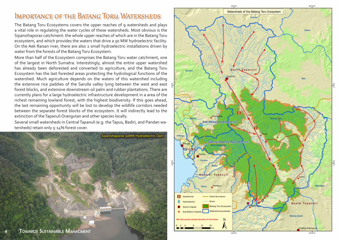
The Batang Toru Ecosystems covers the upper reaches of 9 watersheds and plays a vital role in regulating the water cycles of these watersheds. Most obvious is the Sipansihaporas catchment: the whole upper reaches of which are in the Batang Toru ecosystem, and which provides the waters that drive a 50 MW hydroelectric facility. On the Aek Raisan river, there are also 2 small hydroelectric installations driven by water from the forests of the Batang Toru Ecosystem. More than half of the Ecosystem comprises the Batang Toru water catchment, one of the largest in North Sumatra. Interestingly, almost the entire upper watershed has already been deforested and converted to agriculture, and the Batang Toru Ecosystem has the last forested areas protecting the hydrological functions of the watershed. Much agriculture depends on the waters of this watershed including the extensive rice paddies of the Sarulla valley lying between the west and east forest blocks, and extensive downstream oil palm and rubber plantations. There are currently plans for a large hydroelectric infrastructure development in a area of the richest remaining lowland forest, with the highest biodiversity. If this goes ahead, the last remaining opportunity will be lost to develop the wildlife corridors needed between the separate forest blocks of the ecosystem. It will indirectly lead to the extinction of the Tapanuli Orangutan and other species locally. Several small watersheds in Central Tapanuli (e.g. the Tapus, Badiri, and Pandan wa-tersheds) retain only 5-14% forest cover.
Sipansihaporas 50MW Hydroelectric Dam
Importance of the Batang Toru Watersheds
Extensive rice paddies at the foothills of the Batang Toru Ecosystem4 Towards susTainable ManagMenT

Stable ecosystem and watercatchment functions provided by good forest cover are also vital for the development of the Geothermal Power Generation industry in the Sarulla valley between the east and west blocks. This development is expected to reach an output of 300 MW when completed, and requires reliable supplies of fresh water.
The gold mine operating in the Batang sub-district of South Tapanuli, also relies on water from the Batang Toru Ecosystem, even though it is destroying it.
Finally, the extensive oil palm plantations on the low-er reaches of the Batang Toru river are also highly de-pendent on stable water flows in the river.
The UN organization UNEP, in its report “Orangutans and the Economics of Sustainable Forest Management in Sumatra” used the Batang Toru Ecosystem as a case study for the valuation of different land use scenarios. It predicted that the value of a REDD carbon programme would equal or exceed that of other land use options such as plantations or logging. These calculations did not even include the value of environmental services or or avoided environmental costs from deforestation.
The water from the Batang Toru Ecosystem is of vital importance to the people of the three Tapanuli districts, primarily for their plantations, rice paddies, and their household needs. All the irrigation for the extensive rice paddies in the Sarulla valley comes from the Batang Toru Ecosystem. Mixed rubber and fruit tree plantations are the major source of livelihood for people living around the Batang Toru Ecosystem, and these also depend on water from these forests.
Economic Value of the Batang Toru Ecosystem
Extensive rice paddies at the foothills of the Batang Toru Ecosystem Oil palm in the lower reaches of the Batang Toru RiverRubber tapping is a major livelihood
around the Ecosystem
Geothermal development in the Sarulla valleyThe gold mine in the Batang Toru sub-District
Harvesting rice in the Sarulla valley, North Tapanuli
Environmental services include:• stable water supplies for communities, agriculture and industry;• protection from landslides, flooding, erosion, and sedimentation;• microclimate temperature regulation;• creation of soils and improved soil fertility; • pollination of commercial plant species such as durian; and • tourism potential.
5

“Scoring” Analysis based on Min. of Agriculture Decree 837, 1980The criteria and factors considered in determining which forest areas need to be protected were introduced in 1980. This system is usually called “scoring” in Indonesia. When applied in the Batang Toru Ecosystem to key forest areas allocated as “non -forest” areas (and hence uprotected), almost 70% of these had a score greater than 175, and should be allocated protected status. There are no regions of the Batang Toru Ecosystem that do not have environmentally sensitive areas.
Furthermore, even in areas that appear relatively flat on 25m -contour maps, the micro-topography is still be rugged with frequent relatively shallow but steep gullies. As an example, a page from the book explaining “Land Units and Soils of the Sibolga and Padang Sidempuan Map Sheet” published the Soil Research Institute, clearly states that an area on the standard topographic maps has slopes of only 8 - 16%, actually has an “extremely dissected” micro-topography, and evidence of “extensive accelerated erosion”.
As the Batang Toru Ecosystem is so important for preserving the watershed func-tions for downstream communities and industries, it is obvious that planning for the functions of these rich forests should take into account environmental sensitivity. It is perhaps worth learning from our forebears. Closer study shows that many of the villages around the Batang Toru Ecosystem are very old, and their people have not expanded into the forests because they realized long ago that the costs of destruc-tion of these forests far outweighed short term benefits.
Sensitivity of the Batang Toru Ecosystem
Aerial image showing the rugged topography in the Batang Toru Ecosystem
6 towards sustainaBlE managEmEnt


Some 133,000 people live around the Batang Toru Ecosystem. More 2,800 of these people in 18 sub-Districts were in-terviewed to learn about their socio-eo-nomic profile, natural resource use pat-terns, and their opinions about forests.
In 12 of the sub-Districts, almost all the people were of the local Batak ethnicity living in old long-established villages. In the other 6 sub-Districts (5 in Central Ta-panuli and 1 in South Tapanuli) the com-munities were more diverse, with a lot of in-migration in the last 20 years, primarily from the island of Nias.
The majority of people live from farming with a variety of economically important crops and products such as rubber, benzoin , and various fruits, es-pecially durian.
Most people, especially the local ethnic group, regard the forest as providing water and protection from environmen-tal disasters.
A Profile of Local Communities
A grandmother with 2 grandchildren in a Nias hamlet (Badiri Pardomuan), Central Tapanuli
A Batak lady sells durians from her mixed fruit garden, Sarudik, Central Tapanuli Tengah
An old lady being interviewed by a socio-economy surveyor in Pahae, North Tapanuli
Palm sugar is one staple product from around the Batang Toru Escosystem
Almost all respondents
would like to see more
serious forest managment
(over 90%)
Most local people depend on rivers and
springs to provide their daily water
needs; very few have access to piped mu-
nicipal water supplies.
8
River / Natural Spring72%
Well19% Piped Water
6%Other
3%
Water Sources for people living around the Batang Toru Ecosystem
92%
3%
5%
Answers to "Is more serious / clearer forest management needed?"
Very needed/Needed
Not needed
Don't know

Current threats to the Batang Toru Ecosystem are from industrial infrastructure development, encroachment, and poaching. Most encroachment is being carried out by in-migrants to the western edge of the west block. These in-migrants also hunt wildlife to provide for their protein needs, affecting target species and their ecological functions (such as bats and their role in pollination). Wide use of snares also threatens rare and protected species, even if they are not the target species. Inappropriate development planning is also a threat. For example there are 2 extensive areas of rugged primary forest in South Tapanuli District that are still desig-nated for “Other Use” (i.e. NOT forest). These areas are extremely important for biodiversity, including the Tapanuli Orangutan and the Sumatran Tiger. The largest of these areas is allocated for the development of a major hyrdoelectric dam. Also in South Tapanuli, the Martabe Gold Mine managed by P.T. Agrincourt Resources is planning an expansion of the mine to the Tor Uluala peak, habitat for the Tapanuli Orangutan.
Primary forest loss (2001-2017) in west block of the Batang Toru Ecosystem
Forest encroachment, Lubuk PariasanA planned hydrodam will have massive impacts
Forest clearing, Badiri
Threats
Batang toru EcosystEm 9
The gold mine in Batang Toru sub-District has cleared hundreds of hectares of forest

The map below shows the official Forest Functions in and around the Batang Toru Ecosystem based on the Decree of the Minister of Forestry No.579/2014. With this decree large areas that were proviously designated as “Production” Forests (i.e. for logging) became “Protection” Forests . More than 90% of the Batang Toru Eco-
system in North Tapanuli and Central Tapanuli Districts is now has pro-tected status. It is a different situation in South Tapanuli where 34% its area of the Ecosystem is still either Production Forest or Other Uses, including environmentally sensitive areas that are habitat for endan-gered species such as the Tapanuli Orangutan and Sumatran Tiger.
NorthTapanuli South Tapanuli Central Tapanuli Total
Protection Forest 78.306 16.297 12.704 107.307Nature Reserve 1.836 11.656 0 13.492Logging Forest 180 3.068 0 3.248Other Use 6.125 11.072 503 17.700Total 86.447 42.093 13.207 141.747
Future Managmement
Steep forested slopes in an areas designated for “Other Uses”
The rugged Batang Toru River gorge, also still allocated for “Other Uses”10

The imagined management model is collaborative and multi-stakeholder, and should be able to accommodate the needs of communities that have long lived around these forests, without degrading the ecological values of this ecosystem. A collaborative approach will be required that does not sacrifice the principles of protection for the rich biodiversity and environmental services. This approach could produce a balanced zoning plan that provides clearly defined areas for community uses that
do not compromise environmental services, as well as core protection areas. The current extent of the Batang Toru Ecosystem is the absolute minimum that should preserved, and could be significantly expanded by collaborative programmes with local communities to rehabilitate national forest areas that are currently degraded, especially in corridor areas required to reestablish wildlife links between currently fragmented areas.
Principles and Strategy for Managing the Batang Toru Ecosystem
The main work focus for the collaborative Forest Management Unit for the Batang Toru Ecosystem should include:
• Protection of key values of the area;
• Development of local cadres to support management;
• Facilitation of community participation;
• Survey demarcation of potential Community and Vil-lage Forest areas, and protection zones;
• Development non-extractive use (e.g. ecotourism);
• Research and development;
• Development of management infrastructure.
Participative installation of Boundary Signs in Paromaan, Central Tapanuli: an activ-ity to socialize national forest boundaries. A collaborative activity between the local
Forestry Office (Dinas Kehutanan) and YEL
Future Managmement..... continuedIn 2014, the Minister of Forestry ratifed a status change for the bulk of the Production Forest in the Batang Toru Ecosystem to become Protection Forest. There remain some key areas designated for “Other Uses” that should be designated as “Protected” to allow for long-term protection. A positive recent development has been the formation of Forest Management Units (FMU, known locally as KPH) for the forests of North Sumatra, including the Batang Toru Ecosystem. With the greater recognition of its extraordinary values both for biodiversity and environmental services, there is a timely opportunity for a good example of effective and ef-ficient collaborative management for the Batang Toru Ecosystem. All that is required is the vision and support needed to achieve this.
11

12

© Maxime Aliaga

A mature male Tapanuli Orangutan in the Batang Toru Ecosystem ©Tim Laman