water supply: the history of newark's life source supply: the history of newark’s life ......
TRANSCRIPT

Water Supply:The History of
Newark’s Life Source
by Gerald J. Kauffman
July 2009
published by the
Institute for Public AdministrationCollege of Education & Public PolicyUniversity of Delawareinstitute for Public Administration
serving the public good, shaping tomorrow’s leaders
www.ipa.udel.edu
NewarkWSHistory_cover.qxp 7/21/09 3:19 PM Page 1

Cover design by Mark DeshonPhoto source: Institute for Public Administration, University of DelawareBackground map source: Special Collections, Morris Library, University of Delaware
An Equal Opportunity/Affirmative Action EmployerThe University of Delaware is committed to assuring equal opportunity to all persons and does not discriminate on the basisof race, creed, color, gender, genetic information, age, religion, national origin, veteran or disability status, or sexual orienta-tion in its educational programs, activities, admissions or employment practices as required by Title IX of the EducationalAmendments of 1972, Section 504 of the Rehabilitation Act of 1973, Title VII of the Civil Rights Act of 1964, and other appli-cable statutes. Inquiries concerning Section 504 compliance and information regarding campus accessibility should be referredto the Office of Disability Support Services (DSS), (302) 831-4643, located at 119 Alison Hall. Inquiries concerning Title VIIand Title IX should be referred to the Office of the Assistant Vice President for Affirmative Action, (302) 831-8735, locatedat 124 Hullihen Hall.
NewarkWSHistory_cover.qxp 7/21/09 3:19 PM Page 3

Water Supply: The History ofNewark’s Life Source
July 2009
written byGerald J. Kauffman
with contributions byMartin W. Wollaston
edited and designed byMark A. Deshon
of theInstitute for Public Administration
College of Education & Public PolicyUniversity of Delaware
©University of Delaware 2009, all rights reserved

Foreword
It is our pleasure to publish this history of water supply in Newark, Delaware. Accessto water supplies was important to the city’s forefathers. Newark was founded beforethe American Revolution as a crossroads village due to its fortuitous location at thehead of navigation between the banks of the White Clay and Christina Creeks. Therolling Piedmont creeks in and around Newark provided accessible hydropower fordozens of mills and industries during the 18th and 19th centuries. As the city’s thirstypopulation quadrupled during the second half of the 20th century, new wells weredrilled in Coastal Plain aquifers, and the long search for a new reservoir was underway.With the completion of the Newark Reservoir in 2006, the first major reservoir built inDelaware since the Great Depression, Newark’s is the only water system in the FirstState that has the flexibility to provide drinking water from groundwater and surface-water sources. At the Institute for Public Administration, we believe that water supplyis truly Newark’s economic life source. Enjoy!
Dr. Jerome Lewis, DirectorInstitute for Public AdministrationCollege of Education & Public PolicyUniversity of Delaware
Water Supply: The History of Newark’s Life Source i
institute for Public Administrationserving the public good, shaping tomorrow’s leaders
www.ipa.udel.edu

ii Water Supply: The History of Newark’s Life Source
Dedication
This book is dedicated to the elected and appointed officials and staff of the City ofNewark, who have modernized its water system by planning for and overseeing the con-struction and operation of the Newark Reservoir, notably:
City MayorsRon GardnerHal GodwinVance Funk
City ManagersCarl Luft
Kyle Sonnenberg
Assistant City ManagerCarol Houck
City Water DirectorsJoe DombrowskiRoy Simonson
City Finance DirectorsGeorge Sarris
Dennis McFarland
City Planning DirectorRoy Lopata
City Public Works DirectorRich Lapointe
City Parks & Recreation DirectorCharles Emerson
City Council MembersDavid AtheyJerry CliftonJohn FarrellJerry Grant
Karl KalbacherStu MarkhamFrank OsbornePaul PomeroyChris RewaEzra TemkoDoug TuttleKevin Vonck

Table of Contents
Along the Fall Line 1
The Mill Era 1
The Underground Reservoir 4
Reservoir Quest 5
Wild and Scenic 7
A Regional Approach 9
The Churchmans Redemption 10
The Newark Reservoir 14
Epilogue 27
Appendix 1. Chronology of the City of Newark Water Supply System 31
Appendix 2. Site Plans for the Newark Reservoir 36
Bibliography 37
Water Supply: The History of Newark’s Life Source iii

Water Supply: The History of Newark’s Life SourceLike many cities along the Atlantic seaboard, Newark was founded at a fortuitous
location along streams like the Christina River and White Clay Creek that would provideplentiful supplies for mill power and potable water. From the 17th century, when theLenni Lenape lived in Opasiskunk along the White Clay Creek, to the operation of theNewark Reservoir in 2009, Newark’s growth flowed from the water supplies of thesecreeks and the ancient aquifers that run under the city. Today, 250 years after KingGeorge II chartered trade in was what then a crossroads village, Newark is the onlymunicipality in Delaware able to access drinking water both from underground and sur-face sources.
Along the Fall Line
The City of Newark strategically straddles the fall line, the zone of rapids and rif-fles along streams between the hilly, rocky Piedmont (literally “foot of the mountains”)Plateau to the north and the flat, sandy Coastal Plain to the south. The fall line runsfrom New Jersey to the Carolinas (USGS, 2009); through Newark it runs roughly alongthe Amtrak railroad right of way and I-95. The metamorphic rocks of the Piedmont areabout 540 to 250 million years old (DGS). Steeply sloped Piedmont streams such as theWhite Clay Creek and Upper Christina River were ideally suited to provide the potentialenergy to power several mills. The two-million-year-old ancient underground seabeneath the Coastal Plain provided plentiful water supplies for wells. The fall line wasthe upstream limit of navigation to the European sailors and settlers. This unique com-bination of Piedmont water for mills, the vast underground reservoir of water in theCoastal Plain, and the limit to navigation at the fall line provided a logical place for anew European settlement in America, which later became the City of Newark.
The indigenous peoples of Newark, the Lenni Lenape, settled near the White ClayCreek from the early Archaic period (8000 to 6000 B.C.) through the early 1700s. In1683, Lenni Lenape Chief Kekelappen sold a tract of land known as Opasiskunk (IndianTown) to William Penn (DCNR, 2009). A 1699 survey map noted that Indian Town waslocated at the confluence of the east and west branches of the White Clay Creek, justfour miles upstream from present day Newark (Fig. 1).
The Mill Era
In 1694 Scots-Irish and Welsh settlers founded the village that would later benamed Newark between the banks of the White Clay Creek and Christina River. The twostreams provided the necessary drinking water and hydropower for mills to sustainEuropean settlement. These two tributaries enabled settlers to sail up from theDelaware River and then travel overland to points a few miles inland, including theNewark area. By 1758, when King George II awarded a charter for trading in this cross-roads village, there were dozens of mills for grain, grist and paper along the twoPiedmont streams.
In 1746 English miller William Cooch purchased land along the Christina River atthe foot of Iron Hill and later established a mill (Cooch, 1940). Cooch’s Mill divertedwater from the Christina River in front of the Cooch House along present-day OldBaltimore Pike. After forcing the Continental Army to retreat at the Battle of Cooch’s
Water Supply: The History of Newark’s Life Source 1

Bridge on September 3, 1777, the British under Lord Cornwallis overtook the CoochHouse. After the family had fled, Cornwallis and his officers bunked there and drank allthe liquor that had been left. Both the house and the mill were then burned. In remem-brance, Mr. Ned Cooch hung an historic painting over his fireplace that can still be seenat the Cooch House that depicts Cornwallis’s surrender to George Washington atYorktown at the end of the American Revolution.
On September 8, 1777, the British departed from the burned Cooch property bythe “light of a remarkable borealis” and moved north through Newark (Cooch, 1936).That morning the British marched “north on Academy Street, east on Main Street andnorth on Chapel Street, into Mill Creek Hundred.” As the British passed throughNewark, mischievous soldiers started the machinery in Simonton’s flour and grist millsituated along the south bank of the White Clay Creek. Simonton’s Mill was justdownstream from the present day Paper Mill Road bridge, site of the old NationalVulcanized Fiber (NVF).
This site of Simonton’s Mill along the White Clay Creek dates to 1702, whenWilliam Penn issued a land grant to John Guest to operate a grist mill (Bryant, 2008).In 1882 the Joseph Dean and Sons Woolen Mills were built, which were later replacedby the National Vulcanized Fiber plant, which operated until 1990. A disastrous firedestroyed the Dean Woolen Mills during 1886. The City lacked a water supply to fightfires, and this shortfall led Newark to establish a municipal water system in 1888. In2003 the City of Newark completed a brownfield-redevelopment project at this site,which converted the former NVF plant from a superfund site to the present-day Mill atWhite Clay including new offices, condominiums, and Timothy’s restaurant.
The only mill remaining in Newark is the brick, three-story-tall Dayett Mills, con-structed in 1838 by William Cooch, Jr. along the Christina River, just downstreamfrom present day Old Baltimore Pike (Pencader Area Heritage Association, 2009).The mill is powered by a 3/4-mile-long raceway with headworks at a dam along theChristina River, just downstream from I-95. The Cooch family sold the mill to John W.Dayett in 1884. The mill eventually passed from the Dayett family to Jonathan Irwin.William and Alberta Johnson and Charles Golt acquired the mill in 1948. The milloperated until the 1980s, when Raynor Johnson became the site manager. In 1996 thestate of Delaware purchased Dayett Mills, and the 27-acre property is now part of thestate park system.
In 1789 Thomas Meteer set up a mill along the White Clay Creek just upstreamfrom Paper Mill Road. In 1848 brothers George and Solomon Curtis purchased the milland named it Nonantum Mills, the Indian name of their hometown of Newton, Mass.(Cooper, 1991). In 1870 the brick factory and distinctive smoke stack were built. Justafter World War II, the Curtis Mill made the paper for the various war-ending peacetreaties signed in 1946. In 1997 the James River Company closed the plant, endingpaper mill operations after 208 years. Water power for the plant was provided by a half-mile-long raceway with headworks at White Clay Creek Dam No. 5. The dam divertedwater into the raceway, where it flowed into a sluice that provided water power for thepaper mill. In 1990 the City of Newark acquired the Curtis Paper Mill and raceway tobuild the White Clay Creek water-treatment plant. During 2007, the Curtis Paper Millwas razed; all that remains is the brick smoke stack with “Curtis” spelled in white bricklettering.
2 Water Supply: The History of Newark’s Life Source

Water Supply: The History of Newark’s Life Source 3
Figure 1. Map of Newark and environs (source: Water Resources Agency, Institute for PublicAdministration, University of Delaware*, 2008)
*hereafter referred to as WRA

The Underground Reservoir
Between 1758 (when King George II awarded a charter for trading) and 1888, res-idents obtained drinking water from private wells, springs, and by hauling water fromthe creeks. In 1888 the City of Newark dug its first municipal well (City of Newark,1991). The City expanded the water-supply system in 1903 with the drilling of a well atthe east end of Main Street at the former location of the Newark Senior Center. The firstten-inch-diameter water main was laid under Main Street connecting the new well withthe water tank on the hill along West Main Street across from the Newark Country Club.For 90 years this sole tank controlled water pressures through the City. As neighbor-hoods grew around the University of Delaware campus, the City constructed additionalwater mains under the street-grid network.
By the Great Depression, increasing population in downtown Newark and growth ofthe University increased the demand for water supply. In 1931 the City of Newark con-structed the North Wellfield consisting of four wells at the end of Academy Street southof Park Place near the Pennsylvania Railroad. Well water was pumped into an under-ground tank, where it was treated with chlorine and fluoride. This water plant was oneof the first in the United States to add fluoride to the water for dental health. During the1990s, the City discovered that Well 8 at the end of Academy Street was contaminatedwith the organic chemical trichloroethylene (TCE) so the well was closed to publicwater supply use. Well 8 is shallow, only 55 feet deep, and today is still capable of pump-ing 140 gallons of water per minute to supplement non-potable irrigation by theUniversity of Delaware.
The post-World War II building boom in Newark again increased the demand forpublic water supply as the city population grew from 5,000 in 1940 to 20,000 by 1970.During the 1950s, ’60s, and ’70s, neighborhoods such as Arbour Park, Devon,
4 Water Supply: The History of Newark’s Life Source
Figure 2. Population in the City of Newark, Delaware (source: Delaware PopulationConsortium, 2008)

Nottingham Green, and Fairfield sprung up, and Newark became more thirsty.Exploration by the Delaware Geological Survey (1954) found areas of high water yieldcalled paleochannels (ancient underground sand rivers along the old White Clay Creekbed) in south Newark under the campus beneath the university farm and DelawareStadium.
In 1956 the City drilled wells 11, 12, 13, and 14 in the South Wellfield in the CoastalPlain sediments along South Chapel Street just south of today’s Route 4. In 1968 TheCity developed wells 15, 16, and 19 behind the Scottfield neighborhood near the inter-section of South Chapel Street and I-95 and at the intersection of Route 72 and ReyboldRoad below Old Baltimore Pike. During 1971, the City drilled wells 23 and 25 in thePiedmont rocks near the Fairfield-Fairfield Crest Swim Club at the bottom of the hillfrom the corner of Country Club Drive and New London Road. During the same year, theCity drilled well 19 to 188 feet deep just south of Glasgow High School near the cornerof Old Cooch’s Bridge Road and Route 896. In 1990, additional Piedmont rock wells 20and 21 were dug along the banks of the White Clay Creek along Creek Road about a milenorth of Cleveland Avenue. After six decades of groundwater supply development, thepopulation of the City had grown from 5,000 in 1940 and is expected to hit 30,000 by2010 (Fig. 2). Newark drinking-water wells now yield up to 3.5 million gallons per dayof drinking water from the Piedmont and Coastal Plain aquifers.
Reservoir Quest
Between 1950 and 1960, Newark’s population doubled to 12,000, and public andprivate interests made plans to supplement groundwater supplies with new water allo-cations from the White Clay Creek. After World War II, the Pennsylvania Railroad beganbuying land in the White Clay Creek valley for one of its holdings, the Delaware WaterCompany. At that time, many of the railroad company’s trains were powered by steamlocomotives; therefore, water was a critical need. In the 1950s the DuPont Companyplanned to expand the Newport and Edgemoor plants and drew up plans for a reservoiralong White Clay Creek north of Newark to provide the water supply. In 1956 theDuPont Company purchased the Pennsylvania Railroad’s land assets and began acquir-ing additional land in the White Clay Creek valley for the reservoir (WCWA, 2009).
The U.S. Army Corps of Engineers prepared a 1960 Delaware River Basin water-shed plan of improvement that included schematics (Fig. 3) for a Newark Reservoir onWhite Clay Creek and a Christiana Reservoir on the Christina River (USACOE, 1960).In January 1960, the DuPont Company prepared a “Report of Water Resources Study ofthe White Clay Creek Basin,” which recommended a dam on the White Clay Creek as apotential water supply source for New Castle County that would be “only second in yieldto the Brandywine Creek.” By 1963 a Wilmington Evening Journal editorial supportedthe cause for a new reservoir, stating, “The people and industry of the county cannotafford to let the [White Clay Creek] keep on flowing wastefully to the ocean.”
On January 22, 1964, the Delaware General Assembly passed House Bill No. 444 asamended by House Amendment No. 1, which enabled “…the Levy Court of New CastleCounty to establish a water-supply and flood-control system in the White Clay Creekwatershed….” Later that year on May 26, the New Castle County Levy Court authorizedWhitman Requardt and Associates to prepare a feasibility report on the White ClayCreek reservoir.
From 1961 to 1966, streams such as the White Clay Creek suffered from a multi-
Water Supply: The History of Newark’s Life Source 5

year drought of record. Along the White Clay Creek near Newark, the lowest flow onrecord (previously dating to 1932) slowed to 4.7 cubic feet per second on September 11,1966. The drought of 1966 fueled support for the reservoir from state, county, city, andindustry officials. In 1965 a group of Newark citizens who opposed the reservoir formedthe White Clay Watershed Association (WCWA). Active WCWA members and Newarkresidents included Dennis Neuzil from the Sierra Club, Don Sharpe from the United AutoWorkers, and Dorothy Miller from the Newark Bird Club.
In March 1967, Whitman Requardt (1967) transmitted the White Clay Creek damand reservoir feasibility report to the New Castle County Levy Court. The report recom-mended the construction of a 12.4-billion-gallon (71 million gallons per day or “mgd”)reservoir occupying 1,160 acres, half in Delaware and half in Pennsylvania. The pro-posed 100-foot-high, 1,000-foot-long earth dam would be erected just downstream fromwhat is now Wedgewood Road, creating a four-mile-long pool (Fig. 4). The engineersestimated the cost of land acquisition and construction at $12 million. By 1967 theDuPont Company had bought 87 percent of the land for the reservoir site. Whitman andRequardt estimated that if construction could begin in 1968, the reservoir could be filledby the summer of 1971.
During the turbulent 1960s and early 1970s, the White Clay WatershedAssociation stepped up opposition to the reservoir maintaining it would flood preciouswetland, forest, and birding habitat and create mudflats up in Pennsylvania. A popu-lar symbol of the activism was the “SAVE WHITE CLAY CREEK, DON’T DAM IT” bumpersticker that Dorothy Miller affixed on her car. In 1973 Dorothy and others, includingUniversity of Delaware civil engineering professor Dr. Robert Varrin, formed theCoalition for Natural Stream Valleys, which conducted surveys of the flora and faunaof the White Clay valley.
By the mid 1970s, as the years passed and memories of the historic drought of 1966grew short, official support for the White Clay Creek dam began to dwindle in the face
6 Water Supply: The History of Newark’s Life Source
Figure 3. Schematic of proposed Newark Reservoir and Christiana Reservoir (source: U.S.Army Corps of Engineers, 1960)

of mounting community opposition from the WCWA and the Coalition. In 1984, theDuPont Company realized that the main stem of the White Clay Creek reservoir had lit-tle public support. The company donated more than 1,000 acres of the reservoir land tothe State of Delaware and Commonwealth of Pennsylvania park systems to establishthe White Clay Creek Preserve. Ironically, the quest for the reservoir had resulted in thepreservation of almost two square miles of permanent public open space in the WhiteClay Valley just outside Newark’s backdoor.
Wild and Scenic
By the 1990s, public and legislative support grew for greater protection of theWhite Clay Creek valley. The National Park Service wrote, “On December 11, 1991,President Bush signed into law the White Clay Creek Study Act, responding to the con-cern of citizens of Pennsylvania and Delaware who lived within the White Clay Creekwatershed and who wanted the creek, together with its tributaries and watershed, eval-uated for possible inclusion in the National Wild and Scenic Rivers System.” In January1992, The National Park Service formed a White Clay Creek task force. In addition torepresentation by the City of Newark and WRA, subcommittee members included water-shed residents and owners, private organizations, and representatives of local, county,state, and federal governments. In 1995, after the subcommittees had completed theirstudies, meetings, and reports, the study task force organized a management planningcommittee to develop this plan for the White Clay Creek watershed study area.
Water Supply: The History of Newark’s Life Source 7
Figure 4. White Clay Creek main stream reservoir (source: Whitman, Requardt, 1967)

8 Water Supply: The History of Newark’s Life Source
Figure 5. White Clay Creek Wild and Scenic River watershed (source: WRA, 2004)

In 2000 legislation was introduced to Congress by then–U.S. Delaware SenatorsJoseph Biden and William Roth, Congressman Michael Castle, and Pennsylvania legis-lators to bring the White Clay Creek and its tributaries into the National Wild and ScenicRivers system (Fig. 5). Public Law 106-357 designating the White Clay Creek as aNational Wild and Scenic River was passed by both houses of Congress and signed intolaw by President Clinton on October 24, 2000 (WCCWS and NPS, 2001).
The White Clay Creek Wild and Scenic River designation is unique because it isDelaware’s only Wild and Scenic River. The White Clay Creek became the first Wild andScenic River in the nation to be designated as such on a watershed basis instead of ariver-corridor basis. Federal Wild and Scenic River designation of the White Clay Creekprotects the free flowing nature of the stream and effectively precludes a dam and reser-voir from ever being constructed in the White Clay Creek valley.
A Regional Approach
By 1970 Newark’s population had exceeded 20,000. Groundwater from the Northand South Wellfields remained the city’s sole water source. With the White Clay Creekmain-stem reservoir proposal now only a memory, there still remained the need for addi-tional water supply to sustain the growing population in the greater Newark area.
To resurrect regional water-supply planning, the City of Newark joined with the Cityof Wilmington and New Castle County to sign a 1974 interagency agreement to preparea Water Quality Management Plan. By 1977 the three governments formed a policyboard, which became theWater Resources Agencyfor New Castle County(WRA) responsible forregional water supplyplanning and manage-ment (WRA, 1996). In1990 the state ofDelaware was added asthe fourth voting memberof the WRA policy board.In 1996 WRA boardmembers included then-Governor Thomas Carper,New Castle County Exec-utive Thomas Gordon, Cityof Newark Mayor RonaldGardner, and City ofWilmington Mayor JamesSills, Jr. (Fig. 6). In 1996WRA staff responsible forregional water supplyplanning and manage-ment included Newarkresidents Bernard Dworsky,Gerald Kauffman, Vern
Water Supply: The History of Newark’s Life Source 9
Figure 6. Policy Board of the Water Resources Agency for NewCastle County, 1996 (source: WRA, 1996)

Svatos, and Martin Wollaston.By 1990 Newark’s population was 27,000, and the demand for water was increas-
ing. On April 23, 1990, Mayor Ronald Gardner and Newark City Council appointed theNewark Water System Advisory Committee to address chronic water quality and quan-tity problems with the Newark water system, which included low water pressure as wellas discoloration from high concentrations of iron and manganese. City staff directing thestudy included City Manager Carl Luft and Water Director Joseph Dombrowski. WaterResources Agency for New Castle County staff wrote the report for the City of Newark.In September 1991, the Water Advisory Committee completed the report (City ofNewark, 1991) and forwarded the following recommendations to City Council: (1) inves-tigate a new water-treatment plant at the Newark South Wellfield, (2) rehabilitate theaging water system, and (3) investigate additional regional water supplies including an“impoundment facility that would benefit Newark.”
In 1990 the City began plans to access water from the White Clay Creek by purchas-ing the Curtis Paper Mill water-supply raceway and lagoons. In 1992 the City of Newarkcompleted construction of a surface-water-treatment facility on the north side of townnear Paper Mill Road. The treatment plant was designed to treat up to five million gal-lons per day withdrawn from White Clay Creek. The raw water from the creek enters asettling pond through the 3,500-foot raceway built years ago for the now defunct CurtisPaper Mill. Water is pumped from the pond into the Newark water-treatment plant,where it is then clarified, filtered, and disinfected with chlorine to meet Delaware drink-ing-water standards (WRA, 2002). With construction of the White Clay Creek surface-water-treatment plant, Newark became the only water supplier in Delaware to have con-junctive use from both wells (3.5 mgd) and streams (3.0 mgd).
A severe drought hit Newark in 1995 renewing the call for a new water-supplyreservoir for the city and surrounding county. The City ordered mandatory water restric-tions on August 28, 1995, due to declining White Clay Creek stream flows and theprospect of increased water demand from returning University of Delaware students. BySeptember 8, 1995, the White Clay Creek at Newark slowed to its lowest flow since thedrought of the 1966, and the City ceased withdrawals at the surface-water-treatmentplant. The 12-month annual-precipitation deficit for October 2004 through September2005 was ten inches, the third lowest total in 100 years. Eight inches of rain in October1995 ended the dry period. But the drought resulted in the Churchmans EnvironmentalImpact Statement (EIS) study, which began during the 1980s.
The Churchmans Redemption
In the early 1980s, the City of Newark joined in collaborative efforts to addressregional water supply needs in New Castle County and north of the Chesapeake andDelaware Canal. These efforts, coordinated by a regional water-management programcalled the Water Resources Agency for New Castle County (WRA), involved developingan assessment of how much drinking-water supply was currently available, projectinghow much water supply would be needed in future years, and evaluating the alternativesfor increasing supply to meet those projected demands. These efforts, called WATER2000, formed the basis for Newark’s water-supply efforts for the next decade.
For years, Newark closed the gap between the town’s water demands and developedsupply by purchasing water from other suppliers. While this approach was acceptable,it still left Newark reliant upon other suppliers to meet the needs of its residents and
10 Water Supply: The History of Newark’s Life Source

Water Supply: The History of Newark’s Life Source 11
businesses. The city was particularly vulnerable to water shortages during drought con-ditions, when the other water suppliers typically curtailed supply for all customers,including the city. Newark grew weary of this reliance on other suppliers to meet itswater needs and established the goal to become water-supply self-sufficient.
As a partner in the WATER 2000 planning work, Newark participated in WRA’sefforts to identify the preferred regional water-supply solution for all of northern NewCastle County. The work recommended that a new water-supply impoundment be builtto store some of the stream flows that were very high during much of the year butalmost always dramatically reduced during the summer and early fall. In 1987 WRAbegan the process of assembling the organizational structure and funding that would berequired to conduct the EIS study necessary for a new reservoir. Two preferred sites fora new two-billion-gallon reservoir were identified by the WATER 2000 work, one at anarea known as Churchmans Marsh along I-95 and a second a few miles north of Newarkon a small tributary that drained to the White Clay Creek known as Thompson Stationtributary (later named Lamborn Run).
Since the preferred reservoir at Churchmans Marsh would require dredging to con-struct, in 1988 WRA filed a Section 404 permit application with the U.S. Army Corps ofEngineers. As expected, the Corps responded to the application by confirming that anEIS was necessary to advance this project. All work from this point forward was guid-ed by Corps requirements.
From 1987 to 1990, the City of Newark collaborated with the state of Delaware,New Castle County, City of Wilmington, Artesian Water Company, and WilmingtonSuburban (now United Water Delaware) as an EIS Project Management Committee inan effort to develop a work scope and hire a consultant for the EIS work. Additionalfunding was also identified at this time, as the organizational structure became moreformalized. Finally, the firm Metcalf & Eddy was hired by the EIS Project ManagementCommittee to work on the first phase of the EIS, which re-examined future water needsand supplies and alternatives to meet those needs. The Phase 1 work took the next sev-eral years to complete and involved the participation of hundreds of people represent-ing technical agencies and public groups. After extensive discussions with federal agen-cies, state agencies, water suppliers, and many public groups, the future water-supplyneeds of 20 mgd was finally agreed upon in late 1993.
Throughout this time, Newark continued to work with these groups to advance theidea of developing a regional solution to meet future water needs. In 1994 the Corps ofEngineers listed about 40 future water-supply projects that needed to be addressed atsome level of detail. From 1993 to 1995, this listing of various impoundments, pipelines,and innovative projects (such as desalination) was steadily reduced, and work began tofocus on the two sites originally recommended by the WATER 2000 work, a reservoireither at Churchmans Marsh or Thompson Station. The EIS work finally got the atten-tion of everyone in 1995, when New Castle County again experienced drought conditionsduring the summer and early fall. The drought required mandatory water-use restric-tions and focused everyone’s efforts by reminding the public that New Castle County’swater supply continued to be vulnerable to the weather.
During 1996, the project committee funded $1.1 million in extensive field researchat both potential reservoir sites. Inventories of plants, animals, and aquatic life werecollected and analyzed, including investigations into potential protected species thatcould possibly live on these sites, such as bog turtles (Fig. 7 and Fig. 8). Detailed map-ping of the contours and natural features of these sites was also developed, and numer-

ous water-quality samples were collected. Several Newark officials were optimistic thata regional water-supply solution was finally going to be developed.
Later in November 1996, the Project Management Committee voted to delete theChurchmans Reservoir alternative from consideration due to insurmountable environ-mental concerns, leaving the Thompson Station Reservoir in the White Clay Creek val-ley as the preferred alternative. As 1996 ended, Metcalf and Eddy was authorized toconduct habitat, cultural resources, and geologic studies at the Thompson Station
12 Water Supply: The History of Newark’s Life Source
Fig. 7. Churchmans EIS committee tours the Thompson Station reservoir site north ofNewark during the winter of 1997. City of Newark Water Director Joseph Dombrowski (farright) listens in. (source: M. W. Wollaston)
Fig. 8. Habitat evaluation of the Thompson Station Reservoir site north of Newark during thewinter of 1997. Coalition for Natural Stream Valleys member Dorothy Miller ( far right) mon-itors the work by Federal scientists and the project consultant. (source: M. W. Wollaston)

Reservoir site on some land owned by the state and some owned by Richard du Pont(Fig. 9). A draft EIS permit had been scheduled for release to the public in mid-1997.
Water Supply: The History of Newark’s Life Source 13
Figure 9. Map depicting the proposed Thompson Station Reservoir, Newark Reservoir, andNewark South Wellfield Iron Treatment Plant (source: WRA, 1999)

By the spring of 1997, optimism for a new water supply reservoir trickled away. InMarch 2007, at a public meeting convened by the U. S. Army Corps of Engineers at theUniversity of Delaware, over 30 people spoke against the Thompson Station Reservoirwith only one person in favor. A few weeks later, Project Management Committee mem-bers, New Castle County, and the Artesian Water Company voted to withhold furtherfunding for this work in the face of rising public opposition. Additionally, Richard duPont, the owner of most of the site for the Thompson Station Reservoir, suddenly with-drew his consent to do any additional geological drilling on his property.
The Committee decided that there should be an independent assessment of threekey issues before any further work on the reservoir sites would resume. The Committeewanted a re-examination of future water needs, an assessment of the adequacy of astream-flow pass-by standard (the amount of water that must be allowed to pass by theintake to maintain the aquatic environment), and a detailed study to determine theamount of additional groundwater available for water supply.
The year 1997 passed with the suspension of the Thompson Station EIS. Two yearsafter the drought of 1995, the City of Newark was still without a reserve water-supply stor-age facility to supplement the flows at the new White Clay Creek water-treatment plant.
The Newark Reservoir
In 1998 the City of Newark decided to go it alone in the quest for additional waterstorage to insulate itself from drought. In June and July 1998, City Water DirectorJoseph Dombrowski delivered a presentation to Newark Council recommending thedevelopment of a Newark Water Supply Plan.
In February 1999, the Water Director, City Finance Director George Sarris, andAssistant City Manager Carol Houck briefed Mayor Hal Godwin and City Council aboutthe completed Newark Water Supply Plan (Fig. 10 and 11). The plan recommended con-struction of (1) a new iron treatment plant at the Newark South Wellfield along SouthChapel Street behind Scottfield and (2) a new reservoir at the Koelig Farm on Old PaperMill Road within a half mile of the White Clay Creek water-treatment plant (City ofNewark, 1999). The iron-treatment plant was estimated at a cost of $2 million dollarsto solve taste and odor and iron problems in the well water. The Koelig Farm reservoirsite was selected because it was the largest parcel of open space near the treatmentplant. The farm’s corn and soybean acreage held minimal environmental constraints(such as forests, wetlands, and archeological resources) that would hold up U. S. ArmyCorps of Engineers permitting.
The City of Newark’s proactive plans to build a new South Wellfield iron treatmentplant and new reservoir were further validated by the onset of the drought of 1999, thesecond severe drought in northern Delaware in four years. The century-ending droughtof 1999 caused stream flows along the White Clay Creek at Newark to decline to recordlow levels on 18 days during July and August (WRA, DGS, DNREC, 1999). The WhiteClay Creek stream flow dipped to 9.3 cfs on August 19, 1999, the third lowest since1932. On August 5, 1999, Governor Thomas Carper declared a drought emergency withmandatory water restrictions in northern New Castle County. The drought ended withrains from Hurricane Dennis during the first week of September and a 500-year flood inthe wake of Hurricane Floyd on September 15 and 16, 1999. The peak flow fromHurricane Floyd was 19,500 cfs, the greatest flood on the White Clay Creek since theUSGS gage had been installed in 1932 (Table 1).
14 Water Supply: The History of Newark’s Life Source

Water Supply: The History of Newark’s Life Source 15
Flow (cfs) Date Storm19,500 9/16/99 Hurricane Floyd13,900 9/15/03 Tropical Storm Henri11,600 7/5/89 Fourth of July Storm of ‘89
9,150 1/19/06 Snowmelt Storm of ‘069,080 6/22/72 Solstice Storm of ‘72
Table 1. Top five flood events along the White Clay Creek near Newark, 1932–2006.(source: USGS)
Figure 10. Newark Water Supply Plan, February 1999 (source: City of Newark, 1999)

16 Water Supply: The History of Newark’s Life Source
Figure 11. City of Newark Water Supply System, February 1999 (source: WRA, 1999)

Water Supply: The History of Newark’s Life Source 17
On August 26, 1999, then-Governor Carper issued Executive Order No. 65, whichcreated a water-supply task force composed of state, regional, New Castle Countyagencies, and the five water purveyors in northern New Castle County, including theCity of Newark. The mission as charged by the Governor was to evaluate the 1999drought and recommend solutions to close a one-billion-gallon gap between watersupply and demand. On December 2, 1999, the Water Supply Task Force delivered areport to the Governor recommending: (1) implementation of an “A” list of new water-supply alternatives including a Newark Reservoir and expansion of Hoopes Reservoir,(2) appointment of an interim water master to ensure the “A” list projects would beimplemented by 2003, (3) and appointment of a Delaware Water Supply CoordinatingCouncil to implement the water-supply options. By Executive Order No. 74 datedDecember 30, 1999, Governor Carper appointed the Water Resources Agency (which,by that time, had become part of the Institute for Public Administration at theUniversity of Delaware) as the Temporary Water Coordinator or Water Master. Thesame order appointed the City of Newark as one of the Water Supply CoordinatingCouncil members.
By May 31, 2000, the City of Newark continued with plans to construct an iron-treatment plant at the South Wellfield and build the 300-million-gallon Newark reser-voir on the Koelig Farm. In July 2000, the General Assembly passed and then-GovernorCarper signed House Bill No. 549, which appointed the Water Resources Agency as
Figure 12. Koelig Farm barn before construction of Newark Reservoir in April 2002. In theforeground is lifelong Newark resident Martin Wollaston of the Water Resources Agency.(source: G. J. Kauffman, 2002)

18 Water Supply: The History of Newark’s Life Source
Figure 14. Artist rendering of Newark Reservoir drafted in 2002 (source: URS, 2002)
Figure 13. City of Newark Water Director Joe Dombrowski standing in front of the KoeligFarm house before reservoir construction, April 2002 (source: M. W. Wollaston, 2002)

Water Supply: The History of Newark’s Life Source 19
Figure 15. Invitation to Newark Reservoir groundbreaking ceremony, May 14, 2002 (source:City of Newark, 2002)
Figure 16. City of Newark Water Supply Reservoir Groundbreaking ceremony cake, May 14,2002 (source: City of Newark, 2002)

Delaware’s first Water Coordinator for a three-year period and appointed a Water SupplyCoordinating Council (WSCC) until December 31, 2003. The City of Newark continuedas a key WSCC member as the Newark Reservoir was the leading project on the “A” listof alternatives.
In February 1999, Newark City Council voted to approve City Water Director JosephDombrowski’s recommendation to build a new reservoir at the 112-acre Koelig Farmproperty near Old Paper Mill Road (Fig. 12 and Fig. 13).
On August 23, 2000, the City reached a settlement with the Linden Hill Corporationto purchase the Koelig Farm property for the new reservoir. Earlier, New Castle Countyhad approved this property for the site of a 215-home development, which, ironically,would have increased the City’s water demand. In August 2000, Newark acquired 112acres of land for the reservoir at the site of the former Koelig Farm for $7.95 millionwith the assistance of $3.4 million in funding from the Delaware General Assembly. OnOctober 24, 2000, City Council awarded a $729,000 contract to URS Engineers to pre-pare design plans and specifications for the reservoir construction. That same month,City Council awarded a second contract to Duffield Associates to design the reservoirpump station and pipeline. In September 2000, City Council awarded a contract toWhitman Requardt Associates to design an iron- and manganese-removal plant at theSouth Wellfield.
20 Water Supply: The History of Newark’s Life Source
Figure 17. Groundbreaking for the Newark Reservoir on May 14, 2002, included Mayor HalGodwin (reading proclamation), Delaware Division of Water Resources Director KevinDonnelly (to the Mayor’s right), City Manager Carl Luft (with shovel), and City WaterDirector Joe Dombrowski (to Luft’s left). The Koelig farmhouse is on top of the hill. (source:M. W. Wollaston, 2002)

Water Supply: The History of Newark’s Life Source 21
During 2001, Newark was on schedule with the permitting and design of the 300-million-gallon Newark Reservoir, which would become the first reservoir constructed inDelaware since Wilmington’s Hoopes Reservoir was completed in 1932. On April 10,2001, Newark residents went to the polls and voted by a 4-to-1 margin to support a ref-erendum to increase water rates to pay for the new reservoir and iron-treatment plant.The voters approved an $18.6 million bond issue to build the reservoir, pump station,and pipeline to fill the reservoir.
During 2002, the City of Newark began construction on the South Wellfield plantand the Newark Reservoir. On March 22, 2002, the City broke ground, and HartContractors Inc. commenced construction on the iron-treatment plant along SouthChapel Street. On April 22, 2002, Newark City Council awarded a $9.7 million construc-tion contract to Donald Durkin, Inc., of Southampton, Pa., to build the 317 mg reservoir(Fig. 14). With projected expenditures of $8 million for land and $9.7 million for con-struction, the estimated cost of the Newark Reservoir was almost $18 million. On May14, 2002, Mayor Hal Godwin and dignitaries wielded shovels for the Newark Reservoirgroundbreaking ceremony (Fig. 15, 16, 17). By the end of 2002, the contractor had com-pleted almost 50 percent of the reservoir by installing the intake pipeline and excavat-ing almost 1 million cubic yards of soil. At year’s end, Hart Contractors continued con-struction on the South Wellfield iron-treatment plant with the project at 70 percent com-plete and installation of the aeration unit underway.
The 100-year drought of 2002 again reinforced the need for the Newark Reservoirconstruction, as it was the most severe drought in Newark since 1895, when precipita-tion records were first kept by the National Weather Bureau. The drought of 2002 wasthe third severe drought in seven years, coming on the heels of the droughts of 1995 and1999. On March 5, 2002, then-Governor Ruth Ann Minner issued Executive Order No.29, declaring a drought warning with voluntary water restrictions in northern NewCastle County. On June 6, 2002, the City of Newark curtailed withdrawals at the WhiteClay Creek water-treatment plant as flows declined below the Delaware River BasinCommission’s 14 mgd pass-by flow limit.
On August 2, 2002, then-Governor Minner declared a drought emergency in north-ern Delaware with mandatory restrictions in effect. In September 2002, the City ofNewark ceased withdrawals at the surface-water plant as the creek was nearly dry at5.4 cfs, the lowest flow since the drought of 1966 (Table 2). By October 4, 2002, theremnants of Tropical Storm Isidore helped replenish the water supplies in the WhiteClay Creek watershed. By October 11, coinciding with Tropical Depression Kyle thatdeposited 3.93 inches of rain on Newark, the Governor terminated the drought emer-gency ending the mandatory water restrictions in northern Delaware.
Flow (cfs) Date Drought4.7 9/11/66 19665.4 8/17/02 20028.5 9/4/95 19959.3 8/19/99 19999.4 9/3/63 1963
Table 2. The five most severe droughts along the White Clay Creek near Newark, 1932-2006. (source: USGS)

The end of the drought of 2002 brought a renewed emphasis on completing the NewarkReservoir.
During 2003, the reservoir contractor completed 70 percent of the project with therenovation of the Curtis Paper Mill raceway, installation of the intake pipeline in place,and excavation of more than one million cubic yards of soil. During the summer of 2003,the contractor initiated placement of the soil for the liner. This work was not complet-ed because of wet weather during the fall of 2003 and disagreements between the con-tractor and the city and the city’s design engineer (URS) concerning the constructionmethods used to meet installation specifications. On November 21, 2003, the City com-pleted construction of theiron-removal plant at theSouth Wellfield, whichincreased the well-watersupply by one million gal-lons per day.
In January 2004,Newark City Council votedto terminate the reservoircontract with the contrac-tor because there hadbeen no movement on theinstallation of the linersince the fall and the cityand contractor continuedto disagree on the amountof payments for additionalwork requested by thecontractor. By May 2004,work was suspended, asthe City and the contrac-tor battled in court overthe reservoir’s linerdesign (Fig. 18). No workwas completed on thereservoir between Januaryand October 2004, as theCity made plans to hire anew contractor to resumethe work (Fig. 19). CityCouncil hired a new con-tractor, George and Lynchof New Castle, Del., inOctober 2004 at an esti-mated contract cost of $6million.
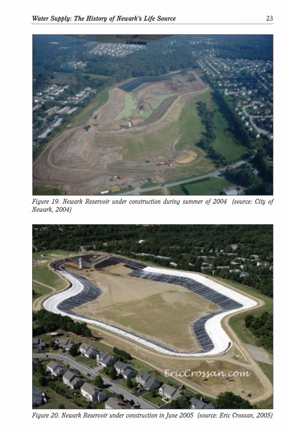
During 2005, work resumed with the new contractor George and Lynch. City crewsperformed clean-up and maintenance of the unfinished reservoir bowl during the winterof 2005. George and Lynch continued construction on the reservoir in March 2005.
22 Water Supply: The History of Newark’s Life Source
Figure 18. Newark Reservoir construction in May 2004(source: City of Newark, 2004)
Water Supply: The History of Newark’s Life Source 23
Figure 19. Newark Reservoir under construction during summer of 2004 (source: City ofNewark, 2004)
Figure 20. Newark Reservoir under construction in June 2005 (source: Eric Crossan, 2005)

During June 2005, the new contractor regraded the bottom and side slopes of thereservoir and installed the geomembrane and concrete liner (Fig. 20). In August 2005,subcontractor Hallaton, Inc., helped install the liner at the reservoir. George and Lynchcompleted construction, and the City began filling the reservoir in November 2005 at arate of one foot per day, in accordance with the dam-safety instructions received fromthe design and construction engineer URS (Fig. 21).
24 Water Supply: The History of Newark’s Life Source
Figure 21. Newark Reservoir filling with water in November 2005 (source: G. J. Kauffman,2005)
Figure 22. City of Newark peak water demand (source: WRA, 2008)

By January 20, 2006, the City had pumped water into the reservoir from the WhiteClay Creek pipeline to a depth of 42 with 14 feet of depth more to add. By February2006, the reservoir was full, and the contractor completed finishing touches on thepedestrian path and turf stabilization. Newark peak water demand has fluctuatedbetween 5 and 6.5 mgd (Figure 22).
With great fanfare, dignitaries from the City of Newark (including Mayor VanceFunk), Lt. Governor John Carney, Delaware’s congressional delegation, and theDelaware Water Supply Coordinating Council celebrated at the ribbon-cutting ceremonyto open the Newark Reservoir on May 24, 2006 (Fig. 23 and 24). The 317-million-gal-lon Newark Reservoir became the first major water supply reservoir constructed inDelaware since the Great Depression, when the City of Wilmington opened the ColonelE. M. Hoopes Memorial Reservoir on June 4, 1932. The Newark Reservoir may very wellbe the last reservoir constructed in the Delaware River Basin for quite some time.
The 30-acre Newark Reservoir holds 100 days of reserve water storage pumped viaa half-mile pipeline from White Clay Creek and makes Newark 99.9 percent reliable andself-sufficient for all recorded droughts except for the tail end of the 1963 drought. The
Water Supply: The History of Newark’s Life Source 25
Figure 23. Dedication of the newly opened Newark Reservoir on May 24, 2006, including (leftto right) Assistant City Manager Carol Houck, Councilman Kevin Vonck, Councilman JerryGrant, Councilman Karl Kalbacher, Former Mayor Ron Gardner, State Senator Joe Miro,Councilman David Athey (behind Miro), Mayor Vance Funk (back row, partially obscured),Councilman Frank Osborne, State Senator Liane Sorenson, Councilman Jerry Clifton, Lt. Gov.John Carney (third from the right), and City Manager Carl Luft (far right). (source: M. W.Wollaston, 2006)

pumped storage facility cost $20 million for the land and construction. The reservoirwith surrounding 1.1-mile pedestrian/bike path has been a popular and healthy additionto the Newark park system. One of the City’s residents was quoted as saying that walk-ing by the azure blue water is like being near the beach.
In this day and age, construction of a drinking-water reservoir requires persistentpolitical and economic commitment. Three Newark mayors-Mayors Gardner, Godwin,and Funk-worked long and hard to guide the reservoir from concept to creation. A com-mitted City Council helped to design referenda wherein the residents approved water-rate and property-tax finances in two instances by at least a 3-to-1 margin. The staff inthe City Manager’s Office, Water Department, Public Works, Planning, and Parks &Recreation were all united in seeing the reservoir through to completion.
The completion of the Newark Reservoir is an historic and courageous achieve-ment. On April 18, 2007, the President and Board of the Water Resources Associationfor the Delaware River Basin recognized the Newark Reservoir with the 2007Government Award at the annual awards dinner at the Downtown Club in Philadelphia.With the Government Award, the City of Newark joins an august group of governmentsand individuals who have contributed to sound water management in the four-stateDelaware River Basin. Congratulations to the City of Newark on accomplishing thisnoteworthy achievement, a watershed moment in water resources in the DelawareBasin.
In additional to the water supply use, the Newark Reservoir is a wonderful recre-ational opportunity for walkers, runners, and bicyclists. The reservoir is open duringdaylight hours. No swimming is allowed in the reservoir, and no feeding of geese andwildlife is permitted.
The Newark water system has grown from a single water main in 1903 to 100 miles
26 Water Supply: The History of Newark’s Life Source
Figure 24. Newark Reservoir looking northeast on May 24, 2006, the day of the dedicationceremony (source: M. W. Wollaston, 2006)

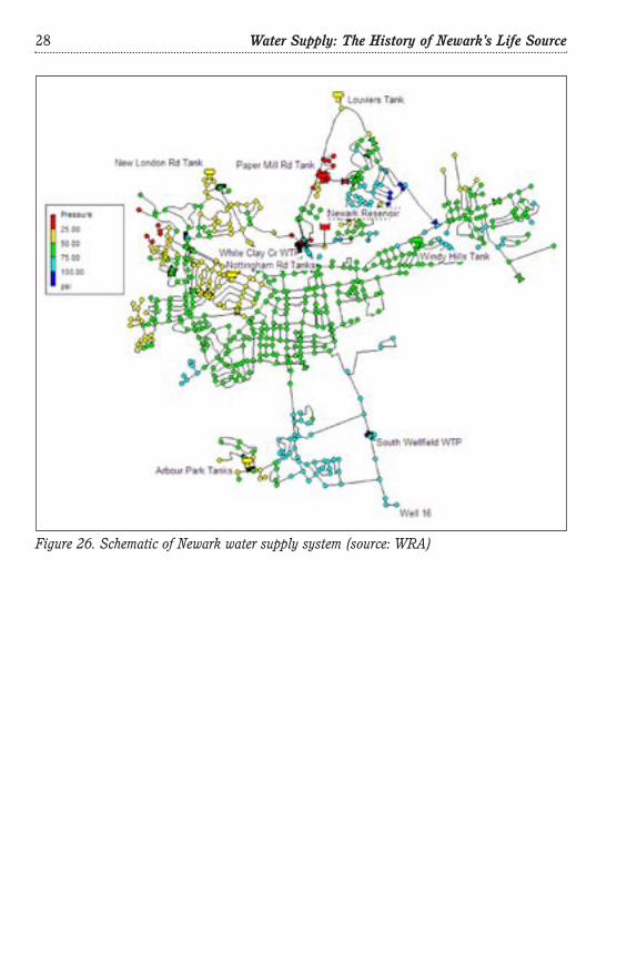
of mains in 2009, serving a population of 33,000 inside and outside of the city over a 25-square-mile area (Fig. 25 and 26). Figures 27 and 28 show the location of the NewarkReservoir before and after construction. Figures 29 and 30 (Appendix 2) depict theexisting and proposed site plans for the Newark Reservoir.
Epilogue
In October 2006, the jury ruled against the City and awarded Durkin,, Inc., $38.4million in damages for breach of contract. Upon appeal by Newark in 2007, U.S. DistrictCourt Judge Gregory Sleet reduced the amount in damages to $11.6 million. On April 9,2008, on the City of Newark’s further appeal, Sleet then reduced the breach-of-contractsettlement amount to $630,000, because the district court determined that originallythe jury had calculated the amount of the settlement based on Pennsylvania, notDelaware, law.
The City paid the claim of $630,000 to the contractor using funds from its insurancepolicy. The reduced-claim ruling validated the city’s position that the Newark Reservoircould indeed be safely designed and constructed in accordance with the specifications.
Water Supply: The History of Newark’s Life Source 27
Figure 25. Map of Newark water supply system (source: WRA)
28 Water Supply: The History of Newark’s Life Source
Figure 26. Schematic of Newark water supply system (source: WRA)

Water Supply: The History of Newark’s Life Source 29
Figure 27. Koelig Farm eest of the Newark water-treatment plant, aerial photograph 2002(source: WRA)

30 Water Supply: The History of Newark’s Life Source
Figure 28. Newark Reservoir, eest of the Newark water-treatment plant, aerial photograph2007 (source: WRA)

Appendix 1.Chronology of the City of Newark Water Supply System
250 million years ago Piedmont metamorphic rocks form along the White Clay Creek.
2 million years ago Coastal Plain sediments form over the ancient underground sea.
8000 B.C. Indigenous people, later known as the Lenni Lenape, settle bythe White Clay Creek and use it as a drinking water source.
1683 Lenni Lenape Chief Kekelappen sells Opasiskunk (Indian Town)to William Penn near the White Clay Creek just four milesupstream from present day Newark.
1694 Scots-Irish and Welsh settlers founded the village that wouldbecome Newark between the banks of the White Clay Creek andChristina River.
1758 King George II awards a charter for trading in this crossroadsvillage, where dozens of mills provided water power for grain,grist and paper.
1746 English miller William Cooch purchases land along the ChristinaRiver at the foot of Iron Hill and later establishes a mill.
1702 William Penn issues a land grant to John Guest to operate a gristmill along White Clay Creek just downstream from what is nowPaper Mill Rd.
Sept. 3, 1777 Cooch’s Mill is burned by the British under Lord Cornwallis afterAmericans retreat at the Battle of Cooch’s Bridge.
Sept. 8, 1777 British march north through Newark, and mischievous soldiersstart the machinery in Simonton’s flour and grist mill situatedalong the south bank of White Clay Creek.
1789 Thomas Meteer sets up mill along White Clay Creek upstreamfrom what is now Paper Mill Road. Now known as the CurtisPaper Mill.
1838 William Cooch, Jr., builds mill, later renamed Dayett Mill, alongthe Christina River just near present-day Old Baltimore Pike.
1848 Brothers George and Solomon Curtis purchased the Meteer milland name it Nonantum Mills, the Indian name of the Curtis’shometown of Newton, Mass.
1888 City of Newark digs first municipal well.
Water Supply: The History of Newark’s Life Source 31

1903 Newark forms first water system by drilling well at east end ofMain Street and installs first ten-inch water main under MainStreet.
1931 City constructs North Wellfield at south end of Academy Streetnear Pennsylvania Railroad.
1956 DuPont Company purchases Pennsylvania Railroad land assetsand acquires land in the White Clay Creek valley for reservoir.
1956 South Wellfield Wells 11, 12, 13, and 14 developed in the coastalplain along South Chapel Street just south of present-day Route 4.
1960 U. S. Army Corps of Engineers and DuPont Company prepareseparate reports recommending a dam and reservoir on WhiteClay Creek as a potential water supply source.
Jan. 1964 The Delaware General Assembly passes House Bill No. 444enabling “… the Levy Court of New Castle County to establish awater supply system in the White Clay Creek watershed….”
May 1964 New Castle County Levy Court authorizes Whitman RequardtInc. to prepare feasibility report on the White Clay Creekreservoir.
1965 Newark residents opposing the reservoir form the White ClayWatershed Association.
Sept. 11, 1966 Along White Clay Creek near Newark, flow dipped to 4.7 cubicfeet per second during 1966 drought, the lowest on record.
Mar. 1967 Whitman Requardt transmits White Clay Creek reservoir reportto New Castle County Levy Court, recommending 12.4-billion-gallon reservoir of 1,160 acres, half in Delaware, half inPennsylvania.
1968 Wells 15, 16, and 19 developed behind Scottfield near inter-section of South Chapel Street/I-95 and at Route 72/ReyboldRoad.
1971 Wells 23 and 25 drilled in the Piedmont rocks, near theFairfield–Fairfield Crest Swim Club at the foot of Fremont Road.
1973 Newark residents form the Coalition for Natural Stream Valleysto conduct surveys of the flora and fauna of the White Clay Creekvalley. Support for White Clay Creek reservoir dissipates.
1977 City of Newark joins with New Castle County and Wilmington to
32 Water Supply: The History of Newark’s Life Source

form policy board for regional water supply planning and man-agement, which became the Water Resources Agency for NewCastle County.
1984 DuPont Company realizes main-stem reservoir has little supportand donates 1,000 acres of land to the Delaware/Pennsylvaniapark systems establishing the White Clay Creek Preserve.
1988 Water Resources Agency for New Castle County files a Section404 permit application with the U.S. Army Corps of Engineers toconstruct a reservoir at either Churchmans Marsh or ThompsonStation.
1990 Piedmont rock wells 20 and 21 are dug along the White ClayCreek along Creek Road about a mile north of Cleveland Avenue.
Dec. 11, 1991 President George H.W. Bush signs law, the White Clay CreekStudy Act, to evaluate for inclusion in National Wild and ScenicRivers System.
Sept. 1991 Newark Water Advisory Committee recommends to City Council:(1) Investigate a new water-treatment plant at the NewarkSouth Wellfield, (2) rehabilitate the aging water system, and (3)investigate additional regional water supplies including an“impoundment facility that would benefit Newark.”
1992 Newark completes new three-million-gallons-per-day surface-water-treatment plant along White Clay Creek on the north sideof town near Paper Mill Road.
1995 On September 8 during drought of 1995, White Clay Creek atNewark dips to lowest flow since the drought of 1966, and Cityceases withdrawals at the new surface-water-treatment plant.
Nov. 1996 EIS Project Management committee votes to delete ChurchmansReservoir due to environmental concerns, leaving ThompsonStation in the White Clay Creek valley as preferred reservoirsite.
Apr. 1997 EIS Project Committee suspends further studies onThompson Station Reservoir, as New Castle County andArtesian Water Company withhold further funding, bowing topublic opposition.
1998 Newark decides to go it alone in quest for new reservoir toinsulate itself from drought. In June and July 1998, City WaterDirector briefs Newark Council about new Newark Water SupplyPlan.
Water Supply: The History of Newark’s Life Source 33

Feb. 1999 City Council briefed about Newark Water Supply Plan recom-mending (1) a new iron-treatment plant at the Newark SouthWellfield along South Chapel Street and (2) a new reservoir atthe site of the Koelig Farm on Old Paper Mill Road.
Aug. 1999 Century-ending drought of 1999 causes White Clay Creekstream flow to decline to 9.3 cfs on August 19, 1999, the thirdlowest flow rate since 1932.
Dec. 1999 By Executive Order No. 74, Governor Carper appoints the WaterResources Agency at the University of Delaware’s Institute forPublic Administration as Temporary Water Coordinator or WaterMaster. The same order appoints the City of Newark as a WaterSupply Coordinating Council member.
Aug. 2000 Newark acquires 112 acres of land for the reservoir at the KoeligFarm site for $7.95 million, with the assistance of $3.4 millionin funding from the Delaware General Assembly.
Sept. 2000 City Council award contract to Whitman Requardt Associates todesign iron- and manganese-removal plant at the SouthWellfield.
Oct. 2000 City Council awards $729,000 contract to engineering firmURS to prepare design plans/specifications for the reservoirconstruction.
Oct. 24, 2000 President Clinton signs Public Law 106-357 designating theWhite Clay Creek as a National Wild and Scenic River, whichpreserves free-flowing status of creek, effectively precludingconstruction of a reservoir in the valley.
Apr 10, 2001 Newark residents went to polls and voted by a 4-to-1 margin tosupport referendum to increase water rates to pay for the newreservoir and iron-treatment plant.
Mar 22, 2002 City broke ground, and Hart Contractors Inc. began constructionon the iron-treatment plant along South Chapel Street.
April 22, 2002 Newark City Council awards a $9.7 M construction contract toDonald Durkin, Inc., to build a 317-million-gallon reservoir onthe Koelig Farm site.
May 14, 2002 Dignitaries wield shovels at the Newark Reservoir groundbreak-ing ceremony.
2002 On August 2, then-Governor Minner declares drought emergencyin northern Delaware with mandatory restrictions in effect. In
34 Water Supply: The History of Newark’s Life Source

September, Newark ceases withdrawals at the surface-waterplant as the White Clay Creek had become nearly dry at a flowrate of 5.4 cfs.
Nov 21, 2003 City completes construction of iron-removal plant at the SouthWellfield, increasing well water supply by one million gallonsper day.
January 2004 City Council votes to terminate reservoir contract with contractorbecause there had been no movement on the installation of linersince the fall. The city and contractor continue to disagree onthe amount of payment for added work requested by contractor.Reservoir construction is 70 percent complete.
May 2004 Work was suspended, as the City and the contractor battled incourt over the reservoir’s liner design.
Oct. 2004 City Council hires new contractor, George & Lynch of NewCastle, Del., at an estimated contract cost of $6 million to com-plete the Newark Reservoir.
Mar. 2005 George & Lynch resumes construction on the reservoir.
June 2005 New contractor regrades the bottom and sides slopes of thereservoir and installs the geomembrane and concrete liner.
Nov. 2005 George and Lynch completes construction, and the City beginsfilling the reservoir at a rate of one foot per day.
Jan. 20, 2006 City continues pumping water into the reservoir from the WhiteClay Creek pipeline with the reservoir now at 42 feet deep, with14 feet of depth more to add.
Feb. 2006 The reservoir is full, and the contractor completes finishingtouches on the pedestrian path and turf stabilization.
May 24, 2006 City officials open the reservoir with a ribbon-cutting celebrationattended by many state, community, and city representatives.
Apr. 18, 2007 Water Resources Association for the Delaware River Basin rec-ognizes the City of Newark Reservoir with the 2007 GovernmentAward at an annual awards dinner in Philadelphia.
Apr. 9, 2008 Using Delaware law, U.S. District Court Judge Gregory Sleetreduced the amount of the city’s payment in the breach-of-contract ruling for Newark Reservoir contractor Durkin,, Inc.,from $11.6 million to $630,000.
Water Supply: The History of Newark’s Life Source 35

Appendix 2. Site Plans for the Newark Reservoir
36 Water Supply: The History of Newark’s Life Source
Figure 30. Newark Reservoir - Proposed Site Plan (source: URS, 2001)
Figure 29. Newark Reservoir - Pre-Construction Site Plan (source: URS, 2001)

Bibliography
Bryant, C., 2008. New Castle County, Delaware Land Records, 1673-1710. HeritageBooks.
City of Newark, 1991. City of Newark Water System Analysis Report. Newark WaterSystem Advisory Committee.
City of Newark, 1999. Newark Water Supply Plan.
Constance J. Cooper, 1991. The Curtis Paper Company: From Thomas Meteer to theJames River Corporation. Wilmington, DE: The Cedar Tree Press Inc.
Cooch, E.W., 1940. The Battle of Cooch’s Bridge, Delaware, September 3, 1777.Copyright Edward W. Cooch.
Cooch, F. A., 1936. Little Known History of Newark, Delaware and Its Environs. ThePress of Kells. Newark, Delaware.
Delaware Geological Survey, 1954. Geology and Ground-Water Resources of theNewark Area, Delaware (Bulletin No. 2).
Delaware Geological Survey, 2009. Delaware’s Geologic Units.http://tapestry.usgs.gov/features/14fallline.html.
Pencader Area Heritage Association, 2009. A Guide to the History and Heritage ofPencader Hundred, Dayett Mills.http://www.pencaderheritage.org/main/landmarks/phland_p15.html.
Pennsylvania Department of Conservation and Natural Resources, 2009. White ClayCreek Preserve. http://www.dcnr.state.pa.us/stateparks/parks/whiteclaycreek.aspx.
U.S. Army Corps of Engineers, 1960. Delaware Basin Watershed Plan of Improvement.
U.S. Geological Survey, 2009. The Fall Line, A Tapestry of Time and Terrain: TheUnion of Two Maps - Geology and Topography. http://tapestry.usgs.gov/features/14fallline.html.
University of Delaware, Delaware Geological Survey, and Delaware DNREC, 1999.Final Report Governor’s Water Supply Task Force.
University of Delaware, Institute for Public Administration, Water Resources Agency,2002. Source Water Assessment of the City of Newark, Delaware, Public Water SupplyIntake Located Along the White Clay Creek.
Water Resources Agency for New Castle County, 1996. Annual Report.
White Clay Creek Wild and Scenic River Study Task Force and National Park Service,
Water Supply: The History of Newark’s Life Source 37

2001 White Clay Creek and its Tributaries, Watershed Management Plan.
Whitman Requardt and Associates, 1967. White Clay Creek Dam and Reservoir, NewCastle County, Delaware.
38 Water Supply: The History of Newark’s Life Source

Cover design by Mark DeshonPhoto source: Institute for Public Administration, University of DelawareBackground map source: Special Collections, Morris Library, University of Delaware
An Equal Opportunity/Affirmative Action EmployerThe University of Delaware is committed to assuring equal opportunity to all persons and does not discriminate on the basisof race, creed, color, gender, genetic information, age, religion, national origin, veteran or disability status, or sexual orienta-tion in its educational programs, activities, admissions or employment practices as required by Title IX of the EducationalAmendments of 1972, Section 504 of the Rehabilitation Act of 1973, Title VII of the Civil Rights Act of 1964, and other appli-cable statutes. Inquiries concerning Section 504 compliance and information regarding campus accessibility should be referredto the Office of Disability Support Services (DSS), (302) 831-4643, located at 119 Alison Hall. Inquiries concerning Title VIIand Title IX should be referred to the Office of the Assistant Vice President for Affirmative Action, (302) 831-8735, locatedat 124 Hullihen Hall.
NewarkWSHistory_cover.qxp 7/21/09 3:19 PM Page 3

Water Supply:The History of
Newark’s Life Source
by Gerald J. Kauffman
July 2009
published by the
Institute for Public AdministrationCollege of Education & Public PolicyUniversity of Delawareinstitute for Public Administration
serving the public good, shaping tomorrow’s leaders
www.ipa.udel.edu
NewarkWSHistory_cover.qxp 7/21/09 3:19 PM Page 1