water and its role in the economic...
TRANSCRIPT

WATER
AND ITS ROLE IN THE
ECONOMIC DEVELOPMENT
OF THE
NORTHERN TERRITORY 1824-2002
Beverley Margaret Sydney James Phelts BA (Hons), Northern Territory University A thesis submitted for Doctor of Philosophy, Northern Territory History, Faculty of Law, Business and Arts, Charles Darwin University. reprinted, February 2006.

I hereby declare that the work herein, now submitted as a thesis for the degree of Doctor of Philosophy of the Charles Darwin University, is the result of my own investigations, and all references to ideas and work of other researchers have been specifically acknowledged. I hereby certify that the work embodied in this thesis has not already been accepted in substance for any degree, and is not being currently submitted in candidature for any other degree. Beverley Margaret Sydney James Phelts Dated February 2005

ACKNOWLEDGEMENTS
The largest accolade goes to my supervisor, Professor David Carment Although Professor Carment was promoted to Dean during my candidature, he remained my supervisor until the bitter end. Also my thesis would not have eventuated without valuable input from Dr Suzanne Parry, Dr Bill Wilson and Dr Linden Salter-Duke my Associate Supervisor. There was also assistance from work colleagues. Big thank-yous go to Graham Ride, David Hardy, Mervyn Chin, Des Yin Foo, Gary Holmes, Peter Garone, Brian Kunde and Rink Van derVelde of Water Resources Division and Graeme Hockey ex pastoral officer, Department of Infrastructure, Planning and Environment. Appreciation is extended to Cathy Flint and Francoise Barr of the Northern Territory Archives Service who patiently helped me to find information and provided other leads. The National Archives of Australia in Nightcliff became my second home for some time and I am thankful for the assistance given to me by Katherine Goodwin and Phyllis Williams. Statistics for my pastoral chapter proved difficult to obtain because data was far flung and found in obscure places. Acknowledgment is given to the Northern Territory Cattleman's Association for allowing me access to their records. Indebtedness also goes to Vern O'Brien, John Hayes owner of Undoolya Station and Ross Peatling, manager of Alexandria Downs Station. For information on my agricultural chapter, I thank Ian Hillock who filled huge gaps. Gavin Kahl, owner of Kahl Table Grape Farm, Ti Tree was more than helpful and went out of his way to provide the data I was seeking. Financial assistance from a Northern Territory Government History Award and a Charles Darwin University grant enabled me to travel interstate to undertake further research. I am grateful to the Northern Territory Archives Service and the University for this support. The encouragement I received from friends and those who had tread the long road before me was priceless and no words could express my gratitude.

TABLE OF CONTENTS
PAGE List of Maps i List of Plates ii List of Tables iii-iv Abstract v-vi Abbreviations vii Conversions viii Glossary ix-x Introduction 1-14 Literature Review Thesis Structure Chapter 1 Water Supply and its Economic Use 15-64 1.1 The Australian Environment and British Attitudes 1.2 The Northern Territory Environment 1.2.1 Water Supplies 1.2.2 Soil 1.3 Water Supply – its Use and Economic Value
in World History 1.4 The Influence of Water Resources on Development –
The Early Australian Economy 1.5 The Influence of Water Development on Primary Industry -
The Northern Territory and Northern Australia 1.6 The Northern Territory and the Tropical Myth 1.7 British Settlement of the Northern Territory 1824-1849 1.8 South Australian Settlement of the Northern Territory 1.9 Commonwealth Government Attempts to Develop
the Northern Territory 1.10 The Effects of the Second World War 1.11 Conclusion

PAGE Chapter 2 The Water Supplies of the Three British Settlements 65-89 2.1 Literature Review 2.2 Water and Disease 2.3 Water Supplies, Gardens and Disease at Fort Dundas 2.4 Other Reasons Given by Historians for Fort Dundas’ Abandonment 2.5 Water Supplies, Gardens and Disease at Fort Wellington 2.6 Other Reasons Given by Historians for Fort Wellington’s Abandonment 2.7 Water Supplies, Gardens and Disease at Fort Victoria 2.8 Other Reasons Given by Historians for Fort Victoria’s Abandonment 2.9 Soil Fertility of the Three Sites 2.10 Conclusion - Why the Three Settlements Failed Chapter 3 Water Development and Pastoralism 90-126 3.1 Literature Review 3.2 The Pioneering Years – South Australian Administration 1863-1910. 3.3 Commonwealth Government Administration 1911-1978 3.4 Drought 3.5 Groundwater and Carrying Capacities 3.6 Conclusion Chapter 4 Water Development and Mining 127-180 4.1 The Use of Water in Crushing and Cyaniding 4.2 Early Mining in the Northern Territory – Setting the Scene 4.3 The Arltunga Goldfield 4.4 Literature Review 4.5 Water Development at Arltunga 4.6 Well Sinkers and Wells 4.7 Conclusion 4.8 The 1930s Mining Period in the Northern Territory – Setting the Scene 4.9 The Tennant Creek Goldfield

PAGE 4.10 Literature Review 4.11 Water Development at Tennant Creek 4.12 Conclusion Chapter 5 Water Development and Agriculture 181-232 5.1 Literature Review 5.2 Past Commercial Agriculture and Water Supplies 5.3 Water Supply and Plant Development 5.4 First Phase of Commercial Agriculture – Sugar Cane 5.5 Literature Review 5.6 Sugar Cane Cultivation 5.7 Site Selection 5.8 The Delissaville Sugar Cane Plantation 5.9 A Post-Mortem on Sugar Cane Farming 5.10 Second Phase of Commercial Agriculture – Peanuts 5.11 Literature Review 5.12 Method of Peanut Cultivation 5.13 Peanut Farming 5.14 A Post-Mortem on Peanut Cultivation 5.15 Third Phase of Commercial Agriculture – Rice 5.16 Literature Review 5.17 Rice Cultivation 5.18 Site Selection – Land and Hydrological Surveys 5.19 The Rice Farms 5.20 A Post-Mortem on Rice Farming 5.21 Commonwealth Government Investigation into the Northern Territory Agriculture Industry 5.22 A Recent Phase of Commercial Agriculture – Table Grapes 5.23 Ti Tree's Water and Soil Resources 5.24 Literature Review 5.25 Table Grape Cultivation and Marketing 5.26 The Ti Tree Table Grape Farms 5.27 Heron Farm 5.28 Ti Tree Farm 5.29 Kahl Table Grape Farm 5.30 Conclusion on the Table Grape Industry 5.31 Conclusion on Agriculture Conclusion 233-236 Bibliography 237-258

i
MAPS PAGE Map 1 Northern Territory xi Map 2 Location of the Three British Settlements 65 Map 3 Showing Location of Pastoral Stations 90 Map 4 Warden Mueller’s Map of Arltunga Wells in 1898 141 Map 5 Water Sites Selected by Water Diviner N. A. Frean, June 1935 160 Map 6 Layout of Delissaville Sugar Cane Plantation 194 Map 7 The Rice Farming Area of Humpty Doo 212

ii
PLATES PAGE Plate 1 Steam Driven Water Pump on Alexandria Downs Station, 1900s 102 Plate 2 Commonwealth Government Well Sinking Party c. 1924 103 Plate 3 Paddy’s Rockhole, Arltunga 135 Plate 4 Arltunga Well 136 Plate 5 Stone Water Tank at Arltunga 138 Plate 6 ‘Dry Blowing’ on the Hale River, 1906 139 Plate 7 The Government Battery at Arltunga 140 Plate 8 Overland Telegraph Line Well (c.1873). Camel Powered Whip, dated early 1920s 146 Plate 9 Defence Farm Adelaide River, 1940s 187 Plate10 Thomas & Roberts Mixed Agricultural Farm 202 on the Daly River, 1912 Plate 11 An American Pump Imported by Territory Rice Limited 221
iii
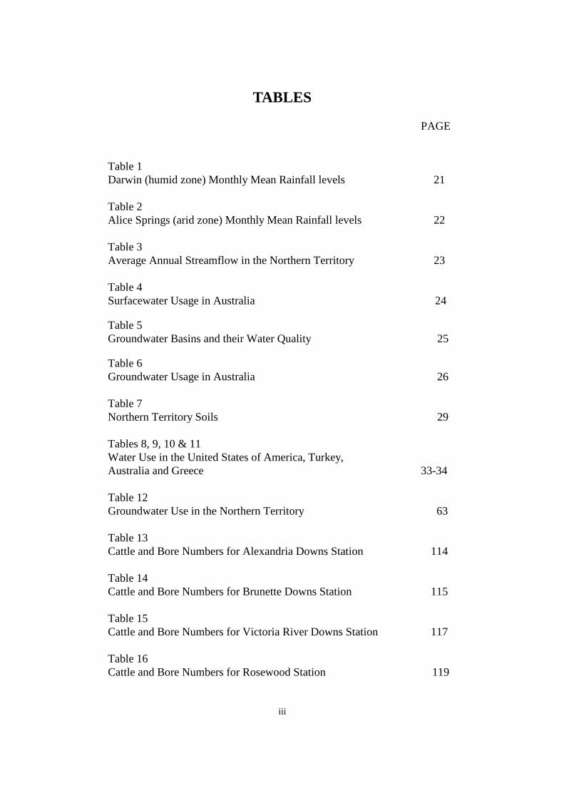
TABLES PAGE Table 1 Darwin (humid zone) Monthly Mean Rainfall levels 21 Table 2 Alice Springs (arid zone) Monthly Mean Rainfall levels 22 Table 3 Average Annual Streamflow in the Northern Territory 23 Table 4 Surfacewater Usage in Australia 24 Table 5 Groundwater Basins and their Water Quality 25 Table 6 Groundwater Usage in Australia 26 Table 7 Northern Territory Soils 29 Tables 8, 9, 10 & 11 Water Use in the United States of America, Turkey, Australia and Greece 33-34 Table 12 Groundwater Use in the Northern Territory 63 Table 13 Cattle and Bore Numbers for Alexandria Downs Station 114 Table 14 Cattle and Bore Numbers for Brunette Downs Station 115 Table 15 Cattle and Bore Numbers for Victoria River Downs Station 117 Table 16 Cattle and Bore Numbers for Rosewood Station 119
iv
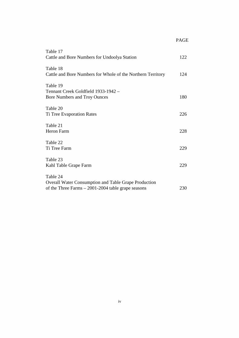
PAGE Table 17 Cattle and Bore Numbers for Undoolya Station 122 Table 18 Cattle and Bore Numbers for Whole of the Northern Territory 124 Table 19 Tennant Creek Goldfield 1933-1942 – Bore Numbers and Troy Ounces 180 Table 20 Ti Tree Evaporation Rates 226 Table 21 Heron Farm 228 Table 22 Ti Tree Farm 229 Table 23 Kahl Table Grape Farm 229 Table 24 Overall Water Consumption and Table Grape Production of the Three Farms – 2001-2004 table grape seasons 230

v
ABSTRACT This thesis examines the Northern Territory’s economic history from 1824,
when the first British settlement was established, until 2002 when the
agricultural and pastoral industries had made significant progress. It is
argued that permanent settlement and the development of primary industry
in the Northern Territory was a long and sometimes bitter process. Between
1824 and 1869 there were five attempts to establish a permanent settlement
and it took much longer to create viable primary industries. The thesis
examines the influence that water supplies had on the three British
settlements and the three primary industries of agriculture, pastoralism and
mining.
The Northern Territory, like other Australian regions, was expected to
evolve into an independent colony and generate economic rewards for
government and private investors. The Eldorado dream, however, was a
constant disappointment. For most of its history, the Northern Territory
remained neglected and branded as a ’white elephant’. The commercial
enterprises of agriculture and pastoralism failed to show potential until the
advent of the Second World War - more than a century after the first British
attempt at settlement.
What emerges is that little consideration was given to the difficult
environmental conditions, in particular water supplies. The fallacy that the
tropical north could be easily exploited for agriculture and pastoralism
persisted well into the twentieth century. Governments and investors
presumed that settlement and primary industry would automatically flourish
and gave little consideration to establishing an infrastructure on which to
base these industries. To the detriment of the agricultural and pastoral
industries, farmers and pastoralists remained reliant on natural water

vi
resources and made little effort to augment the more reliable groundwater
supplies.
The Second World War was the turning point for water development. Water
supplies were not only augmented for defence installations but for the
pastoral industry. Pastoralism benefited from additional water supplies on
stations and stock routes and the demand for beef during the war stimulated
pastoralism to record levels. The defence farms introduced modern
technology in the form of piped, channel and sprayer irrigation, and for the
first time, groundwater was used for commercial agriculture. The farms not
only succeeded in providing all varieties of produce for its soldiers but also
showed that commercial agriculture was achievable in the Northern
Territory
Mining was another primary industry that suffered from water shortages,
especially in the arid region of central Australia. Arltunga and Tennant
Creek goldfields are selected as case studies to demonstrate the huge impact
that water supplies had on mining. In both instances, government was well
aware of how water shortages restricted mining and initiated a vigorous
water development campaign.
It is argued that the Northern Territory and its primary industries did not
fulfil economic visions under the administration of Britain, South Australia,
or the Commonwealth Government. The impetus began when an
infrastructure that included permanent water supplies, essential services,
roads, buildings and transport was implemented. Underdeveloped water
supplies were one underpinning reason why settlement and primary
industries took so long to develop.

vii
ABBREVIATIONS
NAA ACT National Archives of Australia, Canberra NAA NT National Archives of Australia, Darwin AWM Australian War Memorial, Canberra BTEC Brucellosis and Tuberculosis Eradication Campaign. CSIRO Commonwealth Scientific and Industrial Research Organization. DME Department of Mines and Energy, Darwin. MLSA Mortlock Library of South Australia, Adelaide NTAS Northern Territory Archives Service SRSA State Records of South Australia

viii
CONVERSIONS
IMPERIAL METRIC Currency
1d (penny) 0.83 cents 1s (shilling) 10 cents £1 (pound) $2.00 dollar
Linear Measure
1 inch 2.54 centimetres 1 foot 30 centimetres 1 mile 1.61 kilometres
Weight
16 ounces 1 pound 2.2 pounds 1 kilogram
1 kilogram = 32.1507 troy ounces
Capacity Measure
1 gallon 4.546 litres Disclaimer – All care has been taken to convert imperial measures to metric and the author gives no guarantee that converted amounts are accurate.

ix
GLOSSARY Government Resident This was the title of the highest ranking
government official who was responsible for the administration of the Northern Territory during the South Australian Government’s control between 1863 to 1910.
Administrator On Commonwealth Government control in
1911 the title of Government Resident was changed to Administrator. The position of Administrator still continues today but with less legislative powers.
Alice Springs Prior to Commonwealth Government
administration in 1911, Alice Springs was known as Stuart. The name Alice Springs is used throughout the thesis.
Darwin Prior to Commonwealth Government
administration in 1911, Darwin was known as Palmerston. The name Darwin is used throughout the thesis to avoid confusion with the present day Palmerston.
Arid Zone This region extends from the South Australian
border north to Daly Waters. Top End This region extends from the Northern
Territory islands and coast, south to Daly Waters.
Dry Season The period in the Top End from May to
September when rainfall is scarce. Wet Season The period in the Top End from October to
April when rainfall is heavy.

x
Brucellosis and Tuberculosis The Campaign operated between 1980 and Eradication Campaign 1992. In order to improve the pastoral industry
and its market, the Northern Territory Government successfully eliminated Brucellosis and Tuberculosis disease from Northern Territory cattle. Under the program stock were tested for the diseases and thousands of stock (including buffalo) were destroyed.
Measurements and In accordance with the Commonwealth Currencies Government 1994, Style Manual for Authors,
Editors and Printers, 5th edn, Government Printer, Canberra, numerals are used to represent amounts associated with currencies and measurements. In other cases where amounts are less than 100, text is used.
Referencing and Where possible punctuation, referencing Bibliography Style and bibliography style has adhered to the guidelines recommended in Style Manual for Authors, Editors and Printers.

xi
Map 1 - The Northern Territory1
1 Department of Infrastructure, Planning and Environment, Northern Territory Government, Darwin.

INTRODUCTION

1
INTRODUCTION
'When the well's dry, we know the worth of water'. Benjamin Franklin, 1700s1
This thesis examines the Northern Territory's history from 1824, when the first British settlement was founded, until 2002 when the agricultural and pastoral industries had made significant economic progress. It is argued that the Northern Territory's economy failed to become viable largely due to the underdevelopment of water supplies. The lack of reliable water resources had an enormous impact on settlement and primary industry, yet has barely been examined by historians. By the late nineteenth century many other Australian regions had vibrant cities and industries that were supported by sound agricultural, mining or pastoral bases. This was not the case in the Northern Territory where water resources were problematic and too underdeveloped to sustain primary industry. Permanent settlement was thwarted until the late 1860s when Palmerston was established at Port Darwin, and profitable primary industries remained elusive until well into the twentieth century. For centuries, humans have valued water for many reasons, for health, hygiene, industry and recreation, but, most of all, for economic purposes. Modern life is totally reliant on enormous volumes of water. Everyone, from the householder, farmer, business person and industrialist, now depend upon it. Water is such an important commodity that a monetary value has been placed on it. It can now be traded, brought and sold between farmers. At the August 2003 Murray River auction, water was sold for $1 650 a megalitre.2
Water is such a highly valued product that many countries, including Australia, have passed legislation to protect and manage it.
The purpose of this study is to assess the significance of water supplies in the economic development of the Northern Territory. Water is a vital resource, especially in harsh and hot environments such as the Northern Territory. Unlike the southern parts of Australia, most of the Northern Territory's water supplies are derived from groundwater because surfacewater, especially in the arid region, is subject to high evaporation rates. Throughout most of the Northern Territory's history, water supplies remained underdeveloped. No public reticulated water systems or commercial irrigation schemes existed until the Second World War. Water supplies on pastoral stations remained inadequate until the introduction of a government boring program during the 1960s. The program achieved its aim with the number of water points expanding that opened up more land for grazing. More water and land was reflected in the increase of herds. It is argued that water supplies were insufficient to meet the needs of the British settlements and the agricultural and pastoral industries. This contributed to the slow 1 Benjamin Franklin quoted in 1993, National Geographic Magazine, vol. 184, no. 5A, National Geographic Society, Washington, introduction [no page number]. 2 The Northern Territory News, 8 August 2003.
2
development of the Northern Territory. In regard to mining, the two goldfield studies in this thesis, Arltunga and Tennant Creek, show that water shortages hindered mining and restricted the amount of gold that could be extracted. The South Australian and Commonwealth Governments made concerted efforts to augment groundwater for mining and this in turn, enhanced gold production. To understand how water shortages influenced the Northern Territory's economic progress, it is necessary to revisit the early settlements and the three primary industries that were expected to automatically prosper. Water shortages and other water associated problems hindered the Northern Territory's early economy in a variety of ways. In the case of the early British settlements of Fort Dundas, Fort Wellington and Fort Victoria, water shortages contributed to the failure of their crops, and their water supplies harboured disease. There was an array of water problems for the pastoral, agricultural and mining industries. Throughout the thesis, it will be shown that water supplies posed economic problems and had water development kept abreast of early settlement and industry, the 'white elephant'3
might have been dubbed the 'golden goose'.
It is beyond the scope of this thesis to examine all Northern Territory urban water supplies. Instead only water supplies for the first three settlements are selected. Above all other Northern Territory settlements, the British outposts were economically significant because they were the first footholds into northern Australia. The settlements not only represented a British presence in northern Australia but the ports were also expected to attract viable trade for Britain and Australia.4 It could be argued that Palmerston (later Darwin) and Stuart (later Alice Springs)5 were more significant towns because they supported the Overland Telegraph Line and were the first permanent settlements. The initial populations of Darwin and Alice Springs were very small and did not grow at a fast rate like the nearby mining fields. The expansion of Alice Springs was due to demand for services from the Arltunga goldfield.6
3 Aubrey Abbott, a previous Administrator referred to the Northern Territory as a 'white elephant'. C. L. A Abbott 1950, Australia's Frontier Province, Angus & Robertson, Sydney, pp. 5-6.
As a result, it was
4 These reasons are made clear in George Windsor Earl's books: Observations on the Commercial and Agricultural Capabilities of the North Coast of New Holland and the Advantages to be Derived from the Establishment of a Settlement in the Vicinity of Raffles Bay, Effingham Wilson Publishers, London, 1836 and Enterprise in Tropical Australia, Madden & Malcolm Publishers, London, 1846. 5 Palmerston and Stuart were renamed Darwin and Alice Springs on Commonwealth Government control in 1911. The names Darwin and Alice Springs are used from here on. 6 David Carment & Sue Harlow 1995, A history of mining in the Northern Territory, lecture series under the banyan tree, Darwin, 12 May, p. 3. Brown's whole report discusses other mineral discoveries. H. Y. L. Brown, Government Geologist 1903, Report on the Gold Discoveries near Winnecke's Depot and Mines on the Arltunga Goldfields, MacDonnell Ranges with Plan and Appendices, Government Printer, Adelaide.

3
Arltunga's water supply that developed rapidly rather than that of Alice Springs.7 Darwin and Alice Springs supported the Overland Telegraph Line. The line and nearby mining fields inadvertently stimulated the growth of the two towns.8
The South Australian and Commonwealth Governments were well aware of the problems surrounding water supplies. Both governments pursued bore drilling programs but water investigation and drilling occurred largely after agriculture, pastoral and mining were initiated and water shortages became evident. Although water related problems were a reoccurring theme from the beginning of settlement, it was only the Commonwealth Government board of inquiry report released in 19379
which addressed the magnitude of the problem.
The board of inquiry report delivered on the eve of the Second World War deplored the Northern Territory as an economic burden. Among other points, it highlighted the need for an intensive water development program.10
The Second World War, an unanticipated event, was the turning point in the development of water resources in the Northern Territory. To support the thousands of defence personnel, electricity and water schemes, additional housing and roads and the augmentation of airstrips and hospitals were rapidly constructed. The underpopulated and isolated Northern Territory emerged as an important strategic defence installation. After the war, the Commonwealth Government continued improving infrastructure which transformed the Northern Territory's economy. Development of roads and water supplies on stock routes and stations were reflected in a rise of cattle numbers from the late 1960s onwards. Commercial agriculture was revisited in the 1950s and 1960s and large companies were encouraged to mine and develop their own water supplies from the 1950s.
The role of water resources in the historical development of the Northern Territory has not been studied although there is a multitude of information on water resources in general. Water supplies were paramount to settlement and primary industries and will remain significant. From an economic perspective, the role of water supplies was largely ignored until it was addressed in this thesis. Literature Review Many Australian and international authors have written on the diverse subject of water 7 In 1905 Arltunga had eight operational wells while at the same time Alice Springs had no public wells. NAA NT CRS A3 Item 13/11189, Petition for Public Well, Stuart residents to South Australian Minister Controlling the Northern Territory, 1 March 1909. 8 Rather than an industry, Daniel Headrick describes the role of the Overland Telegraph Line as an imperial tool and a technological form of British imperialism. Daniel Headrick 1981, The Tools of Empire: Technology and European Imperialism in the Nineteenth Century, Oxford University Press, London. 9 Commonwealth Government 1937, Report of the Board of Inquiry Appointed to Inquire into the Land and Land Industries of the Northern Territory of Australia, Commonwealth Government Printer, Canberra, pp. xi, 21-22, 77 & 100. 10 ibid.
4
in regard to its engineering, social, scientific, hydrological, geophysical and political aspects. There has been a recent flood in literature devoted to environmental and legislative reforms. It is outside the subject area of this thesis to review all the above and only the history of water development in various Australian states is described here. Most relevant publications are non technical and could be classified as 'coffee table' books. J. M. Powell has written the history of water development in Victoria, Queensland and Western Australia. His Watering the Western Third: Water, Land and Community in Western Australia 1826-199811 was produced for the Water and Rivers Commission with a focus on water organisations and management. Powell also address the political and legislative perspective and concentrates on the settlement and growth of Perth and regional Western Australia. It is an historical snapshot on the role of water in primary industry from early settlement in 1826 until 1998. Powell also examines the changing use of water and when legislation began to impact on the management and protection of water resources. It is not intended to be an analytical study as Powell himself mentions but rather a 'bird's-eye' view.12
The book follows a chronological theme which confirms that water development in Western Australia followed similar lines to most of Australia. The colonial period was optimistic but farmers had to grapple with an unknown situation which meant that the environment was altered, water courses were diverted and wet lands drained. Mining and the expansion of farmlands followed and new methods of water harnessing were introduced such as dams, weirs and water systems. Then followed the post Second World War era of 'thinking big';13
dam building and extensive irrigation schemes.
Powell discusses regional differences and how the environment influenced the pattern of settlement and agriculture. A section on the site selection of Perth and its founder Captain James Stirling is relevant to the Northern Territory experience. Stirling had the same enthusiasm for Fort Wellington's future as he did for Perth. In particular the farming potential of Western Australia's south-west coast but Powell acknowledges that this was a typical British reaction when one had 'the task of securing rapid possession of an unexplored continent'. High expectations of a new land were a common theme throughout most of Australia's settlement.14
Powell's illustrations and photographs enrich and support the information in the book in particular his charts on historical rainfall levels and drought periods. Other tables and
11 J. M. Powell 1998, Watering the Western Third: Water: Land and Community in Western Australia 1826-1998, Water and Rivers Commission, Perth. 12 ibid., p. 3. 13 Powell coined this phrase in another article. J. M. Powell 2000, Snakes and cannons: water management and the geographical imagination in Australia', in Environmental History and Policy: Still Settling Australia, ed Stephen Dovers, Oxford University Press, South Melbourne, pp. 60-61. 14 J. M. Powell 1998, op.cit., p. 11.

5
statistics on northern Western Australia provide a useful comparison with the Northern Territory. Also pertinent is that settlement and agriculture were restricted by available water resources, distances and climatic restraints. The reason why permanent settlement initially concentrated in the south-west district. Powell's Plains of Promise, Rivers of Destiny: Water Management and the Development of Queensland 1824-1990,15
is a political and legislative focus on the history of water development in the rural sector. This book is a complete appraisal of Queensland's water management issues from pre-European times to the present. A variety of subjects is covered, ranging from water quality in health and hygiene, floods, artesian basin groundwater, irrigation projects, public water supplies and water in primary industry. To Powell it was the political culture and legislation of the day that instigated and directed commercial water supply schemes. Powell concludes with a discussion on changing legislation in the management and protection of water that commenced in the 1980s and the Queensland Government's role in water reforms. He also examines the influence of 'Green' political parties and the attitude of the community towards environmental and water issues.
The water resources of north-western Queensland are discussed in great detail. Pastoralism in this region, like the Northern Territory, could not expand until permanent water supplies were augmented. In his chapter on the Great Artesian Basin Powell gives substantial recognition on the physical restraints to pastoralism and the transformation of the region's economy. The tapping of the Great Artesian Basin and the optimism that followed lend support to the common view at the time that only water is needed for the Australian inland to flourish. Drilling artesian bores is discussed in great depth and supported with bore numbers and water yields. Intermittently the Northern Territory pastoral industry is acknowledged and Powell supplies useful figures and information. There is also a comprehensive chapter on the history of irrigation which covers the economics of the Dawson Valley/Theodore area, Huon and Burdekin irrigation schemes and the Bradfield scheme for the inland. Powell also examines the political culture and events at the time and what was driving these schemes. Another view of Queensland's water resources is in Raymond Whitmore's Queensland's Early Waterworks published in 1997.16
15 J. M. Powell 1991, Plains of Promise: Rivers of Destiny: Water Management and the Development of Queensland 1824-1990, Boolarong Publications, Brisbane.
Whitmore uses mainly primary sources and centres around the roles of three prominent engineers, Thomas Oldham, Joseph Brady and William Highfield, who were responsible for implementing water schemes to six major towns during the 1800s. A refreshing aspect of the book is that Whitmore includes social and political issues that challenged the engineers and residents of the towns. The contribution that these engineers made in water development were reflected in improved living standards and the general economies of the towns. Whitmore not only commends the men for their engineering skills but for completing the water
16 Raymond Whitmore 1997, Queensland's Early Waterworks, Queensland Department of Natural Resources, Brisbane.
6
schemes with limited funds and unrealistic time frames. Like his studies of Western Australia and Queensland, Powell's Watering the Garden State: Water, Land and Community in Victoria 1834-198817
is framed within a political and legislative analysis. It is a chronological view that follows familiar lines as Plains of Promise, Rivers of Destiny. Powell addresses a broad range of issues that surround water development and management. He explains how the pioneers harnessed water supplies by modifying and diverting water courses for irrigation and water conservation. Great detail is included on the early water schemes of Melbourne and other major towns which led to conflict between residential and industrial land uses. Attention is drawn to government and industry which largely instigated water development through grand engineering schemes and dam building. Regional rainfall variation and climatic differences which impact on water supplies are also set out in well illustrated charts.
Aside from this Powell looks at changing community attitudes which is mirrored nation wide and driven by government. Government legislation on water reform has increasingly tightened and largely impacts on water management and preservation. To an extent this publication parallels Powell's other two books which also follow environmental, water and institutional reforms on the water industry. Marianne Hammerton has a different perspective and follows Whitmore's lead. Her Water South Australia: A History of the Engineering and Water Supply Department18
covers the period from 1836 to 1984. She examines the social and political context; beginning with early water sources and leads to the construction of the great engineering schemes. Hammerton points out that South Australian European settlement was entirely different to other areas of Australia. She regards it as an 'experiment' because its economy was not built on the back of convicts but was controlled and ordered under the Wakefield Scheme. Like the early settlers in other colonies, they had to modify British ideas and learn to understand the unfamiliar environment, especially their adaptation to the various water sources. Hammerton successfully highlights the difficulties that confronted the pioneers and provides an insight into early settlement.
Hammerton's book is a comprehensive account on the modes of early water transport, methods of water supply, and human adaptation to water sources from creeks, tanks and borewater, and finally to reticulated water. She addresses the politics of the time that influenced dam building, irrigation schemes and also the individual engineers who were involved in these projects. She summarises with a discussion on environmental difficulties, droughts, the 1930s depression and the Second World War that all affected the development of water supplies. The issues of changing community and government perceptions on the value
17 J. M. Powell 1989, Watering the Garden State: Water: Land and Community in Victoria 1834-1988, Allen & Unwin, Sydney. 18 Marianne Hammerton 1986, Water South Australia: A History of the Engineering and Water Supply Department, Wakefield Press, Adelaide.

7
of water in the past twenty years are discussed in her final chapter. Matters such as water conservation and the environmental implications from irrigating the Murray River are covered. Her time frame ends on the eve of Commonwealth Government water reforms that she rightly acknowledges will in the future instigate significant legislative changes. Margo Beasley's The Sweat of their Brows19
was published for the Sydney Water Board's centenary in 1988. This is an appealing book that covers the board's role and achievements between 1888 and 1988. She incorporates many oral and written interviews from board members, engineers, workmen and clerical workers who had been associated with Sydney's water and sewerage schemes. Beasley includes views from the 'wives behind the men' and other women in the community who managed their normal household tasks without a water or sewerage scheme. One chapter is devoted to the contribution of women; the first women engineers, apprentices and office workers. She also looks at how European employees influenced the operation and function of the water board from the 1950s. The book is a broad summary of the board's progress and of the people behind the scenes.
Bobbie Hardy's Water Carts to Pipelines: The History of the Broken Hill Water Supply20
deals with the actions of government in regard to water legislation and the infrastructure built for Broken Hill's water supply. Hardy demonstrates the extent to which the government's water scheme influenced Broken Hill's economy in mining, business and the general population. To illustrate her point, she goes to the extent of meticulously documenting water construction costs and tariff amounts since the beginning of Broken Hill's scheme in 1952.
In general the histories of water supplies in other Australian states are very informative and most provide a thorough account of their individual water supplies. Publications on European and American water systems contain little material relevant to this study. For example, Water Planning in Britain21
discusses the organisations that control and operate British water systems within their respective legislative frameworks and it is not relevant in the Northern Territory's case.
Although not directly pertinent to the Northern Territory, Jean-Pierre Goubert's The Conquest of Water: The Advent of Health in the Industrial Age22
19 Margo Beasley 1988, The Sweat of Their Brows: 100 Years of the Sydney Water Board 1888-1988, Sydney Water Board, Sydney.
examines the changing value of water in regards to industrialism and living standards. It stands apart from many other studies because water is considered in an economic context. Goubert designates the Industrial Revolution as the spark which changed the use of water. The revolution
20 Bobbie Hardy 1968, Water Carts to Pipelines: The History of the Broken Hill Water Supply, Broken Hill Water Board, Sydney. 21 Dennis Parker & Edmund Penning-Rowsell 1980, Water Planning in Britain, Allen & Unwin, London. 22 Jean-Pierre Goubert 1986, The Conquest of Water: The Advent of Health in the Industrial Age, Basil Blackwell Ltd, Oxford.

8
significantly altered the industrial role of water and public perceptions in regards to its health benefits. He covers the economic transformation of water from post Industrial Revolution until the present. To Goubert, the revolution not only reassigned water as a economic commodity but its depletion and pollution also initiated social and health reforms. Although Goubert's work is based on the experience of France and Europe, the reforms serve as guide for an Australian model. Australia, like other western nations is highly industrialised and is reliant on water supplies for its economy. Also the giant strides in public health education in Europe, that Goubert writes about, were paralleled in Australia. As governments become increasingly responsible for national health by way of education and legislation, it naturally followed that government provided public water supplies. Accessibility to clean water improved living standards and assisted in social change. Many countries legislated to protect water resources because of its national and industrial value, and Goubert concludes that water evolved into a 'sanitary, industrial and commercial product'23
and that these three components are vital to western economies. His work is impressive because most publications on the histories of water resources do not examine both the industrial and social aspects.
Goubert's hypothesis motivated me to question whether water supplies were influential in the development of the Northern Territory's settlement and primary industries. The research that followed revealed that this is the case. His work inspired me to study the history of water development from an economic viewpoint. There are two small publications on the history of water supplies in the Northern Territory. Water Resources: 40 Years On: History of the Northern Territory Water Resources Division24
was published by the Darwin Department of Lands, Planning and Environment. It is a booklet that briefly covers the beginning to the end of the Water Resources Branch. The branch was formed in 1955 to collect hydrological data for the Humpty Doo rice farms. Each chapter is divided into decades and discusses the expansion of the branch, the gradual tightening of water legislation and significant projects undertaken by the branch. The booklet is a brief glimpse at the branch's achievements and the progression of water development. It is well presented and includes many old photographs and humorous captions. I was partly involved in its publication and I am aware that much of the research was based on many oral and written interviews. My only criticism is that the content could have been richer if more interviews were included, and that individual contributors should have been acknowledged.
Another concise contribution derives from an article that I wrote for the Australian Institution of Engineers in A Century of Water Resources Development in Australia:
23 ibid., p. 257. 24 Water Resources History Committee 1998, Water Resources: 40 Years On: History of the Northern Territory Water Resources Division, Department of Lands, Planning and Environment, Darwin.

9
1900-1999.25
The book was launched at Water99 in Brisbane and considered a milestone for the institution. Each state government department contributed a chapter on its history of water development.
Other information on the Northern Territory's water resources is largely derived from government reports and correspondence. These reports have been, and continue to be, generated for the benefit of engineers and government organisations and largely address specific topics on water. No author has conducted an extensive study into the history water development and its influence on early settlement and primary industries. Those who have written on these subjects generally only address a multitude of environment reasons why early settlement and primary industry failed. Water supplies, if mentioned at all, are not discussed in any great detail. Bruce Davidson's The Northern Myth: A Study of the Physical and Economic Limits to Agricultural and Pastoral Development in Tropical Australia26
discusses the general environmental problems encountered in northern Australia and designates a myriad of reasons as to why pastoralism and agriculture were unsuccessful. Davidson's study was carried out during the 1950s and 1960s on the pastoral and agricultural industries.
Of the pastoral industry, his figures show that it would be uneconomic to divert money into additional water points, fencing and stock yards in order to increase herd numbers. Davidson believes that a pastoralist should instead purchase undeveloped land to run stock on. His figures contradict John Kelly who advocates the improvement of infrastructure which to Kelly, would increase stock numbers.27
Of the agricultural industry Davidson investigates the cost of irrigation, fertilisers, labour, transport and the general operation of farms in northern Australia. He compares costs with that of the Northern Territory, northern Queensland and Western Australia and concludes that it is more economic to restrict tropical cropping to northern Queensland. Davidson asserts that if agriculture can be produced more cheaply in southern Australia it is pointless pursuing it in the Northern Territory because it would need to be heavily subsidised. The pastoral industry on the hand is considered viable. To Davidson large amounts of capital do not need to be spent on infrastructure as undeveloped land and its natural resources can support cattle. The pastoral and agricultural industries reflect an entirely different story today. His figures are useful and have been sourced, in particular his study on the peanut and rice farms.
Australia Wet or Dry?28
25 Bev Phelts 1999, 'Northern Territory', in A Century of Water Resources Development in Australia: 1900-1999, ed Walter Boughton, The Institution of Engineers Australia, Barton, pp. 173-197.
is another book authored by Davidson which is relevant to
26 Bruce Davidson 1972, The Northern Myth: A Study of the Physical and Economic Limits to Agricultural and Pastoral Development in Tropical Australia, 3rd edn, Melbourne University Press, Carlton. 27 Kelly quoted in ibid., pp. 100-101. 28 Bruce Davidson 1969, Australia Wet or Dry? The Physical and Economic Limits to the Expansion of Irrigation, Melbourne University Press, Carlton.

10
northern Australia. Again based on economics, Davidson passionately argues against the use of irrigation not just in northern Australia but Australia wide. He completely disagrees with the general belief held in the late 1800s that water was scarce and had to be harnessed for irrigation. Large irrigation schemes were implemented under the notion that more water was needed to increase produce rather than improving fertilisers. Davidson says that other factors such as acreage, crop type and livestock numbers in relation to water volume were not considered. A crux to Davidson's argument is that if crops are planted in suitable rainfall, climatic and soil regions irrigation is unnecessary. This point is also engaged by geographer, Griffith Taylor who in 1923 defined the distinct arid and wet regions.29
Davidson contends that all irrigation schemes have been uneconomic and particularly highlights the notable schemes of the Murrumbidgee, Murray and Goulburn Valley. It is difficult to be convinced of Davidson's claim when considering that Australia's irrigated lands continue to increase in size.30
F. H. Bauer's 'Significant factors in the white settlement of northern Australia'31
draws similar conclusions to those of Davidson's The Northern Myth. Although Bauer too considers that environmental factors hindered early primary industry, he focuses on labour shortages and the inability of the white population to work under harsh conditions. To Bauer this was a significant problem. He promotes the ideal that cheap Asian labour was needed if primary industry was going to succeed. This may have been based on the success of the Darwin Chinese to grow fruit and vegetables. Like Davidson, since Bauer published his paper the economic situation of primary industry has taken a positive direction.
P. Courtenay's Northern Australia: Patterns and Problems of Tropical Development in an Advanced Country32
is a well developed argument supported with detailed analyses on tropical primary industry problems. He, like Davidson, compares industry and development in northern Queensland and Western Australia and Courtenay's reasoning is substantiated with data. Useful information is contained in his chronological tables on beef, sheep and tropical crop farming in northern Queensland, Western Australia and the Northern Territory, allowing a comparative examination between the two states and the
29 Griffith Taylor 1923, 'Geography and Australian National Problems' in Australasian Association for the Advancement of Science, no.16, Wellington, p. 485. 30 Bob Beale & Peter Fray 1990, The Vanishing Continent, Hodder & Stoughton, Sydney, p. 132. Clive Agnew & Ewan Anderson 1992, Water Resources in the Arid Realm, Routledge Publishers, London, pp. 137-138. Jeremy Smith 1992, The Unique Continent, University of Queensland Press, St Lucia, pp. 163-169. 31 F. H. Bauer 1963, 'Significant factors in the white settlement of northern Australia' in Australian Geographical Studies, vol. 1, pp. 39-48. 32 P. Courtenay 1982, Northern Australia: Patterns and Problems of Tropical Development in an Advanced Country, Longman Cheshire, Melbourne.

11
Northern Territory. Courtenay acknowledges that northern Australia has many social, economic and environment problems that are common with other tropical parts of the world. In particular, he recognises that all northern Australia experienced water shortages and irrigation and water storage methods needed to be improved before primary production could reach its full potential. Courtenay derives at the same conclusion on the pastoral industry in the fact that it remains the most viable industry because it is the only one suited to northern Australia's remote and poorly watered regions. Most of Courtenay's arguments support Davidson especially his point that agriculture would have to be subsidised to be successful. Courtenay's book was published in 1982 ten years after Davidson's. Nonetheless at the time the agricultural industry was still languishing but the 1980s were a turning point with the growing success of the mango industry. Pastoralism on the other hand, was beginning to feel the effects of the Brucellosis and Tuberculosis Eradication program but in general the industry had better roads, technology and station infrastructure. Unfortunately, most authors have focused on the obvious and general environmental problems associated with settlement and industry in northern Australia. In some cases these problems have been oversimplified. The influence that water supplies had on early development have been either glossed over or ignored. The study of water supplies in a wide range of subject areas required research to be undertaken interstate and locally. These included visits to the National Archives of Australia in Adelaide, Melbourne and Canberra. Other interstate research was carried out at the National Library of Australia, the Australian War Memorial, State Records of South Australia, the Mortlock Library in Adelaide, New South Wales Parliament House library and the Mitchell Library in Sydney. Within the Northern Territory the records of the Darwin National Archives of Australia, Northern Territory Archives Service, Northern Territory Library and various Northern Territory government departments were examined. Where documentation was lacking, information was obtained by interviews and direct communication with pastoralists, pastoral inspectors, agriculturalists and government officers. The bulk of material was derived from government sources. South Australian and Commonwealth Parliamentary Papers and Debates were compared with contemporary newspaper reports. Reports by government departments and Commonwealth inquiries into the Northern Territory provided an insight on the economic situation at the time and the recommendations in regard to infrastructure. Of importance were four reports by the Commonwealth North Australian Commission that was formed to investigate the economic potential of the Northern Territory. The reports published between 1926 and 1930 strongly advocated a sound infrastructure to support industry in general. These reports blamed water shortages as an obstacle to the development of primary industry.33
33 North Australia Commission 1928, Initial Report on Scheme for Development of North Australia, 1926-1928, Commonwealth Government Printer, Canberra.

12
These reports coincided with two reports written by Sir George Buchanan in 1925 and 1926, Northern Territory Development and Administration34 and The Ports of North and North-Western Australia.35 These were economic studies on the Northern Territory in which Buchanan addresses a multitude of issues dealing with shipping services, the railway, infrastructure, labour, isolation, agriculture and pastoralism. Among his recommendations was the development of a sound infrastructure that included water supplies.36
In 1937 the Commonwealth Government released Report of the Board of Inquiry Appointed to Inquire into the Land and Land Industries of the Northern Territory of Australia.37
This also concentrates on issues of population, pastoralism, mining, agriculture and shipping. The report listed reasons why the Northern Territory remained uneconomic, and why viable industries had failed to transpire.
It is clear throughout government documentation that water shortages were problematic in settlement and industry, yet with the exception of some mining communities, water development was a slow process. This is remarkable, considering that the economic vision of both investors and government from the very beginning was for a productive Northern Territory. Apart from brief references, very little has been published on water development and its impact on settlement and primary industry. Until now, it has been a subject that has been overlooked or largely ignored by writers. Thesis Structure The thesis consists of five chapters that examine water development in an economic context, in particular, its influence in settlement, pastoralism, mining and agriculture. Chapter One briefly discusses British attitudes towards the Australian environment which was later reflected in the settlement and development of the Northern Territory. The economic and changing role of water since ancient times to the present is also ____ 1928, Second Annual Report of the North Australia Commission 1st July 1927 to 31st December 1928, Commonwealth Government Printer, Canberra. ____ 1929, Third Annual Report of the North Australia Commission 1st January 1929 to 31st December 1929, Commonwealth Government Printer, Canberra. ____ 1930, Fourth Annual Report of the North Australia Commission 1st January 1930 to 31 December 1930, Commonwealth Government Printer, Canberra. 34 George Buchanan 1925, Northern Territory Development and Administration, Victorian Government Printer, Melbourne. 35 _____ 1926, The Ports of North and North-Western Australia, Victorian Government Printer, Melbourne. 36 ibid., and Buchanan 1925, op.cit., pp. 6 & 22. 37 Commonwealth Government 1937, op.cit.
13
appraised in order to grasp an understanding of its long association and importance to humankind. Not long after British settlement, Australian regions quickly harnessed water for domestic supplies and primary industries. This was seen in the construction of commercial irrigation schemes, dams and public water systems throughout the 1800s. This infrastructure assisted in the development of strong economies, population growth and capital works elsewhere in Australia but not in the Northern Territory. While the Northern Territory shared similar primary industries with other regions of Australia, its infrastructure remained rudimentary until the Second World War. Yet the Northern Territory was often expected to automatically follow the same path as other regions. The chapter argues that pioneering methods were not adequately modified to accommodate the Northern Territory's severe environment. This is why the conventional approach achieved very little. The tropical myth can be partly blamed for this failure. Southern Australia's environment differs greatly and the harsh Northern Territory climate needed to be compensated with a sound infrastructure and in particular, the augmentation of water resources. Chapter Two explains that the failure of the British settlements of Fort Dundas, Fort Wellington and Fort Victoria between 1824-1849 was at least partly due to water shortages and water contamination. Water shortages restricted the productivity of vegetable gardens and without sufficient fresh vegetables and fruit, scurvy, malnutrition and ulcerations were common and prevalent. Drinking supplies harboured cholera, dysentery, typhoid and paratyphoid fevers. Water was responsible for these diseases that were never eliminated even when the last settlement was abandoned. The ill health of the communities was a major reason why Fort Dundas and Fort Wellington were relocated and why Fort Victoria was eventually relinquished. In Chapter Three on the pastoral industry, it is shown that water shortages reflect the carrying capacities of stations. Water boring was in its infancy during the early 1900s and was too expensive for most pastoralists. It was not until government established a drilling branch, increased the number of drilling rigs and subsidised drilling costs that bores became more affordable. Until then, much to the detriment of the industry, many pastoralists relied on natural waters which, in turn, limited grazing areas and restricted herd numbers. Chapter Four discusses mining, another primary industry that was influenced by water shortages, particularly in the arid region of central Australia. Arltunga Goldfield, east of Alice Springs, and Tennant Creek are selected as examples to illustrate the effect that water shortages had on early mining. For alluvial mining, water was needed for sludging and panning. Mining batteries required water to process the crushing of ore which contained the gold, and in the tailing process. Besides the extraction of gold, the miners themselves needed water for everyday domestic use and for stock. While water shortages limited mining activities, in the case of Arltunga and Tennant Creek, the government was proactive in developing water supplies. Chapter Five discusses four main commercial crops grown in the Northern Territory –

14
sugar cane, peanuts, rice and table grapes. Each crop is considered individually with attention given to its water supplies. The chapter analyses how water shortages influenced the sugar cane and peanut crops, both of which relied on rainfall. This reliance became problematic when insufficient rain fell. Without irrigation, the crops could not be supplemented with additional water, which meant that they were often subjected to water stress. The crops either died or their quality and quantity were adversely affected. The rice crops, on the other hand, suffered from inundation and flooding. Drains and channels were constructed to store, divert water and to offset excess water but, overall, this was a failure. The continual flooding of the rice fields either destroyed the rice or washed it away. Table grapes currently grow in the arid Ti Tree region and rely on groundwater. Although only a recent industry, the crop is successful and continues to expand in area and volume. This is the first time commercial crops have been grown in the region and it has only occurred because sufficient groundwater has been identified to support the industry. The study of sugar cane and peanuts shows that reliance on rainfall was precarious and if water resources were developed and irrigated the early crops would have been more successful. The rice farms were situated in an area that was subject to both flood and drought and the watering systems in place were inadequate to cope with such adversity. The success of the table grape industry attests that water development and irrigation are an integral component in agriculture. This is why water development precedes commercial schemes today. The Conclusion summarises water development in settlement and primary industry between 1824 and 2002. Successive governments had economic aspirations for the Northern Territory but these did not come to fruition until the later half of the twentieth century. A major factor was underdeveloped water supplies which did not keep pace with early settlement and primary industry, although in some instances attempts were made to achieve this. In the chapters on the British settlements and agriculture water supplies were severely underestimated partly due to environmental ignorance. In contrast, water shortages were known at the very beginning of the pastoral and mining industries, however, boring was expensive and it was generally left up to government to initiate drilling programs. Although there are various publications on early settlement, agriculture, pastoralism and mining in the Northern Territory, none adequately deals with the role and importance of water supplies. This is the first study on the economic relationship between settlement, primary industry and water development in the Northern Territory.

CHAPTER 1:
WATER SUPPLY AND ITS ECONOMIC USE

15
15
Chapter 1:
WATER SUPPLY AND ITS ECONOMIC USE
'We must farm rivers and the flow of water as well as fields and pastures if we are to continue to thrive. But it has never been easy to extract a living from something so mobile and elusive, so relentless and yet so vulnerable as water'. Donald Worster, environmental historian, 1993.1
This chapter is an overview of early water development in the Northern Territory, with a comparison of other Australian states. In the following chapters, each phase of Northern Territory settlement and primary industry is examined more closely. The Northern Territory's early economy began along a similar path as the rest of Australia. It shared the same type of primary industries – agriculture, pastoralism and mining. Agriculture and pastoralism flourished in most other regions of Australia but remained uneconomic in the Northern Territory until well into the twentieth century. The mining industry on the other hand was spasmodic until the 1950s. The Northern Territory's underdeveloped water supplies were a major contributor to the failure of the first settlements and played a significant role in the agriculture, pastoralism and mining industries. 1.1 The Australian Environment and British Attitudes The general view is that Britain took possession of Australia to expand its manufacturing base and acquire certain raw materials.2 Other suggested reasons include trade considerations and a place to dispose British prisoners. It was obvious from the beginning that Australian settlement was to evolve further than a 'temporary dumping ground for convicts'.3
1 Donald Worster 1993, The Wealth of Nature: Environmental History and the Ecological Imagination, Oxford University Press, New York.
The relocation of convicts to Australia served a dual purpose: to reduce the overcrowding of British prisons and to provide a labour force in the
2 Eric Hobsbawm 1968, Industry and Empire: An Economic History of Britain Since 1750, Widened & Nicolson Publishing, London, pp. 32-34. Luke Trainor 1994, British Imperialism and Australian Nationalism: Manipulation, Conflict and Compromise in the Late Nineteenth Century, Cambridge University Press, Cambridge, pp. 1-3, 167-180. 3 Tim Bonyhady 2000, The Colonial Earth, Mieghunyah Press & Melbourne University Press, Carlton South, p. 7.

16
16
exploitation of Australia's natural resources. The convicts built houses, roads and bridges and eventually produced surplus goods for profit. The period of British settlement coincided with the Industrial Revolution. Donald Worster in The Wealth of Nature4 describes this period of time as a capitalist mode of production. It commenced during the fifteenth century and accelerated in the eighteenth and nineteenth centuries. Within the Industrial Revolution was the 'agricultural revolution' that began in the eighteenth century. Land ownership increased and not just for agriculture and pastoralism purposes but it also became a symbol of wealth. Karl Polanyi's The Great Transformation: The Political and Economic Origins of our Time named this dynamic period 'the great transformation'.5 It was a period when scientific knowledge assisted industrialism and increased agriculture.6 Industrialism introduced improved farming technology that enhanced food production and altered the traditional use of the land. The amount of colonial goods processed by Britain rose from 15% in 1700 to one third in 1775. Cotton became the most profitable colonial crop that accounted for two thirds of Britain's cotton production in 1805. Trade between Britain and its colonies increased so much that ship tonnage had risen from 3 000 tonnes in 1713, to 22 000 tonnes in 1787.7 Britain's industrial position was strengthened and enhanced further by the effects of several wars during the 1700s. This, coupled with the Industrial Revolution increased demand for manufactured and primary goods.8 Britain's economy was regarded as vigorous and Britain looked to Australia's 'virgin' lands as new resource opportunities.9
British attitudes towards the Australian environment were evident from the foundation of Sydney and to a large extent were still present when settlement of the Northern Territory was attempted. From the beginning of Australian settlement the British imported animals, plants and furnishings. British customs and dress were upheld and the first buildings were of distinct British design. Efforts were made to adapt the Australian environment to resemble Britain. Australian landscapes were often portrayed as British and local flora and fauna were ignored well into the nineteenth century.10
4 Worster 1993, op.cit.
5 Polanyi quoted in Worster 1993, op.cit., pp. 56 & 58. 6 ibid., p. 60 and Donald Worster 1990a, 'Transformations of the Earth: toward an agroecological perspective in history', Journal of American History, 'A round table : environmental history', special issue, March, p. 1097. 7 Hobsbawm, op. cit., pp. 32-34. 8 ibid.
9 ibid. and Tim Flannery 1994, The Future Eaters, Reed Books, Sydney, p. 345. 10 These points are mentioned throughout Rickard's book. John Rickard 1996, Australia: A Cultural History, Addison Wesley Longman Limited, London,

17
17
Throughout the colonial period the British considered their religion, material culture, beliefs and values superior to most other societies. A transplanted Britain went hand in hand with settlement and was systematically imposed upon Aborigines and the environment. Aboriginal people were frequently regarded as 'uncivilised and barbaric'11
though colonial opinion was divided over whether this was a matter of nurture (a view held by missionaries intent on conversion) or nature (a view reinforced later in the century by the advent of social darwinism).
The cultural belief that people, animals and the environment had to be civilised, subdued and converted to 'Britishness' was a dominant theme. It was the mainstream view held by government officials, explorers, missionaries and convicts. Emancipated convict James Tucker wrote during the 1840s that beautiful residences and gardens now 'meet the eye of the new colonist, affording abundant proofs of the wonted energy of the Anglo-Saxon race, who speedily rescued the most untamed soils from the barbarism of nature'.12
Here was a paradox. British attitudes towards the Australian environment were mixed. Some recognised the need to adapt and modify British methods and others sought to substitute Australian flora and fauna with British species. Others wanted to extract the natural resources purely for profit. In addition to this many settlers did not understand or had little knowledge of the foreign Australian environment and climate. This was evident even with experienced explorers who held the belief for some time after British occupation that central Australia held an inland sea. Even more recently in the twentieth century people had a misconception of the Australian environment. Edwin Brady, a geologist who published Australia Unlimited seems confused about the environment of central Australia. While Brady acknowledges the absence of inland rivers, he believes that the groundwater could easily be tapped to make the desert bloom. Brady considers the 'wastelands' as one of richest areas in
p. 53. J. M. Powell 1989, Watering the Garden State: Water: Land and Community in Victoria 1834-1988, Allen & Unwin, Sydney, p. 52. ______ 1998, Watering the Western Third: Water: Land and Community in Western Australia 1826-1998, Water and Rivers Commission, Perth, pp. 10-13. Bob Beale & Peter Fray 1990, The Vanishing Continent, Hodder & Stoughton, Sydney, p. 14. 11 Rickard, op.cit., p. 53. 12 ibid., p. 48.

18
18
Australia where farming could be developed.13 Brady's hypothesis was hotly disputed later in 1923 by Professor Griffith Taylor. Taylor regarded central Australia as desert, which in his definition meant that the region was unsuitable for primary industry and settlement. Impediments to this were erratic rainfall, sparse vegetation and poor soil quality. There was no economic justification to construct water systems when agriculture could be more profitably developed in other regions.14 An interesting annotation to this is that in 1992 Clive Agnew and Ewan Anderson in their book Water Resources in the Arid Realm claim that irrigated arid land trebled during the 1960s and 1970s to represent 80% of the world's irrigated lands.15
Now days arid environments can be enhanced with fertilisers, better farming methods and technology.
When Australia was colonised it was during the Industrial Revolution, a time when capitalism was materialistic and anti-ecological says Worster. Capitalism extracted resources without any reservations about destroying the environment.16 This point is supported by Tim Flannery, who states that Australian lands were perceived as untouched and abound with resources that had not yet been utilised.17 The Australian bush and vegetation were generally viewed as valueless and its animals as vermin; therefore indigenous flora and fauna needed to be eradicated.18
This is supported when considering that early settlers set about clearing land for farming and housing. Trees were cut, grubbed and burned down and sawn up for building construction. In 1810 Governor Macquarie remarked that timber was becoming scarce within a ten kilometre radius of the Lane Cove River. In 1822 Governor Brisbane wrote that he had a thousand men clearing the land of its timber and brushwood. It's no wonder, Bob Beale and Peter Fray maintain that as well as having the longest history of
13 E. J. Brady 1918, Australia Unlimited, G. Robertson, Melbourne, pp. 32-33, 577, 582 & 586. 14 Griffith Taylor 1923, 'Geography and Australian National Problems' in Australasian Association for the Advancement of Science, no. 16, Wellington, pp. 465-469. 15 Clive Agnew & Ewan Anderson 1992, Water Resources in the Arid Realm, Routledge Publishers, London, pp. 137-138. 16 Donald Worster 1985, Rivers of Empire: Water, Aridity, and the Growth of the American West, Oxford University Press, New York, p. 332. ______ 1990b, 'Seeing beyond culture', Journal of American History, 'A round table : environmental history', special issue, March, p. 1145. 17 Flannery, op.cit., p. 344. 18 J. M. Powell 1989, op.cit., p. 39. Mary E. White 2000, Running Down: Water in a Changing Land, Kangaroo Press, East Roseville, NSW, p. 2.

19
19
European settlement, Sydney now has the worst land degradation.19
There were also early signs of conserving the natural resources that were being harvested. In 1839 Louisa Meredith, a Sydney resident, protested about the destruction of Australian bush. Meredith's complaint was mainly about aesthetic appearance but nonetheless she highlighted the dust and barrenness left behind.20
Explorer and politician James Reid Scott was concerned that Tasmania's huon pine was diminishing due to deforestation and he advocated replanting of the forests. During the late 1880s ornithologist, Colonel W. Legge, disturbed by the senseless culling of native birds campaigned to have them protected. Legge later lobbied for the foundation of a Tasmanian national park.21 In 1837 Tasmanian Surveyor-General, George Frankland, petitioned for the protection of a fern named salvator rosa's glen on Mount Wellington. It was also during the early 1800s when concerned citizens began to establish conservation groups that ranged from treatment of animals, air and water pollution, preservation of bushland and the advancement of 'Australian' architecture.22 The first natural history society was established in 1821. The Van Diemen's Land Scientific Society was founded in 1829 which was later succeeded by the Royal Society of Van Diemen's Land for Horticulture, Botany, and the Advancement of Science.23
Some geographical planners were well aware of environmental differences when surveys were undertaken for farming lands. New South Wales Surveyor-General, Thomas Mitchell, refused to apply the accepted method of rectangular grid surveying. Mitchell believed that the simple rectangular grids could not be applied when there were water bodies and geological features to consider. He argued that geographical surveys needed to take into account water resources, or water would become a monopoly.24 This was in total contrast to Surveyor-General G. W. Goyder who surveyed Northern Territory pastoral land. His neat rectangular boundaries did not take into account the quality of the land or the availability of water sources.25
19 Beale & Fray, op.cit., p. 29.
Yet Goyder's approach was entirely different when he surveyed farming land in South Australia. 'Goyder's Line',
20 ibid. 21 Bonyhady, op.cit., p. 282. 22 ibid., pp. 7-9 23 Thomas R. Dunlap 1999, Nature and the English Diaspora: Environment and History in the United States, Canada, Australia, and New Zealand, Cambridge University Press, Cambridge, p. 38. 24 J. M. Powell 1989, op.cit., p. 39. 25 G. W. Goyder 13 December 1865, Report of Surveyor-General on Northern Runs, South Australian Parliamentary Proceedings, no. 82. Ian Hillock in his Masters thesis Plantation agriculture in the Northern Territory (1878-1889) also criticises Goyder's land survey methods.

20
20
supposedly a natural boundary was enacted in South Australian legislation. It was considered that any land that laid above the 'line' was wasteland and unfit for farming. The conflicting methods of surveying can be understood when considering that Goyder physically inspected all the land he surveyed in northern South Australia26
but was not the case in the Northern Territory.
The British attitudes towards the environment were mixed. While flora and fauna were destroyed during British settlement others made attempts to protect it. The British transformation of the physical environment has been largely been criticised by many authors but Ann Young in Environmental Change in Australia Since 1788 defends the settlers stating that they only had knowledge of British flora and fauna and held western values. Therefore it's only expected that these ideals would have been imposed on the Australian environment.27 A common perception was that the foreign environment was viewed as hostile. The only hostilities were conflicts with Aborigines and because bush land was regarded as 'jungle' and a cause of 'miasmatic fevers' it was the main reason it was cleared.28 To a minor extent Tim Flannery also supports this. He describes the first attempts of the British as 'foolish' but excuses their faults based on the fact that they were unfamiliar with the environment and only knew British farming practices.29
It is well known that since European settlement Australia has suffered significant environment damage and the many books written on the subject confirm this. However, as Young notes, contemporary environmentalists hold a notion that the early settlers deliberately set out to destroy their environment because of materialism and arrogance30
when ignorance would be a better explanation.
1.2 The Northern Territory Environment
The Northern Territory is isolated from other Australian regions and its climate is 26 D. W. Meinig 1962, On the Margins of the Good Earth: The South Australian Wheat Frontier, 1869-1884, Rigby Limited, Adelaide, p. 45. Ian Hillock 2004, Rethinking colonial endeavour in relation to agricultural settlement in the Northern Territory, 1863 to 1945: a critical perspective, PhD thesis, Charles Darwin University. This version of Hillock's thesis is under examination and is therefore subject to changes, pp. 61-66. 27 Ann Young 2000, Environmental Change in Australia Since 1788, Oxford University Press, South Melbourne, pp. 1-3. 28 ibid., p. 2. 29 Flannery, op.cit., p. 355. 30 Young, op.cit., p. xiv.

21
21
challenging and difficult. The Northern Territory has two climatic regions: the humid and arid zones that are only similar in northern Queensland and Western Australia and countries such as western Africa, Angola and north west India and Pakistan. The humid zone extends from the coast to Daly Waters in the south. The arid zone covers Daly Waters to the South Australian border. Temperatures and climate in the two regions are extreme. The humid zone is tropical and has distinct wet and dry seasons while the arid zone has summer and winter months. The humid zone's dry season temperatures average 10o C to 28o C with little humidity, however during the wet season temperatures can range between 25o C to 33o C with 100% humidity. Temperatures during winter in the arid zone can plunge as low as -7o C and reach a high of 47o C during the summer.31
1.2.1 Water Supplies In arid Australia rainfall is limited, surfacewater is unreliable and subject to a high evaporation rate of 96% which makes water a scarce commodity. Of the national average, the arid zone has just one third of surfacewater and one quarter of groundwater. In contrast is the humid zone. Rainfall in this zone is frequent and heavy during the wet season but almost absent in the dry season. Surfacewater in the humid zone is four times the national average and its groundwater is six times the national average.32
The charts below show the great variation of rainfall between the two zones.
050
100150200250300350400450
Jan
FebMarc
hApri
lMay
June Ju
lyAug
Sept
Oct Nov Dec
Rai
nfal
l mill
imet
res
Table 1 - Darwin (humid zone) Monthly Mean Rainfall Levels33
31 Power and Water Authority 1995, NT Water: Blueprint for the Future, Power and Water Authority, Darwin, pp. 7-8.
Jan Taylor 1987, Evolution in the Outback: Time in the North-west of Australia, Kangaroo Press, Kenthurst, NSW, p. 88. 32 Water Resources Division, Department of Mines and Energy 1985, Water: Northern Territory, vo1. 1, Northern Territory Government Printer, Darwin, pp. 9 & 15. 33 Power and Water Authority 1995, op.cit., p. 7.

22
22
0
10
20
30
40
50
Jan
Feb
Mar
ch
Apr
il
May
June July
Aug
Sep
t
Oct
Nov
Dec
Rai
nfal
l mill
imet
res
Table 2 - Alice Springs (arid zone) Monthly Mean Rainfall Levels34
The unreliability of surfacewater has firmly established groundwater as the major source of water supply. This is especially the case in the arid region where communities rely solely on groundwater. Only Darwin and Katherine are able to use large volumes of surfacewater, especially for public water supplies such as the Katherine River, Manton and Darwin River Dams. Table 3 shows that the amounts of surfacewater able to be collected is significantly less in the arid region compared to the Top End. In the humid zone 2 megalitres per hectare per annum can be harnessed compared to 0.2 megalitres per hectare per annum in the arid zone.
34 ibid.

23
23
Table 3 - Average Annual Streamflow in the Northern Ter r itory35
35 Water Resources Division, Power and Water Authority 1995, NT Water: Blueprint for Future Direction, Power and Water Authority, Darwin, p. 9.

24
24
Still in the arid region surfacewater is able to be used to supplement pastoral supplies and it contributes to groundwater recharge.36
Southern Australian states are able to utilise surfacewater for almost all public and industry water supplies. Even in the comparable states of Queensland and Western Australia, a high volume of surfacewater is still utilised.
0%
20%
40%
60%
80%
100%
120%
QLD NSW TAS SA WA VIC NT
Table 4 – Surfacewater Usage in Australia37
Groundwater in the Northern Territory is primarily used for public water supplies in arid regions and in the agricultural, pastoralism and mining industries. Groundwater usage has escalated in recent years with the number of bores throughout the Northern Territory increasing from 13 000 in 198538 to 30 000 in 2003.39
Regardless of the high representation of groundwater usage in the Northern Territory its use is restrictive due to availability and quality.
36 ibid., pp. 8-9. 37 South Australia Department of Environment and Natural Resources 1995, Our Water Our Future: Sustainable Management, South Australia Department of Environment and Natural Resources, Adelaide, pp. 7-8. Walter Boughton (ed.) 1999, A Century of Water Resources Development in Australia: 1900-1999, The Institution of Engineers Australia, Barton, pp. 2, 56, 82 & 143. Gary Holmes, Land and Water Advisory Officer, Northern Territory Department of Lands, Planning and Environment, personal communication between June and July 2001. 38 Water Resources Division, Department of Mines and Energy 1985, op.cit., p. 51. 39 Mervyn Chin, Bore Data Officer, Northern Territory Department of Infrastructure, Planning and Environment, Darwin, personal communication 30 October 2002.

25
25
Table 5 outlines its suitability in the various regions.
Table 5 - Groundwater Basins and their Water Quality40
40 Water Resources Division, Department of Mines and Energy 1985, Water: Northern Territory, vol. 1, Northern Territory Government Printer, Darwin, p. 42.

26
26
On examination of the table the most glaring feature is that arid settlement is largely confined by the quality of water supplies. Western Australia's groundwater constitutes 56% of the state's water supplies41 and in Queensland its groundwater usage is 44%.42 On the other hand, South Australia utilises 81% of groundwater mainly in its far north region. Groundwater accounts for 90% of Northern Territory water supplies43 while only 18% of groundwater constitutes Australia's total water supplies.44
0%10%20%30%40%50%60%70%80%90%
100%
QLD NSW TAS SA WA VIC NT
Table 6 – Groundwater Usage in Australia45
1.2.2 Soil Historically Northern Territory soils have been described primarily by early explorers
41 J. M. Powell 1999, 'Western Australia', in A Century of Water Resources Development in Australia: 1900-1999, ed Walter Boughton, The Institution of Engineers Australia, Barton, p. 143. 42 Walter Boughton 1999, 'Queensland', in A Century of Water Resources Development in Australia: 1900-1999, ed Walter Boughton, The Institution of Engineers Australia, Barton, p. 2. 43 Gary Holmes, op.cit. 44 Boughton, op.cit., p. 2. 45 South Australia Department of Environment and Natural Resources 1995, op.cit., pp. 7-8. Boughton, op.cit., pp. 2, 56, 82 & 143. Gary Holmes, op.cit.

27
27
and later, agriculturalists. One objective of exploration was to discover suitable land for agriculture and pastoralism and explorers observed the water, soil and vegetation of regions. While there were conflicting views on the potential of Northern Territory soils, generally reports focused on the `well watered fertile land' and ignored substantial areas that contained sandy and undeveloped soils. Huge tracts of land in central Australia contain tenosols and tudosols, weak sandy soil which contain little nutrients. This type of soil was often misinterpreted. Charles Chewings who explored the Alice Springs area during the 1880s judged the sandy soil to be fertile on the basis that vegetation quickly grew after rain had fallen. He believed that because the soil retained heat it acted like a hotbed which assisted the growth of vegetation.46 Edwin Brady visited the Alice Springs area in 1917 and regarded the soil as good because station people were able to grow vegetables and fruit. Brady rejected the popular idea that the desert was useless and viewed as a land full of life.47
Of the Top End Matthew Flinders described the north-east coast in 1803 as a 'poor dried up land afflicted by fever and flies and fit only for a college of monks whose religious zeal might cope with suffocating heat and musketos [sic] which admitted no moment of repose'.48 Opposing this was George Windsor Earl who was enthusiastic about the soil fertility of the Victoria River Downs region and the Gulf of Carpentaria. Earl believed the soil was capable of supporting thousands of cattle and producing cotton, indigo and spices.49 John McDouall Stuart believed that it had great pastoral potential and considered that if the area from the northern coast, south to Newcastle Waters was settled, `it will be one of the finest colonies under the crown, suitable for the growth of any and everything'.50
When the sugar cane plantations were to be established experienced agriculturalists were sent to the Northern Territory to examine the potential sites. In 1895 John MacDonald who was the manager of the government plantation near Brisbane inspected the Adelaide River. He reported that it was the finest river he had seen as a site for sugar
46 South Australian Government 1902, Land-Grant Railway Across Central Australia: The Northern Territory of the State of South Australia as a Field for Enterprise and Capital : Boundless Resources: Pastoral, Agricultural, Mineral, Natural Harbours, Navigable Rivers, Simpson Newland, Hussey & Gillingham, Adelaide, p. 83. 47 Brady, op.cit., pp. 577, 582 & 586. 48 Flinders quoted in Commonwealth Government Department of Territories 1960, Prospects of Agriculture in the Northern Territory: Report of the Forster Committee. Canberra, p. 220. 49 Earl, George Windsor 1863, A Handbook for Colonists in Tropical Australia, Penang Gazette Press, Penang, 1863, pp. 132-135, 170-171. 50 Susan Harlow 1992, `John McKinlay: his significance as a Northern Territory explorer', Journal of Northern Territory History, no. 3, p. 58.
28
28
cane cultivation. The soil was described as alluvial and rich. This was also confirmed by Maurice Holtze who founded the Botanical Gardens. He proposed that huge tracts of land along the Top End coast and on the banks of the Mary, Adelaide and Alligator Rivers could be cultivated.51
In 1911 Walter Campbell, the former Director of Agriculture for New South Wales, inspected the soil potential of different regions. Of the Katherine River district Campbell favoured the soil near the river describing it as sandy chocolate loam which merged into heavier and darker coloured soil. Of the Daly River region Campbell wrote that there were various kinds of fertile soil in the area and recommended that farming should commence at both Katherine and Daly Rivers.52
In 1937 a government report on primary industry was released. The report acknowledged the limitations of agriculture but considered that the soils on the banks of Top End rivers were suited for any kind of crop.53 A later report in 1960 nominates soils in the regions from Elliott and northward as suitable for specific crops. The report also approved of the deep red sands, red earths and alluvial soils near Alice Springs but noted that irrigation would be necessary.54
Table 7 shows soil types located throughout the Northern Territory. Calcarosols is considered the best type of soil for agriculture, while chromosois, dermosols, kandosols, sodosois and vertosols are also regarded as suitable. Calcarosols are located along the Top End coasts and is found where the first British settlements were established. The soil in the area where the Humpty Doo rice farms were founded comprises mainly of hydrosois. While this is a highly organic and fertile soil its location on flood plains makes it prone to inundation and drainage problems. This is exactly what occurred with the rice farms.
51 South Australian Government 1902, op.cit., pp. 15, 75-76. 52 Walter Campbell, Ex-Director of Agriculture for New South Wales 1911, Northern Territory: Report by Mr W. S. Campbell Regarding the Suitability of Certain Lands for Purposes of Agriculture, and for the Establishment of Experimental Farms, Parliamentary Paper no. 39, Government Printer, Melbourne, pp. 4-5. 53 Commonwealth Government 1937, Report of the Board of Inquiry Appointed to Inquire into the Land and Land Industries of the Northern Territory of Australia, Commonwealth Government Printer, Canberra, p. 77. 54 Commonwealth Government Department of Territories 1960, op.cit., p. 25.

29
29
Table 7 - Nor thern Ter r itory Soils55
55 Department of Infrastructure, Planning and Environment, Northern Territory Government, Darwin.
30
30
Hydrosois and calcarosols soils contain some trace elements and nitrogen and it is possible to produce agriculture on these soils without additional fertilisers.56
What is important and relevant is that most early agriculturalists correctly identified suitable land for cropping. This fact is important as soil infertility can be discarded as one reason for the Northern Territory's history of failed agriculture. Soil fertility is taken up further in Chapters Two and Five on the British settlements and agriculture.
1.3 Water Supply - its Use and Economic Value in World History Aside from water supplies being an important resource for the Northern Territory, water has always had an economic purpose since the beginning of humankind.57 For centuries humans have harnessed water for many economic purposes such as a mode of transport, as a waste disposal and power source, for recreational pursuits and to procreate aquatic animals and plants. Water catchments, wetlands and waterways were cleared, drained and regulated for domestic, industrial and agricultural purposes. Many forms of water storages can still be seen in the remains of aqueducts, canals, drainage systems, reservoirs, channels, dykes, baths, sluicing devices and waterwheels.58 An early engineering feat was the construction of the Anio Vetus aqueduct nearly 2 300 years ago which gravitated water seventy kilometres from Tivoli to Rome.59
Agriculture was the economic base for most early societies and water supplies were an important component to cropping. If crops were destroyed or depleted this would have imposed food restrictions on the whole society. Archaeologists have shown that water associated problems plagued societies who lived near the Tigris and Euphrates rivers 8 000 years ago. To avert heavy seasonal rainfall and the frequent and sudden floods from the rivers, the citizens built a system of dykes and dams. Ancient Egyptian civilisations along the Nile endured a similar fate and engineering devices were constructed to control water and divert it to their crops. This strategy was not always successful as Luxor was completely submerged by flood 3 000 years ago.60
56 David Howe & Jason Hill, Land and Soil Officers, Northern Territory Department of Lands, Planning and Environment, personal communication between 14 and 31 December 2004.
57 Worster 1990a, op.cit., p. 1096. 58 Seton Lloyd 1984, The Archaeology of Mesopotamia: From the Old Stone Age to the Persian Conquest, Thames & Hudson Limited, London, p. 17. Karl Butzer 1976, Early Hydraulic Civilization in Egypt: A Study in Cultural Ecology, University of Chicago Press, Chicago, p. 46. 59 Geoffrey Blainey 1993, The Golden Mile, Allen & Unwin, St Leonards, p. 59. 60 Lloyd, op.cit., pp. 15-19.

31
31
Water was not only controlled to prevent flooding but also to prevent the results of flooding: salinisation. Besides the obvious importance of managing water, salinisation was a huge threat to early agricultural societies. Tidal flooding of rivers not only affected crops and buildings but it also increased the risk of salinisation. Water contains salt and when it evaporates, salt rises to the surface and over time destroys the soil's fertility and reduces the productivity of the soil.61 Archaeologists have shown that salinisation in the Mesopotamian cities of Lagash, Sumer and Babylon had adversly affected the crops. Over time the populations were unable to support themselves which led to their decline. A similar situation occurred in the region 1 500 years ago - excessive water and salt forced the abandonment of several villages.62
The same fate met the Maya civilisation that was founded 4 000 years ago until its collapse 3 000 years later. One of the most advanced civilisations of its time in South America, its advanced engineering skills in water control, which expanded agricultural production, ultimately increased salinisation and eventual crop failure.63 More recently was the case of the Hohokam Indians (from later Arizonia) who developed sophisticated irrigations systems that eventually created salinisation. The inability to produce crops led to their eventual extinction during the fifteenth century.64
Europe and Britain remained predominantly agricultural until the Industrial Revolution. There is ample archaeological evidence in Britain in the form of channels, canals and dykes that show the high usage of water for agriculture and transportation prior to the revolution. Populations remained relatively stable until land was intensively farmed and technology improved.65 The revolution transformed water into an industrial product that led to increased demand for water. Water became highly valued as a commercial product for mills, dye works and primary industries.66
The relatively modest water needs of agriculture and industry in an earlier age are vastly different from now which has seen cultures rely heavily on water to support increasing Jacquetta Hawkes 1973, The First Great Civilizations: Life in Mesopotamia, the Indus Valley and Egypt, Penguin Books Limited, London, pp. 121 & 355. 61 Hawkes, op.cit., pp. 90, 120-121, 364 and Lloyd, op.cit., pp. 18-19. 62 Lloyd, op.cit., pp. 18-19 and Butzer, op.cit., p. 96. 63 Patrick Culbert 1988, 'The collapse of classic Maya civilization', in The Collapse of Ancient States and Civilizations, eds Norman Yoffee & George Cowgill, The University of Arizona Press, Tucson, pp. 99-101. 64 The Economist 2003, 'Priceless: a survey of water', London, 19 July, p. 11. 65 Hawkes, op.cit., pp. 29-30. 66 Jean-Pierre Goubert 1986, The Conquest of Water: The Advent of Health in the Industrial Age, Basil Blackwell Limited, Oxford, pp. 21-22.

32
32
populations. Population pressure has instigated intensive food and fibre production with the use of sophisticated machine-driven irrigation schemes. In developed nations as much as 80% of the water usage is allocated to industry. Prime examples are the wood pulp industry that requires 250 tonnes of water to make 1 tonne of wood pulp. The production of 1 tonne of steel needs 280 tonnes of water. An automated paper mill needs access to more water than a city of 50 000 people.67 The United States allocates half its water supply to industry and agriculture.68 For instance, half of California's water supply is used for crops.69
In Australia the population uses 14 600 million cubic metres of water each year that is equivalent to thirty times the capacity of Sydney Harbour. A massive 70% of this amount is used for irrigation and 21% is allocated for urban and industrial use.70
Damming water has been regarded the solution to harnessing huge volumes of ready water for industrialisation and energy. When the Hoover Dam was completed in 1935 it was the largest dam in the world. The Hoover Dam was soon followed by other huge American dams such as the Grand Coulee, Shasta Dam, and the Glen Canyon Dam.71 In 1985 water from the Coulee Dam was irrigating 411 600 hectares of farming land and it was estimated that the dam could support 17 150 additional farms with water.72
Developing countries also began to construct dams: Tarbela Dam in Pakistan, the Bhakra and Sardar Sarovar Dams in India, Kariba Dam in Zambia and the Bujagali Dam, Uganda. Tajikistan has the tallest dam in the world; the Nurek while China has 22 000 dams; the highest number of any country. America is second with 6 600 dams followed by India 4 300 dams and Japan 2 700 dams.73 In comparison Australia has only 466 dams but a large percentage of water is allocated to irrigation.74
67 John Pigram 1986, Issues in the Management of Australia's Water Resources, Longman Cheshire Pty Limited, Melbourne, p. 5.
In recent years the diverting of rivers for dams and the building of dams have been controversial largely due to environmental and political implications. As a result dam construction
68 ibid. 69 The Economist 2003, 'Priceless: a survey of water', London, 19 July, p. 12. 70 Commonwealth Government 1996, COAG Water Reforms, Commonwealth Government Printer, Canberra, (brochure). 71 The Economist 2003, 'Priceless: a survey of water', London, 19 July, p. 9. 72 Worster 1985, op.cit., p. 271. 73 The Economist 2003, 'Priceless: a survey of water', London, 19 July, p. 9. 74 Boughton, op.cit., pp. ii-v, 23-25, 50-53, 77-79, 108-109, 141, 170-171, 199, 221 & 223.
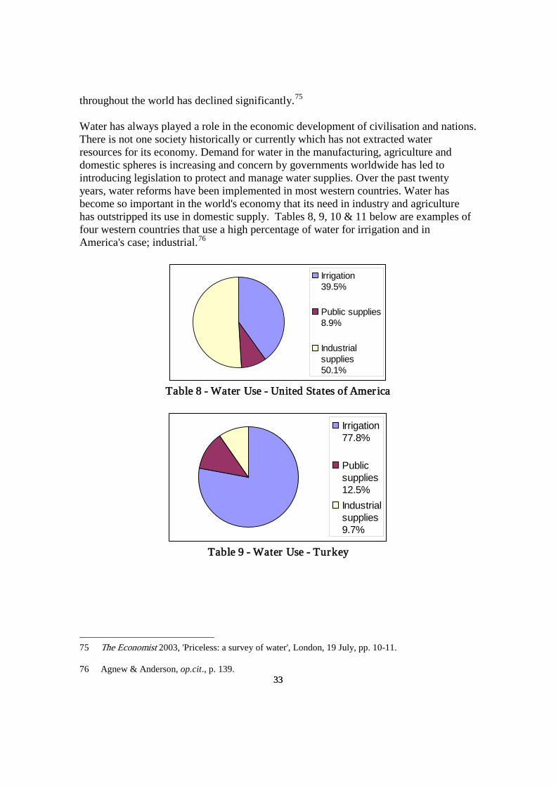
33
33
throughout the world has declined significantly.75
Water has always played a role in the economic development of civilisation and nations. There is not one society historically or currently which has not extracted water resources for its economy. Demand for water in the manufacturing, agriculture and domestic spheres is increasing and concern by governments worldwide has led to introducing legislation to protect and manage water supplies. Over the past twenty years, water reforms have been implemented in most western countries. Water has become so important in the world's economy that its need in industry and agriculture has outstripped its use in domestic supply. Tables 8, 9, 10 & 11 below are examples of four western countries that use a high percentage of water for irrigation and in America's case; industrial.76
Irrigation39.5%
Public supplies8.9%
Industrialsupplies50.1%
Table 8 - Water Use - United States of America
Irrigation77.8%
Publicsupplies12.5%Industrialsupplies9.7%
Table 9 - Water Use - Turkey
75 The Economist 2003, 'Priceless: a survey of water', London, 19 July, pp. 10-11. 76 Agnew & Anderson, op.cit., p. 139.

34
34
Irrigation57.1%
Publicsupplies12.1%
Industrialsupplies4.6%
Table 10 - Water Use - Australia
Irrigation82.7%
Publicsupplies10.8%Industrialsupplies2.1%
Table 11 - Water Use - Greece
1.4 The Influence of Water Resources on Development – The Early Australian Economy Water supplies were detrimental to the establishment of British settlement and primary industry in Australia. In fact, the availability of a permanent water supply was one of the main reasons why Governor Phillip chose Sydney as the site for the first British settlement.77
Early Australian agriculture progressed very slowly during the initial years of settlement, and Sydney remained heavily dependent upon produce and goods from Britain. However by 1801 cultivation had improved and Sydney no longer relied on grain and flour from England. In 1798 11 311 hectares were used for pastoralism and agriculture, by 1809 this had expanded to 38 254 hectares and in 1821 farming areas had more than quadrupled to 129 700 hectares.78
77 Kevin Jeffcoat, More Precious Than Gold: An Illustrated History of Water in New South Wales, Department of Water Resources & MacArthur Press, Sydney, 1988, p. 26.
78 Stephen Roberts 1968, History of Australian Land Settlement, The Macmillan Company of Australia Propriety Limited, South Melbourne, pp. 9, 10, 15 & 23.

35
35
Most of the fertile land had been taken and farmers were expanding inland on inferior soil when Charles Darwin visited Australia in 1836. This led him to comment on the poorer quality of soil and he held little hope for the success of farming. He believed that the frequency of droughts would prevent agriculture being developed on a large scale. He was also disillusioned on the potential of pastoralism because vegetation was too sparse. Darwin expected Australia to equal North America's prosperity but conceded that Australia's environment was too problematic. He was convinced that Australia's future lay in maritime.79
Regardless of Darwin's prediction for Australia, New South Wales by this time was producing wool, beef, mutton, wheat and citrus fruits.80 From the 1870s irrigation schemes were implemented to extend farming areas and to offset drought conditions.81 This was also a time when farming technology greatly improved. The stump-jump plough and stripping and harvesting machines were developed which transformed the wheat industry world wide. Wheat being a major Australian crop benefited from such inventions.82
The Murrumbidgee irrigation scheme became operational in 1908 and this significantly contributed to the expansion of agriculture. By 1913 the average size of farms had grown from 35 hectares to 250 hectares. Farmers were generating dairy products, mixed fruit and vegetables and factories were established in farming regions to manufacture the produce. Between the 1920s and 1930s seven irrigation districts were operating in the Murray and Murrumbidgee Valleys supporting primarily wheat and sheep farms. By 1929 the Murrumbidgee irrigation scheme was watering Australia's largest rice crop of 5 700 hectares.83 By 1958 this had increased to 18 800 hectares.84
Neil Barr & John Cary 1992, Greening a Brown Land: The Australian Search for Sustainable Land Use, MacMillan Education Australia, South Melbourne, pp. 1 & 3.
It is now well known that the scheme has created salinisation problems with an estimate $8 billion in remediation costs being reached by 2010. The cost of rehabilitation has had an economic affect on the people and towns within the Murrumbidgee irrigation area.
79 Flannery, op.cit., p. 350. 80 William Sinclair 1976, The Process of Economic Development in Australia, Longman Cheshire Propriety Limited, Melbourne, pp. 104-105. 81 New South Wales Department of Land and Water Conservation 1999, 'New South Wales', in A Century of Water Resources Development in Australia: 1900-1999, ed Walter Boughton, The Institution of Engineers Australia, Barton, pp. 32-35. 82 Flannery, op.cit., p. 357. 83 New South Wales Department of Land and Water Conservation 1999, op.cit., pp. 32-35. 84 Commonwealth Government Department of Territories 1960, op.cit., p. 71.

36
36
Beale and Fray estimate that environmental damage equals 'the throwing away [of] an entire year's national beef and wool income at 1990 prices'.85
Groundwater development was undertaken in remote New South Wales from the 1880s. Well diggers discovered copper at Cobar in 1870 and silver near Broken Hill in 1876. These mineral discoveries in turn sparked the need for further groundwater augmentation. The Great Artesian Basin which extends to Queensland, Northern Territory, New South Wales and South Australia and covers 1.7 million square kilometres was discovered in the 1870s. It is the largest artesian basin in the world with an estimated water storage of 8 700 million megalitres.86 Its water underlies one fifth of the Australian continent and contains deep aquifers that extend from 500 metres to 2 000 metres.87 The basin was tapped in north-west New South Wales in 1877 and by 1914, 1 200 artesian bores were constructed. Access to a permanent and huge volume of water opened up more land in western New South Wales for pasture and for cropping.88
Most other Australian colonies quickly followed New South Wales' lead. Victoria shared the gold mining booms with New South Wales and Queensland during the 1850s and this created a demand for water supplies. In Victoria the impact of the goldfield discoveries quickly developed water supplies. The gold rushes of the 1850s saw Victoria's population rise from 77 000 in 1851, 460 000 in 1857 to 540 000 in 1859. Water was needed immediately for mining processes and for domestic use. Where surfacewater was not available, shallow sinking took place. As townships grew around the fields miners built small dams, deeper wells and installed tanks.89
Wimmera-Mallee farmers banded together in the 1850s to dam and divert the Wimmera River to supply irrigated water for their farms. As a collective group, farmers in the region continued to enlarge, drain and dam other water sources for their benefit. Where no surfacewater was available farmers carried out their own well sinking.90
85 Beale & Fray, op.cit., p. 96. 86 Great Artesian Basin Consultative Council 1998, Great Artesian Basin: Draft Strategic management Plan: Executive Summary, Brisbane (brochure). 87 Mary E. White 1994, After the Greening: The Browning of Australia, Kangaroo Press, Kenthurst, NSW, p. 36. 88 New South Wales Department of Land and Water Conservation 1999, op.cit., pp. 38-39. 89 J. M. Powell 1989, op.cit., pp. 52 & 75. 90 ibid., p. 44.

37
37
By 1868 the Victorian Government had completed three reservoirs for public water supplies, irrigation projects and for mining activities.91 In 1887 based on irrigation schemes in the United States of America, George and William Chaffey introduced one of Australia's first irrigation systems. This irrigation scheme was driven by huge pumps measuring 4.5 metres in diameter that had been constructed by the brothers. It was reported that the system had transformed 'a Sahara of hissing hot winds and red driving sand' into a garden of Eden. Manning Clark describes the era as 'the age of the optimists' where advances in technology spurred agriculture and prosperity in general.92 On the other hand, such schemes marked the beginning of the decline of the Murray River which today has huge problems of river flows and salinisation.93
In 1896 there were twenty-three irrigation schemes watering 314 749 hectares mainly in the Wimmera-Mallee region.94 In 1905 Victoria had six dams constructed primarily for irrigation. The Wimmera-Mallee district quickly developed wheat, grape and fruit crops and later expanded into the dried fruit industry. By 1932 the Wimmera-Mallee irrigation schemes were providing water for a farming area of 28 500 square kilometres.95 Irrigated land in Victoria and New South Wales expanded further with the completion of the Hume Reservoir in 1936.96
The main areas of water development in South Australia's early years occurred around the Murray River and in the mid north where water shortages necessitated water conservation practices. The first commercial farms were concentrated in the Loxton and Renmark region. The early settlers cultivated on the floodplains adjacent to the Murray River and relied on river flows to water their crops. Although pumps, earthbanks and channels were incorporated, this method of farming was unsuccessful. By 1918 pump irrigation, drainage channels, levy banks and open channel distribution systems were used, which proved a more successful system of watering. Over 5 000 hectares of swamp were reclaimed and reused as farming land. The farms soon began to produce
91 ibid., pp. 78-80, 121-124. 92 Clark quoted in Flannery, op.cit., p. 357. 93 Paul Sinclair 2001, The Murray: A River and its People, Melbourne University Press, Carlton South, pp. 58-75. Barr & Cary, op.cit., pp. 225-226. 94 ibid., pp. 78-80, 121-124. 95 William Sinclair, op.cit., pp. 104-105. J. M. Powell 1999, op.cit., pp. 57-59 & 77. 96 Bruce Davidson 1969, Australia Wet or Dry?: The Physical and Economic Limits to the Expansion of Irrigation, Melbourne University Press, Carlton, p. 83.

38
38
pasture, grapes, stonefruit and citrus.97
The mid north of South Australia receives similar rainfall levels as the Alice Springs region and with the difficulties of securing water, the South Australian Government introduced the Water Conservation Act in 1886 to ensure equity of water resources for domestic and farming purposes in the region. By 1888 130 reservoirs were in use and bores and wells were at 32 kilometre intervals on stock routes. Great Artesian Basin bores were constructed in the far north-east and it was considered that there were enough water supplies available for rural South Australia.98 Sheep and wheat farming rapidly expanded with the construction of the Beetaloo Reservoir in the Lower Flinders Ranges in 1890, the Bundaleer Reservoir in 1902, followed by the Baroota Reservoir near Port Pirie in 1921.99
Perth was proclaimed a city in 1856 and its connection to Adelaide's telegraph line in 1877 assisted its progress.100 However, it was the gold discoveries at Kalgoorlie and Coolgardie during the 1890s which drew huge migrations to Western Australia and boosted local economies.101 Water was scarce and expensive on the field and 'dry blowing' was the common method of gold mining. Water was usually obtained from water carts or tanks. Surfacewater was limited and it was generally considered that the region's groundwater was too brackish and highly saline to be developed for gold mining; so the Western Australian decided to pump fresh water to the goldfields.102 The Perth to Kalgoolie water pipeline took eight years to complete and began operating in 1903, pumping 2.2 million litres daily over a distance of 560 kilometres. The construction of the water pipeline has been acclaimed as one of Australia's early engineering feats103
but the line has also its critics.
Geoffrey Blainey in The Golden Mile notes that while the goldfields suffered from water shortages, he believes that the goldfields were prospering before the arrival of the 97 South Australian Department for Environment, Heritage and Aboriginal Affairs and the South Australian Water Corporation 1999, ' South Australia', in A Century of Water Resources Development in Australia: 1900-1999, ed Walter Boughton, The Institution of Engineers Australia, Barton, pp. 120-121. 98 Marianne Hammerton 1986, Water South Australia: A History of the Engineering and Water Supply Department, Wakefield Press, Netley, pp. 78 & 90. 99 South Australian Department for Environment, Heritage and Aboriginal Affairs and the South Australian Water Corporation 1999, op.cit., pp. 127-128. 100 The New Encyclopaedia Britannica 1987, vol. 9, 15th edn, Encyclopaedia Britannica Incorporated, Chicago, p. 314. 101 William Sinclair, op.cit., pp. 135 & 189. 102 Blainey 1993, op.cit., pp. 3, 5 & 57. 103 J. M. Powell 1998, op.cit., pp. 20-22.

39
39
pipeline because mines were able to utilise brackish water.104 Blainey compares the Broken Hill experience where mines also had to overcome water shortages. Coolgardie and Broken Hill share similar rainfall levels and climates and Blainey maintains that like Broken Hill, reservoirs, rather than a pipeline could have supplied enough water for mining.105
Perth and its mining fields were further stimulated by local demand and this in turn encouraged the construction of housing and infrastructure. Perth's construction industry increased rapidly during the 1890s period with its population increasing faster than all other capital cities.106 In 1900 Western Australia's population was 180 000 and reached 440 000 during the 1930s and 500 000 in the mid 1940s.107 Although Western Australia's population continued to increase the lack of water supplies was blamed for limiting most of the population to the south-west corner of Western Australia.108
The Western Australian Government's first irrigation scheme was the Harvey agricultural area in 1916. The area encompassed 40 000 hectares in the south-west and later water was dammed to irrigate diary pastures and fodder crops in the region. Irrigation projects were later implemented for the Collie River and Waroona region. From the 1940s an area encompassing 49 000 square kilometres (twice the size of Wales) was being developed in south-eastern Western Australia as a wheat farming region. The region suffered from water scarcity and water was piped to the wheat belt from the Wellington Dam and Mundaring Weir but there was still not enough water for the region to reach expectations.109 By 1950 the sheep and wheat farming areas in Western Australia covered 6.8 million hectares.110 J. M. Powell mentions that during this time there was the belief that 'water and progress ran together' and this sparked the rapid increase of water related organisations.111
Farming like most other parts of Australia has come as an enormous cost. Years of farming has created land degradation, salinity, waterlogging and erosion. In 1990 the 104 Blainey 1993, op.cit., p. 56. 105 ibid., pp. 68-76. 106 William Sinclair, op. cit., pp. 135 &189. 107 J. M. Powell 1998, op.cit., p. 18. 108 J. M. Powell 2000, 'Snakes and cannons: water management and the geographical imagination in Australia', in Environmental History and Policy: Still Settling Australia, ed Stephen Dovers, Oxford University Press, South Melbourne. p. 58. 109 ibid. 110 J. M. Powell 1998, op.cit., pp. 29-33. 111 J. M. Powell 2000, op.cit., p. 59.

40
40
Western Australian Government valued environmental damage at $700 million. In the case of salinity, waterlogging and soil rehabilitation it was estimated that it would cost between $70 million and $153 million annually to rectify. These problems were the direct result of land clearing and the use of tractors and tillage machinery on the wheat belt regions.112
Tasmania is regarded as Australia's wettest state but water has been harnessed for irrigation since the 1820s.113 Water from the Derwent, Meander, Nile, Macquarie and the Blackman Rivers was dammed and irrigated for crops, domestic use and as power for grain mills. The Great Lake Dam and its development in 1916 was the first Australian generation of hydro-electric power. The damming of the Derwent River followed in 1934, and by 1968 the Derwent catchment area contained sixteen dams and ten power stations.114
Private Tasmanian irrigation schemes operated from the 1820s and currently utilise 90% of total irrigated water supplies. Government irrigation schemes were introduced much later, the first being the Cressy-Longford Scheme in 1971. Irrigation is currently the second largest water user in Tasmania with mining ranking as the first.115
Besides the agricultural irrigation schemes, other capital cities had developed their public water supplies before Federation. Sydney's 'Busby's Bore' was the first Australian capital city public water supply in 1833.116 Melbourne's water scheme followed in 1857 when Yan Yean water was piped to its residents.117 Adelaide followed in 1860,118 Brisbane in 1866, Hobart in 1867119 and Perth in 1896.120
112 Beale & Fray, op.cit., p. 101.
Outside the capital cities
Taylor 1987, op.cit., p. 95. 113 Tasmanian Department of Primary Industries, Water and Environment 1999, 'Tasmania', in A Century of Water Resources Development in Australia: 1900-1999, ed Walter Boughton, The Institution of Engineers Australia, Barton, pp. 81-84. 114 ibid. 115 ibid., pp. 82 & 85. 116 Margo Beasley 1998, The Sweat of Their Brows: 100 Years of the Sydney Water Board 1888-1988, Sydney Water Board, Sydney, p. 6. 117 J. M. Powell 1989, op.cit., p. 58. 118 Hammerton, op.cit., p. 24. 119 Raymond Whitmore 1997, Queensland's Early Waterworks, Queensland Department of Natural Resources, Brisbane, pp. 25 & 29. 120 J. M. Powell 1998, op.cit., p. 16.

41
41
development was also relatively fast. The regional Queensland towns of Maryborough and Toowoomba acquired public water supplies in 1867 and 1879 respectively121 with Cairns and Charters Towers following in 1891.122 Darwin on the other hand did not obtain its first public water supply scheme until 1941.123
By 1901 Australia's new states had substantially developed their water supplies, primary industries, infrastructure and economies. This was well reflected in their population and construction figures. Tim Flannery believes that it was this enormous expansion of agriculture that was responsible for producing a high standard of living in the twentieth century.124
The Northern Territory in stark contrast had a white population of 201 in 1871. The mining booms of the 1880s attracted a huge population which reached 3 451 in 1881.125
Although a considerable increase in percentage terms, the population was still very sparse and transient. Pastoralism was the only stable economy but it was not a very profitable industry. The Northern Territory in contrast to other Australian regions had limited infrastructure and no established viable industry.
1.5 The Influence of Water Development on Primary Industry - The Northern Territory and Northern Australia
Northern Queensland and Western Australia have similar environmental conditions to the Northern Territory and pastoralism was an early industry in both states. Similarly, all northern Australian pastoralists contended with limited water supplies, remoteness, distance, the high cost of transportation and conflict with Aboriginal people. Queensland settlement remained confined to the Darling Downs and coastal regions until the mining rushes in the 1860s. Well before then, the pastoral industry was firmly established with forty-five cattle and sheep stations founded by 1842.126
121 Whitmore, op.cit., pp. 55, 66, 122 & 124.
However, pastoralism was limited to where permanent surfacewater was available and these areas were fully stocked by 1886 when the Duracks migrated to northern Western Australia in
122 Boughton, op.cit., p. 3. 123 Manton Dam, 60 kilometres south of Darwin became operational. 124 Flannery, op.cit., p. 350. 125 Australian Bureau of Statistics 1993, Northern Territory in Focus, Government Printer, Darwin, p. 43. 126 J. MacDonald Holmes 1963, Australia's Open North: A Study of Northern Australia Bearing on the Urgency of the Times, Angus & Robertson Limited, Sydney, pp. 94-95.

42
42
search of more pastoral land.127
Queensland's western region remained undeveloped until the Great Artesian Basin was discovered. However Australia's drilling technology was limited compared to America and Canada. The Great Artesian Basin is so deep that drilling rigs used to develop America's West and Canada were imported to Queensland. The Inter-Colonial Boring Company was contracted to carry out most of the initial drilling in the basin. The company later drilled in the Barkly Tableland in the Northern Territory.128 The first artesian bore was completed at Thuralgoonia Station, near Cunnamulla in 1887.129
With the assurance of a permanent and high volume of water, pastoralism rapidly spread westward.
Until the basin was tapped 'water was seen as the only thing missing to make the region fertile and productive'.130 By 1904 693 Great Artesian bores had been constructed. This number reached 2 008 in 1943.131 Currently Queensland has 4 700 Great Artesian bores supporting 200 000 people in the pastoral industry which is now worth $2 000 million.132
The first northern irrigation scheme was founded in 1884 on the Burdekin River to support sugar cane growing and by 1890, 800 hectares were under irrigation.133 From the mid 1880s sugar cane was Queensland's main crop and sugar farms extended from the Burdekin as far north as Cardwell.134
127 William Durack 1991, 'Regional history', paper presented to the 50 Years of Ord Irrigation Review and Future Perspectives Conference, Kununurra, 1-3 November, p. 1.
In 1917 the Burdekin River irrigation scheme was supporting eighty-five sugar cane farms amassing 20 000 hectares. The scheme had expanded to include extensive infrastructure that included a powerhouse to supply
128 J. M. Powell 2000, op.cit., p. 54. Peter Garone, Senior Manager Hydrographic and Drilling, Northern Territory Department of Lands, Planning and Environment, personal communication, 22 December 2004. 129 Queensland Water Resources Commission 1989, Water for Queensland: How Water Fits into our Way of Life in Queensland, Queensland Water Resources Commission, Brisbane, p. 18. 130 White 2000, op.cit., p. 100. 131 J. M. Powell 1991, Plains of Promise: Rivers of Destiny: Water Management and the Development of Queensland 1824-1990, Boolarong Publications, Brisbane, p. 137. 132 Great Artesian Basin Consultative Council 1998, op.cit. 133 Queensland Water Resources Commission 1989, op.cit., pp. 20-23. J. M. Powell 1991, op.cit., pp. 63, 72 & 112. 134 J. MacDonald Holmes 1963, op. cit., pp. 123 & 176.

43
43
electricity for the irrigation pumps.135 Between 1891 and 1910 irrigated crops increased from 1 500 to 3 200 hectares, and had expanded to 8 800 hectares by 1926.136 Currently, the majority of irrigated crops in Queensland are situated along the coast strip between Cairns and Mackay. Although this region receives wet season rains, rain watered crops are supplemented with irrigated water.137 It has been pointed out by Beale and Fray that the development of the Burdekin River irrigation scheme has come as a huge cost to the environment. It is estimated that $100 million worth of soil nutrients are wash out to sea annually and in the Darling Downs region farmers are losing up to 40 tonnes of topsoil per hectare annually.138
The northern towns of Bowen and Townsville were established to support the nearby mining fields, especially the Charters Towers region. Mackay developed as a trading port and sugar processing centre.139 The mining booms and pastoral expansion quickly swelled Queensland's population from 25 788 in 1860, to 208 130 in 1880 and 490 081 in 1900.140 So when the Northern Territory was stocking its first pastoral stations, Queensland's sugar cane plantations, mining and pastoral industries were well entrenched.141
The Northern Territory failed to follow Queensland's lead, progressing instead, along similar lines to that of northern Western Australia.
In Western Australia, there was a clear economic distinction between the more affluent south and the far north. Northern Western Australia differed from the south with its economy relying on pastoralism, pearling and mining. The region's inland has a similar geology to central Australia. Most of the region was devoid of surface water and its soil and vegetation were largely infertile and incapable of supporting agriculture. Commercial agriculture remained non existent until the Ord River Irrigation Scheme was completed in 1963. The Ord River Scheme was developed to enable a wide range of tropical crops to be grown. This was Stage One of development which cost $20 million and included the construction of the Kununurra Division Dam, irrigation and relevant works. The area under cropping was initially 1 344 hectares in 1964 expanding
135 Queensland Water Resources Commission 1989, op. cit., pp. 20-23. J. M. Powell 1991, op.cit., pp. 63, 72 & 112. 136 ibid. 137 Queensland Water Resources Commission 1989, op.cit., pp. 20-23. 138 Beale & Fray, op.cit., p. 96. 139 J. MacDonald Holmes 1963, op.cit., pp. 123 & 176. 140 J. M. Powell 1991, op.cit., p. 72. 141 The Administrator was discussing historical comparisons between Queensland and the Northern Territory. Administrator's Report on the Northern Territory for the Year 1912, p. 16.

44
44
to 5 785 hectares in 1972.142
Stage Two involved the construction of the Ord River Dam as a reservoir and was opened in 1972 at a cost of $22 million. In 1974 65 000 hectares of land was under irrigation but the scheme folded because of the inability to control insect pests. The insect problem was partly solved by abandoning cotton as the main crop. In 1994 irrigated land increased to 99 000 hectares and agriculture production reached an estimated $70 million in the 1999/2000 financial year. Sugar cane currently represents 40% of the crop and the rest made up of mixed cropping, seed and fodder. The ecological and environment values of the Ord River are now considered and a water allocation plan has been put in place to protect and manage the water resources.143
The Ord River Scheme although initially regarded as a 'white elephant' has forty years later demonstrated that huge irrigation schemes and commercial cropping are achievable in northern Australia.
Like the Northern Territory, northern Western Australia's pastoral industry was considered backward and it suffered from drought, disease, water shortages and long distances from markets. Its pastoral industry experienced the same economic fate as the Northern Territory. It remained stagnant throughout the twentieth century, with the exception of the Second World War period.144
Throughout the twentieth century, northern Western Australia and the Northern Territory became the subject of various plans to populate the north with selected nationalities who were able to work in a hot climate.145
142 J. M. Powell 1998, op.cit., p. 46.
Although in 1947 Western Australia's Northern Australian Development Committee supported these population
Water and Rivers Commission of Western Australia, 'Sharing the waters of the Ord River', 29 December 2004, www.wrc.wa.gov.au Department of Industry and Resources of Western Australia, 'Ord Irrigation scheme Stage 2', 29 December 2004, www.doir.wa.gov.au Sue Graham-Taylor's 1980, PhD thesis, History of the Ord River Scheme a study in incrementalism, University of Western Australia, provides a comprehensive account of Stage One and the beginning of Stage Two (up to 1975) of the Ord River Scheme. 143 ibid. 144 NAA NT CRS F1 Item 1962/2162, Report, Department of Shipping and Transport, Australian Transport Advisory Council, 'Provision of Transport Facilities for Drought Affected Stock', 1954. Northern Australian Development Committee, Western Australian Government 1949, The Future of the North-West of Western Australia: A Realistic Summing Up, Western Australian Government, Perth, p. 7. 145 Michele Langfield 2001, 'Peopling of the Northern Territory part 2: The white elephant laid to rest? In the inter-war years', Journal of Northern Territory History, no.12, pp. 17 & 22.

45
45
schemes it was adamant that the basic facilities of water, electricity, sewerage, roads and housing were needed to accommodate a rise in population.146 The committee's recommendation could have well applied to the Northern Territory. The committee was well aware of how the future Ord River Irrigation Scheme would impact on the region. It was anticipated that once the project was operational, migration and economic growth would automatically follow because there would be 'water for farming, irrigation, a series of dams, cattle, industries, fodder'.147
The Northern Territory and northern Western Australia share a similar economic history. Unlike northern Queensland extensive groundwater supplies for the pastoral and agricultural industries were not developed until the mid twentieth century. 1.6 The Northern Territory and the Tropical Myth148
The tropical myth is discussed at this point in the chapter because the myth and its expectations was to a large extent the fallacy on which the Northern Territory's pastoral and agricultural industries were based on. It was generally believed that the Top End had vast unlimited fertile soil and its high rainfall levels would easily produce agriculture and lush vegetation for cattle. Professor Griffith Taylor, a geographer, acknowledged the tropical myth in 1923 describing 'luxuriant forests, of fertile soils, of flowing rivers, and abundant minerals' as nothing more than an fantasy which does not exist.149 Much later in 1979 C. J. Lacey, a C.S.I.R.O. scientist, echoed the same sentiments. He identified the tropical myth as a false belief developed by Europeans who failed to realistically assess the environmental ability of the Top End. It was expected that its natural resources could easily be exploited with little or no capital or exertion. Lacey states that 'there is no comparable region in Australia where the white man has so consistently over-estimated the power of his technology in the field of primary industry to draw forth bounty from the land'.150
The myth was possibly inherited from the early settlement of Australia when environmental restraints to farming became obvious. An assumption arose that only water was needed. Water it was believed, would allow unlimited growth of agriculture 146 Northern Australian Development Committee, op. cit., p. 7. 147 ibid. 148 Bruce Davidson refers the myth as the northern myth which is the title of his book The Northern Myth: A Study of the Physical and Economic Limits to Agricultural and Pastoral Development in Tropical Australia, 3rd edn, Melbourne University Press, Carlton, 1972. 149 Taylor 1923, op.cit., p. 453. 150 C. J. Lacey 1979, 'Forestry in the Top End of the Northern Territory: Part of the Northern Myth', Search, vol. 10, no. 5, May, p. 174.

46
46
and make the desert bloom. The response was to irrigate from large rivers such as the Murray Darling and the Burdekin.151 Bruce Davidson is one writer who has attempted to dispel the myth. In Australia Wet or Dry?152 he argues that irrigation is an economic misconception and that that none of Australia's irrigation schemes ever operated profitably. Further Davidson contends that 'no belief is more firmly held in Australia than that the scarcity of water has seriously hindered the nation's development'.153 In later book by Davidson The Northern Myth: A Study of the Physical and Economic Limits to Agricultural and Pastoral Development in Tropical Australia154 he disagrees with the popular idea that environmental hurdles had been solved. During the 1950s and 1960s experts considered that problems that had in the past confronted tropical Australia had been overcome. Davidson on the other hand, undertook his own study and concludes that northern Australian agriculture and pastoralism would never become profitable and would have to remain heavily subsidised by government.155 At the time of his study Davidson was correct. Pastoralism was not a great revenue earner for the government and the last commercial crop had just folded. However there is evidence to suggest that 1960s also marked the departure of the myth. This was a period when water development increased with the introduction of the 'dud' bore scheme156 and pastoral leases included compulsory improvements such as water supplies, buildings, yards and fencing.157
151 There is no shortage of books on the environmental destruction that has occurred since these rivers were irrigated. See
Eric Rolls 1993, From Forest to Sea: Australia's Changing Environment, University of Queensland Press, St Lucia. David Smith 1994, Saving a Continent: Towards a Sustainable Future, University of New South Wales Press, Sydney. Mary E. White, 1997, Listen…Our Land is Crying: Australia's Environment Problems and Solutions, Kangaroo Press, Kenthurst, NSW. Barr & Cary, op.cit., p. 1. 152 Davidson 1969, op.cit. 153 ibid., p. 1. 154 Davidson 1972, op.cit. 155 ibid., p. xv. 156 The scheme was introduced by the Commonwealth Government in 1961 and administered by the Northern Territory Administration. It was an incentive for pastoralists to develop water supplies on their properties. The government provided pastoralists with technical and financial assistance and covered the cost of non productive bores. The scheme is discussed further in Chapter Three on pastoralism. 157 Graeme Hockey, Senior Pastoral Officer, Northern Territory Department of Lands and Housing, 1977-1987, interview by Bev Phelts, Natural Resources Division, Department of Infrastructure, Planning and Environment, October 2002.
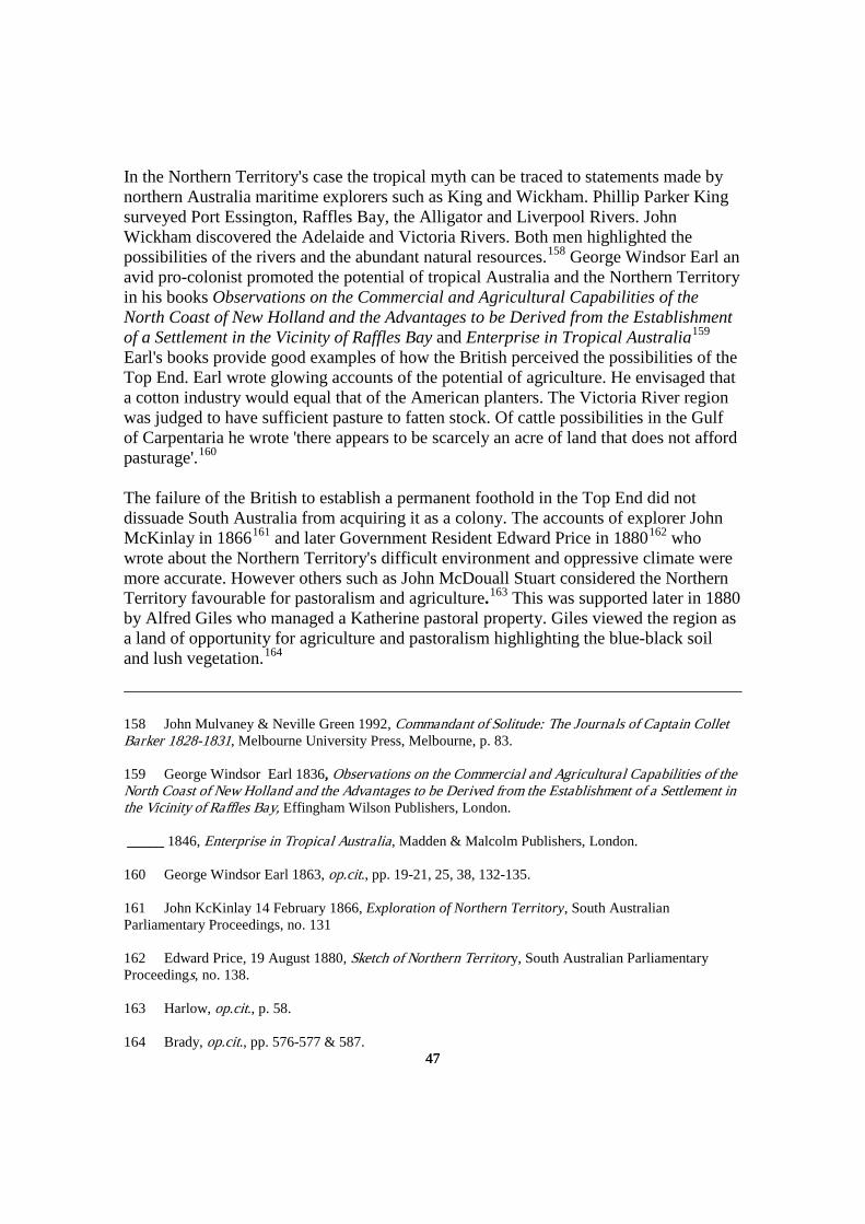
47
47
In the Northern Territory's case the tropical myth can be traced to statements made by northern Australia maritime explorers such as King and Wickham. Phillip Parker King surveyed Port Essington, Raffles Bay, the Alligator and Liverpool Rivers. John Wickham discovered the Adelaide and Victoria Rivers. Both men highlighted the possibilities of the rivers and the abundant natural resources.158 George Windsor Earl an avid pro-colonist promoted the potential of tropical Australia and the Northern Territory in his books Observations on the Commercial and Agricultural Capabilities of the North Coast of New Holland and the Advantages to be Derived from the Establishment of a Settlement in the Vicinity of Raffles Bay and Enterprise in Tropical Australia159 Earl's books provide good examples of how the British perceived the possibilities of the Top End. Earl wrote glowing accounts of the potential of agriculture. He envisaged that a cotton industry would equal that of the American planters. The Victoria River region was judged to have sufficient pasture to fatten stock. Of cattle possibilities in the Gulf of Carpentaria he wrote 'there appears to be scarcely an acre of land that does not afford pasturage'.160
The failure of the British to establish a permanent foothold in the Top End did not dissuade South Australia from acquiring it as a colony. The accounts of explorer John McKinlay in 1866161 and later Government Resident Edward Price in 1880162 who wrote about the Northern Territory's difficult environment and oppressive climate were more accurate. However others such as John McDouall Stuart considered the Northern Territory favourable for pastoralism and agriculture.163 This was supported later in 1880 by Alfred Giles who managed a Katherine pastoral property. Giles viewed the region as a land of opportunity for agriculture and pastoralism highlighting the blue-black soil and lush vegetation.164
158 John Mulvaney & Neville Green 1992, Commandant of Solitude: The Journals of Captain Collet Barker 1828-1831, Melbourne University Press, Melbourne, p. 83. 159 George Windsor Earl 1836, Observations on the Commercial and Agricultural Capabilities of the North Coast of New Holland and the Advantages to be Derived from the Establishment of a Settlement in the Vicinity of Raffles Bay, Effingham Wilson Publishers, London. _____ 1846, Enterprise in Tropical Australia, Madden & Malcolm Publishers, London. 160 George Windsor Earl 1863, op.cit., pp. 19-21, 25, 38, 132-135. 161 John KcKinlay 14 February 1866, Exploration of Northern Territory, South Australian Parliamentary Proceedings, no. 131 162 Edward Price, 19 August 1880, Sketch of Northern Territory, South Australian Parliamentary Proceedings, no. 138. 163 Harlow, op.cit., p. 58. 164 Brady, op.cit., pp. 576-577 & 587.

48
48
The tropical myth was expected to produce a pastoral utopia and this was evident with the land speculations of the 1860s and 1870s. By 1885 it was clear that the tropical myth had failed both in pastoralism and in large scale agriculture. Sugar cane farming had been unsuccessful at Delissaville165 and on the Daly River.166 By now the myth had not been supported with any evidence but it continued to be promoted. An article in The Adelaide Observer in 1886 by an unknown author devotes two page length columns on the capitalist rewards that the Northern Territory will soon generate.167 The tropical myth was later portrayed as the investor's dream in a South Australian Government document in 1902168 and again in 1904 by the South Australian Premier, J. G. Jenkins.169
The tropical myth had dimmed when the Commonwealth Government took responsibility in 1911. The government was more realistic about environment conditions and concentrated on developing water supplies and establishing experimental farms.170 During the initial years the government was realistic about expectations and what could be achieved in the Northern Territory. Notable individuals also were aware of environmental limits. In 1917 Dr H. I. Jensen, Director of Mines and Chief Government Geologist for the Northern Territory, recommended the rich organic soils of the northern coastal regions and the Top End for agriculture but stressed that irrigation would be necessary during the dry season.171 Edwin Brady recognised that the soil and climate of the Top End had agricultural potential but he too, highlighted the need for irrigation during the dry season. He advocated the soil of the Daly and Adelaide Rivers but warned that their waters would need to be controlled and used for irrigation. However Brady seemed overly pessimistic when he wrote that a larger irrigation scheme than the Murrumbidgee's could be established. Brady regarded the banks of the Adelaide River as rich and fertile and believed the area would evolve into a profitable industrial region.172
165 Administrator's Report on the Northern Territory for the Year 1912, p. 15. 166 Government Resident's Quarterly Report on the Northern Territory for 30 June 1885, p. 9. 167 The Adelaide Observer, 22 May 1886. 168 South Australian Government 1902, op.cit. 169 South Australia Government, Premier J. G. Jenkins 1904, 'The Northern Territory of South Australia: its development : proposals of the government', Hansard, 14-15 September, J. L. Boynton & Company, Adelaide. 170 Walter Campbell, op.cit., pp. 3, 17 &18. 171 Brady, op.cit., p. 576. 172 ibid., pp. 559-565 & 570.
49
49
Griffith Taylor ridiculed the tropical myth in 1923 stating that only in the tropical areas of Queensland could pastoral and agriculture be achieved. He maintained that in 1923 tropical regions continued to be misunderstood.173
In short Taylor believed that any attempt to develop these industries in the Northern Territory would be uneconomic and unsuccessful. Taylor's views were later taken up by Davidson and Courtenay.
It was known by the 1920s that crops would need to be supplemented with irrigated water but the myth prevailed with the next commercial crop of peanut rainfed. Peanut farming was undertaken between the 1920s and 1950s and suffered drought and low rainfall levels. In 1937 the Commonwealth Government held an investigation into the Northern Territory's primary industries and largely blamed the myth for the continued failure of agriculture. The report argued that soil and annual rainfall cannot be compared to all other tropical regions and environmental conditions in the Top End differ. The report noted that an accepted belief had risen in Australia that all tropical regions which have high rainfall levels will produce abundant crops. 'This is a fallacy. And nowhere is that fallacy better exemplified than in the Northern Territory'.174 The Second World War defence farms helped to dispel the myth briefly. Modern farm machinery, better farming methods and various forms of irrigation were introduced into cropping. The farms were hailed as a success and had proved that commercial agriculture was achievable if adequate infrastructure was in place.175
Before the rice farms were developed during the 1960s the problems associated with erratic rainfall and water control had already been documented in feasibility studies. Echoes of the tropical myth became apparent when the rice was planted near the fertile river banks and rainfed. This created a multitude of problems which are discussed in Chapter Five. Commercial mango farming commenced in the early 1980s and other irrigated commercial crops such as citrus and table grapes began not long after. Irrigation has become an integral factor in farming practices. Agriculture and pastoralism have become viable industries because of a manipulated environment. Deliberate effort has gone into land conservation, erosion prevention, feral animal control, increasing water supplies and planting drought resilient grasses. Although agriculture and pastoralism continue to dominate the tropical north, it would be true to 173 Taylor 1923, op.cit., pp. 484-485. 174 Commonwealth Government 1937, op.cit., p. 77. 175 AWM Series AWM 54 Item 337/7/5, Report, Lieutenant N.A.M. Kjar, 1 Australian Farm Coy Northern Territory, 22-30 August 1943, pp. 1-2. Commonwealth Scientific and Industrial Research Organization; Northern Territory Administration 1961, Northern Territory Scientific Liaison Conference held at the Fanny (sic) Bay Hotel, Darwin, vol. 2, Commonwealth Scientific and Industrial Research Organization, Melbourne, pp. 48-49.

50
50
say that today the myth has finally been laid to rest.
1.7 British Settlement of the Northern Territory 1824-1849 When the British established the first Northern Territory settlement in 1824 it was for capitalist reasons like the rest of Australia. The colonisation of northern Australia could be compared to the American West which was regarded as the last frontier to be exploited. A scrutiny of the writings of Northern Territory explorers confirms that imperialist and capitalist intentions were evident from the beginning. Sea explorer John Lort Stokes surveyed near the Victoria River and he had written that: `I would fain hope that ere the sand of my life-glass has run out, other feet than mine will have trod the distant shore; that colonization will, ere many years have past, have extended itself in this quarter, that cities and hamlets will have risen on the shore of the new-found river, that commerce will have directed her track thither, and that smoke may rise from Christian hearths where now alone the prowling heathen lights his fire. There is an inevitable tendency in man to create; and there is nothing which he contemplates with so much complacency as the work of his own hands'.176
John McDouall Stuart was driven by the need to find a route for the Overland Telegraph Line. The line and its communication with the Empire was instrumental to British imperialism and capitalism in the Northern Territory and Australia as a whole. Ernest Giles's diary contains imperialistic motives with a touch of romanticism. Giles carried out many explorations in throughout the Northern Territory during the late 1800s and he described explorers as martyrs who toiled and suffered for the sake of duty and for civilisation.177 Romanticism in the taming the 'wild' outback appeared to influence Edwin Brady who wrote in 1918 that pioneer settlement is thrilling, it's a heroic conquest and a story of adventure. 'Australia is destined to become a rampart of Imperial strength'.178
These views reflect Frederick Jackson Turner's perspective on the conquering of the American West: `to civilize the world, to subdue the wilderness, is the proudest achievement to which he [man] can look forward'. Moreover Stokes' remark on the Northern Territory as `the meeting point between savagery and civilization' is classic Turnerism.179
176 Marsden Hordern 1989, Mariners are Warned!: John Lort Stokes and H.M.S. Beagle in Australia 1837-1843, Melbourne University Press, Melbourne, p. 180.
Worster would regard this as the imminent doom of the pristine
177 William Ernest Powell Giles 1889, Australia Twice Traversed: The Romance of Exploration, vol. 1, Sampson Low, Marston, Searle & Rivington Limited, London, p. xxiii. 178 Brady, op.cit., pp. 32-33. 179 Frederick Jackson Turner 1962, The Frontier in American History, Rinehart & Winston

51
51
environment in the name of capitalism.180
Unlike Worster's American West, there was little attempt by early Northern Territory settlers to exploit the natural environment. This was plainly evident during British settlement which is discussed further in Chapter Two. The Northern Territory's environment compared to the rest of Australia has not suffered the same extent of land degradation.181
This is probably due to later permanent settlement (1863), and its much smaller and isolated population of around 200 000 people. Also it has never had any prominent secondary industries that would pollute land or water resources.
During the first century of Australian settlement, primary industry and settlement patterns were confined to the southern and eastern colonies, while northern and western Australia remained sparsely populated, unexplored and underdeveloped. When Britain decided to colonise the Northern Territory, Australia's raw materials had become so important to British manufacturers that, according to Eric Hobsbawm, Australia had progressed from an 'imperial asset' to a 'partner in imperialism'.182
The occupation of the northern shores of New Holland will ultimately be essential to the prosperity of our settlements to the southward, because, as population and wealth increase in the pastoral districts, it will be necessary to explore new sources for the profitable investment of capital accumulated there. To complete the greatness of the Australian nation, it will be necessary that they should have a greater variety than at present of climates, soils, products, and exports.
Hobsbawm's view is supported in a letter written by James Stephen from the Colonial Office in 1842:
183
At the time Stephen penned his letter, the second Northern Territory colony had failed and the third and last British outpost, Fort Victoria at Port Essington, would fold seven years later. By 1849 the British had attempted for twenty-five years to establish permanency in the Northern Territory.
The first northern Australian settlement was at Fort Dundas on Melville Island in 1824.
Publishers, New York, pp. 2-3. 180 Worster 1985, op.cit., p. 332. 181 See the Australian Land and Information Group's Australian vegetation map in Beale & Fray's book, op.cit., p. 32. This would also explain the limited published information on environment damage in the Northern Territory compared to other Australian states. 182 Hobsbawm, op.cit., pp. 32-34. 183 W. M. Curteis, Director of Agriculture Northern Territory 1965, The early history of agriculture and settlement in the Northern Territory (Australia), p. 9.

52
52
Before its abandonment in 1828, the second colony, Fort Wellington on the eastern side of Raffles Bay was established in 1827 only to be relinquished two years later. The third attempt lasted eleven years at Fort Victoria, Port Essington on the Cobourg Peninsula from 1838 to 1849.184
There is debate on the reasons why the British chose the Northern Territory as the first northern Australian settlement, the main reasons given being strategic and commercial interests.
Peter Spillett in Forsaken Settlement,185 Peter Donovan in A Land Full of Possibilities,186 F. J. Allen in 'Port Essington: A successful limpet port?'187 and J. MacDonald Holmes in Australia's Open North: A Study of Northern Australia Bearing on the Urgency of the Times188 propose that Britain wanted to establish outposts in northern Australia for defence and trade purposes. While the garrisons were never tested, it is evident in documentation of the day that trade was one factor for the foundation of the Northern Territory settlements.189 The intent was to capture the south-east Asian trade route and duplicate another Singapore.190
Both external and internal factors have been given as the reasons why the British withdrew from the Northern Territory.191
184 Mulvaney & Green, op.cit., p. 39.
External factors such as harbour difficulties
185 Peter Spillett 1972, Forsaken Settlement: An Illustrated History of the Settlement of Victoria, Port Essington North Australia 1838-1849, Lansdowne Press, Dee Why West. 186 Peter Donovan 1981, A Land Full of Possibilities: A History of South Australia's Northern Territory, University of Queensland Press, St Lucia. 187 F. J. Allen, 'Port Essington: a successful limpet port?', quoted in Alan Powell 1996, Far Country: A Short History of the Northern Territory, Melbourne University Press, Carlton, p. 55. 188 J. MacDonald Holmes 1963, op.cit. 189 Major John Campbell, 'Geographical memoir of Melville Island and Port Essington on the Cobourg Peninsula, northern Australia: with some observations on the settlements which have been established on the north coast of New Holland', Journal of the Royal Geographical Society, 1834, pp. 178-180. James Cameron 1999, Letters From Port Essington, 1838-1845, Historical Society of the Northern Territory, Darwin, Captain Bremer to Secretary of the Admiralty, London, 13 December 1838, pp. 18-21. Frederick Watson (ed.) 1922, Historical Records of Australia: series 1: Governors' Despatches to and from England, vol. XIV, Library Committee of the Commonwealth Parliament, Sydney, Sir George Murray to Governor Darling, 31 May 1828, pp. 214-215. 190 These reasons are made clear in George Windsor Earl's books:Observations on the Commercial and Agricultural Capabilities of the North Coast of New Holland and the Advantages to be Derived from the Establishment of a Settlement in the Vicinity of Raffles Bay, op.cit. and Enterprise in Tropical Australia, op.cit. 191 'Abandonment of the settlement of Port Essington' in Australia, Legislative Council 1850, Votes

53
53
and site position in relation to the trade routes and Torres Strait. The harsh environment and its associated problems of disease, water supplies and food have been forwarded as internal reasons.192
1.8 South Australian Settlement of the Northern Territory
The outposts were abandoned because they remained dependent, costly and were unable to fulfil their purpose. This is discussed in Chapter Two. The British experience could be regarded as the Northern Territory's first failed commercial enterprise.
The British were unable to establish permanency in the Northern Territory largely due to the harsh and difficult environment but nonetheless, it was George Windsor Earl's accounts and that of land explorer John McDouall Stuart which inspired South Australian annexation and settlement of the Northern Territory. Under South Australian administration from 1863, exploration to the inland increased. More scientific knowledge of the interior was needed if central Australia and the rest of the Northern Territory was to be permanently settled. A series of expeditions led by notable explorers such as John McKinlay, Major Warburton, David Lindsay, Alfred Giles, Ernest Giles and Allan A. Davidson took place. To attract capital investment into the Northern Territory, between 1865 and 1904 the South Australian Government advertised the Northern Territory's potential. As an incentive, the government also promised a future south to north railway.193
and Proceedings, vol. 1, session of the year with the various documents connected therewith, Sydney, pp. 3-4.
The
John MacGillivray 1967, Narrative of the Voyage of H.M.S. Rattlesnake: Commanded by the Late Captain Owen Stanley During the Years 1846-1850, Including Discoveries and Surveys in New Guinea, the Louisiade Archipelago etc., to which is Added the Account of Mr E. B. Kennedy's Expedition for the Exploration of the Cape York Peninsula, Libraries Board of South Australia, Adelaide, pp. 138-159. Cameron, op.cit., George Windsor Earl to Captain John Washington, Royal Geographical Society, London, 13 July 1840, p. 70. 192 Graham Calley 1998, The Pumpkin Settlements: Agriculture and Animals in Australia's First Northern Colonies, Historical Society of the Northern Territory, Darwin. Brian Reid, 'Malaria in the nineteenth century British military settlements', Journal of Northern Territory History, no. 3, 1992, pp. 41-54. 193 This book promoted the well watered pastures and their suitability for sheep and cattle. The large and navigable rivers of the Northern Territory were considered perfect water supplies for the growing of cotton. Josiah Boothby 1865, The Adelaide Almanack Town and Country Directory, and Guide to South Australia for 1865, C. Platts; E. S. Wigg; J. Howell & W. C. Rigby Publishers, Adelaide, pp. 30-32. South Australian Government 1902, op.cit. South Australian Government 1904, op.cit.

54
54
government achieved its desired effect and pastoral and agricultural leases were in demand. When the speculative land booms subsided, attraction diverted to the goldfields. During these bursts of activity the government constructed basic water facilities where they would be most beneficial. Water supplies were increased in townships, on the main stock routes and on mining fields, usually where government batteries were operating. The pastoral and agricultural industry was left to private enterprise, which suffered from limited capital or inexperienced managers. Water supplies in these industries were rudimentary with most reliance on natural waters. Chapters Three and Five discuss this point in depth. Part of the reason can be attributed to the tropical myth - the illusion that pastoralism and agriculture would automatically flourish with minimum capital and effort. The tropical vision became a disappointment for South Australia194 and was branded the 'Crow Eater's I.O.U.'.195
The loan:
In 1898 The Bulletin reported the economic disadvantages of administrating the Northern Territory.
Is supposed to be a temporary advance to be repaid by the Territory later on, but there is practically no one in the Territory to repay it. This includes the shortage on the one lonesome railway in the Territory ; that remarkable line was built with borrowed money, and as it has never even quite yielded working expenses, the rest of the expenses and all the interest on the loan are paid out of new loans, and the interest on the new loans is charged to further loans, and it all goes into that remarkable account known as the debt which the Territory owes to S.A.196
Nevertheless even after the poor performance of the pastoral and agricultural industries and the initial mineral rushes, the South Australian Government continued to advertise investment possibilities. In 1902 the government released the publication Land-Grant Railway Across Central Australia: The Northern Territory of the State of South Australia as a Field for Enterprise and Capital: Boundless Resources: Pastoral, Agricultural, Mineral, Natural Harbours, Navigable Rivers. The report contained positive comments from reputable men such as Nat Buchanan, William Forrest, V. J. Solomon, Thomas Playford and Maurice Holtze. John Knight and Reverend J. E. Tenison Woods considered that the Northern Territory's natural resources were rich and abundant and its mineral potential was extensive.
197
The report contained highly inflated predictions with bold claims such as 'magnificent
194 Government Resident's Report on the Northern Territory for the Year 1903, pp. 2-3. 195 The Bulletin, 17 December 1898. 196 ibid. 197 South Australian Government 1902, op.cit., pp. 81-88.

55
55
opportunity for the capitalist to embark in one of the few really great undertakings with a golden future and prospect yet left in the world to be achieved'.198 The capitalist was promised that a fortune could be reaped from the vast pastoral and agricultural lands and the enormous mineral fields. The ultimate goal was for the Northern Territory to develop into the wealthiest Australian state with its imminent railway comparable with the Trans-Siberian Railway.199
The report blamed speculators or incompetent managers for the previous setbacks. It down played the Northern Territory's environment and difficulties by stating that drought and rainless periods were experienced not just in the Northern Territory but throughout Australia: 'this is not an unalloyed evil: it is Nature's fallow for the land, and compensation often comes in increased production in the years that follow'.200 This reaction to a slowly deteriorating situation was a last ditch attempt to revive the Northern Territory's stagnant economy.201
In 1904 the South Australian Premier, J. G. Jenkins's continued to embellish the Northern Territory with a glowing account to members of Parliament.202 Further endorsement of the Northern Territory's economic capability was advanced in a paper read by Matthew MacFie in 1907 before the Australian Association for the Advancement of Science.203
In reality it was the Overland Telegraph Line that opened up the Northern Territory. Besides providing a communication link to Britain, the line indirectly secured the Northern Territory's future. Although the heavily funded and highly promoted capitalist industries followed and failed, ironically the line unintentionally served four vital purposes. First, it was a justification for the continuing existence of Darwin, Alice Springs and other posts that serviced the line. Second, the telegraph repeater stations ensured ongoing financial and administrative support to the Northern Territory. Third, the water supplies and communities situated along the line provided an incentive and a form of security for travellers, drovers and settlers willing to make the journey overland.
198 ibid., p. 6. 199 ibid., pp. 9-10. 200 ibid., p. 5. 201 What could be considered a comical situation was the formation of the Darwin Agricultural, Horticultural and Industrial Society in 1902. The society's aim was to hold regular displays of Northern Territory 'produce and industrial achievements'. Peter Forrest 2002, 'Looking at our history: the way we were: echoes of a century past', The Northern Territory News, 1 January. 202 South Australian Government 1904, op cit. 203 Matthew MacFie 1907, How Can Tropical and Sub-Tropical Australia be Effectively Developed?, South Australian Government Printer, Adelaide, pp. 4-5.

56
56
Last, the line created the opportunity for small businesses and consumerism. When the line became unviable, these businesses remained and assisted the development of Darwin, Alice Springs and other townships. The commercial industries of agriculture, pastoralism and mining remained lethargic and intermittent and gave a little credence to the idea of easily obtainable profits from the natural resources. The tropical myth was now in disrepute, yet the belief persisted until the Commonwealth Government takeover in 1911.204
1.9 Commonwealth Government Attempts to Develop the Northern Territory A renewed interest in the Northern Territory came when the Commonwealth Government took responsibility in 1911. The government commenced its administration with a burst of activity and the aim to revive the agricultural, pastoral and mining industries. More expenditure was allocated to the development of primary industry with the formation of the Department of Lands in 1912. The department began increasing water supplies and improving infrastructure in general.205
Private drillers were contracted to construct bores and the government entered into agreements with pastoral companies and shared the expense of drilling bores on stock routes.206 Administrator John Gilruth advocated the development of water supplies and urged the government to increase funds for dam and bore construction.207 Within a few years, the government's water development policies began to make an impact on pastoralism with the number of cattle and horses transported to markets doubling.208
Commonwealth enthusiasm for the Northern Territory began to waver during the 1920s after the closure of Vesteys Meat Works, industrial unrest and Gilruth's undignified departure. The Commonwealth Government had little more success than its predecessors. The following two decades were a mystifying phase with the government commissioning a series of investigations that repeated time after time much the same conclusions. The first, Sir George Buchanan's Northern Territory Development and Administration, published in 1925, addressed the issues that hindered Northern
204 Commonwealth Government 1937, op.cit., p. 77. 205 Administrator's Report on the Northern Territory for the Year 1912, pp. 13-15. 206 NAA ACT CRS A1 Item 1926/4567, Agreement, Administrator John Gilruth and Northern Agency Limited, 26 August 1916. 207 Administrator's Report on the Northern Territory for the Year 1912, p. 7. 208 Commonwealth Government 1937, op.cit., p. 88.

57
57
Territory development.209 These included the lack of infrastructure, isolation and the ongoing fallacy that Caucasians could not adapt to tropical climates. While the report contained comments from other authors who recommended various methods to harness and control water for agriculture, Buchanan was convinced that the future lay in pastoralism and to improve the industry, it was essential that stock route water supplies be increased.210 In the following year, Buchanan examined the Northern Territory's ports and harbours. Among his recommendations was the reticulation of water from either Freer's Springs or Darwin River to augment supplies for Darwin, the port and shipping services.211
Reports specific to pastoralism were published in 1923 and 1926 by Government Stock Inspector Frank Bishop212 and Government Geologist Keith Ward.213 Bishop's report on the inspection of pastoral interests on the Barkly Tableland and Ward's report on water supplies on the stock routes both concluded that water development needed to be expanded and upgraded. It was also suggested that the Commonwealth Government should participate by offering boring assistance to pastoralists.214
In 1926 the Northern Australian Act divided the Northern Territory into two separate administrative regions of north and central Australia. Central Australian Administrator Cawood immediately tackled environmental issues that confronted the arid region; among his recommendations was a proposal for water conservation and development. However Cawood did not remain long in his post and very little was achieved in regards to water development.215
A development commission was formed under the Northern Australian Act with its objective to prepare a progressive economic plan for the Northern Territory. Mirroring
209 George Buchanan 1925, Northern Territory Development and Administration, Victorian Government Printer, Melbourne. 210 ibid., pp. 6 & 22. 211 George Buchanan 1926, The Ports of North and North-Western Australia, Victorian Government Printer, Melbourne. 212 Frank Bishop 1923, Report on the Inspection of the Pastoral Holdings, Stock Routes, Bores, and Dips on the Barkly Tableland, Northern Territory, Victorian Government Printer, Melbourne. 213 Keith Ward 1926, Report on Water Supply Facilities on Stock Routes and Elsewhere in the Northern Territory of Australia, Commonwealth Department of Works and Railways, Melbourne. 214 Bishop, op.cit. & Ward, op.cit. 215 Langfield, op.cit., p. 19. The Parliament of the Commonwealth of Australia, Northern Australian Act of 1926, Victorian Government Printer, Melbourne.

58
58
Buchanan's directive, the North Australian Commission was required to examine and provide advice on roads, water supplies, communications, railways, ports and harbours.216 The final outcome involved four reports which repeated similar conclusions to previous ones - the immediate need to provide markets, and improve and implement a sound infrastructure that included water supplies. This would in turn encourage investment and industry.217
No recommendations were formally adopted and the commission was dissolved in 1931 when the Northern Australian Act was repealed. The whole exercise of introducing the Act including the commission's function was a waste of time and resources.
The Northern Territory's economy came under attack in the Commonwealth Parliament during the October and November 1933 debates. Huge amounts of capital had been poured into the Northern Territory since British settlement yet it still remained underdeveloped and unprofitable:
We have not the slightest indication of what is to be done with Northern and Central Australia. The development of the Northern Territory is a very serious problem, indeed, and one which proved to be beyond the capacity of many governments of South Australia and of Great Britain.218
The trend of initiating inquiries and then ignoring the recommendations continued into the 1930s with the appointment of the Northern Territory Pastoral Leases Investigation Committee. The committee undertook physical inspections and stocktakes of pastoral properties and produced individual reports on stations. The reports outlined the current situation and the future potential of stations, including suggestions for improvements. Of most concern to the committee was that many properties had not reached their estimated carrying capacities that was considered fundamental to the economic growth of pastoralism. Water shortages and limited water points on stations were listed as the major barriers.
219
216 Northern Australian Act of 1926, op. cit.
217 North Australia Commission 1928, Initial Report on Scheme for Development of North Australia, 1926-1928, Commonwealth Government Printer, Canberra. _____ 1928, Second Annual Report of the North Australia Commission 1st July 1927 to 31st December 1928, Commonwealth Government Printer, Canberra. _____ 1929, Third Annual Report of the North Australia Commission 1st January 1929 to 31st December 1929, Commonwealth Government Printer, Canberra. _____ 1930, Fourth Annual Report of the North Australia Commission 1st January 1930 to 31 December 1930, Commonwealth Government Printer, Canberra. 218 Australia, Senate and House of Representatives 1933, Debates, 26 October to 29 November, vol. 142, session 1932, p. 5135. 219 NAA NT CRS F49, Pastoral Leases, 1935. Individual pastoral stations are catalogued under the

59
59
In 1937 two years after the Northern Territory Pastoral Leases Investigation Committee had completed its task, the Commonwealth Government appointed a board of inquiry to examine Northern Territory industry and settlement. The report was delivered on the eve of the Second World War and was comprehensive and detailed. Like previous reports, it dealt with issues that had impeded development, primary industry and settlement. The report did not address any new problems but merely reiterated ongoing issues that had been raised since settlement. The board's preamble could have applied to the whole economic history of the Northern Territory when it wrote the 'national problem' incurred a deficit for 1937 and most government and private businesses were unprofitable.220 The Northern Territory was described as an economic burden and, among other criticisms, the need for an intensive water development program was highlighted.221 The neglect of the Northern Territory's water supplies could not have been made any clearer when the board wrote that 'water is the chief necessity in the development and management of holdings' and appealed to the government to purchase three boring rigs and begin drilling on pastoral stations.222
Considering the meagre budget of £13 900 allocated in 1938/39 to develop the Northern Territory, the Commonwealth Government obviously had no intention of implementing many of the board's recommendations. Macalister Blain, Member of the House of Representatives for the Northern Territory, reacted strongly to the inadequate budget in September 1939, claiming that the government had insulted the board and blatantly wasted money on investigations.223
Besides the investigations commissioned by the Commonwealth Government, private interests also produced their own entrepreneurial ideas on ways to develop the Northern Territory. In 1907 Herbert Parsons wrote The Truth About the Northern Territory: An Enquiry, based on his own personal experience.224
F49 series under their own Item number.
Parsons blamed the harsh climate and limited water resources for restricting development. The government had not found a solution to overcome these environmental problems and he believed that development should be left to private enterprise which would have more success. In 1933 the same opinion was reflected by Frank Cotton in Porkobidni's Plan: The Development of the
220 Commonwealth Government 1937, op.cit., p. xi. 221 ibid., pp. xi, 21-22, 77 & 100. 222 ibid., p. 22. 223 Australia, Senate and House of Representatives 1939, Debates, 6 September 1939 to 8 December 1939, vol. 161, session 1937-39, p.1097. 224 Herbert Angas Parsons 1907, The Truth About the Northern Territory: An Enquiry, Hussey & Gillingham, Adelaide, p. 74.

60
60
Northern Territory.225
Cotton envisaged the construction of a huge water pipeline from the Top End to central Australia and to use the water for mining and agriculture. Cotton justified the expense by comparing his scheme to the damming of the Colorado River that provided immediate economic benefits.
Other schemes included enticing migrants from Italy, Malta, Asia and establishing a Jewish colony on Melville Island.226 Archibald Grenfell Price's strategy was probably more realistic with a proposal to share the responsibility of the Northern Territory among neighbouring states by partitioning it. Price also advocated privatisation as another avenue as governments had wasted enough money on the Northern Territory's development.227
It is puzzling why the Commonwealth Government authorised a series of investigations into the Northern Territory yet adopted very few recommendations. Political instability at the Commonwealth Government level can be excluded as between January 1918 and October 1941 the party in power only changed three times.228
Besides this, Commonwealth money was available for the foundation of Canberra.
When the effects of the Second World War began to impact on Australia, the security of Australia's northern shores became paramount. To support the thousands of defence personnel, electricity and water schemes, housing, roads, airstrips and hospitals were constructed. The underpopulated and isolated Northern Territory emerged as an important strategic defence installation. Rather than the result of government inquiries and investigations, the Second World War forced the implementation of previous recommendations.
1.10 The Effects of the Second World War The Second World War moved the Northern Territory into a new phase of development. The infrastructure of Darwin and Alice Springs was transformed with improvements in water, sewerage and electricity schemes.
225 This idea was raised again by Alan Jones on the Today Show, Channel 8, Darwin, 17 October 2002. Jones believes that the great rivers of northern Australia should be harnessed for use in times of drought. Frank Cotton 1933, Porkobidni's Plan: The Development of the Northern Territory, Halstead Printing Company Limited, Sydney, pp. 4-16. 226 Langfield, op.cit., pp. 17 & 22. 227 Archibald Grenfell Price 1930, The History and Problems of the Northern Territory, Australia, A. E. Acott Publishers, Adelaide, pp. 56-58. 228 The Australian Encyclopaedia, 1996, vol. 8, 6th edn, Australian Geographic Society Publishers, Terrey Hills, p. 3192.

61
61
On the eve of war, there were only 163 bores throughout the Northern Territory. In 1946 the Northern Territory had 500 bores which were being used for communities, stock routes and on pastoral properties. The pastoral industry benefited the most during the war because of a ready local market and access to improved water supplies. Defence farms situated along the new Stuart Highway utilised irrigated surface and groundwater to water crops. These farms were highly successful because they had the latest technology and were able supported thousands of personnel during the war. Not only that, the farms proved that commercial agriculture was possible in the Northern Territory.229
An outcome of war was the acceleration of water development and the introduction of advanced drilling technology. Prior to the war, drilling rigs were scarce and boring was exceedingly expensive which meant that wells were a dominant source of groundwater until then. The first drilling rigs were steam driven percussion rigs which were brought to the Northern Territory in the 1880s. In the 1920s, semi stationary percussion rigs that operated on diesel were introduced. These rigs were later mounted on trucks for easy transportation. Percussion drilling remained the dominant method until 1960 when the first rotary air drilling rig arrived in the Northern Territory. Rotary air drilling revolutionised boring because of its ability to drill deeper holes at a fast rate and it eliminated the need for water. Rotary air drilling continues to be the principal method of drilling today.230
Throughout the 1950s and 1960s the Commonwealth Government continued to initiate capital works programs that included augmentation of water supplies for communities, agricultural projects and pastoral properties.231
A severe drought during the 1950s and 1960s instigated the 'Drought Relief Scheme' and the subsequent introduction of the 1960 Water Supplies Development Ordinance. The scheme provided technical and financial assistance to pastoralists who wanted to increase their groundwater supplies. Station owners were reimbursed if their bore was unsuccessful and the government would absorb the cost. Many landowners took advantage of the scheme. For example, at the peak of the scheme in 1965 the government received 235 applications covering 461 bores. Later in 1996 a similar plan, the Pastoral Water Enhancement Scheme was introduced and still continues today. The scheme provides a $10 000 grant to pastoralists to enable them to develop new
229 Bev Phelts 2003, 'A brief history of Northern Territory groundwater development: well, bores and drilling rigs', 12th National Engineering Heritage Conference, Toowoomba Qld, 29 September–1 October 2003, Engineers Australia, Canberra, pp. 129 & 130. 230 ibid., p. 129. 231 ibid., pp. 129-130.

62
62
groundwater supplies and water storage facilities for stock.232
Between the 1960s and early 1970s Aboriginal people gained equal pay, voting and land rights and control over their own communities. The responsibility for water supplies for most Aboriginal communities was transferred from the missionaries and pastoralists to government. Aboriginal welfare became a priority and this was reflected in an increase of investigative and drilling work for groundwater supplies for these communities. Prior to then, water supplies for Aboriginal communities were largely obtained from springs and wells in the Top End, and from bores in the arid region. From the 1970s onwards boring increased and expanded to communities where surfacewater was unreliable.233
Water investigation studies have extended to include areas where it was previously believed there were very limited groundwater supplies. The discovery of a substantial groundwater basin in Ti Tree has enabled irrigated borewater to support a table grape industry in an arid region. In 2001 the region covered 420 hectares and produced 4 000 tonnes of grapes worth $20 500 million.234
The Sturt Plateau (Mataranka/Larrimah region) is another region that is able to utilise more land because additional groundwater sources have been identified. The region covers 30 000 square kilometres and comprises of twenty-three pastoral properties. The plateau region suffers from high evaporation rates and therefore has limited surfacewater potential. With the use of aeromagnetic mapping and other investigative work, additional groundwater sources have been located and will allow pastoralists to expand grazing areas.235
As previously mentioned, groundwater constitutes 90% of the Northern Territory water supplies236 whereas in comparison, groundwater accounts for only 18% of Australia's total water supplies.237
232 ibid.
This shows the importance of groundwater in a hot and arid
233 ibid. 234 Andrew Nesbitt, Horticulturalist, Northern Territory Department of Business, Industry and Resource Development, Alice Springs, personal communication, 3 November 2003. 235 Des Yin Foo, Department of Infrastructure, Planning and Environment 2000, Water Resources Development map Commentary Notes: Bloodwood Downs, Cow Creek, Dry River, Gilnockie, Gorrie, Lakefield, Larrizona, Margaret Downs, Nenen and Wyworrie Stations, Department of Infrastructure, Planning and Environment, Darwin, pp. 21-22. _____ 2002, Water Resources of the Sturt Plateau Region: Overview Report, Department of Infrastructure, Planning and Environment, Darwin, pp. 1 & 7. 236 Gary Holmes, op.cit. 237 Boughton, op.cit., p. 2.

63
63
environment where surfacewater is unreliable and deficient.
Groundwater Usage
Domestic20%
Construction, Roads,
Irrigation5%
Pastoral40%
Mining5%
Public Supplies
10%
Investigation bores20%
Table 12 - Groundwater Use in the Northern Territory238
The Northern Territory was the last colony in Australia to be permanently settled and its economic history is littered with failures. Only since the 1960s have pastoral water supplies begun to be systematically developed and during the early 1980s for the agricultural industry. Since then, with the continual improvement of water supplies, infrastructure and technology, both industries have emerged as attributes to the economy.239
1.11 Conclusion This chapter provides a brief overview on the economic importance of water since the beginning of humankind. It needs to be demonstrated that water has always been and will continue to be a major influence in the human economy. This follows with an historical overview of development in the Northern Territory and a comparison with other Australian regions, the purpose being to demonstrate environmental differences between regions and to show that water supplies during the first century of Northern Territory settlement were fundamentally underdeveloped. The reaction to the Australian environment by the British is addressed because it influenced the British settlement of 238 Power and Water Authority 1995, op.cit., p. 10. 239 The pastoral industry rose from $108 million in 1988 to $190 million in 2000. Agriculture grew from $17 million in 1988 to $92 million in 2000. Department of Primary Industry and Fisheries 2001, Annual Report 2000-2001, Northern Territory Department of Primary Industry and Fisheries, Darwin, p. 10.

64
64
the Northern Territory. The Northern Territory's early economy began along a similar path as the rest of Australia. It shared the same primary industries - agriculture, pastoralism and mining. These industries flourished in most other regions of Australia but remained uneconomic in the Northern Territory well into the twentieth century. A main reason for this was the same conventional tried and proven approach that succeeded in other regions failed to be replicated in the Northern Territory. The Northern Territory pioneers, like their British counterparts when Sydney was first founded, had to modify techniques to suit environmental conditions. In particular, water development needed to be progressive in order to compensate environmental conditions and to overcome water shortages and drought. Underdeveloped water supplies contributed to the protracted pace of the Northern Territory's advancement. In the following chapters there is a closer examination of Northern Territory settlement and primary industry. It is argued that the Northern Territory's underdeveloped water supplies were a major influence in the failure of the first settlements and played a significant role in the agricultural, pastoral and mining industries.

CHAPTER 2:
THE WATER SUPPLIES OF THE THREE BRITISH SETTLEMENTS

65
Chapter 2:
THE WATER SUPPLIES OF THE THREE BRITISH SETTLEMENTS
'The Northern Territory is the only place that Great Britain definitely failed to colonize'. C. L. A. Abbott, Member of the House of Representatives and future Administrator of Northern Territory, 19331
When Britain first attempted settlement of northern Australia, its empire was well entrenched in south-eastern Australia - settlement and primary industry was expanding north and west. When Perth was founded in 18272
most of Australia's population was still sparse and concentrated along the south-east coast. British settlement of northern Australia and its inland had not yet been attempted and this would become a difficult obstacle to achieve.
This chapter argues that the quantity and quality of water were instrumental in preventing a permanent British foothold in the Northern Territory, despite three attempts over a twenty-five year period.
Map 2 - Location of the Three British Settlements3
1 Australia, Senate and House of Representatives 1933, Debates, 26 October to 29 November, vol. 142, session 1932, p. 5135.
2 The New Encyclopaedia Britannica 1987, vol. 9, 15th edn, Encyclopaedia Britannica Incorporated, Chicago, p. 314. 3 Department of Infrastructure, Planning and Environment, Northern Territory Government, Darwin.

66
The first northern Australian settlement was Fort Dundas on Melville Island in 1824. Before its abandonment in 1828, the second settlement, Fort Wellington on the eastern side of Raffles Bay was established in 1827 only to be relinquished two years later. The third attempt lasted eleven years at Fort Victoria, Port Essington on the Cobourg Peninsula from 1838 to 1849.4 Other northerly outposts outside what is now the Northern Territory were at Camden Harbour on the Kimberley coast in 1864 which closed the following year and Somerset on the tip of Cape York, Queensland's first northerly post, which was founded in 1863 and lasted until 1868.5
2.1 Literature Review
Generally historians claim that the British wanted to establish the outposts for defence reasons and the need to protect its north Australian shores from Dutch, French or American annexation and for trade. The Northern Territory would be the gateway into the south-east Asian trade market and a second Singapore would evolve.6
Advocates of the trade and defence hypothesis are Peter Spillett in Forsaken Settlement,7 Peter Donovan in A Land Full of Possibilities,8 F. J. Allen's article 'Port Essington: a successful limpet port?'9 and J. MacDonald Holmes in Australia's Open North: A Study of Northern Australia Bearing on the Urgency of the Times.10 Alan Powell in Far Country on the other hand, is not wholly convinced about either theory.11
This thesis is not primarily concerned with why they were established but rather why they were relinquished.
4 John Mulvaney & Neville Green 1992, Commandant of Solitude: The Journals of Captain Collet Barker 1828-1831, Melbourne University Press, Melbourne, p. 39. 5 ibid., p. 39. 6 These reasons are made clear in George Windsor Earl's books: Observations on the Commercial and Agricultural Capabilities of the North Coast of New Holland and the Advantages to be Derived from the Establishment of a Settlement in the Vicinity of Raffles Bay, Effingham Wilson Publishers, London, 1836 and Enterprise in Tropical Australia, Madden & Malcolm Publishers, London, 1846. 7 Peter Spillett 1972, Forsaken Settlement: An Illustrated History of the Settlement of Victoria, Port Essington North Australia 1838-1849, Lansdowne Press, Dee Why West. 8 Peter Donovan 1981, A Land Full of Possibilities: A History of South Australia's Northern Territory, University of Queensland Press, St Lucia. 9 F. J. Allen, 'Port Essington: a successful limpet port?', quoted in Alan Powell 1996, Far Country: A Short History of the Northern Territory, Melbourne University Press, Carlton, p. 55. 10 J. MacDonald Holmes 1963, Australia's Open North: A Study of Northern Australia Bearing on the Urgency of the Times, Angus & Robertson Limited, Sydney. 11 Alan Powell 1996, op.cit., p. 55.

67
Graham Calley in The Pumpkin Settlements: Agriculture and Animals in Australia's First Northern Colonies,12
identifies the inability of the outposts to become independent as a main reason for their downfall. Throughout their duration, the settlements remained reliant on rations and financial support from the Colonial Office and other external sources. The British settlements did not become economically self-sufficient. Very little progress was made in the knowledge of local soils, tropical agriculture and husbandry, nor were any attempts made to acquire this expertise.
In 'Malaria in the nineteenth century British military settlements',13 Brian Reid argues that 'fever' was one of the prime causes of sickness and deaths in all three settlements and that 'fever' outbreaks were 'a more important influence on the demise of the settlements than the isolation and administrative neglect so often blamed'.14
This chapter partly supports both Calley and Reid's views and also investigates the relationship of water supplies and water quality in regard to agriculture and disease. 2.2 Water and Disease It was frequently mentioned in correspondence of the day that all three Northern Territory settlements suffered a variety of health problems with 'fever' and scurvy being the prominent complaints.15 Reid16 argues that this 'fever' can be identified as malaria, while Calley17 blames poor nutrition as the main factor for their health problems. The relationship here is that water, its quantity and quality, contributed to both health issues. Poor quality water harbours disease and water shortages were partly responsible for crop failures. The inhabitants of all three outposts suffered from cholera, dysentery and typhoid which are linked to water pollution. Other common aliments were scurvy, ulcerations and infections which are attributed to malnutrition. These symptoms are noted throughout colonial documentation.18
12 Graham Calley 1998, The Pumpkin Settlements: Agriculture and Animals in Australia's First Northern Colonies, Historical Society of the Northern Territory, Darwin.
13 Brian Reid, 'Malaria in the nineteenth century British military settlements', Journal of Northern Territory History, no. 3, 1992, pp. 41-54. 14 ibid., p. 51. 15 References to the health problems are often mentioned in colonial correspondence and the journals of explorers and the commandants. References to the more established Fort Victoria can be found in James Cameron's book, Letters From Port Essington, 1838-1845, Historical Society of the Northern Territory, Darwin, 1999. 16 Reid, op.cit., pp. 41-54. 17 The health problems of the settlements are mentioned throughout Calley's book, op.cit. 18 See Frederick Watson (ed.) 1922, Historical Records of Australia: series 1: Governors' Despatches to and from England, vol. XIV, Library Committee of the Commonwealth Parliament, Sydney. _____ 1922, Historical Records of Australia: series 111: Despatches and Papers Relating to the Settlement of the States, vol. V, Library Committee of the Commonwealth Parliament, Sydney.

68
It is argued in this chapter that water supplies impacted negatively on the progress of settlement in two ways; the shortage of water and the quality of water. Documentation of the time suggests that contaminated water supplies and a deficient diet were features of colonial life. On many occasions, and especially during the dry season, there was not enough water to supply the vegetable gardens, so the settlers never reached the point where fresh vegetables could be allocated on a regular basis. Besides the inability to provide for themselves, the outposts rarely managed to fulfil one of their primary roles, to supply visiting ships with fresh food and water. The British military was familiar with the hazards of tropical living from experience in India and Africa throughout the previous century. Disease was a constant menace to Britain in its effort to build an empire. The greatest enemy of British imperialism was undoubtedly disease: typhoid, malaria, cholera, hepatitis and gastrointestinal problems. These diseases were responsible for the huge mortality rate among the British and other Europeans (such as the French) in Africa. In India between 200 and 300 per one thousand men were afflicted with tropical diseases at any time; in West Africa up to 600 per thousand men succumbed to disease. Between 1819 and 1836 'fevers' and gastrointestinal problems accounted for 94% of deaths of British soldiers stationed in Sierra Leone. In the late 1800s typhoid became the prime cause of death of the military in Algeria, Tunisia, Egypt and India.19 As in the Northern Territory, the west African garrisons began to consider whether the huge loss of life and expense was worth the effort.20
Tropical diseases were not only confined to British settlement but Philip Curtin in Disease and Empire: The Health of European Troops in the Conquest of Africa 21 claims that if the French had not succeeded in reducing its malaria cases, the French settlement of Algeria would have been impossible. Curtin also argues that it was the prevalence of tropical diseases that prevented Gambia from becoming a British penal settlement.22
In colonial documentation on the Northern Territory, the term 'fever' rather than 'malaria' was consistently used. Reid considers that the term 'fever' can be ascribed to malaria.23
_____ 1923, Historical Records of Australia: series 111: Despatches and Papers Relating to the Settlement of the States, vol. VI, Library Committee of the Commonwealth Parliament, Sydney.
Cameron, op.cit. 19 Philip Curtin 1998, Disease and Empire: The Health of European Troops in the Conquest of Africa, Cambridge University Press, Cambridge, pp. 4-5. 20 ibid., p. 27. 21 ibid. 22 ibid., pp. 3 & 26. 23 Reid, op.cit., p. 45.
69
However, it is likely that there were other causes of 'fever' besides malaria. The British military had a basic understanding of malaria symptoms, yet continued to apply the word 'fever' rather than 'malaria'. This places some doubt on the 'malaria' viewpoint. Although quinine was administered at the time, it could well have been as a preventative rather than a curative measure. 'Fever' is a broad term and could apply to typhoid which was one disease that was often mistaken as malaria. Also typhoid was not an identifiable disease until the late nineteenth century. Besides typhoid, other possibilities could be cholera and gastroenteritis.24
These health problems tormented the three settlements over a twenty-five year period and caused despair among the commandants and doctors in the settlements. Some officers in the settlements were well aware of the benefits of lime juice for scurvy and quinine for malaria but they were generally unversed in nutritional matters and sometimes considered that the climate or the location was to blame.25
In the following, the link between the quality and quantity of water supplies, agricultural production and the health of all three settlements will be discussed. A contaminated water supply can cause cholera, dysentery, typhoid and paratyphoid fevers, and a low water supply restricts hygiene standards and the ability to develop agriculture. Without adequate fresh fruit and vegetables, malnutrition can make one susceptible to scurvy, infections, ulcerations and fatigue. These afflictions and water borne diseases are all mentioned in colonial journals, letters and correspondence. Before the sites of the three settlements were determined, a survey of available water supplies was undertaken.26
24 Oxford Textbook of Medicine 1989, vols 1 & 2, 2nd edn, Oxford University Press, Oxford, pp. 5.213, 5.219, 5.221-5.232.
However, minor attention was given to the decline in water supplies during the dry season. This may have been because judgment was based on
Black's Medical Dictionary 1992, 37th edn, A & C Black Publishers, London, pp. 114-115. 25 Captain Bremer for instance, believed that a change of climate and a good dose of spirits would cure scurvy. Cameron, op.cit., Captain Bremer to Secretary of the Admiralty, London, 30 July 1839, p. 40. Others were undecided whether it was due to diet or climate. Watson, Historical Records of Australia: series 11I, vol. V, op.cit., Major Campbell to Colonial Secretary MacLeay, 8 April 1827, p. 800 & Captain Smyth to Governor Darling, 30 October 1827, p. 817. Doctor Charles Turner who was stationed at Fort Dundas blamed the damp during the wet season and the hard labour. Watson, Historical Records of Australia: series 111, vol. VI, op.cit., Doctor Charles Turner to Major Owens, 25 May 1825, p. 650. 26 Before a decision was made to settle the three sites, the water supplies among other prerequisites were evaluated beforehand. Watson, Historical Records of Australia: series 111, vol. V, op.cit., Captain Bremer to Secretary Croker, 11 November 1824, p. 777 & Captain Smyth to Governor Darling, 17 July 1827, p. 814. Cameron, op.cit., Captain Bremer to Secretary of the Admiralty, London, 13 December 1838, pp. 18-21 & George Windsor Earl to Captain John Washington, Royal Geographical Society, London, 17 July 1839, p. 38.

70
more temperate climates, or through ignorance or carelessness. It was to have serious consequences for the settlements; and the neglect is surprising, since the importance of a reliable water supply was a priority when the First Fleet arrived in Australia in 1788. One of the reasons why Governor Phillip chose Sydney's location was because it had 'the best spring of water...It was absolutely necessary to be certain of a sufficient quantity of fresh water, in a situation that was healthy...and which the ships might approach within a reasonable distance for conveniency of landing stores and provisions'.27 In stark contrast was the siting of Fort Victoria, a water supply was not found at all before it was established.28
Site selection at the time was usually based only on surfacewater availability, ignoring the effects of a prolonged dry season which usually resulted in dry waterholes and wells.
2.3 Water Supplies, Gardens and Disease at Fort Dundas
Captain Sir James John Gordon Bremer chose the Fort Dundas site and was optimistic about its potential. On its water resources and soil, Bremer wrote that 'the soil is probably capable of producing most (if not all) the valuable trees and shrubs of the Eastern Islands...The stream of water first discovered was found to run into several large Ponds near the beach (which afford ships the most easy way of watering)...'.29 However when Bremer dug his first wells on both Melville and Bathurst Islands, the wells produced brackish and muddy water.30
Within six weeks of raising the British flag at Fort Dundas, Bremer applauded the rapid growth of the vegetable garden and the orange, lime and banana trees.31 Bremer departed soon after and in the following four years, Fort Dundas was managed by three more officers: Captain Maurice Barlow from November 1824 until the arrival of Major John Campbell in September 1826 followed by Major George Hartley from March 1828 until its abandonment in January 1829.32
It seems that the gardens continued to flourish throughout the first wet season. In early 1825 Barlow proclaimed:
We have every prospect of having a plentiful supply [of vegetables] in a short time, both the Soldiers' and prisoners' huts have gardens attached, in which they have a quantity of water-melons, and the pumpkins are ripening fast...[We have] Cocoa, Mangoes and Tamarind Trees, which are thriving very well... The millet
27 Kevin Jeffcoat 1988, More Precious Than Gold: An Illustrated History of Water in New South Wales, Department of Water Resources & MacArthur Press, Sydney, p. 26. 28 Watson, Historical Records of Australia: series 111, vol. V, op.cit., introduction, pp. xi-xii. 29 ibid., Captain Bremer to Secretary Croker, 11 November 1824, p. 777. 30 ibid., p. 771. 31 ibid., p. 777. 32 Calley, op.cit., pp. 18-21.

71
I brought from Sydney does very well, I have had one harvest of it and expect another soon. I planted some cotton in January and it is nearly ripe.33
Although Barlow appeared happy with the success of the gardens, he conceded that there were not enough vegetables to support the settlement.34 This is confirmed by the Medical Returns which indicate that twenty-four convicts and eight soldiers had scurvy, and four convicts had died from scurvy within the first six months of settlement.35
The gardens must have been struggling when Campbell took up his post at the end of the 1826 dry season, as he immediately complained about them and how they barely produced. In his first despatch, he described the gardens as backward and unproductive; although the plants and trees were growing, vegetables were desperately needed.36 The inadequacy of the gardens can be gauged by the type of rations that Campbell issued at the time, pickles, vinegar, spirits, flour, rice, bread, tea, sugar, preserved or fresh meat, with a small portion of vegetables and fruit once a week. The weekly ration of fresh food would have been subject to availability, and the consequence of such a poor diet became evident by the increasing numbers of scurvy cases.37
During the 1827 and 1828 dry seasons, the gardens deteriorated further because of dry winds and lack of water, but Campbell still expected fruit to be produced.38 In Campbell's second despatch in December 1826, the outpost was eagerly waiting for fresh supplies from Timor and Sydney. The settlers had been living on salted provisions only, and scurvy, dysentery and bowel complaints were prevalent. In the past two months the hospital was overflowing with patients.39 The situation had not improved by 1828 when Samuel Dowsett visited Fort Dundas and noted that all but twelve men had scurvy or some other disease.40
The deficiency of the gardens points the lack of an irrigation system, such as the use of channels. A water tank or reservoir was not specifically allocated for garden use because 33 ibid., p. 23. 34 Watson, Historical Records of Australia: series 111, vol. VI, op.cit., Doctor Charles Turner to Major Owens, 25 May 1825, p. 649. 35 ibid., Medical Returns for November 1824 to April 1845, p. 651. 36 ibid., Major Campbell to Colonial Secretary MacLeay, 10 October 1826, pp. 664-667. Major John Campbell, 'Geographical memoir of Melville Island and Port Essington on the Cobourg Peninsula, northern Australia: with some observations on the settlements which have been established on the north coast of New Holland', Journal of the Royal Geographical Society, 1834, p. 134. 37 John Campbell, op.cit., pp. 133, 149-150. 38 ibid., pp. 148-149. 39 Watson, Historical Records of Australia: series 111, vol. VI, op.cit., Major Campbell to Colonial Secretary MacLeay, 20 December 1826, pp. 678-681. 40 ibid., Statement by Mr Samuel Dowsett, c. 1828, p. 709.

72
Campbell judged it to be an unwanted expense. It was considered more economical to draw water from the settlement's wells, cart it to the gardens and water by hand.41 Under Campbell's command, the productivity of the gardens declined and Campbell himself developed scurvy and retreated to Sydney.42
Major George Hartley arrived in March 1828. By May he reported that thirteen scorbutic patients were being invalided to Sydney and that in general most residents were 'worn out and emaciated'.43 Apart from the cases of scurvy, Hartley regarded the settlement as being in a healthy condition.44 However, the frequent occurrences of scurvy must have been a concern to government as Captain Laws, who had lived in the tropics, was sent to investigate and report on the situation of Fort Dundas. One of Laws' criticisms regarding Fort Dundas was the failure of the inhabitants to consume native fruits in order to prevent scurvy, there being, he said 'many indigenous roots and vegetables, among which are yams, arrow-root and a kind of parsnip, together with a pea or cavalance [sic]'.45
It appears that few, if any, of Laws' recommendations were implemented; the lack of stores and the ill health of the men continued to be a contentious issue in correspondence. Under Hartley's command the situation did not improve. Hartley himself must have thought that Fort Dundas was doomed when he wrote that the settlement was 'an infirmary for one portion of its population, a cemetery for the other'.46
Little information is recorded on the twenty-two deaths at Fort Dundas but from the available evidence Reid states that five people died from malaria, seven people died from other causes, and of the remaining ten deaths, no reason was given. Of five deaths that were attributed to 'fever', Reid believes malaria was to blame.47
Campbell noted that in November and December 1827, before the wet season had commenced, that twelve people had contracted 'fever' and five of these people died within thirty hours.48
41 John Campbell, op.cit., p. 166.
The sudden deaths suggests a more sinister and contagious disease than malaria. In this instance, malaria can be excluded because it needs a period of time for various symptoms to appear, whereas cholera which also displays 'fever' symptoms
42 Calley, op.cit., p. 21. 43 Watson, Historical Records of Australia: series 111, vol. VI, op.cit., Captain Hartley to Colonial Secretary MacLeay, 12 May 1828, p. 715. 44 ibid. 45 Calley, op.cit., p. 29. 46 ibid., p. 22. 47 Reid, op.cit., pp. 45-46. 48 John Campbell, op.cit., p. 148.

73
can cause death within twelve hours to seven days.49 Cholera is one such disease that fits this description and its other symptoms were described by Campbell.50 Other pronounced health problems were constipation, dysentery, rheumatism which are all symptoms of typhoid.51
Diet and hygiene must also be considered. The most crucial needs for the early settlers were adequate amounts of fresh food and clean water. It is obvious that these needs were not met at Fort Dundas. If similar circumstances are found at Fort Wellington and Fort Victoria, and the inhabitants contracted the same diseases, it can be presumed that there was a link between the water quality, diet and disease. 2.4 Other Reasons Given by Histor ians for Fort Dundas' Abandonment While it is argued that the population suffered from a variety of health problems and this was a primarily reason for its abandonment other historians believe that external reasons were to blame. Because Fort Dundas was established by the military Peter Spillett claims that it did not fulfil its function. The port was expected to provide security and services for ships sailing between England and India to New South Wales and New Zealand via Torres Strait. It was also expected to attract trade but ships rarely visited or did the Macassans.52 Alan Powell also considers that the lack of trade was the reason for Fort Dundas' closure. Powell says that the British made a bad judgement when siting the garrison. The Macassan trade route was a long distance away to the north east of Apsley Strait and no Macassans visited Fort Dundas. As for attracting East India Company merchants Powell notes that only one ship visited which was the Stedcomb.53 Spillett and Powell also agree that the extensive shoals and millrace tides of the Apsley Strait made navigation dangerous.54 As Powell remarks the British greatly miscalculated the Macassan and East India Company trade routes.55
British naval and defence at the time were regarded as superior and had not long beforehand defeated Napoleon at Waterloo. Based on this and Britain's long involvement in south-east Asian trade, it is difficult to comprehend that the Admiralty had little or no knowledge of trade routes and harbour difficulties. These were external factors which were evident before settlement.
2.5 Water Supplies, Gardens and Disease at Fort Wellington
Fort Wellington, in Raffles Bay on the Cobourg Peninsula functioned between 1827 and 49 Oxford Textbook of Medicine, op.cit., p. 5.231. 50 John Campbell, op.cit., p. 148. 51 ibid., p. 149 and Oxford Textbook of Medicine, op.cit., pp. 5.219 & 5.232. 52 Spillett, op.cit., pp. 13-14. 53 Alan Powell, op.cit., p. 48. 54 Spillett, op.cit., pp. 13-14. Alan Powell, op.cit., p. 48. 55 Alan Powell, op.cit., p. 48.

74
1829, and had the briefest history of the three settlements. In its short time span, the four successive commandants, Captain James Stirling, Captain Henry Smyth, Lieutenant George Sleeman and Captain Collett Barker attempted to create a prosperous community. During the initial years of their terms, colonial correspondence indicated that the four officers were positive about their post and all reported favourably on the potential of the gardens. J. MacDonald Holmes believes that Fort Wellington was more successful than the others in producing fruit and vegetable.56
Considering that the outpost only survived for two years and that Smyth was invalided with scurvy, Holmes' claim is unconvincing.
Captain Stirling who founded Fort Wellington was optimistic about his chosen site. He considered that Fort Wellington was in an ideal location because of its good soil, frequent sea breezes, abundant wildlife and the running pools and springs of water.57
The first garden began to show potential from the very beginning: Stirling wrote:
Outside of this rough Rail, but adjoining it, is a cattle pen and a garden, the latter of which already gives promise of produce. The Peas are in flower, the radishes nearly fit for pulling, carrots, cabbages, Pumpkins, Bananas, Orange trees and several other things, all well advanced for the short time they have been planted.58
The garden must have failed throughout the 1827 dry season as the list of food items held in Fort Wellington's store dated 21 July 1827 did not mention any fresh meat, fruit or vegetables, and in August the lagoon which supplied the garden had dried up.59
Captain Smyth arrived in July 1827 and by October he lamented on the poor health of the community in his first correspondence to Sydney. Between August and October most of the thirty-two people hospitalised had scurvy, while others had 'fever' and night blindness. Smyth could not understand why young and newly arrived soldiers soon became afflicted with scurvy and gangrene.60
56 J. MacDonald Holmes 1963, op.cit., p. 19.
Smyth was aware that lime juice helped in the prevention of scurvy and he ordered larger supplies so that the whole community could be treated. During Smyth's short stay, scurvy became the predominant illness amongst the population and within four months of taking up his post, Smyth himself
57 Watson, Historical Records of Australia: series 111, vol. V, op.cit., Smyth is referring to Stirling's report. Captain Smyth to Governor Darling, 17 July 1827, p. 814. 58 ibid., p. 815. 59 Watson, Historical Records of Australia: series 111, vol. V, op.cit., Captain Smyth to Governor Darling, 30 October 1827, p. 817 & Enclosure, Account of Provisions on 21 July 1827; Major Campbell to Colonial Secretary MacLeay, 9 November 1827, p. 821; series 111, vol. VI, op.cit., Captain Smyth to Colonial Secretary MacLeay, 30 October 1827, pp. 775-776. 60 Watson, Historical Records of Australia: series 111, vol. V, op.cit., Captain Smyth to Governor Darling, 30 October 1827, pp. 816-817.

75
contracted it.61
It should be borne in mind here, that Campbell and Smyth would have had better diets than the rest of the population. If these two officers contracted scurvy, the health of the ordinary military man and the convicts would have been much worse. Efforts were made to increase the settlement's water supply by constructing four wells. The first well provided a good water supply for the community for three months and then it dried up; the second well dried up within weeks. The third well was sunk to 9 metres but the water was brackish and not fit for consumption. A better result was found with the fourth well. This well was dug to the considerable depth of 14 metres and it supplied the settlement until October 1827.62 Nonetheless, water shortages must have continued to be a problem as Smyth requested well excavation tools.63
From October onwards, Smyth did not mention the vegetable garden again and instead only highlighted the continual ill health of the settlers, the poor state of the outpost and that no work could be undertaken as too many men were sick. Just before Smyth left the fort on 24 April 1828 after nine months, he requested a gardener and a larger contingent of convicts to undertake work.64
In view of Smyth's instructions, it could be assumed that the garden had not progressed.
Major Hartley's visit and subsequent report on Fort Wellington in March 1828 confirms Smyth's reports. Hartley described Fort Wellington as 'worn out' and that the:
Emaciated condition of the Sick at Raffles Bay and the undue proportion, which their numbers bore to the numerical strength of the population of that Settlement, coupled with the generally sickly appearance of nearly all...appear to render it not only ineligible as a settlement but moreover unfit for the residence of civilized man.65
After nearly one year of settlement the outpost still relied on external sources for fresh food. It seemed that the only time the health of the occupants improved was when provisions arrived from Sydney.66
61 ibid., pp. 817-818.
62 Watson, Historical Records of Australia: series 111, vol. VI, op.cit., Captain Smyth to Colonial Secretary MacLeay, 30 October 1827, p. 775. 63 ibid., Captain Smyth to Colonial Secretary MacLeay, 18 July 1828, pp. 804-805. 64 ibid., Captain Smyth to Colonial Secretary MacLeay, 18 July 1828, pp. 804-805; series 111, vol. V, Captain Smyth to Governor Darling, 30 October 1827, pp. 817-819. Mulvaney & Green, op.cit., p. 43. 65 Watson, Historical Records of Australia: series 111, vol. VI, op.cit., Captain Hartley to Colonial Secretary MacLeay, 12 May 1828, p. 715. 66 ibid., Captain Hartley to Colonial Secretary MacLeay, 12 May 1828, p. 715 & Lieutenant Sleeman to

76
The new commandant, Lieutenant Sleeman, who arrived in April 1828, made concerted efforts to improve the diet of the population. One of the first changes Sleeman made was to designate a soldier with some agricultural knowledge to the position of full time gardener. Sleeman then implemented plans to extend and include a variety of crops in the garden. He wrote:
I feel satisfied it will become a productive and valuable Garden as good Pumpkins, Melons, Bringel, etc., have already been produced, and Yams, Custard Apple, Lemon, Citron, Sugar Cane, Arrow root, Tamarisk, Ginger, Maize, Pomelo, the Cotton tree and other plants look healthy and I think will answer well.67
Sleeman seems to have had some success with improving garden productivity as the number of scurvy cases declined during his five month term. However, this could have been due to a larger supply of lime juice which Smyth had previously requested.68
Captain Barker arrived 13 September 1828 to take responsibility for Fort Wellington. Within three days of his arrival the water supply completely dried up. A frantic search was then undertaken by exploration parties to find surfacewater. A river that Sleeman had examined was investigated but the river turned out to be brackish and other nearby lagoons and waterholes had either dried up or were too salty for use. The settlement's water supply was immediately rationed and the ensuing days were spent digging a new well.69
Despite being dealt a lesson on the fickleness of surfacewater, the population continued to depend upon rainfall to water the garden. The garden was only productive during the wet season. No attempts were made to increase groundwater supplies and as a result Barker found himself in the same predicament in July, the following year. The lagoon which supplied the garden was dry and by August the well which supplied the garrison was barren.70
Barker was aware of the importance of fresh food to prevent scurvy but vegetables and fruit continued to be elusive and were only allocated according to availability. Barker attempted to improve the situation by increasing rations of lime and pickles and incorporating Aboriginal foods. However, rations did not differ greatly from the dried and processed provisions of bread, biscuit, flour, fresh or salt meat, rice, peas, tea and
Colonial Secretary MacLeay, 4 June 1828, p. 797. 67 ibid., Lieutenant Sleeman to Colonial Secretary MacLeay, 4 June 1828, p. 796. 68 ibid., Captain Smyth to Colonial Secretary MacLeay, 30 October 1827, p. 776 & Lieutenant Sleeman to Colonial Secretary MacLeay, 4 September 1828, pp. 814-816. 69 ibid., Captain Barker to Colonial Secretary MacLeay, 21 September 1828, pp. 817-820. 70 ibid. and Mulvaney & Green, op.cit., pp. 197 & 222.

77
sugar. Lime juice remained the dominant preventative for scurvy.71
Under Barker's command, the number of scurvy cases declined but the disease was never eliminated, and it continued to be the major health problem until the settlement was relocated.72 After nearly two years of occupation, Barker wrote to the Colonial Secretary, MacLeay, reporting that besides basic provisions, Fort Wellington still depended upon lime juice, meat and antiscorbutics and that the cultivation of plants was unsuccessful.73
Considering that scurvy prevailed at both Fort Dundas and Fort Wellington, and a regular ration of fresh food was never allocated, it can be surmised that the gardens barely produced any fruit. The insufficient amount of water available for the gardens at both outposts would have contributed to their low productivity. In the case of diseases, both settlements experienced similar health problems; scurvy, dysentery and 'fever'. Quinine was not mentioned or requested by the commandants at Fort Wellington and this has led Reid to believe that malaria was only present at Fort Dundas.74
If malaria was not the cause of the 'fever' symptoms at Fort Wellington; there were obviously other diseases present which will now be examined.
Prior to Barker's arrival at Fort Wellington, the occupants had been afflicted with 'fever', 'violent spasms and vomiting' and dysentery.75 These are classic symptoms which could fit typhoid, cholera or gastroenteritis.76 The term cholera and the administering of potassium is noted in Barker's journals.77 This provides sound evidence that cholera existed at Fort Wellington. The description of 'violent spasms and vomiting' matches the symptoms of gastroenteritis. Besides scurvy, malnutrition must have been prominent as night blindness, a side affect of malnutrition had infected half the garrison.78
Malnutrition can also cause a myriad of health complications and it can also predispose 71 Mulvaney & Green, op.cit., pp. 72, 176 & 195. 72 ibid., pp. 47, 72, 95, 157, 175-177 & 196. 73 Watson, Historical Records of Australia: series 111, vol. VI, op.cit., Captain Barker to Colonial Secretary MacLeay, 26 February 1829, pp. 823-824. 74 Reid, op.cit., p. 47. 75 Watson, Historical Records of Australia: series 111, vol. VI, op.cit., Captain Smyth to Colonial Secretary MacLeay, 18 July 1828, pp. 801 & 803. 76 Oxford Textbook of Medicine, op.cit., pp. 5.213, 5.219, 5.221 & 5.232. 77 Mulvaney & Green, op.cit., pp. 54, 157 & 181. 78 Watson, Historical Records of Australia: series 111, vol. V, op.cit., Captain Smyth to Governor Darling, 30 October 1827, p. 817. Oxford Textbook of Medicine, op.cit., p. 5.5.

78
a person to other diseases such as cholera, diarrhoea, gangrene and malaria;79
all of which appeared at either Fort Dundas or Fort Wellington.
Barker's first impression of Raffles Bay led him to believe that it was a healthy site but after five months as commandant this impression had tarnished and he complained about water shortages during the dry season, ship navigation difficulties and infertile soil.80 Barker blamed the abandonment of Fort Wellington on the prevalence of scurvy and its devastating effect on the health of the settlement.81 The poor health of the population was a significant motivation to relocate sites. This was made clear in the instructions given by Sir George Murray, whose orders included the reasons of ill health, the difficulty in supplying the settlements with provisions, and the disadvantage in remaining and continuing the 'Expense and risk of life'.82
2.6 Other Reasons Given by Historians for For t Wellington's Abandonment Both Spillett and Powell cite the same reasons given for Fort Dundas that is lack of trade and Fort Wellington's obscure position in relation to the south-east Asian trade routes.83 There is substance in this claim as little trade was carried out with the Macassans or any other merchants. Powell cites internal problems such as isolation and loneliness of the population. Inappropriate men were sent direct from Britain rather than from Asian posts. British soldiers from Asia would have been climatised and may have adapted to environmental conditions. Decisions which affected the population were made thousands of kilometres away in Sydney or Britain by absentee landlords. Besides this there was ongoing conflict with the local Tiwi people which resulted in several deaths on both sides.84
Low morale undoubtedly prevailed in the community but it was not listed as a reason to abandon the Fort Wellington.
2.7 Water Supplies, Gardens and Disease at Fort Victoria Fort Victoria, further along Cobourg Peninsula at Port Essington, survived the longest of all British northern Australian outposts, from 1838 to 1849. This eleven year time span
79 Oxford Textbook of Medicine, op.cit., p. 5.5.-5.6. 80 Watson, Historical Records of Australia: series 111, vol. VI, op.cit., Captain Barker to Colonial Secretary MacLeay, 26 February 1829, p. 823. 81 Mulvaney & Green, op.cit., p. 43. John Lort Stokes 1869, Discoveries in Australia: With an Account of the Coasts and Rivers Explored and Surveyed During the Voyage of H.M.S. Beagle, In the Years 1837-38-39-40-41-42-43, vol. 1, T. & W. Boone, London, 1969, Australiana Facsimile, Libraries Board of South Australia, Adelaide, pp. 400-401. 82 Watson, Historical Records of Australia: series 1, vol. XIV, op.cit., Sir George Murray to Governor Darling, 31 May 1828, pp. 214-215. 83 Spillett, op.cit., p. 15. Alan Powell, op.cit., pp. 49-51. 84 Alan Powell, op.cit., pp. 49-51.

79
provides a clearer and lengthier picture of health and agricultural conditions. As with the previous two settlements, the site of Fort Victoria was acclaimed as an excellent port. Major John Campbell, previously Fort Dundas' commandant, considered that the position of the port was advantageous for trade and was close to Torres Strait. From Port Essington, Campbell envisaged that surveys and explorations of the inland and the coast could be undertaken. His grand plans for Port Essington included commercial agriculture and manufacturing, and its role as a vital defence base with commerce eventually extending into New Guinea where its 'barbarous people' would be civilised.85 Captain Bremer who sited and founded Fort Dundas, imagined that the inner harbour of Port Essington would easily hold 500 merchant or smaller ships and the outer harbour would be able to support the British Navy.86 George Windsor Earl, an advocate of British settlement, praised the climate, the fertile soil, abundant water and the harbour, which Earl claimed was 'the best in the world'.87
Reality was far from the expectations of Campbell, Bremer and Earl. Very little inland exploration took place, the land was not exploited for commerce and nearly all of the trade was undertaken to ensure survival of the population.88 The harbour was difficult to negotiate during the prevailing south-easterlies, the only visitors were the ships that supplied Fort Victoria and trade remained limited to Macassans.89
The demise of Fort Victoria was due to the same health problems which attributed to the downfall of its predecessors. The poor health of the population at Fort Victoria became an ongoing concern and was frequently mentioned in colonial correspondence of the day. John Sweatman, Lieutenant John Lort Stokes and naturalist John MacGillivray who were visitors to the fort commented in their journals about the slow progress of the settlement. MacGillivray especially believed that the continual health of the population and the inability of the settlement to become independent prevented the garrison from carrying out its function.90
85 John Campbell, op.cit., pp. 178-180. 86 Cameron, op.cit., Captain Bremer to Secretary of the Admiralty, London, 13 December 1838, pp. 18-21. 87 ibid., George Windsor Earl to Captain John Washington, Royal Geographical Society, London, 17 July 1839, p. 38. 88 John MacGillivray 1967, Narrative of the Voyage of H.M.S. Rattlesnake: Commanded by the Late Captain Owen Stanley During the Years 1846-1850, Including Discoveries and Surveys in New Guinea, the Louisiade Archipelago etc., to which is Added the Account of Mr E. B. Kennedy's Expedition for the Exploration of the Cape York Peninsula, Libraries Board of South Australia, Adelaide, pp. 138-159. Cameron, op.cit., George Windsor Earl to Captain John Washington, Royal Geographical Society, London, 13 July 1840, p. 70. 89 Alan Powell 1996, op.cit., pp. 54-55. Spillett, op.cit., p. 165. 90 MacGillivray, op.cit., p. 143.

80
In The Journal of John Sweatman: A Nineteenth Century Surveying Voyage in North Australia and Torres Strait, Sweatman described the port as a 'crowded graveyard' and when it closed, he remarked that 40% of the population had either died or had been invalided.91
This statement presents a snapshot on the health of the community and what would have been a difficult task to overcome for Commandant Captain John McArthur who was at Fort Victoria for most of the eleven years.
Scurvy was first present at Fort Victoria within two months of settlement and within five months the disease had increased rapidly.92 Sweatman and Stokes remarked that many people at Fort Victoria suffered from scurvy. Stokes wrote that 'the sallow appearance of the settlers clearly demonstrated the temperature to be high, though apparently there was no diminution in physical strength. It should however be remembered that up till this time they had not had the same nourishment as those who appeared amongst them'.93 On future visits Stokes continued to make comments about the sickly and jaundiced appearance of the inhabitants and placed some blame on the hot climate.94
He was well aware of the importance of diet in regard to health and noted that the population lived on an inferior diet without fresh food. Stokes observed the:
Absence or scantiness of vegetables...Scorbutic symptoms were at one period very prevalent, arising principally from the poor form of diet ; similar cases occurred in a former settlement on that part of the coast, from the same causes; [Fort Wellington] but although Port Essington has been of late visited by sickness, I do not consider it by any means an unhealthy spot.95
While it is clear from these accounts that scurvy was prevalent at Fort Victoria, 'fever' also posed a health problem, and malaria cannot be entirely blamed for all the outbreaks. According to Peter Spillett, malaria was introduced to Fort Victoria in May 1843, when a ship arrived from Bombay.96 Reid also believes that it was at this time when malaria first appeared in the settlement.97
If this was the case, what was responsible for the 'fever' which ravaged Fort Victoria in 1840, two years after it was founded?
91 John Sweatman 1977, The Journal of John Sweatman: A Nineteenth Century Surveying Voyage in North Australia and Torres Strait, ed. T. Allen & P. Corris, University of Queensland Press, Brisbane, pp. 137 & 143. 92 Cameron, op.cit., Captain Bremer to Secretary of the Admiralty, London, 9 February 1839, p. 27 & Captain Bremer to Secretary of the Admiralty, London, 30 July 1839, p. 40. 93 Stokes, op.cit., vol. 1, pp. 434-435. 94 ibid., vol. 2, p. 354. 95 ibid., pp. 362-363. 96 Spillett, op.cit., p. 87. 97 Reid, op.cit., p. 49.

81
Forty-six people were afflicted with 'fever' in 1840 but no-one died from it.98 Another 'fever' outbreak occurred in April 1843, before the malaria stricken ship reached the port, but this time there were three deaths.99 McArthur regarded malaria as the culprit because local Aborigines had the same 'fever' symptoms and so did most of the population.100 This swift spread of 'fever' suggests it was a contagious disease and could not possibly be malaria which would have affected the population in varying stages. At this time, there was a cholera epidemic throughout India, China and Europe which could have reached Fort Victoria.101
McArthur wrote that the 'fever' spread rapidly and it was difficult to treat; 'the symptoms were usually the same and death usually occurred in 5-8 days'.102 The men became 'wasted in flesh' and 'desponding in mind'.103
McArthur's description supports the presence of cholera which causes the body to lose fluid and makes the patient's skin become very dry, wrinkled and pinched with the victim developing sunken eyes and a 'washer woman' hands appearance. Usually the individual remains mentally sound but will be apathetic.104 Liver and cold complaints were also noted by McArthur105 which could indicate malaria but are also symptoms of typhoid hepatitis. Typhoid, cholera and paratyphoid fevers are primarily spread by contaminated water supplies, and symptoms can include abdominal pain, constipation or diarrhoea, rheumatism, headache, cough, weakness and anorexia. These symptoms can become evident soon after infection,106 whereas malaria needs time to produce a parasitic life cycle and must have appropriate environmental conditions such as a wet season.107
The ship from Bombay arrived in May at the beginning of the dry season; by this stage breeding grounds such as pools of water would have almost dried up. Also at this time
98 Spillett, op.cit., pp. 90-95. 99 Cameron, op.cit., Captain McArthur to Edward Deas Thomson, Colonial Secretary's Office, Sydney, 22 April 1843, p. 128. 100 ibid., pp. 129-130. 101 Oxford Textbook of Medicine, op.cit., pp. 5.213, 5.218-5.224, 5.231-5.232. 102 Captain John McArthur quoted in Reid, op.cit., pp. 48-49. 103 Cameron, op.cit., Captain McArthur to Edward Deas Thomson, Colonial Secretary's Office, Sydney, 24 August 1843, p. 131. 104 Black's Medical Dictionary, op.cit., pp. 114-115. 105 Cameron, op.cit., Captain McArthur to Edward Deas Thomson, Colonial Secretary's Office, Sydney, 22 April 1843, p. 130. 106 Oxford Textbook of Medicine, op.cit., pp. 5.218-5.224. 107 Reid, op.cit., pp. 41 & 44.

82
of year, mosquito predators are more numerous108
and this would have minimised the mosquito population. A time frame is needed for mosquitoes to infect a person and then for that person to display the symptoms. If it was this particular ship from Bombay which rapidly spread the fever, it is highly unlikely that it was malaria.
In 1844 MacGillivray visited Fort Victoria on the HMS Rattlesnake and was alarmed that within a five year period, twenty-seven men out of fifty-eight had either died or been invalided because of related 'fever' illnesses. MacGillivray was convinced that there were other diseases present.109 Further 'fever' outbreaks were reported in 1845 and a severe one in 1849, which resulted in several deaths including the resident doctor. 'Fever' was acknowledged as the reason for the deaths.110
With the consistent use of the term 'fever' rather than malaria, it could be presumed that the inhabitants themselves were unclear about what diseases were present. It must be remembered that the British had prior tropical experience and were not confronting new and foreign diseases. If the commandants or doctors were convinced it was malaria, it would have been recorded as such.
It is not the purpose of this chapter to argue against Reid's hypothesis but to examine other illnesses which would have affected the Fort Victoria settlers and the inhabitants of the former two outposts. Colonial correspondence shows a correlation between all three settlements, and that malnutrition and scurvy were the dominant problems. The combination of a deficient diet and poor quality water supplies would have predisposed the inhabitants to disease. To ascertain whether a parallel existed between the productivity of the Fort Victoria gardens and those of the other settlements, the water supply will be examined. The site selection of Fort Victoria supports a strong case of ignorance on tropical environmental conditions. Major Campbell examined the Fort Victoria site during the dry season. Unable to locate any water resources Campbell just assumed that water was in the vicinity because large groups of Aborigines and kangaroos were nearby.111 On the other hand, Bremer explored the site during the wet season, did not take into account the time of year and proclaimed that water was bountiful and sufficient.112 The first four wells were excavated between December 1838 and February 1839 and it was stated that there was more than enough water for Fort Victoria and water could be easily obtained through shallow wells.113
108 ibid., p. 44.
However, by the end of the dry season water shortages were a
109 MacGillivray, op.cit., pp. 136-137. 110 Reid, op.cit., pp. 48-49. 111 John Campbell, op.cit., p. 166. 112 Cameron, op.cit., Captain Bremer to Secretary of the Admiralty, London, 13 December 1838, p. 20 & Captain Bremer to Secretary of the Admiralty, London, 9 February 1839, p. 26. 113 ibid. Water shortages hindered the colony until its demise. A later well completed on 5 May 1847 was found to
83
cruel reality; there was little to spare to maintain the garden.114
In the initial years of settlement it was considered that the fertile soil and copious water supplies would sustain the growth of the commercial crops of rice, cotton and sugar.115 Within two months of foundation most of the provisions had been consumed and a ship had been sent to Timor to obtain fresh food and livestock.116 By April 1839 the garden had not produced any vegetables even though, according to Bremer, it had potential. He continued to believe that the soil was very fertile because the bananas, oranges, lemons and the tamarind trees were doing exceptionally well and the sugar cane was 'astonishing'.117 John Lort Stokes wrote a glowing account of the garden two years later and John Sweatman also remarked that bananas, coconuts, chillies, oranges, pineapples, yams, sweet potatoes and jack fruit were all growing well.118
The plants may have been growing but a sign that the garden was deficient in water was in May 1840 when fruit were falling from the plants before ripening.119 This was at the beginning of the dry season, when a higher than normal volume of water is needed to assist plants during the flowering and fruiting stage so that fruit can reach full development. Nevertheless, McArthur was still pleased with the garden's progress and jubilantly notified Governor George Gipps in September 1841 that it had produced nine pineapples, fifty-five bunches of bananas, two lemons and a good crop of potatoes;120 not much to supply a population of eighty to one hundred people. McArthur's expectation of the garden must have been low as in the very same letter to Gipps, McArthur complained about the presence of scurvy and 'fever' and the anxiety these illnesses were creating.121
By 1843 other vegetable gardens had been developed but they never reached a level where they would support the whole community and on a regular basis. The lack of water to the gardens was a major factor as in April 1843, the gardens were described as 'retarded' because of the 'long winter'.122
be too salty to drink. NTAS NTRS 888, John McArthur, positive and negative microfilm of manuscript notebook from Port Essington settlement (NTRS 862) 1843-1849.
The 'winter' had only just commenced, so the
114 Cameron, op.cit., Captain McArthur to Edward Deas Thomson, Colonial Secretary's Office, Sydney, 12 September 1844, p. 138. 115 Stokes, op.cit., vol. 2, p. 388. 116 Cameron, op.cit., Captain Bremer to Secretary of the Admiralty, London, 9 February 1839, p. 27. 117 ibid., Captain Bremer to Secretary of the Admiralty, London, 4 April 1839, p. 31. 118 Stokes, op.cit., vol. 2, p. 354 and Sweatman, op.cit., pp. 137-138. 119 Cameron, op.cit., Captain McArthur to Sir George Gipps, 12 May 1840, p. 67. 120 ibid., Captain McArthur to Sir George Gipps, 3 September 1841, pp. 96-97. 121 ibid. 122 ibid., Captain McArthur to Edward Deas Thomson, Colonial Secretary's Office, Sydney, 24 May

84
condition of the gardens by the start of the wet season would have been pitiful. In September 1844 six years after settlement, McArthur was concerned about the 'long drought' and that their usual successful crops of melons, pumpkins and potatoes had failed: 'We gathered very little produce from the gardens this year; everything impoverished or perished from want of irrigation'.123
John Armstrong was the gardener for many years. He informed McArthur on several occasions that he had difficulties in maintaining water to the plants during the dry season and was unable to provide the settlement with enough fruit and vegetables. Armstrong must have despaired about its progress and the huge responsibility of managing the gardens as he requested to be reassigned and was prepared to have his annual wage reduced from £500 to £50.124
A worthwhile comparison here are the vegetable gardens of the Moreton Bay penal settlement. Moreton Bay settlement was situated where Brisbane is today and was established in 1824 and abandoned in 1839. Its population ranged from 368 to 947 and the settlement grew a variety of vegetables, fruit and maize. Examining a Moreton Bay inventory dated 22 September 1828 it states that 386 labourers were designated to the gardens. In addition to this twelve people were attached to the government garden, three were well diggers, one water carrier, four dairy people, three bakers and three cooks. There was even a Superintendent of Agriculture. Health problems were dysentery, trachoma, malaria and infections.125
There is no mention of scurvy which suggests that the settlement most probably produced enough fresh food for the population. Although the population was much larger than Fort Victoria and the other two British settlements nonetheless about half of the population was dedicated to related garden duties. The Northern Territory settlements in stark contrast usually allocated only one person.
Botanist John MacGillivray's description of Fort Victoria in October 1845 was a grim picture of daily life and the health of the occupants. MacGillivray was critical about the continual poor health, the lack of the fort's development and the general decaying state of the place. He was concerned that Fort Victoria could not progress unless experienced Asian labour was introduced as 'the supply of vegetables from the gardens has always been too trifling and irregular to be of any importance'.126
1843, p. 128.
It was more economical to travel to the local islands to acquire fresh food than to attempt to grow it. Despite being in existence for six years, Fort Victoria still relied on lime juice for scurvy prevention
123 ibid., Captain McArthur to Edward Deas Thomson, Colonial Secretary's Office, Sydney, 12 September 1844, p. 138. 124 Spillett, op.cit., pp. 68-70. 125 Mamie O'Keeffe 1974, A Brief Account of the Moreton Bay Penal Settlement 1824-1839, Oxley Memorial Library of Queensland, Brisbane, pp. 1-5. 126 Cameron, op.cit., John MacGillivray to the Editor, The Sydney Morning Herald, 15 October 1845, pp. 156-159.

85
and MacGillivray remarked that their diet was so inadequate that crews on British naval ships fared better.127
The gardens had not improved when MacGillivray visited Fort Victoria again in 1848, the year before it was abandoned: 'After the settlement had been established for eleven years they are not even able to keep themselves in fresh vegetables much less efficiently to supply any of Her Majesty's vessels'.128 The low productivity of the gardens were also mentioned in a letter from McArthur to Governor Gipps; in the letter, McArthur regretted having to hand over the last of their potatoes to a visiting crew.129
As with the earlier settlements, the Fort Victoria gardens appeared to only produce during the wet season or just after. The lagoons which supplied the gardens were devoid of water by the end of the dry season.130 Dry season gardening would have required a great deal of water and labour considering that water was carried from the wells. Water shortages reached their most acute point in Fort Victoria's final year131 when all the wells dried up during the dry season. It was abandoned in 1849.132
2.8 Other Reasons Given by Historians for For t Victor ia's Abandonment The situation at Fort Victoria had differed slightly from the previous two settlements in the fact that relations with the local Aborigines were close. Aborigines were employed to provide bush food to the port and some assisted on the ships and even travelled to Sydney and Indonesia.133 Spillett is in conflict with Powell's version saying that the local Aborigines were dangerous.134
Spillett and Powell also disagree to an extent on the defence theory.
While Spillett claims that there was not a strategic reason for Fort Victoria to remain he contradicts this by stating that the British continued to be concerned about Dutch or French occupation.135
127 ibid.
F. J. Allen supports Spillett suggesting that while it failed as a permanent settlement it nonetheless served its purpose by thwarting foreign occupation
128 MacGillivray, op.cit., p. 143. 129 Cameron, op.cit., Captain McArthur to Sir George Gipps, 3 September 1841, p. 97. 130 ibid., John MacGillivray to the Editor, The Sydney Morning Herald, 15 October 1845, pp. 156-157. Spillett, op.cit., pp. 146 & 157. 131 Spillett, op.cit., pp. 55, 71 & 167. 132 Reid, op.cit., p. 49. 133 Alan Powell 1996, op.cit., pp. 53-56. 134 Spillett, op.cit., pp. 164-165. 135 ibid., pp. 17, 164-165.
86
just because of its existence. However he rightly acknowledges its defence force was never tested.136 Powell on the other hand claims that throughout British settlement of the Top End there was never any real threat of Dutch, French or American interest. Moreover, this likelihood lessened after 1840 and had removed the need for Fort Victoria.137
This begs the question that if the threat of foreign occupation diminished after 1840 and if Fort Victoria was founded for defence reasons, why did it take until 1849 to abandon it?
Trade has been named as one of the reasons for its foundation,138
yet trade and communication with the Macassans were firmly established; more so than with the previous two settlements. If trade was an important factor it would have been a reason for Fort Victoria to continue.
To Powell and Spillett the same problems haunted Fort Victoria; limited trade, unsuitability as a harbour and long distances from shipping lanes and the Torres Strait.139
Again these were external problems and obvious before settlement. Based on this, these reasons are difficult to accept.
2.9 Soil Fertility of the Three Sites No detailed examination has been undertaken on the soil fertility of the three sites. In order to support my hypothesis that water stress was largely to blame for crop failure I contacted Dave Howe, a land and soil expert from Darwin's Department of Infrastructure, Planning and Environment for information on the soil fertility of the area. The sites of the three settlements were situated on the northern coast of the Northern Territory and according to Howe the soil along the coastal region is largely kandosols which is regarded as the best soil for cropping in the Northern Territory. The fertility of this soil is considered higher than any other Northern Territory soil. The soil is described as earthy and rich and their coastal sites offer good drainage and depth. Mixed crops can be grown in this soil without fertiliser but Howe believes that it was very likely that the settlers used animal manure for fertiliser. The same soil is also prominent around Darwin. As an example of the soil's fertility Howe refers to the success of the early Chinese who grew crops in kandosols soil.140
2.10 Conclusion - Why the Three Settlements Failed Generally historians have applied the same reasons to all three settlements on their
136 F. J. Allen quoted in Alan Powell 1996, op.cit., p. 55. 137 Alan Powell 1996, op.cit., pp. 53-56. 138 Spillett, op.cit., pp. 164-165. 139 Spillett, op.cit., pp. 164-165. Alan Powell 1996, op.cit., pp. 53-56. 140 David Howe, Land and Soil Officer, Northern Territory Department of Lands, Planning and Environment, personal communication between 14 and 31 December 2004.

87
abandonment. One of the major factors given has been their inability to evolve into viable trading ports. This reasoning really only applies to Fort Dundas. The East India Trade Committee established Fort Dundas to take advantage of Malay and Macassan trade; the plan failed because it was some distance from the sea routes. It was moved to Raffles Bay partly to attract trade, but also to resettle on a healthier site, since the constant ill health of the community was another reason for the closure of Fort Dundas.141
If the following two outposts were founded entirely as trading ports, the Colonial Government would have chosen more appropriate locations with the knowledge gained from the Melville Island experience. At Fort Wellington the British did achieve one of their goals, namely sounder trade relations with the Macassans; yet less than two years after settlement, it too was relocated to a healthier site. If Fort Wellington had accomplished its trade purpose, why did the ailing health of the inhabitants overrule the primary objective for founding it?142
Fort Victoria existed for eleven years and was expected to serve several purposes. According to the official documents on its abandonment, it achieved none of them. The documents list the huge expense of operating an unviable port, its dangerous inlet and harbour, its inconvenient location for shipping routes and its distance from the reefs of the Torres Strait where ships were most likely to be wrecked and in need of assistance, and lastly, the limited amount of trade conducted with Malay merchants.143
In regard to the inadequate harbour and its position away from shipping lanes, and the vast distance from Torres Strait, these impediments would have been obvious when the site was first selected.
Although Fort Victoria was a military post and financially supported by the Admiralty, the documents do not suggest that the settlement should remain for defence purposes. The Admiralty appear to only be concerned with the mounting cost and recommended that the garrison be relocated to Cape York.144
Based on this, the defence theory lacks credibility when considering it was not a reason to retain Fort Victoria; also the abandonment of Fort Victoria left the whole northern Australian coast open to foreign occupation. With the closure of all three outposts and the absence of a British presence in the Northern Territory or in northern Australia until 1863 when Somerset was founded, the defence motive is somewhat flawed.
141 Watson, Historical Records of Australia: series 1, vol. XIV, op.cit., Sir George Murray to Governor Darling, 31 May 1828, pp. 214-215 & Sir George Murray to Governor Darling, 1 November 1828, pp. 410-411. 142 Captain Collett Barker wrote that the problems associated with scurvy were the prime reason for the abandonment of Fort Wellington. Mulvaney & Green, op.cit., p. 43. 143 'Abandonment of the settlement of Port Essington' in Australia, Legislative Council 1850, Votes and Proceedings, vol. 1, session of the year with the various documents connected therewith, Sydney, pp. 3-4. 144 ibid., p. 3.

88
Captain Owen Stanley145 of HMS Rattlesnake forwarded an alternative view. He believed that Fort Victoria should be abandoned principally because of internal difficulties; the inefficiency of the gardens which only produced two to three months of the year, the continual ill health of the occupants, and the white ants and other pests which destroyed food, buildings and furniture. Stanley also mentioned that the site was impracticable as a garrison and trading port. His greatest objection was the expense of operating the fort and its improbability that it would never develop into a profitable and independent settlement.146
Stanley's letter differs somewhat from other correspondence that was presented as evidence on the feasibility of Fort Victoria. While the expense of maintaining the fort was raised throughout most of the documentation, Stanley had focused on internal influences and highlighted the daily problems that confronted the inhabitants. A considerable financial outlay would have been invested in the regular delivery of food, provisions and medical supplies and on the relief and replacement of the sick. If Fort Victoria had become a self-supporting settlement rather than a financial burden, the expense - the primary reason for abandoning it - would not have been an issue.147
If Fort Victoria or any other of the settlements had become self-sufficient, even though they did not achieve their original purposes, they might have remained and eventually attracted migrants and commercial enterprise; but they were doomed from the beginning. British military settlement of tropical regions had only been successful where agricultural societies were well entrenched and there was a ready supply of cheap labour, as in Penang, Malacca, Singapore, India and parts of Africa. In the Northern Territory there were no established agricultural societies from which resources could be drawn. The necessities of fresh food and clean water were greatly underestimated. These basic requirements were never satisfactorily supplied which resulted in an unhealthy diet - a precursor to malnutrition and disease. Water acted in a dual role in the health of the occupants; the lack of it contributed to the failure of the gardens and its contamination harboured the water borne diseases of cholera, typhoid, dysentery and gastroenteritis. The dreams of the British and Colonial Governments, and men like Campbell, Stokes, Barker and McArthur,148
145 ibid., attachment, Letter, Captain Owen Stanley, HMS Rattlesnake to Colonial Secretary, 16 April 1849.
of bustling trading ports and grand schemes of commerce did
146 ibid. 147 ibid., pp. 3-4. 148 Major John Campbell expected Fort Victoria to attract whalers, merchants and migrants, and that local timber would be harvested for the manufacture of furniture, boats and ships. Lieutenant John Lort Stokes and Captain Bremer believed that Fort Victoria had the potential to grow commercial crops of spices, pepper, sugar, rice and cotton. To achieve the above, Captain John McArthur wanted to encourage Asian migration. Cameron, op.cit., Captain Bremer to Captain Francies Beaufort, Hydrographic Office, London, 9 December 1838, p. 16, Captain McArthur to Edward Deas Thomson, Colonial Secretary's Office, Sydney,

89
not emerge. Without basic human needs fulfilled, it was impossible to develop thriving populations and settlements. Instead most activity focused on survival.
21 June 1845, pp. 153-154; Stokes, op.cit., vol. 1, p. 388 and John Campbell, op.cit., pp. 165, 180-181.

CHAPTER 3 :
WATER DEVELOPMENT AND PASTORALISM

90
Map 3 - Showing Location of Pastoral Stations1
1 Department of Infrastructure, Planning and Environment, Northern Territory Government, Darwin.

91
Chapter 3: WATER DEVELOPMENT AND PASTORALISM
‘The Northern Territory is a vast, wild land, full of huge possibilities, but, up to now,
a colossal failure. She has leagues and leagues of magnificent country…with no water.’ Banjo Paterson, 1890s2
Since the foundation of pastoralism in the Northern Territory, water shortages constrained the development of the industry in several ways; by limiting the carrying capacity of stations,3 affecting the movement and transportation of stock,4 contributing to disease,5 forcing capital and labour into stock agistment6 and water procurement.7
A whole thesis could be devoted to these points. This chapter addresses the way which water shortages affected carrying capacities of pastoral stations which in turn, reflected the economic status of stations.
Throughout the history of Northern Territory pastoralism the inability of stations to fully stock their properties was an ongoing concern with governments and was frequently highlighted in reports at the time. Pastoralism was the only enduring industry in the
2 Peter Donovan 1976, Land of promise: a history of South Australia’s Northern Territory, PhD thesis, Flinders University, p. v. 3 Government Resident’s Report on the Northern Territory for 1902, p. 2. 4 NAA NT CRS F425 Item C70, Letter, D. Brown, Murray Downs Station, Alice Springs to Director Lands, 19 July 1952. NTAS Northern Territory Pastoral Lessees Association Records, PAC106 199/1/1, Item A1/2E, Letters and Newspaper Cuttings 1930-1963, unprocessed collection, Letter, A. Rose, Animal Industry Branch to Administrator, 21 March 1958. 5 Administrator’s Report on the Northern Territory for the Year Ended 30 June 1923, p. 21. 6 Government Resident’s Report on the Northern Territory for 1899, p. 2. 7 Frank Bishop 1923, Report on the Inspection of the Pastoral Holdings, Stock Routes, Bores, and Dips on the Barkly Tableland, Northern Territory, Victorian Government Printer, Melbourne, p. 9. NTAS Northern Territory Pastoral Lessees Association Records, PAC106 199/1/1, Item reports section 1-37, unprocessed collection, Northern Australia Development Committee 1947, Report on the Development of Northern Australia 1946-1947, Commonwealth Government, Canberra, p. 9. Throughout Kowald & Johnston’s book the need to dedicate labour for water pumping is well emphasised. In drought conditions, one or two people could be assigned to a bore ‘around the clock’ to pump water for cattle. Margaret Kowald & William Johnston 1992, You Can’t Make It Rain: The Story of the North Australian Pastoral Company 1877-1991, Boolarong Publications, Brisbane.

92
Northern Territory but it never reached the height of economic success achieved elsewhere in Australia. Most of the blame was placed on lessees who failed to improve their properties and meet their expected carrying capacities. Part of the reason for low stock numbers was the incapability to utilise all pastoral land. Water points were few and this caused stock to congregate and overgraze close to the water source. The constant heavy grazing prevented pasture regrowth and this in turn degraded areas. Consequently, the overstocking on stations became another government grievance.8
From the beginning of pastoralism in the 1870s when Alfred and Arthur Giles delivered one of the first herds to the Northern Territory,9
water shortages continued to plague pastoralists until the end of one of the Northern Territory’s severest droughts in 1964. However, it was a drought between 1952 and 1964 that would finally motivate the Commonwealth Government to initiate a groundwater development scheme.
Stock numbers have always been dictated by the land capability of a property, so it is surprising that an analysis on water supplies and its effect on carrying capacities has not been carried out before. It has only been in the past forty years that more attention has been given to water supplies and that of other land resources.10
3.1 Literature Review Material on the pastoral industry is somewhat limited compared with agriculture; however, three outstanding and comprehensive works are those of Jack Kelly, Ross Duncan and Glen McLaren and William Cooper. Kelly’s Struggle for the North11 is highly critical of early pastoral policies and the manipulative control large companies had over the industry. On the other hand, Duncan’s The Northern Territory Pastoral Industry 1863-191012
not only blames environmental constraints but gives much attention to the role of water.
Glen McLaren and William Cooper’s book Distance, Drought and Dispossession: A
8 Graeme Hockey, Senior Pastoral Officer, Northern Territory Department of Lands and Housing, 1977-1987, interview by Bev Phelts, Natural Resources Division, Department of Infrastructure, Planning and Environment, October 2002. 9 Because of water shortages, the Giles brothers were forced to move their stock at night to avoid the heat of the day. A. L. Rose 1964, ‘Early Northern Territory droving epics’, Australian Veterinary Journal, vol. 40, p. 76. 10 Pastoralists are now actively involved in land care issues such as water conservation and protection, rangeland management, weed control, erosion rehabilitation and the control of feral animals. 11 John Kelly 1966, Struggle for the North, Halstead Press, Sydney. 12 Ross Duncan 1967, The Northern Territory Pastoral Industry 1863-1910, Melbourne University Press, Melbourne.

93
History of the Northern Territory Pastoral Industry13 has brought the industry into the present by addressing the impact of Aboriginal labour and new technology. Until its publication, these two important issues, which made a huge impact on the pastoral economy were almost excluded. The authors draw most of their research from previously unsourced material and include information from people who were actively involved in the industry. Prior publications dealt with certain aspects of the industry or a particular time frame whereas McLaren and Cooper discuss the industry’s whole history. Of importance here is that they place considerable value on water supplies in relation to carrying capacities. Moreover, they blame limited water supplies for the demise of sheep farming during the pioneering years.14
Their point will be examined further in this chapter.
Authors Jack Kelly,15 Ross Duncan16 and Bruce Davidson in The Northern Myth: A Study of the Physical and Economic Limits to Agricultural and Pastoral Development in Tropical Australia17
were the prominent writers on the topic during the 1960s and 1970s. They generally agree that pastoralism had historically been an uneconomic and stagnant industry. In Struggle for the North, Kelly places most blame on the shoulders of governments and large pastoral companies. He claims that successive governments never implemented any effective planning or policy schemes, and that large companies monopolised and controlled the industry much to the detriment of privately owned stations.
Ross Duncan’s The Northern Territory Pastoral Industry 1863-1910, although limited to the period of South Australia’s administration, is a comprehensive study that makes full use of primary sources. It does acknowledge the importance of water in relation to carrying capacities, stock losses, breeding and the movement and health of cattle but it does not do so in any great detail.18 However, at least Duncan recognises the important role of water; Bruce Davidson, on the other hand, regards the investment of water supplies as uneconomical.19
13 Glen McLaren & William Cooper 2001, Distance, Drought and Dispossession: A History of the Northern Territory Pastoral Industry, Northern Territory University Press, Darwin.
14 ibid., pp. 13-14. Other reasons forwarded are their vulnerabilty to drought and dingoes, their inability to be driven over long distances, more water and feed is needed per head and sheep suffer from tropical diseases. 15 Kelly, op.cit. 16 Duncan, op.cit. 17 Bruce Davidson 1972, The Northern Myth: A Study of the Physical and Economic Limits to Agricultural and Pastoral Development in Tropical Australia, 3rd edn, Melbourne University Press, Carlton. 18 Duncan, op.cit., pp 50-51. 19 Davidson 1972, op.cit., p. 101.

94
In The Northern Myth, Davidson blames the whole environment for the failure of pastoralism and also includes distance, the lack of markets and effective transportation. To support his hypothesis he analyses the cost of infrastructure and the carrying capacity of regions. Davidson argues that a pastoralist would gain higher returns if money was spent on purchasing undeveloped land rather than in increasing water points and fencing.20 Davidson's figures show that instigating water supplies were highly expensive during the 1950s. For a station the size of 1 600 00 square kilometres it cost £50 000 to provide water supplies. Comparing this to the cost of fencing at £30 000 and stockyards at £6 000 at the time, water supplies were the most expensive item.21
There is no dispute about the exorbitant cost of boring it was a known fact and the reason why the government subsidised it.
Although his study was carried out during the 1950s and 1960s, he concludes that the pastoral industry had always been uneconomical and would always remain that way.22 When Davidson published the first edition of his book in 1965, The Times described it as a realistic account of the pastoral industry and the reviewer of the Australian Journal of Politics and History wrote that Davidson’s book ‘poses questions rather than answers them’.23 Davidson was correct at the time of his study, pastoralism had never been a great revenue earner for the government and during the 1950s the industry had just experienced one of its worst droughts. In fact the industry was regarded as devastated. Northern Territory cattle numbers had been reduced from 353 000 to 130 000.24
The 1960s however, also marked a turning point in transportation, water development and new technology which benefited pastoralism.
An irony to the sorry history of pastoralism is the repeated recommendations made in government reports. The Commonwealth North Australia Commission was formed to investigate the economic potential of the Northern Territory and produced some of the prominent reports on the industry. The four reports published between 1926 and 1930 all strongly advocated a sound infrastructure to support industry in general. High on the list of recommendations was the development of water supplies.25
20 ibid.
21 ibid., p. 100. 21 ibid., pp. ix-xvi. 23 The Times & The Australian Journal of Politics and History quoted in Duncan, op.cit., [inside dust cover]. 24 Letter, Administrator to Secretary, Department of Territories, 25 January 1966, author’s personal collection. 25 North Australia Commission 1928, Initial Report on Scheme for Development of North Australia, 1926-1928, Commonwealth Government Printer, Canberra. ___ 1929, Second Annual Report of the North Australia Commission 1st July 1927 to 31st December
95
At the same time, reports on the pastoral industry’s water supplies were produced by Frank Bishop who was a Government Stock Inspector during the 1920s and 1930s26 and Keith Ward a Government Geologist during the 1920s.27 A typical description of a Northern Territory station was ‘the water supply is from natural sources, no attempts have been made to put down bores or conserve water. The cattle seen on this run were very inferior in quality, and in poor condition. The lessees should be made to put down bores’.28
The stock routes were considered substandard because water points were few and far between. Both Bishop and Ward agreed that pastoralism could not economically advance until boring increased on stations and on stock routes.29
Ironically, among Ward’s proposals was the recommendation that government should financially assist pastoralists to drill for water. Ward’s suggestion was not to be implemented until thirty-five years later which marked a substantial turning point for water development.
The most damning evidence on the pastoral industry is derived from the findings of the Northern Territory Pastoral Leases Investigation Committee in 1935. The committee’s prime objective was to investigate whether the lessee was making genuine attempts to increase stock numbers and undertake structural improvements. Pastoral inspectors visited most stations throughout the Northern Territory and reported on the conditions and potential carrying capacities of stations. The committee concluded that most stations needed to improve fencing, yards, buildings and, above all, their water supplies so that cattle numbers could increase.30
Following on the heels of the Investigation Committee was the creation of the Commonwealth Board of Inquiry in 1937. The board’s role was to examine the Northern Territory’s depressed economy and propose methods to improve it. The committee
1928, Commonwealth Government Printer, Canberra. ____ 1929, Third Annual Report of the North Australia Commission 1st January 1929 to 31st December 1929, Commonwealth Government Printer, Canberra. ____ 1930, Fourth Annual Report of the North Australia Commission 1st January 1930 to 31 December 1930, Commonwealth Government Printer, Canberra. 26 Bishop, op.cit. 27 Keith Ward 1926, Report on Water Supply Facilities on Stock Routes and Elsewhere in the Northern Territory of Australia, Commonwealth Department of Works and Railways, Melbourne. 28 Bishop, op.cit., p. 15. 29 Keith Ward, op.cit., pp. 48-54. This is stressed throughout Bishop’s report on the Barkly Tableland. Bishop, op.cit. 30 NAA NT CRS F658, Reports on individual stations are listed under this series.

96
merely reiterated previous findings on water development, transportation, stock routes and markets31
and, like its predecessors, the board’s recommendations were largely ignored.
Besides commissioned reports, Government Residents’ and Administrators’ reports addressed the need to increase water supplies in order to sustain the pastoral industry. In 1903 Government Resident Dashwood appealed to the South Australian Government to instigate a water development program to sink wells and dams on stock routes and stations.32 Administrator Gilruth also pressured government in 1912 to increase the number of dams and bores, arguing that funds were readily available to spend on infrastructure in the southern states and that the Northern Territory should receive the same consideration.33 In 1920 Acting Administrator Smith stated that ‘from the pastoral point of view the most important requirement is an adequate and permanent supply of water’.34 The request for an increase in pastoral water supplies went unheeded yet funds were found to develop water supplies on mining fields where the government would instantly benefit - Arltunga and Tennant Creek goldfields were prime examples.35
In Administrator Urquhart’s 1927 annual report, he remarked that he had travelled throughout central Australia for three weeks and did not see any surfacewater. He wrote that if rain did not fall soon most of the herds would die and this would annihilate the pastoral industry. He advocated the augmentation of groundwater to protect not only stock but to provide future security for pastoralists. He also argued that pastoralism was the only viable industry and if did not become established soon, the pastoralists would abandon their leases.36
Aubrey Abbott was a strong promoter of the Northern Territory economy well before he was appointed Administrator. He had argued as a Member of the House of Representatives in 1933 that the Northern Territory’s pastoral industry was in dire need of a reliable transport system and the development of water supplies.37
31 Commonwealth Government 1937, Report of the Board of Inquiry Appointed to Inquire into the Land and Land Industries of the Northern Territory of Australia, pp. 5, 17-40.
He addressed
32 Government Resident’s Report on the Northern Territory for the Year 1903, pp. 2-3. 33 Administrator’s Report on the Northern Territory for the Year Ended 1912, pp. 6-7. 34 Administrator’s Report on the Northern Territory for the Year Ended 30 June 1920, p. 6. 35 See chapter 4. 36 Commonwealth Administrator for Central Australia 1927, The Northern Territory of Central Australia Report of Administrator for the Period 1 March 1927 to 30 June 1927, pp. 3-5 & 9. 37 Australia, Senate and House of Representatives 1933, Debates, 26 October to 29 November, vol. 142, session 1932, p. 5135.

97
these issues again in his first report as Administrator.38
Abbott advocated the construction of a railway line and an increase in boring that would, in turn, raise herd numbers and enhance the industry.39 His dedication can be seen in his personal involvement in the equipping of bores along the Murranji stock route in 1942.40 His own experience as a pastoralist may have influenced him to tirelessly petition the Commonwealth for a general improvement in infrastructure, especially in the area of water development. Abbott continued to voice his concern about the Northern Territory’s water shortages and its underdevelopment well after 1946 when he had left the Northern Territory. This is evident in Abbott’s book Australia’s Frontier Province published in 1950 and later in a newspaper article where he described it as ‘ill-luck which pursues the Northern Territory’.41
Peter Elder has an alternative view on Abbott in his PhD thesis titled ‘Charles Lydiard Aubrey Abbott: countryman or colonial governor?’42 Elder believes that Abbott alternated his role between that of countryman or colonial governor depending on the occasion and popular view. For instance when Abbott organised the evacuation of people during the war, enlisted assistance from the army and undertook bush activities such as organising stock routes and attending bush races Abbott was acting as countryman.43 Moreover Elder describes Abbott as having poor leadership skills and that he was unable to communicate nor understand the needs of Northern Territory citizens. However Elder admits that charisma was not a common characteristic found in most Administrators.44
38 Administrator’s Report on the Northern Territory for the Year Ended 30 June 1937,
Abbott clearly showed initiative by improving the stock routes, and during the war, he frequently argued against Defence decisions especially when they affected the lives of Northern Territory citizens. During the war citizens were subjected to power and water restrictions and on many occasions went without. Abbott regularly
p. 5. 39 ibid. 40 Administrator’s Report on the Northern Territory for the Year Ended 1941-1942, p. 9. 41 C. L. A. Abbott 1950, Australia's Frontier Province, Angus & Robertson, Sydney. NTAS Northern Territory Pastoral Lessees Association Records, PAC106 199/1/1, Item D3/4J, Miscellaneous Correspondence and Cuttings 1948-1963, unprocessed collection, C. L. A. Abbott, Newspaper article, The Sydney Morning Herald, 26 November 1952. 42 Peter Elder 1998, Charles Lydiard Aubrey Abbott: countryman or colonial governor?, PhD thesis, Northern Territory University. 43 ibid., pp. 397-398. 44 ibid.

98
clashed with the army on this issue thus demonstrating initiative and leadership.45
Based on these examples I disagree somewhat with Elder’s analysis of Abbott’s character.
Abbott’s pastoral utopia evolved during the Second World War when defence installations created a local beef market and water development was fundamental to the war effort.46 The war sparked a pastoral boom that later subsided after the war. In 1947 another investigation committee was selected to undertake an appraisal of the economy and the Northern Territory’s potential. The Northern Australia Development Committee produced no new surprises and a recognisable conclusion: ‘The principal factors which are retarding development are the inadequacy and high cost of transport services, difficulty of obtaining adequate water supplies and the lack of capital investment’.47 The committee stressed that water supplies and fencing were two fundamental requirements on stations if the industry was to progress.48
It would not be any report or investigation that would incite government and landowners to increase water supplies but rather the 1952-1964 drought which devastated pastoralists.49
The drought prompted the government to implement a drilling program that would financially and technically support pastoralists. It was a program that was well overdue and still continues today.
3.2 The Pioneering Years–South Australian Administration 1863-1910 Pastoralism was initially driven by the South Australian Government’s need to make its northern colony profitable. The industry was founded on the expectation that the Northern Territory’s vast fertile land would easily support pastoralism and that little exertion and capital was needed. This image of easy profit fuelled speculative interests with the first pastoral leases quickly signed up. Many leases were taken up sight unseen and never stocked. These lessees expected to sell later at a profit. 50
45 Bev Phelts 1997, Switching on: Darwin's history of electricity supply, Honours thesis, Northern Territory University, see section on 'governnment ownership 1934-1937: diesel'.
46 Administrator’s Report on the Northern Territory for the Year Ended 1942-1943, p. 3. Administrator’s Report on the Northern Territory for the Year Ended 1944-1945, pp. 3-6. 47 NTAS Northern Territory Pastoral Lessees Association Records, PAC106 199/1/1, Item reports section 1-37, unprocessed collection, Northern Australia Development Committee 1947, Report on the Development of Northern Australia 1946-1947, Commonwealth Government, Canberra, pp. iv & 17. 48 ibid. 49 CRS F1 Item 1962/2162, Newspaper articles, The Northern Territory News, 28 July 1964; 29 July 1964 & 28 August 1964. 50 John Costello 1895, South Australian Parliamentary Papers, no. 19, p. 181.

99
Concerned by the lack of progress, the South Australian Government amended the 1863 Northern Territory Act in 1872 giving leaseholders a set period in which to stock their properties. While some lessees complied, many others relinquished their leases. In May 1879 alone, 123 forfeited leases totalling 19 200 square kilometres were auctioned. Nonetheless, the Northern Territory Act had its desired effect because during the late 1870s many leases changed ownership.51 The industry began to stabilise by 1890 but a Royal Commission in 1895 found that the tenure system was still flawed – it did not benefit pastoralists and only encouraged speculators to make a profit.52
For the genuine leaseholders, water supplies became an immediate problem. The lease conditions did not offer any financial incentive to develop pastoral properties or any compensation for improvements when leases were surrendered or resumed. This, in turn, prevented lessees from investing capital into their properties. Although carrying capacity and water development were not lease conditions until the 1960s53 both the South Australian and Commonwealth Governments pressured pastoralists to increase their stock and reach their estimated capacities.54
Significant obstacles to this were the land resources of a property and its ability to support stock.
The expectation of government for pastoralists to increase herd numbers was unreasonable when considering the method by which Surveyor-General G. W. Goyder mapped out pastoral land. His neat rectangular boundaries did not take into account the quality of the land or the availability of water sources. The only concession made to a lessee who had no surfacewater was that rent was deferred until the land was first stocked.55
Even before the drought of 1896-1903,56
51 The Northern Territory Times, 13 April 1878, 18 May 1878 & 31 May 1879.
there was ample information drawn from the
52 W. R. Creswell 1895, South Australian Parliamentary Papers, no. 19, p. 56. 53 Hockey, op.cit. 54 Government Resident’s Report on the Northern Territory for 1902, p. 2. Acting Administrator’s Report on the Northern Territory for the Year Ended 30 June 1920, p. 5. Commonwealth Administrator 1927, The Northern Territory of Central Australia Report of Administrator for the Period 1 March 1927-30 June 1927, p. 4. Bishop, op.cit., p. 7. 55 G. W. Goyder 13 December 1865, Report of Surveyor-General on Northern Runs, South Australian Parliamentary Proceedings, no. 82. Ian Hillock in his Masters thesis Plantation agriculture in the Northern Territory (1878-1889) also criticises Goyder’s land survey methods. 56 Northern Territory Land Board 1964, Report by the Northern Territory Land Board on the
100
experiences of early stockmen and travellers on the scarcity of water. The ordeal of Ralph and John Milner who supplied stock to Overland Telegraph Line crews illustrated this. In their 4 800 kilometre journey in 1870, the brothers commenced their expedition with three, eight horse drawn wagons, fifty horses, 4 300 sheep and 150 goats. By the time the Milners reached the Devil’s Marbles, 3 000 sheep and 100 goats had died from dehydration. When the brothers reached their destination in April 1872, only 1 000 sheep survived. Ralph Milner remarked that they travelled:
Through an unknown country, where in a great many instances there is a long distance to travel without water, and the grass is scarce and burnt up with the hot sun and wind. The distance to travel without water 20, 50, and sometimes 100 miles.57
The droving experiences of the Giles brothers and Nat Buchanan can be drawn on to demonstrate knowledge regarding the Northern Territory environment before pastoralism was firmly established. In 1877 Alfred and Arthur Giles brought 12 000 sheep and 2 500 cattle from the Darling River via Burra, South Australia to Springvale Station near Katherine. Travelling was undertaken at night in areas where the men knew that water was limited. The brothers survived one perilous stage between Alice Springs and Armas [sic] Reservoir which only had two waterholes in a distance of 154 kilometres. Due to their droving experience and foresight, only 150 sheep perished on the fourteen month journey.58 During the wet season of 1878, Nat Buchanan moved cattle from Queensland to the north of the Northern Territory but still confined his journey along the gulf route because he knew he had a greater chance of encountering rainfall. Buchanan’s 2 700 kilometre trip was acclaimed a success because he arrived with most of his herd.59
There were also other early travellers who were aware of what environmental problems the Northern Territory could present. Charles Chewings, who visited the Northern Territory during the 1880s, believed that although a railway would open up the colony, the government should instead direct funding into augmenting water supplies.60 In 1887 Reverend J. Tenison-Woods described the Northern Territory’s soil as poor, the grass scanty and of poor quality and the wells as containing mainly salt water.61
Centralian Pastoral Industry Under Drought Conditions, Northern Territory Land Board, Darwin, pp. 13-14.
57 Rose, op.cit., pp. 73-75. 58 ibid., p. 76. 59 ibid., pp. 76-77. 60 Charles Chewings 1882, ‘The explorer: a trip to the MacDonnell Ranges’, The Adelaide Observer, 5 August 1882. 61 Reverend J. Tenison-Woods 1887, ‘A trip to the Victoria River’, The Sydney Morning Herald, 21

101
Then there is evidence from the pastoralists themselves. John Costello wrote about water shortages on his Lake Nash property, which borders the Northern Territory and Queensland:
The great essential was to secure a permanent and abundant supply of water to provide against the seasons of drought. The overshot dams, in rivers and creeks, were valuable and important auxiliaries, but, great as they were, the abnormal drought saw them dry.62
Alexandria Downs Station on the Barkly Tableland and Victoria River Downs Station in the Victoria River district were established in regions where rainfall was considered as reasonable. Both stations had access to large volumes of surfacewater. Alexandria Downs Station was flanked by the Playford and Ranken Rivers and Victoria River Downs Station benefited from the Victoria River.63 Regardless of accessibility to two rivers, Alexandria Downs Station faced water shortages as early as 1882. Thomas Harding the manager wrote that it had only been a case of sheer luck that got them through the season. In 1892 and 1897, his stock was dispersed to various regions because of water shortages. The Tableland district was so adversely affected by water scarcity that herds were detoured hundreds of kilometres to follow a course that had permanent water. The agistment of stock did not guarantee survival because in 1897, a third of Alexandria Downs Station stock perished. The drought was considered one of the worst with 1897 being recorded the driest year on record. Only 119 millimetres of rain had fallen on the station.64 William Forrest, the lessee of Alexandria Downs Station became concerned about the fickleness of surfacewater and wrote that ‘if it were not for the water supply - or, rather, the want of it – I should feel more hopeful [for the future of pastoralism]’.65
May 1887. 62 Michael J. Costello 1930, Life of John Costello, Dymock’s Book Arcade, Sydney, p. 215. 63 Kowald & Johnston, op.cit., p. 35. 64 Kowald & Johnston mention that cattle tick which carried Redwater disease was a major problem in 1897 and it was one reason why Goldsborough Mort and Company discontinued the live export trade to Indonesia and Singapore. Kowald & Johnston do not mention if Alexandria Downs Station cattle suffered from Redwater disease in 1897 and state that cattle loss at that time was solely due to drought. Kowald & Johnston, op.cit., pp. 33-34. 65 ibid., p. 35.

102
Plate 1 – Steam Driven Water Pump on Alexandria Downs Station, 1900s66
As pastoralism continued into the twentieth century, blame for its lack of progress was placed on the drought of 1896-1903,67 the 1890s depression and the tenure system. Responsibility was also directed at those pastoralists who failed to develop their water supplies and improve their properties. The tenure system provided no incentive for lessees to inject capital into their properties; buildings, fences, troughs and dams were primarily built from ready local material. The absence of capital was clearly seen in the under development of groundwater and the quality of stock.68
This is understandable as boring rigs were scarce, expensive and drilling could easily result in a waterless or low volume bore. A bore on average could take up to eighteen months to drill and rigs and casing had to be transported hundreds of kilometres overland, usually by bullock or donkey teams. Most drilling on pastoral properties and the stock routes was carried out by government. The government had its own drillers but often used private drillers and also international companies which had the latest in drilling technology. The Intercolonial Boring Company was one such company that was contracted to bore in north-west Queensland and on the Barkly Tableland. America and 66 ibid., p. 37. 67 Northern Territory Land Board, op.cit., pp. 13-14. 68 Government Resident’s Report on the Northern Territory for 1900, p. 28. Government Resident’s Report on the Northern Territory for 1903, p. 2. The dilapidated condition of properties and stock continued to be a written about in the 1920s and 1930s. See Keith Ward, op.cit.; Bishop, op.cit. and NAA NT CRS F658, 1935 Northern Territory Pastoral Leases Investigation Committee.
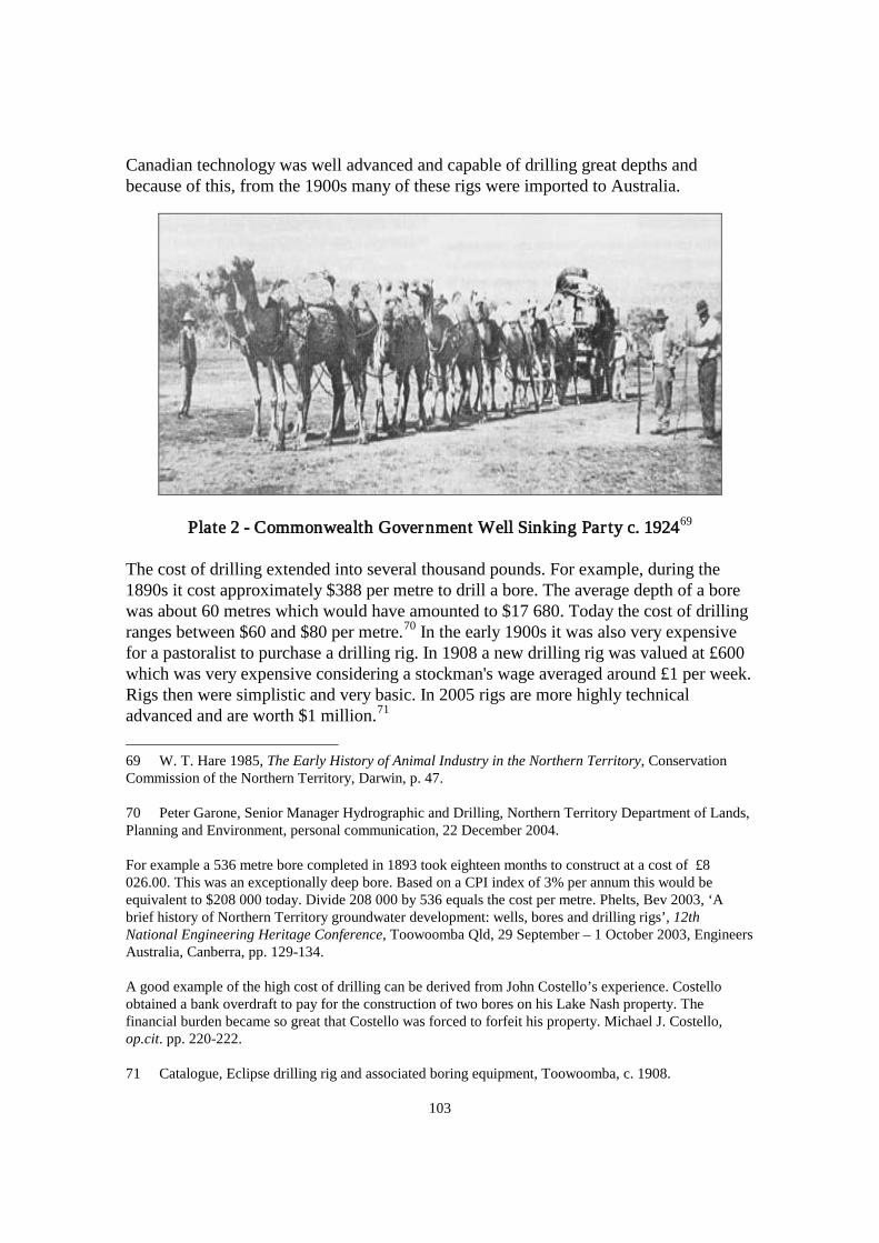
103
Canadian technology was well advanced and capable of drilling great depths and because of this, from the 1900s many of these rigs were imported to Australia.
Plate 2 - Commonwealth Government Well Sinking Par ty c. 192469
The cost of drilling extended into several thousand pounds. For example, during the 1890s it cost approximately $388 per metre to drill a bore. The average depth of a bore was about 60 metres which would have amounted to $17 680. Today the cost of drilling ranges between $60 and $80 per metre.70 In the early 1900s it was also very expensive for a pastoralist to purchase a drilling rig. In 1908 a new drilling rig was valued at £600 which was very expensive considering a stockman's wage averaged around £1 per week. Rigs then were simplistic and very basic. In 2005 rigs are more highly technical advanced and are worth $1 million.71
69 W. T. Hare 1985, The Early History of Animal Industry in the Northern Territory, Conservation Commission of the Northern Territory, Darwin, p. 47.
70 Peter Garone, Senior Manager Hydrographic and Drilling, Northern Territory Department of Lands, Planning and Environment, personal communication, 22 December 2004. For example a 536 metre bore completed in 1893 took eighteen months to construct at a cost of £8 026.00. This was an exceptionally deep bore. Based on a CPI index of 3% per annum this would be equivalent to $208 000 today. Divide 208 000 by 536 equals the cost per metre. Phelts, Bev 2003, ‘A brief history of Northern Territory groundwater development: wells, bores and drilling rigs’, 12th National Engineering Heritage Conference, Toowoomba Qld, 29 September – 1 October 2003, Engineers Australia, Canberra, pp. 129-134. A good example of the high cost of drilling can be derived from John Costello’s experience. Costello obtained a bank overdraft to pay for the construction of two bores on his Lake Nash property. The financial burden became so great that Costello was forced to forfeit his property. Michael J. Costello, op.cit. pp. 220-222. 71 Catalogue, Eclipse drilling rig and associated boring equipment, Toowoomba, c. 1908.

104
Besides the high cost of drilling it was also difficult attracting drillers to the Northern Territory. Wages were low considering the long periods away and the hard conditions that men had to work in. Accommodation consisted of tents that offered little protection from the extreme climate – high humidity and rainfall of the Top End and the zero temperatures in central Australia. Most bores were sunk in remote regions where food, supplies and equipment had to be carted over hundreds of kilometres by animal teams. It was already clear by the turn of the twentieth century that groundwater was a more reliable than surfacewater. As rigs became more available and drilling more economical pastoralists increased the number of bores on their properties. Those who could afford to contract private drillers had already begun to install bores, tanks and windmills before Commonwealth control in 1911.72
On the eve of Commonwealth administration, the pastoral bubble had already burst with water shortages hampering the pastoral industry. In the lead up to government handover, the Top End had experienced several years of low rainfall which severely affected stations. In 1900 Austral Downs Station had no alternative but to relocate stock for a period of five months.73 The same situation confronted the Beetaloo Downs Station in 1909 where for six months stock were continually moved on to new water supplies. The drought had affected the better watered Barkly Tableland region so much that all stations were dependent on borewater.74 In 1910 a drought in the Anthony’s Lagoon region compelled stock to be agisted a great distance away from stations to available water supplies.75
3.3 Commonwealth Government Administration 1911-1978 When the Commonwealth Government became responsible for the Northern Territory in 1911, a great deal of information had been accumulated on water supplies and the pastoral industry in general. Data could be readily sourced from the South Australian Government’s experience, the Northern Territory bulletins, Government Resident and stock inspector reports, and from first hand accounts from drovers, explorers and pastoralists. After forty years of pastoralism, it was a gloomy record - only 25 000 cattle
Garone, op.cit., 22 December 2004. 72 Government Resident’s Report on the Northern Territory for 1903, p. 2. Rink Van derVelde, Water Advisory Officer, Water Resources Division, Department of Lands, Planning and Environment, 1958-1999, personal communication, January 1999. 73 Government Resident’s Report on the Northern Territory for 1900, p. 28. 74 Government Resident’s Report on the Northern Territory for 1909, pp. 18-19. 75 Government Resident’s Report on the Northern Territory for 1910, p. 23.
105
and 550 horses had been exported to the southern markets.76
In the initial years, the Commonwealth Government undertook its new administration with gusto and created the Department of Lands which became responsible for water supply. More attention was given to developing water supplies on stock routes and general infrastructure.77 When Gilruth took up his position as Administrator in 1912 he recognised the need to develop groundwater and ardently promoted its advantages.78 Within a few years, the increase of bores on stock routes had made an impact with the number of cattle and horses travelling to interstate markets doubling. However, the economy had advanced very little and the government’s early enthusiasm waned.79
The Commonwealth phase also marked the emergence of company leaseholds. The London based companies of Bovril Estates and Vesteys soon became well entrenched and prominent pastoral empires for most of the twentieth century.80 By 1937 the north-west section of the Northern Territory was controlled by three large companies consisting of Bovril Australian Estates Limited, the Northern Agency Limited (Vesteys) and Connor Doherty and Durack Limited. By the 1950s Vesteys were leasing Manbulloo, Nutwood Downs, Helen Springs, Waterloo-Limbunya, Wave Hill and Mistake Creek. Other large holdings belonged to the Australian Agricultural Company, Peel River Land and Mineral Company, the Scottish Australian Company and the New Zealand and Australian Land Company.81
Jack Kelly in Struggle for the North is highly critical of company monopolisation, claiming that the absentee landlords did very little in the way of improving their properties.82 On the other hand, it was one of these large companies which ignited the pastoral industry, albeit for a few brief years. When Vesteys opened its meatworks in Darwin in 1917, it was the first time that the industry showed any promise. The meatworks became the largest employer in Darwin, processing and shipping beef to Britain and other international markets. The meatworks closed in 1920 due to industrial unrest, lower beef prices and competition from South America. In 1921 Wyndham and eleven of Queensland’s meatworks followed the same path.83
76 Commonwealth Government 1937, op.cit., p. 88.
77 Administrator’s Report on the Northern Territory for the Year 1912, pp. 6-7, 13-15 & 150. 78 ibid. 79 Commonwealth Government 1937, op.cit., p. 88. 80 John Mettam 1995, Central administration and the Northern Territory 1911-1926, PhD thesis, University of Sydney, pp. 26-27 & 127. 81 Kelly, op.cit., pp. 36-37, 48 & 54. 82 ibid. 83 Mettam, op.cit., pp. 25, 131-132.

106
With better drilling technology, boring rather than well excavation was more economic and the increase in bores soon reflected cattle numbers. Herds throughout the Northern Territory trebled from 214 094 in 1890 to 612 000 in 1920.84 On the Barkly Tableland the number of bores increased from forty in 190985 to eighty in 1920,86 and stock numbers in comparison rose from 69 567 in 1908 to 141 000 in 1921.87
Just when it seemed that progress in boring was beginning make an impact on stock numbers, a drought during the 1920s destroyed any chance of further growth. Barkly Tableland properties were considered progressive and fairly resilient to drought conditions but they were not immune from water shortages. Alexandria Downs Station was running 42 962 head of cattle88 and had twenty-one bores in 1922.89 When the drought peaked in 1928, the station’s cattle numbers had plummeted to 20 962.90 Between 1926 and 1928 all surfacewater had evaporated and Alexandria Downs Station was relying on bores for stock water.91 Avon Downs Station had seventeen bores and 37 800 cattle in 1921.92 In 1926 11 415 cattle died and a further 9 595 perished in 1928.93 In 1925 Rocklands Station cattle numbered 40 00094 and fifteen bores were in operation.95 By 1928 the herd declined considerably to 13 000.96
84 Acting Administrator’s Report on the Northern Territory for the Year Ended 30 June 1920, p. 5. and Duncan, op.cit., p. 159. 85 Kowald & Johnston, op.cit., p. 37. 86 McLaren & Cooper, op.cit., p. 67. 87 Kowald & Johnston, op.cit., p. 41. 88 ibid. 89 Bishop, op.cit., p. 9. 90 NAA NT CRS F48 Item 3, Report, ‘North Australia pastoral leases: stocking conditions’ c. 1935. 91 Kowald & Johnston, op.cit., p. 34. 92 Bishop, op.cit., p. 12. 93 NAA NT CRS F48, Item 4, ‘Statistics in regard to Avon Downs, N.T.’ c. 1930. 94 NAA NT CRS F658, 1935 Northern Territory Pastoral Leases Investigation Committee Report - Rocklands Station. 95 Northern Territory Department of Infrastructure, Planning and Environment, Bore Log Reports for Rocklands Station as at 2002. 96 NAA NT CRS F658, 1935 Northern Territory Pastoral Leases Investigation Committee Report - Rocklands Station.

107
Another drought followed soon after from 1933 to 193597 and the industry was described as being in a ‘very parlous state’.98 In the midst of the drought, the Commonwealth Government unleashed its frustration and disappointment in the industry on the pastoralists. Between 1933 and 1934 the Northern Territory Pastoral Leases Investigation Committee carried out physical inspections of Northern Territory properties. The committee’s primary concern was the general dilapidated state of buildings, fencing and yards, undeveloped water supplies and unhealthy stock. A chief criticism was the inability of managers to increase carrying capacities because of a reliance on natural water supplies. It was noted that most stations only had basic groundwater supplies and during drought or low rainfall periods these supplies would soon disappear. Another issue was the overgrazing of land because water points were so few.99
Very little was achieved by the appointment of the committee and the same matters were raised again in 1937 by a Commonwealth Board of Inquiry which reported:
The lack of water improvements in Central Australia and in other districts in the Northern Territory results in stock being crowded on to a few watering places, the country being grossly overstocked and serious and lasting damage being done to the pastures. Many more water improvements are needed to enable the holdings to be economically and efficiently worked.100
Despite the government’s unrealistic expectation that pastoralists should bear the cost of boring, most pastoralists continued to rely on high rainfall levels and surfacewater for a successful season.101 The possibility that leases may not be extended was another deterrent from investing capital into properties. Alexandria Downs Station for instance, did not drill any bores between 1922 and 1946 because of this risk. This precaution is understandable when considering that in 1940 Alexandria Downs Station had four parcels of land requisitioned for defence purposes.102
97 Northern Territory Land Board, op.cit., p. 13.
98 Administrator’s Report on the Northern Territory for the Year Ended 30 June 1934, p. 4. 99 NAA NT CRS F658. Reports on individual stations are listed under this series. Examples on the condition of stations can be gleaned from the references below; NAA NT CRS F49 Item 27, Report, Northern Territory Investigation Committee, February 1935. NAA NT CRS F658, 1935 Northern Territory Pastoral Leases Investigation Committee Report - Elsey Station. NAA NT CRS F658/51, 1935 Northern Territory Pastoral Leases Investigation Committee Report - Hodgson Downs Station. 100 Commonwealth Government 1937, op.cit., p. 40. 101 Acting Administrator’s Report on the Northern Territory for the Year Ended 30 June 1935, p. 47. 102 NTAS F27 Item 2114 box 1, Pastoral Records and Correspondence 1910-1961 - Alexandria Downs Station, Letter, E. Wood, Field Officer to Administrator, 19 June 1940. Kowald & Johnston, op.cit., p. 108.

108
The Second World War focused attention upon pastoralism in a way that had not been achieved by countless government investigations. One benefit from the war was the local demand for beef which revived the industry.103
Another was the expertise of a boring unit which was solely dedicated to augmenting groundwater supplies on stations, defence installations and stock routes.
Between Darwin and Larrimah alone, the Department of Defence drilled 200 bores.104
The bores largely followed the Stuart Highway which was also the south and north stock route. The bores benefited users of the stock route, nearby pastoral properties and the army agricultural farms which were situated along the highway. The bores were equipped with the newest technology such diesel driven pumps or windmills, piping, troughs and large tanks A consequence of the Second World War was the upgrading of stock routes and water supplies and a fleeting pastoral boom.
In 1947 the Northern Australia Development Committee delivered a report highlighting the shortages of water on properties. The committee’s main objection was the shortage of bores on stations, pointing out that one bore was supporting up to 4 000 cattle when realistically one bore should be watering 500 cattle. The result was overcrowding, erosion, the need for a full time water pumper and the degradation of pasture. It was recommended that government provide financial assistance in boring, and stipulate on new leases a period of time in which leaseholders had to establish a set number of water points.105
When a drought followed in the early 1950s, it soon became apparent that much more work had to be done in groundwater development. The 1950s drought also incited condemnation against government for its ineptitude and lack of active involvement.106
103 Pastoralism boomed during the war period so much that in 1945, Administrator Abbott commented that for the first time in history no lessee had outstanding rent.
Administrator’s Report on the Northern Territory for the Year Ended 1944-1945, p. 5. Administrator’s Report on the Northern Territory for the Year Ended 1945-1946, p. 7. 104 NAA NT CRS E742 Item 1946/37M vol 1, Letter, T. Barnes, Department of Mines, Adelaide to N. T. Administration, Mines Branch, 21 September 1945. 105 NTAS Northern Territory Pastoral Lessees Association Records, PAC106 199/1/1, Item reports section 1-37, unprocessed collection, Northern Australia Development Committee 1947, Report on the Development of Northern Australia 1946-1947, Commonwealth Government, Canberra, pp. 9, 27 & 28. Maryvale Station serves as an example with only four dams, one well and no bores. NTAS Series F1041 Item PL119C part 1 box 2, Letter, W. J. Davidson, Chief Clerk to R. C. Ward, Solicitor, Alice Springs, 22 December 1947. 106 NTAS Northern Territory Pastoral Lessees Association Records, PAC106 Series 199/1/1, Item A1/1B, Executive Minutes 1953-1960, unprocessed collection, Northern Territory Pastoral Lessees’ Association 1957 Annual Report, p. 2.

109
In fact it could be said that except for the need during the war, the Commonwealth Government showed little interest in assisting pastoralists to drill bores. 3.4 Drought Low rainfall levels and water shortages were common problems for most of the time but during drought water supplies became critical. Stock were culled or sold quickly and usually below cost. Herds were agisted to other properties or interstate but many perished on the journey. Birth rates were naturally reduced and calves were more susceptible to death because their mothers left them for long periods to find water and fodder.107
The Northern Territory experienced nineteen recorded droughts between 1896 and 1964, with drought periods ranging from eighteen months to six years.108
Drought conditions, although more prevalent in central Australia, occurred throughout the Northern Territory in varying degrees and regions. Borewater was, and still is, fundamental to supplementing surfacewater supplies that easily evaporate during drought. Although borewater did not wholly protect pastoralists against drought conditions it nonetheless, reduced the uncertainty of water shortages.
A dry period on the Barkly Tableland between 1891 and 1893 incited Alexandria Downs Station to become one of the first properties to develop its groundwater supplies.109 During this time, every herd on the Tableland had to be constantly moved to watered areas or agisted to other properties but it still did not prevent one third of these herds dying.110 During the 1896 to 1903 drought, the station lost 5 000 of its 15 000 cattle in 1897.111 Considering that Alexandria Downs Station could boast of having nine wells at the time, when other Barkly Tableland stations had fewer,112
107 E. J. Connellan 1965, Drought Management and Pasture Protection in Central Australia, Centralian Pastoralists’ Association, Adelaide, pp. 3-9.
it can be assumed
108 Northern Territory Land Board, op.cit., p. 13. 109 Alexandria Downs Station can lay claim to drilling the first sub-artesian bore between 1892 and 1893. Bev Phelts 1999, ‘Northern Territory’, in A Century of Water Resources Development in Australia: 1900-1999, ed Walter Boughton, The Institution of Engineers Australia, Barton, p. 174. In addition to this, by 1896 Alexandria Downs Station had nine wells that exceeded water supplies on other Barkly Tableland stations. Department of Lands, Planning and Environment, Darwin, Bore Log Reports on Barkly Tableland Stations. 110 Duncan, op.cit., pp. 50-51. 111 Cattle loss was solely due to drought and not Redwater disease which was rampant at the time. Kowald & Johnston, op.cit., p. 34. This is also supported by Duncan, op.cit., p. 50. 112 Department of Lands, Planning and Environment, Darwin, Bore Log Reports on Barkly Tableland Stations.

110
that herd losses on the Tableland in general would have been significant. Like the previous drought, cattle had to be shifted to watered regions which at the time was a task that pastoralist John Costello despaired about:
A hazardous succession of lengthy dry stages had to be crossed - stretches of drought-stricken land, grassless, waterless, sweltering under a torrid sun and rolling clouds of suffocating dust of blinding and burning intensity. Over these areas the perishing cattle had to be taken, driven by weary horses, ridden by tired and thirsty men. Mostly night journeying it was - less trying on the stock, but sleepless times for men, ever on the move...113
Water shortages still plagued the Barkly Tableland in 1911 when J. Kerin, Inspector of Stock, visited. Kerin reported that surfacewater and pasture was nonexistent and all stock was being watered from bores: ‘Stock suffered heavily, having to walk so far to and from feed, this no doubt has had a bad effect on the...cattle... The great necessity for many more sub-artesian bores has again been impressed on station managers’.114
When the Barkly Tableland experienced droughts between 1925 and 1938 Alexandria Downs Station had by then, become independent from surfacewater. Between 1926 and 1928 when the drought was at its worst, the station was able to support its herds on borewater. Although stock were able to withstand drought conditions it was still with great difficultly, cattle were consistently moved to water and full time bore pumpers maintained the water supply.115
The drought that ravaged central Australia between 1952 to 1964 best serves as an example of how water shortages can devastate the industry. The difficulties of securing water sources in the pioneering years of pastoralism continued to be reflected in the 1950s when water development had barely made an impact in arid Australia. Despite the fact that most Top End stations had numerous bores by the 1950s, boring was still in its infancy in central Australia.116 Although this particular drought has been recorded as the most brutal with cattle numbers reduced from 353 000 to 130 000,117
it marked a turning point in water development.
113 John Costello quoted in Duncan, op.cit., p. 51. 114 Report on the Administration of Northern Australia for the Year Ending 30 June 1911, p. 34. 115 Kowald & Johnston, op.cit., pp. 34-35. 116 Graham Ride, Groundwater Engineer, Department of Infrastructure, Planning and Environment, Alice Springs, personal communication, 7-9 September 2000. 117 Letter, Administrator to Secretary, Department of Territories, 25 January 1966, author’s personal collection.

111
The severity of the drought compelled the Commonwealth Government to initiate a drought relief program to support pastoralists both financially and technically.118
Pleas for boring assistance soon inundated government with one desperate request from Poppy Banos, the manager of Maryvale Station in central Australia. Maryvale Station was undergoing its eighteenth drought in 1957 and had not recovered from the previous drought in 1956. Banos wrote that during the year five bores had been drilled and only one had produced water:
Conditions were bad then [in 1956], but now they are desperate. Cattle are dying every day because they haven’t the strength to walk to feed. There are some good patches of feed about, but no water within miles...Is there anything you can do to help us?119
Small wonder that in 1994 Maryvale Station could boast of twelve bores and eight large dams.120
Other regions of the Northern Territory were encountering drought effects and requests for aid extended as far as the Gulf region, a region considered well watered. The Gulf Cattle Company manager urged the government to drill three bores on his property to protect the last of his herd. The manager had already agisted his bullocks interstate and only breeding stock remained. He requested government assistance in boring before the rest of his cattle perished.121 The drought also affected Rosewood Station in the north-west, which prompted the manager to appeal directly to the Administrator for assistance. The manager wrote that the station had already invested enormous time and capital into boring but could not keep abreast of drought conditions.122
118 The government may have been motivated by criticism. Pastoral company, Managers and Agents Propriety Limited claimed the government should assist pastoralists to develop their water supplies. Letter, Managers and Agents Propriety Limited to Director, Department of Lands, 3 April 1953, author’s personal collection.
If a government drilling rig
Pastoralist D. Brown also criticised government for the lack of water points on stock routes. Brown was forced to divert his cattle hundreds of kilometres away from his route, so that the cattle could obtain water. NAA NT CRS F425 Item C70, Letter, D. Brown, Murray Downs Station, Alice Springs to Director of Lands, 19 July 1952. 119 Letter, Poppy Banos, Manager Maryvale Station to Resident Geologist, 29 October 1957, author’s personal collection. 120 Northern Territory Department of Infrastructure, Planning and Environment, Pastoral Branch, File ‘Maryvale Station’, Facismile, Ted Easton, Pastoral Officer to Phil Sheridan, Maryvale Station, 3 March 1994. 121 Letter, Director, Department of Lands to Administrator, 18 April 1958, author’s personal collection. 122 NAA NT CRS F1 Item 1952/887, Letter, H. K. Fuller, Manager Rosewood Station to Administrator, 15 June 1952.

112
was not sent to Rosewood the manager believed that his remaining stock would die.123
As the drought intensified, so did demand for government assistance. By 1958 the government had five drilling rigs operating in drought stricken areas.124 In 1961 the Commonwealth Government legislated the Water Supplies Development Ordinance. The Ordinance was a Commonwealth initiative managed by Northern Territory Administration. Under the Ordinance, the Drought Relief Scheme which was introduced in the 1950s evolved into the ‘Dud’ Bore Scheme. The scheme was an incentive for pastoralists to develop water supplies on their properties. The government provided pastoralists with both technical and financial assistance and covered the cost of non productive bores. A low interest loan was available to landholders who wished to develop their water resources.125 Within the first two years, the Water Resources Branch received 289 applications for bores.126 When considering that in 1938 there were approximately 163 bores throughout the Northern Territory, this was a significant increase in such a short time.127
Along with the government’s new initiative was the delivery of a rotary air drilling rig in 1960 from the United States.128
Considering that Rosewood's cattle numbers barely declined during this period Fuller could have exaggerated the station's situation. Duncan mentions that pastoralists were known to overestimate stock losses. Duncan, op.cit., p. 50.
Rotary drilling revolutionised boring as it had the advantage of faster penetration and offered two methods to flush out cuttings from the borehole, either by air or water. Mud drilling had been the prominent method until the 1960s but this method required great amounts of water. Rotary air rigs use compressed air which eliminates the need for water, a commodity not readily available on pastoral
123 NAA NT CRS F1 Item 1952/887, Report on Rosewood Water Position, G. A. Buchanan, Field Officer to Senior Field Officer, 26 June 1952. 124 Letter, Director, Department of Lands to Administrator, 18 April 1958, author’s personal collection. 125 The scheme still continues to today and is known as the Pastoral Water Enhancement Scheme. Rink Van derVelde, Water Advisory Officer, Water Resources Division, Department of Lands, Planning and Environment, 1958-1999, personal communication, 9 December 2004. 126 Water Resources History Committee 1998, Water Resources: 40 Years On: History of the Northern Territory Water Resources Division, Department of Lands, Planning and Environment, Darwin, pp. 9-10. 127 Mervyn Chin, Bore Data Officer, Northern Territory Department of Infrastructure, Planning and Environment, Darwin, personal communication 30 October 2002. 128 NTAS Northern Territory Pastoral Lessees Association Records, PAC106 Series 199/1/1, Item A1/2E, Letters and Newspaper Cuttings 1930-1963, unprocessed collection, Newspaper article, The Northern Territory News, 7 October 1960.

113
properties.129 The new rig was first sent to Brunette Downs Station to assist in drought relief then later operated in other regions.130
The 1960s were a milestone in technological advances for the pastoral industry. Motor bikes, helicopters, four wheel drives and two-way radios were increasingly used on stations. A boost in Commonwealth Government funding allowed the development of the beef roads, improved transport and the new water development scheme were fundamental in opening up more land for grazing and alleviating water problems.131
3.5 Groundwater and Carrying Capacities Until groundwater surpassed dependence on surfacewater, pastoralists had no option but to limit stock numbers according to the quantity and permanence of water on their properties. Herd size of stations is governed by the land’s ability to support cattle in both pasture and water. If the land’s resources are not developed it would not be possible to increase the size of herds. An example of the affects of water development on cattle capacities can be drawn from the pioneering experiences of Alexandria Downs and Brunette Downs Stations. Refer to Tables 13 and 14 below.
129 Peter Garone, Senior Manager Hydrographic and Drilling & Brian Kunde, Drill and Bore Test Manager, Department of Infrastructure, Planning and Environment interview by Bev Phelts, Natural Resources Division, Department of Infrastructure, Planning and Environment, 31 January 2003. 130 NTAS Northern Territory Pastoral Lessees Association Records, PAC106 Series 199/1/1, Item A1/2E, Letters and Newspaper Cuttings 1930-1963, unprocessed collection, Newspaper article, The Northern Territory News, 7 October 1960. 131 NTAS Northern Territory Pastoral Lessees Association Records, PAC106 Series 199/1/1, Item D3/4J, Miscellaneous Correspondence and Cuttings 1948-1963, unprocessed collection, Newspaper articles, The Northern Territory News, 28 June 1960, 11 October 1960 & 14 June 1962.

114
Table 13 - Alexandria Downs Station (Barkly Tableland)132
132 Government Resident’s Report on the Northern Territory for 1901, p. 3.
Administrator’s Report on the Northern Territory for the Year 1912, p. 115. Duncan, op.cit., p. 161; Kowald & Johnston, op.cit., pp. 33-38, 41, 47, 50, 69, 108-109; Hare, op.cit., p. 4. and Bishop, op.cit., pp. 7-9 NAA NT CRS F48 Item 6, Report, ‘Pastoral inspections by F. A. C. Bishop 1922’. NAA NT CRS F48 Item 3, Report, ‘North Australia pastoral leases: stocking conditions’, c. 1935; ‘Barkly Tableland district pastoral leases: stocking conditions’, c. 1935. NAA NT CRS F1 Item 1954/537, Letter, n.a., c. 1954. NAA NT CRS F1 Item 1955/386, List of station properties and improvements, c. 1958. NAA NT CRS E72/1, Item D9968/1, Letter, D. M. Fraser, Chairman, North Australian Pastoral Company Ltd to the Administrator, 19 May 1960 and Letter, n.a., c. 1961. NTAS F27 Item 2123 box 2, Pastoral Records and Correspondence 1910-1961 – Alexandria Downs Station, Letter, B. M. Fraser, Manager to Sir Donald Cameron, Queensland Club, Brisbane, 24 April 1936. NTAS Northern Territory Pastoral Lessees Association Records, PAC106 Series 199/1/1, Item D1/1C, Carrying Capacity of Pastoral Leases, unprocessed collection, Jack Kelly, Potential Carrying Capacities of Stations, 20 October 1956; Item A2/1F, Circulars 1975-78, Letters, unprocessed collection, Newspaper article, The Northern Territory News, 5 September 1967 and Item A2/1D, Letters, Cuttings and Details on Association Members, unprocessed collection, Letter, Northern Territory Cattleman’s Association to Ken Moore, Alexandria Downs Station, 11 July 1972. Northern Territory Department of Infrastructure, Planning and Environment, Pastoral Branch, File ‘Alexandria’, Pastoral Inspection Report, J. Franklin, Pastoral Officer, 5 June 1983; File ‘Alexandria Downs’, Pastoral Inspection Report, Steve Robertson, Pastoral Officer, 18 July 1991 and Bore Log Reports for Alexandria Station as at 2002 Ross Peatling, Manager Alexandria Downs Station, personal communication, 12 December 2002.
Cattle Capacities and Bore Numbers - Alexandria Downs Station
0255075
100125150
1885
1895
1905
1915
1925
1935
1945
1955
1965
1975
1985
1995
2005
Bore
Num
bers
020,00040,00060,00080,000100,000
Cattl
e Nu
mbe
rs
BORES CATTLE
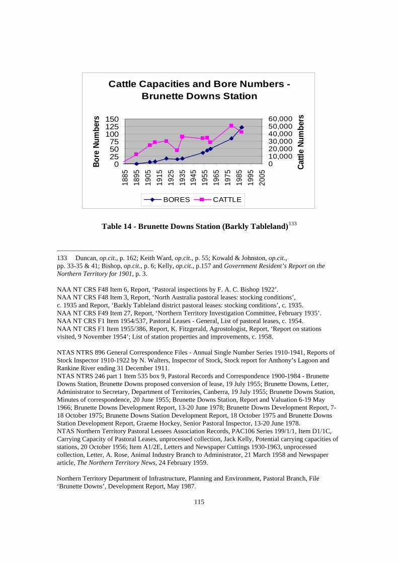
115
Cattle Capacities and Bore Numbers - Brunette Downs Station
0255075
100125150
1885
1895
1905
1915
1925
1935
1945
1955
1965
1975
1985
1995
2005
Bore
Num
bers
010,00020,00030,00040,00050,00060,000
Cattl
e Nu
mbe
rs
BORES CATTLE
Table 14 - Brunette Downs Station (Barkly Tableland)133
133 Duncan, op.cit., p. 162; Keith Ward, op.cit., p. 55; Kowald & Johnston, op.cit., pp. 33-35 & 41; Bishop, op.cit., p. 6; Kelly, op.cit., p.157 and Government Resident’s Report on the Northern Territory for 1901, p. 3. NAA NT CRS F48 Item 6, Report, ‘Pastoral inspections by F. A. C. Bishop 1922’. NAA NT CRS F48 Item 3, Report, ‘North Australia pastoral leases: stocking conditions’, c. 1935 and Report, ‘Barkly Tableland district pastoral leases: stocking conditions’, c. 1935. NAA NT CRS F49 Item 27, Report, ‘Northern Territory Investigation Committee, February 1935’. NAA NT CRS F1 Item 1954/537, Pastoral Leases - General, List of pastoral leases, c. 1954. NAA NT CRS F1 Item 1955/386, Report, K. Fitzgerald, Agrostologist, Report, ‘Report on stations visited, 9 November 1954’; List of station properties and improvements, c. 1958. NTAS NTRS 896 General Correspondence Files - Annual Single Number Series 1910-1941, Reports of Stock Inspector 1910-1922 by N. Walters, Inspector of Stock, Stock report for Anthony’s Lagoon and Rankine River ending 31 December 1911. NTAS NTRS 246 part 1 Item 535 box 9, Pastoral Records and Correspondence 1900-1984 - Brunette Downs Station, Brunette Downs proposed conversion of lease, 19 July 1955; Brunette Downs, Letter, Administrator to Secretary, Department of Territories, Canberra, 19 July 1955; Brunette Downs Station, Minutes of correspondence, 20 June 1955; Brunette Downs Station, Report and Valuation 6-19 May 1966; Brunette Downs Development Report, 13-20 June 1978; Brunette Downs Development Report, 7-18 October 1975; Brunette Downs Station Development Report, 18 October 1975 and Brunette Downs Station Development Report, Graeme Hockey, Senior Pastoral Inspector, 13-20 June 1978. NTAS Northern Territory Pastoral Lessees Association Records, PAC106 Series 199/1/1, Item D1/1C, Carrying Capacity of Pastoral Leases, unprocessed collection, Jack Kelly, Potential carrying capacities of stations, 20 October 1956; Item A1/2E, Letters and Newspaper Cuttings 1930-1963, unprocessed collection, Letter, A. Rose, Animal Industry Branch to Administrator, 21 March 1958 and Newspaper article, The Northern Territory News, 24 February 1959. Northern Territory Department of Infrastructure, Planning and Environment, Pastoral Branch, File ‘Brunette Downs’, Development Report, May 1987.

116
Alexandria Downs was initially a larger station than Brunette Downs Station but Brunette Downs had the advantage of two permanent lagoons and was able to support more cattle. In 1887 Brunette Downs had 12 000 cattle compared to Alexandria Downs’ 8 500. By 1907 Alexandria Downs had five operational bores and had increased stock numbers to 20 000 while at the same time, Brunette Downs had six bores and 25 000 cattle. In 1922 bores on Alexandria Downs numbered twenty-one and more land had been opened up for grazing. Alexandria Downs’ herd had more than doubled to 42 962, surpassing Brunette Downs’ 30 000.134
It can be seen in the two tables that during the 1920s drought, herd sizes declined significantly on both stations. This was because bores were still not sufficient in numbers to offset drought conditions. In contrast, an increase in the number of bores over the years protected the stations against a great loss of cattle during the 1950s drought. By 1975 Brunette Downs was supporting 50 000 cattle on 120 bores135 and had almost reached its estimated carrying capacity of 59 185.136 In 1991 Alexandria Downs was maintaining 48 404 cattle on fifty-six bores but the pastoral inspector considered that if more bores were constructed, the station could increase this number to 58 200.137 Alexandria Downs exceeded this estimation and in 2002 was sustaining 79 123 cattle on 122 bores. Considering that Alexandria Downs was affected by drought conditions during 2001 and 2002,138
these figures show the influence that groundwater can have on carrying capacities during drought conditions.
It can be seen in the tables above that as bores increased so did cattle numbers. This was not an isolated trend but was familiar to other Northern Territory stations as the following tables show. The stations examined in this chapter have been selected from various climatic regions in the Northern Territory and all illustrate the advantages of bores in relation to carrying capacities.
134 Kowald & Johnston, op.cit., pp. 35 & 41; Bishop, op.cit., p. 9; Keith Ward, op.cit., p. 55. 135 NTAS NTRS 246 part 1 Item 535 box 9, Pastoral Records and Correspondence 1900-1984 - Brunette Downs Station Development Report, 18 October 1975. 136 Northern Territory Department of Infrastructure, Planning and Environment, Pastoral Branch, File ‘Brunette Downs’, Development Report, May 1987. 137 Northern Territory Department of Infrastructure, Planning and Environment, Pastoral Branch, File ‘Alexandria Downs’, Pastoral Inspection Report, Steve Robertson, Pastoral Officer, 18 July 1991. 138 Peatling, op.cit.

117
Table 15 - Victoria River Downs Station (Victoria River District)139
139 Hare, op.cit., p. 4; Kowald & Johnston, op.cit., p. 35 and McLaren & Cooper, op.cit., pp. 142 & 191.
The Northern Territory News, 3 July 1962. Australia, Senate and House of Representatives 1933, Debates, 26 October to 29 November, vol. 142, session 1932, p. 5135. NAA NT CRS F48 Item 3, Report, ‘North Australia pastoral leases: stocking conditions’, c. 1935; Report, ‘Victoria River district pastoral leases: stocking conditions’, c. 1935. NAA NT CRS F1 Item 1955/386, List of station properties and improvements, c. 1958; Report, K. Fitzgerald, Agrostologist, Report, ‘Report on stations visited, 9 November 1954’. NTAS NTRS 896 General Correspondence Files - Annual Single Number Series 1910-1941, Reports of Stock Inspector 1910-1922 by N. Walters, Inspector of Stock, Letter, Manager Victoria River Downs Station to Stock Inspector, Bovril Australian Estates Ltd., 31 December 1920. NTAS NTRS F630 Item 121 Box 3, Pastoral Records and Correspondence 1900-1984 - Victoria Downs Station, Cattle figures for the years 1934-1940 inclusive. NTAS NTRS F630 Item 120 box 2, Pastoral Records and Correspondence 1900-1984 - Victoria Downs Station, Inspection Report, D. McInnes, 24 November 1949. NTAS Northern Territory Pastoral Lessees Association Records, PAC106 Series 199/1/1, Item D1/1C, Carrying Capacity of Pastoral Leases, unprocessed collection, Jack Kelly, Potential carrying capacities of stations, 20 October 1956 and Item A2/1E, Letters and Newspaper Cuttings , unprocessed collection, Newpaper article, The Northern Territory News, c. December 1967. NTAS NTRS F630 Item PL120AN, Report, ‘Victoria River Downs - Bovril Australian Estates Limited, 14 January 1942’. Northern Territory Department of Infrastructure, Planning and Environment, Pastoral Branch, File ‘Victoria River Downs’, Inspection Report, Graeme Hockey, Senior Pastoral Inspector, 14 October 1987; File ‘Victoria River Downs’, History of Victoria River Downs Station, n.a., n.d., pp. 20-21, 29, 35-36 and
Cattle Capacities and Bore Numbers - Victoria River Downs Station
0255075
100
1885
1895
1905
1915
1925
1935
1945
1955
1965
1975
1985
1995
2005
Bor
e N
umbe
rs
020,00040,00060,00080,000100,000
Cat
tle
Num
bers
BORES CATTLE

118
Although Victoria River Downs Station has access to the Victoria River, the station suffered from water shortages during the 1950s and 1960s drought and the loss of thousands of cattle. For example, in 1953 cattle numbers were 85 000140 but in1962 the herd was reduced to 40 000.141 On the eve of the drought in 1949 Victoria River Downs Station had twelve bores. The severity of the drought necessitated the drilling of additional bores and by 1962, the station had thirty-four bores142 with a further ten drilled by 1967.143
The estimated carrying capacity of Victoria River Downs Station was 60 000 cattle144 but in 1987 the station was maintaining 71 341 on seventy-four bores.145 In 1999, the herd peaked at 90 000146 and the station had eighty-three bores.147
Bore Log Reports for Victoria River Station as at 2002. 140 Northern Territory Department of Infrastructure, Planning and Environment, Pastoral Branch, File ‘Victoria River Downs’, History of Victoria River Downs Station, n.a., n.d., p. 15. 141 ibid., p. 29. 142 Northern Territory Department of Infrastructure, Planning and Environment, Bore Log Reports for Victoria River Downs Station as at 2002. 143 NTAS Northern Territory Pastoral Lessees Association Records, PAC106 Series 199/1/1, Item A2/1E, Letters and Newspaper Cuttings , unprocessed collection, Newpaper article, The Northern Territory News, c. December 1967. 144 McLaren & Cooper, op.cit., p. 191. 145 Northern Territory Department of Infrastructure, Planning and Environment, Pastoral Branch, File ‘Victoria River Downs’, Inspection Report, Graeme Hockey, Senior Pastoral Inspector, 14 October 1987. 146 McLaren & Cooper, op.cit., p. 191. 147 Northern Territory Department of Infrastructure, Planning and Environment, Bore Log Reports for Victoria River Downs Station as at 2002.
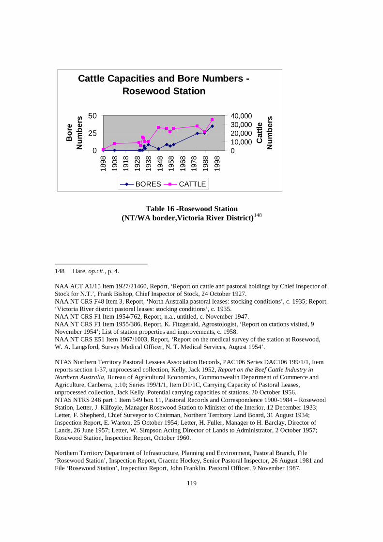
119
Table 16 -Rosewood Station
(NT/WA border,Victoria River District)148
148 Hare, op.cit., p. 4. NAA ACT A1/15 Item 1927/21460, Report, ‘Report on cattle and pastoral holdings by Chief Inspector of Stock for N.T.’, Frank Bishop, Chief Inspector of Stock, 24 October 1927. NAA NT CRS F48 Item 3, Report, ‘North Australia pastoral leases: stocking conditions’, c. 1935; Report, ‘Victoria River district pastoral leases: stocking conditions’, c. 1935. NAA NT CRS F1 Item 1954/762, Report, n.a., untitled, c. November 1947. NAA NT CRS F1 Item 1955/386, Report, K. Fitzgerald, Agrostologist, ‘Report on ctations visited, 9 November 1954’; List of station properties and improvements, c. 1958. NAA NT CRS E51 Item 1967/1003, Report, ‘Report on the medical survey of the station at Rosewood, W. A. Langsford, Survey Medical Officer, N. T. Medical Services, August 1954’. NTAS Northern Territory Pastoral Lessees Association Records, PAC106 Series DAC106 199/1/1, Item reports section 1-37, unprocessed collection, Kelly, Jack 1952, Report on the Beef Cattle Industry in Northern Australia, Bureau of Agricultural Economics, Commonwealth Department of Commerce and Agriculture, Canberra, p.10; Series 199/1/1, Item D1/1C, Carrying Capacity of Pastoral Leases, unprocessed collection, Jack Kelly, Potential carrying capacities of stations, 20 October 1956. NTAS NTRS 246 part 1 Item 549 box 11, Pastoral Records and Correspondence 1900-1984 – Rosewood Station, Letter, J. Kilfoyle, Manager Rosewood Station to Minister of the Interior, 12 December 1933; Letter, F. Shepherd, Chief Surveyor to Chairman, Northern Territory Land Board, 31 August 1934; Inspection Report, E. Warton, 25 October 1954; Letter, H. Fuller, Manager to H. Barclay, Director of Lands, 26 June 1957; Letter, W. Simpson Acting Director of Lands to Administrator, 2 October 1957; Rosewood Station, Inspection Report, October 1960. Northern Territory Department of Infrastructure, Planning and Environment, Pastoral Branch, File ‘Rosewood Station’, Inspection Report, Graeme Hockey, Senior Pastoral Inspector, 26 August 1981 and File ‘Rosewood Station’, Inspection Report, John Franklin, Pastoral Officer, 9 November 1987.
Cattle Capacities and Bore Numbers - Rosewood Station
0
25
50
1898
1908
1918
1928
1938
1948
1958
1968
1978
1988
1998
Bor
e N
umbe
rs
010,00020,00030,00040,000
Cat
tle
Num
bers
BORES CATTLE

120
The first official record of bores on Rosewood Station was noted by the government chief surveyor who wrote that there were six bores on the property in 1934.149 Geraldine Byrne in her book Tom and Jack: A Frontier Story mentions that the Commonwealth Government arranged and subsidised a driller to bore for water on the property.150
It is possible that it was these bores that the government contractor drilled.
Rosewood Station encompasses several huge creeks and has access to semi permanent springs, the main ones being Kinevans, Condons, Duckhole and Dead Horse Springs.151 The station relied on the Keep, Baine and Behn Rivers for stock water until bores were drilled.152
Between 1930 and 1945 Rosewood Station was regarded as one of the best managed and improved stations in the Top End and in 1954 the owner was commended by the pastoral inspector for developing the property’s groundwater supplies.153 The station was owned by the Kilfoyles who also managed it from 1885 to 1908 and again from 1922 to 1947. The Kilfoyles had meticulously recorded the station's rainfall levels since 1886 until its sale in 1947. The owners practiced land conservation methods by fencing waterholes and rivers and regularly moved cattle to prevent overgrazing. Jack Kilfoyle, the sole owner had by 1946 installed twenty-two windmills and had a contractual arrangement with Southern Cross for the regular maintenance and upgrade of his water pumping equipment.154
Table 16 shows that this is supported by the steady rise of cattle numbers. Since 1935 the station’s herd continued to increase until the introduction of the Brucellosis and Tuberculosis Eradication Campaign.155
149 NTAS NTRS 246 part 1 Item 549, Rosewood Station, Letter, F. Shepherd, Chief Surveyor to Chairman, Northern Territory Land Board, 31 August 1934.
In 1954 Rosewood Station’s herd numbered
150 Geraldine Byrne 2003, Tom and Jack: A Frontier Story, Fremantle Arts Centre Press, Fremantle, p. 200. 151 Northern Territory Government Map 1973, ‘Newry’, Sheet 4765, 1st edn, Department of Mines and Energy, Commonwealth Government Printer, Canberra. R. Sanders & L. R. Rajaratnam, Power and Water Authority 1994, Water Resources Survey of the Western Victoria River District: Rosewood Station, Power and Water Authority, Darwin, [pages not numbered]. 152 Byrne, op.cit., p. 200. 153 NTAS NTRS 246 part 1 Item 549 box 11, Pastoral Records and Correspondence 1900-1984 - Rosewood Station, E. Warton, Inspection Report, 25 October 1954. NAA NT CRS E51 Item 1967/1003, Report, ‘Report on the medical survey of the station at Rosewood, W. A. Langsford, Survey Medical Officer, N. T. Medical Services, August 1954’. 154 Byrne, op.cit., pp. 167-169, 190, 200 & 239. 155 The Brucellosis and Tuberculosis Eradication Campaign (B.T.E.C.) operated between 1980 and

121
25 000 and was sustained by eight bores.156
The additional two bores could have been drilled in 1952 when H. K. Fuller, the station manager asked the government to drill more bores on the property. If this was the case, then the station had not drilled any bores between 1934 an 1952. Byrne does not mention the reason why or if the station was under the threat of resumption during the war like Alexandria Downs Station.
Regardless the station must have had access to ample water supplies as its herd only declined slightly during the early 1950s. A report by W. Langsford, a visiting medical officer, confirms this. Langsford observed that there were twenty-one water points on Rosewood Station and he described the station as one of the finest in northern Australia.157 In 1981 Rosewood had more than doubled its estimated carrying capacity of 12 876, and was carrying 28 000 cattle supported by twenty-four bores.158 Under the Brucellosis and Tuberculosis Eradication program (B.T.E.C.), Rosewood Station’s herd was culled considerably reducing it to 20 300.159 By 1994 Rosewood Station had sunk fifty-seven bores but only thirty-five were operational. Since B.T.E.C. the station’s herd had increased to 35 000.160
1992. In order to improve the pastoral industry and its market, the Northern Territory Government successfully eliminated Brucellosis and Tuberculosis disease from Northern Territory cattle. Under the program stock were tested for the diseases and thousands of stock (including buffalo) were destroyed. 156 NTAS NTRS 246 part 1 Item 549 box 11, Pastoral Records and Correspondence 1900-1984 - Rosewood Station, E. Warton, Inspection Report, 25 October 1954. 157 NAA NT CRS E51 Item 1967/1003, Report, ‘Report on the medical survey of the station at Rosewood, W. A. Langsford, Survey Medical Officer, N.T. Medical Services, August 1954’. 158 Northern Territory Department of Infrastructure, Planning and Environment, Pastoral Branch, File ‘Rosewood Station’, Inspection Report, Graeme Hockey, Senior Pastoral Inspector, 26 August 1981. 159 Northern Territory Department of Infrastructure, Planning and Environment, Pastoral Branch, File ‘Rosewood Station’, Inspection Report, John Franklin, Pastoral Officer, 9 November 1987. 160 Sanders & Rajaratnam, op.cit., [pages not numbered]. Keith Lunn, Stock Inspector, Department of Business, Industry and Resource Development, Katherine, personal communication, 1 July 2004.

122
Cattle Capacities and Bore Numbers - Undoolya Station
0
25
1885
1895
1905
1915
1925
1935
1945
1955
1965
1975
1985
1995
2005
Bor
e N
umbe
rs
05,00010,000
Cat
tle
Num
bers
BORES CATTLE
Table 17 - Undoolya Station (Central Australia)161
Undoolya Station, like other central Australian stations, has a long history of unsuccessful boring. In arid Australia, surfacewater is scarce, unreliable and subject to high evaporation rates which is why the region wholly relies on groundwater. During the pioneering years, well and bore construction was a painstaking process because of the hard strata. Usually excavation stopped once water was struck, but over a period of time, the water level would gradually drop making it necessary to deepen the well further. The water supply in the arid region is heavily mineralised and has a high salt content, rendering it sometimes unsuitable for cattle.
161 Hare, op.cit., p. 4. NAA NT CRS F48 Item 3, Report, ‘Alice Springs pastoral leases: stocking conditions’, c. 1935. NAA NT CRS F658, 1935 Northern Territory Pastoral Leases Investigation Committee Report - Undoolya Station. NAA NT CRS F1 Item 1955/386, List of station properties and improvements, c. 1958. NTAS F27 Item 2287 box 2, Pastoral Records and Correspondence 1910-1961 - Undoolya Station, Letter, C. L. A. Abbott to Secretary, Department of the Interior, Canberra, 25 November 1943. NTAS NTRS F630 Item 120 box 3, Pastoral Records and Correspondence 1900-1984 - Undoolya Station, Letter, E. & A. J. Hayes, Manager to Secretary, Department of the Interior, Canberra, 12 August 1933; Letter, W. Clough, Field Officer to Lands and Survey Branch, Darwin, 4 August 1950. NTAS Northern Territory Pastoral Lessees Association Records, PAC106 Series 199/1/1, Item D1/1C, Carrying Capacity of Pastoral Leases, unprocessed collection, Jack Kelly, Potential carrying capacities of stations, 20 October 1956 and Item A2/2I, CPA Minutes and Cuttings 1979-1982, unprocessed collection, Letter, Centralian Cattleman’s Association to W. Devos, Sydney, 29 April 1984. Northern Territory Department of Infrastructure, Planning and Environment, Pastoral Branch File ‘Cattle Capacities’; Memorandum, Graeme Hockey, Senior Pastoral Officer to Head of Division, 6 August 1982; File ‘Undoolya Station’, Inspection Report, Graeme Hockey, Senior Pastoral Inspector, 5 March 1985 and File ‘Undoolya’, Inspection Report, D. Brown, Pastoral Officer, 22 April 1991.

123
Undoolya Station has an extensive record of drilling attempts to locate good water supplies. In 1935 Undoolya Station had still not secured a reliable groundwater source although five wells had been excavated.162 The Hayes family was well aware of the disadvantages of limited vegetation and water in central Australia and the effect it had on the condition of cattle. Their cattle were generally inferior compared to larger and better quality stock from other parts of Australia. By the time the Hayes cattle reached the Adelaide market by hoof their health and weight had deteriorated significantly. To overcome this the cattle were agisted on a property on the outskirts of before market.163
It was not until 1947 with more technically advanced drilling rigs that Undoolya Station finally secured reliable borewater.164 As a result of the difficulty of developing water supplies, in 1955 Undoolya Station’s carrying potential was limited to 2 400.165 In 1984 with more boring success, the station could boast of nineteen bores. This in effect had increased the estimated carrying capacity to 3 414.166 By 1991 Undoolya Station had sixteen operational bores and twenty-two dams and the herd numbered 5 860.167 In 2003 the station's capacity was assessed at 5 391 in a good season.168
It is worth mentioning here that water augmentation does not necessarily produce an increase in herds. In Undoolya Station’s case, it was the huge demand for beef during the Second World War which saw the herd size soar to 9 328 in 1942 and generate a
162 NTAS Northern Territory Pastoral Lessees Association Records, PAC106 Series 199/1/1, Item D1/1C, Carrying Capacity of Pastoral Leases, unprocessed collection, Jack Kelly, Potential carrying capacities of stations, 20 October 1956. 163 John Hayes, owner of Undoolya Station via Alice Springs, interview by Bev Phelts, Department of Lands, Planning and Environment, Undoolya Station, September 2000. Graham Ride, Groundwater Engineer, Department of Infrastructure, Planning and Environment, Alice Springs, personal communication, 7-9 September 2000. Graham is related to the Hayes by marriage. 164 John Hayes, owner of Undoolya Station via Alice Springs, interview by Bev Phelts, Department of Lands, Planning and Environment, Undoolya Station, September 2000. 165 NTAS Northern Territory Pastoral Lessees Association Records, PAC106 Series 199/1/1, Item D1/1C, Carrying Capacity of Pastoral Leases, unprocessed collection, Jack Kelly, Potential carrying capacities of stations, 20 October 1956. 166 Northern Territory Department of Infrastructure, Planning and Environment, Pastoral Branch, File ‘Undoolya Station’, Inspection Report, Graeme Hockey, Senior Pastoral Inspector, 5 March 1985. 167 Northern Territory Department of Infrastructure, Planning and Environment, Pastoral Branch, File ‘Undoolya’, Inspection Report, D. Brown, Pastoral Officer, 22 April 1991. 168 Northern Territory Department of Infrastructure, Planning and Environment, Pastoral Branch, Table, Compilation of Estimated Carrying Capacities for Pastroal Properties of Central Australia', 18 June 2003.

124
high turnover of stock.169
Cattle and Bore Numbers - Northern Territory
0500
1,0001,5002,0002,5003,0003,5004,0004,5005,0005,5006,000
1885
1895
1905
1915
1925
1935
1945
1955
1965
1975
1985
1995
2005
Bor
e N
umbe
rs
0
500,000
1,000,000
1,500,000
2,000,000
Cat
tle N
umbe
rs
BORES CATTLE
Table 18 – Cattle and Bore Numbers for the whole of the Northern Territory170
169 NTAS F27 Item 2287 box 2, Pastoral Records and Correspondence 1910-1961 - Undoolya Station, Letter, C. L. A. Abbott to Secretary, Department of the Interior, Canberra, 25 November 1943.
170 Duncan, op.cit., pp. 158-160. Acting Administrator’s Report on the Northern Territory for the Year 1 July 1919 to 30 June 1920, p. 5. Administrator’s Report on the Northern Territory for the Year 30 June 1922, p .10. Administrator’s Report on the Northern Territory for the Year 1 July 1943 to 30 June 1944, pp. 2-3 & 10. Administrator’s Report on the Northern Territory for the Year 1 July 1953 to 30 June 1955, p. 16. Northern Territory Administration 1948, Animal Industry Division, Second Annual Report 1947-48, Commonwealth Government Printer, Canberra, p. 2; Third Annual Report 1948-49, p. 2; Sixth Annual Report 1951-52, p. 3; Thirteenth Annual Report 1958-1959 p. 6 and Fourteenth Annual Report 1959-1960, p. 5. NTAS Northern Territory Pastoral Lessees Association Records, PAC106 Series 199/1/1, Item A1/3E, Executive Minutes 1937-1952, unprocessed collection, Minutes, Northern Territory Pastoral Lesses’ Association, 21 August 1950; Item D1/1C, Carrying Capacity of Pastoral Leases, unprocessed collection, Jack Kelly, Cattle population and turn off – N. T., 20 October 1956; Item A1/1E, Executive Minutes 1961-1964, unprocessed collection, Animal Industry Branch Annual Report 1961-1962, p. 2; Item A1/1E, Executive Minutes 1961-1964, unprocessed collection, Animal Industry Branch Annual Report 1961-1962, pp. 1 & 2; Item B1/1F, General Correspondence 1949-1961, unprocessed collection, Pastoral industry livestock numbers for the years ending 30 June 1958-1965 and Item A1/1F, Executive Minutes 1975-1978, unprocessed collection, Northern Territory Pastoral Lessees’ Association, Report of proceedings of the Association 1976-1977.

125
Table 18 illustrates a clear trend between increasing bore and cattle numbers in the whole of the Northern Territory. The tables serve as a guide only and other factors must be considered. The data does not take into account changing boundaries of stations, drought conditions, fluctuations in beef markets in which low prices for beef result in lower births and culling. High beef prices and demand intensify breeding programs and will therefore generate a high turnover of stock. The influence that the Second World War had on Undoolya is a good example. On the other hand, with the introduction of the Brucellosis and Tuberculosis Eradication Campaign between 1980 and 1992 stock numbers declined considerably. There is other contradictory data. The data contained in the tables and in the text have been obtained from the most reliable sources. I approached the pastoral stations discussed in this chapter and requested bore and cattle information but with the exception of Undoolya and Alexandria Downs Stations, I had no success. Reasons given were that the information was commercially sensitive, the statistics were not available, or were too difficult and time consuming to assemble. 3.6 Conclusion It has been shown that the development of groundwater supplies made a significant impact on the pastoral industry especially in times of drought. An increase in water supplies also opened up more grazing land for cattle and this, in turn, enhanced the carrying capacities of stations. This argument is not only sustained with documented information but also with statistics collected from a wide range of sources. The carrying capacities of stations were, and still are, important, because they reflect economic viability. Historically, successive governments took carrying capacities into account and this often determined whether a pastoral lease should be resumed. These days, stations strive to evenly balance water supplies and herd sizes and also undertake rangeland management practices, erosion rehabilitation, weed and feral animal control and cultivate drought resilient grasses. Annual figures show that the Northern Territory pastoral industry continues to improve and in 2000, it was valued at $190 million.171
G.R.M. International 1987, Northern Territory Pastoral Industry Study, Northern Territory Government, Darwin, p. 53.
The progress of water development in the
Department of Primary Industry and Fisheries 2001, Annual Report 2000-2001, Northern Territory Department of Primary Industry and Fisheries, Darwin, p. 10. Northern Territory Department of Infrastructure, Planning and Environment, Bore Log Reports for All Pastoral Stations in the Northern Territory as at 2002. 171 Department of Primary Industry and Fisheries Annual Report 2000-2001, op.cit., p. 10.

126
pastoral industry is now reflected in the fact that pastoralism is the largest user of the Northern Territory’s groundwater.172
172 Water Resources Division, Power and Water Authority 1995, NT Water: Blueprint for Future Direction, Power and Water Authority, Darwin, p. 10.

CHAPTER 4:
WATER DEVELOPMENT AND MINING

127
Chapter 4:
WATER DEVELOPMENT AND MINING
'…every battery in the Northern Territory was silent, and nearly all alluvial washing was stopped, for the want of water'. Government Resident Parsons, 18841
This chapter discusses the development of groundwater at two significant goldfields - Arltunga (1887 to 1905) and Tennant Creek (1933 to 1941). Water shortages were experienced on both fields which severely limited gold mining activities. For alluvial mining, water was needed for sludging and panning. Mining batteries needed water to process the crushing of ore that contained the gold, and water was needed in the tailing process. Water was also necessary to convey the ore on the crusher and again in the cyaniding procedure.2
Besides the extraction of gold, the miners themselves needed water for everyday domestic use and for their stock.
The Arltunga and Tennant Creek goldfields are selected for three reasons. Firstly, mining was the reason why Arltunga and Tennant Creek were founded. Secondly, gold was the most profitable mineral in the Northern Territory. From the beginning of the mining rushes during the 1870s until 1 July 1940, the total amount of gold recovered in the Northern Territory was valued at £3 083 331, tin £677 503, wolfram £478 046 and mica £155 113.3
Thirdly, both settlements were in arid regions with limited surfacewater and substantial effort went into well excavation and water drilling. Consequently, the influence of groundwater development on both fields was reflected in the rise of gold production.
4.1 The Use of Water in Crushing and Cyaniding During the core mining periods at Arltunga (1887 to 1905) and Tennant Creek (1933 to 1941) water was a vital component in the method of gold extraction. It was needed in both the crushing and tailing processes. Ore was crushed by a stamp battery to access the gold deposits. This was achieved by using water to carry the crushed ore from the mortar box . The mortar box surrounds the
1 Government Resident's Report on the Northern Territory for 1884, p. 4. 2 Nigel Ridgway, Mining Engineer, State Manager SA, NT, VIC, TAS, Weir Warman Minerals, personal communication, 16 January 2004. 3 Administrator's Report on the Administration of the Northern Territory for the Year Ended 30 June 1939-40, Commonwealth Parliamentary Papers, session 1940-41-42-43, vol. 11, Government Printer, Canberra, p. 1324.

128
stamps and ore particles of less than 500 micron are washed over an amalgam table which consists of a copper sheet wiped with mercury. The gold is attracted to the mercury and after the crushing cycle is completed the mercury is wiped from the table and the mixture is separated in a retort to make bullion gold. Tailings are the fine particles which are carried over the stamp table by water, and gold can be recovered from the tailings using the cyanide process. Water is required to dissolve the sodium cyanide powder to make a 15% solution. The gold then dissolves into the solution and is then drained onto zinc filings. The zinc/gold mixture was then smelted to make bullion gold.4
4.2 Early Mining in the Northern Territory- Setting the Scene In his 1884 report Government Resident Parsons complained about the decline in gold production because of water shortages. Parsons wrote that 'escort after escort arrived with only a few hundred ounces … but now that the wet has begun, gold production is expected to increase’.5
In 1888 the mining industry found itself in the same situation and Parsons reported that:
We have had an exceptionally dry season, and even now, where it is usual to see hundreds of Chinese at work surfacing, there is no water even for drinking purposes. Should this continue it will mean a great falling off of our gold returns, as well as revenue to this office.6
Water shortages on mining fields were not confined to Arltunga and Tennant Creek; they were also repeated in other arid regions of Australia. A British company, Anglo-Australian Gold Development Limited, held an investigation into its Western Australian mines which revealed that water shortages among other problems hindered mining.7
Mining, like agriculture and pastoralism, began with speculation. Reports of rich, deep gold reefs extending throughout the Northern Territory made newspaper headlines in the southern colonies and Britain. Hugh Watt, who purchased several Northern Territory mines on behalf of a British syndicate, returned to London praising the mineral riches of the Northern Territory. Watt considered that it would be easy to access the minerals with the use of cheap Asian labour and the ready supply of water.8
4 Ridgway, op.cit. 5 Government Resident's Report on the Northern Territory for 1884, p. 4. 6 Government Resident's Report on the Northern Territory for 1888, p. 4. 7 The Sydney Morning Herald, 1 September 1933. 8 Timothy G. Jones 1987, Pegging the Northern Territory: The History of Mining in the Northern Territory of Australia, 1873-1946, Northern Territory Government Printer, Darwin, p. 100.

129
Claims of unlimited gold were publicised in the Anglo-French Goldfields of Australia Limited prospectus. It claimed that 'the goldfield in the Northern Territory is extensive and vast. It stretches from Southport to Gladstone and Normanton going east, and to Kimberley and Western Australia going west. Discoveries within these points rival any in the world'.9
The promise of a prosperous mining industry was boosted when E. M. Bagot, an influential Adelaide pastoralist, attained a mining lease in 1874. Bagot's company, Golden Reef Company, soon discovered that the rich resources were a hoax and dissolved the company.10
In 1882 William Sowden toured the main goldfields and remarked that the mining industry was in dire straits because there were only nine batteries and they were all defective in some way. He also complained about the get-rich-quick schemes that were rife, companies were formed on a whim and floated. No mining was undertaken and 'land was pegged out anywhere, leases were applied for, and the ventures sold when not a single prospect had been taken'.11 In fact, the industry could have been summed up in a slogan used by a promoter at the time: 'Peg out claim anywhere. We'll float it'.12 Government Resident Parsons was concerned about the speculative mineral leases being taken up, which he described as an era of 'mania'.13
By 1896 the speculative boom had subsided but opportunists continued to form companies and operate them on shareholder funds. The Northern Territory Goldfields of Australia Limited purchased six groups of gold mines together with plant and machinery for £225 000 and released a prospectus. On reading the prospectus of the company, the Financial News editor quipped that ’I have read many prospectuses but I wonder whether I have not accidentally picked up a copy of the Arabian Nights’.14
Positive accounts such as F. Copley Playford’s Record of Mining in the Northern Territory of South Australia could be partly blamed for high expectations of the industry. It refers to the untapped wealth and the many reports on the new discoveries of silver, tin, gold and copper and that minor attempts had been made to extract these minerals. Although Playford describes mining as being in a depressed state, he points out that the mineral exports for 1889 exceeded those of the previous year.15
9 ibid., pp. 100-101.
10 ibid., p. 19. 11 William J. Sowden 1882, The Northern Territory As It Is, W. K. Thomas & Company, Adelaide, p. 81. 12 ibid. 13 Government Resident's Report on the Northern Territory for 1889, p. 4. 14 Financial News quoted in Timothy G. Jones, op.cit., p. 101. 15 F. Copley Playford 1900, Record of Mining in the Northern Territory of South Australia,

130
After the initial gold discoveries around the Pine Creek region and riding on an illusion of untapped minerals, gold was discovered at Arltunga in 1887 and within the year there were forty-two miners on the field.16
H. Y. L. Brown, the Government Geologist visited Arltunga regularly during the rush and produced several reports on the field. Brown described it as having several small reefs and some large ones rich in gold.17 Even though his geological reports were factual, Adelaide promoters continued to embellish Arltunga's potential up until 1903, claiming that significant gold reefs existed.18 In 1903 a handbook aimed at would-be miners claimed that ’...capitalists are beginning to be aware to the fact that the MacDonnell Ranges are richly impregnated with gold...’.19
Exaggerated accounts such as this, evoked a national interest in Arltunga. A vision of another ’Ballarat’ would have inspired many to make the perilous route to a mining field situated in an isolated and remote desert.
4.3 The Arltunga Goldfield The discovery of gold at Arltunga was significant to the early economy of central Australia because it attracted a large population and a subsequent demand for goods and services. The new goldfield was also responsible for the founding of Stuart (later Alice Springs) in 1888 and acted as a base from which other mineral fields were discovered at Winnecke, White Range and Harts Range.20
Arltunga not only stimulated central Australia's economy but it provided a source of income for the South Australian Government.21
Government Printer, Adelaide, p. 1.
Between the 1880s and 1890s, gold production was the highest revenue raiser for the Northern Territory compared to
16 Kate Holmes 1980, The White Range settlement area, Arltunga goldfield, NT; a look at the lifestyle of an isolated mining area using the written and archaeological records, Masters thesis, University of Sydney, p. 2. 17 H. Y. L. Brown, Government Geologist 1903, Report on the Gold Discoveries near Winnecke's Depot and Mines on the Arltunga Goldfields, MacDonnell Ranges with Plan and Appendices, Government Printer, Adelaide, pp. 4-5. 18 ibid., p. 4. 19 R. S. Frearson 1903, Robt. S Frearson's Guide and Handbook to the Arltunga and Winnecke's Depot Goldfields, MacDonnell Ranges, Frearson's Printing House, Adelaide, p. 3. 20 David Carment & Sue Harlow 1995, A history of mining in the Northern Territory, lecture series under the banyan tree, Darwin, 12 May, p. 3. Brown's whole report discusses other mineral discoveries. Brown 1903, op.cit. 21 Playford, op.cit., p.11.
131
pastoralism, the second highest. In 1895 for instance, gold production in the Northern Territory was valued at £102 734 while pastoralism was worth £39 190.22 Arltunga was regarded as a highly productive field between 1890 and 190023 but even in 1902 Arltunga generated creditable amounts of gold. In 1902 the field produced approximately 9 915 troy ounces of gold24 compared to 11 992 troy ounces - the combined total of all Top End mines.25 The importance of Arltunga was also reflected in the rapid pace of water development. In 1905 Arltunga had eight operational wells
while on the other hand, Alice Springs had no public wells.26
Arltunga is situated 97 kilometres east of Alice Springs and had its gold rush from 1887 to 1903. Those who could afford it began the journey by rail - from Adelaide to Oodnadatta it was 1 032 kilometres and from Oodnadatta it was 622 kilometres overland. The field was located in a remote and destitute region and, at the time, there was only one waterhole between Alice Springs and Arltunga.27
In 1887 Alice Springs consisted of a telegraph and police station and very few businesses. The township could not support the needs of the miners, and they had to bring enough supplies for the whole duration of their time at Arltunga. All food and supplies for the goldfield were overlanded from Oodnadatta, which took about three months for a return trip. However, purchasing goods at Arltunga was expensive with provisions ranging between 50% and 100% higher than Adelaide prices.28 Alice Springs quickly grew and by 1889 it had a population of fifty, four businesses operating and the first hotel was under construction.29
Miners not only had to contend with an isolated, foreign and harsh environment without
22 Government Resident's Report on the Northern Territory for 1895, p. 24b. 23 Playford, op.cit., p.11. 24 Between 16/8/1902-13/9/1902, Arltunga's gold production was 822 ounces, 283 drams and 217 grams (766 troy ounces). I was unable to find figures for the whole of 1902, so to provide an estimate, I have multiplied this amount X 12. H. Y. L. Brown, Government Geologist 1902, Report on the White Range Gold Mines, South Australian Parliamentary Papers, no. 76, Government Printer, Adelaide, p. 6. 25 This includes the main mines in the Pine Creek, Mt Wells and Grove Hill region. Government Resident's Report on the Northern Territory for 1902, p. 11. 26 NAA NT CRS A3 Item 13/11189, Petition for Public Well, Stuart residents to South Australian Minister Controlling the Northern Territory, 1 March 1909. 27 Frearson, op.cit., p. 4. 28 ibid., p. 2. 29 W. H. Tietkens 1891, Journal of the Central Australian Exploring Expedition, 1889, Government Printer, Adelaide, p. 1.

132
basic facilities but also the extreme climate. Arltunga is located in the arid zone where temperatures can range from as low as -7o C in the winter to a high of 47o C in the summer.30 The winter months can produce heavy frost, cold winds and ice.31 Rainfall levels in central Australia are extremely erratic, ranging from zero to 30 millimetres.32 Flash floods suddenly occur and can wash away everything in their path. One exploration party that was caught in a flash flood later found its supplies washed 32 kilometres away.33
Not only was too much water problematic but water shortages created the greatest problems.
Estimates of water resources ranged from waterless to abundant, depending on what time of the year the person travelled, and if drought conditions were present. Generally, most visitors were naive about the hazards of an arid environment. Robert Frearson wrote in 1903 about the 'splendid rains' and the 'abundance of water and grass' on the field, and that 'most of the rivers, creeks and clay-pans had water in them'.34
Opposing this was William Coulthard, who also visited Arltunga in 1903. Coulthard wrote in his diary that all the water in the creeks had dried up within a few days and the waterholes he considered semi permanent were almost dry.35 It was obvious that Frearson travelled during the best time of the year and neglected to add that most surfacewater was not permanent and could disappear soon after rainfall.36
It was this difficult climate and Arltunga's potential that motivated the South Australian Government to keep well sinking abreast with mining. A result is that Arltunga not only influenced the economy of the region but, indirectly, intensive water development on the goldfield provided the first substantial data on central Australia's groundwater.37
30 Power and Water Authority 1995, NT Water: Blueprint for the Future, Power and Water Authority, Darwin, pp. 7-8. 31 William Coulthard 1903, Diary of William Coulthard, an account of his journey from South Australia to the Winnecke Depot goldfield, and his subsequent activities on a central Australian station between February and August 1903, transcribed and annotated by Kate Holmes 1988, pp. 93-101. 32 Water Resources Division, Department of Mines and Energy 1985, Water: Northern Territory, vol. 1. Northern Territory Government Printer, Darwin, pp. 15-21 & 26. 33 Allan A. Davidson 1905, Journal of Explorations in Central Australia, by the Central Australian Exploration Syndicate, Limited, 1898-1900, South Australian Parliamentary Papers, no. 27, p. 4. 34 Frearson, op.cit., p. 4. 35 Coulthard, op.cit., pp. 53 & 67. 36 Water Resources Division, Department of Mines and Energy 1985, op.cit., pp. 15-21 & 26. 37 Graham Ride, Groundwater Engineer, Northern Territory Department of Infrastructure, Planning and Environment, Alice Springs, personal communication, 7-9 September 2000 & 1 May 2002.

133
4.4 Literature Review The most notable general study of Northern Territory mining history is Timothy Jones' Pegging the Northern Territory.38 Jones examines how different events, such as the First and Second World Wars and the 1930s depression, shaped the industry. He also looks at the influence of company syndicates and the Chinese miners. David Carment and Sue Harlow's paper 'A history of mining in the Northern Territory'39 is much briefer. There are numerous books written on individual mining areas such as The Granites40 and Maranboy.41
Two authors who have written specifically on Arltunga are Peter Forrest and Kate Holmes. Forrest's study, A Report on a Study of Historic Sites and Materials at Arltunga42 was prepared for the Northern Territory National Trust. Holmes' 'The White Range settlement area, Arltunga goldfield, NT'43
is a Masters thesis. Both authors provide an excellent account on the history and archaeology of Arltunga and also discuss water supplies. Their research is well documented with useful references to primary material.
Holmes has also published two articles in Australasian Historical Archaeology.44
In 'Excavations at Arltunga, Northern Territory' and 'Arltunga: a minor goldfield in arid central Australia' she applies an historical archaeological cross disciplinary approach. Her excavation of specific buildings not only revealed the function of the buildings but artefacts found on site indicate when white women arrived at Arltunga.
Holmes' doctoral thesis 'Arltunga, Northern Territory: the use of artefacts to augment the
38 Jones, op.cit. 39 Carment & Harlow, op.cit., pp. 1-8. 40 F. E. Baume 1994, Tragedy Track: The Story of the Granites, North Flinders Mines Limited and Hesperian Press, Wayville, SA. 41 Susan Harlow 1992, A Social History of Mining at Maranboy, Northern Territory: 1913-1962, self published, Darwin. Susan Harlow 1997, Tin Gods, Historical Society of the Northern Territory, Darwin. 42 Peter Forrest 1981, A Report on a Study of Historic Sites and Materials at Arltunga, vols 1 & 2, self published, Darwin. 43 Kate Holmes 1980, op.cit. 44 Kate Holmes 1983, 'Excavations at Arltunga, Northern Territory', Australian Historical Archaeology, vol. 1, pp. 78-87. ______ 1989, 'Arltunga: a minor goldfield in arid central Australia', Australian Historical Archaeology, vol. 7, pp. 43-49.
134
documented history'45
covers the period from 1890 to 1950. It focuses solely on the collection, identification and the recording of artefacts found on the site. Holmes divides the Arltunga goldfield into what she terms as 'precincts' with each Arltunga well the centrepoint for a precinct. She also names the precincts after each well but does not explain her reason for this method. The only explanation given is that excavation took place where the greatest mining activity was held. In light of this, her methodology supports the argument that water supplies were an important factor in mining.
Bearing in mind that water development at Arltunga was not undertaken to establish a permanent settlement but rather for a 'fleeting' gold mining community, there is considerable primary material available. The bulk of data is obtained from government documentation such as ministerial correspondence and geologist's reports. 4.5 Water Development at Arltunga When the South Australian Government took responsibility for the Northern Territory in 1863 it was initially to profit from pastoralism and the Overland Telegraph Line. These in turn initiated water development in central Australia but it was a gold discovery at Arltunga in 1887 that increased groundwater knowledge. One of the greatest restrictions to gold production at Arltunga was the shortage of water. It will be shown that the government was well aware of this problem and was actively involved in overcoming it. Water was needed for sludging, panning, domestic and stock purposes and for the operation of batteries. The government was conscious that if Arltunga was to succeed, water supplies had to be constantly increased. A compelling outcome of this was that between 1888 and 1902, nine wells were excavated.46 On average, one well was sunk every second year. Considering that Alice Springs did not have a public well at the time,47
it was a remarkable effort. Arltunga had, inadvertently, instigated the first intensive development of groundwater in a centralised arid region.
Paddy's Rockhole was the only natural source of water on the field in 1887 and this was where most of the population lived and mined. Not only was the rockhole utilised for drinking, watering stock, washing and panning but water was also collected from it and hauled to other claims on the field. Government Geologist Brown who was to become Arltunga's principal geologist throughout the rush was first sent to assess the field's 45 Kate Holmes 1987, Arltunga, Northern Territory: the use of artefacts to augment the documented history, PhD thesis, University of Sydney. 46 H. Y. L. Brown, Government Geologist 1896, Reports on Arltunga Gold Field and Hart's Range Mica Field and Explorations North-East of Hart's Range, North-West of Alice Springs, and of the Frew River Country, &c., South Australian Parliamentary Papers, no. 127, Government Printer, Adelaide, p.3. Brown 1902, op.cit., p. 5. 47 NAA NT CRS A3 Item 13/11189, Petition for Public Well, Stuart residents to South Australian Minister Controlling the Northern Territory, 1 March 1909.
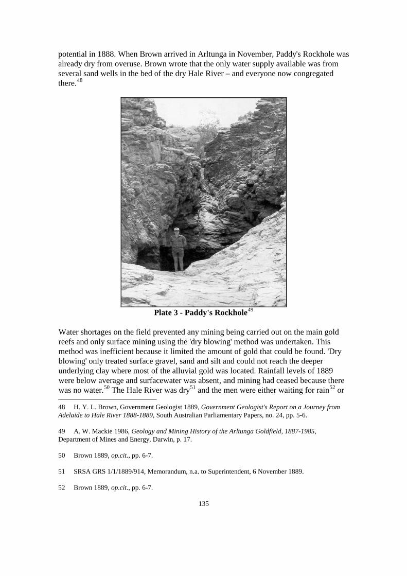
135
potential in 1888. When Brown arrived in Arltunga in November, Paddy's Rockhole was already dry from overuse. Brown wrote that the only water supply available was from several sand wells in the bed of the dry Hale River – and everyone now congregated there.48
Plate 3 - Paddy's Rockhole49
Water shortages on the field prevented any mining being carried out on the main gold reefs and only surface mining using the 'dry blowing' method was undertaken. This method was inefficient because it limited the amount of gold that could be found. 'Dry blowing' only treated surface gravel, sand and silt and could not reach the deeper underlying clay where most of the alluvial gold was located. Rainfall levels of 1889 were below average and surfacewater was absent, and mining had ceased because there was no water.50 The Hale River was dry51 and the men were either waiting for rain52
48 H. Y. L. Brown, Government Geologist 1889, Government Geologist's Report on a Journey from Adelaide to Hale River 1888-1889, South Australian Parliamentary Papers, no. 24, pp. 5-6.
or
49 A. W. Mackie 1986, Geology and Mining History of the Arltunga Goldfield, 1887-1985, Department of Mines and Energy, Darwin, p. 17. 50 Brown 1889, op.cit., pp. 6-7. 51 SRSA GRS 1/1/1889/914, Memorandum, n.a. to Superintendent, 6 November 1889. 52 Brown 1889, op.cit., pp. 6-7.

136
abandoning the field.53
Explorer William Tietkens visited the area and remarked that 'the water was fast drying up, and rations were at a ruinous price'.54 Brown himself was restricted to where he could travel on the field because of water shortages. On one trip, he lamented that he could only inspect some of the gold bearing reefs and then would have to return to water: 'The intense drought prevented me examining the country further except under great difficulty'.55
When Brown visited again in August 1890 two wells were in use. Arltunga Well near Paddy's Rockhole was 23 metres deep and was supplying a large amount of water. A three stamp battery had been operating but was now abandoned.56 In a later report by Brown in 1902, the well was still supplying adequate water for the needs of mining, domestic and stock.57
Plate 4 - Arltunga Well58
53 SRSA GRS 1/1/1889/914, Letter, E. Parker , Claraville to W. South, Warden, 19 October 1889 and Letter, W. South, Warden to Minister of Education, 24 October 1889. 54 Tietkens, op.cit., p. 1. 55 Brown 1889, op.cit., pp. 6-7. 56 H. Y. L. Brown, Government Geologist 1890, Report of Geological Examination of Country in Neighborhood of Alice Springs, South Australian Parliamentary Papers, no. 189, Government Printer, Adelaide, pp. 6 & 7. 57 Brown 1902, op.cit. p. 5. 58 Department of Infrastructure, Planning and Environment, Northern Territory Government, Darwin.

137
Claraville Well, the second well, was producing a small amount of water but Brown was uncertain about the water's permanency. What was clear in Brown's report was his concern about the slow pace of mining at Arltunga. Only three leases were being worked - Wheal Fortune, Wheal Mundi and Claraville - the others had been abandoned.59 A Huntingdon Mill and two, three head stampers were operating but only one crushing had been undertaken.60 The Claraville Well provided the water for the leases but it was almost barren. The Wheal Fortune machinery could not operate and the miners were forced to relocate to Paddy's Rockhole 14 kilometres away.61 There were calls from the miners for the government to increase the number of wells so batteries could be installed and mining could expand.62
Although Brown's 1890 report is a geological examination based on his appraisal of the region's mineral potential, he discusses the consequences of water shortages on mining.63 According to Brown, mining had been dormant since 1888 because of inadequate machinery and water limitations. Brown wrote that 'before crushing can be undertaken on anything like a satisfactory and effective scale, water must be provided by means of wells, or large tanks, or dams'.64 Brown drew attention to the rainless periods when no mining could be undertaken. He recommended that not only water points be increased but storage tanks should be built in the Hale River for use during the dry months.65
59 Brown 1890, op.cit., p. 6.
60 Playford, op.cit., p.11. 61 SRSA GRS 1/1/1889/914, Letter, W. South, Warden to Minister of Education, 24 October 1889 and Memorandum, J. Skinner, Alice Springs to Superintendent, Adelaide, 5 November 1889. 62 SRSA GRS 1/1/1890/539, Newspaper article, n.p., 14 October 1890. 63 Brown 1890, op.cit., p. 7. 64 ibid. 65 ibid., pp. 6 & 7.

138
Plate 5 - Stone Water Tank at Arltunga66
Between 1889 and 1890, both the Arltunga and Claraville Wells were deepened to increase the water supply, and the Wheal Fortune and Wheal Mundy Wells were constructed.67 A fifth well, Star of the North Well, was sunk between June and December 1892 and provided 2 250 litres of water per day. This was regarded as a valuable source because 'the creeks haven't run for three years'.68
Brown visited Arltunga again in October 1896 and reported that all the wells were in good condition and supplying a reasonable amount of water.69 The Claraville Well was supporting several stores at this time, a warden's office, and later in 1899, a police station.70
Brown criticised the slow progress of mining and complained that since his last visit in 1890 mining had not expanded into new areas. Many potential sites remained untested because water supplies were too far away for mining to be feasible. As a result, mining was confined within a 5 kilometre radius of water.71
66 Department of Infrastructure, Planning and Environment, Northern Territory Government, Darwin. 67 SRSA GRS 1/1/1889/914, Letter, E. Parker, Claraville to W. South, Warden, 19 October 1889 and Memorandum, J. Skinner, Alice Springs to Superindent, Adelaide, 5 November 1889. SRSA GRS 1/1/1890/539, Newspaper article, n.p.,14 October 1890. SRSA GRS 1/1/1892/118, Letter, W. South, Warden to Minister of Education, 14 December 1890. 68 SRSA GRS 1/1/1892/118, Letter, W. South, Warden to Under Treasurer, Adelaide, 13 August 1892. 69 Brown 1896, op.cit., pp. 1-3. 70 Carment & Harlow, op.cit. 71 Brown 1896, op.cit., p. 2.

139
Plate 6 - 'Dry Blowing' on the Hale River, 190672
One of Brown's reasons for visiting Arltunga in 1896 was to find a suitable location for a government battery. Brown selected Claraville as a site and recommended that a new well be constructed exclusively for the battery's use.73
Instead the Claraville Well was used which would later be to the government's detriment.
The erection of the government battery at Arltunga was a remarkable effort. In January 1897 the machinery weighing nearly 40 tonnes was conveyed by train to Oodnadatta and from there, including 2 tonnes of stores, was transported by a team of twenty-nine camels escorted by thirteen men. In February, a further 24 tonnes of machinery that included the boiler arrived. This was followed in March by two consignments weighing 3 and 9 tonnes of equipment.74
In 1897 the Claraville Well was almost dry at 50 metres and could not supply the minimum 4 500 litres per day needed for the government battery. A .8 metre horizontal shaft was driven into the bottom of the well to increase the water supply but this was unsuccessful. The low water supply forced the dismantling of the battery, buildings, store, blacksmith's and their relocation 11 kilometres away to the Star of the North Well.75 The ten stamp battery and cyanide works commenced operation again on 11 February 1898.76
72 Department of Infrastructure, Planning and Environment, Northern Territory Government, Alice Springs.
73 Brown 1896, op.cit., p. 1-3. 74 Forrest 1981, op.cit., vol. 2, p. 72. 75 SRSA GRS 1/1/1897/83, Letter, Manager, Government Battery to Minister Controlling the Northern Territory, 20 October 1897. 76 NAA ACT CRS A1640 Item 1903/433, Letter, H. Y. L. Brown, Government Geologist to South

140
Plate 7 - The Government Battery at Arltunga77
With government control of the Star of the North Well, it became necessary to construct another public well for the miners. In February 1898 tenders were received to build a well on Kangaroo Creek. Kangaroo Well was excavated without any difficulty and continued to supply enough water for the inhabitants, horses and the police station for the duration of the rush.78 In fact, as recently as 1959 the well was supplying water for a small battery.79
Australian Minister Controlling the Northern Territory, 30 June 1903. 77 Mackie, op.cit., [cover page]. 78 SRSA GRS 1/1/1898/46, Letter, J. Mueller, Warden to Minister Controlling the Northern Territory, 5 August 1898. Brown 1902, op.cit., p. 6. 79 Forrest 1981, op.cit., vol. 2, p. 102.

141
Map 4 - Warden Mueller's Map of Arltunga Wells in 189880
An exceptionally dry year in 1898 diminished all the water supplies and vegetation for stock.81 Although well construction was ongoing, the water supply could never keep pace with the demands of miners, small businesses, stock and the battery plants. In August 1898 Warden Mueller described all the wells on the field being in poor condition and said that water supplies could only be depended upon during a good wet season. In the Claraville area, water was taken from soakages because the Claraville Well was 'dilapidated and useless'. The Claraville Well was in such bad condition that Mueller refused to take responsibility for it. Water shortages were so acute that he complained to the Minister that the region east of the field could not be mined.82
Water shortages became so critical that thirty-one miners protested to the Minister about the difficulties of mining. On the alluvial fields the miners were 'dry blowing' because no water was available for cradling, and water shortages prevented them from mining the more lucrative fields. The miners wrote that 'the water question is of great importance to us all as at present we have to cart it a distance of six miles'.83
The miners appealed to the Minister to have a well excavated at White Range so that 80 SRSA GRS 1/1/1898/377, Letter, J. Mueller, Warden to Minister Controlling the Northern Territory, 5 August 1898. 81 ibid. 82 ibid. 83 SRSA GRS 1/1/1898/258, Letter, Arltunga miners to Minister Controlling the Northern Territory, 7 May 1898.

142
water could be supplied for the alluvial fields.84 In February 1899, the government sent Sam Olsen to sink a new well at White Range. The excavation of this well became a laborious and lengthy process. After five months the well was only excavated to 30 metres and produced 227 litres of water per day. The amount of water was insufficient and further attempts were made to deepen the well until Olsen struck hard rock.85
Dynamite was used to penetrate the rock and by September, the well was excavated a further 6 metres. 86 The well was completed in November 1899 at a depth of 45 metres and supplying 545 litres of water per day. The water supply was still regarded as inadequate but Warden Mueller believed that it would be sufficient with 'careful usage'.87
Arltunga still continued to have water shortages in 1900, and the drought had affected the animal teams. Water shortages also restricted work at the government battery and in June crushing stopped for a few weeks. The absence of water and feed for the horse teams prevented their ability to work and ore being carted to the battery. The manager eventually substituted the horses with camels to keep the battery functioning.88 To increase water supplies for the battery and the horse teams, Mueller contracted Louis Schaber to extend the White Range Well.89 By August 1900, Schaber had deepened the well by 8 metres which slightly increased the water supply. Mueller was despondent about the outcome and hoped that the water supply would last until the wet season.90
84 ibid. 85 SRSA GRS 1/1/1898/258, Letter, J. Mueller, Warden to Minister Controlling the Northern Territory, 28 February 1899; Letter, J. Mueller, Warden to Minister Controlling the Northern Territory, 24 April 1899 and Letter, J. Mueller, Warden to Minister Controlling the Northern Territory, 8 July 1899. 86 SRSA GRS 1/1/1898/258, Letter, J. Mueller, Warden to Minister Controlling the Northern Territory, 15 September 1899. 87 SRSA GRS 1/1/1898/258, Letter, J. Mueller, Warden to Minister Controlling the Northern Territory, 27 October 1899 and Letter, J. Mueller, Warden to Minister Controlling the Northern Territory, 10 November 1899. 88 SRSA GRS 1/1/1900/308, Letter, Manager, Government Battery to Minister Controlling the Northern Territory, 6 June 1900. SRSA GRS 1/1/1898/258, Letter, J. Mueller, Warden to Minister Controlling the Northern Territory, 22 June 1900. SRSA GRS 1/1/1900/386, Letter, J. Mueller, Warden to Minister Controlling the Northern Territory, 17 August 1900. 89 SRSA GRS 1/1/1898/258, Letter, J. Mueller, Warden to Minister Controlling the Northern Territory, 22 June 1900. 90 SRSA GRS 1/1/1898/258, Letter, J. Mueller, Warden to Minister Controlling the Northern Territory, 3 August 1900 and Letter, J. Mueller, Warden to Minister Controlling the Northern Territory, 14 September 1900.

143
In 1902, Brown chose another site for a new well near White Range. This was to be the most difficult and challenging well on the field. Excavation began in July 1902 with 17 metres dug by August. Work continued steadily until the contractor, John Byrne, died in January 1903. In November 1903, well sinkers Hugh Sutherland and John McKillop were contracted to excavate a further 30 metres. The well caved in several times during excavation and additional timbering was needed to prevent debris falling in. By September 1904 the well had become precarious and 18 metres of timbered framework had been used to secure the walls.91
In March 1905, new tenderers James Dyson and James Scharber were contracted to finish the well. 92 The White Range Well No. 2 was eventually completed in June 1905. The well was dug to 75 metres but was dry.93 Gold was found during the excavation and Mueller commented that it was the deepest gold reef found on the field to date. The excavation of a shaft this deep for gold prospecting would have impressed Brown. The irony here, however, is that all the effort and expense was for the search for water and not for gold.94
Arltunga had seven functional wells in 1903, but water shortages continued to hinder mining. William Coulthard who visited Arltunga in 1903 wrote that all the water in the creeks and waterholes was almost gone.95 Coulthard described the region as 'so fearful rough most of the places where they are getting the alluvial gold are that rough that you can't get up with a horse it is wonderful how they get in at all with drays. They cart water to the foot of the ranges & then carry dirt down on their backs to wash it, there are a few places where they get water since the rain in rock holes right on top of the ranges…'96
In February 1903, Warden Mueller reported that stock feed had dried up and water supplies were limited. The Star Creek region had gold potential but could not be prospected thoroughly because even the usual small amount of surfacewater had dried
91 SRSA GRS 1/1/1902/228, Letter, J. Mueller, Warden to Minister Controlling the Northern Territory, 22 July 1902; Memorandum, H. Y. L. Brown, Government Geologist to J. Mueller, Warden, 21 May 1903; Memorandum of Agreement, South Australian Government and Hugh Sutherland and John McKillop, 15 December 1903; Letter, J. Mueller, Warden to Minister Controlling the Northern Territory, 20 July 1904 and Letter, J. Mueller, Warden to Minister Controlling the Northern Territory, 27 September 1904. 92 SRSA GRS 1/1/1902/228, Memorandum of Agreement, South Australian Government and James Dyson and James Scharber, 1 March 1905. 93 Kate Holmes 1980, op.cit., p. 28. 94 SRSA GRS 1/1/1904/168, Letter, J. Mueller, Warden to Minister Controlling the Northern Territory, 29 October 1904. 95 Coulthard, op.cit., p. 67. 96 ibid., p. 17.

144
up.97 In March, Mueller jubilantly reported heavy rainfalls that filled the creeks and rockholes and the water had significantly assisted mining.98
In August 1905, contractor Thomas Wardle finished the ninth and last well. The Crossroads Well was excavated to 24 metres and produced 1 800 litres of water per day. The well was situated in a prime position as miners passed through Crossroads to travel to Claraville, White Range or Paddy's Rockhole. Crossroads soon became a hub of commercial activity with the establishment of a hotel, blacksmiths, bakery and various stores.99
In the same year, forty-two miners at Whites Gully, east of Paddy's Rockhole, petitioned for a well. The miners complained that water had to be carted in at a cost of 4 shillings each per week. They had already spent £250 on water for the year. Based on the fact that no reefs had been opened up in the area, the Minister refused to finance another well.100
Despite the South Australian Government's attempt to increase the number of wells to meet the needs of mining, water shortages remained a constant problem that was unresolved when the rush ended. Admittedly, for most of this period, the miners had to also contend with a severe drought that ravaged central Australia from 1896 to 1903.101 The drought affected all the wells at Arltunga at various stages.102
4.6 Well Sinkers and Wells A major hindrance to well construction was the inability to attract well sinkers to the Northern Territory. Wages were not exceedingly high and men had to work under difficult conditions for long periods in remote areas. It was not uncommon for wells to take up to twelve months to be manually dug, a major undertaking that tested the skills, determination and endurance of these men. Accommodation consisted of tents that offered little protection from the extreme temperatures of central Australia. Equipment was transported by rail from Adelaide to Oodnadatta, and from there by horse, camel or donkey teams on what was little more than a bush track to Arltunga. The wells were sunk where access to materials, water, food and equipment had to be carted over 97 SRSA GRS 1/1/1903/83, Letter, J. Mueller, Warden to Minister Controlling the Northern Territory, 18 February 1903. 98 SRSA GRS 1/1/1903/83, Letter, J. Mueller, Warden to Minister Controlling the Northern Territory, 16 March 1903. 99 Forrest 1981, op.cit., vol. 2, p. 105. 100 Kate Holmes 1980, op.cit., p. 29. 101 Northern Territory Land Board 1964, Report by the Northern Territory Land Board on the Centralian Pastoral Industry Under Drought Conditions, Northern Territory Land Board, Darwin, pp. 13-14. 102 Ride, op.cit.

145
hundreds of kilometres. This was not a simple task when considering the menagerie of chickens, milking cows, goats and turkeys that travelled with the consignment.103
One such person was Ned Ryan, who was employed by the South Australian Government and was renowned for his ability to find water in the most destitute areas. Ryan used a camel team to move his equipment from site to site that earned the title 'Ned Ryan's Camel Party'. Ryan dug wells for the Overland Telegraph Line and stock routes from 1885 until 1890 and he was sent to deepen and improve Arltunga's first well.104
The construction of a well at Arltunga required ingenuity and the need to adapt to suit local conditions. In Arltunga's difficult strata, the excavation of the well would stop once water was struck, but over a period of time the water level would gradually drop making it necessary to continually deepen the well. By the end of a well's life, it had usually been sunk much deeper than the considered safe depth of 50 metres. Other differences were the timbering of wells. While most Australian wells were timbered throughout, it was an expensive and time consuming process in the arid region, so only the unconsolidated portion of the well was timbered. The well was lined with whatever timber was available, which, in central Australia, was mulga and river red gum. The lack of timbering also contributed to the effort required to hand saw the timber, a back breaking job, especially inside a hot and unventilated pit. With the lack of water, most well excavation was carried out dry, making it a more painstaking task for the diggers who had to inhale quartz and saw dust.105
Each Northern Territory well measured approximately 2 metres by 1 metre, making it wider than traditional wells. A wider well made it a little easier to dig and pick or to drive the pins with sledgehammers. Well levels also had to be raised above ground level to prevent periodical flooding entering the well shaft, which could cause it to collapse, a common occurrence on the Arltunga goldfield.106
103 ibid. 104 Jack Ryan 1991, 'Well sinking in the far north of South Australia, and in the Northern Territory, 1885-1890: The work of Ned Ryan's Camel Party', in Historical Facts & Events, vol. 6, no. 2, pp. 25-35. 105 Ride, op.cit. 106 ibid. and Brown 1896, op.cit., p. 3.

146
Plate 8 - Overland Telegraph Line Well (c.1873). Camel Powered Whip, dated early 1920s.107
4.7 Conclusion When the last well was sunk near White Range in 1905, it would not have been needed as in June 1905 only forty miners remained.108
Paradoxically, more water became available as the population gradually moved to the new fields of Winnecke and Harts Range. The problems of water shortages were then repeated there.
The Arltunga Goldfield provided substantial revenue for the government. In 1902, the field had produced approximately 9 195 troy ounces of gold109 compared to 11 992 troy ounces - the combined total of all Top End mines.110 In six years of operation, between 1898 and 1904, the government battery alone produced 8 680 troy ounces of gold.111
Although the mining population declined significantly from 400 in April 1903,112
107 Department of Infrastructure, Planning and Environment, Northern Territory Government, Darwin.
to
108 Mackie, op.cit., p. 26. 109 Between 16/8/1902-13/9/1902, Arltunga's gold production was 822 ounces, 283 drams and 217 grams (766 troy ounces). I was unable to find figures for the whole of 1902, so to provide an estimate I have multiplied this amount X 12. Brown 1902, op.cit., p. 6. 110 This includes the main mines in the Pine Creek, Mt Wells and Grove Hill region. Government Resident's Report on the Northern Territory for 1902, p. 11. 111 Jones, op.cit., p. 138. 112 Carment & Harlow, op.cit., p. 2.

147
forty in 1905,113 the field yielded a significant amount of gold for the year - nearly 900 troy ounces.114 In 1909 all Top End gold totalled 6 076 troy ounces and the Arltunga Battery produced 965 troy ounces.115
This was almost a sixth of total gold production from the more lucrative Top End mines.
Brown attributed the decline of gold mining to inexperience and the lack of capital.116 Water shortages were another impediment noted by Brown.117 Aside from this, gold mining had waned throughout the Northern Territory by this time, with more men favouring tin mining.118
In 1901, negotiations commenced on the transfer of the Northern Territory to the Commonwealth Government. This meant that the new overseer would become responsible for a sporadic industry. The South Australian Government must have continued to hold some expectation that new mineral discoveries would be found, as Brown and others continued their inspections of central Australian mining fields in 1902, 1903 and 1905.119
The Arltunga Goldfield covered approximately 40 square kilometres120
113 Mackie, op.cit., p. 26.
and by 1905 nine attempts had been made to implement groundwater supplies. Considering that at the time Alice Springs had no public well whatsoever, the effort of government to augment groundwater in such a inhospitable region is commendable. At the end of the rush, more knowledge about groundwater and well construction became known. The experience that these early well sinkers gained was later utilised on pastoral properties, other mining areas and future settlements. Well sinking remained a vital and essential skill for the development of central Australia until the Second World War when boring
114 This amount also includes White Range. ibid., p. 22. 115 Government Resident's Report on the Northern Territory for 1909, pp. 9 &26. 116 Brown 1903, op.cit., p. 7. 117 Brown 1896, op.cit., p. 2. 118 Government Resident's Report on the Northern Territory for 1909, p. 30. 119 Brown 1902 & 1903, op,cit. H. Y. L. Brown, Government Geologist 1905, Report on Arltunga, Winnecke's, etc., Goldfields, South Australian Parliamentary Papers, no. 75. W. H. Matthews, Warden and Inspector of Mines 1905, Report on Arltunga, Winnecke's, etc., Goldfields, South Australian Parliamentary Papers, no. 75. Allan A. Davidson 1905, op.cit., p. 4. 120 Kate Holmes 1989, op.cit., p. 43.

148
rigs became more accessible.121
4.8 The 1930s Mining Period in the Northern Territory - Setting the Scene Mining at the turn of the twentieth century was vastly different from the mining booms of the century before which attracted instant populations and international publicity. Mining had declined since the First World War and was now sporadic. In 1918, there were only 144 current mining leases throughout the Northern Territory with most mining activity centred around Hayes Creek, Maranboy, Finniss and Mount Tolmer.122
At the beginning of 1926, high expectations were held for the Tanami goldfield when Tanami Gold Mines acquired several mining leases. The company went to great expense to transport crushing plant and machinery from Western Australia but was thwarted by adverse weather conditions. By May 1926, there were only four men on the field and no mining had begun.123 Before its rush in 1932, the Granites in the Tanami Desert had been prospected many years earlier. The field was abandoned in 1911 when Aborigines killed a miner named Stewart. The region remained deserted until 1925 when water shortages and water contamination compelled a party of miners to leave. Other miners visited the field in the ensuing years but prospecting was diminutive. Because of water shortages, there was never any expectation that the field would be developed.124 During the early 1930s, a group of miners were 'dry blowing' on the field and they had managed to deepen the government well to attain more water. Two attempts had been made to bore for water but this had failed. In November 1932, there were 200 men on the field but by December 1932 the number had declined to ten.125
While the Granites rush was short lived, the Tennant Creek field would develop into one of the Northern Territory's most outstanding goldfields.
The conditions under which miners worked in the Northern Territory had barely progressed since the first mining rushes. Mining was still carried out in remote and desolate regions with limited water supplies and without basic facilities. The only exceptions from the early years of mining were that water drilling rather than well excavation was carried out and animal teams were replaced by motorised transport. In spite of this, miners in isolated areas still had to bring enough supplies for the whole duration of their time. These included water, food, equipment and shelter. In addition there were the requirements of vehicles or animal teams, such as fuel and food.
121 Ride, op.cit. 122 Administrator's Report on the Northern Territory for the Year Ending 30 June 1918, p. 23. 123 Administrator's Report on the Northern Territory for the Year Ending 30 June 1926, p. 22. 124 ibid., pp. 22 & 23. 125 Baume, op.cit., pp. 2 & 3.

149
4.9 The Tennant Creek Goldfield
'As there is no surface water at Tennant Creek the erection of batteries must be preceded by the supply of water'. Director of Mines, 1935126
The Tennant Creek field was important for three reasons; throughout the 1930s and 1940s it produced almost all of the Northern Territory's gold,127 water development improved strata and geological knowledge of the region128 and the outcome was permanent settlement. At its height, the field was regarded as one of the richest in the world129
and it provided economic hope at a time when Australia was experiencing a depression.
A prospector named Windley claimed to be the first person to discover gold in the Tennant Creek region in 1925. He began sending gold samples to the assayer in Alice Springs from 1925 onwards and applied for mining leases between April 1927 and June
126 DME NTGS Report 1978-016, Extracts from Mines Branch Annual reports on Tennant Creek, 1933-1970, p. 6. 127 ibid., pp. 36, 43 & 46. NAA ACT CRS A452 Item 1957/427, Report, Warden's Report for the Year Ending 30 June 1936, H. B. Owen, p. 1 and Report, Condensed Geological Report on Tennant Creek Goldfield Northern Territory, C. J. Sullivan, Department of National Development, Canberra, 1949. Australia, Senate and House of Representatives 1937, Debates, 24 August 1937 to 15 September 1937, vol. 154, session 1937-38, p. 877. The Northern Standard, 5 July 1938. Administrator's Report on the Administration of the Northern Territory for the Year Ended 30 June 1939-40, Commonwealth Parliamentary Papers, session 1940-41-42-43, vol. 11, Government Printer, Canberra, p. 1302. 128 This chapter will not be discussing geology but it was clear in the reports and correspondence of Woolnough and Owen that drilling for water in the Tennant Creek region was challenging. NAA ACT CRS A431 Item 1946/2633, Report, Dr. W. G. Woolnough, March 1934. NAA ACT CRS 1 Item 1936/1147, Report, Dr. W. G. Woolnough, Report on general matters affecting Tennant Creek goldfield, 19 December 1935. NAA ACT CRS A518 Item D241/6/8/ part 1, Report, Water Supply at Tennant Creek, Dr. W. G. Woolnough, 22 September 1936. NAA ACT CRS A452 Item 1957/427, Report, Warden's Report for the Year Ending 30 June 1936, H. B. Owen. NAA ACT CRS A659 Item 1940/1/847, Report, Report on Tennant Creek Goldfield with a forward by W. G. Woolnough, H. B. Owen, c. 1940. 129 Australia, Senate and House of Representatives 1938, Debates, 21 September 1938 to 16 November 1938, vol. 157, session 1937-38, p. 980.

150
1929. However Windley made no great gold discovery.130 In early 1933, an unnamed miner found gold in an abandoned mine (later The Great Northern), 9 kilometres south from where Tennant Creek is today. With the use of a homemade stamper powered by an old motorised engine, the miner crushed a small amount of ore that produced a good yield of gold. The mine's potential inspired the miner to apply for a mining lease and form a syndicate. The miner sent a 9 tonne parcel of ore to the Peterborough battery in South Australia for processing. The parcel produced 21 troy ounces which was considered a good result. The syndicate applied for a further sixteen leases which drew attention to the field.131 By August 1933, there were 100 men on the field and the rush began.132
The settlement of Tennant Creek did not exist at the time, but the town was to become one of the few examples in the Northern Territory where a community and its economy grew around a mineral field, and continues to be supported by mining today. The nearest main centre was Alice Springs situated about 500 kilometres to the south. In 1933, Alice Springs' population was 536133 and would for a few years be superseded by Tennant Creek's which peaked at 800 in November 1935.134
All goods and equipment were transported from Adelaide to Alice Springs by train then overlanded to Tennant Creek. It was a hazardous journey that could be undertaken either by truck, which took two and a half days, or by camel, which took seventeen days. The miners lived in tents, mud or bough huts and their stable diet was canned food.135
Like Arltunga, Tennant Creek is situated in the arid zone which has low rainfall levels and its surfacewater is subject to high evaporation rates. Therefore surfacewater is only reliable in the wet season and quickly disappears during the dry season. This is why today, Tennant Creek relies on groundwater for all its water supplies. Water shortages were evident when the first miners arrived on the field but the situation worsened with an influx of people. The only water available was from the old Overland Telegraph Line well that was 14 kilometres from the field. Miners had to manually draw the water and
130 NAA ACT CRS A1 Item 1938/6076, Letter, Administrator to Secretary, Department of the Interior, Canberra, 24 March 1938. 131 DME NTGS Report 1978-016, Extracts from Mines Branch Annual Reports on Tennant Creek, 1933-1970, p. 1. 132 The Northern Standard, 10 October 1933. NAA ACT CRS A1 Item 1936/7992, Note, Tennant Creek Goldfield, n.a., c. 1936. 133 Australian Bureau of Statistics 1993, Northern Territory in Focus, Northern Territory Government Printer, Darwin, p. 19. 134 Australia, Senate and House of Representatives 1935, Debates, 23 September 1935 to 7 November 1935, vol. 147, session 1935, p. 2174. 135 The Argus, 10 August 1936.

151
then transport it to their leases. Water cost 4 pence for 4.5 litres and was regarded as the most expensive item on the field.136
Only one well was supplying water for 100 men, their mining activities and domestic needs.137 The miners claimed that water shortages were preventing them from developing the field and that 'the lack of water is hampering work everywhere'.138 The miners established a progress association and began lobbying the government to improve water supplies. The Northern Standard reported that the Commonwealth Government assured the miners that water supplies would be increased 'but nothing has been done yet'.139 The newspaper slammed the government, saying that it has failed the genuine leaseholders but was quick to assist bogus companies at the Granites with water supply. The paper claimed that the Tennant Creek field had enough gold to support mining for three years and the government should drill a bore in the main field so water would be accessible to miners. The water problem was so acute that many leases could not be worked.140
The hard reality of mining in an isolated place with no basic facilities was soon reflected in a decline in population. A warden was appointed on the field in September 1933 to cope with the rush but by October only forty men remained.141 The waning population and adverse publicity compelled the Minister for the Interior to issue a warning to Australian men who intended to go to the field. The Minister cautioned intending miners that water shortages were severe and living expenses high, and that men would need substantial funds to support themselves.142
Another major hindrance to mining was the lack of a local battery to process the ore which contained the gold. The ore was sent to Peterborough, South Australia which was the nearest battery. The ore was loaded into hessian bags, carted to Alice Springs and then placed on the train to Peterborough.143
136 The Northern Standard, 10 October 1933.
This was a 500 kilometre journey to Alice
NAA ACT CRS A1 Item 1936/7992, Note, Tennant Creek Goldfield, n.a., c. 1936. 137 The Sydney Morning Herald, 1 September 1933. The Northern Standard, 10 October 1933. 138 The Northern Standard, 10 October 1933. 139 ibid. 140 ibid. 141 ibid. NAA ACT CRS A1 Item 1936/7992, Note, Tennant Creek Goldfield, n.a., c. 1936. 142 The Sydney Morning Herald, 1 September 1933. The Northern Standard, 10 October 1933. 143 NTRS 226 TS351-1, Kevan Weaber, interview by Helen Wilson, 1981, Tape 1, pp. 4-5.

152
Springs and then by rail to Peterborough 1 120 kilometres away. 144
1 tonne of ore could contain between 3.5 to 9 troy ounces of gold. To transport, crush and process the ore, it usually cost the miner 3.5 troy ounces of gold per tonne.
It was a very expensive procedure that could cost a large portion of a miner's profit. An average
145 The outcome could easily be unprofitable. Udall's Mine for instance, sent its ore to the Peterborough battery and only 2.7 troy ounces of gold was salvaged from one tonne of ore.146 At the time, gold was worth approximately £4 per troy ounce147 and a truck driver's weekly wage at Tennant Creek was £6.148 Mining offered the opportunity to become wealthy. However, the enormous living costs and other expenses easily depleted profit and it was no wonder that miners began to petition the government to install a local government battery.149 The miners had a long wait because it would not transpire until September 1937.150
Entrepreneurs established businesses at Tennant Creek to support the mining population. In May 1934, a store was under construction and in June the Tennant Creek Hotel opened.151 In June 1935, the population was estimated between 500 and 600152 and a monthly mail service between Alice Springs and Tennant Creek commenced.153 By March 1936, there were twenty-five businesses, a school, police residence, post office, warden's house, government offices and a new hospital. In April 1936, a second hotel opened in Paterson Street. Roads had been constructed, 244 blocks had been surveyed for future housing and land was allocated for a cemetery and sanitary facilities. The Australian Inland Mission provided a library service and built a community hall for social activities.154
144 NAA ACT CRS A431 Item 1946/2633, Report, Dr. W. G. Woolnough, March 1934, p. 32.
145 NAA ACT CRS A659 Item 1939/1/8910 part 1, Hansard extracts, 6 July 1934. 146 The Northern Standard, 19 May 1933. 147 NAA ACT CRS A659 Item 1939/1/8910 part 1, Hansard extracts, 6 July 1934. 148 NAA NT CRS F1 Item 1942/196, V. G. Carrington, Deputy Administrator to Secretary, Department of the Interior, Canberra, 4 May 1936. 149 The Northern Standard, 10 October 1933. 150 DME NTGS Report 1978-016, Extracts from Mines Branch Annual Reports on Tennant Creek, 1933-1970, p. 29. 151 ibid., p. 4 and The Adelaide Advertiser, 26 May 1934. 152 DME NTGS Report 1978-016, Extracts from Mines Branch Annual Reports on Tennant Creek, 1933-1970, p. 10. 153 NAA ACT CRS A1 Item 1935/5193, Letter, M. B. Harry, Postmasters-General's Department, Melbourne to Secretary, Department of the Interior, Canberra, 29 May 1935. 154 NAA ACT CRS A452 Item 1957/427, Report, Warden's Report for the Year Ending 30 June 1936, H. B. Owen, pp. 6-7.

153
An Argus reporter visited in 1936 and was amazed by the severe environment and hard living conditions. The reporter described the region as completely flat with either red or hard-baked sand. Rainfall was almost absent and the heat of the sun was overwhelming. Shade was non-existent and the only foliage was mulga and coolibah. The miners resided in tents, huts or gunyahs which were as basic as the Aborigines' homes. Meals were either dried or tinned and eaten in a climate that would rapidly decay fresh food if it was available.155
In 1937, A. B. Haines from the Walkabout magazine visited and wrote about the picture theatre, the 'roofless, hessian-walled dance-hall' and the rough open shed where people gambled. Haines depicted Tennant Creek as a 'dreary desert, a waterless region of sun-baked rocks'. Its homes were crude humpies consisting of corrugated iron and hessian but the town had electricity, telephones, champagne, ice-cream, cold drinks, fresh fruit and vegetables.156
Geoffrey Blainey in The Rush that Never Ended: A History of Australian Mining wrote that governments rarely financially or physically supported mining towns.157 In Tennant Creek's case this was the reverse.158 Within a few short years, Tennant Creek emerged as a thriving town with water and electricity and accessibility to fresh food, medical and legal facilities. Much of the town's development was attributed to both the population and government. The Commonwealth Government was instrumental in providing services to the town but the most remarkable feature was the government's proactive stance on developing groundwater. Between 1934 and 1941, the government drilled forty-four bores, not including the many boreholes which were abandoned.159
It will be shown that as water supplies increased, so did the amount of gold.
4.10 Literature Review David Carment could be regarded as the guru on the gold rush at Tennant Creek. There is no other thorough researched work that covers this period of the Northern Territory's history. Carment's Australia's Depression gold rush: Tennant Creek, 1932-1936 160
NAA ACT CRS A1 Item 1936/7992, Note, Tennant Creek Goldfield, n.a., c. 30 July 1936.
is a
155 The Argus, 10 August 1936. 156 A. B. Haines 1937, 'At Tennant's Creek', Walkabout, 1 June, pp. 43-45. 157 Geoffrey Blainey 1974, The Rush that Never Ended: A History of Australian Mining, Melbourne University Press, Melbourne, pp. 283-287. 158 This is also supported by David Carment 1991, Australia's Depression Gold Rush: Tennant Creek, 1932-1936, Faculty of Arts Occasional Paper Series no. 5, Northern Territory University, Darwin, p. 38. 159 DME NTGS Report 1978-016, Extracts from Mines Branch Annual Reports on Tennant Creek, 1933-1970, p. 44. 160 Carment, op.cit.

154
substantial account of the rush. Other published information on the Tennant Creek field is devoid of detail.161
Carment remarks that historians have neglected the gold rush at Tennant Creek, and the lack of published sources substantiates this.
Carment also addresses the social history of gold mining in an isolated area that was lacking in basic facilities. Drawing from a wide variety of sources that include oral interviews, newspapers and government documents, he provides a social and political perspective that includes women, miners and government officials who lived in Tennant Creek. The residents formed several social and sporting groups and established an outdoor picture theatre. Although the miners were newcomers, they banded together and lobbied the Commonwealth Government for better facilities. As a result, within a few years a school, police, a warden and a health clinic were established. Carment succeeds in showing the influence the residents had on the development of Tennant Creek. 4.11 Water Development at Tennant Creek Mining methods at Tennant Creek differed from those at Arltunga where alluvial and deep mining occurred. Tennant Creek gold was located in deep reefs and to access it the ore which contained the gold had to be extracted in pieces and then processed. This required the assistance of a battery to crush the ore. Water was needed in crushing and again in the tailing process. Water was also necessary to transport the ore on the crusher and again in the cyaniding procedure.162 A great impediment in gold extraction was the shortage of batteries and water. However, before a battery could be installed, a reliable water supply needed to be established first. When the initial rush occurred in May 1933, water shortages were recognised immediately by the miners and brought to the attention of the Commonwealth Government. The miners appealed for a bore to be drilled on the field so water was more accessible.163
Much to the government's credit, an extensive drilling campaign was instigated which continued until the effects of the Second World War began to impinge on mining.
Kevan Weaber was seven years old when he arrived in Tennant Creek with his family in 1933. His family occupied four leases and Weaber recalls having to cart water from the old Overland Telegraph Station well to the leases. Weaber says that the well was very basic and that a pulley with an old iron bucket was used to raise the water.164
161 A prime example here is Blainey who does not even mention Arltunga and is very brief on the Tennant Creek goldfield. Blainey 1974, op.cit.
Two hundred litre drums (44 gallon drums) placed on the back of trucks were filled with water and then taken to the mines. It was a 55 kilometre return trip that usually took all day. Later on, the family contracted Gerry Moloney to drill a bore to supply water for their leases. The water was too brackish to drink and was only used for mining.
162 Ridgway, op.cit. 163 The Northern Standard, 19 May 1933. 164 Weaber, op.cit., Tape 1, pp. 2 & 29, Tape 2, pp. 30 & 31.

155
Weaber's father, William, brought a tin stamp mill battery from Harris Scarfe in Adelaide and began crushing his own ore. Another water supply was near their Rising Sun Mine but water was only present during the wet season, so the Weabers only used it for bathing. Low rainfall levels prevented the Weabers from installing rainwater tanks for drinking water. So throughout their stay at the mines, the Weabers paid to have their drinking water transported in.165
At the end of 1933, only 66 tonnes of ore had been sent to Peterborough and 327 troy ounces of gold had been recovered.166
In early 1934, the cost of transporting and treating ore in Peterborough was around £20 per tonne which prevented many miners from sending their ore. There was renewed petitioning to the government to erect a local battery, and some miners such as the Weabers and Rudolph Schmidt began drilling their own bores.
Schmidt's bore was drilled by J. Gorey to 122 metres and supplied 6 750 litres of salt water per hour. It was unsuitable for drinking but was adequate for crushing and cyaniding. Later in September 1934, Schmidt had another bore drilled 7 metres from the first bore167 and then tendered for the government's Arltunga battery plant.168
Coinciding with the Weabers and Schmidt bores was the government's first bore. The bore was drilled 8 kilometres south of the township and supplied 90 000 litres per day of quality drinking water. The government made an agreement with Fazal Deen that he could use the water for his battery on condition that he supplied water to the public and maintained the bore.169 Deen who became a prominent figure in Tennant Creek, was born in India and arrived in Blackall, Queensland aged twenty-four in 1922. He worked in his family's mixed goods business and arrived in Tennant Creek as a hawker in 1933. He erected one of the first batteries and crushed his own ore as well as others.170
165 ibid., Tape 1, pp. 2, 7 & 29, Tape 2, pp. 30 & 31.
He
166 DME NTGS Report 1978-016, Extracts from Mines Branch Annual Reports on Tennant Creek, 1933-1970, p. 36. 167 ibid., pp. 1 & 3. NAA NT CRS F1 Item 1944/261, Memorandum, H. C. Bell, Director of Mines to ?Administrator, 11 September 1934. 168 NAA NT CRS F1 Item 1942/259, Letter, H. C. Brown, Property and Survey Branch to Minister for the Interior, Canberra, 28 September 1934 and Commonwealth of Australia Gazette no. 42, Sale of Arltunga battery plant, 19 July 1934. 169 The spelling varies in documentation but the name Fazal Deen will be used here. NAA ACT CRS A1 Item 1936/7992, Note, Tennant Creek Goldfield, n.a., c. 1936. 170 The government's No: 1 Bore was also referred to as the Ghan's Bore after Fazal Deen. NAA ACT CRS A431 Item 1946/2633, Report, Dr. W. G. Woolnough, March 1934, p. 4. NAA ACT CRS A1 Item 1936/7992, Note, Tennant Creek Goldfield, n.a., c. 1936.

156
operated his battery between 1934 and 1939 until the Second World War affected mining.171 He remained in Tennant Creek until 1944, when he moved to Brisbane.172 His battery and cyanide plant were situated half a kilometre away from the bore. The battery was described as two single output stamps with a combined weight of 6 600 kilograms driven by an oil engine. Water for the plant and the public was run by pipeline and pumped to an elevated tank for convenience.173
In March 1934, the government drilled a second bore near Mount Samuel, west of the Overland Telegraph Line. The bore was drilled to 110 metres and generated 94 500 litres of water per day. It was reported that the water caused severe gastric symptoms for newcomers until they adjusted to it. Later a pump and oil engine were added to improve volume.174
The Commonwealth Government's Chief Geologist, Dr. W. G. Woolnough, inspected the field in March and was concerned about the lack of water for mining. He reported that no permanent surfacewater existed within the boundaries of the field. The large waterhole at the Overland Telegraph Station and other waterholes dried up by September. Woolnough wrote that of the two wells at the telegraph station, the shallow well was barren by the end of the dry season and the main well, while equipped with windlass and whip, only had a small water supply and could not meet the demand of miners, travellers and stock. He emphasised that 'the provision of ample water is a condition precedent to successful battery operation, it is necessary to consider the possibilities of augmenting the known water reserves'.175 His recommendations were supported by the Darwin Mines Branch which insisted that 'until convenient water supplies are assured it is useless to erect any further crushing plant'.176
D. Carment; R. Maynard & A. Powell 1990, Northern Territory Dictionary of Biography: Volume One: to 1945, Northern Territory University Press, Darwin, pp. 79-81. 171 NAA NT CRS F1 Item 1948/29, Memorandum, Kevin Graham, Department of Works and Housing to Director of Works, Department of Works and Housing, 20 April 1948. 172 NAA ACT CRS A431 Item 1946/2633, Report, Dr. W. G. Woolnough, March 1934, p. 4. NAA ACT CRS A1 Item 1936/7992, Note, Tennant Creek Goldfield, n.a., c. 1936. Carment; Maynard & Powell, op.cit., pp. 79-81. 173 DME NTGS Report 1978-016, Extracts from Mines Branch Annual Reports on Tennant Creek, 1933-1970, p. 3. 174 NAA ACT CRS A431 Item 1946/2633, Report, Dr. W. G. Woolnough, March 1934, p. 4. NAA NT CRS F1 Item 1944/261, Memorandum, H. C. Bell, Director of Mines to ?Administrator, 11 September 1934. 175 NAA ACT CRS A431 Item 1946/2633, Report, Dr. W. G. Woolnough, March 1934, pp. 3 & 33. 176 DME NTGS Report 1978-016, Extracts from Mines Branch Annual Reports on Tennant Creek, 1933-1970, p. 4.
157
The lack of crushing facilities climaxed in May 1934 when the South Australian Government placed an additional £1 per tonne fee for crushing because the ore was not South Australian. This heightened the need for a government battery because 1 000 tonnes of ore was waiting to be processed, and it had become too expensive to send to Peterborough.177 By June the population reached 250 and mining conditions worsened. The plight of the miners was debated in the Commonwealth Parliament with the Opposition demanding that the government install a battery and increase water supplies. It was ludicrous to have miners paying high crushing fees. There was a huge goldfield waiting to be exploited and if a battery was installed it would not only assist the miners but offer hope for the unemployed who could work on the field.178
The Miners and Leaseholders Association, tired of what it perceived as government apathy, threatened the government that miners would begin to leave the field. It claimed that while Fazal Deen was crushing public ore, his small battery could not keep up with demand. The association said that 1 000 tonnes of ore was ready for processing but only 30 tonnes had been crushed in the past five weeks.179 The Administrator was concerned about the lack of support given to the miners by the government. In a letter to the Department of the Interior he addressed the shortage of batteries but understood that more water supplies needed to be found first.180
Nonetheless, some headway was made with water supplies at the end of 1934. The government had drilled two bores and Weaber and Schmidt owned three bores.
In early 1935, the Mines Branch reported that the field was so spread out that cartage fees were high, and more batteries were needed to reduce cost. The Director of Mines was anxious about the slow progress of boring because it hampered the installation of private batteries. Even though a government drilling rig had been operating throughout the past year, it had minor success improving water supplies. Many boreholes had to be abandoned because of hard rock or no water. Six bores were drilled by government with the most recent bore near the Tennant Creek Hotel. This bore was considered important because its water supply was suitable for both domestic and mining use. Nevertheless, the director was still disappointed with the current water supplies and arranged for more rigs to be brought to the field. He believed that the rigs should operate full-time until enough water was augmented.181
177 The Adelaide Advertiser, 26 May 1934.
178 Australia, Senate and House of Representatives 1934, Debates, 28 June 1934 to 2 August 1934, vol. 144, session 1934, pp. 64 & 344. NAA ACT CRS A659 Item 1939/1/8910 part 1, Hansard extracts, 6 July 1934. 179 NAA ACT CRS A659 Item 1939/1/8910 part 1, Hansard extracts, 6 July 1934. The Adelaide Advertiser, 26 May 1934. 180 NAA NT CRS F1 Item 1944/261, Lettergram, Administrator to Secretary, Department of the Interior, 25 October 1934. 181 DME NTGS Report 1978-016, Extracts from Mines Branch Annual Reports on Tennant Creek,

158
William Weaber's second bore near his Rising Sun Mine had been completed and was providing enough water for the mine.182 Schmidt's bores, on the other hand, had almost run out of water. His plight came to the attention of the Administrator, who asked the Department of the Interior to send a drilling rig that was capable of boring deeper holes. The Administrator asserted that 'water is running out on the field' and a 'water supply is essential'.183
The Tennant Creek goldfield problems were raised in the Commonwealth Parliament between March and April 1935. The population had reached 600 and Macalister Blain, Member of the House of Representatives for the Northern Territory, criticised government for not improving conditions on the field. He believed the government should do more for the miners by increasing water supplies and erecting a government battery. The Opposition argued that the field was expected to increase the Northern Territory's income tenfold and all that was needed was water and batteries. There was £90 000 worth of ore waiting to be treated because the private battery was unable to process it. It was claimed that private enterprise was sustaining the field when government should be taking a more active role.184
During the first week of May 1935, Thomas Paterson, the Minister for the Interior, arrived in Tennant Creek to examine the field. He held discussions with the President of the Miners and Leaseholders Association, who informed him that additional water supplies were needed and asked that government supply another drilling rig. The high cost of Fazal Deen's battery charges was also discussed. Deen was charging £4 per tonne when rates in other states were around £2 per tonne.185
Paterson was shown the available water supplies on the field and mining methods. He was taken to the Overland Telegraph Station well and given a demonstration on drawing water. It was reported that ’the "precious fluid"…leaked copiously before the eyes of the visitors as the trucks ran backwards and forwards hauling it to the surface. The bucket had to raise 400 gallons, and this had then to be poured into the tank trucks by hand’.186
1933-1970, pp. 6 & 10.
182 ibid., p. 10. 183 NAA NT CRS F1 Item 1944/261, Lettergram, Administrator to Secretary, Department of the Interior, 11 April 1935. 184 Australia, Senate and House of Representatives 1935, Debates, 13 March 1935 to 11 April 1935, vol. 146, session 1934-35, pp. 50 & 632. The Northern Standard, 5 March 1935. 185 NAA ACT CRS A1 Item 1935/5602, Minutes, Public Meeting at Tennant Creek, 2 May 1935 arranged by Tennant Creek Gold Mining Industries Association, p. 1. 186 The Sydney Morning Herald, 4 May 1935.

159
At the end of his visit the ’Minister’s Promise’ to the miners was published in The Sydney Morning Herald. The Minister stated ’there is no doubt that water is the first and greatest necessity for the development of the rapidly spreading mining industry here’.187 Paterson assured the miners that a second bore would be drilled near the Overland Telegraph Station to a great depth. A large windmill would be provided to pump the water into a new storage tank sufficiently high to enable vehicles to be filled by gravitation. When he made this promise ’he was met with cheers by the miners’.188 He went on to say that a water diviner, N. A. Frean from Melbourne who was travelling with his group, was contracted to find water. The Minister informed the miners that Frean was convinced that a good supply of water could be found 8 kilometres from Tennant Creek and at a shallow depth of 40 metres. Paterson also assured the miners that the government would erect additional batteries but 'the location of such additional battery or batteries will be dependent upon where we can find sufficient water to work them'.189
Immediately after the Minister's visit, Frean began searching for water. Under the heading 'Water Search at Tennant Creek', the Melbourne Herald followed Frean's quest to find water. Frean estimated that he would find water at his first site but failed to do so.190 On 17 June 1935, Frean had the drilling plant moved to a second site. He had no luck at his second site but in September he struck water at his third site. The bore could only produce 180 litres of water per day which was regarded as extremely low.191
187 ibid. 188 ibid. 189 ibid. 190 NAA ACT CRS A518 Item D241/6/8/ part 1, Newspaper article, Melbourne Herald, 17 June 1935. 191 NAA ACT CRS A518 Item D241/6/8/ part 1, Letter, L. N. Stutterd, Warden to Secretary, Department of the Interior, Canberra, 6 September 1935. Carment, op.cit., p. 36.
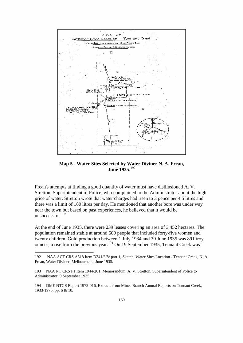
160
Map 5 - Water Sites Selected by Water Diviner N. A. Frean, June 1935.192
Frean's attempts at finding a good quantity of water must have disillusioned A. V. Stretton, Superintendent of Police, who complained to the Administrator about the high price of water. Stretton wrote that water charges had risen to 3 pence per 4.5 litres and there was a limit of 180 litres per day. He mentioned that another bore was under way near the town but based on past experiences, he believed that it would be unsuccessful.193
At the end of June 1935, there were 239 leases covering an area of 3 452 hectares. The population remained stable at around 600 people that included forty-five women and twenty children. Gold production between 1 July 1934 and 30 June 1935 was 891 troy ounces, a rise from the previous year.194
192 NAA ACT CRS A518 Item D241/6/8/ part 1, Sketch, Water Sites Location - Tennant Creek, N. A. Frean, Water Diviner, Melbourne, c. June 1935.
On 19 September 1935, Tennant Creek was
193 NAA NT CRS F1 Item 1944/261, Memorandum, A. V. Stretton, Superintendent of Police to Administrator, 9 September 1935. 194 DME NTGS Report 1978-016, Extracts from Mines Branch Annual Reports on Tennant Creek, 1933-1970, pp. 6 & 10.

161
gazetted as an official goldfield.195
The increasing amount of mining and people continued to strain water resources and it was reported that water, rather than wages was being paid to some labourers.196 Four bores had been drilled in September but they were all disappointments.197 Other bores had to be abandoned because the water supply was too low.198
In September 1935, a newspaper article titled 'Precious Water' described miners having to collect their drinking water from the Overland Telegraph well by moonlight because the well dried out during the day but naturally replenished at night. The article stated that it was the only source of drinking water since all waterholes had dried out. Between April and September 1935, Tennant Creek had only one fall of rain and government had not secured good quality water. So far, only brackish water, not even suitable for washing had been found.199
The government had four drilling rigs operating full-time, yet water shortages continued.200 In October, one bore was fruitful but its water quality was only suitable for mining use.201 The amount of water drawn from the Overland Telegraph well increased dramatically. Besides taking drinking water, the population was using the water for mining purposes. The government was so concerned that the water would run out that a guard was posted at the well to control its usage.202 Warden Stutterd was told to charge a fee for any additional water taken above the set limit.203
195 NTAS F155 Correspondence Files – Single Number Series 1933-1941, Commonwealth Gazette Notice 49/35, 19 September 1935.
By 17 October 1935, water shortages had worsened and a notice was gazetted informing the public that no-one
196 NAA ACT CRS A518 Item D241/6/8/ part 1, Newspaper article, n.p., 22 September 1935 and Letter, J. A. Carrodus, Assistant Secretary to L. N. Stutterd, Warden, 30 September 1935. 197 Australia, Senate and House of Representatives 1935, Debates, 23 September 1935 to 7 November 1935, vol. 147, session 1935, p. 282. 198 Administrator's Report on the Northern Territory for the Year Ending 30 June 1935, p. 33. 199 NAA ACT CRS A518 Item D241/6/8/ part 1, Newspaper article, n.p., 22 September 1935. 200 ibid. NAA ACT CRS A518 Item D241/6/8/ part 1, Letter, J. A. Carrodus, Assistant Secretary to L. N. Stutterd, Warden, 30 September 1935. 201 NAA NT CRS F1 Item 1944/261, Letter, W. B. Kirkland, Chief Medical officer to Administrator, 8 October 1935. 202 NAA ACT CRS A518 Item D241/6/8/ part 1, Telegram, D. D. Smith, Resident Engineer to Secretary, Department of the Interior, Canberra, 10 October 1935. 203 NAA ACT CRS A518 Item D241/6/8/ part 1, Letter, J. A. Carrodus, Assistant Secretary to L. N. Stutterd, Warden, 30 September 1935.

162
could 'remove, cart, take or sell any water – it is only to be used for domestic purposes’.204 By November, water supplies on the field were so limited that water carters began taking water from the soakage waterholes. The Minister for the Interior called on the Administrator to stop it as it was the only water supply the local Aborigines had.205
Conditions at Tennant Creek were debated again in Parliament between September and November 1935, with the same issues raised. The government was criticised for not having sourced reliable water supplies which prevented a government battery from being erected. Again it was emphasised that the goldfield was expected to be the world's largest but the high cost of water and petrol impeded the field's development. The Opposition considered that if the number of bores were increased, a population of 20 000 could be sustained and Tennant Creek would become an Eldorado for the unemployed. As it was, water shortages were so acute that miners were abandoning the field or were forced to 'dry blowing' in alluvial sections of the field.206
The shortage of public batteries prompted a miner named Hale to apply for government financial assistance to erect a battery. Hale proposed to cart 900 litres of water per day from the Overland Telegraph well to his battery. Based on this, Stutterd did not endorse Hale's application but considered it ludicrous that Hale believed he could operate his battery efficiently. He opposed Hale's application on the grounds that carting water over long distances would reduce profitability and Hale would be unable to repay the loan. Stutterd instead recommended that Hale find water first, and then select a battery site.207
By November 1935 three government rigs were operating full time208 and had successfully completed six bores.209 There were now eight government bores and four private bores operating.210
204 NAA ACT CRS A518 Item D241/6/8/ part 1, Letter, H. C. Brown, Secretary to Secretary, Attorney-General's Department, Canberra, 17 October 1935.
Yet the government bores were not producing enough water
205 NAA NT CRS F1 Item 1944/261, Telegram, Minister for the Interior, Canberra to Administrator, 4 November 1935. 206 Australia, Senate and House of Representatives 1935, Debates, 23 September 1935 to 7 November 1935, vol. 147, session 1935, pp. 474 & 808. 207 NAA ACT CRS A1 Item 1935/10119, Letter, L. N. Stutterd, Warden to Secretary, Department of the Interior, Canberra, 16 October 1935. 208 NAA ACT CRS A518 Item D241/6/8/ part 1, Lettergram, D. D. Smith, Resident Engineer to Secretary, Department of the Interior, Canberra, 4 November 1935. 209 Australia, Senate and House of Representatives 1935, Debates, 23 September 1935 to 7 November 1935, vol. 147, session 1935, p. 1457. 210 No. 8 Government Bore had just been completed. Miners, Weaber had two bores, Schmidt had one bore and W. McGovern had just completed the fourth private bore. NAA ACT CRS A518 Item D241/6/8/ part 1, Newspaper article, The Sydney Morning Herald, 19

163
to justify the establishment of a government battery.211
The Commonwealth Geologist, Dr Woolnough, was sent to Tennant Creek to report on water supplies, undertake a geological survey and to select potential bore sites.212 In his report Woolnough was adamant that the current water supplies could not support any further mining or population growth, and promotion of the field should cease. To protect the fragile water supplies, he recommended that all water sources be regulated and that private boring should be discontinued. Government control would ensure equitable distribution and a declared water reserve would protect water supplies.213
While Woolnough was in Tennant Creek two bores were drilled, but the water was found to be even too brackish for stock. In light of this, and the unsatisfactory condition of water supplies, he advocated a water conservation program to eliminate water wastage. He suggested that all milling and metallurgical plants be supervised to prevent water wastage and that a percentage of water should be recycled.214 In addition, the warden should be given the authority to limit the amount of water delivered to any lease, especially where it is known that water is misused.215
Woolnough regarded the current water supplies as inadequate because of constant water shortages. Fresh water was scarce and he held no expectation of ever finding reliable supplies. Although government was drilling continuously, Woolnough stressed that an 'active drilling campaign' needed to be undertaken.216 The prospects of securing good water were so poor that he even suggested that the town be relocated to where fresh water could be found. 217
Woolnough noted that the wells were empty by the end of the dry season even though they had been deepened. With the exception of the Overland Telegraph well, all other
November 1935 and Telegram, D. D. Smith, Resident Engineer to Secretary, Department of the Interior, Canberra, 21 November 1935. 211 NAA ACT CRS A659 Item 1939/1/8910 part 1, Hansard extracts, 28 November 1935. 212 NAA NT CRS F1 Item 1944/261, Memorandum, J. A. Carrodus, Acting Secretary to Minister for the Interior, 12 November 1935 and Memorandum, Dr. W. G. Woolnough to J. A. Carrodus, Acting Secretary, 12 November 1935. 213 NAA ACT CRS 1 Item 1936/1147, Report, Dr. W. G. Woolnough, Report on general matters affecting Tennant Creek goldfield, 19 December 1935, pp. 10-14. 214 ibid., pp. 13, 16-18 and The Northern Standard, 10 December 1935. 215 NAA ACT CRS 1 Item 1936/1147, Report, Dr. W. G. Woolnough, Report on general matters affecting Tennant Creek goldfield, 19 December 1935, p. 14. 216 ibid., p. 13. 217 ibid., pp. 11-13.

164
water supplies were too brackish to drink.218 He viewed the well equipment as ineffective and in dire need of improvement. The Overland Telegraph well was furnished with a windlass, a whip and one 585 000 litre steel tank and troughing for stock. Drawing water by this method was tedious and labour intensive. Woolnough regarded the equipment as suitable for stock and domestic use, but not for people who had to fill tanks on vehicles and take it to their leases. He advocated the erection of a windmill and tank high enough to allow vehicles to park underneath it. This would enable drums to be filled more effectively. Even if well equipment was upgraded, he believed that the lack of water points and the prolonged drought would not reduce the long queues of people waiting to collect water.219
A better setup was Fazal Deen's battery which was commended by Woolnough. Deen's crushing mill and cyanide plant was a profitable enterprise and he believed that Deen maintained the bore competently. Woolnough wrote that the bore was producing a good volume of water sufficient for the battery and for the public and stock. Water was pumped to two, 90 000 litre tanks and Deen charged 6 pence per 450 litres or 1 penny per head of stock.220
The prospect of a government battery looked bleak when Woolnough wrote that water supplies had to be found first. He wanted to subdivide the field based on the distribution of ore supplies. Water supplies in each section were to be investigated and the bores were to be drilled by government. The bores would be supplied with standard equipment so that equipment could be interchangeable.221 As well as supplying water for the batteries, Woolnough believed that water should be given free of charge to miners. He considered that an increase in water points and access to government batteries would be the greatest assistance that government could provide to miners.222
In December 1935, attempts were under way to locate water for the North Star Mine, the Mammoth Mine and the Eldorado Mine which were three of the field's largest mines. If enough water was found, the three mines would erect batteries. Both bores drilled for the Mammoth Mine were failures, and attention was turned to the Eldorado Mine. The bore site was 2.5 kilometres away from the mine but Woolnough believed it would be the nearest place where water would be found. It was still considered feasible to pump water over this distance to the mine. Two bores were drilled near the Overland Telegraph Station and both provided large amounts of fresh water. The Northern Standard reported that at least the problems of water had been solved for the town223
218 ibid., p.10.
219 ibid., pp. 11-13. 220 ibid. 221 ibid., p. 14. 222 ibid. 223 The Northern Standard, 10 December 1935.

165
which now had a population of 800 people.224
The news that fresh water supplies were discovered at Tennant Creek attracted national publicity. The Sydney Morning Herald issued an overly pessimistic statement that water was plentiful and was better quality than any Australian city.225 The search for water never waned and continued until the interruption of the Second World War. Although Tennant Creek goldfields now had three bores near the Telegraph Station the government still searched for water near key mine sites.226
By early 1936, the government had drilled fifteen bores but nearly half of them were barren. The government began to consider installing its first battery but the preferred location was in an isolated area and situated 32 kilometres away from the nearest battery.227 Water supplies were secured at Eldorado, Mammoth and North Star Mines and for the Central Gold Mill and batteries were now in the process of being installed.228
In February 1936, the government had fourteen bores operating but water shortages continued.229 The Melbourne Herald doubted whether enough water for mining would ever be located. The newspaper reported that water was difficult to find and Tennant Creek ore was exceptionally heavy. The ore required enormous amounts of water to crush and extract gold.230
In April 1936 miners complained to government that the batteries could not keep up demand and battery owners charged high fees to crush their ore. A miner pointed out to NAA ACT CRS 1 Item 1936/1147, Report, Dr. W. G. Woolnough, Report on general matters affecting Tennant Creek goldfield, 19 December 1935, p. 18. 224 Australia, Senate and House of Representatives 1935, Debates, 23 September 1935 to 7 November 1935, vol. 147, session 1935, p. 2174. 225 The Sydney Morning Herald, 20 December 1935. 226 ibid. 227 DME NTGS Report 1978-016, Extracts from Mines Branch Annual Reports on Tennant Creek, 1933-1970, p. 12. NAA ACT CRS A1 Item 1936/7992, Note, Tennant Creek Goldfield, n.a., c.1936. 228 NAA ACT CRS A1 Item 1936/7992, Note, Tennant Creek Goldfield, n.a., c.1936. NAA ACT CRS A518 Item D241/6/8/ part 1, Lettergram, D. D. Smith, Resident Engineer to Secretary, Department of the Interior, Canberra, 30 March 1936. 229 NAA ACT CRS A518 Item D241/6/8/ part 1, Lettergram, D. D. Smith, Resident Engineer to Secretary, Department of the Interior, Canberra, 30 March 1936. NAA ACT CRS A452 Item 1957/427, Newspaper article, Melbourne Herald, 18 February 1936. 230 NAA ACT CRS A452 Item 1957/427, Newspaper article, Melbourne Herald, 18 February 1936.

166
Blain that Deen charged £4 8s 5d per tonne and Smith's charges were higher at £5 17s 2d per tonne. The miner claimed charges were cheaper in other parts of Australia and in America. Mining at Tennant Creek was not profitable and men were leaving to find other employment. The miner accused the battery owners and large mining companies of trying to force the smaller lease holders from the field. Again, government was asked to install a battery so that charges would be reduced.231 The Minister for the Interior said that another private battery was being established on the field and the owner was only waiting to find water before he could begin operation. It was believed that the new battery would be competitive and also reduce the backlog of ore.232
Dissatisfied with the Minister's response, the miners petitioned the Administrator for a government battery. Crushing costs were exorbitant and on top of the basic crushing charges, the miners complained that there were cartage, cyaniding and screening fees. These fees amounted to £4 per tonne before the ore was even processed. In addition to these charges, were high living expenses and the price of explosives and water. The miners argued that a mine had to be laden with gold to make mining a viable occupation.233 Water charges ranged from 11 shillings to £1 per 450 litres,234 and an average mine could use up to 151 200 litres of water per day, which equates to £336 per day.235 When comparing the cost of water to a truck driver's weekly wage of £6,236
the miners had a valid grievance.
The government's perceived failure to act incited the miners to threaten to ride camels into Canberra. A 'Eureka rebellion' style protest would take place with miners' rights burnt and the entrance to Canberra blocked with a water tanker. The miners claimed that government spent £12 000 on Tennant Creek public servant facilities but would not fund a government battery to reduce costs.237
In May 1936 the water supplies and batteries at Tennant Creek were again considered in 231 Australia, Senate and House of Representatives 1936, Debates, 23 April 1936 to 22 May 1936, vol. 150, session 1936, pp. 1470 & 1475. NAA ACT CRS A659 Item 1939/1/8910 part 1, Newspaper article, Melbourne Herald, 12 May 1936. 232 The Sydney Morning Herald, 29 April 1936. 233 NAA ACT CRS A452 Item 1957/427, Letter, V. G. Carrington, Deputy Administrator to Secretary, Department of the Interior, Canberra, 4 May 1936. 234 ibid. 235 NAA ACT CRS A452 Item 1957/427, Report, Warden's Report for the Year Ending 30 June 1936, H. B. Owen, p. 5. 236 NAA NT CRS F1 Item 1942/196, V. G. Carrington, Deputy Administrator to Secretary, Department of the Interior, Canberra, 4 May 1936. 237 The Northern Standard, 8 May 1936.
167
Parliament. Edward Holloway, Labor Member for Melbourne Ports, was scathing of government's refusal to assist the miners who would be forced to leave if water supplies were not improved and a government battery installed.238 David Riordan, Labor Member for Kennedy, claimed that the situation was inadequate and government should be providing free water. The field needed more water and more bores must be drilled. ’Successful mining is impossible under such conditions’.239 He stated further that the government was supposed to be encouraging migration to the Northern Territory but instead, the population was declining because of government ineptitude.240
While issues surrounding the Tennant Creek goldfield were being debated, newspapers also supported the miners. The Melbourne Herald wrote about the high cost of water and questioned how the limited water supplies were expected to sustain a goldfield that encompassed 1 600 square kilometres. It went on to compare Tennant Creek crushing prices with those of Victoria and Western Australia. It asked how the government expected miners to absorb these high costs and that government should erect a battery. However, the government was praised for promising a battery as soon as enough water resources were found.241
A later Melbourne Herald article headed 'Beer Down, But Water Up At Tennant Creek' stated that the price of water had risen from 11 shillings to 14 shillings per 450 litres. An editorial commented that when the government eventually installed a battery the whole town would celebrate with free beer.242
The Northern Standard criticised the Commonwealth Government efforts and believed that Tennant Creek goldfield should be managed by the Northern Territory Administration.243 The Sydney Morning Herald wrote that a year had passed and the Minister for the Interior's promise of a government battery had not transpired. The lack of a battery has limited employment opportunities and the field's potential.244
While public opinion seemed to favour the miners, much government effort went into
238 Australia, Senate and House of Representatives 1936, Debates, 23 April 1936 to 22 May 1936, vol. 150, session 1936, pp. 1145-1146. 239 NAA ACT CRS A452 Item 1957/427, Hansard extracts, 12 May 1936. 240 Australia, Senate and House of Representatives 1936, Debates, 23 April 1936 to 22 May 1936, vol. 150, session 1936, pp. 1474-1475. 241 NAA ACT CRS A659 Item 1939/1/8910 part 1, Newspaper article, Melbourne Herald, 12 May 1936. 242 ibid. 243 The Northern Standard, 15 May 1936. 244 NAA ACT CRS A452 Item 1957/427, Newspaper article, The Sydney Morning Herald, 15 May 1936.

168
developing water resources. Government officers were concerned about the slow process of securing permanent water and continued to pursue a rigorous boring program. Acting Administrator V. Carrington was anxious about viable mines being abandoned because of high crushing costs. The miners were either searching for better producing mines closer to the batteries or were leaving the field. Carrington identified prospective battery sites where water supplies could be found and were close enough to service mines.245
H. C. Bell, Director of Mines, was actively involved in locating a suitable site for a battery. He considered it important to secure water first and then decide on a battery location. In a letter to the Administrator, Bell wrote that Tennant Creek's ore was heavier than most Australian ore, and needed to be treated differently. Light stamp batteries were generally suitable to crush quartz and lode, but Tennant Creek's ore was extremely hard and tough hematite or limonite, and a much larger and durable battery was needed to crush it - this required greater amounts of water. Therefore, a high volume of water needed to be found so that a battery would be able to operate efficiently.246
Carrington and Bell's preference for a battery was in the western section of the field where mines were isolated from other batteries. If a battery was established in this part of the field, it would enable the expansion of mining. On 4 May 1936, a bore was under way and it was anticipated that if enough water was found, a government battery would be erected nearby.247 By 13 May with no trace of water, the borehole was abandoned.248
Boring was more successful at the Eldorado Mine, which now had two bores functioning.249 On 2 June 1936, the Minister for the Interior allocated £3 500 to drill four bores and establish an ore treatment plant at the Mammoth Mine. The mine had water shortages and it was expected that additional bores would provide enough water for the new plant.250 The bores would be fitted with 7 metre comet windmills and 171 000 litre water tanks.251
245 NAA ACT CRS A452 Item 1957/427, Letter, V. G. Carrington, Deputy Administrator to Secretary, Department of the Interior, Canberra, 4 May 1936.
246 NAA NT CRS F1 Item 1937/470, H. C. Bell, Director of Mines to Administrator, 23 June 1936. 247 NAA ACT CRS A452 Item 1957/427, Letter, V. G. Carrington, Deputy Administrator to Secretary, Department of the Interior, Canberra, 4 May 1936. 248 NAA NT CRS F742 Item 1941/31M, Letter, H. B. Owen, Assistant Commonwealth Geologist to D. Smith, Resident Engineer, Alice Springs, 13 May 1936. 249 NAA ACT CRS A452 Item 1957/427, Report, Warden's Report for the Year Ending 30 June 1936, H. B. Owen, p. 2. 250 NAA NT CRS F1 Item 1937/470, Letter, J. A. Carrodus, Secretary to Administrator, 2 June 1936. 251 NAA ACT CRS A452 Item 1957/427, Report, Warden's Report for the Year Ending 30 June 1936,

169
By 30 June 1936, there were sixteen bores which included twelve government bores. The only borewater considered acceptable for human consumption was Deen's and the bores and well at the Overland Telegraph Station. The population was estimated at 533,252 and the township now included a hospital, school, medical facilities, police and an assayer.253 There were now 244 businesses and houses, 232 current mining leases and the field had declined to an area of 3 359 hectares.254 Gold production between 30 June 1935 and 30 June 1936 had risen by 7 312 troy ounces.255
Since June 1935, the number of residents had declined by sixty-seven and the mining area by 93 hectares, yet gold production had increased.256
No additional batteries were installed between 1935 and mid 1936 which would have made an impact on gold processing. Plausible explanations could be the increase of bores that provided better access to water and also the improvement in mining machinery and transport.
In August 1936, the Tennant Creek field reached a milestone in gold production. The field had generated £100 000 worth of gold and the occasion captured national interest. Dignitaries and the press arrived at Tennant Creek to mark the event. A speech by the Minister for the Interior congratulating the miners on their success was broadcast around Australia. A positive outcome of the commemoration was the Minister's address on water supplies. He admitted that living conditions were difficult and ’water is hard to find’. 257 The government had provided basic facilities and had spent £33 500 on water supplies. He announced that boring was under way in the western area of the field to locate water for a government battery. ’I sincerely hope that our efforts to discover water will be successful and that the battery will be in operation with a minimum of delay’.258
The Sunday Sun also highlighted the harsh conditions stating that ’water is scarce, under H. B. Owen, pp. 3-5. 252 Administrator's Report on the Northern Territory for the Year Ending 30 June 1936, p. 40. NAA ACT CRS A452 Item 1957/427, Report, Warden's Report for the Year Ending 30 June 1936, H. B. Owen, p. 5. 253 NAA ACT CRS A1 Item 1936/7992, Broadcast Speech, Minister for the Interior, c. 7 August 1936. 254 DME NTGS Report 1978-016, Extracts from Mines Branch Annual Reports on Tennant Creek, 1933-1970, pp. 13 & 15. 255 ibid., pp. 6, 10 & 12. 256 ibid., pp. 6 & 10. 257 NAA ACT CRS A1 Item 1936/7992, Broadcast Speech, Minister for the Interior, c. 7 August 1936. 258 ibid.

170
such conditions, even a goldfield is slow to develop’.259 The Argus described water supplies as sparse and that the nearest bore to the field was situated 11 kilometres away and water had to be transported in. Some mines were located as far away as 64 kilometres from water. 'The difficulties of carting water over such a country are immense so that the cost of water is almost prohibitive'.260 A Sydney Morning Herald article summed up the situation with the remark 'there is no creek but there is gold'.261
A positive side was that the celebration had raised awareness on the plight of the miners and water shortages. From this time on, there was an impetus to develop water supplies. Between July and November 1936, the Mammoth Mine's four bores were completed and equipped with windmills, pumps and pipelines. The mine's new battery was installed and operational.262 The government had also finished bores for the Eldorado, North Star, Queen of Sheba, Black Angel and Marion Ross mines. Two stock bores were drilled near the Eldorado Mine and equipped with a windmill, engine pump and pipelines.263 By mid November, the government had most of its twenty-three bores furnished with windmills and equipment.264
After drilling in the western district for most of 1936, in March 1937 the government finally secured enough water to justify a battery. Arrangements were now made on the design and construction of the battery and plant. The battery would be established 37 kilometres north-west of Tennant Creek and would include a ten head stamp and a cyaniding plant, and the water for the battery would be pumped from the bore to a 90 000 litre tank.265
259 NAA ACT CRS A1 Item 1936/7992, Newspaper article, Sydney Sun, 10 August 1936.
The battery was commissioned six months later on 5 September
260 The Argus, 10 August 1936. 261 The Sydney Morning Herald, 10 August 1936. 262 DME NTGS Report 1978-016, Extracts from Mines Branch Annual Reports on Tennant Creek, 1933-1970, p. 16. NAA ACT CRS A452 Item 1957/427, Report, Warden's Report for the Year Ending 30 June 1937, L. N. Stutterd, p. 4. 263 NAA ACT CRS A518 Item D241/6/8/ part 1, Report, Water Supply at Tennant Creek, Dr. W. G. Woolnough, 22 September 1936, p. 1 and Note, Water Boring – Tennant Creek, D. D. Smith, Resident Engineer, 16 November 1936. 264 NAA ACT CRS A518 Item D241/6/8/ part 1, Letter, D. D. Smith, Resident Engineer to Assistant Secretary, Works and Services Branch, Canberra, 16 November 1936 and Note, Water Boring – Tennant Creek, D. D. Smith, Resident Engineer, 16 November 1936. 265 DME NTGS Report 1978-016, Extracts from Mines Branch Annual Reports on Tennant Creek, 1933-1970, pp. 23-24. NAA ACT CRS A452 Item 1957/427, Report, Warden's Report for the Year Ending 30 June 1937, L. N. Stutterd, pp. 3-4.

171
1937.266
In March 1937, the population was 628267 which soon dispersed when a new goldfield was discovered at Moonlight Rockhole, 50 kilometres north-west of Tennant Creek. Under the heading 'Rich Gold Find', the North Queensland Register wrote that every available car left Tennant Creek laden with men and mining equipment bound for the new field. Two samples of gold - hen egg size were found, and it was believed that a reef lay between Tennant Creek and the Tanami Desert.268 The attraction of the field was that it was alluvial, and therefore did not require a huge amount of water for processing. There was no surfacewater on the field and miners carted water from Tennant Creek. It was claimed that gold was still accessible without water. A miner found 273 troy ounces in eight months 'using nothing but a dry blower and dishes'.269 The government later drilled a bore for the miners but the rush was short lived and ended by June 1939.270 The total amount of gold recovered at the end of the rush was 490 troy ounces271
which was insignificant compared to the Tennant Creek field.
The rush to Moonlight Rockhole did not reduce the demand for water at Tennant Creek and shortages continued. A. B. Haines wrote that 'water, the most vital necessity of all, is scarce and expensive'. A bath in the hotel consisted of a small hanging bucket with a shower rose and the shower allowance was only 9 litres. Rainwater tanks were secured with padlocks otherwise all the water in the tank would be stolen. The cost of water was 6 shillings for a 200 litre tank and some mines were paying up to £1 for 200 litres. The expense of water was compelling mines to drill their own bores.272
Between June 1936 and July 1937, the government drilled eleven bores which brought the total number to twenty-seven.273
266 DME NTGS Report 1978-016, Extracts from Mines Branch Annual Reports on Tennant Creek, 1933-1970, p. 29.
Gold production for the same period almost
267 NAA ACT CRS A452 Item 1957/427, Report, Warden's Report for the Year Ending 30 June 1937, L. N. Stutterd, p. 6. 268 NAA NT CRS F1 Item 1937/322, Newspaper article, North Queensland Register, 'Rich Gold Find', 27 March 1937. 269 The Northern Standard, 5 July 1938. 270 NAA NT CRS F1 Item 1938/302, Lettergram, Administrator to Secretary, Department of the Interior, Canberra, 20 November 1937. DME NTGS Report 1978-016, Extracts from Mines Branch Annual Reports on Tennant Creek, 1933-1970, pp. 31 & 36. 271 DME NTGS Report 1978-016, Extracts from Mines Branch Annual Reports on Tennant Creek, 1933-1970, pp. 36-37. 272 Haines, op.cit., p. 47. 273 Administrator's Report on the Northern Territory for the Year Ending 30 June 1937, p. 75.

172
reached 10 000 troy ounces.274 Just over half of this amount was recovered by the Eldorado Mine battery which was commissioned on 20 October 1936.275
Towards the end of 1937, there were conflicting views on the available water supplies. While government considered that water supplies were beginning to keep abreast with mining, the Opposition believed that there were still water shortages and supplies should be increased.276 The Mines Branch was pleased with the progress of mining as the batteries had adequate water supplies, and the government battery had been operating satisfactorily. The branch regarded the Tennant Creek field as firmly established.277
In March 1938, the water levels in some of the government bores had declined. To increase the water supply new bores were drilled and established bores were deepened and overhauled. Battery bores that only had windmills were equipped with pumps and electric power was installed at the government battery for pumping and lighting.278
In May 1938, the government bought the Mammoth Mine, which became known as the No. 2 Government Battery. The mine and plant had been decommissioned and the government set about upgrading the bores and machinery.279 The Mammoth Mine had two dams and iron water tanks that were filled by borewater gravitated by windmill or pump.280 H. C. Bell the Director of Mines was adamant that 'no additions to the present crushing plant are justified until a sufficient water supply is obtained'.281
274 NAA ACT CRS A452 Item 1957/427, Report, Warden's Report for the Year Ending 30 June 1937, L. N. Stutterd, p. 1.
He was concerned that if water supplies remained in short supply, an ore treatment plant could
275 ibid., p. 4. 276 Australia, Senate and House of Representatives 1937, Debates, 24 August 1937 to 15 September 1937, vol. 154, session 1937-38, pp. 554 & 874. 277 DME NTGS Report 1978-016, Extracts from Mines Branch Annual Reports on Tennant Creek, 1933-1970, p. 28. NAA NT CRS F1 Item 1938/62, Letter, H. C. Bell, Director of Mines to Administrator, 8 January 1938. 278 NAA NT CRS F1 Item 1938/270, Letter, L. N. Stutterd, Warden to Secretary, Department of the Interior, Canberra, 12 March 1938 and Letter, L. N. Stutterd, Warden to Secretary, Department of the Interior, Canberra, 9 April 1938. 279 NAA NT CRS F1 Item 1938/270, Letter, H. C. Bell, Director of Mines to Administrator, 5 May 1938. 280 NAA NT CRS F1 Item 1938/270, Letter, Administrator to Secretary, Department of the Interior, Canberra, 11 May 1938. 281 NAA NT CRS F1 Item 1938/270, Letter, H. C. Bell, Director of Mines to Administrator, 5 May 1938.

173
not be installed.282 The worst scenario however was that if no water was discovered, the battery plant would have to be dismantled and moved to where there was water. The situation was desperate because tailings containing large amounts of gold were waiting to be processed.283
Drilling began for a new bore at the end of April near the battery and Bell was hopeful that it would provide a good water supply. At 29 metres, rock was struck and gelignite was used but failed to shatter the rock. In the following fortnight, only minor progress was made and another attempt was made 45 metres west of the battery.284 A second borehole was underway by 14 May 1938285 but this one, and a third attempt failed.286 A forth bore was successful.287
Besides the boring problems at the No. 2 Battery, the Mines Branch at the same time attempted to overcome water shortages at the No. 1 Battery. Borewater had become so brackish that water was being transported from the Overland Telegraph Station well, 32 kilometres away. The drilling of a new bore began in June 1938 and was completed within a short time.288
By the end of June 1938, there were thirty-one bores, eight more since June 1937. Four batteries were now operating; the government's No. 1 and No. 2 Batteries, Deen's and the Central Gold Milling Company's battery.289 Peko Mine and Golden Forty Mine were commissioned early in the year and employed a large number of men.290
282 ibid.
At this stage,
283 NAA NT CRS F1 Item 1938/270, Letter, Administrator to Secretary, Department of the Interior, Canberra, 11 May 1938. 284 NAA NT CRS F1 Item 1938/270, Letter, H. C. Bell, Director of Mines to Administrator, 5 May 1938. 285 NAA NT CRS F1 Item 1938/270, Letter, L. N. Stutterd, Warden to Secretary, Department of the Interior, Canberra, 4 June 1938. 286 NAA NT CRS F1 Item 1938/270, Letter, L. N. Stutterd, Warden to Secretary, Department of the Interior, Canberra, 27 June 1938. 287 NAA NT CRS F1 Item 1938/270, Letter, L. N. Stutterd, Warden to Secretary, Department of the Interior, Canberra, 4 June 1938. NAA NT CRS F1 Item 1938/270, Letter, L. N. Stutterd, Warden to Secretary, Department of the Interior, Canberra, 11 July 1938. 288 NAA NT CRS F1 Item 1938/270, Letter, Administrator to Secretary, Department of the Interior, Canberra, 11 July 1938. 289 DME NTGS Report 1978-016, Extracts from Mines Branch Annual Reports on Tennant Creek, 1933-1970, p. 29. 290 NAA NT CRS F1 Item 1938/62, Letter, H. C. Bell, Director of Mines to Administrator, 8 January 1938.

174
the government batteries and new mines had not made any impact on gold production. The amount of gold recovered between 1 July 1937 and 30 June 1938 was 8 048 troy ounces,291 slightly less than the previous year which was 10 000 troy ounces.292
By 13 September 1938, water shortages had again restricted battery operations and efforts were made to secure additional water. J. A. Carrodus, Secretary, Department of the Interior, believed that if a new bore was augmented, it would overcome water shortages and support a cyanide plant. However, 'if additional water cannot be located in the vicinity of the present plant a new site for the plant will have to be decided upon'.293 By October 1938, the government batteries were failing to keep pace with the amount of ore to be crushed. Water shortages had impeded crushing and the miners complained that it would not be until Christmas that their ore would be crushed. The Age reported that miners were now leaving the field to search for alternative employment. Crushing difficulties could be solved if government provided 'a better water supply to the batteries to enable the working of more shifts'.294
The Tennant Creek Vigilance Committee wrote to the Minister for the Interior protesting about water shortages and that travelling stock consumed most of the water supplies. A herd of 1 200 cattle had recently devoured all the drinking water and also a significant amount of mining water. The committee asked the Minister to prevent this from happening again by increasing the number of bores and upgrading pumping equipment.295
During the September to November 1938 Parliamentary debates, Senator Richard Keane of Victoria, praised the government for its active drilling campaign but remarked that the field was still disadvantaged in water supplies and high costs. He considered these difficulties a disgrace because the field was highly productive. Comparing the Tennant Creek field to the Bendigo and Maldon fields, he said that Tennant Creek was producing twice the amount of gold to the tonne. He was confident that if the water problem was solved, gold production would increase further.296
291 DME NTGS Report 1978-016, Extracts from Mines Branch Annual Reports on Tennant Creek, 1933-1970, p. 29. 292 NAA ACT CRS A452 Item 1957/427, Report, Warden's Report for the Year Ending 30 June 1937, L. N. Stutterd, p. 1. 293 NAA ACT CRS A452 Item 1957/427, Note, Tennant Creek Goldfield, J. A. Carrodus, 13 September 1938. 294 NAA ACT CRS A452 Item 1957/427, Newspaper article, The Age, 1 October 1938. 295 NAA ACT CRS A452 Item 1957/427, Letter, G. Scanlan, Tennant Creek Vigilance Committee to Minister for the Interior, Canberra, 8 October 1938. 296 Australia, Senate and House of Representatives 1938, Debates, 21 September 1938 to 16 November 1938, vol. 157, session 1937-38, p. 980.

175
On 15 February 1939, the bore at the government's No. 1 Battery ran dry and crushing ceased while the bore was deepened.297 Water supply at the government's No. 2 Battery proved to be adequate to support a cyanide plant298 which was later commissioned in September 1939.299 By March 1939, the government's batteries were crushing ore for most of the mines on the field. No. 1 Battery was crushing ore for eleven mines while No. 2 Battery was crushing for nine mines.300 Still, the government's batteries were unable to keep pace with demand, and in April 1939 an Ordinance 'to encourage the development of mining' was introduced.301
Under the Ordinance, assistance was offered to miners who wanted to install their own battery plant and develop their own water supplies. A major advantage was that government covered the cost of drilling a bore if it was deemed that it would benefit the goldfield.302 Thomas Robertson West applied to establish a battery as his ore could not be crushed for six months. West already had 400 tonnes waiting and he expected to have an additional 250 tonnes ready before crushing could commence on his first parcel. West's three stamp battery was due to arrive at Tennant Creek and he would need immediate access to water. West was granted use of a government bore at the No. 2 Battery.303
This shows that the government was sincere in its efforts to support miners and that the Ordinance was visionary.
By June 1939, the additional bores drilled for the No. 2 Battery brought the number of bores at Tennant Creek to thirty-three, two more than in June 1938.304
297 NAA NT CRS F742 Item 1941/31M, Letter, W. A. Hughes, Director of Mines to Administrator, 18 May 1939.
The
298 NAA NT CRS F742 Item 1941/102M, Report, Warden's Report on Tennant Creek Goldfield, Northern Territory for period 1/1/1939 – 31/3/1939, L. N. Stutterd. 299 Administrator's Report on the Administration of the Northern Territory for the Year Ended 30 June 1939-40, Commonwealth Parliamentary Papers, session 1940-41-42-43, vol. 11, Government Printer, Canberra, p. 1304. 300 NAA ACT CRS A452 Item 1957/427, Newspaper article, The Northern Standard, 6 October 1939. 301 NAA NT CRS F1 Item 1938/270, Commonwealth of Australia Gazette no. 17, 5 April 1938, To encourage the development of mining, Commonwealth of Australia Ordinance no: 5 of 1939. 302 ibid. 303 NTAS F155 Correspondence Files – Single Number Series 1933-194: Letter, T. R. West to L. N. Stutterd, Warden, 29 June 1939; Agreement, Commonwealth Government and Thomas Robertson West, miner, 25 August 1939; Letter, L. N. Stutterd, Warden to W. A. Hughes, Director of Mines, 26 August 1939 and Letter, L. N. Stutterd, Warden to T. R. West, 30 August 1939. 304 NAA ACT CRS A518 Item D241/6/8/ part 1, Note, Water Boring – Tennant Creek, D. D. Smith, Resident Engineer, 16 November 1936. NAA ACT CRS A452 Item 1957/427, Report, Warden's Report for the Year Ending 30 June 1937, L. N.
176
commissioning of No. 2 Battery had also made a huge impact on the amount of gold processed for the year. Between 1 July 1938 and 30 June 1939, almost 11 000 troy ounces305 had been recovered, nearly 3 000 more than the previous year.306
In October 1939, Tennant Creek's population was stable at 520307 and Warden Stutterd considered the development of the field as progressive. Miners had been introducing new machinery such as jack hammers and compressors which enhanced production.308 In early 1940, the Mines Branch noted with delight, the record tonnage of crushed ore and gold. The mines director was pleased that some of the larger companies planned to enlarge treatment plants and increase production. The director wrote that 'there are no indications that the field has reached its peak'.309 By April 1940, the population was 666, an increase of 110 people since March 1939.310 With gold production on the rise, and full operation of the government's two batteries, construction began on a third battery 1.6 kilometres east of Tennant Creek. During April, the foundation for the new battery was laid.311
The Second World War began to impact on the mining population with several lessees and employees leaving the field to join the services.312 In May 1940, Bishop's Bore was completed and equipped,313 and most of the mining bores were regarded as being in a reasonable condition. Generally only their equipment needed to be altered or upgraded.314
Stutterd, p. 4.
At the end of June 1940 there were forty-three bores.
305 DME NTGS Report 1978-016, Extracts from Mines Branch Annual Reports on Tennant Creek, 1933-1970, p. 36. 306 ibid., p. 29. 307 NAA NT CRS F742 Item 1941/102M, Report, Warden's Report on Tennant Creek Goldfield, Northern Territory for period ending 31 October 1939, L. N. Stutterd. 308 ibid. 309 DME NTGS Report 1978-016, Extracts from Mines Branch Annual Reports on Tennant Creek, 1933-1970, p. 37. 310 ibid., p. 41. 311 ibid., p. 37. 312 ibid. 313 NAA NT CRS F742 Item 1941/102M, Report, Warden's Report on Tennant Creek Goldfield, Northern Territory for month ending 30 November 1939, L. N. Stutterd. NAA ACT CRS A659 Item 1940/1/847, Report, Report on Tennant Creek Goldfield with a forward by W. G. Woolnough, H. B. Owen, c. 1940, p. 7. 314 DME NTGS Report 1978-016, Extracts from Mines Branch Annual Reports on Tennant Creek, 1933-1970, p. 39.

177
Nonetheless, gold production between June 1939 and June 1940 continued to climb, reaching 12 618 troy ounces.315
a staggering 17 333 troy ounces. This amount represented 94.4% of the total gold production for the Northern Territory.
This trend continued into the following year reaching
316 In October 1940, the new Cabbage Gum bore began pumping317
and this would be the last bore the Mines Branch would drill until after the war.
In June 1941, government No. 3 Battery was commissioned and there were now three government batteries operating.318 Bores numbered forty-four. By the end of June 1942, mining had declined because of labour, fuel and oil shortages.319 However, the amount of gold produced between June 1941 and June 1942 was still significant at 14 906 troy ounces, and it signified 96.2% of all Northern Territory gold.320 Paradoxical as it may seem, the government had three batteries operating with ample water but many of the miners had left the field to assist in the war. The batteries and water supplies that the miners had always wanted were now available. However, it was to be short-lived as the demands of war soon forced the closure of the government batteries.321 Only the Eldorado Mine operated throughout the war.322
From 1942 until the end of the war, mining bores were neglected because their water supplies were not suitable for drinking and therefore not useful to defence purposes. The large influx of defence personnel soon drained drinking water supplies, and the Tennant Creek residents who remained, were faced with water shortages for the duration of the war.323
NAA NT CRS F742 Item 1941/44M, Letter, W. A. Hughes, Director of Mines to Administrator, 4 June 1940.
When the Second World War had almost ended, a government priority was to
315 DME NTGS Report 1978-016, Extracts from Mines Branch Annual Reports on Tennant Creek, 1933-1970, p. 38. 316 ibid., p. 43. 317 NAA NT CRS F1 Item 1944/261, Telegram, Resident Engineer to Administrator, 24 October 1940. 318 DME NTGS Report 1978-016, Extracts from Mines Branch Annual Reports on Tennant Creek, 1933-1970, p. 44. 319 ibid., p. 47. 320 ibid., p. 46. 321 ibid., p. 48. 322 ibid., p. 49. NAA NT CRS F1 Item 1944/261, Letter, A. G. Cameron, Parliament House, Adelaide to Minister for the Interior, Canberra, 6 November 1944. 323 NAA NT CRS F1 Item 1944/261, Letter, Government Secretary to Inspector of Police, 19 January

178
reinstate Tennant Creek as the largest Northern Territory goldfield. The government soon realised the magnitude of the task when inspections of its batteries and bores were carried out.324 The government was keen to start reviving the mining field and set about cleaning, deepening and re-equipping battery bores.325
By May 1945, the population of Tennant Creek was rising and it was estimated to reach 1 000. New water tanks were installed to alleviate water shortages and plans were made to construct a reservoir for additional water supplies.326 By September 1946, 156 residences were occupied, along with six general stores, two hotels, a boarding house, drapery stores, refreshment rooms, butcher shops, garages, the picture theatre and a bank.327
Water supplies for mines took nearly two years to organise. Bore equipment was not readily accessible and many older bores had deteriorated to the extent that new bores had to be drilled.328
1944; Letter, A. G. Cameron, Parliament House, Adelaide to Minister for the Interior, 16 February 1944 and Letter, A. G. Cameron, Parliament House, Adelaide to Minister for the Interior, Canberra,
The government's No. 3 Battery was the first to commence operation in June 1946, and it was envisaged that when more water became available
6 November 1944. 324 NAA NT CRS F1 Item 1944/261, Letter, A. G. Cameron, Parliament House, Adelaide to Minister for the Interior, Canberra, 6 November 1944. 325 ibid. and Letter, C. R. Stahl, Acting Director of Mines to Government Secretary, 3 September 1946. DME NTGS Report 1978-016, Extracts from Mines Branch Annual Reports on Tennant Creek, 1933-1970, p. 50. Administrator's Report on the Administration of the Northern Territory for the Year Ended 30 June 1945-46, Commonwealth Parliamentary Papers, session 1946-47-48, vol. 11, Government Printer, Canberra, p. 1091. 326 NAA NT CRS F1 Item 1944/261, Letter, J. R. MacKenzie, Engineer, Department of Works and Housing to Director of Engineering, Department of Works and Housing, 29 May 1945. 327 NAA NT CRS F1 Item 1944/261, Letter, C. R. Stahl, Acting Director of Mines to Government Secretary, 13 September 1946. 328 DME NTGS Report 1978-016, Extracts from Mines Branch Annual Reports on Tennant Creek, 1933-1970, p. 50. NAA ACT CRS A452 Item 1957/427, Newspaper article, The Northern Standard, 2 August 1946 and Newspaper article, Melbourne Herald, 10 August 1946. NAA NT CRS F1 Item 1944/261, Telegram, Administrator to Secretary, Department of the Interior, 28 August 1946 and Letter, L. H. A. Giles, Government Secretary to District Officer, Alice Springs, 9 September 1946. NAA NT CRS F742 Item 1941/31M, Letter, C. R. Stahl, Acting Director of Mines to Administrator, 8 November 1946.

179
the battery could increase production.329 In August 1946, a rich load was discovered at the newly opened Whippet Mine. This was the spark needed to thrust Tennant Creek back into the limelight. The find attracted national attention and was followed with a flurry of claims and an influx of miners.330 Early 1949 marked the onset of large mining companies331 and the Administrator was fearful that a false gold rush would start.332 By this time, Tennant Creek was well on the way to exceeding past performances as gold extraction for the June 1948 and June 1949 period was 25 084 troy ounces,333
well above pre war records.
4.12 Conclusion Throughout the 1930s and 1940s, the Tennant Creek field was the most important goldfield in the Northern Territory.334
Renowned for its high yields, it provided inspiration during the 1930s depression. The Commonwealth Government recognised the field's potential by responding with an intensive drilling program. The program was not only extensive and proactive but the government had also assisted and encouraged private drilling. Within a six year period between 1934 and 1940, forty-four bores were commissioned, not including the many others that were abandoned.
Water shortages hampered mining from the beginning with prospectors having the arduous task of carting water to their leases. Reliable water supplies had to be sourced before any batteries could be established. Until then, it was an expensive imposition sending ore interstate for processing. As water supplies increased, so did the number of batteries and the amount of gold. As Table 19 demonstrates, the Tennant Creek field is a
329 Administrator's Report on the Administration of the Northern Territory for the Year Ended 30 June 1945-46, Commonwealth Parliamentary Papers, session 1946-47-48, vol. 11, Government Printer, Canberra, p. 1091. NAA ACT CRS A452 Item 1957/427, Newspaper article, The Northern Standard, 2 August 1946. 330 NAA ACT CRS A452 Item 1957/427, Newspaper article, Melbourne Herald, 10 August 1946. 331 NAA ACT CRS A452 Item 1957/427, Report, Condensed Geological Report on Tennant Creek Goldfield Northern Territory, C. J. Sullivan, Department of National Development, Canberra, 1949. 332 NAA ACT CRS A452 Item 1957/427, Letter, Administrator to Secretary, Department of the Interior, Canberra, 24 January 1949. 333 NAA ACT CRS A452 Item 1957/427, Report, Condensed Geological Report on Tennant Creek Goldfield Northern Territory, C. J. Sullivan, Department of National Development, Canberra, 1949. 334 Administrator's Report on the Administration of the Northern Territory for the Year Ended 30 June 1939-40, Commonwealth Parliamentary Papers, session 1940-41-42-43, vol. 11, Government Printer, Canberra, p. 1324. DME NTGS Report 1978-016, Extracts from Mines Branch Annual Reports on Tennant Creek, 1933-1970, pp. 43 & 46.

180
prime example of how water development influenced gold mining.
Bore Numbers & Gold Tennant Creek Goldfield
05
101520253035404550
1933
1934
1935
1936
1937
1938
1939
1940
1941
1942
Bor
e N
umbe
rs
0
5,000
10,000
15,000
20,000
Gol
d
BORES GOLD (OUNCES)
Table 19 - Tennant Creek Goldfield 1933-1942 -
Bore Numbers and Troy Ounces 335
335 Weaber, op.cit., Tape 1, p. 29. DME NTGS Report 1978-016, Extracts from Mines Branch Annual Reports on Tennant Creek, 1933-1970, pp. 6, 12, 29, 36, 38, 43, 46 & 48. NAA ACT CRS A452 Item 1957/427, Report, Warden's Report for the Year Ending 30 June 1937, L. N. Stutterd, p. 1. References for the bores are not listed here but are documented throughout the text. If all the bores were referenced here it would be too huge to document within one footnote.

CHAPTER 5:
WATER DEVELOPMENT AND AGRICULTURE

181
Chapter 5 :
WATER DEVELOPMENT AND AGRICULTURE
'The lack of an ample water supply prevents any irrigation experiments being carried out, though it must be realized that for any greater development of agriculture in the Territory a large-scale irrigation scheme must be undertaken'. C. L. A. Abbott, Administrator of the Northern Territory, 19371
This chapter examines commercial agriculture in four phases: sugar cane, peanuts, rice and table grapes. Sugar cane was attempted between 1880 and 1890,2 peanuts were grown spasmodically from the 1920s until the early 1950s, rice between 1952 and 19633
and since the early 1990s the table grape industry has developed.
The commercial growing of crops is discussed in four phases because between the 1880s until the present, the watering of crops was undertaken by three different methods. The amount and method of water application is a crucial element in agriculture because crops rely on water. Sugar cane and peanut crops depended upon rainfall and were not supplemented by irrigation. The rice farms relied on rainfall and surfacewater, and were not properly irrigated, while table grapes wholly rely on irrigated groundwater. It is argued in this chapter that the reliance on unreliable and erratic rainfall to water the sugar cane, peanut and rice crops contributed largely to their failure. Besides appropriate soil conditions and crop varieties, successful cropping needs access to irrigated water during rainless periods and to supplement low rainfall levels. In the past twenty years, groundwater has increasingly been incorporated in irrigated commercial cropping. The mango and banana industries, two of the Northern Territory's largest crops,4
1 Administrator's Report on the Northern Territory for the Year 30 June 1937, p. 36.
although confined to the Top End, rely on irrigated water. The sugar
2 NAA NT CRS F1 Item 1936/100, Report, C. E. F. Allen, Inspector of Agriculture, 'Agriculture and settlement in the coastal belt the Northern Territory', 30 January 1936, p. 3. 3 NAA NT CRS F1 Item 1950/245 part 3, Letter, Administrator to the Secretary, Department of Territories, Canberra, 17 April 1953. NTRS 226 TS90, Reg Marsh, Assistant Administrator 1953-1962, interview by Helen Wilson, 1984, Tape 2, pp. 4 & 5. 4 David Hardy, Land and Water Advisory Officer, Northern Territory Department of Infrastructure, Planning and Environment, Darwin, personal communication, 1 May 2002. Gary Holmes, Land and Water Advisory Officer, Northern Territory Department of Lands, Planning and Environment, personal communication between June and July 2001. Department of Primary Industry and Fisheries 2001, Annual Report 2000-2001, Northern Territory

182
cane, peanut and rice crops were Top End crops but were rain fed. At the other end of the scale is the table grape industry in the arid Ti Tree region. Table grapes are totally reliant on irrigated groundwater but this impediment has not prevented the crop from becoming the Northern Territory's second income earning fruit crop.5
In the past twenty years, huge tracts of land have been released for agricultural projects. These days, before land can be zoned for farming, a study of the quality and quantity of groundwater sources must be undertaken. Groundwater sources were identified before the release of the present farming regions of Lambells Lagoon (east of Humpty Doo) and the Venn district (Katherine). Lambells Lagoon has since developed into a productive banana/Asian vegetable growing region and most of the Venn subdivision is dedicated to mango crops which have been expanding annually. Both farming regions use irrigated ground and surfacewater and have quickly become the main contributors in the banana industry ($13 million per annum) and the mango industry ($35.6 million per annum).6
Although banana and mango cropping is not discussed in this thesis, the point is made that regardless of the advances in farming technology during the past one hundred years, Top End crops today use irrigated groundwater. Commercial cropping in arid regions has always been uneconomic due to environment conditions such as infertile soil and low rainfall levels but the harnessing of groundwater has since shown that water can help 'make the desert bloom'.7
This is evident in the successful table grape industry.
5.1 Literature Review Both scientists and historians have written about the general history of Northern
Department of Primary Industry and Fisheries, Darwin, p. 2. 5 Department of Primary Industry and Fisheries Annual Report 2000-2001, op.cit., p. 2. 6 Gary Holmes, op.cit. and Hardy, op.cit. Department of Primary Industry and Fisheries Annual Report 2000-2001, op.cit., p. 2. 7 The idea of harnessing water to 'make the desert bloom' has been addressed by several authors throughout the twentieth century. Herbert Angas Parsons 1907, The Truth About the Northern Territory: An Enquiry, Hussey & Gillingham, Adelaide. Archibald Grenfell Price 1930, The History and Problems of the Northern Territory, Australia, A. E. Acott Publishers, Adelaide. Frank Cotton 1933, Porkobidni's Plan: The Development of the Northern Territory, Halstead Printing Company Limited, Sydney. This idea was resurrected by Alan Jones on the Today Show, Channel 8, Darwin, 17 October 2002. Jones believes that the great rivers of northern Australia should be harnessed for use in times of drought and in desert regions.

183
Territory agriculture. Most authors blame past agricultural failures on mismanagement, absentee speculators, environmental conditions and cropping inexperience and ignorance. The Northern Challenge: A History of CSIRO Crop Research in Northern Australia edited by J. J. Basinski, I. M. Wood and J. B. Hacker8
examines crops grown at several northern Australian research stations. As a scientific overview, it provides detailed information on cropping trials, technology, failures and successes. The book provides sound and factual explanations on the performance of the crops examined in this chapter. While a scientific account, it is not overly consumed with technical jargon. The authors cover a range of environmental issues that affect crop production. Of interest here is that the rice farms are examined and The Northern Challenge's conclusion supports the argument in this chapter. Basinski, Wood and Hacker place most blame on water management and name the problems of water logging, control and quality and inefficient irrigation systems as obstacles to cultivation. The section on peanut and sugar cane cropping, though, is disappointing. It includes little information on site selection, tropical conditions, soils, planting, growing and harvesting.
Bruce Davidson carried out extensive research into Australian, British and African land use. Davidson's background as an agricultural scientist and economist brings another perspective to the debate on Northern Territory agriculture. In The Northern Myth,9 Davidson lists several of reasons why agriculture never succeeded in the Northern Territory. These range from shortage of cheap labour, distances to markets, isolation, transport and a difficult climate. Based on past experience, Davidson believes that the development of agriculture is an uneconomical enterprise. The cost of labour, land preparation, transport and the harnessing water supplies outweigh the value of crop production. He considers that location, physical environment, available technology and scale of production should also be taken into account.10
Davidson is correct when arguing that no thorough feasibility study had been carried out before the commercial crops of sugar cane and peanuts were initiated. However, enormous research and investigation went into the viability of the Humpty Doo rice farms before they were established, yet they still failed.
An impressive chapter in The Northern Myth is 'Irrigation Farming in the Northern Territory'. Davidson acknowledges that Top End crops need irrigation during the dry season. He discusses the types of crops that would be suitable for irrigation in selected regions in the Top End. To support his claim, Davidson uses crop examples from the
8 J. J. Basinski; I. M. Wood & J. B. Hacker (eds.) 1985, The Northern Challenge: A History of CSIRO Crop Research in Northern Australia, Research Report no. 3, Commonwealth Scientific and Industrial Research Organization, Division of Tropical Crops and Pastures, Brisbane. 9 Bruce Davidson 1972, The Northern Myth: A Study of the Physical and Economic Limits to Agricultural and Pastoral Development in Tropical Australia, 3rd edn, Melbourne University Press, Carlton. 10 ibid., pp. 7-10.

184
Ord River Scheme.11 When Davidson's book was published the rice schemes had folded and no commercial cropping was being undertaken. So it is not surprising that Davidson presumed that Northern Territory agriculture would never become a profitable enterprise.12 Other scientists have criticised his view,13 and Davidson was condemned by Charles Court, Minister for the North-West in Western Australia in 1963, for his disapproval of the Ord River project and the general development of northern Western Australia.14 Unlike the 1960s, Northern Territory agriculture is now more successful.15
Publications by non scientists derive from Frank Kent16 and Ihian MacKenzie.17 Frank Kent's Introduction to Agriculture in the Upper Half of the Northern Territory focuses on environment conditions that confronted Top End farmers. While Kent does not examine specific crops, he covers climate, vegetation, water supplies, pasture and land preparation. It is a thorough account on environmental difficulties in cropping but lacks sufficient details on specific crops that have been attempted and have failed. Instead, Kent lumps all crops together and presumes that they all experienced the same problems.18
MacKenzie's 'European incursions and failures in northern Australia'19 blames poor political decisions, absentee speculators and the tropical myth as reasons why commercial agriculture never succeeded.20
While agreeing with MacKenzie's conclusions, I find them underdeveloped. MacKenzie's period extends from 1820 to 1976 which is a long time frame to deal adequately with a variety of subjects.
There is very little documentation available on transport, technology and markets on the sugar cane and peanut farms. However the information that I did find has been included. I contacted Ian Hillock who has over forty years experience in tropical agriculture in northern Australia and Africa. I hoped that Ian could lead me other references and provide further information as this is his subject. Ian informed me that technology of the 11 ibid., pp. 254-260. 12 ibid., p. 271. 13 ibid., [inside dust cover]. 14 J. M. Powell 1998, Watering the Western Third: Water: Land and Community in Western Australia 1826-1998, Water and Rivers Commission, Perth, p. 44. 15 Department of Primary Industry and Fisheries Annual Report 2000-2001, op.cit., pp. 3-6. 16 Frank Kent 1959, Introduction to Agriculture in the Upper Half of the Northern Territory, self published, Darwin. 17 Ihian MacKenzie 1980, 'European incursions and failures in northern Australia', in Northern Australia: Options and Implications, ed Rhys Jones, Australian National University, Canberra, pp. 43-72. 18 Kent, op.cit., p. 5. 19 MacKenzie, op.cit., pp. 43-72. 20 ibid., p. 63.

185
time was equal to what was being used elsewhere in Australia even though farmers had the added cost and burden to transport farming machinery to the Northern Territory from the southern states.21
In regard to transport and markets these were secondary matters which really did not become problematic as agriculture never reached commercial volumes. Transport now presents less of a problem than in the past with better roads and refridgerated trucks and trains.
In relation to the soils at the various agricultural sites, there is insufficient historical scientific data because until the rice farms were established the soils were not technically analysed. There is however conflicting observations made by agriculturalists at the time on soil quality which have been sourced. A soil map at Table 7, Chapter One, supports the case that generally early agriculturalists chose suitable locations for farming. This is discussed further on individual crops. Ian Hillock also refers to a C.S.I.R.O. study carried out in 1947 that found that over 3 000 000 hectares in the Northern Territory was considered good agricultural soil. This compares favourably with many other Australian regions which have successfully been farmed.22
5.2 Past Commercial Agriculture and Water Supplies The value of Northern Territory fruit and vegetable production has increased annually since 1980 and this trend is expected to continue. In 2000, the industry was worth $92 million and is predicted to reach $200 million in 2005.23
This is a remarkable effort within a short time, considering the past century has been littered with failed commercial schemes.
In 1880, when the first sugar cane plantation was founded, both government and farmers were familiar with hazards in tropical cropping. Well before then, British experience in tropical horticulture was acquired through its settlements in India, Ceylon, Fiji, Asia and South America. The British could be regarded as knowledgeable in tropical cropping in 1788 when Britain settled Australia. When the first commercial crop in the Northern Territory was sown in 1880, British and Australian farmers had already developed agricultural farms throughout Australia. Between the 1880s and the 1960s, the Northern Territory notched up a long history of failed agriculture attempts. Commercial agriculture had often succeeded in other Australian colonies and it was anticipated that this would be duplicated in the Northern Territory. Based on the lucrative tropical agricultural industry in Queensland and in other similar climates, it was presumed that the Northern Territory would automatically follow suit.
21 Ian Hillock, retired Northern Territory and African tropical agriculturalist and author, personal communication, 5 January 2005. 22 ibid. 23 Department of Primary Industry and Fisheries Annual Report 2000-2001, op.cit., pp. 3-6 & 10.

186
The first effort was sugar cane in 1880 at Delissaville,24 then on the Daly River in 1885,25 and the last plantation folded at Shoal Bay in 1890.26 Mixed crop farming followed in 191127 in the Daly River region, and on the advice of Walter Campbell, the former Director of Agriculture for New South Wales, experimental farms were established at Batchelor and on the Daly River in 1912.28 These farms folded by 1920.29 Peanut cultivation began in 192330 and persisted until the 1950s.31
The agricultural industry remained stagnant and unprofitable until the Second World War when it became necessary to support thousands of defence personnel. Defence farms were established along the Stuart Highway mainly in the Top End and a few were around Alice Springs and Wycliffe Well. The defence farms introduced the latest farming technology including irrigation in the form of pipe, channel and sprayer irrigation. Groundwater was used for the first time in commercial agriculture.32 The farms not only succeeded in growing all varieties of produce for its soldiers but also proved that commercial agriculture was achievable in the Northern Territory.33
24 NTAS, Government Resident Inward Correspondence:
The use of irrigated groundwater to supplement surfacewater was one reason for this.
A4157, Letter, Minister of Education to Government Resident, 5 August 1880; A4273, Letter, B. De Lissa to Government Resident, 7 October 1880; A4272, Letter, B. De Lissa to Government Resident, 19 October 1880 & A5157, Report, B. De Lissa to Government Resident, 6 December 1881. 25 MLSA, PRG 1132/10, 'Prospectus of the Daly River Plantation Company', January 1885. Government Resident's Quarterly Report on the Northern Territory for 30 June 1885, p. 9. 26 NAA NT CRS F1 Item 1936/100, Report, C. E. F. Allen, Inspector of Agriculture, 'Agriculture and settlement in the coastal belt the Northern Territory', 30 January 1936, p. 3. 27 Walter Campbell, Ex-Director of Agriculture for New South Wales 1911, Northern Territory: Report by Mr W. S. Campbell Regarding the Suitability of Certain Lands for Purposes of Agriculture, and for the Establishment of Experimental Farms, Parliamentary Papers, no. 39, Government Printer, Melbourne, pp. 3, 17 &18. 28 ibid., pp. 3, 17 &18. 29 Administrator's Report on the Northern Territory for the Year Ending 30 June 1920, p. 14. 30 Administrator's Report on the Northern Territory for the Year Ending 30 June 1924, p. 12. Administrator's Report on the Northern Territory for the Year Ending 30 June 1926, pp. 8 & 16. 31 NAA NT CRS F1 Item 1948/38, Letter, J. Nesbitt, General Manager, Queensland Peanut Board to C. R. Lambert, Secretary, Department of Territories, 17 September 1952. 32 AWM Series AWM 54 Item 337/7/5, Report, Lieutenant N. A. M. Kjar, 1 Australian Farm Coy Northern Territory, 22-30 August 1943, pp. 1-2. 33 Commonwealth Scientific and Industrial Research Organization; Northern Territory Administration 1961, Northern Territory Scientific Liaison Conference held at the Fanny [sic] Bay Hotel, Darwin, vol. 2, Commonwealth Scientific and Industrial Research Organization, Melbourne, pp. 48-49.

187
Plate 9 – Defence Farm Adelaide River, 1940s34
On a much smaller scale were farmers Edwin Verburg and Charlie Dargie who irrigated their crops with surfacewater. Verburg utilised the Adelaide River for irrigation from 1914 until the 1950s. Similarly, Dargie accessed the Daly River to irrigate from the late 1920s to 1972.35 Over the years, the methods and farming practices adopted by both men were hailed as irrigation achievements by agricultural inspectors and Administrators.36
Post Second World War agriculturalists returned to the reliance on rainfall and seasonal rises of rivers to water crops. The most legendary fiasco was rice farming during the 1950s and 1960s. The Humpty Doo rice farms serve as an example of the difficulties in controlling and managing water In 1982 the large mango schemes began37
34 J. Donaldson Collection, Northern Territory Library.
and were soon regarded as the Northern Territory's agricultural success story. Mango crops are confined to the Top End and are a
35 Peter Forrest 1994, The Spirit of the Daly, Daly River Community Development Association, Darwin, p. 50. 36 Administrator's Report on the Northern Territory for the Year Ending 30 June 1920, p. 37. Administrator's Report on the Northern Territory for the Year Ending 30 June 1921, p. 22. Administrator's Report on the Northern Territory for the Year Ending 30 June 1924, p. 12. Administrator's Report on the Northern Territory for the Year Ending 30 June 1926, pp. 8 & 16. Administrator's Report on the Administration of Northern Australia for the Year Ended 30 June 1930, Commonwealth Parliamentary Papers, session 1929-30-31, vol. IV, Government Printer, Canberra, p.425. NAA NT CRS F1 Item 1936/100, Report, C. E. F. Allen, Inspector of Agriculture, 'Agriculture and settlement in the coastal belt the Northern Territory', 30 January 1936, pp. 9 & 10. 37 The Sydney Morning Herald, 9 January 1982.

188
dry season crop. The crop relies on irrigated groundwater which is essential during the flowering and fruit development stage. The mango industry is the highest crop earner in the Northern Territory and continues to increase annually. In 1993, it was valued at $13.7 million. By 2002, it had almost trebled to $36.3 million.38 Although mangoes are the pinnacle of commercial agriculture, attention is given to the table grape industry because of its cultivation in an arid and desert region. Since 1999, this industry has increased on average 25% annually and its rate of growth is more than that of any other crop.39 Table grape farming is worthy of discussion because of its total reliance on irrigated groundwater and its economic potential. Since 1993, the value of the industry has soared from $4.4 million to $20.5 million in 2001.40
5.3 Water Supply and Plant Development Until groundwater and irrigation were introduced into commercial agriculture, the availability of well watered fertile land determined agricultural patterns. This is why in the past, most commercial crops were restricted to the northern coastal and monsoonal regions which receive high amounts of rainfall. Although the arid areas of the Northern Territory have surfacewater, there is little potential for agriculture because of limited rainfall, the variability of flow and high evaporation rates. Loss through evaporation can be as high as 95% and most rivers are not permanent. This absence of reliable surfacewater coupled with the high bicarbonate and mineral content in the groundwater restricts agricultural potential.41
The reliance on rainwater or rivers to water crops created problems with water control and management. Critical to crop production is the availability of water in both quantity and quality. In most cases, crops were planted alongside the Daly, Katherine or Adelaide Rivers to take advantage of the fertile banks and water from the tides of the rivers. Yet, water from these rivers was rarely used for irrigation. Crops instead, were exposed to the risk of unreliable rainfall and tidal floods that can overtop crops and introduce salinisation. It was one or more of these problems that contributed largely to the under performance and the disastrous history of the agricultural industry. Plants draw most of their nutrients from water and the soil. If the plant receives too much or too little water, it becomes stressed. When a plant is stressed its composition 38 Department of Business, Industry and Resource Development, 29 October 2003, 'Horticulture production in the Northern Territory', www.nt.gov.au/dbird/dpif/plants/horticulture/production, p. 1. 39 Department of Primary Industry and Fisheries Annual Report 2000-2001, op.cit., p. 2. 40 Huyn Ngo, Department of Primary Industry and Fisheries 2001, Economic Evaluation of Table Grape Production in Central Australia, Northern Territory Department of Primary Industry and Fisheries, Darwin, p. 3. Andrew Nesbitt, Horticulturalist, Department of Business, Industry and Resource Development, Alice Springs, personal communication, 3 November 2003. 41 Hardy, op.cit.

189
alters and its growth slows. Depending upon the stage of plant development, stress will affect plants differently. If stress occurs during the early vegetative phase, tillering and root establishment are affected and growth is retarded. If stress occurs during the development of the floret (small flower that forms part of the composite flower), ears will form with less florets which in turn, reduces the number of grains per ear. Stress during pollenisation is more destructive because it can prevent fertilisation and will result in sterile ears.42
Flooding and water logging prevents the plant from absorbing oxygen and nutrients which suffocates the plant. Alternatively, if the plant receives too much water it will prevent the plant's roots from establishing in the soil. As with water stress, waterlogging affects yields at various stages. If water logging occurs during the heading and flowering stage, it will significantly reduce crop production. Besides crop development, water logged soil increases ground humidity, and will create an environment that is likely to attract fungoid diseases.43
5.4 First Phase of Commercial Agriculture - Sugar Cane A motivation to develop agriculture in the Northern Territory would have been the success of South Australia's wheat industry. Between 1868 and 1878, wheat cultivation had risen from 213 hectares to 465 hectares. In 1880, wheat farming had extended beyond the Goyder Line and farming was bordering pastoral land.44
Riding on the success of its wheat industry and demand for farming land, the Top End land became an attractive option. Based on the accomplishment of Queensland sugar cane, this became the forerunner to commercial cropping in the Northern Territory.
Sugar cane was to be an agricultural salvation for the South Australian Government which was struggling to attract viable investment and permanent settlement in the Northern Territory. Inspired by promising reports from experts, the government promoted the climate and soil conditions of the Northern Territory and their compatibility for the cultivation of sugar cane. It was the South Australian Government's vision that before long, Top End rivers would be engulfed by plantations.45
42 Susan Alling Gregg 1988, Foragers and Farmers: Population Interaction and Agricultural Expansion in Prehistoric Europe, University of Chicago Press Chicago, p. 64.
Sugar cane
43 ibid. 44 Ian Hillock 2004, Rethinking colonial endeavour in relation to agricultural settlement in the Northern Territory, 1863 to 1945: a critical perspective, PhD thesis, Charles Darwin University. This version of Hillock's thesis is under examination and is therefore subject to changes, p. 66. D. W. Meinig 1962, On the Margins of the Good Earth: The South Australian Wheat Frontier, 1869-1884, Rigby Limited, Adelaide, pp. 78-92. 45 In this report, the Administrator was referring to past attempts at agriculture by the South Australian Government. Administrator's Report on the Northern Territory for the Year 1912, p. 16. W. M. Curteis, Director of Agriculture Northern Territory 1965, The early history of agriculture and settlement in the Northern Territory (Australia), n.p., p. 19.

190
was expected to prosper on rainwater but in Delissaville's case it often died before it could be harvested. Attempts to develop sugar cane in the Northern Territory lasted for a decade and its failure devastated the future of commercial farming until the peanut crops of the 1920s. 5.5 Literature Review Considering that there were great aspirations for sugar cane to become the Northern Territory's first commercial crop, very little has been written about its history. This could be due to the limited primary material available on the subject. It has only been recently documented by Ian Hillock in Broken Dreams and Broken Promises: The Cane Conspiracy: Plantation Agriculture in the Northern Territory 1878-1899.46
Hillock's book is well researched and examines the complex political, social and strategic issues that were going on behind the scenes of sugar growing rather than the cultivation of sugar cane. It does not discuss in any great depth about the physical reasons for failure. Hillock blames government policy and ineptitude, labour shortages and inexperience and questions why investors and farmers continued to persevere.
Other contributions by Walter Campbell,47 who was the Director of Agriculture for New South Wales in 1911, C. E. F. Allen,48 who was the Inspector of Agriculture in 1936, and W. M. Curteis,49
who was the Director of Agriculture in 1965, are even less useful. Although they examine the sugar cane failures from a more technical viewpoint, their analyses are limited with little discussion on water supplies.
As mentioned there is limited information available on Delissaville or any other sugar cane farms and in order to fill the gaps, I consulted Ian Hillock. Hillock has the most knowledge on the history of Northern Territory cropping and also currently writing his doctoral thesis on a history of European and northern Australian agriculture.50
Commonwealth Government Department of Territories 1960, Prospects of Agriculture in the Northern Territory: Report of the Forster Committee, Canberra, p. 13.
46 Ian Hillock 2000, Broken Dreams and Broken Promises: The Cane Conspiracy: Plantation Agriculture in the Northern Territory 1878-1899, Northern Territory University Press, Darwin. 47 Walter Campbell, op.cit. 48 NAA NT CRS F1 Item 1936/100, Report, C. E. F. Allen, Inspector of Agriculture, 'Agriculture and settlement in the coastal belt the Northern Territory', 30 January 1936. 49 Curteis, op.cit. 50 Hillock 2004, op.cit. and 2005, op.cit.

191
5.6 Sugar Cane Cultivation The ideal climate for sugar cane growing in the wet season is with temperatures around 30oC and the ability of the soil to provide moisture and adequate drainage. Model conditions for harvesting are temperatures ranging between 10oC and 20o C.51 It is important to note here that Top End temperatures are higher. Dry season temperatures average 10oC to 28oC with little humidity, and wet season temperatures range between 25oC to 33oC with 100% humidity.52
The harvested section of the sugar cane is the stem and in the case of most strains, needs at least twelve months to mature. The sugar yield depends upon the yield of cane and on the sugar content of that cane. The amount of sugar in the cane increases towards the end of the season, when its growth diminishes during the cooler months, in the dry season. Harvesting usually takes place six weeks into the dry season when the cane has ripened and the ground is hard enough to allow machinery access.53
Sugar cane requires permeable, friable soil that holds enough moisture and will be deep enough to allow the roots to penetrate several metres. The growth period is crucial and the cane must receive ample water to encourage development. If the cane suffers from water stress, the average growth of the plant can be significantly reduced. Drainage and irrigation systems are advocated to improve the quality of the crop. If drainage is insufficient, the roots will be subject to water logging and excess soluble salts.54
Irrigation is usually in the form of furrow, overhead sprinklers or drip system and it is an integral part of sugar cane cropping in Australia. Depending on the variety of sugar cane, flowering can be critical to the whole crop. Heavy flowering on maturity can reduce sugar yields but will increase juice if heavy flowering occurs early. The amount of water that the crop receives during its growing period has a direct effect on the crop.55 Frank Blackburn who published his results in Sugar Cane has carried out studies in relation to water supply and sugar cane production.56
Blackburn was a leading agricultural chemist in West Indies sugar cane agronomy for over twenty years. His findings showed that intensive watering during the cane development period enhances weight and quality. In tropical regions, such as the Top End, sugar cane weight doubled during development if water supply was increased and
51 Frank Blackburn 1984, Sugar Cane, Longman Group Limited, New York, p. 65. 52 Power and Water Authority 1995, NT Water: Blueprint for the Future, Power and Water Authority, Darwin, pp. 7-8. 53 Blackburn, op.cit., pp. 80-81, 86. 54 ibid., pp. 43, 50-52, 80-81 & 86. 55 ibid., pp. 65, 76-80. 56 ibid.

192
regulated. His study showed that in warm soil and air temperatures environments, twice the amount of irrigated water should be applied compared to crops in more moderate air and soil temperatures of 20oC. Blackburn calculates that if an additional 10 litres of water is applied during cultivation to one cane stalk this could increase quantity by 450 grams.57 If crops are subjected to water stress, as Delissaville's crops were, this severely limits the quality and quantity of sugar cane, especially prior to harvest.58
It was water stress that contributed largely to failure of Delissaville's crops and will be dealt with further on.
5.7 Site Selection Partly through the encouragement of Maurice Holtze, the Darwin Government Gardener,59 and the need to attract settlement and industry, the South Australian Government heavily promoted the Northern Territory's agricultural potential with generous land grants for commercial agriculture.60 The government attracted national attention when a £5 000 reward was offered to the first farmer who produced 500 tonnes of Northern Territory sugar. Although the reward was never claimed, the government achieved its objective as by 1875 it had issued its first agricultural lease.61
The South Australian Government made every effort to ensure that the right type of soil and site were selected for sugar cane growing. A number of agricultural specialists were invited to survey and examine potential sites. In 1882, W. H. Thomson, a West Indian sugar farmer, believed the Cox Peninsula had the potential to become a rich sugar cane growing region.62
John McDonald who owned the Pandora Sugar Plantation in Rockhampton inspected and recommended a 4 000 hectare section of land on the Adelaide River in 1884. McDonald wrote that:
The Adelaide River was the finest river I have ever seen in the Australian colonies for navigability and as a site for the cultivation of sugar. I carefully examined the soil and subsoil in different places, digging deep down. I consider a large quality of the land I saw on both banks of the river - thousands upon thousands of acres - admirably suited for sugar cane growing. There is room for the establishment of many large plantations and mills, and I consider this land equal to any sugar land in Queensland, and all that is required is surface drains, deep ploughing, and
57 Blackburn does not mention whether the additional 10 litres is for the whole season or for another period of time, eg. per day/week. ibid., p. 66. 58 ibid., pp. 65, 69, 76-79. 59 Holtze originated from eastern Europe and prior to arriving in Darwin, he had no tropical agricultural experience. Hillock 2005, op.cit. 60 Curteis, op.cit., p. 19. 61 ibid., pp. 19-20 and Administrator's Report on the Northern Territory for the Year 1912, p. 16. 62 Commonwealth Government Department of Territories 1960, op.cit., p. 13.

193
working.63
McDonald advocated irrigation to supplement rainfall and extensive drainage to eliminate inundation from the wet season rainfall.64 McDonald's advice was supported by F. Biddle, a South Australian agriculturalist. William Gray, director of De Lissa Sugar and Daly River Plantation Companies sent Biddle to examine the Adelaide River region for sugar cane suitability in August 1884. Biddle described the soil as rich and deep in vegetable matter and he believed that the Adelaide River would not inundate its banks. He considered that dry season irrigation could be achievable and affordable. Biddle also recommended that channels be constructed to assist drainage during the wet season. In his conclusion, he advised that with several ploughings, dry season irrigation and good drainage during the wet season, the banks of the Adelaide River could produce heavy crops of sugarcane.65
Holtze avidly supported commercial sugar cane growing and it was largely due to his influence and success that sugar cane was promoted. What was not taken into consideration was that his farm was small and manageable. He also had ready access to water and prison labour. His limited experience in commercial cropping can be seen in his reports on the sugar cane sites. Unlike the visiting agriculturalists, Holtze's reports are very brief and simplistic. For instance, there is no mention of farming methods for sugar cane or any other crop. He referred to the Daly River as the Northern Territory's potential 'Nile' without any great explanation why, but only by stating that it was suitable for growing sugar cane, coffee and indigo and rice. Furthermore, his statement that 'the banks of the Daly offer sufficient land of the best description, and only capital and enterprise are required to make this river a source of prosperity to the Territory'66
suggests that agriculture is a simple matter and only money and not experience is needed to develop it.
Ironically, it was the experienced farmers who had selected their own sites who were the first to abandon sugar cane farming. G. T. Bean who had operated sugar cane plantations in Ceylon and managed Delissaville in 1882 left after his first crop failed. Henry Poett had twenty years horticultural experience in Ceylon before he selected and planted crops for the Daly River Plantation Company in 1885. He then left soon after.67
63 Administrator's Report on the Northern Territory for the Year 1912, p. 16.
64 The Northern Territory Times and Gazette, 18 October 1884. 65 The Adelaide Observer, 23 August 1884. 66 ibid. Administrator's Report on the Northern Territory for the Year 1911, p. 47. 67 Commonwealth Government Department of Territories 1960, op.cit., p. 13. MLSA, PRG 1132/10, 'Prospectus of the Daly River Plantation Company', January 1885.

194
5.8 The Delissaville Sugar Cane Plantation
Map 6 - Layout of Delissaville Sugar Cane Plantation. Showing the only well and the spring used to water the sugar cane68
The most influential farmer was Benjamin De Lissa who founded Delissaville on the Cox Peninsula in 1880.69
De Lissa was an important figure because a high expectation was placed on his success and the hope that Delissaville would pave the way for future plantations and agricultural investment. He was considered knowledgeable in tropical agriculture because of his broad overseas experience. Four thousand hectares were leased to him and, to ensure that he had good quality stock, he was supplied with cuttings from the government garden.
Delissaville was situated a few hundred kilometres away from Darwin in a remote region on Cox Peninsula. The only access to the plantation was by boat which was used to transport all men, equipment and animals. From the very beginning Delissaville was
68 Stuart Duncan, Place Names Committee, Department of Infrastructure, Planning and Environment. 69 NTAS, Government Resident Inward Correspondence: A4157, Letter, Minister of Education to Government Resident, 5 August 1880; A4273, Letter, B. De Lissa to Government Resident, 7 October 1880; A4272, Letter, B. De Lissa to Government Resident, 19 October 1880 & A5157, Report, B. De Lissa to Government Resident, 6 December 1881.

195
disadvantaged by remoteness and restricted access. This disadvantage never became an obstacle to markets as barely any sugar cane was processed. Very little was known about environmental conditions in the region. Rainfall levels had never been recorded nor had detailed soil analysis been undertaken. The site was founded purely on the tropical myth that all was needed were high rainfall levels, fertile soil and humidity.70
The plantation, a mill, jetty and accommodation were constructed alongside the river between 1880 and 1881. De Lissa confidently wrote to the Government Resident in 1880 about his progress but was concerned that his sugar cane would compete with Maurice Holtze's crop.71
De Lissa planted his crop during the wet season to take advantage of the rainfall to water the crop. In February 1881, he estimated that the first crop would produce 200 to 250 tonnes of sugar but when the cane was harvested in June and July it did not reach anywhere near this expectation.72 The first season was a disaster. Low rainfall levels were insufficient to water the crop which died before it matured.73 This was the very first commercial crop grown in the Northern Territory and no irrigation was in place to supplement watering. Instead, the watering of the crop was left to rainfall. The directors of the De Lissa Sugar Company were concerned that the crop had not reached its anticipated tonnage, as the company would have met its leasehold obligation and success would have allowed freehold purchase of the land.74
In April 1882, a Northern Territory Times and Gazette journalist visited Delissaville and praised the operations of the plantation. The journalist wrote in great detail about the two mills, the engines, cooling tanks and crushing capacity. In particular, the mills were described as being capable of crushing 90 tonnes of cane per day and were fitted with several engines, pumps and cooling tanks. The article provides a vivid description of the buildings, workshops, jetty and employee accommodation. Although the number of employees is not given, it must have been large as the labourers are described as Chinese, Aborigines and white employees who include an engineer and two supervisors. Eighty hectares were cultivated and had been 'ploughed and cross ploughed'. The progress of the plantation within an eighteen month period to a flourishing settlement 70 Hillock describes De Lissa as a charlatan who had no agricultural knowledge. Hillock also blames the South Australian Government for favoring South Australian interests rather than other colonies such as Victoria which had more experienced farmers. Hillock 2005, op.cit. 71 NTAS, Government Resident Inward Correspondence: A4157, Letter, Minister of Education to Government Resident, 5 August 1880; A4273, Letter, B. De Lissa to Government Resident, 7 October 1880; A4272, Letter, B. De Lissa to Government Resident, 19 October 1880 & A5157, Report, B. De Lissa to Government Resident, 6 December 1881. 72 The South Australian Advertiser, 11 November 1884. 73 NTAS, Government Resident Inward Correspondence, A5157, Report, B. De Lissa to Government Resident, 6 December 1881. 74 The South Australian Advertiser, 11 November 1884.

196
was acknowledged as a remarkable accomplishment.75 Delissaville was a huge plantation and much was invested into its infrastructure and operation, yet there were no irrigation systems. Government Resident Price arrived in February 1882, and also praised De Lissa's achievement. Price wrote that the 'cultivation is most perfect, the ground having been ploughed, cross-ploughed, and hoed up, and not a single weed was visible in either cane or maize plantations…the crop looks very healthy, and should be a good one if the wet season lasts its usual time'.76 Price also commented that cane could be grown in the flooded, swampy area during the dry season as there would be enough moisture in the soil for a crop.77
Water shortages during the first season did not persuade De Lissa to incorporate an irrigation system even though funding was available, and he had ready access to a river. The same problem with water shortages was repeated in the 1882 season. De Lissa forecast the more moderate figure of 150 tonnes but again the crop did not meet this prediction. As in the previous year, blame was placed on a short wet season which produced low rainfall levels. With no irrigation in place to supplement rainfall, the crop died soon after the rains stopped.78
Irrigation had been recommended previously by visiting agricultural experts and regarded as affordable so it is surprising that after two short wet seasons De Lissa had not considered introducing irrigation.
In 1883, De Lissa set the same target of 150 tonnes79 but only processed 4 tonnes of sugar,80 well short of the 500 tonne sugar bonus. For the third year in a row, blame was placed on the short wet season and the lack of rain.81 De Lissa abandoned the plantation in 1884.82
Delissaville was hugely unprofitable with the plantation costing £20 000 to produce a total of 20 tonnes of processed sugar. The expense of operating Delissaville included £6 000 on machinery and plant and £13 500 on cultivation, but nothing on a watering system which may have protected the crops. Investors lost their money and the De Lissa Sugar Company was £1 000 in debt83
75 The Northern Territory Times and Gazette, 1 April 1882.
when the plantation collapsed.
76 ibid., 11 February 1882. 77 ibid. 78 The South Australian Advertiser, 11 November 1884.
79 ibid. 80 Administrator's Report on the Northern Territory for the Year 1912, p. 15. The Northern Territory Times and Gazette, 31 January 1885. 81 The South Australian Advertiser, 11 November 1884. 82 Administrator's Report on the Northern Territory for the Year 1912, p. 15. 83 The South Australian Advertiser, 12 November 1884.

197
De Lissa's performance as manager had previously come under scrutiny by G. T. Bean, who had worked at Delissaville in 1882. Bean criticised De Lissa's credibility as 'sugar cultivator and manufacturer of great experience' in the Northern Territory Times and Gazette.84 While Bean and the Adelaide Sugar Company blamed the failure of the Northern Territory's sugar industry on the incompetence of De Lissa, Angus MacKay author of Sugar Cane in Australia blamed deficient rainfall and wrote that the climate was beyond De Lissa's control.85
After De Lissa left the plantation in 1884,86 the directors of the De Lissa Sugar Company and government officials held an investigation into the failure of the plantation. Maurice Holtze and company director William Gray inspected the Delissaville site and reported that the soil was inferior and stated that the only section of the land that grew sugar cane was along the banks of the creek where there was water. The views of Holtze and Gray differed from those of De Lissa and Thompson who considered the soil suitable for sugar cane.87
Delissaville's failure and the folding of two sugar cane farms on the Daly and Adelaide Rivers alarmed potential investors and farmers.88 A Northern Territory Times and Gazette article titled 'Partial Collapse of the Sugar Industry in the Territory' described it as a serious blow to the industry and claimed that the soil or climate was not to blame.89 Another newspaper article criticised farmers for not irrigating their crops. The article was dubious about the experience of the farmers, and questioned how the sugar was expected to grow when it only rained for three months of the year. The article was also critical that no irrigation had been incorporated.90
Acting Government Resident G. R. McMinn queried why irrigation was not used to supplement low rainfall levels. McMinn wrote 'that I do not believe the best results will be obtained from the land in the Northern Territory until means are adopted for irrigating during the long dry season the Territory is subject to'.91
84 The Northern Territory Times and Gazette, 6 January 1883.
He went on to say that 'it is very distressing to anyone occupying the position of Resident here and who takes
85 ibid., 13 January 1883. 86 Administrator's Report on the Northern Territory for the Year 1912, p. 15. 87 The South Australian Advertiser, 12 November 1884. The Northern Territory Times and Gazette, 31 January 1885. 88 Government Resident's Quarterly Report on the Northern Territory for 1 July 1884, p. 3. 89 The Northern Territory Times and Gazette, 14 July 1883. 90 NTAS, Government Resident Inward Correspondence, A7576, Newspaper article, ?The Adelaide Observer, 'Sugar cane cultivation in the Northern Territory', Minister of Education to Government Resident, 14 November 1884. 91 The Northern Territory Times and Gazette, 1 May 1884.

198
an interest to the successful development of the country to stand by and see capital and energy literally thrown away'.92 If there was any flicker of hope that commercial sugar cane farming would become a success, the dream was shattered in 1890 when Otto Brandt, the last farmer relinquished his Shoal Bay plantation.93
5.9 A Post-Mortem on Sugar Cane Farming De Lissa planted crops between 1881 and 1883, and each crop experienced water shortages. Blame was placed on the unreliability and low levels of rainfall. In short, De Lissa relied on wet season rains to develop the sugar cane to maturity. No type of irrigation was implemented although agricultural experts94 and others95
addressed it.
Delissaville had ready access to water, yet no type of pump or windmill was erected to pump water for irrigation. This would have been especially beneficial when rainfall ceased just before the sugar cane matured. It was at this time that Australia was inspired by the great Californian irrigation schemes which were replicated on the Murray River by the Chaffey brothers. Irrigation schemes were either being built or planned in other areas of Australia,96 and the Burdekin irrigation scheme in northern Queensland was supplying irrigated water to sugar cane farmers. Even much later in 1939, water is described as 'the life-blood of the cane crop' and that the most successful sugar cane growers in the world use irrigation.97
Water supply schemes are discussed further in Chapter One.
Enormous effort and funding went into Delissaville's development, in particular mill equipment. Funds were available to erect machinery fitted with engines, pumps and cooling tanks that were capable of crushing 90 tonnes of cane per day.98
92 ibid.
Ironically, this volume of cane was never reached the whole time Delissaville operated, let alone on a daily basis. Funding was available for milling engines yet no funding was injected into engines or irrigation pumps. The river may have contained salt water which could explain the non use of river water however fresh water would have been available depending upon tidal flows. A dam would have been another option.
93 NAA NT CRS F1 Item 1936/100, Report, C. E. F. Allen, Inspector of Agriculture, 'Agriculture and settlement in the coastal belt the Northern Territory', 30 January 1936, p. 3. 94 The Adelaide Observer, 23 August 1884. The Northern Territory Times and Gazette, 18 October 1884. 95 The Northern Territory Times and Gazette, 1 May 1884. 96 Walter Boughton, (ed.) 1999, A Century of Water Resources Development in Australia: 1900-1999, The Institution of Engineers Australia, Barton, pp. 32 & 119. 97 H. W. Kerr & A. F. Bell 1939, The Queensland Cane Growers Handbook, Bureau of Sugar Experiment Stations, Department of Agriculture, Brisbane, p. 72. 98 The Northern Territory Times and Gazette, 1 April 1882.

199
De Lissa planted over 80 hectares of cane and on examination of Map 6 above, the cane was planted away from the river and use was made of a spring and the swampy ground. It is clear that De Lissa relied on these water sources to support the cane to the end of the wet season and until harvesting time. It is unknown if the spring was permanent or if it evaporated soon after the wet season. The swampy ground in contrast would have dried and hardened in a relatively short time. According to Blackburn, this was at a critical time when the amount of sugar in the cane increases towards the end of the season and when more water needs to be applied.99
Instead the cane suffered from water stress and died.
The soils in this area consist primarily of kandosols which is highly fertile and rich in organic matter and regarded as the best soil for cropping in the Northern Territory. This is also supported in the Delissaville map which describes the soil as being dark and red loamy soil. This fits this description of kandosols.100 From this estimate, it appears that De Lissa chose suitable soil but Hillock disagrees and describes most of the soil in the vicinity as lateritic, soil which has a lot of ironstone and is infertile.101
A point worth mentioning is that it was the first time that Australian agriculture had been attempted in a region which is more similar to that of Nigera where only cotton, millet and tapioca have effectively grown. Cooktown was the most northerly point where sugar cane was successfully growing. Anywhere north of Cooktown was regarded as unsuitable, because rainfall levels and frequency were insufficient for agriculture.102 Another factor may have been Top End temperatures which were higher than the ideal temperatures for sugar cane cultivation.103 If sugar cane did succeed it would have received ruthless competition from Queensland. In 1892, Queensland produced 57 000 tonnes which rapidly increased to 485 000 tonnes in 1925 to 763 000 tonnes in 1937.104
Even before the last sugar farmer abandoned the industry, Government Resident Price realised that the industry was doomed. Price was concerned in 1882, about the slow progress of agriculture and maintained that capitalists who wanted to invest in the Northern Territory should look at opportunities in the mining industry, but only 'send up competent managers'.105
99 Blackburn, op.cit., pp. 80-81, 86.
With the exception of local Chinese gardeners, there was no
100 David Howe, Land and Soil Officer, Northern Territory Department of Lands, Planning and Environment, personal communication between 14 and 31 December 2004. 101 Hillock 2000, op.cit., p. 65. 102 Griffith Taylor 1923, 'Geography and Australian National Problems' in Australasian Association for the Advancement of Science, no. 16, Wellington, pp. 445-446 & 452. 103 Blackburn, op.cit., p. 65. 104 Kerr & Bell, op.cit., p. 2. 105 Government Resident's Quarterly Report on the Northern Territory for 26 June 1882, p. 1. Government Resident's Quarterly Report on the Northern Territory for 2 October 1882, pp. 1-3.

200
interest from commercial farmers, and Price wrote that agriculture continues to remain in an 'unsatisfactory condition'.106
Even Maurice Holtze, who had ardently promoted agriculture, became disillusioned and believed that the future looked bleak. In a letter to the Government Resident in 1887, Holtze wrote:
I really do not know whether another appeal to the Government and the honourable Members of Parliament will have more success than my previous attempts to rouse sympathy with the efforts I have till now made, to prove the suitability of the Northern Territory for tropical agriculture, or shall my report have again the fate of its precursors. I can assure you I would not trouble the Government again and again with my complaints if I did not consider it my duty to point out that it is impossible to go on in this way. Either the Government must take it for granted that the Northern Territory is unfit for agriculture, and this I maintain means that it is unfit for permanent settlement, or the means must be afforded to prove the suitability of the soil and climate.107
From this time onwards it seemed that successive Government Residents were disappointed with the agricultural industry. This is clear when reading Government Resident reports from 1880 to 1888 which devoted lengthy paragraphs promoting the potential of the industry. By 1892, this had diminished to one paragraph, which complained that agriculture was at a standstill.108
Government Residents' reports beyond 1892 barely mention the progress of agriculture. The lowest ebb came when Government Resident Dashwood apologetically remarked in 1904 that he had made no reference to agriculture for a few years because there was nothing significant to report.109 When Administrator Mitchell arrived in the Northern Territory in 1911, there were only six active agriculturalists.110 Mitchell was quick to criticise the limits of agriculture and attributed much of this to the impracticality and inefficiency of watering crops. Some crops were manually watered by bucket while other crops were left to rely on rainfall.111
The agricultural failures led Acting Administrator Staniforth Smith in 1920 to question why success continued to elude the Northern Territory. Smith was convinced that one main hindrance to agriculture was the absence of irrigation. On the eve of commercial peanut cropping, Smith wrote that 'the greatest bar to agriculture is the periodicity of the
106 Administrator's Report on the Northern Territory for the Year 1912, p. 15. Walter Campbell, op.cit., p. 15. 107 Commonwealth Government Department of Territories 1960, op.cit., p. ii. 108 This was noted in Administrator's Report on the Northern Territory for the Year 1912, p. 16. 109 Government Resident's Report on the Northern Territory for the Year 1904, p. 4. 110 Administrator's Report on the Northern Territory for the Year 1912, p. 17. 111 Administrator's Report on the Northern Territory for the Year 1911, p. 4.

201
rainfall'112 and that agriculture would not be achievable until irrigation was implemented. He went on to add that it was ludicrous for the farmers to believe that crops could be watered only with rain which only lasted three months of the year.113
It was not only the local Administrators who had become despondent about the agriculture industry but its gloomy outlook had attracted international criticism. Sir James Boucaut wrote a scathing account on the predicament of the Northern Territory, and described Darwin as 'an absolute failure…a very great expense' and that Europeans could not grow crops and Chinese should be encouraged to develop commercial agriculture.114 When Lord Kintore, Governor of South Australia, toured some of the farms in 1891 he was appalled at the lack of water supplies and remarked that government should improve the situation.115 In 1909, Lord Northcote, the former Governor General of Australia, branded the Northern Territory as a liability in a speech at Whitehall, London. Northcote questioned the reliability of the experts who claimed that the Northern Territory was capable of growing anything: 'I would like to see evidence of this after 40 years of trying - Can the public be blamed for being sceptical?'116
The sugar cane crops amplified the failures that were to come. Considering that the plantation sites were especially chosen for their suitability by experienced tropical horticulturalists, it is difficult to understand why no form of irrigation was initiated. Even more difficult to understand is the failure of later agriculturalists to learn from this.
112 Administrator's Report on the Northern Territory for the Year Ending 30 June 1920, p. 14. 113 ibid. 114 MLSA, PRG 1046/5, Papers, Sir James Penn Boucaut 1831-1916. 115 Lord Kintore, Report on his trip to the Northern Territory, 23 June 1891, Britain, House of Assembly, Judicial Committee of the Privy Council, Report of the Proceedings Before the Judicial Committee of the Privy Council: Proceedings NT Litigation, London. 116 The Register, 22 January 1909.

202
Plate 10 - Thomas & Roberts Mixed Agricultural Farm
on the Daly River, 1912117
5.10 Second Phase of Commercial Agriculture - Peanuts
The second wave of commercial agriculture was mixed farming with emphasis on peanut cropping. Peanut cropping and mixed farming was largely confined to the Daly River, Mataranka and Katherine regions with peanut cultivation undertaken spasmodically from the early 1920s until the 1950s. The peanut crops were rain fed, unirrigated and regularly subjected to water deficiency which contributed to their failure. The industry has recently been rejuvenated in the Katherine and Douglas Daly region. Two commercial growers currently have 540 hectares under cultivation with the first harvest producing 4.75 tonnes per hectare which is above the average of 3 tonnes per hectare.118 Both wet season and fully irrigated dry season growing is undertaken. During the 2003 dry season 1 700 tonnes of peanuts were harvested119
117 Peter Forrest 1994, op.cit., p. 46.
which equals the combined peak growing years of the 1920s and 1930s. It is a promising start that has encouraged the farmers to continue expanding their crops. Since the 1950s farming methods have altered dramatically. Land preparation still includes traditional tilling with
118 Fergal O'Gara, Agronomist, Northern Territory Department of Business, Industry and Resource Development, Darwin, personal communication, 3 November 2003. The Northern Territory News, 15 March 2004. Department of Primary Industry and Fisheries, September 1993, Agnote 'Growing peanuts in the Northern Territory', Northern Territory Department of Primary Industry and Fisheries, Darwin. 119 Northern Territory Department of Business, Industry and Resource Development, Darwin, February 2004, Agnote 'Growing peanuts in the Top End of the Northern Territory', Northern Territory Department of Business, Industry and Resource Development, Darwin.

203
the added benefit of mulching and irrigating of the soil before sowing. This lowers soil temperatures and increases moisture in the plant. The more developed fertilisers of phosphorous, potassium, sulphur and calcium are included in farming. Conservation farming practices have increasingly incorporated mulch. Mulch helps retain rainfall runoff and decreases water evaporation. It recycles plants, and increases earthworm numbers, improves soil structure and holds water and nutrients. Other factors include advanced machinery, irrigation and road transport.120
5.11 Literature Review This type of agriculture has barely been addressed with the exception of Jane Gleeson and Michaela Richards in their Mataranka and the Daly: Two Studies in the History of Settlement in the Northern Territory. 121 It is well researched and tackles social and economic matters in farming. The authors recognise the valuable relationship between water supply and cropping and discuss water management in some detail. Of particular interest is their observation that government assistance did not extend to include the cost of irrigation plant until 1937.122
5.12 Method of Peanut Cultivation The Katherine and Daly River regions were considered appropriate because they had two requisites needed to grow peanuts: a hot climate and a wet season.123 These days the dry season climate is also considered suitable because cultivation is undertaken throughout the year. The early peanut farmers selected the best soil and location for peanuts. This is why the region is being used again. The area contains two types of soils that are satisfactory for peanut growing: sandy and clay loams. Sandy loams are favoured because its properties are loose and friable. Peanuts are easily removed and this type of soil produces a clean, light coloured shell.124
The first commercial crops of peanuts were grown during the wet season and reaped in the dry season. The risk however, was that if there was a prolonged wet season the crop
120 O'Gara, op.cit. 121 Jane Gleeson & Michaela Richards 1985, Mataranka and the Daly: Two Studies in the History of Settlement in the Northern Territory, Australian National University & North Australia Research Unit, Darwin. 122 ibid., pp. 11, 47-49. 123 Commonwealth Government Department of Territories 1960, op.cit., pp. 95 & 103. C. Ong 1985, 'Agroclimatological factors affecting phenology of groundnut' in Agrometeorology of Groundnut, proceedings of the International Symposium at ICRISAT Sahelian Center, Niamey Niger 21-26 August, International Crops Research Institute for the Semi-Arid Tropics Andhra Pradesh, India, p. 120. 124 Northern Territory Department of Business, Industry and Resource Development, Darwin, February 2004, Agnote 'Growing peanuts in the Top End of the Northern Territory', op.cit., pp. 102.

204
could be ruined by waterlogging and fungal disease.125 Conversely, if it was a short or erratic wet season, the crop may not fully develop or the peanuts could become too brittle and break.126 Recent studies show that as air temperatures increase, higher amounts of water are needed to prevent the crop from drying out. Using the example of a crop cultivated under 50o C, agronomist C. Ong considers that if the crop dried for even a minimum time of one hour, it can reduce the crop's germination rate up to 14%.127 Water stress during the growing phase can also reduce pod yields up to 30%.128 In addition, drought can prevent root establishment in seedlings, significantly reduce peanut quality and weight, and water deficiency may prevent the germination of seed peanuts for use in the next season.129
The timing of peanut growing in the Top End was crucial for both ploughing and planting. Tilling of the soil could not begin until rain had softened the ground and then planting followed immediately after.130 Peanuts were planted usually in the middle of December to take full advantage of the wet season.131 The planting of peanuts had to be timed correctly so that crops would receive seasonal rainfall throughout the growing period.132 It was imperative that the crop was planted just before the wet season was underway.133 If planting was uncompleted by then, there would be insufficient time for the peanut to fully develop by the end of the wet season.134
125 Commonwealth Government Department of Territories 1960, op.cit., pp. 95 & 103. C. Ong, op.cit., p. 120. 126 NAA ACT, Series A659 Item 1939/1/270, Letter, H. K. C. Mair, Superintendent of Agriculture to C. L. A. Abbott, Commonwealth Administrator, 6 May 1938. 127 Ong, op.cit., p. 117. 128 M. V. K. Sivakumar & P. S. Sarma 1985, 'Studies on water relations of groundnut' in Agrometeorology of Groundnut, proceedings of the International Symposium at ICRISAT Sahelian Center, Niamey Niger 21-26 August, International Crops Research Institute for the Semi-Arid Tropics Andhra Pradesh, India, pp. 94-95. 129 K. Boote; J. Stansell; A. Schubert & J. Stone 1982, 'Irrigation, water use, and water relations', in Peanut Science and Technology, eds H. Pattee & C. Young, American Peanut Research and Education Society Incorporated, Yoakum, Texas, pp. 170-175. 130 Commonwealth Government Department of Territories 1960, op.cit., p. 102. 131 Report on the Administration of Northern Australia for the Year Ending 30 June 1930, p. 8. 132 Report on the Administration of Northern Australia for the Year Ending 30 June 1932, p. 12. NAA NT CRS F1 Item 1936/100, Report, C. E. F. Allen, Inspector of Agriculture, 'Agriculture and settlement in the coastal belt the Northern Territory', 30 January 1936, p. 14. 133 Commonwealth Government Department of Territories 1960, op.cit., p. 102. 134 Report on the Administration of Northern Australia for the Year Ending 30 June 1930, p. 8.

205
Harvesting took place between March and May but if the crop received over 2.5 centimetres of rainfall during this time, the crop would be ruined. This was a precarious situation when considering that in the Katherine region, there was a 76% chance that less than 2.5 centimetres would fall during this period; and a 131% chance that more than 2.5 centimetres could fall.135
At harvesting time a great amount of water was needed to soften the ground to extract the peanuts. If the peanuts were left too long in the ground, the soil would harden, making harvesting difficult. The machine blades would be unable to penetrate the ground, and there was a risk that the blades would break.136
This could mean a six week delay or longer to wait for machinery parts from Darwin or elsewhere, meaning the delay would ruin the crop.
Another dilemma was that if the soil became too hard, there was a possibility that the peanuts would become brittle and then break on extraction. One of the worst seasons when this occurred was in 1938 when 90% of the crop was destroyed because the peanuts became too fragile.137 If the peanuts became brittle while still in the ground, they also became attractive feed for birds. If rainfall levels were inadequate the crops were supplemented manually by water buckets or cart, a labour intensive and time consuming task. Utilising water from tidal rivers was another option. Farmers constructed levee banks along rivers to capture tidal water for cropping. A disadvantage was that tides vary in height and duration and this could easily inundate crops. The lack of appropriate irrigation restricted the farmer's ability to control the amount of watering, which in turn, significantly affected the quality and quantity of peanut.138 Relying on rainfall to water crops was risky and had the potential to jeopardise the whole crop.139
Irrigated water was not readily available to enhance the germination, cultivation or harvest of the first commercial peanut crops. This difficulty of water management was to challenge peanut cultivators throughout the 1920s and 1930s.
5.13 Peanut Farming The problems associated with an erratic wet season confronted the first commercial peanut crop grown in the Northern Territory. The crop, planted in 1924 received national attention and the Commonwealth Government was positive about a successful
135 These percentages were calculated from rainfall measurements taken between 1885 and 1960. Commonwealth Government Department of Territories 1960, op.cit., p. 99. 136 ibid., pp. 95 & 103. 137 NAA ACT, Series A659 Item 1939/1/270, Letter, H. K. C. Mair, Superintendent of Agriculture to C. L. A. Abbott, Commonwealth Administrator, 6 May 1938. 138 Report on the Administration of Northern Australia for the Year Ending 30 June 1932, p. 12. NAA NT CRS F1 Item 1936/100, Report, C. E. F. Allen, Inspector of Agriculture, 'Agriculture and settlement in the coastal belt the Northern Territory', 30 January 1936, p. 14. 139 Commonwealth Government Department of Territories 1960, op.cit., pp. 95 & 103.

206
outcome. From the beginning of the season until its end, the crop suffered from water deficiency. The wet season rainfall was limited and spasmodic and the crop a disillusionment.140 Better success was met with the 1925 season crop with 24 tonnes harvested. However, it was still regarded as mediocre and fault was directed at inexperienced farmers and deficient soil.141
By 1926 there were only a few peanut farmers cultivating a total of 72 hectares. Their combined harvest for 1926 was 35 tonnes, slightly higher than the previous season but the proceeds of the crop barely covered labour costs which left the farmers without funding for the next season. C. E. F. Allen, the Superintendent of Agriculture, was concerned about the quality of the peanuts and the slow progress. He concluded that more water needed to be applied to crops to improve quality because many peanuts were producing empty shells.142
By 1927, it became apparent that farmers had limited funds and no experience in tropical agricultural conditions143 and the industry was described as stagnant.144 There were only fourteen growers mix cropping on 120 hectares145 and the farmers were dependent on government financial assistance. It was a false economy because the government heavily subsidised the peanut industry with tariffs, infrastructure and haulage. The Agriculture Branch covered the cost of grading, fumigating, storage, transportation and sale and farmers were only charged for the handling of the peanuts.146 Despite this, the government persevered.147
140 Administrator's Report on the Northern Territory for the Year Ending 30 June 1924, pp. 3 & 12.
C. E. F. Allen, Report of the Superintendent of Agriculture for the year ending 30 June 1924, Commonwealth Parliamentary Papers, session 1925, vol. 11, Government Printer, Canberra, pp. 2546-2547. 141 Administrator's Report for the Year Ending 30 June 1925, Commonwealth Parliamentary Papers, session 1926-27-28, vol. 11, Government Printer, Canberra, p. 1997. 142 C. E. F. Allen, Report of the Superintendent of Agriculture, and Curator, Botanical Gardens Darwin, Commonwealth Parliamentary Papers, session 1926-27-28, vol. 11, op.cit., p. 2046. Administrator's Report on the Northern Territory for the Year Ending 30 June 1926, p. 8. 143 Administrator's Report on the Northern Territory for the Year Ending 30 June 1926, p. 16. Report on the Administration of Northern Australia for the Year Ending 30 June 1928, p. 10. 144 The Northern Territory Times, 7 June 1927. 145 ibid. 146 Administrator's Report on the Northern Territory for the Year Ending 30 June 1926, p. 16. Report on the Administration of Northern Australia for the Year Ending 30 June 1928, p. 10. 147 The Northern Territory Times, 7 June 1927.
207
The 1927/28 season did not improve. The wet season was 50% below average rainfall which had a devastating effect on the development of the peanuts148 with only one quarter of a tonne harvested.149 Not only did the peanut crop fail to reach maturity but the ground remained hard and it was difficult to harvest the peanuts.150
The situation improved slightly during the 1928/29 season with thirty-eight growers producing 76 tonnes of peanuts.151 Allen was confident that the industry was improving and would soon become profitable. His optimism and the increased harvest must have incited the government to continue to sustain the industry at a great loss.152
By 1930, the number of peanut farmers had grown to fifty-seven on 400 hectares but the failure rate of peanut cultivation remained the same. The lack of rain was blamed for ruining the season's crop that produced second grade peanuts. It was reported that rainfall levels were insufficient for the four to five month development period and this caused a 60% crop loss.153
To encourage unemployed men to take up farming, the government issued generous agricultural grants which soon boosted peanut farming lands to 560 hectares. The increase of farmers and cultivated land was reflected in the 1931/32 harvest which produced 410 tonnes.154 Regardless of achieving a record harvest, the wet season was considered the worst season in the history of peanut cultivation.155
The Katherine and Daly River crops did not receive rain until mid January and then it was another twelve days before rain fell again. While February produced sufficient rain, no rain fell during March until the eighth day of the month. Finally, the wet season finished at the end of March. Fifty bags per hectare were considered an average harvest but only seventeen
148 Administrator's Annual Report for the Year Ending 30 June 1928, Commonwealth Parliamentary Papers, session 1929, vol. 11, Government Printer, Canberra, p. 1964. 149 Administrator's Report on the Administration of Northern Australia for the Year Ended 30 June 1930, Commonwealth Parliamentary Papers, session 1929-30-31, vol. IV, Government Printer, Canberra, pp. 420-425. 150 Administrator's Annual Report for the Year Ending 30 June 1928, Commonwealth Parliamentary Papers, session 1929, vol. 11, Government Printer, Canberra, p. 1964. 151 Administrator's Annual Report for the Year Ended 30 June 1929, Commonwealth Parliamentary Papers, session 1929, vol. 11, Government Printer, Canberra, p. 396. 152 Report on the Administration of Northern Australia for the Year Ending 30 June 1928, p. 10. 153 Administrator's Report on the Administration of Northern Australia for the Year Ended 30 June 1930, Commonwealth Parliamentary Papers, session 1929-30-31, vol. IV, op.cit., pp. 420-425. 154 Report on the Administration of Northern Australia for the Year Ending 30 June 1932, p. 12. The Northern Standard, 17 March 1931. 155 Report on the Administration of Northern Australia for the Year Ending 30 June 1932, p. 12.

208
bags per hectare were cultivated at Katherine and ten bags per hectare at Daly River. Below average rainfall levels had a devastating effect, reducing production to below one third.156
During the early 1930s, Northern Territory peanuts began to compete with Queensland on the southern markets. The Queensland industry, however, was well entrenched and had a high marketable production of 4 000 tonnes per annum. This was the turning point for the Northern Territory peanut industry. Because of low market prices, the industry was not in a position to compete with strong competition.157 The difficulties of peanut cropping began to take its toll on the farmers who numbered fifty-seven in 1930 but had dwindled to eleven by 1932.158 The Lands and Survey Branch lamented at the slow progress of agriculture and the abandonment of many farms.159
Between 1932 and 1936 peanut cultivation remained consistent, averaging 410 tonnes per year.160 In 1937, below average rainfall was blamed for the poor harvest season that only produced 250 tonnes.161 The Katherine farmers faced low rainfall levels again in the following year with the wet season ending before the peanuts were fully developed.162
By 1939, the Australian peanut market was oversupplied and undervalued but it would be doubtful if it would have affected the Northern Territory peanut industry. Only 32 hectares were under cultivation and most farmers were already insolvent.163 The farmers who did not use irrigation were held responsible for the poor harvest. H. K. C. Mair, Superintendent of Agriculture, was adamant that irrigation would have increased the amount of peanuts harvested and allowed other crops to be grown during the dry season.164
156 ibid.
This was later supported by Allen's successor, Walter Nixon-Smith, an avid
157 ibid. NAA NT CRS F1 Item 1936/100, Report, C. E. F. Allen, Inspector of Agriculture, 'Agriculture and settlement in the coastal belt the Northern Territory', 30 January 1936, p. 14. 158 NAA NT CRS F1 Item 1936/100, Report, C. E. F. Allen, Inspector of Agriculture, 'Agriculture and settlement in the coastal belt the Northern Territory', 30 January 1936, p. 12. 159 Report on the Administration of Northern Australia for the Year Ending 30 June 1932, p. 18. 160 ibid., p. 12. Report on the Administration of Northern Australia for the Year Ending 30 June 1936, p. 7. 161 Administrator's Report on the Northern Territory for the Years 1937-1938, p. 29. 162 Administrator's Report on the Northern Territory for the Year 30 June 1937, p. 10. 163 Administrator's Report on the Administration of the Northern Territory for the Year Ended 30 June 1939-40, Commonwealth Parliamentary Papers, session 1940-41-42-43, vol. 11, Government Printer, Canberra, p. 1307. 164 Report on the Administration of Northern Australia for the Year Ending 30 June 1932, p. 18.

209
promoter of irrigation. He believed that if farmers irrigated their crops, the potential of the peanut industry may have been realised.165
However, it would be doubtful if it ever reached Queensland's level.
5.14 A Post-Mortem on Peanut Cultivation In the past couple of years peanut growing has been slowly developing again in the Katherine and Douglas Daly region by two commercial farmers. Unlike past practices, overhead sprayer irrigation is used. This has enabled peanut cultivation to take place throughout the year and not be restricted to the wet season. Irrigation has also enabled day watering which reduces heat stress on the peanuts, the problem of 'empty shells' and undeveloped peanuts; dilemmas that confronted the early farmers.166
During the 1920s, the average peanut crop was expected to harvest 2 tonnes of peanuts per hectare167 but this only eventuated in the 1926 season. It was considered that the 1926 crop had the potential to be a larger crop but low rainfall levels were given as the reason why the crop was largely underdeveloped.168 The 1931/32 harvest was the second largest crop which reaped .732 tonne per hectare. Still, it was a long way from the 2 tonne per hectare benchmark.169 In comparison, are the two newly developed farms which are under irrigation. Water application has contributed to both the quality and quantity of peanut produced and this was evident in the first harvest which produced above average results of 4.75 tonnes per hectare.170
Administrator's Report on the Northern Territory for the Years 1938-1939, p. 12. NAA ACT Series A659 Item 1939/1/270, Letter, H. K. C. Mair, Superintendent of Agriculture to C. L. A. Abbott, Commonwealth Administrator, 6 May 1938. 165 NTRS 276 TS512, Walter Fife Nixon-Smith, Agricultural Officer 1949, interview by F.H. Bauer, 1988, Tape 1, p.16 & 17, Tape 3, p. 13 & Tape 4, p. 1. 166 O'Gara, op.cit. 167 Administrator's Report on the Administration of Northern Australia for the Year Ended 30 June 1930, Commonwealth Parliamentary Papers, session 1929-30-31, vol. IV, op.cit., pp. 420-425. 168 Cropping was undertaken on 72 hectares and the combined harvest was 35 tonnes = 2.05 tonnes per hectare. C. E. F. Allen, Report of the Superintendent of Agriculture, and Curator, Botanical Gardens Darwin, Commonwealth Parliamentary Papers, session 1926-27-28, vol. 11, op.cit., p. 2046. Administrator's Report on the Northern Territory for the Year Ending 30 June 1926, p. 8. 169 The crop at the time covered 560 hectares and produced 410 tonnes = .732 tonne per hectare. Report on the Administration of Northern Australia for the Year Ending 30 June 1932, p. 12. The Northern Standard, 17 March 1931. 170 O'Gara, op.cit. The Northern Territory News, 15 March 2004.

210
The question of irrigation was debated in the early years of peanut farming. In 1925, there were calls to dam a section of the Adelaide River to use for hydro electricity and pipe it to the farmers for irrigation.171 The establishment of a water supply department to initiate irrigation schemes for cropping was contemplated.172 Also at this time various forms of irrigation were being used on some smaller, private farms.173 In the reports of Allen and Nixon-Smith it is clear that these men were aware of the effect that water shortages could have on cropping,174
yet irrigation was not encouraged by government nor implemented by peanut farmers.
In 1937, peanuts and other forms of agriculture were small enterprises and virtually confined to the local market. Peanut cultivation had declined and was almost at a standstill but it remained heavily subsidised by the Commonwealth Government.175 The advent of war interrupted peanut cultivation. Labour was expensive and scarce, and vehicles and fuel were difficult to acquire.176 Attempts were made to rekindle the industry after the war but the combination of a drought in 1952 and the declining demand for peanuts ended the industry.177
The economic issues of peanut farming have been debated by Davidson in The Northern Myth. There is no disputing Davidson's argument that the industry operated at a loss but not to the extent that he imagines. Davidson's 1960 calculations based on 360 acres, producing 950 pounds per acre, and receiving 6 pence per pound amounts to one acre earning £40. He also estimates that £23.3 per acre would have to be outlaid. A closer look
171 The Northern Territory Times and Gazette, 19 June 1925. 172 ibid., 12 June 1925. 173 Administrator's Report on the Northern Territory for the Year Ending 30 June 1920, p. 37. 174 C. E. F. Allen, Report of the Superintendent of Agriculture for the year ending 30 June 1924, Commonwealth Parliamentary Papers, session 1925, vol. 11, op.cit., pp. 2546-2547. NAA NT CRS F1 Item 1936/100, Report, C. E. F. Allen, Inspector of Agriculture, 'Agriculture and settlement in the coastal belt the Northern Territory', 30 January 1936. Nixon-Smith, op.cit., Tape 1, p.16 & 17, Tape 3, p. 13 & Tape 4, p. 1. 175 Commonwealth Government 1937, Report of the Board of Inquiry Appointed to Inquire into the Land and Land Industries of the Northern Territory of Australia, Commonwealth Government Printer, Canberra, pp. 77-78. 176 NAA NT CRS F1 Item 1948/38, Letter, C. L. A. Abbott, Commonwealth Administrator to Secretary, Department of the Interior, 27 January 1943. 177 NAA NT CRS F1 Item 1948/38, Letter, Katherine Police Station to Primary Producers Board, 5 June 1942; Letter, C. L. A. Abbott, Commonwealth Administrator to Secretary, Department of the Interior, 27 January 1943; Letter, T. C. Fitzer, Darwin Police to Superintendent of Police, 20 April 1948 & Letter, J. Nesbitt, General Manager, Queensland Peanut Board to C. R. Lambert, Secretary, Department of Territories, 17 September 1952. Nixon-Smith, op.cit., Tape 1, p. 16.

211
at Davidson's figures reveals that over half of the profit is directed into expenses.178 Besides this, he estimates that the same farm would need an annual subsidy of £2 660.179 If this is the case, peanut farming was in huge debt before the first crop was harvested, and government debt would continue to rise. It would not be economical to continue investing great amounts of money in a futile industry for two decades. Peanut farming continued during the 1920s drought - and the 1930s depression followed soon after. If the industry was losing money at a fast rate as Davidson envisages, surely peanut subsidies would have been redirected into more worthy causes. Reflecting on this, and a Commonwealth Government study that shows a more positive return of £1 800 per acre,180
Davidson's figures are questionable.
It would have been helpful if Davidson supplied figures for a Queensland and Ord River comparison as this would give more credit to his argument. A government assessment carried out at the same time of Davidson's study provides a comparison between Kingaroy and Katherine. The study concludes that Katherine has a greater advantage in climate, especially rainfall levels and Katherine's soil ability could possibly generate higher yields than Kingaroy; 1 500 pounds per acre compared to Kingaroy's 1 200 per acre. Regardless of these benefits, handling, and interstate transport costs were exceedingly high compared to Queensland.181 This point is also raised by Davidson.182
However, interstate transport was never an issue for the early peanut farmers as most Northern Territory peanuts were consumed locally. Aside from this, Davidson's line of reasoning does not explain the physical aspects to farming, namely low crop yields. If crop yields were higher and regular, the industry may have been profitable.
A 1960 Commonwealth Government report on the past peanut industry and its future potential recommended further research and experimental work before any more commercial crops are planted. Other barriers noted in farming were marketing, transportation, suitable machinery and infrastructure. Among the list of structural improvements is a bore for farm use. This suggests that the bore would be used for irrigation by furrow or channel.183
178 Davidson 1972, op.cit. p. 217. 179 ibid., p. xii. 180 Commonwealth Government Department of Territories 1960, op.cit., p. 107. 181 Commonwealth Government Department of Territories 1960, op.cit., pp. 99-101, 105 & 109. 182 ibid., p. 225. 183 Commonwealth Government Department of Territories 1960, op.cit., pp. 106-107 &110.

212
5.15 Third Phase of Commercial Agriculture – Rice Commercial agriculture was in a slump when the Commonwealth Government announced that it planned to develop the world's largest rice farm south of Darwin. The farms were to be located in the Humpty Doo region, 60 kilometres away. Cultivation would initially begin with 75 hectares and would gradually expand to 2 500 hectares within a few years.184
The farms were to be modelled on the successful Murrumbidgee rice farms that had been in operation since 1924.
Map 7 - The Rice Farming Area of Humpty Doo185
The Commonwealth Government entered into a joint project with an American company, Territory Rice Limited, in 1955.186
184 Australian National University & North Australian Research Unit 1978, Cropping in North Australia: Anatomy of Success and Failure, ed F. H. Bauer, Australian National University, Canberra, p. 44.
The government's role in the project was to conduct experimental work on rice varieties and rice growing techniques and undertake hydrological investigations to determine the best methods of water control
185 Wayne Mollah 1982, Humpty Doo Rice in the Northern Territory, Australian National University & North Australia Research Unit, Darwin, p. 11. 186 ibid., p. 72.

213
and use. Territory Rice Limited provided the finance for management, harvesting and marketing the rice.187
Optimism soared on the announcement of the rice farms. It was anticipated that this new project would become the Northern Territory's main source of income.188 The Administrator, Frank Wise, visited the United States in 1955 to examine rice cultivation procedures and inspected Biggs Station Rice Farm in the Sacramento Valley, California. Wise reported that Biggs Station shared many similarities with Humpty Doo in the areas of soil and water control, and was of the opinion that by using Biggs as an example, the Humpty Doo rice farms could easily overcome similar obstacles.189 Wise was a qualified agriculturalist and a tropical agricultural adviser to the Western Australian Government between 1923 and 1933.190
His qualifications and his personal interest in the rice projects suggest that Wise ardently supported the scheme.
The news of the rice farms attracted national and overseas interest, and a flurry of experts visited the Humpty Doo region.191
Speculation on the new rice farms extended to Britain with a headline in a newspaper stating:
Australia's promise of solution to world rice problem: the great northern plains of the southern continent are demonstrating the fact that they can play a major part in providing for the rice-eating millions of Asia.192
This confidence was shared by the British Government, which hoped that the farms would supplement the Asian rice industry, thereby averting civil strife in Britain's Asian settlements because of rice shortages. There was also fear that communists could gain control of the Asian rice market.193
187 Basinski; Wood & Hacker, op.cit. p. 96.
Much hinged on success, but the farms would have enormous water management problems that would hinder rice cultivation. Instead of
188 NAA NT CRS F1 Item 1950/245 part 2, Newspaper article, The Northern Territory News, 16 October 1952. 189 Commonwealth Administrator of the Northern Territory, F. J. S. Wise 1956, Problems of the Development of the Northern Territory: Report by Administrator on Visit Overseas, Commonwealth Parliamentary Papers, no. 87, Government Printer, Canberra, pp. 8-9. 190 D. Carment & B. James 1992, Northern Territory Dictionary of Biography, vol 2, Northern Territory University Press, Darwin, p. 234. 191 NAA NT CRS F1 Item 1950/245 part 2, Letter, 'Visit of Professor Kolb, Hamburg University', W. F. Nixon-Smith, Agricultural Officer to Director of Lands, 18 June 1952. Edward Kilpatrick 1998, Commercial Rice at Humpty Doo 1954-64, self published, Darwin. 192 NAA NT CRS F1 Item 1950/245 part 3, Letter and newspaper article, B. Cockram, Office of the High Commissioner for the United Kingdom, Canberra to F. J. McKenna, Prime Minister's Department, Canberra, 4 August 1953. 193 ibid.

214
evolving into Australia's 'rice bowl', the farms instead became another chequered phase of agriculture. 5.16 Literature Review Much has been written on the rice farms. While it would be feasible to expect those who were involved in the rice projects to provide valuable insights, the accounts of Edward Kilpatrick and W. M. Curteis are disappointing. Kilpatrick194 worked on site at the farms and Curteis195
was the Director of Agriculture Northern Territory in 1965. Kilpatrick bases his book on personal experience and widely discusses the scheme from the beginning to the end, but on a cursory level. The book is difficult to follow because the content is rudimentary and needs further explanation. Curteis' book, instead of being a thorough and methodical account on the rice schemes, is only a fleeting glance. It is a poor contribution from a professional who was personally involved in the rice schemes, and who could have imparted valuable details and ideas.
Reg Marsh, who was the Assistant Administrator from 1953 to 1962,196
offers an alternative opinion from the commonly held belief that the magpie geese were responsible for the failure of the farms. In an interview, Marsh faults management and the problems with water control. His view is interesting because he was not at the grass roots level like Kilpatrick and Curteis. He was a high ranking public servant at the time and his knowledge demonstrates that he obviously had an active interest in the rice projects.
Scientists provide an array of reasons for the downfall of the rice farms. Commonwealth Scientific and Industrial Research Organization officers, J. Basinski, I. Wood and J. Hacker are the most disappointing authors on the subject. In one paragraph, they raise a multitude of problems ranging from 'plantation' mentality, water control, methods of cropping, pests, unsuitable varieties of rice, inappropriate machinery, flooding and soil infertility.197
Needless to say they provide no discussion that could be debated.
Wayne Mollah, scientist for the Northern Territory Department of Business, Industry and Resource Developments and author of Humpty Doo Rice in the Northern Territory198
194 Kilpatrick, op.cit.
provides a technical and useful compendium of information on the rice farms. The book focuses on environment issues and provides a substantial analysis on flooding, damming, water control, pumping, rainfall and irrigation and remarks that the main problem centred around water management but states that not one of these
195 Curteis, op.cit. 196 Marsh, op.cit. 197 Basinski; Wood & Hacker, op.cit., p. 111. 198 Mollah, op.cit..

215
problems acted in isolation.199
A multitude of water associated problems is given as the sole reason by J. D. Moir200
who worked for the C.S.I.R.O. at the time. He cites the difficulties of water control, salinisation, erratic rainfall, flooding, and the delay in harvesting because of wet season conditions. Besides Moir's view, there is a wide range of technical reports produced by the Department of Primary Industry and the C.S.I.R.O. that are too numerous to list.
Many reasons are given for the collapse of the rice farms but a commonly held belief is that it was the magpie geese which ate the rice. This theory is erroneous.201
When the rice suffered from water stress; it dried and cracked, thus making it attractive feed to the birds. The geese did eat the rice but this was a secondary factor.
Other problems raised by authors will be discussed but it will be shown that water associated problems were an obstacle to rice cultivation. Water created problems in two ways; water overtopped the rice and washed it away and water levels became dangerously low that the rice was exposed to weathering and birds. 5.17 Rice Cultivation Rice strains and the method of cultivation of other comparable countries such as Malaya202 and Swaziland203
were investigated in order to apply the best technique. Every aspect from land preparation, planting, fertilising, irrigation and harvesting in these countries was assessed.
The Murrumbidgee farms were also inspected and it was believed that some of its farming techniques could be applied in the Northern Territory. In 1958, Murrumbidgee rice was being cultivated on 18 800 hectares which had produced 124 104 tonnes of rice for the 1958/1959 season. Sowing took place during spring and the rice was irrigated until almost harvesting time.204
199 ibid., pp. 14-15 & 17.
P. McNee, the Director of Drainage and Irrigation in Malaya, a rice expert, believed that a similar method of farming could be undertaken in
200 Commonwealth Scientific and Industrial Research Organization, J. D. Moir, 1960, Wet Sowing of Rice in Northern Australia, technical memorandum 60/5, Commonwealth Scientific and Industrial Research Organization, Canberra, p. 2. 201 The Sydney Morning Herald, 9 January 1982. 202 NAA NT CRS F1 Item 1950/245 part 3, Report, 'Report on a visit to potential rice areas near Darwin', P. McNee, Director Drainage and Irrigation, Malaya, 1953, pp. 7-10. 203 NAA NT CRS F1 Item 1950/245 part 3, Report, 'Swaziland irrigation scheme: Colonial Development Corporation: Growing instructions for paddi type rice', G. Szokolay, Rice Officer, 1952, pp. 1-3. 204 Commonwealth Government Department of Territories 1960, op.cit., p. 71.

216
the Top End if irrigation was used to supplement seasonal rainfall.205
The Humpty Doo region was primarily selected for its soil and access to the Adelaide River for water supplies. McNee had made it known that if rice was planted in his region it would be subjected to river flooding, and he recommended that crops be sown under 'upland' or under rain fed conditions. This meant that rice would be exposed to either flood or drought conditions.206
It was decided that to avoid the need for irrigation, rice would be grown during the wet season to take advantage of rainfall. By the end of the wet season it was envisaged that the rice would have germinated, developed fully and be ready for harvesting around April when the ground had dried and hardened sufficiently to support machinery.207
During the 1952 dry season, the rice fields were cleared, ploughed and prepared.208
10 centimetres deep to prevent early germination. Timing was critical. If the seed germinated before the major rains arrived, the rice would die. Regular rainfall was needed to maintain constant water coverage over the rice throughout its growing period. If rainfall was insufficient, the rice would dry out and crack. Wet season cropping was hazardous and generated the problems of waterlogging, weed infestation, water control, drainage and bogged machinery.
Between September and October before the wet season commenced, rice was sown
209 To manage water, levee banks and gates were constructed to enable water to drain from the rice fields.210
Rice generally takes sixteen weeks to mature. The mean length of rainfall during the wet season is approximately fourteen weeks and Basinski, Wood and Hacker estimate that the rice would have had a five week period without rain. If rainfall ceased before the rice was fully developed, the rice shoots would die and birds would eat the rice. During the final stages of growth, water was needed for the rice to reach maturity and to provide a coverage which regulated water temperature. A minimum water coverage depth of 10 centimetres was required to maintain a water temperature of 25o C. If the water temperature rose above 32o C, the rice would be 'baked'.211
205 NAA NT CRS F1 Item 1950/245 part 3, Report, 'Report on a visit to potential rice areas near Darwin', P. McNee, Director Drainage and Irrigation, Malaya, 1953, p. 19.
Consequently, if water was not applied correctly the crops would be jeopardised. These were the exact obstacles
206 ibid., p. 10. 207 ibid. 208 NAA NT CRS F1 Item 1950/245 part 3, Letter, Administrator to the Secretary, Department of Territories, Canberra, 17 April 1953. 209 Basinski; Wood & Hacker, op.cit., pp. 20 & 93. 210 Commonwealth Government Department of Territories 1960, op.cit., p. 71. 211 Basinski; Wood & Hacker, op.cit., pp. 20 & 103.

217
that the rice farms faced and were never able to overcome. Potential problems with water control were known before sowing began, yet no significant attention was given to planning and implementing functional methods of irrigation or of water control. 5.18 Site Selection - Land and Hydrological Surveys Well before sites for the farms were decided on, in 1949 the Commonwealth Government sought professional advice from Walter Poggendorff of the New South Wales Department of Agriculture. Poggendorff believed that the rice scheme had great potential, stating that most of the world's farms produced rice by natural flooding and the same method could be applied in the Northern Territory. He undertook a survey of the Humpty Doo region and favoured the 'naturally flooded sub-coastal plains along the Adelaide, Mary, and Daly Rivers'.212 He considered that the Humpty Doo flood plains were fertile and suitable for the use of heavy machinery.213 While he recommended this site, he also warned that the rivers flooded at high levels and this would damage the rice and create cropping problems. Before planting could begin Poggendorff emphasised the need to construct a water control scheme.214
Following Poggendorff's advice, surveys were undertaken on the sub coastal plains of Humpty Doo and Marrakai, and the Adelaide, Mary and Daly Rivers. Local experts from the Lands Branch and the C.S.I.R.O. also conducted their own investigations and undertook soil and water analyses which confirmed that the soil and water in the region were favourable for rice. The soil was regarded organic and fertile and fertiliser was not considered necessary. Fertiliser trials were carried later and confirmed that fertiliser improved cropping. The main concern about the constitution of the soil was its heavy clay that could make ploughing difficult.215 The qualities and estimation of the soil type has since been confirmed by a soil expert who regards the area chosen as suitable for rice but is prone to drainage problems.216
Other agricultural experts were invited to travel to the Northern Territory and examine the potential sites. In 1953, P. McNee, Director of Drainage and Irrigation, Malaya, arrived to inspect the rice farm area. McNee drew similar conclusions to Poggendorff identifying potential drainage and cropping problems if water could not be managed.217
McNee was apprehensive about the project because very little topographical and
212 Commonwealth Government Department of Territories 1960, op.cit., p. 71. 213 NAA NT CRS F1 Item 1950/245 part 3, Report, 'Report on potential rice areas', Walter Poggendorff, Chief, Division of Plant Industry, 29 May 1953, pp. 1-3. 214 Commonwealth Government Department of Territories 1960, op.cit., p. 71 & 77. 215 ibid. 216 Howe, op.cit. 217 ibid.

218
hydrological data were available on the chosen sites. This data was needed so that appropriate drainage and irrigation systems could be designed. For the farms to have any chance at success, he believed, vital statistics were needed on rainfall, runoff and flooding levels. He was especially concerned about unreliable and unpredictable rainfall, and the effect this would have on the early stages of rice development. Irrigation was necessary if rainfall was low or else the rice crops would become stressed and the rice would crack.218 It was estimated that the rice farms would require minimum monthly rainfall levels of 30 centimetres; however average rainfall levels in the region were half this amount.219 To supplement rainfall levels, McNee advocated irrigation systems that would especially assist the rice during the early stages.220
There were also the problems associated with flooding. After inspecting the pilot farms and trudging knee deep through water on the rice fields, McNee observed that flood waters did not naturally drain away but remained dormant. Coupled with this and heavy rainfall periods, he urged that efficient drainage systems be integrated. He concluded that the rice crops required both irrigation and drainage systems so there would be complete control of water levels.221
5.19 The Rice Farms The first crop was sown for the 1952/1953 season and from the very beginning water control and its management were problematic. Heavy rain and flooding at the end of 1952 almost decimated the seedlings. Then in early 1953, rainfall was practically absent, except for April, when 30 centimetres fell within three days.222 McNee had calculated that only a monthly rainfall of 30 centimetres was needed to sustain the rice.223 This huge deluge of rain within a short time completely overtopped the rice. 224
The rice fields were inaccessible for days, after which it was discovered that wild rice had progressed better than the cultured rice. Ten days after the heavy rains, the fields were still flooded and attempts were made to begin harvesting. A cyclone in the vicinity brought further flooding and the rice could not be reaped. Administrator Wise admitted
218 ibid. 219 NAA NT CRS F1 Item 1950/245 part 3, Report, 'Report on a visit to potential rice areas near Darwin', P. McNee, Director Drainage and Irrigation, Malaya, 1953, pp. 8-11. 220 Commonwealth Government Department of Territories 1960, op.cit., p. 71. 221 NAA NT CRS F1 Item 1950/245 part 3, Report, 'Report on a visit to potential rice areas near Darwin', P. McNee, Director Drainage and Irrigation, Malaya, 1953, pp. 11 & 19. 222 NAA NT CRS F1 Item 1950/245 part 3, Letter, Administrator to the Secretary, Department of Territories, Canberra, 17 April 1953. 223 NAA NT CRS F1 Item 1950/245 part 3, Report, 'Report on a visit to potential rice areas near Darwin', P. McNee, Director Drainage and Irrigation, Malaya, 1953, pp. 8-11. 224 NAA NT CRS F1 Item 1950/245 part 3, Letter, Administrator to the Secretary, Department of Territories, Canberra, 17 April 1953.

219
to the Minister of Territories that the failure of the first rice crop was due to water engineering problems. The inlets that needed to be opened to drain the water from the rice fields were blocked, and a pump had to be transported from Darwin to expel the water.225
By 30 April 1953, water levels on the rice fields had only subsided 2.5 centimetres in twelve days. As the water slowly receded, the weight of the rice heads buckled the stems and their tops fell off. Because flooded conditions prevented the use of machinery, harvesting was undertaken manually. The crop was ruined but some seed was salvaged for use in the next season.226
Administrator Wise was apologetic about the failure of the crop but was confident that with an improvement in draining methods, there would be 'absolute control of the water level' next season.227 Wise also expected that more hydrological data would be collected by then and this would enhance cropping procedures.228
Undeniably late in the planning process, the Commonwealth Government admitted that hydrology information was vital to the future success of the rice projects. A Water Use Branch was formed in 1955 with its primary role to collect information on streamflow and tidal measurements on rivers, and rainfall levels in the region. The branch was to become so essential to the rice projects, that staff numbers increased from one person in 1955 to eighty-two in 1959.229 However, the data that McNee said was needed would not become available until 1960, when the rice farms were on the verge of abandonment.230
By the second season, American Rice Limited had allocated more funding for flood investigation and experimentation on water control methods. Mud bags were to be the new method for controlling water. The bags were used to maintain water levels over the rice, and were removed at harvesting time. This turned out to be a very inefficient method.231
225 ibid. 226 NAA NT CRS F1 Item 1950/245 part 3, Letter, Hugh Barclay, Director of Lands to Walter Poggendorf, Department of Agriculture, Sydney, 30 April 1953. 227 NAA NT CRS F1 Item 1950/245 part 3, Letter, Administrator to the Secretary, Department of Territories, Canberra, 17 April 1953. 228 ibid. 229 Water Resources History Committee 1998, Water Resources: 40 Years On: History of the Northern Territory Water Resources Division, Department of Lands, Planning and Environment, Darwin, pp. 7-12. 230 ibid., pp. 11-13. 231 Kilpatrick, op.cit., p. 13.

220
During the 1956 wet season, the water levels at Beatrice Hill exceeded the height of the levees and completely submerged not only the rice fields but workmen's camps and buildings.232 The fields were inaccessible so planting was undertaken by light aircraft. As a result, the seeds were destroyed by magpie geese, heavy rainfall and high winds. The hazards of wet weather was not only confined to cultivation, machinery easily became bogged and much time was devoted to its removal.233 Christmas 1956 was 'celebrated with all tractors bogged and all seasonal and long-term operations well behind schedule'.234 There were also occasions when food and equipment had to be dropped from helicopters,235 and it was more efficient to work from horseback than vehicle.236
Between 1952 and 1956, the rice scheme endured years of flooding with only one crop harvested. Attempts were made before the 1956/1957 season to restrict flooding by erecting spillways. Although some spillways were enormous, extending to 61 metres, they did not prevent runoff water and the inundation of crops.237 Earthworks were constructed in 1958 to assist with water control, but these too did not fulfil expectations. Old water pumps used at the Rum Jungle Uranium Mine were transported to the rice fields in an attempt to remove excessive water.238
In desperation, managers began to implement expensive and elaborate pumping systems to control water levels. One of the first pumps was erected at Middle Point but heavy use of the pump during January 1959 washed the soil into the river. Pumps were later installed at North Point, Adelaide River, Beatrice Channel and at other sites. The pumps had minor success but water levels were never completely controlled.239
232 Mollah, op.cit., p. 19.
233 Kilpatrick, op.cit., pp. 17-18. Water Resources History Committee, op.cit., p. 11. 234 Mollah, op.cit., p. 14. 235 ibid. 236 Jon Lawrie, Water Resources Division hydrographer/drilling and bore testing 1956-1995, interview by Bev Phelts, Water Resources Division, Power and Water Authority, Darwin, July 1995. 237 Kilpatrick, op.cit., pp. 16, 24-25. 238 Mollah, op.cit., p. 23. 239 Kilpatrick, op.cit., pp. 54-57. Dave Howe also believes that the pumps inadvertently pumped salt water which damaged or destroyed the rice. Howe, op.cit.
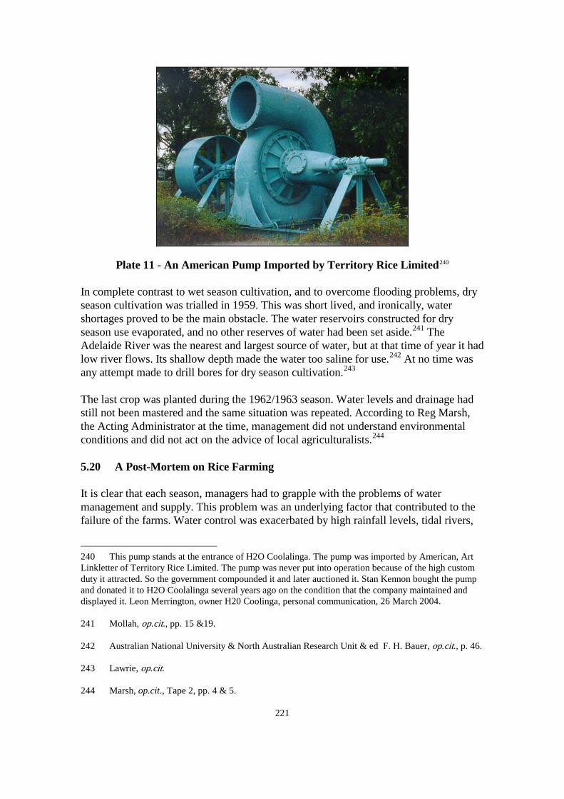
221
Plate 11 - An American Pump Imported by Territory Rice Limited240
In complete contrast to wet season cultivation, and to overcome flooding problems, dry season cultivation was trialled in 1959. This was short lived, and ironically, water shortages proved to be the main obstacle. The water reservoirs constructed for dry season use evaporated, and no other reserves of water had been set aside.241 The Adelaide River was the nearest and largest source of water, but at that time of year it had low river flows. Its shallow depth made the water too saline for use.242 At no time was any attempt made to drill bores for dry season cultivation.243
The last crop was planted during the 1962/1963 season. Water levels and drainage had still not been mastered and the same situation was repeated. According to Reg Marsh, the Acting Administrator at the time, management did not understand environmental conditions and did not act on the advice of local agriculturalists.244
5.20 A Post-Mortem on Rice Farming It is clear that each season, managers had to grapple with the problems of water management and supply. This problem was an underlying factor that contributed to the failure of the farms. Water control was exacerbated by high rainfall levels, tidal rivers,
240 This pump stands at the entrance of H2O Coolalinga. The pump was imported by American, Art Linkletter of Territory Rice Limited. The pump was never put into operation because of the high custom duty it attracted. So the government compounded it and later auctioned it. Stan Kennon bought the pump and donated it to H2O Coolalinga several years ago on the condition that the company maintained and displayed it. Leon Merrington, owner H20 Coolinga, personal communication, 26 March 2004. 241 Mollah, op.cit., pp. 15 &19. 242 Australian National University & North Australian Research Unit & ed F. H. Bauer, op.cit., p. 46. 243 Lawrie, op.cit. 244 Marsh, op.cit., Tape 2, pp. 4 & 5.

222
flooding and ineffective drainage systems. This point is supported by Mollah,245 Basinski, Wood and Hacker,246 Moir247 and to a certain extent by Bauer.248
Other reasons raised by authors are soil. While the soil was regarded as suitable by officials at the time and the main concern was the heavy clay, Bauer believes that salinity and water management were the main problems, which support this argument.249 However, he goes on to fault every conceivable aspect that could go wrong; erratic germination times, wrong rice varieties, inexperience, limited fertilisers, unsuitable machinery, pests and weed infestation.250
These problems did occur but they were intermittent, whereas water management issues were ongoing.
South and Western Australia were the destinations for the rice but like its agricultural predecessors, the cost of freighting the rice never became an issue as the rice harvested only amounted to several hundred tonnes. In fact, it is insignificant compared to the annual harvest of 124 104 tonnes of Murrumbidgee rice.251 Nonetheless, Bauer believes that if the crop was viable and transport and marketing costs were factored in, rice would have been a profitable enterprise.252 Considering that the farms were located 60 kilometres from Darwin's port, Bauer's point has merit. Opposing this, is Mollah who considers that marketing the rice was difficult because there was no railway to southern ports, coupled with road transport problems, flooded roads and limited shipping services.253
The high cost of exporting rice is taken up by Davidson who argues that a Commonwealth Government agricultural committee underestimated the sale price and export potential of Humpty Doo rice. He believes the committee was over optimistic in its calculations and that the rice farmer would barely cover costs. Moreover, the government would have to subsidise the farmer. Davidson advocates dry season pasture and fodder crops as an additional income, and as a means to recoup capital outlay.254
245 Mollah, op.cit., pp. 9, 14-15 & 17.
In short, Davidson is puzzled why it was decided to develop rice at Humpty Doo when the
246 Basinski; Wood & Hacker, op.cit., p. 111. 247 Moir, op.cit., p. 2. 248 Australian National University & North Australian Research Unit & ed F. H. Bauer, op.cit., pp. 46 & 48. 249 This is also supported by Howe, op.cit. who also mentions drainage problems. 250 ibid., pp. 46-49. 251 Commonwealth Government Department of Territories 1960, op.cit., p. 71. 252 Australian National University & North Australian Research Unit & ed F. H. Bauer, op.cit., p. 49. 253 Mollah, op.cit., p. 18. 254 Davidson 1972, op.cit. pp. 256-258.

223
Murrumbidgee Irrigation Area can produce rice more cheaply and effectively, and without subsidies. The ultimate difficulty in northern Australia is the high cost of fertiliser, labour, dam construction and machinery. Instead says Davidson, this infrastructure should be diverted into more profitable areas such as the Murrumbidgee rice farms.255
5.21 Commonwealth Government Investigation into the Northern Territory Agriculture Industry
Well before the demise of the rice farms, the government realised that the farms were doomed, and along with them, commercial agriculture in general. In 1959, the Commonwealth Government commissioned an investigation into the Northern Territory's troubled agricultural industry. The committee comprised a panel of experts and was chaired by Professor H. Forster, Dean of the Faculty of Agriculture, University of Melbourne. The inquiry addressed a multitude of issues ranging from environment and climate, land clearing and development, past crops and water supplies. The outcome was a comprehensive report titled Prospects of Agriculture in the Northern Territory: Report of the Forster Committee.256
While the report does not deliver a conclusive reason for the failure of the rice farms, it nonetheless devotes most of its chapter on rice to water control - hydrology, climate, rainfall, irrigation, water storage and salinity, and acknowledges that hydrological problems hampered rice production.257 The report also mentions that the 'the main environmental factor influencing the successful production of rice is rainfall'.258
The report revisits the recommendations made by Poggendorff and McNee and remarks that: These earlier reports on the engineering difficulties associated with the control of
water is of particular interest, especially in view of later developments. It was envisaged that rice production could only be undertaken if high levee banks could be constructed to protect the rice crop and divert the flood-waters.259
In 1959, there were only 90 hectares of fruit and vegetables under cultivation throughout the Northern Territory. This amount met only 26% of local demand with the other 74% imported. Bearing this in mind, the committee believed that the future of the industry was grim and that there was 'little point in speculating about what would happen if any
255 ibid., p. 269. 256 Commonwealth Government Department of Territories 1960, op.cit. 257 ibid., p. 5. 258 ibid., p. 73. 259 ibid., p. 71.

224
export surplus should develop'.260
Furthermore, rainfall levels and the climate in general were nominated as the largest obstacles to agricultural production. Of relevance here, is that the report emphasised the importance of irrigation:
If vegetables are to be well grown, it is imperative that they be very well supplied with water. Unfortunately much of the vegetable-growing area close to Darwin has no sure sources of underground water and the bores often run dry just when they are needed most, towards the end of the Dry. More could be done by concentrating the vegetable-growing further south, in those areas where there is much better supply of water.261
In its chapter on water supplies, the report acknowledges the need for groundwater development and irrigation for crops. The view that the Top End had abundant water supplies was dismissed, in particular, the belief that permanent water was available all year round. The report nominated potential dam sites which were suitable for large irrigation projects. Rain making both pre and post wet season was supported by the C. S. I. R. O. and endorsed by the committee. In its summary, the development of water supplies were advocated and considered pertinent to the future of agriculture.262
The report's data and recommendations make it the most comprehensive ever undertaken on Northern Territory agriculture. It not only produced new findings but revisited what had previously been recommended. The report noted that since the beginning of agriculture in the Northern Territory 'there has been so little agricultural expansion so far',263 and that the Northern Territory was 'one of Australia's most challenging frontiers'.264
5.22 A Recent Phase of Commercial Agriculture - Table Grapes Table grape growing in Australia began in the nineteenth century but it was not until the mid 1980s when the crop was trialled in the Northern Territory. Nationally, the industry produced 70 185 tonnes in 1999 valued at $123.4 million, with the major contributors being Victoria with 41 253 tonnes and New South Wales with 11 273 tonnes.265 Since 1996, the Ti Tree table grape industry has steadily increased from 1 300 tonnes to 4 000 tonnes worth almost $20.5 million in 2001.266
260 ibid., p. 113.
Compared to other states, the Northern
261 ibid., p. 114. 262 ibid., pp. 129-133. 263 ibid., p. 13. 264 ibid., p. 9. 265 Ngo, op.cit., p. 5. & Nesbitt, op.cit. 266 Ngo, op.cit., p. 3 & Nesbitt, op.cit.

225
Territory pales in significance but its annual tonnage continues to rise.267
The table grape industry in the Ti Tree region is a prime illustration of how water development can transform a desolate area into a successful agricultural region. The Ti Tree district is in the arid zone and has limited surfacewater because of low rainfall levels and high evaporation rates. The whole region depends upon groundwater and until the extent and water potential of Ti Tree's groundwater aquifers became known, agriculture in the region was not possible. 5.23 Ti Tree's Water and Soil Resources Arid environments are clearly a restraint to agriculture and the foundation of a table grape industry under such harsh conditions presents challenges. A profile on soil-water balance needs to be determined before cropping can commence. The interaction between soil, plant, climate and water has to be understood in order to tailor irrigation methods and fertiliser applications. Water balance determines not only water for the grape but also runoff and drainage which are the keys to erosion, salinity and nutrient loss.268
One of the earliest groundwater studies on the Ti Tree region was undertaken in 1966, by K. Edworthy, Government Geologist. Based on the pumping capacity and water quality of thirty-six wells and bores in the area, and data from drilling bores in an area of 160 square kilometres, Edworthy concluded that there would be sufficient groundwater to initiate commercial agriculture.269
By 2001, the extent of the Ti Tree Basin had been found to encompass 5 500 square kilometres. Further groundwater investigations revealed that water from the Ti Tree Basin could sustainably increase from the current 800 megalitres per year to 2 000 megalitres per year for the next one hundred years.270
The report was an assurance to farmers that water resources were available to support the growing industry.
Rainfall is still important to cropping but is not relied upon. Every farm has a rainfall gauge to measure rainfall levels to calculate how much supplemented water is needed. The first 10 millimetres is excluded as it is not considered useful because of high evaporation rates.271
267 Ngo, op.cit., p. 5 & Nesbitt, op.cit.
Evaporation rates are exceedingly high and this is a main reason
268 Northern Territory Department of Business, Industry and Resource Development, Alice Springs, May 2002, Technote 'Irrigation management in table grapes at Ti-Tree', no. 114, Northern Territory Department of Business, Industry and Resource Development, p. 1. 269 K. J. Edworthy, Government Geologist, Northern Territory Administration 1966, Preliminary Appraisal of the Tea-Tree [sic] Groundwater Basin, Commonwealth Government Printer, Alice Springs, pp. 1, 5-6. 270 Peter Jolly, Department of Lands, Planning and Environment 2001, Development of a Groundwater Model for the Ti Tree Farms Area, Department of Lands, Planning and Environment, Darwin, p. 2. 271 Northern Territory Department of Business, Industry and Resource Development, Alice Springs,

226
why more water is needed for cropping in central Australia. Table 20 provides a good example of high evaporation rates. Evaporation rates during November and December 2001 exceeded rainfall levels. Monthly Totals Rainfall (mm) Evaporation (mm) November 2001 90.3 221.4
December 2001 107.5 214.3
Table 20 - Ti Tree Evaporation Rates272
Irrigation scheduling and water amounts are strictly controlled. The under or over irrigation of vines can cause a range of problems and can influence the economic viability of the farm. Excessive water can create vigorous growth especially if nitrogen is in the water. Rapid growth can reduce fruiting and the size of the grape. Alternatively water stress can deplete growth and the maturing of the grape. Ti Tree grape farms are located in a region which has kandosols soil. See Table 7. This soil is loamy sand which is deep, coarse grained with good drainage that still has the ability to hold water. Soil studies have been carried out on individual farms to ascertain what fertilisers and amounts are needed to be applied to improve fertility. Fertiliser is distributed through the irrigation system to reduce wastage and apply fertiliser effectively.273
5.24 Literature Review There are numerous books and reports on the general production of table grapes in Australia. While these are helpful in understanding the basics of table grape farming, they address environmental and seasonal conditions specific to the southern states, which differ from the Ti Tree region. There are no publications dedicated to the Ti Tree table grape region but the many government technical reports and fact sheets have been sourced. Basic information on the industry is lacking, in particular its history. To fill the gaps and gain more insight into the industry, information was provided by three Ti Tree table grape farmers: Ron Miliado, Manager of Heron Farm; Ian Spencer, Manager of Ti Tree Farm and Gavin Kahl, owner of Kahl Farm. Statistics on the history of table grape growing in the region May 2002, Technote 'Irrigation management in table grapes at Ti-Tree', op.cit., pp. 1-5. 272 Northern Territory Department of Business, Industry and Resource Development 2002, Horticulture Technical Annual Report 2001-2002, Northern Territory Department of Business, Industry and Resource Development, p. 56. 273 Northern Territory Department of Business, Industry and Resource Development, Technote 'Irrigation management in table grapes at Ti-Tree', op.cit., p. 2. Howe, op.cit.

227
and water supplies have been sourced from the Department of Business, Industry and Resource Development and the Department of Infrastructure, Planning and Environment. 5.25 Table Grape Cultivation and Marketing The rootstock for the Ti Tree farms is purchased from Victorian nurseries and planted directly into the ground during August. Planting in the winter months allows the rootstock to acclimatise and establish before summer. Water supply is crucial at his time. Irrigated water needs to be applied regularly to assist root establishment and it is the primary method in which fertiliser is applied. The early stages of plant development are vital as rootstock is expensive, has to be freighted to Ti Tree, and is not readily replaceable. When the rootstock is first planted into the ground it must be carefully nurtured. If conditions are favourable during early development, the plant can begin fruiting in its second year. This is an advantageous position to be in, as rootstock in southern Australia do not begin fruiting until the third or fourth year.274 The climatic conditions of the Ti Tree region also favour an earlier harvest than in southern Australia. Harvesting occurs between November and January which enables Ti Tree farmers to supply the Australian market before the southern regions reap their crops in February.275
The bulk of the crops are sold to large chain supermarkets which distribute the grapes throughout the Northern Territory and interstate. Until recently the grapes were transported by refrigerated road trains but since the north to south railway commenced in January 2003, the grapes are now freighted by train.276
In 2001, an economic evaluation was undertaken by Huyn Ngo of the Department of Business, Industry and Resource Development who examined the cost of establishing and operating a Ti Tree table grape farm. Ngo looks at the cost of buildings, sheds, irrigation, plant, bores, electricity, root stock and farm machinery against acreage and potential crop yields. Taking into consideration that market value and crop production can fluctuate enormously and make a difference to profit, Ngo's figures conclude that a farmer can still produce a profit ranging between 15% and 29%.277
5.26 The Ti Tree Table Grape Farms The history of the table grape area is short with most farms founded during the early 1990s. To demonstrate the importance of water supplies to this industry, it was originally intended to trace the economic history of three table grape farms by studying water consumption figures, bore numbers, grape production and hectares under cultivation. Of the three farms examined, the current owners or managers knew very 274 Gavin Kahl, owner Kahl Table grapes and member of Northern Territory Primary Industry Board, Ti Tree, personal communication, 21 October 2003 & 10 February 2004. 275 ibid. 276 ibid. 277 Ngo, op.cit., p. 13.

228
little about the history of their farms. Statistics on the farms are not available from government because data was not systematically collected until only recently. Nevertheless, information is available to provide a small economic snapshot on the relationship between water supplies and grape production. 5.27 Heron Farm Heron Farm is owned by DLOOG Table Grapes and has been managed by Ron Miliado since 1999. Rootstock was planted on the 16 hectares in 1999 which produced fruit in the 2002/03 season. There is only one irrigation bore which is pumping 8 litres per second and adequate for the size of the crop. The bore has the capacity to pump 15 litres per second, so as the crop expands, so will the bore's pumping rate. Over the next few years the crop will be gradually expanded, and Miliado believes that the bore will continue to meet the needs of the crop for some time yet. Additional rootstock was planted between 2002 and 2003 and Miliado expects the crop to produce 100 tonnes in the 2004/05 season.278
YEARS/ table grape seasons
BORES WATER CONSUMPTION (kilolitres)
HECTARES TABLE GRAPE PRODUCTION (TONNES)
2000/01 1 10 704 16 nil 2001/02 1 12 461 16 nil 2002/03 1 43 707 16 25 2003/04 1 46 839 30 55
Table 21 – Heron Farm279
5.28 Ti Tree Farm Ti Tree Farm is owned by Peter McKean and managed by Ian Spencer. It can be clearly seen in Table 22 below, that table grape cultivation expanded rapidly in a few short years and over a significant area. Corresponding with this, has been an increase in the number of bores, and water consumption has almost quadrupled within a two year period. Over the past few years, great effort had gone into the expansion of crops, improving infrastructure and updating farm machinery. Spencer was disappointed with the 2002/03 results explaining that the region had unusual frost and rain which had a detrimental effect on the table grapes.280
278 Ron Miliado, Manager Heron Farm, Ti Tree, personal communication, 28 October 2003 &
2 February 2004. 279 ibid. Department of Infrastructure, Planning and Environment, Alice Springs, Water Consumption Reports on Ti Tree Table Grape Farms. 280 Ian Spencer, Manager Ti Tree Farm, Ti Tree, personal communication, 26 October 2003 & 8 February 2004.
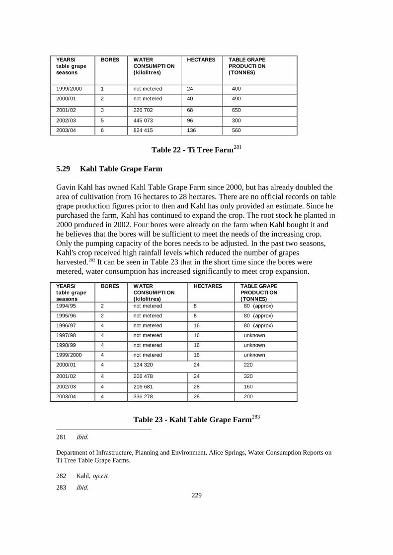
229
YEARS/ table grape seasons
BORES WATER CONSUMPTION (kilolitres)
HECTARES TABLE GRAPE PRODUCTION (TONNES)
1999/2000 1 not metered 24 400 2000/01 2 not metered 40 490 2001/02 3 226 702 68 650 2002/03 5 445 073 96 300 2003/04 6 824 415 136 560
Table 22 - Ti Tree Farm281
5.29 Kahl Table Grape Farm Gavin Kahl has owned Kahl Table Grape Farm since 2000, but has already doubled the area of cultivation from 16 hectares to 28 hectares. There are no official records on table grape production figures prior to then and Kahl has only provided an estimate. Since he purchased the farm, Kahl has continued to expand the crop. The root stock he planted in 2000 produced in 2002. Four bores were already on the farm when Kahl bought it and he believes that the bores will be sufficient to meet the needs of the increasing crop. Only the pumping capacity of the bores needs to be adjusted. In the past two seasons, Kahl's crop received high rainfall levels which reduced the number of grapes harvested.282
It can be seen in Table 23 that in the short time since the bores were metered, water consumption has increased significantly to meet crop expansion.
YEARS/ table grape seasons
BORES WATER CONSUMPTION (kilolitres)
HECTARES TABLE GRAPE PRODUCTION (TONNES)
1994/95 2 not metered 8 80 (approx) 1995/96 2 not metered 8 80 (approx) 1996/97 4 not metered 16 80 (approx) 1997/98 4 not metered 16 unknown 1998/99 4 not metered 16 unknown 1999/2000 4 not metered 16 unknown 2000/01 4 124 320 24 220 2001/02 4 206 478 24 320 2002/03 4 216 681 28 160 2003/04 4 336 278 28 200
Table 23 - Kahl Table Grape Farm283
281 ibid.
Department of Infrastructure, Planning and Environment, Alice Springs, Water Consumption Reports on Ti Tree Table Grape Farms. 282 Kahl, op.cit.
283 ibid.

230
Table 24 – Overall Water Consumption and Table Grape Production of the Three
Farms – 2001–2004 table grape seasons284
5.30 Conclusion on the Table Grape Industry Being a recent crop growing in an arid region, table grapes have already proven their potential in the Ti Tree region. Since the 1960s, over thirty water resource studies on the region have been carried out and water monitoring procedures have been introduced. In 1996, 120 hectares were under cultivation which has since expanded to 420 hectares.285 At this current rate of expansion, the goal of 600 hectares under cultivation will soon be reached.286 Government estimates that if this area of cropping is met, the industry will be worth $70 million.287
5.31 Conclusion on Agriculture The Northern Territory's history of commercial agricultural production was a disastrous combination of ambitious ideas and, to a great extent, ignorance of environmental
Department of Infrastructure, Planning and Environment, Alice Springs, Water Consumption Reports on Ti Tree Table Grape Farms. 284 Kahl, op.cit., Miliado, op.cit. and Spencer, op.cit. Department of Infrastructure, Planning and Environment, Alice Springs, Water Consumption Reports on Ti Tree Table Grape Farms. 285 Nesbitt, op.cit. 286 Ngo, op.cit. p. 3. 287 ibid.
Water & Grape Production
300
500
700
900
1,100
1,300
2001
2002
2003
2004
2005
Wat
er(m
egal
itres
)
1002003004005006007008009001,000
Gra
pe
Prod
uctio
n(to
nnes
)
WATER (MEGALITRES) GRAPES (TONNES)

231
conditions. Environmental difficulties created an array of problems in cropping that continued well into the twentieth century. The belief that the Top End's tropical conditions would easily support agriculture became a proven fallacy in sugar cane, peanut and rice cultivation. A puzzling aspect is that the tropical myth persisted for over a century even though it was never substantiated with any cropping successes.288
What these three crops had in common was that they all relied on rainfall. The sugar cane and peanut crops experienced water stress that adversely affected the quality and quantity of the harvest. Irrigated water was unavailable to supplement crops during their development and prior to harvesting, when water was most needed. Floods on the other hand, plagued the rice crops, and drainage methods continued to be inadequate, right up until the farms folded.
In stark contrast, is the table grapes industry which is entirely dependent upon irrigated water. The Ti Tree region contradicts the wetter and more fertile Top End, yet this dry and largely infertile environment has proven that with adequate water supplies and fertilisers, and good farming practices an arid region can produce viable crops. Since the early 1980s, groundwater has been increasingly tapped for irrigation in commercial cropping.289 Although Northern Territory agriculture is largely concentrated in the Top End, the difference between early farming and now, is that no commercial crop solely relies on rainfall. Today, irrigation is an integral factor in farming practices. Most importantly is that water supplies are identified before farming proceeds. This is evident in the agricultural subdivisions of Lambells Lagoon and Venn in the Top End which are among the largest producing areas. Groundwater rather than surfacewater has become a crucial element in agriculture so much so that it now accounts for 99% of water used in commercial cropping.290
It is worth returning to a statement that Bruce Davidson made in The Northern Myth. He wrote that 'agricultural techniques which have been developed in tropical Australia are uneconomic and that development there could only proceed at tremendous costs to the nation. Resources which would be wasted in the north could be profitably used for many forms of development in the south of the continent'.291
The book was first published at a time when Northern Territory agriculture was stagnant and showing little potential.
Not much has changed in regards to higher costs for farming materials such as machinery, fertilisers, labour and freight. Every item that Davidson mentions still 288 Commonwealth Department of Territories, Paul Hasluck, Minister for Territories 1956, Development of the Northern Territory, Government Printer, Canberra. p. 3. 289 The new mango industry is one reason for the increasing use of groundwater in agriculture. The Sydney Morning Herald, 9 January 1982. 290 Hardy, op.cit. 291 Bruce Davidson 1972, op.cit., p. xvi.

232
continues to be more expensive in the Northern Territory than in southern Australia. Irrigation and better technology have enhanced production, making it a viable enterprise regardless of higher operation costs. Admittedly the crops that are successful today were untried during Davidson's time. Nevertheless the fact that these crops are irrigated, lends weight to the argument. The agricultural industry today has become the Northern Territory's third primary industry earner behind that of mining and pastoralism. Since 1990, agricultural income has increased from $20 million to $60 million in 1997 and $92 million in 2001.292
292 Department of Business, Industry and Resource Development, Horticulture Technical Annual Report 2001-2002, op.cit., p. 69. ___ 2003, Annual Report 2002-2003, pp. 5 & 10.

CONCLUSION

233
CONCLUSION
'Water in this land [Northern Territory] is the first and most important ingredient of any developmental project'. M. R. Irving, Director of Animal Industry, 1950s1
Historians of water development in Australian such as Raymond Whitmore and J. M. Powell primarily deal with its social, political and, to a certain extent, economic aspects. Most publications in general examine the subject of water from engineering, scientific, hydrological, geophysical, environmental, legislative and political viewpoints. No author has explored the role of water in relation to the Northern Territory's economy as a tool in settlement and primary industry. This thesis not only comprehensively documents a history of water development in the Northern Territory for the first time, but also illustrates that water greatly influences the process of settlement, agriculture, pastoralism and mining. Problems with water supplies were detrimental to the Northern Territory's economic health. It has been debated why early schemes failed in the Northern Territory and why the same mistakes were repeated. The British were confronted with the same environmental problems at all three of their settlements, yet never overcame them. Until the latter half of the twentieth century, commercial agriculture constantly failed, pastoralism languished, and mining remained spasmodic. Chapter One examines the economic role of water from ancient society to the present, and the fact that most Australian regions harnessed water for economic use soon after settlement. It was seen in the construction of commercial irrigation schemes, dams and public water systems throughout the 1800s. This infrastructure often assisted the development of strong economies, population growth and capital works in other Australian regions but it was not the case in the Northern Territory. While the Northern Territory shared similar primary industries, its infrastructure remained rudimentary until the Second World War. Conventional methods of primary industry achieved very little and needed to be modified to accommodate the difficult climate and strata. Water supplies in particular needed to be augmented to help off set environmental and drought conditions. The most puzzling aspect to the Northern Territory's economic history was the role of successive governments. The South Australian Government continually promoted the capability of the Northern Territory even though it was never proven with any substantial achievements. The government had bold plans for the Northern Territory in the form of a south to north railway and grand schemes to encourage investment and 1 NTAS Northern Territory Pastoral Lessees Association Records, PAC106 Series 199/1/1, Item D3/4J, Miscellaneous Correspondence and Cuttings 1948-1963, unprocessed collection, Cattle: Stock Routes: Notes on second reading speech of M. R. Irving, Director of Animal Industry, c. 1950s, p. 2.

234
settlement. The Commonwealth Government, on the other hand, initiated a series of investigations into the underdevelopment of the Northern Territory. The investigations began in the 1920s with Sir George Buchanan and four reports by the North Australian Commission. Then in 1933, the Northern Territory Pastoral Leases Investigation Committee was formed to examine why the pastoral industry had not economically progressed. In 1937, a Board of Inquiry was appointed to examine the Northern Territory's industry and settlement and to advocate improvements. In 1947, the Northern Australia Development Committee was formed to address almost the same issues as the Board of Inquiry. In 1959, the Development of the Northern Territory was tabled in the Commonwealth Parliament, and on the heels of this was another inquiry, this time on the Northern Territory's troubled agricultural industry. The outcome was a comprehensive report by the Forster Committee Prospects of Agriculture in the Northern Territory. Except for the Second World War, the Northern Territory's economy remained stagnant until the 1960s, when capital works programs began to make an enormous impact on infrastructure and industry. Chapter Two discusses the futile attempts by the British to establish a foothold in northern Australia. Generally historians blamed inappropriate site selection, difficult harbours and the failure of the outposts to evolve into viable trading ports. It has been argued that site and harbour locations and their position in relation to the trade routes would have been obvious before settlement and internal reasons are more likely explanations for their abandonment. In the case of Fort Victoria, Captain Owen Stanley of the HMS Rattlesnake pointed to unproductive gardens, an unhealthy colony and the problems associated with white ants and other pests. To a small degree, Stanley's documentation supports that of Reid, Calley and the conclusion in Chapter Two. Besides Stanley's evidence, there is other documentation that validates the problems associated with water quality and shortages. If the outposts evolved into healthy independent settlements they may have remained. Chapter Three demonstrates that water supplies were essential to the expansion of pastoralism. The lack of permanent water points not only limited the number of cattle but restricted land use and created overgrazing. The harnessing of groundwater became a fundamental resource to off set drought conditions. Historically, most pastoralists were unable to reach their estimated carrying capacities until water points were increased. This has only been realised since the introduction of the 'dud' bore scheme in 1961, and it has since made a huge impact on the industry. Within a ten year period, between 1965 and 1975, the total number of cattle in the Northern Territory doubled. Documentary evidence and statistics show that the development of groundwater assisted the increase of cattle numbers. The 'dud' bore scheme has proved so successful that pastoralism is now the largest user of groundwater. Chapter Four on mining confirms that water shortages had an adverse affect on mining activities in an arid region. Water shortages were experienced at both Arltunga and Tennant Creek which severely limited gold mining activities. For alluvial mining, water was needed for sludging and panning. Mining batteries needed water to process the

235
crushing of ore that contained the gold, and water was needed in the tailing process. Water was also necessary to convey the ore on the crusher and again in the cyaniding procedure. Besides the extraction of gold, the miners themselves required water for everyday domestic use and for their stock. Arltunga was chosen for study because it was the first gold rush in central Australia. It stimulated the region's economy and was directly responsible for the development of Alice Springs. Arltunga was a highly productive field, which, according to geologist Brown, had more potential if appropriate machinery, and water resources were increased. The South Australian Government excavated nine wells between 1888 and 1902 to keep abreast with mining. No other Northern Territory mining field at the time, could lay claim to this achievement. Tennant Creek was selected because throughout the 1930s and 1940s it produced almost all of the Northern Territory's gold. The field was regarded as one of the most lucrative in the world, and at the end of the rush a permanent settlement remained. This field, like Arltunga, had a constant battle with water shortages in which miners had to transport and pay for. The Commonwealth Government responded with a vigorous drilling campaign that produced forty-four bores within a seven year period. In both examples, government was proactive in water development. The final chapter shows that commercial agriculture was a spasmodic industry that was doomed to fail from the very beginning. The three commercial crops of sugar cane, peanuts and rice were planted in regions where rainfall was expected to supply all the water needs of the crops. Sugar cane and peanuts suffered from water shortages while the rice crops were affected by uncontrollable flooding and tidal flows. Water supplies were not developed or harnessed and used to irrigate crops. Ambitious ideas and ignorance of environmental conditions were the crux to the failure of commercial agriculture schemes. The tropical vision held the belief that fertile soil and abundant rainfall would automatically produce lucrative crops. This myth persisted well into the twentieth century well after the rice debacle of the 1960s. It continued for over a century, yet the myth was never supported by any cropping successes. In the past twenty years, groundwater has been increasingly tapped for irrigation in commercial cropping. Groundwater rather than surfacewater has become a crucial element in agriculture, so much so that it now accounts for 99% of water used in commercial cropping. Today, water investigation and irrigation are an integral part in farming practices. Although agriculture continues to dominate the Top End, the difference between early farming and farming now is that no commercial crop solely relies on rainfall. The significance of this thesis is that water has been shown to be an important component in settlement and primary industry throughout the Northern Territory's economic history. Water was, and still is, a vital resource, especially in harsh and hot environments such as the Northern Territory. Unlike southern parts of Australia, most of

236
the Northern Territory's water supplies are derived from groundwater because surfacewater, especially in the arid region, is subject to high evaporation rates. Throughout most of the Northern Territory's history, water supplies remained underdeveloped and underestimated, and this contributed to the slow development of settlement and primary industry. Water today is regarded as a valuable economic tool and is protected by legislation.

BIBLIOGRAPHY

237
BIBLIOGRAPHY Where possible punctuation, referencing and bibliography style has adhered to the guidelines recommended in the Commonwealth Government Department of Finance and Administration, Commonwealth Government 1994, Style Manual for Authors, Editors and Printers, 5th edn, Government Printer, Canberra.
PRIMARY SOURCES
DEPARTMENT OF INFRASTRUCTURE, PLANNING AND ENVIRONMENT - INTERVIEWS Peter Garone, Senior Manager Hydrographic and Drilling & Brian Kunde, Drill and Bore Test Manager, Department of Infrastructure, Planning and Environment interview by Bev Phelts, Natural Resources Division, Department of Infrastructure, Planning and Environment, 31 January 2003. John Hayes, owner of Undoolya Station via Alice Springs, interview by Bev Phelts, Department of Lands, Planning and Environment, Undoolya Station, September 2000. Graeme Hockey, Senior Pastoral Officer, Northern Territory Department of Lands and Housing, 1977-1987, interview by Bev Phelts, Natural Resources Division, Department of Infrastructure, Planning and Environment, October 2002. Jon Lawrie, Northern Territory Water Resources Division hydrographer/drilling and bore testing 1956-1995, interview by Bev Phelts, Water Resources Division, Power and Water Authority, Darwin, July 1995. PERSONAL COMMUNICATION Mervyn Chin, Bore Data Officer, Northern Territory Department of Infrastructure, Planning and Environment, Darwin, personal communication 30 October 2002. David Hardy, Land and Water Advisory Officer, Northern Territory Department of Infrastructure, Planning and Environment, Darwin, personal communication, 1 May 2002. Ian Hillock, retired Northern Territory and African tropical agriculturalist and author, personal communication, 5 January 2005. Gary Holmes, Land and Water Advisory Officer, Northern Territory Department of Lands, Planning and Environment, personal communication between June and July 2001.

238
David Howe & Jason Hill, Land and Soil Officers, Northern Territory Department of Lands, Planning and Environment, personal communication between 14 and 31 December 2004. Gavin Kahl, owner Kahl Table grapes and member of Northern Territory Primary Industry Board, Ti Tree, personal communication, 21 October 2003 & 10 February 2004. Keith Lunn, Stock Inspector, Department of Business, Industry and Resource Development, Katherine, personal communication, 1 July 2004. Ron Miliado, Manager Heron Farm, Ti Tree, personal communication, 28 October 2003 & 2 February 2004. Leon Merrington, owner H20 Coolinga, personal communication, 26 March 2004. Andrew Nesbitt, Horticulturalist, Northern Territory Department of Business, Industry and Resource Development, Alice Springs, personal communication, 3 November 2003. Fergal O'Gara, Agronomist, Northern Territory Department of Business, Industry and Resource Development, Darwin, personal communication, 3 November 2003. Ross Peatling, Manager Alexandria Downs Station, personal communication, 12 December 2002. Graham Ride, Groundwater Engineer, Northern Territory Department of Infrastructure, Planning and Environment, Alice Springs, personal communication, 7-9 September 2000 & 1 May 2002. Nigel Ridgway, Mining Engineer, State Manager SA, NT, VIC, TAS, Weir Warman Minerals, personal communication, 16 January 2004. Ian Spencer, Manager Ti Tree Farm, Ti Tree, personal communication, 26 October 2003 & 8 February 2004. Rink Van derVelde, Water Advisory Officer, Water Resources Division, Department of Lands, Planning and Environment, 1958-1999, personal communication, January 1999 & 9 December 2004. NORTHERN TERRITORY ARCHIVES SERVICE NTRS 888, John McArthur, positive and negative microfilm of manuscript notebook from Port Essington settlement (NTRS 862) 1843-1849. NTRS 226 TS351-1, Kevan Weaber, interview by Helen Wilson, 1981. NTRS 226 TS90, Reg Marsh, Assistant Administrator 1953-1962, interview by Helen Wilson, 1984.

239
NTRS 276 TS512, Walter Fife Nixon-Smith, Agricultural Officer 1940s-1950s, interview by F. H. Bauer, 1988. NTAS F485 Government Battery, Tennant Creek, Correspondence Files 1939-1942. Government Resident Inward Correspondence, 1870-1910. NTAS F155 Correspondence Files – Single Number Series 1933-1941. Pastoral Records and Correspondence 1910-1961 - various pastoral stations. Northern Territory Pastoral Lessees Association Records, Series PAC106 199/1/1, Items A1/A1-A1/1G, A1/2A-A1/2E, D1/1A-D1/1C, D3/1A-D3/1G, unprocessed collection. NATIONAL ARCHIVES AUSTRALIA, DARWIN CRS F742 Item 1941/31M, Administrator – Mines Branch Policy – Discussion Concerning Lease Application, Tennant Creek, Freight Rates on Mining Material, Port Augusta to Granites, Mica, Wolfra, Tantalite and Carbonate Lead Mining and Maintenance of Waterpoints, Barkly Highway. CRS F1 Item 1938/62, Central Gold Milling Company, Tennant Creek. CRS F1 Item 1942/259, 'Arltunga Battery' Proposed Sale of N.T. CRS F1 Item 1938/302, Moonlight Rockhole Locality Tennant Creek CRS F1 Item 1938/270, Mining Batteries, Tennant Creek. CRS F1 Item 1937/470, Mining Batteries, Tennant Creek. CRS F1 Item 1948/29, No. 3 Government Battery – Tennant Creek. CRS F742 Item 1941/44M, No. 3 Government Battery, Tennant Creek – Construction. CRS F742 Item 1941/102M, Warden – Tennant Creek – Monthly Reports. CRS F1 Item 1944/261, Water Supply Tennant Creek – Hospital and other Government Buildings – Coverings of Tanks etc. CRS F1 Item 1942/196, Water Supplies Tennant Creek. CRS F1 Item 1937/322, Tennant Creek New Goldfield Discovery. CRS A3 Item 13/11189, Government Well Township of Stuart N.T.

240
CRS F658, 1935 Northern Territory Pastoral Leases, Investigation Committee Report - Hodgson Downs Station. CRS F658, 1935 Northern Territory Pastoral Leases Investigation Committee Report - Elsey Station. CRS F658, 1935 Northern Territory Pastoral Leases Investigation Committee Report - Maryvale Station. CRS F658, 1935 Northern Territory Pastoral Leases Investigation Committee Report - Rocklands Station. CRS F658, 1935 Northern Territory Pastoral Leases Investigation Committee Report - Undoolya Station. CRS F48 Item 6, Correspondence with Lessees. CRS F48/0 Item 4, Working and Information Papers. CRS F48 Item 4, Statistics in Regard to Avon Downs, N.T. CRS E72/1 Item D9968/1, Resumption of Pastoral Leases - Crown Land Ordinance 1931-59 Alexandria Station. CRS F49 Item 27, Pastoral Leases - Brunette Station CRS F1 Item 1936/100, Agriculture and Settlement in the Coastal Belt the Northern Territory. CRS F1 Item 1948/38, Peanut Production - Northern Territory. CRS F1 Item 1950/245 parts 1-3, Potential Rice Areas Near Darwin. CRS F1 Item 1955/386, Pastoral Leases - General. CRS F1 Item 1954/537, Pastoral Leases - General. CRS F425 Item C70, Pastoral Leases - General Policy CRS F1 Item 1952/887, Rosewood Station. CRS F1 Item 1954/762, Rosewood Station. CRS E51 Item 1967/1003, Inspection and Surveys - Rosewood Cattle Station. CRS E742 Item 1946/37M vol.1, N.T. Mining General Enquiries and Information. CRS F48 Item 3, General File on Pastoral Holdings.

241
CRS F658 Item 11, 1935 Northern Territory Pastoral Leases Investigation Committee Report - Austral Downs Station. CRS F658,1935 Northern Territory Pastoral Leases Investigation Committee Report - McArthur River Station. CRS F658, 1935 Northern Territory Pastoral Leases Investigation Committee Report - Rocklands Station. CRS F48 Item 1, Department Correspondence re: Pastoral Properties. CRS F1 Item 1962/2162, Assistance to Pastoral Lessees in Time of Drought – Policy and Development. NATIONAL ARCHIVES OF AUSTRALIA, CANBERRA CRS A1 Item 1936/1529, Water Tanker - Tennant Creek. CRS A1 Item 1936/7529, Water Tanker - Tennant Creek – N.T. CRS A1 Item 1935/5193, Alice Springs to Tennant Creek Mail Service. CRS A1 Item 1936/7992, Tennant Creek. Festivities to Mark Gold Production. CRS 1 Item 1935/10119, E. V. Hale. Application for Assistance to Erect Battery, Tennant Creek. CRS 1 Item 1935/5602, Public Meeting at Tennant Creek arranged by Tennant Creek Gold Mining Industries Association. CRS A431 Item 1946/2633, Tennant's Creek Goldfield. Report by Dr. W. G. Woolnough. CRS A518 Item D241/6/8/ part 1, Works – Northern Territory – Tennant Creek Water Supply. CRS 1 Item 1936/1147, Dr. W. G. Woolnough - Report on General Matters Affecting Tennant Creek Goldfield. CRS A452 Item 1957/427, Tennant Creek Goldfield – General – Northern Territory CRS A659 Item 1939/1/8910 part 1, Tennant Creek Goldfield, Northern Territory. CRS A659 Item 1940/1/847, Tennant Creek Goldfield. Report by Owen, H. B. CRS A659 Item 1944/1/4127, Eldorado, Tennant Creek Limited, Northern Territory. CRS A431 Item 1947/2/47, Erection of Government Battery Tennant Creek. N.T.

242
CRS A1 Item 1938/6076, C. H. Windley - Appln. For Reward for Discovery of Gold at Tennant Creek, N. T. CRS A1 Item 1926/4567, Agreement between Administrator John Gilruth and Northern Agency Limited, 26 August 1916. CRS A1/15 Item 1927/21460, Report on Cattle and Pastoral Holdings by Chief Inspector of Stock for N.T. CRS A659 Item 1939/1/270, Mair, H.K.C., Superintendent of Agriculture, Northern Territory. CRS A1640 Item 1903/433, Gold Discoveries near Winnecke's Depot and Mines on the Arltunga Goldfields. AUSTRALIAN WAR MEMORIAL AWM 54 Item 337/7/5, Farms and Gardens - Farming Units: Inspection Report on 1 Australian Farm Coy, Australian Army Service Corps, Northern Territory by Lieutenant N. A. M. Kjar, August 1943. MORTLOCK LIBRARY OF SOUTH AUSTRALIA, ADELAIDE PRG 1132/10, Sugar Plantations, 'Prospectus of the Daly River Plantation Company', January 1885. PRG 1046/5, Papers, Sir James Penn Boucaut 1831-1916. STATE RECORDS OF SOUTH AUSTRALIA, ADELAIDE GRS 1/1 series, Incoming Correspondence to the Minister Controlling the Northern Territory. GRS 1/1/1889/914; GRS 1/1/1890/539; GRS 1/1/1892/118; GRS 1/1/1897/83; GRS 1/1/1898/46; GRS 1/1/1898/258; GRS 1/1/1898/377; GRS 1/1/1900/308; GRS 1/1/1902/228; GRS 1/1/1903/83 and GRS 1/1/1904/168. NEWSPAPERS The Adelaide Advertiser; The Adelaide Observer; The Age; The Argus; The Bulletin; Melbourne Herald; The Northern Standard; The Northern Territory News; The Northern Territory Times; The Northern Territory Times and Gazette; The Register, Adelaide; The Sunday Territorian and The Sydney Morning Herald. CATALOGUES Eclipse drilling rigs and associated boring equipment, Toowoomba, c.1908.

243
INTERNET Water and Rivers Commission of Western Australia, 'Sharing the waters of the Ord River', 29 December 2004, www.wrc.wa.gov.au Department of Industry and Resources of Western Australia, 'Ord Irrigation scheme Stage 2', 29 December 2004, www.doir.wa.gov.au TELEVISION PROGRAMS The World Around Us: What On Earth Have We Done To Our World? (video recording) 20 January 2001, Channel 7 Television, Darwin, . Liquid Assets - Conflict Over the Euphrates, The Cutting Edge (video recording) 13 March 2001, SBS Television, Darwin. Jones, Alan, Harnessing Water for use in Drought, 23 July 2002, Today Show, Channel 8 Television. BRITISH AND COLONIAL GOVERNMENT 'Abandonment of the settlement of Port Essington' in Australia, Legislative Council 1850, Votes and Proceedings, vol.1, session of the year with the various documents connected therewith, Sydney, pp. 3-7. Britain, House of Assembly, Judicial Committee of the Privy Council, 12 November 1874, Report of the Proceedings Before the Judicial Committee of the Privy Council: Proceedings NT Litigation, London. SOUTH AUSTRALIAN GOVERNMENT, PARLIAMENTARY PAPERS, LEGISLATION & REPORTS Selected Government Residents' Reports on the Northern Territory 1863-1910 and South Australian Parliamentary Papers. Playford, F. Copley 1900, Record of Mining in the Northern Territory of South Australia, Government Printer, Adelaide. . South Australian Government 1902, Land-Grant Railway Across Central Australia: The Northern Territory of the State of South Australia as a Field for Enterprise and Capital : Boundless Resources: Pastoral, Agricultural, Mineral, Natural Harbours, Navigable Rivers, Simpson Newland, Hussey & Gillingham, Adelaide. Brown, H. Y. L., Government Geologist 1903, Report on the Gold Discoveries near Winnecke's Depot and Mines on the Arltunga Goldfields, MacDonnell Ranges with Plan and Appendices, Government Printer, Adelaide.

244
MacFie, Matthew 1907, How Can Tropical and Sub-Tropical Australia be Effectively Developed?, South Australian Government Printer, Adelaide. South Australia Department of Agriculture, 1989, Budding Vine Rootstocks, South Australia Department of Agriculture, Adelaide. South Australia Department of Environment and Natural Resources, 1995, Our Water Our Future: Sustainable Management, South Australia Department of Environment and Natural Resources, Adelaide. COMMONWEALTH GOVERNMENT PUBLICATIONS Selected Administrators' Reports on the Northern Territory 1911-1947, Parliamentary Debates and Parliamentary Papers. The Parliament of the Commonwealth of Australia, Northern Australian Act of 1926, Victorian Government Printer, Melbourne. . North Australia Commission 1928, Initial Report on Scheme for Development of North Australia, 1926-1928, Commonwealth Government Printer, Canberra. ____ 1928, Second Annual Report of the North Australia Commission 1st July 1927 to 31st December 1928, Commonwealth Government Printer, Canberra. ____ 1929, Third Annual Report of the North Australia Commission 1st January 1929 to 31st December 1929, Commonwealth Government Printer, Canberra. ____ 1930, Fourth Annual Report of the North Australia Commission 1st January 1930 to 31st December 1930, Commonwealth Government Printer, Canberra. Bishop, Frank 1923, Report on the Inspection of the Pastoral Holdings, Stock Routes, Bores, and Dips on the Barkly Tableland, Northern Territory, Victorian Government Printer, Melbourne. Buchanan, George 1925, Northern Territory Development and Administration, Victorian Government Printer, Melbourne. ____ 1926, The Ports of North and North-Western Australia, Victorian Government Printer, Melbourne. Ward, Keith 1926, Report on Water Supply Facilities on Stock Routes and Elsewhere in the Northern Territory of Australia, Commonwealth Department of Works and Railways, Melbourne.

245
Commonwealth Government 1937, Report of the Board of Inquiry Appointed to Inquire into the Land and Land Industries of the Northern Territory of Australia, Commonwealth Government Printer, Canberra. (commonly referred as the Payne Report). Northern Australia Development Committee 1947, Report on the Development of Northern Australia 1946-1947, Commonwealth Government, Canberra. Northern Territory Administration, Animal Industry Branch Annual Reports, Commonwealth Government Printer, Canberra, 1948-1960. Commonwealth Department of Territories, Hasluck, Paul, Minister for Territories 1956, Development of the Northern Territory, Government Printer, Canberra. Commonwealth Government Department of Territories 1960, Prospects of Agriculture in the Northern Territory: Report of the Forster Committee. Canberra. (commonly referred to as the Forster Report). Edworthy K. J., Government Geologist, Northern Territory Administration 1966, Preliminary Appraisal of the Tea-Tree [sic] Groundwater Basin, Commonwealth Government Printer, Alice Springs. Australian Bureau of Statistics 1993, Northern Territory in Focus, Northern Territory Government Printer, Darwin. Commonwealth Government 1996, COAG Water Reforms, Commonwealth Government Printer, Canberra, (brochure). NORTHERN TERRITORY GOVERNMENT PUBLICATIONS Department of Mines and Energy (DME), NTGS Report 1978-016, Extracts from Mines Branch Annual Reports on Tennant Creek, 1933-1970, Darwin. Commonwealth Scientific and Industrial Research Organization, Moir, J. D. 1960, Wet Sowing of Rice in Northern Australia, technical memorandum 60/5, Commonwealth Scientific and Industrial Research Organization, Canberra. Water Resources Division, Department of Mines and Energy 1985, Water: Northern Territory, vol.1, Northern Territory Government Printer, Darwin. G. R.M. International 1987, Northern Territory Pastoral Industry Study, Northern Territory Government, Darwin. Northern Territory Department of Primary Industry and Fisheries, Darwin. Department of Primary Industry and Fisheries, September 1993, Agnote 'Growing peanuts in the Northern Territory', Northern Territory Department of Primary Industry and Fisheries, Darwin.

246
Northern Territory Department of Business, Industry and Resource Development, Alice Springs, May 2002, Technote 'Irrigation management in table grapes at Ti-Tree', no. 114, Northern Territory Department of Business, Industry and Resource Development. Northern Territory Department of Business, Industry and Resource Development, Darwin, February 2004, Agnote 'Growing peanuts in the Top End of the Northern Territory', Northern Territory Department of Business, Industry and Resource Development, Darwin. Sanders, R. & Rajaratnam, L. R., Power and Water Authority 1994, Water Resources Survey of the Western Victoria River District: Rosewood Station, Power and Water Authority, Darwin. Water Resources Division, Power and Water Authority 1995, NT Water: Blueprint for Future Direction, Power and Water Authority, Darwin. Water Resources History Committee 1998, Water Resources: 40 Years On: History of the Northern Territory Water Resources Division, Department of Lands, Planning and Environment, Darwin. Yin Foo, Des, Department of Infrastructure, Planning and Environment 2000, Water Resources Development map Commentary Notes: Bloodwood Downs, Cow Creek, Dry River, Gilnockie, Gorrie, Lakefield, Larrizona, Margaret Downs, Nenen and Wyworrie Stations, Department of Infrastructure, Planning and Environment, Darwin. Department of Primary Industry and Fisheries 2001, Annual Report 2000-2001, Darwin. Department of Business, Industry and Resource Development 2002, Annual Report 2001-2002, Darwin. Ti Tree Water Advisory Committee, Northern Territory Department Lands, Planning and Environment, February 2001, Newsletter, Alice Springs. Jolly, Peter, Department of Lands, Planning and Environment 2001, Development of a Groundwater Model for the Ti Tree Farms Area, Department of Lands, Planning and Environment, Darwin. Ngo, Huyn, Department of Primary Industry and Fisheries 2001, Economic Evaluation of Table Grape Production in Central Australia, Northern Territory Department of Primary Industry and Fisheries, Darwin. Department of Lands, Planning and Environment, Darwin, Bore Log Reports on Northern Territory Pastoral Stations to 2002. Department of Business, Industry and Resource Development 2002, Horticulture Technical Annual Report 2001-2002, Northern Territory Department of Business, Industry and Resource Development, Darwin.

247
Department of Business, Industry and Resource Development 2003, Horticulture Technical Annual Report 2002-2003, Northern Territory Department of Business, Industry and Resource Development, Darwin. Yin Foo, Des, Department of Infrastructure, Planning and Environment 2002, Water Resources of the Sturt Plateau Region: Overview Report, Department of Infrastructure, Planning and Environment, Darwin. Department of Infrastructure, Planning and Environment, Alice Springs, Water Consumption Reports on Ti Tree Table Grape Farms to 2003. QUEENSLAND GOVERNMENT PUBLICATIONS Queensland Water Resources Commission 1989, Water for Queensland: How Water Fits into our Way of Life in Queensland, Queensland Water Resources Commission, Brisbane. Great Artesian Basin Consultative Council 1998, Great Artesian Basin: Draft Strategic Management Plan: Executive Summary, Brisbane, (brochure). WESTERN AUSTRALIAN GOVERNMENT PUBLICATIONS Northern Australian Development Committee, Western Australian Government 1949, The Future of the North-West of Western Australia: A Realistic Summing Up, Western Australian Government, Perth. UNPUBLISHED PAPERS Coulthard, William 1903, Diary of William Coulthard, an account of his journey from South Australia to the Winnecke Depot goldfield, and his subsequent activities on a Central Australian station between February and August 1903, transcribed and annotated by Kate Holmes 1988. PUBLISHED DOCUMENTS Abbott, C. L. A. 1950, Australia's Frontier Province, Angus & Robertson, Sydney. Boothby, Josiah 1865, The Adelaide Almanack Town and Country Directory, and Guide to South Australia for 1865, C. Platts; E. S. Wigg; J. Howell & W. C. Rigby Publishers, Adelaide. Brady, E. J. 1918, Australia Unlimited, G. Robertson, Melbourne. Cameron, James (ed.) 1999, Letters From Port Essington, 1838-1845, Historical Society of the Northern Territory, Darwin.

248
Campbell, John Major 1834, 'Geographical memoir of Melville Island and Port Essington on the Cobourg Peninsula, northern Australia: with some observations on the settlements which have been established on the north coast of New Holland', Journal of the Royal Geographical Society, pp.129-180. Cotton, Frank 1933, Porkobidni's Plan: The Development of the Northern Territory, Halstead Printing Company Limited, Sydney. Earl, George Windsor 1836, Observations on the Commercial and Agricultural Capabilities of the North Coast of New Holland and the Advantages to be Derived from the Establishment of a Settlement in the Vicinity of Raffles Bay, Effingham Wilson Publishers, London. _____ 1846, Enterprise in Tropical Australia, Madden & Malcolm Publishers, London. _____ 1863, A Handbook for Colonists in Tropical Australia, Penang Gazette Press, Penang. Frearson, R. S. 1903, Robt. S Frearson's Guide and Handbook to the Arltunga and Winnecke's Depot Goldfields, MacDonnell Ranges, Frearson's Printing House, Adelaide. Haines, A. B. 1937, 'At Tennant's Creek', Walkabout, 1 June, pp. 43-51. MacGillivray, John 1967, Narrative of the Voyage of H.M.S. Rattlesnake: Commanded by the Late Captain Owen Stanley During the Years 1846-1850, Including Discoveries and Surveys in New Guinea, the Louisiade Archipelago etc., to which is Added the Account of Mr E. B. Kennedy's Expedition for the Exploration of the Cape York Peninsula, Libraries Board of South Australia, Adelaide. Northern Territory Land Board 1964, Report by the Northern Territory Land Board on the Centralian Pastoral Industry Under Drought Conditions, Northern Territory Land Board, Darwin. Parsons, Herbert Angas 1907, The Truth About the Northern Territory: An Enquiry, Hussey & Gillingham, Adelaide. Price, Archibald Grenfell 1930, The History and Problems of the Northern Territory, Australia, A. E. Acott Publishers, Adelaide. Searcy, Alfred 1912, By Flood and Field: Adventures Ashore and Afloat in North Australia, G. Bell & Sons Limited, London. Sowden, William J. 1882, The Northern Territory As It Is: A Narrative of the South Australian Parliamentary Party's Trip, and Full Description of the Northern Territory; its Settlements and Industries: with an appendix, continuing reports on the general resources of the Territory by Professor Tate, F. G. S., W. K. Thomas & Company, Adelaide.

249
Stokes, John Lort 1869, Discoveries in Australia: With an Account of the Coasts and Rivers Explored and Surveyed During the Voyage of H.M.S. Beagle, In the Years 1837-38-39-40-41-42-43, vols 1 & 2, T. & W. Boone, London; 1969, Australiana Facsimile, Libraries Board of South Australia, Adelaide. Sweatman, John 1977, The Journal of John Sweatman: A Nineteenth Century Surveying Voyage in North Australia and Torres Strait, ed. T. Allen & P. Corris, University of Queensland Press, Brisbane. Tietkens, W. H. 1891, Journal of the Central Australian Exploring Expedition, 1889, under command of W.H. Tietkens: Despatched by the Central Australian Exploring and Prospecting Association, Limited, under the auspices of the Royal Geographical Society of Australasia, South Australian Branch: together with map, list of botanical specimens described by Baron Sir Ferd. von Mueller, K. C. M. G., F. R. S., &c., and Professor R. Tate, F. L. S., also catalogue of geological specimens described by H. Y. L. Brown, F. G. S., Govt. Geologist of South Australia, with geological sketch of the country passed over, Government Printer, Adelaide. Watson, Frederick (ed.) 1922, Historical Records of Australia: series 1: Governors' Despatches to and from England, vol. XIV, Library Committee of the Commonwealth Parliament, Sydney. _______ 1922, Historical Records of Australia: series 111: Despatches and Papers Relating to the Settlement of the States, vol. V, Library Committee of the Commonwealth Parliament, Sydney. _______ 1923, Historical Records of Australia: series 111: Despatches and Papers Relating to the Settlement of the States, vol. VI, Library Committee of the Commonwealth Parliament, Sydney.
SECONDARY SOURCES
PUBLISHED PROCEEDINGS Commonwealth Scientific and Industrial Research Organization; Northern Territory Administration 1961, Northern Territory Scientific Liaison Conference held at the Fanny [sic] Bay Hotel, Darwin, vol. 2, Melbourne. Phelts, Bev 2003, 'A brief history of Northern Territory groundwater development: wells, bores and drilling rigs', 12th National Engineering Heritage Conference, Toowoomba Qld, 29 September-1 October 2003, Engineers Australia, Canberra, pp. 129-134.

250
UNPUBLISHED PAPERS Curteis, W. M., Director of Agriculture Northern Territory 1965, The early history of agriculture and settlement in the Northern Territory (Australia). Carment David & Harlow Sue 1995, A history of mining in the Northern Territory, lecture series under the banyan tree, Darwin, 12 May, pp. 1-8. THESES Donovan, Peter 1976, Land of promise: a history of South Australia's Northern Territory, PhD thesis, Flinders University. Graham-Taylor, Sue 1980, History of the Ord River Scheme a study in incrementalism, PhD thesis, University of Western Australia. Hillock, Ian 2004, Rethinking colonial endeavour in relation to agricultural settlement in the Northern Territory, 1863 to 1945: a critical perspective, PhD thesis, Charles Darwin University. This version of Hillock's thesis is under examination and is therefore subject to changes. Holmes, Kate 1980, The White Range settlement area, Arltunga goldfield, NT; a look at the lifestyle of an isolated mining area using the written and archaeological records, Masters thesis, University of Sydney. Holmes, Kate 1987, Arltunga, Northern Territory: the use of artefacts to augment the documented history, PhD thesis, University of Sydney. Mettam, John 1995, Central administration and the Northern Territory 1911-1926, PhD thesis, University of Sydney. Phelts, Bev 1997, Switching on: Darwin's history of electricity supply, Honours thesis, Northern Territory University. JOURNALS AND PERIODICALS The Australian Encyclopaedia 1988, vol. 1, Collector's edn, Australian Geographic Society, Terrey Hills. The Australian Encyclopaedia, 1996, vol. 8, 6th edn, Australian Geographic Society Publishers, Terrey Hills. The Economist 2003, 'Priceless: a survey of water', London, 19 July 2003, pp. 3-16. Bauer, F. H. 1963, 'Significant factors in the white settlement of Northern Australia', Australian Geographical Studies, vol.1, pp. 39-48.

251
Harlow, Susan 1992, 'John McKinlay: his significance as a Northern Territory explorer', Journal of Northern Territory History, no. 3, pp. 55-65. Havard, C. W. H. (ed.) 1987, Black's Medical Dictionary, 35th edn, A & C Black Publishers, London. Holmes, Kate 1983, 'Excavations at Arltunga, Northern Territory', Australian Historical Archaeology, vol. 1, pp. 78-87. ______ 1989, 'Arltunga: a minor goldfield in arid central Australia', Australian Historical Archaeology, vol. 7, pp. 43-49. Lacey, C. J. 1979, 'Forestry in the Top End of the Northern Territory: Part of the Northern Myth', Search, vol. 10, no. 5, May, pp. 174-180. Langfield, Michele 2001, 'Peopling of the Northern Territory part 2: The white elephant laid to rest? In the inter-war years', Journal of Northern Territory History, no.12, pp.17-26. MacPherson, Gordon (ed.) 1992, Black's Medical Dictionary, 37th edn, A and C Black Publishers, London. The New Encyclopaedia Britannica 1987, vol. 9, 15th edn, Encyclopaedia Britannica Incorporated, Chicago. Philip's Atlas of the World, 1997, 7th edn, George Philip Limited, London. Reid, Brian 1992, 'Malaria in the nineteenth century British military settlements', Journal of Northern Territory History, no. 3, pp. 41-54. Rose, A. L. 1964, 'Early Northern Territory droving epics', Australian Veterinary Journal, vol. 40, pp. 73-78. Ryan, Jack 1991, 'Well sinking in the far north of South Australia, and in the Northern Territory, 1885-1890: The work of Ned Ryan's Camel Party', in Historical Facts & Events, vol. 6, no. 2, pp. 25-35. Weatherall, D. J.; Ledingham, J. G. G. & Warrell, D. A. (eds) 1989, Oxford Textbook of Medicine, vols 1 & 2, 2nd edn, Oxford University Press, Oxford. BOOKS Agnew, Clive & Anderson, Ewan 1992, Water Resources in the Arid Realm, Routledge Publishers, London. Australian National University & North Australian Research Unit 1978, Cropping in North Australia: Anatomy of Success and Failure, ed F. H. Bauer, Australian National University, Canberra.

252
Barr, Neil & Cary, John 1992, Greening a Brown Land: The Australian Search for Sustainable Land Use, MacMillan Education Australia, South Melbourne. Basinski, J. J.; Wood, I. M. & Hacker, J. B. (eds) 1985, The Northern Challenge: A History of CSIRO Crop Research in Northern Australia, Research Report no. 3, Commonwealth Scientific and Industrial Research Organization, Division of Tropical Crops and Pastures, Brisbane. Baume, F. E. 1994, Tragedy Track: The Story of the Granites, North Flinders Mines Limited and Hesperian Press, Wayville, SA. Beale, Bob & Fray, Peter 1990, The Vanishing Continent, Hodder & Stoughton, Sydney. Beasley, Margo 1988, The Sweat of Their Brows: 100 Years of the Sydney Water Board 1888-1988, Sydney Water Board, Sydney. Blackburn, Frank 1984, Sugar Cane, Longman Group Limited, New York. Blainey, Geoffrey 1974, The Rush that Never Ended: A History of Australian Mining, Melbourne University Press, Melbourne. ______ 1993, The Golden Mile, Allen & Unwin, St Leonards. Bonyhady, Tim 2000, The Colonial Earth, Mieghunyah Press & Melbourne University Press, Carlton South. Boote, K.; Stansell, J.; Schubert, A. & Stone, J. 1982, 'Irrigation, water use, and water relations', in Peanut Science and Technology, eds H. Pattee & C. Young, American Peanut Research and Education Society Incorporated, Yoakum, Texas, pp. 164-205. Boughton, Walter 1999, 'Queensland', in A Century of Water Resources Development in Australia: 1900-1999, ed Walter Boughton, The Institution of Engineers Australia, Barton, pp. 1-25. Butzer, Karl 1976, Early Hydraulic Civilization in Egypt: A Study in Cultural Ecology, University of Chicago Press, Chicago. Byrne, Geraldine 2003, Tom and Jack: A Frontier Story, Fremantle Arts Centre, Fremantle. Calley, Graham 1998, The Pumpkin Settlements: Agriculture and Animals in Australia's First Northern Colonies, Historical Society of the Northern Territory, Darwin. Carment, David 1991, Australia's Depression Gold Rush: Tennant Creek, 1932-1936, Faculty of Arts Occasional Paper Series no. 5, Northern Territory University, Darwin.
253
Carment, D.; Maynard, R. & Powell, A. 1990, Northern Territory Dictionary of Biography: Volume One: to 1945, Northern Territory University Press, Darwin. Carment, D.& James, B.1992, Northern Territory Dictionary of Biography: Volume Two, Northern Territory University Press, Darwin. Costello, Michael J. 1930, Life of John Costello, Dymock's Book Arcade, Sydney. Courtenay, P. 1982, Northern Australia: Patterns and Problems of Tropical Development in an Advanced Country, Longman Cheshire, Melbourne. Culbert, Patrick, 1988, 'The collapse of classic Maya civilization', in The Collapse of Ancient States and Civilizations, eds Norman Yoffee & George Cowgill, The University of Arizona Press, Tucson, pp. 69-101. Curtin, Philip 1998, Disease and Empire: The Health of European Troops in the Conquest of Africa, Cambridge University Press, Cambridge. Davidson, Bruce 1969, Australia Wet or Dry?The Physical and Economic Limits to the Expansion of Irrigation, Melbourne University Press, Carlton. ______ 1972, The Northern Myth: A Study of the Physical and Economic Limits to Agricultural and Pastoral Development in Tropical Australia, 3rd edn, Melbourne University Press, Carlton. ______ 1980, 'The economies of pastoral and agricultural development in northern Australia', in Northern Australia: Options and Implications, ed Rhys Jones, Australian National University, Canberra, pp. 73-84. Donovan, Peter 1981, A Land of Possibilities: A History of South Australia's Northern Territory, University of Queensland Press, St Lucia. Duncan, Ross 1967, The Northern Territory Pastoral Industry 1863-1910, Melbourne University Press, Melbourne. Dunlap, Thomas R. 1999, Nature and the English Diaspora: Environment and History in the United States, Canada, Australia, and New Zealand, Cambridge University Press, Cambridge. Flannery Tim 1994, The Future Eaters, Reed Books, Sydney. Forrest, Peter 1981, A Report on Historic Sites and Materials at Arltunga, vols 1 & 2, self published, Darwin. ______ 1994, The Spirit of the Daly, Daly River Community Development Association, Daly River.

254
Gleeson, Jane & Richards, Michaela 1985, Mataranka and the Daly: Two Studies in the History of Settlement in the Northern Territory, Australian National University & North Australia Research Unit, Darwin. Goubert, Jean-Pierre 1986, The Conquest of Water: The Advent of Health in the Industrial Age, Basil Blackwell Ltd, Oxford. Gregg, Susan Alling 1988, Foragers and Farmers: Population Interaction and Agricultural Expansion in Prehistoric Europe, University of Chicago Press, Chicago. Hammerton, Marianne 1986, Water South Australia: A History of the Engineering and Water Supply Department, Wakefield Press, Adelaide. Hardy, Bobbie 1968, Water Carts to Pipelines: The History of the Broken Hill Water Supply, Broken Hill Water Board, Sydney. Hare, W. T. 1985, The Early History of Animal Industry in the Northern Territory, Conservation Commission of the Northern Territory, Darwin. Hawkes, Jacquetta 1973, The First Great Civilizations: Life in Mesopotamia, the Indus Valley and Egypt, Penguin Books Limited, London. Headrick, Daniel 1981, The Tools of Empire: Technology and European Imperialism in the Nineteenth Century, Oxford University Press, London. Hillock, Ian 2000, Broken Dreams and Broken Promises: The Cane Conspiracy: Plantation Agriculture in the Northern Territory 1878-1899, Northern Territory University Press, Darwin. Hobsbawm, Eric 1968, Industry and Empire: An Economic History of Britain Since 1750, Weidenfeld & Nicolson Publishing, London. Holmes, MacDonald, J. 1963, Australia's Open North: A Study of Northern Australia Bearing on the Urgency of the Times, Angus and Robertson Limited, Sydney. Hordern, Marsden 1989, Mariners are Warned!: John Lort Stokes and H.M.S. Beagle in Australia 1837-1843, Melbourne University Press, Melbourne. Jeffcoat, Kevin 1988, More Precious Than Gold: An Illustrated History of Water in New South Wales, Department of Water Resources and MacArthur Press, Sydney. Jones, Timothy G. 1987, Pegging the Northern Territory: The History of Mining in the Northern Territory of Australia, 1873-1946, Northern Territory Government Printer, Darwin. Kelly, Jack 1966, Struggle for the North, Halstead Press, Sydney.

255
Kent, Frank 1959, Introduction to Agriculture in the Upper Half of the Northern Territory, self published, Darwin. Kerr, H. W. & Bell, A. F. 1939, The Queensland Cane Growers Handbook, Bureau of Sugar Experiment Stations, Department of Agriculture, Brisbane. Kilpatrick, Edward 1998, Commercial Rice at Humpty Doo 1954-64, self published, Darwin. Kowald, Margaret & Johnston, William 1992, You Can't Make It Rain: The Story of the North Australian Pastoral Company 1877-1991, Boolarong Publications, Brisbane. Lloyd, Seton 1984, The Archaeology of Mesopotamia: From the Old Stone Age to the Persian Conquest, Thames & Hudson Limited, London. MacKenzie, Ihian 1980, 'European incursions and failures in northern Australia', in Northern Australia: Options and Implications, ed Rhys Jones, Australian National University, Canberra, pp. 43-72. Mackie, A. W. 1986, Geology and Mining History of the Arltunga Goldfield, 1887-1985, Department of Mines and Energy, Darwin. McLaren, Glen & Cooper, William 2001, Distance, Drought and Dispossession: A History of the Northern Territory Pastoral Industry, Northern Territory University Press, Darwin. Meinig, D. W. 1962, On the Margins of the Good Earth: The South Australian Wheat Frontier, 1869-1884, Rigby Limited, Adelaide. Mollah, Wayne 1982, Humpty Doo Rice in the Northern Territory, Australian National University & North Australia Research Unit, Darwin. Mulvaney, John & Green, Neville 1992, Commandant of Solitude: The Journals of Captain Collet Barker 1828-1831, Melbourne University Press, Melbourne. New South Wales Department of Land and Water 1999, 'New South Wales', in A Century of Water Resources Development in Australia: 1900-1999, ed Walter Boughton, The Institution of Engineers Australia, Barton, pp. 27-53. O'Keeffe, Marnie 1974, A Brief Account of the Moreton Bay Penal Settlement 1824-1839, Oxley Memorial Library of Queensland, Brisbane. Ong, C. 1985, 'Agroclimatological factors affecting phenology of groundnut' in Agrometeorology of Groundnut, proceedings of the International Symposium at ICRISAT Sahelian Center, Niamey Niger 21-26 August, International Crops Research Institute for the Semi-Arid Tropics Andhra Pradesh, India, pp. 115-125.

256
Phelts, Bev 1999, 'Northern Territory', in A Century of Water Resources Development in Australia: 1900-1999, ed Walter Boughton, The Institution of Engineers Australia, Barton, pp. 173-197. Pigram, John 1986, Issues in the Management of Australia's Water Resources, Longman Cheshire Pty Limited, Melbourne. Powell, Alan 1996, Far Country: A Short History of the Northern Territory, Melbourne University Press, Carlton. Powell, J. M. 1989, Watering the Garden State: Water: Land and Community in Victoria 1834-1988, Allen & Unwin, Sydney. ____ 1991, Plains of Promise: Rivers of Destiny: Water Management and the Development of Queensland 1824-1990, Boolarong Publications, Brisbane. ____ 1998, Watering the Western Third: Water: Land and Community in Western Australia 1826-1998, Water and Rivers Commission, Perth. ____ 1999, 'Victoria', in A Century of Water Resources Development in Australia: 1900-1999, ed Walter Boughton, The Institution of Engineers Australia, Barton, pp. 55-79. ____ 2000, Snakes and cannons: water management and the geographical imagination in Australia', in Environmental History and Policy: Still Settling Australia, ed Stephen Dovers, Oxford University Press, South Melbourne. pp. 47-71. Rickard, John 1996, Australia: A Cultural History, Addison Wesley Longman Limited, London. Roberts, Stephen 1968, History of Australian Land Settlement, The Macmillan Company of Australia Propriety Limited, South Melbourne. Rolls, Eric 1993, From Forest to Sea: Australia's Changing Environment, University of Queensland Press, St Lucia. Sinclair, Paul 2001, The Murray: A River and its People, Melbourne University Press, Carlton South. Sinclair, William 1976, The Process of Economic Development in Australia, Longman Cheshire Propriety Limited, Melbourne. Sivakumar, M. V. K. & Sarma, P. S. 1985, 'Studies on water relations of groundnut' in Agrometeorology of Groundnut, proceedings of the International Symposium at ICRISAT Sahelian Center, Niamey Niger 21-26 August, International Crops Research Institute for the Semi-Arid Tropics Andhra Pradesh, India, pp. 83-98.

257
Smith, David 1994, Saving a Continent: Towards a Sustainable Future, University of New South Wales Press, Sydney. Smith, Jeremy 1992, The Unique Continent, University of Queensland Press, St Lucia. South Australian Department for Environment, Heritage and Aboriginal Affairs and the South Australian Water Corporation 1999, 'South Australia', in A Century of Water Resources Development in Australia: 1900-1999, ed Walter Boughton, The Institution of Engineers Australia, Barton, pp. 111-141. Spillett, Peter 1972, Forsaken Settlement: An Illustrated History of the Settlement of Victoria, Port Essington North Australia 1838-1849, Lansdowne Press, Dee Why West. Tasmanian Department of Primary Industries, Water and Environment 1999, 'Tasmania', in A Century of Water Resources Development in Australia: 1900-1999, ed Walter Boughton, The Institution of Engineers Australia, Barton, pp. 81-109. Taylor, Griffith, 1923, 'Geography and Australian National Problems' in Australasian Association for the Advancement of Science, no.16, Wellington, pp. 434-487. Taylor, Jan 1987, Evolution in the Outback: Time in the North-west of Australia, Kangaroo Press, Kenthurst, NSW. Trainor, Luke 1994, British Imperialism and Australian Nationalism: Manipulation, Conflict and Compromise in the Late Nineteenth Century, Cambridge University Press, Cambridge. Turner, Frederick Jackson 1962, The Frontier in American History, Rinehart & Winston Publishers, New York. White, Mary E. 1994, After the Greening: The Browning of Australia, Kangaroo Press, Kenthurst, NSW. _____ 1997, Listen…Our Land is Crying: Australia's Environment Problems and Solutions, Kangaroo Press, Kenthurst, NSW. _____ 2000, Running Down: Water in a Changing Land, Kangaroo Press, East Roseville, NSW. Whitmore, Raymond 1997, Queensland's Early Waterworks, Queensland Department of Natural Resources, Brisbane. Worster, Donald 1985, Rivers of Empire: Water, Aridity, and the Growth of the American West, Oxford University Press, New York. _____ 1990a, 'Transformations of the Earth: toward an agroecological perspective in history', Journal of American History, 'A round table : environmental history', special issue, March, pp. 1087-1106.

258
_____ 1990b, 'Seeing beyond culture', Journal of American History, 'A round table : environmental history', special issue, March, pp. 1142-1147. _____ 1993, The Wealth of Nature: Environmental History and the Ecological Imagination, Oxford University Press, New York. Young, Ann 2000, Environmental Change in Australia Since 1788, Oxford University Press, South Melbourne.