washington state - long-range plan for amtrak … amtrak cascades investment history: ... wsdot’s...
TRANSCRIPT

Washington State
Long-Range Plan for Amtrak Cascades
February 2006

For more information, contact:
Call the WSDOT State Rail Office at (360) 705-7900 or 1-800-822-2015;Write to the WSDOT State Rail Office at P.O. Box 47407, Olympia, WA 98504-7407; Fax your comments to (360) 705-6821; or E-mail your comments to [email protected]
Prepared by the Freight Systems Division Washington State Department of Transportation
February 2006
Persons with disabilities may request this information be prepared and supplied in alternate forms by calling the WSDOT ADA Accommodation Hotline collect 206-389-2839. Persons with vision
or hearing impairments may access the WA State Telecommunications Relay Service atTT 1-800-833-6388, Tele-Braille 1-800-833-6385, or Voice 1-800-833-6384,
and ask to be connected to 360-705-7097.

Washington State Long-Range Plan for Amtrak Cascades
Prepared for the
Washington State Department of Transportation
By
The Resource Group Consultants, Inc. Transit Safety Management, Inc. HDR Engineering, Inc. Berk & Associates, Inc. AECOM Consult, Inc.
February 2006


Washington State Long-Range Plan for Amtrak Cascades February 2006 Table of Contents Page i
Table of Contents
List of Exhibits ....................................................................................................... iii
Executive Summary................................................................................................v
Chapter One: Introduction ..................................................................................1-1What is intercity passenger rail? .......................................................................................... 1-1 Where do the trains run? ...................................................................................................... 1-2Why does intercity passenger rail service in this corridor make sense?............................... 1-2 When did planning for passenger rail service begin?........................................................... 1-3 Has WSDOT coordinated with other agencies while developing this plan?........................ 1-8 Have any parts of this plan been implemented? ................................................................... 1-9 What information is contained in this plan?....................................................................... 1-10
Chapter Two: Purpose of the Program ..............................................................2-1Why do we need this plan?................................................................................................... 2-2What specific planning requirements are satisfied by this plan?.......................................... 2-2Why can’t we just increase train speeds and put more trains on the tracks now?................ 2-4What else is going on in the corridor?.................................................................................. 2-4How will these activities affect WSDOT’s rail program?.................................................... 2-6
Chapter Three: Washington’s Vision for Amtrak Cascades Service...............3-1What type of passenger rail service do we have today? ....................................................... 3-2What is the difference between long-distance trains and corridor trains?............................ 3-3What type of future service is WSDOT planning?............................................................... 3-3How many people will ride the train? .................................................................................. 3-8What if ridership doesn’t increase as projected? ................................................................ 3-10Can these goals be achieved under the current funding level?........................................... 3-12
Chapter Four: Amtrak Cascades Program Components..................................4-1Why are grade crossing upgrades needed?........................................................................... 4-1Why are speed increases needed?......................................................................................... 4-3Why are enhanced train signals and communication systems needed?................................ 4-4Why are new passenger trains needed? ................................................................................ 4-4How are passenger rail stations being upgraded?................................................................. 4-6Why are improved tracks and facilities needed? ................................................................ 4-17Are locations identified for these track and facility improvements?.................................. 4-20
February 2006 Washington State Long-Range Plan for Amtrak CascadesPage ii Table of Contents
Chapter Five: Amtrak Cascades Needed Infrastructure Improvements .........5-1How were these improvements identified? .......................................................................... 5-1What were the results of these analyses? ............................................................................. 5-3What are the identified infrastructure improvements? ......................................................... 5-6How will WSDOT and the BNSF work together to constructthese infrastructure improvements?.................................................................................... 5-24What projects will be undertaken by other agencies? ........................................................ 5-25When will these projects be built and how will they affect Amtrak Cascades service? .... 5-29Once funding becomes available, what are the first steps? ................................................ 5-33
Chapter Six: Environmental and Community Considerations.........................6-1What environmental resource areas have been reviewed? ................................................... 6-1What are the potential impacts? ........................................................................................... 6-8Are there specific areas of concern?..................................................................................... 6-8What are the long-term impacts?........................................................................................ 6-10
Chapter Seven: Financial and Institutional Framework ...................................7-1What types of costs will be required to meet WSDOT’s vision?......................................... 7-1What will the total system cost?........................................................................................... 7-2What will it cost to operate?................................................................................................. 7-3Who’s going to pay for it?.................................................................................................... 7-4How will costs be allocated? ................................................................................................ 7-5Is it worth the investment? ................................................................................................... 7-6
Chapter Eight: Next Steps...................................................................................8-1When is the proper time to evaluate the success of the Amtrak Cascades program? .......... 8-3
Chapter Nine: Previous Studies .........................................................................9-1
Chapter Ten: Glossary ......................................................................................10-1
Appendices:A. Amtrak Cascades Proposed Timetables and
Project Implementation Schedule.....................................................................A-1 B. Amtrak Cascades Service Alternatives ............................................................B-1 C. Washington State-owned Rail Equipment Preservation Plan
and Replacement Options.................................................................................C-1 D. Station Profiles .................................................................................................D-1 E. Amtrak Cascades Northern Terminus Options ................................................ E-1 F. Amtrak Cascades Service Delivery ................................................................. F-1

Washington State Long-Range Plan for Amtrak Cascades February 2006 Table of Contents Page iii
Supporting Technical Documents: 1. Amtrak Cascades Operating and Infrastructure Plan Technical Report 2. Amtrak Cascades Capital Cost Estimates 2004 Technical Report 3. Amtrak Cascades Capital Cost Estimates 2006 Technical Report 4. Amtrak Cascades Operating Costs Technical Report 5. Amtrak Cascades Ridership and Revenue Forecasts Technical Report 6. Amtrak Cascades Cross-Modal Analysis Technical Report 7. Amtrak Cascades Environmental Overview Technical Report
List of Exhibits ES-1 Amtrak Cascades Rail Corridor............................................................................v ES-2 Amtrak Cascades Investment History: 1994-2005............................................. ix ES-3 Amtrak Cascades Daily Roundtrip Trains.......................................................... xi ES-4 Amtrak Cascades Travel Times.......................................................................... xi ES-5 Amtrak Cascades: Projected Future Ridership.................................................. xii ES-6 Operating Revenue, Costs, and Subsidy ........................................................... xiv 1-1 Pacific Northwest Rail Corridor ....................................................................... 1-1 1-2 BNSF Railway Company’s Main Line Routes in Washington State ............... 1-3 1-3 Cost Comparison of High Speed Ground Transportation................................. 1-5 1-4 Revised Cost Comparison Associated with High-Speed Ground Transportation...................................................................................... 1-5 1-5 Amtrak Cascades Investment History: 1994-2005........................................ 1-11 3-1 Amtrak Cascades Daily Roundtrip Trains........................................................ 3-4 3-2 Amtrak Cascades Travel Times ....................................................................... 3-4 3-3 Amtrak Cascades Planned Service: Seattle to Vancouver, BC ........................ 3-6 3-4 Amtrak Cascades Planned Service: Seattle to Portland, OR............................ 3-7 3-5 Amtrak Cascades: Historic Ridership Trends .................................................. 3-8 3-6 Amtrak Cascades: Illustration of Historic Ridership Trends ........................... 3-9 3-7 Amtrak Cascades: Projected Future Ridership................................................. 3-9 3-8 Projected Annual Passenger Volumes at Amtrak Cascades Stations in 2023............................................................................................... 3-11 4-1 Types of Railroad Grade Crossing Warning Signs........................................... 4-2 4-2 Passive-Tilt Trainsets for Amtrak Cascades Service between Portland, OR, Seattle, and Vancouver, BC....................................................... 4-6 4-3 Portland’s Union Station, 800 NW 6th Avenue................................................ 4-7 4-4 Vancouver, WA Amtrak Station, 1301 West 11th Street ................................. 4-8 4-5 Kelso’s Multimodal Transportation Center, 501 South First Avenue .............. 4-9 4-6 Centralia’s Union Depot, 210 Railroad Avenue ............................................... 4-9

February 2006 Washington State Long-Range Plan for Amtrak CascadesPage iv Table of Contents
4-7 Olympia/Lacey’s Centennial Station, 6600 Yelm Highway SE..................... 4-10 4-8 Tacoma Dome Station at Freighthouse Square, 425 East 25th Street ............ 4-11 4-9 Tukwila Station, 7301 South 158th Street ...................................................... 4-12 4-10 Seattle’s King Street Station, 303 South Jackson Street................................. 4-12 4-11 Edmonds’ Station, 211 Railroad Avenue........................................................ 4-13 4-12 Everett’s Station, 3201 Smith Avenue............................................................ 4-14 4-13 Skagit Station, 105 East Kincaid Street .......................................................... 4-15 4-14 Bellingham’s Fairhaven Station, 401 Harris Street ........................................ 4-15 4-15 Vancouver’s Pacific Central Station, 1150 Station Street .............................. 4-16 5-1 Railroad Characteristics and Their Relevance.................................................. 5-4 5-2 Whatcom and Skagit Counties Project Improvements ..................................... 5-8 5-3 Snohomish County Project Improvements ..................................................... 5-11 5-4 King County Project Improvements ............................................................... 5-14 5-5 Pierce and Thurston Counties Project Improvements..................................... 5-16 5-6 Lewis, Cowlitz, and Clark Counties Project Improvements........................... 5-19 5-7 Projects to be Implemented by other Agencies and Organizations ................ 5-26 5-8 Vancouver, BC Project Improvements ........................................................... 5-27 5-9 Portland, OR Project Improvements ............................................................... 5-28 5-10 Amtrak Cascades Daily Roundtrip Trains ..................................................... 5-29 5-11 Amtrak Cascades Travel Times...................................................................... 5-29 5-12 Timetables and Relationship to Amtrak Cascades Service Goals Seattle to Vancouver, BC................................................................................ 5-30 5-13 Timetables and Relationship to Amtrak Cascades Service Goals Seattle to Portland, OR ................................................................................... 5-31 5-14 British Columbia Infrastructure Requirements Needed Before Mid-Point Service ............................................................................... 5-32 6-1 Summary of General Potential Environmental Impacts by County.................. 6-9 7-1 Corridor Capital Costs (in Millions of 2006 dollars)........................................ 7-2 7-2 Operating Revenue, Costs, and Subsidy ........................................................... 7-3 7-3 Comparison of Operating Costs........................................................................ 7-7 7-4 Comparison of Capital Costs ............................................................................ 7-8 7-5 Comparison of Modes – Automobile and Passenger Rail Total Operating and Capital Costs.................................................................... 7-9 7-6 Comparison of Modes – Air Travel and Passenger Rail Total Operating and Capital Costs.................................................................... 7-9

Washington State Long-Range Plan for Amtrak Cascades February 2006 Executive Summary Page v
Executive Summary
The Washington State Department of Transportation (WSDOT) has updated its long-range plan for intercity passenger rail service in western Washington. The service, known as Amtrak Cascades,connects Portland, Seattle, Vancouver, BC and ten intermediate cities (see Exhibit ES-1).
WSDOT’s latest long-range plan for Amtrak Cascadesservice includes service goals, ridership and revenue forecasts, equipment requirements, updated operating and capital construction plans, and cost estimates for each service increment that could be added in the years ahead if funding and market demand exist.
WSDOT’s updated plan for intercity passenger rail service follows a step by step approach that links specific sets of construction projects to service improvements. These service improvements are grouped into six distinct “building blocks” that could be introduced to the traveling public over time.
The total cost for all the construction and equipment necessary to achieve WSDOT’s service goals for intercity passenger rail service between Portland, Seattle, and Vancouver, BC is estimated to exceed $6.5 billion dollars in 2006 dollars. The intercity service will also require operating subsidies each year as the capital investments are put in place. Upon completion of the capital investment plan, WSDOT’s projections show that the service could carry nearly three million passengers per year and operate with limited or no public subsidy, depending on prices charged for passenger fares.
WSDOT’s updated long-range plan for Amtrak Cascades is intended to serve as the state’s blueprint for the development of intercity passenger service. As
Exhibit ES-1 Amtrak Cascades Rail Corridor

February 2006 Washington State Long-Range Plan for Amtrak CascadesPage vi Executive Summary
Amtrak Cascades train—introduced to the Pacific Northwest Rail Corridor in January 1999.
such, the blueprint lays out how the entire capital program could be completed by the year 2023. However, there is only limited funding currently available to execute the plan. If WSDOT’s long-range plan is to be completed by 2023, the federal government must become an active funding partner, just as it is in other transportation programs. The absence of federal funding will prevent WSDOT from implementing this plan by 2023 and may severely limit the department’s ability to add faster, more frequent service in the years ahead.
How does this plan fit in with WSDOT’s other planning efforts? This plan satisfies the requirements outlined by the state legislature for rail planning and its integration into WSDOT’s multi-modal plan (Washington Transportation Plan) mandated by the state and federal governments.1
In addition to these requirements, this plan is designed to meet the U.S. Department of Transportation’s recommended planning framework for high speed intercity rail service development.2 WSDOT has made the decision to comply with these federal planning guidelines in order to ensure Washington State’s eligibility for potential federal funding.
How did Washington State’s intercity rail program begin? The vision of reduced travel times and better passenger rail service in the Pacific Northwest began in the late 1980s when the Washington State Legislature funded a program to improve rail depots across the state. In 1991 the Washington State Legislature directed the Washington State Department of Transportation (WSDOT) to develop a comprehensive assessment of the feasibility of developing a high speed ground transportation system in the state of Washington.
1RCW 47.79.040 2Railroad Corridor Transportation Plans – a Guidance Manual, USDOT, Federal Railroad Administration, April 2001.
Washington State Long-Range Plan for Amtrak Cascades February 2006 Executive Summary Page vii
In October 1992, the High Speed Ground Transportation Study was delivered to the Governor and the legislature. This study confirmed the feasibility of developing high speed rail in the region.
Following release of this study in April 1993, WSDOT was directed (Revised Code of Washington Chapter 47.79) to develop “high-quality intercity passenger rail service ... through incremental upgrading of the existing [Amtrak] service.” The legislature believed that this step-by-step approach would help to build a “rail culture” in the region that would eventually make rail a competitive and viable alternative to automobile and regional air travel.
In October 1992, the U.S. Department of Transportation’s Federal Railroad Administration (FRA) designated the Pacific Northwest Rail Corridor as one of five high speed rail corridors in the United States. The 466-mile long rail corridor stretches from Eugene, Oregon to Vancouver, British Columbia, Canada. This designation helps our region compete for potential federal funds to assist the state with planning and implementing improved passenger and freight rail service throughout the corridor.
Purpose of the Program
Freight and passenger rail is an important part of our state’s transportation system. Moving people and goods by rail is safer and friendlier to the environment than adding traffic to our already congested highways.Improvements to the state’s rail system, whether funded by the private sector or the public sector, can help mitigate the impacts of our growing economy and population.
The purpose of Washington State’s passenger rail program is to:
Provide a viable, cost-effective travel mode that significantly increases options for intercity travel. Respond to the direction given in Revised Code of Washington Chapter 47.79 to develop high quality passenger rail service through the incremental upgrading of the existing service. Develop faster, more frequent, safe and reliable Amtrak Cascades service that requires little or no operating subsidy. Reduce the overall impacts of transportation improvements on local communities and the environment. Increase safety throughout the corridor. Team with our partners and customers to provide more efficient, predictable, reliable and cost-effective movement of people and goods.

February 2006 Washington State Long-Range Plan for Amtrak CascadesPage viii Executive Summary
Where do the trains run? Amtrak operates Amtrak Cascades service in the state of Washington over the BNSF Railway Company’s (BNSF) north-south main line. The alignment roughly parallels Interstate 5 and runs through nine counties in western Washington: Clark, Cowlitz, Lewis, Thurston, Pierce, King, Snohomish, Skagit, and Whatcom. The trains also travel through parts of Oregon and British Columbia.
Is WSDOT developing the Amtrak Cascades program by itself? Rail corridor development is a cooperative effort of many entities, including the states of Oregon and Washington, BNSF, Union Pacific Railroad, Amtrak, Sound Transit, the province of British Columbia, ports, local communities, and ticket-buying passengers.
Throughout the program, WSDOT and these organizations and agencies are continually reviewing system improvements and negotiating the funding arrangements for these improvements.
What work has already been done or is currently underway? Over the past ten years, the states of Washington and Oregon have commissioned a series of feasibility studies to assess the practical problems, costs, and benefits of providing public investment to upgrade the corridor for safe, faster, more frequent, and reliable passenger rail service.
These efforts have resulted in expanded service between Portland, OR and Seattle (1994 and 1998); reinstated service between Seattle and Vancouver, BC (1995); expanded service between Portland and Eugene, OR (1994 and 2000); and additional service between Bellingham and Seattle (1999). New Amtrak Cascades service was introduced in January 1999. This new service features new trains built by Talgo, Inc. and upgraded customer amenities.
Station improvements throughout the corridor have also been completed (Bellingham; Mount Vernon; Everett; Olympia/Lacey; Centralia; Kelso/Longview; Vancouver, WA) or initiated (Seattle). Exhibit ES-2 on the following page lists the investments that have been made by the various funding entities between 1994 and 2004.

Washington State Long-Range Plan for Amtrak Cascades February 2006 Executive Summary Page ix
Exhibit ES-2 Amtrak Cascades Investment History: 1994- 2005
Capital InvestmentsPortland, OR-Seattle-Bellingham-Vancouver, BC
Funding Source Amount
BNSF Railway Company $9.4 million
Washington State (WSDOT and Washington State Transportation Improvement Board)
$120 million
Amtrak $62.0 million
Federal Funds for stations and safety projects (non-Amtrak, Federal Transit Administration and the Federal Railroad Administration)
$44 million
Sound Transit and the Federal Transit Administration(projects improve rail system capacity that benefit commuter, intercity passenger and freight services)
$346.0 million
Oregon (Union Station to the Columbia River) $13.7 million
Local/other for stations $13.6 million
Total Capital Investment $608.7 million
Amtrak Cascades Operating Investments Portland, OR-Seattle-Bellingham-Vancouver, BC
Funding Source Amount
State of Washington $150.0 million
Amtrak $77.0 million
Total Operating Funds $227.0 million
Total Capital and Operating Investments for Amtrak CascadesPortland, OR-Seattle-Bellingham-Vancouver, BC
TOTAL $836.0 million
WASHINGTON STATE SHARE OF TOTAL $270.0 million

February 2006 Washington State Long-Range Plan for Amtrak CascadesPage x Executive Summary
Why can’t we just increase train speeds and put more trains on the tracks now?
Amtrak Cascades trains operate primarily on tracks owned by BNSF; they share those tracks with freight trains. With increases in passenger and freight rail service, the tracks are reaching their capacity.
Congestion is due to the increased number of trains on the tracks, particularly where bridges or tunnels limit the system; where freight trains are put together and/or taken apart; and where rivers, shorelines, and mountains limit train service. If more passenger trains are added to this corridor, improvements must be made to relieve or bypass these chokepoints.
In addition, maximum authorized passenger train speeds are seventy-nine miles per hour (mph) on the entire corridor. These speeds are the highest allowed by the FRA’s regulations for the current type of track and signal system that exists along the corridor. To increase speeds above seventy-nine mph, improvements to the tracks, crossings, and train control and signal systems need to be made. These investments, together with track and facility improvements, will ensure the needs of the many users of BNSF’s railway are met.
What type of future service is WSDOT planning?Washington State plans to incrementally improve Amtrak Cascades service over the next twenty years, based on market demand, partnership investment, and legislative authorization. Improvements to track, safety systems, train equipment and stations will reduce travel times, increase train frequency, and improve safety and reliability.
WSDOT’s current plans outline rail corridor and service development through 2023. Exhibit ES-3, on the following page, presents an overview of the number of round-trip passenger trains per day for current and planned service along the corridor. Exhibit ES-4, on the following page, summarizes travel times for this service through year 2023.
The travel times and train frequencies presented in this discussion focus on a service mid-point, as well as year 2023. Year 2023 represents WSDOT’s twenty year build-out plan. A specific year was not chosen for the “mid-point” in service and infrastructure development—a number of intermediate years could have been chosen; however, development of this incremental rail service is dependent upon program funding.

Washington State Long-Range Plan for Amtrak Cascades February 2006 Executive Summary Page xi
Exhibit ES-3 Amtrak Cascades Daily Roundtrip Trains
Total Trains 1994 2003 Mid-point 2023
Portland, OR to Seattle, WA
1 3 8 13*
Seattle, WA to Vancouver, BC
0 2** 3 4
*Includes three trains which travel north, beyond Seattle, to Vancouver, BC. **Amtrak Cascades #513/516 travels between Seattle and Bellingham.
Exhibit ES-4 Amtrak Cascades Travel Times
Destination 1994 2003 Mid-point 2023
Portland, OR to Seattle, WA
3:55 3:30 3:00 2:30
Seattle, WA to Vancouver, BC
N/A 3:55* 3:25 2:37
Vancouver, BC to Seattle, WA to Portland, OR
N/A N/A 6:40 5:22
*Travel time for train #510/517.
Source for Exhibits ES-3 & ES-4: Amtrak Cascades Timetable Effective October 27, 2003, and Amtrak Cascades Operating and Infrastructure Plan Technical Report, 2004.
How many people will ride the train? Ridership on Amtrak Cascades has increased substantially in recent years. In 1993, when service expansion began, annual ridership on Amtrak’s Seattle to Portland, OR train was less than 95,000 passengers per year. By 2004, ridership between Seattle and Portland, OR increased to almost 350,000 annual riders. An additional 155,000 riders traveled between Seattle and Vancouver, BC in 2004.
Analysis and computer models show that, once these infrastructure improvements are in place, passenger rail service can be increased to a level that will result in nearly three million passengers per year3 along the corridor.
The service will carry these people with no automobile emissions, improved safety, and little or no operating subsidy.
A review of these trends indicates the direct relationship between Washington State’s investments in passenger rail service and infrastructure improvements along the corridor and increased ridership. This pattern is projected to continue throughout the next twenty years. Exhibit ES-5, on the following page, presents projected ridership in the corridor for the service mid-point and 2023.
What improvements need to be made to meet WSDOT’s service goals?
Improvements identified by WSDOT and cooperating agencies and organizations include:
3Amtrak Cascades Ridership and Revenue Forecasts Technical Report, 2004.

February 2006 Washington State Long-Range Plan for Amtrak CascadesPage xii Executive Summary
Upgrading grade crossings to ensure safe passage of trains, vehicles and pedestrians;Increasing speeds to improve corridor capacity and travel times; Enhancing train control signals to improve corridor capacity, increase train speeds, and enhance safety; Purchasing new passenger train equipment to operate along the corridor to increase frequencies and decrease travel time;Improving stations and their ability to serve neighboring communities and to provide connections to other modes of travel; andUpgrading tracks and facilities to relieve congestion, improve ride quality and safety, increase train speeds, and improve corridor capacity.In addition to these improvements, WSDOT intends to continue to actively market the program to the public, and work closely with Amtrak to ensure that day-to-day operations meet customer expectations.
What are WSDOT’s “building blocks” and how will they be put in place?
Following the legislature’s directive, WSDOT’s long-range plan for Amtrak Cascades uses an incremental approach that allows the state of Washington to add faster, more frequent Amtrak Cascades service based on market demand, partnership investment, and legislative authorization.
In order to ensure that public funds are expended in the most efficient manner, the long-range plan identifies all of the construction projects that will be necessary to achieve WSDOT’s service goals as depicted in Exhibits ES-3and ES-4. Each construction project is designed to solve a particular problem
Exhibit ES-5 Amtrak Cascades: Projected Future Ridership
Corridor 2004 Mid-point 2023
Seattle to Vancouver, BC 156,872 418,100 945,700
Seattle to Portland, OR 351,426 932,100 1,916,400
Portland, OR to Vancouver, BC NA 59,900 133,200
TOTAL* 508,298 1,410,100 2,995,300
Source: Washington State Department of Transportation Rail Office and Amtrak Cascades Ridership and Revenue Forecasts Technical Report, 2004.

Washington State Long-Range Plan for Amtrak Cascades February 2006 Executive Summary Page xiii
within the corridor. These projects are then grouped into “building blocks” that must be constructed in the sequence described in this plan. Each successive “building block” adds upon the preceding investments and allows WSDOT to add more daily trains, improve schedule reliability, and reduce travel times in a methodical and rational way. These “building blocks” ultimately become the daily timetables that the traveling public will rely upon once a “block” of construction projects has been completed. This planning approach combines methods commonly used by intercity rail planners in Europe with the incremental approach sought by the state legislature.
What will the total system cost? To achieve WSDOT’s vision of faster and more frequent service, it is imperative that improvements and investments be made throughout the corridor, from Oregon to British Columbia. In addition to the three jurisdictions, our other partners—BNSF, Sound Transit, and Amtrak—will also need to make capital investments in the corridor. To fulfill the rail system needs of all users over the next twenty years, a capital investment in excess of $6.5 billion4 by 2023 will be required. However, it should be recognized that, given the uncertainties involved in projecting future expenses, total costs can only be broadly estimated.
How long will these rail investments last? The current configuration of the BNSF main line was completed in 1914. Modifications and updates have been made periodically along the corridor since that time. However, for the most part, the system and infrastructure that we have in place today have been unchanged for ninety years. Using history as a guide, it is safe to say that the physical investments that the state of Washington and our partners make along the corridor will last – if properly maintained – for up to one hundred years or longer. WSDOT also assumes that locomotives and trainsets will require regular repairs and overhauls, with replacement becoming necessary after twenty to thirty years of service. WSDOT’s long-range plan assumes that track and signal maintenance will be funded through operating revenues, and equipment restoration and replacement will require periodic capital investments as locomotives and trainsets reach the end of their lifecycles.
What will it cost to operate? The total annual cost of providing intercity rail service (operations and maintenance) is projected to range from today’s approximately $20 million to more than $83 million by year 2023, excluding the effects of inflation.
4In 2006 US dollars.

February 2006 Washington State Long-Range Plan for Amtrak CascadesPage xiv Executive Summary
Exhibit ES-6 Operating Revenue, Costs, and Subsidy
2002 Mid-Point 2023
Annual Operating Revenue $9.2 $36.5 $82.3
Annual Operating Costs $20.3 $51.5 $83.4
Net Operating Revenues (Subsidies) - $11.1 - $15.1 - $1.1
Farebox Recovery 45% 71% 99%
Source: Washington State Department of Transportation Rail Office and Amtrak Cascades Operating Costs Technical Report, 2004.
Estimates have been developed that highlight how the anticipated growth in ridership will build operating revenues, improve the system’s farebox recovery, and reduce the required operational subsidy. Looking forward, with full implementation of the plan, operating revenues are expected to increase to approximately seventy-one percent of operating costs by the mid-point service and to approximately ninety-nine percent by program completion. This results in operating subsidy requirements of approximately $11 million per year to start, increasing to approximately $15 million per year, and gradually decreasing until nearly all operations costs are expected to be recovered from operating revenues. These estimates are expressed in constant 2003 dollars and are based on current operating experience and comparable corridor activity elsewhere in the Amtrak system.5 Exhibit ES-6 provides the operating costs, projected revenue, and anticipated subsidy for the Amtrak Cascades program for mid-point service and year 2023.
If all of the corridor improvements are put in place during the twenty-year period, 34 million passengers are projected to travel a total of nearly 5.2 billion passenger miles. Cost and revenue estimates indicate that over this timeframe the program will operate with an average farebox recovery of over seventy-five percent, requiring just under $165 million in total operational subsidies. These projections were based on the assumption that fares for the Amtrak Cascades service would not increase over time.
Who’s going to pay for it? WSDOT’s long-range plan for Amtrak Cascades service outlines the various construction projects, equipment requirements, and operating expenditures that will need to be funded in order to achieve WSDOT’s goals for intercity passenger rail service between Portland, Seattle and Vancouver, BC.
5Amtrak Cascades Ridership and Revenue Forecasts Technical Report, 2004.

Washington State Long-Range Plan for Amtrak Cascades February 2006 Executive Summary Page xv
Development of improved Amtrak Cascades service is dependent upon funding from the state of Washington, Amtrak, Sound Transit, the state of Oregon, the province of British Columbia, the federal governments of the United States and Canada, other participating agencies and organizations, and passengers using the service.
Funding for Amtrak Cascades Capital Projects
It is important to note that no long-term financial commitments have yet been made by any of the various funding entities that are described in this plan. However, this long-range plan assumes that the major capital construction projects that are needed to support expanded Amtrak Cascades service in the Pacific Northwest will be funded in the following manner:
Projects necessary to provide faster, more frequent Amtrak Cascadesservice between downtown Portland, OR and the Columbia River will be funded by the state of Oregon, with potential funding coming from the federal government and Amtrak. Projects necessary to increase the level of Sounder commuter rail service in the central Puget Sound region will be funded by Sound Transit and the federal government. Projects necessary to provide faster, more frequent Amtrak Cascadesservice between the Columbia River and the Canadian border will be funded by the state of Washington, with potential funding coming from the federal government and Amtrak. Projects necessary to improve Amtrak Cascades service in British Columbia will be funded by the province of British Columbia, the Canadian federal government, and regional transportation agencies. Train sets and locomotives will be funded by the states of Oregon and Washington, with additional funds provided by Amtrak and the federal government. The Seattle Maintenance Facility will be funded by Amtrak, the federal government, the state of Washington, and Sound Transit. Station improvements will be funded jointly by local jurisdictions, regional, state and provincial governments, and the federal governments of the U.S. and Canada. The new rail bridge across the Columbia River will be funded by the railroads, the states of Washington and Oregon, and the federal government. Projects that provide a direct benefit to the BNSF Railway Company will be funded by the railroad.
In 2003, WSDOT and the BNSF Railway Company reached agreement on a legal framework that will govern the construction of Amtrak Cascades capital projects within the Washington segment of the Pacific Northwest Rail

February 2006 Washington State Long-Range Plan for Amtrak CascadesPage xvi Executive Summary
Corridor. This twenty year agreement outlines how each of the individual projects that WSDOT has identified for Amtrak Cascades service in Washington will be constructed, what operational benefits each project will produce, and under what conditions costs for the projects will be shared by the two parties. It is the only legal agreement of its kind between a railroad and a state government, and it is intended to streamline the construction process for both BNSF and WSDOT in the years ahead.
Funding for Amtrak Cascades Operations
Ticket-buying passengers, the states of Washington and Oregon, and Amtrak currently fund the operating costs for Amtrak Cascades service in the Pacific Northwest. This long-range plan identifies anticipated operating costs and revenues over a twenty year planning horizon. However, this plan does not assign any specific funding amounts to any of the participating agencies that will be required to contribute operating funds to offset the difference between passenger revenues and total operating costs. This is not possible at this time, as all participating agencies must contend with limited budgets that are determined by the respective state legislatures and Congress. WSDOT will continue to work with the state of Oregon, Amtrak and other jurisdictions in order to secure the necessary funds to operate faster, more frequent Amtrak Cascades service between Portland, OR, Seattle, and Vancouver, BC over the next twenty years.
How will this program benefit the citizens of Washington now and in the future?
The public funds that will be invested to support faster and more frequent Amtrak Cascades service will offer the citizens of Washington a number of benefits in the years ahead. The service will provide a viable alternative to automobile and regional air travel, while supporting improved freight rail mobility within the state of Washington.
The Amtrak Cascades program is being implemented through an incremental system approach. Service for both passenger and freight rail continues to be improved while planning and engineering for future improvements moves forward.
Planning for the Amtrak Cascades program has and will continue to incorporate the corridor’s projected population growth, increases in domestic and international trade, and the freight mobility needs of our region’s ports.
Continued implementation of the Amtrak Cascades program will help ease our region’s growing pains in a cost-effective manner. The efficient movement of people and goods within the region is crucial to the state’s

Washington State Long-Range Plan for Amtrak Cascades February 2006 Executive Summary Page xvii
ability to compete in world markets, to protect the environment, and to maintain a high quality of life.
What are the next steps? As WSDOT continues to develop its Amtrak Cascades intercity passenger rail program, the department will regularly update and evaluate operational, financial, and environmental plans in order to provide accurate information on the program’s progress to taxpayers, legislators, the Governor, and the Washington Transportation Commission.

February 2006 Washington State Long-Range Plan for Amtrak CascadesPage xviii Executive Summary
This page intentionally left blank.

Washington State Long-Range Plan for Amtrak Cascades February 2006 Chapter One: Introduction Page 1-1
Chapter One: Introduction
Washington State is incrementally upgrading Amtrak Cascadespassenger rail service along the Pacific Northwest Rail Corridor (PNWRC) in western Washington (see Exhibit1-1). The state’s goal is to provide safe, faster, more frequent, and reliable passenger rail service.
The state’s vision for intercity passenger rail in the Pacific Northwest extends over a twenty-year horizon. The vision is being implemented through a step-by-step approach. Service is being increased over time based on legislative funding and market demand.
What is intercity passenger rail? Intercity passenger rail connects a central city to a central city on a railroad right of way. Those rail corridors which are less than five hundred miles in length are considered to be the most viable places for intercity passenger rail service because these corridors lend themselves to efficient and economical service.
Passengers aboard Amtrak Cascades, the Pacific Northwest’s intercity passenger rail service, travel an average of 140 miles and typically travel to business meetings, to visit family and friends, to shop, and to attend special events. Longer distance intercity passenger rail trains in the Pacific Northwest include Amtrak’s Coast Starlight and Seattle/Portland-Chicago EmpireBuilder.
Exhibit 1-1 Pacific Northwest Rail Corridor
February 2006 Washington State Long-Range Plan for Amtrak CascadesPage 1-2 Chapter One: Introduction
Sound Transit’s Sounder commuter rail service, which shares the BNSF Railway Company’s (BNSF) right of way with Amtrak Cascades service, is an example of commuter rail.1 Intercity passenger rail differs from commuter rail in a number of ways. Although both forms of rail service typically travel along existing railroad rights of way, commuter rail connects a central city with its suburbs. In addition, commuter rail provides service during morning and evening commute hours.
Other modes of passenger rail travel include high speed rail, heavy rail and light rail. High speed rail, like Japan’s bullet train, is a faster version of Amtrak Cascades rail service. High speed rail travels at speeds greater than 110 miles per hour (mph) and typically uses its own dedicated right of way.
Heavy and light rail transit is found in dense urban areas. Both modes of transit serve urban residents for commuting as well as leisure travel. Heavy rail lines travel on their own dedicated rights of way and are grade-separated—either above or below ground. New York City’s subway and elevated system is an example of heavy rail. Light rail, on the other hand, often shares its right of way with automobiles. An example of light rail is Portland’s MAX system and Sound Transit’s future LINK light rail system.
Where do the trains run? Amtrak operates Amtrak Cascades service in the state of Washington over the BNSF’s north-south main line.2 The alignment roughly parallels Interstate 5 and runs through nine counties in western Washington: Clark, Cowlitz, Lewis, Thurston, Pierce, King, Snohomish, Skagit, and Whatcom. These trains also travel through parts of Oregon and British Columbia. This plan focuses on the rail corridor that connects Portland, OR, Seattle, Vancouver, BC, and ten intermediate communities.
Why does intercity passenger rail service in this corridor make sense?
The viability of corridor rail service is driven by several key factors. Based on research recently conducted by the American Association of State Highway and Transportation Officials (AASHTO), approximately eighty-one percent of all intercity trips greater than one hundred miles do not extend
1Sound Transit, the regional transit provider in the Puget Sound area, is developing commuter rail service (Sounder) between Everett and Lakewood. This service shares rail right of way with Amtrak Cascades service. 2BNSF has four main line routes in Washington State, as illustrated in Exhibit 1-2.

Washington State Long-Range Plan for Amtrak Cascades February 2006 Chapter One: Introduction Page 1-3
Exhibit 1-2 BNSF Railway Company’s
Main Line Routes in Washington State
beyond five hundred miles.3 Corridor rail service of five hundred miles or less, with frequent daily departures and travel times of several hours or less between major population centers, can eliminate the need to travel on congested highways, as well as to and from airports located in suburban areas. Corridor rail service can also provide transportation to communities not served by regional air carriers, help relieve aircraft congestion at major airports, and can become an attractive mode of transport for business travelers and those taking single day round trips.
When did planning for passenger rail service begin? Planning for intercity passenger rail along the PNWRC began in the late 1980s with the inception of the Rail Development Commission. This Commission’s work eventually led to a number of analyses, projects, and the creation of the Washington State Department of Transportation (WSDOT) Rail Office.
3Intercity Passenger Rail Transportation, American Association of State Highway and Transportation Officials, Standing Committee on Rail Transportation, 2002. Page 4.

February 2006 Washington State Long-Range Plan for Amtrak CascadesPage 1-4 Chapter One: Introduction
What specific activities led to the development of Amtrak Cascades service?
In 1991, the state legislature4 directed WSDOT to develop a comprehensive assessment of the feasibility of developing a high speed ground transportation system in Washington State as part of a long-term solution to congestion on the state’s major transportation corridors. Following this directive, in early 1992, the WSDOT Rail Office applied to the U.S. Department of Transportation (USDOT) for federal high speed corridor designation.5 The application was accepted, and the PNWRC became one of the five federally-designated federal corridors in the United States.6
During the same period, several studies were conducted resulting in the Statewide Rail Passenger Program - Technical Report (January 1992), the High Speed Ground Transportation Study (October 1992), and the Washington Statewide Rail Passenger Program (Gap Study) (June, September, and December 1992). These studies included analysis of possible rail corridors statewide for items such as: ridership demand, funding sources, train speeds, and number/frequency of trains (level of service). These analyses also focused on identifying the appropriate technology and route for intercity passenger rail in Washington State. The range of technology reviewed included improved conventional rail, tilt body trains, electrification, and magnetically elevated trains (maglev). 7
In addition, both the High Speed Ground Transportation Study and the GapStudy clearly demonstrated that development of a new rail corridor—especially in western Washington—would be very expensive. Discussions with community members and local legislators suggested that a new rail corridor would not be welcomed due to the potential impacts to the environment and surrounding communities.
4Substitute House Bill (SHB) 1452. 5The Intermodal Surface Transportation Efficiency Act of 1991 (ISTEA) became law in December 1991. Section 1010 of this Act called for selection of not more than five corridors to be designated as high speed rail corridors. 6The other four original federally-designated high speed rail corridors are: the Midwest corridor linking Detroit, MI with Chicago, IL, St. Louis MO and Milwaukee WI; the Florida corridor linking Miami with Orlando and Tampa; the California corridor linking San Diego and Los Angeles with the Bay Area and Sacramento via the San Joaquin Valley; and the Southeast corridor connecting Charlotte, NC, Richmond, VA, and Washington, DC. 7Conventional and tilt-body trains are powered by diesel locomotives. Tilt body trains can run at higher speeds than conventional trains on existing tracks. The tilt system has air springs in the main suspension that allows the train to tilt naturally when traveling on curves. The train tilts towards the curve without stressing the passenger. Electrifying rail tracks to power trains is a technology which has been used extensively on the East Coast. Maglev is a type of rail technology which uses magnetic forces to power the rail vehicles.

Washington State Long-Range Plan for Amtrak Cascades February 2006 Chapter One: Introduction Page 1-5
Exhibit 1-3 Cost Comparison of High Speed Ground Transportation
Technology Type of Corridor Estimated Cost*
Tilt and Conventional Trains Existing Rail Right of Way $10 million / mile
Electrification Existing Rail Right of Way $20 million / mile
Maglev New Corridor $30 million / mile
*In 1993 dollars Source: High-Speed Ground Transportation: Issues Affecting Development in the United States, U.S.
Government Accounting Office, November 1993.
Exhibit 1-4 Revised Cost Comparison Associated with
High-Speed Ground Transportation
Technology Type of Corridor Estimated Cost*
Tilt and Conventional Trains (90 to 110 mph)
Existing Rail Right-of-Way $1 to $5 million/mile
Tilt and Conventional Trains (up to 125 mph)
Existing Rail Right-of-Way $3 to $7.5 million/mile
Tilt and Conventional Trains New Corridor $10 to $45 million/mile
Maglev New Corridor $20 to $50 million/mile
*In 1997 dollars Source: High-Speed Ground Transportation for America, USDOT Federal Railroad Administration, September 1997.
Another option identified in these reports was electrification of the existing rail line. This option was also dismissed due to cost and its potential impacts to rail operations on the BNSF main line. A 1993 study by the U.S. General Accounting Office (GAO)8 confirmed the high costs, and infeasibility, of these other options. Exhibit 1-3 compares the results of the U.S. Government’s research.
WSDOT’s and GAO’s findings were re-enforced in 1997, when the Federal Railroad Administration (FRA) released its Commercial Feasibility report.9This report found that the costs differential associated with constructing high speed rail were higher than previously identified. Exhibit 1-4 illustrates this comparison.
8High-Speed Ground Transportation: Issues Affecting Development in the United States, U.S. General Accounting Office, November 1993, page 13. 9High-Speed Ground Transportation for America, USDOT, Federal Railroad Administration, September 1997.

February 2006 Washington State Long-Range Plan for Amtrak CascadesPage 1-6 Chapter One: Introduction
What type of high speed rail was chosen for the PNWRC? Specific findings of the High Speed Ground Transportation Study Final Report (October 1992) resulted in a decision to pursue a combination of improved conventional rail and tilt body trains. The Gap Study took these findings and examined combinations of service frequency and travel time against ridership, cost, and revenue. Two scenarios were examined in detail:
Scenario One: Four daily round trips between Seattle and Vancouver, BC (four-hour headway10; three hours travel time). Nine daily round trips between Seattle and Portland, OR (headway in multiples of one hour; two hours and thirty minutes travel time).
Scenario Two: Eight daily round trips between Seattle and Vancouver, BC (two-hour headway; two hours and thirty minutes travel time). Seventeen daily round trips between Seattle and Portland, OR (one-hour headway; two hours and fifteen minutes travel time).
This information resulted in a decision to pursue an operating plan between the two scenarios studied:
Four daily round trips between Seattle and Vancouver, BC (four-hour headway; travel time two hours fifty-seven minutes); and Thirteen round trips between Seattle and Portland, OR (headway in multiples of one hour; travel time two hours thirty minutes).
Research indicated that this scenario provided the best mix of ridership, revenue and costs.
This approach was adopted by the Washington Transportation Commission, and was forwarded to the legislature for review. Based on the Commission’s recommendation, the 1993 Legislature passed Engrossed House Bill (EHB) 1617 that was codified in RCW 47.79. This legislation established the high speed ground transportation program and set goals for top speeds. The legislation mandated that “high-quality intercity passenger rail service shall be developed through incremental upgrading of the existing service.”
10A headway is a transit term which refers to the amount of time between trains leaving a particular station or location.

Washington State Long-Range Plan for Amtrak Cascades February 2006 Chapter One: Introduction Page 1-7
Did this legislation result in further analysis? Further studies were conducted resulting in the Washington Rail Capacity Analysis (October 1994) and Options for Passenger Rail in the Pacific Northwest Rail Corridor (1995). The rail operations modeling for these studies included information about the characteristics of the existing rail network such as: grades, curve radii and banking, track and switch classifications, allowable speeds, performance characteristics of the various locomotives and trains using the system, and the schedules for all trains using the corridor. From this, a detailed database was created that could be used to calculate train operations and movements including schedules, meets (conflicts) with other trains, bottleneck locations, and delays due to lack of track capacity and other factors. Future projected freight and passenger traffic levels, desired running speeds and times between locations, desired schedules, and equipment characteristics were run through the model. Through an iterative (back and forth) process, the model identified a particular set of improvements that would safely provide the optimal service for passenger and freight rail.
During this period (1994 and 1995), extensive analysis of maximum speeds along the corridor was performed. Although initial findings indicated that speeds in excess of 125 miles per hour (mph) were required to achieve the desired travel times, further analysis indicated that this was not the case.11
The study team reviewed speeds of 110 to 125 mph, and found that only in some cases would trains be able to travel at the higher speeds, thus resulting in only a two minute travel time savings between Seattle and Portland, OR. In addition, the cost between constructing 110 mph service and 125 mph service was over $500 million (in 1995 dollars). As such, the Amtrak Cascadesservice, as presented in the long-range plan, travels at maximum speeds of 110 mph.
When was the first long-range plan released? Throughout the late-1990s, WSDOT prepared and released the PacificNorthwest Rail Corridor Intercity Passenger Rail Plan for Washington State, 1997-2020 (December 1997; revised December 1998, updated April 2000). In addition, a programmatic, corridor-wide environmental analysis12 was produced in 1998 to ensure that corridor operations would not adversely affect communities and the environment along the BNSF main line.
11Due to constraints such as right of way, vehicle performance, and the mix of trains on the corridor.12See Amtrak Cascades Environmental Overview Technical Report, 1998, reprinted 2005.
February 2006 Washington State Long-Range Plan for Amtrak CascadesPage 1-8 Chapter One: Introduction
How is this plan different from previous plans? This revised long-range plan summarizes recent work performed by the WSDOT Rail Office. This recent work updates previous studies and includes revisions to capital costs, operating costs, ridership and revenue projections, operating and infrastructure plans, and cross-modal comparisons.
Has WSDOT coordinated with other agencies while developingthis plan?
Beginning with the first planning study for intercity passenger rail service along the PNWRC, WSDOT has been working closely with Amtrak, BNSF, the state of Oregon, the province of British Columbia, local and regional agencies, ports, and Sound Transit.
How has Sound Transit’s Sounder commuter rail program been integrated into this planning effort?
Infrastructure and operation planning for Sounder was integrated with Amtrak Cascades planning, beginning in the early 1990s. This early coordination and planning ensured the most economical use of infrastructure. It also ensured the absence of conflict between the two passenger rail services.
Development of the Sounder program has continued independently of PNWRC development since 1996. However, the infrastructure plan remains similar to the original integrated plan, and WSDOT’s operation planning continues to integrate the Sounder and Amtrak Cascades services.
Were other local transit agencies included in this planning effort?
Throughout the corridor, WSDOT has worked with local transit agencies to ensure that public transit service and Amtrak Cascades service provide a unified, seamless transportation system. Local transit agencies have worked to modify their bus transit schedules to meet arriving Amtrak Cascades trains at local stations.

Washington State Long-Range Plan for Amtrak Cascades February 2006 Chapter One: Introduction Page 1-9
What is WSDOT’s relationship with the state of Oregon and the province of British Columbia?
The Pacific Northwest Rail Corridor was developed based on three corridor segments between:
Eugene and Portland, OR; Portland, OR and Seattle; and Seattle and Vancouver, BC.
The state of Oregon participated in the early planning work for the corridor, concentrating on the Eugene to Portland, OR segment. Although it begins in Oregon, the Portland, OR to Vancouver, WA segment is associated with the Portland, OR to Seattle segment. As such, most of the planning work for this segment has been conducted by WSDOT.
Approximately one-fourth of the Seattle to Vancouver, BC segment is located in British Columbia. The province of British Columbia participated in some of the planning work before 1995, but most of the program development has been conducted by WSDOT. However, a renewed interest in rail service has emerged in British Columbia since the announcement that the 2010 Winter Olympics will be held in the Vancouver, BC region.
WSDOT has taken on the responsibility of planning passenger rail service in parts of Oregon and British Columbia because both fall within a service segment which lies predominately in Washington. The lack of detailed plans for the segments outside of Washington could result in the inability to continue Amtrak Cascades program development in Washington.
Does this long-range plan consider Amtrak Cascades service between Portland and Eugene, OR?
Passenger rail service between Eugene and Portland, OR will be considered separately. Planning for this segment was not integrated with this infrastructure plan. As of this writing, the future of the Oregon portion of the program is unclear. Assuming that some service will be operated, service may be extensions of any of the Portland, OR to Seattle service, with Oregon supplying additional train equipment as needed.
Have any parts of this plan been implemented?Over the past ten years, the states of Washington and Oregon have commissioned a series of feasibility studies to assess the practical problems, costs, and benefits of providing public investment to upgrade the corridor for safe, faster, more frequent, and reliable passenger rail service. These efforts
February 2006 Washington State Long-Range Plan for Amtrak CascadesPage 1-10 Chapter One: Introduction
have resulted in expanded service between Portland, OR and Seattle (1994 and 1998); reinstated service between Seattle and Vancouver, BC (1995); expanded service between Portland and Eugene, OR (1994 and 2000); and additional service between Bellingham and Seattle (1999). New Amtrak Cascades service was introduced in January 1999.13 This new service features new passive-tilt trains14 and upgraded customer amenities.
Station improvements throughout the corridor have also been completed (Bellingham; Everett; Olympia/Lacey; Centralia; Kelso/Longview; Vancouver, WA) or initiated (Mount Vernon and Seattle).
To date, nearly $800 million has been invested by the states of Washington and Oregon, Amtrak, Sound Transit, and the BNSF to support Amtrak Cascades service between Portland, OR, Seattle, and Vancouver, BC.Exhibit 1-5 on the following page lists the investments that have been made by the various funding entities between 1994 and 2005.
In addition to these capital expenditures, Amtrak and the state of Washington have provided over $200 million in operating subsidies since the program’s inception in 1993.
What information is contained in this plan?This plan presents information to help communities, agencies and residents understand the state’s Amtrak Cascades service.
This plan also highlights efforts that have recently been completed and projects that are underway. In addition, a discussion of future improvements to achieve safe, faster, more frequent, and reliable passenger rail service in the Pacific Northwest Rail Corridor is presented. This document also discusses the potential impacts the rail program and its proposed improvements may have on surrounding communities and the natural environment. In addition to this long-range plan, six technical volumes are available for review. These technical volumes include the detailed analyses, engineering, and projections which were used to develop this long-range plan.
13Washington State-sponsored intercity passenger rail service began in April 1994. The brand name for this service – Amtrak Cascades – was introduced when the new trainsets began operating in January 1999. 14Built by Talgo, Inc.

Washington State Long-Range Plan for Amtrak Cascades February 2006 Chapter One: Introduction Page 1-11
Exhibit 1-5 Amtrak Cascades Investment History: 1994- 2005
Capital InvestmentsPortland, OR-Seattle-Bellingham-Vancouver, BC
Funding Source Amount
BNSF Railway Company $9.4 million
Washington State (WSDOT and Washington State Transportation Improvement Board)
$120 million
Amtrak $62.0 million
Federal Funds for stations and safety projects (non-Amtrak, Federal Transit Administration and the Federal Railroad Administration)
$44 million
Sound Transit and the Federal Transit Administration(projects improve rail system capacity that benefit commuter, intercity passenger and freight services)
$346.0 million
Oregon (Union Station to the Columbia River) $13.7 million
Local/other for stations $13.6 million
Total Capital Investment $608.7 million
Amtrak Cascades Operating Investments Portland, OR-Seattle-Bellingham-Vancouver, BC
Funding Source Amount
State of Washington $150.0 million
Amtrak $77.0 million
Total Operating Funds $227.0 million
Total Capital and Operating Investments for Amtrak CascadesPortland, OR-Seattle-Bellingham-Vancouver, BC
TOTAL $836.0 million
WASHINGTON STATE SHARE OF TOTAL $270.0 million

February 2006 Washington State Long-Range Plan for Amtrak CascadesPage 1-12 Chapter One: Introduction
This page intentionally left blank.

Washington State Long-Range Plan for Amtrak Cascades February 2006 Chapter Two: Purpose of the Program Page 2-1
Chapter Two: Purpose of the Program
Traditionally, when we think of transportation improvements that connect major cities, we think of building or expanding interstate highways and airports. However, new or expanded highways and airports are expensive and extremely difficult to build. Major intercity transportation corridors are becoming increasingly congested. Existing air and highway modes are facing severe congestion.1
Based on year 2000 U.S. Census data, seven out of ten Washington residents currently live within fifteen miles of Interstate 5. The Washington State Office of Financial Management anticipates that the population in the nine counties which are directly served by Interstate 5 and Amtrak Cascadesservice will grow twenty-eight percent by 2020, an increase of over one million people from year 2000. Such an increase in population will result in increased roadway and airport congestion, impacting both the movement of people and goods.
Freight and passenger rail is an important part of our state’s transportation system. Moving people and goods by rail is safer and friendlier to the environment than adding traffic to our already congested highways.Improvements to the state’s rail system, whether funded by the private sector or the public sector, can help mitigate the impacts of our growing economy and population. The purpose of the Washington State Department of Transportation’s (WSDOT) passenger rail program is to:
Provide a viable, cost-effective travel mode that significantly increases options for intercity travel. Respond to the direction given in Revised Code of Washington (RCW) Chapter 47.79 to develop high quality passenger rail service through the incremental upgrading of the existing service. Develop faster, more frequent, safe and reliable Amtrak Cascades service that requires little or no operating subsidy. Reduce the overall impacts of transportation improvements on local communities and the environment. Increase safety throughout the corridor. Team with our partners and customers to provide more efficient, predictable, reliable, and cost-effective movement of people and goods.
1Revised Code of Washington (RCW) 47.79 & High Speed Ground Transportation Study,Washington State Department of Transportation, October 1992.

February 2006 Washington State Long-Range Plan for Amtrak CascadesPage 2-2 Chapter Two: Purpose of the Program
Why do we need this plan?The Washington State Legislature requires WSDOT to develop a plan for implementing Amtrak Cascadesservice in Washington. This plan provides a road map for needed improvements to our intercity rail system to meet the demands of the next twenty years, with an ultimate goal of providing hourly daylight service between Seattle/Tacoma and Portland, OR with frequent connections to Vancouver, BC.
Improving our Pacific Northwest rail system is an option that could ease our region’s growing pains in a cost-effective manner. The efficient movement of people and goods within the region is crucial to the state’s ability to compete in world markets, to protect the environment, and to maintain a high quality of life. Given the level of urbanization, coupled with sensitive areas along the corridor, increasing the capacity of the existing highway system would have significant environmental impacts and prove extremely expensive.
What specific planning requirements are satisfied by this plan? This plan satisfies the requirements outlined by the state legislature for rail planning and its integration with WSDOT’s multi-modal plan (Washington Transportation Plan) mandated by the state and federal governments.2
In addition to these requirements, this plan is designed to meet the U.S. Department of Transportation’s recommended planning framework for high speed intercity rail service development.3 WSDOT has made the decision to
2RCW 47.79.040 3Railroad Corridor Transportation Plans – a Guidance Manual, USDOT, Federal Railroad Administration, April 2001.
The rail corridor serves some of the world’s busiest ports, including the ports of Seattle and Tacoma.

Washington State Long-Range Plan for Amtrak Cascades February 2006 Chapter Two: Purpose of the Program Page 2-3
comply with these federal planning guidelines in order to ensure Washington State’s eligibility for potential federal funding.
Conformance with the National Environmental Policy Act
To ensure that consideration was given to the environmental resources along the corridor, in 1998 WSDOT compiled corridor environmental and community data and identified potential impacts and benefits which could occur as a result of this twenty year program. The results of this analysis have been used throughout the course of the planning process. This environmental document has been reprinted and is included as part of this long-range plan’s supporting technical documentation.4
After extensive discussion with the Federal Railroad Administration (FRA), the Federal Highway Administration (FHWA) and the state Attorney General’s staff, it was determined that the preparation of a corridor-wide environmental overview, in conjunction with a long-range plan, would fulfill the intent of the National Environmental Policy Act (NEPA). It was agreed by all parties that the plan would periodically be updated and would provide a foundation for future project-level environmental documentation.
Why is environmental documentation required? The state’s rail program is governed by both NEPA and the State Environmental Policy Act (SEPA). SEPA requires that most actions (policy or project) undergo an environmental review. As part of this review, a local government or state agency acts as the lead agency, ensuring that the process meets state law. WSDOT is the lead agency under SEPA for these rail projects.
Under a NEPA action, a federal agency is the designated lead agency. It is the lead agency’s responsibility to ensure that the requirements and intent of NEPA are fulfilled. In 1993, under the five-year, high speed rail initiative, FRA was charged with the responsibility of overseeing the high speed rail program. It partnered with the FHWA, which has staff and resources in the Pacific Northwest, and gave FHWA the designation as federal co-lead. In addition, it was agreed that the Pacific Northwest Rail Corridor project should follow FHWA environmental procedures. A Memorandum of Understanding was developed among FHWA’s Washington and Oregon Division, the FRA and the state to address the roles and responsibilities for NEPA actions. These parties signed the Memorandum of Understanding in October 1995.
4See Amtrak Cascades Environmental Overview Technical Report, 1998, reprinted 2005.

February 2006 Washington State Long-Range Plan for Amtrak CascadesPage 2-4 Chapter Two: Purpose of the Program
Why can’t we just increase train speeds and put more trains on the tracks now?
Amtrak Cascades trains operate primarily on tracks owned by the BNSF Railway Company (BNSF); they share those tracks with freight trains. With increases in passenger and freight rail service, the tracks are becoming congested.
Congestion is due to the increased number of trains on the tracks, particularly where bridges or tunnels limit the system; where freight trains are put together and/or taken apart; and where rivers, shorelines, and mountains limit train service. If more passenger trains are added to this corridor, improvements must be made to relieve or bypass these chokepoints.
In addition, maximum authorized passenger train speeds are seventy-nine miles per hour (mph) on the entire corridor. These speeds are the highest allowed by the FRA regulations for the current type of track and signal system that exists along the corridor. To increase speeds above seventy-nine mph, improvements to the tracks and crossing signals need to be made.
It is also important, because of the increasingly diverse activities on the railroad system, to install newer, centralized rail traffic control systems. These investments, together with track and facility improvements, will ensure the needs of the many users of BNSF’s railway are met.
Analysis and computer models show that, once these infrastructure improvements are in place, passenger rail service can be increased to a level that will result in nearly three million passengers per year5 along the corridor.The service will carry these people with no automobile emissions, improved safety, and little to no operating subsidy.
What else is going on in the corridor?WSDOT is committed to developing passenger rail service as part of a balanced transportation system. Efforts have been made to develop state, regional, local, and private interest in the Pacific Northwest Rail Corridor. Numerous activities are currently underway in the same corridor, all of which require extensive coordination among the various agencies and organizations.
In order to meet the program’s stated goals and vision, the Amtrak Cascadesprogram must recognize that the state’s partners also have their goals and visions (based on their particular needs) for the same corridor. As partners,
5Amtrak Cascades Ridership and Revenue Forecasts Technical Report, 2004.
Washington State Long-Range Plan for Amtrak Cascades February 2006 Chapter Two: Purpose of the Program Page 2-5
we all must work together and plan for each other’s needs. The major programs and/or plans that will be implemented within the near future include:
Expansion of Port Facilities. The rail corridor serves some of the world’s busiest ports, including Seattle, Tacoma, Bellingham, Everett, Kelso/Longview, Kalama, and Vancouver, WA, as well as Portland, OR and Vancouver, BC. Imports and exports include commodities such as grain and minerals, and consumer goods such as automobiles and electronics. As a result of growing business, all of these ports are undergoing expansion and renovation. The state’s intercity passenger rail program complements the immediate and future needs of each of these ports.The BNSF Railway Company’s (BNSF) Business Plan. The railroad is continually maintaining and upgrading the existing rail line to accommodate current and projected freight rail growth. A forecast of this growth has been factored into the capacity projections developed for the Amtrak Cascades program. Freight Action Strategy for the Seattle-Tacoma-Everett (FAST) Corridor. The FAST Corridor program’s goal is to streamline the movement of freight through the central Puget Sound region of Washington State. Since 1996, WSDOT and local and regional agencies have studied freight movement via rail, roads, and shipping ports to develop projects that move freight more efficiently and increase safety for cars, trucks and trains.
FAST identified fifteen top priority projects from Everett to Tacoma—seven of these projects are complete, and several others are under construction. Additional projects are in the pipeline for completion by 2006. A number of these projects address grade crossing issues and freight train movement along the BNSF north-south main line. Amtrak Cascades service also uses this same BNSF north-south main line. Sound Transit Sounder Commuter Rail Program. Voter-approved Sound Transit commuter rail service began in September 2000 between Tacoma and Seattle. Sound Transit now offers three daily peak hour roundtrips between these cities. In December 2003, Sound Transit began offering daily roundtrip service between Everett and Seattle. In the near future, Sounder trains will also travel between Tacoma and Lakewood. Soundertrains share tracks and some stations with Amtrak Cascades service.
WSDOT is working closely with Sound Transit to ensure that their infrastructure improvements and service plans are consistent with the Amtrak Cascades program. In addition, capacity analyses performed by both WSDOT and Sound Transit incorporate both programs as well as BNSF’s projected freight needs.

February 2006 Washington State Long-Range Plan for Amtrak CascadesPage 2-6 Chapter Two: Purpose of the Program
How will these activities affect WSDOT’s rail program?These activities will add more trains to the BNSF’s main line. WSDOT is currently working with partners to review specific needs of the many entities using the rail line. WSDOT’s vision, as presented in the following chapter, incorporates many of these activities.

Washington State Long-Range Plan for Amtrak Cascades February 2006 Chapter Three: Washington’s Vision for Amtrak Cascades Service Page 3-1
Chapter Three: Washington’s Vision for Amtrak Cascades Service
“The Legislature finds that high-speed ground transportation offers a safer, more efficient, and environmentallyresponsible alternative to increasing highway capacity. High-speed ground transportation can complement and enhance existing air transportation systems.High-speed ground transportation can be compatible with growth management plans in counties and cities served by such a system. Further, high-speed ground transportation offers a reliable, all-weather service capable of significant energy savings over other modes.” RCW 47.79.010
The State’s vision for passenger rail in the Pacific Northwest extends over a twenty-year horizon. The vision is to reduce travel times and provide safe, more frequent, and reliable Amtrak Cascades service between Portland, OR and Vancouver, BC. In addition, customer satisfaction is a critical component of this service. Amtrak Cascades’ trains provide amenities not traditionally seen on passenger rail service—regional menus in the dining cars, onboard movies, business class seating, and a host of other passenger services. These amenities, coupled with the state’s service goals, provide the traveling public with passenger rail service unlike any other service in the United States.
The Amtrak Cascades program is being implemented through an incremental approach. An incremental approach provides immediate benefits to the traveling public. Service continues to be improved while planning and engineering for future improvements move forward. Improvements include additional or rehabilitated main line tracks, sidings, new train equipment, and more advanced signals and communications systems.
Amtrak Cascades train—introduced to the Pacific Northwest Rail Corridor in January 1999.

February 2006 Washington State Long-Range Plan for Amtrak CascadesPage 3-2 Chapter Three: Washington’s Vision for Amtrak Cascades Service
As funding becomes available, projects will be implemented and service will increase. If this incremental approach was not used for the Amtrak Cascadesprogram, the traveling public would have to wait up to twenty years in order to benefit from the rail program. This would erode public support and potentially public funding.
Why are these improvements needed? These improvements are needed because existing rail facilities cannot currently accommodate more frequent rail service or reduced travel times. In addition, the limited capacity of the existing rail line creates conflicts between slower freight trains and higher speed passenger trains. These conflicts adversely affect passenger and freight train scheduling and reliability.
State-sponsored research indicates that once all the infrastructure improvements are in place (for the entire twenty-year program), passenger rail service can be increased to a level that will result in almost three million passengers per year, hourly service between Seattle and Portland, OR, and increased service between Seattle and Vancouver, BC.
What type of passenger rail service do we have today?Amtrak and the state of Washington operate daily intercity passenger rail service along the entire corridor. Station stops are located in Portland, OR; Vancouver, WA; Kelso/Longview; Centralia; Olympia/Lacey; Tacoma; Tukwila; Seattle; Edmonds; Everett; Mount Vernon; Bellingham; and Vancouver, BC.
All stations on the corridor are served by Washington State’s Amtrak Cascades trains (sometimes called corridor trains). Two daily round trips connect Seattle and Bellingham: Amtrak Cascades #510/517 and #513/516.One of these trains (#510/517) travels north to Vancouver, BC. Three Amtrak Cascades trips are available daily between Seattle and Portland: #500/509, #501/506, and #507/508.
Two Amtrak long-distance trains (sometimes called long-haul trains) also serve many of these communities. Amtrak’s Coast Starlight travels daily between Seattle and Los Angeles, CA via, Tacoma; Olympia/Lacey; Centralia; Kelso/Longview; Vancouver, WA; and Portland, OR.

Washington State Long-Range Plan for Amtrak Cascades February 2006 Chapter Three: Washington’s Vision for Amtrak Cascades Service Page 3-3
The Empire Builder travels daily between Seattle/Portland, OR and Chicago, IL via Spokane.1
What is the difference between long-distance trains and corridor trains?
Long-distance trains start or end outside the Pacific Northwest Rail Corridor.They are typically less frequent—usually providing service only once or twice a day. Their on-time performance is often less reliable because they travel longer distances and are more susceptible to delays.
Amtrak Cascades trains (corridor trains), on the other hand, originate and end service within the Pacific Northwest Rail Corridor. Because of this, their reliability and travel times are more predictable and manageable. Today, corridor trains run daily and carry eighty-seven percent of passengers traveling by rail between Portland, OR and Vancouver, BC. Long-distance trains carry thirteen percent of all riders in the rail corridor.
What type of future service is WSDOT planning?WSDOT’s current plans outline rail corridor and service development through year 2023. Exhibit 3-1, on the following page, presents an overview of the number of roundtrip passenger trains per day for current and planned service along the corridor. Exhibit 3-2, on the following page, summarizes travel times for this service through year 2023. During this time, railroad infrastructure and service will be incrementally upgraded based upon market demand, the availability of partnership investment, and legislative authorization.
The program first began in the early 1990s when the states of Washington and Oregon, the railroads, and others worked together to introduce new corridor train service between Seattle to Portland, OR and Seattle to Vancouver, BC. Washington State plans to incrementally improve Amtrak Cascades service over the next twenty years. Improvements to track, safety systems, train equipment and stations will reduce travel times, increase train frequency, and improve safety and reliability.
The travel times and train frequencies presented in this discussion focus on years 2003, 2023, and a mid-point. Year 2023 represents WSDOT’s twenty-
1Amtrak’s Empire Builder has two routes. One train travels north from Seattle to Everett, and then travels east to Spokane. The other train travels north from Portland, OR to Vancouver, WA where it turns east and travels to Spokane. In Spokane, the two trains are coupled together. The merged train then travels east to Chicago. This process is reversed for westbound trains.

February 2006 Washington State Long-Range Plan for Amtrak CascadesPage 3-4 Chapter Three: Washington’s Vision for Amtrak Cascades Service
Exhibit 3-1 Amtrak Cascades Daily Roundtrip Trains
Total Trains 1994 2003 Mid-point 2023
Portland, OR to Seattle, WA
1 3 8 13*
Seattle, WA to Vancouver, BC
0 2** 3 4
*Includes three trains which travel north, beyond Seattle, to Vancouver, BC. **Amtrak Cascades #513/516 travels between Seattle and Bellingham.
Exhibit 3-2 Amtrak Cascades Travel Times
Destination 1994 2003 Mid-point 2023
Portland, OR to Seattle, WA 3:55 3:30 3:00 2:30
Seattle, WA to Vancouver, BC
N/A 3:55* 3:25 2:37
Vancouver, BC to Seattle, WA to Portland, OR
N/A N/A 6:40 5:22
*Travel time for train #510/517.
Source for Exhibits 3-1 & 3-2: Amtrak Cascades Timetable Effective October 27, 2003, and Amtrak Cascades Operating and Infrastructure Plan Technical Report, 2004.
year build-out plan. A mid-point was chosen as an intermediate service level. The service plans presented in this Chapter assume that all rail infrastructure needed to support the mid-point and year 2023 service levels has been constructed.2
By service mid-point
By the service’s mid-point, WSDOT will have increased Amtrak Cascades service to eight trains per day between Seattle and Portland, OR and three round trips per day between Seattle and Vancouver, BC. One of these daily trains will also provide through-service between Portland, OR and Vancouver, BC.
Train travel times will also decrease by the service’s mid-point. Current travel times from Seattle to either Vancouver, BC or Portland, OR will decrease by approximately thirty minutes each way. The approximate travel time for passengers from Portland, OR to Vancouver, BC will be just under seven hours.
By the year 2023
By the year 2023, Amtrak Cascades service along the Pacific Northwest Rail Corridor will be dramatically different. Travel between Seattle and Portland, OR will increase to thirteen trains per day. Vancouver, BC to Seattle service will include four trains per day, three of which will continue on to Portland, OR.
2Chapter Five of this document presents a list of infrastructure projects necessary for increased service.

Washington State Long-Range Plan for Amtrak Cascades February 2006 Chapter Three: Washington’s Vision for Amtrak Cascades Service Page 3-5
The estimated travel times will be two and one half hours for travel from Seattle to Portland, OR; slightly less than three hours from Seattle to Vancouver, BC; and approximately five and one half hours from Vancouver, BC to Portland, OR. Exhibits 3-3 and 3-4, on the following pages, provide an overview of current and planned service for each station in the corridor.
Why wasn’t a specific year chosen for the mid-point service level?
The operating and capital plan was designed to be implemented within a twenty-year timeframe. Although analysis and research data are based on specific years of operation,3 the purpose of an incremental program is to be able to implement service as funding becomes available. As such, specific years of implementation may change, but the specific projects needed to achieve each service level will not. The most important element of the incremental approach is to increase service and build needed infrastructure in the appropriate phases in order to meet service goals throughout the twenty-year horizon.
What are the service goals for years other than the mid-point and year 2023?
The Amtrak Cascades program has six levels of incremental implementation. Each level of implementation is the result of capital projects that eliminate the greatest capacity limitation(s) of the corridor.4 Each of the service and operating plans for the six increments generally reflect the greatest amount of passenger traffic that can be reliably operated after completion of the infrastructure projects associated with that level of service.
3In order to perform ridership, revenue, and cost projections, it was necessary that specific years for service be chosen. Data for such analyses had to be based on actual information. As such, for data and analysis purposes, WSDOT selected year 2008 as the mid-point year based on the assumption that full funding for all projects targeted for implementation between 2003 and 2008 would be available. Since the initial decision was made to use 2008 as the mid-point for the analysis, WSDOT has recognized that funding levels necessary to meet the program’s goals will not be available. Therefore, the implementation years identified throughout this operating and capital plan are placeholders. Implementation of projects and equipment purchases could take longer than anticipated, or could feasibly be expedited, depending upon funding availability. From the inception of the Amtrak Cascades program, implementation goals have always been based on market demand as well as funding. 4Although these projects together provide the foundation for the specified service level, each project was carefully developed to ensure that it solves a specific problem within the immediate geographic area. The projects were developed with this independence to ensure that taxpayer’s money would not be wasted if all projects were not completed. Each project alone contributes to the incremental development of the overall passenger rail system.

February 2006 Washington State Long-Range Plan for Amtrak CascadesPage 3-6 Chapter Three: Washington’s Vision for Amtrak Cascades Service
Exhibit 3-3 Amtrak Cascades Planned Service: Seattle to Vancouver, BC
Vancouver, BCToday Mid-Point 2023
Travel Times
N/A 6:40 5:22To Portland, OR
3:55 3:25 2:37To Seattle
Round Trips
N/A 2 3To Portland, OR
1 3 4To Seattle
BellinghamToday Mid-Point 2023
Travel Times
2:25 1:59 1:44To Seattle1:48To Vancouver, BC
N/A 5:14 4:29To Portland, OR
2 3 4To Seattle
1 3 4To Vancouver, BC
N/A 2 3To Portland, OR
Mount VernonToday Mid-Point 2023
Travel Times
1:59 1:31 1:24To Seattle
2:19 2:10 1:26To Vancouver, BC
N/A 4:29To Portland, OR
2 3 4To Seattle
1 3 4To Vancouver, BC
N/A 2 3To Portland, OR
EverettToday Mid-Point 2023
Travel Times
To Seattle
3:03 2:42 1:55To Vancouver, BC
Round Trips
N/A 4:11 3:37To Portland, OR
2 3 4To Seattle
1 3 4To Vancouver, BC
N/A 2 3To Portland, OR
EdmondsToday Mid-Point 2023
Travel Times
To Seattle
3:27 3:03 2:15To Vancouver, BC
N/A 3:52 3:19To Portland, OR
2 3 4To Seattle
1 3 4To Vancouver, BC
N/A 2 3To Portland, OR
SeattleToday Mid-Point 2023
Travel Times
3:55 3:25 2:37To Vancouver, BC
Round Trips
3 8 13To Portland, OR
1 3 4To Vancouver, BC
3:30 3:00 2:30To Portland, OR
3:55Round Trips
0:28 0:21 O:21
0:52 0:40 0:39
1:39 0:50
Round Trips
Round Trips
Vancouver, BCToday Mid-Point 2023
Travel Times
N/A 6:40 5:22To Portland, OR N/A 6:40 5:22To Portland, OR
3:55 3:25 2:37To Seattle 3:55 3:25 2:37To Seattle
Round Trips
N/A 2 3To Portland, OR N/A 2 3To Portland, OR
1 3 4To Seattle 1 3 4To Seattle
BellinghamToday Mid-Point 2023
Travel Times
2:25 1:59 1:44To Seattle 2:25 1:59 1:44To Seattle1:48To Vancouver, BC
N/A 5:14 4:29To Portland, OR N/A 5:14 4:29To Portland, OR
2 3 4To Seattle 2 3 4To Seattle
1 3 4To Vancouver, BC 1 3 4To Vancouver, BC
N/A 2 3To Portland, OR N/A 2 3To Portland, OR
Mount VernonToday Mid-Point 2023
Travel Times
1:59 1:31 1:24To Seattle 1:59 1:31 1:24To Seattle
2:19 2:10 1:26To Vancouver, BC 2:19 2:10 1:26To Vancouver, BC
N/A 4:29To Portland, OR
2 3 4To Seattle 2 3 4To Seattle
1 3 4To Vancouver, BC 1 3 4To Vancouver, BC
N/A 2 3To Portland, OR N/A 2 3To Portland, OR
EverettToday Mid-Point 2023
Travel Times
To SeattleTo Seattle
3:03 2:42 1:55To Vancouver, BC
Round Trips
N/A 4:11 3:37To Portland, OR N/A 4:11 3:37To Portland, OR
2 3 4To Seattle 2 3 4To Seattle
1 3 4To Vancouver, BC 1 3 4To Vancouver, BC
N/A 2 3To Portland, OR N/A 2 3To Portland, OR
EdmondsToday Mid-Point 2023
Travel Times
To SeattleTo Seattle
3:27 3:03 2:15To Vancouver, BC
N/A 3:52 3:19To Portland, OR N/A 3:52 3:19To Portland, OR
2 3 4To Seattle 2 3 4To Seattle
1 3 4To Vancouver, BC 1 3 4To Vancouver, BC
N/A 2 3To Portland, OR N/A 2 3To Portland, OR
SeattleToday Mid-Point 2023
Travel Times
3:55 3:25 2:37To Vancouver, BC
Round Trips
3 8 13To Portland, OR
1 3 4To Vancouver, BC
3:30 3:00 2:30To Portland, OR
3:55Round Trips
0:28 0:21 O:21
0:52 0:40 0:39
1:39 0:50
Round Trips
Round Trips

Washington State Long-Range Plan for Amtrak Cascades February 2006 Chapter Three: Washington’s Vision for Amtrak Cascades Service Page 3-7
Exhibit 3-4 Amtrak Cascades Planned Service: Seattle to Portland, OR
Portland, ORToday Mid-Point 2023
Travel Times
3:30 3:00 2:30To Seattle
N/A 6:40 5:22To Vancouver, BC
Round Trips
3 8 13To Seattle
N/A 2 3To Vancouver, BC
TacomaToday Mid-Point 2023
Travel Times
0:58To Seattle
N/A 4:34 3:40To Vancouver, BC
Round Trips
2:39 2:21 1:50To Portland, OR
3 8 13To Seattle
N/A 2 3To Vancouver, BC
3 8 13To Portland, OR
Olympia/LaceyToday Mid-Point 2023
Travel Times
To Seattle
N/A 4:59 4:02To Vancouver, BC
Round Trips
2:02 1:58 1:31To Portland, OR
3 8 13To Seattle
N/A 2 3To Vancouver, BC
3 8 13To Portland, OR
TukwilaToday Mid-Point 2023
Travel Times
To Seattle
N/A 4:07 3:15To Vancouver, BC
Round Trips
3:13 2:50 2:18To Portland, OR
3 8 13To Seattle
N/A 2 3To Vancouver, BC
3 8 13To Portland, OR
SeattleToday Mid-Point 2023
Travel Times
3:55 3:25 2:37To Vancouver, BC
Round Trips
3 8 13To Portland, OR
1 3 4To Vancouver, BC
3:30 3:00 2:30To Portland, OR
CentraliaToday Mid-Point 2023
Travel Times
1:58 1:38 1:24To Seattle
Round Trips
1:39 1:37 1:14To Portland, OR
3 8 13To Seattle
N/A 2 3To Vancouver, BC
3 8 13To Portland, OR
N/ATo Vancouver, BC
Kelso/LongviewToday Mid-Point 2023
Travel Times
2:39 2:16 1:53To Seattle
Round Trips
1:00 1:00 0:47To Portland, OR
3 8 13To Seattle
N/A 2 3To Vancouver, BC
3 8 13To Portland, OR
N/ATo Vancouver, BC
Vancouver, WAToday Mid-Point 2023
Travel Times
3:12 2:48 2:19To Seattle
Round Trips
To Portland, OR
3 8 13To Seattle
N/A 2 3To Vancouver, BC
3 8 13To Portland, OR
N/A 6:28 5:11To Vancouver, BC
0:51 0:37
0:18 0:11 0:10
1:38 1:01 0:59
0:27 0:10 0:12
5:40
5:00 4:16
4:45
Portland, ORToday Mid-Point 2023
Travel Times
3:30 3:00 2:30To Seattle 3:30 3:00 2:30To Seattle
N/A 6:40 5:22To Vancouver, BC N/A 6:40 5:22To Vancouver, BC
Round Trips
3 8 13To Seattle 3 8 13To Seattle
N/A 2 3To Vancouver, BC N/A 2 3To Vancouver, BC
TacomaToday Mid-Point 2023
Travel Times
0:58To Seattle
N/A 4:34 3:40To Vancouver, BC
Round Trips
2:39 2:21 1:50To Portland, OR
3 8 13To Seattle
N/A 2 3To Vancouver, BC
3 8 13To Portland, OR
Olympia/LaceyToday Mid-Point 2023
Travel Times
To Seattle
N/A 4:59 4:02To Vancouver, BC
Round Trips
2:02 1:58 1:31To Portland, OR
3 8 13To Seattle
N/A 2 3To Vancouver, BC
3 8 13To Portland, OR
TukwilaToday Mid-Point 2023
Travel Times
To SeattleTo Seattle
N/A 4:07 3:15To Vancouver, BC
Round Trips
3:13 2:50 2:18To Portland, OR 3:13 2:50 2:18To Portland, OR
3 8 13To Seattle 3 8 13To Seattle
N/A 2 3To Vancouver, BC N/A 2 3To Vancouver, BC
3 8 13To Portland, OR 3 8 13To Portland, OR
SeattleToday Mid-Point 2023
Travel Times
3:55 3:25 2:37To Vancouver, BC
Round Trips
3 8 13To Portland, OR
1 3 4To Vancouver, BC
3:30 3:00 2:30To Portland, OR
CentraliaToday Mid-Point 2023
Travel Times
1:58 1:38 1:24To Seattle
Round Trips
1:39 1:37 1:14To Portland, OR 1:39 1:37 1:14To Portland, OR
3 8 13To Seattle 3 8 13To Seattle
N/A 2 3To Vancouver, BC N/A 2 3To Vancouver, BC
3 8 13To Portland, OR 3 8 13To Portland, OR
N/ATo Vancouver, BC N/ATo Vancouver, BC
Kelso/LongviewToday Mid-Point 2023
Travel Times
2:39 2:16 1:53To Seattle
Round Trips
1:00 1:00 0:47To Portland, OR 1:00 1:00 0:47To Portland, OR
3 8 13To Seattle 3 8 13To Seattle
N/A 2 3To Vancouver, BC N/A 2 3To Vancouver, BC
3 8 13To Portland, OR 3 8 13To Portland, OR
N/ATo Vancouver, BC
Vancouver, WAToday Mid-Point 2023
Travel Times
3:12 2:48 2:19To Seattle
Round Trips
To Portland, ORTo Portland, OR
3 8 13To Seattle 3 8 13To Seattle
N/A 2 3To Vancouver, BC N/A 2 3To Vancouver, BC
3 8 13To Portland, OR 3 8 13To Portland, OR
N/A 6:28 5:11To Vancouver, BC N/A 6:28 5:11To Vancouver, BC
0:51 0:37
0:18 0:11 0:10
1:38 1:01 0:59
0:27 0:10 0:12
5:40
5:00 4:16
4:45

February 2006 Washington State Long-Range Plan for Amtrak CascadesPage 3-8 Chapter Three: Washington’s Vision for Amtrak Cascades Service
Timetables (train schedules) associated with each of the six levels of implementation were developed based upon the phasing of the capital projects. Timetables are identified sequentially by letter. Year 2003 (current service), is identified as Timetable A. The mid-point service level is identified throughout this document as Timetable C. Year 2023 service is identified as Timetable F. Other increments are identified as B, D, and E.Appendix A presents the timetables for these intermediate years, as well as specific construction projects for these service levels.
How many people will ride the train? Ridership on Amtrak Cascades has increased substantially in recent years. In 1993, when service expansion began, annual ridership on Amtrak’s Seattle to Portland, OR train was less than 95,000 passengers per year. By 2005, 5ridership between Seattle and Portland, OR increased to almost 374,000
5Washington State Department of Transportation Rail Office, Ridership Comparison Sheet.
Exhibit 3-5 Amtrak Cascades: Historic Ridership Trends
1993 1994* 1995 1996 1997 1998 1999
Seattle-Vancouver, BC 0 0 60,407 78,649 82,785 96,196 109,494
Seattle-Portland, OR 94,061 171,960 185,490 188,123 219,425 275,773 296,763
SUBTOTAL 94,061 171,960 245,897 266,772 302,210 371,969 406,257
Portland, OR-Eugene, OR
0 8,249 40,759 37,794 43,768 49,147 43,717
TOTAL 94,061 180,209 286,656 304,566 345,978 421,116 449,974
2000 2001 2002 2003 2004 2005
Seattle-Vancouver, BC
149,485 144,524 154,330 152,646 156,872 163,753
Seattle-Portland, OR 328,278 319,840 335,863 343,622 353,297 374,008
SUBTOTAL 477,763 464,364 490,193 496,268 510,169 537,761
Portland, OR-Eugene, OR
52,455 96,017 94,153 93,475 92,890 99,131
TOTAL 530,218 560,381 584,346 589,743 603,059 636,892
*1994 was the first year that Washington State began investing in passenger rail Note: Does not include non-Washington State sponsored Amtrak services (Coast Starlight, Empire Builder, and Pioneer) Source: WSDOT Rail Office
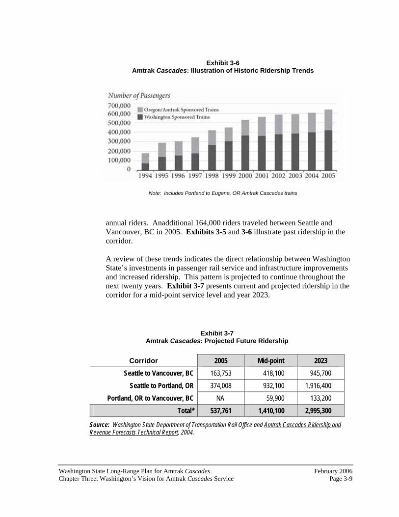
Washington State Long-Range Plan for Amtrak Cascades February 2006 Chapter Three: Washington’s Vision for Amtrak Cascades Service Page 3-9
Exhibit 3-6 Amtrak Cascades: Illustration of Historic Ridership Trends
Note: Includes Portland to Eugene, OR Amtrak Cascades trains
annual riders. Anadditional 164,000 riders traveled between Seattle and Vancouver, BC in 2005. Exhibits 3-5 and 3-6 illustrate past ridership in the corridor.
A review of these trends indicates the direct relationship between Washington State’s investments in passenger rail service and infrastructure improvements and increased ridership. This pattern is projected to continue throughout the next twenty years. Exhibit 3-7 presents current and projected ridership in the corridor for a mid-point service level and year 2023.
Exhibit 3-7 Amtrak Cascades: Projected Future Ridership
Corridor 2005 Mid-point 2023
Seattle to Vancouver, BC 163,753 418,100 945,700
Seattle to Portland, OR 374,008 932,100 1,916,400
Portland, OR to Vancouver, BC NA 59,900 133,200
Total* 537,761 1,410,100 2,995,300
Source: Washington State Department of Transportation Rail Office and Amtrak Cascades Ridership and Revenue Forecasts Technical Report, 2004.

February 2006 Washington State Long-Range Plan for Amtrak CascadesPage 3-10 Chapter Three: Washington’s Vision for Amtrak Cascades Service
Which will be the busiest stations?
As would be expected, the Seattle, Portland, OR and Vancouver, BC stations are projected to have the highest number of passengers. Both Seattle and Portland, OR are projected to have over one million annual passengers at their stations by year 2023. Vancouver, BC is projected to have just over 700,000 annual passengers. The intermediate stations along the corridor are all projected to have between 100,000 and 400,000 annual passengers by year 2023. Exhibit 3-8 provides an overview of these volumes.
What if ridership doesn’t increase as projected? WSDOT recognizes that market forces change over time. Consequently, if ridership goals are not met, increased service may not be provided or may be deferred.
On the other hand, if ridership along the corridor increases beyond WSDOT’s projections, it would be possible, based upon legislative funding, to increase service in a shorter time frame. As an experiment, the project team developed an alternative operating plan for the corridor and prepared ridership forecasts.This exercise illustrated the ability of the incremental approach to add service and attract new riders. Appendix B presents more information about this alternative operating scenario.
This incremental approach was designed to ensure that the State’s investment matched ridership demands. By building with discrete building blocks, implementation of the rail program could stop at any time – without wasting taxpayers’ investments. Each improvement is matched to a service level, so no less or no more will be built – unless it is needed.
To ensure that the program reaches its ridership goals, the Amtrak Cascadesprogram will be evaluated at the program’s mid-point (when eight round trips between Seattle and Portland, OR are reached).6
6As identified in Washington’s Transportation Plan 1997-2016, Washington State Department of Transportation, 1996, page 49.

Washington State Long-Range Plan for Amtrak Cascades February 2006 Chapter Three: Washington’s Vision for Amtrak Cascades Service Page 3-11
Exhibit 3-8 Projected Annual Passenger Volumes at Amtrak Cascades Stations in 2023

February 2006 Washington State Long-Range Plan for Amtrak CascadesPage 3-12 Chapter Three: Washington’s Vision for Amtrak Cascades Service
Can these goals be achieved under the current funding level? Development of improved Amtrak Cascades service is dependent upon funding from the state of Washington, Amtrak, Sound Transit, the state of Oregon, the province of British Columbia, the federal governments of the United States and Canada, other participating agencies and organizations, and passengers using the service. The level of available funding will determine if service goals are met as scheduled, delayed, or accelerated.
This long-range plan outlines the various construction projects, equipment requirements, and operating expenditures that will need to be funded in order to achieve WSDOT’s goals for Amtrak Cascades service between Portland, OR, Seattle and Vancouver, BC. This plan assumes that full funding for all identified projects and operating expenditures are available starting in 2003.This approach was taken in order to clearly demonstrate the series of incremental steps that WSDOT and the other funding agencies would follow in order to reach the goals of hourly rail service between Portland, OR and Seattle with a travel time of two and a half hours, and bi-hourly service between Seattle and Vancouver, BC with a travel time of under three hours. While the years that the projects are to be completed may change as a result of available funding, the specific steps that need to be taken to achieve each service increment will not.
The 2003 Washington State Legislature provided over $200 million for construction projects and day-to-day operations that will support safe, faster, more frequent Amtrak Cascades service between Portland, Seattle, and Vancouver, BC over the next ten years. This level of funding will allow WSDOT to add a fourth daily round trip train between Seattle and Portland, OR in 2006, complete the projects within the state of Washington necessary to support a second daily round trip between Seattle and Vancouver, BC, and continue the department’s program to incrementally add additional service with reduced travel times in the years after 2013. If the goals for Amtrak Cascades service are to be realized by 2023, significant levels of funding from all participating organizations - beyond levels currently available - will be required.
What other funding sources could be used to accelerate the program?
For the past several years, the United States Congress has been working toward establishing a dedicated federal funding source for high speed rail construction across the nation. It is anticipated that this new federal program will require state governments and other participating entities to contribute some amount of matching funds for high-speed rail construction projects

Washington State Long-Range Plan for Amtrak Cascades February 2006 Chapter Three: Washington’s Vision for Amtrak Cascades Service Page 3-13
within their jurisdictions. As a federally-designated corridor, the PNWRC will be eligible for this proposed federal funding. The states of Washington and Oregon intend to take full advantage of any federal funding that becomes available in order to accelerate the development of the Amtrak Cascadesprogram in the Pacific Northwest.
Since the PNWRC is one of only two designated high speed rail corridors that cross an international boundary and connects with a major Canadian city, funding from the province of British Columbia, the Canadian federal government, and Canadian regional sources will be necessary to achieve WSDOT’s goals for Amtrak Cascades service between Seattle and Vancouver, BC. Funding sources could include the Canadian Strategic Investment Fund and new transportation funding programs that are being considered by Canadian authorities.

February 2006 Washington State Long-Range Plan for Amtrak CascadesPage 3-14 Chapter Three: Washington’s Vision for Amtrak Cascades Service
This page intentionally left blank.

Washington State Long-Range Plan for Amtrak Cascades February 2006 Chapter Four: Amtrak Cascades Program Components Page 4-1
Chapter Four: Amtrak CascadesProgram Components
Adding or expanding passenger rail service along an existing freight corridor typically requires the existing infrastructure to be upgraded and/or improved. This infrastructure consists of a number of elements—all of which contribute to the rail line’s ability to handle needed capacity and provide safe and reliable passenger rail service. These components include:
Upgrading grade crossings to ensure safe passage of trains, vehicles, and pedestrians;Increasing speeds to improve corridor capacity and travel times; Enhancing train control signals to improve corridor capacity, increase train speeds, and enhance safety; Purchasing new passenger train equipment to operate along the corridor to increase frequencies and decrease travel time;Improving stations and their ability to serve neighboring communities and to provide connections to other modes of travel; andUpgrading tracks and facilities to relieve congestion, improve ride quality and safety, increase train speeds, and improve corridor capacity.
This chapter discusses these types of capital improvements and their relationship to the service goals presented in Chapter Three of this document.Once improvement types and locations are finalized, the Washington State Department of Transportation (WSDOT) will work with participating agencies and organizations to allocate costs for each improvement.
Why are grade crossing upgrades needed? Grade crossings are designated places where cars, trucks, buses, bicyclists, and pedestrians cross the railroad tracks. At-grade crossings are locations where the roadway and the tracks cross each other at the same elevation. Grade-separated crossings are places where the roadway goes over the railroad tracks or the tracks go over the roadway. Most crossings along the corridor are at-grade.
Depending upon the speed of the train and the amount of vehicular traffic that crosses the tracks, federal guidelines recommend certain types of warnings at the crossings.
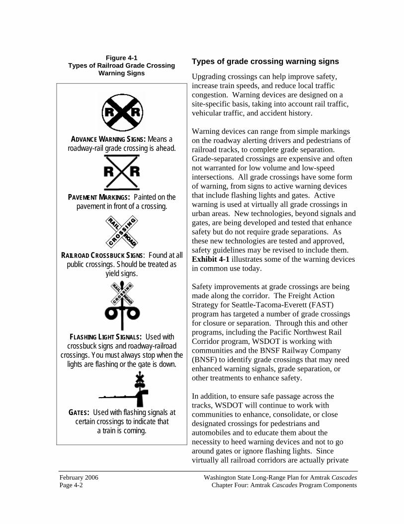
February 2006 Washington State Long-Range Plan for Amtrak CascadesPage 4-2 Chapter Four: Amtrak Cascades Program Components
Types of grade crossing warning signs
Upgrading crossings can help improve safety, increase train speeds, and reduce local traffic congestion. Warning devices are designed on a site-specific basis, taking into account rail traffic, vehicular traffic, and accident history.
Warning devices can range from simple markings on the roadway alerting drivers and pedestrians of railroad tracks, to complete grade separation. Grade-separated crossings are expensive and often not warranted for low volume and low-speed intersections. All grade crossings have some form of warning, from signs to active warning devices that include flashing lights and gates. Active warning is used at virtually all grade crossings in urban areas. New technologies, beyond signals and gates, are being developed and tested that enhance safety but do not require grade separations. As these new technologies are tested and approved, safety guidelines may be revised to include them. Exhibit 4-1 illustrates some of the warning devices in common use today.
Safety improvements at grade crossings are being made along the corridor. The Freight Action Strategy for Seattle-Tacoma-Everett (FAST) program has targeted a number of grade crossings for closure or separation. Through this and other programs, including the Pacific Northwest Rail Corridor program, WSDOT is working with communities and the BNSF Railway Company (BNSF) to identify grade crossings that may need enhanced warning signals, grade separation, or other treatments to enhance safety.
In addition, to ensure safe passage across the tracks, WSDOT will continue to work with communities to enhance, consolidate, or close designated crossings for pedestrians and automobiles and to educate them about the necessity to heed warning devices and not to go around gates or ignore flashing lights. Since virtually all railroad corridors are actually private
ADVANCE WARNING SIGNS: Means aroadway-rail grade crossing is ahead.
PAVEMENT MARKINGS: Painted on thepavement in front of a crossing.
RAILROAD CROSSBUCK SIGNS: Found at all public crossings. Should be treated as
yield signs.
FLASHING LIGHT SIGNALS: Used with crossbuck signs and roadway-railroad
crossings. You must always stop when the lights are flashing or the gate is down.
GATES: Used with flashing signals at certain crossings to indicate that
a train is coming.
Figure 4-1 Types of Railroad Grade Crossing
Warning Signs

Washington State Long-Range Plan for Amtrak Cascades February 2006 Chapter Four: Amtrak Cascades Program Components Page 4-3
right of way, crossing them at other than designated public crossings is not only dangerous, it is also considered trespassing.
Why are speed increases needed?Higher train speeds reduce travel times, resulting in better passenger and freight service. Speeds are limited by safety requirements, by the train signaling system, and by track design. Trains typically cannot go fast around sharp curves or up steep grades.
A number of agencies have the authority to set speed restrictions. In general, under the authority of the Revised Code of Washington (RCW) 81.48.030, the Washington Utilities and Transportation Commission (WUTC) has the authority to set speed limits at all grade crossings in unincorporated areas and in all cities (except first class cities1). However, federal regulations preempt the state from setting speed limits except where unique local safety conditions exist. As a result, the WUTC can set speed limits only where such conditions warrant a deviation from Federal Railroad Administration (FRA) track safety standards.
BNSF and Amtrak have been working with local jurisdictions and the WUTC to increase freight and passenger speeds to keep trains running on schedule in the corridor. These two rail operators, in conjunction with WSDOT, will continue to spearhead speed increases throughout the corridor.
Current maximum speeds set by the FRA for the current type of track and signal system along the corridor are seventy-nine miles per hour (mph) for passenger and sixty mph for freight service. As part of its guidelines, the FRA has recommended specific grade crossing treatments. As discussed above, these treatments range from gates and lights at a railroad crossing to complete grade separation.
In the future, the maximum speeds of Amtrak Cascades trains will be 110 mph. These higher speeds will only be achieved when all of the required safety systems and track improvements have been completed.
1A first class city is a city with a population of ten thousand or more, at the time of its organization or reorganization, that has a charter adopted under Article XI, section 10, of the State Constitution. Per RCW 35.22.280, first class cities are granted the power to regulate and control the use (and vacation) of streets.

February 2006 Washington State Long-Range Plan for Amtrak CascadesPage 4-4 Chapter Four: Amtrak Cascades Program Components
Why are enhanced train signals and communication systems needed?
Enhancements to the existing signal and communication systems along the rail line are crucial for the development of better passenger service in the corridor.Signal and communication systems, such as Centralized Traffic Control (CTC), route and monitor the location and direction of trains on the tracks.Upgrading these systems can help improve safety, increase the number of trains that can simultaneously use the rail system, and reduce the time it takes to get from one place to another.
Improved signal and communications along the rail corridor will allow Amtrak, Sound Transit, and BNSF to run more trains safely and efficiently.
Why are new passenger trains needed? In order to increase the number of trains that serve the corridor over the next twenty years, new train equipment will be needed. After years of research and negotiations, WSDOT and Amtrak selected Talgo trains for this corridor.With the purchase of the first set of Talgo trains in January 1999, Amtrak Cascades service was introduced. These trains, the first owned by the state, not only allow WSDOT to increase frequencies along the corridor, but also offer added passenger comfort and increased speed.
Why does this new equipment allow for increased speed?
Amtrak Cascades trains use passive tilt technology. Consequently, they can run at higher speeds than conventional trains on existing tracks. The tilt system has air springs in the main suspension that allows the train to tilt naturally. This tilting allows the trains to run thru existing curves at higher speeds while maintaining passenger comfort and safety. The system is considered passive because motors do not operate it; the passive tilt system functions with no energy consumption and requires minimal maintenance. Because of this design, many of the sharp curves on the corridor will not have to be eliminated, thus resulting in fewer costly construction projects.
Although these new trains are capable of traveling at speeds exceeding 125 mph, they currently must travel at a maximum speed of seventy-nine mph in our region until additional improvements to tracks, crossings, train control and safety systems are completed.

Washington State Long-Range Plan for Amtrak Cascades February 2006 Chapter Four: Amtrak Cascades Program Components Page 4-5
What are some of the features of the trains?
Amtrak Cascadestrains typically include one baggage car; standard coaches with thirty-six seats each; one accessible coach with nineteen seats that complies with the American with Disabilities Act (ADA); one bistro (cafe) car; one lounge car; one business class coach with twenty-six seats; and one ADA-accessible business class coach with eighteen seats. Each car is approximately forty-four feet long, about half as long as standard Amtrak coaches.
The number of coaches in each train can vary by route and schedule, based upon customer demand. Currently, the trainsets each have 250 seats, but they can be modified in only a few hours to accommodate as few as one hundred passengers to nearly three hundred passengers.
Onboard safety features include clearly marked, removable emergency windows; emergency lights; first aid kits; and fire extinguishers. The new trains meet U.S. Environmental Protection Agency standards for air conditioning refrigerants, U.S. Food and Drug Administration standards for food service, and ADA accessibility standards.
Washington State and Talgo conducted public outreach to obtain input from the physically-challenged community to ensure that Amtrak Cascadestrainsets serve the full public. Amtrak Cascades trains are among the most accessible in the world and are the first to provide independent wheelchair accessibility between cars.
Assembly of Talgo Trains in Seattle, 1998.

February 2006 Washington State Long-Range Plan for Amtrak CascadesPage 4-6 Chapter Four: Amtrak Cascades Program Components
Exhibit 4-2 Passive-Tilt Trainsets for
Amtrak Cascades Service between Portland, OR, Seattle, and Vancouver, BC
Service Year or Timetable
Required Number of Trainsets
2003 4 A 5 B 6
Mid-Point (C) 7* D 9* E 11**
2023 (F) 13*** Spare Sets (See Notes)
2
Notes: *includes one spare set **includes two spare sets ***includes three spare sets
How many trains will be needed by year 2023?
The Amtrak Cascadesoperating plan indicates that by year 2023, twelve trainsets will be needed to meet the service goals outlined in this document. WSDOT currently owns three trainsets and Amtrak owns two.2 Exhibit4-2 outlines the number of trains needed over the next twenty years. The year that an additional trainset may be needed is based on a number of assumptions. As stated earlier in this document, the service levels and years of projected service increases are based on the assumption that funding for this program has been provided and the necessary infrastructure projects have been completed. Maintenance and preservation of this equipment is a key component of the equipment plan. Two of the new trainsets will be used in a back-up capacity to ensure that service is not disrupted if a trainset is in need of repair or maintenance. Appendix C provides more detailed information about WSDOT’s equipment preservation plan.
How are passenger rail stations being upgraded? Throughout the corridor, intercity passenger rail stations (Amtrak stations) have been undergoing expansion and renovation. Since the early 1990s, WSDOT has been working with local communities to upgrade existing passenger rail stations throughout the state. The state of Oregon has also been working with local cities to upgrade their facilities.
Between Portland, OR and Vancouver, BC there are currently thirteen Amtrak stations (eleven in Washington, one in Oregon, and one in British Columbia). The condition, size, and amenities of the stations vary widely.
2The five trainsets currently in use include service between Portland, OR and Eugene, OR – which is outside of this plan’s discussion. For the corridor discussed in this plan (Vancouver, BC to Portland, OR), four trainsets are used.

Washington State Long-Range Plan for Amtrak Cascades February 2006 Chapter Four: Amtrak Cascades Program Components Page 4-7
However, the most important factor for all of these stations is their ability to serve future passengers. As WSDOT implements its program, each station will need to be revisited to ensure that the existing roadway system surrounding the station can accommodate more vehicles and buses. In addition, walkways and bicycle paths should be added to a number of these stations, and additional bicycle racks should also be added at each station. Other factors that will need to be revisited include the amount of available parking. Communities along the corridor have been upgrading their stations to meet such future needs.3
The following discussion presents an overview of each of the Amtrak stations between Portland, OR and Vancouver, BC. Appendix D has more information about each of these stations.
Union Station (Portland, OR) Union Station was built in 1896 and has been in continuousoperation since that time. The station is located at 800 NW 6th Avenue in downtownPortland. This station serves Amtrak Cascadestrains as well as Amtrak long-distance trains. In 1987, the Portland Development Commission acquired the station. It is the current owner of the station and Amtrak is its tenant.
Union Station is a large, historic station. Since 1987 it has undergone substantial renovation. It is wheelchair accessible and is in compliance with the Americans with Disabilities Act (ADA). There is a staffed ticket office in the station. General station amenities include restrooms, telephones, a news stand, and a restaurant.
3Sound Transit is implementing its Sounder Commuter Rail program between Lakewood and Everett. Sounder trains will share stations with Amtrak Cascades trains in Everett, Edmonds, Seattle, Tukwila, and Tacoma. Separate plans and environmental documents are currently being produced by Sound Transit regarding these station area impacts to surrounding communities.
Exhibit 4-3 Portland’s Union Station
800 NW 6th Avenue

February 2006 Washington State Long-Range Plan for Amtrak CascadesPage 4-8 Chapter Four: Amtrak Cascades Program Components
Greyhound Bus Lines and a Tri-Met (the city’s transit provider) bus facility are located one block from the station, providing both intercity and local transportation connections. Tri-Met also plans to add a new MAX light rail stop adjacent to Union Station within the next few years. Fourteen Tri-Met bus routes serve Union Station. Burnside Avenue, a major east-west arterial, is just south of the station. Union Station is easily accessible by auto, bicycle, and on foot. Bicycle racks are located at the station. In addition, there are two City Center parking lots with approximately two hundred public spaces and seventy-five tenant spaces located at the station. Several taxi companies also serve the facility.
Vancouver, WA
Vancouver Station is located west of the downtown area near a major track junction, where tracks branch off from the Portland, OR to Seattle line to head east through the Columbia River Gorge. The station was built in 1908.
Vancouver’s unique two-sided station is eligible for placement on the National Register of Historic Places. Partial renovations were completed in 1988, and the city is currently securing grant funds for a more thorough renovation. Plans include renting the second floor of the station as a community meeting space. In 2001, the city of Vancouver purchased the rail station from the BNSF.
Station amenities include restrooms, telephones, vending machines, and a staffed ticket office. There are ninety-five free parking spaces at the station, and taxi service is available.
Exhibit 4-4 Vancouver, WA Amtrak Station
1301 West 11th Street
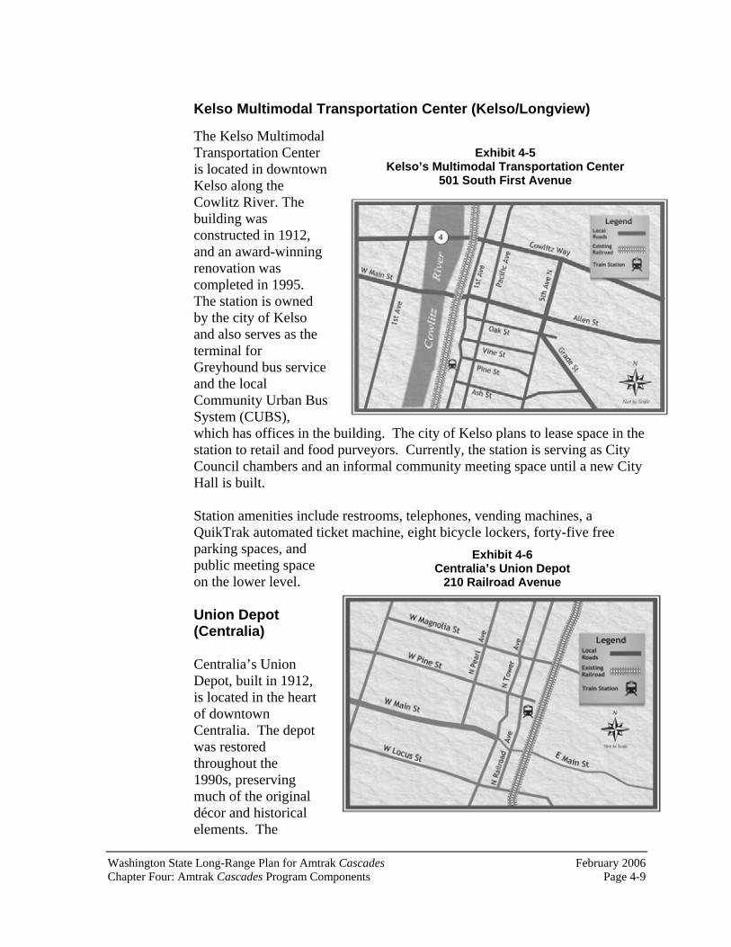
Washington State Long-Range Plan for Amtrak Cascades February 2006 Chapter Four: Amtrak Cascades Program Components Page 4-9
Kelso Multimodal Transportation Center (Kelso/Longview)
The Kelso Multimodal Transportation Center is located in downtown Kelso along the Cowlitz River. The building was constructed in 1912, and an award-winning renovation was completed in 1995. The station is owned by the city of Kelso and also serves as the terminal for Greyhound bus service and the local Community Urban Bus System (CUBS), which has offices in the building. The city of Kelso plans to lease space in the station to retail and food purveyors. Currently, the station is serving as City Council chambers and an informal community meeting space until a new City Hall is built.
Station amenities include restrooms, telephones, vending machines, a QuikTrak automated ticket machine, eight bicycle lockers, forty-five free parking spaces, and public meeting space on the lower level.
Union Depot (Centralia)
Centralia’s Union Depot, built in 1912, is located in the heart of downtown Centralia. The depot was restored throughout the 1990s, preserving much of the original décor and historical elements. The
Exhibit 4-5 Kelso’s Multimodal Transportation Center
501 South First Avenue
Exhibit 4-6 Centralia’s Union Depot
210 Railroad Avenue

February 2006 Washington State Long-Range Plan for Amtrak CascadesPage 4-10 Chapter Four: Amtrak Cascades Program Components
historic building includes a brick exterior, a tile roof, heavy oak millwork, ornate ceilings, and leaded windows. Improvements to the city-owned building include restoration of the building’s interior, new office spaces on the depot’s second floor, an elevator, and a new community meeting space. Eventually, a real-time passenger information system will be installed in the waiting area and on the depot platform.
Amenities include restrooms, vending machines, telephones, and a staffed Amtrak ticket office. There are ninety-six free parking spaces at the station and in the immediate vicinity. Taxi service and local transit bus service, run by Twin City Transit, are also available. Regional bus companies offer daily service to east Lewis County and to Grays Harbor County. The entire depot is ADA compliant.
Centennial Station (Olympia/Lacey)
Centennial Station opened in 1992 and serves the Lacey, Tumwater, Yelm, and Olympia areas of Thurston County.Intercity Transit, the county’s local transit authority, owns the facility.The station is entirely operated by volunteers and was built through donations. Local enthusiasts have been instrumental in expanding and maintaining the station since it opened in 1992. While the surrounding area is growing quickly, the station is in a remote area some distance from the cities’ centers. Amenities include restrooms, vending machines, telephone, a QuikTrak automated ticket machine, and bicycle lockers. The entire station is ADA compliant. Intercity Transit runs local bus service from the station. The bus runs every hour, and service to downtown Olympia takes approximately forty-five minutes.
Exhibit 4-7 Olympia/Lacey’s Centennial Station
6600 Yelm Highway SE

Washington State Long-Range Plan for Amtrak Cascades February 2006 Chapter Four: Amtrak Cascades Program Components Page 4-11
Tacoma Dome Station at Freighthouse Square (Tacoma)
The current facility, located at 1001 Puyallup Avenue, was constructed in 1984 and is owned by the BNSF. Amenities include a staffed Amtrak ticket office, restrooms, telephones, vending machines, a QuikTrak automated ticket machine, and a waiting area. The station is also served by Northwestern Trailways, Pierce Transit, and local taxis. Two parking lots provide free parking with approximately eighty stalls.
Freighthouse Square, one-half mile southwest of the existing Amtrak Station, is the Tacoma stop for Sound Transit Sounder commuter rail. Amtrak Cascades will begin operating out of Freighthouse Square within the next ten years. Transit links will be available at the nearby Tacoma Dome Station. The Tacoma Dome Station is an intermodal facility that accommodates parking, Pierce Transit bus service, Sound Transit Regional Express bus service, and Greyhound. Sound Transit’s Tacoma Link light rail line runs along East 25th Street, directly across from Freighthouse Square.
Exhibit 4-8 Tacoma Dome Station at Freighthouse Square
425 East 25th Street

February 2006 Washington State Long-Range Plan for Amtrak CascadesPage 4-12 Chapter Four: Amtrak Cascades Program Components
Tukwila
Tukwila Station is located twenty minutes south of downtown Seattle.Tukwila’s temporary train station opened in 2001. Sound Transit owns the facility, which consists of two wooden platforms with shelters and 250 interim parking spaces. The Tukwila Station serves both Amtrak Cascades and Sounder commuter trains. (Amtrak’s Coast Starlightdoes not stop in Tukwila.) Metro and Sound Transit’s Regional Express bus services connect passengers to points throughout King County.
The Tukwila comprehensive plan identifies a future, permanent Tukwila station at the same location as a regional transportation hub which will promote transit-orienteddevelopment around the rail station.4
King Street Station (Seattle)
Seattle’s King Street Station was constructed in 1906 and is owned by the BNSF. The station’s
4Tukwila Tomorrow: Comprehensive Land Use Plan, Tukwila Urban Center Element,Background Report, May 2004.
Exhibit 4-10 Seattle’s King Street Station
303 South Jackson Street
Exhibit 4-9 Tukwila Station
7301 South 158th Street

Washington State Long-Range Plan for Amtrak Cascades February 2006 Chapter Four: Amtrak Cascades Program Components Page 4-13
distinctive clock tower is a Seattle landmark and the building is listed on the National Register of Historic Places. Cosmetic renovations and modernization of services are currently underway. Improvements are began in late 2003. Amenities currently include restrooms, vending machines, telephones, two QuikTrak automated ticket machines, and a staffed Amtrak ticket office.
Many transportation options and services are available within a quarter mile of King Street Station. King County Metro and other regional transit providers offer bus service throughout the region and Seattle. Intercity buses to Vancouver, BC and Spokane also serve the station. Colman Dock is the departure and arrival point for Washington State Ferries to Bremerton and Bainbridge and Vashon Islands. Sound Transit’s Sounder commuter rail and regional express bus service connect to cities throughout Puget Sound. In addition, the waterfront trolley serves the Pioneer Square neighborhood and the Seattle waterfront. Interstate 5 and State Route 99 (the Alaskan Way Viaduct) are both easily accessible from the station, as is I-90. Sound Transit’s LINK light rail is planned to serve the former Union Station building, one block away.
Edmonds
The Edmonds Station, located near the city’s waterfront, is owned by the BNSF. Amenities include restrooms, vending machines, telephones, and a staffed Amtrak ticket office. CommunityTransit provides local transit service, and a Washington State Ferry Terminal is three blocks north of the station.
Future plans call for a new Sounder commuter platform between Dayton and Main Streets in downtown Edmonds. In addition, a proposed new Edmonds Crossing multimodal station will combine local and regional transit, commuter rail, intercity Amtrak Cascades service, and Washington State
Exhibit 4-11 Edmonds’ Station
211 Railroad Avenue

February 2006 Washington State Long-Range Plan for Amtrak CascadesPage 4-14 Chapter Four: Amtrak Cascades Program Components
Ferries. The final plans for the new Edmonds Crossing facility have not been determined.
Everett
The city-owned, four-story structure provides many transportation choices, including Amtrak, Everett Transit, Community Transit Quick Bus, Greyhound, Northwestern Trailways, taxis, and Sound Transit’s Regional Express bus service. In late 2003, the station became the northernmost stop for Sound Transit’s Sounder commuter rail. Not only does the station serve as an important transportation hub, but it is also home to higher education and career development centers. The second floor and half of the third floor are occupied by an education center—University Centers of North Puget Sound—whichincludes Washington universities and colleges offering bachelors and masters degree programs. A career development center (Work Source Everett) is located on the main floor, with additional offices on the fourth floor.
Station amenities include restrooms, phones, a café, an espresso cart, a banquet and meeting room, art displays, an Everett Transit customer service office, and staffed Amtrak and Greyhound ticket offices. The station currently has twenty-five designated parking stalls for Amtrak/Greyhound passengers, eight rideshare vehicle stalls, and six bicycle racks. There are twelve bus bays and four separate park and ride lots adjacent to the station, with approximately 750 parking stalls.
Exhibit 4-12 Everett’s Station
3201 Smith Avenue

Washington State Long-Range Plan for Amtrak Cascades February 2006 Chapter Four: Amtrak Cascades Program Components Page 4-15
Skagit Station(Mount Vernon)
Skagit Station is the newest train station in Washington. It is located in the heart of downtown Mount Vernon. It is easily accessible and visible from Interstate 5.
Amtrak Cascadesbegan servicing the station in September 2004.In addition, Skagit Transit (SKAT), Greyhound, and local taxi services are available at the station. It contains a meeting room fitted with advanced telecommunications capabilities. A QuikTrak automated ticket machine will be installed in 2006. The station serves as a convenient transition point for tourists destined for the San Juan Islands, Vancouver Island, and other areas of interest.
FairhavenStation(Bellingham)
Bellingham’s Fairhaven Station is located approximately three miles south of the city’s commercialcenter, near the FairhavenHistoric District. The building was once the headquarters of the Pacific American FisheriesCompany and
Exhibit 4-13 Skagit Station
105 East Kincaid Street
Exhibit 4-14 Bellingham’s Fairhaven Station
401 Harris Street

February 2006 Washington State Long-Range Plan for Amtrak CascadesPage 4-16 Chapter Four: Amtrak Cascades Program Components
underwent extensive renovations in 1994. The station is owned by the Port of Bellingham and is part of the Bellingham Fairhaven Cruise Terminal Complex. The cruise terminal is host to Alaska Marine Highway ferries connecting to southern Alaska and a private company operating day cruises to Victoria and Friday Harbor. The facility also serves as Bellingham’s Greyhound station, with local bus service provided by the Whatcom Transit Authority.
Station amenities include restrooms, vending machines, a small coffee shop, office space, a QuikTrak automated ticket machine, and a staffed Amtrak ticket office. There are eighteen free automobile parking stalls at the station, five bus bays, and eight bicycle lockers. There are 160 long-term parking stalls across from the station. Taxi service is also available. The entire station is ADA compliant.
Pacific Central Station (Vancouver, BC)
The Vancouver, BC station is located at 1150 Station Street. It has undergone significantrenovations since the late 1980s.Amenities include ticket agents, paid short-term and overnight parking, a restaurant, gift shop, car rental, newsstand,currency exchange, espresso bar, restrooms, and lockers. The station is wheelchair accessible.
The station can be easily reached on foot, by bicycle, or automobile. Taxi service and local and regional bus service serve this station. Vancouver’s popular Skytrain has a stop located about one block from the train station. Pacific Central Station is also home to VIA Rail, Canada’s national passenger railroad.
Exhibit 4-15 Vancouver’s Pacific Central Station
1150 Station Street

Washington State Long-Range Plan for Amtrak Cascades February 2006 Chapter Four: Amtrak Cascades Program Components Page 4-17
What other station improvements will be made throughout the corridor?
In the summer of 2003, a new Passenger Information Display System (PIDS) was installed at several stations along the corridor. The new system allows rail passengers to get real-time train arrival and departure information at each station. PIDS uses geographic positioning system (GPS) data that are transmitted directly from Amtrak Cascades trains. The new displays have been mounted along the platforms and near the parking lots of several stations, where rail passengers can easily observe them. Washington stations currently equipped with the PIDS are: Vancouver (WA), Kelso/Longview, Centralia, Olympia/Lacey, Everett, and Bellingham.5 WSDOT and Amtrak intend to install PIDS at the remaining Washington Amtrak Cascades stations within the next few years, based on available funding.
Why are improved tracks and facilities needed?The WSDOT passenger rail program’s incremental approach not only allows service to be introduced over an extended period of time, it also allows infrastructure improvements to be built over time. The following discussion presents the types of infrastructure improvements that will be necessary over the next twenty years to meet the state’s service goals.
Sidings and siding extensions
Siding tracks are secondary tracks parallel to the main line. Sidings are used to let trains on the same track pass each other—one train will switch off the main line and wait on the siding track while the other passes on the main line track.
5Other Pacific Northwest stations that are equipped with the PIDS are Eugene, Albany, Salem, and Portland, Oregon.
Sidings provide areas for trains to pass each other. They increase the capacity of the tracks.

February 2006 Washington State Long-Range Plan for Amtrak CascadesPage 4-18 Chapter Four: Amtrak Cascades Program Components
As rail corridors become increasingly congested,extensions to existing sidings and new sidings are required.Sidings provide more areas for trains to pass each other, resulting in increased capacity along the corridor.
Many of the project improvements that will be designed and constructed over the twenty-year program include new sidings and siding extensions. These projects are discussed in detail in Chapter Five of this document.
Rail storage, yards, and maintenance facilities
Rail storage and maintenance facilities, and rail yards, are used to store, maintain, and sort rail cars before they are loaded, unloaded, or connected together into trainsets. Efficient rail yard activities are essential for the successful operation of both freight and passenger rail.
Additional yard improvements throughout the corridor will be necessary as rail traffic increases. More rail traffic requires larger and more efficient yard operations. Projects may consist of providing more storage tracks, larger maintenance facilities, different layouts of storage and running tracks, or additional running tracks to get trains through or around a yard.
A new Amtrak maintenance facility is being constructed south of downtown Seattle, near Safeco Field. This facility will be the primary maintenance and repair site for current and future Sounder commuter trains, Amtrak Cascades trains, and Amtrak’s long-distance Empire Builder and Coast Starlight trains.
Artist’s rendition of the new Seattle maintenance facility.
Freight traffic and storage along the corridor.
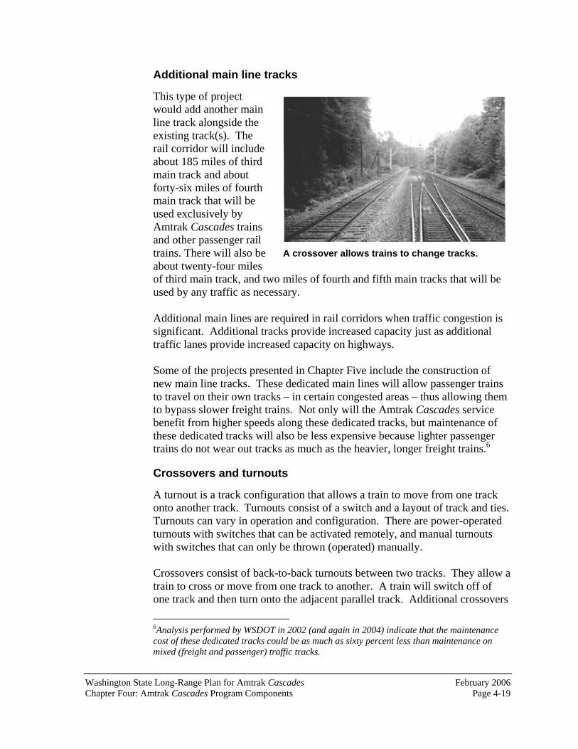
Washington State Long-Range Plan for Amtrak Cascades February 2006 Chapter Four: Amtrak Cascades Program Components Page 4-19
A crossover allows trains to change tracks.
Additional main line tracks
This type of project would add another main line track alongside the existing track(s). The rail corridor will include about 185 miles of third main track and about forty-six miles of fourth main track that will be used exclusively by Amtrak Cascades trains and other passenger rail trains. There will also be about twenty-four miles of third main track, and two miles of fourth and fifth main tracks that will be used by any traffic as necessary.
Additional main lines are required in rail corridors when traffic congestion is significant. Additional tracks provide increased capacity just as additional traffic lanes provide increased capacity on highways.
Some of the projects presented in Chapter Five include the construction of new main line tracks. These dedicated main lines will allow passenger trains to travel on their own tracks – in certain congested areas – thus allowing them to bypass slower freight trains. Not only will the Amtrak Cascades service benefit from higher speeds along these dedicated tracks, but maintenance of these dedicated tracks will also be less expensive because lighter passenger trains do not wear out tracks as much as the heavier, longer freight trains.6
Crossovers and turnouts
A turnout is a track configuration that allows a train to move from one track onto another track. Turnouts consist of a switch and a layout of track and ties.Turnouts can vary in operation and configuration. There are power-operated turnouts with switches that can be activated remotely, and manual turnouts with switches that can only be thrown (operated) manually.
Crossovers consist of back-to-back turnouts between two tracks. They allow a train to cross or move from one track to another. A train will switch off of one track and then turn onto the adjacent parallel track. Additional crossovers
6Analysis performed by WSDOT in 2002 (and again in 2004) indicate that the maintenance cost of these dedicated tracks could be as much as sixty percent less than maintenance on mixed (freight and passenger) traffic tracks.
February 2006 Washington State Long-Range Plan for Amtrak CascadesPage 4-20 Chapter Four: Amtrak Cascades Program Components
also provide rail dispatchers with more flexibility and reliability by adding more capacity for all users.
Crossovers and turnouts are fairly small projects and are done regularly by the BNSF as part of its maintenance and upgrade program. As part of the twenty-year program, crossovers and turnouts will be placed along the corridor as needed. These are the least disruptive and least costly types of improvements that will be added along the corridor.
Main line relocation
Main line relocations occur when a track is shifted from its current location. This type of improvement may be required when a new track needs to be added within the existing rail right of way. Often moving the main line makes more space available to add another track or siding. Moving the main line could also reduce sharp curves.
Bypass tracks
A bypass track is a track that goes around other railroad facilities or provides a more direct route between two points when the existing route is circuitous. It is really a siding or new main line. It may be as simple as a track that bypasses a small yard or as significant as a complete route revision. Bypass tracks are needed, in certain instances, to provide better passenger service without adversely impacting existing freight service.
Utility relocation
Significant utility relocations may be required for the construction of the program’s infrastructure projects. Utilities are located throughout the corridor. Some utilities, such as fiber optics, are parallel to the BNSF right of way, while many others cross under or over the railroad tracks.
Utilities will be routinely identified as part of the design process. A determination will then be made as to whether or not the specific utilities will need to be relocated or if they can remain in place. Depending on easements, rights of way and agreements, utility relocations may be done by the utility company, WSDOT, BNSF, or some combination of all three.
Are locations identified for these track and facility improvements? WSDOT and cooperating agencies and organizations have identified areas along the corridor that need track and facility improvements. Using operations analysis and railroad engineering techniques, specific infrastructure projects have been identified. Chapter Five presents these projects and their locations.

Washington State Long-Range Plan for Amtrak Cascades February 2006 Chapter Five: Amtrak Cascades Needed Infrastructure Improvements Page 5-1
Chapter Five: Amtrak Cascades Needed Infrastructure Improvements
In 1993, the Washington State Legislature directed the Washington State Department of Transportation (WSDOT) to develop high-quality intercity passenger rail service through the incremental upgrading of the existing BNSF Railway Company’s (BNSF) north-south main line. Since that time, WSDOT has been working with the BNSF and other organizations to develop operating plans and identify/prioritize infrastructure projects. These projects would improve existing service and enable WSDOT to fulfill the legislature’s directive to provide safe, faster, more frequent, and reliable passenger rail service through an incremental approach.
This chapter discusses these major infrastructure improvements and their relationship to the service goals presented in Chapter Three of this document.The infrastructure improvements, which are presented in this chapter, reflect the best solution at this time. Other solutions that meet the same operational needs may emerge as each project is fully investigated through the environmental process.
How were these improvements identified? Railroad companies perform careful operations studies to determine the need, type, and location for additional tracks. Public agencies sponsoring passenger rail service also study the need for additional tracks and facilities. Often the public agency—and the railroad owning the rail line—will study track needs repeatedly, removing and adding tracks, until both parties agree on the amount of track and other improvements absolutely necessary to perform the desired function and achieve the operational goals. WSDOT, working with the BNSF, performed many such studies.1 These studies began in the early 1990s and have continued throughout project planning. Other agencies involved in this planning include Amtrak, the Union Pacific Railroad, and the Ports of Seattle and Tacoma. As recently as 2002, these agencies, together with WSDOT, participated in rail modeling activities at BNSF headquarters in Fort Worth, TX.
These modeling efforts looked at the rail corridor over a fifty year horizon.The modeling incorporated all freight and passenger needs of the many
1The operations studies were preceded by a detailed economic and ridership analysis that established the travel time and train frequency (service) goals that would provide the best cost-benefit relationship.

February 2006 Washington State Long-Range Plan for Amtrak CascadesPage 5-2 Chapter Five: Amtrak Cascades Needed Infrastructure Improvements
corridor users. Modeling and planning for freight and passenger rail along the PNWRC was not done in isolation, but in cooperation with the major stakeholders and customers of the rail line.
These studies follow the location of current and future passenger and freight trains minute-by-minute along a specific segment of a rail line. As part of each analysis, a number of steps are performed:
Representation of the existing track configuration. Identification of the minute-by-minute location of every train entering and leaving the area (current trains as well as anticipated future trains).Determination of the conflicts between trains as they use the tracks and associated facilities. Determination of what conflicts could be solved by changing the time certain trains operate, as well as determining if the time can be changed for these trains (trains have various schedule and maintenance requirements that need to be met). Determination of what additional track and facilities are required to accommodate trains that cannot operate at different times. When considering additional track, the possible environmental and economic consequences are also considered.Determination of the track and other facilities needed specifically to achieve the service goals.
This procedure was repeated over the course of many years to ensure that each proposed infrastructure improvement fulfills WSDOT’s goals of providing safe, more frequent, faster, and reliable passenger rail service between Vancouver, BC and Portland, OR without degrading freight rail service.
How does the physical characteristic of the track relate to rail operations?
Upgrading tracks and facilities is critical when planning an intercity passenger rail system on an existing freight corridor. In order to eliminate conflicts between freight and passenger rail, and to ensure that the ability to conduct current and future freight operations is not diminished, operations analysis is used to identify the types and locations of improvements that are necessary to maintain the rail line’s capacity for freight service.
During the operations analysis, passenger trains are incrementally added to the tracks to see if there is enough rail capacity to handle the additional traffic at a given time. If there is a conflict with an existing (or future) freight train, a simple solution may be to change the passenger train’s schedule. This may solve the problem. However, during the analysis, consideration also has to be
Washington State Long-Range Plan for Amtrak Cascades February 2006 Chapter Five: Amtrak Cascades Needed Infrastructure Improvements Page 5-3
given to the potential loss (or gain) in ridership that may result from a schedule change. Because of this, operations analyses are often done in conjunction with ridership and commercial viability studies. Another solution to fitting more trains on a track is to see where the conflicts or chokepoints occur on the rail line, and then identify a physical solution that could solve the conflict. However, this approach to operations analysis isn’t simple either.
A railroad is a fixed-guideway transportation system. Trains, unlike motor vehicles, must follow a track. Trains can only change “lanes,” turn, or enter/leave the route when a track has been specifically constructed for that purpose. Designing for railroads involves figuring out exactly where trains will need to enter and leave the main line, change tracks, and turn onto another route. As such, a number of rail characteristics must be taken into consideration. Exhibit 5-1 on the following page highlights some of these general railroad elements.
Each of the proposed infrastructure improvements presented in this chapter was designed by figuring out how specific tracks at specific locations could solve the problems in that location, as identified as part of the rail operations analysis.
What were the results of these analyses? The operations analysis identified needed projects along the main line between Vancouver, BC and Portland, OR. Each project was developed to solve a particular problem or eliminate a chokepoint within the system. Every one of these projects was designed with the purpose to fulfill a specific service need. Because the operations analysis is based on an incremental approach, each of these projects independently fulfills a specific service (operational) goal. The incremental implementation plan was designed to ensure that if funding is not available to complete all of the needed projects along the corridor, the state’s investment would not be wasted. Projects were designed to maximize system operations – one project at a time. This approach also requires that projects be built in a very specific order in order to ensure that not only the individual problem is solved (by each individual project) but when put together, a larger, operational problem is solved – thus contributing to the ability to increase service. If projects are not constructed in order (as identified in this plan), project completion cannot be followed immediately by service increases.2
2However, benefits will still be derived from each individual project as it relates to its specific location and problem.
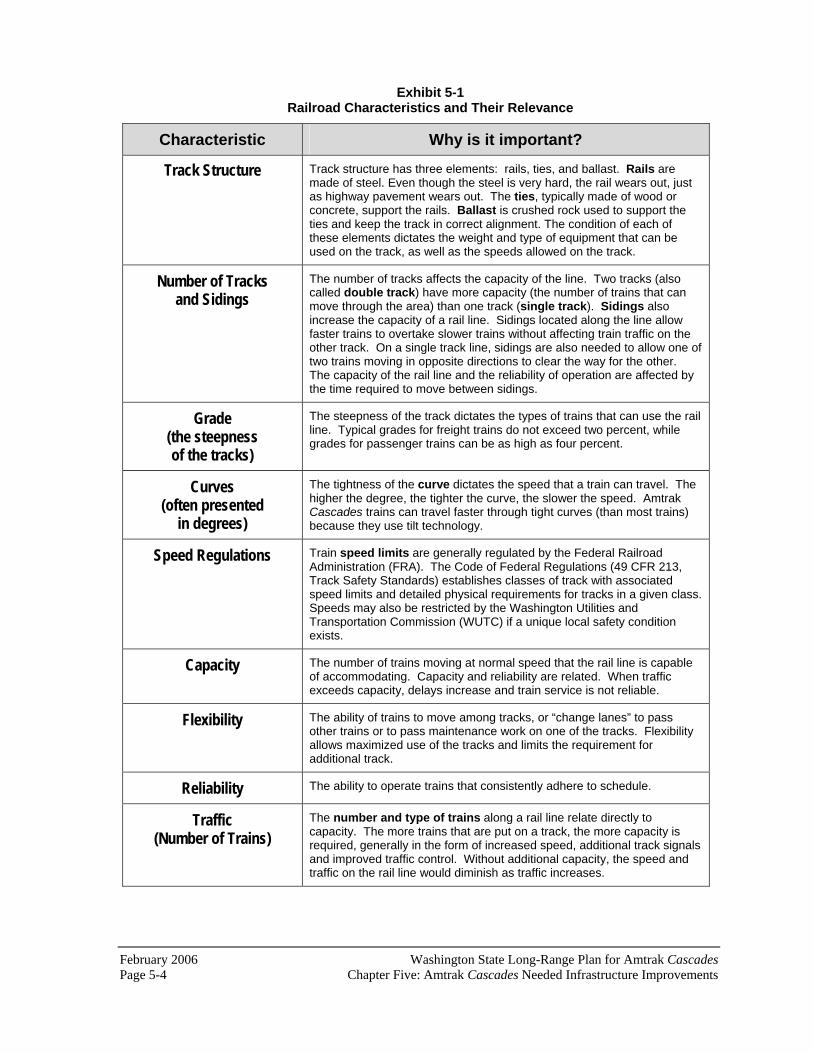
February 2006 Washington State Long-Range Plan for Amtrak CascadesPage 5-4 Chapter Five: Amtrak Cascades Needed Infrastructure Improvements
Exhibit 5-1 Railroad Characteristics and Their Relevance
Characteristic Why is it important?
Track Structure Track structure has three elements: rails, ties, and ballast. Rails are made of steel. Even though the steel is very hard, the rail wears out, just as highway pavement wears out. The ties, typically made of wood or concrete, support the rails. Ballast is crushed rock used to support the ties and keep the track in correct alignment. The condition of each of these elements dictates the weight and type of equipment that can be used on the track, as well as the speeds allowed on the track.
Number of Tracks and Sidings
The number of tracks affects the capacity of the line. Two tracks (also called double track) have more capacity (the number of trains that can move through the area) than one track (single track). Sidings also increase the capacity of a rail line. Sidings located along the line allow faster trains to overtake slower trains without affecting train traffic on the other track. On a single track line, sidings are also needed to allow one of two trains moving in opposite directions to clear the way for the other. The capacity of the rail line and the reliability of operation are affected by the time required to move between sidings.
Grade(the steepnessof the tracks)
The steepness of the track dictates the types of trains that can use the rail line. Typical grades for freight trains do not exceed two percent, while grades for passenger trains can be as high as four percent.
Curves(often presented
in degrees)
The tightness of the curve dictates the speed that a train can travel. The higher the degree, the tighter the curve, the slower the speed. Amtrak Cascades trains can travel faster through tight curves (than most trains) because they use tilt technology.
Speed Regulations Train speed limits are generally regulated by the Federal Railroad Administration (FRA). The Code of Federal Regulations (49 CFR 213, Track Safety Standards) establishes classes of track with associated speed limits and detailed physical requirements for tracks in a given class.Speeds may also be restricted by the Washington Utilities and Transportation Commission (WUTC) if a unique local safety condition exists.
Capacity The number of trains moving at normal speed that the rail line is capable of accommodating. Capacity and reliability are related. When traffic exceeds capacity, delays increase and train service is not reliable.
Flexibility The ability of trains to move among tracks, or “change lanes” to pass other trains or to pass maintenance work on one of the tracks. Flexibility allows maximized use of the tracks and limits the requirement for additional track.
Reliability The ability to operate trains that consistently adhere to schedule.
Traffic(Number of Trains)
The number and type of trains along a rail line relate directly to capacity. The more trains that are put on a track, the more capacity is required, generally in the form of increased speed, additional track signals and improved traffic control. Without additional capacity, the speed and traffic on the rail line would diminish as traffic increases.

Washington State Long-Range Plan for Amtrak Cascades February 2006 Chapter Five: Amtrak Cascades Needed Infrastructure Improvements Page 5-5
Exhibit 5-1 (Continued) Railroad Characteristics and Their Relevance
Characteristic Why is it important?
Width The rails of a railroad track are spaced 56.5 inches apart. To allow sufficient clearance between vehicles on adjacent tracks, the tracks are generally spaced at least fifteen feet apart. This is often referred to as 15-foot track centers.
Length Each track that is not a through-route must be long enough to serve the intended purpose. Just as a parking space for a tractor-trailer must be of sufficient length for the vehicle, a railroad track must be long enough to hold even the longest train. The required length depends upon the type of train traffic handled. The length of a typical passenger train is between 500 feet and 1,700 feet. The length of a typical freight train can be between 7,000 feet and 10,000 feet (over a mile—5,280 feet—in length).
Signals and Traffic Control
Signals help extend the engineer’s sight distance and therefore allow greater speeds. Traffic control determines which trains can use which tracks. The type of traffic control system is related to capacity because it affects the ability to utilize the main line tracks.
What are the current conditions along the rail line?
Amtrak Cascades service operates along the Pacific Northwest Rail Corridor (PNWRC). This corridor extends from Vancouver, BC to Portland, OR along the BNSF north-south main line.3
The BNSF’s predecessors -- the Great Northern Railway and the Northern Pacific Railroad -- originally constructed what now has become the Pacific Northwest Rail Corridor, and several other different routes. The oldest part of the line was constructed in 1872, the newest in 1914. In the intervening years, many sections of the rail line were constructed, including some that replaced part of the original construction in order to improve the route. Generally the sections of line that were relocated had relatively steep grades, which were a more important consideration in that era than now because the largest locomotives were much less powerful than a typical locomotive today. Improvements since 1914 have generally consisted only of improved signal and traffic control systems, and tracks leading into or supporting industrial zones that have been built since 1914.
3 There are three short exceptions to BNSF ownership of the route. Pacific Central Station in Vancouver, BC is owned by VIA Rail Canada. The Fraser River Bridge is owned by the government of Canada and operated by the Canadian National Railway. The rail line which serves Portland’s Union Station, is owned by the Portland Terminal Railroad which is owned jointly by the Union Pacific Railroad and the BNSF. For the most part, BNSF controls rail operation on this rail corridor.

February 2006 Washington State Long-Range Plan for Amtrak CascadesPage 5-6 Chapter Five: Amtrak Cascades Needed Infrastructure Improvements
In addition to the BNSF’s rail traffic, the rail line between Portland, OR and Vancouver, BC also has several tenants. In British Columbia:
Canadian National Railroad between Townsend and Vancouver Junction; VIA Rail Canada and Rocky Mountain Railtour’s passenger trains between Fraser River Junction and Pacific Central Station; West Coast Express between CP Junction and Vancouver Junction; Canadian Pacific Railroad between Townsend and CP Junction; Canadian National Railroad and Canadian Pacific Railroad at Colebrook;
In Washington and Oregon:
Sound Transit between Reservation (Tacoma) and Everett; Union Pacific between Portland, OR and Seattle; and Amtrak (including the Cascades) between Portland, OR andVancouver, BC.
The BNSF has recently sold their line between Tacoma and Nisqually via Lakewood to Sound Transit. This is the line known in this document as the Point Defiance Bypass. The BNSF, Tacoma Rail, and Amtrak (including the Amtrak Cascades), will be tenants on this line.
Because of this large number of tenants, as freight and passenger rail traffic grows, capacity will begin to be filled. New main lines and sidings will be required. The current rail line consists of two tracks between Portland, OR and Seattle except for a one and one half mile single track section between the Nelson Bennett Tunnel and Ruston, south of Tacoma. Between Seattle and Everett the line alternates between single track and two tracks. North of Everett is single track.
The operations analysis used this information as a basis for developing the future Amtrak Cascades service plan. More information about the passenger rail operations, methodology, assumptions, and results can be found in the Amtrak Cascades Operating and Infrastructure Plan Technical Report, 2004.
What are the identified infrastructure improvements?Project improvements are located throughout Washington State’s segment of the corridor, as well as in British Columbia and Oregon.4 The following
4WSDOT identified these potential improvements through their continuous evaluation of the existing rail corridor and the ongoing operational analysis for the Amtrak Cascades
Washington State Long-Range Plan for Amtrak Cascades February 2006 Chapter Five: Amtrak Cascades Needed Infrastructure Improvements Page 5-7
discussion focuses on those projects located in the state of Washington. They are presented geographically, from north to south. The projects have been identified by their rail milepost. Mileposts are designations by the railroad indicating the distance from an established starting point. As part of this discussion, a general description of each project is presented, why it is needed, and how it can independently solve a particular problem.5 The estimated capital cost of constructing each project is also presented. These cost estimates were developed using 2006 dollars. Actual costs will vary, depending on the availability of funding, the outcome of environmental analysis conducted for each project, and the year when projects are finally constructed.
What projects are needed in Whatcom and Skagit Counties?
Seven projects have been identified for this part of the Pacific Northwest Rail Corridor. Exhibit 5-2, on the following page, presents their general location.
Swift Customs Facility (rail milepost 114.6 to 118.3) Congestion on the tracks south of Blaine, near the U.S. Customs and Border Protection facility, can cause delays for Amtrak Cascades passenger trains traveling between Seattle and Vancouver, BC.
The siding and associated tracks will allow freight train inspections to occur off the main line, helping to ensure that passenger trains operate on time. Siding is track located next to a main line that allows a train to move out of the way of an oncoming train. Sidings are also used to store trains or to add/subtract rail cars. The estimated construction cost for this project is $13.8 million. This project is listed in the “2005 Transportation Partnership Account,” but will require additional funding beyond the $3 million allocated by the state legislature. The project also has an additional $3 million in federal funding.
Bellingham to Blaine High-Speed Track (rail milepost 101.5 to 117.1) This project entails construction of a high-speed track and associated facilities. The purpose of the project is to allow passenger trains to operate at 110 mph, providing part of the travel time reduction needed between Seattle and Vancouver, BC to achieve WSDOT’s service goal. This project is needed because the current physical condition of the track and the current track
program. The state of Oregon and the province of British Columbia did not participate in the development of these projects. WSDOT recognizes that it will be each of these jurisdictions’s responsibility to review WSDOT’s findings and perform their own research to solve the given problems along the rail line in Oregon and British Columbia. 5Once all of these projects are constructed, the Amtrak Cascades service goals for year 2023 could be achieved. WSDOT would fulfill its directive to provide safe, reliable, faster and more frequent passenger rail service.

February 2006 Washington State Long-Range Plan for Amtrak CascadesPage 5-8 Chapter Five: Amtrak Cascades Needed Infrastructure Improvements
Exhibit 5-2 Whatcom and Skagit Counties Project Improvements

Washington State Long-Range Plan for Amtrak Cascades February 2006 Chapter Five: Amtrak Cascades Needed Infrastructure Improvements Page 5-9
geometry in this location (due to the terrain) does not allow trains to travel at high speeds. The estimated construction cost of this project is $147.8 million.
Bellingham Siding Extension (rail milepost 92.2 to 97.9)The purpose of this project is to allow passenger and freight trains to pass each other. The current siding at this location is not long enough to accommodate most freight trains. If this siding were not extended and two trains were traveling towards this location on the same track, one of them would have to wait at the first available siding (Bow or Ferndale if those sidings are not occupied by another train) to ensure that the other train could pass. Depending on the location of the nearest available siding, a train could feasibly wait as long as eighty minutes until the oncoming train passes. By having a siding at this location, it shortens the length (and therefore time) between sidings. This project increases capacity and reliability. The estimated construction cost of this project is $102.6 million.
Bellingham GP Upgrade (rail milepost 96 to 97) The existing main line located at the Georgia Pacific plant in Bellingham will be rehabilitated. The purpose of this rehabilitation is to improve the track so that it can handle higher speeds. This improvement is needed because the current condition of the existing track does not meet Federal Railroad Administration (FRA) standards for increased speeds. This project will result in increased passenger and freight rail speeds, which will improve service and increase capacity and reliability. The estimated construction cost of this project is $2.3 million. This project is listed in the “2003 Legislative Funding Package,” but will require additional funding beyond the $200,000 allocated by the state legislature.
Burlington to Bellingham High-Speed Track (rail milepost 72.2 to 86.5) This project entails construction of fourteen miles of high-speed track and associated facilities. The purpose of the project is to allow passenger trains to operate at 110 mph, providing part of the travel time reduction needed between Seattle and Vancouver, BC to achieve WSDOT’s service goal. This project is needed because the current physical condition of the track and the current track geometry in this location (due to the terrain) does not allow trains to travel at high speeds. The estimated construction cost of this project is $408.5 million.
Bow to Samish Siding Extension (rail milepost 81 to 83.5) The purpose of this project is to allow passenger and freight trains to pass each other. The current siding at Samish is not long enough to accommodate most freight trains. If this siding were not extended and two trains were traveling towards this location on the same track, one of them would have to wait at the first available siding (existing Bow or Ferndale if not occupied by another train) to ensure that the other train could pass.

February 2006 Washington State Long-Range Plan for Amtrak CascadesPage 5-10 Chapter Five: Amtrak Cascades Needed Infrastructure Improvements
Depending on the location of the nearest available siding, a train could feasibly wait as long as eighty minutes until the oncoming train passes them. By having a siding at this location, it shortens the length (and therefore time) between sidings. This project increases capacity and reliability. The estimated construction cost of this project is $50.6 million.
Mount Vernon Siding (rail milepost 65.5 to 67.5) Currently southbound morning trains leaving Bellingham must wait for the northbound trains to pass them before they can begin their run. The siding upgrades will allow those trains to pass each other in Mount Vernon, eliminating the southbound train’s wait time in Bellingham.
This upgrade will allow an earlier departure from Bellingham and better Portland connections in Seattle. Because of this change in schedule, the trainset will be available to accommodate an additional Amtrak Cascadesroundtrip between Seattle and Portland, OR in mid-2006.
More refined cost estimates will be negotiated with BNSF before construction is initiated. The estimated construction cost of this project is $8.4 million. This project is listed in the “2003 Legislative Transportation Package,” but may require additional funds beyond the $3.8 million allocated by the state Legislature.
Marysville to Mount Vernon High-Speed Track (rail milepost 39.19 to 67.5) This project entails construction of twenty-eight miles of high-speed track and associated facilities. The purpose of the project is to allow passenger trains to operate at 110 mph, providing part of the travel time reduction needed between Seattle and Vancouver, BC to achieve WSDOT’s service goal. This project is needed because the current physical condition of the track and the current track geometry in this location (due to the terrain) does not allow trains to travel at high speeds. The estimated construction cost of this project is $322.5 million.
What projects are needed in Snohomish County?
Four projects have been identified for this part of the Pacific Northwest Rail Corridor. In addition, a number of other projects, which will be implemented by Sound Transit, will also be required to fulfill the Amtrak Cascades service goals. One of these projects, the Marysville to Mount Vernon High-Speed Track is also located in Skagit County and was previously discussed. Exhibit5-3 presents the general location of the other projects in Snohomish County.

Washington State Long-Range Plan for Amtrak Cascades February 2006 Chapter Five: Amtrak Cascades Needed Infrastructure Improvements Page 5-11
Exhibit 5-3 Snohomish County Project Improvements

February 2006 Washington State Long-Range Plan for Amtrak CascadesPage 5-12 Chapter Five: Amtrak Cascades Needed Infrastructure Improvements
Stanwood Siding (rail milepost 55.18 to 57.93) The purpose of this project is to allow passenger and freight trains to pass each other. The current siding at this location is not long enough to accommodate most freight trains. If this siding were not extended, and if two trains were traveling towards this location on the same track, one of them would have to wait at the first available siding (English and Bow if not occupied by another train) to ensure that the other train could pass.Depending on the location of the nearest available siding, a train could feasibly wait as long as seventy minutes until the oncoming train passes them. By having a siding at this location, it shortens the length (and therefore time) between sidings. This project will increase capacity and reliability. The estimated construction cost of this project is $9.9 million. This project is listed in the “2003 Legislative Transportation Package,” but will require additional funding beyond the $3 million allocated by the state legislature.
PA Junction/Delta Junction Improvements (rail milepost 10.9 to 7.8)
Yard tracks must be constructed to mitigate the use of the main track by passenger trains. After the discontinuance of the previous Amtrak service, increasing freight traffic made it necessary for BN to begin using the main track for additional yard capacity. The return of passenger trains has limited the ability to use the main track for freight trains; a situation has been a source of congestion and delay. This project allows for the continued operation of the Seattle to Bellingham train. More refined cost estimates will be negotiated with BNSF before construction is initiated. In addition, the current track condition and geometry in this area restricts Amtrak Cascades trains to a speed of 10 to 43 mph and freight trains to a speed of 10 to 15 mph. The project will improve the main track, and in some places, construct new track to allow Amtrak Cascades’ speeds of 35 to 50 mph and freight train speeds of 30 to 35 mph. The project will also provide a new siding to allow overtaking and opposing trains to pass. These improvements will increase capacity and reliability and reduce the running time of the Amtrak Cascades trains. The estimated construction cost of this project is $34.4 million. This project is listed in the “2003 Legislative Transportation Package,” but will require additional funding beyond the $14 million allocated by the state legislature.
Everett Junction to Everett Second Main Track(rail milepost 1783.66 to 32) A one-mile extension of a second main track in this location will reduce the length of single track operations. This will result in smoother passenger and
6This rail milepost number remains from the Great Northern Railway’s network. The number represents the distance to St. Paul, Minnesota.

Washington State Long-Range Plan for Amtrak Cascades February 2006 Chapter Five: Amtrak Cascades Needed Infrastructure Improvements Page 5-13
freight train operations, increased reliability, and increased capacity. The estimated construction cost of this project is $9.9 million.
What projects are needed in King County?
Four projects are needed in King County. In addition, a number of other projects, which are being implemented by Sound Transit, will also be required to fulfill the Amtrak Cascades service goals. These projects are located throughout the Puget Sound region and are discussed later in this chapter.Exhibit 5-4 presents the general location of the King County Amtrak Cascades projects.
Ballard Bridge Speed Increase (rail milepost 6.2 to 6.4) The current speed on the bridge is twenty miles per hour. Increasing the Talgo speed limit to forty-five miles per hour and the freight speed limit to thirty-five miles per hour improves service and increases capacity and reliability. A final design solution for this problem has not been determined and will require an engineering evaluation of the bridge. The estimated construction cost of this project is $11.5 million.
King Street Station Track Improvements (rail milepost 0.2 to 0.5)
WSDOT-sponsored Amtrak Cascades, Amtrak long-distance trains (CoastStarlight and Empire Builder), Sound Transit commuter trains, and BNSF freight trains all use the tracks at King Street Station. Currently, the tracks at the station will not accommodate the anticipated growth in rail traffic. New tracks and platforms at King Street Station will accommodate the planned increase in intercity, commuter, and freight trains. The estimated construction cost of this project is $92 million. This project is listed in the “2005 Transportation Partnership Account,” but will require additional funding beyond the $15 million allocated by the state legislature.
Seattle Maintenance Facility A new Amtrak maintenance facility is being constructed south of downtown Seattle, near Safeco Field. This facility will be the primary maintenance and repair site for current and future Sounder commuter trains, Amtrak Cascadestrains, and Amtrak’s long-distance Empire Builder and Coast Starlight trains.
The Seattle Maintenance Facility is being constructed in phases. The first phase, completed in 2002, includes a new rail car washer and a wheel maintenance building. The second phase, scheduled to begin in 2005 if funding is available, will include construction of the main service and inspection facility.
The entire facility is projected to cost $109 million, using funds from Amtrak, WSDOT, and Sound Transit.

February 2006 Washington State Long-Range Plan for Amtrak CascadesPage 5-14 Chapter Five: Amtrak Cascades Needed Infrastructure Improvements
Exhibit 5-4 King County Project Improvements
Washington State Long-Range Plan for Amtrak Cascades February 2006 Chapter Five: Amtrak Cascades Needed Infrastructure Improvements Page 5-15
Auburn South Third Main Track (rail milepost 20.9 to 24.2) Sound Transit will construct a third main line track between Auburn and south of Kent. This configuration is useful for eliminating certain freight-passenger conflicts, but does not fully address passenger-passenger conflicts such as an Amtrak Cascades train overtaking a Sounder commuter train. Extending the third main track to the south end of Auburn Yard provides a configuration that allows movement from either track without slowing while the commuter trains are making the Auburn station stop. The estimated construction cost of this project is $23.9 million.
What projects are needed in Pierce and Thurston Counties?
Eight projects have been identified for this part of the Pacific Northwest Rail Corridor. In addition, a number of other projects, which are being implemented by Sound Transit, will also be required to fulfill the Amtrak Cascades service goals. Exhibit 5-5 presents the general location of these projects.
Reservation to Stewart Third Main Track (rail milepost 38.2 to 33.9) A new main line will be built next to the existing double track. The purpose of this track is to provide a dedicated track for lower speed freight trains that originate, terminate, or stop at Tacoma. The track is needed because freight traffic in this area is predicted to continue to grow over the next twenty years.Additional traffic without increased capacity will result in increased congestion and reduced reliability. The estimated construction cost of this project is $48.3 million.
Ruston Crossover (rail milepost 32) Construction of this crossover provides flexibility for trains to move between tracks. This project provides increased reliability and capacity. This project was recently completed at a cost of $3.6 million.
Titlow Crossover (rail milepost 10.2) Construction of this crossover provides flexibility for trains to move between tracks. This project provides increased reliability and capacity. This project was recently completed at a cost of $4.0 million.
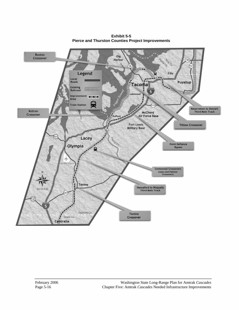
February 2006 Washington State Long-Range Plan for Amtrak CascadesPage 5-16 Chapter Five: Amtrak Cascades Needed Infrastructure Improvements
Exhibit 5-5 Pierce and Thurston Counties Project Improvements

Washington State Long-Range Plan for Amtrak Cascades February 2006 Chapter Five: Amtrak Cascades Needed Infrastructure Improvements Page 5-17
Point Defiance Bypass (rail milepost 25.38 to 12.71)Currently passenger trains must slow down to use the curved tracks along Puget Sound and the single-track tunnels under Point Defiance. This project will build a bypass so that passenger trains can avoid those areas. Freight trains will continue to use the existing tracks in the Point Defiance area. This will provide reliable Amtrak Cascades service by reducing travel time by fourteen minutes and eliminate conflicts with freight trains.
The proposed route of this WSDOT project is the same that Sound Transit will use to extend Sounder Commuter Rail service to Lakewood. After both projects are completed, Amtrak trains and Sounder Commuter Rail will share the route with freight trains serving Fort Lewis.
The first part of this project will include a new second track between Tacoma and Lakewood. The second part of this project – for which funding is unavailable at this time – will include rehabilitation of tracks and speed increases between Lakewood and Nisqually. The current conceptual cost estimate for the entire project is $412 million. This project is listed in the “2003 Legislative Transportation Package” and the 2005 Transportation Partnership Account,” but will require additional funding beyond the $59.8 million allocated by the state legislature.
Ketron Crossover (rail milepost 18.4) Construction of this crossover provides flexibility for trains to move between tracks. This project will provide increased reliability and capacity. The estimated construction cost of this project is $3.4 million. This project is listed in the “2003 Legislative Transportation Package,” and is funded for up to $3.9 million.
Centennial Crossovers (Leary and Pattison) (rail milepost 31.8 to 32.5) Construction of these crossovers provides flexibility for trains to move between tracks when entering Centennial Station to ensure that passengers can exit the train on the east side of the rail line, adjacent to the station. Without these crossovers, there would be situations when a train would be on the west main line and would require passengers to cross the east main line. This project will provide increased capacity, reliability, and safety. The estimated construction cost of this project is $3.4 million. This project is listed in the “2003 Legislative Transportation Package,” and is funded for up to $3.9 million.
Hannaford to Nisqually Third Main Track (rail milepost 51.39 to 24.5) A new twenty-six mile-long main line will be built next to the existing double track between Nisqually and the Lewis/Thurston county border, and a second new main line track will be built between rail milepost 36.2 and rail milepost

February 2006 Washington State Long-Range Plan for Amtrak CascadesPage 5-18 Chapter Five: Amtrak Cascades Needed Infrastructure Improvements
51. The purpose of these tracks is to allow passenger trains to operate at 110 mph, providing part of the travel time reduction needed between Seattle and Portland, OR to achieve WSDOT’s service goal. This project is needed because the current physical condition of the track and the current track geometry in this location (due to the terrain) do not allow trains to travel at high speeds. The second high-speed track allows two Amtrak Cascades trains moving in opposite directions to pass without slowing. The estimated construction cost of this project is $512.5 million.
Tenino Crossover (rail milepost 43.3) Construction of this crossover provides flexibility for trains to move between tracks. This project will provide increased reliability and capacity. The estimated construction cost of this project is $3.4 million. This project is listed in the “2003 Legislative Transportation Package,” and is funded for up to $3.9 million.
What projects are needed in Lewis, Cowlitz, and Clark Counties?
Fourteen projects have been identified for this part of the Pacific Northwest Rail Corridor. Exhibit 5-6 presents the general location of these projects.
Centralia Steam Plant Coal Track and Power Switches (on a spur line near rail milepost 51.5) Coal trains for the Centralia steam power generating station currently block the main line in this area. This project would improve the rail tracks off the main line to allow coal trains to enter and leave the main tracks at a higher speed, increasing capacity and improving reliability. The estimated construction cost of this project is $6.1 million.
China Creek Crossover (rail milepost 53.5 to 53.6)Construction of this crossover provides flexibility for trains to move between tracks when entering Centralia’s Union Depot, which ensures that passengers can exit the train on the west side of the rail line, adjacent to the station. Without this crossover, there would be situations when a train would be on the east main line and would require passengers to cross the west main line. This project will provide increased capacity, reliability and safety. The estimated construction cost of this project is $1.7 million.
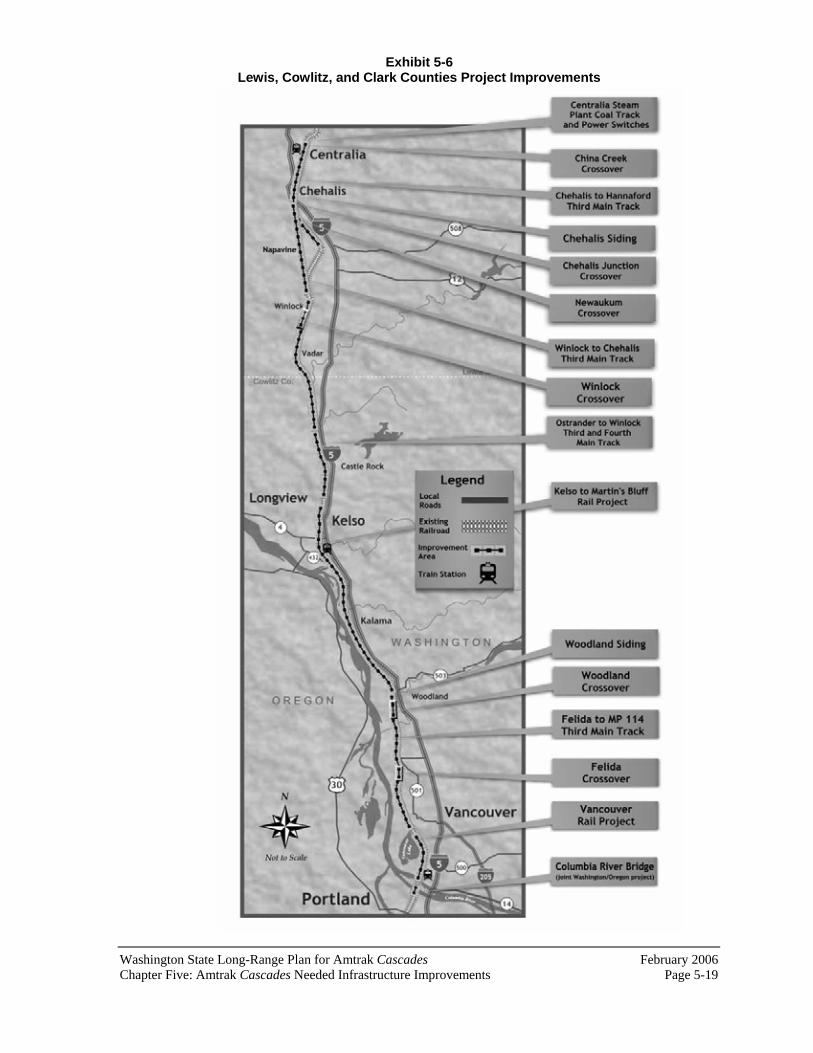
Washington State Long-Range Plan for Amtrak Cascades February 2006 Chapter Five: Amtrak Cascades Needed Infrastructure Improvements Page 5-19
Exhibit 5-6 Lewis, Cowlitz, and Clark Counties Project Improvements

February 2006 Washington State Long-Range Plan for Amtrak CascadesPage 5-20 Chapter Five: Amtrak Cascades Needed Infrastructure Improvements
Chehalis to Hannaford Third Main Track (rail milepost 59.49 to 51.39)A new main line will be built next to the existing double track. This track will provide sufficient capacity for reliable passenger train operation. The portion of the track between rail milepost 54.5 and rail milepost 58.2 will have ninety miles per hour speed limit, providing part of the travel time reduction needed between Seattle and Portland, OR to achieve WSDOT’s service goal. The remainder of the track will be shared with freight traffic. The shared portion of the track is needed because freight traffic in this area is predicted to continue to grow over the next twenty years, requiring increased ability of passenger trains to overtake freight trains. Additional traffic will exceed the existing capacity, resulting in increased congestion and delay, and diminished reliability. With the addition of a dedicated main line, passenger trains can go faster, thereby increasing speeds and decreasing travel times.
The project will also construct a second platform at Centralia’s Union Depot, giving passenger trains a choice of two tracks. This will reduce the conflict between passenger trains and freight trains that, depending upon their origin or destination and traffic conditions, may be unable to be routed to avoid a single passenger platform. The estimated construction cost of this project is $66.6 million.
Chehalis Siding (rail milepost 56.8 to 58.3) Currently, industrial tracks are connected directly to the main line. This area often gets congested because industry trains are using the main lines for switching and idling. Construction of a new siding off the main line would allow freight trains to wait and switch on the siding, thus freeing up the main line. This project would increase capacity and reliability. The estimated construction cost of this project is $11.3 million.
Chehalis Junction Crossover (rail milepost 58.5 to 58.8) Currently passenger trains can be delayed as long as fifteen minutes while they wait for freight trains to pass in this area. A crossover is a set of turnouts connecting multiple tracks. They allow trains to move from one track to another. The new set of crossovers in Chehalis will allow faster Amtrak Cascades trains to move around slower freight trains, at speeds up to 50 mph. Typical main line crossovers limit speeds to 35 mph or less. This project will provide improved Amtrak Cascades on-time performance and faster, more frequent Amtrak Cascades service. The estimated construction cost of this project is $3.5 million. This project is listed in the “2005 Transportation Partnership Account,” at a funding level of $3.9 million.
Newaukum Crossover (rail milepost 60.6 to 60.8) Construction of this crossover provides flexibility for trains to move between tracks. This project will provide increased reliability and capacity. The estimated construction cost of this project is $3.4 million. This project is listed

Washington State Long-Range Plan for Amtrak Cascades February 2006 Chapter Five: Amtrak Cascades Needed Infrastructure Improvements Page 5-21
in the “2005 Transportation Partnership Account,” with a funding level of $3.5 million.
Winlock to Chehalis Third Main Track (rail milepost 72 to 59.49) A new main line and associated facilities will be in the vicinity of, but not entirely adjacent to, the existing double track. Because of the terrain and relatively sharp curves in this area, the existing alignment cannot accommodate the geometry necessary for high-speed tracks. The purpose of this project is to allow passenger trains to operate at 110 mph, providing part of the travel time reduction needed between Seattle and Portland, OR to achieve WSDOT’s service goal. This project is needed because the current physical condition of the track and the current track geometry in this location do not allow trains to travel at high speed. The estimated construction cost of this project is $149.9 million.
Winlock Crossover (rail milepost 71.8 to 72.1) Construction of this crossover provides flexibility for trains to move between tracks. This project will provide increased reliability and capacity. The estimated construction cost of this project is $3.4 million. This project is listed in the “2003 Legislative Transportation Package,” with a funding level of $3.925.
Ostrander to Winlock Third and Fourth Main Track (rail milepost 95.03 to 72) A new main line will be built generally adjacent to the existing double track. A second new main line track will be constructed between rail milepost 81.7 and rail milepost 93.7. Because of the terrain and relatively sharp curves in this area, part of the existing alignment cannot accommodate the geometry necessary for high speed tracks. The purpose of this project is to allow passenger trains to operate at 110 mph, providing part of the travel time reduction needed between Seattle and Portland, OR. This project is needed because the current physical condition of the track and the current track geometry in this location (because of the terrain) do not allow trains to travel at high speed. The second high-speed track allows two Amtrak Cascadestrains moving in opposite directions to pass without slowing. The estimated construction cost of this project is $283.1 million.
Kelso to Martin’s Bluff Rail Project (rail milepost 96.3 to 113.9)This project consists of adding a third main line track, three sidings, construction of two rail yards, and associated facilities. The third main line will separate passenger traffic from freight traffic, allowing an increase in the number of passenger trains. The sidings will allow through trains to pass freight trains stopped to make pick-ups and deliveries. The project is needed because of current congestion on the rail line in this location. Once this project is completed, service will be more reliable and faster. The estimated construction cost of this project is $469.3 million. This project is listed in the “2003 Legislative Transportation Package,” but will require additional

February 2006 Washington State Long-Range Plan for Amtrak CascadesPage 5-22 Chapter Five: Amtrak Cascades Needed Infrastructure Improvements
funding beyond the $50 million allocated by the state legislature. Conceptual design and environmental documentation for this project began in 2001. It is anticipated that final design will begin by 2007.
Woodland Siding (rail milepost 115.3 to 117.1) Currently, industrial tracks are connected directly to the main line. This is often congested because industry trains are using the main track for switching and idling. Construction of a new siding would allow freight trains to wait and switch, thus freeing up the main line. This project would increase capacity and reliability. The estimated construction cost of this project is $15.3 million.
Woodland Crossover (rail milepost 118.6 to 118.8) Construction of this crossover provides increased capacity and reliability.This project was recently completed at a cost of $2.8 million.
Felida to MP 114 Third Main Track (rail milepost 130.45 to 112.2)A new eighteen mile-long main line will be built adjacent to the existing double track. The purpose of this project is to allow passenger trains to operate at 110 mph, providing part of the travel time reduction needed between Seattle and Portland, OR to achieve WSDOT’s service goal. This project is needed because the current physical condition of the track and the current track geometry in this location (because of the terrain) do not allow trains to travel at high speed. The estimated construction cost of this project is $173.1 million.
Felida Crossover (rail milepost 130.4 to 130.8) Construction of this crossover provides increased capacity and reliability.This project was recently completed at a cost of $2.2 million.
Vancouver Rail Project (rail milepost 10 to 132.5) This project consists of a double-track bypass of the Vancouver rail yard, a siding extension, and associated turnouts from rail milepost 132.6 to rail mile post 136.5. The bypass will separate grain freight traffic from passenger traffic to allow for projected increased traffic in both. It will also relieve congestion for freight coming from eastern Washington. West 39th Street, which bisects the rail yard, will also be grade separated, thus providing a safer crossing for vehicles and pedestrians. The estimated construction cost of this project is $86.6 million. This project is listed in the “2003 Legislative Transportation Package” but will require additional funding beyond the $51 million allocated by the state legislature. Conceptual design and environmental documentation for this project has been completed.
Columbia River Bridge (rail milepost 9.61 to 10.14) The Portland-Spokane route junction at the north end of the Columbia River Bridge has a 10 mph speed restriction. The junction connecting to the Port of
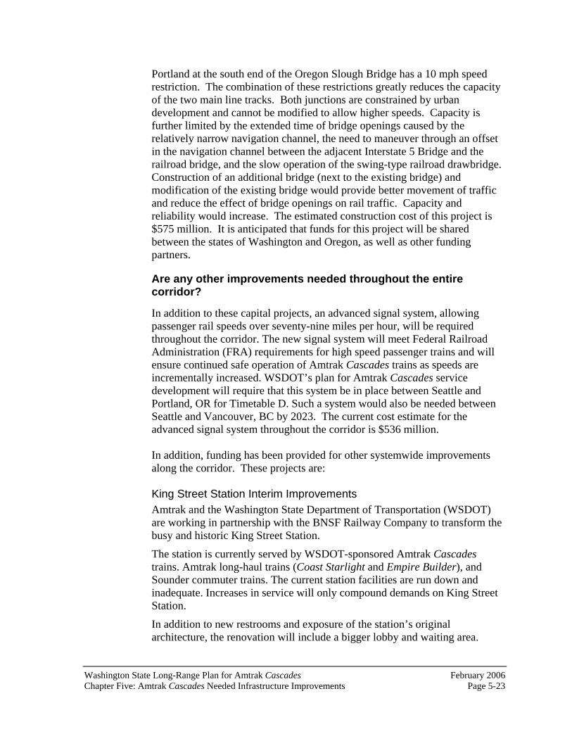
Washington State Long-Range Plan for Amtrak Cascades February 2006 Chapter Five: Amtrak Cascades Needed Infrastructure Improvements Page 5-23
Portland at the south end of the Oregon Slough Bridge has a 10 mph speed restriction. The combination of these restrictions greatly reduces the capacity of the two main line tracks. Both junctions are constrained by urban development and cannot be modified to allow higher speeds. Capacity is further limited by the extended time of bridge openings caused by the relatively narrow navigation channel, the need to maneuver through an offset in the navigation channel between the adjacent Interstate 5 Bridge and the railroad bridge, and the slow operation of the swing-type railroad drawbridge.Construction of an additional bridge (next to the existing bridge) and modification of the existing bridge would provide better movement of traffic and reduce the effect of bridge openings on rail traffic. Capacity and reliability would increase. The estimated construction cost of this project is $575 million. It is anticipated that funds for this project will be shared between the states of Washington and Oregon, as well as other funding partners.
Are any other improvements needed throughout the entire corridor?
In addition to these capital projects, an advanced signal system, allowing passenger rail speeds over seventy-nine miles per hour, will be required throughout the corridor. The new signal system will meet Federal Railroad Administration (FRA) requirements for high speed passenger trains and will ensure continued safe operation of Amtrak Cascades trains as speeds are incrementally increased. WSDOT’s plan for Amtrak Cascades service development will require that this system be in place between Seattle and Portland, OR for Timetable D. Such a system would also be needed between Seattle and Vancouver, BC by 2023. The current cost estimate for the advanced signal system throughout the corridor is $536 million.
In addition, funding has been provided for other systemwide improvements along the corridor. These projects are:
King Street Station Interim Improvements Amtrak and the Washington State Department of Transportation (WSDOT) are working in partnership with the BNSF Railway Company to transform the busy and historic King Street Station.
The station is currently served by WSDOT-sponsored Amtrak Cascadestrains. Amtrak long-haul trains (Coast Starlight and Empire Builder), and Sounder commuter trains. The current station facilities are run down and inadequate. Increases in service will only compound demands on King Street Station.
In addition to new restrooms and exposure of the station’s original architecture, the renovation will include a bigger lobby and waiting area.

February 2006 Washington State Long-Range Plan for Amtrak CascadesPage 5-24 Chapter Five: Amtrak Cascades Needed Infrastructure Improvements
Other improvements include improved ticketing and baggage facilities, new train arrival and departure displays, new way-finding signage to the surrounding neighborhoods, a new roof, exterior cleaning and safety and security improvements.
King Street Station Transportation Center The purpose of this project is to design and construct a multi-modal transportation center which will link the variety of public transportation services that are present in the vicinity of King Street Station. The center will link Amtrak Cascades, Sounder commuter rail, regional and local bus transit, light rail, and the Seattle streetcar. Seattle’s intercity bus terminal will also be relocated to this transportation center. The initial focus this project will include conceptual design and preparation of an implementation strategy for project development.
Cascades Trainset Overhaul The three state-owned trainsets have been in service since 1999. They will be restored to like-new condition and their service life extended to approximately 2029. All three trainsets will receive interior and exterior improvements, including paint, seating, tables, carpet, toilets, windows, wall coverings, and video and audio systems.
In addition to this overhaul, trainsets will continue to be maintained and repaired on a regular basis. The state of Washington does not have any spare train cars, so maintenance and overhaul is critical to the continued service of the Amtrak Cascades.
PNWRC Safety Improvements Since the early 1990s, the U.S. federal government has provided grants to states with federally recognized high-speed rail corridors, which includes the Pacific Northwest Rail Corridor. This federal designation allows WSDOT to apply for federal grants to eliminate safety hazards where vehicles, pedestrians, and higher-speed passenger trains converge. Over the past ten years, WSDOT has received over $3 million for a variety of small rail safety projects between Blaine and Vancouver (WA).
How will WSDOT and the BNSF work together to construct these infrastructure improvements?
In 2003, WSDOT and the BNSF entered into a Master Corridor Development Agreement that will govern the construction of Amtrak Cascades capital projects within Washington State. This agreement is an important milestone for WSDOT’s Amtrak Cascades program, as it sets in place the legal framework and guiding principles that both WSDOT and the BNSF will abide by as WSDOT continues to provide public funding for intercity passenger rail

Washington State Long-Range Plan for Amtrak Cascades February 2006 Chapter Five: Amtrak Cascades Needed Infrastructure Improvements Page 5-25
corridor development. Some of the key highlights of the Master Corridor Development Agreement include:
The expressed intent of both WSDOT and the BNSF to work together to develop Amtrak Cascades intercity passenger rail service between Portland, OR, Seattle, and Vancouver, BC over the next twenty years. BNSF’s acceptance of WSDOT’s detailed capital and operating plans for Amtrak Cascades service improvements within the rail corridor. A streamlined administrative process for executing the individual construction projects funded by WSDOT. Clearly defined expectations of the specific benefits that WSDOT will derive from each construction project in Washington State, including additional daily frequencies and reduced running times between cities. These clearly defined expectations will guarantee that the state of Washington will get what it is paying for. A method for apportioning cost for the various construction projects that provide direct benefits to both WSDOT and the BNSF.
This new Master Corridor Agreement between WSDOT and the BNSF is the first of its kind between a state government and a host railroad that sets a legally binding foundation for future development of state-funded intercity passenger rail service. It is expected that this new agreement will make it much easier for both WSDOT and the BNSF to complete the Amtrak Cascades capital projects within the state of Washington as identified in this plan.
What projects will be undertaken by other agencies? As part of WSDOT’s ongoing relationship with Sound Transit, the province of British Columbia, and the state of Oregon, a number of projects that will benefit Amtrak Cascades service need to be implemented by these entities over the next twenty years. Without implementation of these projects, the build-out of the passenger rail program will not be achieved.
These projects are listed in Exhibit 5-7 by jurisdiction/agency. More information about these projects can be found in the Amtrak Cascades Operating and Infrastructure Plan Technical Report, 2004. The general locations of the Oregon and British Columbia projects are illustrated in Exhibits 5-8 and 5-9. The Sound Transit projects are located between Lakewood and Seattle, as well as between Seattle and Everett.

February 2006 Washington State Long-Range Plan for Amtrak CascadesPage 5-26 Chapter Five: Amtrak Cascades Needed Infrastructure Improvements
Exhibit 5-7 Projects to be Implemented by other Agencies and Organizations
Jurisdiction/Agency General Location Project/Estimated Cost 1Greater Vancouver Terminal (Scott Road Station)
Construct new passenger rail station/$86.3 million
2Vancouver Terminal Control System Installation of new traffic control system/$6.9 million 2Still Creek to CN Junction New siding/$12.9 million 2Sperling-Willingdon Junction Siding New siding/$11.4 million 2Willingdon Junction Grade separation/$16 million 2Brunette-Piper Siding New siding/$28.6 million 2Fraser River Bridge Replace or improve existing bridge/$575 million Colebrook to Brownsville High-Speed Tracks (north of White Rock)
High speed track, continuation of White Rock bypass/$91.8 million
Colebrook Siding New siding/$11.4 million
British Columbia
White Rock Bypass High speed rail bypass/$312.7 million
Seattle to Everett Various capacity improvements/$207 million
Seattle to Tacoma to Lakewood Installation of Centralized Traffic Control (CTC) system and additional trackage/$304 million
Sound Transit
Argo to Black River (south Seattle) Reconfiguration of existing yard and main line tracks/Costs included above
Columbia River Bridge (joint Washington and Oregon project)
New bridge/$575 million. It is anticipated that funds for this project will be shared between the states of Washington and Oregon, as well as other funding partners.
North Portland Junction to Kenton (north of Portland’s Union Station)
Reconfiguration of existing tracks and newsecond main line/$58.7 million
East St. Johns Siding and Main Track Relocation
Construction of a new siding and change in configuration of yard tracks/$40.4 million
Lake Yard North Leads Install high speed yard leads/$26 million
Oregon
Portland Union Station Construct new turnouts and construct newmain line/$7.6 million
1If Scott Road is chosen as the terminus for Amtrak Cascades service, then projects in Group 2 will not be required. Appendix E of this report discusses the possibility of terminating service at Scott Road in Vancouver, BC. WSDOT will work with regional, provincial, and Canadian federal officials to identify the potential benefits and losses that could result from such a change in service.
Note: Canadian projects are estimated in 2006 U.S. dollars.

Washington State Long-Range Plan for Amtrak Cascades February 2006 Chapter Five: Amtrak Cascades Needed Infrastructure Improvements Page 5-27
Exhibit 5-8 Vancouver, BC Project Improvements
Note: Either Group 1 or Group 2 projects would be required, but not both. If it is determined that Scott Road will be the terminus for Amtrak Cascades service in British Columbia, then only Group 1 projects would be required. If it is determined that Amtrak Cascades service will terminate at Pacific Station, then Group 2 projects would be required.
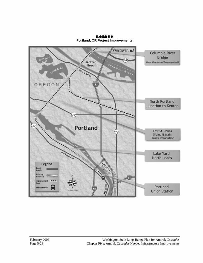
February 2006 Washington State Long-Range Plan for Amtrak CascadesPage 5-28 Chapter Five: Amtrak Cascades Needed Infrastructure Improvements
Exhibit 5-9 Portland, OR Project Improvements
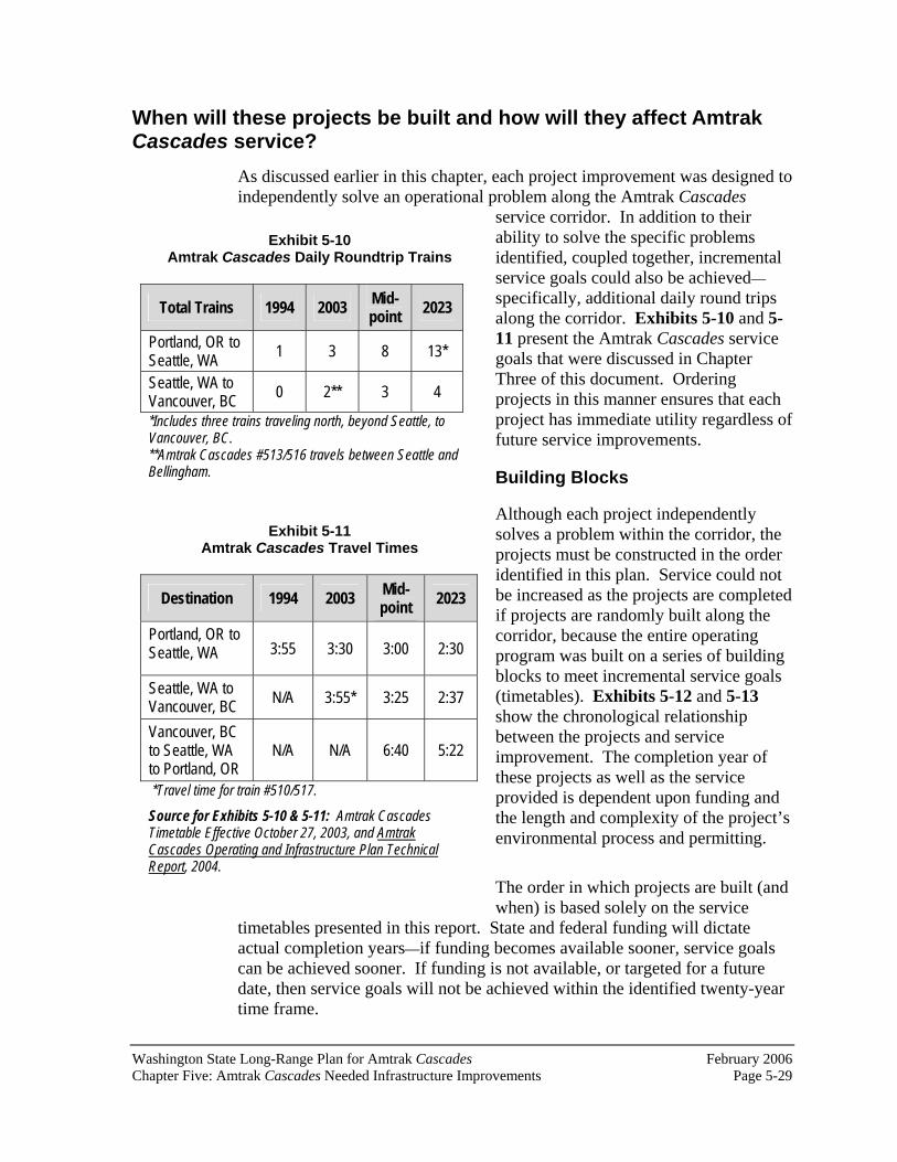
Washington State Long-Range Plan for Amtrak Cascades February 2006 Chapter Five: Amtrak Cascades Needed Infrastructure Improvements Page 5-29
Exhibit 5-10 Amtrak Cascades Daily Roundtrip Trains
Total Trains 1994 2003 Mid-point
2023
Portland, OR to Seattle, WA
1 3 8 13*
Seattle, WA to Vancouver, BC
0 2** 3 4
*Includes three trains traveling north, beyond Seattle, to Vancouver, BC. **Amtrak Cascades #513/516 travels between Seattle and Bellingham.
Exhibit 5-11 Amtrak Cascades Travel Times
Destination 1994 2003 Mid-point
2023
Portland, OR to Seattle, WA 3:55 3:30 3:00 2:30
Seattle, WA to Vancouver, BC
N/A 3:55* 3:25 2:37
Vancouver, BC to Seattle, WA to Portland, OR
N/A N/A 6:40 5:22
*Travel time for train #510/517.
Source for Exhibits 5-10 & 5-11: Amtrak Cascades Timetable Effective October 27, 2003, and Amtrak Cascades Operating and Infrastructure Plan Technical Report, 2004.
When will these projects be built and how will they affect Amtrak Cascades service?
As discussed earlier in this chapter, each project improvement was designed to independently solve an operational problem along the Amtrak Cascades
service corridor. In addition to their ability to solve the specific problems identified, coupled together, incremental service goals could also be achieved—specifically, additional daily round trips along the corridor. Exhibits 5-10 and 5-11 present the Amtrak Cascades service goals that were discussed in Chapter Three of this document. Ordering projects in this manner ensures that each project has immediate utility regardless of future service improvements.
Building Blocks
Although each project independently solves a problem within the corridor, the projects must be constructed in the order identified in this plan. Service could not be increased as the projects are completed if projects are randomly built along the corridor, because the entire operating program was built on a series of building blocks to meet incremental service goals (timetables). Exhibits 5-12 and 5-13show the chronological relationship between the projects and service improvement. The completion year of these projects as well as the service provided is dependent upon funding and the length and complexity of the project’s environmental process and permitting.
The order in which projects are built (and when) is based solely on the service
timetables presented in this report. State and federal funding will dictate actual completion years—if funding becomes available sooner, service goals can be achieved sooner. If funding is not available, or targeted for a future date, then service goals will not be achieved within the identified twenty-year time frame.

February 2006 Washington State Long-Range Plan for Amtrak CascadesPage 5-30 Chapter Five: Amtrak Cascades Needed Infrastructure Improvements
In addition to funding, Amtrak Cascades’ service goals are also dependent upon the completion of projects located outside of WSDOT’s jurisdiction. As discussed earlier, responsible parties include Sound Transit, the state of Oregon, and the province of British Columbia. For those projects located outside of Washington State, WSDOT has only identified necessary improvements - Oregon and British Columbia have not yet researched, designed or funded these projects. Without implementation of these projects, Amtrak Cascades goals as presented in this report cannot be realized.
Exhibit 5-12 Timetables and Relationship to Amtrak Cascades Service Goals
Seattle to Vancouver, BC
Service Goals
Seattle to Vancouver, BC Project Improvement
Timetable(Completion
Year)
Additional Daily Round Trip Trains
Total Daily
Round Trip Trains
ScheduleRunning Time
Mount Vernon Siding A 1 2 3:55
Swift Customs Facility Stanwood Siding PA Junction/Delta Junction Improvements Bellingham GP Improvements Colebrook Siding
B 1 2 3:55
Sound Transit: Seattle to Everett Improvements Bow to Samish Siding Extension Bellingham Siding Extension Ballard Bridge Speed Sperling to CN Junction Vancouver, BC Project Improvements (see Exhibit 5-14 and accompanying text)
C(Mid-pointservice)
1 3 3:25
Marysville to Mount Vernon High-Speed Track Burlington to Bellingham High -Speed Track Bellingham to Blaine High-Speed Track Everett Junction to Everett Second Main Track Advanced Signal System - 110 mph White Rock Bypass Colebrook to Brownsville High-Speed Track
F(2023)
1 4 2:37
Note: At the time of this writing, the implementation of “gray shaded projects” have been identified by WSDOT as needed improvements that will be funded by other jurisdictions or agencies but are necessary to achieve WSDOT’s goals for Amtrak Cascades service.

Washington State Long-Range Plan for Amtrak Cascades February 2006 Chapter Five: Amtrak Cascades Needed Infrastructure Improvements Page 5-31
Exhibit 5-13 Timetables and Relationship to Amtrak Cascades Service Goals
Seattle to Portland, OR
Service Goals
Seattle to Portland, OR Project Improvement
Timetable(Completion
Year)
Additional Daily Round Trip Trains
Total Daily
Round Trip Trains
ScheduleRunning Time
Felida Crossover Woodland Crossover Titlow Crossover Ruston Crossover Sound Transit: Seattle to Lakewood Improvements
A 1 4 3:25
Vancouver Rail Project Kelso to Martin’s Bluff Rail Project Centennial Crossovers (Leary and Pattison) Winlock Crossover Tenino Crossover Ketron Crossover North Portland Junction to Kenton
B 1 5 3:20
Point Defiance Bypass Reservation to Stewart Third Main Track Centralia Steam Plant Coal Track and Power SwitchesWoodland Siding Newaukum Siding King Street Station Track Improvements China Creek Crossover Auburn South Third Main Track Seattle Maintenance Facility Sound Transit: Seattle to Lakewood Improvements
C(Mid-pointservice)
3 8 3:00
Winlock to Chehalis Third Main Track Chehalis Siding Chehalis Junction Crossover East St. Johns Siding and Main Track Relocation Lake Yard North Leads Portland Union Station Advanced Signal System - 110 mph
D 2 10 2:55
Chehalis to Hannaford Third Main Track Ostrander to Winlock Third and Fourth Main Track E 2 12 2:45
Felida to MP 114 Third Main Track Hannaford to Nisqually Third Main Track Columbia River Bridge (Washington/Oregon project)
F(2023)
1 13 2:30
Note: At the time of this writing, the implementation of “gray shaded projects” have been identified by WSDOT as needed improvements that will be funded by other jurisdictions or agencies but are necessary to achieve WSDOT’s goals

February 2006 Washington State Long-Range Plan for Amtrak CascadesPage 5-32 Chapter Five: Amtrak Cascades Needed Infrastructure Improvements
Another critical decision outside of WSDOT’s jurisdiction regards the terminus of the Amtrak Cascades service in Canada. Currently service terminates/begins at Vancouver’s Pacific Central Station. However, in order to increase service to this facility, major infrastructure projects would be required.
What would be required in order to continue service to Vancouver’s Pacific Central Station?
Due to the topography, condition of the existing rail line, and the environmental constraints in British Columbia, it is going to be very difficult to meet the Amtrak Cascades service goals without implementing a number of project improvements. As presented in Exhibit 5-14, the estimated cost of constructing these improvements could be as high as $650 million.
Is there another option for a Greater Vancouver, BC terminus?
WSDOT and other agencies along the Pacific Northwest Rail Corridor have studied the possibility of terminating service at Scott Road, which is located about ten miles south of Pacific Central Station. If service were terminated at this location, passengers would be able to travel to downtown Vancouver via the SkyTrain station at Scott Road. By terminating service at this station, infrastructure improvement costs could feasibly be reduced by $565 million.
As part of the ridership and financial analysis for this twenty-year plan, forecasts were developed for the Scott Road Station alternative. Findings indicate that ridership between Vancouver, BC and Seattle would increase by 7.3 percent (in year 2023) if Amtrak Cascades service were terminated at Scott Road. Results of these analyses can be found in Appendix F of this report.
What key factors will influence the location of the Amtrak Cascades’ northern terminus?As indicated in Exhibit 5-14, a series of infrastructure improvements must be completed before a third round trip between Seattle and Vancouver, BC is possible. In this plan, it is assumed that these capital projects will be
Exhibit 5-14 British Columbia Infrastructure Requirements
Needed Before Mid-Point Service Infrastructure Improvement Estimated Cost
Alternative 1: Pacific Central Station Terminus
Fraser River Bridge Improvement $575 million
Brunette to Piper Siding $28.6 million
Sperling to Willingdon Junction $11.4 million
Still Creek to CN Junction $12.9 million
Vancouver Control System $6.9 million
Willingdon Junction $16 million
Alternative 2: Scott Road Terminus
Scott Road Station $86.3 million
Source: Amtrak Cascades Capital Cost Estimates Technical Report, 2006
Washington State Long-Range Plan for Amtrak Cascades February 2006 Chapter Five: Amtrak Cascades Needed Infrastructure Improvements Page 5-33
completed by Amtrak Cascades mid-point service, the most expensive of which is a new crossing of the Fraser River between Surrey and New Westminster. The New Westminster Rail Bridge, a swing-span structure constructed in 1904, is a major choke point for a number of freight and passenger rail operators in the greater Vancouver area. Canadian officials are currently studying bridge replacement options, but a funding plan for a new structure has not yet been developed. Unless and until this bridge is replaced or substantially upgraded, it will not be possible to add any more Amtrak Cascades service between Seattle and Pacific Central Station in Vancouver, BC beyond two daily round trips.
In 2010, Vancouver/Whistler, BC will be hosting the Winter Olympics. This major international event is expected to draw hundreds of thousands of visitors to the Vancouver, BC area. If Amtrak Cascades trains are to play a role as a transportation provider before, during, and after the 2010 Olympic Games, regional, provincial, and Canadian federal transportation officials will need to decide if funding the projects necessary for additional Amtrak Cascades service is a priority for the region, and if these projects will have a legacy of public benefits after the Olympic Games. These officials will also have to determine if the current station location is the best place for intercity rail travelers—when placed within the context of the region’s multi-modal transportation plan developed for the 2010 Olympic Games and beyond.
The final key factor that will influence the location of the Amtrak Cascades’northern terminus in Vancouver, BC is customer preference. While a Scott Road Station could eliminate the need for major rail line improvements north of the Fraser River, Amtrak and WSDOT have only limited data to assess the commercial impacts of a northern terminus at Scott Road, rather than downtown Vancouver. BC. WSDOT, Amtrak, and Canadian officials will need to gather this customer data and include it in a full benefit/cost assessment before deciding if relocating the Amtrak Cascades’ northern terminus from Pacific Central Station to Scott Road is the best course of action.
Once funding becomes available, what are the first steps? Once funding is available for capital projects in Washington State, WSDOT will work with the BNSF to discuss general design and operational considerations and requirements. Conceptual engineering will then begin.Following conceptual engineering, the preparation of environmental documentation will be required.
What type of environmental documentation will be prepared?
Under the State Environmental Policy Act (SEPA), any agency that proposes to take an official action is required to perform a series of environmental

February 2006 Washington State Long-Range Plan for Amtrak CascadesPage 5-34 Chapter Five: Amtrak Cascades Needed Infrastructure Improvements
analyses7 to ensure minimal impacts will result from that action. At the federal level, pursuant to the National Environmental Policy Act (NEPA), a similar environmental analysis must be performed if the proposed action is being implemented by a federal agency, requires a federal permit, or has federal funding. As a result, each of the identified project improvements (which are being initiated by a state agency and potentially may have federal funding) must follow federal and state environmental regulations as dictated by SEPA and NEPA.
Under NEPA, the Federal Highway Administration (FHWA) and the Federal Railroad Administration (FRA) will act as federal co-lead agencies, while WSDOT will act as the lead SEPA agency. To satisfy both NEPA and SEPA requirements, the three agencies will identify the appropriate level of environmental documentation necessary for each project improvement. Prior to designing and constructing any of these projects, the appropriate environmental documentation will be prepared. Following completion of this documentation, final design, permitting, and mitigation planning will be developed. Only after these steps are completed would construction begin.
What follows the environmental analysis?
Following preparation and approval of the environmental documentation, final engineering can begin. Once engineering is complete, permitting and construction can move forward.
7Unless the action is exempt under SEPA.

Washington State Long-Range Plan for Amtrak Cascades February 2006 Chapter Six: Environmental and Community Considerations Page 6-1
Chapter Six: Environmental and Community Considerations
The feasibility of a plan and its implementation often depends on whether it will have impacts on the communities that it is intended to serve, or if construction of its components will impact the surrounding natural environment.
The purpose of this chapter is to provide a summary and general discussion of the potential impacts that implementation of the proposed infrastructure improvements may have on the environment and the surrounding communities.1 As discussed in Chapter Five, as each proposed project is implemented, appropriate environmental documentation will be prepared.
What environmental resource areas have been reviewed? When analyzing a project for potential environmental and community impacts, a number of resources are reviewed. Examples of environmental resources are wetlands, vegetation, wildlife, land use, and historic resources.This chapter discusses those resources and why it is important to consider them during project planning and design.
Waterways and Hydrological Systems
Our image of Washington State is a land of sparkling rivers, wetlands, lakes, and coastal waterways. The need to keep these waters clean is essential not only for the natural beauty and health of our communities, but also for survival of animal species and fish that depend upon these waterways for water and food.
In addition to surface waters, groundwater and aquifers are also critical elements of our environment. Groundwater is an important natural resource. For many residents of western Washington, groundwater is their sole source of water for all their daily water needs.
Although groundwater exists everywhere under the ground, some parts of the saturated ground contain more water than others. Such an area is called an aquifer. An aquifer is an underground formation of permeable rock or loose
1Detailed existing conditions of the rail corridor (environmental and community conditions), potential impacts, and conceptual mitigation are presented in the Amtrak CascadesEnvironmental Overview Technical Report, 1998, reprinted 2005.

February 2006 Washington State Long-Range Plan for Amtrak CascadesPage 6-2 Chapter Six: Environmental and Community Considerations
material that can produce useful quantities of water when tapped by a well. Aquifers provide drinking water for communities throughout the corridor.
Groundwater quality, like surface water quality, can be eroded by contaminants introduced by various domestic, industrial, and agricultural practices. Even where we might not use it directly as a drinking water supply, we must still protect groundwater, since it will carry contaminants and pollutants from the land into the lakes and rivers from which other people get a large percentage of their freshwater supply.
Floodplains are lowland areas adjacent to lakes, wetlands, and rivers that are covered by water during a flood. The ability of the floodplain to carry and store floodwaters needs to be preserved in order to protect human life and property from flood damage. Also, undeveloped floodplains provide many other natural and economic resource benefits.
Floodplains often contain wetlands and other areas vital to a diverse and healthy ecosystem. Undisturbed, they have high natural biological diversity and productivity. Floodplain vegetation provides important resting, feeding and nesting areas for many waterfowl species. River corridors are frequently used as flyways for migrating birds.
Floodplain vegetation and soils serve as water filters, intercepting surface water runoff before it reaches the river, stream, or lake. This process aids in the removal of excess nutrients, pollutants, and sediments from the water and helps reduce the need for costly cleanups and sediment removal.
Much of the rail corridor passes through floodplain or flood fringe areas.
Hazardous Materials
Finding and cleaning up hazardous materials along the corridor is for the benefit and safety of railroad workers, rail passengers and local residents. It is not anticipated that there will be exposure to potentially hazardous sites and materials during construction or operations. However, there is a possibility of

Washington State Long-Range Plan for Amtrak Cascades February 2006 Chapter Six: Environmental and Community Considerations Page 6-3
finding a historical spill or dump site anywhere along the corridor. As the right of way is primarily used for freight hauling, any commodity being hauled along the route during the past 100 years could have spilled at any location. Recent legislation requires records and clean-ups of such incidences.Spills prior to 1970 were generally not recorded.
Biological Resources/Ecology
Wetlands were once thought of as swampy, bug-filled “wastelands” that were useful only when they were filled in and developed for industry, housing, or businesses. Today, however, society is beginning to realize that wetlands are unique, natural areas, important to the ecosystem we all share, and thus they should be conserved and protected.
Wetlands occur wherever land is inundated, covered, or influenced by the presence of water. Wetlands support the growth of water-loving/tolerant vegetation that is adapted to wet sites.
At times of flooding, wetlands at the mouths of streams and rivers receive overflow water that is rich in nutrients and sediments. In the stillness or gentle motion of the wetlands, these sediments settle out and clearer water percolates into the groundwater. Thus, wetlands play an essential role in filtering nutrients and sediments out of water before it enters lakes and bays. By storing and slowly releasing flood water, wetlands also moderate the damage that flooding can cause.
Wetlands are located throughout stream and river systems, providing nutrient and sediment traps and flood control all along the way.
Wetlands often have very close connections to the groundwater system. Some may serve as important groundwater recharge areas. Others are receptors for significant amounts of groundwater discharge. If the underlying groundwater is contaminated, the consequences will be felt by the wildlife and all other resources dependent on that wetland.
Numerous and diverse types of wetlands are located within the corridor, many that are at locations where the railroad crosses the many waterways.

February 2006 Washington State Long-Range Plan for Amtrak CascadesPage 6-4 Chapter Six: Environmental and Community Considerations
The preservation of our wildlife, fisheries and vegetation has long been a priority of Washingtonians. The rail corridor lies adjacent to and crosses many water resources within the state. Most of the water resources are fish-bearing streams or rivers. Fish species in the corridor include Steelhead, Chinook Salmon, Coho Salmon, and Sockeye Salmon. Many of the fish species in Washington State have recently been listed (or proposed for listing) as threatened or endangered species under the Endangered Species Act. Of these species, those prevalent in our corridor include Coho Salmon, Sea-run Cutthroat, Chum Salmon, Steelhead, Bull Trout, and Chinook Salmon.
Wildlife habitat is abundant along the Columbia River and other river and stream crossings along the corridor. Threatened and endangered species—andspecies of concern—likely to occur in the corridor vicinity include the peregrine falcon and osprey.
Vegetation throughout the corridor varies. It transitions from prairie grasses to wooded areas, with concentrations of Douglas fir, alder, and big leaf maples.
Air Quality
Polluted air can cause or worsen lung-related diseases—such as emphysema, chronic bronchitis, and asthma—and can cause breathing difficulty and even death. Easily inhaled small particles, called particulate matter, are perhaps the most significant health concern related to poor air quality.
Polluted air can contribute to water pollution and lead to decreased visibility.It can also damage building materials, cloth and metals, trees, agricultural crops and other living organisms. When a new transportation facility is proposed, it is imperative that we review the impacts that facility will have on our air.

Washington State Long-Range Plan for Amtrak Cascades February 2006 Chapter Six: Environmental and Community Considerations Page 6-5
Soils and Geology
Knowing the types of soils and geologic formations in a project area is very important. They determine the potential for landslides in the area and the area’s susceptibility to vibration caused by trains. Thus, the types of soils dictate how a project should be constructed.
In addition, steep slopes throughout the corridor can be disrupted during construction of rail improvements. It is critical that these areas be identified as part of project planning. As each proposed capital improvement moves forward, slope stabilization will be evaluated and incorporated into the project design.
Land Use
Land use refers to the types (uses) of buildings and land (for example, commercial, residential,agricultural) in an area. When new transportation projects are under consideration, it is important to ask two land-use related questions.First, is the proposed project compatible with surrounding land uses? For example, building a new freeway through a regional park would not be considered a compatible use.
Second, will existing land uses change as a result of the new transportation facility? Sometimes it is desirable to have the existing land use change, and sometimes it is not.
Throughout the corridor there are many different land uses. In Clark, Cowlitz, and Lewis counties, the land uses are primarily rural in nature. In the larger cities, such as Tacoma or Seattle, the land uses are concentrated with a mix of industrial uses and commercial uses. In Skagit and Whatcom Counties, there are many agricultural uses. In a few of the smaller communities, some housing is located close to the railroad tracks.
February 2006 Washington State Long-Range Plan for Amtrak CascadesPage 6-6 Chapter Six: Environmental and Community Considerations
Another aspect of land use is the development of comprehensive plans. In 1990, the Washington State Legislature adopted the state’s first comprehensive Growth Management Act, which is designed to help communities direct urban growth, reduce sprawl, and protect their resources. As part of the Growth Management Act, most communities are required to develop land use plans that will dictate the character and direction of growth within their cities. Changes to the passenger rail system and its facilities must now be compatible with these plans.
Farmlands
In our increasingly urbanized society, the federal government and the state of Washington have recognized the importance of preserving our diminishing farmland. It is imperative that projects minimize the disruption to these agricultural resources as much as possible.
Parks and Cultural Resources
Historic and archeological resources include historic buildings, districts, and archeological sites. In 1966, this country recognized the importance of preserving these treasures of our culture through the National Historic Preservation Act.
The Pacific Northwest Rail Corridor is rich in resources ranging from Native American burial sites and villages to the historic Fort Lewis Museum building, to the historic Fairhaven district in Bellingham. The corridor is also rich in park and recreational facilities. They range from small playgrounds to sandy beaches to large state facilities. The rail right of way parallels numerous parks and recreational facilities.
Section 4(f) of the U.S. Department of Transportation Act of 1966, as amended, provides protection for significant publicly-owned parks, recreation areas, wildlife refuges, and historic sites. Transportation projects that adversely affect such resources may not be approved by the U.S. Secretary of Transportation unless a determination is made that there is no feasible and prudent alternative, and that all planning has been done to minimize harm.
Social and Economic Resources (including Relocation and Environmental Justice)
In environmental planning, the technical area called social and economic resources includes review of access to social and educational facilities (religious institutions, schools, community centers), emergency vehicle access, community cohesiveness, and general economic conditions of the area.

Washington State Long-Range Plan for Amtrak Cascades February 2006 Chapter Six: Environmental and Community Considerations Page 6-7
When building a new project or implementing a new program, these elements play a vital role in the placement of the new facility or program. For example, it would be illogical to plan and implement a bus system if it did not go from a residential neighborhood to a commercial area. It is important to make sure the facilities can truly serve the community. In the case of intercity passenger rail, many of the communities cannot be served directly since they don’t have a station in their area and they are not on the rail line. However, it is still important to look at the social and economic resources throughout the corridor to make sure that the rail system will not adversely impact the social structure of existing communities.
It is also important to look at the communities’ views of safety because many residents feel that more trains and faster trains will make their communities less safe. Residents feel uncomfortable driving or walking over railroad tracks. Also, since some tracks separate neighborhoods from shorelines, many people illegally walk over the tracks to get to the beach to fish, walk, or picnic.
When implementing a project, it is sometimes necessary to relocate families and businesses because the new transportation facility may impact the home or business to the point where that property is no longer usable. It also happens that the new transportation facility may need more right of way to accommodate its design.
Another important aspect to consider when reviewing community cohesion and relocation is environmental justice. Executive Order 12898, Federal Actions to Address Environmental Justice in Minority Populations and Low-Income Populations, was enacted on February 11, 1994. This Executive Order requires each federal agency, to the greatest extent practicable and permitted by law, to achieve environmental justice as part of its mission. Agencies are to identify and address, as appropriate, disproportionately high and adverse human health or environmental effects, including interrelated social and economic effects of their programs, policies, and activities, on minority and low-income populations. In June 1997, the U.S. Department of Transportation implemented Order 5610.2 to establish procedures for U.S. Department of Transportation agencies, including the Federal Highway Administration (FHWA) and the Federal Railroad Administration (FRA), to comply with this Executive Order.
Visual Quality
The rail corridor program provides for improvements to passenger rail service. These improvements include constructing standard tracks and associated facilities along existing right of way that are not expected to impede visual quality. Some improvements include replacing existing grade crossing and bridge or overpass facilities.

February 2006 Washington State Long-Range Plan for Amtrak CascadesPage 6-8 Chapter Six: Environmental and Community Considerations
Energy
Energy and its conservation, in general, are important factors to consider when implementing a transportation program. A passenger rail train consumes about 350,000 BTUs (British Thermal Unit) of energy per vehicle mile. This energy is in the form of diesel fuel, a hydrocarbon-based petroleum product. A typical automobile consumes about 6,200 BTUs of energy (in gasoline form) per vehicle mile. Due to its high passenger capacity, the passenger train carrying fifty-six or more passengers is more efficient than one single occupant automobile.
Noise and Vibration
An increase in noise can affect the peacefulness of your home, the sacredness of your religious institution, or the serenity of a park or historic site. It is important to measure changes in noise and to mitigate adverse affects.
Railroad noise varies because of operating factors and conditions. Operating factors include the type of train, train frequency, the numbers and lengths of trains, and operating speeds. The number of curves on the tracks, track maintenance, and the terrain in which the track is set - all can affect the noise level. In addition, grade crossings require certain whistles and warning bells.The significance of the noise depends on conditions and on the particular land uses and activities that occur along the corridor and their sensitivity to noise.
What are the potential impacts? Exhibit 6-1, on the following page, presents a summary of general potential impacts identified in a typical environmental review. For the purposes of the environmental overview, a “worst case scenario” is presented. This scenario presumes that all of the affected environmental features within the study corridor will be impacted by some type of construction project within the next twenty years.
Are there specific areas of concern? Review of Exhibit 6-1 indicates that certain environmental resources could be seriously impacted, depending upon the exact nature of the project improvements and their location. These areas of concern include wetlands, shorelines, threatened and endangered species, slope stability, and park/historic resources. As WSDOT moves forward with project planning and design, it will pay special attention to these resources. Project alternatives will be considered to avoid adverse impacts to these resources.
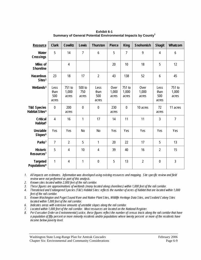
Washington State Long-Range Plan for Amtrak Cascades February 2006 Chapter Six: Environmental and Community Considerations Page 6-9
Exhibit 6-1 Summary of General Potential Environmental Impacts by County1
Resource Clark Cowlitz Lewis Thurston Pierce King Snohomish Skagit Whatcom
WaterCrossings
5 14 7 6 5 7 9 4 6
Miles of Shoreline
4 20 10 18 5 12
HazardousSites2
23 18 17 2 43 138 52 6 45
Wetlands3 Less than500
acres
751 to 1,000 acres
500 to 750
acres
Less than500
acres
Over1,000 acres
751 to 1,000 acres
Over1,000 acres
Less than500
acres
751 to 1,000 acres
T&E Species Habitat Sites4
0 200 acres
0 0 230 acres
0 10 acres 72 acres
11 acres
CriticalHabitat5
4 16 1 17 14 11 11 3 7
Unstable Slopes6
Yes Yes No No Yes Yes Yes Yes Yes
Parks7 7 2 5 1 20 22 17 5 13
Historic Resources7
5 4 10 4 39 40 16 2 15
Targeted Populations8
1 4 1 0 5 13 2 0 3
1. All impacts are estimates. Information was developed using existing resources and mapping. Site specific review and field review were not performed as part of this analysis.
2. Known sites located within 2,000 feet of the rail corridor. 3. These figures are approximations of wetlands (many located along shorelines) within 1,000 feet of the rail corridor. 4. Threatened and Endangered Species (T&E) Habitat Sites: reflects the number of acres of habitat that are located within 1,000
feet of the rail corridor. 5. Known Washington and Puget Sound Rare and Native Plant Sites, Wildlife Heritage Data Sites, and Seabird Colony Sites
located within 1,000 feet of the rail corridor. 6. Indicates areas with extensive amounts of unstable slopes along the rail corridor. 7. Located within 1,000 feet of the rail corridor. Most resources are located on the National Register. 8. Per Executive Order on Environmental Justice, these figures reflect the number of census tracts along the rail corridor that have
a population of fifty percent or more minority residents and/or populations where twenty percent or more of the residents haveincome below poverty level.

February 2006 Washington State Long-Range Plan for Amtrak CascadesPage 6-10 Chapter Six: Environmental and Community Considerations
What are the long-term impacts? In addition to the Amtrak Cascades program, a number of related actions are also being implemented along the rail corridor. These include Sound Transit’s commuter rail service and the general expansion plans of the BNSF.Expansion and implementation of these actions have been incorporated into capacity analyses for the corridor program. As such, future projects could potentially serve all of these programs. This environmental review looks at cumulative impacts that could relate to the many programs along the corridor.
Current environmental documents produced by Sound Transit also look at long-term, cumulative impacts as they relate to the various programs being implemented. Their conclusions, as well as WSDOT’s, indicate that there will not be significant secondary and cumulative impacts along the corridor.

Washington State Long-Range Plan for Amtrak Cascades February 2006 Chapter Seven: Financial and Institutional Framework Page 7-1
Chapter Seven: Financial andInstitutional Framework
Rail service in the state of Washington utilizes rail infrastructure owned by the BNSF Railway Company (BNSF). Extensive analysis of current and future railroad operations reveals that many infrastructure improvements are needed to meet the Washington State Department of Transportation’s (WSDOT) vision of increased passenger rail service while maintaining freight capacity needs. To meet service and capacity demands, WSDOT is working with other agencies and organizations to identify projects, their costs, and financing options.
What types of costs will be required to meet WSDOT’s vision? The Amtrak Cascades program will require different types of investments. These investments are generally categorized as capital costs and operating costs.
Capital Costs
Capital costs generally represent investment for improvements to railroad infrastructure, facilities and equipment. They normally result from a long-range plan that identifies the need for certain expenditures in certain years. The facility and equipment improvements identified in this report are considered capital costs. The purchase of new Amtrak Cascades trains is a current example of a system capital cost.
Chapter Five presented the capital costs for each of the project improvements that will be necessary to meet the service goals of this program.
Operating Costs
Operating costs are a direct function of running the train service every year.Costs include fuel, labor, maintenance (trains and facilities), insurance, marketing and sales, and general administrative costs.1
A passenger rail system not only incurs operating costs but also collects revenue from tickets purchased by passengers. Therefore, some costs are offset by revenue.
1See Appendix F for a discussion of the various agreements that support Amtrak Cascades operations.

February 2006 Washington State Long-Range Plan for Amtrak CascadesPage 7-2 Chapter Seven: Financial and Institutional Framework
What will the total system cost? To achieve WSDOT’s vision of faster and more frequent service, it is imperative that improvements and investments be made throughout the corridor, from Oregon to British Columbia. In addition to the three jurisdictions, our other partners – the BNSF, Sound Transit, and Amtrak - willalso need to make capital investments in the corridor. To fulfill the rail system needs of all users over the next twenty years, a capital investment of approximately $6.5 billion by 2023 will be required. However, it should be recognized that, given the uncertainties involved in projecting future expenses, total costs can only be broadly estimated.
Exhibit 7-1 provides an overview of capital investments required in the corridor over the next twenty years. These investments include planned track and facility improvements, as well as train equipment purchases.
Exhibit 7-1 Corridor Capital Costs (in Millions of 2006 Dollars)
Mid-Point 2023 TOTAL
Corridor Facilities Investments
Oregon (Union Station to the Columbia River)
$59 $362 $421
Washington $1,527 $2,439 $3,966
British Columbia* $98-$662 $405 $503-$1,067
Sound Transit $671 -- $671
Total Corridor Capital Investments $2,355-$2,919 $3,206 $5,561-$5,825
Miscellaneous Capital Costs
Advanced Signal Systems -- $536 $536
Trainsets $218 $180 $398
Total Miscellaneous Capital Costs $218 $716 $934
Total Rail Corridor Costs $2,573-$3,137 $3,922 $6,495-$6,759 *Capital costs for British Columbia are based on two scenarios: terminating service at Pacific Central Station in Vancouver, BCor providing a new terminus in Surrey, just south of Vancouver, BC. The cost differences between these two options are represented by the range in capital costs.
Note: Year 2023 costs for Oregon and Washington assumes equal cost sharing for the construction of the Columbia River Bridge. Due to rounding, amounts may not equal amounts presented in the Amtrak Cascades Capital Cost Estimates Technical Report, 2006.

Washington State Long-Range Plan for Amtrak Cascades February 2006 Chapter Seven: Financial and Institutional Framework Page 7-3
Exhibit 7-2 Operating Revenue, Costs, and Subsidy
2002 Mid-Point 2023
Annual Operating Revenue $9.2 $36.5 $82.3
Annual Operating Costs $20.3 $51.5 $83.4
Net Operating Revenues (Subsidies) - $11.1 - $15.1 - $1.1
Farebox Recovery 45% 71% 99%
Source: Amtrak Cascades Operating Costs Technical Report, 2004.
How long will it last?
The current configuration of the BNSF main line was completed in 1914. Modifications and updates have been made periodically along the corridor since that time. However, for the most part, the system and infrastructure that we have in place today have been unchanged for ninety years. Using history as a guide, it is safe to say that the physical investments which the state of Washington and our partners make along the corridor will last – if properly maintained – well over fifty to one hundred years.
What will it cost to operate? The total annual cost of providing intercity rail service (operations and maintenance) is projected to range from today’s approximately $20 million to more than $83 million by year 2023, excluding the effects of inflation.
Estimates have been developed that highlight how the anticipated growth in ridership will build operating revenues, improve the system’s farebox recovery, and reduce the required operational subsidy. Looking forward, with full implementation of the plan, operating revenues are expected to increase to approximately seventy-one percent of operating costs by the mid-point service and to approximately ninety-nine percent by program completion. This results in an operating subsidy requirement of approximately $11 million per year to start, increasing to $15 million per year, and gradually decreasing until nearly all operating costs are recovered from service revenues. These estimates are expressed in constant 2003 dollars and are based on current operating experience and comparable corridor activity elsewhere in the Amtrak system.2 Exhibit 7-2 provides the operating costs, projected revenue, and anticipated subsidy for the Amtrak Cascades program for mid-point service and year 2023.
2Amtrak Cascades Operating Costs Technical Report, 2004 and Amtrak Cascades Ridership and Revenue Forecasts Technical Report, 2004.
February 2006 Washington State Long-Range Plan for Amtrak CascadesPage 7-4 Chapter Seven: Financial and Institutional Framework
During this twenty-year period, thirty-four million passengers are projected to travel a total of nearly 5.2 billion passenger miles. Cost and revenue estimates indicate that, over this timeframe, the program will operate with an average farebox recovery of over seventy-five percent, requiring just under $165 million in total operational subsidies. These projections are based on the assumption that fares for the Amtrak Cascades service will not increase over time.
Who’s going to pay for it? WSDOT’s long-range year plan for Amtrak Cascades service outlines the various construction projects, equipment requirements, and operating expenditures that will need to be funded in order to achieve WSDOT’s goals for intercity passenger rail service between Portland, OR, Seattle and Vancouver, BC. Development of improved Amtrak Cascades service is dependent upon funding from the state of Washington, Amtrak, Sound Transit, the state of Oregon, the province of British Columbia, the federal governments of the United States and Canada, other participating agencies and organizations, and passengers using the service.
Funding for Amtrak Cascades Capital Projects
It is important to note that no long-term financial commitments have yet been made by any of the various funding entities that are described in this plan. However, this long-range plan assumes that the major capital construction projects that are needed to support expanded Amtrak Cascades service in the Pacific Northwest will be funded in the following manner:
Projects necessary to provide faster, more frequent Amtrak Cascadesservice between downtown Portland, OR and the Columbia River will be funded by the state of Oregon, with potential funding coming from the federal government and Amtrak. Projects necessary to increase the level of Sounder commuter rail service in the central Puget Sound region will be funded by Sound Transit and the federal government. Projects necessary to provide faster, more frequent Amtrak Cascadesservice between the Columbia River and the Canadian border will be funded by the state of Washington, with potential funding coming from the federal government and Amtrak. Projects necessary to improve Amtrak Cascades service in British Columbia will be funded by the province of British Columbia, the Canadian federal government, and regional transportation agencies.

Washington State Long-Range Plan for Amtrak Cascades February 2006 Chapter Seven: Financial and Institutional Framework Page 7-5
Train sets and locomotives will be funded by the states of Oregon and Washington, with additional funds provided by Amtrak and the federal government. The Seattle Maintenance Facility will be funded by Amtrak, the federal government, the state of Washington, and Sound Transit. Station improvements will be funded jointly by local jurisdictions, regional, state and provincial governments, and the federal governments of the U.S. and Canada. The new rail bridge across the Columbia River will be funded by the railroads, the states of Washington and Oregon, and the federal government. Projects that provide a direct benefit to the BNSF will be funded by the railroad.
In 2003, WSDOT and the BNSF reached agreement on a legal framework that will govern the construction of Amtrak Cascades capital projects within the Washington segment of the Pacific PNWRC. This Master Corridor Agreement commits both parties and identifies expectations up front. This twenty year agreement outlines how each of the individual projects that WSDOT has identified for Amtrak Cascades service in Washington will be constructed, what operational benefits each project will produce, and under what conditions costs for the projects will be shared by the two parties. It is the only legal agreement of its kind between a railroad and a state government, and it is intended to streamline the construction process for both the BNSF and WSDOT in the years ahead.
Funding for Amtrak Cascades Operations
Ticket-buying passengers, the states of Washington and Oregon, and Amtrak currently fund the operating costs for Amtrak Cascades service in the Pacific Northwest.
This long-range plan identifies anticipated operating costs and revenues over a twenty year planning horizon. However, this plan does not assign any specific operational funding amounts to our service partners. This is not possible at this time, as all participating agencies have limited budgets that are determined by their respective state legislatures and Congress. WSDOT will continue to work with the state of Oregon, Amtrak and other jurisdictions in order to secure the necessary funds to operate faster, more frequent Amtrak Cascades service between Portland, OR, Seattle, and Vancouver, BC over the next twenty years.
How will costs be allocated? WSDOT has been working closely with Sound Transit and the BNSF to integrate Amtrak Cascades, Sounder and freight rail service. A major

February 2006 Washington State Long-Range Plan for Amtrak CascadesPage 7-6 Chapter Seven: Financial and Institutional Framework
component of this integration is the need for physical improvements along the rail corridor. The funding for these improvements has been an ongoing negotiation among these operators.
How have WSDOT and Sound Transit integrated their programs?
Coordination and integration of Amtrak, Sound Transit, and Amtrak Cascadesschedules has thus far been informal. As development of the Amtrak Cascades and Sound Transit programs continues, integration of operations will become increasingly important.
The Amtrak Cascades service is more capacity-constrained than the Sounderservice, even at full development. Tailoring infrastructure to service minimizes the amount of construction required, but it also prevents changes in the service (other than within the designed pattern). Each service level of the Amtrak Cascades program is designed to make the maximum use of the infrastructure that is constructed for that service level. Because there is generally little excess capacity, there is little ability to rearrange any of the schedules.
The infrastructure being constructed for the implementation of Sounderservice has comparatively greater capacity. It is generally more practical to make some arrangement in a Sound Transit schedule than in a Amtrak Cascades schedule, especially at the later stages of Amtrak Cascadesdevelopment, when traffic approaches capacity. However, detailed scheduling must accommodate the requirements of both services. If that is not possible, additional infrastructure must be constructed. Infrastructure should not be constructed to accommodate only occasional conflict.
Is it worth the investment? When asked to consider the full costs of transportation, most people would identify both private and public expenditures3 that support each travel mode. Fewer individuals would consider the important role that travel time4 and external costs5 play in determining overall costs. Because these latter elements do not require out-of-pocket expenditures by either private or public groups, they are frequently overlooked. However, the hours dedicated to
3Such expenditures typically include the costs associated with maintaining and operating the facility, often referred to as operational costs. 4Travel time simply refers to the amount of time it takes to get to your destination. 5External costs refer to the elements of your trip that aren’t “out-of-pocket” expenses. These are often invisible expenses associated with the human environment, such as the impact to our air and water quality as a result of emissions and water run-off from our transportation systems.

Washington State Long-Range Plan for Amtrak Cascades February 2006 Chapter Seven: Financial and Institutional Framework Page 7-7
travel represent time lost for either work or leisure, and the external costs associated with air pollution, noise impacts, and accident losses are important policy considerations that should not be ignored.
Since each mode relies on a different form of travel—highway travel consists of using personal cars and either driving alone or with passengers; airplanes travel in the air and can carry hundreds of passengers; and trains travel on tracks and also carry hundreds of passengers—it is essential to find a uniform measurement to compare modes. Economists and transportation planners have agreed on a common measurement, known as a passenger mile, to create a “level playing field” among the different modes. This permits a consistent measure of total system usage.
A passenger mile is determined by taking the total number of passengers (in a plane, train, or car) and multiplying that number by the total number of miles traveled. The number of total passenger miles is used to calculate cost per passenger mile. The total component cost (for example, yearly airport operational costs) is then divided by the yearly total passenger miles.
Comparison of Modes: Operating Costs
When these methods are applied to intercity passenger rail in the Pacific Northwest Rail Corridor,results reveal that passenger rail service is comparable to both air and highway travel. This approach indicates that by 2023 rail costs will be approximately thirty-four cents per passenger mile, while highway travel is estimated to cost approximately seventy-six cents per passenger mile. Exhibit 7-3 shows the results of the operating cost comparison.
Exhibit 7-3 Comparison of Operating Costs
YEAR AUTOMOBILEPASSENGER
RAILAIR
TRAVEL
2004 $0.43 $0.31 $1.00 Mid-Point $0.49 $0.29 $1.12
2023 $0.76 $0.34 $1.77
Source: Amtrak Cascades Cross-Modal Analysis Technical Report, 2004.
Note: For a more in-depth discussion of the transportation mode cost comparison, see Amtrak Cascades Cross Modal Analysis.

February 2006 Washington State Long-Range Plan for Amtrak CascadesPage 7-8 Chapter Seven: Financial and Institutional Framework
Comparison of Modes: Capital Costs
By year 2023, highway capital costs are not expected to exceed one cent per passenger mile, but they reach ninety-four cents per passenger mile for rail. Exhibit 7-4presents these findings. This variation is largely driven by three key factors:
Rail is in a different place in the investment cycle. While highway and air are mature systems, rail is still in the midst of building a system infrastructure. Projected levels of ridership for each mode. Although total highway capital costs exceed those for rail, given the number of vehicle miles projected for the I-5 corridor by 2023, average costs are significantly lower for highway travel. The levels of investment in rail and highway are designed to meet different level-of-service goals.
The final step of the cross-modal analysis is to combine the total operating costs per mode with the capital costs.
Conclusions
The results of these combined costs are shown in Exhibits 7-5 and 7-6. The cost per passenger mile for rail travel will begin to decrease in the years beyond the current planning horizon. This is because the rate of capital investment is expected to be significantly lower in the years beyond 2023. By then, improvements will be complete and service objectives met; therefore, future capital needs are likely to be limited to rehabilitation and maintenance needs.
Exhibit 7-4 Comparison of Capital Costs
YEAR AUTOMOBILEPASSENGER
RAILAIR
TRAVEL
2004 $0.002 $0.11 $0.05 Mid-Point $0.001 $0.38 $0.06
2023 $0.001 $0.94 $0.06 Source: Amtrak Cascades Cross-Modal Analysis Technical Report, 2004.

Washington State Long-Range Plan for Amtrak Cascades February 2006 Chapter Seven: Financial and Institutional Framework Page 7-9
Exhibit 7-5 Comparison of Modes – Automobile and Passenger Rail
Total Operating and Capital Costs
Exhibit 7-6 Comparison of Modes – Air Travel and Passenger Rail
Total Operating and Capital Costs

February 2006 Washington State Long-Range Plan for Amtrak CascadesPage 7-10 Chapter Seven: Financial and Institutional Framework
This page intentionally left blank.
Washington State Long-Range Plan for Amtrak Cascades February 2006 Chapter Eight: Next Steps Page 8-1
Chapter Eight: Next Steps
As the Washington State Department of Transportation (WSDOT) continues to develop its Amtrak Cascades intercity passenger rail program, the department will regularly update and evaluate operational, financial, and environmental plans in order to provide accurate information on the program’s progress to taxpayers, legislators, the Governor, and the Washington Transportation Commission.
In addition to future planning updates, a number of other steps will be taken in order to ensure that Amtrak Cascades service and plans continue to be aligned with the goals and policies of the Governor, WSDOT, and the Washington Transportation Commission, while continuing to meet the needs of the traveling public. These steps will include:
Release of This Plan. This plan was revised and expanded from the Updated Plan released in April 2000. Incorporated into this update are revised ridership forecasts, new and expanded lists of needed project improvements, and a general discussion of revised operations. This revised plan will be used as a guide to move forward into future service expansion, and comply with existing state and federal transportation planning requirements. Incorporation of this Plan into the next Statewide Transportation Plan.WSDOT is required to produce a multi-modal transportation plan for the State of Washington every few years. The plan, known as the Washington Transportation Plan (WTP) serves as a blueprint for transportation programs and investments. The next WTP will look ahead at state and local transportation system needs and priorities for the twenty-year period between 2007 and 2026. Washington State Long-Range Plan for AmtrakCascades will be included in this next WTP update. Regular Performance Reporting. WSDOT publishes a performance report every three months for the Governor, Washington Transportation Commission, the state legislature and the public that highlights the ongoing and varied activities of the department. The report, known as Measures, Markers, and Mileposts includes Amtrak Cascadesperformance statistics and program status reports. Amtrak Cascadesstatistics featured include monthly and annual ridership, on-time performance, customer satisfaction, and farebox recovery. The report is designed to provide the policymakers and taxpayers of Washington with a clear picture of what WSDOT is doing and how well the department is performing so that WSDOT continues to be accountable to the people of Washington State.

February 2006 Washington State Long-Range Plan for Amtrak CascadesPage 8-2 Chapter Eight: Next Steps
Monitor and Pursue Additional Funding Sources. WSDOT will continue to monitor and pursue various funding from state and federal sources. The department will also work closely with the BNSF, Amtrak, and local communities to partner on projects and share costs. Environmental Review. As funding becomes available, WSDOT will prepare the appropriate national and state environmental documents for each proposed project improvement, as necessary. Copies of environmental documents which have already been produced can be obtained from the WSDOT Rail Office. Cost Allocation. WSDOT is currently in the process of working with cooperating organizations and agencies to identify cost responsibility for each project. The new WSDOT/BNSF Master Corridor Development Agreement governs this cost sharing agreement for capital projects within Washington State. Consumer Market Research. Amtrak’s Customer Satisfaction Index (CSI) scoring system and onboard surveys are routinely conducted to ensure that WSDOT’s plans for increased service meet the needs of the ticket-buying passenger.Marketing. On-going marketing of Amtrak Cascades service is the joint responsibility of Amtrak and WSDOT. Both organizations will continue to actively market Amtrak Cascades through a variety of media so that the traveling public is aware of the service, the amenities that are available, the competitive price structure of the service, and the overall benefits of rail travel in the Pacific Northwest. Public Involvement. The public is routinely invited to help improve Amtrak Cascades service, to participate in the development of this plan, and to shape other state rail program policies. Examples include customer comment cards aboard Amtrak Cascades trains, open houses, advisory groups, interviews conducted on an as-needed basis, and email messages sent to [email protected]. In addition, as part of the environmental process for each capital improvement, public involvement plays a critical role in the development and analysis of the project.
These are the various facets that make up the components of Amtrak Cascadesservice and its implementation. These activities will continue throughout the course of the program’s development.

Washington State Long-Range Plan for Amtrak Cascades February 2006 Chapter Eight: Next Steps Page 8-3
When is the proper time to evaluate the success of the Amtrak Cascades program?
To ensure that the program reaches its ridership goals and is providing the public benefits envisioned by the legislature, the Amtrak Cascades program will be evaluated at the service’s mid-point (when eight round trips between Seattle and Portland, OR are reached).1
This decision to evaluate the program at the mid-point was made based on case studies from around the United States which indicated that eight round trips provide the appropriate level of ridership and revenue to determine if the rail program is successful and should move forward.
1As identified in Washington’s Transportation Plan 1997-2016, Washington State Department of Transportation, 1996, page 49.

February 2006 Washington State Long-Range Plan for Amtrak CascadesPage 8-4 Chapter Eight: Next Steps
This page intentionally left blank.

Washington State Long-Range Plan for Amtrak Cascades February 2006 Chapter Nine: Previous Studies Page 9-1
Chapter Nine: Previous Studies
This section presents a list of studies that have been prepared or commissioned by the Washington State Department of Transportation Rail Office, the Oregon Department of Transportation, and the Province of British Columbia.
Previous Studies American Association of State Highway and Transportation Officials,
Standing Committee on Rail Transportation. Intercity Passenger Rail Transportation. 2002.
Oregon Department of Transportation. Oregon Rail Passenger Policy and Plan - Analysis of Alternatives. May 1992.
_____. Oregon Rail Passenger Policy and Plan. August 1992.
_____. Oregon High Speed Rail Capacity Analysis - Recommended Investment Program, FY 1993 - 1997. July 1994.
_____. Oregon High Speed Rail Business Plan. August 1994.
_____. Findings on Near-Term Passenger Demand in the Willamette Valley.August 1994.
PNC High Speed Rail Technical Group. Incremental High Speed Rail -Pacific Northwest Corridor. April 1994.
United States Department of Transportation, Federal Railroad Administration. High-Speed Ground Transportation for America. September 1997.
United States Government Accounting Office. High-Speed Ground Transportation: Issues Affecting Development in the United States.1993.
Washington State Department of Transportation. Washington’s Transportation Plan 1997-2016. April 1996.
Washington State Department of Transportation, Rail Office. Statewide High Speed Ground Transportation Study. October 1992.
_____. Preliminary Statewide Multimodal Transportation Plan 1994.December 1994.

February 2006 Washington State Long-Range Plan for Amtrak CascadesPage 9-2 Chapter Nine: Previous Studies
_____. Rail Passenger Program - Technical Report. January 1992. _____. Washington Rail Capacity Analysis. October 1994.
_____. Washington Statewide Rail Passenger Program (GAP Study). June, September and December 1992.
_____. Pacific Northwest Rail Corridor Operating Plan. December 1997.
_____. Economic Analysis for the Intercity Passenger Rail Program for Washington State. September 1998.
_____. Environmental Overview for the Pacific Northwest Rail Corridor, Volumes 1 and 2, December 1998
_____. Amtrak Cascades Plan for Washington State 1998 – 2018 Update.April 2000.
Washington State Department of Transportation, Oregon Department of Transportation, and the Province of British Columbia. Options for Passenger Rail in the Pacific Northwest Rail Corridor. 1995.

Washington State Long-Range Plan for Amtrak Cascades February 2006 Chapter Ten: Glossary Page 10-1
Chapter Ten: Glossary
Active warning device Flashing lights and/or gates used at grade crossings.
Advance warning signals A sign used along a roadway to warn that a roadway-rail grade crossing is ahead.
Aquifer An underground geological formation containing usable amounts of groundwater that can supply wells and springs.
At-grade crossing The surface where the rail and a roadway (or pathway) cross at the same level.
Ballast Material selected for placement on the roadbed for the purpose of holding the track in place.
Best Management Practices (BMPs) Used during construction, methods that have been determined to be the most effective, practical means of preventing or reducing pollution from non-point sources.
BTU (British Thermal Unit) Standard measure for heat energy.
Bypass A track that goes around other rail facilities (bypasses them) or provides a more direct route between two points. A bypass may be as simple as a track that goes around a small yard, or may be as significant as a complete route revision.
Capital costs Non-recurring costs required to construct (or improve) the rail line. Capital costs include the purchase of vehicles, track improvements, station rehabilitation, and design and administrative costs associated with these improvements.
Centralized Traffic Control An electronic system that uses remote controls to change signals and switches along a designated portion of railroad track.
Chokepoint An area along the railroad track that has less capacity than the adjoining tracks, resulting in congestion. This makes it difficult for trains to pass uninterrupted.

February 2006 Washington State Long-Range Plan for Amtrak CascadesPage 10-2 Chapter Ten: Glossary
Commuter rail Service between a central city and its suburbs, running on a railroad right of way. Examples include the Sound Transit’s commuter rail system in Puget Sound, Metrolink in Los Angeles, California and British Columbia’s West Coast Express.
Consist The number of vehicles forming a train.
Continuous welded rail Rails welded together in lengths of 400 feet or more.
Corridor train Intercity rail passenger service that links major transportation centers within a limited geographic region. Trains that only travel between Vancouver, BC and Eugene, OR are called corridor trains throughout this document.
Crossover (and Power crossover) A set of turnouts connecting multiple tracks. A crossover allows a train to move from one track to another. A power crossover may be controlled by Centralized Traffic Control.
Deficiencies Areas along the track that cannot handle expected increased train frequencies.
Derail (and Power Derail) A safety device on the track strategically located that when positioned, intentionally guides runaway rolling stock off the track to protect against collisions. A power derail may be operated by Centralized Traffic Control.
Dispatcher The individual who plans and controls the movement of trains.
Double track Two sets of main line track located side by side, most often used for travel in opposite directions, like roadways.
Environmental Assessment (EA) An environmental analysis prepared pursuant to the National Environmental Policy Act (NEPA) to determine whether a federal action (or project with federal investment) would significantly affect the environment and thus require a more detailed environmental impact statement.
Environmental Impact Statement (EIS) A document required by federal and state agencies under the National Environmental Policy Act (NEPA) and Washington State’s Environmental Policy Act (SEPA). An EIS is required for major projects or legislative proposals that may significantly affect the

Washington State Long-Range Plan for Amtrak Cascades February 2006 Chapter Ten: Glossary Page 10-3
environment. A tool for decision making, it describes the positive and negative effects of the undertaking and identifies alternative actions.
Exclusive right of way A right of way that is to be used only for the rail line (either freight or passenger or both). It is usually completely grade-separated from other types of vehicles.
Fill sections Depositing of dirt, mud, or other materials into aquatic areas to create more dry land.
Flashing light signals Used with the crossbuck signs at railroad crossings.When the lights are flashing, the motorist or pedestrian must stop.
Floodplains The flat or nearly flat land along a river or stream that is covered by water during a flood.
Frequency A term used to describe the level of rail service. For intercity rail, frequent service means that trains serve a particular station at least every four hours.
Gates Used with flashing signals at certain crossings to warn that a train is approaching.
Geometrics An engineering term that refers to the design of the tracks.
Grade crossing The area along the track where a roadway or pathway crosses.
Grade-separated Crossing lines of traffic that are vertically separated from each other (i.e., a roadway that goes over a railroad track).
Groundwater Supply of fresh water found beneath the earth’s surface, usually in aquifers, that supplies wells and springs.
Habitat The place where a population (human, animal, or plant) lives and its surroundings.
Hazardous materials Material, often waste, that poses a threat to human health and/or the environment. Typical hazardous substances are toxic, corrosive, explosive, or chemically reactive.

February 2006 Washington State Long-Range Plan for Amtrak CascadesPage 10-4 Chapter Ten: Glossary
High speed rail Trains like the famed Japanese Bullet Train, well known in European and Asian countries. These trains travel at speeds greater than 125 miles per hour on exclusive right of way and are economically feasible only in the world’s densely populated areas.
Intercity (passenger) rail Service connecting central city to central city on a railroad right of way in densely traveled corridors. Amtrak’s metroliner service between Washington, DC and Boston is a well-known example of higher-speed intercity rail. Locally, the Amtrak Cascades connecting Vancouver, BC to Seattle is an example of intercity passenger rail. Intercity passenger rail provides both regional and long distance service. The Amtrak Cascades service is a regional service.
Intermodal The use of different types of transportation modes to move freight shipments and people, i.e. ships, trains, buses, and trucks.
Light rail Carries a light volume of traffic. “Light” refers to the number of riders that the train can carry, not the weight. Light rail may share right of way on a roadway or operate on exclusive right of way and can have multi-car trains or single cars. Trolley cars and Portland, OR’s MAX system are examples of light rail.
Liquefaction When a solid changes to a liquid. Often the case with some soils, resulting in landslides.
Lock switch (and Electric lock switch) Operated by Centralized Traffic Control to regulate when trains can enter on or off the tracks. An electro-mechanical device that prevents movement of a hand throw switch when a train is approaching
Long distance (Long-Haul) train A passenger train that serves major transportation centers within and beyond those of a corridor train. An example is Amtrak’s Coast Starlight that travels between Los Angeles and Seattle.
Main line (Mainline) A railroad’s primary track that usually extends great distances. It usually carries both freight and passenger trains.
Meet A meet is the location where two trains traveling in opposite directions pass one another. Additional tracks and/or crossovers may need to be placed near these locations so that trains can maintain speeds and schedule reliability.
Mitigation Measures taken to reduce adverse impacts on the environment.

Washington State Long-Range Plan for Amtrak Cascades February 2006 Chapter Ten: Glossary Page 10-5
National Pollution Elimination Discharge System (NPDES) A provision of the Clean Water Act that prohibits discharge of pollution into waters of the United States unless a special permit is issued by the U.S. Environmental Protection Agency, a state agency, or where delegated, a tribal government.
Non-point source Pollution sources without a single point of origin. The pollutants are generally carried off the land by stormwater.
Operating costs Recurring costs of operating passenger service. These costs include wages, maintenance of facilities and equipment, fuel, supplies, employee benefits, insurance, taxes, marketing, and other administrative costs.
Passive warning device Signs or markers used at all grade crossings.
Patronage The number of people carried by the passenger train during a specified period.
Pavement markings Painted on the pavement in advance of a railroad highway crossing, to warn the motorist or pedestrian of the rail crossing.
Positive train separation A new railroad safety system, using high tech equipment to prevent train collisions.
Rail yard A system of tracks within defined limits, designed for storing, cleaning, and assembling (to each other) rail cars.
Railroad crossbuck A type of sign found at all public railroad crossings.This sign should be treated as a yield sign.
Railroad tie The part of the track, often wood or concrete, where the rails are spiked or otherwise fastened.
Rapid (or heavy) rail An electric railway that carries a large volume of people on exclusive right of way. Subways like San Francisco’s BART or Washington, DC’s Metrorail are examples of rapid (or heavy) rail.
Recharge area A land area in which water reaches the zone of saturation from surface infiltration, e.g., where rainwater soaks through the earth to reach an aquifer.
Reliability A service measure in transit planning. If a train or bus arrives within five to ten minutes of its scheduled time, it is considered reliable. Reliability can be impacted by congestion on the tracks, delays at stations, and equipment malfunction.

February 2006 Washington State Long-Range Plan for Amtrak CascadesPage 10-6 Chapter Ten: Glossary
Ridership The number of people carried by the passenger train during a specified period.
Right of way The horizontal and vertical space occupied by the rail service.In the Pacific Northwest Rail Corridor, BNSF owns the right of way. Amtrak, WSDOT, and Sound Transit run their trains on BNSF’s right of way through operating agreements.
Rolling stock Train vehicles.
Runoff That part of precipitation, snow melt, or irrigation water that runs off the land into streams or other surface water. It can carry pollutants from the air and land into receiving waters.
Siding An auxiliary track located next to a main line that allows a train to move out of the way of an oncoming train. Sidings are also used to store trains or to add/subtract rail cars.
Switch The component of a turnout consisting of switch rails and connecting parts providing the means for making a path over which to transfer rolling stock from one track to another. The switch may be thrown manually or electronically.
Travel time The elapsed time between a trip’s beginning and end. It includes travel, transfers, and waiting time.
Turnout A track arrangement that connects tracks, allowing movement from one to another.
Wetland An area saturated by surface or groundwater with vegetation adapted for life under those soil conditions. Examples of wetlands are swamps, bogs, and estuaries.
Yard limits An area where locomotives may enter the main tracks under simplified conditions without authority from the dispatcher.

Appendices
Washington State Long-Range Plan forAmtrak Cascades


Appendix A
Amtrak Cascades Proposed Timetables and Project Implementation Schedule
Washington State Long-Range Plan forAmtrak Cascades

Washington State Long-Range Plan for Amtrak Cascades February 2006 Appendix A Page A-1
Timetable A Amtrak Cascades Intercity Passenger Rail Program
Southward Trains Northward Trains
109 107 105 103 101 Example Train Numbers 102 104 106 108 110 Stations
6:05 P Vancouver, BC 11:35 A
7:37 P 8:35 A Bellingham 9:49 A 9:05 P
8:07 P 9:05 A Mount Vernon 9:16 A 8:16 P
8:51 P 9:53 A Everett 8:36 A 7:36 P
9:18 P 10:19 A Edmonds 8:10 A 7:10 P
10:00 P 11:00 A 7:40 A 6:40 P
5:25 P 2:35 P 11:25 A 7:40 A Seattle
12:10 P 3:40 P 6:15 P 9:40 P
5:36 P 2:46 P 11:37 A 7:51 A Tukwila 11:41 A 3:11 P 5:46 P 9:11 P
6:03 P 3:13 P 12:04 P 8:18 A Tacoma 11:16 A 2:46 P 5:21 P 8:46 P
6:40 P 3:50 P 12:40 P 8:55 A Olympia/Lacey 10:38 A 2:08 P 4:43 P 8:08 P
7:01 P 4:12 P 1:02 P 9:16 A Centralia 10:18 A 1:48 P 4:23 P 7:48 P
7:39 P 4:50 P 1:41 P 9:54 A Kelso/Longview 9:37 A 1:07 P 3:42 P 7:07 P
8:14 P 5:24 P 2:14 P 10:29 A Vancouver, WA 9:03 A 12:33 P 3:08 P 6:33 P
8:50 P 6:00 P 2:50 P 11:05 A Portland, OR 8:45 A 12:15 P 2:50 P 6:15 P

February 2006 Washington State Long-Range Plan for Amtrak Cascades Page A-2 Appendix A
Timetable A Needed Projects, Service Goals, and Capital Costs
Service Goals
Project Improvement (Estimated Cost)* Completion
Year**
Total Daily Round Trip Trains
ScheduleRunning
Time
Maximum Speed
Number of Trainsets
Seattle to Portland, OR Felida Crossover ($2.2) Woodland Crossover ($2.8) Titlow Crossover ($4.0) Ruston Crossover ($3.6) Sound Transit: Seattle to Lakewood Improvements ($304.0)
4 3:25
Seattle to Vancouver, BC
Mount Vernon Siding ($8.4)
3
2 3:55
79 mph 5
*In millions of 2006 U.S. dollars. **The completion year assumes full funding for all capital projects and operations starting in 2002.
Note: At the time of this writing, the implementation of “gray shaded projects” have been identified by WSDOT as needed improvementsthat will be funded by other jurisdictions or agencies but are necessary to achieve WSDOT’s goals for Amtrak Cascades service.

Washington State Long-Range Plan for Amtrak Cascades February 2006 Appendix A Page A-3
Timetable A General Location of Projects

February 2006 Washington State Long-Range Plan for Amtrak Cascades Page A-4 Appendix A
Timetable B Amtrak Cascades Intercity Passenger Rail Program
Southward Trains Northward Trains 109 111 107 105 101 103 Example Train Numbers 104 102 106 108 110 112
Stations 6:00 P 7:10 A Vancouver, BC 11:25 A 10:15 P
7:28 P 8:38 A Bellingham 9:44 A 8:34 P
7:57 P 9:07 A Mount Vernon 9:12 A 8:02 P
8:33 P 9:43 A Everett 8:39 A 7:29 P
8:52 P 10:02 A Edmonds 8:17 A 7:07 P
9:30 P 10:40 A 7:55 A 6:45 P
7:30 P 5:20 P 2:15 P 7:30 A 11:05 A Seattle
9:50 A 12:05 P 3:30 P 6:20 P 9:35 P
7:42 P 5:32 P 2:27 P 7:42 A 11:17 A Tukwila 9:22 A 11:37 A 3:02 P 5:52 P 9:07 P
8:10 P 6:00 P 2:55 P 8:10 A 11:45 A Tacoma 8:57 A 11:12 A 2:37 P 5:27 P 8:42 P
8:44 P 6:34 P 3:29 P 8:44 A 12:19 P Olympia/Lacey 8:19 A 10:34 A 1:59 P 4:49 P 8:04 P
9:06 P 6:56 P 3:51 P 9:06 A 12:41 P Centralia 8:00 A 10:15 A 1:40 P 4:30 P 7:45 P
9:44 P 7:34 P 4:29 P 9:44 A 1:19 P Kelso/Longview 7:20 A 9:35 A 1:00 P 3:50 P 7:05 P
10:16 P 8:06 P 5:01 P 10:16 A 1:51 P Vancouver, WA 6:47 A 9:02 A 12:27 P 3:17 P 6:32 P
10:50 P 8:40 P 5:35 P 10:50 A 2:25 P Portland, OR 6:30 A 8:45 A 12:10 P 3:00 P 6:15 P
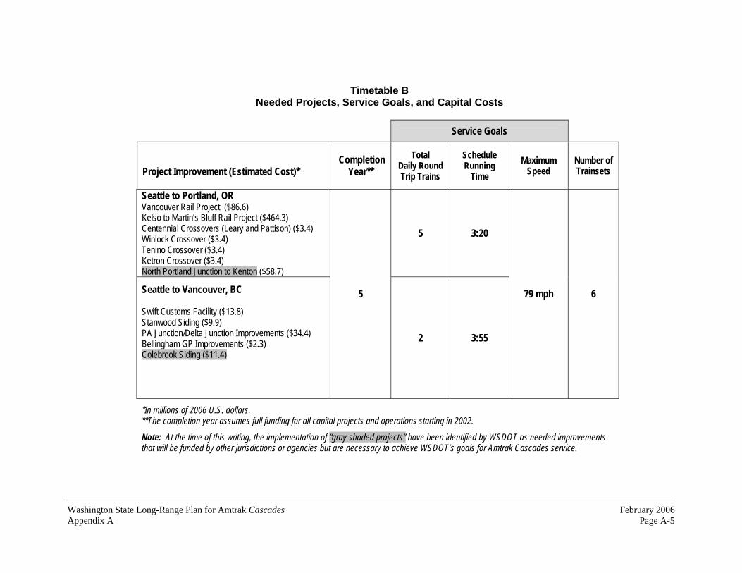
Washington State Long-Range Plan for Amtrak Cascades February 2006 Appendix A Page A-5
Timetable B Needed Projects, Service Goals, and Capital Costs
Service Goals
Project Improvement (Estimated Cost)* Completion
Year**
Total Daily Round Trip Trains
ScheduleRunning
Time
Maximum Speed
Number of Trainsets
Seattle to Portland, OR Vancouver Rail Project ($86.6) Kelso to Martin’s Bluff Rail Project ($464.3) Centennial Crossovers (Leary and Pattison) ($3.4) Winlock Crossover ($3.4) Tenino Crossover ($3.4) Ketron Crossover ($3.4) North Portland Junction to Kenton ($58.7)
5 3:20
Seattle to Vancouver, BC
Swift Customs Facility ($13.8) Stanwood Siding ($9.9) PA Junction/Delta Junction Improvements ($34.4) Bellingham GP Improvements ($2.3) Colebrook Siding ($11.4)
5
2 3:55
79 mph 6
*In millions of 2006 U.S. dollars. **The completion year assumes full funding for all capital projects and operations starting in 2002.
Note: At the time of this writing, the implementation of “gray shaded projects” have been identified by WSDOT as needed improvementsthat will be funded by other jurisdictions or agencies but are necessary to achieve WSDOT’s goals for Amtrak Cascades service.

February 2006 Washington State Long-Range Plan for Amtrak Cascades Page A-6 Appendix A
Timetable B General Location of Projects

Washington State Long-Range Plan for Amtrak Cascades February 2006 Appendix A Page A-7
Timetable C Southward Trains Only
Amtrak Cascades Intercity Passenger Rail Program
Southward Trains 115 111 117 109 113 105 103 107 101 Example Train Numbers
Stations 6:10 P 12:25 P 7:30 A Vancouver, BC 7:36 P 1:51 P 8:56 A Bellingham 8:04 P 2:19 P 9:24 A Mount Vernon 8:39 P 2:54 P 9:59 A Everett 8:58 P 3:13 P 10:18 A Edmonds 9:35 P 3:50 P 10:55 A
7:40 P 6:20 P 2:10 P 4:05 P 9:55 A 8:10 A 11:10 A 6:30 A Seattle
7:51 P 6:31 P 2:21 P 4:16 P 10:06 A 8:21 A 11:21 A 6:41 A Tukwila8:19 P 6:59 P 2:49 P 4:44 P 10:34 A 8:49 A 11:49 A 7:09 A Tacoma8:42 P 7:22 P 3:12 P 5:07 P 10:57 A 9:12 A 12:12 P 7:32 A Olympia/Lacey 9:03 P 7:43 P 3:33 P 5:28 P 11:18 A 9:33 A 12:33 P 7:53 A Centralia9:40 P 8:20 P 4:10 P 6:05 P 11:55 A 10:10 A 1:10 P 8:30 A Kelso/Longview 10:12 P 8:52 P 4:42 P 6:37 P 12:27 P 10:42 A 1:42 P 9:02 A Vancouver, WA 10:40 P 9:20 P 5:10 P 7:05 P 12:55 P 11:10 A 2:10 P 9:30 A Portland, OR

February 2006 Washington State Long-Range Plan for Amtrak Cascades Page A-8 Appendix A
Timetable C Northward Trains Only
Amtrak Cascades Intercity Passenger Rail Program
Northward TrainsExample Train Numbers 104 102 106 108 110 112 114 116 118
Vancouver, BC 11:10 A 5:05 P 9:15 P
Bellingham 9:31 A 3:26 P 7:36 P
Mount Vernon 9:00 A 2:55 P 7:05 P
Everett 8:28 A 2:23 P 6:33 P
Edmonds 8:07 A 2:02 P 6:12 P
7:45 A 1:40 P 5:50 P Seattle
9:30 A 11:40 A 1:25 P 3:10 P 5:35 P 6:55 P 9:15 P 10:45 P
Tukwila 9:01 A 11:11 A 12:56 P 2:41 P 5:06 P 6:26 P 8:46 P 10:16 P
Tacoma 8:36 A 10:46 A 12:31 P 2:16 P 4:41 P 6:01 P 8:21 P 9:51 P
Olympia/Lacey 8:11 A 10:21 A 12:06 P 1:51 P 4:16 P 5:36 P 7:56 P 9:26 P
Centralia 7:52 A 10:02 A 11:47 A 1:32 P 3:57 P 5:17 P 7:37 P 9:07 P
Kelso/Longview 7:14 A 9:24 A 11:09 A 12:54 P 3:19 P 4:39 P 6:59 P 8:29 P
Vancouver, WA 6:42 A 8:52 A 10:37 A 12:22 P 2:47 P 4:07 P 6:27 P 7:57 P
Portland, OR 6:30 A 8:40 A 10:25 A 12:10 P 2:35 P 3:55 P 6:15 P 7:45 P

Washington State Long-Range Plan for Amtrak Cascades February 2006 Appendix A Page A-9
Timetable C Needed Projects, Service Goals, and Capital Costs
Service Goals
Project Improvement (Estimated Cost)* Completion
Year**
Total Daily Round Trip Trains
ScheduleRunning
Time
Maximum Speed
Number of Trainsets
Seattle to Portland, OR King Street Station Track Improvements ($92) Seattle Maintenance Facility ($109) Point Defiance Bypass ($412.0) Reservation to Stewart Third Main ($48.3) Centralia Steam Plant Coal Track and Power Switches ($6.1) Woodland Siding ($15.3) Newaukum Siding ($3.4) China Creek Crossover ($1.7) Auburn South Third Main ($23.9) Sound Transit: Seattle to Lakewood Improvements ($160.0)
8 3:00
Seattle to Vancouver, BC Sound Transit: Seattle to Everett Improvements ($207.0)Bow to Samish Siding Extension ($50.5) Bellingham Siding Extension ($102.6) Ballard Bridge Speed ($11.5) Vancouver, BC Project Improvements($86.3-651.0)
7(Mid-pointservice)
3 3:25
79 mph 7
*In millions of 2006 U.S. dollars. **The completion year assumes full funding for all capital projects and operations starting in 2002.
Note: At the time of this writing, the implementation of “gray shaded projects” have been identified by WSDOT as needed improvementsthat will be funded by other jurisdictions or agencies but are necessary to achieve WSDOT’s goals for Amtrak Cascades service.

February 2006 Washington State Long-Range Plan for Amtrak Cascades Page A-10 Appendix A
Timetable C General Location of Projects
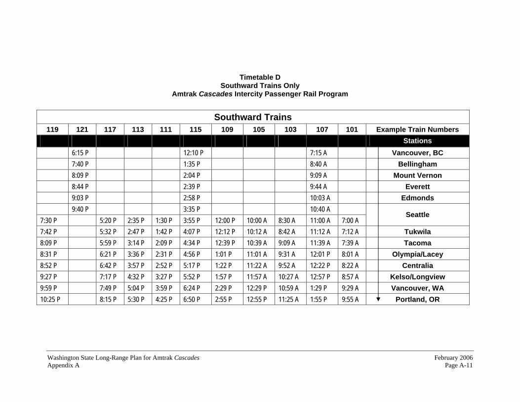
Washington State Long-Range Plan for Amtrak Cascades February 2006 Appendix A Page A-11
Timetable D Southward Trains Only
Amtrak Cascades Intercity Passenger Rail Program
Southward Trains 119 121 117 113 111 115 109 105 103 107 101 Example Train Numbers
Stations 6:15 P 12:10 P 7:15 A Vancouver, BC 7:40 P 1:35 P 8:40 A Bellingham 8:09 P 2:04 P 9:09 A Mount Vernon 8:44 P 2:39 P 9:44 A Everett 9:03 P 2:58 P 10:03 A Edmonds 9:40 P 3:35 P 10:40 A
7:30 P 5:20 P 2:35 P 1:30 P 3:55 P 12:00 P 10:00 A 8:30 A 11:00 A 7:00 A Seattle
7:42 P 5:32 P 2:47 P 1:42 P 4:07 P 12:12 P 10:12 A 8:42 A 11:12 A 7:12 A Tukwila8:09 P 5:59 P 3:14 P 2:09 P 4:34 P 12:39 P 10:39 A 9:09 A 11:39 A 7:39 A Tacoma8:31 P 6:21 P 3:36 P 2:31 P 4:56 P 1:01 P 11:01 A 9:31 A 12:01 P 8:01 A Olympia/Lacey 8:52 P 6:42 P 3:57 P 2:52 P 5:17 P 1:22 P 11:22 A 9:52 A 12:22 P 8:22 A Centralia9:27 P 7:17 P 4:32 P 3:27 P 5:52 P 1:57 P 11:57 A 10:27 A 12:57 P 8:57 A Kelso/Longview 9:59 P 7:49 P 5:04 P 3:59 P 6:24 P 2:29 P 12:29 P 10:59 A 1:29 P 9:29 A Vancouver, WA 10:25 P 8:15 P 5:30 P 4:25 P 6:50 P 2:55 P 12:55 P 11:25 A 1:55 P 9:55 A Portland, OR

February 2006 Washington State Long-Range Plan for Amtrak Cascades Page A-12 Appendix A
Timetable D Northward Trains Only
Amtrak Cascades Intercity Passenger Rail Program
Northward Trains Example Train Numbers 104 106 102 108 110 112 114 116 118 120 122
Vancouver, BC 10:55 A 3:50 P 10:20 P
Bellingham 9:17 A 2:12 P 8:42 P
Mount Vernon 8:46 A 1:41 P 8:11 P
Everett 8:13 A 1:08 P 7:38 P
Edmonds 7:52 A 12:47 P 7:17 P
7:30 A 12:25 P 6:55 P Seattle
9:25 A 10:40 A 12:05 P 1:35 P 3:05 P 5:05 P 6:35 P 7:40 P 8:55 P 10:25 P
Tukwila 8:58 A 10:13 A 11:38 A 1:08 P 2:38 P 4:38 P 6:08 P 7:13 P 8:28 P 9:58 P
Tacoma 8:32 A 9:47 A 11:12 A 12:42 P 2:12 P 4:12 P 5:42 P 6:47 P 8:02 P 9:32 P
Olympia/Lacey 8:09 A 9:24 A 10:49 A 12:19 P 1:49 P 3:49 P 5:19 P 6:24 P 7:39 P 9:09 P
Centralia 7:50 A 9:05 A 10:30 A 12:00 P 1:30 P 3:30 P 5:00 P 6:05 P 7:20 P 8:50 P
Kelso/Longview 7:14 A 8:29 A 9:54 A 11:24 A 12:54 P 2:54 P 4:24 P 5:29 P 6:44 P 8:14 P
Vancouver, WA 6:42 A 7:57 A 9:22 A 10:52 A 12:22 P 2:22 P 3:52 P 4:57 P 6:12 P 7:42 P
Portland, OR 6:30 A 7:45 A 9:10 A 10:40 A 12:10 P 2:10 P 3:40 P 4:45 P 6:00 P 7:30 P

Washington State Long-Range Plan for Amtrak Cascades February 2006 Appendix A Page A-13
Timetable D Needed Projects, Service Goals, and Capital Costs
Service Goals
Project Improvement (Estimated Cost)* Completion
Year**
Total Daily Round Trip Trains
ScheduleRunning
Time
Maximum Speed
Number of Trainsets
Seattle to Portland, OR Winlock to Chehalis Third Main Track ($149.9) Chehalis Junction Crossover ($3.5) Chehalis Siding ($11.3) East St. Johns Siding and Main Track Relocation ($40.4)Lake Yard North Leads ($26.0) Portland Union Station ($7.6) Advanced Signal System - 110 mph ($308.0)
10 2:55 110 mph
Seattle to Vancouver, BC None
13
3 3:25 79 mph
9
*In millions of 2006 U.S. dollars. **The completion year assumes full funding for all capital projects and operations starting in 2002.
Note: At the time of this writing, the implementation of “gray shaded projects” have been identified by WSDOT as needed improvementsthat will be funded by other jurisdictions or agencies but are necessary to achieve WSDOT’s goals for Amtrak Cascades service.

February 2006 Washington State Long-Range Plan for Amtrak Cascades Page A-14 Appendix A
Timetable D General Location of Projects

Washington State Long-Range Plan for Amtrak Cascades February 2006 Appendix A Page A-15
Timetable E Southward Trains Only
Amtrak Cascades Intercity Passenger Rail Program
Southward Trains 123 121 125 119 115 113 117 111 107 105 103 109 101 Example Train Numbers
Stations 5:40 P 12:20 P 7:05 A Vancouver, BC 7:05 P 1:45 P 8:30 A Bellingham 7:33 P 2:13 P 8:58 A Mount Vernon 8:08 P 2:48 P 9:33 A Everett 8:26 P 3:06 P 9:51 A Edmonds 9:05 P 3:45 P 10:30 A
7:20 P 6:10 P 5:10 P 3:00 P 1:55 P 4:05 P 12:05 P 9:50 A 8:40 A 7:35 A 10:50 A 6:35 A Seattle
7:31 P 6:21 P 5:21 P 3:11 P 2:06 P 4:16 P 12:16 P 10:01 A 8:51 A 7:46 A 11:01 A 6:46 A Tukwila7:59 P 6:49 P 5:49 P 3:39 P 2:34 P 4:44 P 12:44 P 10:29 A 9:19 A 8:14 A 11:29 A 7:14 A Tacoma8:20 P 7:10 P 6:10 P 4:00 P 2:55 P 5:05 P 1:05 P 10:50 A 9:40 A 8:35 A 11:50 A 7:35 A Olympia/Lacey 8:39 P 7:29 P 6:29 P 4:19 P 3:14 P 5:24 P 1:24 P 11:09 A 9:59 A 8:54 A 12:09 P 7:54 A Centralia9:06 P 7:56 P 6:56 P 4:46 P 3:41 P 5:51 P 1:51 P 11:36 A 10:26 A 9:21 A 12:36 P 8:21 A Kelso/Longview 9:37 P 8:27 P 7:27 P 5:17 P 4:12 P 6:22 P 2:22 P 12:07 P 10:57 A 9:52 A 1:07 P 8:52 A Vancouver, WA 10:05 P 8:55 P 7:55 P 5:45 P 4:40 P 6:50 P 2:50 P 12:35 P 11:25 A 10:20 A 1:35 P 9:20 A Portland, OR
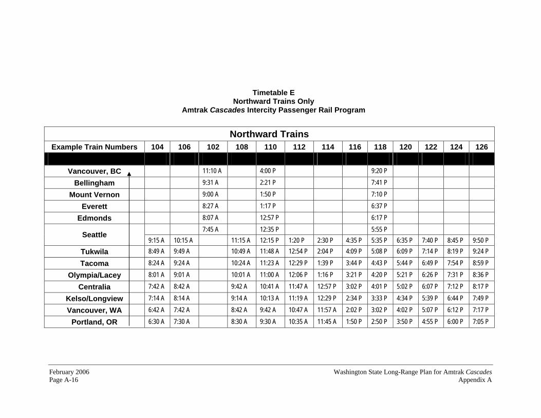
February 2006 Washington State Long-Range Plan for Amtrak Cascades Page A-16 Appendix A
Timetable E Northward Trains Only
Amtrak Cascades Intercity Passenger Rail Program
Northward Trains Example Train Numbers 104 106 102 108 110 112 114 116 118 120 122 124 126
Vancouver, BC 11:10 A 4:00 P 9:20 P
Bellingham 9:31 A 2:21 P 7:41 P
Mount Vernon 9:00 A 1:50 P 7:10 P
Everett 8:27 A 1:17 P 6:37 P
Edmonds 8:07 A 12:57 P 6:17 P
7:45 A 12:35 P 5:55 P Seattle
9:15 A 10:15 A 11:15 A 12:15 P 1:20 P 2:30 P 4:35 P 5:35 P 6:35 P 7:40 P 8:45 P 9:50 P
Tukwila 8:49 A 9:49 A 10:49 A 11:48 A 12:54 P 2:04 P 4:09 P 5:08 P 6:09 P 7:14 P 8:19 P 9:24 P
Tacoma 8:24 A 9:24 A 10:24 A 11:23 A 12:29 P 1:39 P 3:44 P 4:43 P 5:44 P 6:49 P 7:54 P 8:59 P
Olympia/Lacey 8:01 A 9:01 A 10:01 A 11:00 A 12:06 P 1:16 P 3:21 P 4:20 P 5:21 P 6:26 P 7:31 P 8:36 P
Centralia 7:42 A 8:42 A 9:42 A 10:41 A 11:47 A 12:57 P 3:02 P 4:01 P 5:02 P 6:07 P 7:12 P 8:17 P
Kelso/Longview 7:14 A 8:14 A 9:14 A 10:13 A 11:19 A 12:29 P 2:34 P 3:33 P 4:34 P 5:39 P 6:44 P 7:49 P
Vancouver, WA 6:42 A 7:42 A 8:42 A 9:42 A 10:47 A 11:57 A 2:02 P 3:02 P 4:02 P 5:07 P 6:12 P 7:17 P
Portland, OR 6:30 A 7:30 A 8:30 A 9:30 A 10:35 A 11:45 A 1:50 P 2:50 P 3:50 P 4:55 P 6:00 P 7:05 P

Washington State Long-Range Plan for Amtrak Cascades February 2006 Appendix A Page A-17
Timetable E Needed Projects, Service Goals, and Capital Costs
Service Goals
Project Improvement (Estimated Cost)* Completion
Year**
Total Daily Round Trip Trains
ScheduleRunning
Time
Maximum Speed
Number of Trainsets
Chehalis to Hannaford Third Main Track ($66.6) Ostrander to Winlock Third and Fourth Main Track ($283.1)
12 2:45
Seattle to Vancouver, BC None
15
3 3:25
110 mph 11
*In millions of 2006 U.S. dollars. **The completion year assumes full funding for all capital projects and operations starting in 2002.
Note: At the time of this writing, the implementation of “gray shaded projects” have been identified by WSDOT as needed improvementsthat will be funded by other jurisdictions or agencies but are necessary to achieve WSDOT’s goals for Amtrak Cascades service.

February 2006 Washington State Long-Range Plan for Amtrak Cascades Page A-18 Appendix A
Timetable E General Location of Projects

Washington State Long-Range Plan for Amtrak Cascades February 2006 Appendix A Page A-19
Timetable F Southward Trains Only
Amtrak Cascades Intercity Passenger Rail Program
Southward Trains127 125 121 119 123 117 113 115 111 107 105 109 103 101 Example Train Numbers
Stations8:14 P 4:14 P 12:14 P 8:14 A Vancouver, BC 9:07 P 5:07 P 1:07 P 9:07 A Bellingham9:27 P 5:27 P 1:27 P 9:27 A Mount Vernon 9:59 P 5:59 P 1:59 P 9:59 A Everett10:17 P 6:17 P 2:17 P 10:17 A Edmonds10:51 P 6:51 P 2:51 P 10:51 A
8:06 P 6:06 P 5:06 P 7:06 P 4:06 P 2:06 P 3:06 P 12:06 P 10:06 A 9:06 A 11:06 A 8:06 A 6:06 A Seattle
8:18 P 6:18 P 5:18 P 7:18 P 4:18 P 2:18 P 3:18 P 12:18 P 10:18 A 9:18 A 11:18 A 8:18 A 6:18 A Tukwila 8:46 P 6:46 P 5:46 P 7:46 P 4:46 P 2:46 P 3:46 P 12:46 P 10:46 A 9:46 A 11:46 A 8:46 A 6:46 A Tacoma 9:05 P 7:05 P 6:05 P 8:05 P 5:05 P 3:05 P 4:05 P 1:05 P 11:05 A 10:05 A 12:05 P 9:05 A 7:05 A Olympia/Lacey 9:22 P 7:22 P 6:22 P 8:00 P 5:22 P 3:22 P 4:22 P 1:22 P 11:22 A 10:22 A 12:22 P 9:22 A 7:22 A Centralia 9:49 P 7:49 P 6:49 P 8:49 P 5:49 P 3:49 P 4:49 P 1:49 P 11:49 A 10:49 A 12:49 P 9:49 A 7:49 A Kelso/Longview 10:15 P 8:15 P 7:15 P 9:15 P 6:15 P 4:15 P 5:15 P 2:15 P 12:15 P 11:15 A 1:15 P 10:15 A 8:15 A Vancouver, WA 10:36 P 8:36 P 7:36 P 9:36 P 6:36 P 4:36 P 5:36 P 2:36 P 12:36 P 11:36 A 1:36 P 10:36 A 8:36 A Portland, OR

February 2006 Washington State Long-Range Plan for Amtrak Cascades Page A-20 Appendix A
Timetable F Northward Trains Only
Amtrak Cascades Intercity Passenger Rail Program
Northward TrainsExample Train Numbers 104 102 106 108 110 112 114 116 118 120 122 124 126 128
Vancouver, BC 9:22 A 1:22 P 5:22 P 8:22 P
Bellingham 8:19 A 12:19 P 4:19 P 7:19 P
Mount Vernon 7:56 A 11:56 A 3:56 P 6:56 P
Everett 7:27 A 11:27 A 3:27 P 6:27 P
Edmonds 7:07 A 11:07 A 3:07 P 6:07 P
6:45 A 10:45 A 2:45 P 5:45 P Seattle
8:30 A 9:30 A 10:30 A 11:30 A 12:30 P 2:30 P 4:30 P 5:30 P 6:30 P 7:30 P 8:30 P 9:30 P 10:30 P
Tukwila 8:07 A 9:07 A 10:07 A 11:07 A 12:07 P 2:07 P 4:07 P 5:07 P 6:07 P 7:07 P 8:07 P 9:07 P 10:07 P
Tacoma 7:42 A 8:42 A 9:42 A 10:42 A 11:42 A 1:42 P 3:42 P 4:42 P 5:42 P 6:42 P 7:42 P 8:42 P 9:42 P
Olympia/Lacey 7:20 A 8:20 A 9:20 A 10:20 A 11:20 A 1:20 P 3:20 P 4:20 P 5:20 P 6:20 P 7:20 P 8:20 P 9:20 P
Centralia 7:06 A 8:06 A 9:06 A 10:06 A 11:06 A 1:06 P 3:06 P 4:06 P 5:06 P 6:06 P 7:06 P 8:06 P 9:06 P
Kelso/Longview 6:37 A 7:37 A 8:37 A 9:37 A 10:37 A 12:37 P 2:37 P 3:37 P 4:37 P 5:37 P 6:37 P 7:37 P 9:37 P
Vancouver, WA 6:11 A 7:11 A 8:11 A 9:11 A 10:11 A 12:11 P 2:11 P 3:11 P 4:11 P 5:11 P 6:11 P 7:11 P 8:11 P
Portland, OR 6:00 A 7:00 A 8:00 A 9:00 A 10:00 A 12:00 P 2:00 P 3:00 P 4:00 P 5:00 P 6:00 P 7:00 P 8:00 P

Washington State Long-Range Plan for Amtrak Cascades February 2006 Appendix A Page A-21
Timetable F Needed Projects, Service Goals, and Capital Costs
Service Goals
Project Improvement (Estimated Cost)* Completion
Year**
Total Daily Round Trip Trains
ScheduleRunning
Time
Maximum Speed
Number of Trainsets
Seattle to Portland, OR Felida to MP 114 Third Main Track ($173.1) Hannaford to Nisqually Third Main Track ($512.5) Columbia River Bridge (joint Washington/Oregon project) ($575.0)
13 2:30
Seattle to Vancouver, BC Marysville to Mount Vernon High-Speed Track ($322.5)Burlington to Bellingham High -Speed Track ($408.5) Bellingham to Blaine High-Speed Track ($197.7) Everett Junction to Everett Second Main Track ($22.9)Advanced Signal System - 110 mph ($228.0) White Rock Bypass ($312.7) Colebrook to Brownsville High-Speed Track ($91.8)
20(2023)
4 2:37
110 mph 12
*In millions of 2006 U.S. dollars. **The completion year assumes full funding for all capital projects and operations starting in 2002.
Note: At the time of this writing, the implementation of “gray shaded projects” have been identified by WSDOT as needed improvementsthat will be funded by other jurisdictions or agencies but are necessary to achieve WSDOT’s goals for Amtrak Cascades service.

February 2006 Washington State Long-Range Plan for Amtrak Cascades Page A-22 Appendix A
Timetable F General Location of Projects

Appendix B
Amtrak Cascades ServiceAlternatives
Washington State Long-Range Plan forAmtrak Cascades

Washington State Long-Range Plan for Amtrak Cascades February 2006 Appendix B Page B-1
Amtrak Cascades Service Alternative and Fare Sensitivity Analysis
Service goals established for Amtrak Cascades in Washington are based on results from modeling work performed by the Washington State Department of Transportation and the United States Department of Transportation in the 1990s. These service goals include thirteen daily round trips between Seattle and Portland with a total travel time of two hours, thirty minutes and four daily roundtrips between Seattle and Vancouver, BC with a total travel time of two hours, forty minutes. These goals were chosen because the modeling data indicated that this level of service would provide the best mix of ridership, revenue, and cost. The long-range capital and operating plans included in this document are designed to achieve these service goals.
Operating cost data used in this updated long-range plan assumes that the fares for future Amtrak Cascades service will be essentially the same as the fares charged today. This fare structure is projected to reduce the subsidies necessary to operate the trains to approximately $1.1 million per year, in 2003 dollars.
As part of this plan update, the project team examined the feasibility of adding more Amtrak Cascades trains to the daily schedule without adding any more infrastructure or equipment beyond that necessary to implement Timetable F. The project team also explored what would happen to ridership and revenues if fares were increased. This appendix describes the results of these analyses.
Additional Amtrak Cascades Service beyond Timetable F WSDOT’s long-range plan for Amtrak Cascades infrastructure construction is based on a series of six “building blocks” that could be introduced to the traveling public over time. These building blocks ultimately become the timetables that the traveling public will rely upon. In this plan, these six timetables are listed alphabetically as timetables A through F. A listing of these projects and their associated timetables are listed in Appendix A.
Train operation simulations performed for the last of these six timetables, Timetable F, revealed that additional daily service could be added to the rail line without requiring additional rail capacity or rail equipment. The simulations indicated that one additional daily round trip could be added between Seattle and Portland and one additional daily roundtrip could be added between Seattle and Vancouver, B.C. These additional daily roundtrips would be operated as a through train between Portland and Vancouver, B.C. Exhibit B-1 on the following page presents a comparison of the ridership

February 2006 Washington State Long-Range Plan for Amtrak CascadesPage B-2 Appendix B
projections, operating costs, and revenues between Timetable F and the Timetable F - Revised Service Plan that includes this additional service level.
The projections performed for the Revised Service Plan scenario indicate that Amtrak Cascades ridership would increase by 6.96 percent, expenses would increase by 3.30 percent, and revenues would increase by 4.76 percent. This would also result in a total operating subsidy reduction of 97.3 percent.
Amtrak Cascades Fare-Sensitivity Analysis Fare sensitivity analyses estimate the affect of increasing rail fares on passenger travel choice. Throughout most of this plan, ridership and revenue projections assume that the existing Amtrak Cascades fare structure remains the same throughout the life of the program. As part of this plan update, the project team introduced higher fares at the service level mid-point (Timetable C), at the end of the capital program (Timetable F), and at Timetable F - Revised Service Plan described above. The results of this fare sensitivity analysis are listed in Exhibit B-2.
Exhibit B-1 Comparison of Ridership Projections, Operating Costs, and Revenues
Schedule Daily Roundtrips between Portland and Seattle
Daily Roundtrips between Seattle and Vancouver, B.C.
TotalAnnual CorridorRidership
TotalAnnual Operating Expenses
TotalAnnual Operating Revenues
Total Annual Operating Balance
Timetable F 13 4 2,995,300 $83,388,360 $82,257,737 -$1,130,623
Timetable F - Revised Service Plan
14 5 3,203,900 $86,147,314 $86,177,063 -$30,251
All financial data is in 2003 dollars and assumes continuation of the current Amtrak Cascades fare structure.
Timetable F includes 3 daily roundtrips between Portland and Vancouver, B.C.
The Timetable F - Revised Service Plan includes 4 daily roundtrips between Portland and Vancouver, B.C.
Source: Amtrak Cascades Ridership and Revenue Forecasts Technical Report, 2004, and Amtrak Cascades Operating and Infrastructure Plan Technical Report, 2004.

Washington State Long-Range Plan for Amtrak Cascades February 2006 Appendix B Page B-3
Exhibit B-2 Fare Sensitivity Analysis Projections
Average One-Way Fare
Schedule
Seattle-Portland
Seattle-Vancouver,
BC
Annual Ridership
Annual Revenues
Annual Operating
Expenditures
Annual Operating Balance
Timetable C $28 $26 1,410,100 $36,452,805 $51,532,452 -$15,079,646
Timetable C with 23% fare
increase
$34 $32 1,246,900 $39,861,663 $50,825,126 -$10,963,463
Timetable F $28 $26 2,995,300 $82,257,737 $83,388,360 -$1,130,623
Timetable F with 46% Fare
Increase
$40 $38 2,516,600 $88,790,000 $81,298,647 $15,297,339
Timetable F Revised
Service Plan
$28 $26 3,203,900 $86,117,063 $86,147,314 -$30,251
Timetable F - Revised
Service Plan with 46% Fare
Increase
$40 $38 2,696,900 $106,332,057 $83,906,352 $22,425,706

Appendix B:
Amtrak Cascades Service AlternativeSouthound Service 2023
129 127 125 123 121 119 117 115 113 111 109 107 105 103 101 Example Train NumbersStations
8:14 PM 4:14 PM 2:14 PM 12:14 PM 8:14 AM Vancouver BC9:04 PM 5:04 PM 3:04 PM 1:04 PM 9:04 AM Bellingnham9:26 PM 5:26 PM 3:26 PM 1:26 PM 9:26 AM Mount Vernon
9:56 PM 5:56 PM 3:56 PM 1:56 PM 9:56 AM Everett
10:16 PM 6:16 PM 4:16 PM 2:16 PM 10:16 AM Edmonds
10:51 PM 8:06 PM6:39 PM6:51 PM 6:06 PM 4:39 PM 4:06 PM
2:39 PM2:51 PM 2:06 PM 12:06 PM
10:39 AM10:51 AM 10:06 AM 9:06 AM 8:06 AM 7:07 AM 6:06 AM Seattle
8:17 PM 7:17 PM 6:17 PM 5:17 PM 4:17 PM 3:17 PM 2:17 PM 12:17 PM 11:17 AM 10:17 AM 9:17 AM 8:17 AM 7:18 AM 6:17 AM Tukwila
8:43 PM 7:43 PM 6:43 PM 5:43 PM 4:43 PM 3:43 PM 2:43 PM 12:43 PM 11:43 AM 10:43 AM 9:43 AM 8:43 AM 7:44 AM 6:43 AM Tacoma
9:04 PM 8:04 PM 7:04 PM 6:04 PM 5:04 PM 4:04 PM 3:04 PM 1:04 PM 12:04 PM 11:04 AM10:0410:05 9:04 AM 8:05 AM 7:04 AM Centennial
9:19 PM 8:19 PM 7:19 PM 6:19 PM 5:19 PM 4:19 PM 3:19 PM 1:19 PM 12:19 PM 11:19 AM 10:19 AM 9:19 AM 8:20 AM 7:19 AM Centralia9:48 PM 8:48 PM 7:48 PM 6:48 PM 5:48 PM 4:48 PM 3:48 PM 1:48 PM 12:48 PM 11:48 AM 10:48 AM 9:48 AM 8:49 AM 7:48 AM Kelso
10:14 PM 9:14 PM 8:14 PM 7:14 PM 6:14 PM 5:14 PM 4:14 PM 2:14 PM 1:14 PM 12:14 PM 11:14 AM 10:14 AM 9:15 AM 8:14 AM Vancouver, WA10:36 PM 9:36 PM 8:36 PM 7:36 PM 6:36 PM 5:36 PM 4:36 PM 2:36 PM 1:36 PM 12:36 PM 11:36 AM 10:36 AM 9:37 AM 08:36 AM Portland, OR
February 2006Page B-4
Washington State Long-Range Plan for Amtrak CascadesAppendix B

Appendix B:
Amtrak Cascades Service Alternative Northbound Service 2023
Example Train Numbers 102 104 108 110 112 114 116 118 120 122 124 126 128 130Stations
Vancouver, BC 9:22 AM 5:22 PM 1:22 PM 5:22 PM 8:22 PMBellingnham 8:16 AM 10:16 AM 12:16 PM 4:16 PM 6:16 PM
Mount Vernon 7:55 AM 9:55 AM 11:55 AM 3:55 PM 5:55 PM
Everett 7:24 AM 9:24 AM 11:24 AM 3:24 PM 5:24 PM
Edmonds 7:06 AM 9:06 AM 11:06 AM 3:06 PM 5:06 PM
Seattle 6:45 AM08:30 AM08:19 AM
10:30 AM10:19 AM 11:19 AM 12:19 PM 1:19 PM
02:30 PM02:19 PM
04:30 PM04:19 PM 5:19 PM 6:19 PM 7:19 PM 8:19 PM 9:19 PM 10:19 PM
Tukwila 8:06 AM 10:06 AM 11:06 AM 12:06 PM 1:06 PM 2:06 PM 4:06 PM 5:06 PM 6:06 PM 7:06 PM 8:06 PM 9:06 PM 10:06 PM
Tacoma 7:39 AM 9:39 AM 10:39 AM 11:39 AM 12:39 PM 1:39 PM 3:39 PM 4:39 PM 5:39 PM 6:39 PM 7:39 PM 8:39 PM 9:39 PM
Centennial 7:19 AM 9:19 AM 10:19 AM 11:19 AM 12:19 PM 1:19 PM 3:19 PM 4:19 PM 5:19 PM 6:19 PM 7:19 PM 8:19 PM 9:19 PM
Centralia 7:03 AM 9:03 AM 10:03 AM 11:03 AM 12:03 PM 1:03 PM 3:03 PM 4:03 PM 5:03 PM 6:03 PM 7:03 PM 8:03 PM 9:03 PM
Kelso 6:36 AM 8:36 AM 9:36 AM 10:36 AM 11:36 AM 12:36 PM 2:36 PM 3:36 PM 4:36 PM 5:36 PM 6:36 PM 7:36 PM 8:36 PM
Vancouver, WA 6:10 AM 8:10 AM 9:10 AM 10:10 AM 11:10 AM 12:10 PM 2:10 PM 3:10 PM 4:10 PM 5:10 PM 6:10 PM 7:10 PM 8:10 PM
Portland, OR 6:00 AM 8:00 AM 9:00 AM 10:00 AM 11:00 AM 12:00 PM 2:00 PM 3:00 PM 4:00 PM 5:00 PM 6:00 PM 7:00 PM 8:00 PM
Washington State Long-Range Plan for Amtrak CascadesAppendix B
February 2006Page B-5

Appendix C
Washington State-owned Rail EquipmentPreservation Plan and Replacement Options
Washington State Long-Range Plan forAmtrak Cascades

Washington State Long-Range Plan for Amtrak Cascades February 2006 Appendix C Page C-1
Washington State-owned Rail Equipment Preservation Plan and Replacement Options
Pursuant to Revised Code of Washington (RCW) 47.06.090, the Washington State Department of Transportation (WSDOT) is required to identify any state-owned components of the department’s passenger rail program and provide a long-term preservation plan for that equipment. The purpose of this requirement is to ensure that all state-owned rail equipment is properly preserved and maintained so that it lasts as long as possible before requiring replacement.
This appendix describes the current preservation plan for state-owned passenger rail equipment and provides an overview of Washington State’s equipment replacement options for these trainsets.
Washington State-owned Passenger Rail Equipment The Amtrak Cascades fleet that operates between Eugene, OR, Portland, OR, Seattle, Bellingham, and Vancouver, BC consists of five trainsets. Three of these trainsets are owned by the state of Washington. Amtrak owns the other two trainsets. Each trainset has seating capacity for approximately 250 passengers. Amtrak also owns seven locomotives used for the service, and Amtrak and the state of Oregon each own three cab control cars that are connected to the end of each trainset.1
Each trainset includes twelve cars: six regular coaches, two business class coaches, one bistro car, one lounge car, one baggage car, and one generator car that powers heating, air conditioning, lights, kitchen equipment, and the train’s video and audio system. Washington State also owns two additional cars: one baggage car and one generator car. These two cars, stored in Seattle, serve as spares and are only used when needed. Amtrak owns three additional cars: one spare bistro car stored in Seattle, and two coach cars that are used on their trainsets.
1Cab control cars are engineless locomotives placed at the end of each trainset that allow the engineer to operate the train from either end, eliminating the requirement to turn the entire trainset around after completing a route. This saves a significant amount of time and reduces the costs of operating the trains. Since the cab control cars were first put into service in 1999, the Federal Railroad Administration has issued an order that requires cab control cars on all Amtrak Cascades trainsets.

February 2006 Washington State Long-Range Plan for Amtrak CascadesPage C-2 Appendix C
Tilting Trainsets and the Pacific Northwest Rail Corridor The Pacific Northwest Rail Corridor (PNWRC) has some extraordinary geographic characteristics that limit the capabilities of conventional train equipment. First constructed in the 1880s, over a quarter of the 466-mile long rail line is comprised of curves. Curves restrict the speed of conventional passenger equipment, and travel times between major cities could only be reduced by costly and time-consuming track relocation projects.
An alternative approach, identified through research conducted by WSDOT in the early 1990s, was to use “tilting” rail passenger equipment that could safely travel through curves at greater speeds than possible with conventional rail equipment. WSDOT leased European-manufactured trainsets in the mid 1990s to test this type of equipment in everyday service and determine its suitability and reliability in the Pacific Northwest’s unique rail environment. Patentes Talgo, S.A. of Madrid, Spain, manufactured this equipment. The Talgo trainsets performed well due to their rugged construction, lighter weight, and low center of gravity.
I
In 1995 the Washington State Legislature provided funding to lease/ purchase two tilting trainsets. WSDOT, in conjunction with Amtrak, issued a Request for Proposals (RFP) to lease/purchase four trainsets. The performance-based specifications included in this RFP led to the selection of Talgo as the manufacturer of the new trainsets sought by WSDOT and Amtrak. The two key factors that led to Talgo’s selection were the equipment’s demonstrated high service reliability and the fact that the Talgo tilting technology would not require additional testing or modification. The manufacturer-ready tilting technology not only reduced the construction and delivery time of the new trainsets, but also eliminated the need for numerous on-the-ground capital projects along the PNWRC that would have otherwise been necessary to
Talgo’s passive-tilt suspension system permits the rail cars to tilt through curves, which enables the train to maintain higher speeds while preserving passenger comfort.
Conventional Car Passive-tilt Car

Washington State Long-Range Plan for Amtrak Cascades February 2006 Appendix C Page C-3
achieve the state’s travel time goals between cities if non-tilting, conventional rail equipment had been purchased. WSDOT and Amtrak anticipated that the tilting suspension system would ultimately save tens of millions of dollars in publicly-funded capital construction throughout the rail corridor.
In 1997 partially constructed Talgo trainsets were sent via ship to the United States, with final assembly performed in Seattle by Pacifica Marine Inc. These trainsets went into service in January 1999.
Equipment Maintenance and Preservation Talgo has been providing maintenance services on its trains for over forty years. As the manufacturer, they are uniquely suited to understand and conduct maintenance on the trainsets. Talgo’s preventative maintenance philosophy—known as the Talgo Total Logistic Care System—is designed to ensure high reliability of the equipment through scheduled replacement of parts and constant monitoring of the performance of each trainset. This strategic maintenance program helps ensure the equipment’s lowest-lifecycle cost, as Talgo’s progressive maintenance schedule prevents the need for expensive repairs and greatly reduces the probability of major mechanical failures.
Under terms of the equipment maintenance agreements between WSDOT, Amtrak, and Talgo, each trainset is serviced on a regular basis at Talgo’s maintenance facility near Safeco Field in Seattle. Talgo maintenance technicians (Amtrak employees under contract to Talgo) use a series of checklists to inspect and monitor the condition of vital components and ensure compliance with all safety rules. The results from these regular equipment checks are monitored and recorded, and the maintenance work identified through these inspections is then integrated into each Talgo trainset’s regular maintenance schedule.
Talgo has an extensive, four-volume maintenance manual with specific maintenance schedules for the trainsets based on either mileage and/or time intervals. Each technician follows a specific inspection, repair, and replacement procedure as outlined by Talgo in the maintenance manual. These preventative maintenance procedures continue to keep the trainsets in excellent operating condition. In addition to this regular maintenance program, each Amtrak Cascades train has an onboard Talgo technician who constantly monitors the train’s condition while it is in service. The technician can respond quickly to problems and even make some repairs while the train is en route, if necessary. Any problems detected by the onboard technician that cannot be immediately repaired are reported to the Talgo maintenance staff in Seattle, where they are addressed when the equipment arrives for its regularly scheduled servicing every four days.
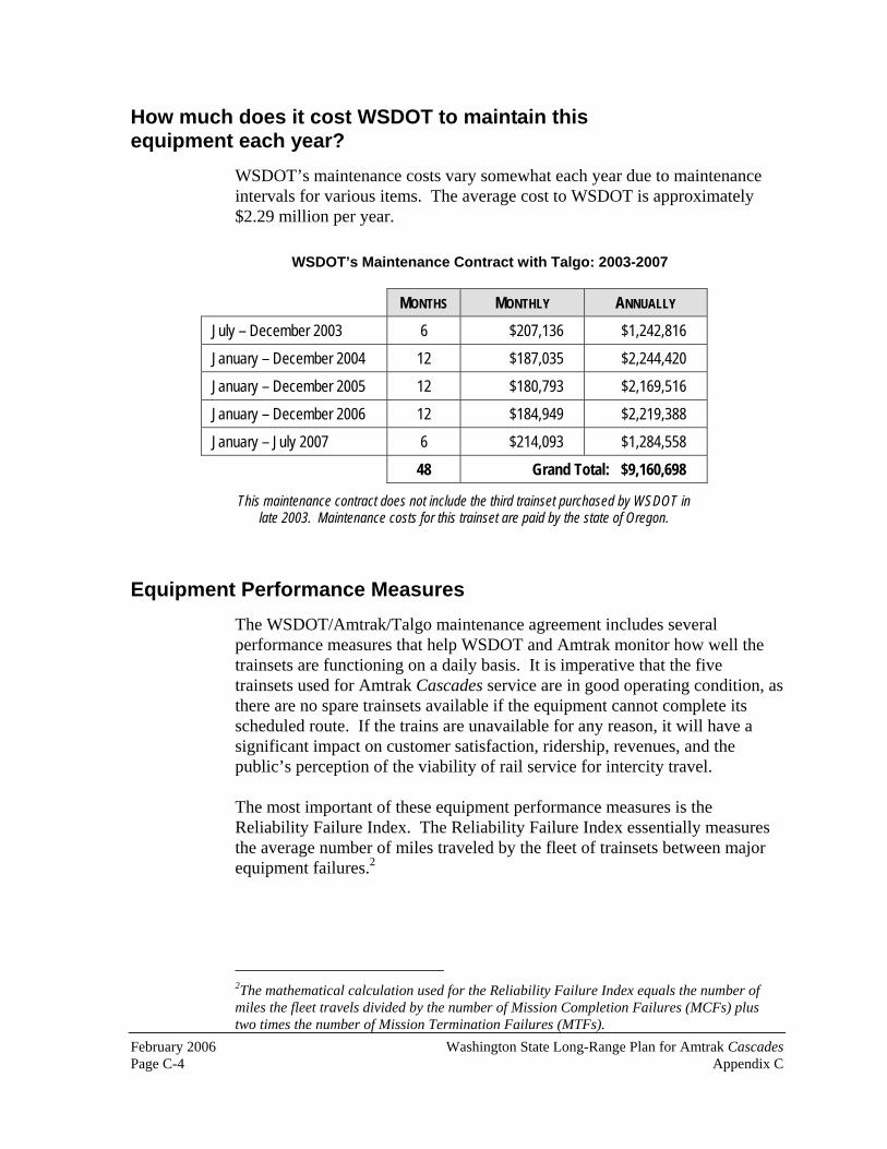
February 2006 Washington State Long-Range Plan for Amtrak CascadesPage C-4 Appendix C
How much does it cost WSDOT to maintain this equipment each year?
WSDOT’s maintenance costs vary somewhat each year due to maintenance intervals for various items. The average cost to WSDOT is approximately $2.29 million per year.
Equipment Performance Measures The WSDOT/Amtrak/Talgo maintenance agreement includes several performance measures that help WSDOT and Amtrak monitor how well the trainsets are functioning on a daily basis. It is imperative that the five trainsets used for Amtrak Cascades service are in good operating condition, as there are no spare trainsets available if the equipment cannot complete its scheduled route. If the trains are unavailable for any reason, it will have a significant impact on customer satisfaction, ridership, revenues, and the public’s perception of the viability of rail service for intercity travel.
The most important of these equipment performance measures is the Reliability Failure Index. The Reliability Failure Index essentially measures the average number of miles traveled by the fleet of trainsets between major equipment failures.2
2The mathematical calculation used for the Reliability Failure Index equals the number of miles the fleet travels divided by the number of Mission Completion Failures (MCFs) plus two times the number of Mission Termination Failures (MTFs).
WSDOT’s Maintenance Contract with Talgo: 2003-2007
MONTHS MONTHLY ANNUALLY
July – December 2003 6 $207,136 $1,242,816
January – December 2004 12 $187,035 $2,244,420
January – December 2005 12 $180,793 $2,169,516
January – December 2006 12 $184,949 $2,219,388
January – July 2007 6 $214,093 $1,284,558
48 Grand Total: $9,160,698
This maintenance contract does not include the third trainset purchased by WSDOT inlate 2003. Maintenance costs for this trainset are paid by the state of Oregon.

Washington State Long-Range Plan for Amtrak Cascades February 2006 Appendix C Page C-5
Talgo equipment performance requirements and penalties
Talgo is permitted one Mission Termination Failure (MTF) every 800,000 fleet miles.3 An MTF occurs when a mechanical component of the train fails en route and the train is either cancelled or is two or more hours late due to a Talgo train mechanical defect. The current accumulated fleet miles per calendar are approximately 680,000. As such, the Talgo fleet cannot have more than 0.85 MTFs a year without being assessed a financial penalty. In 2004, there were no MTFs.
Talgo is also permitted one Mission Completion Failure (MCF) every 200,000 fleet miles. An MCF occurs when a component of the train's mechanical system fails and either delays the train significantly or disrupts electrical power delivery to the train. Talgo is allowed three MCFs per year, based on current fleet usage. In 2004, there were four MTFs.
There are also lower order failures called Mission Success Failures (MSFs), which measure impacts to customer comfort items such as air conditioning, toilets, audio systems, and other customer amenities. These are also monitored and corrected by Talgo when they occur.
At the end of each calendar year, a team comprised of representatives from Amtrak, WSDOT, and Talgo conducts a performance review of the Talgo equipment. Mission Completion, Termination, and Success Failures are compiled and explained by Talgo management. Talgo can earn credits to offset the number of MTFs, MCFs, and MSFs each time Amtrak delivers the trainsets late from King Street Station for maintenance but Talgo is still able to get the trainsets back to Amtrak on time before its next scheduled departure. This gives Talgo a financial incentive to work diligently to correct any problems with the equipment in a timely manner. The review team subtracts any earned credits from the MTF, MCF, and MSF totals, up to a maximum of seven. Once the three parties comprising the review team agree to the final tally of mission failures, the financial penalties assessed to Talgo under the performance provisions of the WSDOT/Amtrak/Talgo maintenance agreement are recovered through a reduction in the monthly maintenance fees paid by WSDOT and Amtrak. The maintenance contract also contains a provision that if mission failures reach unacceptable levels, WSDOT and Amtrak can terminate the maintenance contract with Talgo and hire a new maintenance provider.
3This calculation is based on four Talgo trainsets.

February 2006 Washington State Long-Range Plan for Amtrak CascadesPage C-6 Appendix C
When will the Talgo equipment be replaced? WSDOT and Amtrak have not yet determined when the current fleet of Talgo trainsets will be replaced. The current fleet of trainsets that began service in 1999 has an anticipated life of twenty-five to thirty years, which means they will need to be replaced no later than 2029.
The decision to replace this equipment sooner than 2029 will be based on the availability of funding for rail line construction projects identified in WSDOT’s long range plan for Amtrak Cascades and the ability of WSDOT and Amtrak to procure new train equipment at a reasonable price.
Equipment overhauls
The 2005 Washington State Legislature provided $17 million for overhauls to the three state-owned trainsets. All three trainsets will receive interior and exterior improvements, including paint, seating, tables, carpet, toilets, windows, wall coverings, and video and audio systems. The overhauls will ensure that customer satisfaction and passenger comfort remains high during the life of the equipment. This overhaul work will be done in phases, starting in 2007 and ending in 2013.
Capital funding and incremental service additions
WSDOT’s long-range plan for Amtrak Cascades service development is based upon incremental service additions and travel time reductions resulting from the completion of specific construction projects along the PNWRC. In 2005 the Washington State Legislature approved a ten year funding package for capital improvements to the PNWRC that will allow WSDOT to add one additional daily round trip between Seattle and Portland, OR in 2006, and set the stage for additional daily round trips with reduced travel times between these cities some time after 2015. This fourth daily round trip between Seattle and Portland, OR (Timetable A) will be the maximum level of service that can be accomplished with the existing five Talgo trainsets.
The next service increment identified in WSDOT’s long-range plan calls for five round trips per day between Seattle and Portland and two round trips per day between Seattle and Vancouver, BC (Timetable B). This can only occur after completion of the Vancouver Rail Project (WA) and Kelso-Martin’s Bluff Rail Project, the latter of which is not fully funded in the state’s ten year transportation budget. If federal funding can be obtained to complete this project, and if there are sufficient operating funds to add the fifth daily round trip between Seattle and Portland, OR before the Talgo equipment reaches the end of its life, WSDOT and Amtrak will need one additional trainset to achieve the schedules that make up Timetable B. This means that a single

Washington State Long-Range Plan for Amtrak Cascades February 2006 Appendix C Page C-7
trainset will need to be added to the existing fleet of five trainsets or a minimum of six new trainsets will need to be purchased.
The current fleet of Talgo equipment is limited to a maximum speed of seventy-nine miles per hour (mph) on the PNWRC. The maximum train speeds for Timetable B and C is also seventy-nine mph. In Timetable D, 110 mph operations are introduced. With this higher speed requirement in mind, if there is additional funding provided to construct the projects necessary to achieve the schedules contained in Timetable C, seven trainsets capable of traveling at 110 mph will be necessary for daily operations.
The availability of high-speed rail equipment in the American marketplace
High-performance passenger train cars of any type, including high speed trains, are not readily available in the United States. Acela passenger equipment, developed specifically for use in Amtrak’s Washington, D.C. to Boston Northeast Corridor (NEC) is the only other high speed equipment in use in the United States. Acela passenger rail equipment, designed for the unique characteristics of the NEC, is not well suited to any other rail corridor in the U.S.
Domestic rail transit and passenger car manufacturers are virtually non-existent because of the lack of demand for new passenger rail cars. Bombardier, a large Canadian transportation conglomerate, has some limited production facilities in Vermont, but for the most part, does the majority of its production outside the United States. European and Asian manufacturers have maintained production capabilities due to healthy international rail passenger equipment markets. However, most of these trains are not built to meet the regulations imposed by the U.S. Federal Railroad Administration, and therefore cannot be operated in this country without substantial modifications.
If additional high speed rail projects are funded throughout the U.S., there would likely be sufficient demand for new passenger equipment. As a result, domestic mass production could occur and it would be possible to buy equipment as needed. If WSDOT is the sole customer ordering high speed train equipment, the price will be significantly affected by the size of the order. Even an order for five trainsets (the size of the order for the current fleet of Amtrak Cascades trainsets) could be considered too small if a production facility in the U.S. needs to be established specifically for the order. An order for one trainset would likely receive no reasonably priced bids from rail equipment manufacturers.

February 2006 Washington State Long-Range Plan for Amtrak CascadesPage C-8 Appendix C
Options for passenger rail equipment replacement
Based on the special market conditions described above, WSDOT’s passenger rail equipment replacement options are as follows:
WSDOT and Amtrak could continue to use the current fleet of Talgo equipment until the trainsets reach the end of their lifecycles, which under the current and anticipated service levels, is projected to be in 2029. This long-term use of the existing trainsets will only occur if there is insufficient funding to complete the capital projects necessary to go beyond five daily round trips between Seattle and Portland, OR and two daily round trips between Seattle and Vancouver, BC (Timetable A). After 2029, new equipment would need to be purchased. One additional trainset could be purchased for implementation of Timetable B, bringing the total number of trainsets to six. However, production of only one trainset would be extremely expensive and would likely be deemed cost-prohibitive for the state of Washington and Amtrak. (It is also unlikely that any manufacturer would offer to produce only one trainset.)If the U.S. federal government establishes a dedicated funding source that states can use for high speed rail development, WSDOT, Amtrak, and other organizations responsible for implementing intercity passenger rail service across the country could enter into a pool-agreement where one or more manufacturers would produce a large number of trainsets, thereby lowering the cost to all customers. WSDOT could purchase either six new trainsets for Timetable B, seven new trainsets for Timetable C, and potentially up to twelve new trainsets for Timetable F, which marks the completion of WSDOT’s capital construction plan for Amtrak Cascadesservice in Washington. WSDOT’s three existing Talgo trainsets could potentially be sold to other states or countries, and any funds generated through the sale of equipment could be applied toward other PNWRC capital expenses within Washington State or to offset the cost of this new train equipment.
Appendix D
Station Profiles
Washington State Long-Range Plan forAmtrak Cascades
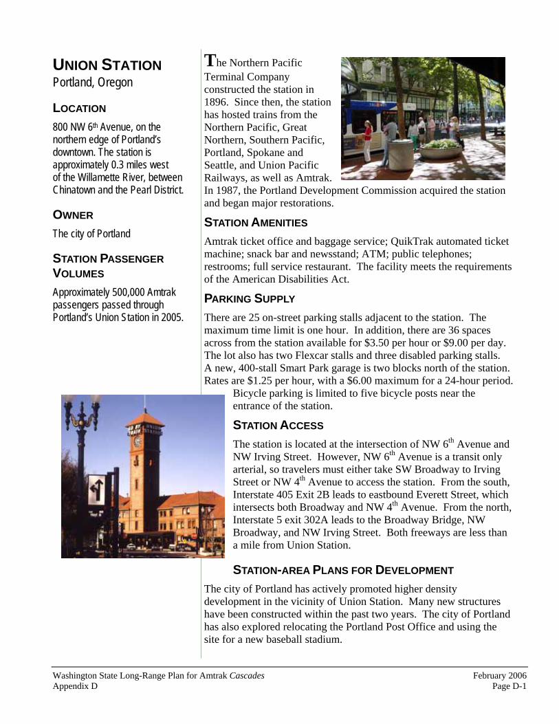
Washington State Long-Range Plan for Amtrak Cascades February 2006Appendix D Page D-1
UNION STATIONPortland, Oregon
LOCATION
800 NW 6th Avenue, on thenorthern edge of Portland’s downtown. The station is approximately 0.3 miles west of the Willamette River, between Chinatown and the Pearl District.
OWNER
The city of Portland
STATION PASSENGER VOLUMES
Approximately 500,000 Amtrak passengers passed through Portland’s Union Station in 2005.
The Northern Pacific Terminal Company constructed the station in 1896. Since then, the station has hosted trains from the Northern Pacific, Great Northern, Southern Pacific, Portland, Spokane and Seattle, and Union Pacific Railways, as well as Amtrak. In 1987, the Portland Development Commission acquired the station and began major restorations.
STATION AMENITIES
Amtrak ticket office and baggage service; QuikTrak automated ticket machine; snack bar and newsstand; ATM; public telephones; restrooms; full service restaurant. The facility meets the requirements of the American Disabilities Act.
PARKING SUPPLY
There are 25 on-street parking stalls adjacent to the station. The maximum time limit is one hour. In addition, there are 36 spaces across from the station available for $3.50 per hour or $9.00 per day.The lot also has two Flexcar stalls and three disabled parking stalls.A new, 400-stall Smart Park garage is two blocks north of the station.Rates are $1.25 per hour, with a $6.00 maximum for a 24-hour period.
Bicycle parking is limited to five bicycle posts near the entrance of the station.
STATION ACCESS
The station is located at the intersection of NW 6th Avenue and NW Irving Street. However, NW 6th Avenue is a transit only arterial, so travelers must either take SW Broadway to Irving Street or NW 4th Avenue to access the station. From the south, Interstate 405 Exit 2B leads to eastbound Everett Street, which intersects both Broadway and NW 4th Avenue. From the north, Interstate 5 exit 302A leads to the Broadway Bridge, NW Broadway, and NW Irving Street. Both freeways are less than a mile from Union Station.
STATION-AREA PLANS FOR DEVELOPMENT
The city of Portland has actively promoted higher density development in the vicinity of Union Station. Many new structures have been constructed within the past two years. The city of Portland has also explored relocating the Portland Post Office and using the site for a new baseball stadium.

February 2006 Washington State Long-Range Plan for Amtrak Cascades Page D-2 Appendix D
UNION STATION PORTLAND, OREGON
CONNECTIONS TO OTHER MODES
Union Station is at the north end of Portland’s Transit Mall. Tri-Met buses traveling south on 5th Avenue connect with other buses serving the greater Portland area, as well MAX, Portland’s popular light rail system, which serves Hillsboro, Gresham, the Portland Exposition Center, and Portland International Airport. (Tri-Met intends to run light rail vehicles on the transit mall by 2009.) Portland’s Greyhound terminal is one block south of Union Station. Amtrak Thruway bus service is available at Union Station, with connections to Astoria and Eugene.Tillamook Transit buses provide service between Union Station and Tillamook. The Portland Streetcar is four blocks west of Union Station. Taxis are available at the south side of the facility.
LOCAL POPULATION DATA
Residents within approximately five miles – 273,000; within approximately ten miles – 485,000; within approximately fifteen miles – 543,000.1
BUILT ENVIRONMENT AND DESIGNATED LAND USES ADJACENT TO THE STATION
The major structures near the station are the Post Office, the Broadway Bridge, and several multi-unit townhouses. The areas adjacent to Union Station are designated for commercial and residential uses.
PROJECTED AMTRAK CASCADES PASSENGER VOLUMES
WSDOT has made two projections for passenger volumes at Portland’s Union Station. The first is for Timetable C, with a level of service that includes eight daily round trips between Seattle and Portland and three daily round trips between Seattle and Vancouver, BC. The second is for Timetable F, with a level of service that includes thirteen daily round trips between Seattle and Portland and four daily round trips between Seattle and Vancouver, BC.
1The methodology used to produce these figures is not the same as that used for the other twelve stations listed in this appendix. These figures are from the city of Portland’s Office and Transportation RTP_8 Model for the year 2000, which combines household data withtravel patterns during an afternoon peak hour commute. Household data was then multiplied by the average number of residents (2.578) per household to produce the figures listed.
Union Station is circled in white. Source: The city of Portland
Projected Passenger Volumes for Portland, OR
Timetable Number of Passengers
C 712,000 F 1,458,000

Washington State Long-Range Plan for Amtrak Cascades February 2006 Appendix D Page D-3
VANCOUVERSTATIONVancouver, WA
LOCATION
1301 West 11th Street, 0.7 miles west of downtown Vancouver. The station is located at the northern end of the railroad bridge that crosses the Columbia River.
OWNER
The city of Vancouver
STATION PASSENGER VOLUMES
Approximately 72,000 passed through Vancouver Station in 2005.
The Spokane, Portland, and Seattle Railway constructed the station in 1908.The station opened upon completion of the Columbia River rail bridge that same year. Partial renovations were completed in 1988. In 2001, the city of Vancouver purchased the station from the BNSF Railway Company.
STATION AMENITIES
Amtrak ticket office and baggage service; QuikTrak automated ticket machine; public telephones; vending machines; restrooms; waiting area; meeting room. The facility meets the requirements of the American Disabilities Act.
PARKING SUPPLY
There are 95 free automobile stalls at the station.
STATION ACCESS
The primary arterial serving the station is West 11th Street. Interstate 5 is approximately one mile east of the station. From the north, Interstate 5 exit 1C connects with State Route 501 (East 15th
Street), Lincoln Avenue, and West 11th Street.From the south, Interstate 5 exit 1B connects East 6th Street, Jefferson Street, and West 11th Street.
CONNECTIONS TO OTHER MODES
There is no transit service available at the station. C-Tran buses are available at the 7th Street Transit Center. C-Tran provides free taxi vouchers to and from Vancouver Station from the 7th Street Transit Center. Local taxi service is available at the station.

February 2006 Washington State Long-Range Plan for Amtrak Cascades Page D-4 Appendix D
VANCOUVER STATION VANCOUVER, WASHINGTON
LOCAL POPULATION CENSUS DATA
Residents within five miles – 175,000; within ten miles – 596,000; within fifteen miles – 820,000.
BUILT ENVIRONMENT AND DESIGNATED LAND USES ADJACENT TO THE STATION
There are currently many empty buildings in the immediate vicinity of the station, and the area is changing from a solely industrial neighborhood to one that encompasses a variety of uses and activities. Several lots in the area between the station and downtown are undeveloped. The area surrounding Vancouver Station is currently zoned heavy industrial, although it was historically a residential neighborhood. A short distance from the station, the land use designation transitions from industrial uses to the commercial downtown district. West of the station is a large parcel of land owned by the Port of Vancouver. The Port’s land holdings stretch along the Columbia River and represent the most significant industry in the area, as well as one of the largest employers. At present, the adjacent land use pattern in the area remains heavy industrial, although the station’s proximity to the commercial zone and to current downtown development projects places it in an area undergoing significant change.
STATION-AREA PLANS FOR DEVELOPMENT
The city of Vancouver Economic Development Office intends to implement a long-range plan to revitalize the downtown area with new retail, commercial, and high-end residential properties, many of them mixed-use buildings.
PROJECTED AMTRAK CASCADES PASSENGER VOLUMES
WSDOT has made two projections for passenger volumes at Vancouver Station. The first is for Timetable C, with a level of service that includes eight daily round trips between Seattle and Portland and three daily round trips between Seattle and Vancouver, BC. The second is for Timetable F, with a level of service that includes thirteen daily round trips between Seattle and Portland and four daily round trips between Seattle and Vancouver, BC.
Projected Passenger Volumes for Vancouver, WA
Timetable Number of Passengers
C 128,000 F 261,000

Washington State Long-Range Plan for Amtrak Cascades February 2006 Appendix D Page D-5
KELSO MULTIMODALTRANSPORTATION CENTERKelso, Washington
LOCATION
501 South First Avenue, approximately 0.3 miles southwest of the center of Kelso’s commercial business district. The station is three blocks south of the Allen Street Bridge, on the eastern shore of the Cowlitz River.
OWNER
The city of Kelso
STATION PASSENGER VOLUMES
Approximately 21,000 Amtrak passengers passed through the Kelso Multimodal Transportation Center in 2005.
The Northern Pacific Railway constructed the building in 1912. A $3.4 million renovation of the facility was completed in 1995, using state and federal funds.
STATION AMENITIES
QuikTrak automated ticket machine; Greyhound ticket office; restrooms; telephones; vending machines; waiting area; public meeting space on the lower level. The facility meets the requirements of the American Disabilities Act.
PARKING SUPPLY
There are 45 free automobile stalls at the station andeight bicycle lockers.
STATION ACCESS
Interstate 5 is approximately 0.75 miles east of the station. I-5 Exit 39 connects with Allen Street, Pacific Avenue, and Ash Street.
CONNECTIONS TO OTHER MODES
Kelso’s Greyhound terminal is located at the Kelso Multimodal Transportation Center.Community Urban Bus System (CUBS) service is available on the east side of the station. Local and regional taxis are also available.
LOCAL POPULATION CENSUS DATA
Residents within five miles – 60,000; within ten miles – 74,000; within fifteen miles – 82,000.

February 2006 Washington State Long-Range Plan for Amtrak Cascades Page D-6 Appendix D
KELSO MULTIMODAL TRANSPORTATION CENTER KELSO, WASHINGTON
BUILT ENVIRONMENT AND DESIGNATED LAND USESADJACENT TO THE STATIONMajor structures near the station include the Kelso City Hall, the Allen Street Bridge, and several small businesses. The current land use for the surrounding area is a mix of retail, office, commercial, and high-density residential.
STATION-AREA PLANS FOR DEVELOPMENT
As part of a downtown revitalization effort, the city established a zoning overlay district in which new buildings, and renovations to existing buildings, in the downtown area must be “designed to reflect turn of the century (1900) western commercial structures.” The city of Kelso hopes these guidelines will help create a pedestrian-friendly downtown that is unique in comparison to the nearby Three Rivers Mall. New construction will reflect the city’s history and maintain the traditional block development pattern of the city.
PROJECTED AMTRAK CASCADESPASSENGER VOLUMES
WSDOT has made two projections for passenger volumes at the Kelso Multimodal Transportation Center. The first is for Timetable C, with a level of service that includes eight daily round trips between Seattle and Portland and three daily round trips between Seattle and Vancouver, BC. The second is for Timetable F, with a level of service that includes thirteen daily round trips between Seattle and Portland and four daily round trips between Seattle and Vancouver, BC.
Projected Passenger Volumes for Kelso, WA
Timetable Number of Passengers
C 53,000 F 107,000

Washington State Long-Range Plan for Amtrak Cascades February 2006 Appendix D Page D-7
UNION DEPOTCentralia, Washington
LOCATION
210 North Railroad Avenue, in the heart of Centralia’s commercial business district.
OWNER
The city of Centralia
STATION PASSENGER VOLUMES
Approximately 19,000 Amtrak passengers passed through Union Depot in 2005.
Centralia’s Union Depot was constructed in 1912.The station has been renovated in phases, with the final phase completed in 2002. The state of Washington, the federal government, and the city of Centralia funded the $4.7 million restoration project.
STATION AMENITIES
Amtrak ticket office and baggage service; public telephones; restrooms; vending machines; waiting area; banquet and meeting rooms; commercial office space. The facility meets the requirements of the American Disabilities Act.
PARKING SUPPLY
There are 96 free parking spaces at the station and in the immediate vicinity.
STATION ACCESS
North Railroad Avenue is one block east of Tower Avenue, a major one-way arterial that accommodates northbound traffic, and two blocks east of North Pearl Street, another major arterial that serves southbound traffic. Tower and Pearl are the bi-directional roadways that comprise State Route 507, which runs through Centralia. The station can be accessed from both roads
via Pine Street. Union Depot is approximately 1.5 miles east of Interstate 5. Exit 82 (Harrison Street) leads in to downtown, becomes Main Street, and intersects with North Railroad Avenue one block south of the station.
CONNECTIONS TO OTHER MODES
Twin City Transit, the area’s public transit service, stops on the west side of Union Depot. Regional bus companies offer daily service to east Lewis County and Grays Harbor on the Washington Coast. Local taxis are also available.

February 2006 Washington State Long-Range Plan for Amtrak Cascades Page D-8 Appendix D
UNION DEPOT CENTRALIA, WASHINGTON
LOCAL POPULATION CENSUS DATA
Residents within five miles – 25,000; within ten miles – 40,000; within fifteen miles – 58,000.
BUILT ENVIRONMENT AND DESIGNATED LAND USES ADJACENT TO THE STATION
Centralia’s central business district, located one block from Centralia Union Depot, is made up of small specialty stores, restaurants, and antique shops. Sixty-seven properties in Centralia’s Historic Downtown Business District, an area approximately six blocks long and three blocks wide, have been placed on the National Register of Historic Places. The area around the depot is zoned Core Commercial District (C-3) and the land use is primarily retail and residential. North and east of the depot, within a one-half mile radius, are vacant lots and some industrial uses.
STATION-AREA PLANSFOR DEVELOPMENT
In 2000, the city of Centralia adopted “Hospitality Centralia,” a plan to re-establish Centralia as a “Hub City,” a destination for small conventions, business meetings, seminars, entertainment, and recreation. A plan is well underway to redevelop Centralia’s historic infrastructure to its original uses for hospitality, business conferences, entertainment, and commerce.
PROJECTED AMTRAK CASCADES PASSENGER VOLUMES
WSDOT has made two projections for passenger volumes at Centralia’s Union Depot. The first is for Timetable C, with a level of service that includes eight daily round trips between Seattle and Portland and three daily round trips between Seattle and Vancouver, BC. The second is for Timetable F, with a level of service that includes thirteen daily round trips between Seattle and Portland and four daily round trips between Seattle and Vancouver, BC.
Projected Passenger Volumes for Centralia, WA
Timetable Number of Passengers
C 38,000 F 76,000
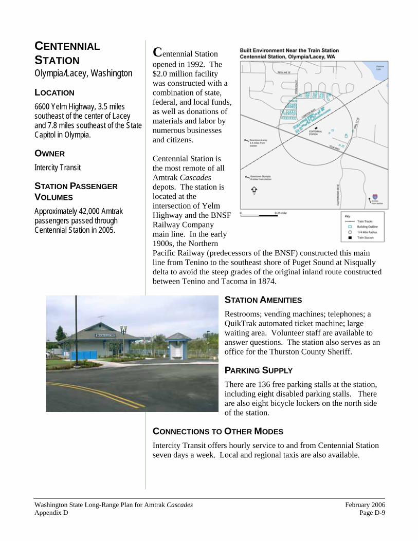
Washington State Long-Range Plan for Amtrak Cascades February 2006 Appendix D Page D-9
CENTENNIALSTATIONOlympia/Lacey, Washington
LOCATION
6600 Yelm Highway, 3.5 miles southeast of the center of Lacey and 7.8 miles southeast of the State Capitol in Olympia.
OWNER
Intercity Transit
STATION PASSENGER VOLUMES
Approximately 42,000 Amtrak passengers passed through Centennial Station in 2005.
Centennial Station opened in 1992. The $2.0 million facility was constructed with a combination of state, federal, and local funds, as well as donations of materials and labor by numerous businesses and citizens.
Centennial Station is the most remote of all Amtrak Cascadesdepots. The station is located at the intersection of Yelm Highway and the BNSF Railway Company main line. In the early 1900s, the Northern Pacific Railway (predecessors of the BNSF) constructed this main line from Tenino to the southeast shore of Puget Sound at Nisqually delta to avoid the steep grades of the original inland route constructed between Tenino and Tacoma in 1874.
STATION AMENITIES
Restrooms; vending machines; telephones; a QuikTrak automated ticket machine; large waiting area. Volunteer staff are available to answer questions. The station also serves as an office for the Thurston County Sheriff.
PARKING SUPPLY
There are 136 free parking stalls at the station, including eight disabled parking stalls. There are also eight bicycle lockers on the north side of the station.
CONNECTIONS TO OTHER MODES
Intercity Transit offers hourly service to and from Centennial Station seven days a week. Local and regional taxis are also available.

February 2006 Washington State Long-Range Plan for Amtrak Cascades Page D-10 Appendix D
CENTENNIAL STATION OLYMPIA/LACEY, WASHINGTON
STATION ACCESS
Yelm Highway is a major east-west roadway that connects south Olympia, Tumwater, and the south edge of Lacey with State Route 510 and Yelm. From points south of Olympia/Lacey, the station can be reached by taking Interstate 5 exit 101, Tumwater Boulevard, and Henderson Boulevard to Yelm Highway. Using this route, the station is approximately seven miles from the freeway. From points north, travelers can take Interstate 5 exit 109, College Way south to its intersection with Yelm Highway. Using this route, the station is approximately five miles from the freeway.
Local Population Census Data: Residents within five miles – 74,000; within ten miles – 133,000; within fifteen miles – 161,000.
BUILT ENVIRONMENT AND DESIGNATED LAND USES ADJACENT TO THE STATION
The station is just beyond the city of Lacey’s urban growth boundary. To the northwest is a higher-density housing development. The other parcels adjacent to the facility are low-density residential and a large sod farm on the south side of Yelm Highway. The land on which the station is situated, and much of the land to the south, is within the McAllister Geologically Sensitive Area (MGSA), which allows only a base density of one residential unit per five acres.
STATION-AREA PLANS FOR DEVELOPMENT
The MGSA land use designation, combined with the dense residential developments to the northwest of the station, greatly decreases the likelihood of any commercial development in the area.
PROJECTED AMTRAK CASCADES PASSENGER VOLUMES
WSDOT has made two projections for passenger volumes at Centennial Station. The first is for Timetable C, with a level of service that includes eight daily round trips between Seattle and Portland and three daily round trips between Seattle and Vancouver, BC. The second is for Timetable F, with a level of service that includes thirteen daily round trips between Seattle and Portland and four daily round trips between Seattle and Vancouver, BC.
Projected Passenger Volumes for Olympia, WA
Timetable Number of Passengers
C 90,000 F 180,000

Washington State Long-Range Plan for Amtrak Cascades February 2006 Appendix D Page D-11
TACOMA AMTRAKSTATION Tacoma, Washington
LOCATION
1001 Puyallup Avenue, approximately 1.4 miles southeast of Tacoma’s commercial business district and 0.5 miles east of Tacoma Dome Station, the city’s major multimodal facility. Within the next 10 years, Amtrak Cascadestrains will no longer stop at the Puyallup Street Station and instead relocate to Tacoma Dome Station.
OWNER
BNSF Railway Company
STATION PASSENGER VOLUMES
Approximately 102,000 Amtrak passengers passed through Tacoma’s Amtrak Station in 2005.
The station was constructed in 1984 in response to the closure of Tacoma’s Union Station, which has since become a Federal Courthouse.
STATION AMENITIES
Amtrak ticket office and baggage service; QuikTrak automated ticket machine; public restrooms and telephones; vending machines; waiting area. The facility meets requirements of the American Disabilities Act.
PARKING SUPPLY
There are 80 free parking stalls at Tacoma’s Amtrak Station. There are also 2,400 free parking spaces at the Tacoma Dome Station three blocks to the west. There is no bicycle parking at Tacoma’s Amtrak Station.
STATION ACCESS
The primary arterial serving Tacoma’s Amtrak Station is Puyallup Avenue. Southbound Interstate 5 exit 135 connects with Portland Avenue and westbound Puyallup Avenue. To reach the station from northbound Interstate 5, travelers take exit 133 (Interstate 705 to City Center), then East 26th (Tacoma Dome), and D Street to eastbound Puyallup Avenue. Travelers coming from downtown Tacoma and the neighborhoods south of downtown can take Pacific Avenue to eastbound Puyallup Avenue.
CONNECTIONS TO OTHER MODES
Amtrak’s Coast Starlight, Pierce Transit, and Northwestern Trailways serve Tacoma’s Amtrak station. The Tacoma Dome Station, three blocks to the west, has several other transportation connections including Greyhound, Sounder commuter rail, Link light rail, Sound Transit regional express buses, Pierce Transit, and Intercity Transit buses to Lacey and Olympia.
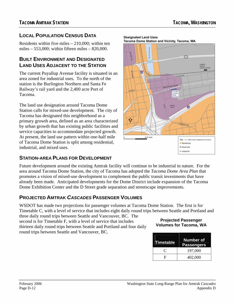
February 2006 Washington State Long-Range Plan for Amtrak Cascades Page D-12 Appendix D
TACOMA AMTRAK STATION TACOMA, WASHINGTON
LOCAL POPULATION CENSUS DATA
Residents within five miles – 210,000; within ten miles – 553,000; within fifteen miles – 820,000.
BUILT ENVIRONMENT AND DESIGNATED LAND USES ADJACENT TO THE STATION
The current Puyallup Avenue facility is situated in an area zoned for industrial uses. To the north of the station is the Burlington Northern and Santa Fe Railway’s rail yard and the 2,400 acre Port of Tacoma.
The land use designation around Tacoma Dome Station calls for mixed-use development. The city of Tacoma has designated this neighborhood as a primary growth area, defined as an area characterized by urban growth that has existing public facilities and service capacities to accommodate projected growth.At present, the land use pattern within one-half mile of Tacoma Dome Station is split among residential, industrial, and mixed uses.
STATION-AREA PLANS FOR DEVELOPMENT
Future development around the existing Amtrak facility will continue to be industrial in nature. For the area around Tacoma Dome Station, the city of Tacoma has adopted the Tacoma Dome Area Plan that promotes a vision of mixed-use development to complement the public transit investments that have already been made. Anticipated developments for the Dome District include expansion of the Tacoma Dome Exhibition Center and the D Street grade separation and streetscape improvements.
PROJECTED AMTRAK CASCADES PASSENGER VOLUMES
WSDOT has made two projections for passenger volumes at Tacoma Dome Station. The first is for Timetable C, with a level of service that includes eight daily round trips between Seattle and Portland and three daily round trips between Seattle and Vancouver, BC. The second is for Timetable F, with a level of service that includes thirteen daily round trips between Seattle and Portland and four daily round trips between Seattle and Vancouver, BC.
Projected Passenger Volumes for Tacoma, WA
Timetable Number of Passengers
C 197,000 F 402,000

Washington State Long-Range Plan for Amtrak Cascades February 2006 Appendix D Page D-13
TUKWILA STATIONTukwila, Washington
LOCATION
7301 South 158th Street, approximately 0.7 miles east of the Southcenter Mall andfour miles east of Sea-Tac International Airport.
OWNER
Sound Transit
STATION PASSENGER VOLUMES
Approximately 14,000 Amtrak passengers used TukwilaStation in 2005.
The temporary facility was constructed in 2001. It is comprised of two wooden platforms with shelters. The temporary facility is located on the site of the former Longarcres Park racetrack.
STATION AMENITIES
The temporary facility has no amenities. However the platforms do comply with the American Disabilities Act.
PARKING SUPPLY
There are 250 automobile/vanpool stalls on the east sideof the station.
STATION ACCESS
Tukwila Station is approximately one mile east of Interstate 5 and 0.25 miles south Interstate 405. The station can be reached by taking Interstate 405 Exit 1, the West Valley Highway (State Route 181) 0.25 miles south to eastbound Longacres Way.
CONNECTIONS TO OTHER MODES
Sound Transit’s Sounder commuter trains serve the station. Bus transit service at Tukwila station includes Metro and Sound Transit’s regional express routes. Private taxis and shuttles are also available. There
is no public transit service between the station and Sea-Tac International Airport. It should be noted that Amtrak’s Coast Starlightdoes not stop at Tukwila Station.
LOCAL POPULATION CENSUS DATA
Residents within five miles – 223,000; within ten miles – 608,000; within fifteen miles – 1,112,000.

February 2006 Washington State Long-Range Plan for Amtrak Cascades Page D-14 Appendix D
TUKWILA STATION TUKWILA, WASHINGTON
BUILT ENVIRONMENT AND DESIGNATED LAND USES ADJACENT TO THE STATION
Tukwila Station is located on the border of Tukwila and Renton, adjacent to the Boeing Longacres Office Park. The area around Tukwila Station is one of the largest undeveloped areas adjacent to any rail station in the state, although it is less than one mile from the heart of Tukwila’s retail core. Nearby structures include the trestle for the Union Pacific Railroad and the Hampton Inn at the corner of Longacres Way and West Valley Highway.
The temporary Tukwila Station is included in the Tukwila Urban Center zoning designation, allowing a broad mix of commercial, office, light industry, warehousing, and retail uses. Although the area surrounding the station is not fully developed, the city of Tukwila established a moratorium in September 2002 on certain land divisions, development activities, and land uses in the proposed Transit Oriented Development (TOD) area surrounding the Tukwila Station. This TOD area lies between the West Valley Highway to the west and Tukwila city limits to the east.
STATION-AREA PLANS FOR DEVELOPMENTPreliminary planning for a permanent facility in Tukwila is underway, but a number of other issues must be addressed and additional funding must be secured before final plans are completed. The cities of Tukwila and Renton are working together to extend and grade separate Strander Boulevard (just south of the station) and establish a link between the West Valley Highway and State Route 167. Relocating the Union Pacific Railroad’s single track main line to the BNSF Railway Company’s right-of-way (0.25 miles to the east) is also being considered so that more land is available for development adjacent to the new Tukwila Station. The station is tentatively schedule to be completed in 2009-2010.
PROJECTED AMTRAK CASCADES PASSENGER VOLUMESWSDOT has made two projections for passenger volumes at Tukwila Station. The first is for Timetable C, with a level of service that includes eight daily round trips between Seattle and Portland and three daily round trips between Seattle and Vancouver, BC. The second is for Timetable F, with a level of service that includes thirteen daily round trips between Seattle and Portland and four daily round trips between Seattle and Vancouver, BC.
Projected Passenger Volumes for Tukwila, WA
Timetable Number of Passengers
C 53,000* F 140,000*
*It should be noted that the model used to develop these passenger volume projections used current passenger volumes at Tukwila Station. Neither WSDOT nor Amtrak have actively promoted Tukwila Station due to its lack of station amenities. Therefore, WSDOT believes these projections are extremely conservative.

Washington State Long-Range Plan for Amtrak Cascades February 2006 Appendix D Page D-15
KING STREETSTATION Seattle, Washington
LOCATION
303 South Jackson Street, on the south edge of downtown Seattle. The station is 0.5 miles east of Puget Sound, between the International District andPioneer Square.
OWNER
BNSF Railway Company
STATION PASSENGER VOLUMES
Approximately 650,000 Amtrak passengers passed through King Street Station in 2005.
The Great Northern Railway constructed King Street Station in 1906. The city of Seattle had originally intended to locate the station along the Seattle waterfront. The current location was selected after James J. Hill of the Great Northern Railway convinced the Seattle City Council that the waterfront properties would be better left for commercialdevelopment.
STATION AMENITIES
Amtrak ticket office and baggage service; QuikTrak automated ticket machine; public telephones; restrooms; vending machines; waiting area. The facility meets the requirements of the American Disabilities Act.
PARKING SUPPLY
Parking around King Street Station is somewhat limited. There is metered, on-street parking on King Street and Second Avenue South for $1.50, with a two hour maximum. Day parking is available for a maximum of $9.00 on non-event days in the parking lot just north of Qwest Field. Several other garages within three blocks of the station provide day and overnight parking that costs as much as $20 per day; for these garages, travelers must check to ensure that the facility will be open if they are returning to Seattle after 7 p.m. There is no bicycle parking at King Street Station.
CONNECTIONS TO OTHER MODES
Transportation connections include Amtrak’s long-distance CoastStarlight and Empire Builder, Sounder commuter trains, Northwestern Trailways and Olympic Bus Lines intercity buses, King County Metro, Sound Transit, Community Transit, and Pierce transit regional buses, Washington State Ferries (0.5 miles to the west), and the Waterfront Street Car (1 block northeast). Local and regional taxis are available on the west side of the station.

February 2006 Washington State Long-Range Plan for Amtrak Cascades Page D-16 Appendix D
KING STREET STATION SEATTLE, WASHINGTON
STATION ACCESS
King Street Station is 0.5 miles west of Interstate 5 and 0.5 miles east of State Route 99. It is situated on the south edge of downtown and several of Seattle’s major arterials lead to the station. For travelers coming from outside of downtown Seattle from the north, Interstate 5 exit 164 connects to Fourth Avenue South, Jackson Street, Second Avenue South, and King Street. From SR 99, the Safeco Field exit leads to Royal Brougham, Fourth Avenue South, Jackson Street, and Second Avenue South to King Street. From the east side of Lake Washington, travelers can take Interstate 90 to exit 1, which leads to the Fourth Avenue South approach to the station described above.
LOCAL POPULATION CENSUS DATA
Residents within five miles – 378,000; within ten miles – 886,000; within fifteen miles – 1,381,000.
BUILT ENVIRONMENT AND DESIGNATED LANDUSES ADJACENT TO THE STATION
King Street Station lies adjacent to the Chinatown/International District, the cultural center for the city’s Asian-American community and historic Pioneer Square, the original business district of Seattle first established in 1852. Today, several large office buildings have been constructed to the east of the station. The other major structure is Qwest Field, an outdoor sports complex and exhibition center. The area to the west is zoned for mixed-use development with a 100-foot height limit. The majority of the other parcels adjacent to the station are zoned for commercial uses.
STATION-AREA PLANS FOR DEVELOPMENT
King Street Station is currently undergoing a $17 million renovation, and plans have been developed for a second phase of improvements for the future King Street Transportation Center. Several development proposals are being considered for the areas around King Street Station. These include new office towers, condominiums and townhouses, parking structures, and some open space for parks and recreational uses. Construction is underway for Seattle’s Link light rail system, which will run one block east of King Street Station.
PROJECTED AMTRAK CASCADES PASSENGER VOLUMES
WSDOT has made two projections for passenger volumes at King Street Station. The first is for Timetable C, with a level of service that includes eight daily round trips between Seattle and Portland and three daily round trips between Seattle and Vancouver, BC. The second is for Timetable F, with a level of service that includes thirteen daily round trips between Seattle and Portland and four daily round trips between Seattle and Vancouver, BC.
A conceptual drawing of the completed King Street Station renovations. Source: 2002 J. Craig Thorpe, commissioned by WSDOT.
Projected Passenger Volumes for Seattle, WA
Timetable Number of Passengers
C 959,000 F 1,919,000

Washington State Long-Range Plan for Amtrak Cascades February 2006 Appendix D Page D-17
EDMONDS STATIONEdmonds, Washington
LOCATION
210 Railroad Avenue, between Edmond’s downtown and waterfront.
OWNER
BNSF Railway Company
STATION PASSENGER VOLUMES
Approximately 28,000 Amtrak passengers passed through Edmonds Station in 2005.
The Great Northern Railway constructed this facility in 1956.
STATION AMENITIES
Amtrak ticket office and baggage service; restrooms; public telephones; vending machines. The facility meets the requirements of the American Disabilities Act.
PARKING SUPPLY
There are six short-term parking stalls for pick ups and drop offs, and approximately 210 longer-term parking stalls at the station available for $12.00 per day.There is no bicycle parking at the station.
STATION ACCESS
The station is approximately four miles west of Interstate 5 and three miles west of State Route (SR) 99. From the south, I-5 exit 177
connects with SR 104. The station can be reached by taking SR 104 to Dayton or James Streets, both of which connect to the station’s parking lot. From the north, I-5 exit 181 B connects with SR 524, which leads to the north entrance of the station at Main Street. From the west, the station can be reached by the Washington State Ferries’ Edmonds to Kingston route.
CONNECTIONS TO OTHER MODES
Other transportation services at Edmonds Station include Amtrak’s long-distance Empire Builder, Soundercommuter rail, Community Transit buses, and the Washington State Ferries. Local taxis and regional private van service are also available.

February 2006 Washington State Long-Range Plan for Amtrak Cascades Page D-18 Appendix D
EDMONDS STATION EDMONDS, WASHINGTON
LOCAL POPULATION CENSUS DATA
Residents within five miles – 136,000; within ten miles – 505,000; within fifteen miles – 994,000.
BUILT ENVIRONMENT AND DESIGNATED LAND USES ADJACENT TO THE STATION
The lots adjacent to the station are paved parking lots, multi-family residential developments, and a mall with a large antique store and other small businesses. The tree-lined streets of the central business district, particularly Main Street, offer a mix of retail, office, commercial, and residential uses. The Port of Edmonds is located to the south of the station, and combines a mix of marina and boating services, a public promenade, and restaurants. Zoning designations in the station area are divided between Community Business, Commercial Waterfront, Public Use/Open Space, and Multi-Family Residential.
STATION-AREA PLANS FOR DEVELOPMENT
In 2012, construction of a new Washington State Ferries terminal in Edmonds is scheduled to begin. The scheduled completion date is set for 2017. The new $122 million terminal, to be located approximately one mile south of the current ferry terminal, will initially serve ferry riders only. If additional funds can be secured for terminal expansion, Amtrak, Sound Transit, and other transportation providers will relocate to this facility.
PROJECTED AMTRAK CASCADES PASSENGER VOLUMES
WSDOT has made two projections for passenger volumes at Edmonds Station. The first is for Timetable C, with a level of service that includes eight daily round trips between Seattle and Portland and three daily round trips between Seattle and Vancouver, BC. The second is for Timetable F, with a level of service that includes thirteen daily round trips between Seattle and Portland and four daily round trips between Seattle and Vancouver, BC.
Projected Passenger Volumes for Edmonds, WA
Timetable Number of Passengers
C 54,000 F 200,000

Washington State Long-Range Plan for Amtrak Cascades February 2006 Appendix D Page D-19
EVERETT STATIONEverett, Washington
LOCATION
3201 Smith Avenue, on theedge of Everett’s commercial business district.
OWNER
The city of Everett
STATION PASSENGER VOLUMES
Approximately 39,000 people boarded and de-boarded Amtrak trains at Everett Station in 2005.
Everett Station opened in 2002. The $45 million facility replaces the Amtrak depot formerly located on Bond Street. Funding for the new station came from the federal government, the state of Washington, Sound Transit, the city of Everett, and Amtrak.
STATION AMENITIES
Amtrak ticket office and baggage service; QuikTrak automated ticket machine; Greyhound ticket office; Everett Transit customer service office; coffee shop and espresso stand; public telephones; restrooms; waiting area; vending machines; banquet and meeting rooms; University Centers of North Puget Sound; Work Source Everett; public art
displays. The facility meets the requirements of the American Disabilities Act.
PARKING SUPPLY
There are 25 automobile stalls designated for Amtrak/Greyhound passengers, eight rideshare vehicle stalls, and six bicycle racks. There are 12 bus bays and four separate park and ride lots adjacent to the station with a total of 750 parking stalls.
STATION ACCESS
Smith Avenue connects with Pacific Avenue, a major east-west arterial, just north of the station. Broadway, a major north-south arterial, is two blocks west of Smith Avenue. Pacific Avenue connects with northbound Interstate 5 exit 193. Travelers on southbound Interstate 5 use exit 194, Everett Avenue, and Maple Street to reach the station.
CONNECTIONS TO OTHER MODES
Everett Station transportation connections include Amtrak’s EmpireBuilder, Greyhound, Northwestern Trailways, Sound Transit regional express buses, Sounder commuter rail, Everett Transit, and Community Transit. Local taxis and regional private van service are also available.
Photo Courtesy of the city of Everett

February 2006 Washington State Long-Range Plan for Amtrak Cascades Page D-20 Appendix D
EVERETT STATION EVERETT, WASHINGTON
LOCAL POPULATION CENSUS DATA
Residents within five miles – 100,000; within ten miles – 240,000; within fifteen miles – 395,000.
BUILT ENVIRONMENT AND DESIGNATED LANDUSES ADJACENT TO THE STATION
The station is located approximately 0.5 miles southeast of the city’s commercial business district. The area in the vicinity of Everett Station is primarily used for light industry, but is zoned to accommodate heavy commercial. The station itself sits in an industrial zone.As stated in the Everett Station Area Plan, the present land use pattern for the area is fragmented and includes a combination of commercial, retail, and industrial uses.The immediate surrounding area is made up of an overpass, parking facilities, light industrial buildings, such as Everett Iron and Metal Recycling Center, and commercial facilities, such as Lowe’s. East of the tracks, and visible from the station, is space available for lease.
STATION-AREA PLANS FOR DEVELOPMENT
The draft Station Area Plan includes development plans, including re-zoning of the area. The overall vision for the Everett Station area involves its evolution and enhancement as an employment center. This vision anticipates “flex tech,” a name for a location that provides easy access to transportation and allows for many different functions to occur within one building.
PROJECTED AMTRAK CASCADES PASSENGER VOLUMES
WSDOT has made two projections for passenger volumes at Everett Station. The first is for Timetable C, with a level of service that includes eight daily round trips between Seattle and Portland and three daily round trips between Seattle and Vancouver, BC. The second is for Timetable F, with a level of service that includes thirteen daily round trips between Seattle and Portland and four daily round trips between Seattle and Vancouver, BC.
Projected Passenger Volumes for Everett, WA
Timetable Number of Passengers
C 62,980 F 142,361

Washington State Long-Range Plan for Amtrak Cascades February 2006 Appendix D Page D-21
SKAGITSTATIONMount Vernon, Washington
LOCATION
105 East Kincaid Street, on the edge of Mount Vernon’s downtown commercial business district.
OWNER
Skagit Transit
STATION PASSENGER VOLUMES
Approximately 21,000 people boarded and de-boarded Amtrak trains at Skagit Station in 2005.
The new Skagit Station, completed in 2004, is near the site of the city’s original Great Northern Railway depot. The $7.7 million facility was constructed with funds from the federal government, the state of Washington, and local contributions.
STATION AMENITIES
Public restrooms; waiting area; community meeting space; the Mount Vernon Chamber of Commerce. The facility meets the requirements of the American Disabilities Act.
PARKING SUPPLY
There are ninety free parking stalls at the station, including four designated for disabled parking. There are also thirteen free on-street parking stalls adjacent to the station with a two hour limit. There is one bicycle rack that can accommodate as many as eight bicycles on the south side of the facility. The station also has a large area for Skagit
Transit and Greyhound.
STATION ACCESS
Kincaid Street and West Montgomery Street are the primary arterials serving the Skagit Transportation Center. Kincaid Street intersects with Interstate 5 at Exit 226, approximately 0.2 miles east of the station.
CONNECTIONS TO OTHER MODES
Skagit Transit’s downtown bus center is located at the Skagit Station. Mount Vernon’s Greyhound depot is located at the station. Local taxis and regional private van service are also available.

February 2006 Washington State Long-Range Plan for Amtrak Cascades Page D-22 Appendix D
SKAGIT TRANSPORTATION CENTER MOUNT VERNON, WASHINGTON
LOCAL POPULATION CENSUS DATA
Residents within five miles – 36,000; within ten miles – 62,000; within fifteen miles – 95,000.
BUILT ENVIRONMENT AND DESIGNATED LAND USES ADJACENT TO THE STATION
Skagit Station is located next to the city’s commercial business district, which includes offices, retail establishments, and government buildings. The designated lands uses include a mix of commercial, public facility, and industrial areas.
STATION-AREA PLANS FOR DEVELOPMENT
The city of Mount Vernon is exploring ways to support more development in its downtown core.
PROJECTED AMTRAK CASCADESPASSENGER VOLUMES
WSDOT has made two projections for passenger volumes at the Skagit Station. The first is for
Timetable C, with a level of service that includes eight daily round trips between Seattle and Portland and three daily round trips between Seattle and Vancouver, BC. The second is for Timetable F, with a level of service that includes thirteen daily round trips between Seattle and Portland and four daily round trips between Seattle and Vancouver, BC.
Projected Passenger Volumes for
Mount Vernon, WA
Timetable Number of Passengers
C 55,864 F 110,381

Washington State Long-Range Plan for Amtrak Cascades February 2006 Appendix D Page D-23
FAIRHAVEN STATIONBellingham, Washington
LOCATION
401 Harris Street, approximately0.4 miles west of the Fairhaven Historic District and three miles south of downtown Bellingham.
OWNER
The Port of Bellingham
STATION PASSENGER VOLUMES
Approximately 56,000 people boarded and de-boarded Amtrak trains at Fairhaven Station in 2005.
Fairhaven Station was once the headquarters of the Pacific American Fisheries Company and underwent extensive renovations in 1994.The renovations cost approximately $4.5 million, using a combination of state and local funds.
STATION AMENITIES
Amtrak ticket office and baggage service; QuikTrak automated ticket machine; Greyhound ticket office; coffee shop; vending machines; public telephones; restrooms; waiting area; commercial office space. The facility meets the requirements of the American Disabilities Act.
PARKING SUPPLY
There are eighteen automobile stalls, five bus bays, and eight bicycle lockers at the station. There are also 160 long-term parking stalls across the street from the station ($6 per day, $30 per week).
STATION ACCESS
Harris Avenue is the primary arterial serving Fairhaven Station.Finnegan Way connects downtown Bellingham and the Fairhaven Historic District, and Old Fairhaven Parkway connects with Interstate 5 at Exit 250, approximately 1.3 miles east of Fairhaven Station.
CONNECTIONS TO OTHER MODES
The Port of Bellingham’s Fairhaven Cruise Terminal Complex is adjacent to the station. The complex is the southern terminus of the Alaska Marine Highway system. Private ferries at the cruise terminal also provide service to the San Juan Islands and Victoria, British Columbia. Bellingham’s Greyhound depot is located at Fairhaven Station. Whatcom Transportation Authority buses stop on the south side of the station on Harris Avenue. Local taxis and regional private van service are also available.

February 2006 Washington State Long-Range Plan for Amtrak Cascades Page D-24 Appendix D
FAIRHAVEN STATION BELLINGHAM, WASHINGTON
LOCAL POPULATION CENSUS DATA
Residents within five miles – 62,000; within ten miles – 91,000; within fifteen miles – 113,000.
BUILT ENVIRONMENT AND DESIGNATED LAND USES ADJACENT TO THE STATION
Major structures within 0.25 miles of the station include the Fairhaven Cruise Terminal Complex, the Brenthaul Shipyards, and the Post Point Pollution Control Plant. The city’s land use designations primarily support industrial and commercial activities.
STATION-AREA PLANS FOR DEVELOPMENT
The city of Bellingham and the Port of Bellingham are working together to develop lands adjacent to Bellingham Bay, including the Georgia Pacific plant along the downtown waterfront. The city is also making improvements to Boulevard Park, a popular recreation area approximately one mile north of Fairhaven Station. Commercial development is also occurring in the Fairhaven Historic District. Several parcels along Harris Avenue between the historic district and the train station remain undeveloped.
PROJECTED AMTRAK CASCADES PASSENGER VOLUMES
WSDOT has made two projections for passenger volumes at Fairhaven Station. The first is for Timetable C, with a level of service that includes eight daily round trips between Seattle and Portland and three daily
round trips between Seattle and Vancouver, BC. The second is for Timetable F, with a level of service that includes thirteen daily round trips between Seattle and Portland and four daily round trips between Seattle and Vancouver, BC.
Projected Passenger Volumes for
Bellingham, WA
Timetable Number of Passengers
C 118,012 F 265,637

Washington State Long-Range Plan for Amtrak Cascades February 2006 Appendix D Page D-25
PACIFIC CENTRALSTATIONVancouver, British Columbia Canada
LOCATION
1150 Station Street, approximately 1.2 miles southeast of Vancouver’s commercial center. The station is located at the intersection of the Strathcona, Mount Pleasant, and Downtown districts of the city.
OWNER
VIA Rail of Canada
STATION PASSENGER VOLUMES
Approximately 129,000 Amtrak passengers passed throughPacific Central Station in 2005.
The Canadian National Railway (CN) constructed Pacific Central Station in 1919. When Amtrak inherited the Great Northern Railway’s Pacific International route between Seattle and Vancouver, in 1971, the railroad continued to use Pacific Central Station as its northern terminus. In the late 1980s, the station underwent an extensive renovation.
STATION AMENITIES
VIA/Amtrak ticket and baggage agents; Greyhound of Canada ticket agents; restaurant; gift shop; car rental agency; newsstand; currency exchange office; espresso bar; telephones; public restrooms; storage lockers; commercial office space. The station is wheelchair accessible.
PARKING SUPPLY
There are 21 short-term parking stalls at the station, including three disabled spaces. The stalls are metered and cost $1.00 (CND) with a one hour maximum. The on-street parking supply near the station includes 19 metered spaces on the east side of Station Street with a two hour maximum ($2.00 CND), and 20 un-metered stalls on the west side of Station Street. An additional 37 un-metered, on-street stalls with a two hour maximum are within a block of the station. Long-term parking for up to 20 automobiles is available at a private storage lot three blocks northwest of the station (on the corner of East 1st Avenue and Quebec Street) for $12 (CND) per day. This lot is open 24 hours a day. There is no bicycle parking at the station.
STATION ACCESS
Station Street is parallel to and one block east of Main Street, a major north south arterial on the east edge of downtown Vancouver that connects the city’s inner harbor, Chinatown, and the north shore of the Fraser River. The major east-west arterial north of the station is Hastings Street (Provincial Highway 7A), 0.5 miles to the north. The major east-west arterial south of the station is Broadway, (Provincial Highway 7), 0.7 miles to the south. The Trans-Canada Highway (Highway 1) is 3.1 miles east of the station, with ingress/egress at exits 25 (Hastings Street) and 28 (Boundary and Broadway).
CONNECTIONS TO OTHER MODES
Pacific Central Station transportation connections include VIA Rail, Greyhound of Canada, Pacific Coach Lines (to Victoria) and Vancouver’s SkyTrain Expo line (Science World/Main Street Station). SkyTrain also provide connections to West Coast Express commuter trains and Vancouver’s Seabus at the Waterfront Station. TransLink local and regional buses serve the station, as well local and regional private taxis.

February 2006 Washington State Long-Range Plan for Amtrak Cascades Page D-26 Appendix D
PACIFIC CENTRAL STATION VANCOUVER, BRITISH COLUMBIA
LOCAL POPULATION CENSUS DATA
Residents within five miles – 665,000; within ten miles 1,131,000; within fifteen miles 1,550,000.
BUILT ENVIRONMENT AND DESIGNATED LAND USESADJACENT TO THE STATION
Vancouver is one of the fastest growing cities on the west coast of North America. As a result, the areas adjacent to the station have been transformed from predominately industrial uses to high-rise residential and commercial uses. The City Gate development to the west of the station includes several new towers with townhouses and condominiums. Structures to the east of the station include the VIA Rail maintenance facility and a large rail yard for storing and assembling freight trains. The parcel to the north of the station (the former location of the Great Northern Railway terminal) is vacant. To the south is the SkyTrain’s elevated guide way and several retail and light industrial structures.
STATION-AREA PLANS FOR DEVELOPMENT
The city of Vancouver is exploring ways to further develop the area around the Pacific Central Station. Plans include a new hospital north of the station and new mixed-use development southeast of the station featuring commercial retail and housing.
PROJECTED AMTRAK CASCADES PASSENGER VOLUMES
WSDOT has made two projections for passenger volumes at Pacific Central Station. The first is for Timetable C, with a level of service that includes eight daily round trips between Seattle and Portland and three daily round trips between Seattle and Vancouver, BC. The second is for Timetable F, with a level of service that includes thirteen daily round trips between Seattle and Portland and four daily round trips between Seattle and Vancouver, BC.
.
Pacific Central Station is circled in white. Source: city of Vancouver
Projected Passenger Volumes for Vancouver, BC
Timetable Number of Passengers
C 294,000 F 711,000

Appendix E
Amtrak Cascades Northern Terminus Options
Washington State Long-Range Plan forAmtrak Cascades

Washington State Long-Range Plan for Amtrak Cascades February 2006 Appendix E Page E-1
Amtrak Cascades Northern Terminus Options
In 1992, the United States Department of Transportation established the Pacific Northwest Rail Corridor (PNWRC). This corridor was selected as one of five corridors in the country to be developed for high speed rail service. The PNWRC stretches 466 miles (750 km), connecting Eugene, OR, Portland, OR, Seattle, Vancouver, BC, and twelve intermediate communities. In 1995, Amtrak, the Washington State Department of Transportation (WSDOT) and the BNSF Railway Company (BNSF) re-established passenger rail service between Seattle and Vancouver, BC. Since then, one daily round trip passenger train has continued to operate between these cities.
The northernmost station on the PNWRC is Vancouver, BC’s Pacific Central Station. The station, located just southeast of the city’s commercial business district, was constructed in 1919 by the Canadian National Railway (CN).When Amtrak inherited the Great Northern Railway’s Pacific Internationalroute between Seattle and Vancouver, BC in 1971, the railroad continued to use Pacific Central Station as its northern terminus. Amtrak’s Internationalservice was discontinued in 1981, and in the late 1980s, the station underwent an extensive renovation. In 1995, Amtrak and WSDOT returned to Pacific Central Station when the Mount Baker International was launched in May of that year.
In 2005, Pacific Central Station served over 129,000 Amtrak passengers. The station is also the western terminus of VIA Rail, Canada’s national passenger rail service. Amtrak intercity buses, as well as local and regional transit, provide service at Pacific Central Station. SkyTrain, Vancouver’s elevated rapid transit system, stops near the station and provides direct access to the Vancouver waterfront and over thirty transit centers throughout the greater Vancouver region.
The long-range plans for Amtrak Cascades service call for four daily round trips between Seattle and Vancouver, BC. To accommodate this level of service to Pacific Central Station, a number of major capital improvements need to be made to the rail corridor between the Fraser River and the downtown station. The cost of these projects, estimated at over $500 million (USD), could preclude Amtrak Cascades service levels from increasing beyond two daily round trips between Seattle and Vancouver’s Pacific Central Station, as it is uncertain if Canadian public funding for projects of this magnitude would ever be made available.
In the late 1990’s the British Columbia Transportation Financing Authority commissioned a study to explore alternative routes for Amtrak Cascades

February 2006 Washington State Long-Range Plan for Amtrak CascadesPage E-2 Appendix E
trains traveling to and from Vancouver, BC.1 The study identified a possible alternative for the northernmost station stop for Amtrak Cascades. It was determined that a new station could be constructed on the south shore of the Fraser River, in Surrey, British Columbia, at a location known as Scott Road. This location is approximately ten miles (16 km) southeast of Pacific Central Station. The new station—referred to as the Greater Vancouver Terminal throughout this plan—would eliminate the need to construct a new Fraser River crossing (as a passenger service project) and other capital improvement between the river and downtown Vancouver. In 2002, the International Mobility and Trade Corridor Group (IMTC) included a preliminary feasibility assessment of the Greater Vancouver Terminal concept in its CascadeGateway Rail Study.2
This appendix assesses the merits and demerits of continued use of Pacific Central Station and those of a new Greater Vancouver Terminal in Surrey, British Columbia.
What are the advantages of keeping the Amtrak Cascades’ northern terminus at Pacific Central Station?
Pacific Central Station has two important attributes: proximity to downtown, and a well-established legacy as a major transportation hub for the city.
Proximity to downtown
Pacific Central Station is 1.25 miles (two kilometers) from the center of Vancouver’s commercial business district and waterfront. The center of the city is a short taxi ride from the station, and easily accessible by transit, bicycle, and walking.
Downtown train stations can help serve as anchors for existing development and can help attract new businesses to the area. As passenger rail travel has become more popular in recent years, downtown train stations are being viewed as important community assets that can serve as catalysts for
1Route and Terminal Alternatives for Amtrak Passenger Train Service Between Vancouver and Seattle. (1998). Prepared by Transit Safety Management for the British Columbia Transportation Financing Authority, Victoria, B.C., Canada. 2Cascades Gateway Rail Study (2002). Prepared by Wilbur Smith Associates for the International Mobility and Trade Group, Bellingham, Washington.

Washington State Long-Range Plan for Amtrak Cascades February 2006 Appendix E Page E-3
Exhibit E-1 British Columbia Infrastructure
Requirements Needed Before Mid-Point Service
Infrastructure Improvement Estimated Cost
Alternative 1: Vancouver Central Station Terminus
Fraser River Bridge Improvement $575 million
Brunette to Piper Siding $28.6 million
Sperling to Willingdon Junction $11.4 million
Still Creek to CN Junction $12.9 million
Vancouver Control System $6.9 million
Willingdon Junction $16 million
Alternative 2: Scott Road Terminus
Scott Road Station $86.3 million
Source: Amtrak Cascades Capital Cost Estimates Technical Report 2004.
economic development and improved multi-modal connections. Examples include Portland’s Union Station, Richmond, Virginia’s renovated Main Street Station, Union Station in Meridian, Mississippi, and the Gateway Intermodal Transit Center in Los Angeles, California.
Well-established transportation hub with popular amenities
Pacific Central Station has been a major transportation hub for over eighty-five years. The station is well suited for rail passengers, with a variety of amenities including a currency exchange office, a rental car agency, a restaurant, a news stand, and easy access to local transit and taxis. The station also provides direct connections to Canada’s transcontinental passenger trains, as well as regional intercity bus service that connect the station with communities across British Columbia.
What are the disadvantages of keeping the Amtrak Cascades’northern terminus at Pacific Central Station?
Cost
The primary disadvantageassociated with the continued use of Pacific Central Station is the cost of the capital projects that must be completed to increase the service levels beyond two daily round trip Amtrak Cascades trains. The most expensive of these projects is a new bridge over the Fraser River. Exhibit E-1presents these estimated costs.
The current bridge was constructed in 1904, and its single track and slow speed limits severely limit rail line capacity. In addition to these limitations, the bridge includes a 380-foot swing span that allows Fraser River marine traffic to pass underneath the bridge. The span must be opened well in advance of approaching marine traffic, as the river channel is difficult to navigate near the bridge.

February 2006 Washington State Long-Range Plan for Amtrak CascadesPage E-4 Appendix E
In addition to the Fraser River bridge replacement, four rail sidings or sections of additional main track and a new rail traffic control system will be necessary before the third and fourth Amtrak Cascades daily round trips can reach to downtown station. Due to the location of many of the piers that hold up the elevated SkyTrain system that parallels the tracks in many locations, the amount of space available for additional trackage may be limited and may prevent portions of it from being constructed.
It should also be noted that while the combination of the new Fraser River bridge and the additional sidings would increase rail line capacity and schedule reliability, the over $500 million investment would do little to reduce travel times between Pacific Central Station and the Fraser River, as the soils and wetlands in the area will always preclude faster speeds for both passenger and freight trains.
Ridership
Population is no longer concentrated exclusively in central urban areas as it was when most of the great central-city stations were built. The suburbs often represent the preponderance of the population of a metropolitan area. For that reason, the schedules of corridor and long distance passenger trains often include a suburban stop in addition to a central city terminal. For example:
Boston (Route 128, Woburn); New York (Croton-Harmon, Yonkers); Washington, DC (New Carrollton); Chicago (Glenview, Naperville, Joliet, Homewood, Hammond); Los Angeles (Fullerton); Seattle (Tukwila, Edmonds); Toronto (Oakville, Malton); and Montreal (Dorval, Saint-Lambert).
The ridership research conducted by WSDOT indicates that a suburban terminal in lieu of a city-center terminal (under a set of specific conditions) supports greater ridership when only one of the two is possible.
The location of many SkyTrain piers may limit the amount of new tracks that can be constructed between the Fraser River and downtown Vancouver, BC.

Washington State Long-Range Plan for Amtrak Cascades February 2006 Appendix E Page E-5
The New Westminster rail bridge (foreground) is at a low level and must be opened frequently for marine traffic. The Patullo highway bridge (immediately behind) and the SkyTrain bridge (background) were constructed high enough above the water to allow marine traffic to pass unobstructed.
What are the advantages of relocating the Amtrak Cascades’northern terminus to Surrey, British Columbia?
A new Greater Vancouver, BC Terminal would avoid the chokepoint that currently exists at the Fraser River crossing and eliminate the requirement that the bridge be modified or replaced before more Amtrak Cascades passenger trains can be added. In addition, the new regional terminal could be more attractive to area residents, as the station would be more centrally located and more accessible for a greater number of people. The new station could also support new development plans that have been proposed by the Planning and Development Department of the city of Surrey.
Avoiding the bridge and avoiding potential tolls
In 2004, the Greater Vancouver Gateway Council released a study that focused on the need for a new Fraser River crossing. Amtrak Cascadespassenger trains represent only a small percentage of the rail traffic using the bridge. Several freight railroads serving the Vancouver, BC area cross the structure an average of forty to fifty times per day. Initial concepts to address this bottleneck include a new lift-span bridge or a tunnel. Initial ideas to pay for such an expensive project include charging a toll on each train using the new bridge or tunnel. The economics of freight transport are different from the economics of passenger transport. Passenger transportation may not be able to sustain a toll of the magnitude required to construct a new Fraser River crossing.
While the study did not call for the replacement of the bridge for operational reasons, the bridge will eventually need to be modified or replaced to ensure its structural integrity.However, it could take many, many years to secure the financing, complete the environmental documentation, and complete construction. If Amtrak Cascades trains no longer had to use the current or the future bridge or tunnel, more daily trains could be

February 2006 Washington State Long-Range Plan for Amtrak CascadesPage E-6 Appendix E
Exhibit E-2 Population in Greater Vancouver, BC Area
MUNICIPALITY POPULATION
Vancouver 545,500 Surrey 348,000 Burnaby 194,000 Richmond 164,000 Coquitlam 113,000 Langley 110,500 Delta 95,500 District of North Vancouver 82,000 Maple Ridge 55,000 New Westminster 54,500 North Vancouver 44,000 Other Municipalities 94,000
TOTAL 1,900,000
added between Seattle and Vancouver, BC before the structure is modified or replaced. The potential toll to use the bridge would not have to be paid by Amtrak, WSDOT, or Amtrak Cascades customers.
Better regional access and increased ridership
A Greater Vancouver, BC Terminal would be situated in the center of the Greater Vancouver Regional District. The district is comprised of several municipalities with a total population of nearly two million residents. ExhibitE-2 lists the most populous of these municipalities based on 2001 Census data from Statistics Canada.
For this plan, ridership forecasts were developed for both Pacific Central Station and a Greater Vancouver terminal located along the Fraser River in Surrey. It is estimated that a Greater Vancouver, BC terminal would increase total annual Amtrak Cascades ridership between Seattle and Vancouver, BC
by three to seven percent when the maximum levels of passenger rail service identified WSDOT’s long-range plan are in place by 2023.3
3Direct ridership comparisons between Pacific Central Station and the Greater Vancouver Terminal were only conducted for the scenario that includes five daily Amtrak Cascades roundtrips between Seattle and Vancouver, BC and fourteen daily round trips between Seattle and Portland, OR. The range of values listed here includes an estimate of ridership at the

Washington State Long-Range Plan for Amtrak Cascades February 2006 Appendix E Page E-7
Exhibit E-3 Projected Passenger Volumes at Vancouver, BC Stations
2023 PASSENGER VOLUME
Pacific Central Station Greater Vancouver Terminal
(South Westminster) Difference
711,000 763,000 7.3% Note: assumes five daily round trips between Seattle and Vancouver, BC and fourteen daily round trips between Seattle and Portland, OR.
This ridership increase would be the result of shorter travel times to and from the new terminal for people residing throughout the region. Exhibit E-3illustrates the results of these ridership projections.
Integration with the proposed South Westminster Neighbourhood Plan
The city of Surrey, British Columbia recently completed a concept plan for the area near the current Scott Road SkyTrain station and the underdeveloped south shore of the Fraser River.4 South Westminster is the historic name of the residential area that emerged along the river in the 1890s that also served as the northern terminus of the original rail line that stretched south to Bellingham and the Skagit Valley of Washington. The new neighbourhood plan includes commercial areas, a business park, pedestrian and bicycle corridors, and residential development.
The city of Surrey has expressed interest in including an Amtrak Cascadesintercity rail terminal adjacent to the new South Westminster development, with the anticipation that the surge in rail passengers converging on the area could further support the economic vitality envisioned in the neighborhood plan. Exhibit E-4 illustrates this plan.
Greater Vancouver Terminal with four daily round trips between Seattle and Vancouver, BC, and thirteen daily round trips between Seattle and Portland, OR.
4A Neighbourhood Concept Plan for South Westminster (2003). Prepared by the city of Surrey Planning and Development Department. Surrey, British Columbia, Canada.

February 2006 Washington State Long-Range Plan for Amtrak CascadesPage E-8 Appendix E
Exhibit E-4 South Westminster Neighborhood Plan

Washington State Long-Range Plan for Amtrak Cascades February 2006 Appendix E Page E-9
What are the disadvantages of relocating the Amtrak Cascades’northern terminus to Surrey, BC?
As evident in many cities around the United States, the resurgence of rail transportation has inspired the renovation of downtown train stations. Suburban train stations that serve as the end point for rail trips located away from the primary commercial business district of a region can have a negative impact on overall ridership, as it requires a shift from one transportation mode (train) to others (transit, automobile) that some travelers destined for the urban core will not find appealing. Amtrak has suggested that in general, ridership can be reduced by as much as fifty percent when downtown-bound travelers know they will have to make a mode switch once they arrive at a suburban terminal. WSDOT’s latest ridership projections address the two Vancouver, BC station options specifically, however, and do not support this suggestion. No other data exists to measure the level of customer support for the relocation from Pacific Central Station to a Greater Vancouver, BC Terminal.
Can Amtrak Cascades trains serve both Pacific Central Station and a Greater Vancouver terminal?
It is unlikely. This dual-station arrangement will pose a number of challenges. First, the total estimated cost of the projects at and north of the Fraser River climbs to over $600 million, as it adds the cost of a new station (estimated at $75 million) and additional tracks at the new station. This scenario eliminates the trade off in total costs that are assumed in the single station concept, which could make it even more difficult to effectively compete for scarce public funds for transportation projects in the greater Vancouver, BC area.
The dual station scenario would also add at least ten minutes to the scheduled running time between Seattle and downtown Vancouver, BC as it would take at least this much time to leave the main line tracks, enter the station, let off passengers, and return to the main line for the journey across the river and into downtown or south to Seattle. This could have a negative impact on ridership, but the degree of the impact is not known at this time.
The final and perhaps most important challenge that would have to be overcome in the two-station scenario deals with Canadian and U.S. federal security protocols. Customs and Immigration agents from both the United States and Canada would have to be positioned at both Pacific Central Station and the Greater Vancouver, BC Terminal, and additional security arrangements would have to be made so that portions of the train would be locked or sealed in such a way as to ensure that all passengers are accounted for before crossing the international boundary. While this is technically feasible, previous discussions with officials from what is now known as U.S. Customs and Border Protection indicate that the two-station scenario would

February 2006 Washington State Long-Range Plan for Amtrak CascadesPage E-10 Appendix E
not be acceptable, as it would increase risk of security breaches and drive up staffing costs.
What additional research needs to be performed?The information included in this plan is based on a thorough understanding of railroad operations in the lower mainland of British Columbia and the type of railroad design that will be necessary to achieve the long-term service goals that have been established for Amtrak Cascades. However, as the Amtrak Cascades program moves forward, more detailed environmental review of the specific capital projects in British Columbia will be necessary, cost estimates would need to be refined further, and public policy decisions regarding the future of the Fraser River Bridge will need to be considered before any action is taken regarding the relocation of the northern terminus for Amtrak Cascades. In addition, a more detailed analysis of the ridership and revenue projections for each of the two station options will be necessary.
One of the key recommendations that emerged for the Cascades Gateway Rail Study (2002) was that marketing research of Amtrak Cascades passengers and residents of the greater Vancouver region would help identify customer preferences for station locations. The appropriate research would be carefully constructed to represent the current and proposed transportation products rather than only the terminal location alternatives. Analysis of the research results would be an important first step toward discovering the level of popular support for continued use of Pacific Central Station or a new Greater Vancouver, BC Terminal.
Who will decide where the northern terminus for Amtrak Cascadesshould be?
The decisions regarding the continued use of Pacific Central Station or relocation to a Greater Vancouver Terminal will ultimately be made by the Canadian organizations that will be funding the capital projects identified in this document. Amtrak and WSDOT will play a role in these discussions, but the responsibility must lie with Canadian funding partners.
When will a decision have to be made? The decision regarding the location of the northern terminus for Amtrak Cascades will need to be made before Timetable C in this plan is implemented. Decision-makers throughout the greater Vancouver, BC area will need to begin to consider the station location options soon. The level of planning needed to begin implementation of either terminal option could take a decade. Substantially completed planning can be helpful when seeking funds and ensures that when funding does become available, the best course of action can be pursued.
Appendix F
Amtrak CascadesService Delivery
Washington StateLong-Range Plan forAmtrak Cascades
Washington State Long-Range Plan for Amtrak Cascades February 2006 Appendix F Page F-1
Amtrak Cascades Service Delivery
The Washington State Department of Transportation (WSDOT) works closely with Amtrak and other organizations to offer Amtrak Cascades intercity passenger service in the Pacific Northwest. This section describes the service agreements that exist between WSDOT, Amtrak, the BNSF Railway Company (BNSF), and Talgo Incorporated. The purpose of this section is to explain how WSDOT and its partners work together to provide Amtrak Cascades service to the people of Washington State on a daily basis.
Amtrak Operating Rights on the BNSF Railway Company Before 1971, passenger rail service was provided by private railroad companies and regulated by the federal government. Recognizing the important role that passenger rail service played in moving people throughout the growing nation, the federal government required the private railroads to offer service to hundreds of American communities, regardless of the commercial viability of the route. As the popularity of automobile and air travel grew, passenger trains carried fewer and fewer riders.
This trend continued through the 1950s and 60s, and the railways eventually petitioned the federal government for relief from their unprofitable passenger services. In 1971, the federal government granted this request and relieved the private railways of their obligation to maintain passenger rail services across the nation. The National Railroad Passenger Corporation, more commonly known as Amtrak, for American Travel by Track, was created.
Amtrak and the Class I1 railroads have legally binding operating agreements that govern the joint use of the railroad rights of way by the host railroads and Amtrak. In Washington State, this operating agreement is between Amtrak and BNSF. In brief, the Amtrak/BNSF operating contract includes the following provisions:
Amtrak’s right to use BNSF’s railroad; The fees Amtrak pays BNSF to use the railroad; BNSF’s control of Amtrak trains operating on BNSF right of way; and Incentive and disincentive payments for individual Amtrak train on-time performance.
1A Class I railroad is any railroad with annual gross revenues of at least $260 million, according to the U.S. Department of Transportation. These are the largest long-distance U.S. railroad systems such as Union Pacific-Southern Pacific, Norfolk Southern, CSX, and BNSF.

February 2006 Washington State Long-Range Plan for Amtrak CascadesPage F-2 Appendix F
Amtrak Cascades trains operating between Portland, Seattle, and Vancouver, BC are governed by this national Amtrak/BNSF agreement. The fifteen year agreement, signed in 1996, expires in 2011.2
WSDOT’s Operating Contract with Amtrak WSDOT has its own operating contract with Amtrak. This agreement, which is renewed annually, specifies:
Amtrak’s responsibilities for providing high-qualityAmtrak Cascades service, including staffing, ticketing, and reservation services; WSDOT’s share of the operating losses incurred by the trains; The maximum amount WSDOT will pay Amtrak over a federal fiscal year to operate the service; and WSDOT’s role in Amtrak Cascades marketing efforts, fare structure, scheduling, food service, and other on-board service delivery.
Washington State—through WSDOT—is one of several states that provide operating funds for Amtrak intercity passenger service. The total amount that WSDOT pays Amtrak for Amtrak Cascades service has a maximum limit for each contract period, which is necessary because Congress funds Amtrak in single-year increments and the Washington State Legislature only provides operating funds on a two-year (biennial) basis. Currently, there are eight Washington state-supported Amtrak Cascades trains. The maximum amount that WSDOT will pay Amtrak for the 2004 federal fiscal year is $11.7 million. This includes a maximum of $200,000 for on-time performance and customer satisfaction incentives. An additional $2.75 million will be provided for the operations of a fourth daily Amtrak Cascades round trip between Seattle and Portland, scheduled to begin in July 2006.
How do Amtrak and WSDOT collaborate on service delivery? The WSDOT/Amtrak operating contract recognizes WSDOT’s important role in tailoring Amtrak Cascades service to meet the needs of Washington rail passengers. WSDOT determined that an active role in Amtrak Cascadesservice development and implementation would be the best way to maximize the public benefits derived from the substantial investment that state makes in the Amtrak Cascades program.
2WSDOT has also entered into a separate contract with BNSF on capital improvements to the corridor, described in Chapter 7 of this document.
Washington State Long-Range Plan for Amtrak Cascades February 2006 Appendix F Page F-3
Since WSDOT began providing Amtrak with state funds for intercity passenger rail services in 1994, WSDOT and Amtrak have continually collaborated on a number of important things that impact the quality of regional intercity passenger rail service in the Pacific Northwest. Areas of collaboration include:
Establishing the design criteria for new trainsets to be met by train manufacturers responding to the Amtrak/WSDOT Request for Proposals advertised in 1996;The selection of the manufacturer of the new train sets (Talgo, Inc.) in 1996;The Amtrak Cascades annual fare structure that is designed to maximize ridership and revenues;Jointly gathering and analyzing customer feedback; this data is used to develop and implement polices and practices that help ensure customer satisfaction; The selection of regional foods and beverages for Amtrak Cascades on-board menus; The development of on-board signage and publications including the Amtrak Cascades route guide and other informational brochures that describe specific elements of the service; and Amtrak Cascades marketing and promotions.
Customer Satisfaction One of the key measurements used to determine the quality of Amtrak Cascades service delivery is Amtrak’s Customer Satisfaction Index (CSI).CSI scores are based on surveys of Amtrak passengers that include questions on train cleanliness, food quality, staff performance, and other key indicators that capture customer perceptions. Amtrak and WSDOT have established the CSI goal for Amtrak Cascades to be an average of ninety-one points (out of one hundred) or better for the year. Terms of the contract stipulate that Amtrak must take steps to maintain this score, as well as the incentives Amtrak will receive from WSDOT if successful. The collaboration between Amtrak and WSDOT on many aspects of service delivery has consistently placed Amtrak Cascades among the nation’s top-ranked routes in Amtrak’s entire national system.
WSDOT also gathers customer feedback directly from passengers. Customer comment cards are available in most coach and business class cars on each Amtrak Cascades train. The cards ask customers what they liked about their train trip and for any other comments they would like to share with WSDOT. Passengers send these comment cards to WSDOT headquarters in Olympia. This qualitative data —coming directly from Amtrak Cascades customers— is shared four times per year with Amtrak management. The data is used to

February 2006 Washington State Long-Range Plan for Amtrak CascadesPage F-4 Appendix F
identify both the good and poor aspect of Amtrak Cascades service delivery.WSDOT and Amtrak use this data, as well as the CSI scores, to pinpoint problems and take steps necessary to improve service delivery and ensure a positive customer experience.
Amtrak Cascades MarketingWSDOT and Amtrak are jointly responsible for developing and implementing marketing plans for Amtrak Cascades service, and each organization provides funds to carry out the marketing plan.
Marketing Amtrak Cascades to the traveling public is an important part of service delivery. The majority of people making intercity trips in western Washington do so using the personal automobile and regional air carriers. Both of these transportation modes have benefited greatly from over fifty years of public investment and are mature systems, while intercity passenger rail service in Washington State has only received limited public funding since the early 1990s. Recognizing this fact, the Washington State Legislature provides funding for Amtrak Cascades marketing efforts to develop public support and awareness of the service. Current marketing activities include newspaper, magazine and Internet advertisements, and cooperative promotions with dozens of organizations such as the King County Convention and Visitors Bureau, the Seattle Seahawks and Mariners, and the Portland, Oregon Visitors Association. All of these marketing activities are designed to increase public awareness of the Amtrak Cascades program, increase ridership and revenues, and help the service become a viable transportation option for intercity travelers throughout western Washington for years to come.
WSDOT’s equipment maintenance contract with Talgo, Inc. In 1999, WSDOT and Amtrak purchased four new train sets from Talgo, Incorporated.3 In addition to the equipment acquisition, Amtrak and WSDOT entered into an ongoing maintenance contract with Talgo, Inc. As part of this agreement, Talgo places staff aboard each daily Amtrak Cascades route to oversee the equipment, and Talgo also performs regular maintenance on the program’s five train sets at its Seattle servicing facility.The equipment maintenance contract between WSDOT and Talgo, Inc. averages $2.3 million per year. The Washington State Legislature also requires WSDOT to have a train equipment preservation plan for the three Talgo train sets owned by the state of Washington. This plan, and more details on the specific elements of the equipment maintenance contract are included in Appendix C of this document.
3A fifth train set, under lease to the state of Oregon by Talgo, Inc., was purchased by WSDOT in 2003.