washington state framework for monitoring salmon populations
TRANSCRIPT

Washington State Framework for Monitoring Salmon Populations Listed under the Federal Endangered Species Act and Associated Freshwater Habitats
Produced by
The Governor’s Forum on Monitoring Salmon Recovery and Watershed Health
March 2007
Edited by Bruce A. Crawford
Olympia, Washington
1
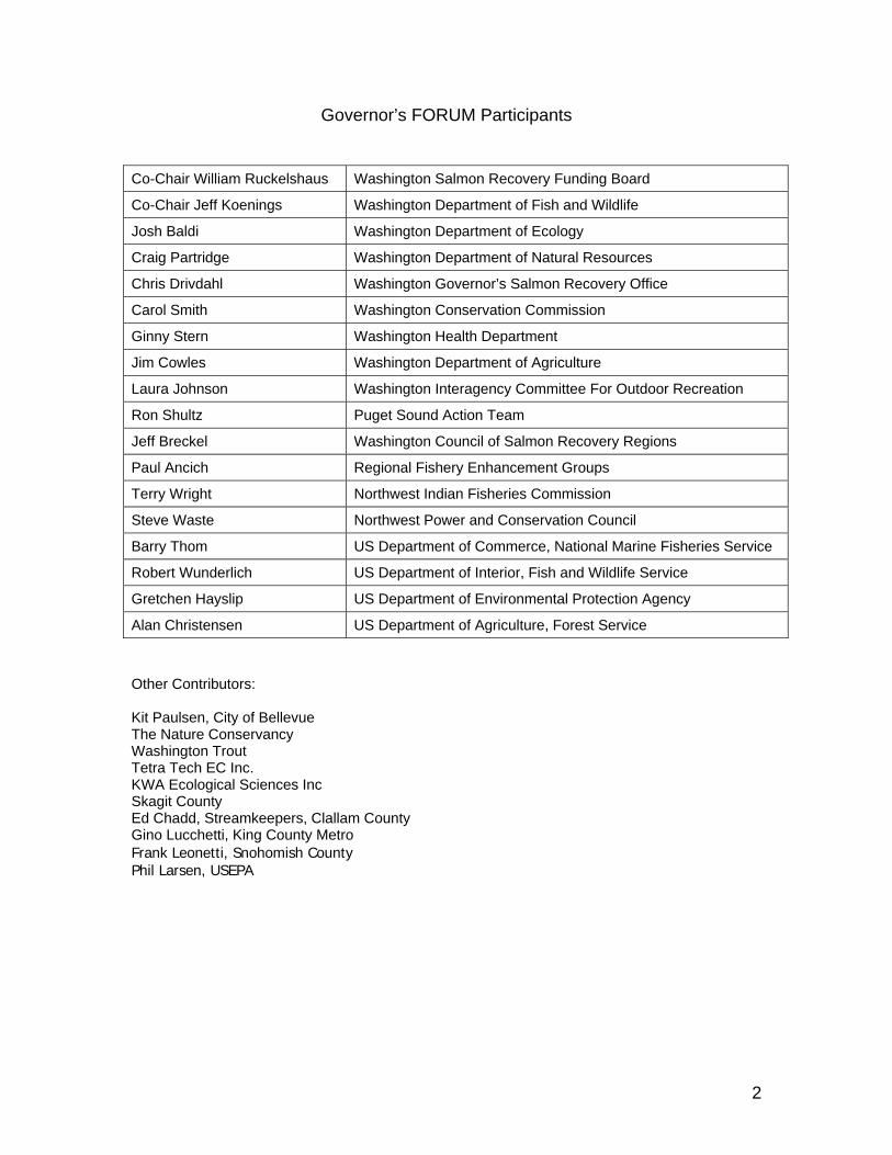
Governor’s FORUM Participants
Co-Chair William Ruckelshaus Washington Salmon Recovery Funding Board Co-Chair Jeff Koenings Washington Department of Fish and Wildlife Josh Baldi Washington Department of Ecology Craig Partridge Washington Department of Natural Resources Chris Drivdahl Washington Governor’s Salmon Recovery Office Carol Smith Washington Conservation Commission Ginny Stern Washington Health Department
Jim Cowles Washington Department of Agriculture
Laura Johnson Washington Interagency Committee For Outdoor Recreation Ron Shultz Puget Sound Action Team Jeff Breckel Washington Council of Salmon Recovery Regions
Paul Ancich Regional Fishery Enhancement Groups Terry Wright Northwest Indian Fisheries Commission
Steve Waste Northwest Power and Conservation Council Barry Thom US Department of Commerce, National Marine Fisheries Service Robert Wunderlich US Department of Interior, Fish and Wildlife Service
Gretchen Hayslip US Department of Environmental Protection Agency Alan Christensen US Department of Agriculture, Forest Service
Other Contributors: Kit Paulsen, City of Bellevue The Nature Conservancy Washington Trout Tetra Tech EC Inc. KWA Ecological Sciences Inc Skagit County Ed Chadd, Streamkeepers, Clallam County Gino Lucchetti, King County Metro Frank Leonetti, Snohomish County Phil Larsen, USEPA
2

Introduction The Washington Legislature asked the Monitoring Oversight Committee (MOC) to develop a comprehensive monitoring strategy for the state that would address salmon recovery and watershed health (SSB5637). The strategy was delivered to the Governor and Legislature in 2002. The strategy evaluated existing monitoring and identified monitoring gaps that were important for tracking future conditions of Washington’s natural resources and to determine, as part of the adaptive management process, whether management actions to restore habitat and fish populations have been effective from physical, biological, and economic perspectives. Seventy-six separate recommendations were made that would materially improve our ability to determine the health of Washington’s natural resources. Combined, this information would enable comprehensive and scientifically sound reporting to Congress, the Governor, Legislature, and to the public. Much of the federal funding available to the state is dependent upon the ability to provide accountable and transparent assessment of progress towards meeting our shared goals. Funding resources are under constant pressure to be reduced, or even eliminated, if progress cannot be demonstrated. To begin to implement the recommendations of the MOC, The Governor's FORUM on Monitoring Salmon Recovery and Watershed Health (FORUM) was created by Executive Order 04-03 in August 2004, to coordinate monitoring consistent with the Comprehensive Monitoring Strategy and Action Plan for Watershed Health and Salmon Recovery (CMS). The FORUM is comprised of state and federal agencies, named by the Governor in the Executive Order, involved in watershed health and salmon recovery. It also includes representation from the Northwest Power and Conservation Council (NWPCC), non government organizations (NGOs), and the tribes, as well as local government. According to the Executive Order, the FORUM is chartered to:
Provide a multi-agency venue for coordinating technical and policy issues and actions related to monitoring Washington’s salmon recovery and watershed health.
This framework document is the result of cooperative efforts of FORUM members and is offered as guidance to state natural resource agencies, regional salmon recovery groups, and federal and tribal co-managers.
Why a Framework is Needed There is a tendency for various agencies to attempt to meet Endangered Species Act (ESA) monitoring requirements without a connecting framework and “game plan” that allows the public, and government to determine the overall status of ESA listed salmon and their trends. This framework document only addresses fish abundance and productivity and habitat conditions. Future work may clarify how other listing factors should be addressed, as well as develop standards and increased consistency for other types of monitoring, such as implementation and effectiveness monitoring, which monitors habitat projects to increase accountability of funds. At this reporting, the framework is only partially funded. At the October 2005 FORUM meeting, the Governor’s Salmon Recovery Office (GSRO) and the National Marine Fisheries Service (NMFS) provided an overview of the criteria needed for de-listing salmon species listed under the ESA. The following chart (Figure 1) illustrates the two branches (biological and statutory) of the decision framework used in determining when a listed
3

species can be upgraded from “endangered” to “threatened” or is recovered and removed from the list. On the left-hand section of the chart are the fish population factors that must be considered for salmon Evolutionary Significant Unit (ESUs). The component populations to be deemed Viable Salmonid Populations (VSP) must address abundance, productivity, spatial distribution, and diversity. On the right side of the chart are statutory considerations; those threats and factors limiting survival that were the reasons for the listing. In making a determination to upgrade or de-list, NMFS must have a reasonable expectation that the listed ESU is viable and that the threats to the species have been corrected. Thus, the biological factors (left side) must be addressed in complete coordination with the physical and administrative factors (right side). The bottom of the chart lists the evaluation of actions such as how effective various types of habitat restoration projects or habitat/water programs were, and allows for adaptive management. Actions in all three sections of the chart work together to form a complete cycle that informs the public and government of salmonid recovery progress.
10/4/05 2
Evaluation
Status of Viability Attributes•Abundance•Productivity•Spatial Distribution•Diversity
Status of Statutory Listing Factors and ThreatsESU Viability Assessment
NMFS will determine an ESU is recovered when an ESU is no longer in danger of extinction or likely to become endangered in the foreseeable future, based on an evaluation of both the ESU’s status and the extent to which the threats facing the ESU have been addressed
Major Population Group Bio-Geographical Region
Strata
ESU Status
Population Status:
Listing Factor 1: The present or threatened destruction, modification, or curtailment of its habitat or range
Listing Factor 3: Disease
or predation
Listing Factor 4: The inadequacy of existing regulatory mechanisms
Listing Factor 5: Other Natural or manmade factors affecting continued existence
Listing Factor 2: Over utilization for commercial, recreational or educational purposes
Status of Harvest Threats
& Limiting Factors
Status of Disease
and PredationThreats & Limiting Factors
Status of Hatchery program’sThreats &
Limiting Factors
Status of Hydropower
Threats & Limiting Factors
Status of Natural
Threats & Limiting Factors
Compliance and Implementation Monitoring
Implement Adaptive Management Plan
Action Effectiveness Monitoring
Status of Regulatory
MechanismsThreats & Limiting Factors
Critical Uncertainty Research and Evaluation
Status of Habitat Threats
& Limiting Factors
Actions
NMFS Listing Status Decision Framework
FORUM Framework
Figure 1. NMFS listing status decision framework and relationship to the FORUM framework.
In view of the above criteria and the complexity of salmon and their recovery, and given limitations of available funding for monitoring, the State of Washington will need to work with all salmon recovery partners to prioritize and sequence what is monitored and at what intensity in a statewide adaptive management approach. If funding were sufficient, it would be possible to measure all of the things shown in the diagram which would provide knowledge desired at all biological and geopolitical levels of interest (population, regional recovery region, ESU, etc.). Funding is limited however, and there is a need to find a balance between VSP fish monitoring and the status/trends of limiting factors and threats. This FORUM framework identifies a
4

reasonable approach to monitoring fish abundance, productivity and habitat. Especially important is the use of volunteers and technology. Efforts are just beginning to develop consistency and data sharing to facilitate project monitoring (implementation and effectiveness monitoring) that is needed for fiscal accountability and adaptive management. However, work on these is too undeveloped to included in this framework.
Viable Salmonid Populations (VSP) Criteria The NMFS guidance has emphasized that the decision criteria for delisting at the ESU level will depend upon information available that the aggregate status and change in status of the major population groups (MPGs) in the ESU demonstrate a level of risk, natural sustainability, or probability of persistence sufficient to warrant a change in ESU listing status. NMFS will at their species status reviews, seek to answer the following questions with available information:
• “Are MPGs within the ESU at, or clearly trending toward, a low risk status?” • “Are primary populations within the MPG at high viability/low risk consistent with
recovery plans and Technical Review Team (TRT) recommendations?” A decision about population viability considers the population status indicators (abundance, productivity, diversity, spatial structure) based on TRT recommendations.
Statutory Listing Factors (Habitat) Statutory listing factors such as habitat will go through a similar process. Questions NMFS must ask include:
1. “Have statutory listing factors been addressed such that threats to the ESU have been ameliorated to the extent that they no longer pose a threat to the continued existence of the ESU?”
2. “Is the ESU achieving or clearly trending toward a low risk status in response to actions that have been implemented to diminish those factors limiting achievement of ESU viability objectives?” If there are habitat-related effects of limiting factors on observed abundance, productivity, diversity, or distribution of natural-origin fish, what is their significance for population viability?
This framework coordinates how the state can begin to address the VSP criteria on the left portion of the NMFS chart and Limiting Factor 1, the present or threatened destruction, modification, or curtailment of its habitat or range. This framework is a coordinated approach that monitors fish and habitat at complimentary scales and in a manner that will determine whether habitat destruction as a limiting factor is being reduced.
Statewide Salmon Abundance Monitoring for ESA Salmon De-Listing Although the Washington Department of Fish and Wildlife (WDFW) and the treaty tribes have monitored many adult salmon and steelhead populations important for harvest management for years, there are many others that have little or no information available. This is particularly true for determining watershed production by enumerating juvenile migrants. The Salmon Monitoring Framework is a strategy outlined by the FORUM to track salmon abundance and productivity and to relate changes in freshwater productivity to habitat conditions. NMFS and their associated TRTs have identified 28 MPGs and a minimum of 86 primary populations that may require monitoring to effectively assess delisting criteria statewide. The concept driving the Salmon Monitoring Framework is based upon their guidance. The framework seeks to develop “fish in and fish out” specific information for selected primary populations and to
5

tie this fish abundance information directly to habitat and water quality conditions in those watersheds and the overall Salmon Recovery Region (SRR) and regional planning. It recognizes that it is not economically feasible for Washington to monitor all 86 salmon populations and their habitats at a level of intensity suggested by the criteria laid out under NMFS VSP criteria. Given the limited funding available from both state and federal sources, the state must determine what is the risk versus cost of obtaining less information, but sufficient information collected in a methodical and scientifically defensible approach that can lead to ESA de-listing in the future.
Figure 2. Illustration of coordinated sampling of primary populations for “fish in” and “fish out” and randomized EMAP habitat sample points across the salmon recovery regions. Simultaneous Monitoring of Juvenile Out Migrants and Adult Spawners Data on both juveniles and adults should be simultaneously and continuously collected for at least one primary population for each major population group (MPG) within an ESU for all listed salmon statewide. Primary populations are those that must demonstrate low risk of extinction in order to recover the MPG and ESU. The FORUM has developed this statewide Framework that identifies a set of the most important populations, including at least one from each MPG, for monitoring. In total, the salmon framework identifies a cumulative total of 28 major population groups containing a total of 86 primary populations for chinook, coho, chum, and steelhead. The FORUM proposes to monitor juvenile migrants at the mouth of 34 rivers. By monitoring these 34 rivers, Washington will obtain information on 70 of the primary populations requiring monitoring. Currently, juvenile salmon production is monitored for 19 of these rivers. Additional funding is needed to fill gaps to provide juvenile monitoring for 15 rivers identified in the salmon framework. Funding should be provided through a consortium of interests including the state legislature, tribal governments, local governments, and the Bonneville Power Administration. Adult monitoring
6

gaps have been identified for Lower Columbia Coho. Adaptive management questions answered include:
• What is the status and trends in productivity of 70 primary populations statewide? • What is the status and trends in adult spawner abundance for 70 primary populations
statewide? • What is the status and trends in juvenile migrant abundance for 70 primary populations
statewide? • What is the status and trends of fish abundance and productivity in 28 MPGs statewide? • What is the status and trends of fish abundance and productivity in all ESA listed
chinook, coho, and steelhead ESUs statewide? Table 1 reflects the locations where it is feasible to collect fish in and out information and collected with the greatest number of primary populations encountered. To view the status of spawner abundance and juvenile migrant information for Washington please consult the Appendix. Table 1. Listing of targeted watersheds for fish-in and fish-out monitoring. It describes the current juvenile monitoring status and who is performing it. A watershed may have more than one listed species therefore having more than one primary population. Salmon Recovery Region
Targeted Primary Watersheds For Juvenile Trapping
Number of primary populations within the watershed
Current Juvenile Trapping Status
Nooksack 2 Yes - Tribal Skagit 6 Yes - WDFW Stillaguamish 2 Yes - Stillaguamish Tribe Skykomish 1 Yes - Tulalip Tribe Snoqualmie 1 Yes - Tulalip Tribe White 1 No Nisqually 1 No - State budget
request Skokomish 1 No Dosewallips 2 No - State budget
request Hamma Hamma 1 Yes - USFWS funded
Puget Sound
Elwha 1 Yes - Lower Elwha Tribe Dungeness 1 No - State budget
request Coast Ozette 1 Yes - Makah Tribe
Grays 3 No - State budget request
EF Lewis 5 No - State request Cedar Creek-NF Lewis
2 Yes - Ongoing SRFB Funding
Kalama 4 Yes - WDFW Federal Funds
Cowlitz 3 Yes - Tacoma City Light Coweeman 3 No - NPCC Proposal Toutle 4 No Mill 1 Yes - SRFB Wind 2 No - NWPCC Proposal
Lower Columbia
Duncan Creek 1 No - NWPCC Proposal Klickitat 1 Yes - Tribal/BPA Yakima 3 Yes - Tribal/BPA
Middle Columbia
Touchet 1 No - State request Wenatchee 2 Yes - PUD-Fed Entiat 2 Yes - USFWS Methow 2 Yes - PUD
Upper Columbia
Okanogan 1 Yes - Tribal BPA
7

Tucannon 2 No - NWPCC Proposal Walla Walla 1 Yes - Umatilla Tribe Asotin 2 No - NWPCC Proposal
Snake
Grand Ronde 4 No - State budget request
Total 34 70 15 traps need funding It is important to note here that, as we move into the follow sections, these efforts are not mutually exclusive to meeting goals and objectives. A holistic approach that includes adequate monitoring of both the biological (fish) and physical (listing and threats) elements is compulsory. Monitoring of fish populations and habitat health are equally important, and as efforts progress, improved project monitoring can be added to enable adaptive management and increased fiscal accountability. Finally, the FORUM is working to identify and eliminate monitoring activities that provide no benefit to the resource or the goals and objectives of the FORUM, Governor, Legislature and to the species populations themselves.
Fish Sampling Protocols Fish sampling protocols have been subject to wide variations and adaptations by field biologists. Recent activities sponsored by the Pacific Northwest Aquatic Monitoring Partnership (PNAMP) and EcoTrust have resulted in the Salmonid Field protocols handbook now in press.
Habitat Monitoring Framework In 2005, the Governor’s FORUM on Monitoring Salmon Recovery and Watershed Health sponsored a workshop to determine whether high level indicators of salmon recovery and watershed health reported biennially in the Washington State of Salmon in Watersheds Report could be improved. It was concluded, and later affirmed by subcommittees of experts, that there is no current habitat evaluation program in practice today that can provide the status and trends necessary to inform the public and meet federal ESA recovery purposes, in contrast to existing efforts to monitor fish populations. Thus, the essential question remains whether habitat necessary for salmon is improving. It was also concluded that the state ambient monitoring program for water quality does not adequately typify water quality conditions over the landscape, but is useful for measuring trends at selected locations. In response to recommendations from the FORUM, the Washington State Salmon Recovery Funding Board (SRFB) provided funds to the Department of Ecology (Ecology) to produce a habitat monitoring framework to be used in addressing large data gaps for Washington currently existing in evaluating habitat and water quality. The concept is consistent with PNAMP which has recommended a regional monitoring framework using multiple jurisdictions and funding sources to complete the needed geographic coverage. The document, “Status and Trend Monitoring for Watershed Health and Salmon recovery, Quality Assurance Monitoring Plan (2006)” publication 06-03-203 can be accessed at the Ecology website at http://www.ecy.wa.gov/biblio/0603203. The habitat framework relies upon remote sensing and instream and riparian sampling. The habitat framework has the following characteristics.
• It provides status and trends of land use and land cover using remote sensing. • It provides a probability-based sampling framework that can be used at the state, SRR,
and Water Resource Inventory Area (WRIA) scales by all levels of government and volunteers to assess the conditions of the state’s aquatic resources.
• Initiates a sampling site selection process that provides a minimum of 80% confidence in the estimated status of wadeable and non-wadeable rivers and streams.
• Identifies the specific indicators that will be monitored as well as the protocols used to measure them.
8

• Incorporates existing information and monitoring data, where possible, into the assessment.
• Develops partnerships with other agencies, local governments, and volunteer groups to implement the monitoring plan or share data.
Remote Sensing The WDFW should acquire high altitude satellite imagery to compare changes in land conversion, impervious surfaces, and floodplain area for each SRR and ESA MPG in the state. Aerial photos would be used to generate a total census of the status and trends in riparian vegetation type and cover, roads, stream crossings, and where possible river channel morphology and large woody debris for at least one listed primary salmon population per major population group in each recovery region. Aerial photography monitoring would be done where there are complimentary salmon productivity (i.e., fish in-fish out) data and where local groups want to do monitoring. Remote sensing data provides “big picture” metrics of land use changes and avoids intrusion into private property. Remote sensing, however, cannot measure water quality, stream sedimentation and other parameters needed to quantify some aspects of watershed health. Therefore, a combination of remote sensing and on-the-ground probabilistic sampling is necessary. This will complement ongoing US Forest Service actions on federal forestlands in Washington where the Aquatic Resource Effectiveness Monitoring Program (AREMP) and Pacific Intermountain Biological Opinion (PIBO) sampling programs are using satellite imagery to typify forest seral changes and roads on the national forests. Satellite imagery provides low cost answers to large scale questions of habitat change in Washington. Monitoring questions answered include:
• What is the status of land cover and land use (agriculture, forestry, urban)? • What are the trends in land cover and land use (agriculture, forestry, urban)?
Figure 3. Landsat view of forest cover Snohomish River basin
9

Habitat and Water Quality Status and Trends – On-The-Ground Sampling The Salmon Recovery Regions can collaborate with WDFW, Ecology, and private industry to identify available local resources to conduct on-the-ground fieldwork. Partners may include local Regional Fisheries Enhancement Groups, conservation districts, municipalities, counties, private corporations, state agencies, and others having expertise and interest in participating in the monitoring activity. Salmon require clean gravel, cool water, hiding cover from down logs, food organisms, and a variety of stream structures for their various life history stages. On-the-ground sampling will collect physical, chemical, and biological data that will enable the SRRs and state to detect changes in water quality, changes in in-stream sedimentation, hiding cover, and stream structure essential to salmon, and changes in fish distribution and composition. In addition, changes to stream bank vegetation and structure can also be documented. The measures serve to track the status/trends not only in salmon habitat and water quality, but also monitors distribution of many invasive species and addresses biodiversity along our rivers and streams. Adaptive management questions answered include:
• What is the status/trend of stream water quality by WRIA, Salmon Recovery Region, and statewide?
• What is the status/trend of riparian stream vegetation by WRIA, Salmon Recovery Region, and statewide?
• What is the status/trend of stream physical characteristics (sedimentation, hiding cover, and stream structure) by WRIA, Salmon Recovery Region, and statewide?
• What is the status/trend of the distribution of native and exotic fish and invertebrates by WRIA, Salmon Recovery Region, and statewide?
It should be noted that this sampling does not provide information on pesticides, toxins, and other water quality issues of concern for watershed health and salmon recovery. “On-the-ground” monitoring focuses on streams and rivers projected on a 1:24,000 scale hydrography coverage using Environmental Monitoring and Assessment Program (EMAP) sampling techniques. EMAP is a research program developed by the USEPA to develop the tools necessary to monitor and assess the status and trends of national ecological resources. It provides for sampling at a scale that provides statistically sound evaluation without measuring everything everywhere. EMAP has developed protocols for indicators to monitor the condition of ecological resources. EMAP also developed sampling designs that address the acquisition, aggregation, and analysis of multi-scale and multi-tier data. EMAP design employed in the framework makes inferences about the habitat within WRIAs and Salmon Recovery Regions with +/-10% precision with 80% confidence. Data required to make these inferences would be collected over a five year period using a probabilistic rotating six panel sampling design. The panel design is shown in Figure 4 below.
10

Site sampling rotation by Salmon Recovery Region
Year PSLower Columbia
Mid Columbia
Upper Columbia Snake Wa Coast NE WA Unlisted WA
1 30 30 1 1 1 1 1 12 1 1 30 30 1 1 1 13 1 1 1 1 30 30 1 14 1 1 1 1 1 1 305 30 30 1 1 1 1 1 16 1 1 30 30 1 1 1 17 1 1 1 1 30 30 1 18 1 1 1 1 1 1 309 30 30 1 1 1 1 1 1
10 1 1 30 30 1 1 1 111 1 1 1 1 30 30 1 112 1 1 1 1 1 1 3013 30 30 1 1 1 1 1 114 1 1 30 30 1 1 1 115 1 1 1 1 30 30 1 116 1 1 1 1 1 1 3017 30 30 1 1 1 1 1 118 1 1 30 30 1 1 1 119 1 1 1 1 30 30 1 120 1 1 1 1 1 1 3021 30 30 1 1 1 1 1 122 1 1 30 30 1 1 1 123 1 1 1 1 30 30 1 124 1 1 1 1 1 1 3025 30 30 1 1 1 1 1 1
Same site sampled annually per SSR for trend 30 random sites sampled in each SRR every four years for status
30
30
30
30
30
30
Figure 4. Sampling design for assessing habitat conditions of streams within each SRR. SRR status available every four years. Trend (3 data points) in instream and riparian habitat available after nine years.
Sites have been selected from a master sample of site locations developed for this framework and available for anyone wishing to participate in the overall statewide approach. A sample drawing is merely a list of latitude and longitude positions along the stream segments within the SRR and WRIA. Each sample site has been selected randomly but stratified by stream size so that there is equal representation. Over 22,000 sites have been identified statewide. The master sample draw is available via the Internet at http://www.ecy.wa.gov/programs/eap/stsmf/ for any participating partner who wishes to begin sampling habitat in their area of interest.
11

Table 2. A portion of the existing sample draw for Cowlitz WRIA 28.
WRIA Number WRIA Name Site ID Latitude Longitude
28 Cowlitz WAM06600-000029 46.45061996 -122.6503033
28 Cowlitz WAM06600-000041 46.33578164 -122.8891076
28 Cowlitz WAM06600-000073 46.26910571 -122.5425068
28 Cowlitz WAM06600.000117 46.22642802 -122.2984985
28 Cowlitz WAM06600-000121 46.38159912 -122.5077361
28 Cowlitz WAM06600-000125 46.55288221 -122.3404624
28 Cowlitz WAM06600-000141 46.44425792 -122.2414204
28 Cowlitz WAM06600-000146 46.62623092 -122.3924478
28 Cowlitz WAM06600-000229 46.1978947 -122.5582835
Sampling Protocols for Habitat A uniform framework with multiple agencies participating can only produce information usable and comparable across jurisdictions if common protocols are used. Accepted protocols have been in existence for many years for those scientists evaluating water quality. The protocols have been published through the “Standard Methods for the Examination of Water and Wastewater” sponsored by the American Waterworks Association and the Water Environment Federation. This has not been the case with habitat evaluations. There are numerous protocols in use and field biologists have been reluctant to subscribe to any one protocol. Johnson et al (2002) published a list of habitat protocols as a first step in helping to guide scientists toward standardization of protocols. PNAMP sponsored a protocol comparison in 2005 of seven commonly used Pacific Northwest watershed condition protocols. The preliminary results of that comparison indicate that the following protocols produce reproducible information with adequate precision sufficient to be used for large scale comparisons across Washington jurisdictions in determining stream health:
• US EPA EMAP Protocols published by Peck et al. (2003 ) • US Forest Service AREMP protocols (AREMP 2006) • US Forest Service PIBO protocols (Heitke et al. 2006) • Upper Columbia River Protocols (Hillman 2006 )
The other protocols tested contain attributes that are measured well and are repeatable, but are less comprehensive. By stream health it is meant that if the total number of measured stream attributes are summed in some fashion, then the results of the above protocols will be comparable. Individual attributes such as stream sinuosity or bank full width may vary among the protocols in precision and variance, and if only sinuosity were to be studied then one protocol may be better. The FORUM envisions that the Salmon Recovery Regions would collaborate with WDFW and Ecology to identify available local resources to conduct on-the-ground habitat fieldwork. The
12

CMS identified USEPA EMAP protocols as the preferred field sampling protocol. However, partners could be using any of the four protocols shown above and obtain comparable results. Partners may include local regional fisheries enhancement groups, conservation districts, municipalities, counties, private corporations, state agencies, and others having expertise and interest in participating in the monitoring activity. EMAP sampling identified here will provide approximately 60 randomly selected, representative sample points across two Salmon Recovery Regions per year. The sampling will be conducted using the randomly selected sampling locations developed by Ecology for the SRFB, and through the use of EMAP sampling protocols developed by the USEPA. Ecology will ensure that quality control measures and training needs are met among the various participants. Together, the use of remote Landsat sensing, aerial photography and EMAP random sampling can provide information about all of the habitat limiting factors identified for the ESU’s occurring in Washington. In addition, the information obtained from these sampling programs will compare directly with data being collected by the US Forest Service and Bureau of Land Management on federal lands in Washington.
Framework Relationship to Existing Regional Monitoring Efforts Regional recovery plans for listed species in Washington contain monitoring and evaluation to support adaptive management. Monitoring and evaluation components in each plan are multi-faceted and address implementation, effectiveness, validation, and status and trends monitoring questions. Monitoring and evaluation provisions in the plans are intended to be consistent with available state and federal guidance (e.g., the Comprehensive Monitoring Strategy (2002), FORUM guidance to the regional salmon recovery organizations (2005), and NMFS guidance). Monitoring and evaluation provisions in virtually all of the plans are currently in the process of being refined with new information and additional detail. Information on the status and trends of fish and habitat condition is identified in each regional salmon recovery plan. The primary use of the fish information is to track abundance, productivity, diversity, and spatial structure of listed populations in major population groups. The primary use of habitat status and trends information is to track changes in key environmental characteristics associated with identified factors limiting recovery, which must be addressed for delisting to occur. In addition, understanding how habitat is changing over time provides crucial context to evaluate how well the implemented recovery actions in the plans are working. Finally, the framework provides a systematic and efficient approach to help integrate information and evaluate relationships of changes in habitat on fish. The FORUM’s Status and Trends Framework provides a multi-faceted statewide design approach, and identifies primary populations and a hierarchy of sites for on-the-ground sampling. The habitat approach applies to multiple scales of interest – from the very coarse scale (statewide), to a fine scale (e.g., watershed). In total, the framework provides a backbone of minimum design elements for fish and habitat, while providing for more intensive trend sampling at finer scales as funds become available. All information collected via the framework can be incorporated and rolled up to address higher level (regional and statewide) questions. In summary, the framework design is consistent with, and will assist, regional recovery plan needs. Some regional salmon monitoring efforts, however, may want to implement the framework monitoring design at smaller scales and with a higher sampling intensity, contingent on the availability of additional funding.
13

Data Data sharing is an integral part of a workable framework, and much work remains in this area. One important example of inconsistent data is the hydro layer (river and stream GIS data). Currently, the State of Washington does not have one source for river and stream GIS data. A consolidated WDFW, DNR, and Ecology regulatory data set (stream typing, water quality, fish habitat) is needed. It should be managed and maintained with changes and updates made by all three agencies in one place. This action will affect municipal, county, and other entities relying upon accurate river and stream maps for regulatory and restoration planning and implementation.
There are currently multiple efforts underway to capture field data on both habitat projects and habitat health so that it can be used by multiple jurisdictions. The Conservation Commission is in the process of developing a new system to document conservation district projects, and has worked with IAC to assure compatibility with their database (PRISM) and with the GSRO for use in the State of the Salmon in Watersheds reports. Many databases have begun in the SRRs to track recovery efforts. Some of these are tied to state and federal databases. Continued work needs to take place to enable rollup of information at multiple scales using data portals, web-based GIS layers, and distributed database reporting systems.
Effects and Risk of Not Implementing This Framework Failure to implement this framework would force decisions to be based on non-existent, subjective, and/or outdated historical information for a resource that is in constant flux with the changing natural environment. WDFW, the tribes, and NMFS will have no credible basis for evaluating benefits from restoration or conservation plans for salmon and steelhead and for proposing delisting. Data gaps would remain for ten major population groups across the state. De-listing decisions would only be able to rely upon partial survey information, insufficient fishery data, or anecdotal information on population trends. Decisions such as these rarely go unchallenged or successfully and recent history leads us to believe that adjudicated outcomes are not in the best interest of the citizenry, government or the resource. Without this framework Washington State would have no comprehensive monitoring program in place during the next two years when regional adaptive management and monitoring plans are completed.
It would mean that there would be no habitat status and trend data available to report salmon habitat recovery progress to the Legislature or Congress, putting this already unstable funding stream at further risk and shifting that risk to the states. The absence of reliable quantitative information may jeopardize federal and state funding that is targeted to processes that build community support for salmon recovery and improving watershed health. Reporting of salmon recovery would rely on anecdotal observations of habitat change to assess or describe progress. Failure to implement this framework will likely delay or preclude subsequent federal NMFS de-listing decisions. Without habitat information that complements the information describing progress on Hatchery, Hydropower, and Harvest management, the federal government will resist delisting salmon even as salmon populations improve because evidence that the listing factors (threats) have been alleviated is a prerequisite for delisting (ESA Section 4(a)(1)). Water quality status and trends analysis will continue to rely upon existing long-term ambient monitoring sites designed to support the National Pollution Discharge Elimination System (NPDES) and Total Maximum Daily Load (TMDL) programs. These stations are not intended to be representative of overall watershed conditions and are therefore inappropriate for deriving estimates of statewide or regional water quality under the USEPA Clean Water Act requirements.
14

Literature Cited AREMP, 2006. Field protocols Manual, Aquatic and Riparian Effectiveness Monitoring Program. Regional Interagency Monitoring for the Pacific Northwest Forest Plan, 2006 field season. http://www.reo.gov/monitoring/watershed/AREMP/2004/aremp.htm.
Cusimano, R., G. Merritt, R. Plotnikoff, C. Wiseman, and C. Smith. 2006. Status and Trends Monitoring for Watershed Health and Salmon Recovery - Quality Assurance Monitoring Plan. No; 06-03-203. Dept of Ecology. Olympia, WA. http://www.ecy.wa.gov/biblio/0603203
Governor’s Forum on Monitoring. 2005. Recommendations to the Salmon Recovery Regions. Olympia, WA. http://www.iac.wa.gov/Documents/Monitoring/Recommendations_to_Salmon_Recovery_Regions.pdf.
Heitke, J.D., E.J. Archer, D.D. Dugaw, B.A. Bouwes, E.A. Archer; R.C. Henderson, J.L. Kershner. 2006. Effectiveness monitoring for streams and riparian areas: sampling protocol for stream channel attributes. Unpublished paper on file: http://www.fs.fed.us/biology/fishecology/emp.
Hillman, T.W., 2006 (August). Draft Monitoring Strategy For the Upper Columbia Basin, Prepared for the Upper Columbia Basin Regional Technical Team and the Upper Columbia Salmon Recovery Board. BioAnalysts, Inc. Eagle Idaho.
Monitoring Oversight Committee. 2002. The Washington Comprehensive Monitoring Strategy for Watershed Health and Salmon Recovery. Volume 1 Executive Report, Volume 2 Comprehensive Strategy, and Volume 3 Action Plan. http://www.iac.wa.gov/monitoring/docs.htm.
Peck, D., J.M. Lazorchak, and D.J. Klemm (editors), 2003. Environmental Monitoring and Assessment Program – Surface Waters: Western Pilot Study Field Operations Manual for Wadeable Streams. U.S. Environmental Protection Agency, Western Division, Corvallis, OR. www.epa.gov/r10earth/offices/oea/ieu/WADEABLE_MANUAL_APR_2003.PDF
15

16

Appendix
Washington State Framework for Monitoring Salmon Populations Listed under the Federal Endangered Species Act and Associated Freshwater Habitats
Produced by
The Governor’s Forum on Monitoring Salmon Recovery and Watershed Health
2007
17

Table 3. Comparison of NOAA limiting habitat factors and indicators measured on federal and non-federal lands.
NOAA Major Habitat Limiting Factor
NOAA RecommendedIndicators
USFS-BLM AREMP-PIBO Federal Lands in Washington
FORUM Landsat Statewide Non-federal lands
FORUM Aerial photography Primary Populations only
FORUM EMAP ESU and Statewide
Trends in land use conversion
Landsat analysis of vegetation, GIS: roads, Landslides (developing model based on topographic features) Verify vegetation data at ground sites
Landsat Land use, Landcover
Aerial photos of vegetation, roads, landslides
Verify and calibrate vegetation data at ground sites.
Degraded Floodplain and channel structure
Trends in stream depth-width ratio
• Bankfull width to depth ratio;
• Pool frequency, sinuosity, and gradient; Wood frequency;
• Percentage of fine sediments; water chemistry data
Not discernible by Landsat
Not discernible by aerial photography
• Bankfull width to depth ratio;
• Pool frequency, sinuosity, and gradient; Wood frequency;
• Percentage of fine sediments; water chemistry data
Trends in land use conversion
Landsat: vegetation, GIS: roads, Landslides (developing model based on topographic features) Verify vegetation data at ground sites
Landsat Land use, Landcover
Aerial photos of vegetation, roads, landslides
Verify and calibrate vegetation data at ground sites
Degraded riparian forest and LWD recruitment
Change in land use/landcover
Landsat: vegetation, GIS: roads, Landslides
Verify Vegetation data at ground sites
Land use, Land cover Aerial photos of vegetation, roads, landslides
Verify and calibrate remote sensing vegetation data at ground sites.
18

NOAA Major Habitat Limiting Factor
NOAA RecommendedIndicators
USFS-BLM AREMP-PIBO Federal Lands in Washington
FORUM Landsat Statewide Non-federal lands
FORUM Aerial photography Primary Populations only
FORUM EMAP ESU and Statewide
Classification of large woody debris
large woody debris at ground sites, macroinvertebrates, periphyton
Not discernible by Landsat satellite
Believed to be possible for most streams
large woody debris, riparian vegetation, canopy cover, macroinvertebrates
Trends in transportation impacts-miles of road crossings
GIS: roads, Landslides (developing model based on topgraphic features)
Roads and landslides Roads and landslides No Scale too fine.
Trends in riparian vegetation and canopy cover
Landsat vegetation, roads, Landslides Riparian vegetation and canopy data at ground sites
Landsat vegetation, roads, Landslides
Trends in riparian vegetation cover type and canopy cover
Riparian vegetation and canopy data at ground sites
Estuarine habitat loss and degradation
Trends in riparian vegetation
Not covered Landsat Land use, Landcover
Aerial photos should be able to determine changes to many habitat parameters
Not covered
Nearshore marine habitat loss and degradation
Not covered Landsat Land use, Landcover
Aerial photos should be able to determine changes to many habitat parameters
Not covered
Trends in water turbidity Percent fines (at pool tail crests)
Not discernible by Landsat satellite
Not discernible by aerial photos
Yes Percent fines
Sediment routing dysfunction
Trends in soil erosion Streambank stability; floodplain bare ground assessment
Not discernible by Landsat satellite Not discernible by aerial
photos Streambank erosion
Degraded water quality1 Trends in impervious surface
GIS , roads Landsat Land use, Landcover
Not discernible by aerial photos
No. Scale too fine.
1 Departments of Ecology and Agriculture note that pesticides, toxins, and other water quality issues are also important to monitori for salmon recovery.
19

NOAA Major Habitat Limiting Factor
NOAA RecommendedIndicators
USFS-BLM AREMP-PIBO Federal Lands in Washington
FORUM Landsat Statewide Non-federal lands
FORUM Aerial photography Primary Populations only
FORUM EMAP ESU and Statewide
Trends in water temperature
Temperature probes in stream from July to
September
Not discernible by Landsat satellite
Not discernible by aerial photos
Yes placement of thermographs
Degraded riparian forest and LWD recruitment
Trends in riparian vegetation and canopy cover
Landsat: vegetative cover Tree counts, DBH, and cover by species at ground sites
Landsat Land use, Landcover
Aerial photos can determine changes to vegetation and canopy cover
Yes
Trends in stream flow Not covered Not discernible by Landsat
Not discernible by aerial photos
Not covered
Trends in flow hydrology
Not covered Not discernible by Landsat
Not discernible by aerial photos
Not covered
Trends in transportation impacts - miles of roads and crossings
GIS: roads, Landslides (developing model based on topographic features)
Not discernible by Landsat
Roads and crossings can be detected
Not discernible with EMAP sites
Hydrologic alterations
Trends in water temperature
Temperature probes in stream from July to September
Not discernible by Landsat
Not discernible by aerial photos
Yes
Impaired Fish Passage Conditions
Miles of newly inhabited spawning grounds
USFS barrier inventory WDFW barrier inventory May be possible to detect barriers
Yes. Ground verification of fish presence at EMAP sites
Man-made blocks to migration
Miles of newly inhabited spawning grounds
USFS barrier inventory WDFW barrier inventory May be possible to detect barriers
Yes. Ground verification of fish presence at EMAP sites
20

Table 4. Description of existing fish in and fish out monitoring in Washington. Statewide Monitoring of listed species - Juveniles & Adults
Proposed for FY07-09 GF-S Funding Proposed for FY07-09 GF-S and submitted for BPA funding
Submitted for BPA funding 2/13/2007
10:34
Juveniles Adults Recovery Region
Major Population
Groups
WR
IAs
Target Species
Primary Populations16
Smol
t Site
s
Prod
uctio
n In
dex2
Smol
t Tr
appi
ng
Age
ncy
Fund
ing
Spaw
ners
(S
tock
s)
Dat
a Q
ualit
y3
Mon
itorin
g A
genc
y
Fund
ing
1 to 2
Chinook NF Nooksack Nooksack Index4
Lummi Tribal NF/MF Nooksack
Very Good
GFS
SF Nooksack SF Nooksack Very Good
GFS
North Sound
Samish/MS Nooksack
Poor
3 to 7
Chinook Upper Skagit17 Skagit Yes WDFW Federal (Dingall/ Johnson) 50% Seattle PU 50%
Good
Lower Skagit Upper Skagit MS/Tribs
Very Good
Upper Sauk (early)
Lower Sauk Good
Lower Sauk Upper Sauk Excel-lent
Suiattle (early) Suiattle Excel-lent
Cascade (early)
Upper Cascade
Excel-lent
Puget Sound
Whidbey Basin
NF Stillaguamish
Stillaguamish Yes4 Stillaguamish
Tribal NF Stillaguamish
Good GFS
Puget North SF SF Good GFS
21

Statewide Monitoring of listed species - Juveniles & Adults Proposed for FY07-09 GF-S Funding
Proposed for FY07-09 GF-S and submitted for BPA funding Submitted for BPA funding
2/13/2007 10:34
Juveniles Adults Recovery Region
Major Population
Groups
WR
IAs
Target Species
Primary Populations16
Smol
t Site
s
Prod
uctio
n In
dex2
Smol
t Tr
appi
ng
Age
ncy
Fund
ing
Spaw
ners
(S
tock
s)
Dat
a Q
ualit
y3
Mon
itorin
g A
genc
y
Fund
ing
Stillaguamish Stillaguamish Skykomish Skykomish/ Yes4 Tulalip Tribal Skykomish Good GFS
Sound
Snoqualmie Snoqualmie Snoqualmie Good GFS
8 to 11
Chinook N/A Cedar River Yes WDFW Seattle PUD
Cedar Good King Cons Dist GFS
N/A Bear Creek Yes WDFW King Co. N Lk Washington Tribs
Good King Cons Dist GFS
N/A Green River Yes WDFW SRF Board
Green R (Duwamish)
Good 90% State GFS/ 10% Fed (PST)
N/A Puyallup Yes Puyal-lup
Tribal Puyallup Poor (total esc est)
State General Fund 50% / Tribal 50%
Sound
Central South Sound Basin
White River White River Adult Trap
Good GFS 10%/ Tribal 90%
22

Statewide Monitoring of listed species - Juveniles & Adults Proposed for FY07-09 GF-S Funding
Proposed for FY07-09 GF-S and submitted for BPA funding Submitted for BPA funding
2/13/2007 10:34
Juveniles Adults Recovery Region
Major Population
Groups
WR
IAs
Target Species
Primary Populations16
Smol
t Site
s
Prod
uctio
n In
dex2
Smol
t Tr
appi
ng
Age
ncy
Fund
ing
Spaw
ners
(S
tock
s)
Dat
a Q
ualit
y3
Mon
itorin
g A
genc
y
Fund
ing
White River White River Spawner Surveys
GFS 50%/ Tribal 50%
Nisqually Nisqually Pro-posed
WDFW GF-S Nisqually GFS 50%/ Tribal 50%
Hood Canal 16 Chinook N/A Hamma
Hamma River
Index6
LLK/HCSEG/ Port Gamble/ WDFW
USFWS (DOI) /Tribal/ State Good State General Fund (GFS) 90% / LLTK 10%
Skokomish Skokomish Good GFS 90%/ Tribal 10%
Puget Sound
Dosewallips Dosewallips Pro-posed
WDFW GF-S Mid-Hood Canal / Dosewallips
Good State General Fund (GFS) 90% /
23

Statewide Monitoring of listed species - Juveniles & Adults Proposed for FY07-09 GF-S Funding
Proposed for FY07-09 GF-S and submitted for BPA funding Submitted for BPA funding
2/13/2007 10:34
Juveniles Adults Recovery Region
Major Population
Groups
WR
IAs
Target Species
Primary Populations16
Smol
t Site
s
Prod
uctio
n In
dex2
Smol
t Tr
appi
ng
Age
ncy
Fund
ing
Spaw
ners
(S
tock
s)
Dat
a Q
ualit
y3
Mon
itorin
g A
genc
y
Fund
ing
LLTK 10%
Summer Chum
Quilcene Quilcene Good GFS 100%
Dosewallips Dosewallips Pro-posed
WDFW GF-S Dosewallips Good GFS 100%
Duckabush Duckabush Good GFS 100%
Lilliwaup Lilliwaup Good GFS 100%
Union River Union River Good GFS 100%
Hamma Hamma
Hamma Hamma River
Production1
2
LLK/HCSEG/ Port Gamble/ WDFW
USFWS (DOI) /Tribal/ State Good GFS 100%
Dungeness Dungeness
River Production
WDFW SRF Board
Dungeness Excel-lent
GFS 100%
Puget Sound
Eastern JDF
18 Chinook
Elwha Elwha River Production
Lower Elwha
Tribal Elwha Excel-lent
GFS 80%/ Tribal 20%
24

Statewide Monitoring of listed species - Juveniles & Adults Proposed for FY07-09 GF-S Funding
Proposed for FY07-09 GF-S and submitted for BPA funding Submitted for BPA funding
2/13/2007 10:34
Juveniles Adults Recovery Region
Major Population
Groups
WR
IAs
Target Species
Primary Populations16
Smol
t Site
s
Prod
uctio
n In
dex2
Smol
t Tr
appi
ng
Age
ncy
Fund
ing
Spaw
ners
(S
tock
s)
Dat
a Q
ualit
y3
Mon
itorin
g A
genc
y
Fund
ing
Jimmycome- lately
Jimmycome-lately
NOSC 60% /GFS 40%
Summer Chum
Salmon/Snow Salmon/Snow NOSC 30% / GFS 70%
Coastal Ozette 20 Sock-
eye Lake Ozette Ozette River Index Makah Tribal Ozette Excel-
lent Tribal
Grays/Chinook Falls
Grays River Proposed
WDFW NPCC BPA, GF-S
Elochoman/ Skamokawa Falls Pro-posed
WDFW NPCC/BPA
25
N/A Mill Creek Production
WDFW SRF Board
Mill/Abernathy/Germany
Good SRF Board
Abernathy Creek
Production
WDFW
Chinook
Germany Creek
Production
WDFW
Lower Columbia
Coast
Chum Mill/Abernathy/ Germany
Mill Creek Production
WDFW SRF Board
Mill/Abernathy/Germany
BPA
25

Statewide Monitoring of listed species - Juveniles & Adults Proposed for FY07-09 GF-S Funding
Proposed for FY07-09 GF-S and submitted for BPA funding Submitted for BPA funding
2/13/2007 10:34
Juveniles Adults Recovery Region
Major Population
Groups
WR
IAs
Target Species
Primary Populations16
Smol
t Site
s
Prod
uctio
n In
dex2
Smol
t Tr
appi
ng
Age
ncy
Fund
ing
Spaw
ners
(S
tock
s)
Dat
a Q
ualit
y3
Mon
itorin
g A
genc
y
Fund
ing
Abernathy Creek
Production
WDFW
Germany Creek
Production
WDFW
Grays/Chinook Riv
Grays River Proposed
WDFW NPCC BPA, GF-S
Elochoman/ Skamokawa
Elocho/Skamokawa
Pro-posed
WDFW NPCC/BPA
Grays/Chinook
Grays River Proposed
WDFW NPCC BPA, GF-S
Grays River Pro-posed
NPCC/BPA, GF-S
Elochoman/ Skamokawa
Elocho/Skamokawa
Pro-posed
WDFW NPCC/BPA
N/A
Mill Creek
Production
WDFW
SRF Board
Mill/Abernathy/Germany
Very Good7
SRF Board
Abernathy Creek
Production
WDFW
Coho
Germany Creek
Production
WDFW
Lower Columbia
Upper Cowlitz Springs
Cowlitz Falls Production
WDFW Tacoma PUD
Cascade 26 to 28
Chinook
26

Statewide Monitoring of listed species - Juveniles & Adults Proposed for FY07-09 GF-S Funding
Proposed for FY07-09 GF-S and submitted for BPA funding Submitted for BPA funding
2/13/2007 10:34
Juveniles Adults Recovery Region
Major Population
Groups
WR
IAs
Target Species
Primary Populations16
Smol
t Site
s
Prod
uctio
n In
dex2
Smol
t Tr
appi
ng
Age
ncy
Fund
ing
Spaw
ners
(S
tock
s)
Dat
a Q
ualit
y3
Mon
itorin
g A
genc
y
Fund
ing
Cispus Springs
N/A Mayfield Dam
Index WDFW Tacoma PUD
Coweeman Falls
Coweeman Pro-posed
WDFW GF-S, Mitchell Act
Kalama Falls Kalama
Springs
NF Lewis Falls Cedar Creek Index11
WDFW State GFS/ SRF Board
NF Lewis Springs
EF Lewis Falls EF Lewis Pro-posed
WDFW GF-S
Lower Columbia
Washougal Falls
EF Lewis EF Lewis Pro-posed
WDFW GF-S
Chum
Washougal N/A Cowlitz Falls Produ
ction WDFW Tacoma
PUD Upper Cowlitz NA8 Tacoma
PUD
Coho
Mayfield Dam
Index WDFW Tacoma PUD
27

Statewide Monitoring of listed species - Juveniles & Adults Proposed for FY07-09 GF-S Funding
Proposed for FY07-09 GF-S and submitted for BPA funding Submitted for BPA funding
2/13/2007 10:34
Juveniles Adults Recovery Region
Major Population
Groups
WR
IAs
Target Species
Primary Populations16
Smol
t Site
s
Prod
uctio
n In
dex2
Smol
t Tr
appi
ng
Age
ncy
Fund
ing
Spaw
ners
(S
tock
s)
Dat
a Q
ualit
y3
Mon
itorin
g A
genc
y
Fund
ing
Lower Cowlitz SF Toutle NF Toutle Coweeman Coweeman Pro-
posed WDFW GF-S,
Mitchell Act
N/A Cedar Creek Production
WDFW GF-S, SRFB
Lewis N/A5, 9
EF Lewis EF Lewis Pro-posed
WDFW GF-S EF Lewis proposed
NPCC BPA, GF-S
N/A
Cowlitz Falls
Production
WDFW
Tacoma PUD
Upper Cowlitz winter
NA8
Tacoma PUD
Mayfield Dam
Index WDFW Tacoma PUD
Lower Columbia
Cascade SF Toutle Winters
NF Toutle Winters
Coweeman Winters
Coweeman Pro-posed
WDFW GF-S, Mitchell Act
Steel-head
Kalama Winters
Kalama River Production
WDFW Mitchell Act (NMFS-NOAA) Excel-lent
Mitchell Act
28

Statewide Monitoring of listed species - Juveniles & Adults Proposed for FY07-09 GF-S Funding
Proposed for FY07-09 GF-S and submitted for BPA funding Submitted for BPA funding
2/13/2007 10:34
Juveniles Adults Recovery Region
Major Population
Groups
WR
IAs
Target Species
Primary Populations16
Smol
t Site
s
Prod
uctio
n In
dex2
Smol
t Tr
appi
ng
Age
ncy
Fund
ing
Spaw
ners
(S
tock
s)
Dat
a Q
ualit
y3
Mon
itorin
g A
genc
y
Fund
ing
(NMFS-NOAA)
Kalama Summers
Kalama winter Good
N/A Cedar Creek Production
WDFW GF-S, SRFB
NF Lewis summer
N/A5, 9 State GFS/ SRF Brd
NF Lewis winter
Just start-ing
EF Lewis Winters
EF Lewis Proposed
WDFW GF-S
EF Lewis Summers
EF Lewis Proposed
WDFW GF-S
Washougal Summers
29 N/A NONE10 Wind Tule Fall Good Wind Springs10 Poor Wind Bright
Fall Poor
White Salmon Tule Fall
Gorge
Chinook
White Salmon Bright Fall
29

Statewide Monitoring of listed species - Juveniles & Adults Proposed for FY07-09 GF-S Funding
Proposed for FY07-09 GF-S and submitted for BPA funding Submitted for BPA funding
2/13/2007 10:34
Juveniles Adults Recovery Region
Major Population
Groups
WR
IAs
Target Species
Primary Populations16
Smol
t Site
s
Prod
uctio
n In
dex2
Smol
t Tr
appi
ng
Age
ncy
Fund
ing
Spaw
ners
(S
tock
s)
Dat
a Q
ualit
y3
Mon
itorin
g A
genc
y
Fund
ing
Lower Gorge Duncan Creek
Production
WDFW NPCC/BPA
Duncan Creek
Chum
Hamilton Creek
USFS Federal: Forest Service
Hardy Creek USFS Hardy Creek Lower Gorge
Coho Upper Gorge Wind River11 Index WDFW NPCC/B
PA Bonneville Tributaries
Fair
Lower Gorge Winters
Upper Gorge Summers
Wind River Production
WDFW NPCC/BPA
Wind summer Good
Gorge
Steel-head
Wind winter NONE
29 to 31
Klickitat summer
Klickitat River11
Index Yakama Tribal (NPCC/BPA)
Klickitat summer
Tribal (NPCC/BPA)
Klickitat winter
Eastslope
Steel-head
Rock Creek summer
Middle Columbia
30

Statewide Monitoring of listed species - Juveniles & Adults Proposed for FY07-09 GF-S Funding
Proposed for FY07-09 GF-S and submitted for BPA funding Submitted for BPA funding
2/13/2007 10:34
Juveniles Adults Recovery Region
Major Population
Groups
WR
IAs
Target Species
Primary Populations16
Smol
t Site
s
Prod
uctio
n In
dex2
Smol
t Tr
appi
ng
Age
ncy
Fund
ing
Spaw
ners
(S
tock
s)
Dat
a Q
ualit
y3
Mon
itorin
g A
genc
y
Fund
ing
37 to 39
Satus Creek summer
Yakima River (Prosser Dam a.k.a. Chandler Juv. Eval. Facility)
Production
Yakama Tribal (NPCC/BPA)
Satus Creek summer
NA Tribal (NPCC/BPA)
Toppenish Creek summer
Toppenish Creek summer
NA Tribal (NPCC/BPA)
Naches summer20
Naches summer
NA WDFW 50%; USFS 50%
Yakima
Steel-head
Upper Yakima summer20
Upper Yakima summer
NA Tribal (NPCC/BPA); USBR
32 Steelhe
ad Walla Walla Walla Walla13 Produ
ction Umatilla Tribal Walla Walla
summer poor in WA
CTUIR, WDFW
NPCC/BPA
Walla Walla
Touchet Touchet Proposed15
WDFW NPCC BPA, GF-S
Touchet summer
Fair-index
WDFW LSRCP+BPA
31

Statewide Monitoring of listed species - Juveniles & Adults Proposed for FY07-09 GF-S Funding
Proposed for FY07-09 GF-S and submitted for BPA funding Submitted for BPA funding
2/13/2007 10:34
Juveniles Adults Recovery Region
Major Population
Groups
WR
IAs
Target Species
Primary Populations16
Smol
t Site
s
Prod
uctio
n In
dex2
Smol
t Tr
appi
ng
Age
ncy
Fund
ing
Spaw
ners
(S
tock
s)
Dat
a Q
ualit
y3
Mon
itorin
g A
genc
y
Fund
ing
33 to 35
Tucannon Spring
Tucannon River
Production
WDFW NPCC/BPA
Tucannon spring
Good WDFW LSRCP/BPA
Snake fall Good WDFW LSRCP/BPA
Chinook
Asotin Spring Asotin Creek Production
WDFW BPA Asotin Spring Fair WDFW LSRCP/BPA
Tucannon Summer
Tucannon River
Production
WDFW BPA Tucannon summer
Fair WDFW LSRCP/BPA
Asotin Summer
Asotin Creek Production
WDFW BPA Asotin Creek summer
Fair WDFW LSRCP/BPA
Lower Snake14
Steelhead
Asotin Co. Conservation Dist WDFW Asotin Co. Conservation Dist//BPA
Chinook Wenaha
Spring Grand Ronde Index
19WDFW/ODFW
PSMFC Wenaha Sprnig
Fair ODFW/CTUIR
NPCC/BPA
Joseph Summer
NPCC/BPA
Joseph Summer
Fair ODFW NA
Snake
Grande Ronde
Steelhead
Lower Grande Ronde Summer GF-S Cottonwood Creek
Fair WDFW LSRCP/BPA
32

Statewide Monitoring of listed species - Juveniles & Adults Proposed for FY07-09 GF-S Funding
Proposed for FY07-09 GF-S and submitted for BPA funding Submitted for BPA funding
2/13/2007 10:34
Juveniles Adults Recovery Region
Major Population
Groups
WR
IAs
Target Species
Primary Populations16
Smol
t Site
s
Prod
uctio
n In
dex2
Smol
t Tr
appi
ng
Age
ncy
Fund
ing
Spaw
ners
(S
tock
s)
Dat
a Q
ualit
y3
Mon
itorin
g A
genc
y
Fund
ing
4546 & 48
Wenatchee Spring
Wenatchee Production
WDFW Chelan Co PUD
Chiwawa spring
Excel-lent
Chelan Co PUD
NMFS-NOAA
Nason Creek spring
Excel-lent
Chelan Co PUD
NPCC BPA
Little Wenatchee spring
Excel-lent
Chelan Co PUD
White River spring
Excel-lent
Chelan Co PUD
Upper Columbia
East Cascades
Chinook
Entiat Spring Entiat Production
USFWS Federal (DOI)
Entiat spring Good
Methow Production
WDFW Douglas Co PUD
Methow spring Excel-lent
Douglas Co PUD
Twisp spring Excel-lent
Chewuch spring
Excel-lent
Chinook Methow spring
Lost River spring
Excel-lent
Wenatchee summer
Wenatchee Production
WDFW Chelan Co PUD NMFS-NOAA NPCC/BPA
Fair Chelan Co PUD
Upper Columbia
East Cascades
Steelhead
Entiat Summer
Entiat Production
USFWS Federal (DOI)
Entiat Summer Fair
33

Statewide Monitoring of listed species - Juveniles & Adults Proposed for FY07-09 GF-S Funding
Proposed for FY07-09 GF-S and submitted for BPA funding Submitted for BPA funding
2/13/2007 10:34
Juveniles Adults Recovery Region
Major Population
Groups
WR
IAs
Target Species
Primary Populations16
Smol
t Site
s
Prod
uctio
n In
dex2
Smol
t Tr
appi
ng
Age
ncy
Fund
ing
Spaw
ners
(S
tock
s)
Dat
a Q
ualit
y3
Mon
itorin
g A
genc
y
Fund
ing
Methow summer
Methow Production
WDFW Douglas Co PUD
Okanogan summer
Okanogan18 Production
Okan-ogan Tribe
BPA Methow/Okan-ogan summer
Good Douglas Co PUD
34