warren – blackwood region · warren – blackwood region: industrial sites study prepared for the...
TRANSCRIPT


Warren – Blackwood Region:Industrial Sites Study
Prepared for theWestern Australian Planning Commission
by
Department for Planning and Infrastructure
based on studies prepared by:
Thompson McRobert EdgeloePO Box 733
BUNBURY WA 6231Ph: (08) 97914411
and
ATA EnvironmentalDilhorn House2 Bulwer StreetPERTH 6000
Ph (08) 9328 3488
July 2007
Introduction from the Chairman of the WesternAustralian Planning Commission
The Warren Blackwood Industrial Sites Strategy is the latest in a series of strategic plans that have been preparedfor the Warren Blackwood Region to implement recommendations of the Warren Blackwood Regional PlanningStrategy (1997).
Warren Blackwood has traditionally been an area of high productivity and great economic importance to the Stateof Western Australia. It is essential that its economy continues to remain competitive in the global market place toprovide employment and lifestyle opportunities, while maintaining its unique character.
The industrial sites strategy complements the Warren Blackwood Rural Strategy (2004) by identifying sites that aresuitable for the location of moderate sized industrial uses and activities to process local produce such as timber andother agricultural products. The strategy will assist in creating a competitive advantage for the area to assisteconomic growth, attract new businesses and create opportunities to compete in domestic and internationalmarkets.
The strategy identifies a number of sites within the area, which have the capacity to accommodate industry withinthe region to cater for medium to long-term growth.
The strategy acknowledges that further technical and environmental studies will be required at the developmentapplication stage to ensure that the future development of these sites occurs in an environmentally sustainablemanner.
The Western Australian Planning Commission thanks the local communities who participated in the communityconsultation process and who assisted in preparation of the strategy.
Jeremy Dawkins
ChairmanWestern Australian Planning Commission
ii Warren-Blackwood Region: Industrial Sites Study
Contents
Summary . . . . . . . . . . . . . . . . . . . . . . . . . . . . . . . . . . . . . . . . . . . . . . . . . . . . . . . . . . . . . . . . . . . . . . . . . . v
1.0 Introduction . . . . . . . . . . . . . . . . . . . . . . . . . . . . . . . . . . . . . . . . . . . . . . . . . . . . . . . . . . . . . . . . . . . . 11.1 . Methodology . . . . . . . . . . . . . . . . . . . . . . . . . . . . . . . . . . . . . . . . . . . . . . . . . . . . . . . . . . . . 1
2.0 Regional structure . . . . . . . . . . . . . . . . . . . . . . . . . . . . . . . . . . . . . . . . . . . . . . . . . . . . . . . . . . . . . . . 52.1 . Overview . . . . . . . . . . . . . . . . . . . . . . . . . . . . . . . . . . . . . . . . . . . . . . . . . . . . . . . . . . . . . . 5
3.0 Comparative analysis . . . . . . . . . . . . . . . . . . . . . . . . . . . . . . . . . . . . . . . . . . . . . . . . . . . . . . . . . . . . . 9
4.0 Impact analysis . . . . . . . . . . . . . . . . . . . . . . . . . . . . . . . . . . . . . . . . . . . . . . . . . . . . . . . . . . . . . . . . . 114.1 . Social impact . . . . . . . . . . . . . . . . . . . . . . . . . . . . . . . . . . . . . . . . . . . . . . . . . . . . . . . . . . 124.2 . Economic impact . . . . . . . . . . . . . . . . . . . . . . . . . . . . . . . . . . . . . . . . . . . . . . . . . . . . . . . . 164.3 . Environmental impact . . . . . . . . . . . . . . . . . . . . . . . . . . . . . . . . . . . . . . . . . . . . . . . . . . . . 19
4.3.1 Food/vegetable processing . . . . . . . . . . . . . . . . . . . . . . . . . . . . . . . . . . . . . . . . . . . . . . . . . . 194.3.2 Timber processing . . . . . . . . . . . . . . . . . . . . . . . . . . . . . . . . . . . . . . . . . . . . . . . . . . . . . . . . 214.3.3 Buffer implications . . . . . . . . . . . . . . . . . . . . . . . . . . . . . . . . . . . . . . . . . . . . . . . . . . . . . . . 23
4.4 . Conclusion . . . . . . . . . . . . . . . . . . . . . . . . . . . . . . . . . . . . . . . . . . . . . . . . . . . . . . . . . . . . 23
5.0 Community consultation . . . . . . . . . . . . . . . . . . . . . . . . . . . . . . . . . . . . . . . . . . . . . . . . . . . . . . . . . 255.1 . Community consultation strategy . . . . . . . . . . . . . . . . . . . . . . . . . . . . . . . . . . . . . . . . . . . . 255.2 . Community reference group . . . . . . . . . . . . . . . . . . . . . . . . . . . . . . . . . . . . . . . . . . . . . . . . 265.3 . Component 1 report . . . . . . . . . . . . . . . . . . . . . . . . . . . . . . . . . . . . . . . . . . . . . . . . . . . . . 265.4 . Yornup Community Committee . . . . . . . . . . . . . . . . . . . . . . . . . . . . . . . . . . . . . . . . . . . . . 275.5 . Component 2 report . . . . . . . . . . . . . . . . . . . . . . . . . . . . . . . . . . . . . . . . . . . . . . . . . . . . . 275.6 . North Greenbushes Reference Group . . . . . . . . . . . . . . . . . . . . . . . . . . . . . . . . . . . . . . . . . 27
6.0 Planning considerations and key issues . . . . . . . . . . . . . . . . . . . . . . . . . . . . . . . . . . . . . . . . . . . . . . 296.1 . Background and rationale . . . . . . . . . . . . . . . . . . . . . . . . . . . . . . . . . . . . . . . . . . . . . . . . . . 29
6.1.1 Site selection criteria . . . . . . . . . . . . . . . . . . . . . . . . . . . . . . . . . . . . . . . . . . . . . . . . . . . . . . 296.1.2 Defining an area of interest. . . . . . . . . . . . . . . . . . . . . . . . . . . . . . . . . . . . . . . . . . . . . . . . . . 336.1.3 Estate area . . . . . . . . . . . . . . . . . . . . . . . . . . . . . . . . . . . . . . . . . . . . . . . . . . . . . . . . . . . . . . 336.1.4 Potential sites . . . . . . . . . . . . . . . . . . . . . . . . . . . . . . . . . . . . . . . . . . . . . . . . . . . . . . . . . . . . 33
6.2 . Submissions: summary of key issues . . . . . . . . . . . . . . . . . . . . . . . . . . . . . . . . . . . . . . . . . . 346.2.1 Component 1 . . . . . . . . . . . . . . . . . . . . . . . . . . . . . . . . . . . . . . . . . . . . . . . . . . . . . . . . . . . 346.2.2 Component 2 . . . . . . . . . . . . . . . . . . . . . . . . . . . . . . . . . . . . . . . . . . . . . . . . . . . . . . . . . . . 35
7.0 Implementation: planning considerations and recommendations . . . . . . . . . . . . . . . . . . . . . . . . . . 397.1 . Long-term strategic sub-regional industrial estate: North Greenbushes . . . . . . . . . . . . . . . . . 397.2 . Short-term options: Hester, North Greenbushes and Manjimup . . . . . . . . . . . . . . . . . . . . . . 44
7.2.1 Hester . . . . . . . . . . . . . . . . . . . . . . . . . . . . . . . . . . . . . . . . . . . . . . . . . . . . . . . . . . . . . . . . . 447.2.2 North Greenbushes . . . . . . . . . . . . . . . . . . . . . . . . . . . . . . . . . . . . . . . . . . . . . . . . . . . . . . . 497.2.3 Manjimup . . . . . . . . . . . . . . . . . . . . . . . . . . . . . . . . . . . . . . . . . . . . . . . . . . . . . . . . . . . . . . 52
8.0 Conclusions . . . . . . . . . . . . . . . . . . . . . . . . . . . . . . . . . . . . . . . . . . . . . . . . . . . . . . . . . . . . . . . . . . . 59
iiiWarren-Blackwood Region: Industrial Sites Study

Figures
1 Study area . . . . . . . . . . . . . . . . . . . . . . . . . . . . . . . . . . . . . . . . . . . . . . . . . . . . . . . . . . . . . . . . . . . 2
2 Area of interest . . . . . . . . . . . . . . . . . . . . . . . . . . . . . . . . . . . . . . . . . . . . . . . . . . . . . . . . . . . . . . . 3
3 Regional structure . . . . . . . . . . . . . . . . . . . . . . . . . . . . . . . . . . . . . . . . . . . . . . . . . . . . . . . . . . . . . 7
4 Consultation process . . . . . . . . . . . . . . . . . . . . . . . . . . . . . . . . . . . . . . . . . . . . . . . . . . . . . . . . . . 25
5 North Greenbushes existing conditions . . . . . . . . . . . . . . . . . . . . . . . . . . . . . . . . . . . . . . . . . . . . . 40
6 North Greenbushes long-term recommendations . . . . . . . . . . . . . . . . . . . . . . . . . . . . . . . . . . . . . . 41
7 Hester existing conditions . . . . . . . . . . . . . . . . . . . . . . . . . . . . . . . . . . . . . . . . . . . . . . . . . . . . . . 46
8 Hester short-medium term . . . . . . . . . . . . . . . . . . . . . . . . . . . . . . . . . . . . . . . . . . . . . . . . . . . . . . 47
9 North Greenbushes short-medium term . . . . . . . . . . . . . . . . . . . . . . . . . . . . . . . . . . . . . . . . . . . . 50
10 Manjimup existing conditions . . . . . . . . . . . . . . . . . . . . . . . . . . . . . . . . . . . . . . . . . . . . . . . . . . . . 54
11 Manjimup short-medium term . . . . . . . . . . . . . . . . . . . . . . . . . . . . . . . . . . . . . . . . . . . . . . . . . . . 55
Tables
1 Comparative site analysis . . . . . . . . . . . . . . . . . . . . . . . . . . . . . . . . . . . . . . . . . . . . . . . . . . . . . . . 10
2 Summary of possible social impacts . . . . . . . . . . . . . . . . . . . . . . . . . . . . . . . . . . . . . . . . . . . . . . . . 14
3 Economic multipliers . . . . . . . . . . . . . . . . . . . . . . . . . . . . . . . . . . . . . . . . . . . . . . . . . . . . . . . . . . 16
4 Summary of possible economic impacts . . . . . . . . . . . . . . . . . . . . . . . . . . . . . . . . . . . . . . . . . . . . . 18
5 Food/vegetable processing - management requirements . . . . . . . . . . . . . . . . . . . . . . . . . . . . . . . . . 19
6 Timber processing - management requirements . . . . . . . . . . . . . . . . . . . . . . . . . . . . . . . . . . . . . . . 21
7 Site selection criteria . . . . . . . . . . . . . . . . . . . . . . . . . . . . . . . . . . . . . . . . . . . . . . . . . . . . . . . . . . 30
Appendices
1 The Warren-Blackwood Region: Industrial Sites Study Steering Committee . . . . . . . . . . . . . . . . . 61
2 The Warren-Blackwood Region: Industrial Sites Study Community Reference Group . . . . . . . . . . . . . . . . . . . . . . . . . . . . . . . . . . . . . . . . . . . . . . . . . . . 62
3 Summary of submission issues – component 1 . . . . . . . . . . . . . . . . . . . . . . . . . . . . . . . . . . . . . . . 63
4 Summary of submission issues – final draft . . . . . . . . . . . . . . . . . . . . . . . . . . . . . . . . . . . . . . . . . . 67
Technical appendix(On compact disc — available on request)
1 Environmental management
2 Yornup physical information
3 Yornup land capability
4 Yornup flora survey
5 Yornup fauna survey
6 Management of perched water tables
7 North Greenbushes physical information
8 North Greenbushes land capability
iv Warren-Blackwood Region: Industrial Sites Study

Summary
vWarren-Blackwood Region: Industrial Sites Study
Summary
Introduction
The Warren-Blackwood Regional PlanningStrategy 1997 identified the need to locate apotential downstream processing site or sites alongthe South Western Highway transport corridor inthe Warren-Blackwood region. The purpose of theWarren-Blackwood Region: Industrial Sites Studyis to identify a site or sites suitable for asub-regional industrial estate, which will assist theregion to gain a competitive advantage that willattract new businesses to the area, creating localeconomic and employment benefits.
Industrial Sites Hierarchy
The study recognises an industrial sites hierarchywith four levels, including regional, sub-regional,district and urban industrial estates. A sub-regionalindustrial estate is considered appropriate toaccommodate moderate industrial installations,such as timber mills and processing plants fortimber and regional produce, and may also includeindustrial developments relevant to industrialestates of a lower hierarchical level. It is anticipatedthat the most likely forms of industry that would belocated in the estate are industries that are exportorientated and associated with processing bulkyprimary products that are sourced from the region.
Stage 1
In stage 1 of the study, the broad opportunities andconstraints for the location of an industrial estate inthe region were assessed and eight sites wereidentified for investigation. Sites selected wereinvestigated using detailed selection criteria andperformance objectives. The site selection processsought to integrate economic, social andenvironmental criteria in assessing the potential toachieve a sustainable development outcome. Thisbroad comparative sustainability analysis identifiedYornup as the preferred site for furtherconsideration and the sites of Hester, NorthGreenbushes and Manjimup as having potential tosustainably accommodate industrial development.The formal consultation process for the studyincluded the establishment of a communityreference group to guide the progress and direction
of the study. A component of this process was animpact assessment of potential industries.
Stage 2
In response to the outcome of these assessments,and to determine the most appropriate frameworkfor the region to accommodate sub-regionalindustries, the project steering committee requestedthe preparation of opportunities and constraintsanalysis for Hester, Manjimup and NorthGreenbushes in parallel to further studies atbroader Yornup.
The study acknowledges that establishment of agreenfield sub-regional estate requires government,industry and community support, in addition to acatalyst industry to precipitate infrastructureinvestment. The combination of these criteria willevolve over time; however requires direction and abasis in the short term to gain momentum for theprocess.
Study Outcomes
An approach based on a two-tier structureidentifying sites with short-term and long-termpotential was adopted as the preferred option todevelop the strategy. The study identified one sitefor further consideration for a long-termsub-regional level industrial estate and indicatedthat in the long term, the region will only sustainthe development of one strategic sub-regionalindustrial estate. The study also identified that asignificant amount of further investigation isnecessary in supporting the potential for planningand development in each of the sites, particularlythe areas earmarked for long-term consideration.
Recommendations
An area of unallocated Crown land at NorthGreenbushes has been recognised as the preferredsite for promoting the development of a long-termsub-regional industrial estate; based onconsiderations of government owned land,proximity of site to rail infrastructure and locationof existing industry and infrastructure
The locations of North Greenbushes (landimmediately to the south-east of existing industryuse), Hester and Manjimup were also identified ashaving potential to accommodate sub-regional

industries in meeting short-to-medium termdemand.
At each of the four sites, investigation areas wereidentified and recommendations made regarding:• site establishment• structure plan requirements and issues; and• development issues.
Principal recommendations for eachsite
The principal recommendations for each site are:• that unallocated Crown land at North
Greenbushes be identified as having potential fordevelopment as a long-term sub-regionalindustrial estate; with this requiring government,industry and community support generally andspecifically; support for use of unallocated Crownland;
• that the existing Hester industrial area and landto the south and east be classified as a potentialshort-term district estate, noting that it has thepotential for expansion to sustainablyaccommodate sub-regional industry;
• that the existing North Greenbushes industrialarea and land immediately to the south and eastbe classified as a potential short-term districtestate; noting that it as the potential forexpansion to sustainably accommodatesub-regional industry; and
• that the Manjimup industrial area be classified asa district estate, noting that it has potential inundeveloped and developed sites to sustainablyaccommodate limited sub-regional industrial use.
These recommendations provide a framework forgovernment, the community and developers toassist and consider the potential development ofeach site. While it is identified that in all casesfurther investigation and site establishment work isrequired, this framework can be responsive todemand in accommodating development proposalson the short-medium term sites.
In all locations the recommendations noted that theprovision of supporting infrastructure, such assecuring suitable water supplies and adequate powersupplies, would be important issues fordevelopment.
Summary
vi Warren-Blackwood Region: Industrial Sites Study
1Introduction
1Warren-Blackwood Region: Industrial Sites Study
1.0 IntroductionThe Western Australian Planning Commissioncommissioned the preparation of theWarren-Blackwood Region: Industrial Sites Studyto identify locations suitable for development of asub-regional industrial estate in theWarren-Blackwood region. The study areacomprises the shires of Manjimup,Bridgetown-Greenbushes, Boyup Brook andNannup (figure 1).
The primary purpose of the study as recommendedunder the Warren-Blackwood Regional PlanningStrategy 1997 is to identify a preferred site thatcould accommodate a sub-regional industrial estateand address issues associated with siteestablishment, co-ordination of transport,infrastructure, waste disposal, environmentalconstraints and buffer requirements. The study willassist the region to gain a competitive advantagethat will attract new businesses to the area, creatinglocal economic and employment benefits.
The study acknowledges an industrial siteshierarchy in the South-West Region that generallyhas the following characteristics:(i) Regional industrial estate (for example
Kemerton) — to accommodate major industrialprocessing installations, such as steel mills (forimported or regional produce), aluminiumsmelters and other major plants of statesignificance (may also include some industrialdevelopments relevant to industrial estates of alower hierarchical level).
(ii) Sub-regional industrial estate — toaccommodate moderate industrial installationsfor regional produce such as timber mills,timber and agricultural processing plants. Theestate would provide opportunity for supportindustries that may service moderate industrialdevelopment to create synergies and function asan industrial estate.
(iii) District industrial estate — to accommodatesub-regional level industries, such as timbermills, timber processing plants and other foodand industrial processing facilities that may havelocation and site requirements not suitablylocated in an urban industrial estate. Districtindustrial estates are constrained for expansionand therefore would not fulfil the requirements
to establish as a sub-regional industrial estatesite.
(iv) Urban industrial estate — service, light andgeneral industrial areas near or in townsites.
1.1 MethodologyA steering committee was established to overviewthe preparation of the study, reporting directly tothe Western Australian Planning Commission(WAPC) and including representatives from stateand local government. The members of the steeringcommittee are listed in appendix 1.
A community reference group was also establishedto represent a range of community interests fromthe Warren-Blackwood region and its membershipis listed in appendix 2. The community referencegroup reported to the steering committee. Section5.0 of this report outlines the detailed communityconsultation processes used in the study.Consultation with the project groups, landownersand the wider community has been an integralcomponent of the study process. This consultationprocess also included establishment of the YornupCommunity Committee (section 5.4) and theNorth Greenbushes Reference Group (section 5.6).
The study has been completed in two maincomponents.
Component 1
Component 1 examined the regional context andbackground to the possible development ofsub-regional industry in the region and definedselection criteria to identify and evaluate potentialsites.
A regional overview was prepared to understand thecontext of the existing and potential economicactivity of the Warren-Blackwood region. As partof this background, the existing town planningframework, policies, strategies and directions forgrowth were noted. Future industrial trendsexpected to influence the development and locationof a sub-regional industrial estate were examinedand were explained in terms of possible economicscenarios, potential industry types, trends inmanufacturing, trends in transport, trends in thetimber industry and identification of locationfactors.

1 Introduction
2 Warren-Blackwood Region: Industrial Sites Study
Figure 1 - Study area
MUIR
S
HIGHW
AY
VASS
E
HIGHWAY
BROCKMAN
HIG
HWAY
HIG
HW
AY
VA
SSE
Road
HIGH
WAY
BRO CKMAN
Road
Donnybrook-
Boyup
Brook
Road
Boyup Brook - KojonupRoad
Boyup Brook - Arthur
Roa
d
Road
WE
STER
NSOUT
H
Shire ofBoyup Brook
Shire ofBridgetown-Greenbushes
Shire ofNannup
Shire ofManjimup
HIGHWAY
SOU
TH
WE
STE
RN
HWY
Boyup
Donn yb r o o kR o a
dB rook
Shire ofDonnybrook-Balingup
0
Kilometres
5 10 15 20
WindyHarbour
Pt. D’Entrecasteaux
Cliffy Head
Point Nuyts
Black Point
Pemberton
Nannup
Northcliffe
Nyamup
Jalbarragup
Donnelly Mill
Jardee
NorthGreenbushes
Greenbushes
Hester
BridgetownMayanup
DinninupKulikupBoyup Brook
Manjimup
Walpole
Palgarrup
Tonebridge
Quinninup
Yornup
Dean Mill
Mullalyup
Kirup
Donnybrook
OCEAN
BrokeInlet
Riv
er
Frank
land
Riv
er
Dee
p
Weld
River
River
Shannon
River
Wilgarup
Riv
er
Gardner
Riv
er
River
Meerup
River
Warren
River
Collie
South
River
Tweed
River
Per
up
Riv
er
Tone
Donnelly
Riv
er
River
Bla
ck
w
ood
Ye
rram
innup
NornalupInlet
MuirLake
FLINDERS BAY
RiverScott
River
Blackwood
JasperLake
SOUTHERN
GEOCENTRIC DATUM OF AUSTRALIA
25 30 35
Balingup
PrestonRiver
Wilga
Boy
upBrook
- Bridgetown
Boyup
Bro
ok
-
Cranbrook
Bal
ingu
p-N
a nnu
p
Study area
Additional areareviewed for sites

Site selection criteria were developed to identifyeconomic, social and environmental factors. Theconsiderations used in defining the criteria aresummarised as:• likely types of industries and their requirements;• the most cost effective and sustainable provision
of new infrastructure and use of existinginfrastructure;
• ensuring that the site characteristics areenvironmentally and physically capable for theintended use;
• ensuring that the site is suitable for the use,having regard to the strategic planning objectivesfor the area and the normal operating preferencesof firms; and
• regarding social factors that may affectdevelopment.
The selection criteria provided an opportunities andconstraints framework, which defined an ‘area ofinterest’ in which eight sites were nominated forfurther investigation. This area of interest focusedalong the strategic transport and infrastructurecorridor of the South Western Highway and theSouth West rail line (figure 2).
The selection criteria were further defined throughnominating a set of requirements for thedevelopment of an ‘estate’, which included:• land area;• buffers;• sustainability;• land capability;• town planning/environmental
processes/implementation;• transport;• infrastructure;• work force; and• vegetation.
An individual and an overall comparative analysisof the eight selected sites was prepared using thesite selection criteria and estate requirements todetermine the sustainability of the sites forindustrial purposes. This provided the basis forrecommending a preferred site for furtherconsideration under component 2 of the study.
1Introduction
3Warren-Blackwood Region: Industrial Sites Study
Figure 2 - Area of interest
Collie
River
South
Bla
ckw
oo
dRiv
er
Yerra
min
nup
Riv
er
Wilg
arup
Shire ofBridgetown-Greenbushes
Donnybrook
-Boyup
Broo
k
Roa
d
Brook
BoyupBri
getow
n
-
Broc
kman
Hwy
SOUTH
WESTERN
HW
Y
d
GA
NO
RT
H
G RE E N BU SH
ES
B
O YU P B R O OK
H E S TE R
YO
R
N U P
MA N J I MUP
DAI
MON D T REE
LIW
N

Component 2
Subsequent to completion of component 1, anumber of issues arose which affected theevaluation of the sites against the selection criteriaand indicated a need to review the approach to theproposed industrial structure in the region. As anoutcome of this, a revised approach to thefinalisation of the study was adopted. The revisedapproach was based on providing the highestpotential for the region to attract and accommodatesub-regional industries in a sustainable manner.This involved collation of further information onthe previously identified sites, with confirmedpotential to accommodate sub-regional industriesand the development of a future sub-regionalindustrial structure based on a number of sites asopposed to a single estate.
The recommended industrial framework for theWarren-Blackwood region provides potential fordevelopment of sub-regional industry at threelocations in the short-to-medium term (districtindustrial estates) and potential for theestablishment of a strategic sub-regional industrialestate in the long term.
1 Introduction
4 Warren-Blackwood Region: Industrial Sites Study

2.0 Regional structure
2.1 OverviewThe Warren-Blackwood Regional PlanningStrategy 1997 identified the need to locate apotential downstream processing site or sites alongthe South Western Highway transport corridor inthe Warren-Blackwood region. The Industrial SitesStudy has been developed to address this need byproviding a framework to accommodate potentialsub-regional level industry (downstream processing)in the Warren-Blackwood region. This frameworkwas confirmed against the study objectives asproviding the greatest potential advantage for theregion.
The study identified the need to provide a range ofopportunities to encourage greater potential for theWarren-Blackwood region to attract new industryand facilitate the expansion and evolution ofexisting industrial activities.
The Warren-Blackwood Region: Industrial SitesStudy reflects the recognised industrial hierarchy inthe South-West Region (described in section 1.0)and includes:• regional industrial estate (Kemerton)• sub-regional industrial estate • district industrial estate • urban industrial estate
The Warren-Blackwood region industrialframework and accompanying recommendationsseek to:• provide clarity to the community about the level
of industry that should be considered for locationat the sites identified and an expectation that thisshould not be compromised in the hierarchy ofindustry important for regional and stateindustrial development;
• provide a guide to industry regarding land useand planning criteria essential for industrydevelopment, and the process which industry willneed to undertake in gaining approvals and itsongoing responsibility to the broader community;and
• provide direction for local government and theWAPC in preparing local planning strategies
and assessing town planning schemeamendments for industrial proposals.
The Warren-Blackwood Region: Industrial SitesStudy recognises:1. Regional industrial estate: Kemerton
Kemerton (Greater Bunbury region) regionalindustrial estate is recognised under thisframework. The Bunbury Port and associatedindustrial activities provide regional industrialinfrastructure that supports theWarren-Blackwood Region: Industrial SitesStudy.
2. Sub-regional industrial estateThe nature of the recommendation for thelong term recognises that potential forestablishment of a greenfield sub-regionalestate requires government, industry andcommunity support, a catalyst industry andinfrastructure investment.The development of a greenfield sub-regionalestate is considered to be a long-term optionfor the region due to the additionalinvestigation, planning and development ofinfrastructure and services that are required.
3. District estate:Due to the need to provide for sub-regionalindustrial development in the short-mediumterm, existing locations were considered as theseshowed potential to sustainably accommodatesuitable industry types and were included as partof the regional framework. Through this processthree sites were investigated in detail andrecommendations regarding the potential forthe development of sub-regional industries wereprovided. The sites were identified at:Hester
Has potential to develop as a district estateand may provide opportunities toaccommodate sub-regional level industry.May accommodate one key industry with thebalance of the area being used for smallerservice industries.
ManjimupFunctions as both a district and urbanindustrial estate. Further development wouldconsolidate the existing centre. Other serviceindustrial subdivisions and development inproximity to the townsite will providecomplementary development options.
2Regional structure
5Warren-Blackwood Region: Industrial Sites Study
2 Regional structure
6 Warren-Blackwood Region: Industrial Sites Study
North GreenbushesHas potential to develop as a district estatewith opportunities to expand toaccommodate smaller service industries toexisting mill operations.
4. Urban industrial estatesBoyup Brook
A small urban estate catering for local needsfocusing on the existing zoned land and alsopotentially using vacant Crown land in thevicinity of the railway reserve and ForbesStreet.
BridgetownProvision of an urban estate in one or morelocations catering for local needs andcomplementing possible development atHester.Council has previously identified land nearthe sports ground on the Boyup Brook Roadas a suitable site but servicing costs and inparticular the cost of extending the watersupply is prohibitive. Alternative locationsmay be identified by council through thecompletion of its local planning strategy.
NannupProvision of a small urban estate catering forlocal needs focusing on the existing zonedland and the sawmill site.
NorthcliffeProvision of a small urban estate catering forlocal needs, focusing on the existing zonedland and the sawmill site.
PembertonDoes not have any defined industrial areasexcept for two timber mills. There has been along-term need to identify a suitable locationfor a small urban estate to cater for localneeds.
WalpoleProvision of a small urban estate catering forlocal needs focusing on the existing zonedland at the old sawmill site.
The Industrial Sites Study also recognises thatthere are, and will continue to be, a number ofstand-alone industries in the region. These aregenerally existing timber mill sites and in figure 3the following have been identified:• Diamond Mill;• Deanmill Timber Mill; and• Greenbushes Mine.
These are industries, which have specific needs andassociated buffers that tend to favour stand-alonelocations. Industries of a similar nature that wish tolocate within the study area may also require singlelocations, although may be large enough to drawservices and infrastructure to the location. Thedevelopment of such industries will not prejudicethe Industrial Sites Study and may provideopportunities for additional development.

2Regional structure
7Warren-Blackwood Region: Industrial Sites Study
Figure 3 - Regional structure
Shire ofBoyup Brook
Shire ofBridgetown-Greenbushes
Shire ofNannup
Shire ofManjimup
PRESTON RIVER
Shire ofDonnybrook-Balingup
WindyHarbour
Pt. D’Entrecasteaux
Cliffy Head
Point Nuyts
Black Point
Pemberton
Nannup
Northcliffe
Nyamup
Wilga
Jalbarragup
Donnelly Mill
Jardee
NorthGreenbushes
Greenbushes
Hester
Bridgetown
Mayanup
DinninupKulikup
Boyup Brook
Manjimup
Walpole
Palgarrup
Tonebridge
Quinninup
Yornup
Dean Mill
Mullalyup
Kirup
Donnybrook
0
Kilometres
5 10 15 20 GEOCENTRIC DATUM OF AUSTRALIA25 30
Boyup BrookBridgetownHester
ManjimupNannupNorthcliffeNorth Greenbushes
PembertonWalpole
Urban EstateUrban EstatePotential District Estate in conjunction withBridgetownDistrict and Urban EstateUrban EstateUrban EstatePotential District Estate and long termpotential Sub Regional EstatePotential Urban EstateUrban Estate
Regional Industrial EstateTo accommodate major heavy industrialprocessing installations of State significance(may also include some industrial developmentsrelevant to industrial estates of a lowerhierarchical level) for imported or regional produce
Sub-regional Industrial EstateTo accommodate heavy industry installations (mayalso include industrial developments relevant toindustrial estates of a lower hierarchical level) forregional produce
District Industrial EstateTo accommodate processing plants that may not beappropriatly located within an urban industrial estatefor district produce
Urban Industrial EstateFor urban scale light and general industrial uses
Stand Alone IndustryExisting industry not associated or requiring tolocate with other industries
Kemerton

2 Regional structure
8 Warren-Blackwood Region: Industrial Sites Study

3.0 Comparativeanalysis
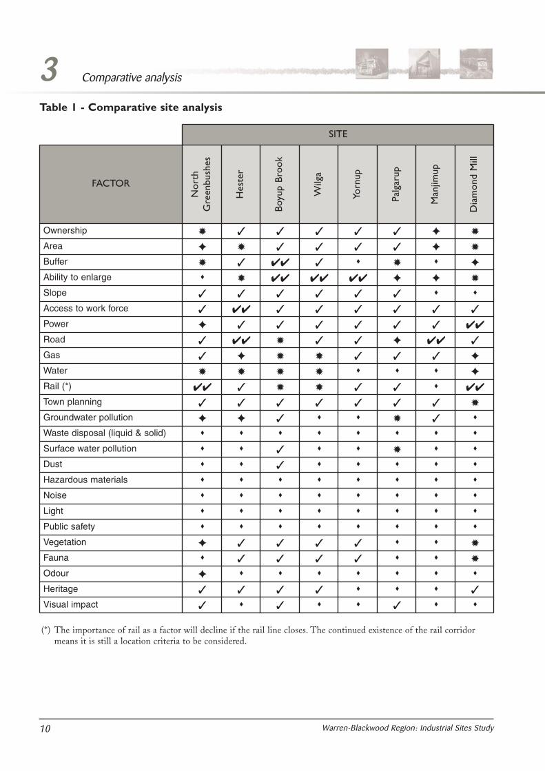
The comparative analysis of the sites is primarilybased on the objectives in table 7 - site selectioncriteria. The ability of a site to meet the selectioncriteria is not absolute and compliance is a questionof degree, with the outcome a summary of allfactors related to a specific criteria at each site. Theanalysis is summarised in table 1.
In applying the selection criteria to each site, regardwas given to the level of suitability of each of thecriteria. Where the criteria could not be addressed,or was considered a fatal flaw to the specific site, itis shown in the table by the symbol (✹). It isdefined as a constraint that is not easily overcomein terms of processes, time or expenses.
Where the criteria is not a fatal flaw, howevercannot be met easily it is shown by the symbol (✦).A site that meets the objectives subject to suitablemanagement measures is shown by the symbol ( ).A site that generally meets the objective is shownby the symbol (✓). A site that meets and surpassesthe criteria is shown by the symbol (✔✔).
In consideration of the eight sites, Yornup wasrecognised as the specific area with the greatestpotential to accommodate a future sub-regionalindustrial estate as described in component 1.Yornup also has the greatest flexibility in terms oflocation factors with sufficient land area, however itis recognised that specific management measureswould need to be introduced to address keyenvironmental considerations.
Consideration of North Greenbushes undercomponent 1 identified limitations in terms of landavailability, along with constraints from thesurrounding development and existing landpatterns. However, further consideration by thesteering committee under component 2 recognisedthat a large area of unallocated Crown land atNorth Greenbushes might have potential forconsideration as a long-term sub-regional industrialestate (section 7.2.2).
Hester is constrained in terms of provision of asuitable site area for a sub-regional estate but itslocation and characteristics may be suitable forexpansion of local industry serving a sub-regionalfunction.
Boyup Brook and Wilga are remote from the maintransport and servicing corridors, while Palgarup islimited by a number of factors; including theproximity to the townsite and the high water table.
Manjimup was considered, as existing industrialareas in the estate could be further developed;however, the fragmented ownership and land tenureissues associated with Crown land may make thisdifficult. The site has excellent road access but alsopotential problems with buffers and waste disposal.
Diamond Mill has the existing Lambert rail sidingand the main Manjimup substation located at thesite; however these benefits are mitigated by theconservation issues and possible conflicts with theplanning objectives of protecting this vegetationand protecting prime agricultural land.
3Comparative analysis
9Warren-Blackwood Region: Industrial Sites Study
3 Comparative analysis
10 Warren-Blackwood Region: Industrial Sites Study
SITE
Dia
mon
d M
ill
Man
jimup
Palg
arup
Yorn
up
Wilg
a
Boyu
p Br
ook
Hes
ter
Nor
thG
reen
bush
es
FACTOR
Ownership
Area
Buffer
Ability to enlarge
Slope
Access to work force
Power
Road
Gas
Water
Rail (*)
Town planning
Groundwater pollution
Waste disposal (liquid & solid)
Surface water pollution
Dust
Hazardous materials
Noise
Light
Public safety
Vegetation
Fauna
Odour
Heritage
Visual impact
✹ ✓ ✓ ✓ ✓ ✓ ✦ ✹
✦ ✹ ✓ ✓ ✓ ✓ ✦ ✹
✹ ✓ ✔✔ ✓ ✹ ✦
✹ ✔✔ ✔✔ ✔✔ ✦ ✦ ✹
✓ ✓ ✓ ✓ ✓ ✓
✓ ✔✔ ✓ ✓ ✓ ✓ ✓ ✓
✦ ✓ ✓ ✓ ✓ ✓ ✓ ✔✔
✓ ✔✔ ✹ ✓ ✓ ✦ ✔✔ ✓
✓ ✦ ✹ ✹ ✓ ✓ ✓ ✦
✹ ✹ ✹ ✹ ✦
✔✔ ✓ ✹ ✹ ✓ ✓ ✔✔
✓ ✓ ✓ ✓ ✓ ✓ ✓ ✹
✦ ✦ ✓ ✹ ✓
✓ ✹
✓
✦ ✓ ✓ ✓ ✓ ✹
✓ ✓ ✓ ✓ ✹
✦
✓ ✓ ✓ ✓ ✓
✓ ✓ ✓
(*) The importance of rail as a factor will decline if the rail line closes. The continued existence of the rail corridormeans it is still a location criteria to be considered.
Table 1 - Comparative site analysis

4.0 Impact analysisThe development of a sub-regional industrial estatewill have social, economic and environmentalimplications for the region and associatedcommunities. There is generally a presumption thatthese implications would increase as the size of theestate or individual industrial operations increases.The impact may also vary depending on wheredevelopment occurs within each site and on thelocation of the site itself. A key issue is whether thesocial structure and economic changes caused bythe development of an estate in one location aregreater in comparison to other locations and howthe community manages these changes.
The impact of a proposal is assessed by examiningthe associated social, economic and environmentalissues. This provides a balanced and integratedapproach and a framework in which to understandthe impacts of a specific proposal. The frameworkalso provides a consistent approach whencomparing the impact at different locations.
Social implications can vary depending oncommunity and individual perceptions of a proposaland the values associated with the location. Hence,a similar proposal in a different location may havedifferent social implications depending on thecharacteristics of the community. Theenvironmental management issues associated with aproposal can be reasonably well anticipated.
Economic implications are interdependent andinvolve linkages, multipliers and externalities in thelocal economy.
The Warren-Blackwood region has beenundergoing significant structural change. This hasbeen precipitated by many factors, including theRegional Forest Agreement and changes inagriculture. Changes that are occurring in theregion include:• restructuring of the native timber industry;• increase in plantation development;• declining reliance on traditional farming, dairy
and horticulture;• increase in viticulture;
• changing population base;• increasing awareness of residents’ rights and
demands to participate in processes;• decline of the traditional farming family;• broader awareness of the scenic and
quality-of-life attributes of the region;• increase in tourism; and• increase in lifestyle developments.
The Shire of Manjimup, in its submission on thedraft forest management plan,1 believes there isevidence of a range of social and health problems inthe shire and these problems are exacerbated by therestructuring of the native timber industry andother changes to employment (for example, joblosses in the vegetable processing business, the pinesaw mill closure and a loss of small businesses).
Change is a normal process in all communities andit is the nature and pace of the change that canaffect a community’s reaction. This can be either anevolutionary type of change, that has no clearbeginning or end; or a dramatic change associatedwith a particular event or proposal.
An assumption in the component 1 analysis wasthat a sub-regional estate would provide a largesource of employment in the region, and thereforeshould be located to take advantage of existingtownsites which provide accommodation, facilitiesand services for the work force. This means thatassociated implications will be focused on existingtownsites when considering the broader socialimpacts.
For the purpose of this analysis, two individualindustries will be studied to identify the likelysocial, economic and environmental implicationsrather than the implications of a hypothetical sub-regional estate. These industries are:• a timber processing centre directly employing 100
persons; and• a food/vegetable processor directly employing 200
persons.
4Impact analysis
11Warren-Blackwood Region: Industrial Sites Study
1 CALM Supplementary Social and Economic Report FMP 2002 page 17.

4 Impact analysis
12 Warren-Blackwood Region: Industrial Sites Study
4.1 Social impact There is no definitive method available to measurethe social impact of a proposal. While there may beclear effects on social infrastructure such ashospitals and schools, the impacts on lifestyle relateto how individuals and communities perceive andreact to change in an area.
Expectations and desires of the community andindividuals will vary. The community includes boththe immediately affected landowners and localcommunity, and the broader regional community.
Issues to be considered in understanding the socialimpact of an industrial proposal or designation ofan area for an industrial estate are discussed belowand may be confirmed or expanded through adetailed consultation program.
Rural identity
The development of an estate and/or individualindustries may potentially alter the existingcharacter of an area and expectations of the localcommunity. The extent of change will depend onthe nature and characteristics of that community,including its previous exposure to, or familiaritywith, similar developments.
All the sites investigated have experienced someform of development for industrial purposes orhave industry located nearby. Overall, the sitesconsidered in the study are generally associatedwith a strong rural identity. It is important toensure that any potential future industrialdevelopment in the region considers the impact onthe rural identity.
The Yornup locality, while considered to have astrong rural character and identity, has historicallyhosted a timber mill and, in addition, currentlyaccommodates a transport depot. Hester andGreenbushes are recognised for industry, howeverrural lifestyle opportunities have also been providednear the localities.
The strategic designation of preferred sites willprovide the opportunity for careful planning andmanagement of landscape and visual elements overa gradual period of time to reduce their impacts onthe locality. This will provide a wider benefit as theimpacts can be managed at specific locations.
Lifestyle
The quality of lifestyle in the Warren-Blackwoodregion is highly valued and relates to thepredominant rural character. Specifically, thisincludes the relative peace and quiet of the region,landscape values and environmental features such asthe air quality, bushland and rivers.
The impact of a potential estate on a particularlocality, as well as the general impact of increasedindustrial operations in the region, requires carefulconsideration throughout the planning andmanagement processes to ensure that any potentialimpacts are minimised. Impacts associated withgeneral industrial operations may include increasedrail and vehicle movements in connecting transportcorridors and localised effects of the estate on thesurrounding area.
Development will attract new industry to theregion, which will benefit the wider communityeconomically. This may also generate additionallifestyle opportunities in the region. The generalpositive linkages between secure employmentopportunities and confidence in the region areimportant contributing factors in improvinglifestyles.
Environmental
All environmental management issues cited insection 6.2 are also likely to have socialimplications.
The social impacts may be less definitive thanspecific environmental management issues as theymay vary depending on the perception or values ofan individual or community. For example, while anindustry may meet the legal requirements of thenoise abatement regulations, the ‘noise’ may beaudible in the locality where previously that noisemight not have existed.
A wider community benefit may be that industriesalso offer support for community andenvironmental programs. There may well be manypositive environmental benefits to the widercommunity that are not directly attributable to aspecific site.
Road safety and movement
Proximity to the South Western Highway was animportant location criterion in the site selectionprocess. The potential impacts on the roads and onresidents adjoining those roads will vary betweeneach site, however all potential sites are located totake advantage of existing heavy haulage routes.With the exception of Hester, all sites are adjacentto declared main roads. The Hester link road is adesignated heavy haulage bypass for Bridgetown.
Each site is also located at a central junction in thesecondary road network and the development ofany one site may also involve the use of thisnetwork. This may have a more pronounced impacton the adjoining communities than does the use ofthe main highways. The issue is whether any partof these road networks would be carrying adisproportionate amount of heavy traffic associatedwith the estate and whether the associated roadnetwork can adequately cater for such increases.
North Greenbushes also has access to the easternareas of the region via the Greenbushes-BoyupBrook Road, which is a sealed secondary rural road.Secondary access to Yornup is also available fromGommes Road via Kingston Road to the BoyupBrook–Cranbrook Road. Kingston Road is a gravelforestry road.
Consideration of upgrades or improvementrequirements to the road infrastructure as a result offuture industry operations and resultant traffic willbe important to ensure that other functions of thehighway are not compromised. The use of regionaltransport corridors provides the opportunity forsafe and efficient use of infrastructure with widerbenefits to the community.
Community values
A proposal to establish an industry may generatediffering views and attitudes in a community. Theviews of the local community and nearby residentsmay also be different to those held by members ofthe broader affected community; particularly wherelifestyle and/or local community values arethreatened.
The creation of jobs and the provision of stableemployment opportunities are perhaps the mostsignificant social benefits that will result from thedevelopment of a potential sub-regionalestate/industry for the broader region
Other community benefits could include:• retention of local businesses;• reducing outward migration from the region,
especially youth;• increasing the range of skills in the region;• attracting government funding for infrastructure
provision;• providing a catalyst for training and skills
development;• attracting development that may have located in
an alternative location;• developing relationships with other industries in
the region and attracting investment; and• providing an ability to reduce the impact of
structural change in the region.
Townsite impacts
The potential social impacts of either a vegetable ortimber processing operation establishing at each ofthe preferred locations identified in the industrialstructure and the effects that it will have on thevarious centres in the area of interest aresummarised in table 2.
4Impact analysis
13Warren-Blackwood Region: Industrial Sites Study

4 Impact analysis
14 Warren-Blackwood Region: Industrial Sites Study
Table 2 - Summary of possible social impacts
Diversification of industries may provide greater protection to the town and community fromstructural changes and fluctuations in mining and forestry based industries.
Provides potential to use local housing, school, recreation and businesses.
Development may indirectly affect the character, and hence lifestyle opportunities, particularly ofexisting rural residential properties.
Town may benefit from improved infrastructure, depending on the nature of the industry, that iswater, power, gas etc.
Greenbushes
May emphasise the use of Hester Road as a haulage route.
May benefit from service upgrades, and in particular power supplies.
Hester
May gain some advantages as the designated regional centre, although due to the distance therewould be external leakages towards Bunbury.
Manjimup
May provide opportunities for the development of agricultural properties in the area.Nannup
Would not be expected to have any significant impact.Yornup
Social impacts of potential vegetable and timber industry at Hester
May alter the regional road transport routes with associated issues and concerns in the local districtand townsite. May have a flow-on effect on housing demand.
Boyup Brook
Development would require employment, housing and access to community and social infrastructure,including recreation facilities, medical, schools.
Would create opportunities for support industries and services in the town.
May provide opportunities for improved use of social and recreation facilities without affecting thecharacter of the town.
Creates a linkage to Hester, effectively extending the townsites.
May potentially increase haulage through the town and focus on the CBD bypass issue.
May benefit from service upgrades, and in particular power supplies, and possible extension ofwater.
Will place additional pressure on the operation of the local landfill site.
Bridgetown
May benefit from long-term extension of regional infrastructure along the highway corridor.Greenbushes
Would provide for potential townsite redevelopment and upgrade.
Development may alter the character of Hester and conflict with the aspirations of the existingresidents or disrupt their lifestyle choices.
Would emphasise the use of Hester Road as a haulage route and the need to develop a bypassaround the town development.
Hester
May gain some indirect advantages as the designated regional centre.Manjimup
Would not be expected to have any significant impact.Nannup
Would not be expected to have any significant impact.Yornup
Social impacts of potential vegetable and timber industry at North Greenbushes
May alter the regional road transport routes with associated issues and concerns in the local districtand townsite. May have a flow-on effect on housing demand.
Boyup Brook
Local support for local housing, community services, recreation and businesses as the nearestcentre.
May provide opportunities for improved use of social and recreation facilities without affecting thecharacter of the town.
May potentially increase heavy haulage through the town and focus on the townsite bypass issue.
Will reinforce, in conjunction with existing mining operations, the perception of Greenbushes as amajor industrial and employment node in the South-West Region with associated benefits for Bridgetown.
Bridgetown

4Impact analysis
15Warren-Blackwood Region: Industrial Sites Study
Social impacts of potential vegetable and timber industry at Yornup
Would not be expected to have any significant impact.Boyup Brook
Development would require employment housing and access to community and social infrastructure,including recreation facilities, medical, schools.
Would create opportunities for support industries and services in the town.
May potentially increase heavy haulage (in both directions) through the town and focus on thetownsite bypass issue.
May benefit from long-term extension of regional infrastructure along the highway corridor.
Bridgetown
Would not be expected to have any significant impact.
May benefit from long-term extension of regional infrastructure along the highway corridor.
Greenbushes
Would not be expected to have any significant impact.Hester
Development would require employment housing and access to community and social infrastructure,including recreation facilities, medical, schools.
Would create opportunities for support industries and services in the town.
Manjimup
Would not be expected to have any significant impact.Nannup
May alter the nature and character of the area. Extent of changes would depend on the types ofindustries.
Little scope for additional settlement due to buffer requirements.
May result in loss of long-term families as they move from the area and changed populationcharacteristics as new owners move into the area.
Yornup
Social impacts of potential vegetable and timber industry at Manjimup
Would not be expected to have any significant impact.Boyup Brook
Secondary support for local housing, community services, recreation and businesses as apercentage of employees would commute from Bridgetown.
May benefit from long-term extension of services along the highway corridor.
May potentially increase haulage through the town and focus on the CBD bypass issue.
Bridgetown
Would not be expected to have any significant impact.
May benefit from long-term extension of services along the highway corridor.
Greenbushes
Would not be expected to have any significant impact.Hester
May provide opportunities for the development of agricultural properties in the area.Nannup
Would not be expected to have any significant impact.
May benefit from long-term extension of services along the highway corridor.
Yornup
Development would require employment housing and access to community and social infrastructure,including recreation facilities, medical, schools.
Would create opportunities for support industries and services in the town.
May provide opportunities for improved use of social and recreation facilities without affecting thecharacter of the town.
May benefit from service upgrades, and in particular power supplies and possible upgrade of water.
Would reinforce Manjimup’s role as the primary centre for the region.
Would provide catalyst for development and marketing of the southern portion of the study area andassociated settlements, that is, Pemberton.
Manjimup

4.2 Economic impactThe economic structure of the Warren-Blackwoodregion is changing. The purpose of this study is toprovide the preliminary measures and framework toencourage positive change. A new or expandingindustry is expected to have economic impactsbeyond the employment and income generated bythe original project.
Economic impact analysis is a means to assess themeasurable impacts resulting from a proposeddevelopment. Two of the most common methodsused to asses potential economic impacts are theuse of input–output models and the calculation ofmultiplier effects. A multiplier is a single numberwhich summarises the total economic benefitsresulting from a change in the local economy.When applied correctly, multipliers provideplanners and community leaders with estimates ofpotential change in factors such as employment,gross sales and income that will result from a neweconomic activity. Comparison of the alternativescan help communities decide where to invest timeand resources to get the greatest benefit. Forexample, a new manufacturing facility will createeconomic changes, which can spur ripple effects orspin-off activities. Multipliers measure theeconomic impact of these new exports, includingthe resulting spin-off activities.
Multipliers are simple ratios of change over a givenperiod. The Department of Treasury and Finance2
identifies three major multiplier classifications as:
• output multipliers (which are most frequentlyquoted) that show the increase in the totalproduction of all industries in the economy froman external (and usually unexplained) $1 increasein final demand for one industry. An outputmultiplier captures the increase in intermediatedemands required to service the increase in finaldemand;
• income multipliers, which show the increase ineconomy-wide income from an external increasein demand; and
• employment multipliers, which show the increasein economy-wide employment from an increasein demand.
Multipliers for Western Australia have beencalculated for a range of industries (Table 3).
Output multiplier
Multiplying the increase in sales of the exportingindustry by the output multiplier provides anestimate of the total increase in sales for the studyarea.
For example, a timber processor creates anadditional $1 million of produce. An outputmultiplier of 2.36 indicates that for every $1 oftimber exported from the region that an additional$1.36 of output is produced in the local economy. If$1 million of produce is sold, then $1 360 000 ofadditional output is produced locally to supply thecompany, other affected industries and consumers.
Similarly, for a food processor that creates anadditional $1 million of produce. An outputmultiplier of 2.4 indicates that if $1 million ofproduce is sold, then $1 400 000 of additionaloutput is produced locally to supply the company,other affected industries and consumers.
The region still benefits from the base value of theproduction, which in the above examples is $1million dollars. However, if most of the suppliesand services are purchased from outside the localcommunity, the output multiplier would beconsiderably lower.
4 Impact analysis
16 Warren-Blackwood Region: Industrial Sites Study
Industry
Out
put
mul
tiplie
r
Empl
oym
ent
mul
tiplie
r
Inco
me
mul
tiplie
r
Food and beverages 2.40 4.03 3.37
2.36 2.50 2.67
2.24 1.96 1.77
2.02 1.89 2.20
1.88 1.70 3.26
1.89 2.42 2.44
Wood, wood products
Forestry and logging
Road transport
Agriculture
Miscellaneous manufacturing
Source KW Clements and Y Qiang - A NewInput-Output Table for Western AustraliaEconomic Research Centre UWA 1995
Table 3 - Economic multipliers
2 Department of Treasury and Finance: The Use and Abuse of Input–Output Multipliers – Economic Research Articles 2002

The multiplier takes into account the direct,indirect and consumption-induced effects arisingfrom the initial increase in demand.
Employment multiplier
The number of jobs that are expected to be createdas a result of a new industry is often a keyjustification for the establishment of that industry.This includes the multiplier effect on localemployment.
Hence, if a new timber-processing centre employs100 persons with a multiplier of 2.5, the totalnumber of jobs that would be created in the regionis 250. This consists of 100 direct jobs and 150indirect jobs. Similarly, a food processor that creates200 direct jobs with an employment multiplier of4.03 would create additional 606 indirect jobscreated in support and service industries.
Income multiplier
The income multiplier measures the total increasein income in the local economy resulting from aone-dollar increase in income received by workersin the new industry.
If the new industry such as timber processor payswages of $1 000 000 with a multiplier of 2.67, thenthe total increased wages in the region will amountto $2 670 000. This consists of $1 000 000 to directemployees and $1 670 000 to indirect employees.Similarly, a food processor that pays wages of $2 000 000 with a multiplier of 3.37, then the totalincreased wages in the region will amount to
$6 740 000. This consists of $2 000 000 to directemployees and $4 740 000 to indirect employees.
From this it can be seen the potential multipliereffects from food processing industries are muchgreater than for timber processing or agriculture asthis reflects the more complex nature of theoperations.
The potential impact of industries locating in theregion will include consideration of the followingissues3:• employment generation potential;• potential to improve the skills base of local
residents;• competition with existing businesses;• diversification of the local business base; and• benefit to the region.
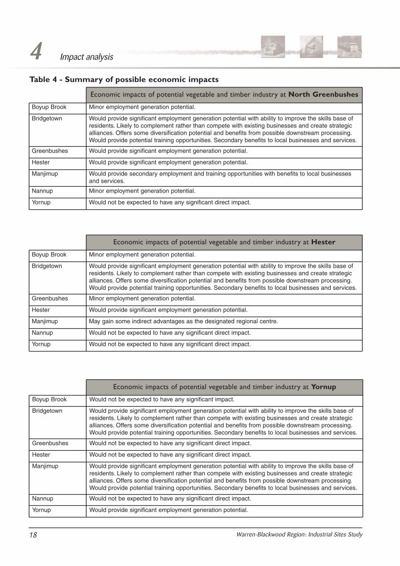
The potential economic impacts of either avegetable or timber processing operationestablishing at each location and the effects that itwill have on the various centres in the area ofinterest are summarised in table 4.
It should be noted that this assessment is based onbasic processing industries and as the processingbecomes more complex there is generally greatervalue added to the product, providing greaterpotential multipliers and linkages through theregion. The introduction of industries that are ableto provide greater downstream processing of theraw product, such as paper production, clothing ormanufacturing would have greater benefits.
4Impact analysis
17Warren-Blackwood Region: Industrial Sites Study
3 Redland Shire Council: Job Grow Incentive Funds Notes
4 Impact analysis
18 Warren-Blackwood Region: Industrial Sites Study
Table 4 - Summary of possible economic impacts
Economic impacts of potential vegetable and timber industry at North Greenbushes
Minor employment generation potential.Boyup Brook
Would provide significant employment generation potential with ability to improve the skills base ofresidents. Likely to complement rather than compete with existing businesses and create strategicalliances. Offers some diversification potential and benefits from possible downstream processing.Would provide potential training opportunities. Secondary benefits to local businesses and services.
Bridgetown
Would provide significant employment generation potential.Greenbushes
Would provide significant employment generation potential.Hester
Would provide secondary employment and training opportunities with benefits to local businessesand services.
Manjimup
Minor employment generation potential.Nannup
Would not be expected to have any significant direct impact.Yornup
Economic impacts of potential vegetable and timber industry at Hester
Minor employment generation potential.Boyup Brook
Would provide significant employment generation potential with ability to improve the skills base ofresidents. Likely to complement rather than compete with existing businesses and create strategicalliances. Offers some diversification potential and benefits from possible downstream processing.Would provide potential training opportunities. Secondary benefits to local businesses and services.
Bridgetown
Minor employment generation potential.Greenbushes
Would provide significant employment generation potential.Hester
May gain some indirect advantages as the designated regional centre.Manjimup
Would not be expected to have any significant direct impact.Nannup
Would not be expected to have any significant direct impact.Yornup
Economic impacts of potential vegetable and timber industry at Yornup
Would not be expected to have any significant impact.Boyup Brook
Would provide significant employment generation potential with ability to improve the skills base ofresidents. Likely to complement rather than compete with existing businesses and create strategicalliances. Offers some diversification potential and benefits from possible downstream processing.Would provide potential training opportunities. Secondary benefits to local businesses and services.
Bridgetown
Would not be expected to have any significant direct impact.Greenbushes
Would not be expected to have any significant direct impact.Hester
Would provide significant employment generation potential with ability to improve the skills base ofresidents. Likely to complement rather than compete with existing businesses and create strategicalliances. Offers some diversification potential and benefits from possible downstream processing.Would provide potential training opportunities. Secondary benefits to local businesses and services.
Manjimup
Would not be expected to have any significant direct impact.Nannup
Would provide significant employment generation potential.Yornup

4.3 Environmental impactDevelopment of a sub-regional industrial estatemust be managed in a sustainable manner to ensureminimal impact on the environment andcompliance with the Environmental Protection Act1986, other environmental legislation andassociated regulations.
A range of legislation exists to assure that newindustries do not create adverse impacts on eitherthe environment or residents of a locality. Forexample, section 51 of the Environmental ProtectionAct 1986 requires owners to;(a) comply with any prescribed standard for an
emission; and(b) take all reasonable and practicable measures to
prevent or minimise emissions.An “unreasonable emission” is defined in the Act asan emission or transmission of noise, odour orelectromagnetic radiation which unreasonablyinterferes with the health, welfare, convenience,comfort or amenity of any person.
The technical appendix to this report contains adetailed description of the elements ofenvironmental control in Western Australia, dealingwith licensing, planning measures, noise, odour,gaseous emissions, particulate emissions, wastewaterand solid waste.
Having regard to this, the following overview of theissues associated with these industries has beenprepared.
4.3.1 Food/vegetable processingFruit and vegetable processing operations can becarried out in locations which service localproducers. With modern commodity transport(refrigerated container transport), both local andinternational markets can be targeted.
The relevant environment managementcharacteristics, considered by the EnvironmentalProtection Authority (EPA), are summarised intable 5.
4Impact analysis
19Warren-Blackwood Region: Industrial Sites Study
Economic impacts of potential vegetable and timber industry at Manjimup
Would not be expected to have any significant impact.Boyup Brook
Would provide secondary employment and training opportunities with benefits to local businessesand services.
Bridgetown
Would not be expected to have any significant direct impact.Greenbushes
Would not be expected to have any significant direct impact.Hester
Would provide significant employment generation potential with ability to improve the skills base ofresidents. Likely to complement rather than compete with existing businesses and create strategicalliances. Offers some diversification potential and benefits from possible downstream processing.Would provide potential training opportunities. Secondary benefits to local businesses and services.
Manjimup
Minor employment generation potential.Nannup
Would not be expected to have any significant direct impact.Yornup
FactorManagement requirement
n/r low medium significant high
air
odour
water
noise
Sludges and solids
Table 5 - Food/vegetable processing - management requirements
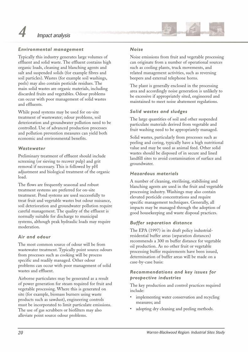
Environmental management
Typically this industry generates large volumes ofeffluent and solid waste. The effluent contains highorganic loads, cleaning and blanching agents andsalt and suspended solids (for example fibres andsoil particles). Wastes (for example soil washings,peels) may also contain pesticide residues. Themain solid wastes are organic materials, includingdiscarded fruits and vegetables. Odour problemscan occur with poor management of solid wastesand effluents.
While pond systems may be used for on-sitetreatment of wastewater; odour problems, soildeterioration and groundwater pollution need to becontrolled. Use of advanced production processesand pollution prevention measures can yield botheconomic and environmental benefits.
Wastewater
Preliminary treatment of effluent should includescreening (or sieving to recover pulp) and gritremoval if necessary. This is followed by pHadjustment and biological treatment of the organicload.
The flows are frequently seasonal and robusttreatment systems are preferred for on-sitetreatment. Pond systems are used successfully totreat fruit and vegetable wastes but odour nuisance,soil deterioration and groundwater pollution requirecareful management. The quality of the effluent isnormally suitable for discharge to municipalsystems, although peak hydraulic loads may requiremoderation.
Air and odour
The most common source of odour will be fromwastewater treatment. Typically point source odoursfrom processes such as cooking will be processspecific and readily managed. Other odourproblems can occur with poor management of solidwastes and effluent.
Airborne particulates may be generated as a resultof power generation for steam required for fruit andvegetable processing. Where this is generated onsite (for example, biomass burners using wasteproducts such as sawdust), engineering controlsmust be incorporated to limit particulate emissions.The use of gas scrubbers or biofilters may alsoalleviate point source odour problems.
Noise
Noise emissions from fruit and vegetable processingcan originate from a number of operational sourcessuch as cooling plants, truck movements, andrelated management activities, such as reversingbeepers and external telephone horns.
The plant is generally enclosed in the processingarea and accordingly noise generation is unlikely tobe excessive if appropriately sited, engineered andmaintained to meet noise abatement regulations.
Solid wastes and sludges
The large quantities of soil and other suspendedparticulate materials derived from vegetable andfruit washing need to be appropriately managed.
Solid wastes, particularly from processes such aspeeling and coring, typically have a high nutritionalvalue and may be used as animal feed. Other solidwastes should be disposed of in secure and linedlandfill sites to avoid contamination of surface andgroundwater.
Hazardous materials
A number of cleaning, sterilising, stabilising andblanching agents are used in the fruit and vegetableprocessing industry. Washings may also containelevated pesticide concentrations and requirespecific management techniques. Generally, allimpacts may be managed through the adoption ofgood housekeeping and waste disposal practices.
Buffer separation distance
The EPA (1997) in its draft policy industrial-residential buffer areas (separation distances)recommends a 300 m buffer distance for vegetableoil production. As no other fruit or vegetableprocessing buffer requirements have been issued,determination of buffer areas will be made on acase-by-case basis:
Recommendations and key issues forprospective industries
The key production and control practices requiredinclude:• implementing water conservation and recycling
measures; and• adopting dry cleaning and peeling methods.
4 Impact analysis
20 Warren-Blackwood Region: Industrial Sites Study

Reductions in wastewater volumes of up to 95 percent have been reported through implementation ofgood practices (World Bank 1999). Where possible,measures such as the following should be adopted:• procure clean raw fruit and vegetables, thereby
reducing the concentration of dirt and organics inthe effluent;
• use dry methods (vibration or air jets) to cleanfruit and vegetables;
• separate and re-circulate process wastewaters;• use steam instead of hot water to reduce quantity
of wastewater going for treatment;• minimise the use of water for cleaning floors and
machinery;• remove solid wastes without the use of water; and• re-use concentrated wastewaters and solid wastes
for production of by-products.
4.3.2 Timber processingTimber processing includes the processing of woodproducts into seasoned or unseasoned timber forbuilding trades and/or production of other timberproducts. The preparation of raw materials includesdebarking, sawing, chipping and the use ofchemical processes. Residues may be reprocessed toyield by-products such as compost and mulch.
The relevant environment managementcharacteristics, considered by the EPA, aresummarised in table 6.
4Impact analysis
21Warren-Blackwood Region: Industrial Sites Study
FactorManagement requirement
n/r low medium significant high
air
odour
water
noise
Sludges and solids
Table 6 - Timber processing - management requirements

Environmental management
All timber processing produces a high volume ofsolid waste (by nature of debarking). The use ofchemical processing in the production of veneersand laminates also results in chemical wastesrequiring safe storage and disposal.
Environmental management programs should focuson reducing wastewater discharges and minimisingair emissions. Process recommendations include:• using energy-efficient processes wherever feasible;• minimising the generation of effluent through
use of advanced techniques and recyclingwastewater;
• minimised effluent volume and treatment byusing dry debarking; and
• minimising emissions to the atmosphere.
Scrubber systems may be used to control the releaseof exhaust gases from emulsion/formaldehydeplants, which involves ducting gases through eitherabsorber towers or chimney stacks (ATAEnvironmental, 2002).
Air emissions
Dust emissions may result from all materialshandling operations, stockpiles and transportactivities. The generation of vapours from thestorage of volatile materials and exhaust gases fromemulsion plants and formaldehyde plant may alsoimpact on air quality.
Noise emissions
Timber processing industries may generatesubstantial amounts of noise. Noise emissions fromoperations on site will be required to comply withthe Environmental Protection (Noise) Regulations1997 (Environmental Protection Authority, 1997b).
Transport activities
Noise, and to a lesser extent vibration, will begenerated by transport operations. Tonal noiseelements can result from vacuum air brakes, engineand gearbox noise on accelerating and gearchanging, or train operation.
Dust from transport operations can originate fromthe logs being carried or re-suspended from theroad surface and shoulders as a consequence of thepassage of the vehicle.
Hazards to the public range from direct (collision)to indirect hazards (road damage from heavyvehicle use).
Solid waste
The principal solid waste is bark generated duringdebarking and prior to further processing of thewood. Accumulated fines and residual bark mayrequire disposal. Scrubber liquor may be producedduring chemical processing and require disposal atan appropriate location.
Wastewater
Log watering may contribute particulate materialsand tannins, requiring treatment and managementof wastewater generated by timber processing.
The safe storage of environmentally hazardouschemicals is necessary to ensure that liquid spills orleakages do not contaminate either the stormwatersystem or the groundwater table.
Solid waste
Approximately half the weight of the logs deliveredto the mill becomes residues, including bark,sawdust, shavings, round-offs, end cuts, trimmingsand reject timber. Processes have been developed toconvert wood processing residues into productssuch as pulp, particleboard, animal bedding andgarden products. In many cases, efficient use ofresidues is necessary for a sawmill to operateprofitably.
Buffer separation distance
The EPA (1997b) in its draft policy industrial-residential buffer areas (separation distances)recommends:• 1000 m buffer distance for wood fibre processing
(including wood chip products); and• 500 m buffer distance for sawmills.
Recommendations and key issues forprospective industries
The key production and control practices that willlead to compliance with emissions guidelinesinclude:
• use of dry debarking processes;• prevention and control of chemical liquid spills;• controlling noise from wood processing;
4 Impact analysis
22 Warren-Blackwood Region: Industrial Sites Study

• management of truck movements;• safe storage of resins and chemicals;• aiming for zero-effluent discharge where possible,
thereby reducing wastewater discharges;• reducing emissions from incinerators; and• encouraging the use of plantation timber as the
raw material.
4.3.3 Buffer implicationsThe amenity and health of the community must beprotected from adverse impacts. The primary aim isfor industry to contain amenity and health impactsand risk on-site. When planning an estate, it isdesirable that the core area house industries that areconsidered to have the greatest potential for off-siteimpacts, as some industries by their nature generatea range of emissions that cannot be fully containedwithin their specific site. Generally, emissionsdecrease and the impacts reduce with increasingdistance from the source.
Where emissions cannot be contained on-site abuffer will be required to separate industrial areasand other sensitive land uses from potentialimpacts. A ‘buffer area’ is the area in whichsensitive land uses are prohibited or specialmeasures are necessary to ameliorate the impacts ofindustry or essential infrastructure.4 These buffersmay extend beyond the investigation areas that havebeen identified for each site.
As previously indicated, off-site buffers are likely tobe in the order of between 500 m and 1000 m;however actual sizing will depend on industry typeand site specific factors. Further buffer issues arealso discussed in the technical appendix.
As indicated in section 4, it is preferable to useareas of state forest as industrial buffers over privateland. In consideration of the management of thebuffer, the proponent, industry or governmentagency will be required to liaise with theDepartment of Environment and Conservation(DEC) to ensure that the intended purpose of theDEC estate will not be jeopardised through theintroduction of industry into the area.
With regard to the location of existing and futuredwellings, the sites and potential impacts arerequired to be investigated. This includes rural farmdwellings as well as urban residences. At all theproposed sites potential off-site buffer areas willimpinge on existing dwellings and potentiallocations for future dwellings and this will requireresolution through detailed planning processes.
4.4 ConclusionThe potential impacts of the estate, whether theyare social, economic or environmental impacts,must all be managed in a sustainable manner. Thesustainability objectives for the estate as identifiedin component 1 included the following:• local economic benefits and employment;• increased recycling and re-use;• decreased natural resource use;• improved water efficiency;• improved energy efficiency;• improved transport efficiency;• decreased greenhouse gas emissions;• non-contaminating land uses;• protection of biodiversity;• development of partnerships between the local
community, business and government; and• increased business competitiveness.
The identification of the potential industrial siteshas been undertaken on the basis of criteria selectedto ensure that location of future industrial useswithin the sites is able to be undertaken in amanner that is socially, environmentally andeconomically sustainable. In the region there are,however, different impacts and benefits that willaccrue depending on the location of development.This will influence location decisions of industryand community and government support for thefurther planning and development of a particularsite.
4Impact analysis
23Warren-Blackwood Region: Industrial Sites Study
4 WAPC Draft statement of planning policy 4.1 – State industrial buffer policy July 2004.

4 Impact analysis
24 Warren-Blackwood Region: Industrial Sites Study

5.0 Communityconsultation
Community consultation is integral to the studyprocess and has been integrated into each stage ofthe strategy development. The Western AustralianGovernment recognises community consultation inits ‘commitment to accountability, transparency andengagement’. This is a guiding principle of thedecision-making process, which identifies thatpublic engagement lies at the heart of allsustainability principles (Hope for the Future: TheWestern Australian State Sustainability Strategy2003).
The steering committee recommended the need toprepare a community consultation strategy in theinitial phase of the study. The consultation processis outlined in figure 4.
5.1 Community consultationstrategy
The community consultation strategy was preparedin the preliminary phases of component 1. Theaims of the consultation strategy were to:• improve the quality of the decision making in the
study;• demonstrate a commitment to accountability,
democracy and transparency;• empower citizens and promote community
involvement;• confirm the priority for site options;• offer and/or create new perspectives and solutions
on the selection issues;• provide greater legitimacy for decision making;• reveal actual or potential problems; and• identify the needs and wants of the community.
5Community consultation
25Warren-Blackwood Region: Industrial Sites Study
Figure 4 - Consultation process
5 Community consultation
26 Warren-Blackwood Region: Industrial Sites Study
The overall objectives of the consultation strategywere to:• enable the community to participate in
partnership in the study;• give all the community the opportunity to
comment;• allow for the consideration of community
opinions;• provide for continuous community reference
throughout the study;• promote the use of innovative and creative
methods of consultation;• design consultation for its specific purpose, follow
a consistent approach and incorporate monitoringand evaluation; and
• regard the consultation facilitated by others (thatis, previous studies and work with partners) toreduce overlap and consultation ‘fatigue’.
The adopted community consultation strategyprovided for a high level of communityinvolvement. In review of the study process it wasacknowledged that while agencies and planningauthorities are well represented on the steeringcommittee, the wider community needed to beinvolved in the initial planning process. Acommunity reference group was established toensure that the wider community was included inthe consultation process.
5.2 Community referencegroup
A media release advising the general community ofthe study was advertised in local newspapers inDecember 2002. Community groups, agencies andbusinesses were targeted to attract a representativeto be a member of the group. A number ofnominations were received in response to letters ofinvitation and initial media advertisements to allowformation of the community reference group.
A second media release advising of the formation ofthe community reference group and request fornominations for a further two non-allied memberswas published in local newspapers during the lastweek of April 2003. This process attracted oneadditional member to the group.
Membership of the community reference group wasintended to represent a cross-section of the
community. The group was structured so that groupmembers could operate as a conduit of informationfrom the wider community to the steeringcommittee. The role of the community referencegroup was to report to the steering committee andprovide it with information about communityattitudes, provide input into consultation processesand on other issues being considered during thestudy process. Membership of the communitygroups is included at appendix 2.
5.3 Component 1 reportThe preparation of component 1 of the reportinvolved a number of important consultation stepswith both landowners in the areas of interest and inthe broader community. In the initial preparationphase of the component 1 report, eight areas ofinterest were identified targeting sites forconsideration and assessment. The spatial extentand boundaries of these ‘areas of interest’ were notspecifically defined. Landowners in the core of eachof the areas of interest were notified of the study.Each landowner was contacted by an officer of theDepartment for Planning and Infrastructure (DPI)and informed of the start of the study.Correspondence followed the phone call to providea summary of the purpose of the study and to givecontact details for further information on the study.
Following endorsement by the steering committeeand the community reference group the component1 report was released for a six-week publicconsultation period. The community referencegroup had the opportunity to meet twice as a groupand provide comments on the draft report prior toits release. The draft component 1 report did notprovide specific recommendations or conclusions onsites; however, its release was considered animportant component of the general process ofconsultation and engagement, and provision ofinformation to the community on the site analysis.
Advertising of the component 1 report commencedon 19 May 2003 and the closing date forsubmissions was 27 June 2003. A display was heldat each of the four local government officesthroughout the advertising period. DPI officerswere available to discuss the study at these displays.Members of the project groups, relevant agenciesand affected landowners were individually notified.Information brochures were produced summarising

the key points and potential questions about thecomponent 1 report. These brochures were includedwith a letter to landowners and were also availableat each of the local government offices forinformation. A copy of the draft report wasavailable on the DPI website. Hard copies weremade available to community reference groupmembers, steering committee members and thefour local authorities’ libraries, and on request toaffected landowners and community members.Eighteen submissions were received. A summary ofthe issues raised from the submissions received isincluded in appendix 3.
5.4 Yornup CommunityCommittee
Subsequent to the WAPC endorsement of Yornupas the preferred site, the Yornup communityexpressed strong opposition towards theconsideration of the area for future industry. Thecommunity advised that these concerns were notraised strongly during the initial consultation as itwas not generally considered that Yornup would beidentified as a preferred site. The concerns raised bythe community included the impact on land values,lifestyle and productive agricultural land, the studyconsultation processes (community reference group)and environmental issues associated with futureindustrial development, including watercontamination. In addressing these issues arepresentative Yornup consultative committee wasestablished to meet with a sub-group of thesteering committee during the next phase of thestudy.
The Yornup Community Committee also requestedthat the study consider areas of degraded stateforest for the location of sub-regional industryrather than productive farmland, and that the areaof Yornup indicated for investigation undercomponent 1 be broadened to include surroundingareas of state forest.
5.5 Component 2 reportThe methodology (section 1.1) describes theprocess followed by the steering committee in itsreview of the study approach based on the issuesthat arose from the consultation processes andadditional issues that had been identified.
The steering committee consulted with thecommunity reference group in developing therevised approach for completion of the study, whichwas then endorsed by the WAPC. Throughout theprocess of reviewing the study approach, theYornup Community Committee was kept informedof the process.
The component 2 report reflected the steeringcommittee recommendations endorsed by theSouth West Region Planning Committee. Thedraft report (component 2) containedrecommendations for a sub-regional industrystructure for the Warren-Blackwood region,outlining the potential for development of sub-regional industry at four locations providing short-to-medium and long-term options.
Advertising of the draft report by the WAPC wascarried out with the support of the four localgovernment councils, the steering committee andthe community reference group. The six-weekadvertising period involved direct contact withaffected landowners at displays at each of the localgovernment offices and a copy of the report wasposted on the WAPC website. During theadvertising period a public meeting was also held inNorth Greenbushes to facilitate the publicconsultation process.
Thirty-seven submissions were received which havebeen summarised in the Summary of submissionissues – component 1 (appendix 3). These issueshave been summarised relative to each site andlong-term/short-term options.
5.6 North GreenbushesReference Group
The need for a public meeting at NorthGreenbushes was held in response to a largenumber of calls raising issues in relation toidentification of the area as a potential site forfuture industry. Sixty local residents attended themeeting; meeting with staff from the DPI(Bunbury and Perth offices), representatives fromthe South West Development Commission and theShire of Bridgetown-Greenbushes. Concerns andissues raised at the meeting related to:• type of industry and hours of operation;• public consultation process and the planning
process;
5Community consultation
27Warren-Blackwood Region: Industrial Sites Study

• environmental considerations/impacts/processes;• transitional areas and buffers;• the road-to-rail intermodal proposal; and• heavy haulage traffic and transport routes.
During the meeting a request was made bycommunity members to continue their involvementin the study process. The steering committee andthe community reference group resolved to formthe North Greenbushes Reference Group to assistin resolving the issues and concerns that were raisedat the public meeting in written submissions thathad been previously received. Eight representativeswere nominated by North Greenbushes communitymembers to meet with members of the steeringcommittee (a DPI officer, Shire of Bridgetown-Greenbushes chief executive officer and twomembers of the community reference group).
This meeting was held to resolve issues that hadbeen raised through the submissions on the studyand determine ways in which the study couldaddress these issues. The North GreenbushesReference Group was advised the outcomes ofrecent community reference group and steeringcommittee meeting recommendations in relation tothe draft report and submissions received.
Concerns were also raised in relation to themanagement of existing industry operations, whichare outside the scope of the study. The manager ofthe local Whitakers timber mill (who is a memberof the community reference group) and the shirecouncil chief executive officer agreed to continuefacilitated discussions at the venue following theWarren-Blackwood Region: Industrial Sites Studymeeting to discuss contentious local planningissues.
The community reference group and the steeringcommittee considered the submissions received andprovided recommendations that were presented tothe South West Region Planning Committee(along with the outcomes of the meetings with theNorth Greenbushes Reference Group). The SouthWest Region Planning Committee considered thesteering committee recommendations to thesubmissions, public meetings and endorsed thefinalisation of the industrial sites study.
5 Community consultation
28 Warren-Blackwood Region: Industrial Sites Study
6.0 Planningconsiderations andkey issues
6.1 Background andrationale
6.1.1 Site selection criteriaThe process of selecting potential industrialdevelopment sites integrates economic, social andenvironmental criteria to achieve a sustainableoutcome from development. It is also important forthe estate site or sites to be economicallycompetitive in terms of development andoperational costs. The objective is to minimisethese costs as far as practicable withoutcompromising development standards orenvironmental and social requirements.
The State Government has released the StateSustainability Strategy for Western Australia and itis committed to the following principles forsustainability:1. conservation of biological diversity and
ecological integrity (as the basis on which lifedepends);
2. the precautionary principle (lack of scientificcertainty should not delay measures to preventenvironmental degradation and other damage);
3. inter- and intra-generational equity (ourdecisions today should not compromise thechoices of those generations still to come andshould provide for equity within generations);and
4. improved resource valuation, pricing andincentive mechanisms to protect and repair theenvironment.
Sustainability characteristics and objectives for theestate location include:• local economic benefits and employment;• increased recycling and re-use;• decreased natural resource use;• improved water efficiency;• improved energy efficiency;• improved transport efficiency;• decreased greenhouse gas emissions;• non-contaminating land uses;• protection of biodiversity;• development of partnerships between the local
community, business and government; and• increased business competitiveness.
The sustainability objective is achieved by ensuringthat the defined selection criteria and objectivesreflect sustainability principles. The second stage ofthe study considers economic, environmental andsocial criteria in more detail. The final level ofimplementing sustainability principles will bethrough the promotion of best managementpractices and recommendations in the design andmanagement of the estate.
In considering potential areas for the estate,detailed selection criteria were developed (table 7).These criteria were identified based on discussionswith industry and service agencies, a review ofexisting government policies and requirements ofvarious agencies. The criteria have been identifiedspecifically to fulfil the sustainability objectives ofthe study. In applying the selection criteria theidentification of a preferred location is an outcomeof overall assessment, and full compliance with eachcriteria will not necessarily be achieved.
6Planning considerations and key issues
29Warren-Blackwood Region: Industrial Sites Study

6 Planning considerations and key issues
30 Warren-Blackwood Region: Industrial Sites Study
Factor Relevant area Objective
Site characteristics
Ownership Core and buffer area To minimise impact and uncertainty to the affected landowners. The landidentified for the estate preferably should have a simple ownershippattern and tenure.
Services
Power Core area andassociated servicecorridor
Road Region
To reduce the need for new transmission lines and to be aware of thestrategic implications for other users.
The estate to be within 5 km of the existing 132 kV network.
To minimise impact on existing communities.
The estate to be near existing strategic transport and haulage routes.
Gas Service corridor Identify potential service routes and potential benefits for other users.
The estate to be located to take advantage of potential gas supplyroutes, while recognising the need to extend services to localcommunities.
Water Region To secure an appropriate supply with minimal impact on other users andthe environment.
The estate to be located to take advantage of potential water supplyroutes, while recognising the need to extend services to localcommunities.
Rail Region To promote the use of rail as a sustainable and preferable alternative toroad transport.
The location of the estate to give preference to sites that are nearexisting or proposed rail connections, or that have the potential for aspur connection.
Air Region To have regard to existing and potential airfield sites to offer flexibility forair use in the future.
Telecommunications Region To recognise the growing importance of communications and to identifyopportunities and constraints for improved services at a site.
Estate size Core area Optimum 200 ha of unconstrained land (minimum of 100 ha) with thepotential for a larger area if required.
Buffer size Buffer area Minimum of 500 m with the potential for 1000 m.
Lot sizes Core and buffer area Preferably in large holdings (40 ha +).
Slope Core area Less than 10 per cent.
Soil Core area The estate to be located on land with high capability for the intendeduses.
Access to work force Core area Within 30 km of major settlement.
Table 7 - Site selection criteria

6Planning considerations and key issues
31Warren-Blackwood Region: Industrial Sites Study
Factor Relevant area Objective
Town Planning
Pollution management
Strategic Region Ensure consistency with regional policies.
To ensure that the estate does not result in a loss of designated priorityagricultural land.
Groundwater quality Below the site andhydraulic head
Ensure that beneficial uses of groundwater can be maintained.
Liquid and solid wastedisposal
Core area Liquid and solid waste to be contained and isolated from groundwater.
Surface water quality Core area Ensure that surface water is managed to prevent discharge ofcontaminated water from the site or to groundwater.
Dust Core area, accessroad and buffer
Minimise airborne dust.
Hazardous materials Core area Comply with Explosives and Dangerous Goods Act 1961, OccupationalSafety and Health Act 1984 and Environmental Protection Act 1986.
Noise Core and buffer area Ensure that cumulative noise emissions are as low as reasonablypracticable and comply with Environmental Protection (Noise)Regulations 1997.
Light overspill Core area, buffer andsurrounding district
Manage potential impacts from light overspill and comply with AustralianStandard 4282.
Public health andsafety
Core area, accessroad and buffer
Ensure that risk is as low as is reasonably achievable.
Odour Core and buffer area Ensure no adverse effect on the welfare and amenity of land users.
Local Core and buffer area Have regard to local planning controls and objectives in consideringsites.
Ensure that the location of the estate does not conflict with localplanning objectives.
Buffer protection Buffer area Ensure potential for protection of designated buffers through appropriateplanning controls.

6 Planning considerations and key issues
32 Warren-Blackwood Region: Industrial Sites Study
Social surroundings
Fauna Core and buffer area Protect any protected (threatened) species
Heritage Core area Comply with Aboriginal Heritage Act 1972 in relation to areas of culturaland historical significance.
Have regard to local municipal heritage inventories in identifyingpotential sites.
Visual amenity Core area, buffer andsurrounding district
Visual amenity of the area adjacent to the project should not be undulyaffected by the proposal.
The location of the estate should have minimal profile and visibility frommajor roads and designated tourist and scenic routes.
Public consultation Local community As per agreed strategy to provide the public with ample opportunity tounderstand the project.
Lifestyle Surrounding area Minimise perceived loss of lifestyle opportunities.
Sensitive premises Surrounding area Minimise impact on existing and future dwellings
Work force location Region Predict likely requirements and possible locations.
The estate should be located within 30 km of major centres.
Biophysical
Vegetation Core and buffer area To maintain the abundance, species diversity, geographic distributionand productivity of communities.
The core area should be predominantly cleared with minimal remnantvegetation.
The buffer area can contain remnant vegetation but the objective mustbe to ensure that no areas of high conservation value that may belocated in the buffer are unduly affected.
Factor Relevant area Objective

6.1.2 Defining an area ofinterest.
The development of a new industrial estate must beplanned to balance the requirements and needs ofindustry, the environment and community. Theestate must be sustainable by meeting acceptedstandards of environmental protection and theaspirations of the community as reflected in thevarious strategies for the area.
Having regard to this, potential industrial areasmust have location and site characteristics that areappropriate to ensure that industries locating inthese areas have the ability to remain competitiveon the international export market. Reducing thedirect and indirect costs of servicing and transportwill assist in achieving this and is also consistentwith state sustainability objectives.
Based on these assumptions, the selection criteriaand the existing pattern of land use anddevelopment as described in the Warren-Blackwood region plan, the opportunities andconstraints for the location industry sites in theregion have been assessed. It is clear from this thatthe major opportunities for locating the estate arealong the strategic transport and infrastructurecorridor following the South Western Highway(figure 2).
The Shire of Nannup was excluded from thedefined area of interest because:• the geographical source area for products,
especially related to plantation development, aremore focused to the east of Nannup;
• the need to position the estate in a location thatcan service a wide catchment in the regionfacilitating transport towards the Bunbury Port;
• the objective to promote the strategic transportcorridor along the South Western Highway,especially for potential rail use;
• the absence of any recommendations in theprevious studies to investigate sites in Nannup;
• the location of Nannup in relation to theprincipal road haulage routes for the region; and
• remoteness of the area from the potential gaspipeline.
6.1.3 Estate areaTo determine an appropriate size for the estate,consideration has been given to the land arearequirements of selected industries and infacilitating the objective for multiple industries tobe located together.
It is expected that there will be a catalyst industryto initiate development of an estate and thisindustry may need a reasonable sized land holding(that is, 50 ha). Many regional and sub-regionallevel industries do not, however, need large areas ofland for their processing operations. Based on anassessment of existing industry characteristics thesite should have a preferred core area of at least 200ha with the potential to expand to 500 ha.
6.1.4 Potential sitesBased on the defined selection criteria a detailedexamination has been undertaken for sites selectedat:• Wilga;• Boyup Brook;• North Greenbushes;• Hester;• Yornup;• Palgarup• Manjimup; and• Diamond Tree.
The selection criteria were used to prepare adetailed analysis for each site. A summary of thecomparative analysis undertaken is included at table1. The impact analysis outlined in section 4provides further detailed analysis on the sitesfurther investigated through component 2 based onthe sustainability objectives. The analysis considersthe economic, social and environmental impacts ofeach of the sites in the region.
The review of industry potential identified that thesource area for product for processing in the studyarea may extend well beyond the Warren-Blackwood region. This has the potential to resultin development of sites to the north of the studyarea along the South Western Highway corridorextending towards Donnybrook.
6Planning considerations and key issues
33Warren-Blackwood Region: Industrial Sites Study

6.2 Submissions: summaryof key issues
6.2.1 Component 1Eighteen submissions were received duringadvertising of component 1. A summary of theissues raised from the submissions received isincluded in appendix 3.
The main issues raised through assessment of thesubmissions by the steering committee andcommunity reference group included:
Preferred site or sitesIn response to a submission, the communityreference group raised concern that selectingonly one preferred site for assessment wouldnegate the other identified sites’ opportunity tobe considered for future industrial development.
Site assessment methodologySeveral submissions highlighted perceivedinconsistencies between assessments of the sites.Both the steering committee and communityreference group noted that given the broad levelof assessment, the variation in the size of sitesidentified; that compliance with selectioncriteria is not an absolute and thereforeinconsistencies might appear at this level. Theseissues would be clarified through furtherdetailed assessment of the sites as part ofcomponent 2.
Implementation issuesMost issues raised throughout the submissionshighlight implementation, which was an aspectto be considered in component 2.
After the advertising of component 1recommending Yornup as the preferred site,meetings held with the Yornup CommunityCommittee raised concerns, which included:• the impact on land values;• lifestyle and productive agricultural land,• the study consultation processes (community
reference group); and• environmental issues associated with future
industrial development, including watercontamination.
It was also requested that the study consider areasof degraded state forest for the location of sub-regional industry rather than productive farmland,and that the area of Yornup indicated forinvestigation under component 1 be broadened toinclude surrounding state forest.
Based on submissions received, consultation withthe Yornup committee, and other issues that aroseafter completion of component 1 in respect tofuture industrial development in the region and thenature of likely industrial development projects,resulted in the steering committee reviewing theframework for completion of the second stage ofthe study.
This revised approach involved:Site assessment methodology and preferred siterecommendationsThe collation of further information on thepreviously identified sites with potential toaccommodate sub-regional industries to evaluatethe potential for a future sub-regional industrialstructure based on a number of sites as opposedto a single estate.
To assist further consideration of this approachopportunities and constraints analysis wereprepared for Hester, Manjimup and NorthGreenbushes in parallel to further studies atbroader Yornup. The impact analysis of all sitesconsidered each site in relation to thesustainability objectives of the study (section 4).
Consideration of state forest/governmentowned landIn consideration of advice from the Departmentof Conservation and Land Management (nowthe DEC), the steering committee agreed that arequest to have access to state forest forindustrial uses would be unlikely to besupported by the Conservation Commissionbased on legislative restriction. Advice from theDEC provided that state forest might be used asa buffer as long as the buffer did not restrict thepurpose for which the state forest was vested.
In consideration of government owned land, inthe area that confirmed the study’s objectivesand selection criteria, an area of unallocatedCrown land west of the existing industrial nodewith potential for future industrial developmentwas also identified in North Greenbushes.
6 Planning considerations and key issues
34 Warren-Blackwood Region: Industrial Sites Study

6.2.2 Component 2Thirty-seven submissions were received which havebeen summarised in the Summary of submissionissues – final draft (appendix 4) The key issueshave been summarised relative to each site andlong-term/short-term options. Concerns and issuesraised at the North Greenbushes public meetingrelated to:• type of industry and hours of operation;• public consultation process and the planning
process;• environmental considerations/impacts/processes;• transitional areas and buffers;• the road-to-rail intermodal proposal; and • heavy haulage traffic and transport routes.
Short-term sites
North Greenbushes received the most interestthrough the submissions relating to sites identifiedunder the study’s short-medium term frameworkfor the location of sub-regional industry. The keyissues related to:• environment processes;• clarification and recommendations regarding the
transitional or buffer area; and• transport issues associated with the movement of
heavy haulage vehicles in the locality.
Long-term sites
Most submissions relate to the identification oflong-term sub-regional industrial development atYornup. Many submissions opposed considerationof Yornup for an industrial area for reasons relatingto environmental management, social implicationsand impacts on privately owned agricultural land,which reiterated previously raised concern. Thesubmissions relative to the North Greenbusheslong-term site options supported the nominatedarea of unallocated Crown land but objected torecommendations relating to privately owned land.The key issues raised regarding North Greenbushesrelate to traffic and heavy haulage vehiclemanagement.
During the study process, local governmentrepresentatives raised concerns that this studyshould promote and progress planning for industryin the region. In an effort to focus study efforts, thesteering committee recommended that the study
identify one site for further consideration as a long-term sub-regional level industrial estate. The studyalso indicated that in the long term the regionmight sustain the development of one strategicindustrial estate only. This led to the primary focusof the study on North Greenbushes as the preferredsite to accommodate long-term needs for thelocation of sub-regional level industry in the region.
The key issues have been addressed and are broadlyaddressed below. Many of the changes have beenincorporated into section 7.0 Implementation.
Environmental considerations
The implementation section for each of the sites insection 7 addresses environmental management andnatural values at a broad strategic level. Each stageof the planning process, however, requiresconsideration of environmental values and therelevant environmental management response. Anyscheme amendment process will require (in)formalassessment by the EPA. Proponents will undertakeenvironmental impact assessments prior todevelopment, and development will be managed ina sustainable manner to ensure minimal impact onthe environment and compliance with theEnvironmental Protection Act 1986 and with otherenvironmental legislation and associatedregulations. Flow charts in figures 5 and 6 identifythe planning and associated environmentalassessment that will be conducted through eachphase of the planning process.
The Warren-Blackwood Region: Industrial SitesStudy is a strategic document and, as demonstratedthrough the flow charts, there are many furtheropportunities for investigation and assessment toensure that environmental issues are managed andthat development occurs in a sustainable manner.The planning process provides also a number ofopportunities for further community consultationto occur in relation to structure planning and moredetailed development proposals.
6Planning considerations and key issues
35Warren-Blackwood Region: Industrial Sites Study

Transport
The principal transport corridor in the region isfocused along the alignment of the South WesternHighway and the Bunbury-to-Greenbushes railline. The development of heavy haulage routes inthe region has been previously addressed for theplantation industry by the Timber Industry RoadEvaluation Strategy (TIRES) Committee. Thecommittee has investigated the impact andmanagement of the increases in road freight, andwhile these studies specifically related to theplantation industry, they provide a useful guide toother potential industries in the region that mayhave a dispersed resource area.
Through the course of preparing this study, theoperation of the Bunbury–Manjimup rail lineceased. However, in August 2006 state governmentfunding was allocated to upgrade the section oftrack between North Greenbushes and Bunbury. Anew log transport rail service is to be introduced toNorth Greenbushes, ensuring the operational statusof the line between North Greenbushes andBunbury. This supports the location of NorthGreenbushes as a long-term location for future sub-regional industry.
Individual industry types will generate differenttraffic movements and volumes. Trafficmanagement will be addressed throughout theplanning process and specific management planswill need to be submitted to the local governmentfor consideration and approval prior to theintroduction of new industry at the nominatedsites.
Traffic issues and concerns in relation to NorthGreenbushes, are currently being addressed byMain Roads Western Australia and the Shire ofBridgetown-Greenbushes (outside the scope of thisstudy). Main Roads Western Australia supportsthat all road trains bringing timber from the north-east will use the Donnybrook to Boyup Brook Roadthen the Boyup Brook to Greenbushes Road. TheShire of Bridgetown-Greenbushes may prohibit theuse of road trains along the Grimwade Road andother minor roads in the shire to ensure the MainRoads preferred route is used. This detail isreflected in the implementation section of thisreport.
Buffer requirements
A buffer area is defined by specifying a distance inrelation to an industrial or infrastructure operationfor the purpose of avoiding conflicts betweenincompatible land uses.
The analysis of industry characteristics indicatesthe need to provide a minimum buffer distance ofat least 500 m, and preferably up to 1000 m. Thisallows for any cumulative effect that may result offsite from the clustering of industrial activities orwhere air emissions are involved. Adopting aprecautionary principle means that a minimumbuffer of 1000 m will be preferred for the siteselection and planning of the estate.
Management of industry emissions and associatedbuffer areas has been addressed through each site’sland use framework and guidelines forimplementation in section 7.0. Particular referenceis made to the short-term district estaterecommendations for North Greenbushes, wherethe advertised plan indicated a transitional areanorth of the industrial investigation area. This areahas been modified as a rural buffer that is notsuitable for additional industrial uses. Details onthe management of this buffer area will be clarifiedthroughout the more detailed structure planningprocess.
Type of industry
The combination of technology change and therapid process of international deregulation havebeen important drivers of the global knowledgeeconomy which has manifested itself in three keyareas:• liberalisation of trade, that is, reduction of tariff
and non-tariff barriers to trade in both goods andservices;
• liberalisation of capital markets, includingfloating of currencies, deregulation of financialmarkets more generally and reduction of barriersto direct foreign investment (and to otherinternational capital flows and technologytransfer); and
• deregulation of internal markets for goods,services and financial flows.
One effect of these trends is the growing inter-relationships between the economic activity inregions and the world economy. Regionaleconomies are becoming more permeable and more
6 Planning considerations and key issues
36 Warren-Blackwood Region: Industrial Sites Study

strongly linked to other national and internationalregions. The effect of these possible scenarios andthe emergence of the ‘new economy’ reinforces theneed to provide an industrial estate with a highdegree of flexibility to cater for a range of futurescenarios.
The changing characteristics of the transportindustry and the opportunity for new initiativesmust be recognised in considering the potential fornew industries in the region. These factors will beconsidered in the location decisions of companiesand are relevant in the consideration of potentialindustry types likely to locate in the region. Thereis a clear objective from the State Government tomaximise the use of rail as an efficient andsustainable form of transport. This may influencethe location decisions for industry investment andthe proposed industry structure should support theuse of the rail transport corridor.
In assessing the potential location andcharacteristics of industry for the Warren-Blackwood region, the relationship between theindustry, its catchment, market and existingtransport systems and corridors must be recognised.
The factors that determine the location of industryare varied both within and between industries.There are many geographical location theories thatattempt to model and explain the location choicesof firms. Industries that are orientated towardsexport markets are likely to seek to locate theprimary processing facility close to the source ofthe product. In many cases this is simply to reducethe transport costs and to avoid double handling.
The site that has the greatest flexibility in terms oflocation factors and development costs is likely tobe the most robust site in catering for the range ofeconomic scenarios that may face the region andthe industry types seeking to locate in these areas.
No specific industry has been identified for locationat any of the sites in the Warren-BlackwoodRegion: Industrial Sites Study. The study considersthe location of sub-regional level industries whichare moderate downstream processing industries,relative to produce in the region.
The range of potential industries that could beconsidered is extensive. Many industries havesimilar characteristics in terms of theirrequirements and effects, however, there is no directcorrelation between the size of an industry(however measured) and its infrastructure needs orpotential effect on the community and naturalenvironment.
6Planning considerations and key issues
37Warren-Blackwood Region: Industrial Sites Study

6 Planning considerations and key issues
38 Warren-Blackwood Region: Industrial Sites Study

7.0 Implementation:planningconsiderations andrecommendations
This section provides a general overview of theissues highlighted through the broad studies of therecommended industrial sites and how these oughtto be considered through the planning andenvironmental processes required prior todevelopment. The section provides detail in relationto further investigations required in pursuingstatutory approval, however as investigationsprogress other issues may arise requiring additionalstudies. Broadly defined in figures 5 and 6 is anexplanation of the planning process andcorresponding environmental approvals process.
Implementation of statutory processes will begreatly supported and processes streamlined shouldcomprehensive strategic environmental andplanning investigations be undertaken to supportlocal planning scheme amendments. This willensure clear direction and leadership in achievingsustainable development outcomes.
7.1 Long-term strategicsub-regional industrialestate: NorthGreenbushes
Research conducted for the Warren-BlackwoodRegion: Industrial Sites Study has indicated thatthe Warren-Blackwood region may only sustain thedevelopment of one strategic industrial area. Anarea of unallocated Crown land at NorthGreenbushes has been recognised as the preferredsite for promoting the development of a long-termsub-regional industrial estate based on the selectioncriteria, which include proximity of the site to roadand rail infrastructure and location to existingindustry and service infrastructure. Development ofthis site will require support from state government,local government, community and industry, and willbe dependent on the suitability of the identifiedarea to house appropriate industry types.
The North Greenbushes site has access to theSouth Western Highway, rail line and the proposedintermodal road-to-rail transfer facility. Power isremote from the site as the existing transmissionline to the Greenbushes is fully committed for useby the existing mine operation. The details of theexisting conditions are shown in figure 5.
Figure 6 identifies the characteristics of NorthGreenbushes and provides a recommended land useframework. The investigation areas areapproximately 230 ha and are split between twolocations comprising:• area 1 – 115 ha located east of Daronche Road;
and• area 2 – 105 located west of Daronche Road.
Area 1 is predominantly unallocated Crown landbut includes two freehold lots. The land is wellvegetated. Area 2 is private land that has beendeveloped for semi-rural purposes and containsareas of remnant vegetation. It straddles the SouthWestern Highway and would most suitably be anextension to area 1 if required.
The sites are potentially suitable for:dry industries;
• small-medium sized industries;• road based transport industries; and• non-power intensive industries.
Examples would include primary productmanufacturers such as timber processing and someforms of bulk materials or light industries needinglarger land area requirements, especially associatedwith the transport industry. There is some scope forprocessing type industries with larger landrequirements.
A key issue to be addressed at the site is therelationship, management and ownership of theexisting townsite dwellings. Although these are notgreat in number, they are significant as they areadjacent to the rail line and would be between theexisting and new development areas. In addition,the proximity of other dwellings north of the sitewill require careful consideration of industryemissions.
7Implementation:planning considerations and recommendations
39Warren-Blackwood Region: Industrial Sites Study

7 Implementation:planning considerations and recommendations
40 Warren-Blackwood Region: Industrial Sites Study
GOLF
COURSE
2.5km
from Rail Crossing
NSCALE : 1:40 000
SmallHoldings
Plantation
ChippingOperations
ExistingDwelling
Mill AccessRoad
SouthWesternHighway
Sons ofGwaliaMinesite
ExistingSawmill
ExistingRail Siding
TownsiteLots
GreenbushesTownsite
+-
Dum
pl ing
Gu lly
Dumpling
Gully
Catchment
Photography: December 2004
GEOCENTRIC DATUM OF AUSTRALIA
Positional Accuracy 10 metres
Figure 5 - North Greenbushes existing conditions

7Implementation:planning considerations and recommendations
41Warren-Blackwood Region: Industrial Sites Study
2.5km
from Rail Crossing
1
2
NSCALE : 1:40 000 GEOCENTRIC DATUM OF AUSTRALIA
LAND USE/TENURE LAND CAPABILITY CONSTRAINTS
GOLFCOURSE
WESTERN
SOUTH
RAILW
AY
HIGHWAY
Figure 6 - North Greenbushes long-term recommendations

The issues relating to environmental managementare:
Air qualityThere is undulating land with high surfaceroughness, surrounded by state forest, which willassist in dispersing air emissions. Existing airpollution sources are minor, though cumulativeimpacts may need to be considered.
Water qualityLocal drainage systems are poorly defined.
Solid waste managementExisting municipal landfill site at Spring GullyRoad has reached its capacity and is due to beclosed. Council is investigating potentialregional facility to be located between Yornupand Manjimup.
Management of hazardous materials andhazardous wastesThe regional road network and rail allows forready transport. Management of the site wouldbe required.
Noise controlClose proximity to nearby noise sensitivepremises requires management to ensure thatindustries and associated traffic will not exceedacceptable noise criteria.
VegetationNo detailed vegetation survey has beenconducted at the site. A preliminaryexamination has indicated that the unallocatedCrown land located off Daronche Road includesremnant vegetation, which is well representedfrom a regional perspective.
Fauna
No detailed fauna survey has been undertaken atNorth Greenbushes.
Land capability
Landforms in the North Greenbushes area varyfrom undulating ridges and hillcrests, minorvalleys and swampy depressions. The soil andlandform units in the site have been assessed interms of their suitability for possibledevelopment. Drainage may be restricted andswampy depressions are known to occur in suchareas.
In summary, the North Greenbushes site has thefollowing characteristics:• existing industrial area;• access to regional road and rail infrastructure;• the land is relatively flat;• the site is well defined spatially and
predominantly surrounded by Crown reserves.• proximity to existing residences and small rural
lots to the north of the site;• existing remnant vegetation on unallocated
Crown land (well represented in the region);• limited power supplies;• limited understanding of water availability;• poorly defined drainage system; and• native title issues relative to the unallocated
Crown land.
Recommendations
Site recommendations (figure 6)
1. That area 1 be considered and furtherinvestigated as a potential sub-regionalindustrial estate subject to addressing thevegetation and land availability issues.
2. Area 2 should be considered as a potentialexpansion area for an estate, in conjunction witharea 1 only.
3. That areas 1 and 2 be identified as investigationareas in the shire’s local planning strategy andremain as a rural zone in the town planningscheme.
4. It is not recommended that any private land beacquired by government for the development ofthe strategic industrial estate. The priority forconsideration is the unallocated Crown land.
5. Consideration of area 2 for expansion of theestate into the long term will depend onlandowner will and in consultation with thecouncil and the local community.
6. Seek the creation of a Crown lease orconversion to freehold land for the unallocatedCrown land.
7. Native title claim clearance process for theunallocated Crown land is required.
8. That the shire’s local planning strategy outlinethe requirements for preparation of a structureplan to eventually support an amendment to
7 Implementation:planning considerations and recommendations
42 Warren-Blackwood Region: Industrial Sites Study

council’s local planning scheme. The preparationof a structure plan should address servicing,environmental and community issues.
Structure plan requirements and issues
9. Identify sustainable water supplies (eithersurface or groundwater).
10. Undertake a detailed vegetation survey todetermine conservation values. The vegetationcomplexes on site are well represented in theregion.
11. Identify the requirements for managingemissions based on sub-regional level industrycharacteristics and location of existingdwellings. These should ensure that the impactsof industry be contained in the boundaries ofthe unallocated Crown land. Given the locationof existing dwellings and intended industrytype, the emissions for consideration willprimarily be noise (industry and associatedtransport) and dust. Consideration of air qualityand odour limits will also need to be addressed.
12. Outline the range of industries suitable for thesite (based on the definition of sub-regionalindustries), indicate suitable locations and sizeof lots for the intended use as demonstrated bya land capability and emissions analysis for thesite.
13. Prepare a conceptual transport network toidentify servicing needs. The preferred heavyhaulage route for road trains from the north eastis the Donnybrook-to-Boyup Brook Road andthe Boyup Brook-Greenbushes Road. Theconceptual transport network should recognisethe preferred heavy haulage route and alsoconsider the function and management ofGrimwade Road in limiting traffic servicingneeds for existing and future industry.
14. That a stormwater and drainage managementplan be prepared addressing such issues as: theprotection of drainage lines; adoption of DECguidelines for the protection of stream values;and site discharge requirements and nutrientretention.
15. Prepare a noise model to determine the extentof existing background noise and the likelyimpact on existing dwellings. Prepare amanagement plan that addresses issuesassociated with existing residences andresidential lots adjoining the rail.
16. That a social impact statement be prepared toidentify responses to the values and issues of theresidents in the area.
17. That the shire’s local planning strategy outlinethe structure plan content and process to beaddressed.
Development issues
18. Proposed industry to meet the guidelines of anendorsed structure plan for the estate and allnecessary statutory planning and environmentalapprovals.
19. Investigate the potential to extend thetransmission line based on the needs and likelyloads generated by industry in the area. ThatWestern Power investigate the potential toextend the transmission network to the sitebased on the needs and likely loads generated bypotential industry.
20. Development of any ‘wet’ industry must besupported by evidence of a suitable water supplyand wastewater disposal system.
21. That an environmental assessment andmanagement plan be required for any proposedindustry.
22. A survey of existing remnant vegetation beundertaken to determine conservation values.
23. The need to submit a notice of intention to theDEC for the possible removal of vegetation.
24. The potential use of mine areas for surfacewater supplies.
25. The need to comply with native titlerequirements and address Aboriginal heritageissues.
26. That any development be required todemonstrate the likely demand for housing andsocial infrastructure in each townsite and theproposed measures to accommodate these.
27. A community relations plan should bedeveloped aimed at informing, consulting andinvolving key stakeholders and residents in thelocality.
28. Proposed developments should identify possiblelinkages to local business and services.
7Implementation:planning considerations and recommendations
43Warren-Blackwood Region: Industrial Sites Study
7.2 Short-term options:Hester, NorthGreenbushes andManjimup
Sites identified in component 1 that althoughhaving some limitations to meet the site sizerequirements for a sub-regional estate were noted ashaving potential to accommodate sub-regionalindustry have been further examined as short-to-medium term options as part of the regionalstructure.
Descriptions of each of the sites are presented interms of:• details of the location (including area);• mix of industries on the site (to ensure that the
industries are compatible — for example, thatneighbours of food processing plants do not posea risk of contaminating food products);
• layout and design;• transport services;• issues related to air quality management;• water quality management, including the
provision of common effluent treatment facilities,as required;
• solid waste management;• management of hazardous materials and
hazardous wastes; and • noise control.
Recommendations have then been provided inconjunction with a conceptual land use frameworkfor each area.
7.2.1 HesterHester is recognised under the Warren-BlackwoodRegion: Industrial Sites Study as a potential short-term district estate, noting that it has the ability toaccommodate sub-regional industry development.
The site is located adjacent to Krsuls Road,extending between the Hester townsite and thenorth-eastern edge of Bridgetown. Hester containsthree existing timber operations, including a pinetreatment and processing plant. Hester Roadconnects the South Western Highway to theBridgetown-Boyup Brook Road and is a designated
alternative heavy haulage route. Krsuls Road is amain feeder into the Bridgetown urban area.
The site is currently in private ownershipcomprising three locations. The site is not regularin its size and depth from Krsuls Road, with boththe Geegelup Brook and the rail line forming thewestern boundary. The 132 kV transmission spurline to Greenbushes crosses the southern portion ofthe site. The railway line borders the site to thewest and a decommissioned narrow gauge railsiding extends into the northern section of the site.
State forest is located to the east and west of thesite and a council reserve is situated to the south,which includes the sports ground and trottingtrack. The State Government is proposing thatthese areas of state forest will form part of theHester Conservation Park.
The details of the existing conditions are shown infigure 7 and the potential land use framework ofHester is shown in figure 8.
Hester has been identified as a district industrialestate with the capacity to support sub-regionalindustry. Potential industries may include primaryproduct manufacturers such as timber processing,bulk material handling, or light industries needinglarger land area requirements, especially associatedwith the transport industry.
The site is potentially suitable for:• dry industries;• energy intensive industries (short distance to
suitable connection); and• road based transport industries.
The gross investigation area is approximately 200ha and includes a portion of land on the easternside of Krsuls Road. This comprises the followingnet development areas:• area 1 – 40 ha;• area 2 – 15 ha; and • area 3 – 53 ha.
A key consideration highlighted in figure 9 is theprovision of transitional development area toseparate the potential industry from the townsiteand associated residential uses.
Area 1, which is located on the southern portion ofthe site on the corner of the Bridgetown-BoyupBrook Road, is bisected by a 132 kV power line.The northern edge of sub-area A is an existing
7 Implementation:planning considerations and recommendations
44 Warren-Blackwood Region: Industrial Sites Study

drainage line that separates it from sub-area B. Thewestern portion of sub-area A slopes down to thedrainage line, requiring special managementmeasures.
Area 2 is adjacent to the townsite development.Due to its narrow configuration it contains alimited amount of usable land. It is also limited indevelopment potential by the need to provide agraduation of uses and associated impacts in thevicinity of the townsite.
Area 3 has been identified as a possible long-termexpansion area if it is required. It is a secondarydevelopment area due to its relationship to areas Aand B, particularly in terms of drainage andservicing. It is also limited in development potentialby the need to provide a graduation of uses andassociated impacts near the townsite. A furtherlimitation may arise in respect to the provision ofbuffers to the state forest/conservation park on itssouthern boundary.
Environmental management issues for the site are:Air qualityReasonable separation to designated urban areaof more than 1 km. Steep terrain with highsurface roughness may affect buffer.
Water qualityProposed site drains to Geegelup Brook, whichflows through the Bridgetown town centre andassociated residential areas before discharginginto the Blackwood River. While planning andmanagement of any development must abide bythe policies of the DEC, designed to ensure thatthere is no polluted drainage leaving the site,any discharge through urban areas is likely tofocus attention on the site. This may limitindustries considered suitable for the location.
Solid waste managementExisting municipal landfill site is located inproximity to the site on the southern side of theBridgetown-Boyup Brook Road. However thissite has limited capacity.
Management of hazardous materials andhazardous wastesRoad network allows for ready transport.Managed site would be required.
Noise controlSeparation distances to designated urban area ofboth Bridgetown and Hester townsites can beachieved in excess of 500 m. Hester residentialareas are separated from the site by existingindustrial operations. Outdoor levels for thenoise received at any noise sensitive premisesduring various times of day in Bridgetownwould take into account influencing factors frommajor transport routes. Steep terrain wouldinfluence noise propagation.
The buffer areas can be largely contained in the siteand adjoining state forest and/or other Crown land.The more sensitive area is in the northern portionof the site, which contains the buffer from theHester residential areas. This may be mitigated tosome extent because of the existing industry locatednearer the residences. The development of this areashould allow for a graduation of land uses awayfrom the main core area to facilitate managementof possible buffer areas.
The timing of development can accommodate alow level of short-term implementation based onthe capacity of existing services. Rural industriescould establish immediately, while the developmentof other industries would depend on rezoning.
In summary, the Hester site has the followingcharacteristics:• it forms a natural corridor connecting Hester and
Bridgetown;• existing industrial activities adjacent to site;• regional and local road access;• landscape screening from the Bridgetown–Boyup
Brook Road;• high voltage transmission lines access the site;• cleared land;• surrounding land is predominantly Crown
reserves, state forest;• the overall size with a core of less than 100 ha
limits expansion to accommodate a sub-regionalestate;
• the long and narrow configuration of the site andposition of drainage lines may impact usable area,the drainage line through the site flows directlyinto Bridgetown;
• moderate slopes on the site may increaseinfrastructure and development costs; and
• limited availability of water.
7Implementation:planning considerations and recommendations
45Warren-Blackwood Region: Industrial Sites Study

7 Implementation:planning considerations and recommendations
46 Warren-Blackwood Region: Industrial Sites Study
NSCALE 1:30 000
+-
TransmissionLine
ExistingIndustriesTimber Milland TimberProcessing
ProposedConservationReserve
Drainage Line
Sports Ground
Proposed LightIndustrial Estate
ExistingMunicipalWasteDisposal Site
ExistingSpecial RuralDevelopment
ProposedSpecial RuralDevelopment
132KVTransmission"Spur Line"
BridgetownHeavy HaulageBypass Road
Bridgetown/Hester/Boyup BrookTown WaterSupply
Photography: December 2004
GEOCENTRIC DATUM OF AUSTRALIA
Positional Accuracy 10 metres
Figure 7 - Hester existing conditions

7Implementation:planning considerations and recommendations
47Warren-Blackwood Region: Industrial Sites Study
GEOCENTRIC DATUM OF AUSTRALIA
NSCALE 1:30 000
1
2
3
Figure 8 - Hester short-medium term

Recommendations
Site recommendations
29. That areas 1 and 2 be considered as the coredevelopment area, with area 3 as a long-termdevelopment option to be considered followingthe development of the other areas.
30. That the investigation areas be identified incouncil’s local planning strategy and remain arural zone in the town planning scheme.
31. That the shire’s local planning strategy outlinethe requirements for preparation of a structureplan to support an amendment to council’s localplanning scheme. The preparation of a structureplan should address servicing, environmentaland community issues. It is not recommendedthat private land be acquired by government atthis time. Development will depend onlandowner will and in consultation with thecouncil and the local community.
Structure plan requirements and issues
32. Identify the limit of industry emissions areasbased on the proposed industry characteristicsand location of existing dwellings and stateforest.
33. Identify suitable land uses to be included in thetransitional industrial area that can beaccommodated within buffer areas andrecommendations for management andownership of these areas.
34. Consult with the DEC relating to the interfaceof the proposed industry and the use of stateforest as buffers.
35. Outline the range of industries suitable for thesite (based on the definition of sub-regionalindustries), indicate suitable locations and sizeof lots for the intended use as demonstrated bya land capability and emissions analysis for thesite.
36. That a stormwater and drainage managementplan be prepared addressing such issues as; theprotection of drainage lines; adoption of DECguidelines for the protection of stream values;site discharge requirements and nutrientretention. Provide for minimum 50 m buffersfrom the two drainage lines in the estate.
37. Prepare a noise model. Prepare a managementplan that addresses issues associated with theHester townsite.
38. Identify sustainable water supplies (eithersurface or groundwater).
39. Prepare a conceptual transport network toidentify infrastructure needs, including theprovision of a possible bypass around Hestertownsite. Ensure retention of the landscapebuffer (vegetation) to major roads. Provide forthe potential widening of Krsuls Road and re-alignment of the Boyup Brook Roadintersection.
40. Provide an easement to the satisfaction ofWestern Power to accommodate the 132 kVpower line.
41. That a social impact statement be prepared toidentify issues relating to the values and issuesof the residents in the area.
Development issues
42. Development of any wet industry must besupported by evidence of a suitable water supplyand wastewater disposal system.
43. An environmental assessment and managementplan will be required for any proposed industry.
44. The impact of the proposed conservationreserves and the ability of those areas toincorporate buffers.
45. The potential to extend the transmissionnetwork to the site based on the needs andlikely loads generated by potential industry.
46. Development of sites with lot areas larger than4 ha must negotiate agreed load requirementswith Western Power.
47. The potential to extend the 22 kV line from theBridgetown substation to the site and determineits maximum capacity to provide for short-termdevelopment. If the capacity is insufficientinvestigate extending the transmission network.
48. To allow for short-term development identifythe options for light power use (100 kVa/ha)based on the specific uses where increasedpower users are responsible for the cost ofupgrades.
49. The possible need to realign the intersection ofKrsuls and Boyup Brook roads.
7 Implementation:planning considerations and recommendations
48 Warren-Blackwood Region: Industrial Sites Study
50. The possible need to widen Krsuls Road andthe method of attributing costs of such works tothe adjoining development
51. Any development should be required todemonstrate the likely demand for housing andsocial infrastructure in each townsite and theproposed measures to accommodate these.
52. A community relations plan should bedeveloped aimed at informing, consulting andinvolving key stakeholders and residents in thelocality in relation to new industries. This mayalso be required on endorsement of a structureplan.
53. Proposed developments should identify possiblelinkages to local business and services.
7.2.2 North GreenbushesThe short-term development opportunitiesaddressed at North Greenbushes focus on theexisting industrial timber mill site and land locatedon the eastern side of Greenbushes Road. This areaof North Greenbushes is classified as a potentialshort-term district estate under the regionalindustrial framework, noting that it has the abilityto accommodate elements of sub-regional industrialuse. The principal attraction of the site is access tothe south-west transport corridor including the railline and the approved train loading facility
The details of the existing conditions are shown infigure 5.
The main features in relation to this are:• the proximity of small rural holdings to the
north;• a residential area to the south; and• surrounding remnant bushland on both public
and private land.
The site is potentially suitable for:• dry industries;• non-power intensive industries; and• low noise producing industries.
Two development areas have been identified in theconceptual land use framework (figure 9):• area 1 – principal area of 14 ha; and• area 2 – 8 ha.
Area 1 is freehold land that is presently used forindustrial purposes. Area 2 is unallocated Crown
land that contains remnant vegetation. These areasalso provide further opportunities to develop usesadjacent to the rail corridor.
In summary, the North Greenbushes site has thefollowing characteristics:• existing industrial area;• access to regional road and rail infrastructure;• the land is relatively flat;• proximity to existing residences and small lots
zoned ‘rural 2 general agriculture’ to the north ofthe site;
• existing remnant vegetation on private andunallocated Crown land (well represented in theregion);
• limited power supplies;• limited prospective water availability;• poorly defined drainage system;• native title issues relative to the unallocated
Crown land.
Recommendations
Site recommendations
54. That area 1 be considered as the coredevelopment area with area 2 a potentialextension – or for a specific rail orientated use.
55. That the investigation areas be identified incouncil’s local planning strategy and that area 1remain as rural/special rural and area 2 as areserved land in the shire’s local planningscheme.
56. It is not recommended that private land beacquired by the government at this time.Development will depend on landowner willand in consultation with the council and thelocal community.
57. Seek the creation of a Crown lease orconversion to freehold land for the unallocatedCrown land.
58. Native title claim clearance process for theunallocated Crown land is required.
59. Development proposals on land currently zonedindustry under the local planning scheme donot require preparation of a structure plan. Thescheme provisions will provide the appropriateguide for development in these areas, howeverstructure planning to support local planning
7Implementation:planning considerations and recommendations
49Warren-Blackwood Region: Industrial Sites Study

7 Implementation:planning considerations and recommendations
50 Warren-Blackwood Region: Industrial Sites Study
GEOCENTRIC DATUM OF AUSTRALIA
NSCALE 1:25 000
1
2
Figure 9 - North Greenbushes short-medium term

scheme amendments for the investigation areasshould integrate and consider the adjacentdevelopment.
60. That the shire’s local planning strategy outlinethe requirements for preparation of a structureplan to support an amendment to council’s localplanning scheme for the investigation areas. Thepreparation of a structure plan should addressservicing, environmental and community issues.
Structure plan requirements and issues
61. Identify sustainable water supplies (eithersurface or groundwater).
62. That a detailed vegetation survey be undertakento determine conservation values. Thevegetation complexes on site are wellrepresented in the region.
63. Identify the requirements for management ofemissions based on sub-regional level industrycharacteristics and location of existingdwellings. These should ensure that the impactsof industry be contained in the boundaries ofthe site. Given the location of existing dwellingsand intended industry type, the emissions forconsideration will primarily be noise (industryand associated transport) and dust.Consideration of air quality and odour limitswill also require to be addressed.
64. Outline the range of industries suitable for thesite (based on the definition of sub-regionalindustries), indicate suitable locations and sizeof lots for the intended use as demonstrated bya land capability and emissions analysis for thesite.
65. Prepare a conceptual transport network toidentify servicing needs. The preferred heavyhaulage route for road trains from the north-east is the Donnybrook-Boyup Brook Road andthe Boyup Brook-Greenbushes Road. Theconceptual transport network should recognisethe preferred heavy haulage route and alsoconsider the function and management ofGrimwade Road in limiting traffic servicingneeds for existing and future industry.
66. That a stormwater and drainage managementplan be prepared addressing such issues as: theprotection of drainage lines; adoption of DECguidelines for the protection of stream values;site discharge requirements and nutrientretention.
67. The buffer area indicated in figure 11 to bereflected in any structure plan to ensure thatindustrial uses are not permitted. The bufferarea should be for uses permitted under thelocal planning scheme ‘rural 2 generalagriculture’ zone only. Further consideration ofmanagement of the buffer, that is revegetation,should be undertaken through the structureplanning process.
68. Prepare a noise model to determine the extentof existing background noise and the likelyimpact on existing dwellings. Prepare amanagement plan that addresses issuesassociated with existing residences andresidential lots adjoining the rail.
69. That a social impact statement be prepared toidentify responses to the values and issues of theresidents in the area.
70. That the shire’s local planning strategy outlinethe structure plan content and process to beaddressed.
Development issues
71. That development in the existing industrialzone complies with existing scheme provisions.
72. Proposed development in investigation areas tobe in accordance with endorsed structure planguidelines.
73. Rationalise the roads and Crown landboundaries in area 1 to optimise the availabilityof land in the existing industrial site.
74. That the extent of any upgrading of Mill Roadbe determined based on the level of proposeddevelopment.
75. Development of sites with lot areas larger than4 ha must negotiate agreed load requirementswith Western Power.
76. Investigate the potential to extend thetransmission line based on the needs and likelyloads generated by industry in the area.
77. Development of any wet industry must besupported by evidence of a suitable water supplyand wastewater disposal system.
78. An environmental assessment and managementplan will be required for any proposed industry.
79. A survey of existing remnant vegetation beundertaken to determine conservation valuesand the ability of those areas to incorporatebuffers.
7Implementation:planning considerations and recommendations
51Warren-Blackwood Region: Industrial Sites Study

80. Any development should be required todemonstrate the likely demand for housing andsocial infrastructure in each townsite and theproposed measures to accommodate these.
81. A community relations plan should bedeveloped aimed at informing, consulting andinvolving key stakeholders and residents in thelocality.
82. Proposed developments should identify possiblelinkages to local business and services.
83. The need to submit a notice of intention to theDEC for the possible removal of vegetation inarea 2.
7.2.3 ManjimupManjimup is a recognised industrial centre withdistrict/sub-regional components under theWarren-Blackwood Region: Industrial Sites Study.Industry components include the food processingand timber processing sites located on larger landto the south and west part of the site. The foodprocessing site includes a large Crown lease that isused for water supply and waste disposal purposesand contains remnant vegetation. The timberprocessing site contains surplus land with thecapacity to attract allied industries to that location.
The site predominantly incorporates the existingManjimup industrial estate on Franklin andWetherell streets. It contains a major foodprocessing centre site and major timber processingfacility, vegetable and fruit packagers, transportdepots, engineering and service industries. It alsoincludes additional undeveloped land to the east.The site consists predominantly of private landwith a number of Crown reserves. The total area isapproximately 340 ha.
The existing estate is provided with reticulatedwater but is unsewered. Power is sourced from theManjimup substation, 7 km south of the town atDiamond Mill. The site has good access to both theSouth Western and Muir highways.
DEC residential housing is located in the northernportion of the site in the defined industrialprecinct. While this is separated from industry bylandscape areas, potential impacts on residents fromindustrial uses must be considered.
The details of the existing conditions are shown infigure 10 and the conceptual land use framework ofManjimup is shown in figure 11.
The site is potentially suitable for a limited numberof major activities, including wet industries,wineries, dairy processing, hemp and tea. Othersupport industries will be limited to dry industriesuntil the area is sewered. Provision of sewerage maymake possible the inclusion of primary productmanufacturers such as timber processing,food/vegetable processing, tea, wineries andassociated activities.
The key feature of this plan is the potentialdevelopment area to the east of the existing estate.Opportunities in the estate relate to existing Crownland and infill development. A buffer area has beenprovided along the South Western Highway forlandscape and separation from the residential useson the western side of the rail line.
The identified development area is 100 ha in size.This comprises the following net developmentareas:• area 1 - 6 ha in a Crown lease;• area 2 - 15 ha adjacent to the timber processing
lease;• area 3 - 65 ha adjacent to Muir Highway; and• area 4 - 16 ha in the existing estate.
Area 1 is approximately 6 ha, which forms part ofCrown lease associated with the food-processingsite. It is relatively flat and contains remnantvegetation. There is an existing power supply alongits eastern boundary. The western portion of thisarea is being retained for landscape and transitionaluses.
Area 2 is Reserve 21763, the purpose of which wasrecently amended to allow it to be developed forindustry. The site contains remnant karri woodlandand the start of the main drainage line flowing tothe east. In parts it has moderate slopes andrequires retaining earthworks along the boundary ofthe timber processing site.
Area 3 is private land that has been partiallysubdivided. It has not been fully developed due tothe high cost of servicing, particularly sewerage. Italso contains the start of an additional drainageline.
Area 4 is farmland adjacent to the Muir Highway.It slopes away from the highway and has been
7 Implementation:planning considerations and recommendations
52 Warren-Blackwood Region: Industrial Sites Study

identified as a potential expansion site. Progressingplanning of this area will require consideration ofthe land to the south to provide appropriatesetbacks and buffers.
The issues relating to environmental managementare:
Air qualityThe site has undulating land with variable lowto high surface roughness, surrounded byagricultural areas and areas of remnantvegetation affecting the level of dispersal.Existing air pollution sources are minor, thoughcumulative impacts may need to be considered.
Water qualityThe existing estate has no reticulated drainagesystem leading to direct discharge fromproperties. The potential expanded site drainsinto several defined catchments andwatercourses. The other central drainage lineflows into the existing industrial water supplydam potentially raising management issues.
Solid waste managementThe existing municipal landfill site is located onRalston Road, Manjimup. It has an estimated 20to 25 years capacity for expansion.
Liquid waste managementThe existing Water Corporation reticulatedsewer is on the northern side of Muir Highway.Most of the existing development is located in aseparate catchment that would require apumping station for connection.
The food processing site has significantwastewater treatment facilities and there may bepotential to use these for additional industries.
Management of hazardous materials andhazardous wastesThe existing road network allows for readytransport. Managed site would be required.
Noise controlThere is a reasonable separation to designatedurban area. The closest dwellings (sensitivepremises) are within 500 m of existingdevelopment but are separated by the SouthWestern Highway and the rail line. Outdoornoise levels for the noise received at any noise
sensitive premises during various times of theday in Manjimup would take into accountinfluencing factors from major transport routes,which lie between undulating terrain and wouldinfluence noise propagation.
In summary, the Manjimup site has the followingcharacteristics:• located at the junction of two main highways;• it is the designated regional industrial area and
may benefit from agglomeration factors;• nearby work force;• the buffers to the site and community acceptance
of development are already well established;• potential sites available for expansion with
existing industry zoning under the local planningscheme;
• potential for the establishment of supportindustries in the existing subdivided areas;
• existing reticulated water supplies;• presence of the highway and railway will result in
upward noise adjustment, possibly reducingbuffer requirements;
• extension of the site may provide opportunitiesfor sewerage extension for part of the existingestate;
• vegetated catchment in food processing site leaseprovides an opportunity to improve and managewater quality for discharge and for use inprocessing;
• adjacent to a regional airfield;• presence of the adjoining urban area may limit
potential for certain industries;• sewerage and servicing development costs have
limited further subdivision;• development of Crown reserves would require
removal of remnant vegetation;• no reticulated drainage or stormwater
management system; and• extension of the site would require additional
management of adjoining private land andassociated drainage line.
7Implementation:planning considerations and recommendations
53Warren-Blackwood Region: Industrial Sites Study
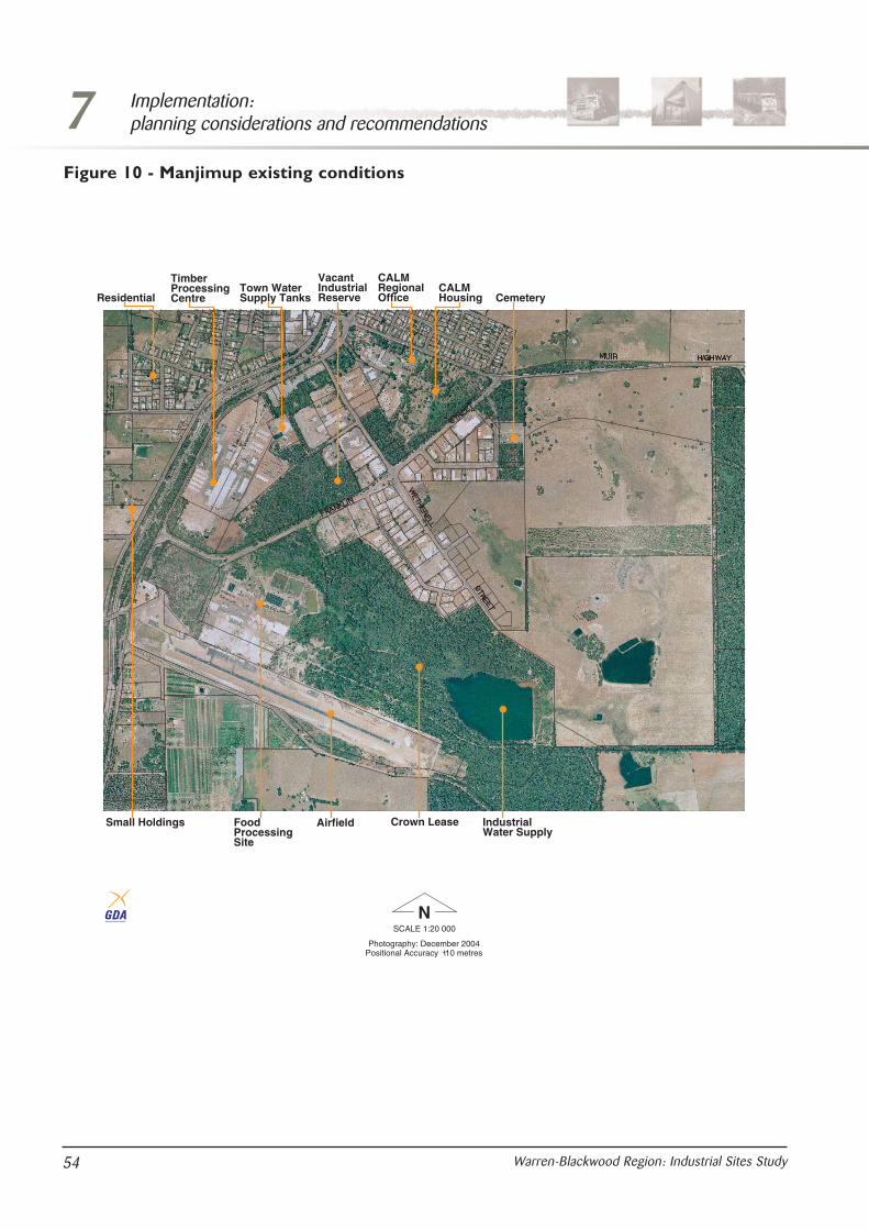
7 Implementation:planning considerations and recommendations
54 Warren-Blackwood Region: Industrial Sites Study
ResidentialTown WaterSupply Tanks
VacantIndustrialReserve
CALMRegionalOffice
CALMHousing Cemetery
TimberProcessingCentre
IndustrialWater Supply
Crown LeaseAirfieldFoodProcessingSite
Small Holdings
NSCALE 1:20 000
Positional Accuracy 10 metres+-Photography: December 2004
GEOCENTRIC DATUM OF AUSTRALIA
Figure 10 - Manjimup existing conditions

7Implementation:planning considerations and recommendations
55Warren-Blackwood Region: Industrial Sites Study
1
23
4
NSCALE 1:20 000 GEOCENTRIC DATUM OF AUSTRALIA
AIRFIELD
WATERSUPPLY
EXISTINGINDUSTRY
Figure 11 - Manjimup short-medium term

Recommendations
Site recommendations
84. That areas 1 and 2 be promoted for furtherindustrial use.
85. The purpose of the Crown lease for area 1should be altered to allow it to be developed forsuitable industrial purposes.
86. That area 2 should be promoted for timber andfurniture uses that will complement the existingprocessing centre. While area 2 is available inthe short term as a Crown lease, considerationshould be given to freehold conversion in themid term.
87. That area 3 be encouraged to develop for dryindustries (unsewered) on appropriate sized lots,subject to structure planning.
88. Area 4 is a long-term development option to beconsidered following the development of theother areas or development for an industrywhich may have site requirements not availablein the estate.
89. That the recommendations of the draftstructure plan for the timber processing site andarea 2 be implemented having specific regard tothe servicing requirements.
90. That area 4 be identified as investigation area inthe shire’s local planning strategy and remain asa special rural zone in the town planningscheme. That development of area 4 will requirean amendment to council’s local planningscheme.
91. It is not recommended that any private land beacquired by government. Purchase of the site fordevelopment is to be done by a proponent inagreement with the landowner and inconsultation with the council and the localcommunity.
Structure plan requirements and issues
92. Identify landscape characteristics to beprotected.
93. Identify sustainable water supplies (eithersurface or groundwater).
94. Outline the range of industries suitable for thesite (based on the definition of sub-regionalindustries), indicate suitable locations and sizeof lots for the intended use as demonstrated by
a land capability and emissions analysis for thesite.
95. Prepare a conceptual transport network toidentify servicing needs.
96. That a stormwater and drainage managementplan be prepared addressing such issues as: theprotection of drainage lines; adoption of DECguidelines for the protection of stream values;site discharge requirements; and nutrientretention.
97. Prepare a noise model to determine the extentof existing background noise and the likelyimpact on existing dwellings. Prepare amanagement plan that addresses issuesassociated with the location of the Manjimuptown site.
98. That a social impact statement be prepared toidentify issues relating to the values and issuesof the residents in the area.
Development issues
99. Council and the DPI should continue tonegotiate with the lessee of area 1 with a viewto converting it to freehold title in the midterm.
100. Existing vegetated areas along the SouthWestern Highway and Franklin Street shouldremain as buffer areas to the existing residentialdevelopment.
101. There is a need to prepare a long-term seweragecatchment plan incorporating areas 1, 2 and 4.
102. Development of any wet industry is likely torequire connection to sewerage.
103. That an environmental assessment andmanagement plan be required for any proposedindustry.
104. That special consideration be given to thedrainage of the existing developed industrialareas and the potential impact on the watersupply catchment for the food processing centre.
105. The potential to extend the transmissionnetwork to the site based on the needs andlikely loads generated by potential industry.
106. Development of sites with lot areas larger than4 ha must negotiate agreed load requirementswith Western Power.
107. To allow for short-term development identifythe options for light power use (100 kVa/ha)based on the specific uses where increased
7 Implementation:planning considerations and recommendations
56 Warren-Blackwood Region: Industrial Sites Study

power users are responsible for the cost ofupgrades.
108. That a flora and fauna survey be undertaken inarea 2 to determine the conservation values.
A notice of intention is prepared for the possibleremoval of vegetation in areas 1 and 2 whererequired.
109. That any development be required todemonstrate the likely demand for housing andsocial infrastructure in each townsite and theproposed measures to accommodate these.
110. A community relations plan should bedeveloped aimed at informing, consulting andinvolving key stakeholders and residents in thelocality.
111. Proposed developments should identify possiblelinkages to local business and services.
7Implementation:planning considerations and recommendations
57Warren-Blackwood Region: Industrial Sites Study

7 Implementation:planning considerations and recommendations
58 Warren-Blackwood Region: Industrial Sites Study

8.0 ConclusionsThe Warren-Blackwood region is highly productiveand this has characteristically focused on forestryand agriculture. The region has traditionallyengaged in the production of bulk commoditieswhich compete in large markets and are exportorientated. Over the past decade the region hascome under economic pressure from industryrestructuring, with considerable stress across thetraditional timber and agricultural sectors. Thestudy has been prepared to assist the region to gaina competitive advantage in attracting newbusinesses to the area, creating local economic andemployment benefits.
The objective of the study is to identify a suitablesite or sites for location of a sub-regional industrialestate and provide a framework for future attractionand accommodation of industry in the region. Theemphasis of the document is providing an industrialframework to accommodate potential sub-regionallevel industry (downstream processing) in theWarren-Blackwood region. This required evaluationof issues in respect to site establishment, planningfor infrastructure provision, buffer protection, wasteproduct management and transport co-ordination.
The document provides direction for localgovernment and the WAPC in preparing localplanning strategies and dealing with town planningscheme amendments for industrial proposals, andprovides a guide to industry regarding land use andplanning criteria essential for industry location andthe process which industry will need to undertakein gaining approvals and its ongoing responsibilityto the broader community. The study providesinformation to the community about the level ofindustry that should be located at the sitesidentified and an expectation that this should notbe compromised in the hierarchy of industryimportant for regional and state industrialdevelopment.
During the process of the study it became evidentthat the identification of a greenfield estate mightnot provide the best framework for attracting oraccommodating industry in the region successfully.Through the investigations it was demonstratedthat the initiation of the establishment of agreenfield estate without a catalyst industry orsupport from industry, community and governmentsupport would be a constraint to development in
the region. The following issues create uncertaintyin the process of securing and developing agreenfield estate and were taken into account:1. not having industries currently seeking to
establish in the area;2. community concerns;3. political and economic trends; and 4. the existing industrial hierarchy working to
attract industry to established locations.
The study therefore adopted an approach based onidentifying existing sites and new sites that havethe potential to accommodate sub-regionalindustries. In the site evaluation it was clear thatthere was a convergence of infrastructure provisionand transport options along the South WesternHighway corridor and the most suitable areas foradditional development would be in this corridor.
In all cases, provision of supporting infrastructure,such as securing suitable water supplies andadequate power supplies are important issues fordevelopment. Generally, the infrastructure in theregion is insufficient to cater for new developmentand the potential costs of upgrading may make newventures unviable without industry assistance. Thepotential cost to industry in having to establishessential services for development can be a very realthreat to the feasibility of a project and constrainsthe potential to develop industrial estates withoutconfirmed demand.
The study presents the Warren-Blackwood regionindustrial framework, which recognises unallocatedCrown land at North Greenbushes as a potentiallong-term sub-regional industrial estate. Inconsideration of sites with existing industry it wasidentified that North Greenbushes, Manjimup andHester have industrial expansion potential and thestudy recommends that these sites provide theshort-medium term opportunities for sub-regionalindustries and are classified as district industrialestates.
Further development of these options will dependon the need and demand from industry and ongovernment and community initiative and supportfor basic infrastructure. Identification of these sitesin local planning strategies is important to ensurethat the areas are protected from inappropriate usesthat would compromise future potential. Theframework proposed through this study isconsidered to give the region the greatest flexibility
8Conclusions
59Warren-Blackwood Region: Industrial Sites Study

in terms of location factors and development costsin catering for the range of economic scenarios.
It is also acknowledged that there will be situationswhere specialised industries require isolatedlocations that do not fit in the regional structure.These are able to be considered where they do notconflict with the principal planning objectives forthat location and reinforce the overall structure andinfrastructure investment.
8 Conclusions
60 Warren-Blackwood Region: Industrial Sites Study
APPENDIX 1
The Warren-Blackwood Region: Industrial Sites Study Steering Committee
Department for Planning and Infrastructure (Chair) Ms Janine Griffiths
Department for Planning and Infrastructure Mr Roy Johnson
Shire of Manjimup Mr Steve ThompsonMr Jim Lee
Shire of Bridgetown-Greenbushes Mr Tim Clynch
Shire of Nannup Mr Leigh Guthridge
Shire of Boyup Brook Mr William Pearce
South West Development Commission Mr Ashley ClementsMr Dominique VanGentMr Mike Barrett/MsGayle Gray
Department of Industry and Resources Mr Leigh Mathieson
Mr Tom Grigson
Conservation and Land Management (now DEC) Mr Peter Keppell
LandCorp Mr John Clifton(Until September 2003)Mr Peter TesorieroMr Graeme Watt
Warren Blackwood Economic Alliance Ms Anita Iuretigh(until October 2003)
Department for Planning and Infrastructure (until 2004) Mr Nigel Bancroft
Appendix 1
61Warren-Blackwood Region: Industrial Sites Study
APPENDIX 2
The Warren-Blackwood Region: Industrial Sites Study Community Reference Group
Warren Blackwood Economic Alliance
South West Aboriginal Land & Sea Council
Manjimup Chamber of Commerce and Industry
Manjimup Economic Development Committee
Manjimup Land Conservation District Committee
Tourism South West
Shire of Bridgetown-Greenbushes Council
Blackwood Valley Landcare
The Western Australian Farmers Federation
New Opportunities for Australian Horticulture
Warren Blackwood Business Assistance Centre
Blackwood Environment Society
Sons of Gwalia
Bridgetown-Greenbushes Chamber of Commerce and Industry
Sotico
Whittakers Timber Products
Community representatives (2)
Appendix 2
62 Warren-Blackwood Region: Industrial Sites Study

APPENDIX 3
Summary of submission issues – component 1
Appendix 3
63Warren-Blackwood Region: Industrial Sites Study
Factor Summary of issueComment
(includes community reference group and steeringcommittee comment)
OutcomesResponse
Transport Access to the site needs to beaddressed, particularly in respect tothe effect transport will have throughBridgetown. This should beconsidered in conjunction with theBridgetown bypass study.
Noted. Transport is an importantselection criteria. The site will beprocessing material which shouldreduce road traffic due to the smallerprocessed volumes or the use of rail.
Outcome of overallstudy to be provided toBridgetown bypassstudy.
The study to provide a broaderregional focus as the major focus forindustrial investment in the regionwill be the Bunbury Port.
Noted. The study has had regard toregional transport requirements.
No change.
Timber industry development will bemore regionally based withemphasis on transport linkages.
Noted. It is an importantconsideration and factor insuccessful development of theestate.
No change.Addressed.
The preferred site is located ondeteriorating road and rail assetsand is unlikely to be a successfulsite unless the government agrees toupgrade these assets.
Noted. A primary transport selectioncriteria relates to the South WestHighway transport corridor, wherefuture infrastructure funding will befocused.
To be furtherconsidered incomponent 2 of thestudy.
Buffer Delineation of the buffer is a criticalfactor in approval of the industrialsite.
The extent of the buffer area isconsidered in general terms of aminimum 500 m distance with thepotential for 1000 m. The generallocation of features within these radiiwill influence the ability of sites tomeet the criteria.
No change.
Buffer assessment needs to takeinto account effect on dwellings andconservation values.
The number of houses in the buffersat each site vary and have beenconsidered in evaluation of thecriteria. Allowance has been madefor Manjimup being an existingindustrial area. Concern regardingconservation values at Diamond Millbeing within the buffer are noted.
Requiresconsideration on sitespecific basis undercomponent 2.
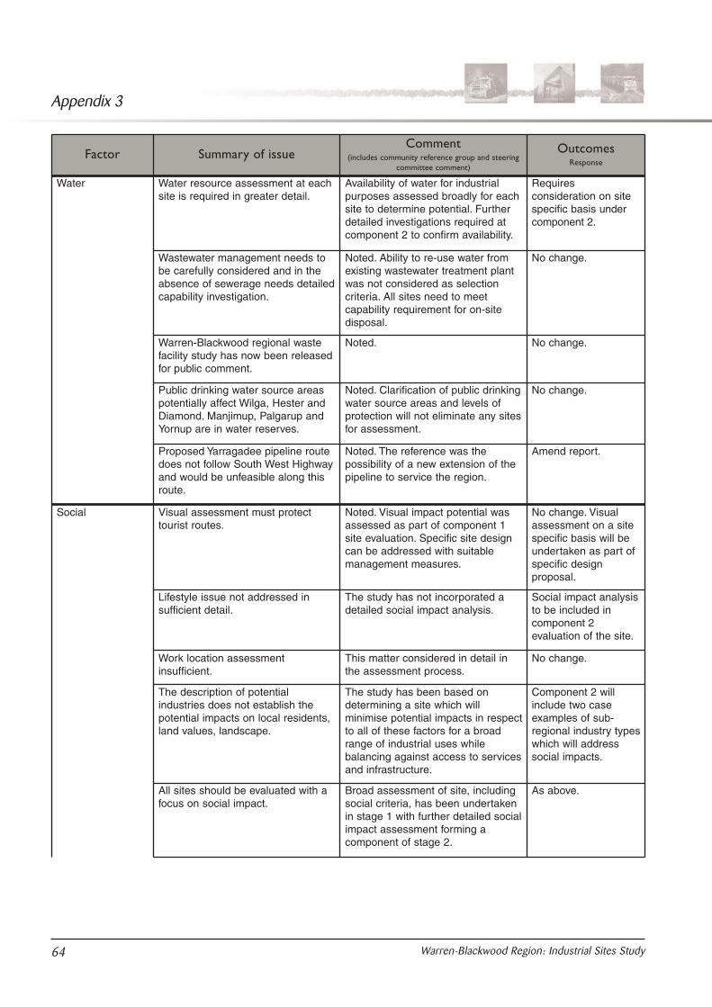
Appendix 3
64 Warren-Blackwood Region: Industrial Sites Study
The description of potentialindustries does not establish thepotential impacts on local residents,land values, landscape.
The study has been based ondetermining a site which willminimise potential impacts in respectto all of these factors for a broadrange of industrial uses whilebalancing against access to servicesand infrastructure.
Component 2 willinclude two caseexamples of sub-regional industry typeswhich will addresssocial impacts.
All sites should be evaluated with afocus on social impact.
Broad assessment of site, includingsocial criteria, has been undertakenin stage 1 with further detailed socialimpact assessment forming acomponent of stage 2.
As above.
Factor Summary of issueComment
(includes community reference group and steeringcommittee comment)
OutcomesResponse
Water Water resource assessment at eachsite is required in greater detail.
Availability of water for industrialpurposes assessed broadly for eachsite to determine potential. Furtherdetailed investigations required atcomponent 2 to confirm availability.
Requiresconsideration on sitespecific basis undercomponent 2.
Wastewater management needs tobe carefully considered and in theabsence of sewerage needs detailedcapability investigation.
Noted. Ability to re-use water fromexisting wastewater treatment plantwas not considered as selectioncriteria. All sites need to meetcapability requirement for on-sitedisposal.
No change.
Warren-Blackwood regional wastefacility study has now been releasedfor public comment.
Noted. No change.
Public drinking water source areaspotentially affect Wilga, Hester andDiamond. Manjimup, Palgarup andYornup are in water reserves.
Noted. Clarification of public drinkingwater source areas and levels ofprotection will not eliminate any sitesfor assessment.
No change.
Proposed Yarragadee pipeline routedoes not follow South West Highwayand would be unfeasible along thisroute.
Noted. The reference was thepossibility of a new extension of thepipeline to service the region.
Amend report.
Social Visual assessment must protecttourist routes.
Noted. Visual impact potential wasassessed as part of component 1site evaluation. Specific site designcan be addressed with suitablemanagement measures.
No change. Visualassessment on a sitespecific basis will beundertaken as part ofspecific designproposal.
Lifestyle issue not addressed insufficient detail.
The study has not incorporated adetailed social impact analysis.
Social impact analysisto be included incomponent 2evaluation of the site.
Work location assessmentinsufficient.
This matter considered in detail inthe assessment process.
No change.

Appendix 3
65Warren-Blackwood Region: Industrial Sites Study
Define the infrastructurerequirements for specific industrieswhich may be developed in theestate.
Noted. The capacity of infrastructureat the site will largely determine theindustry.
Range of potentialindustries to beprovided undercomponent 2 of thestudy. Two industrieswill be taken as casestudies undercomponent 2 whichwill address a broadrange of criteria,including infrastructurerequirements.
Community consultation consideredinsufficient.
Component 1 included consultationwith landowners, formation of acommunity reference group, generaladvertising and referral of a draftreport to local governments forconsideration.
No change. Includedconsultation strategyin parallel withpreparation of thestrategy.
Area is affected by two native titleclaims.
Noted. No change.
Future industries Bridgetown–Greenbushes is adeclared genetically modified freearea and will limit the types ofindustries that can be established.
Noted. This is a matter for thecouncil to address in its townplanning scheme and local planningstrategy.
No response.
Study does not clearly define thetypes of heavy industries that maybe permitted on the site. Thepotential impacts of major industryon the preferred site cannot bedefined objectively.
Noted. Each industry would besubject to an individual assessmentby the EPA, with the strategicassessment based on generalisedimpacts of potential industry types.The assessment of the preferred sitemay result in a limit on the types ofindustries that can beaccommodated.
Range of potentialindustries to beprovided undercomponent 2 of thestudy.
There is a contradiction between thepromotion of the pulp mill in theoriginal terms of reference and itbeing defined as a stand-aloneindustry in the report.
Noted. This relates to the originalstudy brief and the explanation ofthe industrial hierarchy as it wasrefined during the study.
Addressed undercomponent 2.
Factor Summary of issueComment
(includes community reference group and steeringcommittee comment)
OutcomesResponse

Appendix 3
66 Warren-Blackwood Region: Industrial Sites Study
Site assessmentmethodology
Heritage and waste disposalassessment are required to beconsistent and provide more detail ateach site.
The study is a comparative balanceof the issues and consideredadequate given the strategic natureof the study. There is an element ofsubjectivity with all of the criteriabecause:• the ability of a site to meet
individual selection criteria is notabsolute and compliance is aquestion of degree; and
• the study did not identify a specificlocation at each site.
Group addressed anddiscussed each pointraised in submission 2and noted that anyissues and identifiedinconsistencies wouldbe clarified in theoverall comprehensivedraft report which willinclude outcomes fromcomponents 1 and 2.
Require more detailed assessmentprocess.
As above. A more detailedassessment of the preferred site willtake place in component 2.
As above.
Implementation Council must remain the approvalagency.
Noted. Community reference groupemphasised that council should beapproval agency for industrialdevelopment.
Level ofimplementation to beaddressed throughcomponent 2.
Opposed use of state agreements. Community reference group raisedconcerns with the use of the stateagreement acts, which should not beused to override the powers of localgovernment.
As above.
Factor Summary of issueComment
(includes community reference group and steeringcommittee comment)
OutcomesResponse
Preferred sites:comparativeanalysis
Opposed to industry at Yornup as itwould adversely affect lifestyle andthe rural character of the area.
Noted. To be considered inmore detail whereappropriate undercomponent 2.
Opposed to Boyup Brook area beingacquired or developed for industrialpurposes.
Noted. As above.
Hester and Greenbushes should beretained as suitable locations forestablishing industry.
Noted. As above.
Opposed to further development atGreenbushes-North Greenbushes.
Noted. As above.
Endorses Yornup as the preferredsite.
Noted. As above.
North Greenbushes and Hestershould also be promoted fordevelopment.
Noted. As above.
Although Yornup is a central point inthe region, sub-regional industriesare more likely to locate closer to thesource.
Noted. As above.

Appendix 4
67Warren-Blackwood Region: Industrial Sites Study
1 Long-termsites
5 Please considerthe unallocatedCrown land atNorthGreenbushes orcleared areas ofstate forest inYornup.
Upheld. Unallocated Crown land at NorthGreenbushes has been identified for furtherinvestigation and consideration as a long-termstrategic industrial estate under the study’sindustrial framework. Yornup and NorthGreenbushes have been identified as potentialareas for consideration of a strategic industrialestate in the future. These sites have beenidentified to provide an option to industry,government and the community. The regionalframework will only sustain the development ofone strategic industrial estate and based on thecriteria, which include proximity of the site toroad and rail infrastructure and location ofexisting industry and service infrastructure, theunallocated Crown land at North Greenbusheshas been recognised as the preferred site forpromoting the development of a long-termindustrial estate.
Report modified insections necessaryto reflectrecommendation.
1a
1 Should areas 2and 3 impinge onprivate residentsand agriculturalindustries.
Noted. Unallocated Crown land at NorthGreenbushes has been identified for furtherinvestigation and consideration as a long-termstrategic industrial estate under the study'sindustrial framework. The regional frameworkwill only sustain the development of onestrategic industrial estate and based on thecriteria, which include proximity of the site toroad and rail infrastructure and location ofexisting industry and service infrastructure andthe fact that it is in government ownership, it isrecommended that the unallocated Crown landat North Greenbushes be recognised as thepreferred site for promoting the development ofa long-term industrial estate. Area 3 is an areaof logical extension and should not bedismissed, even though it is in privateownership. Area 3 should remain in theframework for future consideration of industrialdevelopment.
Report modified insections necessaryto reflectrecommendation.
1a
3 Object to long-termoptions areas 1-3.
1 Object to area 2 ofthe long-termoptions for NorthGreenbushes.
1 Areas 1 and 3 ofthe long-termoptions should bethe only areasconsidered.
Issues/siteSummary ofcomment
Steering committee and communityreference group recommendation
Rep
ort
reco
mm
enda
tions
Freq
uenc
y
Ass
essm
ent
crite
ria
APPENDIX 4
Summary of submission issues – final draft

Appendix 4
68 Warren-Blackwood Region: Industrial Sites Study
2 Short-termsites
1 Does not supportshort-term optionsarea 1 for NorthGreenbushes andtransitional areaswhererecommendationswill have an impacton existingindustrial uses.
Dismissed. Detailed structure plans will not berequired for land already zoned industry, unlessit is a structure planning requirement from thelocal government under the provisions of itstown planning scheme. Structure plans will berequired for expansion of industrial zoned landinto area 1. Recommendation 7 in the reportwill be deleted and the transitional areaidentified on figure 11 which encroaches overexisting zoned land will be removed andreplaced by a buffer area in which industrialland uses will not be permitted. The bufferareas will be used for rural land uses only andthe addition of sensitive land uses in theseareas will be discouraged.
Further clarificationrequired, updateplans.
1b
3 State forest 2 An industrial areashould bedeveloped at theolder mining areasin theGreenbushesmineral field.
Opinion noted. The land will not be consideredfor industrial development as it is state forestland and state government legislation preventsthis from happening.
No change. 3e
4 Environmental 2 Existing industrycan be heard andsmelt from nearbyresidents and is atcapacity given thesurrounding uses.
Comment noted. Non compliance of existingindustry is outside the scope of the study. Thelocal government and the DEC are required toensure compliance with requirements andlegislation. The study recommendations ensurethat acceptable environmental parameters areconsidered throughout the planning andenvironmental processes.
No change. 2a
1 No substantiationthat the vegetationis underrepresented in theregion.Recommendationin the report statesno clearing ofvegetation, thenwhy choose area 1short-term optionas an investigationarea?
Noted. Seek further clarification from the DECin relation to recommendation 9 (NorthGreenbushes) of the study. The study hasidentified areas at a desktop level andrecommends that detailed studies take placeas part of the structure plan, rezoning anddevelopment application stage. (Area 1 appearsto contain re-growth vegetation, this will needto be confirmed.)
No change. 2b
1 Short-term areas 1and 2 will affectresidences to thenorth.
Noted. Environmental impact assessment willtake place prior to any development.Development will be managed in a sustainablemanner to ensure minimal impact on theenvironment and compliance with theEnvironmental Protection Act 1986 and otherenvironmental legislation. Structure plans willbe prepared and adopted incorporatingadequate buffer areas as per therecommendation above.
Further clarificationrequired.
1b

Appendix 4
69Warren-Blackwood Region: Industrial Sites Study
2 Identify DumplingGully Dam onfigures 7 and 8. Itsupplies Balingupand Greenbusheswater supply.
Comment noted. Maps will be amended toinclude existing infrastructure and catchmentboundaries.
No change. 1b
1 How will waste bedisposed off?
Any waste disposal will take place inaccordance with DEC and local governmentrequirements and has been identified as aspecific issue in the report. Waste disposalrequirements are dependant on industry andwill be addressed on a case-by-case basis.
No change. 3c
72 Concerns ofpollution and theeffect on lifestyle,impacts onvegetation,watercourses, ofexisting andproposedindustries.
7 And expansion ofindustry in any ofthe investigationareas will affect thechosen lifestyleand environment ofthe area.
2 Carefulenvironmentalplanning is criticalto any heavyindustry proposal.
Noted. Each stage of the planning processrequires consideration of environmental valuesand the relevant environmental managementresponse. The report identifies that preparationof storm water and drainage managementplans address issues of drainage lines,protection of stream values, site dischargerequirements and nutrient retention will berequired in development of a structure plan.Any scheme amendment process will require(in)formal assessment by the EPA.Environmental impact assessments will beundertaken prior to development anddevelopment will be managed in a sustainablemanner to ensure minimal impact on theenvironment and compliance with theEnvironmental Protection Act 1986, otherenvironmental legislation and associatedregulations. A flow chart will be included in thereport to explain the processes involved.
Further clarificationrequired.
1b
13 Object toexpansion ofindustry at NorthGreenbushesindustrial estate.Concern ofpollution, dust,noise and damageto water systems.
Noted. Land already zoned for industrialdevelopment and under the existing schemewill be allowed to develop further in accordancewith scheme requirements. Each stage of theplanning process requires consideration ofenvironmental values and the relevantenvironmental management response. Thereport identifies that preparation of stormwaterand drainage management plans, noise modelsand identification of buffer requirements will berequired in development of a structure plan.Any scheme amendment process will requirethe formal or informal assessment of the EPA.Environmental impact assessments will beundertaken prior to development anddevelopment will be managed in a sustainablemanner to ensure minimal impact on theenvironment and compliance with theEnvironmental Protection Act 1986.
A flow chart will be included in the report toexplain the processes involved.
Further clarificationrequired.
1b

Appendix 4
70 Warren-Blackwood Region: Industrial Sites Study
1 Noisemanagementmeasures are dealtwith throughexisting legislationand do notrequired furtherconsideration.
Comment noted. Local government and theDEC are required to ensure that existingindustries comply with requirements andlegislation. However, where future structureplans are required, noise management will beconsidered as part of the environmentalmanagement considerations that will underpinfuture planning processes. The studyrecommends that future planning of the areaconsiders management measures for a bufferarea to separate industrial and sensitive landuses.
No change. 3c2b
6 General anddevelopmentissues
1 Proposed industryin existing zonedareas should nothave to addressthe structureplan/requirementsof the study, asplanning anddevelopment inexisting zoned landis governed byregulations.
Any proposed industry will need to comply withlocal and state government requirements.Detailed structure plans will not be required forland already zoned industry.
No change. 1a
5 Transitionaland bufferissues
3 Transitional areasare not consideredfor development oflow impactindustry.
1 The transitionalarea/ bufferalready includesthree home sites.
1 Concern that thereare inadequatebuffers.
Noted. The transitional area should be referredto as a buffer area. The report will review theterminology of ‘transitional area’ and nominatea buffer area that may discourage the additionof sensitive land uses and also discourageadditional industry that is not associated withrural uses. In essence, the concept planindicates that there may be an impact on thearea by the adjacent industry, however shouldnot have an impact on its use as rural land asdesignated under the scheme.Recommendation 7 will be amended to deleteconsideration of transitional industries andconsider management measures for the bufferarea (that is vegetation buffers, limitingadditional sensitive land uses).
Editing to addressconcern.
1a
1 Figure 11 showsBlueleaf’s landlargely in thetransitional area orinvestigation area1. That land iszoned andoperates asindustry under thecurrent townplanning scheme.This needs to bereflected in thereport.
Comment noted. Plans will be amended toreflect this, as per the previousrecommendation.
Plans amended. 1b

Appendix 4
71Warren-Blackwood Region: Industrial Sites Study
2 Should reflectindustrial zoningsfor the short-termoptionsimmediately intown planningscheme and therezoning processfor the long-termoptions should becommenced.
This study is a strategic document to provide aframework for local governments, developersand/or potential industries to be aware ofissues and to consider the potentialdevelopment of sites. Local governments mayincorporate the study recommendations intolocal planning strategies and schemes. Schemeamendments will only be initiated if anapplication for development is received by thelocal government. The report will be amendedto include the existing industrial land uses andzonings. Initiation of a greenfield industrialestate would require a catalyst industry and/orcommunity, government and industry support.
Further clarificationrequired.
1b
7 Type ofindustry
3 What is thelikelihood of awoodchip plantbeing consideredin this area?
No specific industry has been identified. Thestudy considers the location of sub-regionallevel industries, which are moderatedownstream processing industries, relative toproduce in the region. The intermodal facility atNorth Greenbushes is associated with WesternAustralian Plantation Resources (WAPRES)and government funding has been allocated forits construction and operation.
No change. 2a
4 What type ofindustries are likelyto operate here?
No specific industry has been identified. Thestudy considers the location of sub-regionallevel industries which are moderatedownstream processing industries, relative toproduce in the region.
No change. 3c
1 There are othersites more suitable(that is, the area tothe north wherethe South WestHighway crossesthe railway north ofHay Road, or areasouth where therailway crosses theBoyup BrookRoad).
Dismissed. The study has identified areas forfuture consideration based on a number ofselection criteria. The site selection criteriawere applied to identify areas suitable forfurther consideration. Other sites wereeliminated due to various constraints.
No change. 3e
3 Previous industrialdevelopments havebeen rejected bythe residents.
Noted. Previous proposals for rezoning of landto expand were rejected due to the lack of astrategic planning document to provide acontext and justify consideration of expansion.This study identifies the issues and providesthe framework for consideration of industryexpansion in the region.
No change. 3e
1 Any furtherindustry should belimited in operationto 6.30am –7.00pm.
The details of operation will be considered bythe local government at the time ofdevelopment approval and in view of approvednoise management and environmentalmanagement plans.
2a2b

Appendix 4
72 Warren-Blackwood Region: Industrial Sites Study
9 Infrastructure,power andwaterservicing
1 Should not limit itto dry industries asthere is plenty ofwater availablefrom scheme, damand groundwatersources.
Noted. The study has identified land suitablefor industrial development. There are nospecific industries selected. Intended industriesare for downstream processing. Wateravailability and potential to provideinfrastructure will determine nature of industry(that is, wet/dry).
No change 3c
1 Power supplyneeds checking.
Each individual industry will have differentrequirements for power. Each developmentproposal will have to undertake its ownassessment. More specific details and studieswill be undertaken at structure plan stage.
No change 3e
1 Non-powerindustries arerelevant to thecurrent situation.
Each individual industry will have differentrequirements for power. Each developmentproposal will have to undertake its ownassessment.
No change 3e
8 Transport 1 No heavy haulagenorth of the mill onGrimwade Roadand operatinghours for trucksand logs on railbeing provided tothe community.
9 Concerns relatingto impacts ofincreased traffic onGrimwade Road.Heavy haulagetrucks conflict withschool buses.
19 Road/rail/intermodal facility mustprovide assurancethat no movementof haulage truckstake place onGrimwade Road,as it servicesresidential areasand is used byschool buses.Traffic planning inthis area needs tobe carefullyconsidered forexpansion ofindustry.
Noted. Each individual industry will generatedifferent traffic movements and volumes. Trafficmanagement will be addressed throughout theplanning process and specific managementplans will need to be submitted to the localgovernment for consideration and approvalprior to introduction of new industry.Furthermore, the State Government hasallocated significant funding for the upgradingof existing roads and rail.
Current traffic issues and concerns are beingaddressed by Main Roads Western Australia(MRWA) and the shire and are outside thescope of this study. MRWA supports that allroad trains bringing timber from the north-eastto use the Donnybrook-Boyup Brook Road thenthe Boyup Brook-Greenbushes Road. TheShire of Bridgetown-Greenbushes can prohibitthe use of road trains along the GrimwadeRoad and other minor roads in the shire toensure the Main Roads preferred route is used.A statement regarding preferred heavy haulageroutes should be included in the report.
That the report be amended to include specificreference to Grimwade Road in preparation ofconceptual transport network. That the functionand management of Grimwade Road be givenconsideration in the traffic management planassociated with the servicing needs for long orshort-term industrial areas that result inrezoning of land; and these considerations beaddressed at structure plan and developmentphases for the identified sites.
Include statementof clarification.
1b
1 The railway systemneeds repair.
Noted. The State Government has announcedthat it will allocate more than $10 million for theestablishment of an intermodal facility at NorthGreenbushes. The railway system betweenNorth Greenbushes and Bunbury Port will beupgraded to accommodate this facility.
No change 3e

Appendix 4
73Warren-Blackwood Region: Industrial Sites Study
Social
Economic
1 The site isserviced byscheme water. Thestudy doesn’tmention this.
More detailed studies will take place at thestructure plan stage to determine theavailability of water at each location.
No change 3c
10 2 Who would beresponsible forsupplying housingand socialinfrastructure?
The local government will earmark areas forresidential development in its local planningstrategy and its planning scheme. Demand forthese areas will dictate their development. Thereport recommends that industries demonstratethe housing and social infrastructure needs toaccommodate future work force.
No change 3c
1 The property willnever be for saleand has been inthe family for 117years (area 3NorthGreenbushes).
It is not intended that there will be governmentintervention with the acquisition or resumptionof land. It is up to the individual developers orindustries to acquire the land and proceed withthe approval process.
Furtherclarification,however nochange torecommendation.
1b
3 NorthGreenbushescommunity has notbeen appropriatelyconsulted.
Noted. Community consultation has beenongoing throughout the entire process,including the formulation of communityreference groups to act as conduits betweenthe community and the steering committee,public meetings have been held, individualcontact has taken place, displays held at thelocal government offices. A request has beenreceived at the public meeting for the formationof a North Greenbushes community committee.It is recommended that the group be formed aspart of the consultative process in addressingsubmissions received.
No change 3e
7 Concerned aboutthe impact futureindustry will haveon property valueand lifestyle
Noted. Section 4.0 provides an understandingof the potential for impacts that may result fromintroducing industry into the area. Impacts onthe surrounding land uses will be addressedthrough the planning processes (through theintroduction of adequate provisions in planningschemes and adequate managementmeasures.
No change 3c
2 Accept existingindustry, howevernot an expansion.
Noted. No change 3e
1 Impacts onpotential touristactivities.
Noted. No change 3e
1 Do not believe thatthe type of industryconsidered willimprove theeconomic situationand will actuallydeter people frommoving into thearea
Comment noted. No change 3e
11

Appendix 4
74 Warren-Blackwood Region: Industrial Sites Study
Criteria for analysis of key issues raised in submissions
1. The report recommendations were amended where the comments:
a) proposed a change that would achieve a better outcome;
b) provided additional information or indicated need for additional information related to omissions, inaccuracies or alack of clarity.
2. The report recommendations were not amended where the comments:
a) introduced issues beyond the scope of the study;
b) introduced issues to be addressed in implementation of the future planning proposals.
3. The comments were noted but did not result in an amendment to the report where the comments:
a) clearly supported the recommendation;
b) offered an unclear or a neutral statement;made points already included in the report;
d) were among several widely divergent viewpoints received and it was considered that the existing recommendationsprovided the best option;
e) offered comment or critique which is noted;
f) requested clarification.