walpole, a mystery island in southeast new caledonia? - australian
TRANSCRIPT

© Copyright Australian Museum, 2004
Walpole,A “Mystery Island” in Southeast New Caledonia?
CHRISTOPHE SAND
Archaeology Department, New Caledonia Museum,BP 2393, 98846 Noumea, New Caledonia
ABSTRACT. Walpole Island, the southernmost island of Melanesia, is a spectacular raised limestoneformation 135 km south of the Loyalty Islands within the New Caledonian archipelago. Occupied byenormous numbers of seabirds when the first westerners landed, this rocky spot was mined for guano.Workers frequently reported archaeological finds that indicated prehistoric occupation and an earlycollection of artefacts was sent to the Australian Museum in Sydney. Over the last 30 years, research onthe archaeological heritage of the island has been carried out through the study of museum collectionsand excavations. This paper reports the results of recent stratigraphic excavations, and synthesizes currentarchaeological knowledge about the human occupation of Walpole spanning at least 2,500 years.
SAND, CHRISTOPHE, 2004. Walpole, a “Mystery Island” in southeast New Caledonia? In A Pacific Odyssey:Archaeology and Anthropology in the Western Pacific. Papers in Honour of Jim Specht, ed. Val Attenbrow andRichard Fullagar, pp. 109–122. Records of the Australian Museum, Supplement 29. Sydney: Australian Museum.
Records of the Australian Museum, Supplement 29 (2004): 109–122 ISBN 0-9750476-3-9
www.amonline.net.au/pdf/publications/1407_complete.pdf
During the last two decades, Melanesian and Polynesianprehistory has come of age (Kirch, 2000). Jim Specht wasa pioneer with an insatiable drive to explore new directionsin Pacific prehistory. Amongst numerous other projects, heinitiated modern archaeological studies of the pre-Europeansettlement on Norfolk Island (Specht, 1984). Beforediscovering Norfolk on the 5th October 1774, James Cookput a new archipelago on the European map—NewCaledonia (Beaglehole, 1961). One week previously he hadpassed just out of sight of a small uplifted coral island, atthe southeastern tip of the Grande Terre. Its name, given afew decades later, is Walpole.
Very few people know of this island at the southernmostpoint of Melanesia. Although Walpole appeared as a“mystery” early in the literature (see Sand 2002: 14 for areview), it is not normally listed in studies of the Pacific“mystery islands”, which focus only on Polynesia andeastern Micronesia (Bellwood, 1978: 352–353; Kirch, 1988;but see Di Piazza & Pearthree, 2001: 165). A historical
connection links Walpole to the Australian Museum inSydney, where the oldest archaeological collection from theisland is stored. In this paper I summarize the historicaland archaeological data of Walpole and propose a tentativechronology.
“Mystery Islands”: a short review
When European navigators started to systematically explorethe Pacific, they visited uninhabited islands with signs offormer human occupation, like Pitcairn in East Polynesia,and Norfolk off eastern Australia. These abandoned islandswere mostly in Polynesia (Kirch, 1984: table 9), althoughsome east Micronesian islands were also identified (Terrell,1986: fig. 28). The “mystery” of their pre-historic settlementand abandonment led to early research (e.g., Emory, 1928,1934). As Kirch (1984: 89–92, 1988) pointed out, althoughall these “mystery islands” were grouped on the basis ofisolation, resource scarcity and absence of occupation at

110 Records of the Australian Museum, Supplement 29 (2004)
European contact (Bellwood, 1978: 352–353), there arehuge differences in size, geographic location and naturalenvironments.
First archaeological surveys in the early twentieth centuryshowed a Micronesian-Polynesian cultural origin based onthe presence of marae, ahu or diagnostic stone tools.Excavations dated these occupations to between 1,000 and500 B.P., with most being abandoned soon after 500 B.P.More importantly, Kirch (1985: 89–98) showed that some,like the 23 ha Necker Island 500 km off Kauai in leewardHawai’i, were occupied for a single generation (Kirch, 1988:30), whereas the larger 77 ha neighbouring island of Nihoa,only 250 km from Kauai, probably had a longer humanhistory. Although Necker and Nihoa were remembered inoral traditions (Kirch, 1985: 89) (as were other uninhabitedislands) and showed a classic prehistoric Polynesianoccupation, they were classified as “mystery islands”.
More recent studies of the “mystery islands” concentrateon three regions:• In the southwestern Pacific, research on sub-tropical
Raoul and Norfolk Islands, has shown the existence ofan inter-voyaging network between smaller and biggerislands during the first millennium B.P., in some casesover distances of more than 1000 km, before abandon-ment (e.g., Anderson, 2000; Anderson & McFadgen,1990; Anderson et al., 1997).
• In sub-tropical eastern Polynesia, Weisler (1994, 1995,1996a,b) conducted an extensive program on theMangareva-Pitcairn group. Around 500 B.P. interactionceased and consequently about 200 years later thePitcairn group was abandoned by Polynesians (Weisler,1998).
• Finally in the central Pacific, two teams (Anderson etal., 2000; Di Piazza & Pearthree, 2001) have conductedresearch on the windward Line Islands, concentratingon Kiritimati (Christmas Island) and Tabuaeran (FanningIsland). Interestingly, although both conductedexcavations essentially on the same sites on Kiritimati,their proposed conclusions are very different. Andersonet al. (2000: 289) view settlement of the large atoll duringthe first half of the first millennium B.P. as occurring onlyonce, being continuous, substantial, and not related to awider inter-island interaction sphere, before “acombination of environmental hazard, tenuous horti-cultural productivity and unsustainable harvesting of thenatural resources, produced, eventually, a subsistenceenvironment that was no longer attractive to settlement,even one unable to sustain settlement”. In contrast, DiPiazza & Pearthree (2001: 164) see Kiritimati as a stagingpost on long regional voyages, and as a regularly visited“satellite” island for bird and turtle hunting from aneighbouring “mother community” in Tabuaeran, butwithout permanent settlement.This final example shows how much even the first step
in interpreting “mystery islands” can vary immensely.Accordingly, reasons advanced for abandonment arenumerous and certainly do not apply in the same way toeach island. Weisler (1996a: 627) has listed five reasons toexplain small population extinction: demographic andenvironmental stochasticity, natural catastrophes, inbreed-ing, and social dysfunction (like political threat andcessation of inter-island voyaging). On small, barren NeckerIsland, the whole history might have just involved a canoe
castaway, with the survivors trapped. On large, fertile islandslike Pitcairn, Raoul or Tabuaeran, the reasons for departuremight relate to local environmental and social conditions.As Kirch (1984: 90) summarizes: “Why such larger andfertile islands should have ceased to be occupied is indeeda mystery, though either demographic instability, or thedepredations of internal conflicts are conceivable causes forextinction”. The Rapa Nui case shows how internal stress couldlead to political uncertainty in Polynesian communities (Bahn& Flenley, 1992).
In island Melanesia, far less attention has been placedon unoccupied islands, and the small island of Anuta is atpresent the only one where a possible period of prehistoricabandonment, before resettlement, has been identified(Kirch, 1982). For southern Melanesia, only the remoteuninhabited islands of Hunter and Walpole have receivedsome attention, each showing very different types ofremains. On Hunter Island, a small 1 km wide cone ofvolcanic origin located south of Vanuatu, three structuresof human origin were partly studied by geologists (Lardyet al., 1988). The major site is a rectangular 11 m by 7 mstructure with a 1.2 m high and 70–80 cm thick stone wall,and a possible pavement buried about 30 to 40 cm deep. Atypical oceanic rounded net-sinker with a central groovewas found in this undated structure. Nearby, a smaller 4 mby 4 m wall located in the only part of the island wherecultivable soils are present was interpreted as a possiblegarden. Finally, a stone cairn about 1 m high was identifiedin the only cave where fresh water (rich in calcium sulphate)is present. No definitive origin for these remains can begiven as they might be related to pre-historic short-termoccupation, as well as recent historical whaling (Lardy etal., 1988: 46–48). In archaeological terms, Hunter Island(named Fanuamanu, the birds’ island, by the people ofnearby West-Futuna) has more in common with a “mysteryisland” like Necker than with closer examples like Raoulor Norfolk.
Walpole’s environmental setting
Walpole Island is the southernmost outpost of the LoyaltyIslands chain. Positioned 22°36'S 168°57'E, it lies 140 kmeast of the Isle of Pines and 135 km southeast of Maré (Fig.1). The uplifted coral platform rises to a height of morethan 80 m in some places and has a probable volcanic core.
Fig. 1. Location of Walpole Island in the New Caledonianarchipelago.

Sand: Walpole, Southeast New Caledonia 111
Successive uplifting and erosion during the last 400,000years have created a long narrow island, about 3.5 km longand between 300 and 900 m wide (Fig. 2). The centre ofWalpole is a flat plateau, surrounded by steep cliffs fallingtowards the sea (Fig. 3). On its southwestern andnorthwestern leeward sides, there is a narrow flat area thatcan be used for landing in calm weather. The heavy waveson the windward eastern side prevent landing by boat.
Fig. 2. Walpole Island, with the locations of the surveyed sites.The positions of the sites recorded by the treasure hunters areapproximate only.
Fig. 3. Aerial view of the central and northern part of Walpole, showing the central plateau, the high cliffs and thenarrow coastal zones.
The island has no permanent streams, and the rainwaterdrains into the porous soil, sometimes accumulating infreshwater pools in deep caves. In a few areas a thin surfacesoil has been formed by decomposing leaves. The only othernon-calcareous soil is guano from the nesting birds.
The remote position of Walpole and its extreme geologyhave led to a particular natural environment. Although thereis an area of medium deep sea floor on the western side, theocean around Walpole is not known for its richness in fishinggrounds. The number of fish species is more limited than inthe other parts of New Caledonia (Sand, 2002: 38–39). Theformer diversity of local flora has probably been muchreduced by recent exploitation of guano soils (Renevier &Cherrier, 1991). On the southern and central parts of thecentral plateau, very degraded by mining, only a shortscrubby vegetation is present, whereas pandanus and othercoral-adapted trees grow on the lower plateaux. The onlywell-preserved remnant of forest occurs on the unexploitednorth of the plateau, where endemic species, hardwoodspecies and symbolic oceanic trees like banana survive(Sand, 2002). Seabirds, the dominant fauna, nest on the lowbushes, in trees, or in various natural holes in the upliftedcoral. Endemic land birds, lizards, and insects are rare.Walpole was the first place in the archipelago where hornedturtle (Meiolania) bones were found (Balouet, 1984).
History of Walpole
Walpole Island was first placed on a modern map on 17thNovember 1794, when the English captain Butler passedby and gave it the name of his ship. Surrounded by seacurrents used by whales during winter migrations, Walpolewas frequented by whalers early in the nineteenth century.Captain Herskine is the first European reported to havelanded on the island in 1850 (Chevalier, 1976).

112 Records of the Australian Museum, Supplement 29 (2004)
At the beginning of the twentieth century, the high qualityguano on Walpole led to the industrial exploitation of thisnatural fertilizer, the major player being the Austral GuanoCompany Limited. Between 1916 and 1941, up to 300people lived on the island, with contact to the mainlandonly every three to four months. Over 100,000 tons of guanowere extracted. Europeans, Kanaks and Asians worked inthe extraction areas and the local factory. Meat was importedin tins, and very fertile gardens were cultivated (Chevalier,1976). “One year was enough to have bananas, everythinggrew” (Sintès, 1988: 14). During their free time on Sundays,the workers explored the cliffs, looking especially for birds’eggs. However, they also discovered evidence of earlieroccupation in the low shelters, confirming observations ofhuman structures on the central plateau. Skeletons were foundin caves, and various shell and stone artefacts were collected,all indicating the existence of a “mysterious civilization”. In1929, an anonymous writer published his discoveries in theChina Journal of Shanghai. His testimony is worth reading infull, as the objects and structures he describes have mostlyvanished, and it is reproduced in an appendix to this paper.
If the early Europeans had consulted the Kanaks, theywould have heard stories about Walpole; to my knowledge,three have been recorded. The first two are from the nearestislands to Walpole—Isle of Pines and Maré—and werepublished by the ethnographer J. Guiart (1963: 207). Onedescribes two canoes adrift between Maré and Isle of Pines.The first canoe was lost at sea. The second landed on emptyWalpole, where its crew constructed a new canoe from twoCasuarina trees, and set sail to the west. In the other storyTongan sailors stopped on uninhabited Walpole beforesettling on Isle of Pines and Lifou, probably in the 1820s or1830s as the tradition is linked to the arrival of Christianity.The third story, recently recorded on Maré (Sand, 2002:42), is more mythical and tells of two men setting sail tomarry the queen of Walpole, an island possibly called Hacolo (“turn its back”) in Nengone (Maré) language andwhere only women were living.
At the end of the Guano mining period new talescirculated about the Walpole discoveries. One was that aKanak worker had found the remains of European sailorsin a cave with pieces of cloth and a canoe. With them was abutton that was supposed to bear a “fleur-de-lis” design,the emblem of the French king. In the early 1960s, Pognon,a local amateur historian, inferred from the button thatWalpole was the place where Laperouse was shipwreckedafter leaving Vanikoro. Another local historian wrote thatthe Peruvian captain Robertson had hidden his fabulousgolden treasure (which he stole from the British in 1826)on Walpole. Others claimed that the human bones were theremains of convicts escaped from Tasmania (Sintès, 1987).Although amusing now, these stories were taken seriouslyby some people at the time.
Archaeological fieldwork and treasure hunting
The island was first archaeologically surveyed between thelate 1960s to early 1970s by the former director of the NewCaledonia Museum, Luc Chevalier. During five short stays,he found the remains of pre-European settlements withassociated human remains, shell adzes and wooden objects.Working in southern Melanesia, R. Shutler Jr. startedcollecting information about Walpole, made the first study
of the Australian Museum collection, and in the early 1980ssubmitted three samples from the Chevalier collection forradiocarbon dating (Sand, 2000a).
Unfortunately, each time Chevalier visited Walpole, theweather turned to rain and wind, necessitating departureafter only two days (Nunn, 1967). However, worse was yetto come. In 1993, a team of “treasure hunters” spent onemonth on Walpole to find traces of Laperouse, collectprehistoric remains of the “mysterious civilization”, and findhidden treasures (Letrosne, n.d.; Sand, 2002). They exploredmost of the rockshelters in the cliffs and systematicallyemptied those where stratified in situ deposits had beenpreserved, excavating five sites on the east coast (Fig. 2).Their activities resulted in huge destruction, although onlysome of the objects were brought back to Noumea. Theavailable written reports suggest they collected all surfacematerial, and mapped some surface “hearths” and “workingfloors”. They also indicate stratigraphies up to 30–40 cmdeep, with in situ materials like hearths, ornaments and shellartefacts. The richest site (No. 5, called “The Women’sCave”), located in a niche at the base of the cliff, containedworked bone points, shell artefacts and food remains.
The New Caledonia Museum managed to recover someof the archaeological material from these unauthorizedexcavations only after a long battle. The most interestingobjects were kept by the treasure hunters and so thecollection, recently published (Lacroix, 1998; Sand, 2002),allows only a partial view of the island’s archaeology. Inthe mid-1990s, I went to Walpole twice to evaluate thedestruction caused by the treasure hunters, to make apreliminary survey (Fig. 2) and to conduct the first scientificexcavations (Sand, 1995a; Sand, 2002). This recent visitshowed a deplorable destruction of the deposits by the treasurehunters, particularly in Site No 5 where huge amounts ofarchaeological material were abandoned in the cave andscattered along the outside path. Some stratified deposit hashopefully survived, but this is yet to be confirmed.
Most of the large rockshelters are at the base of cliffs,beyond wave action, and have archaeological depositsconsisting of sediment and ashes, up to 60 cm deep. In somecases there are successive stratigraphic layers, indicatingregular use of these sites over a relatively long period.Although no pollen samples have been studied to date,samples from some rockshelters could enable thereconstruction of local vegetation changes. During my firststay, I excavated 50 by 50 cm test pits in four locations. Thesediments were not screened but soil samples were taken fromeach layer. A summary of the collected data follows:
Site LWR003. A rockshelter with a 20 sq m floor, locatedabout 30 m above sea-level on the southwest coast, the onlyaccessible shore of Walpole. The 50 cm deep stratifieddeposit in the centre has six layers (Fig. 4). Under a sterilelayer 1, layer 2, 10 cm thick, is mostly white ash with somecharcoal forming the upper part of the anthropogenicoccupation. Layers 3 and 5 are burnt soil and charcoal, withburnt oven stones, shells and broken bird bones. They areseparated by a thin sterile yellow layer 4. The bottom layer6, resting on the limestone floor, is of same texture as layer4, and has some Placostylus land snail shells.
Site LWR004 is the only inland site excavated. It is at thenorthern tip of the central plateau, where a collapsedlimestone cave has trapped sediments. Today, numerous rats

Sand: Walpole, Southeast New Caledonia 113
Fig. 4. Plan and cross-section ofrockshelter LWR003 and strati-graphic profile.
and birds have dug deep holes. The excavation revealed 60cm of stratified deposit with two layers which hadaccumulated on the limestone bedrock. The top layer, about55 cm thick, is loose soil with very little cultural material. Somecharcoal in the lower part of this layer was collected. The bottomlayer, about 5 cm thick, is a brown sterile sediment.
Site LWR005, in the central part of the lower easternplateau, is a 30 sq m rockshelter at the foot of the cliff, infront of an organized area with numerous flat floors madeof shell debris, some alignments of fossil coral boulders, aswell as coconut trees. Unfortunately, the excavation in thecentre of the rockshelter revealed disturbed deposit about35 cm deep, possibly linked to holes made by the treasurehunters (their site 2) or resulting from storms and waveaction. Prehistoric Tridacna shell adzes and a cut Cowrieshell were recovered.
Site LWR006, in which the deepest test-pit was excavated,is a rockshelter in the northern part of the lower easternplateau. It is about 35 m above sea-level, partly protectedfrom the prevailing winds by large limestone blocks fallenfrom the cliff. The shelter has a flat floor of about 60 sq m,a roof over 4 m high and a large talus. A 1.3 m high wall ispresent on the northern side, and a broken stalactite about 1m long was purposefully raised at the entrance of the site.The test pit, in the centre of the rockshelter, was excavateduntil 70 cm deep without reaching the limestone floor. Layer1 is a thin sterile soil. Layer 2 is a 10 cm thick dark-greysediment, with burnt soil at the base, containing some birdbones. Layer 3 is a 25 cm thick brown, loose sediment withburnt coral stones and charcoal. Broken bird bones, smallsea shells (Nerithae, Pinctada margarifera, Cypraeacaputserpentis), Placostylus shells and sea urchin spineswere unearthed. Within layer 4, 20 cm thick, was a burntwhite deposit surrounded by charcoal and heated coralstones. No bones were clearly identified in this layer, butthe same types of sea shells as in layer 3, plus a Turbo sp.opercula, were noted, along with more Placostylus shells.Layer 5 is a sterile coarse yellow sand.
Archaeological finds
Although limited in size and scope, the test excavationsconfirmed the presence of stratified deposits on Walpole.Hearths and burnt coral blocks from ovens were identified.If some credit can be given to the treasure hunters’ descriptions,working floors associated with the manufacture of shell adzesand shell ornaments were also observed in some layers. Thesediments also contained bird and fish bones, as well as seashells. Only in the lowest layers were land snails of thePlacostylus family found. Artefacts include: stone items insurface collections, necessarily imported; shell artefacts,mostly from fossilized shell; as well as bone and woodenitems (Lacroix, 1998; Sand, 2002).
Stone artefacts. Apart from one “basaltic” stone with norecognizable form, supposedly found by the treasure hunters,the stone items are all polished adzes/axes. Two artefacts,coming from early surface collections and housed in theAustralian Museum, are certainly of Grande Terre origin. Oneis a classic Kanak adze probably of semi-nephrite (Fig. 5a).The other is a flat disc possibly of nephrite, with two holesmade at one end (Sand, 2000a). These discs are used by theKanaks to make the ceremonial ostensoir axe (Fig. 5b),which traditionally was manufactured on the Isle of Pinesfrom stone quarried on nearby Ile Ouen, before beingexchanged with people from Maré (Leenhardt, 1937; Sand,1995b). A canoe lost at sea between the two islands mayhave resulted in these objects being on Walpole.
Two other black basaltic adzes, whose typology is clearlyFijian/West Polynesian, tell a different story. The first, afully ground thin quadrangular adze (Fig. 5c), is from anunknown sub-alkaline basalt source west of the andesiteline (Sheppard et al., 2001). The other, of longer and thickersection (Fig. 5d), was found by the treasure hunters and isin a private collection in New Zealand (Sand, 2002, fig.5.22). Both objects indicate an eastern link.
Shell tools. The exposed and rugged nature of the Walpolecoast does not allow for a large quantity of molluscs to grownear the surface or on the reef. The vast majority of theshell artefacts found in archaeological contexts weremanufactured from fossilized shell which can be obtainedeasily on the island. The most spectacular are certainly theshell adzes/axes (Fig. 6). Probably made from the largeventral (hinge) and thinner dorsal parts of Tridacna maxima,some of these adzes are huge, weighing over 3 kg. Collectedrounded hammer stones and waste flakes show that adzes/axes were made locally. Their size and the form are uniquein New Caledonia—the archipelago is known for its nearabsence of shell tools. The Walpole shell tools also differ

114 Records of the Australian Museum, Supplement 29 (2004)
from those known in Vanuatu (Garanger, 1972), the southeastSolomon Islands (Kirch & Yen, 1982), elsewhere in Melanesia,and even East Polynesian islands like Henderson (Weisler,1996a) which lack such large specimens.
Shell ornaments. Three different types of shell ornamentshave been recovered. The first is made of the flat parts ofbivalve and gastropod shells, smoothly rounded andpolished, with a hole drilled at one end (Fig. 7a–b). Someare small, with an average length of about 10 cm, but othersare more than 20 cm long and quite heavy. On some largespecimens, two or three holes are present. All are made fromfossilized shell, pointing to local manufacture. Theseartefacts were obviously used mostly as pendant necklaceswith a string indicated by use wear on some specimens.
The second type of ornament is made from the upperpart of a conus-like shell, whose spire has been removedand its lower part cut and polished (Fig. 7c). Diameters varyfrom less than 3 cm to over 10 cm. None of these discscould be used as arm bands and they were probably attachedto a string and worn as necklaces.
The third type of shell ornament is made from gastropodshells (several species and mostly fossilized) with a hole at
Fig. 5. Stone adzes/axes found in surface collection on Walpole Island. (a–b) New Caledonian origin; (c–d) probable Fiji/West Polynesian origin.
one end of the margin (Fig. 7d–e). This type of work ismostly associated with fastening shells on complex nodedpendants, each shell being firmly tied and therefore unableto damage its neighbour.
Bone objects. The treasure hunters’ excavation of site 5’sdeposit yielded a variety of bone points. All seem to bemade from bird bones. Large and small, long bones werebevelled, probably for use in pointing, netting and mattingactivities (Fig. 8). The articular end is preserved on largespecimens but was removed from the small needles, whichhad a hole on the upper side for string. The large number ofthese bone objects in some sites indicates a rather longprehistoric occupation. Other bones (such as shark vertebra)may have been used for ornaments.
Wooden objects. Guiart (1963: 207) reported that largepaddles and gourds were found during the Guano period,in addition to a decaying canoe with skeletons. The onlywooden items remaining in current collections are a woodenbeater, possibly for cloth preparation, and a large curvedhook, probably used for catching large fish. These objectsare recent, as wood preserves poorly in salty environments.

Sand: Walpole, Southeast New Caledonia 115
Fig. 6. Shell adzes/axes of different sizes from Walpole Island. Scale length 5 cm.
Human remains. Written descriptions of the structuralremains on the central plateau clearly indicate the formerexistence of complex burials with upright slabs, unknownelsewhere in New Caledonia. The added existence of bodiesplaced in rockshelters, a common tradition elsewhere in thearchipelago, indicates two different ways of disposing ofthe dead, possibly linked to two cultural traditions or twochronological periods.
The only collection of human remains from Walpole thatI have located was brought back after the 1967 expeditionand is now housed in the New Caledonia Museum. Thismaterial, representing a minimum of eight individuals, wasanalysed by F. Valentin (Valentin & Sand, 2000). The bonesrepresent young children, adolescents and mature males andfemales. The skulls are absent. The only jaw has characteristicsmore common in Polynesian than Melanesian populations.Adults height ranges from 152 cm to 170 cm. The bones havenumerous signs of degenerative osteoarthritis on the spinalcolumn, the hands and feet. One vertebra bears a rare exostosisof hooked form (Valentin & Sand, 2000: fig. 6.4).
Prehistory of Walpole: a first tentative chronology
With such complex and mixed material, derived largely fromsurface collections or illegal excavations, it is difficult tobuild an accurate chronology. One point is central: objectsthat are clearly associated with the “Traditional KanakCultural Complex” of the last thousand years (such as thestone adzes/axes) (Sand, 1995b) have all been found on thesurface in the rockshelters. This is also true for the humanremains. A second set of objects made of shell and bonehas been found in surface collections and in stratigraphiclayers up to 40 cm deep. Controlled excavations confirmedthe existence of stratified deposits in some sites, suggestingsuccessive occupations. The first set of objects can be related
tentatively to the Kanak oral traditions, which recordirregular landings on Walpole. The second set of remainsand the stone constructions on the central plateau, are clearlyquite different and may relate to an older occupation.
There are eleven radiocarbon dates (Table 1) from threeseries of measurements:
• The oldest, run in the 1980s by Rainer Berger of UCLALab for R. Shutler Jr., are from wood, charcoal and shellsamples coming most probably from the Chevaliercollection (letter from R.B. to R.S. dated 27 April 1982).The dates are calibrated to 660–460 B.P., 760–0 B.P. and460–110 B.P. (UCLA-2333A, wood; 2333B, charcoalwith adze; 2333C, shell; respectively, see Table 1 forother details).
• A human bone, collected by Chevalier in a rockshelterand processed by the Lyon Laboratory in France, returneda calibrated result of 540–460 B.P. (Ly-8308).
• Dates of 690–570 cal. B.P. (Beta-155197) and 660–540cal. B.P. (Beta-155198) came from bird bone toolsexcavated by the treasure hunters in site 5.
• Finally, five charcoal samples from stratigraphic contextsexcavated in 1995. The earliest date calibrated to 2,750–2,470 B.P. (Beta-155199) comes from layer 5 (25–30 cmdeep) in site LWR003, near the only generally accessiblepart of the island. In the same test pit, and separated bythe sterile layer 4, charcoal from layer 3 (20 cm deep)returned a calibrated date of 2,050–1,880 B.P. (Beta-155200). On the lower east coast, samples from siteLWR006 returned comparable dates. The earliest fromlayer 4 (55 cm deep) calibrated to 2,710–1,905 B.P. (Beta-83786), and the most recent layer with continuous signsof occupation (layer 3 at 20 cm deep) calibrated to 2,120–1,900 B.P. (Beta-155202). Possibly related to the Guanoperiod is a calibrated date of 270–0 B.P. (Beta-155201) fromLWR004 at a depth of 40cm.

116 Records of the Australian Museum, Supplement 29 (2004)
The calibrated dates obtained for stratigraphic contextsin the bottom and middle levels of the excavations fall intothe early part of the regional prehistoric chronology, mainlycovering the second half of third millennium B.P.Significantly, the dates obtained from surface collectionsall fall in the first millennium B.P., mainly during its middleand second part. These results, although preliminary, enablea hypothesis of prehistoric occupation.
First discovery and permanent settlement. It appears thatinitial settlement of each Pacific region was characterizedby a period of regular exploration to locate all the islands(Irwin, 1992). Walpole, although very rarely visible fromMaré Island and Isle of Pines even in good weather, musthave been discovered during Lapita times. The earliest datefor a human presence on Walpole in front of the only viablelanding place (LWR003) possibly places this exploratoryphase at around 2,750–2,470 B.P. (800–520 B.C., Beta-155199).
Long-term settlement on the island was probably delayeduntil the expansion period of New Caledonian prehistorywhich occurred during the second half of the thirdmillennium B.P. (Sand, 1999), partly as a consequence ofrapid population growth (Sand, 1995b). Two radiocarbondates place the major occupation of two strategically locatedrockshelters, LWR003 and LWR006, about 2,000 B.P. (Table1). Significantly, the chronology of the nearby LoyaltyIslands at that period shows the rapid reduction of exchangeand relationships with the Grande Terre, leading to thedisappearance of imported items in the excavated sites(Sand, 1995b, 1998). In this regard, one major differencebetween Walpole and the East Polynesian “mystery islands”(Weisler, 1994) is certainly the absence of foreign objects(e.g., potsherds, stone flakes, and stone adzes). Importeditems have never been found in stratigraphic associationwith the shell artefacts on Walpole, contrary to what appearsin the Loyalty Islands during the third millennium B.P. (Sand,1998). Production of artefact types unknown in the rest ofthe archipelago included the heavy Tridacna axes, unusualshell ornaments, and numerous bone points—all rare orunknown in prehistoric contexts in New Caledonia wherepottery, conus armbands and stone tools dominate. I considerthat this is a sign of a rather isolated community on Walpoleat a period characterized by little movement of objectsbetween islands. In the Loyalty Islands, this occurred duringthe second millennium B.P., contemporaneous with theappearance of megalithic fortifications indicating regularepisodes of war (Sand, 1996).
This first period of permanent settlement seems to havebeen characterized by a humanization of the landscape, withat least some environmental transformations. Placostylusland snails are present only in the bottom of the stratifieddeposits and unidentified bones of what might be extinctspecies have been found associated with the shell artefacts.If the settlement had been only intermittent, each time by asmall group, these indigenous species would have managedto survive in one or the other part of the island. However, atthis stage there is no way of linking the rockshelter chronologywith architectural remains on the central plateau (i.e., the walls,plazas, coral columns and raised burials with cut coral slabs).
Some human bones found buried in rockshelters may berelated to that major phase of occupation. As well asexploiting fish and birds, the people were probably
Tab
le 1
. Rad
ioca
rbon
dat
es f
rom
Wal
pole
Isl
and.
She
ll d
ate
UC
LA
-233
3C h
as b
een
cali
brat
ed u
sing
a ∆
R o
f 0.
0.
sam
ple
no.
mat
eria
lsi
tede
pth
mea
sure
d13
/12 C
conv
enti
onal
calib
rati
on (
2 σσσσ σ)
calib
rati
on (
2 σσσσ σ)
(cm
)14
C (B
.P.)
14C
(B.P
.)(B
.C./A
.D.)
(B.P
.)
Bet
a-15
5199
char
coal
LWR
003
25–3
02,
530±
40-2
5.2
2,53
0±40
B.C
. 800
(78
0) 5
202,
750
(2,7
30)
2,47
0B
eta-
8378
6ch
arco
alLW
R00
655
2,27
0±13
0-2
4.7
2,28
0±13
0B
.C. 7
60–6
35/5
60 (
360
280
255)
A.D
. 45
2,71
0–2,
585/
2,51
0 (2
,310
2,2
30 2
,205
) 1,
905
Bet
a-15
5202
char
coal
LWR
006
252,
070±
40-2
6.0
2,05
0±40
B.C
. 170
(50
) A
.D. 4
02,
120
(2,0
00)
1,90
0B
eta-
1552
00ch
arco
alLW
R00
320
2,01
0±40
-24.
82,
010±
40B
.C. 1
00 (
10)
A.D
. 70
2,05
0 (1
,960
) 1,
880
Bet
a-15
5187
bone
site
5?
510±
40-1
2.5
710±
40A
.D.
1,26
0 (1
,290
) 1,
310/
1,37
0–1,
380
690
(660
) 64
0/58
0–57
0B
eta-
1551
88bo
nesi
te 5
?42
0±40
-13.
761
0±40
A.D
. 1,2
90 (
1,32
0 1,
350
1390
) 1,
420
660
(630
600
560
) 54
UC
LA
-233
3Aw
ood
surf
ace
530±
80no
t re
p.A
.D. 1
,290
(1,
410)
1,4
9066
0 (5
40)
460
UC
LA
-233
3Bch
arco
alsu
rfac
e46
0±20
0no
t re
p.A
.D. 1
,190
(1,
440)
1,9
5276
0 (5
10)
0*U
CL
A-2
333C
shel
lsu
rfac
e65
0±80
not
rep.
A.D
. 1,4
90 (
1,66
0) 1
,840
460
(290
) 11
0L
y-83
08bo
nesu
rfac
e45
5±40
not
rep.
A.D
. 1,4
10 (
1,44
0) 1
,490
540
(510
) 46
0B
eta-
1552
01ch
arco
alLW
R00
440
100±
40-2
5.5
90±
40A
.D.
1,68
0–1,
770/
1,80
0 (1
,890
–1,9
10)
1,94
0/1,
950
270–
180/
150
(60–
40)
10/0

Sand: Walpole, Southeast New Caledonia 117
Fig. 7. Shell ornaments from stratigraphic contexts on Walpole Island. Scale length 5 cm.
Fig. 8. Bone points from Walpole Island. Scale length 5 cm.

118 Records of the Australian Museum, Supplement 29 (2004)
cultivators. Historical records emphasize the high fertilityof the soil, and taro plants still survive today. Some wallsmay have been garden enclosures protecting crops fromthe wind. The descriptions of “raised burial mounds” withcut coral slabs and rounded pebbles on the surface point toa West Polynesian or maybe Vanuatu tradition, but clearlynot to New Caledonia. The coral columns described aslaying on their side recall a coral pillar of Maré, raised onthe seashore to mark the limit of a former chiefdom (Sandet al., 1999). However, it is not possible to link the remainsdescribed on the central plateau to a specific culture orsociety, and even less to give them a date.
The duration of this possibly isolated settlement isimpossible to evaluate at this stage. Similar results fromthe two rockshelters indicate that it may have lasted a fewgenerations or a few centuries. Studies in other areas haveshown that a simple explanation for the abandonment ofsmall islands is unsatisfactory and that each case is probablyunique (Kirch, 1988).
A stopover. After its abandonment, perhaps during thesecond part of the second millennium B.P., Walpole wasused as a stopping point on regional voyages. Thearchaeological imported materials found in surfacecollections, significantly limited to a dozen items, is datedto the first millennium B.P., when new exchange routes weredeveloping (Sand, 1995b, 1998). Six radiocarbon dates allfall in the last 600 years (Table 1), a period known for newmovements of people (Spriggs, 1997: 187–222). The twodates from the bird bone tools excavated by the treasurehunters might correspond to one of these episodes of longduration by passing sea farers in search of new lands.
The stone artefacts, such as the nephrite ostensoir axe,indicate relationships with the rest of the New Caledonianarchipelago, probably as a consequence of involuntary stopsbetween the Isle of Pines and Maré as part of the jadeexchange network. Interestingly, relations with the east,mainly Fiji/West Polynesia, are also represented, therebygiving credence to the oral tradition of an early historical“Tongan” stop on Walpole. Examination of the onlycollected human jaw shows affinities with Polynesians(Valentin & Sand, 2000: 95–96), possibly indicating thedeaths of foreign visitors. Future surveys might even showthat the few slab-faced burials of the central plateau are ofWest Polynesian cultural affinity, and bear no relation withthe possibly older surrounding walls and cairns. Clearly,no objects collected on the surface indicate permanentsettlement. Finally, the apparent absence of a widely knownindigenous name for the island is another sign of the absenceof a permanent local population immediately precedingEuropean discovery, making the Walpole case no differentto the “mystery island” of Nihoa for example, known inHawaiian traditions (Kirch, 1985: 89).
Sometimes Kanaks came deliberately to Walpole for fish,bird eggs and feathers (Sand, 2002: 42). The large numberof birds on Walpole, some with long or coloured feathers,may have attracted the producers of ornaments for dancingor display. No wide tradition of using indigenous birdfeathers has survived in ethnographic accounts. Archaeo-logical data, however, show that Kanak society was sotransformed after first European contact (Sand, 2000b) that
the scarcity of feather use during historical times and nearabsence of oral traditions about Walpole might not be adefinitive sign that these traditions did not exist previously.The difficult access to Walpole’s shores meant that the islandmay have experienced long periods without visits beforethe new settlement to exploit guano was established.
Analysis—Is Walpole a “Mystery Island”?
The archaeological data collected on Walpole Island showa complex human history. The destruction of most pre-European remains scattered on the central plateau preventsus from fully reconstructing the former landscape andoccupation chronology. However, the main question arisingfrom this work concerns the inclusion of Walpole into thegroup of “mystery islands”, as traditionally described andsummarized in the first part of this paper. Significantly, theterm itself is getting outmoded, now that archaeology istaking “the mystery out of the … ‘mystery islands’”(Weisler, 1994). Kirch, in his wide summary of Pacificprehistory, doesn’t tackle the point of the “so-called‘mystery islands’ of Polynesia” (2000: 265) in any detail.Interestingly, in his extensive work on southeast Polynesia,Weisler talked about “marginal islands” (1994: 84) whenreferring to the Pitcairn group. Di Piazza & Pearthree,expanding on work by Weisler (1996a), propose “threeclasses, defined by the role each island played in regionalinteraction. These classes might be characterized as mothercommunities, satellites and isolates” (Di Piazza & Pearthree,2001: 165).
Applying this model to Walpole shows how unique theNew Caledonian island is. The “mother community-satellite” model, with a distance not exceeding c. 250 km(Di Piazza & Pearthree, 2001: 150), can apply for the latepart of the prehistoric chronology proposed for Walpole,with canoes using the spot as a waypoint, and Kanaknavigators visiting irregularly to collect local products.Interestingly enough, Walpole is the only Melanesian Islandappearing in Di Piazza & Pearthree’s paper (2001: 165). Intheir model there is no “abandonment”, as there is noresident populations. However, recent excavations nowsuggest an early permanent occupation, rendering the“mother community-satellite” model inapplicable for thatperiod. Walpole may be unique in the Pacific, having twoclearly differentiated historical episodes.
Moreover, Walpole remains a “real mystery island”, aswe do not know who made the unusual artefacts andstructures, or for what purpose. Most likely Walpolerepresents an extreme situation of “local cultural adaptationand differentiation” widely recognized in the Melanesianregion (Bedford, 2000) and possibly linked to some formof purposeful isolation.
In conclusion, Walpole is a “mystery island”, not inBellwood’s (1978) sense, but because of its uniquechronology, incorporating discovery and later long-termoccupation(s), then abandonment, followed by irregularvisits and short-term settlements. Although the start andendpoints of this chronology are fairly well identified, theunique phase of long-term occupation(s) characterized byunusual artefacts and raised structures, remains an enigmato be properly solved only by future archaeological research.
Sand: Walpole, Southeast New Caledonia 119
Conclusion
This very preliminary exploration into the prehistory ofWalpole Island, the southernmost part of island Melanesia,has led to a voyage into a unique human experience inRemote Oceania. Using various sets of data collected onthis coral fortress over nearly one century, I propose ahypothetical, preliminary and general chronology. To gofurther, a multi-disciplinary research program involving soil,pollen, bone and shell tool specialists is required. Recentstudies prefer to replace Bellwood’s concept of “mysteryisland” with terms like “marginal island” (Weisler, 1994:84). For Walpole, the best term in the regional context isperhaps “extreme island”, being one of the most inaccessibleand inhospitable places in southern Melanesia.
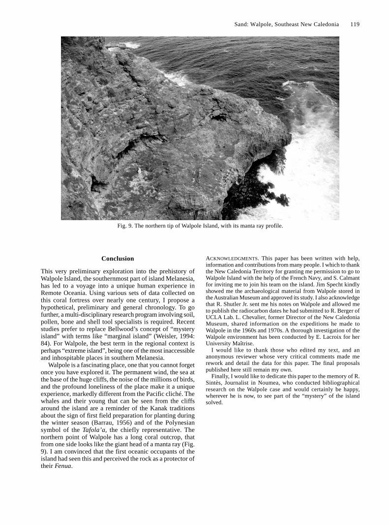
Walpole is a fascinating place, one that you cannot forgetonce you have explored it. The permanent wind, the sea atthe base of the huge cliffs, the noise of the millions of birds,and the profound loneliness of the place make it a uniqueexperience, markedly different from the Pacific cliché. Thewhales and their young that can be seen from the cliffsaround the island are a reminder of the Kanak traditionsabout the sign of first field preparation for planting duringthe winter season (Barrau, 1956) and of the Polynesiansymbol of the Tafola’a, the chiefly representative. Thenorthern point of Walpole has a long coral outcrop, thatfrom one side looks like the giant head of a manta ray (Fig.9). I am convinced that the first oceanic occupants of theisland had seen this and perceived the rock as a protector oftheir Fenua.
Fig. 9. The northern tip of Walpole Island, with its manta ray profile.
ACKNOWLEDGMENTS. This paper has been written with help,information and contributions from many people. I which to thankthe New Caledonia Territory for granting me permission to go toWalpole Island with the help of the French Navy, and S. Calmantfor inviting me to join his team on the island. Jim Specht kindlyshowed me the archaeological material from Walpole stored inthe Australian Museum and approved its study. I also acknowledgethat R. Shutler Jr. sent me his notes on Walpole and allowed meto publish the radiocarbon dates he had submitted to R. Berger ofUCLA Lab. L. Chevalier, former Director of the New CaledoniaMuseum, shared information on the expeditions he made toWalpole in the 1960s and 1970s. A thorough investigation of theWalpole environment has been conducted by E. Lacroix for herUniversity Maîtrise.
I would like to thank those who edited my text, and ananonymous reviewer whose very critical comments made merework and detail the data for this paper. The final proposalspublished here still remain my own.
Finally, I would like to dedicate this paper to the memory of R.Sintès, Journalist in Noumea, who conducted bibliographicalresearch on the Walpole case and would certainly be happy,wherever he is now, to see part of the “mystery” of the islandsolved.
120 Records of the Australian Museum, Supplement 29 (2004)
Appendix
Up to the time that I went there no one had been downon the lower reef on the weather side of the island. (I wasmost anxious to get down, thinking that perhaps I mightfind traces of water, so one Sunday the engineer, someLoyalty Island boys and myself made a bid for it. Gettingdown was not worrying us so very much, it was the gettingup again that might be the trouble. However, we stuck along crowbar into a hole in the coral, made a rope fast to it,also a small wire rope in case the other got cut on the sharprough coral.) We got down all right. (The first 20 feet or sowas the worst, as the cliff over hung there.) We found severalcaves at the foot of the cliffs, two of which contained goodfresh water. These two caves were two of the outlets for therain water, and one might call them small under groundcreeks. Of course they only run during heavy rains. Wecrawled along one of them for a fair distance. The caveswere pretty wide near the mouth with a smooth floor, eachhaving a saucer shaped hole about eight feet across andabout eighteen inches deep; both full of fresh water. Theholes I am almost sure were formed by nature, althoughthe ancients may have given them a start. The whole was ofcourse of coral formation, and some kind of a sedimentmust have lodged in them to retain the water. The quantityof water we found would not go a long way towards keepinga lot of people supplied, but there are other caves whichmay be of the same nature, although since they are all inthe face of the cliffs where the latter run sheer down intothe sea, it was not possible to get near them. (But they werenot always as they are now. Again, the island at one timemay have been very much larger with some of the primitiverock showing, which would retain water.)
In some of the other caves we found numerousimplements, such as axe heads and the like, made fromfossilized clam shells. The axe heads were from six incheslong and up, beautifully shaped and smooth at and near thecutting edges, the rest of the head being left pretty much inits natural stage, all very hard. (In breaking a piece off itglittered like a bit of broken quartz.) One of the axe headswas very large and heavy. I could not possibly lift it withone hand, and feel sure it could never have been used as anaxe. We found also skulls and human bones in the caves,but I am pretty sure that they must be of a more recent date,and may have belonged to castaways from the Loyalty orother islands. I did not take away any of the skulls or bones,but the implements I took and gave to the Sydney Museum,where they told me that implements of that kind had notpreviously been found south of the Equator. They showedme some from, I think the Caroline Island. They had neverseen or heard of anything of the kind so large as the largeaxe head.”
Anonymous, 1929. This anonymous writer was mostprobably A.C. Mackay, who gave the
Walpole collection to the Australian Museum.
“… What was to me another interesting feature was themany traces of human habitation in the form of rough wallsobviously built by man, columns of coral from two to ninefeet high, large tombs or graves, clam shell bladedinstruments and so on.
I knew from the walls and columns of coral, before Ifound anything else, that at one time the island wasinhabited, but had not been so for nobody can say howlong (the present people are only there to work the guano).What beat me was where did these early inhabitants getwater, for although there is plenty of rain in the season, attimes eight to nine inches in a night, it disappears nearly asquickly as it falls … .
The walls that I found in various parts of the island wereof a very crude style, but still walls, up to about four feethigh, one coming upon them here and there as the scrubwas cut down. The columns of coral are as a rule in lots offifty or so in and about one place. They appear in variousparts of the island, but, strange to say, practically the wholeof them are not great distances back from the edge of thecliff, some so close that part of them at the base projectover the cliff, all going to show what a long time ago itmust be since they were erected. The idea of them no oneperhaps can say, certainly nothing to do with graves, as,where a lot of them are, there are no holes where a bodycould be placed, practically bare coral rock. Any body buriedat the foot of one of them could only be covered with aheap of coral, and there are no signs of anything of thatkind. Moreover, graves I found were built up or over withloose coral, with no sign of a columns [sic] near them. Themost mysterious thing to me was how and where did theyget those practically flat coral slabs. Anyone who knowsanything about coral knows that you cannot split it, and ofcourse, never get it in slabs that can be separated. There areall kinds of coral on this island, some so hard that it willcut glass, but most of it strongly gnarled. These columnsare just wedged into crevasses, but are well fixed, very fewhaving fallen. They have, of course, a good long base. Atvarious times I have had boys from most of the islands inthe western Pacific but these columns were new to them, sothey told me.
I found several graves, all of which were formed by coralof various kind, built up like mounds the shape of a grave.One in particular was most interesting, being inside a walledenclosure, pear-shaped, about 50 feet long and 20 feet wide,with the entrance at the small end. The grave itself wasextra large, about 12 feet long, piled up like the smallerones, but on a better scale. Some of the coral was shaped abit. On this grave only there were a lot of waterworn pebbles(coral, no stone of any kind on the island), also pumice,some very large pieces. I found no pumice anywhere elseon the island. There was also a large piece of the hardcemented guano the shape of an egg, about 30 inches long,and of course, very heavy. How they got it into this shapewhich was perfect is another mystery. It certainly was notin its rough or natural state, nor was it waterworn.

Sand: Walpole, Southeast New Caledonia 121
References
Anderson, A., 2000. Implications of prehistoric obsidian transferin South Polynesia. In Indo-Pacific Prehistory: the MelakaPapers, vol. 4, ed. P. Bellwood, D. Bowdery, J. Allen, E. Bacusand G. Summerhayes. Bulletin of the Indo-Pacific PrehistoryAssociation 20: 117–123.
Anderson, A., W. Ambrose, F. Leach & M. Weisler, 1997. Materialsources of basalt and obsidian artefacts from a prehistoricsettlement site on Norfolk Island, South Pacific. Archaeologyin Oceania 32(1): 39–46.
Anderson, A., & B. McFadgen, 1990. Prehistoric two-wayvoyaging between New Zealand and East Polynesia: MayorIsland obsidian on Raoul Island, and possible Raoul Islandobsidian in New Zealand. Archaeology in Oceania 25(1): 37–42.
Anderson, A., P. Wallin, H. Martinsson-Wallin, B. Fankhauser &G. Hope, 2000. Towards a first prehistory of Kiritimati(Christmas) Island, Republic of Kiribati. Journal of thePolynesian Society 109(3): 273–293.
Anonymous, 1929. Walpole Island. China Journal 11: 86–90.Bahn, P., & J. Flenley, 1992. Easter Island, Earth Island. London:
Thames and Hudson Ltd.Balouet, J.C., 1984. Paléontologie des vertébrés terrestres de
Nouvelle-Calédonie et paléobiogéographie du Pacifique sud-ouest. Unpublished Thèse de troisième cycle. Université Pierreet Marie Curie, Paris.
Barrau, J., 1956. L’agriculture vivrière autochtone de la Nouvelle-Calédonie. Nouméa : Commission du Pacifique Sud.
Beaglehole, J.C., 1961. The Journal of Captain James Cook on hisvoyages of discovery. The Voyage of the Resolution and Adventure1772–1775. Cambridge: Cambridge University Press.
Bedford, S., 2000. Pieces of the Vanuatu puzzle. Archaeology ofthe North, South and Centre. 2 vols. Ph.D. thesis, AustralianNational University, Canberra.
Bellwood, P., 1978. Man’s Conquest of the Pacific: The Prehistoryof Southeast Asia and Oceania. Auckland: Collins Publishers Ltd.
Chevalier, L., 1976. Walpole, la citadelle du vertige. Le MémorialCalédonien IV. Editions Nouméa diffusion: 409–437.
Di Piazza, A., & E. Pearthree, 2001. An island for gardens, anisland for birds and voyaging: a settlement pattern for Kiritimatiand Tabuaeran, two “mystery islands” in the northern Lines,Republic of Kiribati. Journal of the Polynesian Society 110(2):149–170.
Emory, K.P., 1928. Archaeology of Nihoa and Necker Islands.Honolulu: Bernice P. Bishop Museum Bulletin 53.
Emory, K.P., 1934. Archaeology of the Pacific Equatorial Islands.Honolulu: Bernice P. Bishop Museum Bulletin 123.
Garanger, J., 1972. Archéologie des Nouvelles-Hébrides.Contribution à la Connaissance des îles du Centre. Publicationde la Société des Océanistes 30. Paris: ORSTOM.
Guiart, J., 1963. La Chefferie en Mélanésie du Sud. Institutd’Ethnologie, Musée de l’Homme, Paris.
Irwin, G., 1992. The Prehistoric Exploration and Colonisationof the Pacific. Cambridge: Cambridge University Press.
Kirch, P.V., 1982. A revision of the Anuta sequence. Journal ofthe Polynesian Society 91(2): 245–254.
Kirch, P.V., 1984. The Evolution of the Polynesian Chiefdoms.Cambridge: Cambridge University Press.
Kirch, P.V., 1985. Feathered Gods and Fishhooks. An Introductionto Hawaiian Archaeology and Prehistory. Honolulu: Universityof Hawaii Press.
Kirch, P.V., 1988. Polynesia’s mystery islands. Archaeology 41:26–31.
Kirch, P.V., 2000. On the Road of the Winds. An ArchaeologicalHistory of the Pacific Islands before European Contact.Berkeley: University of California Press.
Kirch, P.V., & D.E. Yen, 1982. Tikopia. The Prehistory andEcology of a Polynesian Outlier. Honolulu: Bernice P. BishopMuseum Bulletin 238.
Lacroix, E., 1998. Un peuplement préhistorique dans un site del’archipel calédonien aux conditions de survie difficiles: étudede l’îlot Walpole. Unpublished Mémoire de Maîtrise,Université Paris I.
Lardy, M., M. Monzier, & C. Pambrun, 1988. Rapport de Missionsur le Volcan Hunter du 15 au 19 Septembre 1988. Sciencesde la Terre. Géophysique 6. Nouméa: ORSTOM.
Leenhardt, M., 1937. Gens de la Grande-Terre. Paris: EditionsGallimard.
Letrosne, R., n.d. Expédition Walpole 1993. Field Journal.Noumea: On file at the Department of Archaeology of NewCaledonia.
Nunn, F., 1967. Who were Walpole Island’s Polynesian visitors?Pacific Islands Monthly (September): 65–68.
Renevier, A., & J.F. Cherrier, 1991. Flore et végétation de l’île deWalpole. Atoll Research Bulletin 348–354. Washington-DC:Smithsonian Institution.
Sand, C., 1995a. Données archéologiques préliminaires sur l’îlotWalpole (Sud-Est de l’archipel de la Nouvelle-Calédonie).Nouméa: Département Archéologie du Service des Musées etdu Patrimoine de Nouvelle-Calédonie.
Sand, C., 1995b. «Le temps d’avant»: la préhistoire de laNouvelle-Calédonie. Contribution à l’étude des modalitésd’adaptation et d’évolution des sociétés océaniennes dans unarchipel du Sud de la Mélanésie. Paris: Editions L’Haramattan.
Sand, C., 1996. Structural remains as markers of complex societiesin southern Melanesia during prehistory: the case of themonumental forts of Maré Island (New Caledonia). In Indo-Pacific Prehistory: The Chiang Mai Papers, ed. I.C. Gloverand P. Bellwood. Bulletin of the Indo-Pacific PrehistoryAssociation 15: 37–44.
Sand, C., 1998. Recent archaeological research in the LoyaltyIslands of New Caledonia. Asian Perspectives 37(2): 194–223.
Sand, C., 1999. Lapita and non-Lapita ware during NewCaledonia’s first millennium of Austronesian settlement. InThe Western Pacific, 5000 to 2000 B.P.: Colonisations andTransformations, ed. J.C. Galipaud and I. Lilley, pp. 139–159.Paris: Editions de IRD.
Sand, C., 2000a. Données archéologiques dispersées sur l’îlotWalpole. Nouméa: Département Archéologie du Service desMusées et du Patrimoine de Nouvelle-Calédonie.
Sand, C., 2000b. Reconstructing “traditional” Kanak society inNew Caledonia: the role of archaeology in the study ofEuropean contact. The Archaeology of Difference. NegotiatingCross-Cultural Engagements in Oceania, ed. R. Torrence andA. Clarke, pp. 51–78. One World Archaeology 38. London:Routledge.
Sand, C., ed., 2002. Walpole. Ha colo, une île de l’extrême,archéologies et histoires. Nouméa: Les Cahiers de l’Archéo-logie en Nouvelle-Calédonie 14.
Sand, C., J. Bolé & A. Ouetcho, 1999. Fichier d’inventaire dessites archéologiques et traditionnels de la Province des îlesLoyauté: programme 1992–1997. Nouméa: DépartementArchéologie du Service des Musées et du Patrimoine deNouvelle-Calédonie.
Sheppard, P., C. Sand & R. Parker, 2001. Sourcing Walpole Island.Problems and prospects in Pacific adze sourcing. AustralasianConnections and New Directions. Proceedings of the SeventhArchaeometry Conference, ed. M. Jones and P. Sheppard, pp.349–363. Auckland: University of Auckland.
Sintès, R., 1987. Les vestiges de Walpole sont à Sydney. LesNouvelles Calédoniennes (13.12.87): 4.
Sintès. R., 1988. A la recherche du temps passé. L’énigme deWalpole. Les Nouvelles-Calédoniennes: 14–15.
Specht, J., 1984. The prehistoric archaeology of Norfolk Island.Pacific Anthropological Records 34. Honolulu: Bernice P.Bishop Museum.
Spriggs, M., 1997. The Island Melanesians. The Peoples ofSoutheast Asia and the Pacific. Oxford: Blackwell Publishers.

122 Records of the Australian Museum, Supplement 29 (2004)
Terrell, J., 1986. Prehistory in the Pacific Islands. Cambridge:Cambridge University Press.
Valentin, F., & C. Sand, 2000. Walpole: étude anthropologiquesur un îlot de l’extrême. Archéologie des morts. Etudesanthropologiques de squelettes préhistoriques de Nouvelle-Calédonie. Nouméa: Les Cahiers de l’Archéologie enNouvelle-Calédonie 11: 75–85.
Weisler, M.I., 1994. The settlement of marginal Polynesia: newevidence from Henderson Island. Journal of Field Archaeology21(1): 83–102.
Weisler, M., 1995. Henderson Island prehistory: colonisation andextinction on a remote Polynesian island. In The PitcairnIslands: Biogeography, Ecology and Prehistory, ed. T.G.Benton and T. Spencer. London: Biological Journal ofLinnaean Society 56: 377–404.
Weisler, M.I., 1996a. Taking the mystery out of the Polynesian“mystery islands”: a case study from Mangareva and thePitcairn group. In Oceanic Culture History: Essays in Honourof Roger Green, ed. J. Davidson, G. Irwin, F. Leach, A. Pawleyand D. Brown, pp. 615–629. Dunedin North: New ZealandJournal of Archaeology Special Publication.
Weisler, M., 1996b. An Archaeological Survey of Mangareva:Implications for Regional Settlement Models and InteractionStudies. Man and Culture in Oceania 12: 61–85.
Weisler, M., 1998. Issues in the colonisation and settlement ofPolynesian Islands: Mangareva and Pitcairn Islands interactionsphere. In Easter Island and East Polynesian Prehistory, ed.P. Vargas-Casanova, pp. 73–86. Santiago: Universitad de Chile.

Full-text PDF of each one of the works in this volume are available at the following links :
Attenbrow and Fullagar, vol. eds, 2004, Rec. Aust. Mus., Suppl. 29, pp. i–v http://dx.doi.org/10.3853/j.0812-7387.29.2004.1483 Taçon et al., 2004, Rec. Aust. Mus., Suppl. 29: 1–8 http://dx.doi.org/10.3853/j.0812-7387.29.2004.1396 Khan, 2004, Rec. Aust. Mus., Suppl. 29: 9–14 http://dx.doi.org/10.3853/j.0812-7387.29.2004.1397 Athens, 2004, Rec. Aust. Mus., Suppl. 29: 15–30 http://dx.doi.org/10.3853/j.0812-7387.29.2004.1398 Bolton, 2004, Rec. Aust. Mus., Suppl. 29: 31–36 http://dx.doi.org/10.3853/j.0812-7387.29.2004.1399 Bonshek, 2004, Rec. Aust. Mus., Suppl. 29: 37–45 http://dx.doi.org/10.3853/j.0812-7387.29.2004.1400 Denham, 2004, Rec. Aust. Mus., Suppl. 29: 47–57 http://dx.doi.org/10.3853/j.0812-7387.29.2004.1401 Galipaud, 2004, Rec. Aust. Mus., Suppl. 29: 59–64 http://dx.doi.org/10.3853/j.0812-7387.29.2004.1402 Knowles, 2004, Rec. Aust. Mus., Suppl. 29: 65–74 http://dx.doi.org/10.3853/j.0812-7387.29.2004.1403 Lentfer, 2004, Rec. Aust. Mus., Suppl. 29: 75–88 http://dx.doi.org/10.3853/j.0812-7387.29.2004.1404 Lilley, 2004, Rec. Aust. Mus., Suppl. 29: 89–96 http://dx.doi.org/10.3853/j.0812-7387.29.2004.1405 Pavlides, 2004, Rec. Aust. Mus., Suppl. 29: 97–108 http://dx.doi.org/10.3853/j.0812-7387.29.2004.1406 Sand, 2004, Rec. Aust. Mus., Suppl. 29: 109–122 http://dx.doi.org/10.3853/j.0812-7387.29.2004.1407 Sheppard, 2004, Rec. Aust. Mus., Suppl. 29: 123–132 http://dx.doi.org/10.3853/j.0812-7387.29.2004.1408 Smith, 2004, Rec. Aust. Mus., Suppl. 29: 133–138 http://dx.doi.org/10.3853/j.0812-7387.29.2004.1409 Spriggs, 2004, Rec. Aust. Mus., Suppl. 29: 139–144 http://dx.doi.org/10.3853/j.0812-7387.29.2004.1410 Summerhayes, 2004, Rec. Aust. Mus., Suppl. 29: 145–156 http://dx.doi.org/10.3853/j.0812-7387.29.2004.1411 Swadling, 2004, Rec. Aust. Mus., Suppl. 29: 157–161 http://dx.doi.org/10.3853/j.0812-7387.29.2004.1412 Torrence, 2004, Rec. Aust. Mus., Suppl. 29: 163–172 http://dx.doi.org/10.3853/j.0812-7387.29.2004.1413 Wilson, 2004, Rec. Aust. Mus., Suppl. 29: 173–186 http://dx.doi.org/10.3853/j.0812-7387.29.2004.1414