walking in northumberland · 10 11 walking in northumberland there’s something very special about...
TRANSCRIPT
WALKING IN NORTHUMBERLAND
WALKING IN NORTHUMBERLAND
Vivienne Crow
JUNIPER HOUSE, MURLEY MOSS, OXENHOLME ROAD, KENDAL, CUMBRIA LA9 7RL
www.cicerone.co.uk
About the AuthorVivienne is an award-winning freelance writer and photographer specialis-ing in travel and the outdoors. A journalist since 1990, she abandoned the constraints of a desk job on regional newspapers in 2001 to go travelling. On her return to the UK, she decided to focus on the activities she loves the most – hill walking, writing, travelling and photography. Needless to say, she’s never looked back!
Based in north Cumbria, she has put her intimate knowledge of north-ern England to good use over the years, writing more than a dozen popu-lar walking guidebooks. She also contributes to a number of regional and national magazines, including several regular walking columns, and does copywriting for conservation and tourism bodies. Vivienne is a member of the Outdoor Writers and Photographers Guild.
Other Cicerone guides by the authorWalking in Cumbria’s Eden ValleyLake District: High Level and Fell WalksLake District: Low Level and Lake Walks
© Vivienne Crow 2018First edition 2018ISBN: 978 1 85284 900 9
Replaces the previous Cicerone guide to Northumberland by Alan Hall ISBN: 978 1 85284 428 8Second edition 2004First edition 1998
Printed in China on behalf of Latitude PressA catalogue record for this book is available from the British Library.All photographs are by the author unless otherwise stated.
© Crown copyright 2018 OS PU100012932
Front cover: Dunstanburgh Castle (Walk 2)
CONTENTS
Map key . . . . . . . . . . . . . . . . . . . . . . . . . . . . . . . . . . . . . . . . . . . . . . . . . . . . . . 7Overview map . . . . . . . . . . . . . . . . . . . . . . . . . . . . . . . . . . . . . . . . . . . . . . . . . 9
INTRODUCTION . . . . . . . . . . . . . . . . . . . . . . . . . . . . . . . . . . . . . . . . . . . . . 11Weather . . . . . . . . . . . . . . . . . . . . . . . . . . . . . . . . . . . . . . . . . . . . . . . . . . . . . 12Geology . . . . . . . . . . . . . . . . . . . . . . . . . . . . . . . . . . . . . . . . . . . . . . . . . . . . . 13Wildlife and habitats . . . . . . . . . . . . . . . . . . . . . . . . . . . . . . . . . . . . . . . . . . . 14History . . . . . . . . . . . . . . . . . . . . . . . . . . . . . . . . . . . . . . . . . . . . . . . . . . . . . . 17Where to stay . . . . . . . . . . . . . . . . . . . . . . . . . . . . . . . . . . . . . . . . . . . . . . . . . 21Public transport . . . . . . . . . . . . . . . . . . . . . . . . . . . . . . . . . . . . . . . . . . . . . . . 22Maps . . . . . . . . . . . . . . . . . . . . . . . . . . . . . . . . . . . . . . . . . . . . . . . . . . . . . . . 23Waymarking and access . . . . . . . . . . . . . . . . . . . . . . . . . . . . . . . . . . . . . . . . . 23Dogs . . . . . . . . . . . . . . . . . . . . . . . . . . . . . . . . . . . . . . . . . . . . . . . . . . . . . . . . 24Clothing, equipment and safety . . . . . . . . . . . . . . . . . . . . . . . . . . . . . . . . . . . 25Using this guide . . . . . . . . . . . . . . . . . . . . . . . . . . . . . . . . . . . . . . . . . . . . . . . 26
NORTHEAST NORTHUMBERLAND, INCLUDING THE COAST . . . . . . . . . . 27Walk 1 Craster and Howick Hall . . . . . . . . . . . . . . . . . . . . . . . . . . . . . . . . 28Walk 2 Dunstanburgh Castle and Low Newton . . . . . . . . . . . . . . . . . . . . . 32Walk 3 Seahouses to Belford . . . . . . . . . . . . . . . . . . . . . . . . . . . . . . . . . . . 36Walk 4 Lindisfarne . . . . . . . . . . . . . . . . . . . . . . . . . . . . . . . . . . . . . . . . . . 42Walk 5 Berwick-upon-Tweed to Eyemouth . . . . . . . . . . . . . . . . . . . . . . . . 47Walk 6 Norham Castle and River Tweed . . . . . . . . . . . . . . . . . . . . . . . . . . 54Walk 7 St Cuthbert’s Cave and the Kyloe Hills . . . . . . . . . . . . . . . . . . . . . . 59Walk 8 Doddington Moor . . . . . . . . . . . . . . . . . . . . . . . . . . . . . . . . . . . . . 64Walk 9 Bewick Moor . . . . . . . . . . . . . . . . . . . . . . . . . . . . . . . . . . . . . . . . 68
NATIONAL PARK (NORTH) INCLUDING THE CHEVIOT HILLS . . . . . . . . . . 75Walk 10 Yeavering Bell from Wooler . . . . . . . . . . . . . . . . . . . . . . . . . . . . . . 76Walk 11 Great Hetha, the border and Ring Chesters . . . . . . . . . . . . . . . . . . 82Walk 12 The Cheviot . . . . . . . . . . . . . . . . . . . . . . . . . . . . . . . . . . . . . . . . . . 87Walk 13 Ancient Ingram . . . . . . . . . . . . . . . . . . . . . . . . . . . . . . . . . . . . . . . 92Walk 14 Breamish Valley and Salter’s Road . . . . . . . . . . . . . . . . . . . . . . . . . 96Walk 15 Harbottle . . . . . . . . . . . . . . . . . . . . . . . . . . . . . . . . . . . . . . . . . . . 101Walk 16 Wether Cairn . . . . . . . . . . . . . . . . . . . . . . . . . . . . . . . . . . . . . . . . 104Walk 17 Clennell Street and Usway Burn . . . . . . . . . . . . . . . . . . . . . . . . . 109
Updates to this GuideWhile every effort is made by our authors to ensure the accuracy of guide-books as they go to print, changes can occur during the lifetime of an edi-tion. Any updates that we know of for this guide will be on the Cicerone website (www.cicerone.co.uk/900/updates), so please check before plan-ning your trip. We also advise that you check information about such things as transport, accommodation and shops locally. Even rights of way can be altered over time.We are always grateful for information about any discrepancies between a guidebook and the facts on the ground, sent by email to [email protected] or by post to Cicerone, Juniper House, Murley Moss, Oxenholme Road, Kendal LA9 7RL, United Kingdom.
Register your book: to sign up to receive free updates, special offers and GPX files where available, register your book at www.cicerone.co.uk.

7
Map key
Walk 18 Border Ridge including Windy Gyle . . . . . . . . . . . . . . . . . . . . . . 114Walk 19 Thrunton Wood . . . . . . . . . . . . . . . . . . . . . . . . . . . . . . . . . . . . . . 119Walk 20 Rothbury Terraces . . . . . . . . . . . . . . . . . . . . . . . . . . . . . . . . . . . . 123Walk 21 The Simonside Hills . . . . . . . . . . . . . . . . . . . . . . . . . . . . . . . . . . 128
KIELDER . . . . . . . . . . . . . . . . . . . . . . . . . . . . . . . . . . . . . . . . . . . . . . . . . . . . 133Walk 22 Tarsetdale Bastles . . . . . . . . . . . . . . . . . . . . . . . . . . . . . . . . . . . . 134Walk 23 Bull Crag Peninsula . . . . . . . . . . . . . . . . . . . . . . . . . . . . . . . . . . . 139Walk 24 Cat Cairn, Lewis Burn and Lakeside Way (south) . . . . . . . . . . . . . 142Walk 25 Kielder Forest and Lakeside Way (north) . . . . . . . . . . . . . . . . . . . 147Walk 26 Deadwater Fell and Peel Fell . . . . . . . . . . . . . . . . . . . . . . . . . . . . 152
TYNE VALLEY AND NATIONAL PARK (SOUTH) INCLUDING HADRIAN’S WALL . . . . . . . . . . . . . . . . . . . . . . . . . . . . . . . . . 157Walk 27 Heavenfield and Wall . . . . . . . . . . . . . . . . . . . . . . . . . . . . . . . . . 158Walk 28 Hadrian's Wall and Greenlee Lough . . . . . . . . . . . . . . . . . . . . . . 162Walk 29 Vindolanda and Crag Lough . . . . . . . . . . . . . . . . . . . . . . . . . . . . 167Walk 30 Best of Hadrian’s Wall . . . . . . . . . . . . . . . . . . . . . . . . . . . . . . . . . 171Walk 31 Haltwhistle and the South Tyne . . . . . . . . . . . . . . . . . . . . . . . . . . 176Walk 32 Hadrian's Wall Path and Thirlwall Castle . . . . . . . . . . . . . . . . . . . 182
NORTH PENNINES . . . . . . . . . . . . . . . . . . . . . . . . . . . . . . . . . . . . . . . . . . . 187Walk 33 Allenmill Flues . . . . . . . . . . . . . . . . . . . . . . . . . . . . . . . . . . . . . . 188Walk 34 Above Allenheads . . . . . . . . . . . . . . . . . . . . . . . . . . . . . . . . . . . . 194Walk 35 Blanchland Moor . . . . . . . . . . . . . . . . . . . . . . . . . . . . . . . . . . . . 199Walk 36 Birkside Fell and Beldon Burn . . . . . . . . . . . . . . . . . . . . . . . . . . . 204
Appendix A Route summary table . . . . . . . . . . . . . . . . . . . . . . . . . . . . . . 209Appendix B Useful contacts . . . . . . . . . . . . . . . . . . . . . . . . . . . . . . . . . . . 213
Route symbols on OS map extracts
Features on the overview map
start/finish pointstart point finish point
route direction
(for OS legend see printed OS maps)
route
County/Unitary boundary
National boundary
Urban area
National Park eg NORTHUMBERLAND
Area of Outstanding Natural Beauty/National Scenic Areaeg Northumberland Coast
Forest Park/National Foresteg National Forest 0m
75m200m400m
800m600m
AcknowledgementsThe author wishes to thank the following for their help with this guide-book: Andy Chymera, Senior Public Transport Project Officer at Northumberland County Council; Alex Bell, Definitive Map Officer at Northumberland County Council; Northumberland walking guide and co-owner of Footsteps, Patrick Norris; Alex MacLennan and Richard Gilchrist, of the Forestry Commission; history enthusiast and keen walker Raymond Greenhow; Martin O’Loughlin, of Natural England; and the Northumberland Estates. A particularly big thank you to Heleyne and Jess for accompanying me on most of these walks, and for being patient models whenever the camera appeared.
8
Walking in northuMberland
9
overvieW Map
A696
A10
68
691
A167
A1
A68
A68
A68
A69
A689
A1
A68
A68
A1
A692
A6091
A697
A697
A
A19
A69
A690
A189
A19
A1
A1
Durham
Tynemouth
South Shields
Sunderland
Newcastleupon Tyne
Gateshead
R Twee
d
R
R Teviot
R North Tyne
R South Tyne
Wear
KielderWater
R Eden
R Tyne
NorthumberlandCoast
NORTHUMBERLAND
Holy Island
TH
E P
EN
NI N
ES
Brampton
Bedlington
Amble
Greenlaw
Duns
Melrose
Blyth
Coldstream
Chester-le-Street
Seahouses
Lindisfarne
Newbiggin-by-the-Sea
Seaham
Crook
Haltwhistle
Allendale Town
BlanchlandAlston
Wearhead
Kelso
WoolerBelford
Langwathby
Cramlington
Tow Law
Consett
Hexham
Corbridge
MorpethOtterburn
Alnwick
Rothbury
Bellingham
Jedburgh
Berwick-upon-Tweed
Ashington
Bishop Auckland
Durham Peterlee
Washington
Tynemouth
South Shields
Sunderland
Newcastleupon Tyne
Gateshead
CUMBRIA
R Twee
d
R
R Teviot
R North Tyne
R South Tyne
Wear
KielderWater
R Eden
R Tyne
NorthumberlandCoast
NORTHUMBERLAND
Holy Island
TH
E P
EN
NI N
ES
Brampton
Bedlington
Amble
Greenlaw
Duns
Melrose
Blyth
Coldstream
Chester-le-Street
Seahouses
Lindisfarne
Newbiggin-by-the-Sea
Seaham
Crook
Haltwhistle
Allendale Town
BlanchlandAlston
Wearhead
Kelso
WoolerBelford
Langwathby
Cramlington
Tow Law
Consett
Hexham
Corbridge
Morpeth
Alnwick
Rothbury
Otterburn
Bellingham
Jedburgh
Berwick-upon-Tweed
Ashington
Bishop Auckland
Durham Peterlee
Washington
Tynemouth
South Shields
Sunderland
Newcastleupon Tyne
Gateshead
CUMBRIA0
0 10 miles
20kmN
31
32 30
2829 27
2223
2426
25
1817 16
15
21
2019
1314
12
11 10
9
8
7
6
5
4
3
21
33
3635
34
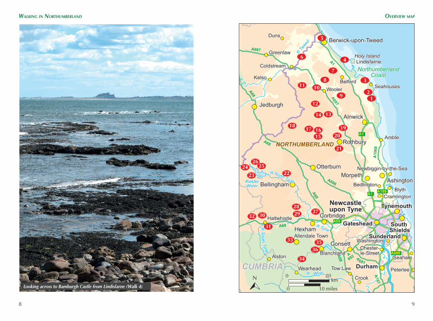
Looking across to Bamburgh Castle from Lindisfarne (Walk 4)

1110
Walking in northuMberland
There’s something very special about walking in Northumberland. It’s got a lot to do with all the history in the landscape – from cliff-top castles and world-class Roman remains to long-abandoned prehistoric settlements hid-den in the hills. It’s also got something to do with those big northern skies, largely free of pollution, unfettered by man-made constructions and open-ing up views that stretch on for miles and miles and miles… It’s undoubt-edly got a lot to do with the landscape itself: remote hills, seemingly endless beaches, wild moors, dramatic geo-logical features and valleys that are so mesmerizingly beautiful they defy description. It’s surely related to the wildlife, too – from the feral goats
Much of the walk above Allenheads follows shooters’ tracks (Walk 34)
and the upland birds that are some-times the walkers’ sole companions to the ancient woods and vast expanses of heather moorland that burst into vibrant purple bloom every summer.
Stretching from Berwick-upon-Tweed in the northeast to Haltwhistle in the southwest – two places that, even as the crow flies, are about 95km apart – Northumberland cov-ers more than 5000km2. It’s not quite the biggest county in England, but as you wander its hills and valleys and beaches it feels like it. There are wide, open spaces here like no others found south of the border. Unsurprisingly, this is England’s most sparsely popu-lated county – with just 62 people per km2. To put that into perspective,
INTRODUCTION
Northumberland – a land of open spaces and big skies
12
Walking in northuMberland geology
13
it compares with 73 in neighbour-ing Cumbria with its vast areas of uninhabited fell and moorland, or, at the other extreme, 3142 in the West Midlands and 5521 in Greater London. Want to escape from it all? This is the place to come!
Roughly 25 per cent of the county, including Hadrian’s Wall and the Cheviot Hills, is protected within the boundaries of the Northumberland National Park. The county also has two designated Areas of Outstanding Natural Beauty – the Northumberland Coast and the North Pennines.
This book covers the whole county. The routes range from easy ambles on the coast and gentle woodland trails to long days out on the lonely hills: hope-fully, something for all types of walker – and all types of weather.
Now for the statistics. July and August are the warmest months, with a mean daily maximum temperature of about 18°C. The coldest months are January and February with a mean daily minimum of 1.5°C. According to rainfall totals for Boulmer on the coast, the wettest period is from October to December, while April to July are the driest months. Obviously these figures will differ according to altitude, as well as latitude and longitude; and don’t forget, they’re averages.
Snow is even more widely var-ied from one part of the county to another – with the white stuff rarely lying for long on the coast while, in the North Pennines, it’d be an unu-sual winter if there weren’t occasional road closures. Generally speaking, January and February see the most, although snow can fall any time from late October to late April in the North Pennines and, to a lesser extent, in the Cheviot Hills.
The weather becomes an impor-tant consideration when heading on to the high ground, particularly in winter. Check forecasts before set-ting out, and prepare accordingly. The Mountain Weather Information Service (www.mwis.org.uk) covers the higher Cheviot Hills in its Southern Uplands forecast for Scotland, while the Meteorological Office (www.metoffice.gov.uk) provides detailed predictions for locations throughout the county.
WEATHER
L i k e t h e r e s t o f t h e U K , Northumberland experiences plenty of meteorological variety but, being on the east side of an island domi-nated by moisture-laden southwest-erlies, it tends to be drier and gener-ally more benign than the western side. Having said that, the Pennines and the Cheviot Hills get more than their fair share of strong winds, heavy rain and snow. And, in winter, the easterly winds that periodically come in off the North Sea are enough to bring tears to your eyes. During sum-mer, the coast is prone to sea fog, or haar, an annoyance that will nor-mally burn off quickly, but can linger all day if there’s a steady wind com-ing off the North Sea to keep replen-ishing the banks of moisture.
GEOLOGY
Northumberland’s size gives rise to a varied and complex underlying geology. In its most simplistic form, it could be summed up as a mixture of largely Carboniferous sedimen-tary rocks and volcanic rocks, both intrusive and extrusive, all topped by Quaternary deposits, including those of the last glacial period.
The rolling hills of the Cheviot range are generally associated with a period of mountain building known as the Caledonian Orogeny, about 490 to 390 million years ago. The collision of several mini-continents, includ-ing Avalonia, with Laurentia and the subduction of the Iapetus Ocean, resulted in volcanic activity. This cre-ated a mass of granite surrounded by extrusive volcanic rocks, most notably andesite. The collision of the plates also resulted in faulting, evident in places such as the Harthope and Breamish valleys.
Although there are older rocks dating as far back as the Ordovician, about 450 million years ago, the rocks of the North Pennines are largely Carboniferous limestone, sandstones and shales laid down about 360–300 million years ago, when this area was covered by a tropical sea.
There are certain surface features that will stand out as walkers explore the county – the andesite outcrops that form small crags on the otherwise smooth slopes of the Cheviot Hills; the fell sandstones, most prominent on the Simonside Hills; and, probably
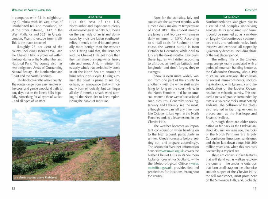
It’s shorts weather above Rothbury!

14
Walking in northuMberland Wildlife and habitats
15
most famously, the dolerite of the Great Whin Sill, on which Hadrian’s Wall and several castles were built. The latter was formed towards the end of the Carboniferous period, when movement of tectonic plates forced magma to be squeezed side-ways between beds of existing rock. The magma, as it then slowly cooled, crystallised and shrank, forming hex-agonal columns.
WILDLIFE AND HABITATS
With habitats covering anything from coastal dunes to 600m-plus hills, it’s not surprising that the wildlife of Northumberland is extremely diverse. While walking the coast, keep your eyes peeled for seals and even the occasional dolphin out at sea. Seals often haul out on the sands of the
They’re also home to common lizards and an assortment of moths and but-terflies, including the dark green fritil-lary and grayling.
Moving inland, the uplands contain some very important ecosys-tems. Almost 30 per cent of England’s blanket bog is found in the North Pennines, home to peat-building sphagnum moss as well as heather, bog asphodel, bilberry, crowberry and cotton grass. Rare Arctic/alpine plants, such as cloudberry, still thrive on the highest moors. The nutrient-poor, acidic soils also support native grasses such as purple moor grass, mat-grass and wavy-hair grass, which give the Cheviot Hills, beyond the heavily managed grouse moors, their distinctive look.
The North Pennines and Cheviot Hills are important for a variety of bird
Lindisfarne National Nature Reserve (see Walk 4), while dolphins have fre-quently been spotted playing in the waters around Berwick. Seabirds such as puffins, guillemots, Arctic terns and shags nest on the rocky Farne Islands, while winter visitors to the coast include barnacle geese, brent geese, pink-footed geese, wigeon, grey plov-ers and bar-tailed godwits. The wad-ers, in particular, enjoy feeding on the sand and mudflats, where they are joined by their British cousins, who abandon the hills for a winter holiday at the seaside.
At first sight, the delicate and ever-shifting dunes seem to be home to nothing more than marram grass; closer inspection reveals an array of wildflowers such as lady’s bedstraw, bloody cranesbill, houndstongue, bird’s foot trefoil and restharrow.
species, including red grouse, some of England’s last remaining popula-tions of elusive black grouse, and the heavily persecuted and extremely rare hen harrier, as well as merlin, kestrel, short-eared owl, peregrine falcon, ring ouzel, skylark, lapwing, golden plover, whinchat and wheatear.
As far as mammals go, the most common species you’re likely to see on the uplands is sheep, but there is wildlife too – foxes, brown hares, weasels and stoats can be seen, par-ticularly around dusk and dawn. Small bands of feral goats also roam parts of the Cheviot Hills.
The valleys and low-lying woods are home to badgers, roe deer, voles, shrews, minks and otters. Northumberland is also one of England’s last bastions of native red squirrels, driven to extinction in other
Hadrian’s Wall was built on the Great Whin Sill
Curlew in flight

28
Walking in northuMberland Walk 1 – Craster and hoWiCk hall
29
WALK 1Craster and Howick Hall
From the car park, take the footpath heading southwest towards Craster South Farm – along the edge of the Northumberland Wildlife Trust’s Arnold Memorial Nature Reserve. Having ignored one path to the right, you’ll quickly reach a kissing-gate providing access to more open ground. Follow the faint trail away from the woods (southwest). After a slight rise, stay parallel with a fence over to the left.
Reaching a road, cross diagonally right to head up a lane – signposted Howick Hall Gates. The lane ends in a turning circle at Craster South Farm. Just before this, bear left around the side of a farm gate. The muddy path soon joins a more solid track from the left. Continue with the field boundary on your left for almost 500m. Having crossed another rough track, go through a kissing-gate.
Start/finish Craster Quarry car park, Craster (NU 256 197)Distance 9.2km (5¾ miles)Total ascent 137m (450ft)Grade 1Walking time 2½hrTerrain Field paths, road, track, low cliffsMaps OS Explorer 332; OS Landranger 81Transport Buses 418 and X18Facilities Craster Seafood Restaurant, Jolly Fisherman and
Shoreline Café, all in Craster; public toilets and seasonal catering van in car park
Starting from the attractive fishing village of Craster, this relaxing amble heads south to Howick Hall before taking to roads and rough tracks to reach the coast path and a gentle stroll back to the village. Even across the farmland at the start of the walk, the paths are generally easy to follow. Unwind and enjoy a few undemanding hours on this gorgeous section of the coast!
Still following signs for Howick Hall, bear half-right, aim-ing for a farm gate at the base of the low crags of Hips Heugh. Once through the gate, skirt the base of the rocks for another 100m or so and then swing right across damp ground to go through a kissing-gate next to a ladder stile. A fingerpost shows the way through the crops ahead (south-southwest).
In the field corner, a pair of gates with a bridge between them provides access to the next field. Keep close to the trees on the right until you encounter a clear track rising through the woods. Follow this up to a broad, stony track near the walls of Howick Hall. This leads to a road, along which you turn left.
Howick Hall has been owned by the Grey family since 1319, although the house was rebuilt in 1928 after a massive fire. Among the many Greys who have lived there, the most distinguished is prob-ably Charles, the second Earl Grey, after whom the ber-gamot-flavoured tea is named. As leader of the Whigs, he was Prime Minister from 1830 to 1834, during the time of the Great Reform Act 1932. The grounds – but not the house – are open to the public. They are particularly famed for their dense banks of snowdrops in late winter and
30
Walking in northuMberland Walk 1 – Craster and hoWiCk hall
31
their unusual range of trees, gathered from some of the farthest-flung corners of the world. Visit www.howickhallgardens.org for more information.
After 850m the road bends sharp left. Take the track on the right here – signposted Alnmouth via coast path. At the entrance to Sea Houses Farm, keep straight on – along what is now a public byway.3
A small, fenced enclosure to the left of the track was the site of an archaeological dig from 2000 to 2002, when a rare example of a Mesolithic hut was unearthed. Radiocarbon dating from hearths inside the home show it was built in about 7800bc, mak-ing it Northumberland’s oldest occupied site and among the oldest in the UK. Five Bronze Age burial cists were also found.
Just before the track drops to Howick Burn, a small gate on the right allows a 250m detour to the earthwork remains of an Iron Age settlement. After a metal gate, the mouth of Howick Burn is reached – a chance, finally, to
For the first time on this walk you’re able to look south along the coast, towards
a series of small, golden beaches cradled by long fingers of rock.
enjoy a paddle in the chilly North Sea, or to search for fossils. Turn sharp left immediately after the gate – almost back on yourself – along the coast path as it hugs the top of low cliffs.
The lump of metal on the rocks below in a short while is part of the boiler of the French steam trawler Tadorne, which ran aground here in 1913. Five of the crew were killed in the accident, but another 25 were rescued by the Boulmer lifeboat.
The path goes through a couple of gates, passes to the seaward side of Sea Houses Farm and reaches a junc-tion with a more solid path. Turn right along this. Views of Dunstanburgh Castle, further up the coast, come and go until you round Cullernose Point; now, the ruins take on a more surreal appearance, looming mirage-like above Craster.
Passing through a kissing-gate, keep to the seaward side of the first buildings on the southern edge of the vil-lage. The path passes to the right of a play area. After a set of steps, the coast path enters the beer garden behind the Jolly Fisherman pub. After a gate on the other side, turn left along a track between the buildings. Go left at the road and then take the lane rising on the right – Whin Hill. Swing right at the top and then follow the narrower path to the left. This leads back to the car park.
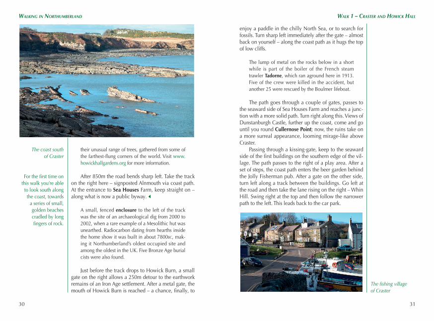
The coast south of Craster
The fishing village of Craster