wakefield local biodiversity action plan€¦ · 2 wakefield district biodiversity group 2.1 from...
TRANSCRIPT

www.wakefield.gov.uk
WakefieldLocal BiodiversityAction Plan
produced in partnership with Wakefield District
Biodiversity Group

Cover photographs (clockwise from top left):
Great Crested Newt; Eurasian Wigeon; Young Oak; Autumn leaf; Bluebell; Common Frog; Badger; Stanley Marsh; Angle Shades Moth.

PagePrologue - What is a Local Biodiversity Action Plan? iiPart 1 Biodiversity in Wakefield
1 Introduction 12 Wakefield District Biodiversity Group 23 Update on national and regional biodiversity policy and legal obligations. 34 Targets achieved from original BAP 75 Individual sites of biodiversity interest and value 10 6 Priority habitats 23 7 Key/priority species 26 8 Wildlife recording 32
Part 2 Individual Species and Habitat Action PlansSpecies Action PlansSAP 1 Badger 34SAP 2 Water Vole 35 SAP 3 Water Shrew 36 SAP 4 Otter 37 SAP 5 Great Crested Newt 38 SAP 6 Common Toad and Common Frog 39 SAP 7 Grass Snake 40 SAP 8 Odonata: Dragonflies and Damselflies 41 SAP 9 Salmon 42 SAP 10 European Eel 43 SAP 11 Butterflies: Woodland and Hedgerow 44 SAP 12 Butterflies: Grassland 45 SAP 13 Wetland Birds 46 SAP 14 Woodland and Woodland Edge Birds 47 SAP 15 Bat Species 48 SAP 16 Farmland and Grassland Bird Species 49 SAP 17 Farmland and Grassland Plant Species 50 SAP 18 Woodland and Woodland Edge Plant Species 51 Candidate Key Priority Species Action Plans 52 Habitat Action PlansHAP 1 Deciduous Woodland 53 HAP 2 Rivers and Streams 54 HAP 3 Lakes and Ponds 55 HAP 4 Unimproved Magnesian Limestone Grassland 56 HAP 5 Unimproved Neutral Grassland 57 HAP 6 Unimproved Acid Grassland 58 HAP 7 Lowland Heathland 59 HAP 8 Hedgerows 60 HAP 9 Brownfield Sites and Disused Railways 61 HAP 10 Walls and Quarry Faces 62HAP 11 Urban and Suburban Areas 63 HAP 12 Scrub 64 Candidate Priority Habitat Action Plans 66 Summary Table of Priority Habitats, Actions and Targets 67
Acknowledgements 73
CONTENTS
i

Prologue - What is a Local Biodiversity Action Plan?Local Biodiversity Action Plans (LBAPs) are a proven mechanism for focusing resources and utilizing local partnerships to conserve and enhance biodiversity locally, and in combination, nationally. Natural England defines the specific functions of LBAPs as follows:
• to translate national targets for species and habitats into effective action at the local level;
• to identify targets for species and habitats important to the local area and reflecting the values of local people;
• to stimulate effective local partnerships to ensure programmes for biodiversity conservation are developed and maintained in the long term;
• to raise awareness of the need for biodiversity conservation and enhancement in the local context;
• to ensure opportunities for conservation and enhancement of biodiversity are promoted, understood and rooted in policies and decisions at the local level;
• to provide a basis for monitoring and evaluating local action for biodiversity priorities, at both national and local levels.
The need for such local action plans, which can involve many partners and identify local priorities, was identified in the UK BAP, which stated that ‘Biodiversity is ultimately lost or conserved at the local level.1 ’
The United Nations has declared 2011-2020 the ‘UN Decade on Biodiversity’ and it is timely to be launching the new Wakefield Biodiversity Action Plan during the decade.
1 UK Steering Group (1994) Biodiversity: The UK Action Plan. London: HMSO.
ii

1 Introduction1.1 Natural England2 states that:
‘To conserve species, we need an emphasis on increasing appropriate habitat heterogeneity, between and within sites and over time. …This more dynamic approach to managing habitats has the potential to support the recovery of most species. This approach is also likely to facilitate adaptation by species to climate changes, by increasing the opportunities for them to persist within their existing habitats and to colonise new sites.’
1.2 The Wakefield Biodiversity Action Plan (BAP) is intended to provide a sound basis for local action to conserve,protect and enhance the biodiversity of the district as well as contributing to the sub-regional and regional improvements across Yorkshire and Humberside3 and national targets outlined in the Biodiversity of the UK Action Plan1.
1.3 The original Wakefield BAP was published in 1999, since when significant improvements have been achievedfor some habitats and species in the district; while concurrently the district has also witnessed increasing pressures on and declines of others. This updated and much revised BAP aims to highlight those habitats and species requiring particular conservation measures to ensure not only their survival within the district but also, wherever possible, an increase in their area and population. However, recognizing it is essential that any Action Plan should have achievable targets and not simply present a ‘wish list’, the habitats and species featured are those which Wakefield District Biodiversity Group considers to have a realistic prospect of benefiting from the work of the group’s constituent membership organizations, landowners and concerned individuals. Uncertainty also results from the potential outcomes that may arise from climate change over the coming 40 years, in particular changes to habitats and the less mobile individual species.
1.4 The landscape around us continues to evolve in a variety of ways due to human activities. The appropriatemanagement of change can result in significant benefits. A prime example of this has been the reclamation of industrial land, especially former colliery sites and gravel pits, resulting in valuable habitats and a range of species where previously there had been few, if any.
1.5 Though each element of the Action Plan can be seen as a separate entity, the strength of the package lies intheir combined value. If resources can be secured to implement all the actions, the benefits for biodiversity across the district will be dramatic.
2 Webb, J.R., Drewitt, A.L. & Measures, G.H., 2010. Managing for species: Integrating the needs of England’s priority species into habitat management. Part 1 Report. Natural England Research Reports, Number 024.3 The Yorkshire & Humber Biodiversity Forum (2009) Yorkshire & Humber Regional Biodiversity Strategy [Online] Available from: www.lgyh.gov.uk/dnlds/Regional%20Biodiversity%20Strategy%20-%202009.pdf
1
Part 1 BIODIVERSITY IN WAKEFIELD
2 Wakefield District Biodiversity Group2.1 From the outset, the Wakefield Biodiversity Action Plan has been seen as a product of the combined
commitment, expertise and experience of many of the district’s conservation organizations: either local groups of national organizations such as the RSPB, or groups with an interest in specific sites, such as Wintersett Wildlife Group and Friends of Haw Park Wood. It has drawn on the expertise of local naturalists with a combined knowledge of most of the major plant and animal groups, and the skills of Wakefield BTCV (now The Conservation Volunteers) and the Council’s staff in implementing projects and work on the ground.
2.2 The Wakefield District Biodiversity Group (WDBG) has been able to offer advice and training to landowners,fellow member organizations, community groups, schools and individuals in the monitoring of wildlife, the conservation and enhancement of habitats, improvements to appropriate access onto local wildlife sites, and advice to planners on the wildlife impact of proposed developments.
2.3 In January 2013, regular contributors to the Group’s work and meetings included the following:
Wakefield Naturalists Society
RSPB Wakefield District Local Group
Wakefield Badger Group
Wintersett Wildlife Group
TCV Wakefield
Friends of Haw Park Wood
Friends of Fitzwilliam Country Park
Spring Mill Conservation Group
Lofthouse Colliery Action Group
Crofton Parish Council
Ryhill Parish Council
West Yorkshire Joint Ecological Services
Wakefield District Council Countryside Service
Wakefield District Council Land Drainage Section
Wakefield District Council Planning Department
Natural England
Entotax Environmental Consultants
plus interested individuals.
2.4 The Group has received a number of presentations from organizations wishing to develop land across thedistrict who have recognized the value of the expertise within the Group when considering biodiversity implications of their proposals.
2

3 Update on national and regional biodiversity policy and legal obligations 3.1 At a national level, the Government has issued a range of strategies and policies that are relevant to biodiversity, the most important being:
• Biodiversity - the UK Action Plan 1994 • UK Sustainable Development Strategy 1999 • Working with the Grain of Nature: A Biodiversity Strategy for England 2002 • Rural Strategy 2004 • National Planning Policy Framework 2012 • Conserving Biodiversity - the UK Approach 2007 • Securing a Healthy Natural Environment: an action plan for embedding an ecosystems approach 2007 • Water Framework Directive 2009 • Biodiversity Strategy for England 2011
3.2 The main relevant current legislation includes:
• Wildlife and Countryside Act 1981 (as amended) • Environmental Protection Act 1990 • Protection of Badgers Act 1992 • The Hedgerow Regulations 1997 • Countryside and Rights of Way Act 2000 • Natural Environment and Rural Communities Act 2006
3.3 In 2008 the Integrated Regional Framework 4 provided the vision and overall strategic framework for theYorkshire and Humber region that underpins all other regional policy development. The Yorkshire and Humber Biodiversity Strategy3 was published in 2009 with the aim of ensuring biodiversity is embedded within all regional strategies, policies and projects.
3.4 Many of the important sites for wildlife across the district are owned by public bodies. In 2006, the NaturalEnvironment and Rural Communities Act (section 40) placed a duty on public authorities such that ‘Every public authority must, in exercising its functions, have regard, so far as is consistent with the proper exercise of those functions, to the purpose of conserving biodiversity’.
3.5 Section 41 of the same Act includes a list of 943 Species and 56 Habitats of Principal Importance in England.
3.6 The Countryside and Rights of Way (CRoW) Act 2000 states that planning decisions should seek to ‘maintain,enhance, restore and add to biodiversity by enhancing green spaces in towns and cities as well as in the countryside’.
3.7 This legislation, along with that in place under the Wildlife and Countryside Act 1981 (as amended), shouldprove to be a powerful tool in the conservation and enhancement of biodiversity across Wakefield district; and enable public authorities (public, government and statutory undertakers) to set an example of good conservation practice to neighbouring private landowners.
3.8 Local authorities have a responsibility to report annually to DEFRA on the proportion of locally recognizedwildlife sites (known henceforth as Wakefield Local Wildlife Sites) in favourable management. These sites are areas of substantive nature conservation value, identified and selected locally for their nature conservation interest and, although they do not have any statutory status, many are of equal wildlife value to SSSIs.
3
4 Yorkshire and Humber Assembly (2008) Growing Together: The Integrated Regional Framework [Online] Available from: http://www.lgyh.gov.uk/dnlds/TS-634%20Regional%20Framework.pdf
3.8.1 To assist in the identification of such sites, the West Yorkshire Local Sites Partnership was established in 2010to agree criteria for Local Wildlife Site designation across the county, based on area and type of habitat, and presence and population levels of species within the sites. These sites will be assessed on a rotational basis of 3-5 years using the agreed criteria.
3.9 Strategic Biodiversity Framework
3.9.1 The Strategic Biodiversity Framework for Yorkshire and Humber is detailed in the Yorkshire and Humber Biodiversity Strategy. Six key themes are adopted in the Framework:
1. protecting the best sites for wildlife in the region2. focusing conservation action on the region’s Priority Habitats and Species3. improving functional habitat networks and enhancing the wider environment4. developing a robust evidence base for the region5. engaging people with the region’s biodiversity6. helping the region’s biodiversity adapt to climate change
3.10 Yorkshire and Humber Biodiversity Delivery Plan5
3.10.1 Biodiversity Action Groups are invited to endorse the Yorkshire and Humber Biodiversity Delivery Plan and to linktheir individual habitat targets to the priority landscape-scale targets which reflect regional priorities. In Wakefield’s case the sub-regional landscape areas identified are
• the Calder Valley corridor • Magnesian Limestone Grasslands • Went Valley
They are also invited to assist the regional partnership by inputting data onto a Biodiversity Action Recording System; and to assist the regional partnership to integrate fully the LBAP species action plans and targets and the overall needs of species into habitat delivery.
3.10.2 This endorsement does not preclude WDBG from action to manage/improve local habitats lying outside thepriority landscape areas or species not in the regional priority list but of local interest/value. Locally important areas such as Bretton and Wintersett fall outside the priority landscape areas. However, given limitations of resources the Plan encourages choices favourable to regional targets over local targets.
3.11 Wakefield Local Development Framework - Habitat Network
3.11.1 The current Wakefield Local Development Framework contains a number of policies of direct relevance to biodiversity and conservation: • D4 - Sites Designated for Biological or Geological Conservation • D5 - Ecological Protection of Watercourses and Water Bodies • D6 - Wildlife Habitat Network • D7 - Protection of Trees, Woodland and Hedgerows • D13 - Protected Areas of Open Land (currently only Wrenthorpe Meadows) • D23 - Existing Uses in the Green Belt • D24 - Flood Risk • D26 - Protection of Agricultural Land • L3 - Protection of Open Space • L5 - Countryside Leisure (including Country Parks and Local Nature Reserves)
4
5 The Yorkshire & Humber Biodiversity Forum (2010) Yorkshire & Humber Biodiversity Delivery Plan 2010-2015 [Online] Available from: http://www.yhref.org.uk/pages/yorkshire-and-humber-biodiversity-delivery-plan

3.11.2 Specifically, Policy D6 states:
Wildlife Habitat Network: Development that would adversely affect the integrity and value of the Wildlife Habitat Network across the district or the movement of flora and/or fauna species will only be permitted if it can be demonstrated that reasons of public interest for the development clearly outweigh any significant harm. Proposals for development shall make provision for the retention of the network and protection of its wildlife links and ecological conservation value. Where development is permitted the Council will require developers to:a. minimize disturbance;b. protect and enhance the site’s ecological conservation value;c. contribute towards the objectives of the Wakefield District Biodiversity Action Plan;d. ensure appropriate management; ande. create new or replacement habitats equal to or above the current ecological value of the site if damage or loss is unavoidable.
3.11.3 These policies present opportunities to ensure the conservation and improvement of habitats and species across Wakefield district and the contiguity and continuity of wildlife sites along habitat networks and within biodiversity foci.
3.11.4 Continuity and contiguity of habitats: continuity of habitats in both spatial and temporal terms is vital to ensurethe increasing biodiversity of the district, as is contiguity of habitats to ensure the natural progress from one habitat to another without isolated areas of (limited) conservation value arising, or existing areas becoming isolated and thus preventing/reducing the opportunities for natural migration and (re)colonization of species. The opportunities for habitat expansion and improved contiguity must be recognized and grasped, with mosaics of habitats created whenever and wherever possible, in particular along and adjacent to the Wakefield Habitat Network.
3.11.5 The opportunity for securing long-term revenue resources such as Higher Level Stewardship, as well as short- term capital funding requires investigation.
3.11.6 Much of the successful habitat work in previous years has been linked to land in public/third sector ownership. Itwill be necessary to involve more private landowners whenever possible to further increase habitat area, for example by building on successful priority species work such as the Barn Owl nesting box project described in 4.2.
3.12 Relationship of BAP with Wakefield Green Infrastructure Plan
3.12.1 Wakefield’s Green Infrastructure Plan ‘will create places that are attractive to live, learn, work and invest in andwhere our diverse towns and villages work together to promote the well-being of the whole district’. The Council regards protecting, enhancing and creating new green infrastructure as a crucial element in its spatial planning strategy.
3.12.2 Wakefield Council sees its green infrastructure assets as including natural and semi-natural habitat for wildlife including: • Heaths and woodland • Country parks • Land in agri-environmental management • Local Nature Reserves and Sites of Special Scientific Interest • Local Wildlife Sites • Rivers, waterways and water bodies, including ponds, reservoirs and canals
3.12.3 The Council has a history of investing in industrial land reclamation, woodland creation, countryside access and habitat restoration projects funded and delivered by a wide range of public, private and independent agencies.
5
3.12.4 One of the four main objectives of the Green Infrastructure Plan is to improve biodiversity by increasing the area of high biodiversity value, and protecting and conserving important natural environment assets.
3.12.5 The Green Infrastructure Plan therefore complements the Biodiversity Action Plan by supporting and promotingthe conservation and improvement of a range of habitats to the benefit of both wildlife and citizens; and by offering potential for multiple uses of land contributing to the network of wildlife habitats across the whole of Wakefield district and adjacent local authorities.
3.12.6 The Green Infrastructure Plan also complements Leeds City Region’s Green Infrastructure Strategy, focusing on those regional programmes that are best suited to Wakefield district.
3.12.7 A Local Nature Partnership is being set up to implement the biodiversity theme of the Green Infrastructure Strategy on behalf of Leeds City Region.
3.13 Biodiversity links to complementary land uses
3.13.1 Opportunities may arise to improve habitat condition and access through links with other long-term strategiessuch as those for health; culture and heritage; and wood fuel production (which may provide alternate sources of finance and other resources).
3.13.2 Conservation and wildlife attractions should be promoted alongside those of heritage sites to provide potentialvisitors with knowledge of the value of Wakefield district’s biodiversity; and the health and well-being benefits of wildlife and natural habitats emphasized. A 2007 survey by the Council reported that ‘contact with nature’ and ‘the chance to see wildlife’ were the two most important reasons that local people visited the district’s country parks and rural green spaces. The many opportunities for voluntary work that basic habitat management and monitoring involves should also be stressed to both the general public and policy makers. By generating public interest in, greater understanding of, and greater public ownership of biodiversity issues, future support for conservation measures is more likely to get the support it will require.
3.13.3 The Forestry Commission has highlighted the potential to retain and improve biodiversity in the south-west ofthe district, where ancient woodlands have been identified for their current and potential biodiversity value. The Priority UK BAP Fund contributes 80% costs of projects such as Priority Woodland Bird Areas in Yorkshire delivering UK BAP-recognized priorities.
6

7
HABITAT/SPECIES SELECTED TARGETS ACHIEVED
Ancient Semi-natural Woodland
a. Ensure all ASN woodland is being appropriately managed by 2010b. Ensure 20% of all broadleaved woods in appropriate management by 2010c. Plant 50 ha of new broadleaved woods adjacent to existing ASNW by 2010
Council achieved Forest Certification on all ancient woodlands in its ownership in 2008Total deciduous woodland increased from 1258 ha in 2004 to 1760 ha by 2009
Heathland a. 3 ha of new heathland at Lofthouse Collieryb. 1 ha of new heathland at Newmarket-Silkstone Colliery c. 2 ha of new heathland at Frickley Collieryd. 2 ha of new heathland at Bushcliff Wood, Newmillerdam
a. Achieved 2007b. Awaiting completion of restorationc. 2 ha planted at Frickley Colliery in 2009; establishment problems
Scrub a. Identify all existing scrub habitat in the district and grade for importanceb. Ensure all areas of scrubland are properly surveyed by 2010
Ongoing
Marshland / Wet Grassland
a. Ensure all marshland and wet grassland is being appropriately managed by 2010b. Ensure all marshland and wet grasslands are properly surveyed by 2010c. Create 10 ha of marshland and wet grassland by 2020
Ongoing
Magnesian Limestone Grassland (MLG)
a. Ensure all magnesian limestone grassland is being appropriately managed by 2010b. Create 10 ha of MLG through appropriate management by 2020
MLG Project 2010-12 (YWT) bringing grasslands and other limestone features into management
Great Crested NewtTriturus cristatus
a. Maintain the current population in Wakefield by ensuring the future of known breeding sitesb. Establish two new breeding sites by 2005
Known breeding sites all protected
Tree Sparrow Passer montanus
a. Stabilize the breeding population in known colonies by 2001b. Establish new colonies within colonization distance of existing ones by 2005
Achieved. New colonies established. 130 nesting boxes erected
Water VoleArvicola terrestris
a. Improve habitat along 5 km length of river/ditch/lakeside by 2010, targeting areas that will link existing populations
Approximately 15 km of potential habitat improved and new habitat created, as part of flood amelioration and other habitat work
Yellow Meadow AntLasius flavus
a. Maintain Wakefield district population (numbers of colonies)b. establish new breeding colonies at suitable sites by 2003
Translocation scheme at Ellis Laithe
White Letter HairstreakSatyrium w-album
a. Expand population by allowing Wych Elms in hedgerows to grow into standards and by planting Wych Elms in reclamation schemes and planting programmes
Ongoing
4 Targets achieved from the original BAP4.1 Both Key Habitats and Key Species were given achievement targets in the previous BAP. Unfortunately there
was a serious lack of knowledge of habitat areas, species populations and other criteria on which to base measurable achievements.
Table 1 Notable achievements

4.2 Other notable achievements during the lifetime of the first BAP are as follows:
4.2.1 The Barn Owl Species Recovery Project: the erection of 40 Barn Owl nesting boxes at sites around the district,with two being used for successful breeding and others occupied by Kestrel, Tawny Owl and Stock Dove for breeding and roosting.
4.2.2 Establishment in 2008 of a further six Local Nature Reserves (LNRs):
• Alverthorpe & Wrenthorpe Meadows (traditional hay meadows, wetlands), • Fitzwilliam Country Park (acid grassland, woodland, wetland), • Pontefract Park (wetland, acid and neutral grassland), • Upton Country Park (wetlands, woodland, species-rich neutral and calcareous grassland), • Walton Nature Park (wetlands, species-rich acid and neutral grassland, woodland, bare rock) and • Well Wood (calcareous woodland and species-rich calcareous grassland).
There are 16 LNRs across Wakefield with a total area of 649 ha. Each of the new LNRs has benefited from associated habitat management and enhancement plus improved public access. All LNRs have an individual five-year rolling management plan to be revised in 2013.
4.2.3 Creation of 45 new ponds and enhancement of a further 17 at sites across the district, mostly on Councilland. Most of the new ponds have been created as part of flood alleviation, highway or reclamation schemes. Where possible, hibernacula have been created using dredged materials adjacent to these ponds. During 2009, eight ponds were surveyed in detail (on behalf of the Council’s Drainage Section), of which three ponds (Wrenthorpe Park, St John’s Normanton and Northfields South Kirkby) were found to contain a species diversity qualifying them as Priority Ponds in the national Pond Habitat Action Plan. In 2010, a further nine ponds were surveyed, of which six qualified as BAP Priority Ponds.
4.2.4 The Council continues to manage ponds on its land across the district to ensure the retention of these priorityhabitats. Opportunity was taken for the translocation of aquatic and marginal plants from sites being restored, some of which were subsequently translocated back to their site of origin on completion of work. Seed was gathered from a wide range of plants to form a local seed bank for sowing at newly created ponds.
4.2.5 Establishing 14 ‘Friends’ groups who carry out basic habitat maintenance and enhancement works as well as monitoring wildlife.
4.2.6 Creation of 12 artificial badger setts and one artificial otter holt.
4.2.7 Completion of reclamation schemes at former colliery sites at Sharlston, Frickley, Fryston Wheldale and SouthKirkby; ongoing reclamation at Newmarket Silkstone and St John’s Normanton (Welbeck); and commencement of schemes at Monckton (Rabbit Ings, completed in 2012) and Prince of Wales (Pontefract). All these schemes include significant habitat creation, including woodland, grassland and wetland.
4.2.8 Re-establishment of heather on Low Sharlston Common, Heath Common (south) and Lofthouse Colliery Nature Park.
4.2.9 Establishment of a tree nursery for native broad-leaved species within Haw Park Wood using locally derived seed and transplants.
4.2.10 Management and replanting of the arboretum at Newmillerdam Country Park.
4.2.11 Establishment of flower-rich grasslands on part of former Bullcliffe Colliery.
4.2.12 Construction by the Environment Agency of a fish and eel pass on Castleford Weir to promote upstream migration of Salmonids, eels and coarse fish.
4.2.13 Restoration of Waterton’s hide in Waterton Park, believed to be the oldest surviving bird hide.
8

4.2.14 Commencement of long-term schemes to control/eradicate invasive alien species: Floating Water Pennywort (Environment Agency, Calder and Colne Rivers Trust), Giant Hogweed (Council, Yorkshire Water) and Himalayan Balsam (Council, Friends groups). Japanese Knotweed infestations tend to be addressed on a case-by-case basis (Council).
9

5 Individual sites of biodiversity interest and value5.1 Protected Sites
5.1.1 Protected sites cover some 920 ha of Wakefield district. There are 6 Sites of Special Scientific Interest,1 Special Area of Conservation, and 16 Local Nature Reserves. These sites are now listed for protection within the Local Development Framework (LDF), alongside 60 former Wakefield Nature Areas and 26 Sites of Scientific Interest now listed as Local Wildlife Sites. The majority of protected sites are in the south-west of the district or along the River Calder corridor to the east and north of Wakefield city.
5.1.2 Protected sites are listed below. The relevant LDF Policies concerned with protecting them are as follows:
Policy D4 - Sites Designated for Biological or Geological Conservation Within the district are a number of sites designated for biological or geological conservation of international, national, regional and local importance. Where the Council considers that any designated site or any species of principal importance for conservation may be affected by a development proposal, an ecological assessment will be required to be submitted with the planning application.
1. Development that is likely to have either a direct or indirect adverse affect on a nationally designated sitewill only be permitted if it can clearly be demonstrated that exceptional reasons of public interest for development clearly outweigh any impact on its features of ecological importance and on the national network of designated sites. The development must further the conservation and enhancement of the site.
2. Development that is likely to have either a direct or indirect adverse affect on a regional or locally designated site will only be permitted if it can clearly be demonstrated that:
a. development cannot reasonably be located on an alternative site; and b. reasons of public interest for development clearly outweigh its features of ecological importance; and c. the need for development clearly outweighs any harm which may be caused to the ecological or geological conservation value of the site; and d. harm can be reduced to acceptable limits; and e. positive environmental mitigation measures can be implemented either on site or in a suitable alternative location.
3. Where development is permitted the Council will require developers to: a. minimise disturbance; b. protect and enhance the site’s ecological value; c. ensure appropriate management; d. ensure appropriate mitigation measures are designed into the proposal and work on the site does not commence until these measure are in place; e. work to approved methods; and f. create new or replacement habitats equal to or above the current ecological value of the site if damage or loss is unavoidable.
Policy D5 - Ecological Protection of Watercourses and Water Bodies The Wakefield District Local Biodiversity Report identifies watercourses and water bodies as important ecological assets. Development on or adjacent to watercourses and water bodies will not be permitted unless it can clearly be demonstrated that there will be no significant harm to any ecological features. Where development is permitted proposals shall include:
a. environmentally sensitive engineering methods; b. appropriate wetland features and landscaping; and c. appropriate management schemes for the planning and use of areas of water.
10

Policy D6 - Wildlife Habitat Network Development that would adversely affect the integrity and value of the Wildlife Habitat Network across the district or the movement of flora and/or fauna species will only be permitted if it can be demonstrated that reasons of public interest for the development clearly outweigh any significant harm. Proposals for development shall make provision for the retention of the network and protection of its wildlife links and ecological conservation value. Where development is permitted the Council will require developers to:
a. minimise disturbance; b. protect and enhance the site’s ecological conservation value; c. contribute towards the objectives of the Wakefield District Biodiversity Action Plan; d. ensure appropriate management; and e. create new or replacement habitats equal to or above the current ecological value of the site if damage or loss is unavoidable.
Policy D7 - Protection of Trees and Woodland The district’s woodland, hedgerows and trees are important ecological assets identified in the Wakefield District Local Biodiversity Report. Where the Council considers that trees or woodland may be affected by a development proposal, it will require an appropriate tree survey to be submitted with the planning application.
1. Development that would detrimentally affect or result in the loss of ancient woodland will only be permitted if it can clearly be demonstrated that: a. development cannot reasonably be located on an alternative site; and b. exceptional reasons of public interest for development clearly override the ecological and historical importance of ancient woodland; and c. the need for development clearly outweighs any harm which may be caused to the ecological and landscape value of the woodland; and d. harm can be reduced to acceptable limits through the implementation of positive environmental mitigation measures within the site.
2. Development that would damage or result in the loss of trees, particularly veteran trees, areas of woodland or hedgerows, will only be permitted if it can clearly be demonstrated that: a. development cannot reasonably be redesigned or located on an alternative site; and b. the need for development clearly outweighs any harm to the ecological value and landscape quality of the area; and c. harm can be reduced to acceptable limits through the implementation of positive environmental mitigation measures either on site or in a suitable alternative location.
5.2 Sites of Special Scientific Interest (SSSIs) and Special Area of Conservation
Under the Wildlife and Countryside Act 1981 (as amended by Countryside and Rights of Way Act 2000) responsibility for SSSIs is vested with Natural England. Across Wakefield district there are six SSSIs, of which Denby Grange Colliery Ponds (also a European Special Area of Conservation), Seckar Wood and South Elmsall Quarry are owned by the Council; Thorpe Audlin Ings by Yorkshire Water; and Wentbridge Ings/Brockadale (partly in North Yorkshire) by Yorkshire Wildlife Trust. The former Coal Measures Marine Band geological SSSI in the clay quarries at Nostell has been reburied by the quarry owners and recorded as Destroyed by Natural England. SSSIs are protected under Policy D4 of the LDF, plus D5, D6 and D7 as appropriate.
11

Table 2 Sites of Special Scientific Interest
SSSI NAME VALUE AREA (ha) GRID REFBrockadale Flora, invertebrates 59.4 SE499173
Denby Grange Colliery Ponds Amphibians 18.5 SE270153
Nostell Brickyard Quarry Destroyed 11.4 SE404170
Seckar Wood Woodland, wet woodland, heathland, flora
47.3 SE326142
South Elmsall Quarry Flora, geology 0.3 SE483115
Wentbridge Ings Flora 2.1 SE477181
SPECIAL AREA OF CONSERVATION
Denby Grange Colliery Ponds 18.5 ha SE270153
12

5.3 Sites of Scientific Interest (SSIs) and Wakefield Nature Areas (WNAs)
5.3.1 SSIs are of county importance: surveys and citations are undertaken by West Yorkshire Ecology. WNAs were of district importance and were listed by Council officers working in concert with WDBG. Those listed below appear in the Local Development Framework and are protected as Local Wildlife Sites by Policy D4 of the LDF, plus D5, D6 and D7 as appropriate.
Table 3 Sites of Scientific Interest (Local Wildlife Sites in LDF)
SSI NAME DESIGNATION(S) SSI GRID REF.* SURVEYED 1997
SURVEYED 2001/2002
MAP GRID REF.**
Anglers Country Park SSI, LNR SE378161 Y Y SE378160
Barnsley Canal SSI SE351191-SE372121
Y Y SE364137
Bretton Lakes SSI SE281124 Y Y SE277124
Bullcarr Mires SSI SE481148 Y Y SE481148
Clayworth’s Ponds SSI SE457128 Y SE457128
Foxholes SSI SE377251 Y Y SE377250
Fryston Park SSI SE462255 Y Y SE461257
Half Moon SSI SE357208 Y Y SE354205
Haw Park Wood SSI, LNR SE365135 Y Y SE363150
Holywell Wood SSI SE445245 Y Y SE444244
Lupset Golf Course SSI SE314189 Y SE314189
Moorhouse Lane Ponds SSI SE393157 Y Y SE393156
New Monkton SSI SE395138 Y Y SE393138
Newmillerdam SSI, LNR SE335154 Y Y SE336150
Nostell Priory Lakes SSI SE403174 Y Y SE399174
Pugneys SSI, LNR SE330175 Y Y SE329176
Southern Washlands SSI, LNR SE355215 Y Y SE355214
St Cuthbert’s Pond SSI SE439182 Y Y SE439181
Stanley Ferry Flash SSI SE353227 Y Y SE352225
Stanley Marsh SSI, LNR SE345236 Y Y SE344235
Stony Cliffe Wood SSI SE272160 Y Y SE272161
Vale Head Marsh SSI, LNR SE426143 Y Y SE426142
Went Hill Grassland SSI SE476184 Y Y SE476184
Willowgarths SSI SE516240 Y Y SE515240
Wintersett/Cold Hiendley Reservoirs
SSI SE375146 Y Y SE376147
* Grid ref. taken from citation
** Grid ref. taken from map accompanying citation/ GIS
13

Table 4 Wakefield Nature Areas (Local Wildlife Sites in LDF)
LDF SITE NO.
SITE NAME, LOCATION
REASONS FOR DESIGNATION PRIORITY HABITATS PRESENT
KEY PRIORITY SPECIES PRESENT
34 Altofts Ings Permanent wetland, species diversity Lake Teal, Reed Warbler
47 Barnsdale A1M Junction
Unimproved magnesian limestone grassland, orchids
Unimproved magnesian limestone grassland
Orchids
78 Bretton Country Park
Species diversity, old trees, lakes, woodland Woodland, lake White Clawed Crayfish, Lesser Spotted Woodpecker, Yellow Wagtail, Skylark, Leisler’s and Daubenton’s Bats
62 British Oak, Calder Grove
Woodland, grassland, wet grassland, wetland features
Woodland, ponds Skylark, Song Thrush
76 Bullcliff, West Bretton
Mixed woodland, rough grassland Woodland
83 Bush Wood, Havercroft
Scrub, transitions, glades, hummocks (bell pits), tree ages and species, south-facing banks, bare mud, tall herbs, brambles, hedges, rubble (shale), short sward, tall sward, semi-improved grassland. Remains of outdoor tannery
Woodland (composed of 95% Hawthorn), semi-improved grassland
77 Calder Drift, West Bretton
Wetland features Scrub, ponds
36 Cobblers Lane, Pontefract
Unimproved magnesian limestone grassland (tussocks/tall), scrub (mixed spp.)
Unimproved magnesian limestone grassland, scrub
85 Durkar Lows and Cow Field, Crigglestone
Scrub, ponds Reed Bunting
42 Ellis Laithe, Cold Hiendley
Grassland, scrub, woodland features Scrub, woodland, unimproved neutral grassland, unimproved acid grassland
Dingy Skipper
79 Emroyd Common, Middlestown
Species diversity, unimproved acid grassland
Unimproved acid grassland, scrub
Great Crested Newt, Palmate Newt
35 Featherstone Railway
Rough grassland, heathland, unimproved neutral grassland
Heathland, unimproved neutral grassland
41 Fitzwilliam Country Park
Grassland, plantation woodland (mixed species), ponds, wetland, species diversity
Woodland ponds Grey Partridge, Skylark, Water Vole
14

15
LDF SITE NO.
SITE NAME, LOCATION
REASONS FOR DESIGNATION PRIORITY HABITATS PRESENT
KEY PRIORITY SPECIES PRESENT
50 Frickley Colliery, South Elmsall
Wetland features (reedbeds, mud, shallow water) butterflies, orchids, insects, species
Ponds Water Vole, Skylark
27 Fryston Colliery, Castleford
Unimproved magnesian limestone grassland, scrub, wetland
Unimproved magnesian limestone grassland, scrub, lake, ponds
Bittern
32 Goosehill Common, Normanton
Wetland features (ponds, mud, flush, marginals, deep/shallow water), fringe woodland. Unimproved acid grassland
Woodland, pond, unimproved acid grassland
Skylark, Song Thrush
37 Harewood Park, Pontefract
Unimproved magnesian limestone grassland (tussocks/tall), scrub (mixed spp)
Unimproved magnesian limestone grassland, scrub
74 Hare Park Wood, Walton
Woodland features (ages, shaded logs, dead wood, glades, species diversity) unimproved neutral grassland
inc. new wood and pond adj. to woodland (>200yrs), unimproved neutral grassland
Tree Sparrow, Common Frog, Common Toad
81 Hartley Bank Wood, Netherton
Woodland features (ages, shaded logs, dead wood, wet glade)
Woodland
84 Havercroft Common
Tussocks, tall sward, transitions, glades, tree species, hedgerows, damp logs. Unimproved neutral grassland, unimproved acid grassland
Pond, unimproved neutral grassland, unimproved acid grassland
Song Thrush
29 Healdfield Quarry, Castleford
Unimproved magnesian limestone grassland, rough grass
Unimproved magnesian limestone grassland, woodland
71 Heath Common Unimproved acid grassland, heathland, scrub, pond, species diversity
Heathland, scrub, unimproved acid grassland
Great Crested Newt, Grey Partridge, Skylark
70 Hell Lane Railway Cutting, Warmfield
Grassland, wetland, amphibians, ferns, species
Scrub
44 Hessle and Brackenhill Commons, Ackworth
Relic heathland, grassland features, wetland features, scrub, species diversity. Unimproved neutral grassland, unimproved acid grassland
Scrub, heathland, unimproved neutral grassland, unimproved acid grassland
Water Vole, Skylark, Song Thrush
63 Horbury Lagoons
Wetland features, species diversity Woodland, lakes Teal
64 Horbury Wyke Marsh, open water Marsh, lake Teal

LDF SITE NO.
SITE NAME, LOCATION
REASONS FOR DESIGNATION PRIORITY HABITATS PRESENT
KEY PRIORITY SPECIES PRESENT
49 Hull to Barnsley Railway, South Elmsall
Scrub, rough grassland, ponds, marsh and wetland
Scrub
48 Johnny Brown’s Common, South Elmsall
Grassland, wetland, plantation woodland, orchids, 16 species of dragonflies and damselflies
Woodland, lake Common Hawker
66 Kettlethorpe Shaft
Woodland features (glades, scrub, age structure), rough grassland (fine, tall, brambles), pond, dragonflies
Woodland
65 Kettlethorpe Wood
Woodland features (glades, scrub, ages), stream, pond, amphibians, tall herbs
Woodland
39 Leys Lane, Knottingley
Unimproved magnesian limestone grassland, (tussocks/tall), scrub (mixed spp.)
Unimproved magnesian limestone grassland, scrub
57 Lindale Hill Quarry, Wrenthorpe
Scrub, rough grassland, heathland Scrub, heathland
56 Former Lofthouse Colliery
Wetlands (ponds, mud, rushes), plantation (mixed species, rides, scrub, bare ground, tall herbs), grassland, heathland
Scrub, heathland, woodland pond
80 Lower Spring Wood, Midgley
Woodland Woodland
58 Lupset Golf Course
Species diversity, ponds, trees Pond Great Crested Newt, Tree Sparrow
53 Manface Quarry, South Kirkby
Rough grass, Brown Argus, wetland, woodland features (hedges, scrub). Seeded wildflower meadow
86 Mill Pond Meadow, Featherstone
Flowers, butterflies, birds Unimproved neutral grassland
Grey Partridge, Skylark
52 Mutton Flatts, South Kirkby Colliery
Reclaimed land, ponds, rough grassland. Plantation (species diversity)
Woodland, lakes Water Vole
55 Newmarket Silkstone Colliery
Species diversity Water Vole, Skylark, Teal
68 Newmillerdam School Hill
Grassland (hay meadow), plantation (varied ages/species)
Woodland, semi-improved grassland
33 Normanton Railway Sidings
Unimproved neutral grassland (tall/short/tall herb features), scrub, butterflies
Scrub woodland, unimproved neutral grassland
Brimstone
16

17
LDF SITE NO.
SITE NAME, LOCATION
REASONS FOR DESIGNATION PRIORITY HABITATS PRESENT
KEY PRIORITY SPECIES PRESENT
38 Orchard Head, Pontefract
Unimproved magnesian limestone grassland (tussocks/tall), scrub (mixed spp.), woodland
Unimproved magnesian limestone grassland, scrub
67 Painthorpe Plantation
Plantation woodland, scrub, fungi Scrub, woodland
40 Park Baulk Quarry, Pontefract
Unimproved magnesian limestone grassland, scrub
Unimproved magnesian limestone grassland, scrub
82 Pits Beck Wood, Netherton
Woodland features (ages, shaded logs, dead wood, glades, species-rich hedgerow links, species variety). Wetland features (stream, mud, obstructions)
Woodland, stream
59 Roundwood, Ossett
Grassland (fine/coarse/mown/tussocks), scrub, bracken. Woodland features (transitional/small/deadwood/hedgerows, mixed species)
Scrub, woodland
72 Sharlston Common
Relic heathland, ponds, wetland, species diversity
Heathland, ponds Great Crested Newt
31 Smawthorne Marsh, Castleford
Wetland habitats, garden birds, dragonflies, species diversity
Lake Water Vole
61 Soap Tip, Calder Bridge
Tall/short turf grassland, scrub (physical structure), rare plants, butterflies
Scrub
43 South Hiendley Common
Heathland, pond, rough grassland, unimproved acid grassland
Heathland, unimproved acid grassland
Skylark, Lapwing
51 South Kirkby Colliery Tip
Species diversity, invertebrates, butterflies, unimproved neutral grassland
Woodland, unimproved neutral grassland
Skylarks
54 South Kirkby Fort
Rough grass and scrub, species diversity Scrub Water Vole
30 Stansfield Road, Castleford
Old sand workings, unimproved magnesian limestone grassland
Unimproved magnesian limestone grassland, semi-improved grassland
75 Stocksmoor Common
Rough grassland, woodland/scrub, wetland/ponds, unimproved acid grassland
Scrub, ponds, unimproved acid grassland
Palmate Newt, Great Crested Newt
60 Storrs Hill Quarry, Ossett
Scrub, heathland, rough grassland, species diversity
Scrub, heathland Grayling

18
LDF SITE NO.
SITE NAME, LOCATION
REASONS FOR DESIGNATION PRIORITY HABITATS PRESENT
KEY PRIORITY SPECIES PRESENT
45 Former Upton Colliery
Calcareous/neutral semi-natural grassland, scrub (mixed species), woodland, unimproved magnesian limestone grassland. Upper Carboniferous/ Lower Permian unconformity in railway cutting
Unimproved magnesian limestone grassland, scrub woodland, lakes, streams, ponds
Pochard
73 Walton Park Grassland, woodland, wetland, open water, wet woodland, species (bat)
Woodland, lake Long-eared Bat
46 Walton Wood, Upton
Mixed woodland: limestone and oak-beech, hornbeam, maple, guelder rose. Tree species, dead wood, coppice
Woodland
69 Warmfield Common
Ponds, grassland, heathland Heathland
28 Wheldale, Castleford
Unimproved magnesian limestone grassland (south-facing banks, short/tall/tussocks), Felwort and other limestone species. Scrub.
Magnesian limestone grassland, scrub
5.3.2 One former WNA - Parkhill - has been lost to a Special Policy Area (the Wakefield East development). A new site at Durkar Lows and Cow Field, Crigglestone has been added to the list of Local Wildlife Sites in the LDF.
19
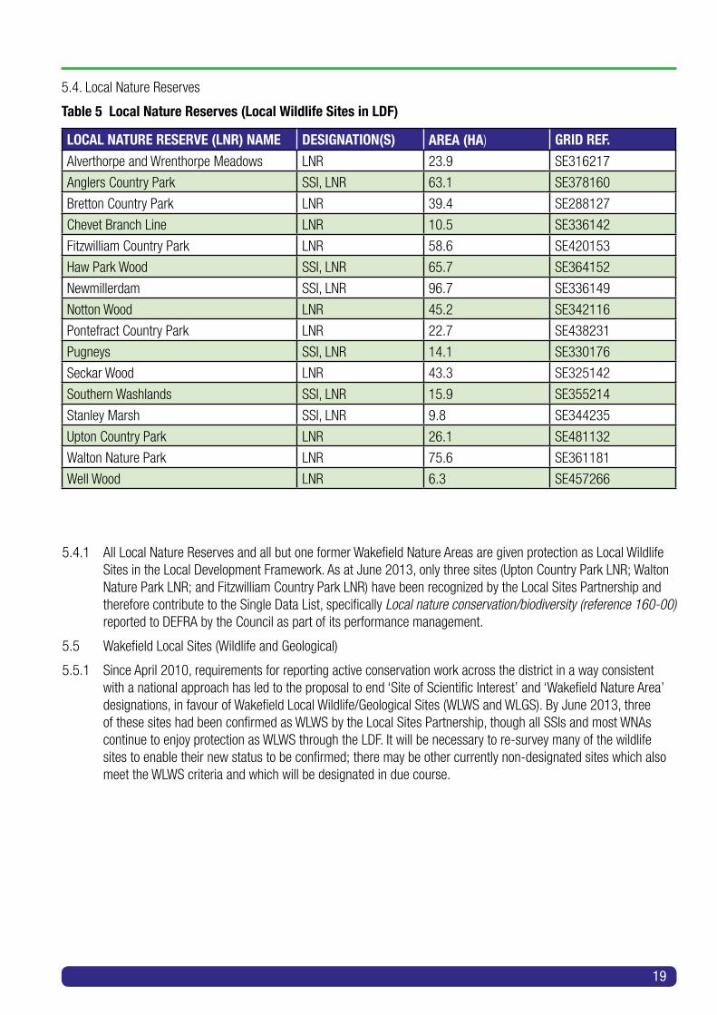
5.4. Local Nature Reserves
Table 5 Local Nature Reserves (Local Wildlife Sites in LDF)
LOCAL NATURE RESERVE (LNR) NAME DESIGNATION(S) AREA (HA) GRID REF.
Alverthorpe and Wrenthorpe Meadows LNR 23.9 SE316217
Anglers Country Park SSI, LNR 63.1 SE378160
Bretton Country Park LNR 39.4 SE288127
Chevet Branch Line LNR 10.5 SE336142
Fitzwilliam Country Park LNR 58.6 SE420153
Haw Park Wood SSI, LNR 65.7 SE364152
Newmillerdam SSI, LNR 96.7 SE336149
Notton Wood LNR 45.2 SE342116
Pontefract Country Park LNR 22.7 SE438231
Pugneys SSI, LNR 14.1 SE330176
Seckar Wood LNR 43.3 SE325142
Southern Washlands SSI, LNR 15.9 SE355214
Stanley Marsh SSI, LNR 9.8 SE344235
Upton Country Park LNR 26.1 SE481132
Walton Nature Park LNR 75.6 SE361181
Well Wood LNR 6.3 SE457266
5.4.1 All Local Nature Reserves and all but one former Wakefield Nature Areas are given protection as Local WildlifeSites in the Local Development Framework. As at June 2013, only three sites (Upton Country Park LNR; Walton Nature Park LNR; and Fitzwilliam Country Park LNR) have been recognized by the Local Sites Partnership and therefore contribute to the Single Data List, specifically Local nature conservation/biodiversity (reference 160-00) reported to DEFRA by the Council as part of its performance management.
5.5 Wakefield Local Sites (Wildlife and Geological)
5.5.1 Since April 2010, requirements for reporting active conservation work across the district in a way consistentwith a national approach has led to the proposal to end ‘Site of Scientific Interest’ and ‘Wakefield Nature Area’ designations, in favour of Wakefield Local Wildlife/Geological Sites (WLWS and WLGS). By June 2013, three of these sites had been confirmed as WLWS by the Local Sites Partnership, though all SSIs and most WNAs continue to enjoy protection as WLWS through the LDF. It will be necessary to re-survey many of the wildlife sites to enable their new status to be confirmed; there may be other currently non-designated sites which also meet the WLWS criteria and which will be designated in due course.

20
5.5.2 Though not protected by specific legislation, the value of these sites to both wildlife and local residents is wellrecognized. All such sites brought forward in the future will need to be identified in the Local Development Framework and thus afforded some recognition when subject to development proposals.
5.5.3 WDBG will assist in the monitoring of these sites and the identification and proposal of new ones.
5.5.4 However, as the report ‘Making Space for Nature’6 points out, despite the important contribution designatedsites have made, England’s wildlife habitats have become increasingly fragmented and isolated, leading to declines in the provision of some ecosystem services and losses to species populations.
5.5.5 Ecological networks have become widely recognized as an effective response to conserve wildlife inenvironments that have become fragmented by human activities. An ecological network comprises a suite of high quality sites that collectively contain the diversity and area of habitat that are needed to support species and which have ecological connections between them that enable species to move. Such networks are identified and protected through the Council’s Local Development Framework (see 3.11).
5.6 Ancient Woodland
5.6.1 Ancient woodlands (that is, areas wooded continuously since 1600 AD) have been designated in the LDF inaccordance with national policy in consultation with Natural England and ecologists. They are protected under Policy D7 of the LDF, plus D4 and D6 as appropriate.
Ancient woodlands are identified, mapped and enumerated within the LDF as follows:
5.7 Approach to non-designated sites of wildlife interest
5.7.1 Many areas of varying size that are of value to wildlife (such as urban parks, hedgerow systems, disusedrailways and other ‘brownfield’ sites) but which have no formal conservation designation (for example, as Wakefield Local Wildlife Sites) are known across the district. Such sites often act as local staging posts, feeding areas and roosting sites within a larger wildlife framework and are thus essential to the overall welfare of the district’s wildlife.
5.7.2 In conjunction with the Council’s Greenspace Strategy such sites will also be monitored on a regular basis, withtheir value being promoted to local people. Where possible, small-scale management will be encouraged to improve wildlife habitat and increase local biodiversity.
AW1 Ackton Pasture/Houghton Woods, Castleford
AW2 Hagg Wood and The Snipery, Hemsworth
AW3 Priory Wood, Nostell
AW4 Low Wood, Nostell
AW5 New Hall, Stonycliffe and Perkin Woods, Netherton
AW6 Dial Wood, New Hall
AW7 Bank Wood, Midgley
AW8 Bentley Spring, West Bretton
AW9 Bullcliffe North Wood, West Bretton
AW10 Bullcliffe Wood, West Bretton
AW11 Jenkin Wood, West Bretton
AW12 Gate Royd Wood, Woolley
AW13 Woolley Edge, Woolley
AW14 Totty Spring, Woolley
AW15 Jobson Wood, Woolley
AW16 Windhill Wood, Woolley
AW17 Seckar Wood
AW18 Newmillerdam Woods
AW19 Notton Park Wood
AW20 Haw Park Wood
AW21 Brockadale Wood
6 Lawton, J.H., Brotherton, P.N.M., Brown, V.K. et al. (2010) Making Space for Nature: a review of England’s wildlife sites and ecological network. Report to Defra.

21
5.8 Climate Change
Though difficult to predict to any degree of accuracy for individual sites and their climate, there is growing evidence of medium and long-term climatic changes affecting the whole of the United Kingdom and having consequent effects on wildlife and biodiversity.
5.8.1 Summary of Projected Climate Changes for the Yorkshire and Humber Region
5.8.2 The government’s UK Climate Change Projections7 provide information on how the UK’s climate is likely tochange in the 21st century in response to higher levels of greenhouse gases in the atmosphere. For inland Yorkshire, headline predictions based on the ‘medium emissions’ scenario are as follows:
IMPACT 2020s 2050s 2080sSummer average temperature +1.3% +2.3% +3.3%
Summer average rainfall -8% -19% -23%
Winter average rainfall +4% +11% +15%
5.8.3 Other predictions include:8
• extreme hot temperatures will increase, with summer temperatures more regularly reaching 34°C
• an increase in the number of extreme rainfall events
• an increase in the number of dry spells
• a significant reduction in the number of days of frost and snow
• marginal increases in winter average wind speeds, although summer and autumn speeds reduce
5.8.4 It is expected that there will be an increasing level of unpredictability of the extreme events arising, especiallyprecipitation. These extremes may result in greater dramatic short-term damage to habitats whereas long-term trends, such as average temperature increases, will have slow but long-term effects on them.
5.8.5 These changes will have both positive and negative effects on biodiversity, depending on complex interactionsbetween different species and between species and their habitats. However, it is clear that species that can colonize different areas easily will hold an advantage.
5.8.6 Recent observed phenomena include alterations in the behaviour of the jetstream over the UK, which could belinked to alterations in the Gulf Stream due to ice melt in the Arctic. Whether this is a medium- or long-term effect is currently unknown.
5.8.7 The Yorkshire and Humber Regional Adaptation Study9 highlights the direct key impacts of climate change to biodiversity as follows:
Threats
• changes in the timings of seasonal events (phenology), potentially leading to a loss of synchrony between species and the availability of food, and other resources upon which they depend;
• shifts in suitable climate conditions for individual species (their climatic niche or ‘space’) leading to changesin both abundance and range; for example increased water temperatures threatening salmon and the spread of invasive non-native species;
• changes to habitats and ecosystems such as altered water regimes, increased rates of decomposition in bogs and higher growth rates in forests and changes in plant and animal communities;
7 Crown Copyright (2009) UK Climate Projections, 2009 [Online] Available from: http://ukclimateprojections.defra.gov.uk/231228 The Yorkshire & Humber Biodiversity Forum (2009) Yorkshire & Humber Regional Biodiversity Strategy [Online] Available from: www.lgyh.gov.uk/dnlds/Regional%20Biodiversity%20Strategy%20-%202009.pdf9 Your Climate - The Climate Change Partnership for Yorkshire & Humber (2012) A Summary of Climate Change Risks for Yorkshire and Humber [Online] Available from: http://www.yourclimate.org/news/climate-change-risks-yorkshire-and-humber

22
• more intense rainfall may increase waterlogging, increase runoff and enhance erosion - particularly when combined with dry periods and other pressures such as increased tourism;
• a projected increase in conditions such as periods of drying and increased tourism that can lead to the occurrence of parkland, moorland and forest fires, with implications for Fire and Rescue Services.
Opportunities
• Well-designed green infrastructure can provide shade, cooling and wind interception and an insulation role inthe winter. It can also potentially mitigate risks from climate change-induced reductions in air and water quality; and it can provide a buffer for habitats and species, whilst contributing to sustainable urban drainage and controlling upstream water flows to reduce flood risk.
5.9 Non-native species
5.9.1 A number of invasive non-native species have become established across the district and are giving serious concern regarding their actual and potential effects on native wildlife and associated reduction of biodiversity.
5.9.2 The main plant species causing concern are
• Himalayan Balsam (Impatiens glandulifera) • Japanese Knotweed (Polygonum cuspidatum) • Giant Hogweed (Heracleum mantegazzianum) • Snowberry (Symphoricarpos albus) • Floating Water Pennywort (Hydrocotyle ranunculoides) • Australian Swamp Stonecrop (Crassula helmsii)
5.9.3 Faunal concerns include
• American Mink (Neovison vison), which is probably the most significant threat to local fauna, being an ongoing threat to Water Voles, amphibians and wetland birds
Other established invasive fauna include
• American Signal Crayfish (Pacifasticus leniusculus) • Grey Squirrel (Sciurus carolinensis) • Harlequin Ladybird (Harmonia axyridis)
5.9.4 It is extremely unlikely that any of the above species can be eradicated in the life-span of this BAP. Thereforemeasures to control the spread of these aggressive alien species will be required to ensure the minimum degradation of habitats and individual native species.
5.9.5 A number of invasive species currently not found in Wakefield district could also expand their range into thearea as a result of climate change, e.g. Ring-necked Parakeet (Psittacula krameri). It will be necessary to carefully monitor Local Wildlife Sites and other wildlife locations to identify and take appropriate action against any such species becoming established.

23
6 Priority habitats 6.1 There are approximately 2100 ha of semi-natural habitats (including those on reclaimed land) greater than
0.1 ha in size, with the majority in the south-west of the district. This association is mainly dependent on the woodland and wetland habitats, which are generally scarce elsewhere, especially in the east. Other habitats tend to be fragmented and often come under pressure for housing and industrial development as well as neglect from a management perspective.
6.2 It is proposed that those habitats to be prioritized for action in Wakefield will be those present that are of UKimportance, plus others occurring within the district deemed to be of importance where action would be worthwhile. Table 6 below clarifies the relationships between these habitats, known henceforth as Priority Habitats. It also indicates which will be given Habitat Action Plans or HAPs, which are numbered and set out in Part 2.
6.3 The conservation and enhancement of Priority Habitats is central to the conservation of most Priority Species(see Chapter 7). It is therefore proposed that resources be concentrated on these Priority Habitats wherever possible. Exceptions should only be where resources are secured for a particular Priority Species (such as for the erecting of Barn Owl or Tree Sparrow nesting boxes).
6.4 UK BAP priority habitats
6.4.1 These are threatened habitats requiring conservation action under the UK Biodiversity Action Plan (UK BAP).The original list of UK BAP priority habitats was created between 1995 and 1999, and was revised in 2007, following publication of the Species and Habitats Review Report. Following this review, the list of UK BAP priority habitats increased from 49 to 65.
6.4.2 As a result of devolution and new country-level and international drivers and requirements, much of the workpreviously carried out by the UK BAP is now focused at a country-level rather than a UK-level, and the UK BAP was succeeded in July 2012 by the UK Post-2010 Biodiversity Framework. The UK list of priority habitats, however, remains an important reference source and has been used to help draw up statutory lists of priorities.
6.4.3 The revised list of priority habitats is shown in Table 6, along with links to their definitions, taken from ‘UKBiodiversity Action Plan: Priority Habitat Descriptions’10 (with some amended definitions in July 2010 and December 2011 updates). The priority habitats are grouped according to the UK BAP broad habitat type with which they are mainly associated.
10 Ant Maddock (ed.) (2008) UK Biodiversity Action Plan; Priority Habitat Descriptions. [Online] Available from: http://jncc.defra.gov.uk/PDF/UKBAP_PriorityHabitatDesc-Rev2011.pdf

24
Table 6 Priority Habitats: UK BAP and Wakefield Priority Habitats
Habitats emboldened and green appear in Table 10 in Part 2.
UK BAP BROAD HABITAT
UK BAP PRIORITY HABITAT/WAKEFIELD PRIORITY HABITAT
NOTES AND RELATED WAKEFIELD HABITAT ACTION PLANS (HAPS)
Broadleaved, Mixed and Yew Woodland
Lowland Mixed Deciduous Woodland
(Deciduous Woodland)
HAP 1
Rivers and Streams Rivers HAP 2
Standing Open Waters and Canals
Lakes Unlikely all examples in Wakefield will meet UK BAP priority habitat criteria. Keep as non-UK BAP broad definition. HAP 3
Standing Open Waters and Canals
Ponds Unlikely all examples in Wakefield to meet UK BAP priority habitat criteria. Keep as non-UK BAP broad definition. HAP 3
Standing Open Waters and Canals
Canals HAP 3
Fen Marsh & Swamp Reedbeds Candidate HAP
Fen Marsh & Swamp Marsh Candidate HAP
Broadleaved, Mixed and Yew Woodland
Wet Woodland Candidate HAP
Calcareous Grassland Lowland Calcareous Grassland
(Magnesian Limestone Grassland)
HAP 4
Neutral Grassland Lowland Meadows
(includes most forms of Unimproved Neutral Grassland across enclosed lowland landscapes, including Wet Grassland* or, Alopecurus pratensis-Sanguisorba officinalis floodplain meadow and Cynosurus cristatus-Caltha palustris)
HAP 5 *Otherwise define and/or differentiate with Coastal and Floodplain Grazing Marsh.
Acid Grassland Lowland Dry Acid Grassland
(Unimproved Acid Grassland)
HAP 6
Dwarf Shrub Heath Lowland Heathland HAP 7
Boundary and Linear Features
Hedgerows HAP 8

25
UK BAP BROAD HABITAT
UK BAP PRIORITY HABITAT/WAKEFIELD PRIORITY HABITAT
NOTES AND RELATED WAKEFIELD HABITAT ACTION PLANS (HAPS)
Built Up Areas and Gardens
Open Mosaic Habitats on Previously Developed Land
Correspondence with existing habitats:
• UK BAP broad habitat: Built up areas and gardens.
• Phase 1: Quarry, Spoil, Mine, Ephemeral/short Perennial, Bare Ground.
• NVC: Overall poor fit. Grassland communities associatedwith this habitat complex include MG1-2, MG9, MG10, MG11, MG13; CG10; and U1-2, whilst the scrub communities W6 and W23 are also commonly encountered. Complexes and mosaics can also include a range of aquatic plant and swamp communities.
http://jncc.defra.gov.uk/pdf/UKBAP_BAPHabitats-40-OMH-2010.pdf
Probably includes:
Brownfield Sites and Disused Railways
Urban, suburban and other built-up areas, including gardens
HAP 9
HAP 11
Walls and Quarry Faces
The district’s geology has resulted in building stones of both acidic (sandstone) and alkaline (limestone) nature as well as neutral brickwork (from local clays). Many walls were constructed using lime mortar which lime-loving species take advantage of, appearing on acidic sandstone walls, especially north-facing sites.
Similarly quarry faces may consist of either acidic sandstone or magnesian limestone, a good example of the latter being Field Lane Quarry SSSI at South Elmsall.
Non-UK BAP priority habitat. Wakefield Priority Habitat.
HAP 10
Broadleaved, Mixed and Yew Woodland
(Scattered Scrub = Unclassified, subject to context)
Scrub
Scrub is usually considered to be vegetation 0.5-5 m high, consisting of woody plants with many stems.
It can be in the form of scrub as a habitat on its own; as part of a mosaic; or as a transition from grassland.
Species which usually comprise scrub are Hawthorn, Elder, Blackthorn, Silver Birch, Sallow, Gorse and Dog Rose. Scrub developed on magnesian limestone may have a wider variety of shrubs and climbers. Associated plants include Bramble, Rosebay Willowherb, Stinging Nettle and rank grasses. In certain instances, scrub retains elements of the grassland flora on which it has developed. Scrub therefore has features in common with woodland edge, hedgerow and grassland habitats.
Non-UK BAP priority habitat. Wakefield Priority Habitat
HAP 12

26
7 Key/priority species 7.1 A full list of Priority Species is given below including 8 butterfly species, 35 birds (mostly of Red and Amber
Conservation Concern), 12 vascular plant species, 5 spleenworts and ferns, 6 mammals, 9 bats, 3 fish, 6 reptiles and amphibians and 8 other invertebrates. Of these 92 species the 59 species in Table 7 below (including all bat species) have been selected as Key Priority Species with associated targets. Habitat improvements and management work towards meeting these Key Priority Species targets will also benefit populations of the remaining species (and others).
7.2 The following are recognized as Priority Species for the district, with species in bold regarded as Key Priority Species.
7.2.1 Birds
Bittern, Grey Heron, Teal, Shoveler, Pochard, Grey Partridge, Water Rail, Kestrel, Sparrowhawk, Little Ringed Plover, Lapwing, Snipe, Curlew, Common Tern, Turtle Dove, Barn Owl, Long-eared Owl, Kingfisher, Lesser Spotted Woodpecker, Swift, Skylark, Sand Martin, Swallow, Yellow Wagtail, Song Thrush, Grasshopper Warbler, Reed Warbler, Spotted Flycatcher, Tree Sparrow, Hawfinch, Reed Bunting, Corn Bunting, Yellowhammer, Willow Tit, Cetti’s Warbler
7.2.2 Mammals
Harvest Mouse, Water Vole, Brown Hare, Water Shrew, Otter, Badger
7.2.3 Bats
Whiskered, Natterer’s, Daubenton’s, Noctule, Leisler’s, Common Pipistrelle, Soprano Pipistrelle, Brown Long-eared, Brandt’s
7.2.4 Amphibians and reptiles
Great Crested Newt, Palmate Newt, Grass Snake, Common Lizard, Common Frog, Common Toad
7.2.5 Insects
Butterflies: Brimstone, Purple Hairstreak, White-Letter Hairstreak, Marbled White, Ringlet, Dingy Skipper, Grayling, Brown Argus
Other insects: Emperor Dragonfly, Brown Hawker Dragonfly, Common Hawker, Banded Demoiselle Damselfly, Short Winged Conehead Bush Cricket, Southern Oak Bush Cricket, Speckled Bush Cricket
7.2.6 Other invertebrates
White-clawed Crayfish
7.2.7 Fish
Salmon, River Lamprey, European Eel
7.2.8 Vascular plants
Wild Service Tree, Spindle, Wild Privet, Needle Spike Rush, Large Flowered/Round Leaved Wintergreen, Wood Small Reed, Purple Milk Vetch, Bluebell, Pendulous Flowered Helleborine, Pyramidal Orchid, Fly Orchid, Field Garlic
7.2.9 Spleenworts and ferns
Hartstongue, Maidenhair Spleenwort, Black Spleenwort, Rustyback Spleenwort, Lady Fern
7.3 The following lists set out other species recorded across Wakefield district considered to be of interest and value to biodiversity.
27
7.3.1 Birds
Bullfinch, Cuckoo, Dunlin, Dunnock, Fieldfare, Gadwall, Goldeneye, Golden Plover, Green Woodpecker, Grey Wagtail, House Martin, House Sparrow, Kestrel, Lesser Redpoll, Linnet, Nuthatch, Redwing, Ruff, Sedge Warbler, Starling, Whinchat, Whitethroat, Wigeon, Willow Warbler
7.3.2 Mammals
Common Shrew
7.3.3 Amphibians and reptiles
Smooth Newt
7.3.4 Insects
Southern Hawker, Four-Spotted Chaser, Black-tailed Skimmer, Marbled White, Holly Blue
7.3.5 Other invertebrates
A range of True Bugs (Heteroptera), Lacewings and Snakeflies (Neuroptera), Beetles (Coleoptera), Slugs and Snails (Mollusca) were identified in the original BAP as Priority Species; for these and any other species of invertebrates of local and/or national interest the conservation and management of habitats is considered the most appropriate method of conserving and enlarging individual species populations
7.3.6 Fish
Bullhead, Brown Trout, Grayling, Minnow
7.3.7 Vascular plants
All orchid species, Chamomile

28
Table 7 Key Priority Species
SPECIES HABITAT LOCAL STATUSTeal Wetland Rare breeder, winter visitor
Shoveler Wetland Rare breeder, winter visitor
Pochard Wetland Winter visitor
Cetti’s Warbler Wetland, reedbeds Colonising the region. Bred locally in 2011
Bittern Wetland, reedbeds Rare winter visitor
Barn Owl Grassland Resident
Grey Partridge Arable, grassland Resident
Swift Urban/suburban Summer visitor
Lapwing Wetland, farmland Resident but declining
Yellow Wagtail Wetland, farmland Summer visitor, declining
Curlew Wetland, grassland Occasional breeding, winter visitor
Snipe Wetland, marsh Occasional breeding, winter visitor
Skylark Arable, grassland Resident, widespread
Song Thrush Woodland, hedge Resident
Reed Bunting Wetland, scrub Resident
Reed Warbler Reedbeds Summer visitor
Tree Sparrow Farmland, woodland Resident, recovering
Lesser Spotted Woodpecker Woodland Rare resident
Willow Tit Wetland, scrub Resident, declining
Great Crested Newt Wetland, woodland Rare, declining
Palmate Newt Wetland, woodland Rare, declining
Grass Snake Wetland, woodland Resident, dispersed
Common Frog; Common Toad Wetland, woodland, gardens Resident, declining
Water Vole Wetland, ditches Resident, rare
Water Shrew Wetland, ditches Resident
Badger Woodland, farmland Resident, increasing
Otter Rivers, wetlands Resident, increasing
All Bat species All habitats, mainly wetlands and woodlands
9 resident species, varying populations
Salmon Rivers Increasing
River Lamprey Rivers ?
European Eel Rivers, wetlands Decreasing, possibly endangered
Brimstone Woodland, hedge Resident but dispersed
Purple Hairstreak Mature oak woods, hedgerow oaks Resident
White-letter Hairstreak Woodland (Elms) and hedge Resident, local
Dingy Skipper Grassland, waste Resident, rare
Grayling Dry grassland Resident, rare
Brown Argus Short grass/ruderal mosaics Resident, local

29
SPECIES HABITAT LOCAL STATUSShort-winged Conehead Bush Cricket Wet grassland / marsh Known from one site. Only colony
discovered September 2010
Emperor Dragonfly Wetland Resident
Common Hawker Wetland Resident, local
Banded Demoiselle Rivers, streams Resident, local
White Clawed Crayfish Rivers Declining: YSP lakes and River Dearne
Wild Service Tree Woodland Edge Occasional, Haw Park
Spindle Tree Woodland Uncommon, declining
Wild Privet Scrub, hedgerows, woodland Local to limestone, rare elsewhere
Bluebell Old and semi-ancient woods Throughout, declining
Pyramidal orchid; Fly orchid Old and semi-ancient woods; hay meadows and grasslands
Throughout, possibly increasing on reclamation sites
Rustyback Spleenwort
Maidenhair Spleenwort; Black Spleenwort
Walls with calcareous mortars
Walls with calcareous mortars
Ossett: 1 population 20 individual specimens
One Maidenhair Spleenwort record at Ryhill
Red = bird species of highest conservation priority, needing urgent action.
Amber = bird species of conservation concern.

30
Table 8 Priority Habitats and Associated Key Priority Species
HABITAT PLANTS BIRDS BATS OTHER MAMMALS
INVERTEBRATES AMPHIBIANS& REPTILES
Ponds, Lakes, Canals
Teal,Shoveler,Pochard,Bittern,Lapwing,Snipe,Curlew,Reed Bunting,Reed Warbler,Willow Tit,Cetti’s Warbler,Swift
Daubenton’s, Natterer’s, Noctule, Common Pipistrelle, Soprano Pipistrelle
Water Vole, Water Shrew, Otter
Emperor Dragonfly,Common Hawker,Banded Demoiselle
Great Crested Newt,Palmate Newt,Grass Snake,Common Frog, Common Toad
FISH Eel
Rivers and Streams
Yellow Wagtail,Willow Tit,Cetti’s Warbler
Otter White-clawed Crayfish,Banded Demoiselle
FISH - Salmon, River Lamprey, Eel
Deciduous Woodland
Wild Service Tree,Spindle Tree,Bluebell
Lesser Spotted Woodpecker,Song Thrush
Natterer’s, Noctule,Leisler’s, Brandt’s,Brown Long-eared
Badger Purple Hairstreak,White-letter Hairstreak
Grass Snake
Hedgerows Spindle TreeWild Privet
Grey Partridge, Skylark,Barn Owl,Yellow Wagtail,Tree Sparrow
Whiskered,Common Pipistrelle,Soprano Pipistrelle
Badger Brimstone,White-letter Hairstreak
Magnesium Limestone Grassland
Pyramidal Orchid
Skylark Grayling
Unimproved Neutral Grassland
Skylark,Barn Owl,Grey Partridge,Lapwing
Short-winged Conehead Bush Cricket
Unimproved Acid Grassland
Skylark,Barn Owl,Grey Partridge,Lapwing
Dingy Skipper
Lowland Heathland
Skylark Common Pipistrelle,Noctule
Grayling,Brown Argus
Walls and Quarry Faces
Spleenworts Common Pipistrelle,Soprano Pipistrelle
Grass Snake

31
HABITAT PLANTS BIRDS BATS OTHER MAMMALS
INVERTEBRATES AMPHIBIANS& REPTILES
Brownfield Sites and Disused Railways
Pyramidal Orchid
Swift Whiskered, Leisler’s,CommonPipistrelle,Soprano Pipistrelle,Brown Long-eared
Dingy Skipper,Brown Argus
Grass Snake
Urban and Suburban areas
Swift Whiskered,Leisler’s,Common Pipistrelle,Soprano Pipistrelle,Brown Long-eared
Grass Snake,Common Frog, Common Toad
Scrub Spindle,Wild Privet
Tree Sparrow, Reed Warbler, Barn Owl, Grey Partridge, Skylark,Reed Bunting,Willow Tit
Whiskered,Pipistrelle,Soprano Pipistrelle
Badger Dingy Skipper,Brimstone
Grass Snake, Great Crested Newt,Common Frog, Common Toad

8 Wildlife recording 8.1 A concurrent database of known species and their distributions across the district is essential to enable
long-term monitoring and affect the necessary actions (and, where applicable, revisions of the BAP) required to ensure biodiversity continues increasing across Wakefield District. The records will also be used in the compilation of annual reports, future species and habitat action plans, and other occasional publications.
8.2 A detailed, highly valuable but incomplete record of species already exists in the records of West Yorkshire Joint Archaeological and Ecological Services. This database is accessible to Wakefield District Biodiversity Group.
8.3 Wakefield District Biodiversity Group (WDBG) has purchased equipment and software to establish its owndatabase of species, which will be interchangeable with the Ecological Services’ system so as to compile a detailed database that can be continuously updated from both ends. It will also enable the uploading of data to the national Biological Records System.
8.4 Significant numbers of species records are also held by other organizations and individuals, and their agreementto access these records and add them to those of WDBG will be sought. As some are in paper format commitment from WDBG to transfer onto the digital system will be required.
8.5 A policy will be agreed for other organizations and individuals to access the WDBG records. This will need toinclude policies for ecological consultants, developers and others seeking planning permissions, including levels of charging (if any) for information provided.
8.6 A Records Monitoring Committee, consisting of WDBG members with a range of appropriate expertise, will beestablished to agree the acceptance or otherwise of contentious records. The Committee will agree its own criteria for acceptance in due course.
32

There follows a series of Key Priority Species and Priority Habitat Action Plans for the period to December 2023.
A strategy will be developed to publicize and increase the general awareness of individual species and their habitats through
• public events
• guided walks
• practical events and training
• illustrated talks
• leaflets and posters
The strategy will be aimed primarily at the general public but will also include specific policies aimed at landowners and managers where appropriate.
The strategy will need to dovetail with other district strategies, including those for
• health improvement
• education opportunities
• greenspace provision
• sport
• archeology
• safer neighbourhoods
• informal outdoor recreation and play
• wood fuel and biomass production
• and overall environmental improvements
A summary table linking species and habitat plans together and showing the relationship of habitat plans to larger landscape-scale projects is provided at the end of the Part.
The list of Priority Species should be reviewed by 2015.
At the time of writing, the following habitats are considered to be Candidate Priority Habitats for which Habitat Action Plans are to be prepared:
• Reedbeds
• Wet Woodland
• Marsh
These should receive consideration and protection as any Priority Habitat.
33
Part 2 INDIVIDUAL SPECIES ANDHABITAT ACTION PLANS

Up to 1 m long with tail of 12-19 cm. Short, powerful legs and feet. Head has prominent white face with two black stripes from ears to long-tailed snout. Small ears are tipped with white.
Omnivore, with a particular liking for earthworms, insects and fruit.
National StatusCurrent national population is thought to be about 300,000, spread widely across the UK.
Local StatusThe species within Wakefield district is showing a steady recovery after many decades of direct persecution (which still occurs today) and the legacy of habitat loss through heavy industry and agricultural intensification.
Legal StatusBadgers and their setts are protected by
• Wildlife and Countryside Act 1981 Schedule 6
• Protection of Badgers Act 1992
Current factors causing loss or declineOngoing threats to the species include habitat loss and fragmentation through developments (housing, industry and roads) as well as increases in traffic on existing roads resulting in more road casualties. Such road casualties are thought to be the main individual cause of badger mortality.
There is a need to keep sett locations out of the public domain.
Current Local Action• Local Badger Group
• Artificial sett construction
• Ongoing surveying and mapping of distribution
Proposed Local Action• Survey further areas of the district to establish whether badgers are present
• Create artificial setts in areas where badgers are not currently present (but could expand into and occupy)
Targets for 2023• Identify eight sites at which habitat can be improved for badgers
• Comprehensive mapping of badger distribution and population
34
Species Action Plan 1
BadgerMeles meles

The Water Vole is the largest of the British voles, measuring up to 20 cm in length. They inhabit the banks of slow-flowing rivers, streams and ditches as well as still water such as ponds, lakes and canals.
Water Voles do not hibernate but remain in their burrows for much of the winter with a food store.
National StatusFound throughout Britain with strongholds in lowland areas near water. The species has suffered a significant decline in numbers and distribution. Some estimates suggest that only 5% of the post-war population now remains in the UK.
Water Voles are listed on the IUCN Red List of Threatened Species.
Local StatusThe West Yorkshire Water Vole Assessment 2010 (Yorkshire Wildlife Trust) shows that Wakefield district contains one Regional Core area (the Upper Went catchment), two Local/District Key Areas (Barnsley Canal and Walton Nature Park) and a Potential Local Key Area (Gilcar -Whitwood area). There are scattered local populations across the district; it is probable that other populations will be discovered as surveying continues.
Legal StatusUnder the Wildlife and Countryside Act 1981 (as amended), since April 2008 Water Voles are completely protected under both European and UK legislation. It is now an offence to damage, destroy or obstruct access to any place that Water Voles use for shelter or protection.
Current factors causing loss or decline• Loss of suitable bank-side habitat
• Population fragmentation
• Water level fluctuations
• Predation, especially by mink
• Indirect poisoning
Current Local Action• West Yorkshire Water Vole surveys 2009/10/11 including sites across Wakefield district
• Ongoing surveys at particular sites
• Habitat management at local nature reserves and other sites
Proposed Local Action• Continue with and expand surveys
• Identify new potential sites for wetland creation as part of flood defence strategy to reduce distance between existing populations
Targets for 2023• Comprehensive mapping of distribution and population
• 10% increase in appropriate habitat availability
Species Action Plan 2
Water VoleArvicola terrestris
35

Britain’s largest shrew (6.5 - 9.5 cm long), the Water Shrew forages constantly using shallow burrows close to water, hunting insects, worms, small fish and amphibians. Most animals are solitary and territorial. They have several litters between May and September.
National StatusWater Shrews are found throughout Britain, except in western and northern Scotland.
Local StatusOccurs at Wintersett and Cold Hiendley Reservoirs, and Anglers Country Park (2013 record).
Legal Status Water Shrews are protected under the Wildlife and Countryside Act 1981 (Schedule 6).
Current factors causing loss or decline• Loss of suitable bankside habitat
• Population fragmentation
• Water level fluctuations
• Pollution and poorer water quality
• Indirect poisoning
Current Local Action • Partial pond clearance to increase area of open water
Proposed Local Action• Commence population surveys
• Identify new potential sites for wetland creation as part of flood defence strategy to reduce distance between existing populations
Targets for 2023• Comprehensive mapping of distribution and population
• Habitat increase of 10%
36
Species Action Plan 3
Water ShrewNeomys fodiens

A large member of the stoat and weasel family, otters are opportunistic hunters of a wide range of prey, though feeding mainly on fish, with eels being particularly favoured. They require secure, undisturbed breeding and lying up/resting sites to establish and maintain sustainable populations. One such lying-up site per kilometre of watercourse is needed.
National StatusAfter undergoing a rapid decline from the 1950s to 1970s, otters are now returning to many areas through natural re-colonization, assisted in some parts with re-introductions. The UK BAP target is to restore otters to all river catchments where they were present before 1960.
Local StatusPopulation appears to be growing slowly as a result of improved water quality and associated fish populations. Present along all major river systems.
Legal StatusThe Otter is listed on Appendix 1 of CITES, Appendix II of the Bern Convention and Annexes II and IV of the Habitats Directive. It is protected under the Wildlife and Countryside Act 1981.
Current factors causing loss or decline• Loss of suitable bankside habitat
• Population fragmentation
• Water level fluctuations
• Pollution and poorer water quality
• Indirect poisoning
• Reduction in eel population
• Road kills
Current Local Action• Construction of artificial holt on the River Dearne
Proposed Local Action• Continue with and expand surveys
• Identify new potential sites for wetland creation as part of flood defence strategy to reduce the distance between existing populations
• Removal of weirs and other barriers and/or installation of fish and eel passes to increase prey availability
Targets for 2023• Comprehensive mapping of distribution and population
• Remove 4 barriers to prey movement by removal of weirs or construction of fish and eel passes
Species Action Plan 4
OtterLutra lutra
37
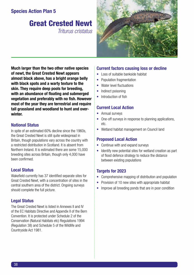
Much larger than the two other native species of newt, the Great Crested Newt appears almost black above, has a bright orange belly with black spots and a warty texture to the skin. They require deep pools for breeding, with an abundance of floating and submerged vegetation and preferably with no fish. However most of the year they are terrestrial and require tall grassland and woodland to hunt and over-winter.
National StatusIn spite of an estimated 60% decline since the 1960s, the Great Crested Newt is still quite widespread in Britain, though populations vary across the country with a restricted distribution in Scotland. It is absent from Northern Ireland. It is estimated there are some 15,000 breeding sites across Britain, though only 4,000 have been confirmed.
Local StatusWakefield currently has 37 identified separate sites for Great Crested Newt, with a concentration of sites in the central southern area of the district. Ongoing surveys should complete the full picture.
Legal Status The Great Crested Newt is listed in Annexes II and IV of the EC Habitats Directive and Appendix II of the Bern Convention. It is protected under Schedule 2 of the Conservation (Natural Habitats etc) Regulations 1994 (Regulation 38) and Schedule 5 of the Wildlife and Countryside Act 1981.
Current factors causing loss or decline• Loss of suitable bankside habitat
• Population fragmentation
• Water level fluctuations
• Indirect poisoning
• Introduction of fish
Current Local Action• Annual surveys
• One-off surveys in response to planning applications, etc.
• Wetland habitat management on Council land
Proposed Local Action• Continue with and expand surveys
• Identify new potential sites for wetland creation as part of flood defence strategy to reduce the distance between existing populations
Targets for 2023• Comprehensive mapping of distribution and population
• Provision of 10 new sites with appropriate habitat
• Improve all breeding ponds that are in poor condition
38
Species Action Plan 5
Great Crested NewtTriturus cristatus

Toad - brown to grey, with dry, rough, warty skin. Movement slow, walks with occasional weak hops. Spawn laid in strings up to 2 m long, containing up to 6,000 eggs. Does not need to live near water and thrives in drier conditions than frogs.
Frog - variety of colouration and markings, with smooth, moist skin. Moves with long hops and leaps and is a proficient swimmer. Spawn laid in clusters of up to 3,000 eggs. Normally found close to ponds or in moist areas.
National StatusFrogs and toads have undergone a significant reduction in number over the past 100 years due to loss of habitat (in particular infilling of ponds). Road deaths also result in significant mortality particularly in spring. In the past 20 years, various fungal diseases have contributed to the decline in numbers. Toads have declined an estimated 75% and frogs an estimated 81% since 1997.
Local StatusStill relatively common in wetland areas across the district. Gardens probably contain a significant proportion of the district’s frog population. The Common Toad occurs in the wider countryside and is the only toad species found in the district.
Legal Status The only legal protection afforded toads and frogs is that it is illegal to sell or trade them.
Current factors causing loss or decline• Reduction in ponds and other stillwater areas resulting in lack of breeding waters
• Fragmentation of habitat resulting from development such as new roads
• Decline in water quality
• Fungal diseases
Current Local Action• Occasional pond surveys
Proposed Local Action• Surveys of stillwater areas during breeding season
• Continue with and expand surveys
• Identify new potential sites for wetland creation as partof flood defence strategy to reduce the distance between existing populations
Targets for 2023• Comprehensive mapping of distribution and population
• Maintain and increase habitats
• Improve network of ponds to enable spread of populations
Species Action Plan 6
Common ToadBufo bufo
Common FrogRana temporaria
39

Our largest native snake, attaining a length of 1.5 m, the Grass Snake is generally dark brown to green in colour, with a whitish underside and distinct yellow collar. It is non-venomous, killing through partial constriction and devouring of whole prey. It requires the warmth of rotting vegetation to incubate eggs. Though often associated with ponds and wetlands, Grass Snakes are also often found in deciduous woodland and woodland edges.
National StatusWidely reported from across England, though becoming increasingly uncommon in northern England and virtually absent from Scotland.
Local StatusIncreasing numbers of reports from across the district but especially in the western half. Reports from nature reserves and domestic gardens. (Many such reports are initially of ‘adders’ but all of these have been shown to be grass snakes.)
Legal StatusGrass Snakes are protected under the Wildlife and Countryside Act 1981. In 2007 they were added to the UK BAP as a species in need of conservation and greater protection.
Current factors causing loss or decline• Loss of suitable habitat
• Population fragmentation
• Pollution and poorer water quality
• Predation and persecution by humans
Current Local Action• Provision of rock piles, hibernacula and other habitats on local wildlife sites
Proposed Local Action• Continue with and expand surveys
• Identify new potential sites for wetland creation as partof flood defence strategy and woodland strategy to reduce the distance between existing populations
Targets for 2023• Comprehensive mapping of distribution and population
• Improve habitat quality at 10 sites
40
Species Action Plan 7
Grass SnakeNatrix natrix
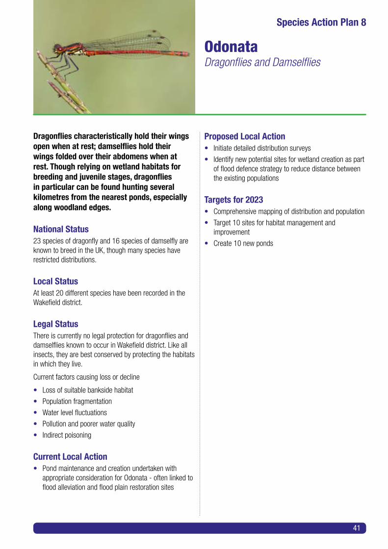
Dragonflies characteristically hold their wings open when at rest; damselflies hold their wings folded over their abdomens when at rest. Though relying on wetland habitats for breeding and juvenile stages, dragonflies in particular can be found hunting several kilometres from the nearest ponds, especially along woodland edges.
National Status23 species of dragonfly and 16 species of damselfly are known to breed in the UK, though many species have restricted distributions.
Local StatusAt least 20 different species have been recorded in the Wakefield district.
Legal StatusThere is currently no legal protection for dragonflies and damselflies known to occur in Wakefield district. Like all insects, they are best conserved by protecting the habitats in which they live.
Current factors causing loss or decline
• Loss of suitable bankside habitat
• Population fragmentation
• Water level fluctuations
• Pollution and poorer water quality
• Indirect poisoning
Current Local Action• Pond maintenance and creation undertaken with appropriate consideration for Odonata - often linked to flood alleviation and flood plain restoration sites
Proposed Local Action• Initiate detailed distribution surveys
• Identify new potential sites for wetland creation as part of flood defence strategy to reduce distance between the existing populations
Targets for 2023• Comprehensive mapping of distribution and population
• Target 10 sites for habitat management and improvement
• Create 10 new ponds
Species Action Plan 8
OdonataDragonflies and Damselflies
41

The Atlantic Salmon is a migratory fish and spends time as a juvenile in fresh water, leaving this environment to grow to adulthood at sea. They return to coastal waters in the spring and summer, move upstream into our rivers and spawn during the winter months. Salmon are an indicator of very high river water quality.
National StatusFollowing severe population reductions over the last century (as a result particularly of pollution of both river and marine environments), populations in rivers are increasing again. This rise should continue as water quality improves but it will also be necessary to remove obstacles such as weirs to allow passage along the river systems.
Local StatusSince 2000 there have been a small number of sightings of salmon along the River Calder system; removal of weirs and/or installation of fish ladders will likely produce an increase in reports.
Legal StatusSalmon is listed on Annex II of the EC Habitats Directive, regulated by the Salmon and Freshwater Fisheries Act 1975 (as modified by the Water Act 1989, the Water Resources Act 1991 and the Environment Act 1995) and the Atlantic Salmon Act 1986, in conjunction with by-laws made under these pieces of legislation.
Current factors causing loss or decline• Damage to and pollution of spawning grounds
• Physical barriers along rivers
• Water level fluctuations
• Pollution and poorer water quality
Current Local Action• Recent completion of fish pass at Castleford weir
Proposed Local Action• Continue to monitor sightings
• Identify new potential sites for spawning ground creation as part of flood defence strategy
• Remove physical barriers such as weirs and/or construct fish ladders/passes at obstructions
• Increase awareness of salmon to anglers, encouraging them to report sightings
Targets for 2023• Comprehensive mapping of distribution and population
• Removal of all barriers to fish movement along River Calder and River Aire in Wakefield
42
Species Action Plan 9
SalmonSalmo salar
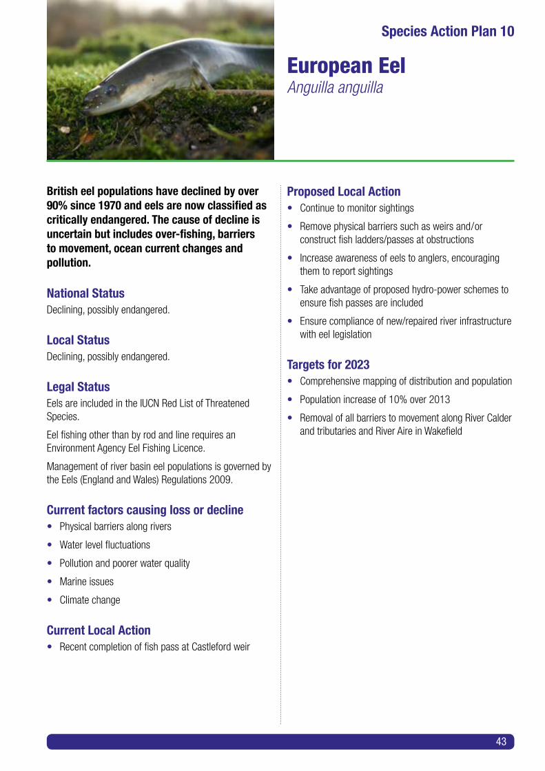
British eel populations have declined by over 90% since 1970 and eels are now classified as critically endangered. The cause of decline is uncertain but includes over-fishing, barriers to movement, ocean current changes and pollution.
National StatusDeclining, possibly endangered.
Local StatusDeclining, possibly endangered.
Legal StatusEels are included in the IUCN Red List of Threatened Species.
Eel fishing other than by rod and line requires an Environment Agency Eel Fishing Licence.
Management of river basin eel populations is governed by the Eels (England and Wales) Regulations 2009.
Current factors causing loss or decline• Physical barriers along rivers
• Water level fluctuations
• Pollution and poorer water quality
• Marine issues
• Climate change
Current Local Action• Recent completion of fish pass at Castleford weir
Proposed Local Action• Continue to monitor sightings
• Remove physical barriers such as weirs and/or construct fish ladders/passes at obstructions
• Increase awareness of eels to anglers, encouraging them to report sightings
• Take advantage of proposed hydro-power schemes to ensure fish passes are included
• Ensure compliance of new/repaired river infrastructure with eel legislation
Targets for 2023• Comprehensive mapping of distribution and population
• Population increase of 10% over 2013
• Removal of all barriers to movement along River Calder and tributaries and River Aire in Wakefield
Species Action Plan 10
European EelAnguilla anguilla
43
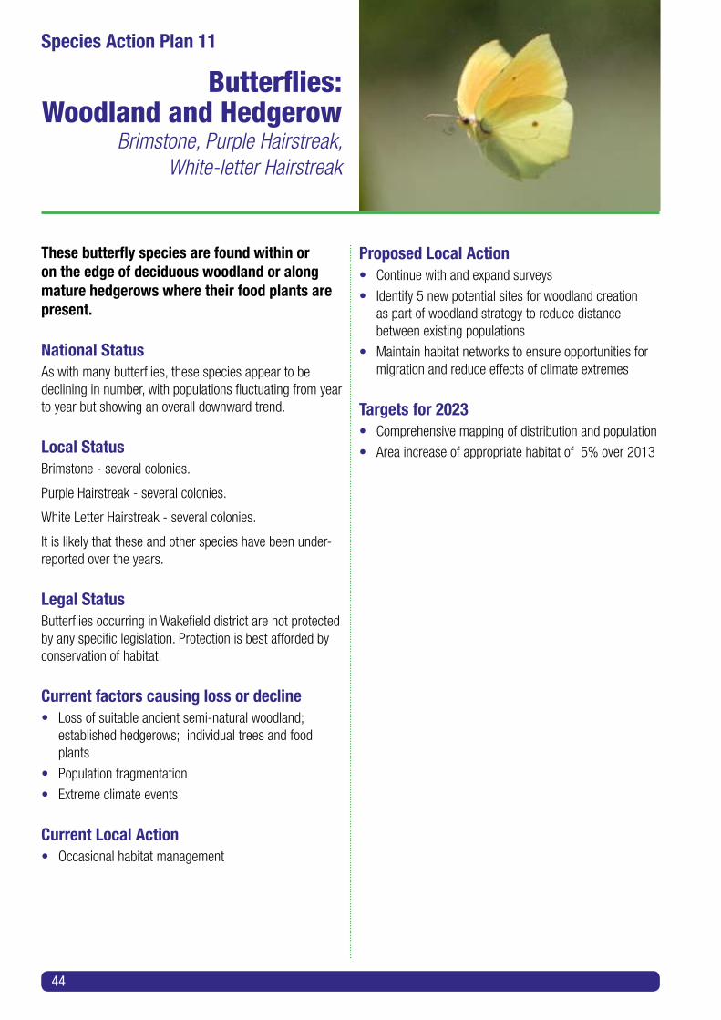
These butterfly species are found within or on the edge of deciduous woodland or along mature hedgerows where their food plants are present.
National StatusAs with many butterflies, these species appear to be declining in number, with populations fluctuating from year to year but showing an overall downward trend.
Local StatusBrimstone - several colonies.
Purple Hairstreak - several colonies.
White Letter Hairstreak - several colonies.
It is likely that these and other species have been under-reported over the years.
Legal StatusButterflies occurring in Wakefield district are not protected by any specific legislation. Protection is best afforded by conservation of habitat.
Current factors causing loss or decline• Loss of suitable ancient semi-natural woodland; established hedgerows; individual trees and food plants
• Population fragmentation
• Extreme climate events
Current Local Action• Occasional habitat management
Proposed Local Action• Continue with and expand surveys
• Identify 5 new potential sites for woodland creation as part of woodland strategy to reduce distance between existing populations
• Maintain habitat networks to ensure opportunities for migration and reduce effects of climate extremes
Targets for 2023• Comprehensive mapping of distribution and population
• Area increase of appropriate habitat of 5% over 2013
44
Species Action Plan 11
Butterflies:Woodland and Hedgerow
Brimstone, Purple Hairstreak,White-letter Hairstreak

These butterfly species are found on or on the edge of grassland, including hay meadows and brownfield sites, where their food plants are present.
National StatusAs with many butterflies, these species appear to be declining in number, with populations fluctuating from year to year but showing an overall downward trend.
Local StatusMarbled White - small colonies in the south-west of district.
Dingy Skipper - several discrete local colonies.
Grayling - occurs in one area in the Wakefield district.
Legal StatusThere is currently no legal protection for butterflies known to occur in the Wakefield district. Like all insects they are best conserved by protecting the habitats in which they live.
Current factors causing loss or decline• Loss of suitable grassland habitat
• Population fragmentation
• Scrub encroachment
Current Local Action• Occasional habitat management
Proposed Local Action• Continue with and expand surveys
• Identify new potential sites for grassland creation aspart of agri-environment schemes and flood defence strategy to reduce the distance between existing populations
Targets for 2023• Comprehensive mapping of distribution and population
• Area increase of appropriate habitat of 10% over 2013
Species Action Plan 12
Butterflies: GrasslandMarbled White, Dingy Skipper, Grayling
45

National StatusFollowing a decline in numbers during the last century, populations of most wetland bird species levelled off in the period 2000-2005 but have since shown a further downward trend.
Local StatusLimited breeding species and numbers. Significant increases in numbers during winter and passage periods.
Legal StatusAll wild birds, their nests and eggs are protected under the Wildlife and Countryside Act 1981; however ducks and geese can be shot in designated seasons. The Bittern is listed on Annex 1 of the EC Birds Directive and Appendix III of the Bern Convention.
Current factors causing loss or decline• Loss of suitable habitats
• Increased disturbance
• Population fragmentation
• Water level fluctuations
• Pollution and poorer water quality
• Indirect poisoning
Current Local Action• Wetland creation on reclamation sites and flood alleviation schemes across district
Proposed Local Action• Continue with and expand surveys
• Identify new potential sites for wetland creation as part of flood defence strategy to reduce distance between existing populations
Targets for 2023• Comprehensive mapping of distribution and population
• Increase area of appropriate wetland habitat as part of flood prevention works by minimum of 5 ha
46
Species Action Plan 13
Wetland BirdsTeal, Lapwing, Curlew, Reed Bunting,
Bittern, Grey Heron, Shoveler, Pochard, Water Rail, Snipe, Common Tern, Kingfisher,
Grasshopper Warbler, Reed Warbler,Cetti’s Warbler, Willow Tit

National StatusWoodland bird populations have shown a significant downward trend nationally since 2000.
Local StatusSome species increasing in population and distribution, others contracting. On the whole, local populations appear to mirror the national downward trends.
Legal StatusAll wild birds, their nests and eggs are protected under the Wildlife and Countryside Act 1981.
Current factors causing loss or decline
• Development and associated woodland clearance
• Woodland fragmentation
• Air pollution and poor water quality
• Indirect poisoning
Current Local Action• Erection of nesting boxes for Tree Sparrow
• Monitoring of nesting boxes
• Feeding station at Anglers Country Park
Proposed Local Action• Continue with and expand surveys
• Identify new potential sites for woodland and hedgerow creation as part of woodland strategy to reduce distance between existing populations
• Erect bird boxes at appropriate locations
Targets for 2023• Comprehensive mapping of distribution and population
• Increase in appropriate new woodland habitat area (minimum 2 ha) and number of woodland stands
• Increase in deciduous woodland resulting from clear- felling of conifers and replanting with native species (minimum of 9 ha)
Species Action Plan 14
Woodland and Woodland Edge BirdsSong Thrush, Kestrel, Sparrowhawk, Turtle Dove, Lesser Spotted Woodpecker, Spotted Flycatcher, Tree Sparrow, Hawfinch
47

Bats are specialized feeders relying on an abundant supply of flying insects and sheltered areas in which to catch them. Bats also require safe undisturbed roosting sites in which to breed and over-winter in hibernation.
National Status(from NBMP survey on population trends 1997 - 2006)
Daubenton’s: common/widespread - increasing
Brandt’s: common/restricted - no change
Whiskered: common/restricted - no change
Natterer’s: common/widespread - increasing
Common Pipistrelle: common/widespread - increasing
Soprano Pipistrelle: common/widespread - stable
Noctule: uncommon/widespread - no change
Leisler’s: scarce/widespread - no data
Brown Long-eared: common/widespread - no change
Local Status9 species of bats are known to occur in Wakefield district. The most northerly roosts of Leisler’s Bat occur in the district.
Legal Status Bats are listed on Appendix III of the Bern Convention, Annex IV of the Habitats Directive and Appendix II of the Bonn Convention (and are included under the Agreement of the Conservation of Bats in Europe). They are protected under Schedule 2 of the Conservation (Natural Habitats etc) Regulations 1994 (Regulation 38).
All bats in the UK are fully protected under the Wildlife and Countryside Act 1981, updated by the Countryside and Rights of Way Act 2000 and the Habitat Regulations 1994, updated by the Conservation (Natural Habitats etc) (Amendment) Regulations 2007. Under the legislation it is
an offence to take, kill, injure or disturb bats or obstruct or destroy their roosts.
Current factors causing loss or decline• Loss of suitable roosting and nesting sites, including old buildings, trees etc.
• Population fragmentation
• New building with PVC soffits
• Replacement of wooden infrastructure with plastic
• Reduction in food supply due to habitat loss
Current Local Action• Ongoing surveys by bat groups and for planning application purposes
• Erection of bat boxes across district
Proposed Local Action• Continue with and expand surveys
• Give particular priority to Whiskered, Natterer’s and Leisler’s Bats
• Ensure protection of roosting, hibernating and breeding sites
• Erection of further 50 bat boxes including around new developments
• Encourage developers to include bat entrances on new and repaired structures
Targets for 2023• Comprehensive mapping of distribution and population of individual species
48
Species Action Plan 15
Bat SpeciesWhiskered, Daubenton’s, Natterer’s,
Noctule, Leisler’s, Pipistrelle, Soprano Pipistrelle, Brown Long-Eared, Brandt’s
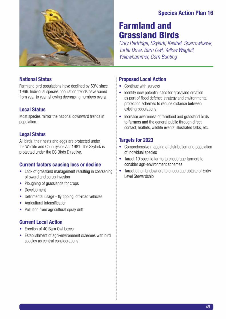
National StatusFarmland bird populations have declined by 53% since 1966. Individual species population trends have varied from year to year, showing decreasing numbers overall.
Local StatusMost species mirror the national downward trends in population.
Legal StatusAll birds, their nests and eggs are protected under the Wildlife and Countryside Act 1981. The Skylark is protected under the EC Birds Directive.
Current factors causing loss or decline• Lack of grassland management resulting in coarsening of sward and scrub invasion
• Ploughing of grasslands for crops
• Development
• Detrimental usage - fly tipping, off-road vehicles
• Agricultural intensification
• Pollution from agricultural spray drift
Current Local Action• Erection of 40 Barn Owl boxes
• Establishment of agri-environment schemes with bird species as central considerations
Proposed Local Action• Continue with surveys
• Identify new potential sites for grassland creationas part of flood defence strategy and environmental protection schemes to reduce distance between existing populations
• Increase awareness of farmland and grassland birds to farmers and the general public through direct contact, leaflets, wildlife events, illustrated talks, etc.
Targets for 2023• Comprehensive mapping of distribution and population of individual species
• Target 10 specific farms to encourage farmers to consider agri-environment schemes
• Target other landowners to encourage uptake of Entry Level Stewardship
Species Action Plan 16
Farmland and Grassland BirdsGrey Partridge, Skylark, Kestrel, Sparrowhawk, Turtle Dove, Barn Owl, Yellow Wagtail, Yellowhammer, Corn Bunting
49

The naturally occurring farmland and grassland flora reflects the underlying geology, with predominantly acid and neutral grasslands in the west and central areas and calcareous grasslands extending in a narrow belt down the eastern side of the district.
National StatusTraditional, species-rich grasslands of all types have declined to less than 3% of the 1945 area cover as a result of agricultural intensification and land development. Many remaining sites are now recognized and protected, particularly those under the control of local authorities and charitable organizations. The use of agri-environment schemes to halt and reverse this trend has increased significantly since 2000.
Local StatusThe once extensive mosaic of grasslands has declined rapidly since the 1950s due to intensification of agricultural methods, leaving behind scattered areas of the habitat. It is estimated that less than 5% of traditionally managed hay meadows now remain, many on land owned or controlled by the Council.
Legal Status• All wildflower species are protected but with few exceptions such protection does not extend to productive farmland
Current factors causing loss or decline• Lack of management resulting in coarsening of sward and scrub invasion
• Ploughing of grasslands for crops
• Development
• Detrimental usage - fly tipping, off-road vehicles
• Pollution from agricultural spray drift
Current Local Action• Hay meadow and grassland management by the Council and other land-owning bodies
Proposed Local Action• Secure management of grassland sites threatened by neglect
• Continue with and expand surveys
• Identify new potential sites for grassland creation aspart of land use strategy and environmental protection schemes to reduce distance between existing populations
• Increase awareness of farmland and grassland plants to farmers and the general public through direct contact, leaflets, wildlife events, illustrated talks, etc.
Targets for 2023• Comprehensive mapping of distribution of grassland habitats
• Improve 5 sites across district for farmland and grassland wild flowers
50
Species Action Plan 17
Farmland andGrassland Plants
Purple Milk Vetch, Pyramidal Orchid, Fly Orchid, Field Garlic

National StatusAs the area of managed broad-leaved woodland has declined over the last 50 years the associated ground flora and edge flora have also declined.
Local StatusOnly 5.6% of the district is covered by woodland of all types and the distribution of woodland is very uneven. Almost all ancient and semi-natural broad-leaved woodland (oak-birch) and its associated ground flora is found in the south-west of the district. Over 50% of woodlands are between 1 and 5 ha in size. 40% are managed by the Council.
Legal StatusAll native species are legally protected but are generally dependent on associated planning protection for broad-leaved woodland rather than for individual species.
Current factors causing loss or decline• Development, especially of smaller unprotected sites
• Population fragmentation
• Drift of agricultural sprays
• Lack of appropriate woodland management, especially in privately owned woods
• Inappropriate land use, fly tipping, etc.
• Invasion by non-native species
Current Local Action• FC Woodland Management schemes
• Ongoing basic management in woodland LNRs
• Ongoing management and thinning of reclamation site plantations
Proposed Local Action• Continue with and expand surveys
• Identify new potential sites for woodland creation as part of woodland strategy to reduce distance between existing habitats
• Clear-felling of conifer woodlands and replacement with native broad-leaved species
• Seeding and planting to produce more varied structure in plantations
Targets for 2023• Comprehensive mapping of distribution and population of woodland ground flora and woodland edge species
• Planting up of 10 sites alongside existing woodlands
Species Action Plan 18
Woodland and Woodland Edge PlantsWild Service Tree, Spindle Tree, Large Flowered Wintergreen, Wood Small Reed, Bluebell
51

52
Species Action Plan 19
Short Winged Conehead Bush Cricket
Conocephalus dorsalis
Species Action Plan 23
SpleenwortsMaidenhair spleenwort, Black
spleenwort, Rustyback spleenwort
Species Action Plan 20
White Clawed CrayfishAustropotamobius pallipes
Species Action Plan 24
Brown ArgusAricia agestis
Species Action Plan 21
Palmate NewtLissotriton helveticus
Species Action Plan 25
River LampreyLampetra fluviatilis
Species Action Plan 22
SwiftApus apus
These are Candidate Key Priority Species for which SAPs will be prepared during the life of this Plan. Meanwhile these species should be given special consideration during the Development Planning process.

Broad-leaved deciduous woodland is classified by splitting it into ancient semi-natural, ancient plantation (PAWS), recent semi-natural and recent plantation. Plantations tend to have a simple structure and semi-natural woodland is normally considered to be of greater ecological value, though some plantations, especially older ones are an important resource for wildlife, especially where there is little adjacent semi-natural and ancient woodland.
National StatusLess than 4% of Britain is covered by deciduous woodland.
Local StatusOnly 5.6% of the district is covered by woodland of all types and the distribution of woodland is very uneven. Almost all ancient and semi-natural woodland (oak - birch) is found in the south-west of the district, whereas recently planted sites are scattered across the district and reflect the location of colliery reclamation sites. Over 50% of woodlands are between 1 and 5 ha in size. 40% are managed by the Council.
Legal StatusFelling of woodland and larger individual trees is subject to licence through the Forestry Commission. However there is no formal protection for woodland understorey or ground flora outside designated sites.
Current factors causing loss or decline• Development, especially of smaller unprotected sites
• Lack of, or inappropriate management
• Detrimental usage
• Invasion by non-native species
Current local action• Replacement of 2 ha of conifers with 2 ha of native deciduous woodland
• Ongoing management of plantation broadleaved woodland on reclamation sites
Proposed local action• Continue and increase level of management of woodlands for biodiversity interest, wood fuel and other timber products and recreational / amenity / landscape value
• Promote management of neglected sites, especially reclamation plantation woodlands
NB It is essential that other priority habitats are not lost, damaged or reduced in size as a result of the planting of trees for wood fuel or other purposes.
Targets for 2023• Increase area of native deciduous woodland habitat by 2 ha
• Return 8 ha of PAWS to native deciduous woodland
• Return 18 ha of coniferous plantation to deciduous woodland through thinning
• 10 ha plantation woodland taken into coppicing
Habitat Action Plan 1
Deciduous Woodland
53

There are approximately 390 km of rivers and other watercourses in Wakefield district. Four main river systems with associated tributaries occur in the district: River Calder (merging with the River Aire above Castleford) (tributaries include Oakenshaw Beck, Balne Beck, Alverthorpe Beck, Sewerbridge Beck) River Went (including Little Went, Hardwick Beck, Hessle Beck and Tan House Dike), Langthwaite Beck and, along the south-west border, the River Dearne.
Legal StatusEnvironment Act (1995) imposes a duty on the Environment Agency, water companies, Canal & River Trust, Internal Drainage Boards and local authorities to promote aquatic flora and fauna. W&C Act 1981 prohibits the unlicensed release of non-resident animals, some established alien animals, and some plants.
Current factors causing loss or decline• River channel modification
• Point and diffuse pollution discharges
• Overgrazing along river banks
• Bankside development
• Structures preventing migration movements of fish
• Water abstraction
• Culverting of feeder streams
Proposed local action• Further flood alleviation works and habitat creation
• Identify target areas for habitat enhancement, particularly the restoration of riparian vegetation on bare sections of river bank
• De-culverting of stream sections where possible
• Removal of weirs/creation of fish passes on R Calder and R Aire, including within hydro-power generating schemes
Targets for 2023 • Improvement of habitats along 5 km of river/stream
• Eradication of invasive plant species along 5 km of river/stream
• Comprehensive mapping of wildlife habitats along 20 km of bankside habitat
• Install two artificial otter holts
• 4 fish passes created and/or
• 4 weirs removed on R Calder and R Aire
54
Habitat Action Plan 2
Rivers and Streams

This category includes ponds, permanently wet flood-water retaining features, ditches, springs and disused canals. Ponds are generally very rich in wildlife, supporting amphibians, dragonflies and other aquatic insects, water vole, breeding and over-wintering birds, bats, eels and other fish. Adjacent grasslands form hunting and foraging grounds for a range of species including birds.
Local StatusThe total area of such habitats in Wakefield is approximately 300 ha, plus 5.3 km of disused canal (and an unknown area of garden and other private ponds). In 1934 there were 616 ponds across Wakefield district; by 1984 this number had shrunk to 261 (a 57% decline).
Legal StatusEnvironment Act (1995) imposes a duty on the Environment Agency, water companies, Canal & River Trust, Internal Drainage Boards and local authorities to promote aquatic flora and fauna. W&C Act 1981 prohibits the unlicensed release of non-resident animals, some established alien animals, and some plants.
Current factors causing loss or decline• Eutrophication resulting from agricultural run-off
• Introduction of fish for recreational angling
• Other recreational pursuits on larger lakes and canals
• Infilling and/or isolation of ponds to facilitate development or for safety reasons
Current local action• Partial removal of vegetation, especially Typha stands, to create open water areas
• Creation of new water-bodies within flood prevention projects, reclamation schemes, etc.
Proposed local action• Further new and enlarged water-bodies within flood control works, colliery reclamation etc.
• Work with angling clubs, sailing clubs and other water users to ensure biodiversity is promoted at all sites
• Survey ponds for water quality and for flora and fauna and advise appropriate management
• Seek further areas where open standing water can be created; with an emphasis on the creation of clean water ponds
Targets for 2023 • Create a further 50 new permanent and seasonal ponds
• Where appropriate, manage over-dominant vegetation in 30 existing ponds
• Assess water quality of 30 existing ponds using macroinvertebrates and biotic indices
Habitat Action Plan 3
Lakes and Ponds
55

Magnesian limestone is only found in a narrow band up to 14 km wide between Nottingham and South Shields. The type of grassland directly associated with the geological formation only occurs in this very narrow range.
In Wakefield district, vegetation is typically NVC CG3 and CG5. Typical species include Upright Brome, Tor Grass, Common Milkwort, Ploughman’s Spikenard, Greater Knapweed, Fairy Flax, Clustered Bellflower and Marjoram.
National StatusUnimproved limestone grasslands are now scarce because the soils are fertile and easily cultivable and much has been converted to arable farmland. There are probably only a few hundred hectares remaining.
Local StatusOnly 13 sites are known in Wakefield District, of which 10 are one hectare or less in area and the total is only some 29 ha. The resource is fragmented with sites being separated by large expanses of land with little ecological value. Four sites (Fryston Wood, Holywell Wood, Well Wood and Went Hill) are designated as Sites of Scientific Interest and candidate Local Wildlife Sites.
Legal statusSites included in the Local Development Framework have a presumption against development but have no protection against operations which do not require planning consent.
Current factors causing loss or decline• Lack of management resulting in coarsening of sward and scrub invasion
• Development
• Landfill of quarry sites
• Detrimental usage - fly tipping, off-road vehicles
• Pollution - from agricultural spray drift
Current Local Action• Recent grassland management at Well Wood, including scrub removal
• Mowing and arisings removal at Orchard Head
• All sites identified and included in Local Development Framework
Proposed Local Action• Use local community and other voluntary activities for management
• Take steps to prevent inappropriate and illegal use of sites
• Secure long-term arrangements to enable appropriate management
• Continue management advice to landowners including Council departments and other public bodies
Targets for 2023 • Restoration of 5 ha of habitat
• 3 ha of new species-rich grassland established
• Active management of 29 ha of previously unmanaged magnesian limestone grassland
56
Habitat Action Plan 4
Unimproved Magnesian Limestone Grassland

Unimproved neutral grasslands are particularly vulnerable to invasion by tall herbs and scrub when not managed.
National StatusAn estimated 97% of neutral grasslands, in particular species-rich meadows, has been lost since 1945 to development, and changes in agricultural practices.
Local StatusSome 46 sites of neutral grassland make up approximately 74 ha of this habitat across the district (excluding roadside verges). However, less than 20 ha of this habitat is thought to be species rich.
Legal StatusSites included in the Local Development Framework have a presumption against development but have no protection against operations which do not require planning consent.
Current factors causing loss or decline• Lack of recognition of the value of this habitat by landowners and developers
• Development of grasslands
Current local action• Annual mowing of hay meadows
Proposed local action• Continued low input management
• Seeding of areas as part of flood alleviation schemes
• Creation of new sites
• Sympathetic management of grass verges
• Bring Roadside Nature Reserves into appropriate management
Targets for 2023 • 5 new neutral grassland sites (minimum 0.5 ha) created
• 7 ha increase in area of species-rich neutral grassland and neutral/acid grassland mosaics
Habitat Action Plan 5
Unimproved Neutral Grassland
57

Lowland dry acidic grassland typically occurs on nutrient-poor, free-draining soils overlying acid rock. The habitat is characterized by a range of plants such as Heath Bedstraw, Sheep’s Sorrel, Tormentil, Harebell and Common Bent. Many invertebrates that occur in acid grasslands are specialist species and are not found in other types of grassland. The habitat is important for skylark, bumble bees and brown hare.
National StatusAn estimated 97% of neutral grasslands, in particular species-rich meadows and roadside verge has been lost since 1945 to development, and changes in agricultural practices.
Local StatusIn Wakefield there are approximately 110 ha of acid grassland, of which over 50% is on sites of less than 1 ha; only three sites exceed 10 ha.
Legal StatusSites included in the Local Development Framework have a presumption against development but have no protection against operations which do not require planning consent.
Current factors causing loss or decline• Lack of recognition of value of habitat by landowners and developers
• Development on grasslands
• Tree planting on grasslands
Current local action• Annual mowing of hay meadows
Proposed local action• Continued low input management
• Seeding of areas as part of flood alleviation schemes
• Creation of new sites
• Sympathetic management of grass verges
• Bring designated Roadside Nature Reserves into appropriate management
Targets for 2023 • 5 new acid grassland sites (minimum 0.5 ha) created
• 7 ha increase in area of managed species-rich acid & neutral grasslands and acid/neutral grassland mosaic
58
Habitat Action Plan 6
Unimproved Acid Grassland

Lowland heathland is a nationally rare and threatened habitat. In Wakefield the only area of any extent is found at Seckar Wood, where 14 ha of dry heath and 3 ha of wet heath form part of the Seckar Wood SSSI. Attempts to establish further areas of lowland heath on reclaimed colliery spoil heaps have met with mixed success. The habitat is subject to rapid successional change and requires more intensive management than most other habitats.
National StatusThere are 58,000 ha of lowland heathland, the great majority being in the south and south-west of England.
Local Status1 large established habitat; other scattered remnants and planted areas.
Legal StatusSites other than the Seckar Wood SSSI are included in the Local Development Framework and have a presumption against development but have no protection against operations which do not require planning consent.
Current factors causing loss or decline
• Invasion by birch/oak/hawthorn scrub and bracken
• Localized vandalism and arson
Current local action• Management of existing sites
• Targeted scrub and bracken removal (Seckar Wood)
• Limited planting of heather
• More extensive planting as part of reclamation schemes
Proposed local action• Continuing scrub removal
• Further heather establishment at 3 sites alongside existing heather stands
Targets for 2023 • Maintain or enhance quality of all existing heathland
• Increased area of established heathland (minimum 0.5 ha) on 3 reclaimed spoil heaps
Habitat Action Plan 7
Lowland Heathland
59

Hedgerows are important habitats in their own right, being especially important for butterflies and moths, farmland birds, bats, reptiles and amphibians and a broad range of flora. They act as wildlife corridors for many species, allowing movement between other habitats and thus promoting migration, dispersal and genetic exchange of wild species.
National StatusHedgerows have declined significantly since the 1940s due to intensification of agriculture. This decline in length and condition reached a peak in the 1980s and 1990s but indications are that it is slowly reversing as a result of agri-environmental scheme incentives to farmers.
Local StatusBetween 1945 and 1987 a minimum of 224 km of hedgerows were lost from Wakefield district. Those remaining across the district vary from mature, well-maintained, diverse hedges to poorly managed, gappy remainders of former enclosures. Hawthorn, blackthorn, hazel, elder, and field maple are the most common hardwood species.
Legal StatusUnder the Hedgerows Regulations 1997 Local Planning Authority permission is required before removing hedges that are at least 20m in length; more than 30 years old; and contain certain species of plant. The Authority will assess the importance of the hedgerow using criteria set out in the Regulations.
Current factors causing loss or decline• Neglect of hedgerows rather than destruction is the main threat
• Uprooting as part of local development, particularly in urban/sub-urban locations
Current local action• Regular trimming by landowners
Proposed local action• Encourage landowners to plant new hedgerows and re-establish hedgerow networks where feasible
• Encourage and assist landowners to ‘beat up’ and manage existing poor quality hedgerows for wildlife
• Survey older established hedgerow systems
Targets for 2023 • 5 km new/replacement hedgerows planted, with emphasis on hedgerow networks rather than individual hedgerows
• 10 km hedgerow brought back into wildlife-friendly management
60
Habitat Action Plan 8
Hedgerows

This habitat includes derelict industrial land such as former colliery sites, disused railways, mineral and clay extractions, allotments, road verges and public open space which form a very significant resource for wildlife. Disused railways can provide important wildlife corridors linking a number of isolated conservation sites. Individual areas can be quite small but cumulatively provide an area in excess of that of LWSs and SSSIs. Such habitats may have significant assemblages of both natural and introduced plants and are often particularly important for invertebrates.
National StatusCentral government has identified brownfield sites as having priority over greenfield sites for development. The value for biodiversity is only now becoming realized following loss to this redevelopment. However, the reclamation of such sites offers opportunities for new habitat creation and expansion, as demonstrated by the creation of a number of nature reserves following the reclamation of former colliery spoil heaps in Wakefield district.
Local StatusThere are approximately 350 ha of derelict and contaminated land and 34 km of disused railways across Wakefield.
Legal StatusBrownfield sites have no specific protection but species found on them often benefit from legal protection.
Current factors causing loss or decline• Redevelopment of brownfield sites for industry, housing and recreation
• Fragmentation of habitats
Current local action• The reclamation of the last three former colliery sites is currently being completed and includes habitat creation and enhancement
Proposed local action• Continue surveying and recording of brownfield sites
• Increase knowledge of biodiversity value of brownfield sites for planners and developers
• Where development is shown to be essential, ensure appropriate mitigation for habitat creation and management is secured
• Management of neglected sites
Targets for 2023• 10 km disused railways surveyed
• 10 ha brownfield sites surveyed
Habitat Action Plan 9
Brownfield Sites and Disused Railways
61
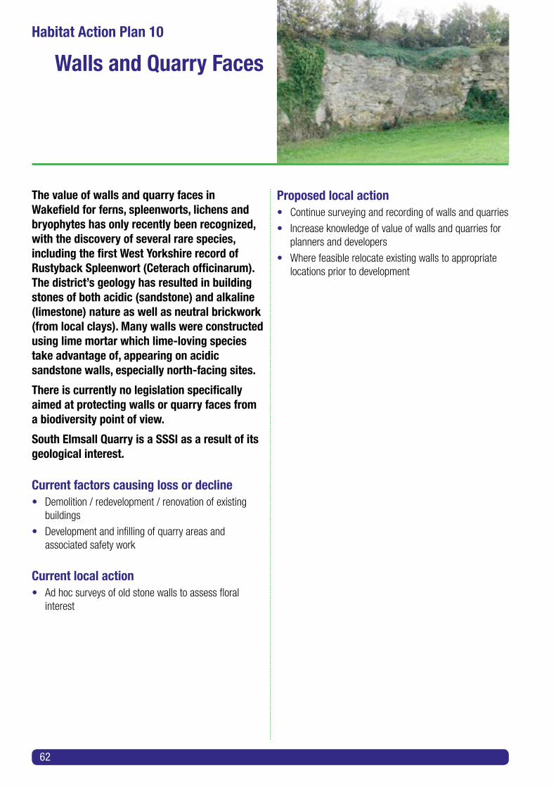
The value of walls and quarry faces in Wakefield for ferns, spleenworts, lichens and bryophytes has only recently been recognized, with the discovery of several rare species, including the first West Yorkshire record of Rustyback Spleenwort (Ceterach officinarum). The district’s geology has resulted in building stones of both acidic (sandstone) and alkaline (limestone) nature as well as neutral brickwork (from local clays). Many walls were constructed using lime mortar which lime-loving species take advantage of, appearing on acidic sandstone walls, especially north-facing sites.
There is currently no legislation specifically aimed at protecting walls or quarry faces from a biodiversity point of view.
South Elmsall Quarry is a SSSI as a result of its geological interest.
Current factors causing loss or decline• Demolition / redevelopment / renovation of existing buildings
• Development and infilling of quarry areas and associated safety work
Current local action• Ad hoc surveys of old stone walls to assess floral interest
Proposed local action• Continue surveying and recording of walls and quarries
• Increase knowledge of value of walls and quarries for planners and developers
• Where feasible relocate existing walls to appropriate locations prior to development
62
Habitat Action Plan 10
Walls and Quarry Faces

Urban and suburban areas offer a wide range of potential and actual habitats for wildlife, both in and on buildings and within gardens, allotments, churchyards etc. In total they far exceed the total area of more ‘natural’ habitat such as woodlands and wetland across the district. For some species e.g. Swift, they offer the only habitats suitable for breeding populations.
Local Planning Policy actions• Identify locations of all key and best representative habitat types
• Ensure developers are made aware of the existence of valuable habitats, both existing established habitats and those with potential for improvement; in particular grasslands, woodlands and wetlands
• Encourage the creation of new habitat
• Encourage creation of a habitat framework and habitat networks through LDF policies
• Presumption against development involving damage to woodland
Development Control actions• Discuss protection, mitigation and conservation of habitats on development sites prior to submission of planning applications
• In particular consider the value of grasslands for wildlife
• Seek habitat enhancement for all development proposals in the vicinity of watercourses, woodlands and grasslands
• Ensure that built development does not result in the loss of wildlife-rich habitats
• Where development is shown to be essential, ensure appropriate mitigation for habitat creation and management is secured
Habitat Action Plan 11
Urban and Suburban Areas
63
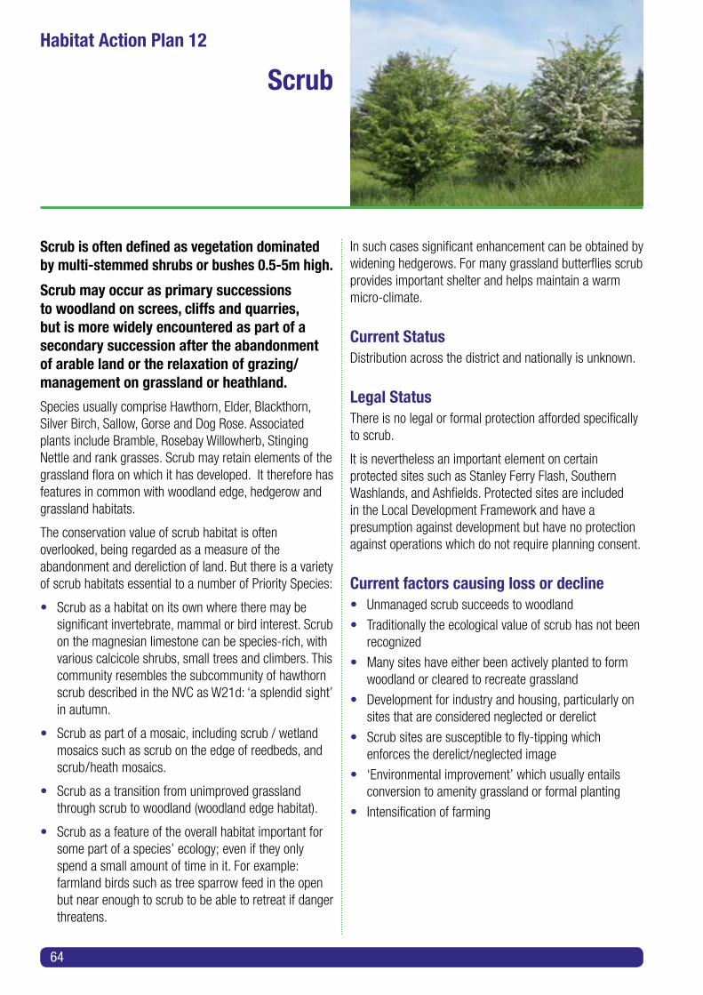
Scrub is often defined as vegetation dominated by multi-stemmed shrubs or bushes 0.5-5m high.
Scrub may occur as primary successions to woodland on screes, cliffs and quarries, but is more widely encountered as part of a secondary succession after the abandonment of arable land or the relaxation of grazing/management on grassland or heathland.
Species usually comprise Hawthorn, Elder, Blackthorn, Silver Birch, Sallow, Gorse and Dog Rose. Associated plants include Bramble, Rosebay Willowherb, Stinging Nettle and rank grasses. Scrub may retain elements of the grassland flora on which it has developed. It therefore has features in common with woodland edge, hedgerow and grassland habitats.
The conservation value of scrub habitat is often overlooked, being regarded as a measure of the abandonment and dereliction of land. But there is a variety of scrub habitats essential to a number of Priority Species:
• Scrub as a habitat on its own where there may besignificant invertebrate, mammal or bird interest. Scrub on the magnesian limestone can be species-rich, with various calcicole shrubs, small trees and climbers. This community resembles the subcommunity of hawthorn scrub described in the NVC as W21d: ‘a splendid sight’ in autumn.
• Scrub as part of a mosaic, including scrub / wetland mosaics such as scrub on the edge of reedbeds, and scrub/heath mosaics.
• Scrub as a transition from unimproved grassland through scrub to woodland (woodland edge habitat).
• Scrub as a feature of the overall habitat important forsome part of a species’ ecology; even if they only spend a small amount of time in it. For example: farmland birds such as tree sparrow feed in the open but near enough to scrub to be able to retreat if danger threatens.
In such cases significant enhancement can be obtained by widening hedgerows. For many grassland butterflies scrub provides important shelter and helps maintain a warm micro-climate.
Current StatusDistribution across the district and nationally is unknown.
Legal StatusThere is no legal or formal protection afforded specifically to scrub.
It is nevertheless an important element on certain protected sites such as Stanley Ferry Flash, Southern Washlands, and Ashfields. Protected sites are included in the Local Development Framework and have a presumption against development but have no protection against operations which do not require planning consent.
Current factors causing loss or decline• Unmanaged scrub succeeds to woodland
• Traditionally the ecological value of scrub has not been recognized
• Many sites have either been actively planted to form woodland or cleared to recreate grassland
• Development for industry and housing, particularly on sites that are considered neglected or derelict
• Scrub sites are susceptible to fly-tipping which enforces the derelict/neglected image
• ‘Environmental improvement’ which usually entails conversion to amenity grassland or formal planting
• Intensification of farming
64
Habitat Action Plan 12
Scrub

Current Local Action• Southern Washlands: current management plan including coppicing and rotational scrub management
• Wintersett Reservoir: management to conserve sedge warbler and reed bunting, and to encourage Cetti’s Warbler
• Fryston Colliery: parts reclaimed to limestone scrub. Currently managed by Land Trust
• Walton Colliery Nature Park: scrub areas managed to encourage, for instance, grass snakes
• Three reclamation sites to be planted using carbon sequestration funding will include a species-rich scrub component
Proposed Local Action• Ensure scrub is given due weight when formulating management plans
• Ensure that built development does not result in the loss of wildlife-rich scrub
• Where development is essential, ensure appropriate mitigation for scrub creation and management is secured
• Prescribe species-rich scrub mixtures
• Identify natural areas of self-generating scrub
• Manage habitat to ensure retention of scrub where not adversely affecting other habitats
Targets for 2023• 50 ha of previously unmanaged continuous scrub managed and retained
• Coppice management reinstated at 5 sites
65

66
Habitat Action Plan 13
Reedbeds
Habitat Action Plan 14
Marsh
Habitat Action Plan 15
Wet Woodland
These are Candidate Priority Habitats for which HAPs will be prepared during the life of this Plan. Meanwhile these habitats should be given special consideration during the Development Planning process.

Table 9 Summary Table of Priority Habitats, Actions and Targets
Priority Habitat
Proposed Activities/Work April 2013 - March 2023
Targets for March 2023
Landscape Scale Projects
Main Stakeholders
Other Comments
1. Deciduous Woodland
• Continue andincrease level of management of woodlands for biodiversity interest, wood fuel and other timber products and recreational/amenity/ landscape value.
• Promotemanagement of neglected sites, especially reclamation plantation woodlands.
• 2 ha new native deciduous woodland.
• 8 ha of PAWSrestored to native deciduous woodland.
• 18 ha coniferouswoodland restored to native deciduous woodland.
• 10 ha plantation woodland taken into coppicing.
• StrategicWaterways Project - Calder Valley.
• Magnificent Magnesian Habitats.
• Council.
• Forestry Commission.
• Landowners.
• Friends Groups.
• Yorks Wildlife Trust (YWT).
• National Trust.
Leeds City Region Infrastructure Strategy.
Wakefield Green Infrastructure Plan.
Do not destroy other Priority Habitats through woodland planting.
Reverse neglect of private woodlands.
2. Rivers & Streams
• Habitat creation on flood alleviation sites.
• Restoration of riparian vegetation on river banks.
• De-culvert streams.
• Removal of weirs/ creation of fish passes.
• Habitat along5 km of bank improved.
• Invasive plantsalong 5 km of bank eradicated.
• 20 km ofbankside habitat mapped.
• 2 artificial otter holts created.
• 4 fish passes created and/or
• 4 weirs removed.
• StrategicWaterways Project - Aire and Calder Rivers.
• Went Catchment.
• Council(Planning, Drainage).
• Riparian Owners.
• Canal & River Trust.
• Environment Agency.
• Calder & Colne Rivers Trust.
• YWT
• Angling Clubs & other water users.
• Hydro-power developers.
Leeds City Region Green Infrastructure Strategy.
Wakefield Green Infrastructure Plan.
Survey programme required.
67

Priority Habitat
Proposed Activities/Work April 2013 - March 2023
Targets for March 2023
Landscape Scale Projects
Main Stakeholders
Other Comments
3. Lakes & Ponds
• Further new andenlarged water-bodies within flood control works, colliery reclamation etc.
• Work with anglingclubs, sailing clubs and other water users to ensure biodiversity is promoted at all sites.
• Survey ponds forwater quality and for flora and fauna and advise appropriate management.
• Seek further areaswhere open standing water can be created; with an emphasis on the creation of clean water ponds.
• 50 newpermanent & seasonal ponds created.
• Managementof over-dominant vegetation 30 existing ponds.
• Assesswater quality of 30 existing ponds using macroinvertebrates and biotic indices.
• StrategicWaterways Project - Aire and Calder Rivers.
• Went Catchment.
• Council (Planning, Drainage).
• Riparian Owners.
• Canal & River Trust.
• Environment Agency.
• Angling Clubs & other water users.
• SUDS Approval Boards.
Million Ponds Project.
4. Unimproved Magnesian Limestone Grassland
• Use localcommunity and other voluntary activities for management.
• Take steps to preventinappropriate and illegal use of sites.
• Secure long-termarrangements to enable appropriate management.
• Continuemanagement advice to landowners including Council departments and other public bodies.
• 5 ha of habitat restored.
• 3 ha ofnew species-rich grassland established.
• 29 ha of existing habitat actively managed.
• Magnificent Magnesian Habitats.
• West YorksGrasslands Project.
• Council.
• Farmers & Landowners.
• YWT
Entry Level Stewardship.
Higher Level Stewardship.
Frequent reviews of targets required.
68

Priority Habitat
Proposed Activities/Work April 2013 - March 2023
Targets for March 2023
Landscape Scale Projects
Main Stakeholders
Other Comments
5. Unimproved Neutral Grassland
• Continue low input management.
• Seeding of areas aspart of flood alleviation schemes.
• Creation of new sites.
• Sympathetic management of grass verges.
• Bring RoadsideNature Reserves into appropriate management.
• 5 new sites(minimum 0.5 ha).
• 7 ha increase inarea of managed species-rich neutral & acid grasslands and neutral/acid grassland mosaics.
• West YorkshireGrasslands Project.
• Council (Highways).
• Farmers & Landowners.
• YWT
• West Yorkshire Ecology.
Entry Level Stewardship.
Higher Level Stewardship.
6. Unimproved Acid Grassland
• Continued lowinput management.
• Seeding of areasas part of flood alleviation schemes.
• Creation of new sites.
• Sympatheticmanagement of grass verges.
• Bring RoadsideNature Reserves into appropriate management.
• 5 new sites(minimum 0.5 ha).
• 7 ha increasein area of managed species-rich acid & neutral grasslands and acid/neutral grassland mosaics.
• West Yorks Grasslands Project.
• Council (Highways).
• Farmers & Landowners.
• YWT
• West Yorkshire Ecology.
Entry Level Stewardship.
Higher Level Stewardship.
Frequent reviews of targets needed.
7. Lowland Heathland
• Continuing scrub removal.
• Establish further heather areas at three sites.
• All existingheathland (27 ha) maintained in prime condition.
• Increasedarea of cover (minimum 0.5 ha) on 3 reclaimed spoil heaps.
• Council Landowners.
• Friends Group.
69

Priority Habitat
Proposed Activities/Work April 2013 - March 2023
Targets for March 2023
Landscape Scale Projects
Main Stakeholders
Other Comments
8. Hedgerows • New planting ofindividual hedgerows and networks.
• ‘Beat up’ poor quality hedges.
• Survey older hedge systems.
• 5 kmreplacement /new hedgerows.
• 10 kmhedgerows brought back to wildlife friendly condition.
• Farmers and Landowners.
• Natural England.
Entry Level Stewardship.
Higher Level Stewardship.
9. Brownfield & Disused Railways
• Continue surveys.
• Educate planners and developers.
• Wheredevelopment is shown to be essential, ensure appropriate mitigation for habitat creation and management is secured.
• Manage neglected sites.
• 10 kmdisused railways surveyed.
• 10 habrownfield sites surveyed.
• Council Landowners.
• Developers.
Survey programme required.
10. Walls and Quarry Faces
• Educate planners and developers.
• Surveys.
• Relocation of threatened walls.
• Council.
• Mining /Quarrying Companies.
Start with Local Geological Sites, surveying for biological interest.
11. Urban & Sub-Urban inc. Gardens
• Local Planning Policy actions.
• Development Control actions.
• Residents.
• Developers.
• Schools.
Education and Publicity Plan required.
70

Priority Habitat
Proposed Activities/Work April 2013 - March 2023
Targets for March 2023
Landscape Scale Projects
Main Stakeholders
Other Comments
12. Scrub • Ensure scrub isgiven due weight when formulating management plans.
• Ensure that builtdevelopment does not result in the loss of wildlife-rich scrub.
• Wheredevelopment is essential, ensure appropriate mitigation for scrub creation and management is secured.
• Prescribe species-rich scrub mixtures.
• Identify naturalareas of self-generating scrub.
• Manage habitatto ensure retention of scrub where not adversely affecting other habitats.
• 50 ha of scrubmanaged and retained.
• Coppicemanagement reinstated at 5 sites.
• CalderValley Strategic Waterways Project.
• MagnificentMagnesian Habitats.
• Council.
• Forestry Commission.
• Landowners.
• Friends Groups.
Leeds City Region Infrastructure Strategy.
Wakefield Green Infrastructure Plan.
Planting funded under Carbon Code.
13. Reedbeds • Prepare and adopt HAP.
• Council.
• WDBG
14. Marsh • Prepare and adopt HAP.
• Council.
• WDBG
15. Wet Woodland
• Prepare and adopt HAP.
• Council.
• WDBG
71

72

ACKNOWLEDGEMENTS
This edition of the Wakefield Biodiversity Action Plan has been prepared by Paul Andrews and Bob Pipkin, drawing on the expertise of local naturalists in their specialist fields; local groups of national organizations such as the RSPB; and site-specific groups such as Wintersett Wildlife Group and Friends of Haw Park Wood. Members of the Wakefield District Biodiversity Group have given extensive help through the generous donation of their free time.
73

74


1311
54 D
esig
ned
and
prod
uced
by
Wak
efiel
d Co
unci
l, Co
mm
unic
atio
ns 0
6/14
Contact:Countryside ServiceWakefield Council
Email: [email protected]: 0345 8 506 506
Please use this Contact should you require a copy of this document in Large Print or another format.