volume 39 spring 2011 ://...volume 39 spring 2011 lp approaches introduced the first localizer...
TRANSCRIPT
VOLUME 39Spring 2011
LP Approaches IntroducedThe first Localizer Performance (LP) procedures have been pub-lished, initially at Tampa, Florida’s Peter O. Knight Airport (TPF), Runway 36, on January 13, 2011, and also at Moline, Illinois’ Quad City International Airport (MLI), Runway 28, on March 10, 2011. This new approach procedure takes advantage of the greater accuracy of the Wide Area Augmentation System (WAAS) to provide a non-precision approach procedure equivalent to an Instrument Landing System (ILS) Localizer-only approach. LP procedures may provide lower minima than lateral navigation (LNAV) procedures due to the
narrower Obstacle Clearance Sur-face (OCS). The smaller LP OCS footprint provides greater potential for avoiding more obstructions in the final approach segment that would otherwise require the minima to be higher. The LP approach published at Tampa provides a Minimum De-cision Altitude (MDA) that is 60 feet lower compared than the LNAV ap-proach to the same runway; the ap-proach published in Moline provides an MDA that is 40 feet lower than the LNAV approach to the same runway.
LP approaches will be published at locations where terrain or obstruc-
tions do not allow publication of Localizer Performance with Vertical Guidance (LPV) procedures. Over 20 additional LP approaches are pending publication in the next few months, including Daytona Beach, FL - Daytona Beach International Airport (DAB), Ardmore, OK - Ard-more Downtown Executive Airport (1F0), and Milwaukee, WI - Lawrence J Timmerman Airport (MWC).
“The introduction of LP procedures provides the lowest possible MDA for aviators to access airports,” said Ted Urda of the FAA’s Global Navigation Satellite System (GNSS)
Inside ...
http://gps.faa.gov
Federal Aviation Administration 800 Independence Avenue, SW Washington, DC 20591
The SatNav News is produced by the Navigation Services AJW-91 branch of the Federal Aviation Administration (FAA). This newsletter provides informa-tion on the Global Positioning System (GPS), the Wide Area Augmentation System (WAAS) and the Ground Based Augmentation System (GBAS).
1 LP Approaches Introduced
2 WAAS Service for Alaska Fully Restored
2 Alternate PNT Research Ongoing
5 Economical WAAS Landing Systems Get LPV Certification on Boeing 737
5 Europe’s EGNOS System Operational
6 Satellite Navigation Approach Procedures Update
6 The Effects of the Ionosphere on Satellite Navigation Systems
7 GBAS Update
8 Air Berlin Focus on GBAS
8 What’s New on the Web!
9 Navigation Systems - Satellite and Conventional
We’re collecting testimonials about the benefits of Wide Area Augmentation System (WAAS) navigation from users. If you are a pilot, passenger, airport manager, airline employee, or are involved in aviation in any capacity - whether you fly fixed-wing or vertical flight aircraft - we want to hear from you! Please send your stories and contact information to Scott Speed at [email protected]
Tell Us Your WAAS Story
Navigation Systems Chart
Page 9
Special Feature

Group. “LPs provide another tool for our procedure developers to continue to achieve the FAA Flight Plan goal of publishing 500 GNSS procedures annually for the foreseeable future.”
NOTE - WAAS receivers certified prior to TSO C-145b and TSO C-146b, even if they have Localizer Performance with Vertical guidance capability, do not contain LP capability unless the receiver has been upgraded. Receiv-ers capable of flying LP procedures must contain a statement in the Flight Manual Supplement or Approved Supplemental Flight Manual stating that the receiver has LP capability, as well as the capability for the other WAAS and GPS approach proceduretypes. - Scott Speed, FAA AJW-9131/NAVTAC
WAAS Service for Alaska Fully RestoredOn March 18, 2011, FAA officials placed the Intelsat Galaxy 15 GEO satellite (also known as CRW) back into operational mode, thereby restoring Wide Area Augmentation System (WAAS) LPV service to a large area in northwest Alaska. Dual GEO
coverage over a large portion of the rest of Alaska has also been restored.
The decision to return the Galaxy 15 to service came after successful testing of the WAAS signal-in-space (SIS). On March 18th, Galaxy 15 was at 120° West, moving west at 0.8° longitude per day. It arrived at its assigned geostationary orbit at 133.1° West on April 4th, 2011.
The restoration of dual GEO coverage significantly improves the availability of WAAS service across most of Alas-ka. The restoration of service affects 16 airports in northwest Alaska, two of which, Barrow (BRW) and Kotze-bue (OTZ), have published Localizer Performance with Vertical Guidance (LPV) approach procedures.
In April 2010, the FAA was notified that telemetry, tracking & control (TTC) of the Galaxy 15 GEO satellite had been lost. As a result, the satellite had started drifting eastward from its assigned position at 129W. Engineers anticipated that at some point in late 2010 the Galaxy 15 GEO would lose its “earth-pointing” capability and
the SIS would become unreliable or unavailable. In mid-December the Galaxy 15 GEO ceased broadcasting the WAAS signal after the satellite rolled out of alignment with the earth.This also caused the batteries to dis-charge. However, later in December 2010, the satellite initiated a restart after rolling back in alignment with the earth, which caused the solar panels to recharge the batteries, restoring the satellite’s command and control elements to normal. Intelsat had therefore regained the ability to com-municate with and control the satellite. - Scott Speed, FAA AJW-9131/NAVTAC
Alternate PNT Research OngoingThroughout the world, Positioning, Navigation, and Timing (PNT) services enable applications essential to safety and security in transportation and to securing broad economic benefits. For an increasing number of users - whether in the air, land, or sea - their primary source of PNT is the Global Positioning System (GPS). Users, how-ever, need to be able to revert from GPS-enabled PNT to an alternate source of PNT (APNT) services in the event of a GPS outage.
GPS outages have increased over the years. While much of it can be attribut-ed to scheduled testing conducted by the Department of Defense, a growing amount of GPS interference is com-ing from the proliferation of so-called “personal protection devices” (PPD), which are marketed on the internet as a means to prevent a person being tracked or located. While the intent of the PPD user might not be to disrupt the PNT services others require, the reality is that PPDs affect GPS users at significant distances. Along with such Radio Frequency Interference (RFI) events, an APNT system must also provide required service to users in other situations where GPS might not be available, such as solar events or episodes of severe weather.
This transition from GPS-enabled PNT services to APNT - in a manner that ensures safety and security, precludes
Federal Aviation Administration 800 Independence Avenue, SW Washington, DC 20591
2
significant loss of economic benefits, and requires little change in the way operations are carried out - is the goal of the Alternate PNT Program. The APNT Program seeks to determine, through research, the right mix of a variety of alternative strategies that will best ensure the availability of the PNT services necessary to safely, securely, and effectively support the transition of the US National Airspace System (NAS) to the Next Generation Air Transportation System (NextGen).
Today, the FAA retains a network of VHF Omni-directional Range (VOR), Non-Directional Beacon (NDB), pri-mary and secondary radar, and Dis-tance Measuring Equipment (DME) to support airspace user requirements for APNT. However, VOR and NDB do not enable Performance-Based Navigation (PBN) capabilities such as area navigation (RNAV) and required navigation performance (RNP) for NextGen. The FAA needs to enable the transition to NextGen, maintain an appropriate APNT capability, and avoid any unnecessary investment in legacy systems that are not compat-ible with NextGen. The VORs are very old and will need to be replaced at a significant cost unless a suitable alternative is identified.
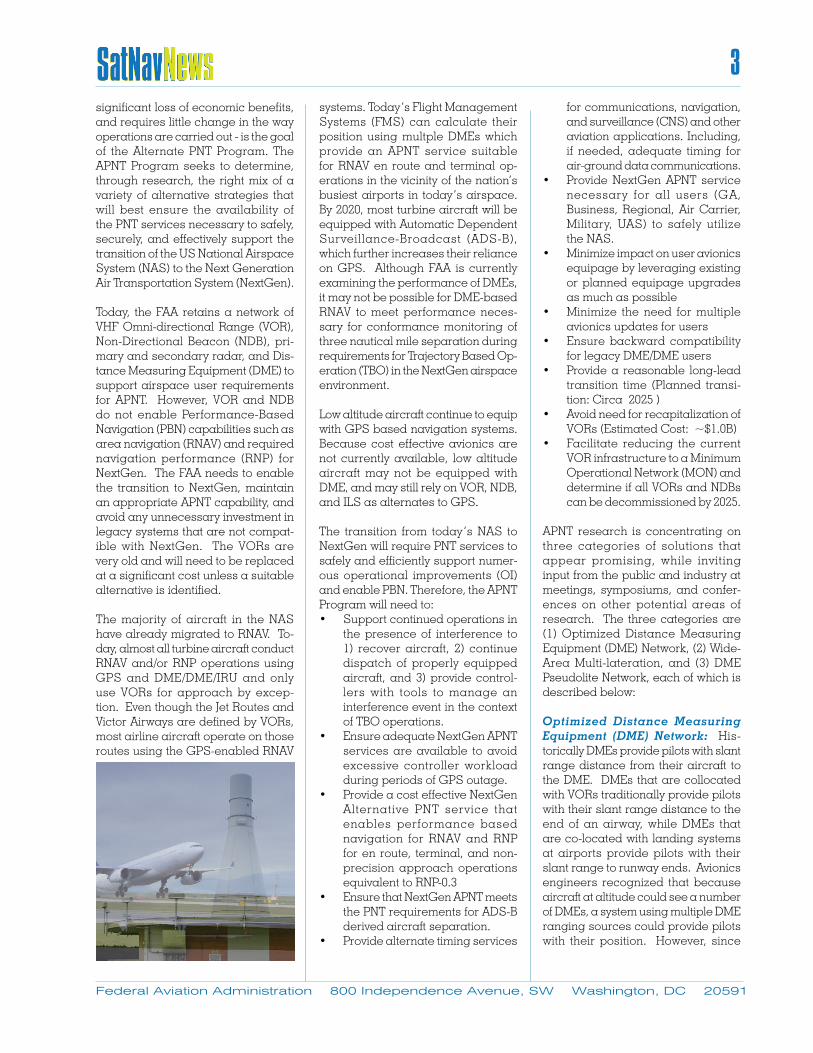
The majority of aircraft in the NAS have already migrated to RNAV. To-day, almost all turbine aircraft conduct RNAV and/or RNP operations using GPS and DME/DME/IRU and only use VORs for approach by excep-tion. Even though the Jet Routes and Victor Airways are defined by VORs, most airline aircraft operate on those routes using the GPS-enabled RNAV
systems. Today’s Flight Management Systems (FMS) can calculate their position using multple DMEs which provide an APNT service suitable for RNAV en route and terminal op-erations in the vicinity of the nation’s busiest airports in today’s airspace. By 2020, most turbine aircraft will be equipped with Automatic Dependent Surveillance-Broadcast (ADS-B), which further increases their reliance on GPS. Although FAA is currently examining the performance of DMEs, it may not be possible for DME-based RNAV to meet performance neces-sary for conformance monitoring of three nautical mile separation during requirements for Trajectory Based Op-eration (TBO) in the NextGen airspace environment.
Low altitude aircraft continue to equip with GPS based navigation systems. Because cost effective avionics are not currently available, low altitude aircraft may not be equipped with DME, and may still rely on VOR, NDB, and ILS as alternates to GPS.
The transition from today’s NAS to NextGen will require PNT services to safely and efficiently support numer-ous operational improvements (OI) and enable PBN. Therefore, the APNT Program will need to:• Support continued operations in
the presence of interference to 1) recover aircraft, 2) continue dispatch of properly equipped aircraft, and 3) provide control-lers with tools to manage an interference event in the context of TBO operations.
• Ensure adequate NextGen APNT services are available to avoid excessive controller workload during periods of GPS outage.
• Provide a cost effective NextGen Alternative PNT service that enables performance based navigation for RNAV and RNP for en route, terminal, and non-precision approach operations equivalent to RNP-0.3
• Ensure that NextGen APNT meets the PNT requirements for ADS-B derived aircraft separation.
• Provide alternate timing services
for communications, navigation, and surveillance (CNS) and other aviation applications. Including, if needed, adequate timing for air-ground data communications.
• Provide NextGen APNT service necessary for all users (GA, Business, Regional, Air Carrier, Military, UAS) to safely utilize the NAS.
• Minimize impact on user avionics equipage by leveraging existing or planned equipage upgrades as much as possible
• Minimize the need for multiple avionics updates for users
• Ensure backward compatibility for legacy DME/DME users
• Provide a reasonable long-lead transition time (Planned transi-tion: Circa 2025 )
• Avoid need for recapitalization of VORs (Estimated Cost: ~$1.0B)
• Facilitate reducing the current VOR infrastructure to a Minimum Operational Network (MON) and determine if all VORs and NDBs can be decommissioned by 2025.
APNT research is concentrating on three categories of solutions that appear promising, while inviting input from the public and industry at meetings, symposiums, and confer-ences on other potential areas of research. The three categories are (1) Optimized Distance Measuring Equipment (DME) Network, (2) Wide-Area Multi-lateration, and (3) DME Pseudolite Network, each of which is described below:
Optimized Distance Measuring Equipment (DME) Network: His-torically DMEs provide pilots with slant range distance from their aircraft to the DME. DMEs that are collocated with VORs traditionally provide pilots with their slant range distance to the end of an airway, while DMEs that are co-located with landing systems at airports provide pilots with their slant range to runway ends. Avionics engineers recognized that because aircraft at altitude could see a number of DMEs, a system using multiple DME ranging sources could provide pilots with their position. However, since
Federal Aviation Administration 800 Independence Avenue, SW Washington, DC 20591
3
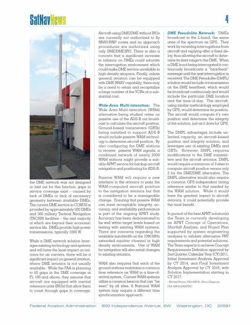
the DME network was not designed or laid out for this function, gaps in service coverage exist – caused by lack of DMEs or lack of necessary geometry between available DMEs. The current DME service in CONUS is provided by approximately 500 DMEs and 500 military Tactical Navigation (TACAN) facilities – the vast majority of which are beyond their economic service life. DMEs provide high power transmissions, typically 1000 W.
While a DME network solution lever-ages existing technology and systems and will have the least impact on avi-onics for air carriers, there will be a significant impact on general aviation, where DME avionics is not usually available. While the FAA is planning to fill gaps in the DME coverage at FL 180 and above, they assume that aircraft are equipped with inertial reference units (IRUs) that allow them to coast through gaps in coverage.
Aircraft using DME/DME without IRUs are currently not authorized to fly RNAV/RNP routes and no approach procedures are authorized using only DME/DME/IRU. There is also a concern that a significant increase in reliance on DMEs could saturate the interrogation environment which could make DME service unreliable in high density airspace. Finally, unless general aviation can be equipped with DME RNAV capability, there may be a need to retain and recapitalize a large number of the VORs at a sub-stantial cost.
Wide-Area Multi-lateration: The Wide Area Multi-lateration (WAM) alternative being studied relies on passive use of the ADS-B out broad-cast to calculate the aircraft position.Ground-based transceivers (GBTs) being installed to support ADS-B would include passive WAM technol-ogy to determine aircraft position. By also configuring the DME stations to receive passive WAM signals, a combined network of nearly 2000 WAM stations might provide a suit-able APNT service for backup aircraft navigation and positioning for ADS-B.
Passive WAM will require a new interface in the avionics to pass the WAM-computed aircraft position to the navigation avionics but that is considered to be a manageable change. Ensuring that passive WAM can meet acceptable integrity, ac-curacy, and availability performance is part of the ongoing APNT study. Accuracy has been demonstrated to be well within target levels based on testing with existing WAM systems. There are concerns regarding the available bandwidth on the 1090 MHz extended squitter channel in high density environments. Use of WAM for navigation will also entail changes to existing avionics.
WAM also requires that each of the ground stations maintains a common time reference as WAM is a time-of-arrival system. Current WAM systems utilize a common beacon that can “be seen” by all sites. A National WAM system may require a different time synchronization approach.
DME Pseudolite Network: DMEs broadcast in the L-band, the same area of the spectrum as GPS. They work by receiving interrogations from aircraft and replying after a fixed de-lay, thus allowing the aircraft to deter-mine its slant range to the DME. When a DME is not being interrogated it con-tinuously broadcasts a “heartbeat” message until the next interrogation is received. The DME Pseudolite (DMPL) solution would include a transmission on the DME heartbeat, which would be broadcast continuously and would include the particular DME location and the time-of-day. The aircraft, using similar methodology employed by GPS, would determine its position. The aircraft would compute it’s own position and determine the integrity of the solution, just as it does for GPS.
The DMPL advantages include un-limited capacity, an aircraft-based position and integrity solution, and leverages use of existing DMEs and GBTs. However, DMPL requires modifications to the DME transmit-ters and the aircraft avionics. DMPL would require a minimum of 3 sites to compute aircraft position versus only 2 for the DME/DME alternative. The DMPL alternative would also require a common GPS-independent timing reference similar to that needed by the WAM solution. While it would have the greatest impact to aircraft avionics, it could potentially provide the most benefit.
In pursuit of the best APNT solution(s) the Team is currently developing an APNT Concept of Operations, Shortfall Analysis, and Project Plan supported by system engineering analyses to validate alternative PNT requirements and potential solutions. The Team expects to achieve Concept Requirements Definition approval by 2nd Quarter, Calendar Year (CY) 2011, Initial Investment Analysis Approval by CY 2014, and Final Investment Analysis Approval by CY 2016, with Solution Implementation starting in CY 2017. - Mitchell Narins, FAA AJW-91; Darin Chapman,
FAA AJW-913/NAVTAC
Federal Aviation Administration 800 Independence Avenue, SW Washington, DC 20591
4
Economical WAAS Landing Systems Get LPV Certification on Boeing 737Esterline CMC Electronics (CMC) has recently announced that its IntegriFlight™ Global Positioning System (GPS) Landing System has been certified for Localizer Performance with Vertical Guidance (LPV) approach operations on a Boeing 737-300 aircraft operated by Canadian North Airlines (www.canadiannorth.com). As a stand-alone, ILS look-alike solution that smoothly integrates with existing navigation instrumentation, the installation of dual CMA-5024 Wide Area Augmentation System (WAAS) GPS Receivers in conjunction with dual CMA-5025 Control Panels provides a highly economic approach to retrofitting aircraft with LPV capability.
According to Chris Drossos, 737-300 project pilot for Canadian North, “the addition of LPV capability to our aircraft permits our airline to provide significantly improved schedule reliability for our scheduled and charter clients, given the absence of traditional ground-based approach aids at so many of the remote Canadian destinations we serve. From the pilot’s perspective, CMC’s LPV solution provides a clean, straightforward interface which behaves exactly like an ILS but with the exceptional WAAS performance and availability.”
Logic-Air Aviation Services of Mirabel, Quebec was responsible for the development and installation of the system kit and is the holder of the Supplemental Type Certificate (STC) issued by Transport Canada. CMC’s CMA-5024 is a high-reliability WAAS/GPS Receiver certified by the FAA
and Transport Canada to TSO-C145c Beta-3 and TSO-146c Delta-4, the most stringent categories for aviation GPS receivers. The latter category covers the provision of Precision Approach guidance signals to the aircraft’s autopilot and instrument displays for the execution of an LPV approach. Specifically designed for ease of retrofit and adaptability to either existing or new build aircraft, the CMA-5024 may be used with any aircraft, from helicopters and business jets to airliners. Any aircraft equipped with the CMA-5024 is also inherently ready to support ADS-B operational regulations in both remote and high-density traffic areas. - Scott Speed, FAA AJW-9131/NAVTAC
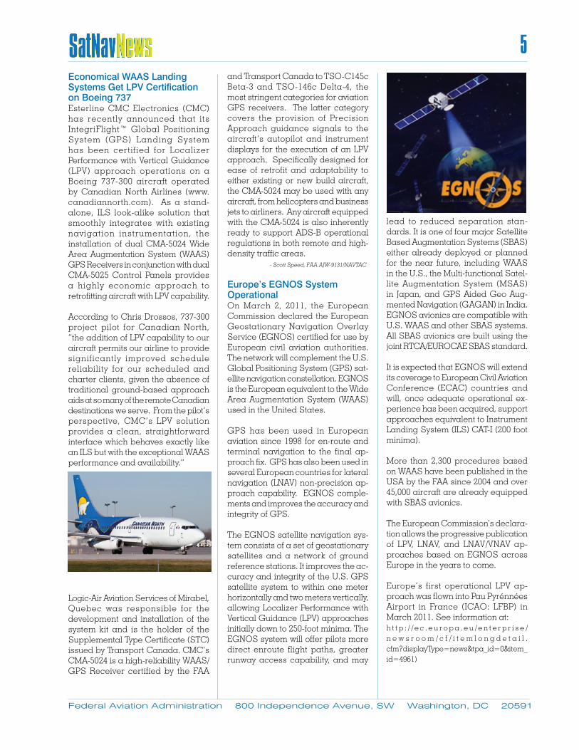
Europe’s EGNOS System OperationalOn March 2, 2011, the European Commission declared the European Geostationary Navigation Overlay Service (EGNOS) certified for use by European civil aviation authorities. The network will complement the U.S. Global Positioning System (GPS) sat-ellite navigation constellation. EGNOS is the European equivalent to the Wide Area Augmentation System (WAAS) used in the United States.
GPS has been used in European aviation since 1998 for en-route and terminal navigation to the final ap-proach fix. GPS has also been used in several European countries for lateral navigation (LNAV) non-precision ap-proach capability. EGNOS comple-ments and improves the accuracy and integrity of GPS.
The EGNOS satellite navigation sys-tem consists of a set of geostationary satellites and a network of ground reference stations. It improves the ac-curacy and integrity of the U.S. GPS satellite system to within one meter horizontally and two meters vertically, allowing Localizer Performance with Vertical Guidance (LPV) approaches initially down to 250-foot minima. The EGNOS system will offer pilots more direct enroute flight paths, greater runway access capability, and may
lead to reduced separation stan-dards. It is one of four major Satellite Based Augmentation Systems (SBAS) either already deployed or planned for the near future, including WAAS in the U.S., the Multi-functional Satel-lite Augmentation System (MSAS) in Japan, and GPS Aided Geo Aug-mented Navigation (GAGAN) in India. EGNOS avionics are compatible with U.S. WAAS and other SBAS systems. All SBAS avionics are built using the joint RTCA/EUROCAE SBAS standard.
It is expected that EGNOS will extend its coverage to European Civil Aviation Conference (ECAC) countries and will, once adequate operational ex-perience has been acquired, support approaches equivalent to Instrument Landing System (ILS) CAT-I (200 foot minima).
More than 2,300 procedures based on WAAS have been published in the USA by the FAA since 2004 and over 45,000 aircraft are already equipped with SBAS avionics.
The European Commission’s declara-tion allows the progressive publication of LPV, LNAV, and LNAV/VNAV ap-proaches based on EGNOS across Europe in the years to come.
Europe’s first operational LPV ap-proach was flown into Pau Pyrénnées Airport in France (ICAO: LFBP) in March 2011. See information at:h t t p : / / e c . e u r o p a . e u / e n t e r p r i s e /n e w s r o o m / c f / i t e m l o n g d e t a i l .cfm?displayType=news&tpa_id=0&item_id=4961)
Federal Aviation Administration 800 Independence Avenue, SW Washington, DC 20591
5
6
Federal Aviation Administration 800 Independence Avenue, SW Washington, DC 20591
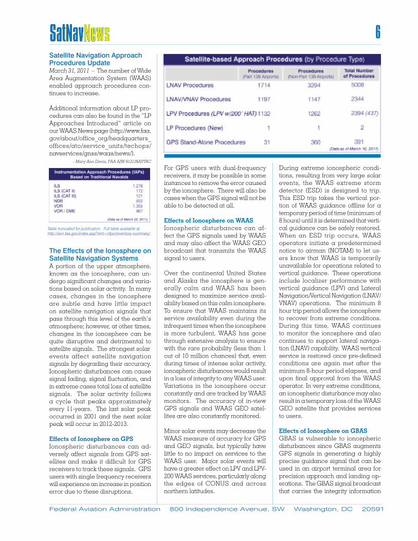
Satellite Navigation Approach Procedures UpdateMarch 31, 2011 – The number of Wide Area Augmentation System (WAAS) enabled approach procedures con-tinues to increase.
Additional information about LP pro-cedures can also be found in the “LP Approaches Introduced” article on our WAAS News page (http://www.faa.gov/about/office_org/headquarters_offices/ato/service_units/techops/navservices/gnss/waas/news/). - Mary Ann Davis, FAA AJW-9131/NAVTAC
The Effects of the Ionosphere on Satellite Navigation SystemsA portion of the upper atmosphere, known as the ionosphere, can un-dergo significant changes and varia-tions based on solar activity. In many cases, changes in the ionosphere are subtle and have little impact on satellite navigation signals that pass through this level of the earth’s atmosphere; however, at other times, changes in the ionosphere can be quite disruptive and detrimental to satellite signals. The strongest solar events affect satellite navigation signals by degrading their accuracy. Ionospheric disturbances can cause signal fading, signal fluctuation, and in extreme cases total loss of satellite signals. The solar activity follows a cycle that peaks approximately every 11-years. The last solar peak occurred in 2001 and the next solar peak will occur in 2012-2013.
Effects of Ionosphere on GPSIonospheric disturbances can ad-versely affect signals from GPS sat-ellites and make it difficult for GPS receivers to track these signals. GPS users with single frequency receivers will experience an increase in position error due to these disruptions.
For GPS users with dual-frequency receivers, it may be possible in some instances to remove the error caused by the ionosphere. There will also be cases when the GPS signal will not be able to be detected at all. Effects of Ionosphere on WAASIonospheric disturbances can af-fect the GPS signals used by WAAS and may also affect the WAAS GEO broadcast that transmits the WAAS signal to users.
Over the continental United States and Alaska the ionosphere is gen-erally calm and WAAS has been designed to maximize service avail-ability based on this calm ionosphere. To ensure that WAAS maintains its service availability even during the infrequent times when the ionosphere is more turbulent, WAAS has gone through extensive analysis to ensure with the rare probability (less than 1 out of 10 million chances) that, even during times of intense solar activity, ionospheric disturbances would result in a loss of integrity to any WAAS user. Variations in the ionosphere occur constantly and are tracked by WAAS monitors. The accuracy of in-view GPS signals and WAAS GEO satel-lites are also constantly monitored.
Minor solar events may decrease the WAAS measure of accuracy for GPS and GEO signals, but typically have little to no impact on services to the WAAS user. Major solar events will have a greater effect on LPV and LPV-200 WAAS services, particularly along the edges of CONUS and across northern latitudes.
During extreme ionospheric condi-tions, resulting from very large solar events, the WAAS extreme storm detector (ESD) is designed to trip. This ESD trip takes the vertical por-tion of WAAS guidance offline for a temporary period of time (minimum of 8 hours) until it is determined that verti-cal guidance can be safely restored. When an ESD trip occurs, WAAS operators initiate a predetermined notice to airman (NOTAM) to let us-ers know that WAAS is temporarily unavailable for operations related to vertical guidance. These operations include localizer performance with vertical guidance (LPV) and Lateral Navigation/Vertical Navigation (LNAV/VNAV) operations. The minimum 8 hour trip period allows the ionosphere to recover from extreme conditions. During this time, WAAS continues to monitor the ionosphere and also continues to support lateral naviga-tion (LNAV) capability. WAAS vertical service is restored once pre-defined conditions are again met after the minimum 8-hour period elapses, and upon final approval from the WAAS operator. In very extreme conditions, an ionospheric disturbance may also result in a temporary loss of the WAAS GEO satellite that provides services to users.
Effects of Ionosphere on GBASGBAS is vulnerable to ionospheric disturbances since GBAS augments GPS signals in generating a highly precise guidance signal that can be used in an airport terminal area for precision approach and landing op-erations. The GBAS signal broadcast that carries the integrity information
Table truncated for publication. Full table available at http://avn.faa.gov/index.asp?xml=nfpo/inventory-summary/

7
Federal Aviation Administration 800 Independence Avenue, SW Washington, DC 20591
from the GBAS to the aircraft is not affected by the ionosphere.
The impact of ionosphere on GBAS has been studied extensively by both U.S. institutions and many various international organizations over the past decade. Different models have been developed to better understand the potential risks of the ionosphere. Amongst the models developed, there is a general subject matter expert consensus on one particular model. This model is believed to accurately define the impact of the ionosphere on GBAS, at least based on data observed to date. Also, there is consensus that the ionospheric activ-ity should continue to be monitored until its impact on GBAS is more fully understood. Efforts are currently underway by the FAA to develop ap-propriate tools to this end. Research has shown that there is a possibility, albeit remote, of the GBAS station and the airplane experiencing dif-
ferent ionospheric conditions even at separation distances of six to ten kilometers. This could result in the airplane experiencing signal errors that the GBAS station cannot see and therefore cannot detect, resulting in significant positional errors in the airplane. The current certified GBAS system (Honeywell SLS-4000) has a set of ionospheric monitors built in that monitor GPS satellites and de-tect errors in GPS signals due to the ionosphere.
Historical Experience from the 2003 Ionospheric StormsFrom October 29th through 31st, 2003 a large ionospheric disturbance was observed over the northern hemi-sphere. This disturbance was trig-gered by a solar flare emitted from the sun. This disturbance was registered at the highest value in the index to measure such disturbances. This storm began to affect WAAS at ap-proximately 17:00 GMT on October 29
and resulted in the loss of LPV service for approximately 15 hours. This was followed by a second interrupt ion of LPV service that began at approximately 19:00 GMT on October 30. This second interrupt ion resulted in the loss of LPV ser-vice for over 11 hours. The actual times of the storms are approxi-mate since the effects of the storm are not instantaneous and take time to propagate t h r o u g h o u t t h e W A A S service area. The same is
true for the time it takes to safely restore LPV service. Even with the temporary interruption in WAAS LPV service, WAAS continued transmit-ting non-precision approach (NPA) data throughout the storm with no interruption. - Mary Ann Davis, FAA AJW-9131/NAVTAC
GBAS UpdateThe FAA continues work toward a Category (CAT) II/III GBAS capability. This work includes coordination with the International Civil Aviation Orga-nization (ICAO), the Radio Technical Commission for Aeronautics, Inc. (RTCA), and industry and airline part-ners. Prototypes for the CAT III GBAS ground system and CAT III GBAS avionics will be developed in coopera-tion with industry at the FAA William Hughes Technical Center, which will support the operational validation of the ICAO Annex 10 draft standards. In parallel to the CAT III validation and specification development, the FAA continues to support operational im-plementation efforts of CAT I systems with airport and airline partners who decided on an early implementation of GBAS technology. The airport part-ners are Newark Liberty International Airport and Houston Bush Interna-tional Airport. The lead airline partner is Continental Airlines with over 30 GBAS-capable aircraft in service. This GBAS city pair (Houston-Newark) provides the FAA and Continental with excellent opportunities for data collection on GBAS performance, GBAS benefits, and the potential to interact with other Next Generation Air Transportation System (NexGen) activities at Houston, such as closely spaced parallel operations (CSPO).
International interest in GBAS remains high. The International GBAS Working Group (IGWG) met in Osaka, Japan in February 2011 with participants from 20 nations. It was hosted by the Elec-tronic Navigation Research Institute (ENRI) in coordination with the Japan Civil Aviation Bureau (JCAB). This international working group has had a strong impact on the proliferation of GBAS technology. With the GBAS
Photo Courtesy of NASA
8
Federal Aviation Administration 800 Independence Avenue, SW Washington, DC 20591
technology moving from the develop-ment stage to the implementation stage, new participants - commercial airlines in particular - have joined the working group to monitor progress and to provide information about their operations and equipage plans. - Dieter Guenther, FAA AJW-9132/NAVTAC
Air Berlin Focus on GBASAir Berlin is the first European airline to benefit from the improvements in flexibility, efficiency, and safety which the Ground Based Augmentation System (GBAS) can provide, according to Skyway Magazine, the periodical of the European Organization for the Safety of Air Navigation (Eurocontrol). Air Berlin (also known as “airberlin”) is Germany’s second largest airline with around 33 million passengers in 2010. It operates a very modern fleet of aircraft with planes that are only five years old on average. Air Berlin has taken a leading role in technical innovation and it sees the innovative potential of GBAS and the Global Navigation Satellite System (GNSS) Landing System (GLS) as enormous. In comparison with the conventional instrument landing system (ILS), satellite technology offers much greater flexibility during approaches. This will provide better scheduling stability and improved cost efficiency, as well as allowing further reductions in noise and pollution.
At present, only a few airports have the technology to permit GLS approaches. In Germany these are the Bremen airport and the research airport of DLR (German Aerospace Center) in Braunschweig-Wolfsburg. In the rest of Europe, only Malaga airport in Spain has a GBAS station. Air Berlin is the only airline worldwide that has been approved by the LBA (German Federal Aviation Office) to use GLS in normal flight operations. While the airline is allowed to fly GLS approaches as routine in Bremen, it is only allowed to monitor the GLS signal at Malaga for the time being.
Pilots are already confirming the aeronautical benefits of satellite navigation. In comparison with ILS, the vertical profile is much more stable, especially in mountainous terrain. Furthermore, there is no difference between GLS and ILS in terms of operating the aircraft. Consequently, pilots do not require complex simulator training and can familiarize themselves with the system using a computer-based training method.Satellite navigation also represents a new option for airports which, due to their geographical location, have not yet been able to operate an instrument landing system. The GBAS ground station allows up to 49 approaches to be coordinated simultaneously.
At Air Berlin all new Boeing 737-700s and -800s delivered since June 2007 have been fitted with equipment for GBAS/GLS. The airline’s flight modernization policy aims to have the entire Boeing 737 fleet carry such equipment by 2013. - Scott Speed, FAA AJW-9131/NAVTAC
What’s New on the Web!Just type http://gps.faa.gov into any web browser to access the best and most accurate information available from the FAA’s Navigation Services Global Navigation Satellite System (GNSS) website.
GNSS Main Page – The GNSS Main Page features a prominent GPS/WAAS Approaches button that takes you to the page with latest Approach-es data. There’s also a button for the latest status reports used by Congres-sional staffers. The left side of the GNSS Main Page is the gateway to a wealth of information available within the site.GNSS Library Page – This page al-lows access to current and past is-sues of SatNav News, briefings, fact sheets, and other documents that are constantly updated. This page is maintained with the latest informa-tion to keep our readers in the know on the GNSS and all its aviation ap-plications.
GPS/WAAS Approaches Page – This page gives the most current list of available Localizer Performance with Vertical guidance (LPV) approach procedures as well as two of the new Localizer Performance (LP) ap-proaches. There’s also data about each published LPV, to include airport identifier and airport census informa-tion and a graphic of all current LPVs in the U.S. The page also includes a helpful link to the FAA’s Instrument Flight Procedures (IFP) Production Plan web page which contains infor-mation on projected IFP production by region or fiscal year and links to how to apply for an IFP at your airport.
Type http://gps.faa.gov for easy ac-cess to the Global Navigation Satellite Systems segment of the FAA website.
9
Federal Aviation Administration 800 Independence Avenue, SW Washington, DC 20591
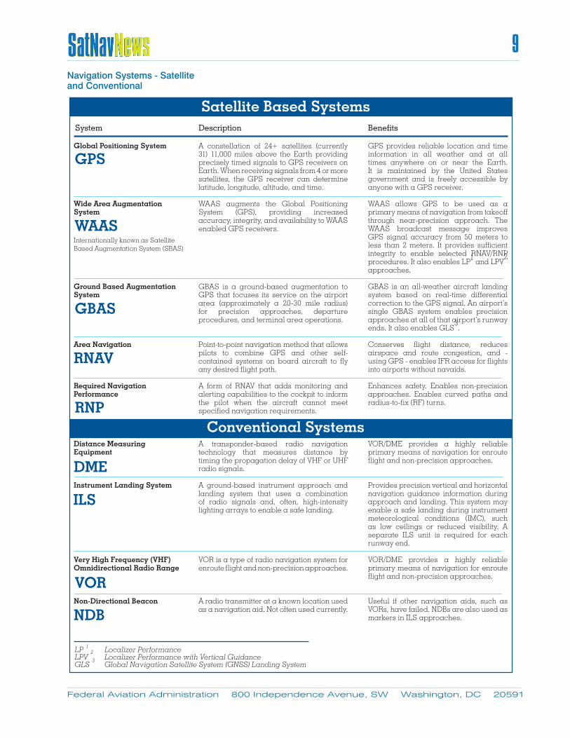
A constellation of 24+ satellites (currently 31) 11,000 miles above the Earth providing precisely timed signals to GPS receivers on Earth. When receiving signals from 4 or more satellites, the GPS receiver can determine latitude, longitude, altitude, and time.
WAAS augments the Global Positioning System (GPS), providing increased accuracy, integrity, and availability to WAAS enabled GPS receivers.
GBAS is a ground-based augmentation to GPS that focuses its service on the airport area (approximately a 20-30 mile radius) for precision approaches, departure procedures, and terminal area operations.
Point-to-point navigation method that allows pilots to combine GPS and other self-contained systems on board aircraft to fly any desired flight path.
A form of RNAV that adds monitoring and alerting capabilities to the cockpit to inform the pilot when the aircraft cannot meet specified navigation requirements.
A transponder-based radio navigation technology that measures distance by timing the propagation delay of VHF or UHF radio signals.
A ground-based instrument approach and landing system that uses a combination of radio signals and, often, high-intensity lighting arrays to enable a safe landing.
VOR is a type of radio navigation system for enroute flight and non-precision approaches.
A radio transmitter at a known location used as a navigation aid. Not often used currently.
GPS provides reliable location and time information in all weather and at all times anywhere on or near the Earth. It is maintained by the United States government and is freely accessible by anyone with a GPS receiver.
WAAS allows GPS to be used as a primary means of navigation from takeoff through near-precision approach. The WAAS broadcast message improves GPS signal accuracy from 50 meters to less than 2 meters. It provides sufficient integrity to enable selected RNAV/RNP procedures. It also enables LP1 and LPV
2
approaches.
GBAS is an all-weather aircraft landing system based on real-time differential correction to the GPS signal. An airport’s single GBAS system enables precision approaches at all of that airport’s runway ends. It also enables GLS
3.
Conserves flight distance, reduces airspace and route congestion, and - using GPS - enables IFR access for flights into airports without navaids.
Enhances safety. Enables non-precision approaches. Enables curved paths and radius-to-fix (RF) turns.
VOR/DME provides a highly reliable primary means of navigation for enroute flight and non-precision approaches.
Provides precision vertical and horizontal navigation guidance information during approach and landing. This system may enable a safe landing during instrument meteorological conditions (IMC), such as low ceilings or reduced visibility. A separate ILS unit is required for each runway end.
VOR/DME provides a highly reliable primary means of navigation for enroute flight and non-precision approaches.
Useful if other navigation aids, such as VORs, have failed. NDBs are also used as markers in ILS approaches.
Global Positioning System
Wide Area Augmentation System
Ground Based Augmentation System
Area Navigation
Required Navigation Performance
Distance Measuring Equipment
Instrument Landing System
Very High Frequency (VHF) Omnidirectional Radio Range
Non-Directional Beacon
GPS
Description BenefitsSystem
Internationally known as Satellite Based Augmentation System (SBAS)
WAAS
GBAS
RNAV
RNP
Satellite Based Systems
Conventional Systems
DME
ILS
VOR
NDB
LP 1 Localizer Performance LPV 2 Localizer Performance with Vertical GuidanceGLS 3
Global Navigation Satellite System (GNSS) Landing System
Navigation Systems - Satellite and Conventional