volume 1, chapter 6 dco project description · figure 6.1, volume 2 and graphic 6.1 represents one...
TRANSCRIPT
Heathrow Expansion PRELIMINARY ENVIRONMENTAL INFORMATION REPORT
© Heathrow Airport Limited 2019
Volume 1, Chapter 6
DCO Project description
Heathrow Expansion PRELIMINARY ENVIRONMENTAL INFORMATION REPORT: Chapter 6: DCO Project description
© Heathrow Airport Limited 2019
CONTENTS
6. DCO Project Description 6.1
6.1 Introduction 6.1 Overview 6.1 Structure of the Chapter 6.5
6.2 The DCO Project Overview 6.5 Development Consent Order 6.5 The DCO Project Summary 6.5 DCO Project programme 6.7
6.3 DCO Project components 6.10 Introduction 6.10 Airport infrastructure 6.10 Motorway developments 6.14 Other road developments 6.17 River diversions and flood storage areas 6.18 Utilities 6.21 Green infrastructure 6.22 Airport Supporting Development 6.25 Displacement of exiting uses 6.31
6.4 Construction 6.38 Introduction 6.38 Construction Phasing 6.38 Code of Construction Practice 6.50 Key construction activities 6.51 Construction and Logistics Management 6.63 Management of the construction workforce 6.75 Worksite Security and Lighting 6.76 Temporary buildings and structures 6.76 Temporary utilities and infrastructure 6.77 Logistics hubs 6.78 Working hours 6.79
6.5 Operation 6.81 Overview 6.81 Airport Operations 6.83 Employment 6.90 Utilities and Energy 6.90 Site Drainage 6.91 Security and Lighting 6.93 Waste Management 6.95 Transport, site access & car parking 6.95
TABLE OF TABLES
Table 6.1: Parameter and Illustrative Plans 6.4 Table 6.2: Runways, taxiways, terminals and aprons 6.13 Table 6.3: Motorway developments 6.16 Table 6.4: Other road developments 6.17 Table 6.5: River diversions and flood storage 6.20 Table 6.6: Utilities 6.21
Heathrow Expansion PRELIMINARY ENVIRONMENTAL INFORMATION REPORT: Chapter 6: DCO Project description
© Heathrow Airport Limited 2019
Table 6.7: Green infrastructure 6.24 Table 6.8: Airport Supporting Development 6.28 Table 6.9: Displacement of existing uses 6.34 Table 6.10: DCO Project development by Zone 6.35 Table 6.11: Construction activities in Phase 1 for the PEIR assessment 6.40 Table 6.12: Construction activities in Phase 2 for the PEIR assessment 6.44 Table 6.13: Construction activities in Phase 3 for the PEIR assessment 6.47 Table 6.14: Forecasted increase in ATMs and passenger numbers between 2022 and 2050 6.81 Table 6.15: Operation activities anticipated in Phases 1 to 3 for the PEIR assessment 6.82 Table 6.16: Pattern of Mode Alternation 6.85 Table 6.17: Displaced Thresholds 6.86
TABLE OF GRAPHICS
Graphic 6.1: Preferred Masterplan 6.2 Graphic 6.2: Illustrative Zones plan 6.3 Graphic 6.3: Illustrative DCO Project schedule 6.9 Graphic 6.4: Runways and Taxiways 6.11 Graphic 6.5: Terminals, Satellites and Aprons 6.12 Graphic 6.6: Motorway and other road developments 6.15 Graphic 6.7: River diversions and flood storage areas 6.19 Graphic 6.8: Green infrastructure 6.23 Graphic 6.9: Airport Supporting Development 6.26 Graphic 6.10: Parking 6.27 Graphic 6.11: Displacements: Key land uses 6.32 Graphic 6.12: Displacements: Communities 6.33 Graphic 6.13: Illustrative construction area during 2023 6.41 Graphic 6.14: Illustrative construction area during 2025 6.42 Graphic 6.15: Illustrative construction areas after North West Runway opening in c. 2026 6.45 Graphic 6.16: Illustrative construction areas during 2030 6.46 Graphic 6.17: Illustrative construction areas during 2035 6.48 Graphic 6.18: Illustrative construction areas during 2040 6.49 Graphic 6.19: Illustrative location of borrow pits 6.56 Graphic 6.20: Illustrative proposed stockpile areas 6.58 Graphic 6.21: Illustrative proposed new landfill locations 6.60 Graphic 6.22: Illustrative location of Construction Support Sites 6.66 Graphic 6.23: Illustrative Construction traffic routes Day 1 6.72 Graphic 6.24: Illustrative construction traffic routes c. 2023 6.73 Graphic 6.25: Illustrative construction traffic routes at runway opening 6.74 Graphic 6.26: Runways and runway numbering 6.87 Graphic 6.27: Proposals for additional bus and coach capacity 6.97 Graphic 6.28: Indicative proposed new coach corridors 6.97 Graphic 6.29: Proposed new bus routes 6.98 Graphic 6.30: Proposed locations of bus priority 6.99 Graphic 6.31: Proposed ‘hub and spoke’ cycle network 6.100
Heathrow Expansion PRELIMINARY ENVIRONMENTAL INFORMATION REPORT: Chapter 6: DCO Project description
6.1 © Heathrow Airport Limited 2019
6. DCO PROJECT DESCRIPTION
6.1 Introduction
Overview
6.1.1 This chapter sets out the preliminary description of the development for the DCO
Project. This description represents the basis upon which the subsequent aspect
assessment chapters are based to support the Airport Expansion Consultation
(AEC) being undertaken under sections 42 – 47 of the Planning Act 2008. This
consultation will inform the evolution of the DCO Project before a formal
application is made for it to be authorised under that Act.
6.1.2 The aspect assessments have been undertaken on the basis of project principles,
and parameters (e.g. location of the North West Runway, overall quantum of new
building floor space, widths of highway corridors, numbers of aircraft, and
passengers). The use of this approach enables the PEIR to be based on the
description of the location, design and size of the DCO Project that is sufficient to
allow a preliminary assessment of its ‘likely significant environmental effects’, and
includes the information reasonably required to enable a properly informed
response to the AEC (June 2019).
6.1.3 Figure 4.1, Volume 2 identifies the draft Development Consent Order (DCO)
Limits and shows the overall boundary of the DCO Project. To enable
understanding of the DCO Project, this project description has, where necessary,
described an outline design (Preferred Masterplan), which has been developed
within the DCO Project parameters. The Preferred Masterplan, as illustrated in
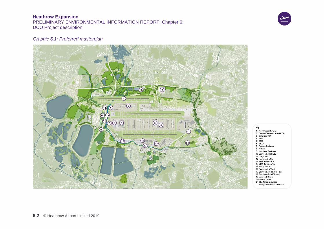
Figure 6.1, Volume 2 and Graphic 6.1 represents one interpretation of the DCO
Project parameters, and has been prepared to assist in the understanding of the
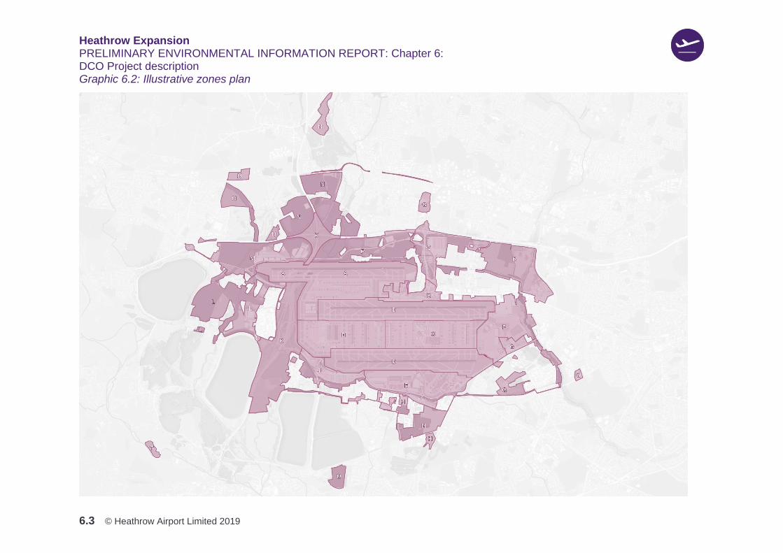
DCO Project. Additionally, the DCO Project has been split up into Zones (A to T),
which are described later in this chapter in Table 6.10 in Section 6.3. The location
of these Zones is shown in Graphic 6.2. This masterplan would be subject to
change, but within the flexibilities and constraints imposed by the DCO Project
parameters. Figures 6.2 to 6.14, Volume 2 presents the principal parameter
plans, which describe the physical aspects of the DCO Project proposals that have
been assessed in this PEIR. Table 6.1 provides a short description of each plans
presented in Figures 6.2 to 6.14, Volume 2.
Heathrow Expansion PRELIMINARY ENVIRONMENTAL INFORMATION REPORT: Chapter 6: DCO Project description
6.2 © Heathrow Airport Limited 2019
Graphic 6.1: Preferred masterplan
Heathrow Expansion PRELIMINARY ENVIRONMENTAL INFORMATION REPORT: Chapter 6: DCO Project description
6.3 © Heathrow Airport Limited 2019
Graphic 6.2: Illustrative zones plan

Heathrow Expansion PRELIMINARY ENVIRONMENTAL INFORMATION REPORT: Chapter 6: DCO Project description
6.4 © Heathrow Airport Limited 2019
6.1.4 This DCO Project description also includes embedded environmental measures, to
avoid or reduce environmental effects, which have been directly incorporated into
the design for the DCO Project and the operational procedures (for example, the
siting of the new runway to reduce aircraft noise, and the inclusion of
compensatory flood storage areas to provide for those areas lost from the
realignment of infrastructure in the Colne Valley). Figure 6.2, Volume 2, the
Illustrative Mitigation and Enhancement Areas plan and Figure 6.3, Volume 2 the
Illustrative Water Enhancement Areas show areas outside of the draft DCO Limits
where Heathrow’s proposals are still under development as to the powers and the
extent to land that may be required. These additional areas are referred to within
the relevant topic areas to which the environmental measures will be applicable,
but are not considered as part of the preferred masterplan that has been assessed
in this PEIR.
Table 6.1: Parameter and illustrative plans
Figure Number Figure Title
Figure 6.1 (HEP15-AG-GA-000-120601) Preferred masterplan
Figure 6.2 (HEP15-XX-GA-000-120104) Illustrative mitigation and enhancement areas
Figure 6.3 (HEP15-XX-GA-000-120105) Illustrative water enhancement areas
Figure 6.4 (HEP15-XX-GA-000-120501) Existing site levels
Figure 6.5 (HEP15-XX-GA-000-120502) Proposed site levels
Figure 6.6 (HEP15-XX-GA-000-120901) Roads illustrative key plan
Figure 6.7 (HEP15-XX-GA-000-120301) Building and Road Demolitions
Figure 6.8 (HEP15-XX-GP-000-120704) Parameter plan development heights site wide
Figure 6.9 (HEP15-XX-GP-000-120703) Parameter plan below ground site wide
Figure 6.10 (HEP15-XX-GP-000-120701) Parameter plan green infrastructure site wide
Figure 6.11 (HEP15-XX-GP-000-120702) Parameter plan water infrastructure site wide
Figure 6.12 (HEP15-AG-GA-000-120602) Preferred masterplan boundary treatments site wide
Figure 6.13 (HEP15-AG-GA-000-120603) Preferred masterplan below ground site wide
Figure 6.14 (HEP15-XX-GA-000-121002) Utilities parameter plan
6.1.5 Chapter 5: Approach to the EIA, Section 5.7: Approach to environmental
measures explains the approach to environmental measures that has been
applied in the PEIR. The environmental assessments presented in Chapters 7 to
21 provide details of how the embedded environmental measures are proposed to
avoid or reduce environmental effects. The measures presented in this PEIR
would be updated for inclusion in the ES as the design of the DCO Project is
evolved.
Heathrow Expansion PRELIMINARY ENVIRONMENTAL INFORMATION REPORT: Chapter 6: DCO Project description
6.5 © Heathrow Airport Limited 2019
Structure of the chapter
6.1.6 The remainder of this chapter is structured as follows:
1. Section 6.2: DCO Project overview – this section provides an overview of the
DCO Project
2. Section 6.3: DCO Project components – this section describes each of the
components that form the DCO Project
3. Section 6.4: Construction - this section describes how the DCO Project
would be constructed
4. Section 6.5: Operation – this section describes how the DCO Project would
operate.
6.2 The DCO Project overview
Development consent order
6.2.1 A single Development Consent Order (DCO) application (the Application) would
seek authorisation to develop, operate and maintain the DCO Project, including
measures to mitigate the environmental effects of the DCO Project.
6.2.2 The Application would be guided by the relevant policies of the Airports National
Policy Statement (ANPS) as it falls within the definition of a Nationally Significant
Infrastructure Project (NSIP), as set out within the Planning Act 2008. The M25
works also fall within the definition of an NSIP, and would also be guided by the
relevant policies of both the ANPS and National Policy Statement for National
Networks (NN NPS) (Department for Transport, 2014). They also share
'Associated Development' such as changes to local roads. The proposal is
therefore that the Airport and M25 works would be included within a single
comprehensive Application.
6.2.3 Unless otherwise indicated, every element of the DCO Project described in this
chapter, for which development consent is sought through the DCO process,
comprises either part of an NSIP or Associated Development.
The DCO Project summary
Overview
6.2.4 The DCO Project assessed in this PEIR comprises: a North West Runway,
including new taxiways, to the northwest of the existing northern runway; works to
the existing northern runway; new terminal and apron capacity; and new
passenger and cargo handling capacity. These would enable Heathrow to deliver
around 756,000 Air Transport Movements (ATMs) per annum and 142 million

Heathrow Expansion PRELIMINARY ENVIRONMENTAL INFORMATION REPORT: Chapter 6: DCO Project description
6.6 © Heathrow Airport Limited 2019
passengers per annum (MPPA) in 2050. By 2035 cargo capacity is forecast to
increase to circa 3 million tonnes.
6.2.5 As part of the DCO Project the early release of additional capacity from the
existing airport infrastructure is proposed, prior to opening of the North West
Runway. This would be achieved by lifting the existing cap of 480,000ATMs per
annum, and increasing the total number of ATMs by 25,000, incrementally over a
four-year period, in advance of the North West Runway opening. This would
enable the two existing runways to operate a total of around 505,000ATMs
annually. In addition, one of the benefits of early growth would be that it would
bring forward some of the proposed mitigation, for example it would enable
Heathrow to implement its preferred proposal to schedule flights later in the
morning, after 05:30, instead of from 04:30 today
6.2.6 Following the anticipated opening of the North West Runway in 2026, there would
be expected annual growth in ATMs and passenger numbers until 2035 when an
anticipated capacity of approximately 740,000ATMs and 130MPPA is forecast.
Continued growth in passenger numbers and ATMs would be forecast to continue
to reach approximately 135MPPA and 750,000ATMs by 2040, with a further
anticipated increase to approximately 142MPPA and 756,000ATMs in 2050. The
three runways would operate with one runway dedicated for landings, one runway
for departures and one runway for both landings and departures (known as mixed
mode operations). The existing northern runway would not operate in mixed mode
due to aircraft safety reasons. The use of the runways in this way will provide
respite to local communities. With the opening of the North West Runway
Heathrow would fulfil its commitment in the DCO, to a restriction on night flights.
This comprises a ban on scheduled night flights for a period of six and a half hours
between 23:00 and 05:30 (consistent with ANPS paragraph 5.62, which sets out
the Government’s expectation for
“a ban on scheduled night flights for a period of six and a half hours between the hours of
11pm and 7am.)”
6.2.7 To support the forecast increase in ATMs and passengers the DCO Project would
include the following components:
1. A new runway 3,500m in length and supporting aircraft taxiway network, to the
northwest of the existing Airport
2. New passenger terminal buildings and related infrastructure including apron
capacity to enable processing of the additional flights and passengers
associated with expansion of the Airport
3. Provision and relocation of critical Airport Supporting Development such as fuel
depots and pipelines, and security control posts
Heathrow Expansion PRELIMINARY ENVIRONMENTAL INFORMATION REPORT: Chapter 6: DCO Project description
6.7 © Heathrow Airport Limited 2019
4. Realignment of the M25 and alterations to its junctions 14 and 14a
5. Diversion and upgrading of local roads including the A4, the A3044 and
Southern Perimeter Road (SPR), plus works to existing junctions and the
construction of a Southern Road Tunnel
6. Diversion of local rivers, works to existing watercourses, provision of flood
storage areas and ecological mitigation around the Airport
7. Provision of new hotels, offices, cargo facilities, car parking, industrial facilities
(including freight forwarding and flight catering) and other ancillary facilities
(e.g. aircraft maintenance) to enable the expanded Airport to operate
8. Measures for avoiding, minimising and or mitigating adverse environmental
effects likely to arise in connection with the construction and operation of the
DCO Project
9. Other associated works, for example, temporary access roads, highway works,
temporary works compounds, work sites and ancillary works
10. Compulsory acquisition of land, including interests in land, and rights over land,
over-riding easements and other rights and the temporary use of land
11. The discontinuance of existing restraints on air transport movements at
Heathrow set by planning permissions
12. Changes to the existing operational regime at Heathrow Airport including:
changes to the runway alternation arrangements; changes to the directional
preference for aircraft landing and taking off from the Airport; and the
introduction of new and revised operating restrictions, including a 6.5 hour ban
on scheduled flights at Heathrow during the night period.
DCO Project programme
6.2.8 The description of the DCO Project is presented with reference to three phases.
The phases include both construction and operational activities, since over the
course of the period of development these activities would overlap.
6.2.9 These phases reflect the ‘Assessment Years’ presented in Chapter 5, Section
5.4: Scope of the assessment. The phases used for the purposes of the
assessment in this PEIR are anticipated to be approximately as follows:
1. Phase 1 (c. 2022 – 2026) – includes assessment year 2025, which is the
anticipated year of maximum release of first phase of early growth capacity
2. Phase 2 (c. late 2026 – 2033) – includes assessment year 2027, which is
anticipated to be the first full year of the new runway operations
Heathrow Expansion PRELIMINARY ENVIRONMENTAL INFORMATION REPORT: Chapter 6: DCO Project description
6.8 © Heathrow Airport Limited 2019
3. Phase 3 (c. 2034 – 2050) – includes assessment year 2035, which is
anticipated to be the year of minimum ANPS capacity the ANPS requires at
least 260,000 additional ATMs), and 2050, which is forecast to be the year of
maximum ATM capacity.
6.2.10 This programme is considered to represent a reasonable worst case for the
purposes of the assessment undertaken in this PEIR, since it assumes
construction and delivery at a stage when certain key baseline factors such as air
quality remain higher than they are expected to be in later years. Should the
anticipated programme for construction and delivery of the DCO Project evolve
prior to DCO application, as is not unusual with major infrastructure projects, the
assessment that would be presented in the ES would respond appropriately.
6.2.11 Graphic 6.3 shows an illustrative schedule, key milestones and activities required
to deliver the DCO Project.

Heathrow Expansion PRELIMINARY ENVIRONMENTAL INFORMATION REPORT: Chapter 6: DCO Project description
6.9 © Heathrow Airport Limited 2019
Graphic 6.3: Illustrative DCO Project schedule

Heathrow Expansion PRELIMINARY ENVIRONMENTAL INFORMATION REPORT: Chapter 6: DCO Project description
6.10 © Heathrow Airport Limited 2019
6.3 DCO Project components
Introduction
6.3.1 This section provides a description of each of the components that form the DCO
Project.
Airport infrastructure
6.3.2 This section provides a description of the new airport infrastructure required for the
DCO Project.
6.3.3 describes the runway, taxiway, terminal and apron works that would form part of
the DCO Project. A series of illustrative graphics are presented for each of the
DCO Components, and, as with the preferred masterplan, as shown in Graphic
6.1, represent one interpretation of the DCO Project parameters and have been
prepared to assist in the understanding of the DCO Project description presented
in this chapter. They would be subject to change, but only within the flexibilities
and constraints imposed by the DCO Project parameters.
6.3.4 Graphic 6.4 illustrates the location of the North West Runway, works to the
existing northern runway and the proposed location of new taxiways.
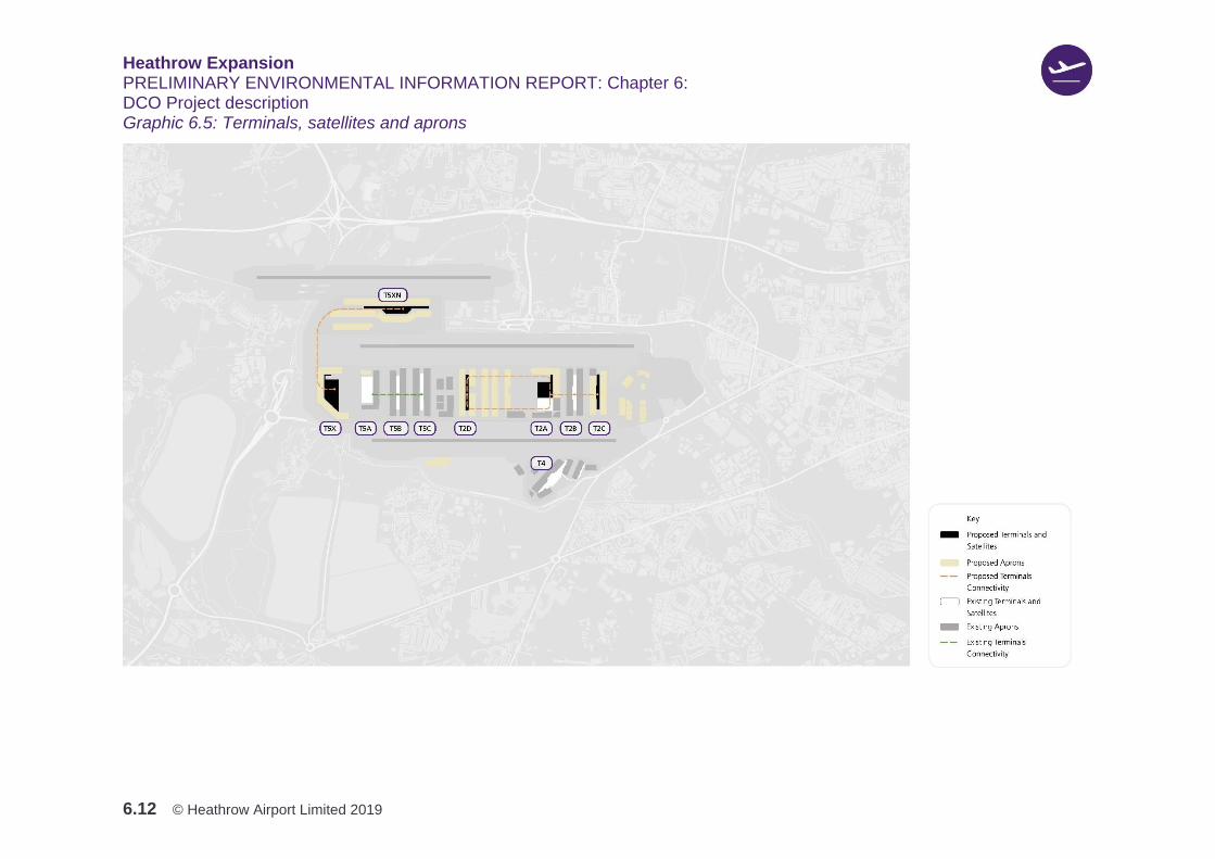
6.3.5 Graphic 6.5 illustrates the current and proposed new and expanded terminals and
aprons.

Heathrow Expansion PRELIMINARY ENVIRONMENTAL INFORMATION REPORT: Chapter 6: DCO Project description
6.11 © Heathrow Airport Limited 2019
Graphic 6.4: Runways and taxiways
Heathrow Expansion PRELIMINARY ENVIRONMENTAL INFORMATION REPORT: Chapter 6: DCO Project description
6.12 © Heathrow Airport Limited 2019
Graphic 6.5: Terminals, satellites and aprons
Heathrow Expansion PRELIMINARY ENVIRONMENTAL INFORMATION REPORT: Chapter 6: DCO Project description
6.13 © Heathrow Airport Limited 2019
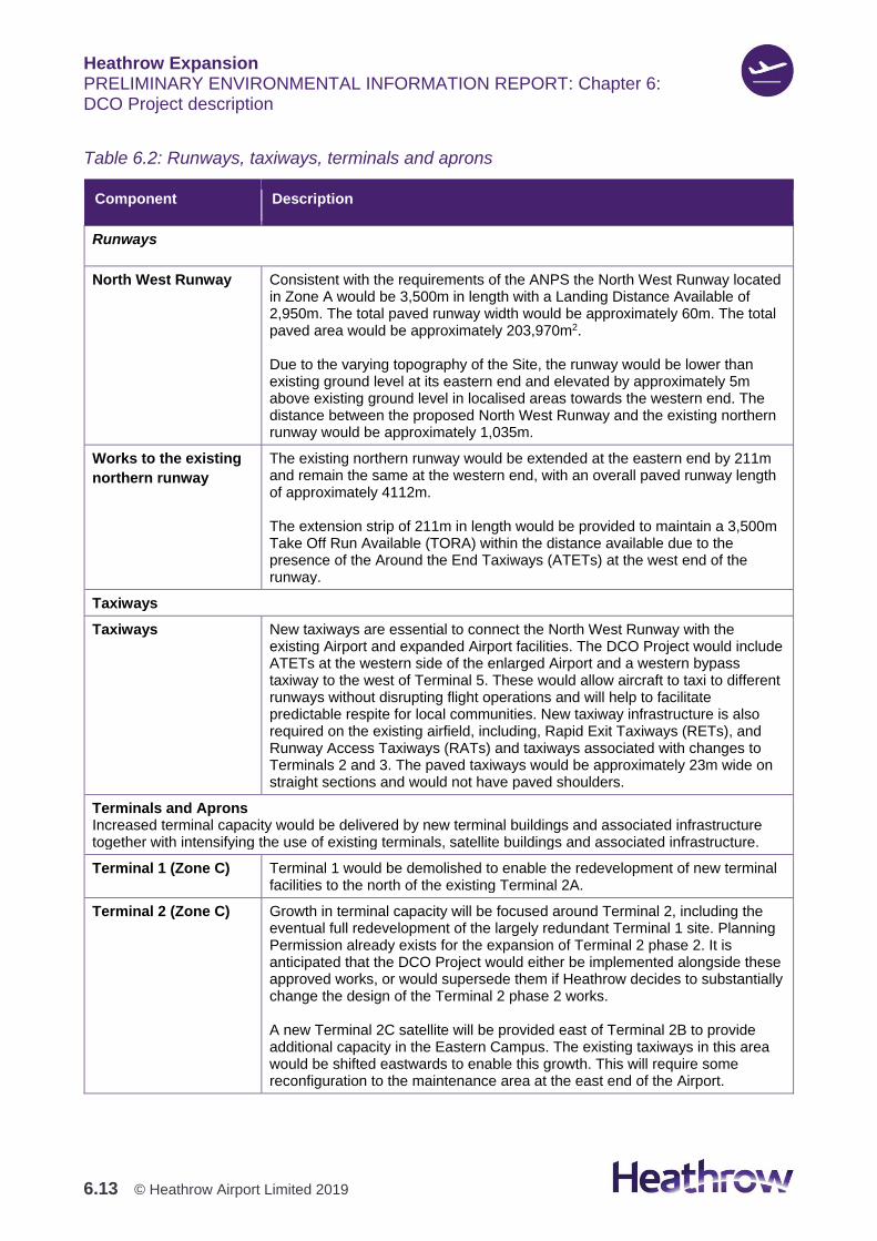
Table 6.2: Runways, taxiways, terminals and aprons
Component Description
Runways
North West Runway Consistent with the requirements of the ANPS the North West Runway located in Zone A would be 3,500m in length with a Landing Distance Available of 2,950m. The total paved runway width would be approximately 60m. The total paved area would be approximately 203,970m2. Due to the varying topography of the Site, the runway would be lower than existing ground level at its eastern end and elevated by approximately 5m above existing ground level in localised areas towards the western end. The distance between the proposed North West Runway and the existing northern runway would be approximately 1,035m.
Works to the existing
northern runway
The existing northern runway would be extended at the eastern end by 211m and remain the same at the western end, with an overall paved runway length of approximately 4112m. The extension strip of 211m in length would be provided to maintain a 3,500m Take Off Run Available (TORA) within the distance available due to the presence of the Around the End Taxiways (ATETs) at the west end of the runway.
Taxiways
Taxiways New taxiways are essential to connect the North West Runway with the existing Airport and expanded Airport facilities. The DCO Project would include ATETs at the western side of the enlarged Airport and a western bypass taxiway to the west of Terminal 5. These would allow aircraft to taxi to different runways without disrupting flight operations and will help to facilitate predictable respite for local communities. New taxiway infrastructure is also required on the existing airfield, including, Rapid Exit Taxiways (RETs), and Runway Access Taxiways (RATs) and taxiways associated with changes to Terminals 2 and 3. The paved taxiways would be approximately 23m wide on straight sections and would not have paved shoulders.
Terminals and Aprons Increased terminal capacity would be delivered by new terminal buildings and associated infrastructure together with intensifying the use of existing terminals, satellite buildings and associated infrastructure.
Terminal 1 (Zone C) Terminal 1 would be demolished to enable the redevelopment of new terminal facilities to the north of the existing Terminal 2A.
Terminal 2 (Zone C)
Growth in terminal capacity will be focused around Terminal 2, including the eventual full redevelopment of the largely redundant Terminal 1 site. Planning Permission already exists for the expansion of Terminal 2 phase 2. It is anticipated that the DCO Project would either be implemented alongside these approved works, or would supersede them if Heathrow decides to substantially change the design of the Terminal 2 phase 2 works. A new Terminal 2C satellite will be provided east of Terminal 2B to provide additional capacity in the Eastern Campus. The existing taxiways in this area would be shifted eastwards to enable this growth. This will require some reconfiguration to the maintenance area at the east end of the Airport.

Heathrow Expansion PRELIMINARY ENVIRONMENTAL INFORMATION REPORT: Chapter 6: DCO Project description
6.14 © Heathrow Airport Limited 2019
Component Description
Terminal 3 (Zone C) Terminal 3 is proposed to be demolished in the later stages of the construction of the DCO Project. The site would be redeveloped to make way for a new linear apron arrangement west of Terminal 2, including a new Terminal 2D satellite, aircraft parking stands and Airport Supporting Development such as baggage handling and waste facilities
Terminal 4 (Zone E) No changes are proposed to the capacity of Terminal 4.
Terminal 5 (Zones B and A)
A new Terminal 5X would be located in Zone B to the west of the existing Terminal 5A. It would act as a passenger processor and contain the key passenger processing facilities of: check-in, security, immigration, baggage reclaim and transfer facility, with walking links back to Terminal 5A. Terminal 5X will serve new aircraft stands around the building. A satellite pier, named Terminal 5XN, with aircraft stands is provided between the North West Runway and the existing northern runway, minimising aircraft taxiing journeys to the North West Runway. This satellite would be connected to the new Terminal 5X terminal via a new passenger transit system and would house a large passenger dwell area with retail offerings as well as departure gates and associated apron level infrastructure.
The proposed Western Campus Landside Terminal Zone (LTZ) represents a significant portion of the Western Campus area, delivering a new consolidated Public Transport Interchange (PTI) that can accommodate new rail connections such as the Elizabeth line and a Western Rail link, and a large associated commercial zone. The existing Multi-Storey Car Park (MSCP) and hotel located to the west of Terminal 5 will remain largely unchanged.
Aprons At Terminal 5, the stand layout would be reconfigured to optimise its operational model and increase the number of contact stands. In Zone B, a new bank of stands along the double taxiways would be provided, with service from the new Terminal 5X. In Zone A, a new apron would be developed, including a satellite building Terminal 5XN. After the demolition of Terminal 3, the apron in Zone C would be rearranged with a rack layout of 5 banks of stands operated from Terminal 2. To the east of Terminal 2B, a new bank of stands would be added as part of the new satellite Terminal 2C development.
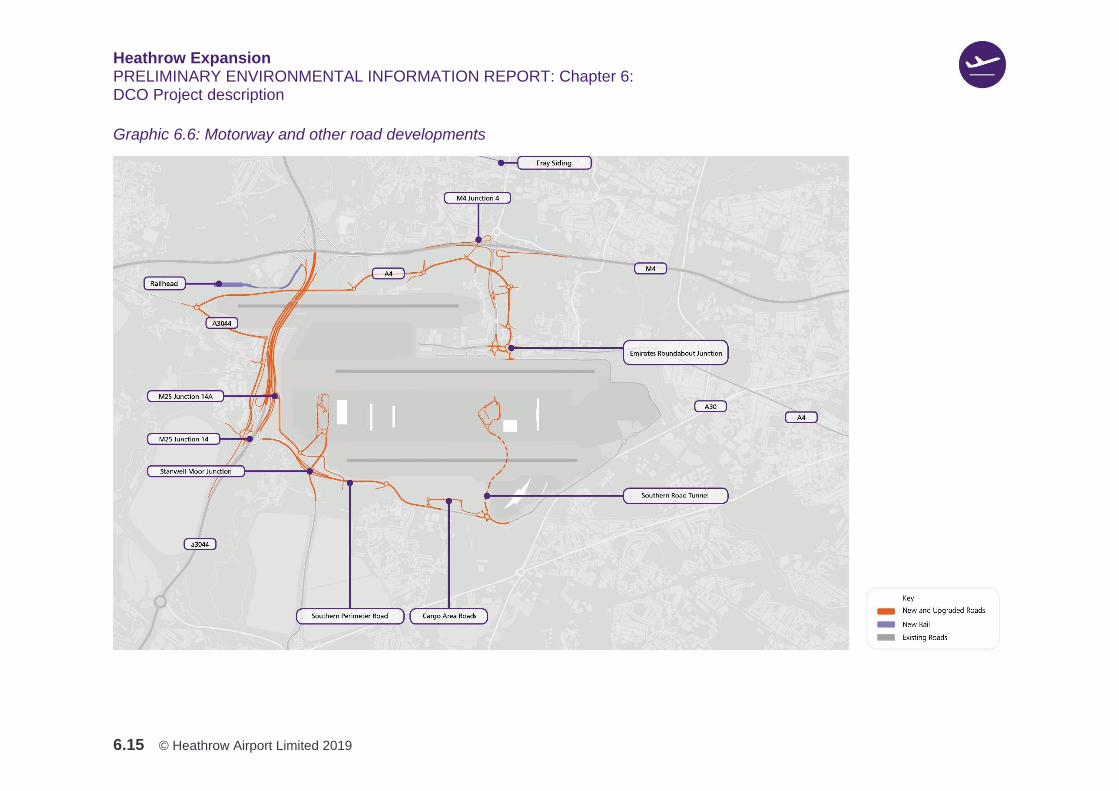
Motorway developments
6.3.6 Table 6.3 describes the motorway related infrastructure (M25 realignment, M25
junctions 14 and 14a, and M4 junction 4 realignment) works that would form part
of the DCO Project.
6.3.7 Graphic 6.6 illustrates the route of the M25 realignment, the proposed alterations
to junction 14 and 14a and the M4 junction 4 realignment.
Heathrow Expansion PRELIMINARY ENVIRONMENTAL INFORMATION REPORT: Chapter 6: DCO Project description
6.15 © Heathrow Airport Limited 2019
Graphic 6.6: Motorway and other road developments
Heathrow Expansion PRELIMINARY ENVIRONMENTAL INFORMATION REPORT: Chapter 6: DCO Project description
6.16 © Heathrow Airport Limited 2019
Table 6.3: Motorway developments
Component Description
Motorway developments.
M25 realignment (Zone K)
The M25 is proposed to be realigned to the west of the existing motorway, between junctions 14 and 15, to allow the M25 to pass under the proposed North West. Runway. This would include constructing Collector Distributor roads in each direction. These address the issue of two junctions being close together, and avoids the need for merging, by effectively linking two junctions into one extended junction. The alignment of the proposed M25 route would run approximately 150m to the west of its existing alignment, over a length of approximately 2km. The vertical profile would be lowered by approximately 4 to 4.5m below the existing M25 and passes under the North West Runway in a short tunnel. with 4 boxes - 2 for the new M25 mainline carriageways and one each for the northbound and southbound Collector Distributor roads
M25 junctions – junctions 14 & 14a
Access to the M25 and to and from the DCO Project would be via two separate junctions. An enhanced junction 14a would provide a second access via the A3113, Stanwell Moor Junction and Southern Perimeter Road. This has been designed in accordance with the proposed north and south Collector Distributor roads, which make up part of the M25 realignment between junction 14 and junction 15. A new roundabout at the eastern side of the existing junction 14a would be structurally elevated above other highways and the proposed river corridor. Junction 14 would have an enlarged roundabout which enables connection to the new A3044 north. No additional facility would be provided at junction 14 for the south to east traffic movement.
M4 junction 4 realignment
Modifications are proposed to the M4 junction 4 towards the south occurring primarily in Zone Q. Access and connectivity currently offered by M4 junction 4 would be preserved, with an additional spur proposed to the southeast of the junction that would give access to the Northern Parkway. A link cuts through the roundabout to provide a shorter route for traffic travelling towards M4(W) from Stockley Road, and traffic travelling towards Stockley Road from the M4(E). To provide more capacity under the existing bridge structures, the M4 westbound slips have been pulled towards the south of the junction to tie in at a tangent to the proposed cut-through. An additional lane is proposed on the westbound merge slip (currently two lanes) and a new merge arrangement with the M4. It is proposed to construct four standard-width lanes in both the eastern and western circulatory carriageways under the M4 mainline. This would increase the lane arrangement on the eastern side of the junction, which currently has five lanes. The section of road to the north of junction 4 is not proposed to change.
Heathrow Expansion PRELIMINARY ENVIRONMENTAL INFORMATION REPORT: Chapter 6: DCO Project description
6.17 © Heathrow Airport Limited 2019
Other road developments
6.3.8 Table 6.4 describes the other road development (for example, A4 replacement,
A3044 replacement, Stanwell Moor Junction, and Southern Road Tunnel to the
Central Terminal Area (CTA) works, which would form part of the DCO Project.
6.3.9 Graphic 6.6 illustrates the location of the proposed changes to the road networks.
Table 6.4: Other road developments
Component Description
Other road developments
A4 replacement The existing A4 sits beneath the proposed North West Runway and consequently would need to be diverted. A new off-line A4 route is proposed between the A4 at Colnbrook and the existing A3044 roundabout east of Harmondsworth. It would be re-routed to the south of Saxon Lake, passing through Moor Lane Allotment site, avoiding Saxon Way Industrial Estate. The Roads Illustrative Key Plan (Figure 6.6, Volume 2) allows for a dual carriageway road, but this could be a single carriageway along sections of the new road corridor. This would serve to reconnect the severed east-west link to the north of the Airport. To the west, the existing A3044 would connect to the A4, directing traffic east where it would bypass Harmondsworth, connecting into the existing A3044 to the east. East of the reconnection, traffic would use the existing road network. A link-road would be provided between the eastern junction of the A4 at Holloway Lane, and the intersection between Sipson Road and the A4, located just east of Emirates Roundabout. The link would bypass Sipson to the north, cross the M4 Spur Road just south of the M4 junction 4, head southeast of the M4 Spur Road through Zone Q to then join the existing A4 via a new junction located east of Emirates Roundabout in Zone R. A new at grade roundabout would be provided on the route just south of the proposed Northern Parkway in Zone Q. A new off-slip and on-slip would be added to the M4Spur Road. The eastern end of Holloway Lane would also be upgraded to a dual carriageway. The total route length of the proposed A4 replacement would be approximately 2.3km.
Emirates Roundabout Junction (ERJ)
The existing Emirates Roundabout Junction would be reconfigured to reduce its footprint, rationalise the road layout and be compatible with the proposed changes to the surrounding roads. The Emirates Roundabout is reconfigured by removing the northern part of the circulatory system and the eastbound A4 on-slip. Access to the A4 is instead provided via the East Ramp. A new at-grade roundabout is introduced at Nene Road, providing access to the rerouted A4, the existing A4, East Ramp and the Northern Perimeter Road.
A3044 Replacement
To accommodate the expanded Airport to the east of the M25, the A3044 has been diverted to the west of the M25. The replacement A3044 is proposed to run parallel to the west of the realigned M25. The ‘wide’ single carriageway road would run from junction 14 to the east of Poyle Industrial Estate past junction 14a and the M25 and would join an east west section of the A3044 to the south of the North West Runway. The existing A3044 would connect into the proposed A4 realignment, directing traffic to the east.
Heathrow Expansion PRELIMINARY ENVIRONMENTAL INFORMATION REPORT: Chapter 6: DCO Project description
6.18 © Heathrow Airport Limited 2019
Component Description
Stanwell Moor Junction
Stanwell Moor Junction is currently an at-grade partially signalised roundabout which connects junction 14 of the M25 with the Southern Perimeter Road and the A3044 via the A3113. It is proposed to upgrade Stanwell Moor Junction to a new grade-separated (multi-level) roundabout junction on the A3113 at Stanwell Moor, east of the M25 junction 14. The A3113 would run underneath the roundabout to provide additional capacity. The northern arm of the roundabout would drop down to connect to a new road tunnel beneath the southern taxiways. The east facing slips would connect to a realigned SPR.
Southern Perimeter Road (SPR)
The SPR would be upgraded from two to three lanes in each direction by widening the road asymmetrically into the existing Cargo Area. The proposed alignment mainly follows the existing alignment. This would occur across Zones J and E. The SPR would dive down by approximately 8m to pass under the new Stanwell Moor Junction roundabout via a simple box structure. Connecting the widened SPR, new roundabouts are proposed at Seaford Road and Stirling Road to replace the existing signal junctions. The Seaford Road roundabout would provide access to and from the Southern Parkway site and the retained Southern Fuel Receipt Facility (SFRF). The Stirling Road roundabout would provide access to the Cargo Area link road
Cargo Area Access Road
To complement the proposed changes to the SPR, a new Cargo Area Access Road with two at-grade roundabouts is proposed in Zone E to link Stirling Road to the Cargo Area and Beacon Roundabout. This would take all cargo-related traffic off the SPR between the two junctions. All other existing junctions into the Cargo Area from the SPR would be stopped up and access would be provided internally.
Southern Road Tunnel to the CTA
A new Southern Road Tunnel would connect the SPR to the CTA from an improved roundabout at the junction with Beacon Road to the west of Terminal 4. This is to provide a new direct landside connectivity link for buses, coaches and other vehicles between the Western Campus and CTA once the Northern Perimeter Road is closed, to increase the capacity of the landside road network into the CTA and to provide greater resilience. A twin-bored tunnel is proposed to provide access from the SPR to the CTA under the southern runway, running from Zone E02 into Zone C01. The tunnel would be approximately 1.1km long, and the new route would have a total length of approximately 1.7km. The bored tunnel diameter would be approximately 12m.
Other changes The Western Perimeter Road would not be replaced, and its functions would be transferred to other routes in the future road network, including the rerouted A4 and A3044.
River diversions and flood storage areas
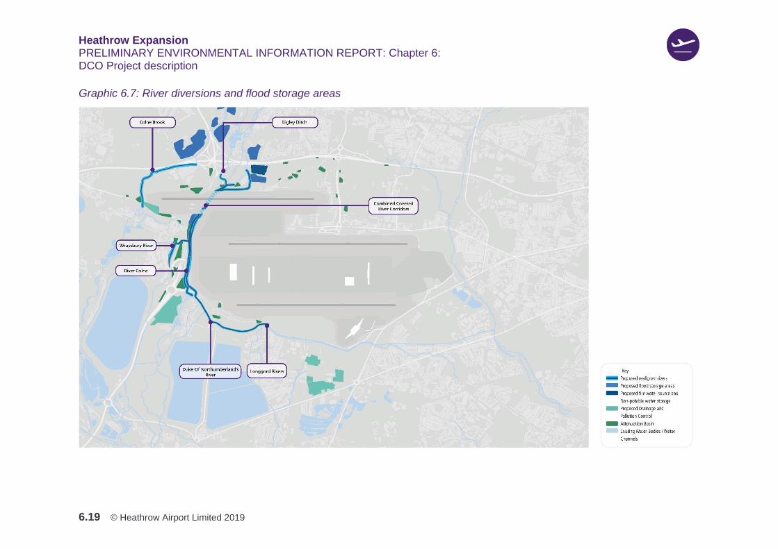
6.3.10 Table 6.5 describes the river and flood storage works that would form part of the
DCO Project. Graphic 6.7 illustrates the location of where river diversions and
flood storage areas are proposed.
Heathrow Expansion PRELIMINARY ENVIRONMENTAL INFORMATION REPORT: Chapter 6: DCO Project description
6.19 © Heathrow Airport Limited 2019
Graphic 6.7: River diversions and flood storage areas

Heathrow Expansion PRELIMINARY ENVIRONMENTAL INFORMATION REPORT: Chapter 6: DCO Project description
6.20 © Heathrow Airport Limited 2019
Table 6.5: River diversions and flood storage
Component Description
River Diversions
Covered River Corridor (CRC)
The Covered River Corridor (CRC) is the term that refers to the main diversion of the River Colne, Wraysbury River, Duke of Northumberland’s River, and Longford River to enable them to pass beneath the proposed North West Runway and taxiways to the east of the M25. The CRC is divided into two compartments, one containing the combined Colne and Wraysbury channel, and the other the combined Duke of Northumberland’s and Longford channel. The combined channels would provide variable depth and width conditions to support a range of different habitats. The CRC would convey both normal flows and flood flows. The river channels in the CRC would be similar multi-stage channels to the open sections of river and would attempt to mimic natural channels with space provided for riparian corridors either side of the channels to facilitate ecological connectivity and channels would only be lined where they flow over contaminated land. The CRC would be designed to be appropriate for key species groups (for example: fish, otters and bats).
Wraysbury River, Bigley Ditch, River Colne and Poyle Channel
The flows from the Bigley Ditch and Wraysbury River, would combine with those of the River Colne north of the North West Runway at Harmondsworth Moor and pass, in a new single diverted channel, east of the M25 under the airfield (in the CRC), for approximately 3.5km. South of the Bath Road the flows split (via a control structure) and an open channel section of Wraysbury River would head west under the M25 and join the Poyle channel. The River Colne compartment of the CRC would continue southwards along the western perimeter of the Site under the existing A3113, connecting back into its existing channel north of Stanwell Moor. The upstream reaches of the Holme Lodge and Stanwell Moor ditches will also be abandoned and infilled to accommodate the airfield expansion to the south west of the DCO Project. Further modification of the open Wraysbury River channel to the west of the M25 would be carried out for a length of approximately 1.18km to accommodate the modifications to the M25 and A3044 layout before returning to its existing channel.
Duke of Northumberland’s River and Longford River
The Duke of Northumberland’s River would be combined with flow from the Longford River and pass in a common channel under the airfield and to the east of the existing M25, so there would be a new single diversion channel for the combined Duke of Northumberland’s River and Longford River, approximately 5.9km in length. This river would flow parallel to the Colne and Wraysbury channel along the western perimeter of the Site. The Duke of Northumberland’s River and Longford River would continue in a combined channel, passing south under the SPR next to the River Colne, before flowing east, along the southern boundary of the SPR in an open channel. The channel would pass beneath the southern spur from the Stanwell Moor Junction roundabout (A3044), to the south of the proposed new Southern Parkway, in an open channel, before splitting back into the existing two rivers further east at Oaks Road. Along the length of this diversion, the combined Duke of Northumberland’s River and Longford River channel flows within a river corridor. A control structure at the end of this channel would provide the required flow split to

Heathrow Expansion PRELIMINARY ENVIRONMENTAL INFORMATION REPORT: Chapter 6: DCO Project description
6.21 © Heathrow Airport Limited 2019
Component Description
return flows (at the existing rates) to the existing Duke of Northumberland’s River and Longford River south of the airfield.
Colne Brook The Colne Brook would be diverted around the DCO Project south of its crossing under the M4, before returning to its existing channel immediately upstream of Colnbrook village. The Colne Brook would be diverted to the north and west of the logistics centre. The diversion begins immediately to the south of the M4 crossing, passes around the northern side of the Thames Water Iver South sewage treatment works (STW) and around the northern and western side of the logistics centre. This requires the infilling (at least in part) of Old Slade Lake and for the diverted Colne Brook to pass under the access road to Thames Water (Iver South) STW. In addition, the existing flow control structures located south of the existing A4 would be relocated on the new channel and flood defence works would be carried out on the channel through Colnbrook village to mitigate flood risk due to a change in overland flood flow paths resulting from the DCO Project.
Flood Storage Areas
Flood Storage Areas
The loss of existing floodplain due to the DCO Project would require the provision of compensatory flood storage areas. Current estimates of floodplain storage loss are approximately 350,000m³ to the west of the M25 (on the Colne Brook) and approximately 135,000m³ to the east of the M25 (on the Wraysbury River, River Colne, Duke of Northumberland’s River and Longford River).
Utilities
6.3.11 Table 6.6 describes the utilities works that form part of the DCO Project.
Figure 6.14, Volume 2 presents the parameter plan for the proposed alterations
to utilities.
Table 6.6: Utilities
Component Description
Utilities
Fuel Fuel supply to Heathrow is provided by pipelines and by rail from the north and pipelines from the south. On arrival, the fuel is metered and filtered at ‘receipt facilities’ and transferred to storage tanks. New infrastructure would include new storage tanks in the form of a new fuel farm ‘Northern Apron Tank Farm’ to be built to the south of the North West Runway and additional Airport Transfer Pipelines (ATPs) to connect existing assets to the new receipt facility in the north: the Northern Fuel Receipt Facility (NFRF). The new NFRF is anticipated to be on the airside / landside boundary south of the North West Runway and, would have a footprint approximately twice the size of the original.
Power lines To the west of the Airport it would be necessary to replace existing electrical infrastructure as follows:
Heathrow Expansion PRELIMINARY ENVIRONMENTAL INFORMATION REPORT: Chapter 6: DCO Project description
6.22 © Heathrow Airport Limited 2019
Component Description
Longford substation would be relocated to a site to the west of the Colnbrook rail branch line and north of the A3044. While these works would be included within the Application, planning permission may be sought separately to the DCO. The existing 275 & 132kV overhead powerlines at the western end of the North West Runway would need to be diverted as they clash with height restrictions imposed by the runway. These would be diverted underground. In addition, to meet the projected electrical demand for the DCO Project the power supply would need to be reinforced. Two locations for grid supply points are proposed north west of the M25 junction 15 and west of the industrial area in Poyle. Heathrow is working with the Utility companies who own and operate these assets, and potentially impacted landowners, to develop solutions for diversions.
Green infrastructure
6.3.12 Table 6.7 describes the green infrastructure works that form part of the DCO
Project. The potential location and extent of areas of green infrastructure are
illustrated in Graphic 6.8.

Heathrow Expansion PRELIMINARY ENVIRONMENTAL INFORMATION REPORT: Chapter 6: DCO Project description
6.23 © Heathrow Airport Limited 2019
Graphic 6.8: Green infrastructure

Heathrow Expansion PRELIMINARY ENVIRONMENTAL INFORMATION REPORT: Chapter 6: DCO Project description
6.24 © Heathrow Airport Limited 2019
Table 6.7: Green infrastructure
Component Description
Green Infrastructure
European Protected Species Mitigation Areas
European Protected Species (EPS) Mitigation Areas are to be focused to the north and north west of the Airport in Zones L, M, P, Q and R. These areas would comprise habitats appropriate for EPS such as bats and otters and are likely to include: ponds, wet ditches, open water, scrub and grassland mosaic, reedbed and hedgerows. Footpaths and cycle routes may be incorporated to allow public access where appropriate for the habitats and species under consideration. Further information on the EPS Mitigation Areas can be found in Chapter 8: Biodiversity.
Biodiversity Offsetting Areas
Biodiversity Offsetting Areas would be created to compensate for loss of biodiversity. The offsetting areas on Graphic 6.8 are shown for illustrative purposes only at this stage recognising that these may be subject to change due to negotiations with landowners and further consultation with stakeholders. The Biodiversity Offsetting Areas are located in proximity to the airport to maximise biodiversity unit value for offsetting and to provide for habitat connectivity and biodiversity resilience in the local area. Biodiversity Offsetting Areas would incorporate a range of habitat types, including, for example: reedbed, traditional orchard, standing water, wet woodland, semi-improved natural grassland, plantation woodland, marsh grassland, broadleaved parkland, amenity grassland and semi-natural mixed woodland.
Re-provided and enhanced Public Open Space (POS)
It is proposed that land would be re-provided as Public Open Space (POS) to compensate for the loss of existing POS resulting from the DCO Project. At this stage, it is envisaged that the amount of re-provided POS would exceed the amount of POS lost as a result of the DCO Project. Additionally, approximately 150 ha of land has been identified as necessary for EPS mitigation would be categorised as dual-purpose EPS and POS to maximise the range of environmental benefits delivered by the green infrastructure strategy. Enhancements to existing POS would be made to improve quality and accessibility of the network of green infrastructure potentially affected by the DCO Project. Harmondsworth Moor would be subject to enhancement to ensure that the retained part of the resource is of sufficient quality to maintain its current Green Flag status. Crane Meadows and the Crane Corridor have been identified as requiring enhancement both to improve the quality of the POS provided and to enhance recreational connectivity. Enhancements to existing pubic open spaces may include:
1. Improved connectivity under or over major infrastructure
2. Improvements to signage, footpaths, gates and stiles
3. New street furniture such as lighting, seating and bins

Heathrow Expansion PRELIMINARY ENVIRONMENTAL INFORMATION REPORT: Chapter 6: DCO Project description
6.25 © Heathrow Airport Limited 2019
Component Description
4. New recreational features such as play or sports equipment
5. Drainage for sport pitches
6. New planting and management of existing planting.
Multifunctional Green Loop
A Multifunctional Green Loop, ranging in width from 10-50m, is proposed to be provided around the Airport. The northern part of this link would run in an east-west direction, improving connectivity between the Colne Valley and the Crane Valley for both people and wildlife. This new link would contain a continuous dedicated footpath and cycleway, and a belt of planting which would act as a wildlife corridor. It would connect with other existing or enhanced PRoW and cycleways which run north-south and intersect it. For example, connections are being considered in the south west to link up with the proposed River Thames Scheme.
Noise Attenuation Indicative areas of noise attenuation features are located along the boundary of the draft DCO Limits at the boundaries of Zones A, M and P. These areas may include bunds, walls, fences and planting for visual screening, depending on how much space is available. Further information can be found in Chapter 17: Noise and vibration.
Airport supporting development
6.3.13 Table 6.8 describes the airport supporting development (e.g. airport operations,
freight distribution, car parking, hotels, warehousing, and offices) works that would
form part of the DCO Project.
6.3.14 Graphic 6.9 shows the location of proposed airport supporting development.
Graphic 6.10 illustrates the location and extent of the proposed Airport parking.
Heathrow Expansion PRELIMINARY ENVIRONMENTAL INFORMATION REPORT: Chapter 6: DCO Project description
6.26 © Heathrow Airport Limited 2019
Graphic 6.9: Airport supporting development
Heathrow Expansion PRELIMINARY ENVIRONMENTAL INFORMATION REPORT: Chapter 6: DCO Project description
6.27 © Heathrow Airport Limited 2019
Graphic 6.10: Parking

Heathrow Expansion PRELIMINARY ENVIRONMENTAL INFORMATION REPORT: Chapter 6: DCO Project description
6.28 © Heathrow Airport Limited 2019
Table 6.8: Airport supporting development
Component Description
Airport Supporting Development is a term which is used to describe a range of development that is related
to the DCO Project’s operation, such as: airport maintenance; cargo; hotels; offices; and warehousing.
Airport Operations
Airport operations includes existing facilities that will require enhancement to
support the expanded Airport, for example: ground service equipment parking,
emergency services facilities, turnaround support facilities, aircraft fueling facilities,
winter resilience infrastructure, baggage handling facilities and airside road
infrastructure.
Aircraft Maintenance
The existing maintenance base on the eastern side of the Airport would be
reconfigured with additional hangars and other accommodation. The existing
maintenance floorspace, including a hangar known as the Cathedral Hangar and
Technical Block E, would be demolished to facilitate the redevelopment and
rationalisation of this area. Approximately 60,000m2 of additional Maintenance
floorspace is proposed in Zone F.
Rail Fray’s Sidings (Zone N) The Colnbrook rail branch line is connected to the Great Western Mainline (GWML)
at West Drayton by way of a London (eastward) facing rail connection onto the
West Drayton Loop (WDL) line. The eastward facing connection makes
approaching from the west difficult. A modification to the railway infrastructure at
West Drayton is proposed to the existing Fray’s Sidings. The railway infrastructure
would be modified to use the existing Up Goods Loop to provide a new access onto
the Frays curve from the west by running a sixth line to the north of the Up Goods
Loop. This would provide extra holding capacity, provide enhanced access to and
from the west and would aid delivery of the North West Runway infrastructure by
enabling materials to be conveyed by rail in larger quantities to the construction
areas.
Colnbrook Rail Head (Zone M) A proposed new rail head will be developed for the import of bulk materials and
aggregates and containerised goods for construction purposes. The rail head will be
located on the Colnbrook branch of the Great Western Main Line (GWML). The
proposed location is immediately north of the proposed north-west runway where it
crosses the M25 into the Colne Valley. The railhead is likely to operate 24 hours a
day to utilise available paths during the night when passenger services are much
reduced.
Total Fuel Depot – Rail Head (Zone M) The rail line that serves the Total Fuel Depot will be severed by the North West
Runway and, therefore, a replacement would be provided. Consequently, the rail
line that serves the Total Fuel Depot would be diverted and realigned in an east-
west direction alongside the Colnbrook railhead to ensure that aviation fuel supply is
maintained to the expanded airport. The rail line relocation includes sidings together
with associated infrastructure and buildings, including fuel storage areas. This
provides for existing and future demand at Heathrow Airport.

Heathrow Expansion PRELIMINARY ENVIRONMENTAL INFORMATION REPORT: Chapter 6: DCO Project description
6.29 © Heathrow Airport Limited 2019
Component Description
Cargo To handle the additional level of cargo approximately 206,000m2 of cargo floor area
is proposed. This will include the reconfiguration and intensification of the existing
‘SEGRO Horseshoe’ (Zones E and J) and additional accommodation to the north,
east and south of the existing IAG World Cargo Centre.
Industrial Approximately 151,500m2 of industrial development is proposed. The majority of
facilities that fall under the ‘Industrial facilities’ category are related to utilities,
engineering, contractor’s compounds, in‐flight catering.
Hotels The DCO Project would include re-provision of displaced hotels and responds to the
demand for additional hotel rooms to support the increase in passenger and crew
numbers. This equates to the provision of approximately 375,000m2 of floorspace.
Hotel provision is summarised below:
1. Western Terminal Zone (Zone B) – approximately 151,500m2
2. Central Terminal Zone (Zone C) – approximately 65,500m2
3. To the south of the Northern Parkway (Zone Q) – approximately
20,000m2
4. Zone F – approximately 27,500m2
5. Around Hatton Cross (Zone G) – approximately 66,000m2
6. To the south of, or integrated with, the Southern Parkway in Zone J -
approximately 23,000m2.
7. In Zone R -approximately 20,800m2
Offices Approximately 20,500m2, offices are proposed in two locations:
1. Central Terminal Zone - approximately 8,000m2
2. Hatton Cross - approximately 12,500m2
Warehousing To support the increase in cargo capacity that is proposed as a result of the DCO
Project, additional off-airport warehousing floorspace is required, specifically freight
forwarding, which primarily handles import or export cargo associated with activity
on-airport. The proposals include provision for approximately 151,500m2 of
floorspace.
Airport parking
Car parking and on-airport transport
The total number of car parking spaces currently anticipated would be
approximately 63,400 spaces. In addition, it is assumed that there would be
approximately a further 3,600 airport related off-site public spaces close to the
Airport.
Additional car parking would be distributed across the Airport with the principal
areas being: Northern Parkway (Zone Q), Southern Parkway (Zone J), Terminal 4
Car Parking (Zones E & F), the CTA (Zone C) and Terminal 5 area (Zone A). There
would also be additional coach and lorry parking areas.
Northern Parkway Parking spaces: approximately 24,000 spaces.
Heathrow Expansion PRELIMINARY ENVIRONMENTAL INFORMATION REPORT: Chapter 6: DCO Project description
6.30 © Heathrow Airport Limited 2019
Component Description
Access: by cars via a grade separated roundabout from the M4 Spur Road. The Parkway will be connected to the CTA via a shuttle following the alignment of the M4 Spur descending to run through the outer bores of existing road tunnel to the CTA.
Southern Parkway Parking spaces: approximately 22,000. Access: principally accessed by cars from Junctions 14 and 14a of the M25. The Parkway will be connected to the Terminal 5 campus by shuttle. The Southern Parkway would be connected to the Western Campus (Terminal 5
and Terminal 5X) by an at-grade Mass Rapid Transit system, AGV or coach using
the public roads via the Stanwell Moor Junction. A route is reserved for a grade
separated PRT or GRT that crosses above the SPR before going underground to
reach the Terminal 5 LTZ.
Terminal 4 car parking
Parking spaces: approximately 10,750 car parking spaces in new MSCPs. Access: Terminal 4 car parking would be accessed from the SPR.
CTA (Eastern Campus)
Parking spaces: approximately 3,600 car parking spaces. Access: The CTA would be accessed from the existing Northern Road Tunnel or the Southern Road Tunnel.
Terminal 5 (Western Campus)
Parking spaces: approximately 4,300 car parking spaces. Access: Terminal 5 would be accessed from the new Terminal 5 roundabout.
Coach parking Three types of surface level coach parking would be provided in Zone P:
1. Airside coach parking for off pier and transfer traffic would be provided and
access would be via the control post near Polar Park.
2. Landside coach parking bays to support the connectivity between the
Parkways and terminals and to take Heathrow colleagues to other parts of
the Airport.
3. A buffer park for landside coaches that are waiting to be called forward to
replace the existing facility that would be affected by the DCO Project. This
would be located to the east of the existing northern runway, reusing the site
currently used for long term parking (which would be consolidated into the
Parkways).
Lorry Park A lorry park would be provided to the north-west of the Southern Parkway. The truck
park in Zone J would be a secured parking facility for truck drivers awaiting access
to the Cargo Centre; potentially with additional services such as sanitary facilities,
showers, food courts and a minor repair workshop. The facility is expected to
provide secure parking for approximately 100 HGVs.
Heathrow Expansion PRELIMINARY ENVIRONMENTAL INFORMATION REPORT: Chapter 6: DCO Project description
6.31 © Heathrow Airport Limited 2019
Component Description
The lorry park would have direct access from the M25 and dedicated links to the
SPR.
Displacement of exiting uses
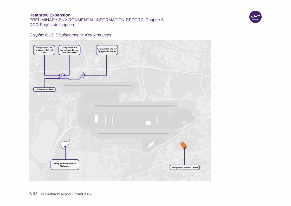
6.3.15 Table 6.9 describes the commercial uses, infrastructure and properties that would
be displaced by the DCO Project and identifying where they would be replaced as
part of the DCO Project.
6.3.16 Graphic 6.11 and Graphic 6.12 illustrate the location of displaced uses that are
included in the DCO Project.
Heathrow Expansion PRELIMINARY ENVIRONMENTAL INFORMATION REPORT: Chapter 6: DCO Project description
6.32 © Heathrow Airport Limited 2019
Graphic 6.11: Displacements: Key land uses

Heathrow Expansion PRELIMINARY ENVIRONMENTAL INFORMATION REPORT: Chapter 6: DCO Project description
6.33 © Heathrow Airport Limited 2019
Graphic 6.12: Displacements: Communities

Heathrow Expansion PRELIMINARY ENVIRONMENTAL INFORMATION REPORT: Chapter 6: DCO Project description
6.34 © Heathrow Airport Limited 2019
Table 6.9: Displacement of existing uses
Component Description
Displacement of existing uses.
Immigration Removal Centres (IRCs)
Harmondsworth and Colnbrook IRCs are Home Office facilities located on adjacent sites, north of the A4 Colnbrook Bypass and east of the Duke of Northumberland’s River. The IRCs would be demolished as part of the DCO Project, however given the function the IRCs plays, and the requirements set out in the ANPS, a replacement site would be provided in Zone G. The replacement facility would seek to provide appropriate amenities and capacity in comparison to the existing.
Lakeside Waste Management Facilities
The Lakeside Waste Management Facilities are currently located in Lakeside Industrial Estate, Colnbrook, Zone M. The Energy from Waste (EfW) facility is located to the southwest of the M25 / M4 junction, in the path of the North West Runway and taxiways. The Lakeside Waste Management Facility would be demolished as part of the DCO Project.
British Airways’ Waterside Office
The British Airways’ Waterside Office complex is located north of the A4 Colnbrook Bypass and east of Harmondsworth Moor on the border of Zones P and A. These facilities would be demolished as part of the DCO Project. .
BT Data Centre and Maintenance Depot
The BT Data Centre and Maintenance Depot are located north of the A4 and the IRCs, east of the Duke of Northumberland’s River, and within the area that would be impacted by the North West Runway. It is, therefore, necessary to move these facilities and consequently they would be removed from their current location as part of the DCO Project.
Aggregate Industries
Aggregate Industries’ operation of a rail and road-served aggregates site is located to the southwest of the M25 and M4 junction. Its operational area covers approximately 10 acres and comprises a rail unloading system together with a rail fed asphalt plant and ready-mix concrete plant. The southern half of the facility, the asphalt plant, would be demolished due to the DCO Project. Part of the eastern area of Zone M is safeguarded for the re-provision of Aggregate Industries’ asphalt and ready-mix concrete plant, which may come forward independently of Heathrow’s DCO application. In the event that it does not, Airport Supporting Development would be developed in this location.
Community facilities
Various community facilities are displaced by the DCO Project, and impacts on the facilities and the people that use them would be mitigated through re-provision within the DCO Project as follows:
1. Harmondsworth Primary School – the school will be demolished, with a preferred strategy to re-provide the school in Zone Q to limit disruption to children, staff and families. Facilities could be delivered as permanent buildings during the 2022 school summer holiday. This is a preliminary position subject to further engagement and technical assessment
2. Heathrow Special Needs Centre – to be demolished with a preferred strategy for re-provision in Zone L. This is a preliminary position subject to further engagement and technical assessment
3. Green Corridor – to be demolished with the preferred strategy for re-provision at a Heathrow-owned site at Princes Lake, to the south of the Airport. This is a preliminary position subject to further engagement and technical assessment
Heathrow Expansion PRELIMINARY ENVIRONMENTAL INFORMATION REPORT: Chapter 6: DCO Project description
6.35 © Heathrow Airport Limited 2019
Component Description
4. Harmondsworth Community Hall – to be demolished. The preferred strategy would be to re-purpose an existing building in Harmondsworth to accommodate a community hall. Several options are being considered for this use. This is a preliminary position subject to further engagement and technical assessment
5. Nursery provision at Wonderland Day Nursery (Harmondsworth) and Littlebrook Nursery (Longford) – subject to residual demand following residential property loss associated with the DCO Project, residual demand would be accommodated within the Harmondsworth community hub. This is a preliminary position subject to further engagement and technical assessment
6. Pinglestone Allotments, Moor Lane Allotments and Vineries Allotments – re-provision of displaced allotment plots would be ensured to continue to serve existing users, in line with standards set by policy, legislation and guidance
7. Sports facilities at Little Harlington Playing Fields, Harmondsworth Recreation Ground and Townmead Recreation Ground – the preferred strategy is for sports facilities displaced from these locations to be replaced in equal or greater quantity and quality adjacent to the existing facilities, to ensure continuity of access in line with standards set by policy, legislation and guidance.
Further information on displaced community facilities can be found in Chapter 11: Community.
Residential Properties
The construction of the DCO Project, as currently proposed, would result in the demolition of 756 homes. Further information can be found in Chapter 11: Community and in Heathrow’s Property Policies.
Development by zone
6.3.17 To help describe the DCO Project, it has been divided into zones. Table 6.10
provides a summary of the DCO Project by development zone.
6.3.18 Graphic 6.2 shown previously in Section 6.1, illustrates the location of each of the
zones within the draft DCO Limits.
Table 6.10: DCO Project development by Zone
Zone Description
Development Zone A
Zone A includes the proposed North West Runway and associated taxiway infrastructure, a northern satellite building (Terminal 5XN) of approximately 180,000m2, associated apron and Airport Supporting Development required to serve the new runway, apron and terminal facilities, such as baggage handling, ground support equipment parking and vehicle control posts, are also included. The Airport Supporting Development would include airport operational offices, an airfield firefighting station, airside vehicle fuel facilities and other supporting accommodation and infrastructure such as sanitation blocks, radio antenna, waste management and de-icing
Heathrow Expansion PRELIMINARY ENVIRONMENTAL INFORMATION REPORT: Chapter 6: DCO Project description
6.36 © Heathrow Airport Limited 2019
Zone Description
facilities. Approximately 23,800m2 of Airport operations, approximately 3,000m2 of cargo facilities and approximately 8,220m2 of industrial facilities are proposed.
Development Zone B
This Zone includes a new terminal building to the west of the existing Terminal 5 building (Terminal 5X). Approximately 370,000m2 of terminal accommodation is proposed, plus approximately 20,350m2 of airport operations and approximately 3,450m2 of industrial floorspace. The existing Multi Storey Car Park and hotel to the west of Terminal 5 would remain largely unchanged. The West Campus Landside Terminal Zone would include a new consolidated Public Transport Interchange (PTI) that can accommodate new rail connections such as the Elizabeth Line and a Western Rail Link. It would also include new hotels with approximately 151,500m2 of accommodation.
Development Zone C
Development Zone C includes new buildings and infrastructure which would increase passenger capacity in the existing CTA. Growth in terminal capacity would be focused around Terminal 2, including the eventual full development of the largely redundant Terminal 1 site. A new Terminal 2C satellite would be provided east of Terminal 2B to provide additional capacity in the East Campus. The existing taxiways in this area will be shifted eastwards to enable this growth. In the later stages of the DCO Project, Terminal 3 will be redeveloped to make way for a new linear apron arrangement west of Terminal 2. The CTA would be reconfigured to deliver an improved PTI and an associated commercial zone. Approximately 49,500m2 of additional Airport operational floorspace, 8,000m2 of offices, 65,500m2 of hotel accommodation, 560m2 of cargo floorspace, and 3,160m2 of Airport Supporting Development (industrial) and car parking is situated within the Zone.
Development Zone D
Development Zone D comprises the two existing runways. This Zone would also include an extension to the existing northern runway, landing thresholds would also be inset on the existing runways and there would be reconfiguration to the taxiway system to integrate them with the enlarged airfield. Airport Supporting Development in Zone D includes aviation fuel facilities, construction compounds and batching sites. Approximately 12,430m2 of Airport operations floorspace is proposed together with approximately 1,570m2 of industrial floorspace.
Development Zone E
Development Zone E is located to the south of the existing southern runway and includes existing cargo areas and Terminal 4 would remain in operation with a similar capacity as present. It includes, approximately, an additional 198,500m2 of cargo floorspace, alongside new parking structures and approximately 17,700m2 of Airport operations development. In addition, this Zone would accommodate Airport Supporting Development, Industrial and Maintenance Facilities (approximately 5,660m2).
Development Zone F
Development Zone F is located to the east of the two existing runways and includes much of the Airport’s current maintenance facilities accommodated in hangars. The existing maintenance base would be reconfigured with additional hangars and other maintenance accommodation, such as aircraft parking stands and ground run pens for aircraft engine testing. The existing Cathedral Hangar and Technical Block E will be demolished to enable the development of the new Terminal 2C satellite building, apron and taxiways. In the northern part of the Zone the parameter plans allow for a Multi-storey Car Park.

Heathrow Expansion PRELIMINARY ENVIRONMENTAL INFORMATION REPORT: Chapter 6: DCO Project description
6.37 © Heathrow Airport Limited 2019
Zone Description
In the southern part of the Zone existing surface level car parks are proposed to be reconfigured to provide additional surface level car parking and coach parking. An area of Airport Supporting Development would be provided at the southern and northern ends of the Zone. Approximately 7,050m2 of Airport operations, 910m2 of industrial facilities, 60,000m2 of maintenance facilities and 27,500m2 of hotel accommodation is located in the Zone.
Development Zone G
Located to the east of the existing southern runway, Airport Supporting Development is proposed in this Zone. It includes approximately 45,800m2 of freight industrial / freight forwarding facilities, 12,500m2 of offices and 66,000m2 of hotels. It also includes approximately 2,380m2 of Airport operational floorspace, car parking. The replacement IRC would be in Zone G.
Development Zone H
This Zone is located to the south of Heathrow. To the south of the Shell West London Fuel facility and within Zone H would be a surface water treatment facility. The remainder of the Zone to the south of the SPR would be used for the purposes of freight forwarding (approximately 65,000m2).
Development Zone J
This Zone includes the Southern Parkway, an area of additional car parking. This would be directly connected to the Eastern Campus. Access would be from a new junction which is connected to the M25, hotels may be integrated within the Parkway buildings.
Development Zone K
This Zone includes the M25 and the River Colne, the Duke of Northumberland’s River and the Longford River. The CRC would allow the North West Runway and taxiways to cross over the rivers flowing to the east of the M25. The CRC is divided into two compartments, one containing the combined Colne and Wraysbury channel, and the other the combined Duke of Northumberland’s River and Longford River channel. The Zone includes the realigned M25 with associated Collector Distributor Roads and parts of the relocated A3044. It includes changes to junction 14 and 14a. Approximately 13,500m2 of industrial Airport Supporting Development is proposed within the Zone.
Development Zone L
Located to the south of Colnbrook, Zone L would largely be enhanced open space. The eastern part of the Zone is proposed for approximately 59,000m2 of freight forwarding Airport Supporting Development.
Development Zone M
This Zone is located to the northwest of the proposed North West Runway. A new rail head would be located immediately north of the western edge of the North West Runway where it crosses the M25 into the Colne Valley – close to the existing rail logistics facilities. Part of the Zone includes the existing Lakeside Waste Management Facilities (Energy from Waste Plant) which would be demolished as part of the DCO Project. A Multifunction Green Loop is proposed to complement the new river corridor, which would pass through the centre of the Zone.
Development Zone N
Zone N is located north of the M4 motorway and includes green infrastructure, flood storage areas, utilities infrastructure and rail improvements.
Development Zone P
This Zone is located north of the proposed North West Runway, and adjoins the retained parts of Harmondsworth and Sipson, where noise attenuation and landscape enhancement are proposed at the boundaries of the settlements. The A4 would pass through the middle of the Zone to the north of Harmondsworth across the M4 Spur Road.
Development Zone Q
Zone Q is located around the existing M4 Spur Road and is proposed to be predominately for car parking (the Northern Parkway with approximately 24,000 spaces). Access would be provided from a new roundabout from the M4 junction, which would also provide access to hotels (approximately 20,000m2) to the south of the car parking. Landscape and ecological mitigation areas are proposed along the northern boundary.
Heathrow Expansion PRELIMINARY ENVIRONMENTAL INFORMATION REPORT: Chapter 6: DCO Project description
6.38 © Heathrow Airport Limited 2019
Zone Description
Within the northern portion of the Zone, a school and or community facilities are proposed, and within the southern portion, Airport Supporting Development.
Development Zone R
Zone R is located to the north of the existing northern runway. In this Zone the following is proposed: Airport Supporting Development comprising Industrial (approximately 6,800m2), Airport operations (approximately 43,370m2) and hotels (approximately 20,800m2) in part of the Zone.
Development Zone S
No development is proposed in this Zone.
Development Zone T
Located to the south west of the Airport, next to the Thames River, this Zone has been identified for enhancements to setting of historic assets.
Development Zone U
This Zone has been identified for accommodating both reprovided POS and biodiversity areas.
6.4 Construction
Introduction
6.4.1 The land area required to deliver the DCO Project is currently occupied by a
variety of infrastructure and land uses, including: residential; commercial;
industrial; transport; energy; waste; rivers; agriculture; and open space. These
existing land uses, and infrastructure, would be demolished or suitably diverted in
a phased approach after the DCO is granted.
6.4.2 Heathrow is in the process of developing specific plans for the construction and
delivery of each element, with the aim to reduce possible impacts. Heathrow is
also developing an overall plan that integrates all the activities into a
comprehensive site-wide solution. This is part of the on-going coordination
between construction, environmental, planning and design disciplines. Heathrow
has set out some of its initial thinking on its approach to construction in a
Construction Proposals document, on which it is consulting and seeking feedback
through the AEC. This section sets out some of the details of the construction
proposals from that document.
6.4.3 Heathrow is also creating an earthworks strategy that would be integrated with the
river, road and runway solutions. The strategy aims to optimise material
management, and develop construction phasing, that ensures best use of the
available land.
Construction Phasing
6.4.4 Graphic 6.13 to Graphic 6.18 illustrate the areas of land required for construction
during each of the anticipated three main phases. These graphics also show that
the land required for construction would change throughout the construction
Heathrow Expansion PRELIMINARY ENVIRONMENTAL INFORMATION REPORT: Chapter 6: DCO Project description
6.39 © Heathrow Airport Limited 2019
phases, and would likely reduce as construction of the DCO Project progresses.
Phase 1 would require the largest amount of land for construction, such as for the
earthworks and infrastructure activities. During Phase 2 and Phase 3, the delivery
of buildings and associated infrastructure would be carried out mainly within the
Airport, and would be confined to smaller areas and require less land for
construction. Table 6.11 to Table 6.13 identify the construction activities in each
phase.
6.4.5 Phase 1 (c. 2022 - 2026) - This phase is the major period of construction,
including: the demolition of existing buildings and structures; earthworks;
construction and improvement of motorways and the surrounding road network;
re-routing of existing gas, aviation fuel, water and electricity supplies; realignment
of rivers; construction of the North West Runway and airfield; and creation of
greenspaces and other environmental measures. This period also includes the
incremental increase of ATMs from the current cap of 480,000ATMs, year on year
starting in approximately 2022, and reaching 505,000ATMs in 2025. The phase is
currently anticipated to end in 2026, immediately prior to the opening of the new
runway.
6.4.6 The main earthworks activities are anticipated to commence in 2022 and continue
until 2024, with some localised earthworks extending into 2025 and 2026. The
period c. 2022 – 2025 would also include the re-provision of some commercial and
industrial properties, the alterations to the M25 and junctions, and the diversion
and construction of local roads, utilities and rivers.
6.4.7 The illustrative schedule shows construction of the North West Runway, taxiway
and other civil works and systems, would be phased between c. 2024 and 2026, to
fit the completion of the earthworks in each zone. Activities that would be carried
out during this phase include: drainage installation; foundation construction; the
construction of concrete pavements and subsurface tunnels; services installation
(electrical and lighting systems); and the construction of associated airfield
facilities and perimeter roads; testing and commissioning of the runway and
taxiways; and operational readiness including trial flights.
6.4.8 Table 6.11 provides an overview of the construction and operational activities that
are anticipated within Phase 1 (c. 2022 - 2026). Graphic 6.13 illustrates the areas
of construction activity during Phase 1 in 2023, and Graphic 6.14 shows the
illustrative construction areas during 2025.

Heathrow Expansion PRELIMINARY ENVIRONMENTAL INFORMATION REPORT: Chapter 6: DCO Project description
6.40 © Heathrow Airport Limited 2019
Table 6.11: Construction activities in Phase 1 for the PEIR assessment
Construction Activities in Phase 1
1. Site mobilisation and start of logistics and
construction works
2. Commencement of residential areas
demolition
3. Demolition of areas on land needed by the
project
4. Modification of local roads and junctions
5. Temporary bridge over the M25
6. Modifications to retained roads
7. Creation and operation of new railhead
8. Logistics sites created
9. River diversions complete
10. M25 modifications and operation of new
road
11. Southern parkway started
12. Modification / demolition of existing car parks
13. Utilities diversions
14. Allowance for environmental mitigation
15. Landfill enabling and construction
16. Runway and Taxiway construction
17. Construct airport ancillary facilities
18. Adjustments to existing runways
19. Terminal 5X construction starts
20. Landscaping and parkland works
21. Northern apron works
22. Eastern apron works
23. Terminal 4 works
24. Community projects
Heathrow Expansion PRELIMINARY ENVIRONMENTAL INFORMATION REPORT: Chapter 6: DCO Project description
6.41 © Heathrow Airport Limited 2019
Graphic 6.13: Illustrative construction area during 2023
Heathrow Expansion PRELIMINARY ENVIRONMENTAL INFORMATION REPORT: Chapter 6: DCO Project description
6.42 © Heathrow Airport Limited 2019
Graphic 6.14: Illustrative construction area during 2025
Heathrow Expansion PRELIMINARY ENVIRONMENTAL INFORMATION REPORT: Chapter 6: DCO Project description
6.43 © Heathrow Airport Limited 2019
6.4.9 Phase 2 (c. late 2026 - 2033) - Following the anticipated opening of the North
West Runway in 2026, the majority of construction areas to the north and west of
the North West Runway would be complete. Graphic 6.15 shows the anticipated
construction areas at runway opening. This phase would include the ongoing
development of Terminal 5X, Terminal 2A and supporting infrastructure, the
realignment of the A3113 and Stanwell Moor Junction, the initial phase of the new
Southern Parkway and the construction of the Southern Road Tunnel, which would
connect the south of the Airport with the CTA.
6.4.10 Phase 2 would also include the creation of new aircraft stands in the Northern
Apron between the North West Runway and the existing northern runway. The
Construction Support Site (CSS) in the North West of the DCO Project site would
be decommissioned during this period, with the exception of the railhead that
would continue to be used to support construction activities for subsequent
phases. For further information on the CSS, see the Section on ‘Construction
Support Sites’. Graphic 6.16 shows the anticipated construction areas during
2030.
6.4.11 Construction in Phase 2 from around 2031, would be largely located within the
airport, and would include the ongoing development of Terminal 5X and the
Northern Apron. The latter would require the demolition of a new section of the A4
and existing facilities to allow the construction of Terminal 5XN and new taxiways.
6.4.12 In the south, construction works to expand the new Southern Parkway would
continue.
6.4.13 Table 6.12 provides an overview of the construction activities that are anticipated
within Phase 2 (c. late 2026 - 2033).
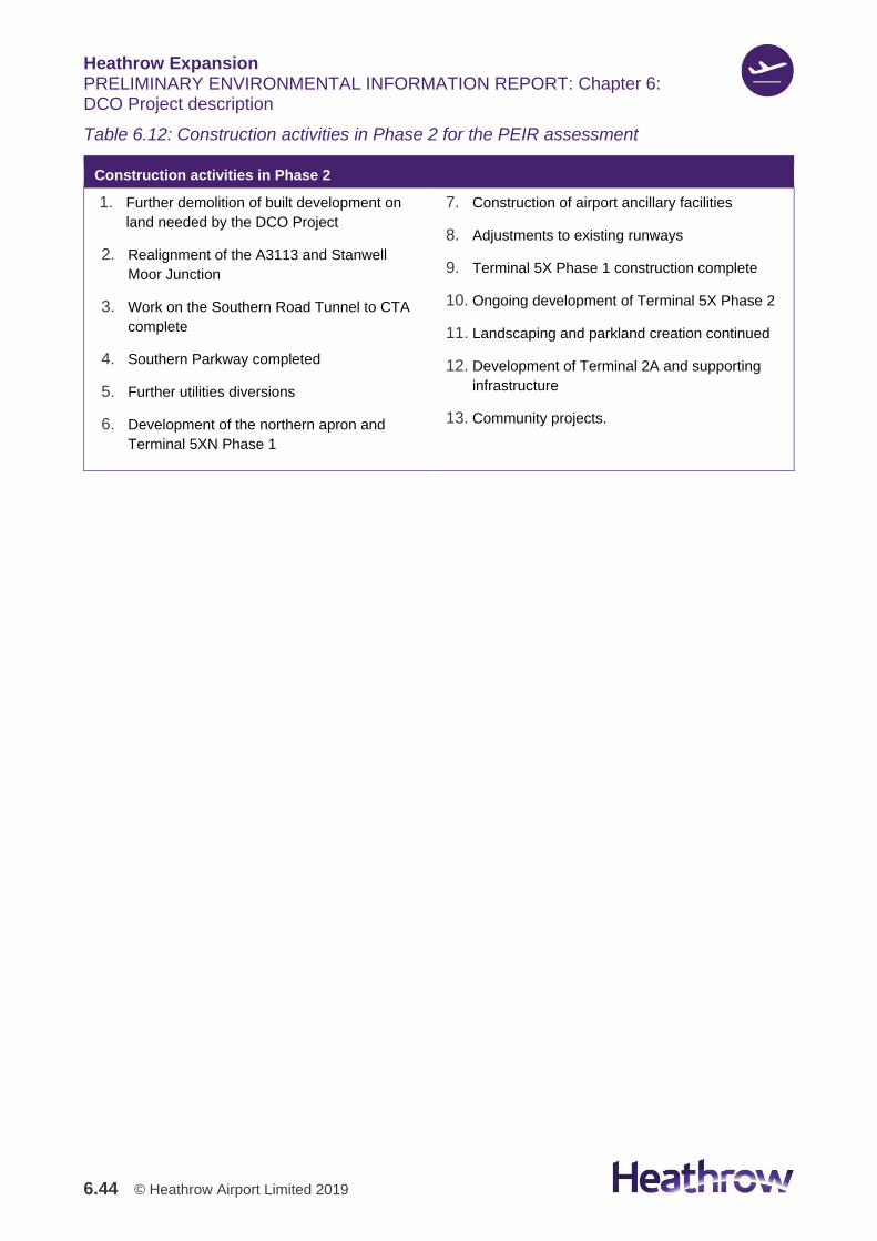
Heathrow Expansion PRELIMINARY ENVIRONMENTAL INFORMATION REPORT: Chapter 6: DCO Project description
6.44 © Heathrow Airport Limited 2019
Table 6.12: Construction activities in Phase 2 for the PEIR assessment
Construction activities in Phase 2
1. Further demolition of built development on
land needed by the DCO Project
2. Realignment of the A3113 and Stanwell
Moor Junction
3. Work on the Southern Road Tunnel to CTA
complete
4. Southern Parkway completed
5. Further utilities diversions
6. Development of the northern apron and
Terminal 5XN Phase 1
7. Construction of airport ancillary facilities
8. Adjustments to existing runways
9. Terminal 5X Phase 1 construction complete
10. Ongoing development of Terminal 5X Phase 2
11. Landscaping and parkland creation continued
12. Development of Terminal 2A and supporting
infrastructure
13. Community projects.
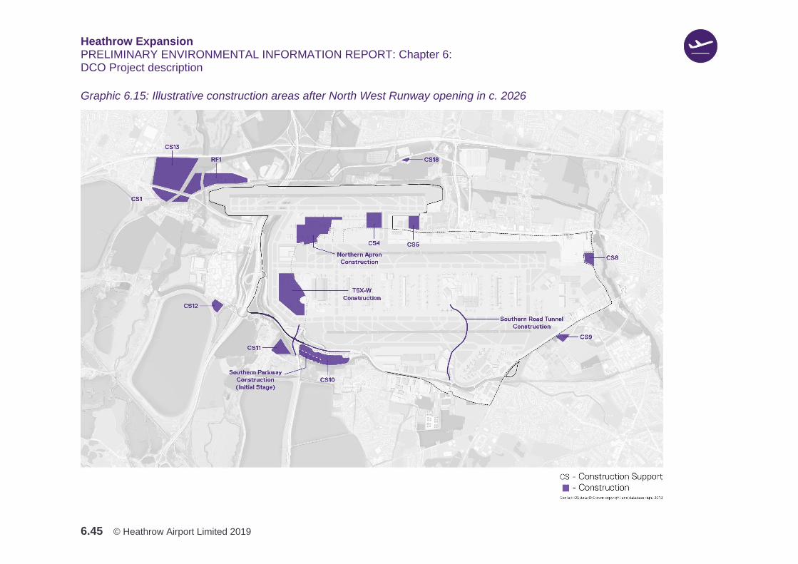
Heathrow Expansion PRELIMINARY ENVIRONMENTAL INFORMATION REPORT: Chapter 6: DCO Project description
6.45 © Heathrow Airport Limited 2019
Graphic 6.15: Illustrative construction areas after North West Runway opening in c. 2026
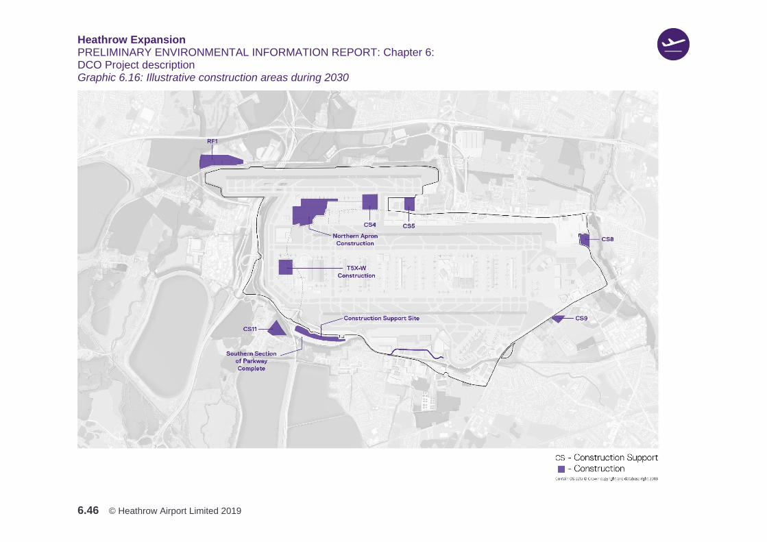
Heathrow Expansion PRELIMINARY ENVIRONMENTAL INFORMATION REPORT: Chapter 6: DCO Project description
6.46 © Heathrow Airport Limited 2019
Graphic 6.16: Illustrative construction areas during 2030
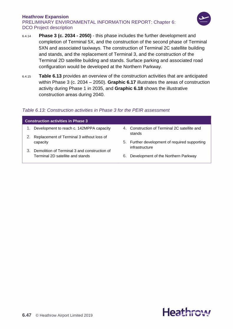
Heathrow Expansion PRELIMINARY ENVIRONMENTAL INFORMATION REPORT: Chapter 6: DCO Project description
6.47 © Heathrow Airport Limited 2019
6.4.14 Phase 3 (c. 2034 - 2050) - this phase includes the further development and
completion of Terminal 5X, and the construction of the second phase of Terminal
5XN and associated taxiways. The construction of Terminal 2C satellite building
and stands, and the replacement of Terminal 3, and the construction of the
Terminal 2D satellite building and stands. Surface parking and associated road
configuration would be developed at the Northern Parkway.
6.4.15 Table 6.13 provides an overview of the construction activities that are anticipated
within Phase 3 (c. 2034 – 2050). Graphic 6.17 illustrates the areas of construction
activity during Phase 1 in 2035, and Graphic 6.18 shows the illustrative
construction areas during 2040.
Table 6.13: Construction activities in Phase 3 for the PEIR assessment
Construction activities in Phase 3
1. Development to reach c. 142MPPA capacity
2. Replacement of Terminal 3 without loss of
capacity
3. Demolition of Terminal 3 and construction of
Terminal 2D satellite and stands
4. Construction of Terminal 2C satellite and
stands
5. Further development of required supporting
infrastructure
6. Development of the Northern Parkway
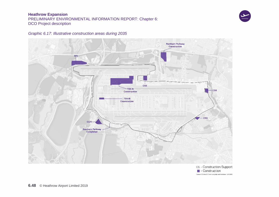
Heathrow Expansion PRELIMINARY ENVIRONMENTAL INFORMATION REPORT: Chapter 6: DCO Project description
6.48 © Heathrow Airport Limited 2019
Graphic 6.17: Illustrative construction areas during 2035
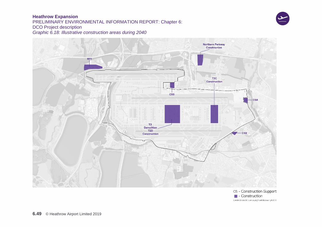
Heathrow Expansion PRELIMINARY ENVIRONMENTAL INFORMATION REPORT: Chapter 6: DCO Project description
6.49 © Heathrow Airport Limited 2019
Graphic 6.18: Illustrative construction areas during 2040
Heathrow Expansion PRELIMINARY ENVIRONMENTAL INFORMATION REPORT: Chapter 6: DCO Project description
6.50 © Heathrow Airport Limited 2019
Code of Construction Practice
6.4.16 Heathrow recognises the need to limit disturbance to local communities from
construction activities as far as reasonably practicable, and to maintain, and where
possible enhance, the wider environment. A draft Code of Construction Practice
(CoCP) has therefore been produced that contains control measures and
standards to be implemented throughout the construction period.
6.4.17 Whilst multiple construction works would run concurrently throughout the DCO
Project, the final CoCP would act as the overarching document for all construction
related activity. As such, the CoCP would present a consistent approach to the
management of construction activities for the entire proposed works.
6.4.18 The draft CoCP contains general requirements on matters such as working hours,
construction site layout, and management of earthworks, and specific sections on:
air quality and odour; biodiversity; carbon and greenhouse gasses; historic
environment; land quality; landscape and visual amenity; noise and vibration;
resource efficiency; traffic and transport; and the water environment.
6.4.19 The draft CoCP also sets out the proposed measures and standards of work that
would be implemented by Heathrow and its main contractors throughout the
construction period to:
1. Provide effective planning, management and control during construction in
order to manage potential impacts to people, businesses and the natural and
historic environments
2. Provide mechanisms to engage with the local community and their
representatives throughout the construction period.
6.4.20 The draft CoCP has been developed alongside the EIA process, and has
informed the assessments presented within this PEIR. A number of environmental
measures have been incorporated into the draft CoCP, and in turn this DCO
Project description, and the PEIR assessments, have assumed that the measures
in the draft CoCP would be implemented.
6.4.21 A number of potentially significant construction-phase effects would be avoided or
mitigated as a result of implementing the draft CoCP during construction. The
draft CoCP has been shared with relevant local authorities, and other statutory
bodies, through Heathrow’s programme of ongoing engagement. An updated
version, which takes account of comments from stakeholders on the early draft, is
available at AEC (June 2019).
6.4.22 The draft CoCP would be subject to further engagement with relevant local
authorities, and other statutory bodies, prior to submission of the Application for
the DCO Project. The draft CoCP may, therefore, be subject to refinement where
Heathrow Expansion PRELIMINARY ENVIRONMENTAL INFORMATION REPORT: Chapter 6: DCO Project description
6.51 © Heathrow Airport Limited 2019
necessary, as the scheme design and construction approaches continue to
develop.
6.4.23 At Application, a further draft of the CoCP would be submitted, with the
anticipation that it would become a 'certified document'. That is a document
certified as ‘final’ by the Secretary of State, with which compliance would be
required by the DCO.
Key construction activities
Overview
6.4.24 This section explains the general construction methods upon which the
environmental assessments reported within this PEIR have been based. Further
details of how construction would be carried out near the local communities of
Harmondsworth and Sipson, Poyle and Colnbrook, and Stanwell and Stanwell
Moor are presented in the Construction Proposals document, which is provided for
consultation at AEC. The proposed construction methodology is based on the
current stage of DCO Project development, and would be developed in more detail
as progress is made toward the Application, and would include responses to AEC
feedback.
6.4.25 The proposed methodology has been grouped under the following three main
construction activities:
1. Demolition of property and construction of new infrastructure
2. Airfield expansion including earthworks
3. Campus development.
6.4.26 Plans are being developed by Heathrow that aim at keeping construction activities
within the permanent land use area as much as reasonably practicable. However,
where this is not practicable, Heathrow has identified CSS that would be
temporarily used during the construction phase. These CSS would be located
along main roads, and as close as possible to the main construction areas. This
would ensure that construction traffic avoids local roads, and leaves public roads,
as soon as reasonably practicable. Further details on the proposed CSS are
presented later in this Section and their locations shown in Graphic 6.22.
Demolition of properties and construction of new infrastructure
6.4.27 The construction methodology for the following key activities is described in this
section:
1. Exploratory ground investigations, environmental and archaeological surveys

Heathrow Expansion PRELIMINARY ENVIRONMENTAL INFORMATION REPORT: Chapter 6: DCO Project description
6.52 © Heathrow Airport Limited 2019
2. Site establishment works
3. Installation of temporary facilities and infrastructure
4. Reprovision of certain facilities
5. Diversion of utilities, roads and rivers.
6.4.28 Exploratory ground investigations, and environmental and archaeological surveys,
have been used to inform the environmental assessments presented in this PEIR,
and the current design, and development of construction strategies. Further
investigations may be necessary following DCO consent. Appropriate
environmental measures would be adopted to protect the biodiversity of the area
in which the DCO Project would be constructed, with special attention given to
areas of ecological value. Pre-construction surveys would be undertaken where
necessary to determine the status and distribution of protected species, and locally
important species, throughout the Site (see draft CoCP, Section 6).
6.4.29 Construction activities would generally start with site establishment works. These
would include the installation of worksite security measures, to prevent
unauthorised access, and the implementation of environmental measures (e.g.
bunds and barriers), to mitigate the potential effects of construction activities on
local residents, businesses and the environment. The draft CoCP contains details
of measures that would be put in place to mitigate potential effects.
6.4.30 Temporary construction compounds and associated facilities would need to be
installed to progress construction and logistics operations. This would include: the
provision of welfare facilities and offices; site entrances; rail facilities; stockpiling
areas; internal construction roads and temporary bridges; temporary car parking;
batching plants; material conveyors; and any other temporary utilities and
infrastructure required to support and deliver the main construction works.
6.4.31 These facilities and infrastructure would be developed and decommissioned over
the course of the construction programme, to reflect their temporary nature and
the different stages of development activity. These temporary facilities and
infrastructure would be located as far as reasonably practicable from sensitive
receptors, including residential areas. The environmental measures set out in the
draft CoCP, including site lighting, fencing and screening, and security, would also
be implemented to minimise impacts during construction.
6.4.32 During the early stages of construction, it would be necessary to demolish a
number of properties. Some of the uses, which would be relocated, may be
subject to separate planning applications, either prior to, or alongside the
Application. This would apply to a number of community uses that would be
demolished early in the construction programme, and where it is important to

Heathrow Expansion PRELIMINARY ENVIRONMENTAL INFORMATION REPORT: Chapter 6: DCO Project description
6.53 © Heathrow Airport Limited 2019
ensure continuity of service provision. The demolition and displacement of existing
uses is described in Table 6.9.
6.4.33 Roads, rivers and other infrastructure would also be suitably diverted. The
construction principle for all diversions and reprovisions, would be to take a
phased approach, and maintain the existing assets in their current state until the
new assets are complete. For example, to maintain traffic connectivity and access
to properties in the area, and reduce potential effects on road users, the existing
section of the A4 affected by the North West Runway, would be demolished only
following the completion and operational handover of the new A4 diversion.
6.4.34 Additionally, the diversion of the M25 would be carried out off-line, with minimal
construction or roadworks taking place on live, operational roads. This would be to
avoid disruption to existing motorway traffic while constructing the realignment.
This would require the early diversion of the SSE overhead line equipment and
substation, and the relocation of Spout Lane Lagoon to Mayfield Farm. Due to the
different timing for the demolition of existing assets located along the new M25
alignment, construction would be undertaken in sections.
6.4.35 The proposed works to the M25 would include a western roundabout extension at
junction 14, and extensive modifications at junction 14a. The construction of the
new roundabout extension at junction 14 would be completed without impacting
the traffic on the existing junction. Junction 14a would be redeveloped in phases,
with the installation of temporary measures to maintain traffic flow into Terminal 5
and Sofitel. Where reasonably practicable, public rights of way (PRoW) for
pedestrians and cyclists affected by construction, would be maintained, including
reasonable adjustments to maintain inclusive access.
6.4.36 It is intended to divert multiple utilities along the alignment of the proposed new
roads, like the new A4 and A3044, to avoid disrupting existing roads. Where
multiple changes to utilities are required in an existing area, works would be
undertaken in a single operation where possible, to reduce potential effects on the
public during the works. There are a number of small tunnels and underpasses
required to accommodate roads and utilities. Most of the tunnels would be
constructed either off-line or within the Airport boundary.
6.4.37 There are also a number of rivers that would need to be diverted / realigned to
maintain the connectivity of these rivers through the Site. The approach to river
diversions would be to maintain the existing river corridors in their current
condition, until the new river corridors have been sufficiently established.
6.4.38 Heathrow would also incorporate the following into the design and construction of
the river diversions:

Heathrow Expansion PRELIMINARY ENVIRONMENTAL INFORMATION REPORT: Chapter 6: DCO Project description
6.54 © Heathrow Airport Limited 2019
1. The new river channel would be constructed whilst all flow remains in the
existing river channel
2. The phased movement of rivers (including relocation of fish from old river
channels) would be sensitive to fish spawning seasons
3. Fish subject to removal from old river channels would be placed upstream and
downstream of the construction site in reaches where habitat would not be
disturbed by construction activities from the DCO Project and
4. The removal of old river corridors would only take place once alternative
terrestrial ecological corridors are in place, including riparian areas where
these are vital for ecological connectivity.
6.4.39 In addition, upstream flood storage would be provided to mitigate the displacement
of areas of floodplain within the DCO Project, in order to prevent any increase in
flood risk elsewhere.
6.4.40 Where reasonably practicable, public rights of way for pedestrians, cyclists and
equestrians affected by the DCO Project, would be maintained, including
reasonable adjustments to maintain or attain inclusive access.
Airfield Expansion
6.4.41 The construction methodologies for the following key activities are described in
this section:
1. Earthworks
2. Materials management
3. Airfield construction
4. Dewatering and infilling of waterbodies.
Earthworks
6.4.42 Earthworks is a key component of the DCO Project, as it creates the horizontal
and vertical layout of the airfield plate (encompassing runway, taxiways, aprons
and stands), and the platform for other infrastructure, including roads, rivers and
buildings. The earthworks for the airfield plate would be the most significant
determinand in the overall earthworks material balance.
6.4.43 There have been three main elements to the development of the currently
proposed earthworks strategy:
1. Optimisation of fill requirements. The key driver was the minimisation of the
quantities of material needed to be imported onto site or exported off it. This
Heathrow Expansion PRELIMINARY ENVIRONMENTAL INFORMATION REPORT: Chapter 6: DCO Project description
6.55 © Heathrow Airport Limited 2019
reduces the impact on the road and transport network as well as the impact to
cost and programme
2. Borrow pits. Identification of potential on-site sources of ‘fill ‘material (i.e.
material used to artificially raise existing ground levels such as soil, rocks and
aggregates) to plug the materials deficit
3. Design solution development. This work centred on the identification of
engineering solutions to facilitate the development of the DCO Project and to
respond to challenges such as the extensive presence of landfills and
minimising excavation.
6.4.44 The earthworks for the DCO Project would require the movement of a large
amount of material over three years during Phase 1, with some localised
earthworks later in that Phase.
6.4.45 Earthwork materials would be generated on site from the following sources:
1. Cut and fill operations - whereby the 'cut' material consists of the removal of
soil from its original location, and the 'fill' is the placement and compaction of
layers of the soil to form a level surface that would enable construction
2. Borrow pits - where gravel, sand and clay would be dug for use at other
locations on site. A number of borrow pits are proposed as shown in Graphic
6.19:
a. Northern Strip (south of Harmondsworth)
b. Taxiway islands (south of Harmondsworth)
c. East of Saxon Lake (north of Harmondsworth)
d. Colnbrook at Poynings (north of M4). Note the long-term use of this site
would be a proposed flood storage area.
3. Demolition of existing buildings / infrastructure.
6.4.46 These sources would be expected to generate a significant volume of fill material
with current estimates totalling in excess of 20 million m3. Approximately
8 million m3 would be expected to be moved during the peak year of construction
(c.2023), prior to runway opening. More information on the management of these
materials is set out below.
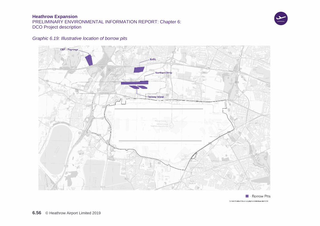
Heathrow Expansion PRELIMINARY ENVIRONMENTAL INFORMATION REPORT: Chapter 6: DCO Project description
6.56 © Heathrow Airport Limited 2019
Graphic 6.19: Illustrative location of borrow pits
Heathrow Expansion PRELIMINARY ENVIRONMENTAL INFORMATION REPORT: Chapter 6: DCO Project description
6.57 © Heathrow Airport Limited 2019
Materials Management
6.4.47 A draft Materials Management Plan would be submitted with the Application for the
DCO Project, setting out how materials (including cut and fill, borrow pit arisings
and waste) would be managed during construction. The focus would be on waste
prevention and minimisation, with contractors having responsibility for reducing the
waste generated from all construction-related activities. Measures to reduce waste
impacts from construction works would include the timely and efficient storage of
materials on-site.
6.4.48 Topsoil and natural subsoils would be stripped as close as reasonably practicable
to the period of excavation or other earthworks activities, to reduce risks
associated with surface water runoff, odour or dust generation. Further detail is
provided in the draft CoCP, Chapters 4 and 9. Where possible, topsoil and natural
subsoil would be placed in its final reuse location following stripping, which would
potentially avoid the need to stockpile. Where this would not be possible, it would
be temporarily stockpiled until it could be used. Where stockpiles were required,
these would be designed and managed to reduce dust generation and visual
intrusion.
6.4.49 Where excavated gravel, sand and clay could not be used immediately, and delay
of excavation would not be feasible due to phasing constraints, the material would
be temporarily stockpiled. In general, material requiring stockpiling to the east of
the M25, would be stockpiled to the northeast of the DCO Project, with stockpiling
to the west of the M25 proposed in an area just north of the existing A4. This is
shown in Graphic 6.20. Other minor stockpiling would be required in localised
areas across the Site.
6.4.50 The earthworks would be expected to generate a surplus of sand and gravel,
which would be processed and used for applications other than the bulk
earthworks, e.g. as aggregate for concrete production. Crushing and screening of
demolition arisings (e.g. concrete) would also be undertaken on-site to produce
recycled, granular fill materials.
6.4.51 Heathrow would consider the potential to reuse or recover materials arising during
earthworks. As part of the EIA for the DCO Project, Heathrow would undertake a
land contamination risk assessment. This would inform the identification of
acceptance criteria for re-use of excavated materials in the earthworks, which
would be used in conjunction with geotechnical assessment criteria.

Heathrow Expansion PRELIMINARY ENVIRONMENTAL INFORMATION REPORT: Chapter 6: DCO Project description
6.58 © Heathrow Airport Limited 2019
Graphic 6.20: Illustrative proposed stockpile areas
Heathrow Expansion PRELIMINARY ENVIRONMENTAL INFORMATION REPORT: Chapter 6: DCO Project description
6.59 © Heathrow Airport Limited 2019
6.4.52 The overall approach to the management and potential remediation of ‘made
ground’ (i.e. land where natural soils have largely been replaced by man-made or
artificial materials) would be based on ‘suitability for use’ principles, which would
be consistent with ANPS paragraph 5.11. The draft CoCP, Chapter 9 contains
further information on Heathrow’s approach to management of construction either
on or adjacent to contaminated land.
6.4.53 In circumstances where re-use or recovery of excavated material would not be
possible, and the material is classified as waste, it is proposed that, with the
exception of hazardous waste, it would be disposed of in new, on-site landfills. The
Northern Strip and Taxiway Island borrow pits are proposed to be converted to
new landfills, after sand and gravel, and underlying London Clay have been
excavated. Another new landfill is proposed to be constructed by infilling Old Slade
Lake (shown in Graphic 6.21). These would be appropriately engineered in
accordance with relevant legislation and guidance, and would be carried out in
accordance with environmental permits issued by the Environment Agency.
6.4.54 Constructing new landfills on-site would reduce the need for vehicle movements to
and from the site to remove such material. This would minimise the potential
environmental effects that could result from transporting such waste to off-site
disposal facilities. This would be consistent with paragraph 5.80 of the ANPS. This
approach would also minimise the need to store excavated landfill waste on site.
Where direct emplacement in a new landfill would not be possible, some
temporary storage would be required in the proximity of the area of landfill
excavation. Contaminated materials that require temporary storage, would be held
in contained areas with impermeable bases and bunding, to prevent infiltration and
run-off of contaminated water. Where necessary the deployment of odour
suppressant measures would be implemented.
6.4.55 A Site Waste Management Plan would be prepared in accordance with the
requirements of the draft CoCP. The role of the Plan would be to minimise waste
arising from construction, and to facilitate good practice for waste management.
Furthermore, all waste management practices would comply with legal ‘duty of
care’ requirements. These practices would protect the interests and safety of the
environment, and others, from the potential impacts of handling, storing,
transporting, and depositing excavated materials, and the demolition and
construction wastes, that would arise from the Project.
Heathrow Expansion PRELIMINARY ENVIRONMENTAL INFORMATION REPORT: Chapter 6: DCO Project description
6.60 © Heathrow Airport Limited 2019
Graphic 6.21: Illustrative proposed new landfill locations
Heathrow Expansion PRELIMINARY ENVIRONMENTAL INFORMATION REPORT: Chapter 6: DCO Project description
6.61 © Heathrow Airport Limited 2019
Airfield construction
6.4.56 The runway and taxiways are proposed to be constructed on an area of land that
has been subject to landfilling. Landfill materials are compressible and can be
prone to settlement, i.e. downward movement of the ground.
6.4.57 As a result, a key focus for the earthworks strategy has been the identification of
the best way to control settlement on the airfield so that it remains within
acceptable limits. This is particularly significant for runways, taxiways and aircraft
stands, where strict operational limits are set.
6.4.58 There would be three potential solutions in relation to earthworks and engineering
in these areas:
1. Excavate the landfills and replace with clean backfill
2. Pile through the base of the landfills, minimising excavation
3. Undertake ground improvement works, which would not involve piling through
the base of the landfills, and which would also minimise excavation.
6.4.59 A key component of the proposed earthworks strategy would be to minimise the
generation of waste. However, which of these solutions is adopted in different
parts of the site, would also depend on the proposed use, the depth and nature of
the landfill, and the underlying geology. The solution chosen for each area would
be dependent on the outcome of the ground investigations, and ongoing
discussions with stakeholders.
6.4.60 The construction of the North West Runway, taxiway and other civil works and
systems, would be phased to fit the completion of the earthworks in each zone.
Activities that would be carried out during this phase, include: the construction of
concrete pavements; drainage and other services installation; and the construction
of associated airfield facilities and perimeter roads.
6.4.61 As part of the design process, Heathrow is exploring options to minimise the
amount of concrete used for construction. There will still be, however, significant
quantities required for the runway, taxiways, terminals, roads and other
infrastructure. To maximise the use of more sustainable freight modes during
construction, Heathrow would deliver concrete material to the DCO Project by train
as much as practicable. Batching plants and pre-casting areas would be
established on-site to minimise the transport of ready-mix concrete by road.
Materials for concrete production would be stored on-site with enough supply, to
ensure continuous production, and reduce exposure to supply chain risks.
6.4.62 Heathrow would locate the main batching plant at the proposed rail facilities at the
Colnbrook branch line, to optimise delivery by rail, and to minimise the potential

Heathrow Expansion PRELIMINARY ENVIRONMENTAL INFORMATION REPORT: Chapter 6: DCO Project description
6.62 © Heathrow Airport Limited 2019
impacts of noise and dust associated with the operation of such plant to sensitive
areas. Other batching plants may potentially be placed within the CSS locations to
facilitate localised concrete supply to the various worksites.
Dewatering and infilling of waterbodies
6.4.63 The airfield earthworks platform would also extend over Colnbrook West and
Orlitts lakes, to the west of the M25, and these would require dewatering and
infilling.
6.4.64 A range of measures would be adopted during the construction phase, to control
potential risks to the water environment and local communities arising from
earthworks activities. For example, flood plains would be maintained, and
compensatory flood storage provided before any loss of flood plain is incurred as a
result of the DCO Project. The draft CoCP, and the assessment chapters in this
PEIR, outline the preliminary thinking on some of the key measures that would be
required to manage impacts on the water environment. These would be developed
further, with relevant stakeholders, as Heathrow’s construction proposals mature
further.
Campus development
6.4.65 The new campus development would comprise the following elements:
1. Western Campus: including Western Apron with Terminal 5, additional
terminal capacity (Terminal 5X) to the west of Terminal 5A, and a Western
Landside Terminal Zone (WLTZ), and Northern Apron including new satellite
capacity and facilities between the North West Runway and the existing
northern runway (Terminal 5XN)
2. Eastern Campus: including Eastern Apron 2 and 3 and the expansion of
Terminal 2, and demolition of Terminal 3.
6.4.66 Heathrow would ensure that any works within the existing airfield would not
adversely affect airport operations and the passenger experience. Maintaining or
improving the existing connectivity between terminals during the construction
stage, would also be a key consideration in how the works are phased. Heathrow
would also be exploring opportunities to maximise the off-site production adopted
in the delivery of the new terminal buildings, utilising the Logistics Hubs and the
CSS. This would allow the development of repeatable and buildable solutions that
maximise efficiency, reduce the on-site resources required, and potentially
minimise construction impacts.
Heathrow Expansion PRELIMINARY ENVIRONMENTAL INFORMATION REPORT: Chapter 6: DCO Project description
6.63 © Heathrow Airport Limited 2019
Construction and Logistics Management
Overview
6.4.67 A driving principle for the delivery of the DCO Project, would be to provide
construction and logistics solutions that maximise the off-site production of
materials and products. The intention is that this approach would optimise the flow
of freight and workforce, to reduce adverse effects on the local communities, the
public, the environment and airport operations. This would be achieved by
implementing the following measures:
1. The implementation of CSS at Heathrow to facilitate, manage and coordinate
construction and logistics operations at the project level, before materials are
delivered to the various works sites for erection or assembly in-situ
2. The maximisation of rail freight for the delivery of materials by constructing a
dedicated railhead and by selecting remote Logistics Hubs with dedicated
railhead facilities where practicable. Rail would be used to remove some
materials from the site where practicable
3. The optimisation of road freight by consolidating and configuring material at the
remote Logistics Hubs and CSS for ‘just-in-time’ delivery, the implementation of
delivery management systems to control and manage all road deliveries, to
and from the site
4. The selection and adherence to designated haul routes that avoid residential
roads and minimise construction traffic in areas of poor air quality and the
creation of HGV parking areas at the CSS that would discourage HGVs from
parking on the road network and provide a location where they can be
controlled and held
5. The choice of location of construction facilities, compounds, parking, site
entrances, and construction roads would ensure that these would be located as
far as possible from residents and, where this is not practicable, that measures
set out in the draft CoCP are in place to minimise impacts
6. Utilising the support of remote Logistics Hubs across the UK to maximise off-
site production, consolidation and supply chain integration.
Construction Support Sites
6.4.68 The DCO Project would require temporary use of land, above and beyond the
permanent land required, to support and facilitate construction and logistics
operations. This would include: allocated areas for the transport and storage of
materials; batching plants; HGV parking; workforce parking; contractors’
compounds; and stockpiling areas.
Heathrow Expansion PRELIMINARY ENVIRONMENTAL INFORMATION REPORT: Chapter 6: DCO Project description
6.64 © Heathrow Airport Limited 2019
6.4.69 Construction activities are proposed to be within those areas identified for
permanent land use as much as reasonably practicable. However, where this
would not be practicable, CSS would be identified for temporary use during the
construction phase. These plots would be located as close as practicable to the
main construction areas, to reduce construction traffic on public roads, and to
reduce potential effects on the local community and environment. CSS would likely
include the following activities:
1. Construction compounds: areas allocated to the management of people and
resources, including the location of site offices, workforce welfare, plant and
maintenance operations, and storage and laydown areas for construction
materials
2. Site entrances and control posts: areas that would provide security checks for
vehicles, materials and workforce entering and leaving construction sites
3. Temporary car parking: that would be used by the workforce in addition to
public transport
4. HGV parking: areas allocated to manage the flow of HGVs arriving and
departing the construction zone and ensure minimal impact to local
communities. These areas facilitate ‘just-in-time’ delivery, so the vehicle is
called upon when it is required on-site, rather than circling the site on the
surrounding road network
5. Batching plants: for concrete and asphalt. At least one of these facilities would
be located in proximity to the railhead to enable the efficient delivery of
aggregates
6. Pre-fabrication and pre-assembly facilities: providing the ability to manufacture
pre-cast products and other construction components, and to pre-assemble
components, before moving them to the construction area for erection in situ
7. Railhead: The railhead (to be located at the proposed CSS adjacent to
Colnbrook) would be the principal import facility for bulk materials, primarily
aggregates, sand and cement for concrete production. Other materials and
containerised goods for construction purposes may also be delivered by rail.
Rail would also be used to export materials off-site where practicable
8. Workforce welfare facilities: for example, changing rooms, catering facilities,
and toilets
9. Areas of hardstanding for construction worker accommodation: this would
include managed areas for construction workers that choose to bring their own
mobile accommodation.
Heathrow Expansion PRELIMINARY ENVIRONMENTAL INFORMATION REPORT: Chapter 6: DCO Project description
6.65 © Heathrow Airport Limited 2019
6.4.70 The land required for CSS would change throughout the construction phases and
would peak during earthworks and runway construction. Post runway opening,
construction of terminals and associated infrastructure would require less land for
construction. Graphic 6.22 shows the illustrative location of the CSS.
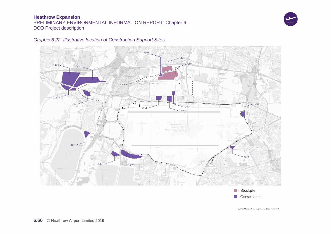
Heathrow Expansion PRELIMINARY ENVIRONMENTAL INFORMATION REPORT: Chapter 6: DCO Project description
6.66 © Heathrow Airport Limited 2019
Graphic 6.22: Illustrative location of Construction Support Sites
Heathrow Expansion PRELIMINARY ENVIRONMENTAL INFORMATION REPORT: Chapter 6: DCO Project description
6.67 © Heathrow Airport Limited 2019
Management of construction traffic
6.4.71 The ANPS paragraph 5.40 identifies a number of potential approaches to the
management of construction traffic, and suggests that applicants for DCO projects
should consider developing a construction traffic management plan. Heathrow
supports this approach and has produced two preliminary plans, which are
available for consultation:
1. Preliminary Outline Construction Traffic Management Plan (POCTMP), which
describes the range of measures that would be used to encourage sustainable
freight and managed the impacts of traffic
2. Preliminary Outline Construction Workers Travel Plan (POCWTP), which
focuses specifically on how construction workers would be likely to travel to
and from the DCO Project, and identifies measures that encourage alternatives
to the use of private car, especially single occupancy journeys.
6.4.72 These plans form a key part of Heathrow’s strategy to manage and mitigate the
effects of construction traffic and workers. The plans have adopted the following
principles:
1. Mitigating emissions from construction traffic
2. Enhancing safety for local residents and users of the airport
3. Reducing congestion from construction vehicles.
6.4.73 A new railhead would be developed for the import of bulk materials and
aggregates and containerised goods for construction. The railhead would be
located at Fray’s Sidings on the Colnbrook branch of the GWML. The proposed
location is immediately north of the western end of the North West Runway where
it crosses the M25 into the Colne Valley.
6.4.74 The daily number of freight trains would be dictated by the number of train paths
available in the national rail network, and the capacity of the junction where the
national network connects with the Colnbrook branch at West Drayton. Capacity
enhancement options are being considered to the line at West Drayton to allow
access to the Colnbrook branch to / from the west (the branch is currently only
accessible from the east).
6.4.75 Further work is ongoing to establish capacity, but it is likely that the railhead would
operate 24-hours a day in order to utilise available paths during the night-time
hours, when passenger services are much reduced. The logistics approach would
seek to use this capacity to its maximum, thus minimising the dependency on road
haulage and the associated impacts of an increase in HGVs on the road network.

Heathrow Expansion PRELIMINARY ENVIRONMENTAL INFORMATION REPORT: Chapter 6: DCO Project description
6.68 © Heathrow Airport Limited 2019
6.4.76 Where construction freight is brought to site by road, it would be managed through
adherence to dedicated routes and specific arrival slots. Delivery management
systems would allocate pre-booked delivery slots to suppliers, allowing the time of
each delivery to be controlled, thus managing the flow of vehicles arriving at the
site entrances. This would also allow for the spread of deliveries throughout the
day, and so minimise the impact of construction traffic on the road network,
especially during peak times.
6.4.77 To mitigate impacts on local air quality, Heathrow would require all construction
vehicles during construction to be powered by set minimum vehicle emission
standard engines. HGVs would be required to comply with Euro VI emission
standards. Petrol fueled Light Duty Vehicles (LDVs) would be required to comply
with Euro 4 emission standards, and Diesel fueled LDVs would be required to
comply with Euro 6 emission standards. This is consistent with paragraph 5.40 of
the ANPS, which refers to the use of cleaner engines. Further details on our
approach to the management of construction traffic are set out in the draft CoCP,
Chapter 13, which is available for consultation.
6.4.78 In developing its construction proposals, Heathrow has considered the option of
transporting materials and delivering goods by water via the River Thames and/or
the Grand Union Canal, which is suggested as a possible mitigation measure by
ANPS paragraph 5.40. However, due to lack of water connectivity to the site and
the distance between the site and the nearest river/canal, this option is not
considered practicable. Should, however, a Logistics Hub be positioned at or in
proximity to a sea port, Heathrow would work with the hub provider to make the
best use of delivery of goods by sea and rail to an area closer to Heathrow, where
practicable.
6.4.79 HGV parking/holding areas would be located within some of the CSS to act as a
buffer for parking and holding HGVs when required. This would provide efficient
management of vehicle movements and reduce potential circulation / parking of
HGVs on the local road network, as early arrivals wait for their delivery slot.
Additionally, these HGV parking/holding areas would offer a security checking
facility, so reducing the level of inspection required at the site entrances. They
would also provide dedicated driver welfare areas to discourage drivers from using
welfare facilities on the local network, which could lead to congestion or increased
disruption on the local road network.
6.4.80 Materials and equipment delivered to Site may be pre-fabricated or pre-assembled
before installation. Pre-fabrication and pre-assembly would take place at one of
the CSS, where dedicated areas would be established. The large sections would
then be transported, using large trailers, along the internal site roads to the point
where they would be lifted into position. Where abnormal loads would be delivered
Heathrow Expansion PRELIMINARY ENVIRONMENTAL INFORMATION REPORT: Chapter 6: DCO Project description
6.69 © Heathrow Airport Limited 2019
to Site by public road, these deliveries would be subject to the standard controls
for such loads, to minimise the impact on other road users.
Segregated construction network
6.4.81 During the site preparation works, a number of temporary construction roads
would be developed on Site to facilitate the movement of construction vehicles.
These roads are shown in Graphic 6.23 to Graphic 6.25, and would include:
1. Haul roads – dedicated to earthworks transport
2. Internal construction roads – dedicated to all the other construction traffic
including HGVs and buses and
3. Service roads – dedicated to inspection and maintenance of the fence line, and
a secondary route for emergency service access (these are not shown in
Graphic 6.23 to Graphic 6.25).
6.4.82 These roads would vary in location, alignment and specifications according to the
construction needs and phasing. The temporary roads would cross a number of
physical restrictions, including public roads and watercourses. These crossings
would be facilitated by the installation of temporary bridges.
6.4.83 The movement of construction traffic would be planned to ensure the effective and
efficient operation of the site and avoidance of unnecessary vehicle movements.
The enforcement of speed limits would improve safety and suppress dust
emissions.
6.4.84 Haul roads dedicated to earthworks would typically be constructed on existing
terrain consisting of sands, gravels or clay formation, and built up with suitable
excavated material where required. The haul roads would be continually
maintained, and where particularly heavy use is expected, some sections of the
haul road network would be surfaced with asphalt.
6.4.85 HGVs, buses and other vehicles would be allocated to the internal construction
roads, which are not normally used by earthworks vehicles, to avoid mixing
general construction traffic with site dump-trucks, as both a safety and productivity
precaution. The site roads would be surfaced with either asphalt or compacted
granular material as appropriate, and the surface water drainage would be tied into
the sitewide drainage system.
6.4.86 Two main strategic internal construction road routes would be established to
facilitate the movement of materials and people on site, as shown in Graphic 6.23
to Graphic 6.25:

Heathrow Expansion PRELIMINARY ENVIRONMENTAL INFORMATION REPORT: Chapter 6: DCO Project description
6.70 © Heathrow Airport Limited 2019
1. A north-south alignment (east of M25) to provide a principal artery for the
movements of materials between the southwest and the northeast ends of the
airfield
2. An east-west alignment to link areas located to the east and west of the M25.
This road would comprise a temporary bridge over the existing M25 and
approach ramps on either side.
6.4.87 In addition to the main strategic internal construction road routes, there would also
be other internal roads required for the construction of the linear infrastructure
elements, including the M25, A4, and other local roads. Where practicable, these
would be confined to the same alignment, to minimise wider impacts.
6.4.88 Service roads would be allocated to maintenance vehicles for maintenance of
perimeter fences and other perimeter services, such as CCTV and would also
provide for a secondary route for emergency services vehicles
6.4.89 The service roads would be constructed in accordance with the relevant standards
as required for the estimated traffic volumes. These roads would be compacted
granular material or would be surfaced with asphalt as appropriate. Any surface
water drainage for the roads would be linked into the sitewide drainage system.
Access and circulation
6.4.90 The points of access to the site would vary throughout the period of construction.
Access would be from the road network, either directly, or via the CSS onto
temporary roads. These temporary roads would be developed on-site, to facilitate
the movement of vehicles carrying excavation and construction materials, as well
as buses, around the site. The temporary roads would vary in location, alignment
and specifications according to the construction needs and phasing.
6.4.91 Graphic 6.23 to Graphic 6.25 illustrate the principal access routes for
construction traffic during the proposed development stages. Heathrow’s objective
would be to minimise the distance travelled on local public roads, by utilising the
trunk road network, and main roads on the local road network (e.g. A4 and A3044)
and providing access to dedicated construction routes off the public highway, as
quickly as reasonably practicable. For other local roads, such as town and village
centres and high streets, access for construction traffic would be restricted, but
may at times be necessary, for instance to enable transport or delivery of locally
sourced materials.
6.4.92 Generally, access along residential roads would be prohibited. In instances where
access on lower class local roads and roads within residential areas is
unavoidable, Heathrow and the main contractors would implement measures to
manage and minimise any negative effects.

Heathrow Expansion PRELIMINARY ENVIRONMENTAL INFORMATION REPORT: Chapter 6: DCO Project description
6.71 © Heathrow Airport Limited 2019
6.4.93 The design and construction of site accesses would be completed to recognized
standards, to enable the safe access and egress of vehicles in a forward direction,
and to limit disruption to other road users.
6.4.94 At the start of main construction activities, construction traffic circulation would be
reliant upon the existing road network. The principal east-west corridor would be
the A4, whilst the A3044 would provide north-south connectivity. This is shown in
Graphic 6.23.
6.4.95 During the early stages of construction, sections of the planned internal
construction road network would be in place to support construction operations.
This would include a proposed temporary construction bridge over the M25, which
would keep site construction traffic off the public road network. The existing A4
and A3044 would remain open at this stage, and would provide connectivity
between the various areas of the DCO Project that cannot be connected via the
internal construction road network. This is shown in Graphic 6.24.
6.4.96 Later during Phase 1, the sections of the A4 and A3044 within the construction
site, would be closed and demolished. All major internal construction roads would
then be segregated from the public highway network.
6.4.97 After runway opening, construction traffic would significantly reduce. Access to the
various construction sites would be via the upgraded public highway network,
including the A4 and A3044. This is shown in Graphic 6.25.
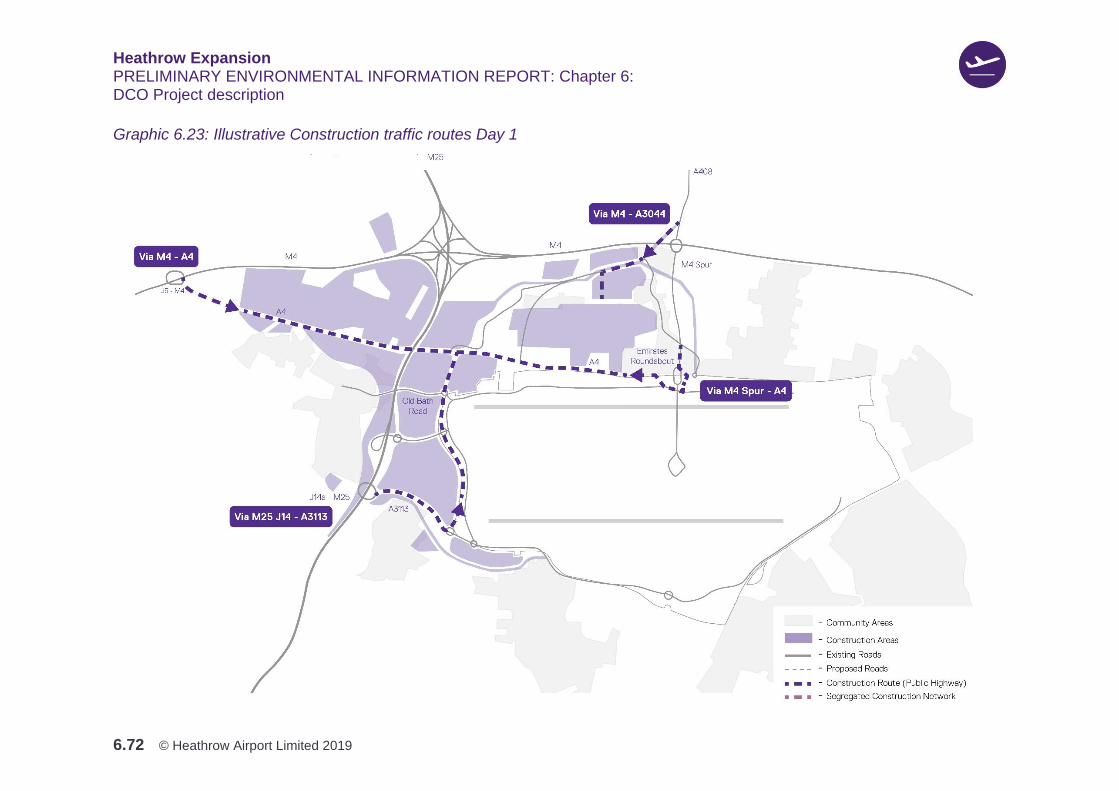
Heathrow Expansion PRELIMINARY ENVIRONMENTAL INFORMATION REPORT: Chapter 6: DCO Project description
6.72 © Heathrow Airport Limited 2019
Graphic 6.23: Illustrative Construction traffic routes Day 1

Heathrow Expansion PRELIMINARY ENVIRONMENTAL INFORMATION REPORT: Chapter 6: DCO Project description
6.73 © Heathrow Airport Limited 2019
Graphic 6.24: Illustrative construction traffic routes c. 2023
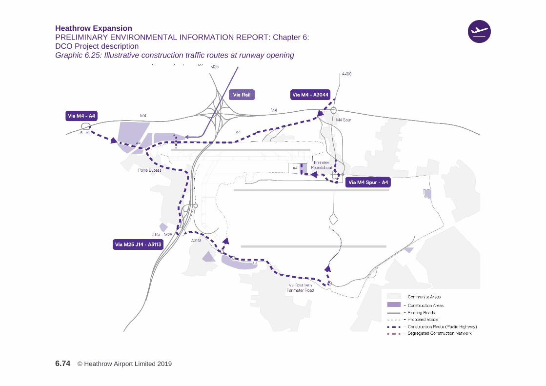
Heathrow Expansion PRELIMINARY ENVIRONMENTAL INFORMATION REPORT: Chapter 6: DCO Project description
6.74 © Heathrow Airport Limited 2019
Graphic 6.25: Illustrative construction traffic routes at runway opening
Heathrow Expansion PRELIMINARY ENVIRONMENTAL INFORMATION REPORT: Chapter 6: DCO Project description
6.75 © Heathrow Airport Limited 2019
Management of the construction workforce
6.4.98 Current estimates indicate that the construction workforce would be projected to
reach a peak of approximately 14,000 people during Phase 1. This compares with
8,000 people during the construction of Terminal 5, and 5,000 people for
Terminal 2.
6.4.99 The estimated workforce would then reduce following the completion of the
runway, and is expected to vary between approximately 2,000 and 5,000 from
runway opening to completion of construction. During this period, the workforce
would be largely confined to either the construction areas of the new terminals and
satellite buildings, or within other new airport supporting facilities and related
developments, largely within the curtilage of the Airport.
6.4.100 The majority of the construction workforce would be expected to be drawn from
the existing construction labour market, residing within a commutable distance of
Heathrow. Heathrow’s location in London also benefits from a well-developed
housing market and public transport links, so the requirement for construction
worker accommodation would be less than for more remote infrastructure
construction projects.
6.4.101 Experience gained from other major construction projects, has shown that some
sections of the workforce would choose to live in their own mobile homes. Due to
the possible demand for mobile home infrastructure, and to prevent the creation of
unlicensed caravan sites, Heathrow would develop and manage dedicated areas
of hardstanding for mobile accommodation, which would be located within some of
the CSS. By establishing this capability, the demand and management of these
locations would be carefully monitored. Heathrow would also utilise
accommodation that comes into its ownership in the areas around the construction
site, to accommodate construction workers.
6.4.102 A Worker Code of Conduct would be implemented, which would cover the general
behaviour expected of those involved in construction activities, including their
interaction with local communities. Provisions would be included relating to
construction workers using their own mobile accommodation, construction car
parking, and local community and recreation facilities. To avoid negative impacts
on occupational health and wellbeing, Heathrow would ensure that there is
provision for access to welfare and occupational healthcare facilities on site.
These proposals would be within the requirements for ‘active workforce
management’ set out in paragraph 5.40 of the ANPS.
Heathrow Expansion PRELIMINARY ENVIRONMENTAL INFORMATION REPORT: Chapter 6: DCO Project description
6.76 © Heathrow Airport Limited 2019
Worksite Security and Lighting
Worksite Security
6.4.103 The geographical spread of the DCO Project would mean that it would not be
possible, at least initially, to create a fenced perimeter around the whole
construction site.
6.4.104 As set out in draft CoCP, Section 4.5, Heathrow and the main contractors would
ensure that the security measures include adequate, and appropriately well-
designed, and well-maintained perimeter security facilities. This would likely take
the form of fencing, barriers, ditches and bunds, or hoarding of suitable strength
and dimensions where necessary. These elements would be designed so that they
respond to landscape character, visual amenity, and biodiversity in each location,
whilst taking account of site security, public safety needs, and vulnerabilities.
Heathrow is currently planning for security processes and procedures to be
standardised across the construction sites.
Lighting
6.4.105 Lighting would be required during the construction phase to enable safe working
conditions. This would include the lighting of construction areas, security lighting
as well as aircraft warning lights for tall structures.
6.4.106 Proposed lighting would comply with the following:
1. The Institute of Lighting Professionals' Guidance notes for the reduction of
obtrusive light (GN01:2011) (Institute of Lighting Professionals, 2012)
2. BS EN 12464-2 Lighting of workplaces – Outdoor (2014) (British Standard,
2014)
3. BS 5489 Code of practice for the design of road lighting (2013) (British
Standard, 2013).
6.4.107 An assessment of the lighting proposals during the construction phase would be
carried out and presented in the ES. The methodology for carrying out this
assessment can be found in Appendix 5.2: Lighting Assessment Methodology
Statement, Volume 3.
Temporary buildings and structures
6.4.108 A range of buildings, structures and plant would be required temporarily in
connection with, and for the duration of the construction works. The height of any
temporary buildings and structures would vary depending on construction
requirements, but would be kept well within the height limitations imposed by the
Airport.
Heathrow Expansion PRELIMINARY ENVIRONMENTAL INFORMATION REPORT: Chapter 6: DCO Project description
6.77 © Heathrow Airport Limited 2019
6.4.109 Temporary buildings would include offices, welfare facilities, fabrication and
storage buildings and batching plants, as well as a number of smaller facilities.
The design of temporary buildings would consider the specific location and visual
impacts on nearby receptors. Structures could include tower cranes, mobile
cranes, and other specialised lifting equipment. For example, these would be used
to facilitate the installation of equipment, handle scaffolding, reinforcing bars, and
pre-fabrication elements. These structures would be located within construction
sites, and in pre-fabrication areas, at the railhead, and at a number of CSS,
depending on their function.
6.4.110 Some works could also require the use of exceptional structures, such as super
heavy lift cranes, and similar equipment for specific activities, such as lifting large
structural elements or pre-assembled units. It is envisaged that this equipment
would be used for relatively short periods during the construction works, and an
appropriate specific management plan would be implemented for each of these.
Temporary utilities and infrastructure
6.4.111 Surface water run-off from the construction sites would be managed to avoid any
increase in flood risk downstream and to protect downstream water quality.
Dedicated temporary construction site surface water drainage systems would be
constructed as part of the site preparation and earthworks. These would include
appropriately sized attenuation and treatment facilities, such as attenuation basins
and ponds, settlement or detention basins, and hydrocarbon interceptors.
6.4.112 The drainage system would be designed to handle surface water run-off from: the
construction areas; groundwater pumped from excavations; borrow pits; lake
dewatering and tunnelling works; as well as water discharged during early
commissioning of the various assets. These discharges would be directed via
water treatment facilities to surface watercourses. The temporary construction
drainage system would be divided into different drainage zones, depending on the
topography and work phases.
6.4.113 A new sewage collection network would be installed for the construction
workforce, and this would take the sewage to several modular sewage treatment
plants. The treated water would then be discharged into the site drainage systems.
Appropriate temporary plant and buildings would be provided to ensure acceptable
discharge quality.
6.4.114 Electrical power and water would be provided for the construction works, by
means of a dedicated supply from the existing power and water networks, with a
new temporary distribution network serving the whole of the construction site.
Mains electricity or battery powered equipment would be used, to reduce the use
of diesel and petrol-operated generators or equipment, where reasonably
practicable. The temporary electrical and water systems would be
Heathrow Expansion PRELIMINARY ENVIRONMENTAL INFORMATION REPORT: Chapter 6: DCO Project description
6.78 © Heathrow Airport Limited 2019
decommissioned as the construction area is cleared, and the supply from the
existing network would be terminated.
6.4.115 Solid waste would be generated by site excavations, demolition and construction
activities. Details on the projected construction wastes arising from the DCO
Project, and the proposed management measures, are set out in Appendix 20.1:
draft Resource Management Plan, Volume 3.
6.4.116 The Waste Hierarchy would be used as the overarching framework for the
management of waste from construction-related activities. The Waste Hierarchy
aims to prevent and minimise harm to human health, environmental health and
amenities. The waste hierarchy, and a range of waste management techniques
would be utilised, as set out in the draft CoCP and Appendix 20.1.
6.4.117 There would be a focus on waste prevention and minimisation with contractors
having the responsibility to reduce the waste generated from all construction-
related activities, where applicable. Measures to reduce waste impacts from
construction works would include the timely and efficient storage of materials on-
site.
6.4.118 A Site Waste Management Plan (SWMP) would be prepared in accordance with
the draft CoCP. The role of the SWMP would be to minimise waste arising from
construction, and to facilitate good practice for waste management. Furthermore,
all waste management practices would comply with all legal ‘duty of care’
requirements, as set out in Section 34 of the Environmental Protection Act 1990
(as amended). These waste management practices would protect the interests
and safety of others from the potential impacts of handling, storing, transporting
and depositing excavated materials, and the demolition and construction wastes
that arise from the DCO Project.
Logistics hubs
6.4.119 The DCO Project would be supported by four regional Logistics Hubs, within which
a broad spectrum of off-site activities would take place, including: prototyping;
offsite manufacture; pre-assembly of components; consolidation and configuration
of materials. This approach would enable Heathrow to minimise the on-site
construction activities for the DCO Project, as far as practicable. The regional
Logistics Hubs would form the backbone to the logistics network, ensuring efficient
Just-in-Time delivery scheduling, which would be managed by integrated delivery
management systems. This would be consistent with paragraph 5.40 of the ANPS,
which refers to the use of consolidation sites.
6.4.120 Potential regional Logistics Hub locations, operators and supporting transportation
specialists are being assessed currently as part of a formal procurement process.
The chosen Hubs would be announced in early 2020 and the aspiration would be
Heathrow Expansion PRELIMINARY ENVIRONMENTAL INFORMATION REPORT: Chapter 6: DCO Project description
6.79 © Heathrow Airport Limited 2019
to have two regional Logistics Hubs in support by the anticipated start of main
construction, with the others being used for support from shortly after the start of
construction.
6.4.121 Heathrow recognises the importance of the regional Logistics Hubs to maximise
off-site production solutions. These sites would also be key to realising the
efficiencies that could arise from integrating manufacturing and assembly
processes with consolidation, configuration and logistics functions.
Working hours
Overview
6.4.122 Working hours would vary by construction activity and across different sites
depending on land uses and receptors (for example residential areas) surrounding
work sites. Shift start, and finish times would be staggered to reduce pressure on
local transport services, roads and construction site infrastructure. The proposed
working hours are outlined in the following sections.
24-hour day, seven days a week working
6.4.123 24-hour day and seven day a week working, including bank holiday working, would
be required for activities directly related to ensuring that the North West Runway
can be operational as soon as possible.
6.4.124 Activities where 24-hour day, seven days a week working, including Bank Holiday
working, may apply include:
1. Earthworks, airfield construction, establishing CSS, work on or close to road
infrastructure (including construction of bridges), tunnelling (e.g. M25 tunnel)
and railhead construction and any directly associated activities
2. Railhead operation, operation of manufacturing / production facilities (e.g.
Concrete batching, asphalt plants), logistics support activities for subsequent
shifts, operation of worker car parks, bussing operations, welfare and office
facility operations, security, essential plant maintenance, repairs and refuelling,
abnormal load delivery, or those requiring a police escort (e.g. delivery of
prefabricated bridge beams or heavy plant)
3. Work requiring possession of, or to avoid impact to, major transport
infrastructure (road, rail, airport)
4. Certain other specific construction activities that would require additional
working hours for reasons of engineering practicability or to take advantage of
daylight hours. These activities include, but are not limited to, surveys (e.g. for
Heathrow Expansion PRELIMINARY ENVIRONMENTAL INFORMATION REPORT: Chapter 6: DCO Project description
6.80 © Heathrow Airport Limited 2019
wildlife or engineering purposes), major concrete pours, piling / diaphragm wall
works
5. Utilising periods of low traffic flow for activities such as abnormal loads /
construction plant delivery, works within the highway or footpaths, works
affecting operational railways, utility diversions
6. Where it is beneficial to minimise disruption to the daytime operations of third
parties.
Exceptions to 24-hour day, seven days a week working
6.4.125 In preparation for the DCO Application, Heathrow will be considering its
construction mitigation proposals (for example, bunds or buffer zones) to take
account of 24-hour day, seven days a week working, particularly in relation to
matters such as noise and lighting, and further to the ongoing environment
assessment of effects to sensitive receptors arising from the DCO Project.
6.4.126 As part of this exercise, Heathrow will consider locations and activities where
24-hour day, seven days a week working may cause unacceptable effects, and will
propose reduced working hours/ activity restrictions in the draft CoCP submitted
with the DCO.
6.4.127 The approach set out above reflects the development of Heathrow’s proposals for
the DCO Project to date. In the draft CoCP submitted with the DCO Application,
Heathrow will set out the working hours proposals on a locational basis, based on
the principles set out above. For the purposes of this PEIR, 24-hour day, seven
days a week working has been used as a reasonable worst case.
Short notice working
6.4.128 There may be isolated occasions where there is the potential for unforeseen or
unplanned works outside the working hours agreed pursuant to the process set
out in Section 11 of the draft CoCP, which, if not completed, would be unsafe or
harmful to the works, staff, the public or the local environment, and that need to be
completed or undertaken to secure and make safe construction operations. On
these occasions, where required, the relevant local authority would be informed as
soon as reasonably practicable of the reasons for the works and their likely
duration. Examples of the type of work envisaged include where unexpectedly
poor ground conditions, encountered whilst excavating, require immediate
stabilisation.

Heathrow Expansion PRELIMINARY ENVIRONMENTAL INFORMATION REPORT: Chapter 6: DCO Project description
6.81 © Heathrow Airport Limited 2019
6.5 Operation
Overview
6.5.1 Following the anticipated opening of the North West Runway in 2026, forecasted
growth in ATMs and passenger numbers (PAX) by 2035 of 740,000ATMs and
130MPPA. By 2035 cargo capacity is also forecast to increase from 1.59 million
tonnes per year to around 3 million tonnes. The forecast for continued growth in
passenger numbers and ATMs is anticipated to reach 135MPPA and
750,000ATMs by around 2040, with a further increase to 142MPPA and
756,000ATMs forecast by 2050. Table 6.14 presents the current forecast for ATM
and PAX from 2022 through to 2050. These forecasts form the Assessment Case
for the purposes of the PEIR.
Table 6.14: Forecasted increase in ATMs and passenger numbers between 2022 and 2050
Year ATMs Pax Per Annum Average Pax/ATM
2022 485,000 82,500,000 170
2023 495,500 84,800,000 171
2024 500,000 86,200,000 172
2025 505,000 86,800,000 172
2026 505,000 87,400,000 173
2027 567,000 98,700,000 174
2028 607,500 106,000,000 174
2029 631,500 110,800,000 175
2030 665,000 115,000,000 173
2031 685,000 118,000,000 172
2032 700,000 121,000,000 173
2033 715,000 124,000,000 173
2034 730,000 127,000,000 174
2035 740,000 130,000,000 176
2036 742,000 131,000,000 177
2037 744,000 132,000,000 178
2038 746,000 133,000,000 178
2039 748,000 134,000,000 179
2040* 750,000 135,000,000 180
2050** 756,000 142,000,000 188
Table Notes:

Heathrow Expansion PRELIMINARY ENVIRONMENTAL INFORMATION REPORT: Chapter 6: DCO Project description
6.82 © Heathrow Airport Limited 2019
* Traffic Assessment year - required to demonstrate compliance with ANPS mode-share targets (Passenger Public
Transport mode share of at least 55% by 2040 and a reduction in staff car trips of 50% by 2040
** Carbon assessment year – required to demonstrate compliance with national carbon obligations relevant to 2050
6.5.2 As previously described, for the purposes of the assessment in this PEIR, the
DCO Project has been presented in three phases: Phase 1 (c. 2022 – 2026);
Phase 2 (c. late 2026 – 2033); and Phase 3 (c. 2034 – 2050). Table 6.15 provides
an overview of the operational activities that are currently anticipated within each
phase.
Table 6.15: Operation activities anticipated in Phases 1 to 3 for the PEIR assessment
Activities in phase
Phase 1 (c. 2022 – 2026)
1. Two runway airport business as usual
operations continue
2. Continued growth in passenger numbers at
the Airport
3. Release of an additional 25,000ATMs in
Phase 1 over a four-year period:
a. 2022 = 485,000
b. 2023 = 495,500
c. 2024 = 500,000
d. 2025 = 505,000
4. Heathrow’s terminal and apron capacity at
North West Runway opening would be c.
95MPPA
5. Two runway airspace improvements delivered
by 2024
6. Short haul demand continues to be spilled to
other London airports, but long-haul growth
continues unconstrained at annual average of
approximately 2%
Phase 2 (c. late 2026 – 2033)
1. High passenger and ATM growth from 2027
to 2030 inclusive in response to the North
West Runway opening
2. Phased delivery of Terminal capacity enables
further ATM and PAX growth, initially at a
rapid rate and then at more long-term average
rates
3. Assume significant recovery of London short-
haul demand at runway opening
Phase 3 (c. 2034 – 2050)
1. ATMs continue to increase and reach the
capacity of at least 740,000ATMs in 2035,
750,000ATMs in 2040, and 756,000ATMs in
2050
2. Continued growth in passenger numbers at
the Airport to reach 130MPPA in 2035,
135MPPA in 2040, and 142MPPA in 2050.

Heathrow Expansion PRELIMINARY ENVIRONMENTAL INFORMATION REPORT: Chapter 6: DCO Project description
6.83 © Heathrow Airport Limited 2019
Airport Operations
Early Realisation of Growth
6.5.3 The DCO will of necessity remove the current restriction on annual air transport
movements at Heathrow. This will be effective from the date at which the DCO
comes into force. Clearly, most of the growth at Heathrow will not be able to take
place until the proposed North West Runway is constructed and operational,
however, some growth will be able to occur before then.
6.5.4 There will be a gradual increase in ATMs but bearing in mind the punctuality and
other service commitments at Heathrow, it is not anticipated that this early growth
will be able to exceed an additional 25,000 ATMs, prior to the operational opening
of the North West Runway.
Directional Preference
6.5.5 For safety and performance reasons aircraft typically take off and land into the
wind. In the UK, the wind is mostly from the south west. That means the majority
of aircraft (approximately 70% a year) make their final approach over London and
take off towards the west. This is known as ‘westerly operations’.
6.5.6 When the wind blows from the east (and has a component over five knots), the
direction of operation is switched and aircraft land from the west over Berkshire
and take off towards the east. This is known as ‘easterly operations’ and occurs
approximately 30% of the time.
6.5.7 During the day a ‘westerly preference’ is operated at Heathrow. Westerly
preference is Government policy and means that even during periods of light
easterly winds (up to 5 knots) aircraft would continue to land in a westerly
direction, making their final approach over London.
6.5.8 In 2001, following consultation, the Department for Transport decided that westerly
preference should be removed at night, to provide a more equitable distribution of
aircraft noise. Whilst the expectation was that with lighter winds at night there
would be a notable shift towards a 50:50 east west split, however this has not
been achieved with only a small change from the 70:30 mix in the day.
6.5.9 Heathrow is considering a range of alternative options at this stage. For the
purposes of the PEIR it is proposed that a ‘Managed Preference’ scenario (70/30)
is adopted. A ‘Managed Preference’ would involve changing the direction of
arriving and departing aircraft based on a set of criteria or rules designed to limit
overall noise effects on communities and to help deliver periods of relief. It would
aim to maintain operations akin to the long-term average directional split (70%
from westerlies and 30% from easterlies), but adding the ability to break up long
periods of easterly and westerly operations in order to provide respite. The final

Heathrow Expansion PRELIMINARY ENVIRONMENTAL INFORMATION REPORT: Chapter 6: DCO Project description
6.84 © Heathrow Airport Limited 2019
option on ‘directional preference’ is to be confirmed following the outcome of
further evaluation. Further details regarding directional preference and the
assumptions that underpin the PEIR assessments are summarised in Chapter 17:
Noise and Vibration and detailed in Appendix 17.1 Annex G, Volume 3.
Mode Alternation
6.5.10 Currently when planes are landing and taking off to the west (westerly operations)
Heathrow alternate the use of the two runways to provide local communities with
respite. This alternation pattern means that for part of the day one runway is used
for landings (arrivals) and the other for take-offs (departures) then, halfway
through the day at 15:00hrs, they switch over. This gives some communities
approximately eight hours of respite a day.
6.5.11 At the end of each week it is switched completely so that communities get respite
from planes in the morning one week and in the evening the next.
6.5.12 When planes take-off and land towards the east (easterly operations) Heathrow
cannot alternate the runways at 15:00 hours, due to the legacy of the Cranford
Agreement (now rescinded). This is because the taxiways leading to the runway
are inadequate to allow the full schedule of easterly departures on the northern
runway. Although planning consent was granted for the access taxiways these
have not been developed because they would be incompatible with the three-
runway airfield. As part of the DCO Project the airfield taxiway system required to
enable easterly operations on the existing northern runway would be included.
This taxiway modification would be provided as part of the first phases of
expansion construction enabling easterly alternation at the earliest practicable
time, prior to the anticipated opening of the new runway.
6.5.13 The new alternation pattern proposed for the airport after the new runway has
opened, would include runway alternation, on both easterly and westerly modes of
operation, giving respite to communities to the east and west of the Airport in both
modes of operation.
6.5.14 One runway would always need to operate in mixed mode to ensure a balance of
arrivals and departures at the Airport. The existing northern runway would not be
operated in mixed mode during normal operating conditions, but instead would
always be an arrivals or departures runway. Therefore, there are four runway
operating patterns – in each direction – to achieve the benefits of alternation for all
affected communities.
6.5.15 Each pattern provides respite for two areas at once and the introduction of mixed
mode means that some areas would also experience less intense periods of
aircraft flying overheard. The operation of the three runways would cycle through
these runway operating patterns so that every community gets a share of respite.
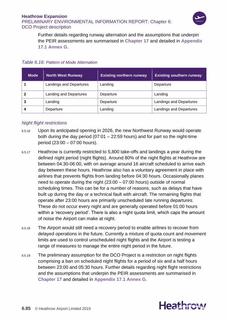
Heathrow Expansion PRELIMINARY ENVIRONMENTAL INFORMATION REPORT: Chapter 6: DCO Project description
6.85 © Heathrow Airport Limited 2019
Further details regarding runway alternation and the assumptions that underpin
the PEIR assessments are summarised in Chapter 17 and detailed in Appendix
17.1 Annex G.
Table 6.16: Pattern of Mode Alternation
Mode North West Runway Existing northern runway Existing southern runway
1 Landings and Departures Landing Departure
2 Landing and Departures Departure Landing
3 Landing Departure Landings and Departures
4 Departure Landing Landings and Departures
Night flight restrictions
6.5.16 Upon its anticipated opening in 2026, the new Northwest Runway would operate
both during the day period (07:01 – 22:59 hours) and for part so the night-time
period (23:00 – 07:00 hours).
6.5.17 Heathrow is currently restricted to 5,800 take-offs and landings a year during the
defined night period (night flights). Around 80% of the night flights at Heathrow are
between 04:30-06:00, with on average around 16 aircraft scheduled to arrive each
day between these hours. Heathrow also has a voluntary agreement in place with
airlines that prevents flights from landing before 04:30 hours. Occasionally planes
need to operate during the night (23:00 – 07:00 hours) outside of normal
scheduling times. This can be for a number of reasons, such as delays that have
built up during the day or a technical fault with aircraft. The remaining flights that
operate after 23:00 hours are primarily unscheduled late running departures.
These do not occur every night and are generally operated before 01:00 hours
within a ‘recovery period’. There is also a night quota limit, which caps the amount
of noise the Airport can make at night.
6.5.18 The Airport would still need a recovery period to enable airlines to recover from
delayed operations in the future. Currently a mixture of quota count and movement
limits are used to control unscheduled night flights and the Airport is testing a
range of measures to manage the entire night period in the future.
6.5.19 The preliminary assumption for the DCO Project is a restriction on night flights
comprising a ban on scheduled night flights for a period of six and a half hours
between 23:00 and 05:30 hours. Further details regarding night flight restrictions
and the assumptions that underpin the PEIR assessments are summarised in
Chapter 17 and detailed in Appendix 17.1 Annex G.

Heathrow Expansion PRELIMINARY ENVIRONMENTAL INFORMATION REPORT: Chapter 6: DCO Project description
6.86 © Heathrow Airport Limited 2019
Displaced Thresholds
6.5.20 A runway threshold, the point where aircraft touch down, is identified by surface
markings and lighting and delineates the beginning of the runway available for
landing aircraft. Thresholds can be coincident with the physical end of the paved
surface or be ‘displaced’ further into the runway length.
6.5.21 The landing thresholds on the North West Runway would be inset by 550m
inwards from both ends of the paved surface. This means that landing aircraft
would be kept as high as possible on their final approach (in relation to the
communities on the ground), while still providing a landing distance of 2,950m.
6.5.22 The landing thresholds would also be inset on the existing runways (except the
southern runway’s western threshold due to the proximity to the southern fuel
receipt facility), again increasing the height of aircraft approaching over local
communities. The extent of displacement is governed by the need to provide a
minimum of 2800m for landing distance, whilst maintaining safe operations and
throughput on mixed mode runways as well as accounting for existing
infrastructure and obstacles.
6.5.23 Around the end taxiways (ATETs) would be provided to link the existing Airport to
the new Terminal 5XN campus. The ATETs are so called as they pass around the
western end of the northern runway.
6.5.24 The displacement of the existing northern runway western threshold would also
enable a fully independent operation between the western dual taxiways (ATETs)
and the existing northern runway.
6.5.25 The displaced thresholds proposed for the North West Runway and the existing
runways are described in Table 6.17.
Table 6.17: Displaced Thresholds
Runway Baseline Displaced Threshold Future Displaced Threshold
North West Runway
(09-27 New)
Not Applicable 550m 09new
550m 27new
Existing northern (Centre)
(09L-27R)
309m 09L
0m 27R
1101m 09L
1101m 27R
Existing southern
(09R-027L)
308m 09R
0m 27L
308m 09R
550m 27L
6.5.26 Although the displacement of the thresholds would affect the length of paved
runway available to landing aircraft, departures would still be able to use the full
length of paved runway available.

Heathrow Expansion PRELIMINARY ENVIRONMENTAL INFORMATION REPORT: Chapter 6: DCO Project description
6.87 © Heathrow Airport Limited 2019
6.5.27 To aid understanding of the runway numbering shown in Table 6.17, further
explanation is provided as follows. Heathrow has parallel runways commonly
referred to as the Northern and Southern runways, lying west to east. They are
numbered based on the compass bearing, 090 if you are arriving or departing
towards the east, and 270 towards the west. Graphic 6.26 indicates the names of
Heathrow’s runways, which are based on the perspective of an arriving aircraft.
Graphic 6.26: Runways and runway numbering
Aircraft parking, manoeuvring and de-icing
Aircraft parking
6.5.28 To accommodate the increase in ATMs, new aircraft parking stands and apron
areas to support additional aircraft parking would be required.
6.5.29 The new terminal and apron facilities would be delivered in phases to meet
demand, with the majority of additional aircraft parking being provided in two
zones:
1. To the west of the existing Airport
2. Between the new and existing northern and southern runways.
6.5.30 Some rationalisation of the existing aprons would also take place around the CTA
through the development of Terminals 2 and 3.
6.5.31 New aircraft parking stands would provide flexible aircraft parking wherever
possible, such that stands would be designed to be multi-choice, accommodating
either one large Code E or F aircraft (for instance Boeing 777 and the Airbus
A380, respectively), or two smaller Code C aircraft (for instance Airbus A320 or
Boeing 737).
Heathrow Expansion PRELIMINARY ENVIRONMENTAL INFORMATION REPORT: Chapter 6: DCO Project description
6.88 © Heathrow Airport Limited 2019
6.5.32 New aircraft parking positions would become operational throughout the delivery
programme, with the new stands comprising a mixture of ‘contact’ or pier-served
stands, and ‘remote’ stands. The remote stands are likely to be used for a mixture
of aircraft turnaround and towing operations, until the completion of the proposed
terminal developments.
6.5.33 All new aircraft parking stands would be floodlit to meet requirements dictated by
the European Aviation Safety Agency’s Certification Specifications: Aerodromes
Design (CS-ADR-DSN) (European Union Aviation Safety Agency, 2017)]. Stands
would also be equipped with Advanced Visual Docking Guidance Systems
(AVDGS) and Fixed-Electrical Ground Power (FEGP) units, wherever possible.
Aircraft Manoeuvering
6.5.34 At all points during the development, the new North West Runway would have a
safe, unhindered taxiway system, supporting all modes of operation, minimising
taxi-times and delay, reducing ground noise and emissions while providing
predictability of operations. The system would be characterised by long straight
sections with minimal bends, with sufficient space to enable efficient asset
maintenance and safe contingency routes.
6.5.35 Departing aircraft would access the runway via RATs at the runway ends, with
multiple RATs at either end of the North West Runway to enable a controlled and
efficient departure flow.
6.5.36 Arriving aircraft would exit the runway using RETs. RETs are oblique runway exit
points, designed to enable aircraft to vacate the runway at speed, minimising
runway occupancy times whilst reducing the need for heavy braking and excessive
use of reverse thrust.
6.5.37 RETs would be provided for both direction of operations at locations supporting
the operation of a range of aircraft types and sizes.
6.5.38 A dual parallel taxiway system would be provided with sufficient capacity for two-
way taxi-flow.
6.5.39 The twin ATETs would enable aircraft to taxi between the existing CTA and the
new Northern Campus safely and efficiently, without impacting the capacity of the
runway.
6.5.40 South of the ATETs a western bypass taxiway system would be provided, enabling
access to / from the southern quadrant of the airport for aircraft from the Northern
Campus.
6.5.41 Wherever possible, new taxiways would be capable of operations of aircraft with
wingspans of up to 80m (Code F) such as the Airbus A380, providing the airport
the maximum operational flexibility.
Heathrow Expansion PRELIMINARY ENVIRONMENTAL INFORMATION REPORT: Chapter 6: DCO Project description
6.89 © Heathrow Airport Limited 2019
Aircraft de-icing
6.5.42 A combination of on and off-stand aircraft de-icing operations would continue to be
operated to achieve safe aircraft operations. The majority of aircraft de-icing is
currently undertaken on stand, with four supplementary remote aircraft de-icing
pads located on the airfield. These remote pads are generally used during the
more extreme weather events and during weather events that require ‘second
wave’ aircraft to be de-iced. (‘Second wave’ aircraft de-icing occurs when the
temperature remains sufficiently low that aircraft, other than the first ones
departing in the morning, require de-icing; it is these aircraft that have a more
constrained time slot on stand, and hence remote pads are sometimes utilised to
release required stand capacity).
6.5.43 Through the DCO Project, all new aircraft stands would be equipped to safely
facilitate aircraft de-icing, with the necessary pollution control and drainage
safeguards. Additional off-stand aircraft de-icing would be required, not only to
accommodate ‘second wave’ aircraft de-icing, but also due to more modern
composite construction aircraft typically having a shorter ‘hold-over’ time (the
maximum allowable time between an aircraft de-icing and an aircraft taking-off,
which is dependent on the atmospheric conditions).
6.5.44 As at other hub airports, off-stand operations would be conducted at remote
aircraft de-icing pads, located on the taxiway system. Heathrow’s existing remote
aircraft de-icing pads are located between the existing two runways. Additional
aircraft de-icing pads would be provided within the airfield boundary, and wherever
possible close to the departure thresholds, facilitating the shorter hold-over time
requirements. New pads would be located such that during any aircraft de-icing,
the taxiway system would provide an alternative route for aircraft not requiring the
service, minimizing delays, extended ground operations and noise.
6.5.45 A new off-airfield area for the capture and treatment of surface water run-off
containing elevated levels of de-icants would be installed, with treatment being
undertaken in dedicated vertical flow aerated reed or gravel beds.
6.5.46 The existing treatment area around Mayfield Farm would also be expanded.
Ground Noise Emissions
6.5.47 Operational ground noise measures are proposed to include noise-reduced
operating practices and the use of quieter airside equipment. Heathrow is
committed to providing:
1. Fixed Electrical Ground Power and Pre-Conditioned Air at all pier served
aircraft stands, to avoid the need for aircraft to produce noise through using
their auxiliary power unit whilst on-stand
Heathrow Expansion PRELIMINARY ENVIRONMENTAL INFORMATION REPORT: Chapter 6: DCO Project description
6.90 © Heathrow Airport Limited 2019
2. New and modern airside equipment such as electric vehicles and clatter-
resistant baggage trolleys would further reduce airside noise, and an improved
airside road system with few taxiway crossings and vehicle conflict points, to
minimize journey times and vehicle noise.
Airport support functions hours of operation
6.5.48 The Airport and associated support functions would continue to operate 24 hours a
day 365 days a year, but scheduled flights would not operate for 6.5hrs during the
night period as specified in the ANPS. Airport operations, including critical
infrastructure asset management (works that cannot be undertaken safely during
the busy daytime periods), aircraft maintenance, airport and aircraft cleaning
would continue throughout the night, along with commercial deliveries and their
associated requirements for secure access/egress to/from the airside areas, and
Heathrow colleague welfare.
Employment
6.5.49 Information on employment during the operation phase can be found in Chapter
18: Socio-economics and employment.
Utilities and Energy
Electricity
6.5.50 Expansion of the existing electrical network would be required both to meet the
future electrical demand of the DCO Project and to increase the resilience of the
33kV energy distribution network. There is a predicted increase in the electrical
energy demand for Heathrow from 75 Mega Volt Amps (MVA) (current estimate
2016) to approximately 142MVA by the year 2050.
6.5.51 On-site electrical energy generation is limited to what can be provided from
photovoltaics (solar panels) installed on buildings and carparks. The energy
strategy estimates that this would contribute approximately 5% (but not limited to)
of the electrical consumption at Heathrow. The remaining demand would be met
from the grid.
Thermal Energy
6.5.52 The thermal strategy is to install networks of heating and cooling pipework that
would distribute heating and chilled water from energy centres to new and existing
terminals. There would be three primary energy centres: Terminal 5 Energy Centre
(an existing facility south west of Terminal 5A); Heathrow Energy Centre (an
existing facility located to the west of Terminal 4); and a new 3R Energy Centre
(located south of Terminal 5XN). A fourth energy centre would be located to the
Heathrow Expansion PRELIMINARY ENVIRONMENTAL INFORMATION REPORT: Chapter 6: DCO Project description
6.91 © Heathrow Airport Limited 2019
east of Saxon Lake. These energy centres would contain equipment for generating
hot and chilled water for use throughout the Site. A Common Thermal Network
(CTN) would distribute thermal energy between the energy centres; thermal
energy stores and raw water sources including Saxon Lake, the chalk aquifer and
the rivers to the west of the Site. It would improve resilience and have the
capability to facilitate the addition of more energy sources in additional locations to
provide future flexibility.
6.5.53 Any waste heat which cannot be used would be discharged to raw water sources
or vented to atmosphere through cooling towers. The current gas and biomass
boilers would be gradually phased out and replaced with high efficiency, zero local
emission heat pumps.
Fuel
6.5.54 The DCO Project includes additional aviation fuel storage to provide fuel supply
resilience.
6.5.55 Fuel supply to Heathrow would continue to be provided through northern and
southern Fuel Receipt Facilities located on the airside / landside boundary (albeit
with the northern facility in a new location). The Fuel Receipt Facilities accept
pipelines from refineries and from the realigned Total Fuel Depot - Rail Head and
are linked to the storage facilities by a system of pipelines. The storage facilities
are used for final preparation and storage of the fuel before it is classed as
‘hydrant ready’ and transferred through pipe circuits to the stands. Each storage
facility serves a particular area of the Airport.
6.5.56 Supply routes to Heathrow would continue to be by pipelines from Buncefield, the
Total Fuel Depot (rail), the Esso facility to the south of Heathrow and the London
Airport Pipeline from Walton.
6.5.57 The Airport aviation fuel system would be capable of handling traditional fossil jet
fuels as well as sustainable aviation fuels.
Site Drainage
6.5.58 The design of the surface water drainage system to serve the DCO Project has
been developed at a high level for PEIR to determine potential and preferred
strategies. The potential strategies outlined below all ensure that surface water
would be captured, attenuated, treated and released in a controlled manner. Two
potential approaches to airfield drainage have been put forward for PEIR
assessment, which reflect the most-preferred and second most-preferred of the
options currently thought to be available.
6.5.59 The differentiator of the two options provided for PEIR assessment is how the
drainage would be conveyed.

Heathrow Expansion PRELIMINARY ENVIRONMENTAL INFORMATION REPORT: Chapter 6: DCO Project description
6.92 © Heathrow Airport Limited 2019
1. Option 1 involving a gravity led system for drainage of the new airfield
catchments, requiring attenuation and pollution control (treatment) facilities to
be located down-gradient to the north west and south west of the expanded
airfield
2. Option 2 involving a pump – led system for drainage of the new catchments,
allowing for a single dedicated attenuation and treatment facility to be located
upgradient to the north of the expanded airfield. This comprises of a new
stormwater outfall tunnel (SWOT), and in the lowest lying part of the Site either
an underground tank with an associated pump station, or an additional
attenuation pond in combination with the existing SWOT for providing
additional storage.
6.5.60 Informed by various non-drainage considerations, the gravity led approach is
currently the preferred option.
6.5.61 Both options would include the following elements:
1. A capture and collection system, at the surface and under the airfield
2. Aircraft de-icing pads at each end of the North West Runway
3. A new off-airfield dedicated treatment area for the North West Runway, for the
treatment of surface water run-off containing elevated levels of de-icers. The
treatment itself would be undertaken in dedicated vertical flow aerated reed
beds (and or gravel beds) designed and built specifically for the purpose
4. The new off-airfield treatment area would include ‘contaminated-flow’ lagoons
(for storage of contaminated run-off) to enable balancing of flows ahead of
treatment in the reed beds
5. A connection into the existing treatment area in proximity to Mayfield Farm, to
treat de-icer-contaminated surface water associated with the existing runway
western catchment
6. New pipe connections to transfer treated or clean flows to the final discharge
locations
7. Sustainable Drainage System (SuDS) (location and form to be confirmed) to
provide the treatment necessary to address other potential contaminants (other
than de-icers) within the surface water run-off prior to discharge to the
environment
8. Outfall infrastructure at the final discharge locations, for discharge of treated
and or clean runoff to the environment (rivers or water bodies)
Heathrow Expansion PRELIMINARY ENVIRONMENTAL INFORMATION REPORT: Chapter 6: DCO Project description
6.93 © Heathrow Airport Limited 2019
9. Additional drainage infrastructure (including attenuation, if necessary) within
existing airfield catchments, to provide for redevelopment within those
catchments.
6.5.62 Further information on Site drainage can be found in Appendix 21.16: Drainage
Impact Assessment, Volume 3.
Foul Water
6.5.63 Two strategies are being considered for dealing with foul water from the DCO
Project and possibly the existing airport facilities.
6.5.64 The preferred strategy is to continue the existing approach of discharging to the
Thames Water Utilities Limited (TWUL) system, with treatment being undertaken
off-site at their treatment works at Mogden. An ‘offset strategy’ is proposed
whereby there would be no increase in flows to the TWUL system compared to the
existing situation. This approach has been subject to preliminary consultation with
Thames Water and remains under review.
6.5.65 The alternative to the preferred strategy would be the creation of a new dedicated
Waste Water Treatment Plant (WWTP) to serve the expanded airfield. This could
take a number of forms, from treating the North West Runway foul water (only), to
serving the entire airfield, and perhaps providing treatment for surface water as
well. Tertiary treatment could be incorporated to produce treated sewage effluent
for water re-use as grey water.
6.5.66 The potential location of any WWTP is flexible and has not been fixed. Locations
under consideration include the land parcels centrally to the north and south, away
from both watercourses and settlements. The discharge location from the potential
WWTP are unconfirmed at this stage, and in any case could be flexible as outfall
flows could be pumped. The point of discharge would be agreed with regulators.
Security and Lighting
Security
6.5.67 The DCO Project would be designed to meet aviation security regulations.
6.5.68 The new boundary between landside and airside areas would be demarked with
security fencing, in the form of weld-mesh fencing panels similar to the existing
boundary fence.
6.5.69 Where heightened vehicle threat risks are identified (for instance areas vulnerable
to high velocity attack), additional hostile vehicle mitigation solutions, such as
bollards or supplementary fencing, would also be installed.
Heathrow Expansion PRELIMINARY ENVIRONMENTAL INFORMATION REPORT: Chapter 6: DCO Project description
6.94 © Heathrow Airport Limited 2019
Control Posts
6.5.70 Control Posts would be established to enable secure access to the airfield. An
optimum number of new Control Posts would be provided to balance serviceability
and performance with operational efficiency.
Site Lighting
6.5.71 The illumination of key components of the Airport is essential to deliver a safe and
secure environment for customers, Heathrow colleagues and aircraft operations.
6.5.72 External components of the development, such as: car parks, forecourts, roads,
aircraft parking stands, airside roads, equipment parking and fuel farms would all
require illumination meeting the relevant regulatory requirements, standards and
guidance documents including (but not restricted to):
1. BS 5489-1:2013: Code of practice for the design of Road Lighting-Part 1:
Lighting of Roads and Public Amenity Areas (British Standard, 2013)
2. BS EN 12464-2-2014: Lighting of Workplaces-Part 2: Outdoor Work Places
(British Standard, 2014)
3. BS EN 13201-2:2015: Road Lighting-Part 2: Performance Requirements
(British Standard, 2015)
4. BS 8300-1:2018, Design of an accessible and inclusive built environment Part
1: External environment — Code of practice (British Standard, 2018)
5. International Civil Aviation Organisation (ICAO) – Annex 14 volume 1 (8th
edition, July 2018 (International Civil Aviation Authority, 2018)
6. The Society of Light and Lighting (SLL) and Chartered Institution of Building
Services Engineers (CIBSE) - Lighting Guide 6: The exterior environment –
Lighting for the built environment, 2016 (Society of Light and Lighting, 2016).
6.5.73 The heights of external lighting columns would be determined primarily through the
required lighting standards and their location with reference to the Obstacle
Limitation Surfaces (OLS) that govern the safe operation of aircraft.
6.5.74 It is expected that within landside areas such as car parks, forecourts and roads;
and airside areas such as roads and equipment parking areas, lighting columns
would generally be a maximum height of 12m. To achieve regulatory requirements
for the lighting of aircraft parking stands and turnaround activities, the columns
would be higher. As at present, all ‘tall‘ structures (for instance high-mast lighting
columns) or those sited within the runway strip zones would be fitted with red
obstacle identification lighting.

Heathrow Expansion PRELIMINARY ENVIRONMENTAL INFORMATION REPORT: Chapter 6: DCO Project description
6.95 © Heathrow Airport Limited 2019
6.5.75 All new exterior luminaires are expected to be active only in hours of darkness,
being primarily switched using daylight detection sensors, and shall have LED
fittings.
6.5.76 An assessment of the lighting proposals during the operation phase would be
carried out and presented in the ES. The methodology for carrying out this
assessment can be found in Appendix 5.2: Lighting Assessment Methodology
Statement, Volume 3.
Waste Management
6.5.77 Operational waste generated by the DCO Project would generally be of a non-
hazardous nature and comprise dry recyclables, organic waste (food and green),
litter and sweepings, and mixed residual wastes. Operational activities that would
give rise to waste include additional passengers using current and new terminals,
increased air traffic movements bringing aircraft cabin waste to the airport, and the
operation of Airport Supporting Development and other functions and businesses.
6.5.78 Details of the operational wastes arising from the DCO Project, and the proposed
waste management measures are set out in Appendix 20.1.
Transport, site access & car parking
Transport Proposals Overview
6.5.79 The Surface Access Proposals (SAP) document submitted as part of the AEC
(June 2019) sets out how access to the Airport by all travel modes would be
managed to meet targets set out in the ANPS. The targets set out in the ANPS
are:
1. To increase the proportion of journeys made to the Airport by public transport,
cycling and walking to achieve a public transport mode share of at least 50%
by 2030 and at least 55% by 2040 for passengers
2. From a 2013 baseline level, achieve a 25% reduction of all Heathrow colleague
car trips by 2030, and a reduction of 50% by 2040.
6.5.80 Given the timescales associated with the DCO Project and the ANPS targets set
out above, a key requirement of the SAP is that they are flexible, and that
Heathrow retain the ability to react to ongoing monitoring of travel to and from the
Airport. As such, rather than being a single fixed approach, the surface access
proposals set out a ‘toolbox’ of measures. Some of these measures are within the
control of Heathrow and can be introduced or altered as and when it is necessary
to do so. Others, particularly large infrastructure projects being brought forward by
others, such as the Western and Southern Rail schemes, have fixed programmes.

Heathrow Expansion PRELIMINARY ENVIRONMENTAL INFORMATION REPORT: Chapter 6: DCO Project description
6.96 © Heathrow Airport Limited 2019
6.5.81 Both Western and Southern Rail would be important parts of improving surface
access at Heathrow, and would allow Heathrow to expand its public transport
catchment to areas to the south and west of the Airport that do not currently have
attractive, direct rail links to the Airport. Heathrow is seeking to support and
prioritise rail access to the Airport in all directions.
6.5.82 However, it is acknowledged that Heathrow needs to demonstrate that targets can
be met should third-party projects not be brought forward as anticipated. To this
end, the surface access proposals set out two scenarios. The ‘Assessment Case’
is a precautionary assessment which sets out how surface access could be
managed should third party schemes such as Western and Southern Rail not
come forward, given that these are not yet committed. The ‘Expected Case’
assumes that these schemes are delivered and changes other measures within
the control of Heathrow accordingly. Only the Assessment Case is considered in
the PEIR and Preliminary Transport Information Report (PTIR).
6.5.83 The SAP document contains a number of more specific proposals, policies and
initiatives to manage particular aspects of surface access. The first of these are
the Public Transport proposals. This sets out how the usage of existing and
committed public transport to the Airport would be increased through measures
such as better ticketing, cheaper fares on the Heathrow Express and earlier and
later services. It also sets out the new bus and coach services Heathrow is
proposing to support, and how Heathrow would support the Department for
Transport and Network Rail to bring forward the proposed Western and Southern
rail schemes.
6.5.84 To facilitate these new rail links, Heathrow would provide additional infrastructure
at both the Terminal 5 and CTA rail stations. This is in addition to seeking to agree
a reasonable financial contribution towards their delivery, based on the benefits
the new links provide to Airport passengers and in agreement with the Civil
Aviation Authority.
6.5.85 To allow the introduction of new bus and coach routes, additional capacity would
be provided at both the Heathrow Central Bus Station (CBS) and Terminal 5 Bus
Station. Proposals for additional stop and stand capacity are shown in Graphic
6.27.
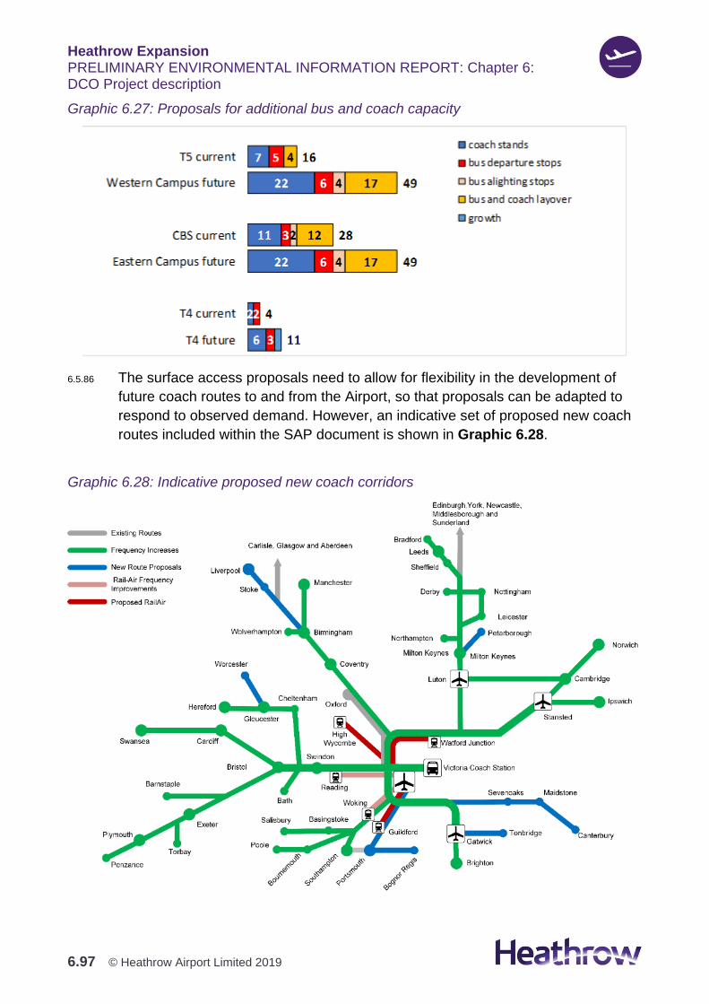
Heathrow Expansion PRELIMINARY ENVIRONMENTAL INFORMATION REPORT: Chapter 6: DCO Project description
6.97 © Heathrow Airport Limited 2019
Graphic 6.27: Proposals for additional bus and coach capacity
6.5.86 The surface access proposals need to allow for flexibility in the development of
future coach routes to and from the Airport, so that proposals can be adapted to
respond to observed demand. However, an indicative set of proposed new coach
routes included within the SAP document is shown in Graphic 6.28.
Graphic 6.28: Indicative proposed new coach corridors

Heathrow Expansion PRELIMINARY ENVIRONMENTAL INFORMATION REPORT: Chapter 6: DCO Project description
6.98 © Heathrow Airport Limited 2019
6.5.87 Similarly, Heathrow has developed an indicative set of proposals for new bus
routes based on analysis of current Heathrow colleague travel patterns. This is
shown in Graphic 6.29.
Graphic 6.29: Proposed new bus routes
6.5.88 To ensure that passengers and Heathrow colleagues travelling by bus and coach
have quick, reliable journeys, bus priority measures have been identified on roads
around the Airport. The locations of the proposed bus priority measures are shown
in Graphic 6.30.
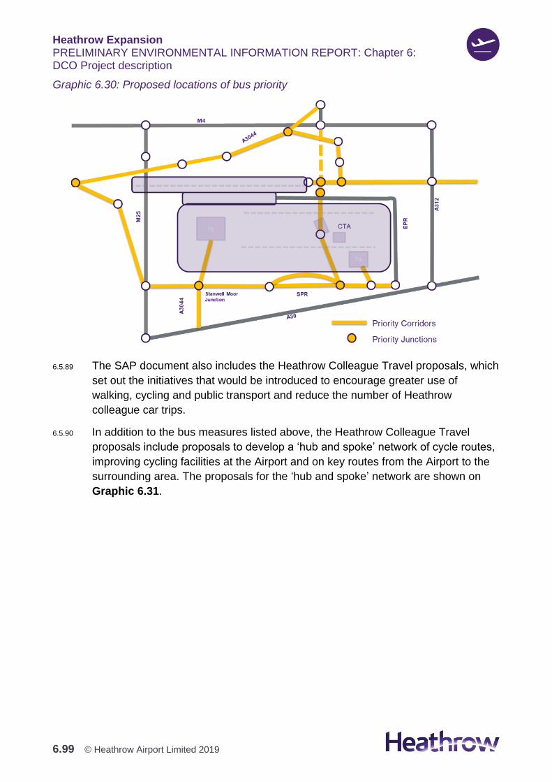
Heathrow Expansion PRELIMINARY ENVIRONMENTAL INFORMATION REPORT: Chapter 6: DCO Project description
6.99 © Heathrow Airport Limited 2019
Graphic 6.30: Proposed locations of bus priority
6.5.89 The SAP document also includes the Heathrow Colleague Travel proposals, which
set out the initiatives that would be introduced to encourage greater use of
walking, cycling and public transport and reduce the number of Heathrow
colleague car trips.
6.5.90 In addition to the bus measures listed above, the Heathrow Colleague Travel
proposals include proposals to develop a ‘hub and spoke’ network of cycle routes,
improving cycling facilities at the Airport and on key routes from the Airport to the
surrounding area. The proposals for the ‘hub and spoke’ network are shown on
Graphic 6.31.

Heathrow Expansion PRELIMINARY ENVIRONMENTAL INFORMATION REPORT: Chapter 6: DCO Project description
6.100 © Heathrow Airport Limited 2019
Graphic 6.31: Proposed ‘hub and spoke’ cycle network
6.5.91 The Heathrow Colleague Travel proposals also seek to introduce a needs-based
framework for allocation of Heathrow colleague car parking spaces in the context
of Heathrow colleague car parking provision being reduced. It also explains the
initiatives that Heathrow would introduce to support Heathrow colleagues travelling
to the Airport by alternative means.
6.5.92 The Car Parking Road User Charging, and Taxi and Private Hire proposals set out
the different ways that Heathrow would seek to manage passenger car access in
the future. On opening of the North West Runway, Heathrow intends to introduce a
vehicle access charge to encourage passengers to travel by other modes. This
also allows Heathrow to improve the way in which taxis and private hire vehicles
are managed at the Airport. Suitable exemptions would be in place as part of any
charge to ensure that people with restricted mobility can still access the Airport.
6.5.93 In the near-term, before the North West Runway opening, Heathrow proposes the
establishment of a Heathrow Ultra Low Emissions Zone (HULEZ) at the Airport by

Heathrow Expansion PRELIMINARY ENVIRONMENTAL INFORMATION REPORT: Chapter 6: DCO Project description
6.101 © Heathrow Airport Limited 2019
2022, which aligns with the London Ultra Low Emission Zone (ULEZ) standards.
The HULEZ would apply to all vehicles carrying passengers that come to
Heathrow. The HULEZ is proposed as a first step to encourage passengers using
Heathrow to consider other modes of travel to the Airport.
6.5.94 Heathrow proposes to transition the HULEZ into a full Heathrow Vehicle Access
Charge at the time of opening of the North West Runway, which is anticipated to
be the end of 2026. This charge would apply to all passenger vehicles entering the
Airport regardless of the vehicle’s emission standard. Airport users who park or
pick-up or drop-off passengers will be subject to payment of this charge on entry to
the Airport. Private Hire Vehicles and taxis (black cab) passengers will be required
to pay the charge per entry to forecourts and car parks. The purpose of this charge
is to help encourage passengers to use public transport for their journey to the
Airport.
6.5.95 Both the proposed HULEZ and vehicle access charge are anticipated to only apply
to passenger vehicles, taxis and private hire vehicles accessing the terminals and
passenger car parks. No charge is anticipated to be levied on Heathrow colleague
vehicles, goods vehicles, or vehicles on nearby roads that do not have an origin or
destination within the Airport. The Road User Charging proposals section of the
SAP document provides further detail. A Freight Proposals section has also been
produced as part of the document. These set out the different types of freight
activity that take place at the Airport today and suggests a framework to introduce
consolidation of cargo, reducing the number of HGV trips that have to be made in
connection with freight operations. To support this, two lorry parking areas are
proposed on the southern side of the Airport. These would help to reduce
congestion on the SPR, as well as inappropriate parking by HGVs on roads
around the Airport.
6.5.96 Finally, Intelligent Mobility Proposals, which form part of the SAP document, have
also been produced. This sets out how Heathrow would use emerging and
disruptive technologies for the benefit of passengers and Heathrow colleagues.
6.5.97 The SAP document shows how the initiatives incorporated within the proposals
can be combined to ensure that the ANPS targets are met under different sets of
circumstances.
6.5.98 Appended to the SAP document is the indicative Surface Access Delivery Plan.
This sets out a suggested approach to the introduction of surface access
measures prior to the opening of the North West Runway, should the DCO Project
be granted consent.
6.5.99 Separate to the SAP document is the PTIR. The PTIR considers the changes
which are likely to arise in the usage and operation of the surface access networks
as a result of the DCO Project.

Heathrow Expansion PRELIMINARY ENVIRONMENTAL INFORMATION REPORT: Chapter 6: DCO Project description
6.102 © Heathrow Airport Limited 2019
6.5.100 The PTIR provides more information on the type, nature and number of transport
movements forecasted to be generated by the DCO Project. This covers the
operational workforce, visitors and passengers accessing and departing the
Airport. In addition, it also includes forecasts of freight movements to and from the
Airport associated with its daily operation.
Parking
6.5.101 Parking forms an integral component of the surface access proposals for the DCO
Project.
6.5.102 In order to meet the Heathrow colleague vehicle reduction targets required within
the ANPS, there would need to be a significant phased reduction in Heathrow
colleague parking spaces. It is currently (2016) estimated that the approximate
25,000 spaces of Heathrow colleague parking would need to be reduced to around
17,000 spaces by 2030 and to approximately 12,000 spaces by 2040. The phased
reduction would be achieved in line with vehicle demand reductions which would
include initiatives to enhance and promote public transport and active travel
modes, as well as increasing car sharing.
6.5.103 There are two types of parking at Heathrow. The first of these are car parks that
are directly controlled by Heathrow. The second type is parking operated by third-
parties. This is either parking outside the Airport operated by airport parking
companies, or parking inside the Airport that is leased long-term to third parties.
This latter type of parking is known as 'tenanted parking'. At this stage different
approaches to the control of tenanted car parking are under consideration.
6.5.104 Passenger parking would increase, but not in line with airport throughput growth,
and this would be delivered in a phased way such that no more parking than the
realised demand is built, taking account of the full implementation of the initiatives
in SAP, and future changes in technology and policy.
6.5.105 Heathrow would consolidate parking in three major Parkways.
1. Consolidated Heathrow colleague and passenger parking in a Southern
Parkway with access from the M25 to serve the Western Campus (Terminal 5
and Terminal 5X). A frequent transfer system would be provided to transport
passengers and Heathrow colleagues to the Western Campus
2. Consolidated Heathrow colleague and passenger parking in a Northern
Parkway with access from the M4 to serve the Eastern Campus. A frequent
transfer system would be provided to transport passengers and Heathrow
colleagues to the Eastern Campus
3. Additional parking to support Terminal 4, accessible via junction 14 of the M25
and the SPR. Parking would also be provided at the CTA and Terminal 5.

Heathrow Expansion PRELIMINARY ENVIRONMENTAL INFORMATION REPORT: Chapter 6: DCO Project description
6.103 © Heathrow Airport Limited 2019
6.5.106 Car hire, taxi and private hire waiting areas (the ‘Taxi Feeder Park’ and
‘Authorised Vehicle Area’) are proposed to be consolidated in an intensified MSCP
on the former Terminal 4 Landside Terminal Car Park able to efficiently service
both the Western Campus, Terminal 4 and CTA (via the proposed Southern Road
Tunnel).
Road Maintenance
6.5.107 Routine highway maintenance would be carried out by the responsible Highways
Authority or Heathrow, dependent on whether roads are kept in Heathrow
ownership or adopted by the Highways Authority. Prior to this happening Heathrow
would be responsible.
Road Drainage
6.5.108 Road drainage across all the local roads, junctions and motorways that would be
altered as a consequence of the DCO Project would include the following
elements:
1. Surface water collection from proposed and existing carriageways,
hardshoulders and other impermeable areas associated with alterations to the
road network shall be via kerb and gully, surface water channels, slot drains,
linear drains and combined drainage kerbs as per design standards and DCO
Project requirements
2. Ditches for above ground and pipes for below ground conveyance systems
3. SuDS attenuation basins to which the piped network would drain
4. Where limited land is available at the ground surface, such that SuDS
attenuation basins cannot be provided, a combination of oversized pipes and /
or underground attenuation tanks would be utilised to provide the required
attenuation for surface water flows
5. Where required, additional SuDS measures for pollution control and prevention
would be utilised to provide the required isolation and /or treatment prior to
discharge
6. Gravity fed systems would be prioritised and where this is not feasible pump
systems would be utilised. New connections to connect the SuDS
basins/treatment areas to final discharge locations
7. Drainage outfalls would follow the drainage hierarchy, with appropriate
associated existing or new infrastructure identified.
6.5.109 The majority of the road drainage systems would drain by gravity. Firstly, towards
the low points of the road network, and from there by gravity to the SuDS
attenuation basins, and then to the final discharge locations.
Heathrow Expansion PRELIMINARY ENVIRONMENTAL INFORMATION REPORT: Chapter 6: DCO Project description
6.104 © Heathrow Airport Limited 2019
6.5.110 There are some instances where, due to the flat lying nature of the site and the
need to include low elevation roads, gravity fed drainage systems would not be
possible, pumping would therefore be required to lift water to discharge locations.
In the interest of sustainability (in accordance with the SuDS hierarchy) and
resilience of design, such scenarios would be avoided wherever possible.
6.5.111 Discharge locations have been determined in line with the SuDS hierarchy:
1. Into the ground (infiltration)
2. To a surface water body
3. To a surface water sewer, highway drain, or another drainage system
4. To a combined sewer.
6.5.112 It has been assumed at this stage (subject to further ground investigation data
being available) that infiltration is not a feasible means of discharge owing to the
generally shallow groundwater table, and presence of contaminated ground, either
existing or proposed. The proposed attenuation systems at present, would not
allow infiltration into the underlying ground. Instead, discharge is therefore
generally proposed to be to the nearest watercourse, where this is not feasible
discharge into existing (or new) surface water drainage systems shall be
proposed.
6.5.113 Under those circumstances where discharges would be to an existing surface
water sewer (or small watercourse), the discharge rate would be limited to a rate
appropriate for the flow capacity of that sewer system (or channel), to ensure no
increase in surface water flood risk elsewhere. All proposals would be designed in
accordance with the Design Manual for Roads and Bridges, taking into
consideration stakeholder requirements and guidance.
6.5.114 The necessary treatment of surface water runoff before discharge to the
environment would be undertaken within the areas allocated for highway
development, either alongside the roads (albeit not yet indicated in the plans), or
within the areas indicated as 'proposed attenuation basin'.
6.5.115 Highway drainage at the M25 tunnel would capture surface water before it enters
the tunnel and where possible keep it separate to the tunnel drainage. The tunnel
itself would be waterproofed with only minimal seepage envisaged into the
structure, this seepage would be kept separate from the main tunnel drainage
where possible. Highway drainage within the tunnel is to be designed to capture
tunnel maintenance cleaning liquid runoff, firefighting water and liquid spillages.
The tunnel drainage system would connect to a low point sump where it is pumped
out of the tunnel into an impounding sump for discharge outside of the tunnel bore.
Once discharged outside the tunnel the water would be stored in an appropriate
Heathrow Expansion PRELIMINARY ENVIRONMENTAL INFORMATION REPORT: Chapter 6: DCO Project description
6.105 © Heathrow Airport Limited 2019
attenuation system. This attenuation would either need to be treated or discharged
to an appropriate foul system.
Road lighting
6.5.116 All alterations to the road network that require lighting would require illumination to
meet the relevant regulatory requirements and standards, including (but not
restricted to):
1. BS5489-1:2013: Code of practice for the design of road lighting-Part 1: Lighting
of roads and public amenity areas (British Standard, 2013)
2. BS5489-2:2016: Code of practice for the design of road lighting-Part 2: Lighting
of tunnels (British Standard, 2016)
3. BS EN 13201-2:2015: Road Lighting-Part 2: Performance Requirements
(British Standard, 2015).
6.5.117 All new exterior lighting is expected to be active only in hours of darkness, being
primarily switched on using daylight detection sensors, and shall have LED fittings.
Lighting in proposed tunnels would be active 24hrs a day. There being limited or
no natural light levels in tunnels requires light levels to be much higher during the
day for safety reasons and hence the need for 24hr lighting.
6.5.118 An assessment of the lighting proposals during the operation phase would be
carried out and presented in the ES. The methodology for carrying out this
assessment can be found in Appendix 5.2.