volcano–basement interaction in the eastern carpathians
TRANSCRIPT
mal Research 158 (2006) 6–20www.elsevier.com/locate/jvolgeores
Journal of Volcanology and Geother
Volcano–basement interaction in the Eastern Carpathians:Explaining unusual tectonic features in theEastern Transylvanian Basin, Romania
Alexandru Szakács a,⁎, Csaba Krézsek b,1
a Institute of Geodynamics, Romanian Academy, Bucharest, Romaniab ROMGAZ, Mediaş, Romania
Received 4 January 2005; accepted 10 April 2006Available online 7 July 2006
Abstract
Evidence of volcano–basement interaction related to the Neogene/Quaternary Călimani-Gurghiu-Harghita volcanic chain(CGH) in the Eastern Carpathians, Romania, includes both structural and morphological features. The CGH is located roughlybetween the Carpathian thrust-and-fold arc to the east and the Transylvanian Basin to the west. Geological and geophysical datademonstrate basement subsidence along most of the axial part of the volcanic chain. The wide volcaniclastic plateau developedpreferentially westward by adjoining composite volcanoes, extends deep into the Transylvanian Basin, and its surface is tiltedtoward the chain axis, especially in the Gurghiu Mountains. These features strongly suggest late-stage or post-volcanic basementsagging beneath the volcanoes and related peripheral uplift. Interpretation of 2D seismic profiles acquired in the TransylvanianBasin indicates strong influence of the salt-related tectonics on the entire post-salt sequence. The Middle to Late Miocenesuccession, including the volcanic edifices, are tilted toward the basin margins. The pre-salt deposits together with the metamorphicbasement are not tilted; instead, they are progressively uplifted. We suggest that the salt-related tectonics enhanced by volcano-induced compressive tectonics is the main triggering factor. The Neogene salt-tectonics developed under an overall regionalcompressive stress field. The salt withdrawal beneath the Upper-Miocene siliciclastites was amplified by the influence of theweight of the volcanic edifices. The post-salt succession (including the volcanics) tilting is related to salt withdrawal processes androtation of the whole post-salt sedimentary succession along the salt-layer acting as a detachment surface. Swarms of small-scalewest-verging reverse faults developed near the CGH volcanic range represent small-scale thrust structures accommodating therotation induced compression in the post-salt brittle lithologies. The observed tectonic features are characteristic only for the easternpart of the Transylvanian Basin. No such features have been identified along the western margin or elsewhere in the basin. Theperipheral deformation of the pre-volcanic shallow sedimentary basement induced sagging and spreading of the nearby largevolcanic edifices. This process combined with the effect of increased heat-flux may have strongly enhanced salt diapirism as well.Volcano spreading was asymmetric because the basement at the eastern margin of the volcanic chain consists of brittle Mesozoicsedimentary and Precambrian metamorphic rocks of the Eastern Carpathian thrust-and-fold belt. The buttressing effect to the eastfavored spreading toward the west. Tectonic features resulted from volcano–basement interaction are combined with those relatedto regional tectonic processes involved in the evolution of the Transylvanian Basin and the Eastern Carpathians. Interplay between
⁎ Corresponding author. Current address: Sapientia EMTE University, Cluj-Napoca, Romania. Fax: +40 264 593693.E-mail addresses: [email protected], [email protected] (A. Szakács), [email protected] (Cs. Krézsek).
1 Fax: +40 269 841910.
0377-0273/$ - see front matter © 2006 Elsevier B.V. All rights reserved.doi:10.1016/j.jvolgeores.2006.04.012

7A. Szakács, C. Krézsek / Journal of Volcanology and Geothermal Research 158 (2006) 6–20
regional stress fields and local volcano-induced stress may best account for the complexity of tectonic features recorded in theeastern Transylvanian Basin.© 2006 Elsevier B.V. All rights reserved.
Keywords: volcano–basement interaction; salt diapirism; composite volcano; Eastern Carpathians; Transylvanian Basin; volcano tectonics
1. Introduction
The recognition of dynamic interaction betweenvolcanoes and their basement is a recent development involcanology (e.g., Delaney, 1992; Borgia, 1994; Merleand Borgia, 1996). Basement deformation under theweight of large volcanoes in turn induces deformationwithin the edifices themselves which influences furthereruptive behavior.
The main way the edifice adjusts to deformation ofweak basement underneath is volcano spreading,involving subsidence of the central summit part andcentrifugal lateral expansion at its peripheries as it wasdemonstrated via scaled experiments (Merle and Borgia,1996). To accommodate space reduction due to sagging,plastically deformable basement rocks are squeezedfrom beneath the central part of volcanoes and displacedlaterally, while the resulting compressive stress isresolved through reverse faulting and thrusting at thedistal peripheries. It is obvious that volcano–basementinteraction is strongly dependent on basement rocktypes and structure.
Volcano spreading as resulting from interactionbetween edifice and basement has been demonstratedat a number of active or recent composite volcanoesworldwide (e.g., Borgia et al., 1990; Van Wyk De Vriesand Borgia, 1996; Merle and Borgia, 1996). However,relevant examples of volcano–basement interaction areas yet missing for older, partially eroded volcanoes,where volcano-induced tectonic structures can morereadily be investigated and understood. This paperdiscusses the particular case of interaction betweencomposite volcanoes of the Neogene Eastern Carpathianvolcanic range and their Miocene sedimentary basementmaking of the fill of the Transylvanian Basin, Romania,where deformation of both volcanic edifices andbasement is recorded. This process may account forpuzzling tectonic features recognized in the eastern partof the Transylvanian Basin, which do not fit with basinevolution models proposed to date.
2. Geological setting
The Transylvanian Basin and the Eastern Car-pathians are both parts of the larger alpine Car-
pathian–Pannonian orogenic system (Fig. 1), whichdeveloped at the western margin of the Eurasian Plateinvolving at least two smaller lithospheric blocks, theTisia–Dacia and the ALCAPA blocks (Balla, 1987;Csontos et al., 1992; Csontos, 1995). Eastwardtranslation (Ratschbacher et al., 1991; Csontos et al.,1992; Fodor et al., 1999) and divergent rotation(Pătraşcu et al., 1994; Márton and Fodor, 1995) ofthese blocks resulted in the arcuate shape of theCarpathians (Maţenco, 1997; Zweigel, 1997). Themain shortening phases occurred during Middle Creta-ceous and Miocene times (Săndulescu, 1988) accom-panying subduction of the Tisia–Dacia and ALCAPAblocks beneath the Eurasian Plate (Balla, 1987; Csontoset al., 1992).
Intense and widespread magmatic activity accompa-nied deformation in the area during Miocene to UpperPleistocene (Pécskay et al., 1995). Both calc-alkalineand alkali-basaltic compositions are present. Most of theproducts of the mostly andesitic calc-alkaline magma-tism occur as a subduction-related volcanic arc,typically located along the inner part of the arcuateCarpathian fold-and-thrust belt.
The Transylvanian Basin develops between the EastCarpathians, South Carpathians and the ApuseniMountains (Fig. 1) in a back-arc type tectonic setting(Burchfiel and Royden, 1982; Balintoni et al., 1997;Sanders, 1999; Huismans, 1999; Ciulavu, 1999) withrespect the Carpathian arc (Săndulescu, 1988;Maţenco, 1997; Gârbacea, 1997; Zweigel, 1997;Sanders, 1999).
The sedimentary succession comprises Upper Me-sozoic to Miocene sediments deposited in severalsubsequent basin types (Balintoni et al., 1998). TheMiddle to Upper Miocene sediments are mainlyrepresented by siliciclastics (see Fig. 5). One of thecharacteristic features of the basin fill is the MiddleMiocene evaporites, represented by shallow-watergypsum (Ghergari et al., 1991) and deeper-marinesalt (Dragoş, 1969; Stoica and Gherasie, 1981). TheMiddle to Upper Miocene sedimentary successionbelongs to the latest megasequence (2nd ordersedimentary cycle) of the basin fill and can be dividedinto eight 3rd order depositional sequences (Krézsekand Filipescu, 2005).

8 A. Szakács, C. Krézsek / Journal of Volcanology and Geothermal Research 158 (2006) 6–20
3. The Călimani-Gurghiu-Harghita volcanic chain
The Călimani-Gurghiu-Harghita volcanic chain(CGH hereafter), occurring along the eastern marginof the Transylvanian Basin (Fig. 1), is the southeasternsegment of the Carpathian volcanic arc (Seghedi et al.,2004). It consists of a NW–SE-trending row of closely-spaced adjacent volcanic edifices. Most of them aremedium-size composite volcanoes, a couple of themwith summit calderas (Szakács and Seghedi, 1995).Obvious along-arc migration of volcanism from NW toSE has been pointed out (Rădulescu et al., 1972;Pécskay et al., 1995), accompanied by decreasingheight, volume and complexity in the same direction(Szakács et al., 1993; Szakács and Seghedi, 1995).
Volcanic edifices in the CGH consist of lava-dominated central cones flanked by extensive volcani-clastic aprons. The central-type composite edifices weremostly built by more mafic (basalt and basaltic andesite)
Fig. 1. Sketch map of the Carpathian–Pannonian Region (after Pécskay et al.,units, 2 — Outer Carpathian Units, 3 — Carpathian Foredeep, 4 — EasternNeogene/Quaternary volcanics. Frame shows location of Fig. 2 with the Căl
effusive products including cone-forming lava flowsand more viscous and felsic (andesite and dacite) lavadomes concentrated in the summit areas of thevolcanoes. Since the volcanoes are closely-spaced,their volcaniclastic aprons mostly developed sideways,especially westwards, towards the Transylvanian Basinwhere a flatland allowed unrestricted accommodationand redistribution of volcanic material from the centraland proximal parts of the edifices. Mechanisms ofprimary and secondary dispersion of fragmentedvolcanic material of the volcaniclastic aprons includedpyroclastic flows, debris flows, debris avalanches andfluvial erosion-transport systems. A widespread, gentlyoutward-dipping volcanic ring-plain resulted on top ofthe latest (Pannonian) sedimentary fill of the easternTransylvanian Basin. In contrast, volcaniclastic depositsshow limited eastward extension due to the buttressingeffect of the nearby Carpathian thrust-and-fold belt witha more rugged topography. Westward-dipping pre-
1995, modified) with location of the study area. 1— Inner CarpathianAlps, 5 — Klippen Belt, 6 — Intra-Carpathian basins, 7 — Arc-typeimani-Gurghiu-Harghita volcanic chain (CGH).

9A. Szakács, C. Krézsek / Journal of Volcanology and Geothermal Research 158 (2006) 6–20
volcanic topography also contributed to the asymmet-rical development of volcaniclastic aprons along theCGH chain.
4. Volcano–basement interaction
Interaction between volcanic edifices and their pre-volcanic basement is recorded in a number oftopographic and tectonic features that can be observedor inferred both inside and outside the CGH volcanicchain. Effects of such interaction on the volcanicedifices are obvious from geological and geophysicaldata and they strongly suggest volcano spreading. Onthe other hand, some unusual tectonic features,particular to the eastern margin of the TransylvanianBasin, may be interpreted as structures formed by acomplex interplay of salt-tectonics, regional tectonics,and volcano-induced tectonics.
4.1. Volcano spreading in the CGH
Evidence of volcano spreading in the CGH istwofold: topographic and geologic.
4.1.1. Topographic evidenceVolcaniclastic ringplains around composite volca-
noes show a gently outward-dipping overall topographyas the smooth extension of the hyperbolic topographicprofile of the volcanic edifices themselves. Themorphological transition between volcaniclastics andbasement is normally smooth or marked by a gentleslope-break.
One long-standing puzzling topographic feature ofthe CGH chain is the inward-dipping topographic andstructural surface of the volcaniclastic apron developedat the western peripheries of the volcanoes of theGurghiu Mts and of the northernmost part of the NorthHarghita Mountains. The highest topographic points ofthese surfaces are located along the westernmost marginof the volcaniclastic plateau, forming local peaks suchas Bekecs, Siklód, Küsmöd, Firtos, Szarkakő (fromnorth to south) (Fig. 3). From these peripheral highpoints the topographic surfaces show gentle to moderatedip northeastwards, i.e., towards the axial part of theCGH chain. A series of transversal topographic profiles(Figs. 2 and 3) and panoramic pictures (Fig. 4) clearlyrecord this feature. The surfaces flatten and eventuallyreverse to the “normal” outward dip towards the limitbetween volcaniclastic medial facies and lava-dominat-ed proximal facies (Fig. 3).
Inward-tilted surfaces of peripheral volcaniclasticformations can readily be observed along the southern
2/3 of the western Gurghiu Mountains between theGurghiu and Târnava Mare valleys, where medial todistal volcanic facies is best developed (Figs. 2 and 3).North of the Gurghiu valley, erosional dissection ismuch more advanced because of tectonic uplift of thepre-Neogen basement along a seismically active fault(Ciulavu, 1999), hence structural surfaces are less wellpreserved and more difficult to reconstruct. South of theTârnava Mare valley the volcaniclastic plateau isgenerally less developed, and the volcanic material hasbeen redistributed along tectonically determined south–southwest-trending paleovalleys parallel to the PerşaniMountains Neogene horst-and-graben structure. Exceptfor its northwesternmost part, no well-individualizedplateau-type topography developed peripherally adja-cent to most of North Harghita and South HarghitaMountains (Fig. 2). Thus, no anomalous topographicfeatures can be observed here, nor in the eastern side ofthe North Harghita Mountains, where extensive volca-niclastic plateau does also occur in places. The surfacesof peripheral volcaniclastic deposits here show normaloutward-decreasing topographic gradients.
Inward-dipping structural surface of the peripheralvolcaniclastic plateau can only be explained byinversion of the dip direction from outward to inwardafter most volcanic edifice construction was accom-plished. Mechanisms which may be envisaged aretectonic, volcanic or both. Regional tectonic tilting ofpaleosurfaces may result from differential uplift and/orsubsidence. Uplift of the westernmost peripheries of thevolcaniclastic plateau is unlikely to be related to non-volcanic regional tectonic events, because no boundingfaults are recognized nearby. Faults disrupting thepaleosurface are located much inwards (Fig. 3). Theybound segments of inward-dipping surfaces. Subsidencebeneath the lowest-positioned paleosurface areas, on theother hand, can certainly be ruled out because beneath atleast part of such areas (e.g., Sovata-Praid-Corund area)just the opposite effect can be expected due to Middle-Miocene to recent salt diapirism (Ciupagea et al., 1970;Visarion et al., 1976) (Fig. 3). Volcano spreading mayconveniently account for inward-dipping of the volca-niclastic topographic surface. Sagging of the centralparts of volcanic edifices in the Gurghiu Mountains andaccompanying peripheral shortening by small-scalethrust-faulting is a likely mechanism for distal upliftof the volcanic plateau together with its sedimentarybasement.
Andesite-dominated composite volcanoes, such asthose in the CGH chain, are characterized by their cone-shaped morphology. Modern composite volcanic conesdisplay upward-concave outer slopes with slope angles

Fig. 2. Volcanic facies map of the CGH volcanic chain with location of morphological profiles (AA′–FF′). 1— East Carpathian thrust-and-fold belt,2 — Transylvanian Basin, 3 — Pre-volcanic intrusions, 4 — Upper Pliocene/Quaternary post-volcanic basins, 5 — Central volcanic facies, 6 —Proximal volcanic (cone) facies, 7—Medial volcanic (volcaniclastic) facies, 8— Distal m (alluvial) volcanic facies, 9— Topographic caldera rim.Dashed white line shows the presumed boundary between Carpathian and Transylvanian pre-volcanic basement types, respectively. Solid black lineslabeled A to F show locations of topographic profiles in Fig. 3. Dashed frame shows the rough outline of the area with inward-dipping peripheralstructural surface (see explanation in text). Localities: LB— Lunca Bradului, Sv— Sovata, Pr— Praid, Cd— Corund, Vl— Vlăhiţa, L— Lueta,Md—Mădăraş. Volcanoes mentioned in text (indicated by white numbers): 1— Fâncel-Lăpuşna, 2— Seaca-Tătarca, 3— Şumuleu, 4— Ciumani-Fierăstraie, 5 — Ostoroş, 6 — Ivo-Cocoizaş, 7 — Vârghiş (after Szakács and Seghedi, 1995, modified).
10 A. Szakács, C. Krézsek / Journal of Volcanology and Geothermal Research 158 (2006) 6–20
gradually increasing upwards up to 35–40° (Francis,1993; Davidson and De Silva, 2000). Volcanoes in theGurghiu and North Harghita Mountains were activebetween 9–4 Ma (Pécskay et al., 1995). They show arather attenuated morphology, and their outer slopes aretypically low-angle (10–13°). Some of them vaguelysuggest a former upward-concave profile (Şumuleu,Ciumani-Fierăstraie and Ostoroş) while others (Seaca-Tătarca, Ivo-Cocoizaş) have rather upward-convexshield-like profile (Szakács and Seghedi, 1995) as it is
obvious in profile D–D′ of Fig. 3. The latter categoryvolcanoes are higher-volume than those belonging to theformer one. Erosion may have played a role inattenuation of their original topographic profile, but itsinfluence was quite modest: average erosional topo-graphic lowering rate is ca. 30 m/Ma at the CarpathianNeogene volcanoes (Karátson, 1996). Also, the outer-slope angles could not be modified significantly by suchlow erosion rates since the end of volcanic activity. Wesuggest that the present-day low-angle outer slopes and

Fig. 3. Topographic profiles across the CGH (Gurghiu and North Harghita Mountains). Location of profiles in Fig. 2. Surface limits betweenmain formations are shown. Tr— basin fill sediments of theTransvlvanian Basin, Vcl— peripheral volcaniclastics (medial volcanic facies), Str— proximal and central volcanic facies, Q— Quaternary sediments, F— faults. Fine dashed line shows smoothedtopographic surface of peripheral volcaniclastic plateau. Note dip of peripheral topographic surfaces toward center of volcanoes and dip of basement–volcanics boundary in the same direction. 11
A.Szakács,
C.Krézsek
/Journal
ofVolcanology
andGeotherm
alResearch
158(2006)
6–20

Fig. 4. Structural surfaces of peripheral volcaniclastic deposits in the western part of the CGH. Picture taken towards the northwest from south ofCorund. Summit of Seaca-Tătarca volcano is at right, just out of sight of picture. Note dip of structural surfaces toward center of volcano shown bydashed lines. Slope break is visible on the opposite side of prominent hills marking the basement–volcanics boundary.
12 A. Szakács, C. Krézsek / Journal of Volcanology and Geothermal Research 158 (2006) 6–20
the shield-like morphology of the largest Gurghiu andNorth Harghita volcanoes, as well as the inward-dippingpaleotopographic surfaces at the western peripheries ofCGH chain are morphological features consistent witheach other and may have resulted from post-eruptivesubsidence of the edifices.
4.1.2. Geological evidenceThe boundary between post-salt sedimentary base-
ment and volcanics, seen in outcrops or inferredthrough mapping at the western peripheries of theCălimani, Gurghiu and North Harghita Mountains isinvariably inward dipping, paralleling the paleotopo-graphic surface of the peripheral volcaniclastic apron.This is especially well seen in the Sovata-Parid-Corundarea at the western periphery of the Gurghiu Mountains(Figs. 3 and 4).
The central parts of most large composite volcanoesof CGH have been drilled but, none of them reached thepre-volcanic basement. Local networks of medium-depth drillings (150–600 m) were made to explore foriron ore deposits close to the western (Vlăhiţa-Lueta)and eastern (Mădăraş) peripheries of the North HarghitaMountains Since the siderite deposits are hosted at thebasement–volcanics boundary, the paleomorphology ofbasement has additionally been investigated by gravitysurvey in the case of the Vlahiţa-Lueta area. Both drill-hole data and gravity survey show a general inward-dipping paleosurface of the pre-volcanic basement in theVlăhiţa-Lueta area (Peltz et al., 1983), as well as atMădăraş (Tănăsescu, 1967).
The obvious deeper position of the pre-volcanicbasement surface in the axial part of the CGH chain withrespect its peripheral areas has implicitly been inter-preted in terms of volcano-tectonic depressions (Mur-eşan et al., 1986). The inferred “blind” normal faultsexplaining this subsidence were drawn on a purely
theoretical basis without any positive evidence of theirlocations. Volcano-tectonic subsidence of basementbeneath the axial part of the CGH cannot be ruled out.However, sagging of the volcanic edifices due tovolcano spreading might be an equally viable explana-tion of central subsidence beneath the large compositevolcanoes.
4.2. Volcano-induced tectonic features in the easternTransylvanian Basin
A number of peculiar geological, structural andtectonic features along the eastern margin of theTransylvanian Basin are difficult to reconcile with theoverall basin tectonics and evolution. They includecontrasting tectonic style of the pre-salt and post-saltdeposits, marginal thickening of the youngest basin-filldeposits, eastward dip of lithological and stratigraphicboundaries and of decollement surfaces in the post-saltsedimentary pile, presence of swarms of west-vergingreverse faults, and enhanced salt diapirism. Suchfeatures can readily be identified on seismic profilesand by geological mapping.
4.2.1. Geological evidenceThe youngest basin-fill sediments, Pannonian in age,
occur along the eastern margin of the northernTranylvanian basin. Their sedimentological features(Krézsek, 2005) indicate a relative high-angle Panno-nian basin margin profile, characterized by coarse-grained fandeltas prograding on a narrow shelf, feedingsandy submarine fans (Fig. 5). Well-log data in the frontof CGH chain indicate an overall eastward thickening ofthe Pannonian sedimentary pile toward the volcanicedifices. This is due to clockwise rotation — in verticalplan— of the Upper-Badenian to Pannonian successionalong the salt layer acting as decollement surface. The

13A. Szakács, C. Krézsek / Journal of Volcanology and Geothermal Research 158 (2006) 6–20
consequences of the large-scale rotation are: (1) therelatively flat Sarmatian/Pannonian depositional bound-ary was tilted eastwards (downward), (2) all Pannoniansediments were eroded in the proximity of the easternTransylvanian salt-diapir belt; and (3) progressivelyyounger sediments (Upper-Badenian to Pannonian) cropout toward the CGH.
4.2.2. Geophysical evidence: 2D seismics interpretationA number of 2D seismic profiles have been
acquired by oil companies during the 1990s in theTransylvanian Basin. A few of them reach the boun-dary area between the Transylvanian Basin and theCGH Chain (Fig. 6).
The seismic facies of the Upper-Badenian toPannonian sediments were calibrated to the well-logfacies and core data. The Upper-Badenian sediments arecoarse-grained sands and conglomerates interbeddedwith small amounts of pelites. For the basal part of thesuccession, a proximal littoral environment is inferred,which is passing upwards into proximal fan deposits,built up by a complex fringing of channels and proximal
Fig. 5. Badenian to Pannonian sedimentary environments
lobes. The Sarmatian is built up by various submarinefans. The change of seismic facies is mainly related todepositional changes characteristic for such an environ-ment: superimposed submarine lobes and channels. Thesame depositional settings are inferred for the Panno-nian deposits. The Upper Sarmatian and Pannonianseem to follow each other without erosional unconfor-mities. It is important to note that the entire Upper-Sarmatian–Pannonian-volcanics succession is formedby relatively conformable, parallel reflectors. Therefore,we interpret stable sedimentary conditions, with almostnegligible salt-tectonic activity. On the flattened seismicline (Fig. 7c), the Upper Badenian to Pannonian strataare onlapping the thinned salt-layer. However, the actualarchitecture indicates that the original onlaps wererotated downward. This rotation is due to the westwardwithdrawal of the salt layer beneath the onlappingdeposits. If we suppose progressive salt withdrawal,than we must have angular unconformities between thesubsequent Sarmatian seismic packages. However, thisis not the case, rather it seems that the whole structureglided as a whole along the salt layer acting as a
and simplified lithology of the Transylvanian Basin.

14 A. Szakács, C. Krézsek / Journal of Volcanology and Geothermal Research 158 (2006) 6–20
detachment surface after forming the volcanic edifices,in post-Pannonian times.
4.2.3. Enhanced salt tectonicsThe Middle Badenian evaporites in the Transylva-
nian Basin are mostly represented by salt, forming anearly continuous layer with variable thickness due todepositional conditions, doming and diapirism. Usuallytheir thickness ranges between 100–300 m, but in thediapir structures it may attain up to 1500 m (Ciupagea etal., 1970; Visarion et al., 1976).
Although salt-dome structures are present through-out the whole Transylvanian Basin, outcropping andshallow diapirs are mostly concentrated along beltslocated near, and paralleling, the margins of the basin(Figs. 6 and 7a). One striking feature of saltdiapirism in the basin is that the diapir structuresare much better developed, involving much largervolumes of salt, in the eastern part as compared tothe western part. This feature has not been explainedso far.
Near-surface and outcropping salt diapirs in theeastern part of the Transylvanian Basin form a diapirbelt roughly parallel to the basin margin and to the CGHvolcanic chain. The northern half of this belt is located
Fig. 6. Geologic sketch map of the Transylvanian Basin (compiled after CiupaD–E, F–G).
west of the western margins of the CGH volcanics(Călimani and northern Gurghiu Mountains), while itssouthern half is inside the medial to distal-faciesvolcaniclastic apron of the volcanic chain (southernGurghiu and North Harghita Mountains) (Fig. 6).
Salt diapir structures can easily be identified anddescribed on seismic profiles. The diapirs deform all thesurrounding sediments, including the youngest Panno-nian ones too. In profile A–B (Fig. 7a), crossing thewhole basin, it is obvious that diapir structures in theeastern part are much larger (radius up to 3 km, andhight up to 3 km) than those from the western margin(height up to 1 km and width around 1 km). Theseobservations lead to the conclusion that diapirism in theeastern part of the basin is strongly enhanced ascompared to diapirism in the western part: both saltvolumes involved and duration of the process showlarger values. This requires the admission of additionalfactors involved in salt diapirism in the eastern part ofthe basin. In our opinion these could be: 1) the proximityof the Neogene CGH volcanic chain, 2) the position ofthe Middle Badenian depocenters eastward to the actualbasin center, involving higher amounts of salt depositedhere, and 3) the post-Pannonian uplift of the easternmargin of the Transylvanian Basin (Krézsek, 2004).
gea et al., 1970) with location of 2D travel-time seismic profiles (A–B,

Fig. 7. 2D travel-time seismic profiles in the Transylvanian Basin. Locations are shown in Fig. 6. a. Interpreted regional seismic line (A–B) and its interpreted eastward extension (B–C). The tentativeinterpretation of the extended segment is based on outcrop and drill hole data. b. Interpreted detail of the regional seismic line A–B (a). c. Interpreted detail of the seismic line A–B (b), flattened on anintra-Sarmatian horizon. d. Interpreted detail of the regional seismic line D–E. e. Interpreted detail of the regional seismic line F–G.
15A.Szakács,
C.Krézsek
/Journal
ofVolcanology
andGeotherm
alResearch
158(2006)
6–20

16 A. Szakács, C. Krézsek / Journal of Volcanology and Geothermal Research 158 (2006) 6–20
Although the diapirs seen in profiles A–B and C–D(Fig. 7b, d) are vertical, Visarion et al. (1976) state thatmost of the diapirs are southwest-verging and crosscutby vertical faults. In their salt isopach map, Visarion etal. (1976) depict a salt-wall line as a west-verging thrustfault along the diapir occurrences in the easternTransylvanian Basin. Ciupagea et al. (1970) alsomention west-vergence of the Miocene sedimentsincluding salt diapirs along the eastern margin of theTransylvanian Basin. Incipient small-scale diapiricfeatures located east of the main diapir in profile A–Bclearly show eastward-dipping axes (Fig. 7d). Westverging of diapir structures is fully consistent withobservations related to the westward gliding of the post-salt succession along the salt layer acting as adecollement surface. The gliding induced shorteningnear the Pre-Pliocene diapir belt, shifting the diapir axiswestward.
4.2.4. Reverse faultsWest-verging post-Middle Miocene reverse faults
were previously pointed out in the eastern part ofseismic line 1 (Ciulavu, 1999). They are locatedbetween the salt diapir belt of the northeasternTransylvanian Basin and the Călimani segment of theCGH volcanic chain. These faults deform only theMiocene sediments above the Middle Badenian saltlayer and they display reverse vergence with respectthrust-faults occurring in the basin basement, shown inseismic line C–D (Fig. 7d).
Sanders (1999) and Huismans (1999) suggest that thereverse faulting in the eastern Transylvanian Basin iscorrelated with E–W compression in the East Car-pathians because their orientation is similar to that of theback-thrusts in the internal parts of the East Carpathians.However, this interpretation ignores the fact that thesereverse faults only affect post-salt deposits and noimportant west-verging thrust faults are recorded on thecontact zone between the Transylvanian Basin andMiddle Dacides (Balintoni and Petrescu, 2002).
The presence of west-verging reverse faults in thearea reflect smaller-scale ruptural tectonics (thrustfaults) related to the gliding of the post-salt brittle-lithology succession. Outer-fan to basin-plain Sarmatianto Pannonian pelites favorised the formation of localdetachment surfaces along which the gliding-inducedshortening was accommodated (Fig. 7b).
5. Tectonic interpretation
A narrow band of contractional deformation can beoutlined along the eastern part of the Transylvanian
Basin which is parallel to the volcanic chain, as well asto the alignment of salt-diapir structures. Moreover, it isparallel to the strip of inward-dipping structural surfacesof the volcaniclastic plateau.
The present structural architecture of the post-saltsuccession in the eastern Transylvanian Basin is relatedto salt-tectonics and salt-withdrawal processes, en-hanced by volcano-spreading and regional tectonics.We found the existence of at least two important phasesof salt-tectonic activity: one around the Badenian–Sarmatian boundary, and the other post-Pannonian. Thefirst phase is related to one of the pulses of thecompressive tectonics of the Carpathian Chain. Follow-ing the Late Badenian salt-tectonic phase, probably dueto the high rate of sedimentary input, beneath the Upper-Badenian–Sarmatian to Pannonian sediments a rela-tively thick salt-layer was trapped. It was subjected tovolcano-induced tectonics during the second salt-tectonic maximum, which postdates in time the buildingup of the large volcanic edifices in the central CGH. Theeffect of volcanism in enhancement of diapirism istwofold: (1) increased geothermal gradient resulted inprogressively decreasing salt viscosity near the CGHrange, and (2) compressive stress on the pre-volcanicbasement due to gravitational loading by volcanicedifices. The resulting stress-field has two components:a downward-oriented component resulting from theweight of volcanic edifices and a westward componentinduced by the preferentially westward spreading ofvolcanic structures due to both westward-slopingsubstratum and buttressing in the east.
There are major structures in the Transylvanian Basinrelated to the Upper-Pannonian to Pliocene paroxysmaltectonic phase. It is striking that the salt-withdrawalprocess and related tectonics seem to be of the same age.Therefore, we suspect that the triggering mechanism ofthe post-Pannonian salt tectonics was represented by thisregional tectonic phase. The salt tectonics was enhancedby the preferential westward spreading of the volcanicedifices, as well as by volcanism-related increased heatflux. The post-Pannonian salt-tectonics represented amajor salt-withdrawal process generating large-scaledetachment along the remaining thinned salt layer. Thepost-salt succession, including the volcanic edifices, wasdisplaced downward, following the westward migrationof the salt. This downward displacement created awestward-oriented compressive stress-field, pushing thepost-salt sedimentary succession onto the progressivelyevolving eastern diapir belt. At the end of the process,reverse detachment listric faults have been created abovethe plastic salt-layer, while the post-salt successionsiliciclastic pile was pushed upwards. The west-verging

17A. Szakács, C. Krézsek / Journal of Volcanology and Geothermal Research 158 (2006) 6–20
thrust faults thus represent small-scale compressionstructures when the block-rotation and volcanic spread-ing-induced stress have been locally compensated. Theydo not account for the large-scale architecture of thepresent structures.
6. Discussion of volcano–basement interaction
Basement is different beneath the eastern and westernparts of the CGH volcanic chain. Proterozoic to LowerPaleozoic metamorphic rocks overlain by Mesozoicmostly carbonatic sedimentary rocks (belonging to theInner Dacides Units of the East Carpathians, Săndu-lescu, 1988) form the pre-volcanic basement in theeastern part. Due to this composition, its mechanicalproperties allow for brittle deformation under stress. Incontrast, the pre-volcanic basement of the western partof the CGH consists of a thick sedimentary pileincluding ductile rocks such as clay and salt prone toplastic deformation. The boundary between these twocontrasting basement types is located beneath the axialpart of the CGH, excepting its southeasternmostsegment where the row of South Harghita volcanicedifices crosscut the Inner Dacides (Szakács et al.,1993). The geometric details of this major structuralboundary are as yet unknown.
Sagging of the central composite volcanoes into sucha compound basement with contrasting mechanicalbehavior should be non-uniform. We may tentativelyassume that basement of the eastern part deforms byeither flexuring or faulting under the weight of thevolcanoes. Such a basement-deformation style shouldbe restricted to the axial part of the CGH anddeformational structures do not propagate peripherally,being hidden beneath the thick volcanic pile.
Volcano–basement interaction in the western partof the CGH is much different. The presence ofplastically deformable rocks in the basement mayinduce stronger and more complex deformation ofunderlying basement under the weight of the volca-noes, while the edifices themselves may also deform.Space problems caused by sagging of the volcanicedifices are resolved by the mechanisms of volcanospreading (Delaney, 1992; Borgia, 1994) which mayaffect the basement only or both basement and edifice,as suggested by scaled experiments (Merle andBorgia, 1996). In the case of the CGH chain and itswestern-half basement the signatures of both processescan be recognized in the geologic and topographicrecord as discussed in the previous sections. Saggingof the central part of the volcanic edifices led toinversion of dip direction of the volcanic rocks–
basement boundary at the western periphery of theCGH chain, as well as of the paleotopographic surfaceof the peripheral volcaniclastic plateau (change oftopographic gradient from outward-dipping to inward-dipping).
Sagging also resulted in squeezing of plastic rocks(especially salt) from beneath the volcanic cones. Atisolated volcanoes such a process may generatedeformation structures in basement rocks all aroundthe volcano in a concentric arrangement (Merle andBorgia, 1996). In the particular case of the CGHedifices, compressive deformation of basement rocksis strongly focused to the west, to a sector of ca. 1/4of the volcanoes circumference. Focused deformationof basement at preferential sectors is due to thefollowing factors: (1) buttressing by plasticallyundeformable basement in the eastern half of CGH,(2) westward dipping basement topography; and (3)close spacing of adjacent composite volcanoes, whichdoes not allow for spreading along the CGH chainaxis. Thus, volcano-induced compressive stress inplastic basement rocks is constrained to act unidirec-tionally, normal to the chain axis. As a consequence,the resulting deformation is expected to be strongerand farther-reaching as compared to cases where stressis more uniformly distributed around volcanoes.Inward-dipping paleotopographic surfaces and volca-nic rock–basement boundaries are located at ca. 22–28 km from the geometrical axis of the CGH. Reversefault swarms seen in seismic sections are found at upto 30–35 km distances. These figures are significantlylarger as compared with most of those reportedelsewhere. The volcano-induced morphological Ale-juela Ridge, for instance, developed above a thrust-fault, is at ca. 14 km from the Central Costa RicaVolcanic Range (Borgia et al., 1990). At Nicaraguanvolcanoes Concepcion and Maderas, basement-defor-mation features including thrusting and mudstonediapirism are within 10 km from their summits (VanWyk De Vries and Borgia, 1996). However, fault-propagation folds around the base of the Etna volcano,interpreted as resulting from volcano–basement inter-action, are found up to ca. 30 km from summit (Merleand Borgia, 1996), but Etna's edifice is also buttressed(on two sides: north and west). The influence ofinclined basement topography on volcano spreadingand edifice failure, as recently suggested fromanalogue modeling (Wooller et al., 2004), acts in thedownslope sense of sectorial deformation in thedirection of basement tilt.
The styles of volcano-induced deformation havebeen addressed through numerical modeling by Van
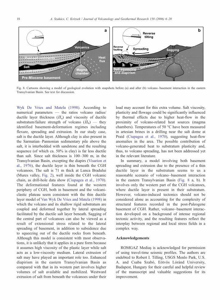
Fig. 8. Cartoons showing a model of geological evolution with snapshots before (a) and after (b) volcano–basement interaction in the easternTransylvanian Basin. See text for discussion.
18 A. Szakács, C. Krézsek / Journal of Volcanology and Geothermal Research 158 (2006) 6–20
Wyk De Vries and Matela (1998). According tonumerical parameters — the ratios volcano radius/ductile layer thickness (Πa) and viscosity of ductilesubstratum/failure strength of volcano (Πb) — theyidentified basement-deformation regimes includingflexure, spreading and extrusion. In our study case,salt is the ductile layer. Although clay is also present inthe Sarmatian–Pannonian sedimentary pile above thesalt, it is interbedded with sandstone and the resultingsequence (of which ca. 50% is clay) is far less ductilethan salt. Since salt thickness is 100–300 m, in theTransylvanian Basin, excepting the diapirs (Visarion etal., 1976), the ductile layer is thin beneath the CGHvolcanoes. The salt is 71 m thick at Lunca Bradului(Mures valley, Fig. 2), well inside the CGH volcanicchain, as drill-hole data show (Ciupagea et al., 1970).The deformational features found at the westernperiphery of CGH, both in basement and the volcani-clastic plateau seem consistent with the thin ductilelayer model of Van Wyk De Vries and Matela (1998) inwhich the volcano and its shallow rigid substratum arecoupled and deformed together by lateral spreadingfacilitated by the ductile salt layer beneath. Sagging ofthe central part of volcanoes can also be viewed as aresult of extensional stress related to the lateralspreading of basement, in addition to subsidence dueto squeezing out of the ductile rocks from beneath.Although this model is consistent with most observa-tions, it is unlikely that it applies in a pure form becauseit assumes high viscosity of the plastic layer while saltacts as a low-viscosity medium. Lateral extrusion ofsalt may have played an important role too. Enhanceddiapirism in the eastern Transylvanian Basin ascompared with that in its western part involves highervolumes of salt available and mobilized. Westwardextrusion of salt from beneath the volcanoes under their
load may account for this extra volume. Salt viscosity,plasticity and flowage could be significantly influencedby thermal effects due to higher heat-flow in theproximity of volcano-related heat sources (magmachambers). Temperatures of 50 °C have been measuredin artesian brines in a drilling near the salt dome atPraid (Ciupagea et al., 1970), suggesting heat-flowanomalies in the area. The possible contribution ofvolcano-generated heat to substratum plasticity and,thus, to volcano spreading, has not been addressed yetin the relevant literature.
In summary, a model involving both basementspreading and extrusion due to the presence of a thinductile layer in the substratum seems to us areasonable scenario of volcano–basement interactionin the eastern Transylvanian Basin (Fig. 8 a, b). Itinvolves only the western part of the CGH volcanoes,where ductile layer is present in their substratum.However, volcano-induced tectonics should not beconsidered alone as accounting for the complexity ofstructural features recorded in the post-Paleogenebasement of CGH. Rather, volcano–basement interac-tion developed on a background of intense regionaltectonic activity, and the resulting features reflect theinterplay between regional and local stress fields in acomplex way.
Acknowledgements
ROMGAZ Mediaş is acknowledged for permissionof using travel-time seismic profiles. The authors areendebted to Robert I. Tilling, USGS Menlo Park, U.S.A. and Csaba Szabó, Eötvös Lóránd University,Budapest, Hungary for their careful and helpful reviewof the manuscript and valuable suggestions for itsimprovement.

19A. Szakács, C. Krézsek / Journal of Volcanology and Geothermal Research 158 (2006) 6–20
References
Balintoni, I., Petrescu, I., 2002. A hypothesis on the Transylvanianhalite genesis. Studia Universitatis Babes-Bolyai. Geologia 1,51–61 (special issue).
Balintoni, I., Seghedi, I., Szakács, A., 1997. Review of the Neogenepost-collisional magmatism tectonics interplay in the intracar-pathian region. Studia Universitatis Babes-Bolyai, XLII/2,pp. 33–49.
Balintoni, I., Mészáros, N., Györfi, I., 1998. La Transylvanie,dépressions et bassins. Studia Universitatis Babes-Bolyai. Geolo-gia XLIII (1), 43–57.
Balla, Z., 1987. Tertiary paleomagnetic data for the Carpatho-Pannonian region in the light of Miocene rotation kinematics.Tectonophysics 139, 67–98.
Borgia, A., 1994. Dynamic basis of volcano spreading. J. Geophys.Res. 99 (B9), 17,791–17,804.
Borgia, A., Burr, J., Montero, W., Morales, L.D., Alvarado, G.E.,1990. Fault-propagation folds induced by gravitational failure andslumping of the Central Costa Rica volcanic range: implicationsfor large terrestrial and Martian volcanic edifices. J. Geophys. Res.95, 14,357–14,382.
Burchfiel, B.C., Royden, L., 1982. Carpathian foreland fold and thrustbelt and its relation to Pannonian and other basins. Am. Assoc. Pet.Geol. Bull. 66/9, 1179–1195.
Ciulavu D. (1999) Tertiary tectonics of the Transylvanian Basin. PhD.Thesis. Vrije University, Amsterdam, 154 pp.
Ciupagea D., Pauca M., Ichim T. (1970) Geology of the TransylvanianBasin. Ed. Acad. R.S.R., Bucharest, 255 pp. (in Romanian).
Csontos, L., 1995. Tertiary tectonic evolution of the Intra-Carpathianarea: a review. Acta Vulcanol. 7 (2), 1–13.
Csontos, L., Nagymarosi, A., Horváth, F., Kovac, M., 1992. Tertiaryevolution of the Intra-Carpathian area: a model. Tectonophysics208, 221–241.
Davidson, J., De Silva, S., 2000. Composite volcanoes. In: Sigurdsson,H. (Ed.), Encyclopedia of Volcanoes. Academic Press,pp. 663–681.
Delaney, P., 1992. You can pile it only so high. Nature 357,194–196.
Dragoş, V., 1969. Contributions to the knowledge of evaporite genesisin the Transylvanian Basin. St. cerc. geol. geofiz. geogr., Seriageol., vol. 14/1, pp. 163–180 (in Romanian).
Fodor, L., Csontos, L., Bada, G., Györfi, I., Benkovics, L., 1999.Tertiary tectonic evolution of the Pannonian Basin system andneighbouring orogens: a new synthesis of paleostress data. In:Durand, B., Jolivet, L., Horváth, F., Séranne, M. (Eds.), TheMediterranean Basins: Tertiary Extension within the AlpineOrogene. Geol. Soc. Spec. Publ., vol. 156. The Geological Societyof London, pp. 295–334.
Francis, P., 1993. Volcanoes. A Planetary Perspective. ClarendonPress,. 443 pp.
Gârbacea, R., 1997. The Pliocene to Recent tectonic evolution of theEastern Carpathians (Romania). Tübinger GeowissenschaftlicheArbeiten (TGA), vol. A-35. Tübingen,. 136 pp.
Ghergari, L., Mészáros, N., Hosu, A., Filipescu, S., Chira, C., 1991.The gypsiferous Formation at Cheia (Cluj County), StudiaUniversitatis Babes-Bolyai. Geologia XXXVI/1, 13–28.
Huismans, R.S. (1999): Dynamic modelling of the transition frompassive to active rifting. PhD thesis, Vrije Universiteit, Amster-dam, 182 pp.
Karátson, D., 1996. Rates and factors of stratovolcano degradationin a continental climate: a complex morphometric analysis of
ninteen Neogene/Quaternary crater remnants in the Carpathians.J. Volcanol. Geotherm. Res. 73, 65–78.
Krézsek, Cs., 2004. Gravitational gliding in Transylvania. AAPGExtended Abstracts, Prague,. 8 pp.
Krézsek, Cs., 2005. Sedimentology and arhitecture of the Panno-nian deposits in the East Transylvanian Basin, Romania, PhDthesis, Babes-Bolyai University, Cluj-Napoca, Romania, 166 pp.(in Romanian).
Krézsek, Cs., Filipescu, S., 2005. Middle to Late Miocene sequencestratigraphy of the Transylvanian Basin (Romania). Tectonophy-sics 410 (1–4), 437–463.
Márton, E., Fodor, L., 1995. Combination of paleomagnetic and stressdata— a case study from Northern Hungary. Tectonophysics 242,99–114.
Maţenco, L., 1997. Tectonic evolution of the Outer RomanianCarpathians: constrains from kinematic analysis and flexuralmodelling, PhD thesis, Vrije University, Amsterdam, 160 pp.
Merle, O., Borgia, A., 1996. Scaled experiments of volcano spreading.J. Geophys. Res. 101 (B6), 13,805–13,817.
Mureşan M., Mureşan G., Kreutner H., Kreutner F., Peltz S., SzakácsA., Seghedi I., Bandrabur T. (1986) Geological map of Romania,sc. 1: 50 000, Sheet Voşlăbeni.
Pătraşcu, Ş., Panaiotu, C., Şeclăman, M., Panaiotu, C.E., 1994. Timingof the rotational motion of the Apuseni Mountains (Romania):paleomagnetic data from Tertiary magmatic rocks. Tectonophysics233, 163–176.
Pécskay, Z., Lexa, J., Szakács, A., Balogh, Kad., Seghedi, I., Konecny,V., Kovacs, M., Márton, E., Kaliciak, M., Széky-Fux, V., Póka, T.,Gyarmati, P., Edelstein, O., Roşu, E., Zec, B., 1995. Space andtime evolution of Neogene–Quaternary volcanism in the Carpatho-Pannonian Region. Acta Vulcanol. 7 (2), 15–28.
Peltz, S., Peltz, M., Bratosin, I., Ianc, R., 1983. Iron mineralizationassociated with the Neogene volcanism in the south-west of theHarghita Mountains (East Carpathians). An. Inst.Geol.Geofiz.XIIth CBGA Congress, vol. LXI, pp. 233–244.
Rădulescu, D., Pătraşcu, S., Bellon, H., 1972. Pliocene geomagneticepochs: New evidence of reverse polarity around the age of 7 m.y.Earth Planet. Sci. Lett. 14, 70–74.
Ratschbacher, L., Frisch, W., Linzer, H.-G., 1991. Lateral extrusionin the Eastern Alps: Part II. Structural analysis. Tectonics 10,51–70.
Sanders, C.A.E., 1999. Tectonics and erosion. Competitive forcesin a compressive orogen. A fission track study of theRomanian Carpathians. PhD thesis, Vrije Universiteit, Amster-dam, 204 pp.
Săndulescu, M., 1988. Cenozoic tectonic history of the Carpathians.In: Royden, L., Horváth, F. (Eds.), The Pannonian Basin: A Studyin Basin Evolution. American Association of PetroleumGeologistsMemoir, vol. 45, pp. 17–25. Tulsa.
Seghedi, I., Downes, H., Szakács, A., Mason, P.R.D., Thirlwall, M.F.,Roşu, E., Pécskay, Z., Márton, E., Panaiotu, C., 2004. Neogene–Quaternary magmatism and geodynamics in the Carpathian–Pannonian region: A synthesis. Lithos 72, 117–146.
Stoica, C, Gherasie, I., 1981. Halite, Potassium and Magnesium saltsof Romania (in Romanian), Ed. Tehnica, Bucuresti, 247 pp.
Szakács, A., Seghedi, I., 1995. The Călimani-Gurghiu-Harghitavolcanic chain, East Carpathians, Romania: Volcanologicalfeatures. Acta Vulcanol. 7 (2), 145–153.
Szakács, A., Seghedi, I., Pécskay, Z., 1993. Pecularities of SouthHarghita Mountains as terminal segment of the CarpathianNeogene to Quaternary volcanic chain. Rev. Roum. Geol. 37,21–36 (Bucharest).

20 A. Szakács, C. Krézsek / Journal of Volcanology and Geothermal Research 158 (2006) 6–20
Tănăsescu, L., 1967. New data on the deep geological formations inthe Mădăraş basin and on the siderite mineralization. (inRomanian). St.Tehn.Econ. Inst.Geol., A, vol. 7, pp. 188–203.
Van Wyk De Vries, B., Borgia, A., 1996. The role of basement involcano deformation. In: McGuire, W.J., Jones, A.P., Neuberg, J.(Eds.), Volcano Instability on the Earth and other Planets. Geol.Soc. Special Publ., vol. 110, pp. 95–110.
Van Wyk De Vries, B., Matela, R., 1998. Styles of volcano-induceddeformation: numerical models of substratum flexure, spreadingand extrusion. J. Volcanol. Geotherm. Res. 81, 1–18.
Visarion, M., Polonic, P., Ali-Mehmed, E., 1976. Contributions to thestudy of the structural forms of salt in the Transylvanian Basin (inRomanian). St.Tehn.Econ. Inst.Geol.Geofiz., D, Geof., vol. 11,pp. 29–62.
Wooller, L., van Wyk de Vries, B., Murray, J.B., Rymer, H., Meyer, S.,2004. Volcano spreading controlled by dipping substrata. Geology32 (7), 573–576.
Zweigel, P., 1997. The Tertiary tectonic evolution of the EasternCarpathians (Romania): Orogenic arc formation in response tomicroplate movements, PhD thesis, Univ. Tübingen, 158 pp.