volcanic ash in the makara basin (upper miocene), hawke's bay, new zealand
TRANSCRIPT
This article was downloaded by: [Eindhoven Technical University]On: 18 November 2014, At: 19:09Publisher: Taylor & FrancisInforma Ltd Registered in England and Wales Registered Number:1072954 Registered office: Mortimer House, 37-41 Mortimer Street,London W1T 3JH, UK
New Zealand Journal ofGeology and GeophysicsPublication details, including instructions forauthors and subscription information:http://www.tandfonline.com/loi/tnzg20
Volcanic ash in the MakaraBasin (Upper Miocene),Hawke's Bay, New ZealandG. J. van der Lingen aa Department of Scientific and IndustrialResearch , Sedimentation Laboratory, NewZealand Geological Survey , ChristchurchPublished online: 21 Dec 2011.
To cite this article: G. J. van der Lingen (1968) Volcanic ash in the Makara Basin(Upper Miocene), Hawke's Bay, New Zealand, New Zealand Journal of Geologyand Geophysics, 11:3, 693-705, DOI: 10.1080/00288306.1968.10420279
To link to this article: http://dx.doi.org/10.1080/00288306.1968.10420279
PLEASE SCROLL DOWN FOR ARTICLE
Taylor & Francis makes every effort to ensure the accuracy of allthe information (the “Content”) contained in the publications on ourplatform. However, Taylor & Francis, our agents, and our licensorsmake no representations or warranties whatsoever as to the accuracy,completeness, or suitability for any purpose of the Content. Any opinionsand views expressed in this publication are the opinions and views ofthe authors, and are not the views of or endorsed by Taylor & Francis.The accuracy of the Content should not be relied upon and should beindependently verified with primary sources of information. Taylor andFrancis shall not be liable for any losses, actions, claims, proceedings,demands, costs, expenses, damages, and other liabilities whatsoeveror howsoever caused arising directly or indirectly in connection with, inrelation to or arising out of the use of the Content.
This article may be used for research, teaching, and private studypurposes. Any substantial or systematic reproduction, redistribution,reselling, loan, sub-licensing, systematic supply, or distribution in anyform to anyone is expressly forbidden. Terms & Conditions of accessand use can be found at http://www.tandfonline.com/page/terms-and-conditions
Dow
nloa
ded
by [
Ein
dhov
en T
echn
ical
Uni
vers
ity]
at 1
9:09
18
Nov
embe
r 20
14
No.3
VOLCANIC ASH IN THE MAKARA BASIN (UPPER MIOCENE), HAWKE'S BAY,
NEW ZEALAND
G. J. VAN DER LINGEN
693
Sedimentation Laboratory, New Zealand Geological Survey, Department of Scientific and Industrial Research, Christchurch
(Receit'ed for publication 2 August 1967)
ABSTRACT
Volcanic ash products of intermediate composition were found, mixed with detrital sediment, in some samples of the Silver Range Sandstone. The Silver Range Sandstone is a prominent thick-bedded sandstone within the Upper Miocene thinner-bedded, flysch-like deposits in the Makara Basin, Central Hawke's Bay. The ash is probablY derived from intermediate volcanism in the north-western part of the North Island.
Tuff beds of rhyolitic composition, on the other hand, are intercalated in the Makara Basin sediments underneath the Silver Range Sandstone. Similar rhyolitic tuffs and tuffaceous beds are found all along the east coast of the North Island. As little rhyolitic volcanism of Upper Miocene age is known in New Zealand, an eastern, now off -shore, origin is postulated.
INTRODUCTION
Named after the Silver Range, the Silver Range Sandstone forms a steep dip slope and is a marked morphological feature in the Makara Basin, Central Hawke's Bay. The Makara Basin is mainly filled with flysch-like deposits (Kingma, 1958, 1960; Van der Lingen, 1968). The Silver Range Sandstone is part of this sedimentary filling, but differs somewhat from the "normal" flysch-like deposits. The latter are cycles of sandstone grading into siltstone. The thicknesses of most of these cycles are from some 20 em up to a few metres. The Silver Range Sandstone, however, is a body consisting of a series of about 10, much thicker cycles, reaching a thickness of some 10m per cycle. The siltstone, showing typical conchoidal weathering, occupies a subordinate position only and sandstone predominates in these cycles. The Silver Range Sandstone is stratigraphically and geographically in the middle of the basin; its age, based on foraminifera, is Lower Tongaporutuan (Upper Miocene) (Kingma, 1958). The sedimentology of the Silver Range Sandstone proper will be described in a separate paper.
During laboratory work volcanic ash products were found in some of the samples of the Silver Range Sandstone from a locality near Grunard Road (grid ref. Provisional 1 : 63,360 Sheet N141/230950). The exact position of these samples within the Silver Range Sandstone is difficult to assess, as only part of the unit is exposed at this locality. So far, no volcanic ash material was encountered in samples from other Silver Range Sandstone localities.
Tongaporutuan volcanic activity in the Makara Basin is also shown by tuff beds locally intercalated in the flysch-like sediments underneath the Silver Range Sandstone. Above the Silver Range Sandstone, however, no
N.z. JIGeol. Geophys. 11 : 693-705
Dow
nloa
ded
by [
Ein
dhov
en T
echn
ical
Uni
vers
ity]
at 1
9:09
18
Nov
embe
r 20
14

N.Z. JOURNAL OF GEOLOGY AND GEOPHYSICS VOL. 11
such tuff beds have so far been observed. Two representative tuff beds were sampled for comparison with the volcanic ash of Grunard Road, the first from the Kairakau Road (grid ref. NI41/305847), and the second from near Atua Road (grid ref. NI41/227835).
LABORATORY ~ETHODS
The sandstone samples from Grunard Road were treated for grain size analysis as described by Van der Lingen (1968). The sieve fractions were also used for roundness measurements.
For petrological studies the size fractions coarser than 64 microns (sieve fractions) were separated in bromoform into light and heavy mineral fractions. The sieve fractions were also split into eight magnetic fractions with the Frantz Isodynamic ~agnetic Separator (forward slope 25°, side slope 15°): lower than 0'05 A; 0'05 to 0'2 A; 0'2 to 0,4 A; 0'4 to 0'5 A; 0'5 to 0,6 A; 0'6 to 1'0 A; 1'0 to 1'5 A; higher than 1'5 A. The strongest magnetic fraction was first removed by hand magnet.
The induration of the tuff samples from Kairakau and Atua Roads is too high to allow a mechanical and roundness analysis, For microscopic studies the samples were crushed in a mortar and subsequently separated into light and heavy mineral fractions. Thin sections were also prepared.
Abrasion tests on the shards were carried out in a revolving plastic bottle.
DESCRIPTION OF SAMPLES
The samples from Grunard Road have a textural range from sandy silt to silty sand. The textural classification used is that of Folk (1965; see also Van der Lingen, 1960). The particular samples under discussion contain abundant glass shards and idiomorphic to hypidiomorphic ferromagnesian grains (up to 10%) amongst the "normal" detrital grains (Figs. 2 and 3), and can be classified as tuffaceous sandstones and siltstones. The volcanic components are found in all the sand-sized fractions (coarser than 64 microns) present. The very angular nature of the glass shards can be shown to influence the roundness pattern of the samples in which they occur. In normal sediments the degree of angularity of the grains decreases with increasing grain size, as shown in Fig. IB, whereas in one of the volcanic samples the proportion of grains in the very angular class actually shows a substantial increase in the coarser size fractions (Fig. lA), The roundness was determined by visual comparison with roundness images as given by Powers (1953).
The volcanic origin of the ferromagnesian minerals is clearly shown by some of them having volcanic glass still adhering to them (Fig. 4). These minerals are not normally found in the heavy mineral fractions of sandstones from the ~akara Basin,
The tuff from Kairakau Road is greyish white, fine-grained, well indurated and shows faint sedimentary structures. It contains hardly any heavy minerals; out of 8 gm of crushed sample only a few grains could be separated. The tuff from Atua Road is coarser and has a slightly darker grey colour. Dark minerals are more abundant and are visible to the naked eye.
Dow
nloa
ded
by [
Ein
dhov
en T
echn
ical
Uni
vers
ity]
at 1
9:09
18
Nov
embe
r 20
14

No.3 VAN DER LINGEN - VOLCANIC ASH DEPOSITS 695
% A fraction fraction fraction fraction fraction ¢ 4 J 5 ¢ 35-3 ¢ ]-25 ¢ 25 2 ¢ 2- I
70
60
50
r-- r-r- -- r-30 --- r-
-20
10 - f-r- h -, -, ABCDE FABCDE FABCDE FABCDE FABCDE F
% B fraction (raction fraction fraction ¢ -4 ),5 ,.-- 1> J 5 J 1> J 25 1> 25 2
r-
70
60
50 ,.-- r-r-
f-30
n -
-f- .- --, c-
20
10
ABCDEFABCDEFABCDEFABC~EF
FIG. l-(A) Roundness histograms of the sieve fractions of a sandstone sample from the Silver Range Sandstone near Grunard Road, containing volcanic ash particles. A-very angular, B-angular; C-sub-angular; D-sub-rounded; E-rounded; F-well rounded. (B) Roundness histograms of the sieve fractions of a typical sample of the Silver Rangt Sandstone, without volcanic ash particles.
Abrasion Test
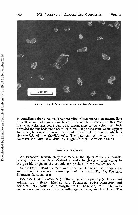
Because of the angularity of the shards it is obvious that these have a different sedimentary history from the "normal" sediment. The same holds for the ferromagnesian minerals with adhering volcanic glass. To investigate the "transport history" of these grains an abrasion test was carried out on one of the samples. This sample is fine grained and is classed as a sandy siltstone. The sediment was tumbled for 40 hr, equalling a travelling distance of 35 km. After this treatment, the shards did not show appreciable abrasion. Hereafter some pebbles were added to the same sample and tumbled for another 13 hr (equivalent to 11'5 km). Following this treatment the shards showed considerable rounding and disintegration into smaller particles (Figs. 5A, 5B), the ferromagnesian minerals having lost most of their adhering glass. The ferromagnesian minerals themselves did not show any noticeable abrasion.
This result indicates that the volcanic particules could not have gone through a high energy environment like a river or a beach, as otherwise the particles would have been worn. Some transport within the basin, however, undoubtedly took place as the volcanic ash material is mixed with detrital sediment. The absence of any sign of wear indicates that the volcanic grains were brought into the basin as an ash shower.
Dow
nloa
ded
by [
Ein
dhov
en T
echn
ical
Uni
vers
ity]
at 1
9:09
18
Nov
embe
r 20
14

696 N.Z. JOURNAL OF GEOLOGY AND GEOPHYSICS VOL. 11
FIG. 2-Photomicrograph of shards from a sample near Grunard Road.
PETROLOGY
The volcanic ash material of the Grunard Road samples consists, in order of decreasing abundancy, of glass shards, orthopyroxenes, clinopyroxenes, and hornblendes.
Shards Most of the shards are almost colourless glass, although a faint brownish
tint may be observed when they are compared with clear quartz crystals. A small percentage of the shards, however, has a light to dark brown colour. These coloured shards show weak magnetism and could only be concentrated by magnetic separation. They are found in the magnetic fraction 1°0 to 1°5 A. The almost colourless shards have a refractive index lower than 1°503. According to Challis (1962) shards of such a low refractive index are rhyolitic. Some of the darker coloured shards, however, have a refractive index slightly higher than 1°510 and are andesitic.
Orthopyroxenes
The crystals are idiomorphic to hypidiomorphic and have a light brown colour in ordinary light. Under the polarising microscope the grains show a distinct pleochroism (Z = brown, Y = green). The crystals have many inclusions, mainly magnetic. Because of these inclusions, orthopyroxenes are
Dow
nloa
ded
by [
Ein
dhov
en T
echn
ical
Uni
vers
ity]
at 1
9:09
18
Nov
embe
r 20
14

No.3 VAN DER LINGEN - VOLCANIC ASH DEPOSITS 697
0·5 mm
f
o
FIG. 3-Photomicrograph of ferromagnesian minerals from a sample near Grunard Road. O-orthopyroxene; C- clinopyroxene; H--hornblende.
found in almost all the magnetic fractions, even in the fraction removed with the hand magnet. Crystals without magnetite inclusions only occur in the magnetic fraction 0·6-1·0 A. No orthopyroxenes were found in fraction 1·0-1·5 A.
The optic axial angle (2V",) was determined with the universal stage and lies between 60° and 65°. The maximum refractive index (ny) is between 1·712 and 1·734. These data place the orthopyroxene in the hypersthene range (FssO-Fs50) (Deer, Howie, and Zussman, 1963, p. 28, fig. 10).
ClinopyroxeneJ
The crystals are idiomorphic to hypidiomorphic. Many grains are fragments of larger crystals. The grains are green in both ordinary and polarised light. Pleochroism is absent or very weak. The crystals have fewer inclusions than the orthopyroxenes. All the magnetic fractions contain clinopyroxenes.
The optic axial angle is about 55°. The intermediate refractive index (nf3) is between 1·696 and 1·712. These data, plotted on the triangular diagram for clinopyroxenes indicate a composition of about EnS5Fs35WOaO (Deer, Howie, and Zussman, 1963, p. 1, fig. 1; p. 132, fig. 41).
Dow
nloa
ded
by [
Ein
dhov
en T
echn
ical
Uni
vers
ity]
at 1
9:09
18
Nov
embe
r 20
14

698 NZ. JOURNAL OF GEOLOGY AND GEOPHYSICS VOL.1l
Hornblende
The hornblende crystals form only a small percentage of the ferromagnesian minerals. The grains are idiomorphic. In reflected light the grains have a black, opaque appearance. Under the polarising microscope the grains show pleochroism in brown and green colours. Extinction angle CAZ is 16°. Like the pyroxenes, some of the crystals have glass adhering to them. The crystals have very few inclusions and are remarkably fresh. They are more magnetic than the pyroxenes.
Pla/iiociase The plagioclase is mainly andesine. But it is not possible to determine
whether these are derived from a volcanic ash shower or belong to the normal sediment of the Silver Range Sandstone. In other samples of the Silver Range Sandstone, which show no evidence of volcanic ash showers, the plagioclases range from oligoclase to andesine.
The tuff from Kairakau Road is too fine grained to allow detailed microscopic determinations. High power magnification shows mainly shards and rare quartz. The few grains of the heavy mineral fraction are mainly hypersthene and biotite.
FIG. 4-Photomicrograph of an orthopyroxene crystal with adhering volcanic glass.
Dow
nloa
ded
by [
Ein
dhov
en T
echn
ical
Uni
vers
ity]
at 1
9:09
18
Nov
embe
r 20
14
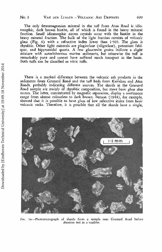
No.3 VAN DER LINGEN - VOLCANIC ASH DEPOSITS 699
The only ferromagnesian mineral in the tuff from Atua Road is idiomorphic, dark brown biotite, all of which is found in the heavy mineral fraction. Small idiomorphic zircon crystals occur with the biotite in the heavy mineral fraction. The bulk of the light fraction consists of volcanic glass (Fig. 6) with a refractive index lower than 1'503. The glass is rhyolitic. Other light minerals are plagioclase (oligoclase), potassium feldspar, and bipyramidal quartz. A few glauconite grains indicate a slight mixture with autochthonous marine sediments, but otherwise the tuff is remarkably pure and cannot have suffered much transport in the basin. Both tuffs can be classified as vitric tuffs.
There is a marked difference between the volcanic ash products in the sediments from Grunard Road and the tuff beds from Kairakau and Atua Roads, probably indicating different sources. The shards in the Grunard Road sample are mainly of rhyolitic composition, but more basic glass also occurs. The latter, concentrated by magnetic separation, display a continuous range from almost colourless to dark brown. Benson (1944), for example, showed that it is possible to have glass of low refractive index from basic volcanic rocks. Therefore, it is possible that all the shards have a single,
FIG. SA-Photomicrograph of shards from a sample near Grunard Road before abrasion test in a tumbler.
Dow
nloa
ded
by [
Ein
dhov
en T
echn
ical
Uni
vers
ity]
at 1
9:09
18
Nov
embe
r 20
14
700 N.Z. JOURNAL OF GEOLOGY AND GEOPHYSICS VOL.lI
FIG. 5B-Shards from the same sample after abrasion test.
intermediate volcanic source. The possibility of two sources, an intermediate as well as an acidic volcanism, however, cannot be dismissed. In this case the acidic volcanism could well be a continuation of the volcanism which provided the tuff beds underneath the Silver Range Sandstone. Some support for a single source, however, is found in the lack of biotite, which is characteristic of the rhyolitic tuffs. The petrology of the tuff beds of Kairakau and Atua Road definitely suggests a rhyolitic volcanic source.
POSSIBLE SOURCES
An extensive literature study was made of the Upper Miocene (Taranaki Series) volcanism in New Zealand in order to obtain information as to the possible origin of the volcanic ash products in the Makara Basin.
In the North Island the main volcanism was of intermediate composition and is found in the north-western part of the island (Fig. 7). The most important functions are:
Beeson's Island Volcanics (Brothers, 1965; Couper, 1953; Fraser and Adams, 1907; Healy, Schofield, and Thompson, 1964; Henderson and Bartrum, 1913; Kear, 1959; Morgan, 1924; Thompson, 1960). The rocks are andesitic and dacitic breccias, tuffs, agglomerates, and lava flows. The
Dow
nloa
ded
by [
Ein
dhov
en T
echn
ical
Uni
vers
ity]
at 1
9:09
18
Nov
embe
r 20
14

No.3 VAN DER LINGEN - VOLCANIC ASH DEPOSITS 701
FIG. 6-Photomicrograph of a thin section of the Atua Road tuff .
main ferromagnesian minerals are orthopyroxene, clinopyroxene, and hornblende in varying proportions. Plagioclase ranges from andesine to labradorite. Correlated with the Beeson's Island volcanics are the Kiwitahi Volcanics (Kear, 1959), and the Wairakau andesite (Bell and Clarke, 1909; Ferrar, 1925; Kear, 1959; Kear and Hay, 1961; Thompson, 1961).
Dacite Series (Henderson and Bartrum, 1913; Kear, 1959) . These rocks are thought to be younger than the Beeson's Island Volcanics, but probably still Upper Miocene. The formation contains glassy dacite flows, dacitic crystal tuffs and breccias, and andesitic breccias. Ferromagnesian minerals are orthopyroxene, clinopyroxene, and hornblende. The glass is clear and colourless. No data on the refractive index of the glass could be found. The distribution of the Dacite Series is given by Kear (1959). On 1 : 250,000 sheet 5, Rotorua (Healy, Schofield, and Thompson, 1964) the formation is included in the Waitawheta Dacites. Correlated with the Dacite Series are the Parahaki Volcanics (Brothers, 1965; Ferrar, 1925; Kear, 1959; Kear and Hay, 1961; Thompson, 1961).
Of less importance are two small remnant cones of hornblende andesite, the Orangiwhao Volcanics (Henderson and Grange, 1926; Kear, 1959, 1960).
According to their age and petrography, both the Beeson's Island Volcanics as well as the Dacite SeCIes could have been sources for the volcanic ash in the Grunard Road samples.
Dow
nloa
ded
by [
Ein
dhov
en T
echn
ical
Uni
vers
ity]
at 1
9:09
18
Nov
embe
r 20
14

702 N.z. JOURNAL OF GEOLOGY AND GEOPHYSICS
Beeson·s Island Volca nics
2 Kiwitahi Volcanics
3 Wa irakau Volcan ics
4 DaCite Series (Waita wheta DaCites)
5 Parahaki Volcan ics
6 Orangiwhao VolcaniCs
7 Dunedin Volcan ic Complex
8 Wa ip iata VolcaniCS
9 Harper Hills Volcanics
10 Gebbie s Pass Rhyolite
II RhyolitiC Tuff beds
Ihngton
o 100 200 3OOM
.,
VOL. 11
East Cape
Bas in
I-I __ ~---JI'--~ __ ..JI'--_~_..JI I es o ,Jo 2Jo 3bo 460 Kilo meters
FIG. 7-Distribution of Upper Miocene (Taranaki Series) volcanic rocks in New Zealand.
Dow
nloa
ded
by [
Ein
dhov
en T
echn
ical
Uni
vers
ity]
at 1
9:09
18
Nov
embe
r 20
14
No.3 VAN DER LINGEN - VOLCANIC ASH DEPOSITS 703
In the South Island Upper Miocene volcanism is mainly found round Dunedin and near Christchurch (Gregg and Coombs, 1965). Except for the Gebbies Pass Rhyolite, the rocks are mainly basic to ultrabasic. The main formations are:
Dunedin Volcanic Complex (Benson, 1944; Coombs, 1965; McKellar, 1966). The rocks are basic to ultrabasic. The ferromagnesian minerals are mainly clinopyroxene and olivine. The combination orthopyroxene-clinopyroxene appears to be rare. Correlated with the Dunedin Volcanic Complex are the Waipiata Volcanics (Coombs, 1965; Mutch, 1963).
Harper Hills Volcanics (Gregg, 1965; Oborn and Suggate, 1959). The rocks are mainly basaltic.
Gebbies Pass Rhyolite (Liggett and Gregg, 1965; Oborn and Suggate, 1959; Speight, 1935). The Gebbies Pass Rhyolite is part of the Banks Peninsula Volcanics. Its age is not certain, but is more probably Miocene.
The petrography of the South Island volcanics makes it unlikely that they provided the volcanic ash in the Grunard Road samples.
All along the east coast of the North Island tuff beds and tuffaceous beds are found intercalated in Miocene sediments as well as in older and younger formations (Ghent and Henderson, 1966; Grindley, 1960; Henderson and Ongley, 1920; Kear, 1957; Kingma, 1960, 1962, 1964; Lillie, 1953; Ongley, 1930, 1935). Most of them described so far, appear to be rhyolitic. The tuff beds in the Makara Basin are part of them. Little rhyolitic volcanism is known during Miocene time. A few rhyolitic tuffs and plugs are mentioned in the Parahaki Volcanics (Brothers, 1965) and in the South Island only the small occurrence at Gebbies Pass is known. They can hardly be accepted as a possible source for the extensive ash beds along the east coast.
Kear (1957) inferred a source to the south or south-east for volcanic ash beds of pumiceous character in the Upper Miocene (uppermost Southland to Taranaki Series) sediments along the east coast. This was based on two observations, firstly the pumice becoming less prominent northwards and secondly, no pumice material being found in sediments along the west coast of the North Island. Later data, however, recorded previously unknown rhyolitic tuffaceous horizons in Upper Southland and Taranaki strata further to the north, in the East Cape area (Kingma, 1965). Therefore the most likely source direction of these volcanic ash beds is to the east.
CONCLUSIONS
If the source of the intermediate volcanic ash in the Silver Range Sandstone samples near Grunard Road was within the New Zealand area, it was probably in the north-west of the North Island, either the Beeson's Island Volcanics or the Dacite Series.
Because little rhyolitic volcanism of Upper Miocene age is known in the New Zealand land area, a source area outside the present coastline has to be considered for the rhyolitic tuff beds along the east coast of the North Island, including those of the Makara Basin. Various authors (Kingma, 1958, 1962, 1964, 1965; Kuenen, 1960) have suggested the former existence of land to the east of the present coastline.
Geology--13
Dow
nloa
ded
by [
Ein
dhov
en T
echn
ical
Uni
vers
ity]
at 1
9:09
18
Nov
embe
r 20
14

704 NZ. JOURNAL OF GEOLOGY AND GEOPHYSICS VOL.l1
Thus the rhyolitic tuff beds along the east coast probably had their source area to the east of the present coastline. Sporadically, however, more basic ash showers from the north-west of the North Island reached the Makara Basin.
ACKNOWLEDGMENTS
Dr J. T. Kingma of the New Zealand Geological Survey visited me in the field. For discussions at the localities as well as in the laboratory and for his critical reading of the manuscript I am very grateful. Thanks are also expressed to Dr R. P. Suggate of the New Zealand Geological Survey and Dr D. Shelley of the University of Canterbury for reading the manuscript and offering many helpful suggestions.
BELL, J.
BENSON,
REFERENCES
M.; CLARKE, E. DE C 1909: The geology of the Whangaroa subdivision, Hokianga division. N.Z. geol. Surv. Bull. n.s. 8.
W. N. 1944: The basic igneous rocks of eastern Otago and their tectonic environment. Part IV. Trans. R. Soc. N.Z. 74 (1) : 71-123.
BROTHERS, R. N. 1965: Coromandel Peninsula. In THOMPSON, B. N.; KERMODE, L. O. New Zealand Volcanology; Northland, Coromandel, Auckland. Dep. scient. indo Res., Wellington. Information Series 49.
CHALLIS, G. A. 1962: Mineralogy of Selected North Island Pumices and Ash Showers. In WELLMAN, H. W. Holocene of the North Island of New Zealand: A Coastal Reconnaissance. Trans. R. Soc. N.z. Geol. 1 (5): 90-9.
COOMBS, D. S. 1965: Dunedin Volcanic Complex and Waipiata Volcanic Formation (Upper Miocene to Early Pliocene). In THOMPSON, B. N.; KERMODE, L. O. New Zealand Volcanology; South Island. Dep. scient. indo Res., Wellington. Information Series 51.
CoUPER, R. A. 1953: Plant microfossil dating of some N.Z. Upper Tertiary volcanic rocks. N.z. 11 Sci. Technol. B, 34: 373-77.
DEER, W. A.; HOWIE, R. A.; ZUSSMAN, ]. 1963: "Rock Forming Minerals. Vol. 2. Chain Silicates." Longman Green, London.
FERRAR, H. T. 1925: The geology of the Whangarei - Bay of Islands subdivision, Kaipara Division. N.z. gwl. Surv. Bull. n.s. 27.
FOLK, R. L. 1965: "Petrology of Sedimentary Rocks." Hemphill's, Austin, Texas.
FRASER, C; ADAMS, J. H. 1907: The geology of the Coromandel subdivision, Hauraki, Auckland. N.Z. geol. Surv. Bull. n.s. 4.
GHENT, E. D.; HENDERSON, R. A. 1966: Petrology, sedimentation, and paleontology of middle Miocene, graded sandstones and mudstones, Kaiti Beach, Gisborne. Trans. R. Soc. N.z. Geol. 4 (7) : 147-69.
GREGG, D. R. 1965: Geology of the Harper Hills. In THOMPSON, B. N.; KERMODE, L. O. New Zealand Volcanology; South Island. Dep. scient. indo Res., Wellington. Information Series 51.
GREGG, D. R.; COOMBS, D. S. 1965: Volcanism in the South Island. In THOMPSON, B. N.; KERMODE, L. O. New Zealand Volcanology; South Island. Dep. scient. indo Res., Wellington. Information Series 51. .
GRINDLEY, G. W. 1960: Sheet 8-Taupo (1st ed). "Geological Map of New Zealand 1 : 250,000." N.Z. Dep. scient. indo Res., Wellington.
HEALY, J.; SCHOFIELD, J. C; THOMPSON, B. N. 1964: Sheet 5-Rotorua (Ist ed.). "Geological Map of New Zealand 1 : 250,000." N.Z. Dep. scient. indo Res., Wellington.
HENDERSON, J.; BARTRUM, J. A. 1913: The geology of the Aroha subdivision, Hauraki, Auckland. N.Z. geol. Surv. Bull. n.s. 16.
Dow
nloa
ded
by [
Ein
dhov
en T
echn
ical
Uni
vers
ity]
at 1
9:09
18
Nov
embe
r 20
14
No.3 VAN DER LINGEN - VOLCANIC ASH DEPOSITS 705
HENDERSON, J.; GRANGE, L. T. 1926: The geology of the Huntly-Kawhia subdivision, Pirongia and Hauraki divisions. N.Z. geol. SUYv. Bull. n.s. 28.
HENDERSON, J.; ONGLEY, M. 1920: The geology of the Gisborne and Whatatutu subdivision, Raukumara division. N.z. geol. SUrt}. Bull. n.s. 21.
KEAR, D. 1957: Pumice chronology in New Zealand. N.z. 11 Sci. Technol. 38 (8): 862-70.
1959: Stratigraphy of New Zealand's Cenozoic volcanism north-west of the volcanic belt. N.z. 11 Geol. Geophys. 2 (3): 578-89.
1960: Sheet 4-Hamilton (1st ed.). "Geological Map of New Zealand 1 : 250,000." N.Z. Dep. scient. indo Res., Wellington.
KEAR, D.; HAY, R. F. 1961: Sheet I-North Cape (1st ed.). "Geological Map of New Zealand 1 : 250,000." N.2. Dep. scient. indo Res., Wellington.
KINGMA, J. T. 1958: The Tongaporutuan sedimentation in central Hawke's Bay. N.z. 11 Geol. Geophys. 1 (1): 1-30.
--- 1960: The tectonic significance of graded bedding in geosynclinal sedimentary systems. Intern. geol. Congy. Copenhagen, Part XXI: 205-14.
1962: Sheet 11-Dannevirke (1st ed.). "Geological Map of New Zealand 1 : 250,000." N.Z. Dep. scient. indo Res., Wellington.
1964: Sheet 9-Gisborne (1st ed.). "Gwlogical Map of New Zealand 1 : 250,000." N.Z. Dep. indo scient. Res., Wellington.
1965: Sheet 6, East Cape (1st ed.). "Geological Map of New Zealand 1 : 250,000." N.Z. Dep. scient. indo Res., Wellington.
KUENEN, PH. H. 1960: Turbidites in Makara Basin, New Zealand. Proc. Kon. Akad. JYl" etensch. Amsterdam, Ser. B, 63 (2): 127-34.
LIGGETT, K. A.; GREGG, D. R. 1965: Geology of Banks Peninsula. In THOMPSON, B. N.; KERMODE, L. O. New Zealand Volcanology, South Island. Dep. scient. indo Res., Wellington. Information Series 51.
LILLIE, A. R. 1953: The geology of the Dannevirke 3ubdivision. N.z. geol. Surv. Bull. n.s. 46.
McKELLAR, I. C. 1966: Sheet 25-Dunedin (Ist ed.). "Geological Map of New Zealand 1 : 250,000." N.Z. Dep. scient. indo Res., Wellington.
MORGAN, P. G. 1924: The geology and mines of the Waihi district, Hauraki Goldfield, New Zealand. N.Z. geol. Surv. Bull. n.s. 26.
MUTCH, A. R. 1963: Sheet 2'l-Oamaru (1st ed.). "Geological Map of New Zealand 1 : 250,000." Dep. scient. indo Res., Wellington.
OBORN, L. E.; SUGGATE, R. P. 1959: Sheet 21-Christchurch (lsted.). "Geological Map of New Zealand 1 : 250,000." Dep. scient. indo Res., Wellington.
ONGLEY, M. 1930: Wairoa subdivision. N.z. geol. Surv. Ann. Rep. 24: 7-10. 1935: Eketahuna subdivision N.z. geol. Surv. Ann. Rep. 29: 1-6.
POWERS, M C. 1953: A new roundness scale of sedimentary particles. 1. Sedim. Petrol. 23 (2) : 117-19.
SPEIGHT, R. 1935: The geology of Gebbies Pass, Banks Peninsula. Trans. R. Soc. N.Z. 65: 305-28.
THOMPSON, B. N. 1960: Sheet 2B--Barrier (Ist ed.). "Geological Map of New Zealand 1 : 250,000." N.Z. Dep. scient. indo Res., Wellington.
---- 1961: Sheet 2A-Whangarei (Ist ed.) "Geological Map of New Zealand 1 : 250,000." N.Z. Dep. scient. indo Res., Wellington.
VAN DER LINGEN, G. J. 1968: Preliminary sedimentological evaluation of some flyschlike deposits from the Ma.kara Basin, Central Hawke's Bay, New Zealand. N.z. 11 Geol. Geophys. 11 (2): 455-77.
Dow
nloa
ded
by [
Ein
dhov
en T
echn
ical
Uni
vers
ity]
at 1
9:09
18
Nov
embe
r 20
14