vol 11 no:3 eorih sciences andmineral p-esourcesin … 11 no:3 eorih sciences andmineral...
TRANSCRIPT

Vol 11 No:3 Eorih Sciences and Mineral P-esources in Arizona Sepiember 1981
THE GE LOGICAL EXP RATION OF ARIZONAAn Historical Perspective of the State Geologie Map
By Stephen J. Reynolds
INTRODUCTION
The geological exploration of Arizona was pioneered in the latterhalf of the 1800s by geologists, such as John Wesley Powell, whoaccompanied the early expeditions into the territory. Thesegeologists found the region to be a wild and untamed frontier. Theywere confronted by enormous problems-uncharted mountainsand canyons, lack of dependable transportation (mules included),and occasional encounters with unfriendly Indians. By necessity,many of the early geologists were as much interested in theweather, watering holes, wildlife, and human inhabitants of theregion as they were in the geology. Their reports make fascinating reading and provide a vivid perspective on the Arizona ofyesterday.
As the early geologists explored Arizona, they encounteredmany new and exciting geologic features that had not been previously described. In order to fUlly document the size, shape, andcharacteristics of these features, they constructed geologic maps,drew elaborate sketches (figure 1), and wrote pages of detaileddescriptions. The geology of Arizona became more understoodthrough these efforts. Eventually, enough was known to produce ageologic map of the entire state. The first state geologic map waspublished in 1924, only 12 years after Arizona's statehood; it hasbeen revised only once in the last 57 years. This revision waspublished in 1969, but it has become significantly oUtdated bymore detailed geologic studies.
The Bureau of Geology and Mineral Technology is currently inthe initial phases of a major project aimed. at revising and updatingthe 1969 state geologic map. The need for a new state geologicmap will greatly increase in the future as our society makes additional demands on the earth and its limited resources.
THE ESSENCE OF A GEOLOGIC MAP
A geologic map is a graphic representation of the rock units andgeologic features that occur at the surface of the earth. Each areaof the earth's surface is unique and must be individually examinedand mapped. Geologic mapping can be quickly accomplished inregions of relatively uncomplicated geology, such as the ColoradoPlateau of northern Arizona. In contrast, mapping can be excruciatingly slow in southern Arizona where the geology is verycomplex. In either case, the information gained from geologic
Figure 1, State Map. "Head of the Grand Canyon," a woodcut drawn by Thomas mapping is essential to our modern-day society and its depen-Moran (from Dutton. 1882. p. 212). denee on things geologic (Peirce, 1981).
IN THIS ISSUENatural gas storage. p. 8; COSUNA, p. 9; Mine safety, p. 10; Industrial minerals, p. 11; Penrose conference, p. 11; National/regional/local events, p. 11;mineralogy, p. 12; Announcements, p. 12; Cosart, p. 12; Davenport, p. 12

Page 2 Gureau of Geology and Mineral Technology Seprember 1981
Some of the main attributes of a geologic map are illustrated bycomparing figures 2a and 2b. Figure 2a is a high-altitude aerialphotograph that shows a number of geologic features in the SanFrancisco volcanic field north of Flagstaff, Arizona. The most striking feature is a dark-colored lava flow that dominates the right halfof the photograph. The nearly circular feature at the south end ofthe lava flow is S.P. Crater, a well-preserved cinder cone fromwhich the lava flow was erupted. Surrounding S.P. Crater areseven additional dark-colored patches; these are cinder conesthat are older and not as well preserved as S.P. Crater.
Another obvious geologic feature on the photograph is the large,light-colored gray region in the center of the image. In this area,light-colored Kaibab Limestone is exposed at the surface. Surrounding the limestone exposures are dark gray volcanic rocksthat are older than S.P. Crater and its associated lava flow. Theolder volcanic rocks and adjacent limestones are traversed byconspicuous, linear features, such as valleys and ridges. Many ofthese linear features are fault zones where the rocks have beenbroken and displaced.
Figure 2b is a geologic map of the region covered by the aerialphotograph. The map is highly simplified, but accurately portraysthe general geologic features of the area. It shows the distributionof the following four rock units:' 1) volcanic rocks comprising theS.P. lava flow; 2) cinder cones, including S.P. Crater; 3) othervolcanic rocks; and 4) Kaibab Limestone.
In essence, the map outlines areas where each rock unit isexposed at the surface. Contacts between different rock units aredepicted with a thin, unbroken line, whereas a thicker line is usedto show the location of fault zones. Each asterisk on the map(figure 2b) indicates the position of a volcanic vent within a cindercone. The legend of the geologic map gives the relative ages ofthe rock units.
In addition to locating the main geologic features, the map infigure 2b provides a basis for interpreting the area's geologic history. The oldest rock unit exposed is the light-colored KaibabLimestone, which was originally deposited in an ancient sea thatcovered much of Arizona about 260 million years ago. In contrast,most of the volcanic rocks were erupted within the last millionyears. S.P. Crater and its associated lava flow were formed by aneruption less than 100,000 years ago and are, therefore, relativelyrecent by geological standards. Faulting has visibly affected allbut the youngest volcanic rocks. The relatively young age of the
faUlting and volcanism may help explain why the region experi-ences occasional small earthquakes. .
Figure 2b is but one example of a geologic map. GeologiC mapscan portray the geology of either large or small areas. For example, the geology of North America can be shown in a highlysimplified manner on a single, standard-sized map; such a map isreferred to as a small-scale map. On .the other hand, a large-scalemap may be needed to accurately depict the geology of a small,geologically complex hill. The scale chosen for a particular mapis largely dependent upon its intended use. A small-scale mapwould be used for showing the distribution of active volcanoesof North America, whereas a more detailed, large-scale mapwould be needed for evaluating the mineral potential (e.g., gold)of a small area. Most geologic maps are produced at a scalethat is intermediate between the two extremes discussedabove; geologic maps at the scale of standard U.S.G.S. 15 minuteand 7.5 minute quadrangles are perhaps most common.
There are two types of geologic mapping: reconnaissance anddetailed. In reconnaissance mapping, a geologist has a limitedamount of time in which to map the geology of a relatively largearea. Around 1920, N. H. Darton of the U.S. Geological Surveymapped nearly one third of Arizona in a scant 20 months. Darton'smapping, by neccesity, showed only the main geologic features ofthe region. However, other geologists are known to have spenttheir entire professional careers mapping in detail the geology of asingle mine or mining district. The choice between a detailed mapand a reconnaissance map is dictated by its intended use and bytime and financial constraints. A detailed map provides more information than a reconnaissance map, but requires more time,effort and money.
Geologic maps are used for numerous purposes. A goodgeologic map is essential for evaluating potential geologichazards, such as volcanic eruptions and earthquakes, because ithelps identify sites of recent volcanism and faulting. Geologicmaps also playa key role in exploration for energy, mineral, andwater resources. For example, a geologic map might indicatewhere oil-bearing rocks are exposed at the surface or, if buried,how deep they might be. Areas with high geothermal energy potential might also be located by examining a standard geologicmap. Engineering applications are too numerous to list.
Arizona is well known for its important copper industry. Nearly allof the large copper deposits in the state are associated with gran-
ROCK UNITSCENOZOIC
• S.P. Lava Flow
Cinder Cone
1::::::::::::::1 Other Volcanic Rocks
PALEOZOIC
o Kaibab Limestone
SYMBOLS---- Contact
- Fault
* Volcanic VentoIIo
Figure 2a, State Map. High-altitude aerial photograph(U-2) of part of the San Francisco volcanicfield north of Flagstaff. Arizona,
Figure 2b, State Map, Simplified geologic map of the area covered by photograph in Figure 2a.

Vol 11 No J Fieldnotes PogeJ
ites of a particular age (60 to 75 million years old). For the mostpart, granites of this age are specifically identified on the present"Geologic Map of Arizona." Areas near these granites are probably most favorable for the discovery of additional copper deposits.Geologic maps are used in analogous ways for exploration of othertypes of mineral resources. Lastly, good geologic maps are importan~ for reconstructing the natural history of the earth, includingnational and state parks, monuments, and wilderness areas.
HISTORICAL DEVELOPMENT OF THE STATEGEOLOGIC MAP
The Great Western Expeditions and Surveys (1853-1879)The origins of the Geologic Map of Arizona can be traced to the
great expeditions and surveys that explored the southwesternUnited States between 1853 and 1879. The illustrious journeys ofJohn Wesley Powell down the uncharted Colorado River in 1869and 1871 are perhaps the most familiar to Arizonans. However,geologists accompanied other expeditions, including thoseheaded by Lt. Amiel W. Whipple, Lt. Joseph C. Ives, and Capt.George M. Wheeler. In fact, some of the most famous geologists ofthe 19th century were involved in the early geological explorationof Arizona and surrounding regi·ons. These geologists included'Jules Marcou, J. S. Newberry, G. K. Gilbert, C. E. Dutton, and, ofcourse, John Wesley Powell. They had to explore unfamiliar terrainand surmount tremendous difficulties while "geologizing" thecountryside. In spite of the imposing obstacles and the limited timeavailable, these geologists made many keen observations andconclusions that remain valid to this day. Some of the most fundamental concepts of geology were first developed during thoseearly surveys.
One of the first geologists to enter Arizona was Jules Marcou. Heaccompanied the 1853 Whipple expedition as it crossed northernArizona, exploring for a railroad route along the 35th parallel.Marcou's observations were severely hampered by a series ofwinter storms that concealed the rocks beneath a shroud of~now. Nevertheless, he described vast areas containing petrified wood near the present-day location of Petrified Forest National Monument and noted that the San Francisco Mountainswere extinct volcanoes.
The second geologist to visit the San Francisco Mountains wasJ. S. Newberry of the 1857-58 Ives Expedition. This expeditiondeparted from Fort Yuma and sailed up the lower Colorado Riverin a steamship. It then traveled overland toward the San Francisco Mountains and on to Fort Defiance in the eastern part of thestate. Newberry was exuberant upon reaching the forestedColorado Plateau, after traversing the "volcanic and desertregion of the lower Colorado" (Newberry, 1861). He states (p. 59):
We had all been wearied by the monotonous prevalence ofthe products of a single destructive force [volcanism]; andthe varied and beautiful volcanic minerals so profuselyscattered over the Colorado basin, devoid of all traces oforganii)ms, and associated with the death-like sterility nowpervading all that area, had ceased to excite a pleasurablescientific interest, and had even produced a positive thirstfor life!; a longing to reach some region where nature's vitalfires had not burned out; where the varied forms of recentanimal and vegetable life adorned the earth's surface, andthe rocks below contained in their fossils a record of itsprevalence on sea and shore from the earliest ages.
This same lack of fossils in much of western Arizona continues tofrustrate geologists to this day.
Newberry's observations regarding the San Francisco Mountains are totally in accord with those of modern geologists. In reference to some of the most recent volcanic features, he states:" .. '. showing by all their surroundings that they have been in action,as It were but yesterday, and might be again tomorrow." This isundoubtedly one,of the first statements published concerning potential volcanic hazards of Arizona. Newberry also characterizes
some of the more recent lava flows as being "as little affected bythe action of the elements as slag fresh drawn from a furnace." Helikened the appearance of the San Francisco Peaks above thesurrounding plateau to "some rocky island rising from the surfaceof the sea," and indicated that the main peak is "volcanic throughout, and is, in fact, a huge volcano whose fires have been butrecently extinguished." The San Francisco volcanic field indeedcontains one of the most recently active volcanic areas in Arizona.Newberry's writings also reveal his surprise upon encountering thedeceptively hidden gorge of the Little Colorado River. While traveling upon what he thought was a "smooth and grass-coveredplain," he suddenly found himself on the brink of "a series ofcanons ... forming a labyrinth of difficulties effectually arresting ourprogress in the line we had hoped to follow." (p. 61).
In honor of Newberry's pioneering spirit, and that of his commander, Lt. J. C. Ives, many physiographic features of Arizona andCalifornia bear their names (Granger, 1960).
In 1853, a few years before the Ives expedition, the U.S. government negotiated the Gadsden Purchase from Mexico and dispatched surveys to explore the newly acquired land. Only a minoramount of geologic work was done in conjunction with these surveys. However, C. C. Parry, a scientist on the Emory Survey, madethe following key observation:
" .: ..copper is quite frequently found in connexion [sic] with porph~n!lc r?cks." (Parry, 1857, p. 21). This observation is an uncannyanticipation of our modern-day understanding that nearly all ofArizona's large copper deposits are directly associated with porphyritic rocks (i.e., a type of granitic rock that contains both largeand small crystals). In fact, the association is so strong that thedepOSits are commonly called porphyry coppers. It is important toremember that the first large copper mines at Ajo and Bisbee hadnot yet been developed when Parry made his incisive observation.
The next important geologist to arrive on the Arizona scene was~ohn Wesle~ Powell. Powell is probably best known for his pioneerIng exploration of the Colorado River and Grand Canyon. Howe~e:, ~.e rer:nained an influential figure in Arizona geology long afterhiS Initial tnps down the Colorado River in 1869 and 1871. He wasin charge of a government-sponsored survey that continued toexplore northern Arizona until around 1879. Powell was instrumental in the creation of the U.S. Geological Survey (U.S.G.S.) andserved as its second director (Bartlett, 1962).
Powell's initial journey down the uncharted Colorado River in1869 is a hallmark of adventure, courage, and persistence. Powelland his companions never knew what dangers lay before them,what evil tidings were borne by the distant rumble of rapids, orwhether their provisions and patience would hold out for an unknown number of days. In his fascinating book, Canyons of theColorado, Powell (1895) writes (p. 247):
The flour has been resifted through the mosquito-net sieve;the spoiled bacon has been dried and the worst of it boiled'the few pounds of dried apples have been spread in th~sun and reshrunken to their normal bulk. The sugar has allmelted and gone on its way down the river. But we have alarge sack of coffee....
We are three quarters of a mile in the depths of the earth,and the great river shrinks into insignificance as it dashesits angry waves against the walls and cliffs that rise t6 theworld above; the waves are but ripples, and we but pig-mies, running up and down the sands or lost among theboulders.
We have an unknown distance yet to run, an unknownriver to explore. What falls are there, we know not; whatrocks beset the channel, we know not; what walls rise overthe river, we know not. Ah, well! We may conjecture manythings. The men talk as cheerfully as ever; jests are bandied about freely this morning; but to me the cheer issomber and the jests are ghastly.
In spite of such unavoidable apprehensions, Powell was alwayscarefully observing the geology of the canyon. His thoughts were

Page 4 Oureau of Geology and Mineral Technology September 1981
•
generally occupied by the large-scale features and problems,rather than by the specific characteristics of a single rock type; hisvision and imagination were uncluttered by detail. While ponderingsome fairly recent lava flows that had spilled over the sides of thecanyon, Powell envisioned the following: "What a conflict of waterand fire there must have been here! Just imagine a river of moltenrock running down into a river of melted snow. What a seethingand boiling of the waters; what clouds of steam rolled into theheavens!"
A number of features in the canyon were originally named byPowell and his men. These include Bright Angel Creek, MarbleCanyon, and Lava Falls.
After his two river excursions, Powell organized a survey to explore the Colorado Plateau around the Grand Canyon. The PowellSurveys included two famous geologists, Clarence E. Dutton andG. K. Gilbert. Dutton's 1882 treatise on the Grand Canyon 'is replete with eloquent, flowing prose and exquisite illustrations. A fewof Dutton's vivid passages are quoted below.
In reference to cliffs formed of Jurassic Navajo Sandstone,Dutton wrote (p. 36):
It might be imagined that such fronts would be monotonous and tame, and once seen would soon lose all interest.Let us not underrate the versatility and resources of Nature,nor question her good taste, for she has made these walls asfull of life, variety, and expression as any others, and yet hasconserved the noble dignity of which simplicity is anessential part ... [the sandstones] often weather into domesand half-domes of bald, white rock which look [sic] a calmdefiance of human intrusion. Occasionally, the austerity ofthese forms is exchanged for those of the opposite extreme, as if nature were tired and impatient of all this solemn dignity, and the proverbial step from the sublime tothe ridiculous is actually taken ... we shall perceive numberless rock-forms of nameless shapes, but often grotesqueand ludicrous, starting up from the earth as isolated freaksof carving or standing in clusters and rows along the whitewalls of sandstone. They bear little likeness to anything wecan think of, and yet tease the imagination to find something whereunto they may be likened. Yet the forms are in acertain sense very definite, and many of them look merryand farcical. It is a singular display of Nature's art mingledwith nonsense.
Upon examining the extinct volcanoes along the north rim of theGrand Canyon, Dutton comments (p. 83): "We wonder what theirage may be; what time has elapsed since they vomited fire andsteam."
In reference to Point Sublime on the north rim (which Dutton firstnamed), he writes (p. 142): "Great innovations, whether in art orliterature, in science or in nature, seldom take the world by storm.They must be understood before they can be estimated, and mustbe cultivated before they can be understood."
Dutton's 1882 monograph is heartily recommended to anyonewho is interested in 100-year old descriptions and illustrations of theGrand Canyon.
A contemporary of the Powell Survey was the U.S. Army'sWheeler Survey that explored parts of northern and easternArizona. At one time or another, the survey was accompanied byseveral geologists, including G. K. Gilbert. Like other surveys, theWheeler expedition had its share of difficulties. Around Canyon DeChelly, the Wheeler Survey encountered rain storms, fields of mud,rattlesnakes, and poisonous, five-inch-long centipedes that had ateridencyto take refuge in their bed clothes (Bartlett, 1962, p. 360).In addition, several of Wheeler's men were killed in an ambushby Mohave Indians. Nevertheless, the science and explorationwent on.
In 1879, the various surveys were consolidated into the U.S.Geological Survey. The Powell and Wheeler Surveys were discontinued, bringing to a close the first phase of geological explorationin Arizona.
Geologic Studies Between 1879 and 1924
Creation of the U.S. Geological Survey in 1879 resulted in greatlyintensified study of the geology and mineral resources of Arizona.Much research was also carried out by scientists and engineers ofthe University of Arizona from 1891 onward. T. B. Comstock, firstPresident of the University, wrote several articles on Arizona geology and emphasized-in 1895-the need for a geologic map ofthe territory. Arizona became a state in 1912 and the ArizonaBureau of Mines, predecessor to the present Bureau of Geologyand Mineral Technolqgy, was established in 1915, with offices atthe University'of Arizona. The Bureau and the U.S.G.S. jointly pUblished the first "Geologic Map of the State of Arizona" in 1924.
A number of exceptional geologic studies were completedbetween 1879 and 1924. Many of their conclusions have beenverified by 60 to 100 years of additional scientific research. Theclassic publications of F. L. Ransome, Waldemar Lindgren, N. H.Darton, and L. F. Noble are representative of this timeperiod. Geologic studies of this era may be subdivided into fourgeneral types:
1) Regional geologic reconnaissance2) Geologic research on mineral deposits and their surrounding
areas3) Regional reconnaissance concerning water supplies4) Detailed research on rock units, minerals, and fossilsThese four types of geologic studies are discussed in more detailbelow.
The first type, regional geologic reconnaissance, consisted of amore-or-less cursory examination of a large area, These studiesincluded a variable amount of detailed investigation of the rocks'and their relationship to mineral deposits and water resources. Bynecessity, the geologic maps produced by these pioneering regional geologists were quite generalized and thus subject to laterrefinements. However, these maps were the first all-important steptoward accurately depicting the geology of the state. Such reconnaissance maps formed the basis for the first state geologic map.
An excellent example of this type of regional study is N. H.Darton's 1910 reconnaissance of northern Arizona and northwestern New Mexico. Darton's report contains a geologic map of a100-mile strip of land from Albuquerque to Kingman. It is in thisreport that Darton (1910) first proposed the names Kaibab limestone, Coconino Sandstone, and Supai Formation for the upperrock layers of the Grand Canyon. These names have been used bygeologists ever since.
Northern Arizona was the site of two other regional geologicstudies during this period. H. H. Robinson mapped and describedthe geology of the San Francisco Mountains, focusing on theabundant volcanic features. The three periods of volcanism recognized by Robinson (1913) are still discussed today. Robinsonspent much time pondering whether the'volcanic field was extinctor simply dormant. This haunting question remains unanswered.East of the San Francisco Mountains, H. E. Gregory was investigating the regional geology of northeastern Arizona. Gregory (1917)describes the countryside as haVing few roads, virtually no satisfactory maps, only minor amounts of safe water, and an unfriendlyIndian population. He goes on to state (p. 9): "Geological fieldwork in such a country is necessarily reconnaissance; some of it, infact, is exploratory."
The second type of geologic study was concerned with mineraldeposits and their surroundings. These studies generally includeddetailed mapping of the surface and subsurface geology of theindividual mines or mining districts, In several notable cases, theregion surrounding the mines was also mapped in relative detail.F. L. Ransome's geologic maps of areas around Globe, Ray, Bisbee, and Oatman have remained untarnished by 60-70 years ofadditional research. In addition, many geological formations originally named by Ransome (1903, 1904) are still widely recognized.For example, Ransome named the Pinal Schist, Apache Groupand Bolsa Quartzite, rock units that are familiar to most Arizona

Vol 11 No 0 . Fieldnotes PageS
geologists. A contemporary of Ransome was Waldemar Lindgren,a famous economic geologist. Lindgren's 1905 geologic map ofthe Clifton-Morenci area has likewise surviVed years of scrutiny.Ransome's and Lindgren's maps were incorporated, virtually without modification, into both the 1924 and 1969 state geologic maps.
The third type of geologic study examined the relationship between regional geology and water supplies. The resulting reportsgenerally described in detail the locations of watering holes, butwere less concerned with the geology. In those days, water was amore immediate concern than rocks. Good examples of this typeof study are the publications of W. T. Lee (1905, 1908), C. P. Ross(1923), and H. E. Gregory (1916). Lee (1908) examined the waterresources of northwestern Arizona and summarized his findings asfollows: "Conditions were found so unfavorable for water development in this region that the economic results of the work areunimportant, or at best have negative value."
One of the more interesting water-related studies was KirkBryan's 1925 report on the geology and water supplies of thePapago country of southern Arizona. In addition to geology,Bryan's report contains excellent descriptions of the landscape,vegetation, and wildlife. Bryan refers to the Gila Monster as "a bigclumsy lizard ... [that is] sluggish and difficult to annoy but has abrutish temper and a grip like a bulldog." He describes the packrat as a "bold marauder in camps" that will carry off anything that isloose, returning with "rubbish of various kinds which he leaves inplace of the pilfered articles, hence one of his names is 'trade rat.'''Bryan discusses kangaroo rats in the following manner (p. 51):" ... several [kangaroo rats] came into camp which was lighted bya large fire. In spite of being shot at several times they persisted incoming back, and one was finally caught in the hand. The forelimbs are much smaller than the hind limbs, but are doubtlessused more in walking than one would judge by the tracks. Certainlythese individuals, when investigating the Survey camp, went on allfours." Clearly, Bryan's scientific curiosity was not limited to geology.
The fourth type of geologic study was the detailed descriptionand analysis of rocks, minerals, and fossils. C. D. Walcott's research in the Grand Canyon from 1880 to 1895 is exemplary of thistype of detailed study. Walcott published a number of articlesdiscussing the rock units and fossils of the canyon. Several important rock units in the canyon are still recognized by names thatwere originally proposed by Walcott.
The 1924 State Geologic Map
The years 1918 to 1924 represent an important time period in thehistory of the state geologic map. In 1918, geologist G. M. Butlerreplaced prominent mining engineer C. F. Willis as director of theArizona Bureau of Mines. At that time, Butler was also Dean of theCollege of Mining and Engineering at the University of Arizona.Under Butler's direction, the Bureau began to assume its presentrole as a state geological survey. The Bureau restructured itspriorities and directed most of its efforts toward production of areconnaissance geologic map of the entire state. In 1919, theBureau and the U.S. Geological Survey entered into a cooperativeagreement to jointly produce the map. The U.S.G.S. assigned itsmost experienced reconnaissance mapper, N. H. Darton, to coordinate the project. Darton spent a total of 20 months in the fieldbetween 1919 and 1922, and, in the process, mapped the geologyof approximately a third of the state. Darton was assisted by several Bureau geologists, including Eldred D. Wilson, Carl Lausen,and Olaf P. Jenkins. Lausen and Wilson are credited with mappingnearly all of southwestern Arizona. For northeastern Arizona,Darton relied extensively on the previous geologic mapping ofH. E. Gregory. As mentioned earlier, the geologic maps ofRansome and Lindgren were incorporated into the state mapwithout major modification.
The field work for the map was finished in 1922 and the map waspublished in 1924 (Darton and others, 1924). The map is mostlya reconnaissance geologic map, although not labeled as such.Much of the geologic mapping was done from horseback, horse
and wagon or Model T. Due to the limited time and access, severalmountain ranges in southwestern Arizona were probably mappedin a single day, or less. In areas of most difficult access, the geology may have been sketched from a distance using binoculars.There was simply too much area, too few geologists, and too littletime to feasibly map every range in the detail or accuracy desired.For example, a large number of mountain ranges in westernArizona are simply shown on the 1924 map as "granite." Moredetailed mapping in some of these ranges has revealed the predominance of other rock types, suc;h as limestone, sandstone, andvolcanic rocks. However, the geology of other areas was shownalmost exactly as we know it today! In all, the 1924 state map is aremarkable accomplishment considering the circumstances underwhich it was produced. Its chief compiler and contributor, N. H.Darton, will long be remembered as one of the foremost geologiststo have worked in Arizona.
Geologic Studies Between 1924 and 1969
Publication of the state geologic map in 1924 was an importantmilestone in the geological exploration of Arizona. The entire statehad now been mapped, albeit in a very cursory and over-simplifiedway. Geologists finally had a map of the whole state that they couldstudy while trying to unravel Arizona's geologic history. The slowand deliberate process of improving and updating the state mapcould now proceed. Between 1924 and 1969, nearly all areas ofthe state were remapped in more detail. The resulting 1969"Geologic Map of Arizona" (Wilson and others, 1969) bears littleresemblance to its 1924 predecessor.
An appropriate point of departure in this discussion is Darton's1925 publication entitled, "A Resume of Arizona Geology." In thisreport, Darton summarizes the geologic history of Arizona andpresents many cogent observations that he made while mapping.Darton wrote the text in 1923 immediately after completing fieldwork on the state map. The resume, in conjunction with state map,provides a useful record of what was known about Arizona geology in 1923-24. It is a remarkable scientific work that remains animportant contribution to Arizona geology. To this day, Darton'sdescriptions and cross-sections constitute the only published information for certain parts of western Arizona. Modern-daygeologists still have much to gain by reading this classic summaryof Arizona geology.
Arizona experienced a surge of geological activity after 1924.The U.S. Geological Survey, Arizona Bureau of Mines and University of Arizona were responsible for most of the geologicalresearch published between 1924 and 1969. Geologic studiesconducted by the U.S.G.S. during this time period fall into severaldistinct categories. First, the Survey mapped a number of keyquadrangles near important mining districts in southern and central Arizona. Representative examples of this type of study arethe publications of James Gilluly (1937) on the Ajo area, C. A.Anderson (1950,1951), on Jerome and Bagdad, J. R. Cooper (1960)on southeastern Arizona, and N. P. Peterson (1962) on the GlobeMiami area. Important quadrangles were also mapped by M. H.Kreiger, S. C. Creasey, P. T. Hayes, J. R. Cooper, and H. Drewes.These quadrangle studies provided essential information aboutArizona's mineral deposits and their geologic setting.
The second type of U.S.G.S. study was concerned with the relationship between geology and water resources. The publicationsof M. E. Cooley, J. W. Harshbarger, L. C. Halpenny, and C. A.Repenning established much of what we presently know about thelayered rocks of northeastern Arizona (Harshbarger and others,1957). U.S.G.S. geologists L. A. Heindl and D. G. Metzger contributed much information about the relatively recent geologic histories of southern and western Arizona, respectively.
The Arizona Bureau of Mines continued its emphasis ongeologic mapping. In 1933, Eldred D. Wilson published a map anddiscussion of the geology and mineral resources of southern YumaCounty. Wilson mapped this hitherto unknown area of southwestern Arizona from 1929-1932. In the process, he discovered a new

Page 6 Gureau of Geology and Mineral Technology ~eprember1981
set of mountains that had been overlooked by previous geologistsand explorers. He named this range the Butler Mountains after G.M. Butler, former Director of the Bureau and Dean of the College ofMining and Engineering (Wilson, 1931). Wilson was the first personto describe and map the geology of a large number of mountainranges in southwestern Arizona. The data from Wilson's 1933geologic map were incorporated into the 1969 state geologic map.
J. D. Forrester became director of the Bureau in 1956 and supported intensified work on a new state geologic map. Bureaugeologists, E. D. Wilson, R. 1. Moore, and H. W. Peirce, beganmapping selected areas in more detail. As before, the U.S.G.S.agreed to cooperate on the state map project.
The University of Arizona continued its tradition of research onthe geology and mineral resources of Arizona. Professors A. A.Stoyanow, E. D. McKee, B. S. Butler, J. F. Lance, E. B. Mayo, andtheir students contributed many important ideas.
An important development in the geological exploration ofArizona was the advent of radiometric techniques for determiningthe actual ages of rocks in millions of years. The contributions ofUniversity of Arizona professor Paul E. Damon cannot be overemphasized in this regard. He and his colleagues have determinedthe ages of hundreds of rock units throughout the state. In manycases, these age determinations have drastically modified ourperception of the geologic history of Arizona. Future geologicmaps of the state will be significantly different from previous maps,simply because of these new age assignments. L. 1. Silver of theCalifornia Institute of Technology and R. F. Marvin and E. H.McKee of the U.S.G.S. have also been important in determiningthe ages of some Arizona rocks.
The 1969 State Geologic MapThe Arizona Bureau of Mines, in cooperation with the U.S.G.S.,
Darton and others (1924 state map)Lee (1908)
+++++++++++++
++++++++++++++++++++++++
++++++++++++++++++++++++++++++++++
++++++++++++++++++++++++++++++++++++++++++
+++++++++++++++++++++++.+++++++++++++++++++++++++++++++++++++++++++++++++
++++++++++++++++++++++++++++++++++++++++++++++++++++++++++++++++++++++++++++++++++++++++++++++++++++++++
+++++++++++++++++++++++++++++++++++++++++++++++++++++++++++++++++++++++++++++++++
++++ +++++++++++++++++++++++++++++++++++++++++++++++++++++++++++++++++++++++++++++++++++++++++++++++++++++++++++++++++++++++++++++++++++++++++++++++++++++++++++++++++++++++++++++++++++++++++++++++++++++++++++++++++++++++++++++++++++++++++++++++++++++++++++++++++++++++++++++++++++++++++++++++++++++++++++++++++++++++++++++++++++++++++++++++++++++++++++++++++++++++++++++++++++++++
Salome
Wilson and others (1969 state map) Reynolds and others (1980)Figure 3, State Map. Evolution of geologic mapping for the western Harquahala and Little Harquahala Mountains, west-central Arizona.
rnJ\&.il

Vol 11 No J Fieldnores Page 7
PALEOZOIC E\(:;..<l Sedimentary Rocks
? ~ MILES
o~1:;::1~-:'I::;,=!:-K'-IL.....OMET ERS
county geologic maps was published by 1960, only four yearsafter initiation of the project. In 1962, Eldred Wilson's version of"A Resume of the Geology of Arizona" was published to accompany the county map series.
The U.S.G.S. was responsible for compiling a state geologicmap from the county maps provided by the Bureau. The Surveymodified the reconnaissance geology on the county maps withmore recent Survey mapping when it was available. The resulting"Geologic Map of Arizona," published in 1969 by the ArizonaBureau of Mines and the U.S. Geological Survey (Wilson andothers, 1969), was a great improvement over the original 1924state map.
THE FUTURE OF THE STATE GEOLOGIC MAP
What does the state map's past foretell of its future? The map'shistory would predict that the present version of the "Geologic Mapof Arizona" will become outdated by additional observations andmore detailed geologic mapping. In fact, this has already occurred. A number of dramatic new discoveries have been madesince the most recent state map was published in 1969. Thesediscoveries have nearly rendered the 1969 map obsolete for manyareas of southern and western Arizona.
The geological exploration of Arizona has greatly accelerated inthe last decade. Geologic mapping is being carried out by anumber of geologists from the U.S.G.S., the Arizona Bureau ofGeology and Mineral Technology, and various universities. "(heseongoing studies are providing a view of Arizona geology that didnot previously exist. Earlier geologists would have been highlyskeptical of the geologic features currently being described insouthern Arizona.
The ability to determine the age of rocks has greatly modifiedour understanding of Arizona's geologic history. Some large volcanic fields shown on the 1969 map as Quaternary (less than 2million years old) are now known to be more than 10-15 millionyears old. It is essential to sort out such discrepancies before wecan properly assess the potential for volcanic hazards, geothermalenergy related to young volcanism, or other features. Recent agedeterminations have also demonstrated that volcanic rocksthroughout much of western Arizona are 15-25 million years old,rather than 70 million years, as inferred by earlier geologists. Wenow know that these volcanic rocks are young enough to haveburied valuable mineral deposits that may have been exposed atthe surface prior to volcanism. The early geologists simply did nothave the benefit of such age determinations. Consequently, theypresented their best educated guesses and took their chances.However, nature still had some major surprises in store for them.For example, many geologists thought that mountain ranges inwestern Arizona were composed of some of the oldest rocks in thestate. They observed that these rocks had undergone complexhistories and had been subjected to high temperatures and pressures. They logically concluded that the rocks must be very old.However, we now know that these supposedly "old" rocks arestartlingly young. Some, in fact, are as much as 1.7 billion yearsyounger than originally thought. Such major reyisions in the agesof rock units will drastically modify how they are depicted on anyfuture geologic map.
Clearly, geologic mapping is a process of continuous refinementvia progressively more detailed study. Figure 3 reveals how onearea has been mapped by four successive geologists. Eachgeologist was able to spend more time in the area than his predecessors. Additional detailed mapping in this area has demonstrated that the most recent map shown on figure 3 is already outof date.
The Arizona Bureau of Geology and Mineral Technology is preparing to embark on a project to revise the present state geologicmap. The forthcoming state map revision project will differ significantly from previous efforts because we plan to re-map onlyselected areas of the state. The U.S.G.S. and other organizations
~~:[g{ Granitic Rocks~ Sedimentary andt::::::=j Volcanic Rockst-:J Metamorphic Rocks
H:: Granitic Rocks
Metamorphic Rocks
Steep Fault
Gently Dipping Thrust Fault
SYMBOLS
Contact Between Rock Un its
ROCK UNITS
D Surficial Deposits
[::(1 Volcanic RocksCENOZOIC
MESOZOIC
-..,.,....
PRECAMBRIAN
started work on a new state geologic map in 1956. Both agenciesagreed to map certain areas, with much of the state ultimatelybeing mapped by Bureau geologists Eldred D. Wilson and RichardT. Moore. Due to the limited time and personnel available for theproject, the mapping was still only broad reconnaissance in manyareas. Most of the mapping was done from vehicles or on foot,although horses and aerial photographs were used on occasion.As always, geologic mapping was not without its hazards. OneSunday, two Bureau geologists had permission to map on the AirForce gunnery range in southwestern Arizona. Suddenly, theywere strafed by machine-gun fire from military jets. Unsubstantiated reports suggest that the jet pilots missed the Bureau vehicleon purpose, intending only to scare away the "intruders." In spiteof such incidents, the geologic mapping of southwestern Arizonaand the rest of the state was completed by 1960.
In order to release the mapping results as rapidly as possible,the Bureau decided to publish geologic maps of each county, or oftwo adjoining counties, as they were completed. Bureaugeologists spent months in the office, transferring the geology fromtheir field maps onto county base maps. The county base mapsavailable to the Bureau were somewhat inaccurate, and tOplography on the maps had to be substantially modified for manyareas. Bureau geologists did all of the drafting and color separation for the published county maps. Bureau mineralogist, R. T.O'Haire, used modified phonograph needles and other improviseddrafting tools to prepare the maps for printing. The entire folio of

Page 8 Oureau of Geology and Mineral Technology Sepiember 1981
rare currently mapping several key areas that will not have to bere-mapped. In other areas, only the age designation of rock unitswill have to be changed from the present map. However, most ofwestern Arizona will have to be re-mapped in more detail becausethe region is geologically complex and somewhat remote. To thisday, western Arizona remains terra incognita. It is not knownhow long this mapping will take or when a revised state map willbe published. One thing is certain-for much of western Arizona,the next state map will bear little resemblance to either of itspredecessors.
REFERENCES CITED
Anderson. C. A., 1950, Alteration and metallization in the Bagdad porphyrycopper deposits. Arizona: Economic Geology, 45, p. 609-28.
___ 1951, Older Precambrian structure in Arizona: Geological Society ofAmerica Bulletin, 62, p. 1331-46.
Bartlett, R. A., 1962. Great surveys of the American West: University of OklahomaPress, Norman, 410 p.
Bryan, K., 1925, The Papago country, Arizona; a geographic, geologic, andhydrologic reconnaissance with a guide to desert watering places: U.S.Geological Survey Water-Supply Paper 499,436 p.
Darton, N. H., 1910, A reconnaissance of parts of northwestern New Mexico andnorthern Arizona: U.S. Geological Survey Bulletin 435,88 p.
___ 1925, A resume of Arizona geology: Arizona Bureau of Mines Bulletin119,298 p.
Darton, N. H., and others, 1924, Geologic map of the state of Arizona: ArizonaBureau of Mines and the U.S. Geological Survey, scale 1:500,000.
Dutton, C. E., 1882, Tertiary history of the Grand Canyon district: U.S. GeologicalSurvey Monograph 2, 260 p.
Gilluly, J., 1937, Geology and ore deposits of the Ajo quadrangle, Arizona:Arizona Bureau of Mines Bulletin 141, 83 p.
Granger, B. H., 1960, Arizona place names: University of Arizona Press, Tucson,519 p.
Gregory, H. E., 1916, The Navajo country; a geographic and hydrographic reconnaissance of parts of Arizona, New Mexico, and Utah: U.S. GeologicalSurvey Water-Supply Paper 380,219 p.
___ 1917, Geology of the Navajo country; a reconnaissance of parts ofArizona, New Mexico, and Utah: U.S. Geological Survey ProfessionalPaper 93, 161 p.
Harshbarger, J. W., and others, 1957, Stratigraphy of the uppermost Triassic andthe Jurassic rocks of the Navajo country (Colorado Plateau): U.S. Geological Survey Professional Paper 291, 74 p.
Lindgren, W., 1905, The copper deposits of the Clifton-Morenci district, Arizona:U.S. Geological Survey Professional Paper 43,375 p.
Marcou, J., 1856, Resume of a geological reconnaissance extending fromNapoleon, at the junction of the Arkansas with the Mississippi, to thePueblo de los Angeles, in California; explorations for a railroad routefrom the Mississippi to the Pacific: U.S. Government Printing Office,3, part4, p.121-175.
Newberry, J. S., 1861, Geological report in Ives, J. C., Report upon the ColoradoRiver of the west: U.S. Government Printing Office, 154 p.
Parry, C. C., 1857, General geological features of the country, in Emory, W.H.,Report on the United States and Mexican boundary surveys: U.S. Government Printing Office, 174 p.
Peirce, H. W., 1981, Things geologic: Bureau of Geology and Mineral Technology, Fieldnotes, 11,2, p. 6.
Peterson, N. P., 1962, Geology and ore deposits of the Globe-Miama district,Arizona: U.S. Geological Survey Professional Paper 342,151 p.
Powell, J. W., 1895, Canyons of the Colorado: The Chatauqua-Century Press,400 p. (republished as The exploration of the Colorado River and itscanyons, 1961, Dover Publications, New York, 400 p.)
Ransome, F. L., 1903, Geology of the Globe copper district, Arizona: U.S.Geological Survey Professional Paper 12,168 p.
___ 1904, The geology and ore deposits of the Bisbee quadrangle, Arizona:U.S. Geological Survey Professional Paper 21,168 p.
Reynolds, S. J., and others, 1980, Stacked overthrusts of Precambrian basementand inverted Paleozoic sections emplaced over Mesozoic strata, westcentral Arizona: Arizona Geological Society Digest, 12, p. 45-51.
Robinson, H. H., 1913, The San Francisco volcanic field, Arizona: U.S. Geological Survey Professional Paper 76, 213 p.
Ross, C. P., 1923, The lower Gila region, Arizona: a geographic, geologic, andhydrologic reconnaissance with a guide to desert watering places: U.S.Geological Survey Water-Supply Paper 498,237 p.
Wilson, E. D., 1931, New Mountains in the Yuma desert, Arizona: GeographicalReview, 21, p. 221-28.
___ 1933, Geology and mineral deposits of southern Yuma County, Arizona:Arizona Bureau of Mines Bulletin 134, 236 p.
___ 1962, A resume of the geology of Arizona: Arizona Bureau of MinesBulletin 171, 140 p.
Wilson, and others, 1969, Geologic Map of Arizona: Arizona Bureau of Mines andthe U.S. Geological Survey, scale 1:500,000. ~
Natural Gas Storage In Arizona Salt
by H. Wesley Peirce
Arizona already has two energy materials (LPG)* storagefacilities in salt and a third is being planned. Southwest GasCorporation intends to have a natural gas storage operation online for the heating season of 1983-84.
The project site is in a part of Arizona seldom visited. Manywould call the Hualapai Valley of northwestern Arizona hostile anddesolate. Geologically, it is a fascinating place. Within this valley,northeast of Kingman, is one of Arizona's two playas, Red Lake.The other is Willcox playa in the southeastern part of the state. Nodoubt there once were many others, but the persistent enlargement of the Colorado River drainage system has long since erodedthem away. Only these two have escaped destruction.
That common rock salt exists beneath the surface of HualapaiValley was confirmed in 1958. In that year the Kerr-McGee Corporation drilled close to 1,300 feet of salt, the top of the salt beingabout 1,500 feet beneath the valley surface. This drilling stoppedin salt, so true salt thickness was not obtained. Then, in 1970, EIPaso Natural Gas Co. drilled a 6,000 footer that cut 4,200 feet ofsalt. Again,the hole was terminated while still in salt. To date, nodrill has penetrated the entire salt body. However, on the basis ofgeophysical evidence, it is estimated that this deposit could be asmuch as 10,000 feet thick. It has also been estimated that therecould be 100 cubic miles of rocksalt beneath the Hualapai Valley(Peirce, 1972).
Southwest Gas Corporation has submitted plans to the FederalEnergy Regulatory Commission (FERC) and is negotiating with theBureau of Land Management (BLM) for a land exchange. The plancalls for the washing out (dissolving) of two caverns in salt with acapability of storing 4.4 billion cubic feet of natural gas. Suchstorage is to be used as backup for peak use during the wintermonths. The largest communities affected will be Las Vegas,Nevada and Tucson, Arizona. Stored supplies will be tradedwith EI Paso Natural Gas pipeline supplies at appropriate placesas needed.
The two washed caverns will be 1,000 feet in length verticallyand between 4,000 and 5,000 feet below the valley surface. Waterwill be supplied from local wells, and tentative plans call for brineto be stored and evaporated at the surface of the Red Lake Playa.It is expected that 1.7 million tons of salt will be accumulated atthe surface. The handling of this salt is one of the parametersunder study.
Although not widely known, Arizona's depths contain severallarge bodies of salt. It is anticipated that others will be discoveredbeneath our valley floors. Already, two of these masses influencesouthwestern U.S. energy logistics, and it seems likely that a thirdwill soon be added.
*liquified petroleum gas
REFERENCE
Peirce, H. W., 1972, Red Lake salt mass, Bureau of Geology and Mineral Technology,Fieldnotes,2, 1, p. 4. ~

Vol 11 No J Fieldnores
by Rex Knepp
Page 9
".
This past summer, COSUNA came to the Bureau of Geology andMineral Technology, The Bureau has joined twenty-five other stategeological surveys in this nationwide project. COSUNA, an, acronym for Correlation of Stratigraphic Units of North America, is acontinuing project of the American Association of PetroleumGeologists (AAPG).COSUNA's present purpose is the improvement of stratigraphic correlation in the United States, an extensionof a similar project carried out by the Geological Survey of Can.adain the late 1960s. The survey plans to revise and update the Canadian correlations as an extention of the COSUNA Project. Correlations by Mexican geologists will extend the work into CentralAmerica.
The final olltcome of COSUNA's U. S. national project will consist of two parts: First, the AAPG will publish more than 600 stratigraphic columns grouped on fifteen regional charts, The columnswill show five basic facts about each stratigraphic unit: name
114'" •...,.. 'i..I'30 -;- __ £ ......_"...'......__~"0l-. ...-
( 51'
I
\~~~ x5
(I
II
1-,,·
-- 1
1.10'
Figure 1. cosUNA provinces and sites (X) of the Arizona columns. Letters A-Drefer to the provinces: A = Plateau Province, B = Black Mesa Basin, C = Southern Basin and Range Province, D = Pedregosa Basin, Numbers 1-6 refer to thestratigraphic column sites: 1 = Quartzsite; 2 = Verde Valley area; 3 = Sonoitaarea; 4 = southern Papago Indian Reservation: 5 = Grand Canyon area; 6 =Black Mesa Basin composite.
and stratigraphic rank, dominant rock type, thickness or range ofthicknesses (where known), types of contacts and geologicage. The initial chart is scheduled for publication in the Fall of1982. Second, each stratigraphic unit will be described in moredetail in a computerized storage and retrieval system at the University of Oklahoma, where data about fossil content, economicuses, radiometric ages, key references and other pertinent information will be stored.
To accomplish this major feat, COSUNA has divided the lowerforty-eight states and Alaska into twenty regions, each consistingof one or more geological provinces. COSUNA has used a basemap compiled by the AAPG Committee on Statistics of Drilling(CSD) which separates these provinces along county lines in orderto facilitate information storage. In western states with larger counties, this method of division may only approximate the actual physical boundaries of the provinces.
In all, the United States has been subdivided into more than 100provinces, and COSUNA will publish one or more stratigraphiccolumns for each. Allor part of four of these provinces fall withinthe state of Arizona: the Pedregosa Basin, Southern Basin andRange Province, Black Mesa Basin, and Plateau Province. SixArizona columns will be published on COSUNA's Southern RockyMountains chart, two of which (the Grand Canyon area and theBlack Mesa Basin) come to COSUNA from Dr. Harry C, Kent of theColorado School of Mines, coordinator of the Southern RockiesColorado Plateau Region. The four remaining columns (the resultsof a research project at the Arizona Bureau of Geology and MineralTechnology) fall within the Southern Basin and Range Region,coordinated by Dr. Frank E. Kottlowskiof the New Mexico Bureauof Mines and Mineral Resources, The four columns depict thestratigraphy of the Sonoita area (Pima, Cochise, and Santa CruzCounties), the southern portion of the Papago Indian Reservation,the Verde Valley area north of Phoenix, and near Quartzsite inYuma County.
Compilation of COSUNA's Arizona columns is another steptoward describing the complex geologic history of the southwestern United States. Although the stratigraphy of the Colora.doPlateau and the Pedregosa Basin have been described previously, this project marks the first attempt to systematize the stratigraphy of the southern Papago Reservation and ot far westernArizona. The Bureau plans to publish the Arizona columns separately, along with brief discussions and partial bibliographies of thefour columns from the Basin and Range Province.
The Arizona contribution to the COSUNA Project has been directed by Stephen J,Reynolds of the Arizona Bureau of Geology and Mineral Technology, The nationalCOSUNA program is directed by Orlo E, Childs who is also the Director of the ArizonaMining and Mineral Resources Research Institute, and lists among his many accomplishments the past presidencies of the American Association of PetroleumGeologists, the Rocky Mountain Association of Geologists, and the Colorado Schoolof Mines; as well as vice president of research at Texas Tech University.
Rex Knepp, a graduate student in Geology at the University of Arizona, served as aResearch Assistant for the Bureau of Geology on the COSUNA project. ~
Historical Perspective in Mine Health and Safety
Page 10 Oureau of Geology and Mineral Technology
by Mel Garcia
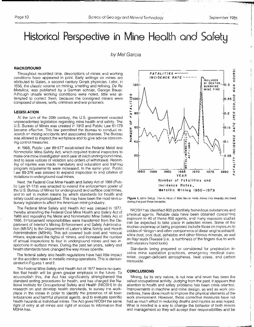
Figure 1, Mine Safety. The number of fatalities in metal mines has steadily declinedduring the past three decades.
CONCLUSIONS
Mining, by its very nature, is not now and never has been thesafest occupational activity. Judging from the past, it appears thatattention to health and safety problems has been crisis oriented.Improvements in machine and mine design, as welJ as work procedures, have done much to improve the physical elements of thework environment. However, these corrective measures have nothad as much effect in reducing deaths and injuries as was hoped,What is needed is a way to change the behavior of both minersand man'agement so they will accept their responsibilities and be
00.25 g
00l\I
0.2 II:UJa......UJ
0.15I-"l:II:
UJu
0.1 ~UJ0
U~
0.05>-I-
::i"l:I-
1980 "l:l£.
1975
INCLUDES91 DEA THS.SUNSHINEMINE FIRE
19701960 1965YEAR
Number of Fatalities and
Incidence Rates,
Metallic Mining 1950-1979
1955
FATALITIES --
INCIDENCE RATE -----
20
1950
120
NIOSH has identified 800 potentially hazardous substances andphysical agents. Reliable data have been obtained concerningexposure to 40 of these 800 agents, and many exposure studiescan be expected to take place in selected mines. Some of thestudies underway or being proposed include those on exposure tooxides of nitrogen and other components of diesel engine exhaust,silica dust, coal dust, asbestos and other fibrous min~rals, as wellas Raynauds Disease (i.e., a numbness of the fingers due to workwith vibratory hand tools).
Standards being prepared or considered for preparation involve mine sanitation practices, emergency medical care,noise, oxygen-deficient atmospheres, heat stress, and carbonmonoxide.
.J"l:I-"l: 80l£.
l£.oII: 60UJIII::E:::l~ 40
BACKGROUND
Throughout recorded time, descriptions of mines and workingconditions have appeared in print. Early writings on mines areattributed to Galen, a second century Gre~k physician. Later, in1556, the classic volume on mining, smelting and refining. De ReMetallica , was published by a German scholar, George Bauer.Although unsafe working' conditions were noted, little was attempted to correct them, because the consigned miners werecomposed of slaves, serfs, criminals and war prisoners.
LEGISLATION
At the turn of the 20th century, the U.S. government enactedunprecedented legislation regarding mine health and safety. TheU.S. Bureau of Mines was created in 1910 and Public Law 61-179became effective. This law permitted the Bureau to conduct research on mining accidents and associated illnesses. The Bureauwas allowed to inspect the workplace and to give advice concerning control measures.
in 1966, Public Law 89-577 established the Federal Metal andNonmetallic Mine Safety Act, which required federal inspectors tomake one mine investigation each year at each underground mine,and to issue notices of violation and orders of withdrawal. Reporting of injuries was made mandatory and education and trainingprogram requirements were increased. In the same year, PublicLaw 89-376 was passed to expand inspection to and citation ofviolations in underground coal mines.
Next, the Federal Coal Mine Health and Safety Act of 1969 (PUblic Law 91-173) was enacted to extend the enforcement power ofthe U.S. Bureau of Mines for underground and surface coal mines,and to set in motion means by which standards for health andsafety could be promulgated. This may have been the most revolutionary legislation to affect the American mining industry.
The Federal Mine Safety and Health Act was passed in 1977,thereby amending the Federal Coal Mine Health and Safety Act of1969 and repealing the Metal and Nonmetallic Mine Safety Act of1966. Enforcement responsibilities were transferred from the Department of Interior's Mining Enforcement and Safety Administration (MESA) to the Department of Labor's Mine Safety and HealthAdministration (MSHA). This act covered both coal and noncoalminers, expanded the rights of miners, and increased the numberof annual inspections to four in underground mines and two inspections in surface mines. During the past ten years, safety andhealth standards have changed the way mines operate.
The federal safety and health regulations have had little impacton the accident rates in metallic mining operations. This is demonstrated in Figures 1 and 2.
The Federal Mine Safety and Health Act of 1977 leaves no question that health will be given greater emphasis in the future. Toaccomplish this, the Act has significantly strengthened thestandard-setting procedures for health, and has charged the National Institute for Occupational Safety and Health (NIOSH) to doresearch on and develop health standards, to survey the workplace in the mines in order to identify the presence of all toxicsubstances and harmful physical agents, and to evaluate specifichealth hazards at individual mines. The Act gives NIOSH the sameright of entry at all mines and right of access to information thatMSHAhas.
-

Vol11 No.3 Fieldnores Page 11
Figure 2. Mine Safety. The actual reduction in number of and incidence rates fornonfatal disabling injuries occurred before 1960.
committed to working safely, while improving their productivity. It iscommonly accepted that unsafe acts committed by the workeraccount for 80% of all industrial accidents. Also, the governmentand organized labor must learn to work cooperatively rather than inan adversary relationship with the employer to accomplish realisticsafety performance goals. By focusing on performance standards,rather than specification standards, regulatory agencies shouldconcentrate on the real causes of accidents, not on the number ofcitations issued.
NONFATAL DISABLING INJURIES --
INCIDENCE RA TE -----
INDUSTRIAL MINERAL NEWS
Bureau Geologist, H. Wesley Peirce, attended the 17th AnnualForum on the Geology of Industrial Minerals that was held inAlbuquerque, New Mexico, May 12-15, 1981. The program wassponsored by the New Mexico. Bureau of Mines and Mineral Resources and chaired by George S. Austin, Assistant Director of theNew Mexico Bureau. The theme for this meeting was "IndustrialRocks and Minerals of the Southwest."
Field trips were offered prior to, during and after the meeting.The pre-meeting trip provided a rare opportunity for both husbands and wives to go underground into one of the Carlsbadpotash mines. Currently, there are seven operations in the districtthat together supply about 80% of the national needs for potash(potassium) fertilizers. The surface milling and processing facilitieswere also visited. The potash bearing minerals occur as mixtureswith common rock salt. Salt mines are dry and salt dust is not ahealth hazard. The district was opened in 1931 and is now lacedwith thousands of miles of underground workings.
Two days of technical papers were highlighted by a banquettalk given by Robert L. Bates. Bob writes the popular "GeologicColumn" that appears on the last page of Geotimes. His presentation, titled, "A View from the Column," elicited much laughter.
The spouses' activities, handled by Marjorie Austin, were reported to have been most rewarding. All in all the meeting was abig success.
Next year, the annual meeting will take place in Hoosier country.The Forum comes to Arizona in 1985; it's not too early to startthinking about technical papers for this one.
PENROSE CONFERENCE
Stephen J. Reynolds, geologist for the Bureau, recently attended aGeological Society of America Conference on the "significanceand petrogenesis of mylonitic rocks." The conference was held inSan Diego on April 28-May 2 and was preceded by a three-dayfield trip through the San Gabriel Mountains, the Santa Rosa Mountains and the Peninsular Ranges of southern California. G.SAPenrose Conferences are designed to bring together a selectgroup of geoscientists that have expertise on a certain subject.Reynolds was invited to the conference on the basis of his research on mylonitic rocks of Arizona and other western states. Theconference was attended by approximately 75 geoscientists fromall parts of the U.S. and from eight foreign countries, includingAustralia, Switzerland, Norway and France.
IJ)
ll:::::>o:t:
c:«
10.0 ~
ooo
8.0 gC\l
ll::lIJ
6.0 ~lIJ...«
4.0ll::
lIJ(.)
c:lIJ
2.0Q
(.)
c:
1980197519701960 1965
YEAR
Number of Nonfatal DisablingInjuries and Incidence Rates,Metallic Mining L950-1979
1950 1955
(!)IOOc:-Jco«IJ) 80Q
-J«~ 60u..c:oc:u.. 40oll::lIJco~ 20:::>c:
NATIONAL/REGIONAL/LOCAL EVENTS
Mel Garcia is Assistant Director for Mine Health and Safety in the Department ofMining and Geological Engineering at the University of Arizona, and is also IndustrialHygienist with the Bureau of Geology and Mineral Technology.
REFERENCES
Felton, Jean Spencer, MD. and others, Man, medicine and work, historic events inoccupational medicine: U.S. Department of Health, Education and Welfar.e,Public Health Service Publication 1044, Washington, DC.
Hatch, Ralph W., 1980, Testimony on behalf of the American Mining Congress, presented before the Subcommittee on Health and Safety Oversight Hearings onthe 1977 Federal Mine Safety and Health Act, March 25,1980.
Schroder, John L., Jr., 1981, What do we do now?: American Mining Congress Journal, January 1981, p. 35-37.
Snyder, Katharine, 1979, Two agencies join in concentrated attack on toxic minesubstances: Mine Safety and Health, v. 4, no. 3, p. 6-13.
U.S. Department of Labor, Mine Safety and Health Administration, 1980, Annual report and achievements, fiscal year 1978, part I: Government Printing Office,Washington, D.C.
U.S. Department of Labor, Mine Safety and Health Administration, 1979, Injuryexperience in coal mining, 1977: Government Printing Office, InformationalReport IR 1108, Washington, D.C.
U.S. Department of Labor, Mine Safety and Health Administration, 1978, Injury experience in metallic mineral mining, 1977: Government Printing Office,Informational Report IR 1104, Washington, D.C. ~
Planning Association of Arizona-Annual Conference,Flagstaff, AZ, September 16-18,1981
Arizona Science Teachers Association-Annual. Meeting,Scottsdale, AZ, October 16, 1981
American Geophysical Union-Symposium (Geophysics andGroundwater), San Francisco, CA, December 7-11, 1981
American Institute of Mining Engineers, ArizonaConference-Annual Meeting, Tucson, AZ, December 7,1981
Quartzsite Improvement Association-16th Annual Gem &Mineral Show, Quartzsite, AZ, February 4-8,1982
Tucson Gem & Mineral Society-28th Annual Gem & MineralShow, Tucson, AZ Wholesale Show & Manufacturers'Exhibits, February 11-14, 1982Retail Show (open to public), ,......."11':-11\/
American Association of Petroleum Ge,olclgist!I-Al}nualing, Pacific Section, Los Angeles, CA,
Geological Society of America & Seisnlol,ogi'cal S()I~ielty
America-Annual Meeting, Cordilleran ;,e(JuulJ,
CA, April 19-21, 1982Colorado School of Mille5i-lntElrn~:ltio,nal
cal Information), Golden, CO:

Page 12 Oureau of Geology and Mineral Technology Seprember 1981
by H. Wesley Peirce and Robert T. O'Haire
The mineral conichalcite, CaCu(As04) (OH), was identified byBureau mineralogist Bob O'Haire from petrified wood collectedby Wes Peirce and Larry Fellows. The wood was found as floatboulders in the stream bottom downstream from Bath TubTank in Adobe Canyon, Santa Rita Mountains, Santa Cruz County.
Conichalcite, identified by composition and x-ray pattern, occurs along fractures as small greenish masses having a radialfibrous structure. It occurs in association with chrysocolla andunidentified iron oxides. Vanadium and/or phosphorous can substitute for arsenic (Palache and others, 1951). Spectroscopicexamination confirms the presence of some vanadium, and qualitative chemical testing indicates some phosphorous. Additionaltesting is necessary to more precisely determine the chemicalcomposition.
Miller and Schwab (1966) noted the occurrence of "silicified treetrunks" in Lower Cretaceous strata in Adobe Canyon. Drewes(1972) mapped the region and named the nearly vertical, tiltedstrata in the Bath Tub Tank area, the Turney Ranch Formation-thestratigraphically highest unit in the Lower Cretaceous BisbeeGroup.
Conichalcite is a relatively rare mineral in southern Arizonahaving been recognized only in a few copper mining regions,such as Bisbee, Ajo and Globe (Anthony and others, 1977). Thisoccurrence of conichalcite in petrified wood (not associated witha mining property) seems unique.
SELECTED REFERENCES
WILLIAM P. COSART has been selected to be Acting Dean ofthe College of Mines and Acting Director of the Bureau of Geologyand Mineral Technology for the fiscal year 1981-82, replacingWilliam H. Dresher. Dr. Cosart joined the University of Arizonafaculty in 1968 and became Assistant Dean in 1972. In additionto his teaching, he has been active in University programs, i.e.,student advisory committees (curriculum, scholarship, admission, Indian advisory, etc.) and with research and development.
Dr. Cosart received a PhD. in Chemical Engineering from Oregon State University (1973) and a B.S. and M.S. from Stanford(1958, 1960). From 1959 to 1962, Cosart served as Lieutenantin the U.S. Army Chemical Corps, and from 1962-64, ResearchAssociate at the Oregon Primate Research Center.
In 1972, he was the recipient of the Good Teaching Award,sponsored by Standard Oil; in 1978, Dr. Cosart received the Outstanding Student Chapter Counselor Award from the AmericanInstitute of Chemical Engineers.
Effective last July, WILLIAM G. DAVENPORT became head ofthe Department of Metallurgical Engineering at the Universityof Arizona and Assistant Dire.ctor of the State of Arizo.na Bureauof Geology and Mineral Technology, in charge of the MineralTechnology Branch.
Since 1964, Dr. Davenport has held numerous faculty positionsat McGill University (from Assistant Professor to Associate Dean ofEngineering). He has been a consultant to many Canadian mineralindustries and has acquired a working familiarity with virtually allsmelters and refineries in Canada, as well as with metallurgicaloperations in Australia, Japan and the U.S.
Dr. Davenport received his PhD. in Extractive Metallurgy fromthe Royal School of Mines, University of London (1964) and his B.S.and M.S. in Metallurgical Engineering from the University of BritishColumbia (1959, 1960).
MINERA GY CORNER
State of Arizona" ." '" """"""."""."""", Governor Bruce BabbittUniversity of Arizona "" ,,,,,. """"'" President John P. SchaeferBureau of Geology & Mineral Technology
Acting Director """ " " William P. CosartState Geologist, "" .. ". Larry D. FellowsEditor.. ' ".""""""""""" ......... ""." Anne M, CandeaIliustrators ' ' .. Joe LaVoie, Ken Matesich and Jenny Laber
Anthony. J. W,. Williams, S. A.. and Bideaux, R. A., 1977, Mineralogy of Arizona: TheUniversity of Arizona Press, Tucson. Arizona, 254 p.
Drewes, H., 1972, Structural Geology of the Santa Rita Mountains, southeast ofTucson, Arizona: U.S. Geological Survey Professional Paper 748,35 p.
Miller, H, W., and Schwab, K. W., 1966, Microfossils from the Upper Cretaceousof Adobe Canyon, southern Arizona: Arizona Geological Society Digest, 8,p.65-95.
Pal.ache, C., Berman, H., and Frondel, C., 1951, "The system of mineralogy," JohnWiley and Sons, Inc., New York, p. 806-808.
ANNOUNCEMENTSArizona Geological Society Digest XIV, "Relations of Tectonics toOre Deposits in the Southern Cordillera" has been released andis available for purchase ($15.00) from AGS (P.O. Box 40952,Tucson, AZ 85717). This volume contains the proceedings ofa symposium held on March 19-20, 1981 at the University ofArizona. Digest XIV has been mailed to symposium registrants.Note: Digest XIII is still in preparation.
The Bureau of Reclamation (BuRec) has reclaimed its originalname and will no longer be known as the Water and Power Resources Service (WPRS).
Daniel N. Miller, former director of Wyoming's Geological Survey,has been appointed Assistant Secretary of the Department ofInterior for Energy and Minerals. Miller will have jurisdictionover the U.S.G.S., the U.S. Bureau of Mines and the l:J.S. Officeof Surface Mining.
Vol 11 NaG
FieldnotesSeptember 1981
The l3ureou of Geology and Minerai Technology IS a DIVISion of th~ University of Anzona, on Equal Opporrunlty/Afflrmarlve Action Employer
Srare of ArizonaBureau of Geology and Mineral Technology845 N. Parl~ Ave.Tucson, Arizona 85719602/626-2733
NON·PROFIT ORG,
U,S. POSTAGEPA I 0
PERMIT NO. 190TUCSON, ARIZONA