vital signs 2019 - nps.gov
TRANSCRIPT

Science and Resource Management National Park Service
Grand Teton National Park U.S. Department of the Interior
& John D. Rockefeller, Jr. Memorial Parkway
G RA N D T E T O N N AT I O N A L PA R K & Jo h n D. R o c ke fe l l e r, J r . M e m o r i a l Pa r k w a y
N a t u r a l a n d C u l t u r a l R e s o u r c e s
VITAL SIGNS 2 0 1 9

...: GRAND TETON ASSOCIATION
This report is made possible through generous support from Grand Teton National Park Foundation and Grand Teton Association.
It shares natural and cultural resource data collected during the calendar year 2019 and compiled in 2020.
Science and Resource Management Grand Teton National Park
& John D. Rockefeller, Jr. Memorial Parkway P.O. Drawer 170
Moose, WY 83012 www.nps.gov/grte
2 Vital Signs 2019• Grand Teton National Park

Acknowledgments To supplement funding from the National Park Service and work done by Grand Teton National Park staf, the following organizations supported the monitoring of vital signs included in this report: • Biodiversity Research Institute • Craighead Beringia South • Colorado State University, Federal Land Manager Environmental Database • Charles Engelhard Foundation • Cross Charitable Foundation • Grand Teton Association • Grand Teton National Park Foundation • Greater Yellowstone Coalition • Greater Yellowstone Coordinating Committee • Greater Yellowstone Whitebark Pine Monitoring Working Group • Idaho Department of Fish and Game • Interagency Grizzly Bear Study Team (US Geological Survey–Biological Resources Division, National Park Service, US Forest Service,
and the states of Idaho, Montana, and Wyoming) • Iowa Chapter of Foundation for North American Wild Sheep • Jackson Hole Historical Society and Museum • Jackson Hole One Fly Foundation • Jackson Hole Weed Management Association • Knobloch Family Foundation • Meg and Bert Raynes Wildlife Fund • Mule Deer Foundation, Snake River Chapter • National Park Service Air Resources Division • National Park Service Greater Yellowstone Inventory and Monitoring Network • National Park Service Northern Rockies Exotic Plant Management Team • Northern Rockies Conservation Cooperative • Patagonia World Trout Initiative • Ricketts Conservation Foundation • Teton Conservation District • US Fish and Wildlife Service, National Elk Refuge • US Forest Service, Bridger-Teton National Forest • US Forest Service, Forest Health Protection • US Geological Survey, Northern Rocky Mountain Science Center and Columbia Environmental Research Center • University of Wyoming-National Park Service Research Station • Upper Snake River Basin Sage Grouse Working Group • Western Regional Climate Data Center • Wildlife Conservation Society • Wyoming Game and Fish Department • Wyoming State Climate Ofce • Wyoming State Historic Preservation Ofce • Wyoming Wild Sheep Foundation
Holly McKinney, Editor and Design Email: [email protected]
Suggested citation: U.S. Department of Interior, National Park Service, Grand Teton National Park & John D. Rockefeller, Jr. Memorial Parkway:
Resource Report 2019, Moose, Wyoming, USA, 2020.
Cover painting: Elk Near the Cathedral Group by Bill Freeman. Gift from the Grand Teton Association to Grand Teton National Park.
Where not otherwise indicated, photos in this report are courtesy of the National Park Service.
Grand Teton National Park • 2019 Vital Signs 3

5
10
15
20
25
30
35
40
45
Table of Contents
Acknowledgments........................................................................................................................... 3 Why We Monitor the Park’s Resources........................................................................................... Vital Signs Summary........................................................................................................................ 6 Climate and Environment................................................................................................................ 7
Air Quality............................................................................................................................7 Climate................................................................................................................................. 8 Fire........................................................................................................................................8 Glaciers................................................................................................................................. 9 Rivers.................................................................................................................................... Water Quality...................................................................................................................... 11
Natural Resources.............................................................................................................................12
Bison.....................................................................................................................................
Grizzly Bears.........................................................................................................................
Peregrine Falcons.................................................................................................................
Amphibians.......................................................................................................................... 12 Bald Eagles........................................................................................................................... 13 Common Loons.................................................................................................................... 13 Bighorn Sheep..................................................................................................................... 14
Columbian Sharp-tailed Grouse..........................................................................................16 Great Gray Owls...................................................................................................................16 Elk.........................................................................................................................................17 Golden Eagles...................................................................................................................... 17 Gray Wolves......................................................................................................................... 18 Great Blue Herons............................................................................................................... 19 Greater Sage-grouse............................................................................................................19
Harlequin Ducks...................................................................................................................21 Ospreys................................................................................................................................. 21 Moose...................................................................................................................................22 Mule Deer............................................................................................................................ 23 Pronghorn............................................................................................................................ 24
Trumpeter Swans................................................................................................................. 25 Red Fox.................................................................................................................................26 Sagebrush Steppe and High Elevation Vegetation........................................................... 27 Snake River Fine-spotted Cutthroat Trout......................................................................... 28 Whitebark Pine.................................................................................................................... 29
Cultural Resources............................................................................................................................ Archeological Sites.............................................................................................................. 30 Historic Structures................................................................................................................31 Museum Collection and Archives....................................................................................... 32
Challenges........................................................................................................................................ 33
Elk Reduction Program........................................................................................................
Mountain Goats...................................................................................................................
Aquatic Invasive Species......................................................................................................33 Chronic Wasting Disease..................................................................................................... 34 Integrated Pest Management.............................................................................................34
Fish Passage..........................................................................................................................36 Human-Bear Interface......................................................................................................... 37 Invasive Plants......................................................................................................................38 Kelly Warm Spring...............................................................................................................39 Livestock Grazing.................................................................................................................39
Native Plant Restoration..................................................................................................... 41 Trail and Pathway Use......................................................................................................... 42 Visitor Use............................................................................................................................ 43 Wildlife-Vehicle Collisions...................................................................................................44
Research Permits..............................................................................................................................
4 Vital Signs 2019• Grand Teton National Park

Grand Teton resources include the T.A. Moulton Barn, bison, and the Teton Range.
Why We Monitor the Park’s Resources The National Park Service was established in 1916 with the mission of protecting the resources of the parks and providing for the public enjoyment of those same resources in such manner that the resources will remain unimpaired for future generations. While Grand Teton National Park was not created until 1929 (and expanded in 1950), the mission remains the same. To protect and manage the wide variety of natural and cultural resources held within the park, resource management staf monitor and study individual resources and ecological processes—vital signs— to better inform decisions made in the park. Systematic monitoring is complicated by the fact that air resources, water resources, and many of the animals’ seasonal migrations cross the boundaries of the park where other factors infuence their condition. Inside the park, plant and animal species that may change or afect native species have been introduced both accidentally and intentionally. Pressure from humans, both within Grand Teton National Park and outside, may also afect conditions in the park. Data collected on some resources may be too limited to predict signifcant trends, but hopefully will provide a baseline for future study. Resources summarized in this report are monitored because of their signifcance to or infuence on this ecosystem.
Vital Signs Summaries Grand Teton’s vital signs summaries are grouped into four categories for purposes of this report. They include: • Climate and Environment (air quality, climate, fre,
glaciers, rivers, and water quality) are primarily the result of natural processes that operate on a distinctly larger scale than the park, but can be afected by human activities both within and outside the park.
• Natural Resources: selected plants and animals that – are or have been listed under the federal Endangered
Species Act (bald eagle, gray wolf, grizzly bear, and peregrine falcon).
– have experienced declines in the park and surrounding areas or are of special concern (golden eagle, great blue
heron, great gray owl, greater sage-grouse, moose, trumpeter swan, and whitebark pine).
– have relatively small populations in the park and are considered vulnerable (bighorn sheep, Columbia sharp-tailed grouse, common loon, harlequin, pronghorn, and red fox).
– have a signifcant impact on the ecosystem and park management based on such factors as their large number, size, and movement outside the park, or where they are harvested (bison, elk, and mule deer).
– are considered important indicators of ecosystem health because they are especially sensitive to environmental pollutants, habitat alteration, and climate change (sagebrush steppe, amphibians, cutthroat trout, and osprey).
• Cultural Resources (archeological sites, historic structures, and museum collections) are signifcant representations of the human evidence in or on the park and are inventoried, protected, and monitored to ensure that these resources and the information associated with them are passed along to future generations.
• Challenges (nonnative plants and animals, livestock grazing, park visitation, plant and habitat restoration, wildlife collisions, and the human-bear interface) are generally caused or largely infuenced by human activity.
Comparison to Reference Conditions The table on the following page summarizes the current status of selected resources. In most cases, a reference condition is indicated that can be used for comparison purposes. Because conditions may fuctuate widely over time in response to natural factors, the reference condition is not considered the “desired” condition unless it is one that has been specifed by government regulation or a plan. In other cases, the reference condition simply provides a measure for understanding the current condition, e.g., a historical range or scientifc opinion as to the level needed to maintain biological viability.
Grand Teton National Park • 2019 Vital Signs 5

Vital Signs Summary TBD = to be determined
Resource Indicators Current Condition 2019 (or latest available)
Reference Condition
Climate and Environment X X X
Air Quality Basic air quality parameters at 1 site Class I Airshed Clean Air Act Climate Average min., max. daily temp. (Moose)
Annual precipitation (Moose) 24°F, 52°F
25.66” 22°F, 53°F (1959–2019 average)
21.81” (1959–2019 average) Fire Acres burned per year by wildfre 0.8 acres 1–19,211 (1999–2019 range) Glaciers Extent of 10 named glaciers 1.5 km² (2016) Long-term decline Water Quality Basic water quality parameters- 2 river sites Iron exceeds state standards State water quality standards
Natural Resources X X X Amphibians % of potential sites suitable for breeding 86% TBD Bald Eagle Breeding pairs 12 pairs 11.9 pairs (2000–2019 average) Bighorn Sheep Teton Range herd estimate 97 sheep 100–125 sheep (1970–2000 estimate) Bison Jackson herd winter count (includes areas
outside park) 484 bison 500 bison
Common Loon Breeding pairs 1 pair TBD Elk Jackson herd winter count (includes areas
outside park) Summer count (portion of park herd)
9,627 elk
>1254 elk
11,000 elk
≤1600
Gray Wolves Wolves in Wyoming (outside of Yellowstone) Breeding pairs in WY (outside of Yellowstone)
201 wolves (42 in park) 14 pairs (4 in park)
>100 wolves >10 pairs
Great Blue Heron Active nests 34 nests 23.7 nests (2000–2019 average) Greater Sage-grouse Active lek 7 leks (6 in park) 9 occupied leks (8 in park) Grizzly Bears GYE population estimate
Distribution of females with cubs 737
18 bear management units >500 grizzly bears
>16 bear management units of 18 Moose Jackson herd winter count >258 (47 in park) TBD Osprey Breeding pairs 12 pairs 12.3 pairs (2010–2019 average) Peregrine Falcon Breeding pairs 3 pairs 3.6 pairs (2010–2019 average) Pronghorn Jackson Hole/Gros Ventre herd estimate 356 pronghorn 350–900 (modeled range) Trumpeter Swans Occupying breeding territories (includes areas
outside park) Pairs producing young
4 pairs (1 in park)
4 pairs (6 cygnets fedged)
18 historic territories (13 in park)
TBD Whitebark Pine Blister rust infection (% of trees in park) 63% of trees TBD
Cultural Resources X X X Archaeological Sites Percentage of park inventoried
Percentage of documented sites in good condition
4.7% of the park (2017) 42% (2017)
75–100% TBD
Historic Structures Percentage assessed in good condition 73% (2017) 100% Museum Collections Percentage that has been cataloged 86% 100%
Challenges X X X Aquatic Invasive
Species Presence of non-native species 13 0 (limit spread & effects on
native sp.)
Fish Species present 12 native 9 non-native
12 native 0 (limit spread & effects on native sp.)
Human-Bear Conficts Injuries, food obtained, or property damaged 9 in park 9.9 (2010–2019 average) Invasive Plants Species present
Acres treated 30 invasive species
2429 acres 0 (limit spread & effects on native sp.)
Mountain Goats Estimated number in park ≈100 goats 0 (limit spread & effects on native sp) Plant Restoration Restoring native plant communities in former
agricultural felds (Kelly hayfelds) 1319 acres under restoration
treatment 100% of 4500 acres in the former Kelly hayfelds area
Reference condition specifed by government regulation or management plan.
6 Vital Signs 2019• Grand Teton National Park

CLIMATE and ENVIRONMENT
Air Quality Grand Teton National Park experiences good air quality;
however, both distant and local sources of air pollution afect the park. As a federally designated Class I airshed, Grand Teton is required to meet high standards for air quality. The park conducts monitoring to evaluate the potential for air pollution to afect other park resources.
Air pollutants of concern include sulfur and nitrogen compounds deposited by precipitation and by settling out of the atmosphere. These compounds can harm surface waters, soils, and vegetation. High-elevation lakes are especially sensitive to acidifcation from sulfur and nitrogen deposition and excess nitrogen enrichment. Acidifcation may cause loss of sensitive macroinvertebrates and fsh, while nutrient enrichment may alter lake diversity. Alpine plant communities are also vulnerable to nitrogen enrichment, which may favor some species at the expense of others. Research suggests that deposition of nitrogen above 1.4 kilograms per hectare per year afected the diversity of diatoms (single-celled algae) found in high-elevation lakes in the Greater Yellowstone Ecosystem, an area that includes Grand Teton National Park.
The park operates an air quality monitoring station, established in 2011, to track the deposition of these compounds in precipitation. This station is part of the National Atmospheric Deposition Program, which measures precipitation chemistry at over 200 locations across the country. The link for real-time results from this station, including a webcam is https://www.nps. gov/subjects/air/webcams.htm?site=grte. Annual wet deposition of nitrogen measured at the Grand Teton station from 2012 through 2018 varied from 1.1 to 2.1 kilograms per hectare per year. The Grand Teton deposition monitor is located at an elevation of 6,900 feet; higher elevation areas of the park are likely experiencing higher levels of deposition as a result of higher annual precipitation.
Some air pollutants while still in the atmosphere react in the presence of sunlight to form ozone. Ozone is harmful to humans as well as vegetation and is regulated under the Clean Air Act. Ozone monitoring in Grand Teton began in 2012. The Environmental Protection Agency has established a standard for ozone that is
based upon the three-year average of the fourth-highest eight-hour average concentration that occurs during the year. Data collected by the park ozone monitor from 2012 through 2019 indicate that the park meets the ozone standard. Due to the short span of time that the Grand Teton monitor has collected data, it is not possible to determine whether or not there is a trend.
Visitors come to Grand Teton to enjoy spectacular views of the Teton Range and the Jackson Hole valley. Sometimes the park’s scenic vistas are obscured by haze caused by fne particles in the air. Many of the same pollutants that ultimately fall out as nitrogen and sulfur deposition contribute to this haze and visibility impairment. Additionally, organic compounds, soot, and dust reduce visibility. In the region, average natural visual range is reduced from about 180 miles (without the efects of pollution) to about 120 miles because of pollution. The visual range is reduced to about 70 miles on the haziest days and can be even less on days with smoke. While natural fre is recognized for its ecological benefts, smoke from wildfres signifcantly contributes to particulate matter in the region. Periods of reduced visibility from forest fre smoke are typical in late summer and were a factor even prior to human occupation.
A comparison of the maximum ozone levels annually on the fourth-highest day
in Grand Teton and Yellowstone National Parks. The fourth-highest day of the
year is identifed and reported in order to minimize the impact of short-term
variations in weather conditions in any given year.
0.04
0.05
0.06
0.07
0.08
2012 2013 2014 2015 2016 2017 2018 2019
Part
s p
er m
illio
n
Annual 4th-Highest 8-Hour Daily Maximum Ozone Concentration
Grand Teton Yellowstone Ozone Standard
Grand Teton National Park • 2019 Vital Signs 7
HIGHLY VALUED RESOURCES AND AssETS
=...... -r_
WLllO.Jf£ _,.,
WILDFIRE LIKELIHOOD AND INTENSITY
+--+
X
-~,.---,·-I : ~ 1 -l(IIII; fl-I "' ... ... I:: 1 ·---
1 RESPONSE FUNCTION
WILDFIRE RISK
CLIMATE and ENVIRONMENT
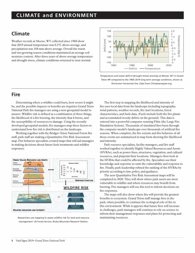
Climate Weather records at Moose, WY collected since 1960 show that 2019 annual temperature was 0.2°C above average, and precipitation was 104 mm above average. Overall the warm and wet growing season conditions maintained an average soil moisture content. After three years of above average temperature and drought stress, climate conditions returned to near normal.
Temperature and water defcit (drought stress) anomaly at Moose, WY in Grand
Teton NP compared to the 1960–2019 long-term average conditions, shown as
the brown horizontal line. Data from Climateanalyzer.org.
-3 -2.5 -2 -1.5 -1 -0.5 0 0.5 1 1.5 2 2.5
-150
-100
-50
0
50
100
150
1960 1980 2000 2020
Temperature (deg C)
Def
cit (
mm
)
Defcit Temperature
Fire Determining where a wildfre could burn, how severe it might
be, and the possible impacts or benefts are inquiries Grand Teton National Park fre managers are using a new geospatial model to answer. Wildfre risk is defned as a combination of three things, the likelihood of a fre burning, the intensity that it burns, and the susceptibility of resources to damage. Using the recently developed geospatial models, fre managers map these factors to understand how fre risk is distributed on the landscape.
Working together with the Bridger-Teton National Forest fre staf, park staf are making a Quantitative Fire Risk Assessment map. Fire behavior specialists created maps that will aid managers in making decisions about future fuels treatments and wildfre responses.
The frst step in mapping the likelihood and intensity of fre uses local data from the landscape including topography, wind patterns, weather records, fre start locations, forest characteristics, and fuels data. (Fuels include both the live plants and accumulated woody debris on the ground). This data is entered into a powerful computer running FSim (the Large Fire Simulation System). Thousands of simulated fres burn through the computer model’s landscape over thousands of artifcial fre seasons. When complete, the fre extents and fre behavior of all those events are summarized in map form showing fre likelihood and intensity.
Park resource specialists, facility managers, and fre staf worked together to identify Highly Valued Resources and Assets (HVRAs), such as power lines, structures, vegetation, and cultural resources, and pinpoint their locations. Managers then look at the HVRAs that could be afected by fre. Specialists use their knowledge and expertise to rank the vulnerability and response to fre. Finally, park leadership refned the ranking of the HVRAs by priority according to law, policy, and guidance.
The new Quantitative Fire Risk Assessment maps will be completed in 2020. They will show where park assets are most vulnerable to wildfre and where resources may beneft from burning. Fire managers will use this tool to inform decisions on fre responses.
The maps will also show where fre will provide the greatest benefts to ecosystem. Grand Teton staf manage fres in the park, when possible, to continue the ecological role of fre in this environment. While it appears that future fres will increase in challenges, park managers will continue to rely on science to inform their management responses and plans for protecting and maintaining resources.
8 Vital Signs 2019• Grand Teton National Park
Researchers use mapping to assess wildfre risk for land and resource
management- US Forest Service, Rocky Mountain Research Station.
2019 Spring Glacier Survey
• 20 , g A~1uon StakH Snow Probe Loeallons Snow Depth (cm)
800
• Roclf Sttlkff 20; 5 Ice Eltten1
N
A
CLIMATE and ENVIRONMENT
Glaciers Grand Teton National Park has 11 known glaciers, formed during a short cold neo-glaciation period called the Little Ice Age (1400–1850). Some of these glaciers are active, while others are considered remnant because they have lost so much volume they have stopped fowing. The Teton glaciers are iconic features of the park landscape, prompting eforts to monitor their fuctuations under current and future climate regimes.
Park staf monitor glacier movement, area and volume changes, as well as glacial infuence on streamfow quantity and quality. Glaciers store water that provides critical input for land and aquatic ecosystems during the summer months. This is particularly evident in years of below-average precipitation. Researchers outside the park found summer stream temperatures can be 3–4 degrees cooler in glacier-fed streams than in adjacent glacier-less basins. In 2019, park staf began a new monitoring efort measuring stream temperatures and fow levels throughout the summer to assess the efect glaciers have on streams.
Changes in glacial extent and volume are signifcant indicators of changing climate and, as in nearly all glaciated areas of the globe, recent studies show signifcant and rapid retreat and volume loss of glaciers in the Greater Yellowstone Ecosystem (GYE). High-elevation areas of the Rockies are experiencing changes such as rising temperatures and earlier, more rapid snow melt than the region overall.
In 2013, NPS staf created and tested ice surface elevation surveys methods on Middle Teton and Schoolroom Glaciers— both chosen for their relative safety and accessibility. Park staf also
installed air temperature sensors to provide data for a GYE-wide sensor network, as well as time-lapse cameras to provide images and monitor summer snowmelt patterns on glaciers too difcult or hazardous to monitor directly.
Annually since 2015, physical science staf and climbing rangers conduct GPS elevation surveys of Middle Teton Glacier. These surveys show changes in the glacier surface and measure volume
change over time. Results from 2019 indicate a net volume gain of 21,000 cubic meters across the 31,000 square meter area measured (approximately 17% of the entire glacier surface) compared to 2018—the second year in a row of net gain.
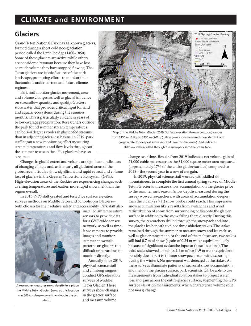
In 2019, physical science staf worked with skilled ski mountaineers to complete the frst annual spring survey of Middle Teton Glacier to measure snow accumulation on the glacier prior to the summer melt season. Snow depths measured during this survey wowed researchers, with areas of accumulation deeper than the 8.5 m (27.9 ft) snow probe could reach. This impressive snow accumulation likely results from avalanches and wind redistribution of snow from surrounding peaks onto the glacier surface in addition to the snow falling there directly. During this survey, the researchers drilled through the snowpack and into the glacier ice beneath to place three ablation stakes. The stakes remained through the summer to measure snow and ice melt, as well as glacier movement. At the end of the melt season, two stakes still had 0.7 m of snow (a gain of 0.25 m water equivalent likely because of signifcant avalanche input at these locations). The third stake showed a net loss 2.1 m of ice (1.9 m water equivalent possibly due in part to thinner snowpack from wind scouring during the winter). No movement was detected at the stakes. As these surveys illuminate patterns of seasonal snow accumulation and melt on the glacier surface, park scientists will be able to use measurements from individual ablation stakes to project water loss and gain across the entire glacier surface, augmenting the GPS surface elevation measurements, which characterize volume (but not mass) change.
Map of the Middle Teton Glacier 2019. Surface elevation (brown contours) ranges
from 3150 m (E tip) to 3730 m (SW tip). Hexagons show measured snow depth in cm
(large white for deepest snowpack and blue for shallower). Red indicates
ablation stakes drilled through the snowpack into the ice surface.
A researcher measures snow density in a pit on
the Middle Teton Glacier. Snow at this location
was 600 cm deep—more than double the pit
depth.
Grand Teton National Park • 2019 Vital Signs 9

CLIMATE and ENVIRONMENT
Rivers The rivers and streams of the Upper Snake River Basin and Grand Teton National Park drain the Teton Range, Absaroka Mountains, and Yellowstone Plateau. Major tributaries are Pacifc Creek, Bufalo Fork, Spread Creek, and the Gros Ventre River feeding into the Snake River from the east. Spring snowmelt released from the surrounding high elevation areas drive annual foods throughout the park. Yearly peak fows can occur anytime from mid-May to mid-June, depending on snowpack and spring temperatures.
The fuvial backbone of Grand Teton, the Snake River, is managed as a Wild and Scenic River. The Wild and Scenic Rivers Act was created by Congress on October 2, 1968 to preserve rivers with outstanding natural, cultural, and recreational values in a free-fowing condition for the enjoyment of present and future generations. Geology is considered one of the outstanding natural values of the Snake River due to the presence of long stretches of naturally braided, geomorphically active river channels.
The segment of the Snake River below Jackson Lake Dam contains a textbook example of one of the longest continuous and naturally braided river systems in the contiguous United States. This dynamic system transports signifcant quantities of gravel and has diverse fuvial features such as side channels, logjams, and foodplains. These geomorphically active surfaces support habitat critical to the ecological health of the river. However, in 2019, shifting channels and numerous logjams created difcult and unpredictable conditions on some of the side channels on the
Snake River between Pacifc Creek and Deadman’s Bar Landing, specifcally in the area directly downstream of Spread Creek.
Because of the river’s designation under the Wild and Scenic Rivers Act, Grand Teton National Park does not remove obstructions that may exist in the river, but rather preserves the natural fow and processes of the river. Floating the river is complex any year, and in 2019 numerous logjams made navigation particularly challenging.
Although the Snake River is managed as a Scenic River, human impacts continue to infuence the hydrologic system. Jackson Lake Dam, originally built in 1906–07 and reconstructed in 1916 to supply water to Idaho for agriculture, raised the height of the
natural lake by 38 feet. Dam operations completely dictate the fow of the Snake River until the Pacifc Creek confuence 4.5 miles downstream. In 2019, the dam altered peak fow in that segment was 4670 cfs, less than ½ of the estimated unregulated fow of 9630 cfs – cutting of an important part of the peak runof which scours the riverbed and transports material including downed trees. Another signifcant change resulting from dam operations is the median date of maximum fow, which over the course of the 110 year record is June 26th, 24 days later than the estimated unregulated fow median of June 2nd. These factors afect the ecology of river plants, animals, insects, and fsh in ways we do not yet fully understand.
Lidar imaging of the Snake River shows the topography of its
braided channel. Artistic colors equate to elevations purple= 6594’
and dark orange= 6516’. B. Crosby/Idaho State
Chart comparing the Snake River’s 2019 fow regulated by the dam (green)
compared to the estimated unregulated fow (gold).
0
2000
4000
6000
8000
10000
4/1/2019 5/1/2019 5/31/2019 6/30/2019 7/30/2019 8/29/2019 9/28/2019
Flo
w (
cfs)
2019 Water Year - Snake River below Jackson Lake Dam - Actual vs. Unregulated Flow
Actual Flow Estimated Unregulated Flow
As the channels of the Snake River shift, banks erode toppling trees that
become navigation hazards.
10 Vital Signs 2019• Grand Teton National Park

Grand Teton National Park • 2019 Vital Signs 11
. -
CLIMATE and ENVIRONMENT
Water Quality Less than 10% of Grand Teton National Park is covered by surface water. The park contains more than 100 alpine lakes, with surface areas ranging from 1 to 60 acres, and many above 9,000 ft in elevation. All surface and groundwater in the park drains to the Snake River. The Snake River is of considerable signifcance to the biological diversity and functioning of not only Grand Teton and the Greater Yellowstone Ecosystem, but also to the health and vitality of gateway and downstream communities.
The uppermost reaches of the Snake River in Wyoming are characterized by good water quality with relatively low levels of dissolved nutrients and other anthropogenic compounds (e.g., pesticides). Good water quality and the presence of native fsh, including cutthroat trout, are not surprising given that the headwaters of the Snake River include parts of Grand Teton and Yellowstone National Parks. Maintenance of high quality waters and continued support of native freshwater assemblages are among the highest management objectives for Grand Teton National Park. The State of Wyoming also recognizes and values this important resource and has designated the upper Snake River and all surface waters within the park as Outstanding or Class 1 waters—recognized for their exceptional quality and therefore “no further water quality degradation by point source discharges other than from dams will be allowed”(WYDEQ 2001). Along with these designations, the Snake River headwaters also received Wild and Scenic River designation by Congress (Snake River Headwaters Legacy Act, 2009), designed to preserve the Snake River headwaters’ outstanding natural, cultural, and recreational values for the enjoyment of present and future generations.
The US Geologic Survey monitors fow levels of the Snake River at two locations—Flagg Ranch and Moose, Wyoming. Discharge in 2019 was near the long-term average at the Flagg site (1983–2019), while peak fows ranked as the 11th lowest in the 36-year monitoring record. Those peak fows occurred just 13 days later than the average for the site. Snake River fows at Moose were near average for that site (1995–2019) early in the season, but dropped as the season progressed. Flows then spiked in mid-September and remained high until the end of the month—a period when 2.25 inches of rain were recorded in Moose. Flows at
Moose are strongly modifed by Jackson Lake Dam, and reservoir operations may have contributed to the 2019 pattern. Total volume of annual fow at the Moose monitoring location ranked 10th out of the 24-year record, but the date of half discharge (the day marking half the annual fow volume) occurred June 23, 2019, just a few days before the average date (June 27) for this location.
NPS resource staf also monitor water quality at these same Snake River locations. Concentrations of primary nutrients (nitrogen and phosphorus) remain consistently low or near detection limits at both sites. Nitrogen levels show little variation seasonally; however, total phosphorus showed signifcant variation and was highest during runof. Trace metals (i.e., arsenic, copper, and selenium) are found in the watershed and are often naturally present in measurable concentrations, but typically below the State of Wyoming’s aquatic life criteria. In 2019, copper and selenium were below detection levels at both sites. Total iron concentrations are highest in the Snake River during elevated fows and both monitoring locations exceeded the State of Wyoming’s aquatic life criterion during high fows in 2019. In contrast, total arsenic concentrations increase to measurable amounts during low fow at both locations with higher concentrations found at the Flagg site; however, both sites were below the State of Wyoming’s aquatic life criterion. Because most of the watershed in the upper Snake River is undeveloped, scientists believe that iron and other trace metals are naturally occurring and that natural fuctuations in metal levels are driven by elevated spring discharge following snowmelt.
The Snake River is an extremely important park resource, Grand Teton NP.
7000 180
1983 - 2018 Mean Total Annual Flow Volume 6000
,,., 1
to - - - 60 . 25th Percentile )
3 5-year Running Average 75th Percentile tf 140
-5000 f
) 2019 Discharge s -- s o 120 f
(c e 4000
g
' noil 100
r j
li
a (b '--- / 00
-, -
siD I I .I .
I -
hc 30 ' . ti ::
w 80
•"1 . I\I ""
\
olF
.
l 60 2000
40 \
100·. ~
at
.J \ o
T
0 20 .JI/,•~ . ....... ' ... :'!',., - . 0
0 6 7 8 9 0 1 2 3 4 5 6 7 8 9 0 1 2 3 4 5 6 7 8 9
1 101 201 301 9 9 9 9 0 0 0 0 0 0 0 0 0 0 1 1 1 1 1 1 1 1 1 1
9 9 9 9 0 0 0 0 0 0 0 0 0 0 0 0 0 0 0 0 0 0 0 0
Day of Ye ar 1 1 1 1 2 2 2 2 2 2 2 2 2 2 2 2 2 2 2 2 2 2 2 2
Summary of the average daily discharge in the Snake River near Annual Snake River fow totals (in billions of cfs) at Moose, WY. A 5-year
Flagg Ranch, Wyoming by day of year. average smooths annual variations for a clearer examination of trends.

NATURAL RESOURCES
Amphibians Each year the National Park Service collaborates with the Northern Rockies Conservation Cooperative, US Geological Survey, and university scientists to monitor amphibians in Grand Teton and Yellowstone National Parks. Biologists identifed four species of native amphibians in Grand Teton and Yellowstone National Parks: western tiger salamander (Ambystoma mavortium), boreal chorus frog (Pseudacris maculata), western toad (Anaxyrus boreas), and Columbia spotted frog (Rana luteiventris). The boreal chorus frog and the Columbia spotted frog are the most widely distributed species each year. The western tiger salamander and western toad appear to be less widespread. The northern leopard frog was historically documented in Grand Teton National Park, but only one confrmed sighting occurred since the 1950s. Plains spadefoot toads (Spea bombifrons) were recently documented in Yellowstone’s Lower Geyser Basin, but their presence in Grand Teton has not been documented.
Annually since 2006, biologists have monitored and documented amphibian breeding activity in 31 catchments. Encompassing about 500 acres each, these catchments or watersheds are defned by topography and vary in amounts of seasonal and permanent water. Within these 31 catchments, researchers visited 336 individual wetland sites in 2019, and surveyed 281 that had standing water present. Biologists documented breeding activity using visual surveys to detect eggs, larvae (e.g. tadpoles), and metamorphic forms (i.e., transitional forms between aquatic and terrestrial life stages). Of these wetland sites, 56% were occupied by at least one species of breeding amphibian. In 2019, two of the 31 catchments contained breeding evidence of all four species (referred to as amphibian “hotspots”). This was consistent with the past two years and up from 2016 when no catchments contained breeding evidence by all four species. For comparison, biologists found two hotspot catchments in 2015 and four in 2014, illustrating the breeding variability that takes place even in protected areas.
Annual variations in breeding may be tied to hydrologic fuctuations that are driven by unique meteorological conditions
100
90
P
each year. Such annual variations alter the extent and mosaic of wetland breeding sites, which can afect amphibian reproduction. The percentage of visited wetlands that supported surface water suitable for breeding varied between 59% in 2007 and 96% in 2011; in 2019, 86% of visited wetlands were fooded. Note, however, that some 2019 surveys were delayed up to 2 weeks due to high spring water and compared to previous years this likely increased the overall number of dry wetlands.
All amphibians in Grand Teton and Yellowstone National Parks require wetlands for breeding, but individual habitat needs difer and may leave some species more vulnerable to changes in wetland condition (e.g., cumulative loss of seasonal water bodies or shrinkage of year-round ponds). The predicted increasing temperatures and changes in snowpack driven runof for this region could alter wetland habitats and infuence amphibian breeding. These expected impacts will disproportionately impact amphibians relying on shallow wetlands.
0
0.1
0.2
0.3
0.4
0.5
0.6
0.7
0.8
0.9
1
2006 2009 2012 2015 2018
Pro
po
rtio
n o
f Su
rvey C
atc
hm
en
tsB
reed
ing
Ob
serv
ed
Boreal Chorus Frog
Columbia Spotted Frog
Western Tiger Salamander
Western Toad
roportion of surveyed catchments where breeding was observed for each species.
The boreal chorus frog has a single white stripe along the upper lip and a dark
stripe that extends from snout to leg running across the eye.
Perc
en
tag
e o
f Su
rved
yed
W
etl
an
ds
Flo
od
ed
80
70
60
50
40
30
20
10
0 2006 2009 2012 2015 2018
Percentage of surveyed wetlands with standing water suitable for breeding.
12 Vital Signs 2019• Grand Teton National Park

NATURAL RESOURCES
Bald Eagles Bald eagles (Haliaeetus leucocephalus) are large, primarily fsh-eating predators that generally nest in trees, close to water bodies. They also feed on small mammals, waterfowl, and carrion. Within Grand Teton, breeding sites are found along the shores of Jackson Lake and along the Snake River.
Bald eagles, once listed as endangered under the Endangered Species Act, were delisted in 2007. Over the past few decades, bald eagles experienced a dramatic recovery in Grand Teton, mirroring their recovery throughout the Greater Yellowstone Ecosystem. The number of territorial pairs in the park has almost doubled over the past 30 years. In accordance with the Greater Yellowstone Bald Eagle Management Plan (1995), park managers may implement temporary closures around active bald eagle nest sites to minimize
disturbances. In 2019, closures were established at nest sites along the Snake River, as well as at the Wilcox Point campsite.
Of the 20 bald eagle territories monitored in 2019, 14 were occupied. Twelve pairs initiated nesting and hatched 15 chicks. At the close of the season, 8 pairs successfully fedged 10 eaglets. Most of the 2019 breeding statistics were on trend with the 10-year average. The number of occupied territories in 2019 was 14 (10-year average = 14.5), 12 nesting pairs were observed (11.9), and 8 successful nests (8.2) fedged a total of 10 eaglets (11.2). The number of fedglings per successful nest in 2019 (1.25) was slightly lower than both the 10-year average (1.37) and 30-year average (1.43). Overall, data collected in 2019 indicates a stable breeding population.
2.50 18 100 II
16 '\
2.00 14
I\ I \ I\ 9
I I ~ ~-
0
80 s / \ 'I I J ~ ~ ~ 70
ei 12 :;....
g 1.50 roti 60 n r
u r ~
e 10 '-..7 _v Pe
o t r
f
-
V ~
f y ' 50 c
o
e
1.00
8 ~
n
r o e ~ ~
t r b 40
e m
b uN 6
m 30
uN 0.50 4 20
2 10 0.00
1
--988 1991 1994 1997 2000 2003
--2006 2009 2012 2015 2018 0 - 0
1987 1990 1993 1996 1999 2002 2005 2008 2011 2014 2017
Young Per O ccupied Territory Young Per P roductive Nest Number of Occupied Territories Percent Active Nests Successful
Trend in Occupied Territories Trend in Percent Active Nests Successful
Counts of bald eagle young produced by territories and nest. Bald eagle pairs occupying territories and successfully producing young.
Common Loons Common loons (Gavia immer) are long-lived birds with a prolonged period of maturation and low reproductive rates. They are one of the rarest birds in the Greater Yellowstone Ecosystem. Arriving shortly after lakes become ice free in the spring, loons breed on freshwater lakes throughout the northern US and migrate to coastal areas for winter. Loons that nest in Grand Teton National Park reside near the southeasternmost extent of the species’ range in the interior mountain west. The Wyoming population is small and appears isolated from other breeding populations. Long-term monitoring showed a reduction in the number of territorial pairs and chicks fedging in the Greater Yellowstone population around 2010, followed by an increasing trend from 2012–2014, and then remaining mostly stable from 2014–2019. The State of Wyoming lists loons as a species of greatest conservation need primarily because of the small size of the nesting population and its restricted distribution.
In July 2019, park biologists coordinated with the Ricketts Conservation Foundation to conduct a survey of all loon habitat within or near the park. They completed surveys around Jackson, Jenny, Arizona, Emma Matilda, Two Ocean, Bradley, Taggart,
Leigh, Bearpaw, Trapper, and Lower Slide Lakes. They found just one pair of loons with a chick at Arizona Lake, adjacent to Grand Teton National Park. The loon chick successfully fedged at the end of the summer.
Loons are excellent swimmers, using their feet to propel them on the surface
and under water. While their foot position far back on their bodies aids in
swimming, it makes it hard for them to walk on land.
Grand Teton National Park • 2019 Vital Signs 13

NATURAL RESOURCES M
. Go
cke
Bighorn Sheep Bighorn sheep (Ovis canadensis) were once widely distributed throughout the mountains and foothills of the Rocky Mountain west. They persist today in small, fragmented populations that remain at risk of further decline and extirpation. The Teton Range herd is Wyoming’s smallest and potentially most isolated core native sheep herd. The herd now lives year-round at high elevation along the Teton crest and in steep canyon areas on the east and west slopes of the range. Sheep in this herd endure harsh winter weather in windblown areas above 9,500 feet due to the loss of low-elevation winter ranges to residential and recreational encroachment. The Teton Range bighorn sheep population faces the serious threat of local extinction and biologists are working to address the most pressing concerns.
Traditionally biologists estimate the size of this population from winter helicopter surveys. In 2018, Wyoming Game and Fish Department (WGF) personnel counted a total of 81 bighorn sheep (37 in the south end of the range and 44 in the north end). In the past few years, the winter counts varied widely from 46–81 bighorn. This dramatic variation is unlikely to represent true population increases or decreases, but indicates the traditional count method does not provide a reliable estimate. Consequently, biologists implemented studies to assess the efectiveness of two non-traditional count methods based on bighorn use of mineral licks during the summer months: analysis using remote cameras and analysis based on fecal DNA. In 2018 and 2019, park biologists placed motion-triggered cameras at nine natural mineral licks scattered across the Teton Range that, collectively, are likely used by the entire bighorn sheep population. They collected fecal samples at these same sites in 2019. Since 2018, biologists have analyzed more than 39,000 photos of bighorn sheep and observed all radio-collared individuals on camera. Of the more than 500 fecal samples collected, just over 300 were genotyped. Genotyping results yielded a minimum count of 97 individuals (40 in the south and 57 in the north).
Annual ground classifcation surveys started in 1990 provide composition, distribution, and trend information. Biologists from the park, WGF, Bridger-Teton and Caribou-Targhee National Forests, as well as several volunteers from the local community counted a total of 26 sheep during the late August ground surveys (14 in the south and 12 in the north). Herd ratios were estimated at 67 lambs, 50 yearlings, and 133 rams per 100 ewes. Since ratios derived from summer ground counts are highly variable over time, the counts primarily provide confrmation that the herd is still reproducing and that some of the lambs survive their frst year.
After a 6 month gestation, bighorn ewes isolate themselves on rocky slopes to
give birth. Lambs are born with horns and can walk within hours of birth, but
remain hidden for about a week before starting to follow their mothers. They
stay with their mother throughout their frst year learning behavior and range.
Between 2–4 years of age a male lamb will leave to join the male group, but a
female lamb will usually stay in her mother’s group her whole life.
Park personnel conducted captures in December of 2019. Weather conditions were not favorable, thus only one adult ewe was captured. This animal was aged, weighed, sampled for pneumonia pathogens, and ftted with a GPS radio collar. The information collected will be used to track survival, better estimate population size, track habitat use, and assess the potential for disease transmission between bighorn sheep and nonnative mountain goats. Compared to surrounding bighorn sheep populations, relatively few pneumonia pathogens were found in Teton Range bighorn sheep. This result is surprising because historically domestic sheep (the typical source of pneumonia in wild sheep) grazed in the Tetons and may have mingled with bighorns.
Over the last several years the Teton Range Bighorn Sheep Working Group has become increasingly concerned about the status of the Teton Range bighorn sheep population and its long-term prospects for persistence. The Working Group considers the population to be at a breaking point where the management agencies must take conservation actions soon or risk losing the population. In 2019, the Working Group convened an expert panel to review and provide feedback on current management, research, and issues facing the bighorn sheep population.
14 Vital Signs 2019• Grand Teton National Park
Grand Teton National Park • 2019 Vital Signs 15
NATURAL RESOURCES
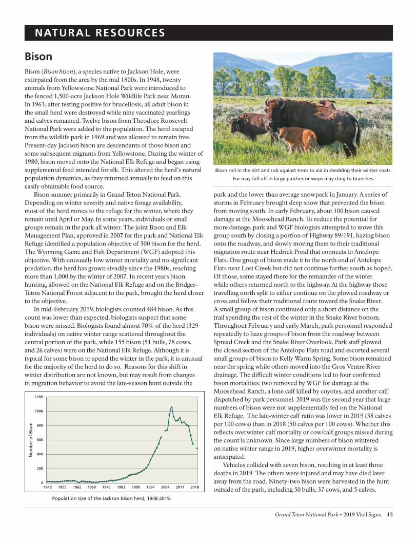
Bison Bison (Bison bison), a species native to Jackson Hole, were extirpated from the area by the mid 1800s. In 1948, twenty animals from Yellowstone National Park were introduced to the fenced 1,500-acre Jackson Hole Wildlife Park near Moran. In 1963, after testing positive for brucellosis, all adult bison in the small herd were destroyed while nine vaccinated yearlings and calves remained. Twelve bison from Theodore Roosevelt National Park were added to the population. The herd escaped from the wildlife park in 1969 and was allowed to remain free. Present-day Jackson bison are descendants of those bison and some subsequent migrants from Yellowstone. During the winter of 1980, bison moved onto the National Elk Refuge and began using supplemental feed intended for elk. This altered the herd’s natural population dynamics, as they returned annually to feed on this easily obtainable food source.
Bison summer primarily in Grand Teton National Park. Depending on winter severity and native forage availability, most of the herd moves to the refuge for the winter, where they remain until April or May. In some years, individuals or small groups remain in the park all winter. The joint Bison and Elk Management Plan, approved in 2007 for the park and National Elk Refuge identifed a population objective of 500 bison for the herd. The Wyoming Game and Fish Department (WGF) adopted this objective. With unusually low winter mortality and no signifcant predation, the herd has grown steadily since the 1980s, reaching more than 1,000 by the winter of 2007. In recent years bison hunting, allowed on the National Elk Refuge and on the Bridger-Teton National Forest adjacent to the park, brought the herd closer to the objective.
In mid-February 2019, biologists counted 484 bison. As this count was lower than expected, biologists suspect that some bison were missed. Biologists found almost 70% of the herd (329 individuals) on native winter range scattered throughout the central portion of the park, while 155 bison (51 bulls, 78 cows, and 26 calves) were on the National Elk Refuge. Although it is typical for some bison to spend the winter in the park, it is unusual for the majority of the herd to do so. Reasons for this shift in winter distribution are not known, but may result from changes in migration behavior to avoid the late-season hunt outside the
park and the lower than average snowpack in January. A series of storms in February brought deep snow that prevented the bison from moving south. In early February, about 100 bison caused damage at the Moosehead Ranch. To reduce the potential for more damage, park and WGF biologists attempted to move this group south by closing a portion of Highway 89/191, hazing bison onto the roadway, and slowly moving them to their traditional migration route near Hedrick Pond that connects to Antelope Flats. One group of bison made it to the north end of Antelope Flats near Lost Creek but did not continue further south as hoped. Of those, some stayed there for the remainder of the winter while others returned north to the highway. At the highway those travelling north split to either continue on the plowed roadway or cross and follow their traditional route toward the Snake River. A small group of bison continued only a short distance on the trail spending the rest of the winter in the Snake River bottom. Throughout February and early March, park personnel responded repeatedly to haze groups of bison from the roadway between Spread Creek and the Snake River Overlook. Park staf plowed the closed section of the Antelope Flats road and escorted several small groups of bison to Kelly Warm Spring. Some bison remained near the spring while others moved into the Gros Ventre River drainage. The difcult winter conditions led to four confrmed bison mortalities: two removed by WGF for damage at the Moosehead Ranch, a lone calf killed by coyotes, and another calf dispatched by park personnel. 2019 was the second year that large numbers of bison were not supplementally fed on the National Elk Refuge. The late-winter calf ratio was lower in 2019 (38 calves per 100 cows) than in 2018 (50 calves per 100 cows). Whether this refects overwinter calf mortality or cow/calf groups missed during the count is unknown. Since large numbers of bison wintered on native winter range in 2019, higher overwinter mortality is anticipated.
Vehicles collided with seven bison, resulting in at least three deaths in 2019. The others were injured and may have died later away from the road. Ninety-two bison were harvested in the hunt outside of the park, including 50 bulls, 37 cows, and 5 calves.
Population size of the Jackson bison herd, 1948-2019.
0
200
400
600
800
1000
1200
1948 1955 1962 1969 1976 1983 1990 1997 2004 2011 2018
Num
ber o
f Biso
n
Bison roll in the dirt and rub against trees to aid in shedding their winter coats.
Fur may fall off in large patches or wisps may cling to branches.

NATURAL RESOURCES
Columbian Sharp-tailed Grouse Columbian sharp-tailed grouse (Tympanuchus phasianellus columbianus) are endemic to sagebrush, shrub-steppe, mountain shrub, and riparian shrub communities. Once found in nine states and British Columbia, Canada, this subspecies now occupies less than 10% of its historic range. Excessive hunting in the 19th century combined with habitat alteration and degradation contributed to local population declines and range reduction. The Columbian sharp-tailed is the rarest sharp-tailed subspecies and has experienced the most severe declines in population and distribution. Sharp-tailed grouse are considered a species of greatest conservation need in Wyoming.
Similar to greater sage-grouse, sharp-tailed grouse males display in the spring to attract females to breeding grounds called leks. Leks are typically positioned on elevated sites with fat, open areas. Columbian sharp-tailed grouse leks tend to have taller vegetation and more shrub cover than leks of other sharp-tailed grouse subspecies. Little is known about the sharp-tailed grouse population in Jackson Hole. Several incidental observations of small groups of sharp-tailed grouse were recorded in Grand Teton over the years but no leks were found prior to 2010, and the nearest known lek was in Idaho along the western slope of the Tetons.
In the spring of 2010, biologists located a sharp-tailed grouse lek near the southeast boundary of the park, where they observed
fve males displaying. This marked the frst known sharp-tailed grouse lek in the park in over 40 years. In 2019, biologists observed one sharp-tailed grouse on the lek. The bird was not displaying and dense vegetation combined with poor lighting prevented the biologist from identifying the sex of the bird. This lone bird marks the lowest count of Columbian sharp-tailed on this lek since its discovery in 2010. Over the past four years maximum counts of sharp-tailed grouse on this lek declined from six males to the lone unknown sex bird. While staf never observed females on the lek during surveys, the longevity of lek activity as well as three observations of a hen with chicks within two miles of the lek in 2016 suggests that successful breeding occurs.
Counts of male Columbian sharp-tailed grouse on the Grand Teton lek, 2010-
2019. The gold box indicates the unknown sex of the bird observed in 2019.
0
1
2
3
4
5
6
7
8
9
10
2010 2011 2012 2013 2014 2015 2016 2017 2018 2019
Num
ber o
f Sha
rp-t
aile
d G
rous
e
Great Gray Owls The great gray owl (Strix nebulosa) is associated with old-growth boreal forest habitats in western Wyoming and is considered a species of greatest conservation need in Wyoming. Little is known about their population status and trends. Since boreal forests in Wyoming are currently at risk due to drought, insect outbreaks, disease, and logging; concern for the status of great gray owls is growing.
Starting in 2013, Grand Teton National Park partnered with the Teton Raptor Center (TRC) to collect baseline data on territorial occupancy, demographics, nest success, prey use, and year-round habitat use of the great gray owl population in the Jackson region. This data will aid area land managers in developing conservation plans and strategies.
In late winter–early spring of 2019, TRC biologists deployed automated recorders near previously occupied nests. These recorders documented owl activity in nine territories prior to nesting season, including two new territories. In 2019, fve great gray owl pairs initiated nests. At least two territories were successful, fedging a total of fve owlets. While this was an increase after very low success rates the last 2 years (≤1 nests initiated and owlets fedged for both 2017 and 2018), it still is below the highest success rate recorded in 2016 (8 nests initiated and 17 owlets fedged).
Biologists continued to track owls previously outftted with VHF transmitters as well as capture and outft additional owls
to evaluate habitat selection and movement patterns. A total of six adult owls within Grand Teton National Park had VHF transmitters in 2019. Additionally, researchers surveyed pocket gophers to assess prey availability and measured monthly snow depths at several owl territories throughout the valley and park.
Standing 24–33” tall, the great gray is the tallest of the owls but not the
heaviest. Their bulk is mostly feathers. Despite their size they are mostly invisible
quietly perched on the edge of meadows or forest openings.
16 Vital Signs 2019• Grand Teton National Park

NATURAL RESOURCES
Elk
Grand Teton National Park and the John D. Rockefeller, Jr. Memorial Parkway support a migratory Rocky Mountain elk (Cervus canadensis) population that is part of the larger Jackson elk herd. Elk summer throughout these park lands and occur at relatively high densities in low elevation open sagebrush, willow, and forested habitats. Most of the elk migrate to winter range on the National Elk Refuge near Jackson, but a small number winter in the eastern portion of the park. Other portions of the herd migrate through the park/parkway between the National Elk Refuge and summer ranges in Yellowstone and the Bridger-Teton National Forest. The Jackson elk herd is one of the largest in North America. Its migratory routes cross multiple jurisdictional boundaries as elk travel between seasonal ranges. As Grand Teton’s most abundant ungulate, elk have signifcant efects on park ecology. Their grazing and browsing may afect plant productivity and, as prey and carrion, elk provide sustenance to carnivores and scavengers. They are also popular with park visitors.
The mid-winter trend count objective for the Jackson elk herd set by the Wyoming Game and Fish Department (WGF) is a three-year average of 11,000 elk ± 20%. In the trend count conducted in 2019, WGF found 9,627 elk yielding a three-year average of 10,423. Estimated at above 19,000 during the early–mid 1990s, the Jackson herd is reduced by annual harvest on the national forest
and the refuge, in addition to an elk reduction program in the park (authorized by Congress in 1950 to help manage herd size when necessary). Non-harvest mortality (e.g., from winterkill) averages an unusually low 1–2% of the herd. During the 2019 park reduction program a total of 54 elk were harvested.
During the summer, park biologists count and classify elk from a helicopter in a portion of the park with high elk density and visibility. The survey is not intended as a census of park elk, but provides a minimum count of elk within the area surveyed. In 2019, park biologists counted and classifed 1,254 elk. The total number of elk counted was 20 fewer than in 2018. Overall numbers remained remarkably consistent from 2009–2014, but abruptly declined in 2015 and rebounded to near the previous level the last several years. Herd ratios and composition were 28 mature bulls, 16 spike bulls, and 32 calves per 100 cow elk. Calf ratios decreased compared to 2018 (45). The calf ratio was highest along the Snake River north of Moose and lowest in Willow Flats.
Atypical antlers on a bull elk can result from a variety of causes. Damage to the
pedicle, the growing base of the antler, will cause the anomaly to be present
in each successive years’ antler growth. Damage occurring to the antlers while
growing, covered with velvet, will only be present for that year. If a number of
animals in an area have similar anomalies, genetic variation is likely the cause.
t +
+ '
0
200
400
600
800
1000
1200
1400
1600
1800
0
5
10
15
20
25
30
35
40
45
50
2008 2010 2012 2014 2016 2018
N um
ber of Elk Counted Num
ber p
er 1
00 C
ows
Bulls Spikes Calves Totals
Grand Teton mid-summer elk count and classifcation, 2008–2019.
Golden EaglesGolden eagles (Aquila chrysaetos) are large aerial predators well suited to the Teton Range, with its abundance of clif faces for nest sites and diversity of prey found in the canyons. In the 1980s, biologists located golden eagle nests in Death, Avalanche, Cascade, and Webb Canyons but did not regularly monitor the Teton Range golden eagle population. Concerns about golden eagle populations throughout the western US have arisen recently, primarily because of habitat loss and alteration. Like many raptors, golden eagles are sensitive to disturbance around their nest sites.
In 2019, park biologists conducted ground surveys for golden eagles and their nesting behavior in fve of seven known territories. Biologists surveyed for golden eagles throughout Granite, Death, Avalanche, and Cascade Canyons, as well as the Uhl Hill area. Park biologists confrmed occupancy in Avalanche and Granite Canyons, but were not able to survey the other territories extensively enough to determine occupancy. The golden eagles in Avalanche Canyon nested in 2019; however, the success of this nest is unknown.
Grand Teton National Park • 2019 Vital Signs 17

Yelllowstone National Park
O "6% MCP Home Radges
CJ G<ondTelon••-•P.,.
IOMilu A
NATURAL RESOURCES
Gray Wolves After the US Fish and Wildlife Service and National Park Service reintroduced gray wolves (Canis lupus) into Yellowstone National Park in 1995–96, wolves dispersed to Grand Teton National Park and surrounding areas. In 1999, a wolf pack denned in Grand Teton and produced a litter of pups—the frst in the park in over 70 years. Since then, wolves continue to live and reproduce in the Jackson Hole area, including Grand Teton and the John D. Rockefeller, Jr. Memorial Parkway. The reintroduction of wolves restored a predator-prey relationship absent since humans eradicated wolves from the ecosystem in the early 20th century.
At the end of 2019, a minimum of 42 wolves in 4 packs resided in the Jackson Hole area with home ranges in Grand Teton National Park. The Lower Gros Ventre (12 wolves), Huckleberry (17), Pinnacle Peak (10), and Murie (3) packs used the park. Three packs produced pups in 2019: Lower Gros Ventre (5 pups), Huckleberry (11), and Pinnacle Peak (4). The Lower Gros Ventre and Huckleberry packs denned in the park. To minimize human disturbance to wolves raising young, park managers implemented closures around den and rendezvous sites for the Lower Gros Ventre and Huckleberry packs.
The Huckleberry pack had at least 11 pups likely from two breeding females. In March, three wolves split of from the Huckleberry pack to form the Murie pack maintaining a distinct and separate territory in the park’s valley bottom for the remainder of the year. The Huckleberry pack ventured to the southern end of the park in late November and then onto the Elk Refuge in late December, displacing the Pinnacle Peak pack. Three wolves died in the park in 2019. All three, adult females from the Huckleberry pack, were hit by separate vehicles on the North Park Road in June, July, and August.
To assist in wolf monitoring and research, eleven wolves were captured in December 2019 and ftted with 5 GPS and 5 VHF collars (one wolf was not collared). The return of wolves to Grand Teton and the surrounding area presents researchers with an opportunity to study the complex relationships of an ecosystem with an intact suite of carnivores and ungulates. Wolves and other predators afect prey populations and behaviors. In a fve-year study, biologists found that in the winter when elk densities were relatively low, wolves preyed primarily on elk (71%) and moose (26%) and fed on deer and bison infrequently (3%). In the summer, when elk densities in the park were high, wolves preyed almost exclusively on elk, with their calves representing more than half of the kills in June and July.
Wolves also prey on other species, including livestock which bring wolves into confict with humans outside the parks. A long history of controversy surrounds wolf management and the efects of wolves on ungulates and livestock. Wolves in Wyoming were removed from the federal list of threatened and endangered species in September 2012. In 2013, the State of Wyoming implemented a wolf hunt in the trophy management area of northwest Wyoming outside national parks, parkway, refuge, and the Wind River Indian Reservation. In September 2014, a court ruling suspended the hunt and again granted Wyoming wolves federal protection; however, on April 25, 2017, the US Court of Appeals for Washington DC ruled to reverse the 2014 decision and once again remove Wyoming wolves from the endangered species list.
Distribution of Jackson area wolf packs, 2019. MCP (Minimum convex
polygons) are home ranges based on collared pack members.
A trail camera captures wolves following a scent.
Nu
mb
er
of
Wo
lve
s
80 8
70 7
6 60
5 50
4
40
3
30 2
20 1
10 0
0 -1
Wolves
Packs
Breeding pairs
Nu
mb
er o
f Pa
cks a
nd
Bre
ed
ing
Pa
irs
1999 2001 2003 2005 2007 2009 2011 2013 2015 2017 2019
Population of Jackson area wolves, including those in Grand Teton, 1999-2019.
18 Vital Signs 2019• Grand Teton National Park

NATURAL RESOURCES
Great Blue Herons Great blue herons (Ardea herodias) are colonial water birds dependent on wetlands for feeding, nesting, and habitat security. Colonial nesters are highly vulnerable to human disturbance. Human activities near heron colonies (heronries) may infuence heron occupancy, disrupt nesting behaviors, change foraging behavior, increase predation, or lead to heronry abandonment. Heronries are also vulnerable to predation. Monitored since 1987 in Grand Teton National Park, heron occupancy and reproductive success vary widely with long-term productivity declining but fairly stable within the last decade. Over the last decade herons abandoned several historic heronries, most recently two along the Bufalo Fork. Bald eagles in particular can have devastating impacts on the survival of young herons. Biologists do not know if bald eagles nesting near the Bufalo Fork led to the demise or displacement of heronries in that area. In 2018, park biologists discovered a new heron nest at both Oxbow Bend and Moran Junction that are geographically separate from historic heron colonies. In 2019, biologists observed four additional active nests at both the Oxbow Bend and Moran Junction heronries.
During the 2019 breeding season, park staf located and monitored fve heron colonies in or adjacent to the park. At Arizona Lake, herons produced 30 young from 13 active nests. At Pinto Ranch, there were 11 active nests which produced a total of 21 young. The Oxbow Bend and Moran Junction heronries each had 5 active nests, yielding eight young each. The Sawmill Pond heronry was unoccupied, despite three nests still being present in this area.
In 2019, the totals of 34 active nests, 67 nestlings, and average of 2 nestlings per active nest were well above the 10-year averages (23.7, 41.7, and 1.6 respectively). Overall numbers of active nests and nestlings remained fairly stable with a slight increase for the past 10 years. While heron numbers increased since their historic lows of 1995-2006, current numbers are still well below the historic highs of the early 1990s.
Great blue herons do not mate for life but have
elaborate courtship rituals that help form a strong
pair bond.
0
0.5
1
1.5
2
2.5
3
3.5
0
20
40
60
80
100
120
140
160
1991 1993 1995 1999 2001 2004 2006 2009 2011 2013 2015 2017 2019
Nestlin
gs p
er active n
est
Nes
tlin
gs
and
act
ive
nes
ts
Active nests Nestlings Nestlings/Active nest
Great blue heron productivity in Grand Teton NP, 1991-2019. Arizona Lake
heronry, discovered in 2007 just outside the park’s boundary, is included in
the park’s monitoring program since 2009. Monitoring of heronries was not
conducted in 1996, 1997, 2002, or 2008.
Greater Sage-grouse Historically, greater sage-grouse (Centrocercus urophasianus) occurred in sagebrush habitats across much of Wyoming and the American West. Sage-grouse populations declined up to 80% throughout their range over the past 50 years, most likely due to increased livestock grazing, farming, residential development, invasive plants, and oil and gas development. The Jackson Hole sage-grouse population also declined, despite occurring in an area with a high density of public lands and protected habitat.
Sage-grouse congregate on display areas, or leks, during their breeding season each spring. Lek sites are usually open areas such as rocky slopes, burned areas, or gravel pits. Males perform a unique strutting display to attract females for breeding. Biologists began monitoring sage-grouse leks in Grand Teton National Park in the 1940s to document population trends.
In the spring of 2019, eight leks were monitored weekly [seven in the park and one on adjacent National Elk Refuge (NER) land] and sage-grouse consistently occupied seven leks (Airport, Bark Corral, Moulton, RKO, Spread Creek, Timbered Island, and North Gap-NER). The Airport pit, last active in 2014, was inactive in 2019.
For the six active leks within Grand Teton, the total maximum count of all sage-grouse was 55 and the maximum male count was
42; less than half of the 10-year averages of 150 and 105, respectively (and less than a quarter of the 2015 highs of 243 birds and 215 males). All leks within the park experienced historic lows possibly caused by limited winter habitat. Two of the past three winters, Grand Teton experienced well-above average snowpack that decreased the amount of exposed sagebrush which is critical cover and food for sage-grouse. This is possibly exacerbated by the loss of >2100 hectares of mature sagebrush habitat since 1998 due to wildfre.
250
200
Total Males Trend
Max
imu
m M
ale
Co
un
ts
150
100
50
0 1949 1989 1993 1998 2002 2006 2010 2014 2018
Counts of male sage-grouse with a trend line on Grand Teton NP leks 1948-2019.
No monitoring data for sage-grouse in 1952−1985 and 1993.
Grand Teton National Park • 2019 Vital Signs 19

NATURAL RESOURCES
Grizzly Bears Predator eradication programs eliminated grizzly bears (Ursus arctos) from most of the western U.S. by the 1950s. Due to its isolation, the Greater Yellowstone Ecosystem (GYE) became one of the last refuges for grizzly bears south of the Canadian border. In the frst half of the 20th century, garbage became a signifcant food source for bears throughout the region. In an efort to return bears to a diet of native foods, garbage dumps in the GYE were closed in the 1960s and 1970s. Following the dump closures, human-caused mortality increased signifcantly and the population declined from an estimated 312 grizzly bears, prior to the dump closures, to 136 bears in 1975. That same year the grizzly bear was federally listed as a threatened species.
Intensive conservation eforts over the next 40 years allowed grizzly bears to make a remarkable recovery. For 2019, the GYE grizzly bear population was estimated at 737 (95% confdence interval =657−818). This estimate is based on the estimated number of unique female grizzly bears with cubs (via Chao2 methodology) in the demographic monitoring area. There are more grizzly bears today, occupying a larger area (25,038 mi²), than there were in the late 1960s prior to the closure of the garbage dumps (312 bears occupying 7,813 mi²). Grizzly bears now occupy areas where they were absent for decades including all of Grand Teton National Park and the John D. Rockefeller, Jr. Memorial Parkway. The high visibility of bears foraging on native foods in roadside meadows makes Grand Teton a popular bear viewing destination.
As part of its enabling legislation in 1950, Grand Teton National Park administers an Elk Reduction Program (ERP) cooperatively with the state of Wyoming, when necessary, in portions of the park. Grizzly bear population recovery in the GYE coincided with increased human occupation on the periphery of the ecosystem and human visitation to public lands. Increasing grizzly bear numbers in ERP hunt areas over the last 20 years have created a unique and substantial challenge for national park managers. Given the availability of elk remains from this program,
grizzly bears may be attracted to areas where this program is administered. Although uncommon, human-bear conficts within Grand Teton, including the mauling of an elk hunter in 2011 and the death of a grizzly bear in an elk hunting-related incident in 2012, receive substantial local, regional, and national attention. As a result, park managers sought new, science-based information to help reduce the potential of conficts. Park biologists established a collaborative research project with USGS scientists. From 2014–15, intensive genetic sampling showed that while grizzly bears made temporary movements into the study area, those temporary movements occurred prior to the annual start date of the ERP and were primarily from transient bears. Resident bears (approx. 15) appear to be specializing on availability of elk remains from the ERP. The current timing of the ERP, after transient bears have moved to hibernation areas, helps reduce risks by limiting the availability of elk remains to a small number of resident bears only. Existing measures to reduce risk of human-bear conficts are efective; however, the risk of encountering resident bears remains for hunters in the feld.
This new, science-based research is the frst published efort to help inform managers about the ERP confict potential (research citation- van Manen, F. T., M. R. Ebinger, D. D. Gustine, M. A. Haroldson, and K. R. Wilmot. 2019. Primarily resident grizzly bears respond to late-season elk harvest. Ursus 30e1: 1–15). The researchers plan to continue their collaborative study through 2021, and their remaining work will estimate the distribution of elk remains due to the ERP, document use of those elk remains by grizzly bears, and estimate the risk factors of a human-bear encounter for participants in the ERP. This research will help inform decisions about the bear-human interface. Management of grizzly bears and their habitat continues to be a high priority in the park and parkway to ensure human safety and contribute to the population’s recovery.
A trail camera captures a grizzly bear guarding the cached (buried) gut pile of
an elk. Bears often guard their food even sleeping on it or nearby until they
are ready to consume more. If humans approach a bear’s food cache, they may
unwittingly trigger the bear to defend its food source.
Estimates of grizzly bear females with cubs of the year, 1984–2019, are used
to calulate the total grizzly population estimate within the USFWS-designated
Yellowstone Ecosystem Suitable Habitat. One recovery criteria is a population of
at least 48 grizzly bears females with cubs of the year.
0
10
20
30
40
50
60
70
1984 1989 1994 1999 2004 2009 2014 2019
Fem
ales
wit
h C
ub
s o
f th
e Y
ear
M. Eb
ing
er/ USG
S-IGB
ST
20 Vital Signs 2019• Grand Teton National Park
NATURAL RESOURCES
Harlequin Ducks The harlequin duck (Histrionicus histrionicus) is a relatively small species that breeds in northern boreal regions of eastern Canada, the Pacifc Northwest of the US and Canada, Alaska, and the Rocky Mountains. The population status for North American harlequin ducks is regionally variable; however, in the Rocky Mountain region they are considered a sensitive species and Wyoming lists them as a species of greatest conservation need. Harlequin duck core breeding range exists in Alaska, Washington, Oregon, Idaho, Montana, and Wyoming. The population in Wyoming represents the extreme southern and eastern extent of the western North American breeding population. The harlequin duck is one of the rarest breeding birds in Wyoming and its current breeding range appears to be limited to Yellowstone and Grand Teton National Parks, and the Bridger-Teton and Shoshone National Forests. Little information is available on survivorship, migration movements, winter habitat use areas, and general breeding ecology. Better understanding of these subjects are needed in order to conserve harlequin ducks in Wyoming.
For the ffth year, biologists in Grand Teton collaborated with both the Wyoming Game and Fish Department and the Biodiversity Research Institute to capture breeding pairs in the northern part of Grand Teton National Park. In 2019, the team of biologists captured one pair on lower Moose Creek, which included a female harlequin with a geolocator device.
The biologists equipped the male with a specialized implantable satellite transmitter and the female with a small geolocator device.
In early August, biologists returned to conduct surveys of Berry, Owl, and Moose Creeks to locate females and their broods. All harlequins observed during the August survey were found in Owl Creek. This included a hen with four ducklings, and fve hens without broods (four foraging together and a single hen alone).
The male harlequin’s showy plumage is unmistakable while the female is
identifed by the white patch behind the eye. These small ducks feed by
dabbling and diving. Their densely packed feathers trap a lot of air that both
insulates them from the cold water and makes them exceptionally buoyant,
popping them back to the surface like corks after dives.
Ospreys Ospreys (Pandion haliaetus) are medium-sized hawks that prey almost exclusively on fsh. The osprey population in Grand Teton is migratory and research documents that ospreys from the park migrate to the Mexican gulf coast and Cuba for the winter. Staf started monitoring osprey nests in 1968. From 1972–1981, only 6–9 nests were occupied each year. More recently, ospreys occupy approximately 14 territories annually (10-year average 14.2). Generally, ospreys nest near low-elevation lakes and along the Snake, Gros Ventre, and Bufalo Fork Rivers and their tributaries. Osprey are occasionally found in park canyons from mid-to-late summer, but nesting in these areas has never been documented.
In 2019, ospreys occupied 13 of 17 (76.5%) monitored
territories. Breeding activity occurred at 12 of these sites and 8 pairs successfully fedged a total of 16 young. These numbers are above the 10-year averages (7.2 successful breeding pairs and 11.8 young) and mark a second year of average or better statistics after the lowest number of fedglings were recorded in 2017 (3 chicks total from 2 breeding pairs). Of special note in 2019, three territories (Bufalo Valley, Emma Matilda East, and RKO) successfully fedged three chicks each, which is rare for ospreys in this area.
Although the number of territorial pairs has declined since 1990, the trend in active nests that are successful is more stable. The decline in the number of occupied territories coincides with an increase in the number of territorial bald eagles. Compared to bald eagles, osprey populations recovered relatively quickly following the banning of DDT and now that eagles are once again more prevalent on the landscape, osprey populations may be responding by stabilizing at a lower level. Territorial and successful osprey pairs, Grand Teton National Park, 1990-2019.
0
10
20
30
40
50
60
70
80
90
100
0
5
10
15
20
25
30
1990 1992 1994 1996 1998 2000 2002 2004 2006 2008 2010 2012 2014 2016 2018
Percent
Num
ber o
f te
rrit
orie
s
Number of Occupied Territories Precent active nests successful
Trend in Occupied Territories Trend in Percent Active Nests Successful
Osprey pairs do not remain together outside of the breeding season, but fdelity
to the nest is strong and the same pair will often breed together in subsequent
years enlarging and expanding the nest.
Grand Teton National Park • 2019 Vital Signs 21

- -
NATURAL RESOURCES
Moose Moose (Alces alces) were rare or absent from Grand Teton National Park prior to 1912, but became numerous by 1950. They are better adapted to survival in deep snow than other ungulates in the Greater Yellowstone Ecosystem. Except during the rut, moose are usually found alone or in small family groups. Grand Teton moose are part of the Jackson herd which includes animals outside the park boundaries. The herd experienced a decline from an estimated high of more than 4,000 in 1990 to less than 1,000 since 2008. This partially migratory herd moves between distinct but overlapping summer and winter ranges. The Wyoming Game and Fish Department conducts an annual aerial trend count of the Jackson moose herd. The count for 2019 totaled 258 moose (roughly 18 less than counted in 2018), including 47 within Grand Teton. Ratios were estimated at 52 calves and 91 bulls per 100 cows.
The moose herd decline likely resulted from a combination of interacting factors. The ecological landscape of today is dramatically diferent than the turn of the 20th century when moose populations expanded. At that time, large-scale predator reduction programs were ongoing throughout the west and wildfre suppression was widespread. Today, grizzly, cougar, and wolf populations have recovered, and large-scale wildfres afected portions of the herd unit in 1988, 2000, and 2010. Studies suggest that nutritional quality of moose forage in areas burned in 1988 is signifcantly lower than in unburned areas. Individuals summering in these areas have lower pregnancy and calf survival rates. Conversely, winter habitat availability does not appear to be limiting the growth of the Jackson moose population. Moose have narrow temperature tolerances. Temperatures above 57°F trigger moose to seek cooler locations. Many of the shady mature forests bordering the riparian forage areas preferred by moose remain absent after large catastrophic fres. Additionally, warming temperatures associated with changing climate may be afecting moose, by altering their feeding and other activities, potentially afecting food intake.
Biologists are also studying parasites, like carotid artery worms and ticks, to evaluate their efects on moose populations. Recent research indicates that carotid artery worm is found in 50% of the hunter-harvested moose in Wyoming. In a study begun in 2012, biologists assess the extent of hair loss caused by winter ticks in moose using photographs. Hair loss can leave moose unable to properly thermoregulate. In 2019, biologists analyzed hair loss data from 45 moose. In the southern portion of the park, mean total hair loss (broken and bare patches) for all individuals was 5.9%. Adult males had 5.1% mean hair loss, females had 7.2% mean hair loss, and calves had mean hair loss of 9.3%. In the northern portion of the park, moose exhibited a 4% mean hair loss, with 1.4% for males, 3.1% for females, and 1% for calves. Moose photographed in 2018 and 2019 had similar levels of mean hair loss; the lowest observed since the project began. Biologists continue to explore the relationship between weather indices (e.g. fall/spring temperatures and amount of snow-on-the-ground) and hair loss in moose as these variable may infuence tick survival. Earlier studies elsewhere demonstrated that severe winter tick infestations can negatively impact calf survival and tick reproductive success is positively afected by earlier springs and milder winters. While the nature of the link between parasites and the population decline is unknown, it is clear that these parasites are having an impact on the overall health of the moose population.
Jackson moose herd mid-winter counts, 1986-2019 (data from Wyoming Game
and Fish Department). These counts are used to estimate overall herd size.
0
200
400
600
800
1000
1200
1400
1986 1992 1998 2004 2010 2016
Num
ber o
f M
oose
Herd wide Grand Teton
Moose have long legs allowing them to easily wade through deep mud in pond
bottoms or deep snow. Their two large toes spread widely apart to stop them
from sinking. The hump at their shoulder is a powerful muscle. Their front legs
are longer than their back legs. They can nimbly jump over obstacles, are strong
swimmers, and can run at speeds up to 35 mph.
22 Vital Signs 2019• Grand Teton National Park

ld,hof
lANO JURISDICTION
Bure,u of Lind Min.gemtnl
fi3,h & Wildlife 5e-fvtee
Forest Servic@
N,11tiONI Parle Sttrvic@
Private
State
20mile$
W JO RIVER
SER\IATION
NATURAL RESOURCES
Mule Deer Mule deer (Odocoileus hemionus), one of many park animals that are seasonal residents, undertake annual migrations to distant wintering areas to meet their biological needs. Migrations showcase the behavioral strategies species use to exploit seasonal resources in otherwise inhospitable environments. Despite their intrinsic and ecological value, animal migrations have received little conservation attention until recently. Documenting animal movements is an essential frst step to meaningful conservation actions.
Park mule deer research identifes important animal migration corridors in the Greater Yellowstone Ecosystem. Park scientists are documenting the migrations of mule deer moving between summering grounds in Grand Teton National Park and the John D. Rockefeller, Jr. Memorial Parkway (JDR) and crucial wintering areas throughout the ecosystem. Specifc objectives for the mule deer migration research include: identifying important migration routes and seasonal use areas both inside and outside the park; determining the timing of migrations and assessing the variations in mule deer movements; evaluating land use patterns along migration routes to identify potential movement barriers, important deer stopover areas, and conservation needs; and working with partners to conserve migration routes and important seasonal habitats.
Since the project began in 2013, park biologists collared 53 adult female mule deer on summer range in the park and parkway. In 2019, biologists placed 29 GPS collars on adult female mule deer on Idaho winter ranges (11 at Sand Creek Wildlife Management Area and 18 along the Teton River) in partnership with the Idaho Department of Fish and Game and 16 GPS collars on mule deer summering in the park at Flagg Ranch (1), Jackson Lake Overlook
(1), Signal Mountain (4), Jenny/String Lakes area (6), Lupine Meadows (1), Taggart corrals (2), and the Gros Ventre Campground (6). Collectively, biologists recorded 192 complete migration sequences that describe 7 population-level corridors (travel paths of difering groups). The travel paths derived from the GPS collar data form a complex migration network spanning two states and multiple land management jurisdictions. This project continues to uncover great diversity within the migration network.
The deployment of 59 collars on eastern Idaho winter ranges from 2017–2019 vastly expanded scientifc knowledge of the routes mule deer use moving to summer ranges on both sides of the Teton Range and into Yellowstone National Park. In 2019, seven of these deer entered Grand Teton or the JDR. Most mule deer collared in the park in 2019 migrated south to wintering ranges along the western front of the Wind River Range. While the these routes often closely followed the Path of the Pronghorn on the southern end, the northern extent diverged considerably west for all but one individual. Four additional mule deer migrated onto the Wind River Reservation, wintering near Crowheart, WY. In addition, a new mule deer wintering range was identifed locally when two deer collared near Jenny Lake migrated to the Twin Creek drainage close to the National Elk Refuge and the Bridger-Teton National Forest boundary.
Travel paths of 68 mule deer that migrate seasonally from Grand
Teton National Park and the Teton Range and cross multiple of
land management jurisdiction boundaries.
In the course of their migration, mule deer face many obstacles.
Grand Teton National Park • 2019 Vital Signs 23
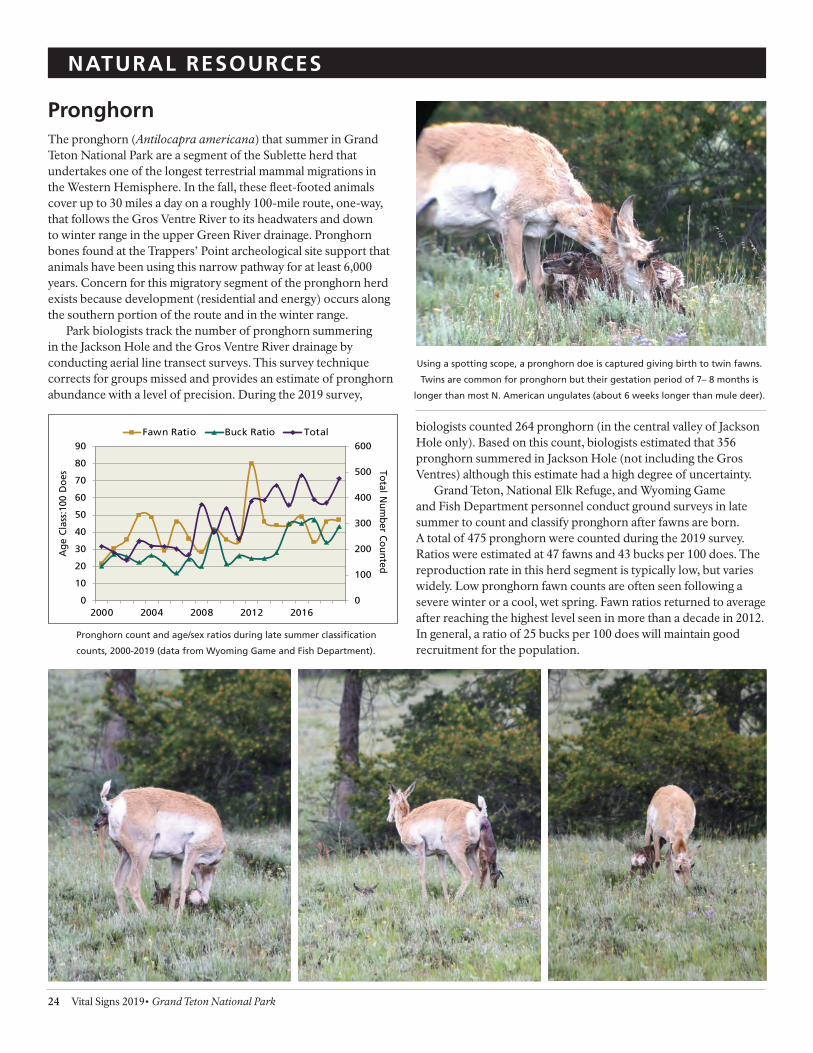
- -- -
NATURAL RESOURCES
Pronghorn The pronghorn (Antilocapra americana) that summer in Grand Teton National Park are a segment of the Sublette herd that undertakes one of the longest terrestrial mammal migrations in the Western Hemisphere. In the fall, these feet-footed animals cover up to 30 miles a day on a roughly 100-mile route, one-way, that follows the Gros Ventre River to its headwaters and down to winter range in the upper Green River drainage. Pronghorn bones found at the Trappers’ Point archeological site support that animals have been using this narrow pathway for at least 6,000 years. Concern for this migratory segment of the pronghorn herd exists because development (residential and energy) occurs along the southern portion of the route and in the winter range.
Park biologists track the number of pronghorn summering in the Jackson Hole and the Gros Ventre River drainage by conducting aerial line transect surveys. This survey technique corrects for groups missed and provides an estimate of pronghorn abundance with a level of precision. During the 2019 survey,
biologists counted 264 pronghorn (in the central valley of Jackson Hole only). Based on this count, biologists estimated that 356 pronghorn summered in Jackson Hole (not including the Gros Ventres) although this estimate had a high degree of uncertainty.
Grand Teton, National Elk Refuge, and Wyoming Game and Fish Department personnel conduct ground surveys in late summer to count and classify pronghorn after fawns are born. A total of 475 pronghorn were counted during the 2019 survey. Ratios were estimated at 47 fawns and 43 bucks per 100 does. The reproduction rate in this herd segment is typically low, but varies widely. Low pronghorn fawn counts are often seen following a severe winter or a cool, wet spring. Fawn ratios returned to average after reaching the highest level seen in more than a decade in 2012. In general, a ratio of 25 bucks per 100 does will maintain good recruitment for the population.
Pronghorn count and age/sex ratios during late summer classifcation
counts, 2000-2019 (data from Wyoming Game and Fish Department).
0
100
200
300
400
500
600
0
10
20
30
40
50
60
70
80
90
2000 2004 2008 2012 2016
Total Num
ber Counted
Age
Cla
ss:1
00 D
oes
Fawn Ratio Buck Ratio Total
Using a spotting scope, a pronghorn doe is captured giving birth to twin fawns.
Twins are common for pronghorn but their gestation period of 7– 8 months is
longer than most N. American ungulates (about 6 weeks longer than mule deer).
24 Vital Signs 2019• Grand Teton National Park

1 I 11 n I
--~ J -- - - ...... -- -
~-~ ~ - , ~
- -, , ... II ,11 w
-
-
NATURAL RESOURCES
Peregrine Falcons Peregrines (Falco peregrinus) are clif-nesting falcons that mainly eat other birds. The lower elevations of the major Teton Range canyons provide peregrines with excellent clif-nesting and diverse foraging opportunities. Decimated by DDT (used in the US until the 1970s), peregrine falcons were extirpated from the Greater Yellowstone Ecosystem by the 1960s. Between 1980 and 1986, 52 fedgling falcons were released at several sites in Grand Teton National Park and the John D. Rockefeller, Jr. Memorial Parkway. Following reintroduction, peregrine falcons frst attempted nestingin 1987 at Glade Creek and successfully fedged young the next year. Peregrines, once listed as threatened under the Endangered
Species Act, were delisted in 1999. Recently, peregrines occupied territories in Garnet, Death, Cascade, and Webb Canyons; Blacktail Butte; and Glade Creek.
In 2019, peregrines occupied fve of the seven territories monitored within the park and parkway. Of those occupied territories, peregrines successfully bred at three eyries and fedged fve chicks. Peregrines using Webb Canyon and Baxter’s Pinnacle territories fedged two chicks each while those in the Steamboat territory fedged one chick. After adult peregrines displayed courtship behavior near Baxter’s Pinnacle in Cascade Canyon, park managers established a temporary area closure to protect the nesting pair from disturbance due to the popular climbing route located close to the eyrie. After biologists confrmed that the pair successfully fedged their chicks, the closure was lifted. Adult falcons consistently occupied the Blacktail Butte and Glade Creek territories throughout the summer of 2019 but did not initiate nests. Garnet and Death Canyon territories were not occupied this year. The breeding statistics for 2019 were consistent or slightly higher than the 10-year averages, signifying that the peregrine falcon population in Grand Teton National Park is stable.
Territorial and successful peregrine falcon pairs, Grand Teton NP, 1987-2019.
0
10
20
30
40
50
60
70
80
90
100
0
1
2
3
4
5
6
7
1987 1991 1995 1999 2003 2007 2011 2015 2019
Percent
Nu
mb
er o
f Te
rrit
ori
es
Number Occupied territories Percent Active Nests Successful
Trend in Occupied Territories Trend in Percent Active Nests Successful
Trumpeter Swans Nearly exterminated in the contiguous 48 states by the turn of the 20th century, trumpeter swans (Cygnus buccinator) made a comeback after intensive captive breeding programs, habitat conservation measures, and protection from hunting. Despite these eforts, swan population growth is low in the tri-state region (the Greater Yellowstone Ecosystem and surrounding areas in MT, ID, and WY). Many factors likely inhibit recovery, including competition with migratory focks of swans, marginal winter range, variable reproduction rates, limited and low-quality nesting habitat, and high cygnet mortality. Monitored since 1987, Grand Teton provides important nesting habitat for swans.
The number of occupied swan sites, nesting pairs, and young hatched and fedged fuctuated widely since monitoring began. Biologists monitor 18 historic nesting territories: 13 within the park and parkway plus 5 outside but adjacent to park boundaries. In 2019, nesting territories were primarily monitored from the air. Swan pairs exhibited breeding behavior at four territories: Colter Bay Slough, Pinto Pond, and Indian and Loon Lakes. Only one of those four territories, Colter Bay Slough, is within the boundary of Grand Teton National Park. Throughout the summer and fall, biologists observed a total of seven cygnets hatched from these four active territories. A total of six cygnets survived to fedge from three territories. The pair at Colter Bay Slough produced one
cygnet, but what happened to the swan family is unknown—the slough water level dropped signifcantly by mid-July and the site was vacant. It is possible the swans moved somewhere unobserved and survived, but biologists could not confrm this.
Swan pairs have disappeared from some traditional park nesting sites that were occupied for decades. Substantially decreased water levels due to drought and other undetermined causes likely led to abandonment of some sites while increased human activity and predation may afect occupancy and productivity at other sites.
0
2
4
6
8
10
2010 2011 2012 2013 2014 2015 2016 2017 2018 2019
Nu
mb
er o
r p
airs
of
swan
s
Occupied Sites Nesting Pairs Fledged Occupied Sites Trend Nesting Pairs Trend Fledged Trend
Trumpeter swan productivity at territories within Grand Teton, 2010-2019.
Grand Teton National Park • 2019 Vital Signs 25

NATURAL RESOURCES
Red Fox Habituation of red foxes (Vulpes vulpes) to humans in national parks appears to be increasing in recent years. Habituated foxes have been documented at Acadia, Crater Lake, Grand Teton, and Mount Rainier National Parks. Anthropogenic food sources undoubtedly attract foxes. This includes the purposeful feeding of individual foxes by park visitors, ingestion of fsh remains left by anglers during winter, and opportunistically acquiring unsecured food in developed areas. Habituation can cause numerous issues, including harm to the wildlife ingesting processed foods, trafc hazards for wildlife and humans, health and safety concerns (e.g., aggression and disease transmission) for park visitors and employees, and property damage. Therefore, park resource managers aim to minimize the potential for human-fox conficts while maintaining this valued ecological and wildlife viewing resource.
To address habituation issues and make efective management decisions, park staf began a monitoring project in 2016 to gain a better understanding of fox ecology. Data collected from this project aids in assessments of temporal and spatial movements, distribution, foraging patterns, and diets of this resourceful and charismatic species. Increased ecological understanding of foxes coupled with enhanced outreach and education eforts will greatly reduce human-fox conficts in Grand Teton, as well as provide a template for addressing this wildlife management issue in parks throughout the country. Due to known dens near trails, roads or human development, 3 closures were implemented in 2019 to protect the denning foxes and kits. Remote cameras were set up to capture data about denning chronology, kit survival, and den attendance by the adult foxes.
In the winter of 2019, biologists again trapped, collared or marked, and collected samples from foxes in developed areas. Live trapping using box traps occurred near Moose, Beaver Creek, the
Murie Center, Teton Science School, Colter Bay, Jackson Lake Dam, Jackson Lake Lodge, and Signal Mountain Lodge. Blood and hair samples were collected for disease and diet analyses, and foxes were individually marked with ear tags and/or ftted with a collar (GPS or VHF). Samples were also collected from any known fox mortalities (primarily from vehicle collisions).
The 2 store-on-board GPS collars that were deployed in the winter of 2018 successfully released and were recovered in the winter of 2019. To date, a total of 27 individual foxes have been captured and a total of 24 foxes collared. Grand Teton biologists established a new partnership with a research team from the University of Wyoming, Haub School to analyze the disease, diet, and movement data that is being collected. Biologists will continue the study and capture additional foxes in the winter of 2020.
Two fox kits race back to the den to share what their mother brought for them
to eat. Red foxes come in a variety of different colors. In this case one kit is the
classic red while the other shares the mother’s darker coloring.
26 Vital Signs 2019• Grand Teton National Park

NATURAL RESOURCES
Sagebrush Steppe & High Elevation Vegetation
Grand Teton National Park hosts intact native plant communities that have seen very little direct human alteration. Sagebrush steppe occupies much of the valley foor and represents an incredibly diverse plant community with a greater variety of plant species than any other plant community in the park except for wetlands. Home to sage-grouse—a species of concern—as well as a myriad of other wildlife species, the health of sagebrush ecosystems is infuenced by direct and indirect efects of changing climate. Biologists are studying the overall health of this plant community and documenting long-term trends to aid in conservation eforts.
Approximately 15% of the park’s sagebrush steppe acreage has been afected by settler occupation and agriculture over the past 130 years. In 2009, park managers initiated long-term restoration of the Kelly Hayfelds—sagebrush steppe lands that were converted to agricultural use in the late 1890s and early 1900s, then abandoned when they became park lands in 1950. Understanding the intact sagebrush steppe plant community provides baseline information for evaluating ecological restoration success.
This year was the eighth year that vegetation biologists conducted monitoring studies of intact sagebrush communities, as well as some areas that are undergoing restoration. In 2019, biologists sampled more than 700 micro-plots in 14 sample frames distributed throughout native sagebrush steppe communities. This data set will be analyzed periodically to identify types and rates of change occurring in the sagebrush steppe community.
High elevation (alpine/sub-alpine) ecosystems in Grand
Teton also host intact plant communities that may be at risk of a rapidly changing climate. In 2017, park biologists established high-elevation monitoring in the upper South Fork of Cascade Canyon. They located monitoring sites in dry and moist areas to capture changes in vegetation due to both climate and fuctuations in meltwater output from Schoolroom Glacier. Biologists collected monitoring data in 2019 at three sites and the remainder will be revisited in 2020–2021.
Biologists inventory vegetation in a sagebrush monitoring plot.
Grand Teton National Park • 2019 Vital Signs 27

The mature cutthroat trout is recorded swimming through the chute
to access the spawning stream.
CHALLENGES
Snake River Fine-spotted Cutthroat Trout Grand Teton National Park is home to 12 species of native fsh along with 9 non-native fsh (4 trout species and 5 warm or tropical species). Two distinct looking but genetically undifer-entiated cutthroat trout (Oncorhynchus clarkii), the Snake River fne-spotted and Yellowstone cutthroat, are native to the park. Historically the Wyoming Game and Fish Department stocked both the easily accessible valley lakes and the remote backcountry lakes with non-native game fsh: lake, brook, brown and rainbow trout. With strong support from the park, the last fsh stocking program ended in 2006. The state manages the recreational fshing licenses and catch limits of both native and non-native fsh within the park, with input from the National Park Service. The potential impacts of non-native trout species on native trout in Grand Teton National Park continues to be a concern.
Grand Teton National Park fsheries staf initiated eforts to develop new tools to census cutthroat trout in the park with the support of the National Park Foundation and the One Fly Foundation. In order to assess the population status of the Snake River fne-spotted cutthroat trout, they constructed a video weir and installed it at Upper Bar BC Spring. The spring is one of the primary spawning springs in the park and has been a location for cutthroat recruitment studies for decades. By understanding the number of fsh entering spawning springs and streams, managers improve their knowledge of the cutthroat population and can better predict recruitment and future population trends.
In order to achieve a non-invasive census of the fsh entering the spring, fsheries personnel fabricated an aluminum weir that funnels fsh through a chute past a video camera in that records footage 24 hours a day. The lights, video camera, and recorder are powered by a solar array. The recorder uses security software to highlight time periods when movement is detected, allowing staf
to quickly review footage and count the number of fsh passing through the chute.
In 2019, a researcher from the University of Wyoming used the weir to gain data for his thesis. This study required handling each fsh and provided information on the sex of the fsh entering the spring. During the weir’s deployment (May 15–August 5, 2019), 105 cutthroat were recorded heading upstream (49 females, 55 males, and 1 undetermined). The frst fsh recorded heading upstream was on June 12, 2019 and the last one recorded heading to the spawning grounds was on July 28, 2019.
This video weir is the frst one constructed in Wyoming. In the future, this tool is expected to make accurate counts of fsh annually without the need to handle them, causing minimal disruptions to their activities. As the tool is refned the fsheries staf plans to use this method on other springs and streams for a more accurate survey of cutthroat in the park.
28 Vital Signs 2019• Grand Teton National Park
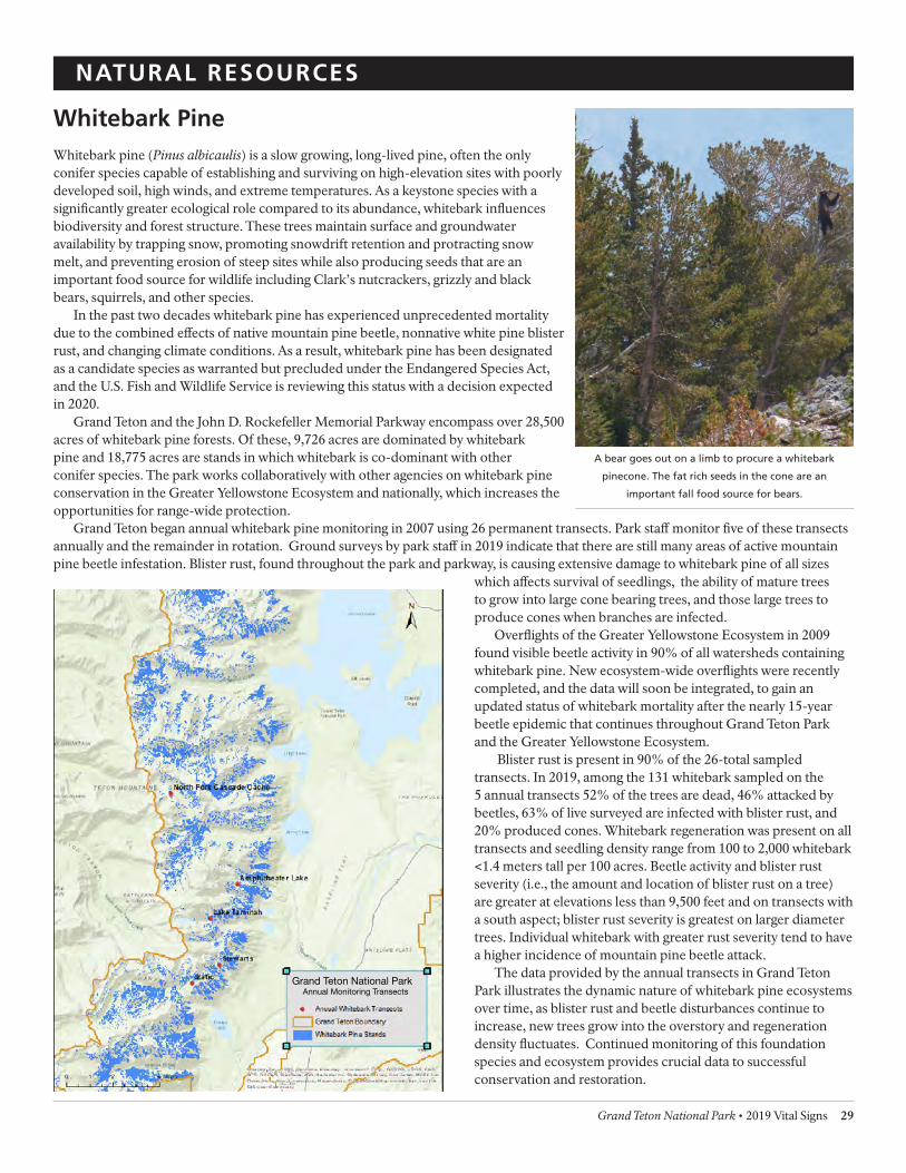
• k, ~ebarlc.Tfa...rtMCtl
Gt'i.,id Teton Boundlry
- W,aewlcP eSW'ads
-------:~
-~, .. . ..... .
NATURAL RESOURCES
Whitebark Pine Whitebark pine (Pinus albicaulis) is a slow growing, long-lived pine, often the only conifer species capable of establishing and surviving on high-elevation sites with poorly developed soil, high winds, and extreme temperatures. As a keystone species with a signifcantly greater ecological role compared to its abundance, whitebark infuences biodiversity and forest structure. These trees maintain surface and groundwater availability by trapping snow, promoting snowdrift retention and protracting snow melt, and preventing erosion of steep sites while also producing seeds that are an important food source for wildlife including Clark’s nutcrackers, grizzly and black bears, squirrels, and other species.
In the past two decades whitebark pine has experienced unprecedented mortality due to the combined efects of native mountain pine beetle, nonnative white pine blister rust, and changing climate conditions. As a result, whitebark pine has been designated as a candidate species as warranted but precluded under the Endangered Species Act, and the U.S. Fish and Wildlife Service is reviewing this status with a decision expected in 2020.
Grand Teton and the John D. Rockefeller Memorial Parkway encompass over 28,500 acres of whitebark pine forests. Of these, 9,726 acres are dominated by whitebark pine and 18,775 acres are stands in which whitebark is co-dominant with other conifer species. The park works collaboratively with other agencies on whitebark pine conservation in the Greater Yellowstone Ecosystem and nationally, which increases the opportunities for range-wide protection.
Grand Teton began annual whitebark pine monitoring in 2007 using 26 permanent transects. Park staf monitor fve of these transects annually and the remainder in rotation. Ground surveys by park staf in 2019 indicate that there are still many areas of active mountain pine beetle infestation. Blister rust, found throughout the park and parkway, is causing extensive damage to whitebark pine of all sizes
which afects survival of seedlings, the ability of mature trees to grow into large cone bearing trees, and those large trees to produce cones when branches are infected.
Overfights of the Greater Yellowstone Ecosystem in 2009 found visible beetle activity in 90% of all watersheds containing whitebark pine. New ecosystem-wide overfights were recently completed, and the data will soon be integrated, to gain an updated status of whitebark mortality after the nearly 15-year beetle epidemic that continues throughout Grand Teton Park and the Greater Yellowstone Ecosystem.
Blister rust is present in 90% of the 26-total sampled transects. In 2019, among the 131 whitebark sampled on the 5 annual transects 52% of the trees are dead, 46% attacked by beetles, 63% of live surveyed are infected with blister rust, and 20% produced cones. Whitebark regeneration was present on all transects and seedling density range from 100 to 2,000 whitebark <1.4 meters tall per 100 acres. Beetle activity and blister rust severity (i.e., the amount and location of blister rust on a tree) are greater at elevations less than 9,500 feet and on transects with a south aspect; blister rust severity is greatest on larger diameter trees. Individual whitebark with greater rust severity tend to have a higher incidence of mountain pine beetle attack.
The data provided by the annual transects in Grand Teton Park illustrates the dynamic nature of whitebark pine ecosystems over time, as blister rust and beetle disturbances continue to increase, new trees grow into the overstory and regeneration density fuctuates. Continued monitoring of this foundation species and ecosystem provides crucial data to successful conservation and restoration.
Grand Teton National Park Annual Monitoring Transects
A bear goes out on a limb to procure a whitebark
pinecone. The fat rich seeds in the cone are an
important fall food source for bears.
Grand Teton National Park • 2019 Vital Signs 29

CULTURAL RESOURCES
Archeological Sites Grand Teton National Park and the John D. Rockefeller, Jr. Memorial Parkway contain an array of archeological resources from prehistoric and historic human occupation in the park. There are about 550 identifed archeological sites within the park and parkway, 96% of which are recorded in the NPS database. The diverse archeological record provides a snapshot view into Jackson Hole’s past, including over 11,000 years of American Indian habitation within and adjacent to the Teton Range. Additional sites relate to the historic occupation of the park beginning in the late 19th century and include homesteads, roads, trails, irrigation ditches, and trash dumps. The vast majority of the park and parkway’s 333,700 acres has not been surveyed, and the sum total of knowledge about archeological resources amounts to approximately 4.7% of that area. The opportunity to discover new facts about the valley’s history through archeological study is vast.
During the summer of 2019, park staf worked with the trails crew to conduct archeological surveys in the backcountry. Deteriorating trail conditions near Paintbrush Divide and Hurricane Pass require intensive trail maintenance. Because the Civilian Conservation Corps constructed these trails in 1930s, special considerations to protect their historic values are required. In addition, increased visitor use at Delta Lake prompted trail building in an area not previously surveyed. Visiting these sites allowed the cultural staf to make informed decisions about the direction of these trail projects.
The Civilian Conservation Corps completed many park projects from
building roads, trails, and cabins to clearing the trees drowned
by the dam on Jackson Lake.
Inspecting a damaged part of the trail on Paintbrush Divide.
At the beginning of the summer season, cultural resource staf gave presentations to park employees introducing them to basic archeological principles and educating them on what steps to follow if they encountered an object or site in the park. Over the summer, park seasonal archeologists conducted several surveys to fulfll requirements set out in Sections 106 and 110 of the National Historic Preservation Act. Contract archeologists also conducted survey work in preparation for several proposed park construction projects.
In anticipation of projects, Grand Teton invites consultation with 24 traditionally associated American Indian tribes. These consultations aid collaboration and inform decision-making. In 2019, Grand Teton conducted one in-person consultation and held many conversations with Tribal Historic Preservation Ofcers.
30 Vital Signs 2019• Grand Teton National Park
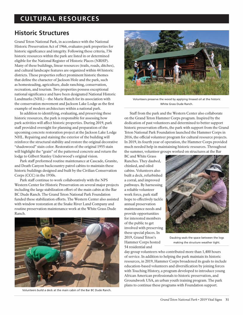
Volunteers preserve the wood by applying linseed oil at the historic
White Grass Dude Ranch.
CULTURAL RESOURCES
Historic Structures Grand Teton National Park, in accordance with the National Historic Preservation Act of 1966, evaluates park properties for historic signifcance and integrity. Following these criteria, 736 historic resources within the park are listed in or determined eligible for the National Register of Historic Places (NRHP). Many of these buildings, linear resources (trails, roads, ditches), and cultural landscape features are organized within 44 historic districts. These properties refect prominent historic themes that defne the character of Jackson Hole and the park, such as homesteading, agriculture, dude ranching, conservation, recreation, and tourism. Two properties possess exceptional national signifcance and have been designated National Historic Landmarks (NHL)—the Murie Ranch for its association with the conservation movement and Jackson Lake Lodge as the frst example of modern architecture within a national park.
In addition to identifying, evaluating, and preserving these historic resources, the park is responsible for assessing how park activities will afect historic properties. During 2019, park staf provided oversight for planning and preparation of the upcoming concrete restoration project at the Jackson Lake Lodge NHL. Repairing and staining the exterior of the building will reinforce the structural stability and restore the original decorative “shadowood” stain color. Restoration of the original 1955 stain will highlight the “grain” of the patterned concrete and return the lodge to Gilbert Stanley Underwood’s original vision.
Park staf preformed routine maintenance at Cascade, Granite, and Death Canyon backcountry patrol cabins to maintain these historic buildings designed and built by the Civilian Conservation Corps (CCC) in the 1930s.
Park staf continue to work collaboratively with the NPS Western Center for Historic Preservation on several major projects including the large stabilization efort of the main cabin at the Bar BC Dude Ranch. The Grand Teton National Park Foundation funded these stabilization eforts. The Western Center also assisted with window restoration at the Snake River Land Company and routine preservation maintenance work at the White Grass Dude Ranch.
Volunteers build a deck at the main cabin of the Bar BC Dude Ranch.
Staf from the park and the Western Center also collaborate on the Grand Teton Hammer Corps program. Inspired by the dedication of past volunteers and determined to better support historic preservation eforts, the park with support from the GrandTeton National Park Foundation launched the Hammer Corps in 2016, the ofcial volunteer program for cultural resource projects. In 2019, its fourth year of operation, the Hammer Corps provided much needed help in maintaining historic resources. Throughout the summer, volunteer groups worked on structures at the Bar BC and White Grass Ranches. They daubed, chinked, and oiled cabins. Volunteers also built a deck, refurbished a corral, and improved pathways. By harnessing a reliable volunteer work force, park staf hope to efectively tackle annual preservation maintenance needs and provide opportunities for interested members of the public to get involved with preserving these special places. In 2019, Grand Teton’s Hammer Corps hosted 54 residential and day group volunteers who contributed more than 1,400 hours of service. In addition to helping the park maintain its historic resources, in 2019, Hammer Corps broadened its goals to include education-based volunteers and diversifcation by joining forces with Touching History, a program developed to introduce young African American professionals to historic preservation, and Groundwork USA, an urban youth training program. The park plans to continue these programs with Foundation support.
Daubing seals the space between the logs
making the structure weather tight.
Grand Teton National Park • 2019 Vital Signs 31

had P. ..,t , • l J' o110\lals-i.eo .. 1.,1ns
our b&:a• CIIIIIP in • OhMant •IWn •• ~ lO®t.e<. Mlt .-a,
u;, 1 •l,tl t..1.anron. Bo.ev9l"• 4 t.o th• l•t• bo.ir of' depl,rt\lN'
fT'G~ J.n:QJ l.U.. ( '7 i3' :, •• , . ....... Cdl ~l• to lloko t.Aa
netd ot Let ClaQoa. ber ore d • 0\11" -.kid oap ne•t. '°
t.h11 t .. had e at:abl l llbed GIUP bho\o&CI 111 a nootu:rnal 'J"NM'IYCN9
t or l a.•J .. ..,.. lr9Pt • •UII -11 Ill.ti bJ ••""1 prlokl:' Tla l t.or• •
I'be r tr-n. • • Hnlt. WM .U.eoOYa:-ed bJ' Ole n &t. a141:il t.
u t"-4 Vb.II 1-u4.::.7 anDDN 'bJ a pm.~ ., t.bll u. af hl•
1l • •Ptn& bq. ■U.• and 1 Nie ....--ia\...,. ~ 07 lll.■1'A ' •
blood t.1U.-dltnr &lua ud. :roae \,o U. ooou:lon ...a Yitn l'OOka,
llW>• • and other pr lJl.lU'NI ,._,1..-..nu or t.M ~••• .. l ..
no1• J atrc.• ...e ...,.. ou:ipaC mxt to .aa.rao ••Ml .nt.
e...u.nap fCI"' tb• rutlln& ~r-o&.~b or t.1'!111 •Dl14'1'1 • ~ 110
1 t ... that- w ..,.. rinl. .a»l • to dlaoo-.er ••• .. •l •~eq_u.nt.
• u.1~1.. rwo -oar-..aJ"U , l• rs:i..s tbr• •l•.plr oa • •
pt11!!1U atO"N , rOOIS aunlJ, eoolt ' ftl 111d • •UAI uian~t1• 1
b! • • .ae,UeJ"-. o,aox, , p._r u , t•o U.0 1 .1 7/11'. '
,..~, two t oa n , ...... al e&rlblnttr• ,
y.rt•tJ of ~1 '°"8• lo9q\&l o r• •1 · 1tr:\ 'P1"0"-' to
1' • r t • • ••
l
\ I
CULTURAL RESOURCES
Museum Collection & Archives Grand Teton’s archival collection documents the complex history of Grand Teton National Park. The archives—the two-dimensional paper based unpublished materials—include reports, photographs, and maps documenting subjects ranging from land management, park history, and natural resources to the Tetons’ extensive climbing history. The park’s archives contain early records from the Jackson Hole National Monument which include the legislative records and historic photographs that document park projects through time. The archives also contain the manuscript collection from Glen Exum, the frst climbing concessioner in Grand Teton and a recently donated scrapbook created by Dick Pownall, a 1940s Exum guide, documenting his time in the Tetons. With fnding aids to assist research, the archives are a well-organized resource available by appointment to park staf and the public.
Grand Teton’s museum collection preserves objects that represent the human historical record, such as natural history specimens, archeological materials (projectile points and scrapers), historic vehicles, a signifcant fne art collection, regional handmade furnishings, and the renowned David T. Vernon Collection of ethnographic materials. While Grand Teton National Park lacks a museum facility that adequately meets the storage, research, and conservation needs of the collection, some materials are held in repositories maintained by other institutions outside the park, such as the Midwest Archeological Center in Lincoln, Nebraska, where a large percentage of the park’s archeological collection is stored. The majority of the Vernon Collection is also currently housed of site at the National Park Service’s Western
Archaeological and Conservation Center in Tucson, Arizona, to ensure the preservation of the materials. A small number of pieces from the Vernon Collection are displayed in two of the park’s visitor centers. In 2017, park staf installed a new exhibit of David T. Vernon collection and contemporary items entitled “Living Traditions: Refections from the Past.” Historic and contemporary items are displayed together to illustrate enduring cultural traditions and document changes in those traditions over time. These pieces show how modern Native American art is a refection of the past blended with elements of contemporary Native culture.
A few items from the museum collection are on exhibit outside of the park in local museums such as the National Museum of Wildlife Art and the Teton Valley Museum. The park continues to explore options to develop appropriate facilities for the park collections.
In partnership with Idaho State University’s Geosciences and Geography Department, Grand Teton’s museum program is working to document the history of recreational use in Grand Teton. Research in 2019 continued from the previous year to focus on collecting oral histories from Jenny Lake climbing rangers in addition to park concessioners operating river trips on the Snake River since the mid-1950s.
As of 2019, 85.78% of the one-million-item collection is processed and cataloged. While the park curator completed a full inventory of the collection, updates to the collections management database are still in progress to document Grand Teton’s natural and cultural history.
Two pages from Dick Pownall’s scrapbook documenting their climb of Thor Peak on July 22, 1949.
32 Vital Signs 2019• Grand Teton National Park

- CHALLENGES
Aquatic Invasive Species Aquatic invasive species (AIS) are aquatic organisms that are not native in a particular watershed. These species vary in size and phylum and are most often, but not solely, introduced to a new watershed via watercraft. Once introduced, many species can thrive without the presence of their natural predators or competitors. This can result in major alterations to native ecosystems, and adversely afect recreation, water utilization, and the local economy. A few examples of species that have recently expanded their range near Grand Teton National Park include curly leaf pondweed (Potamogeton cripus), fowering rush (Butomus umbellatus), and fsh species such as burbot (Lota lota). Quagga and zebra mussels (Dreissena bugensis and D. polymorpha, respectively) are two of the most impactful invasive species in the US and signifcantly expanded their range in the last 10–20 years, but have not been found in the park or parkway.
The park has enacted measures to prevent the introduction of AIS, inspecting watercraft and educating boaters on practices to prevent the spread of unwanted species. In 2019, for the fourth year, the park had watercraft inspection stations at two locations operating daily during prime visitation periods (May 25–September 29). Crews inspected 18,726 watercraft, with an additional 3,589 commercial rafts passing through the stations. (Commercial rafts are only used on the Snake River and therefore are not inspected.) In the summer of 2019, 197 boats/day came through the stations an increase from previous years (189 boats/ day in 2018 and 177 boats/day in 2017). Staf preformed 36 decontaminations to reduce the risk of AIS introduction. Boaters can help prevent AIS introductions and speed inspections by ensuring they drain, clean, and dry their watercrafts and gear after every use.
National Park Service personnel contracted with Working Dogs for Conservation of Bozeman, Montana to have dogs trained in the detection of quagga and zebra mussels. The dogs trained using dead mussel samples to a 100% detection rate. In 2019, these dogs spent two weeks in each of eight NPS units working on prevention of Dreissenid mussel introductions. The canines assist in watercraft inspections and AIS outreach eforts, looking solely for mussels. The dog’s handler would obtain permission from boaters to allow the dog to snif the outside of the vessel.
While the handler and certifed dog proceeded to the search the watercraft’s exterior, the NPS inspector independently conducted their examination. The dogs wore booties to prevent any potential property damage, increase traction, and protect their paws from the hot pavement. After the dog completed their search, the handler would give interested boaters a business trading card reading “You’ve Been Snifed!” with the dog’s name and picture, a brief profle of the dog, and some conservation messaging. If a trained dog alerted, fnding a mussel, the NPS inspector followed up searching the area and applying appropriate decontamination protocols. In addition to the canine expertise in mussel detection, this unique program promotes public awareness of AIS prevention and improves the boater contact experience. Actively involving the public in preventing mussel spread is an important factor in preventing contamination of park waters.
An AIS inspector works with a dog that is specially trained to sniff out invasive
mussels on watercraft. These dogs also generate public interest and awareness.
Grand Teton National Park • 2019 Vital Signs 33

CHALLENGES
Chronic Wasting Disease Chronic wasting disease (CWD) is a naturally occurring prion disease of cervids (species in the deer family). The disease attacks the brain causing animals to become emaciated, display abnormal behavior and poor coordination, and eventually die. Since the 1967 discovery of CWD in a captive mule deer herd in Colorado, the disease has spread geographically and increased in prevalence. CWD is now relatively well established and widely distributed in the eastern two-thirds of Wyoming and also has been detected in scattered hunt areas in the west. The spread of CWD in elk generally lags behind deer. The closest elk hunt area with confrmed CWD is roughly 80 miles from Grand Teton, southeast of Cody.
After the 2008 detection of CWD in a Star Valley moose, less than 50 miles of Grand Teton National Park, park biologists implemented a more intensive sampling program with targeted surveillance of deer and elk showing clinical signs of the disease. In November 2018, a sample from an adult male mule deer road-killed near Kelly, WY tested positive for CWD, marking the frst detection of CWD in Grand Teton National Park. In response, park biologists developed a CWD Action Plan to manage CWD, minimize disease spread, conduct research, and increase communication. The plan included securing and testing deer
carcasses before disposing of them to limit disease spread. A large walk-in freezer is used to store mule deer carcasses, while test results are pending. Park and USGS research partners collected soil samples at carcass disposal sites and random spots within the park to serve as a baseline for environmental prion contamination. These samples will be banked until diagnostic methods are available to assess the risk of indirect transmission due to environmental prion contamination. Additionally, surveillance eforts were intensifed by requiring mandatory testing of elk harvested during the parks’ Elk Reduction Program (ERP).
Biologists collected the retropharyngeal lymph nodes, tonsils, or obex from road-killed cervids and hunter-killed elk during the ERP and submitted those samples for testing at the Wyoming State Veterinary Laboratory. In 2019, NPS personnel collected a total of 78 samples from cervids in the park: 12 mule deer, 3 white-tailed deer, 4 moose, and 55 elk. Twenty-nine samples were collected from roadkills, two from winter-killed moose, and 39 from the Elk Reduction Program. Compliance with the new mandatory submission of samples for CWD testing during the ERP was 72% in the frst year of the requirement. None of the samples were positive for the disease.
Integrated Pest Management Grand Teton National Park managers remain committed to the safety, health, and well-being of park visitors and employees. The park’s Integrated Pest Management (IPM) program is tasked with prevention, response to, and mitigation of pest related issues in park visitor facilities, employee housing, and other structures. In 2019, IPM responded to 141 reports of pest issues including intrusions into structures by bats, mice, insects, birds, and other species.
Currently, the park’s biggest pest issue is the ingress of bats into employee quarters. At least 12 species of bats are native to the park and also vital to the ecosystem as voracious consumers of insects. However, their intrusion into housing units can carry serious consequences for human inhabitants as bats carry batbugs and are a reservoir for rabies and other diseases. In 2019, the IPM team responded to 68 bat related incidents in park buildings, representing nearly 48% of all IPM cases. The combined eforts of the IPM team (consisting of Science and Resource Management and Facilities staf) in 2017 and 2018 to exclude bats from housing units with previously high exposure potential proved successful, resulting in a sharp decrease in human exposures. IPM will continue exclusionary eforts in other problem housing units.
In August of 2019, a bat landed on a visitor hiking in the park. As the visitor brushed the bat away, it bit her fnger. Luckily another quick acting member of the hiking party collected the bat and brought it to park staf for testing. Physical contact with a bat is unusual, especially when not in association with a structure that harbors bats. Wyoming has a low incidence of rabies, less than
1%; however, this bat tested positive for the disease. Knowing the results allowed the visitor to receive proper treatment. Over the course of the summer IPM staf submitted 17 additional bats for testing and all were negative for rabies.
Park staf continue to educate and raise awareness of the severity of bat exposure to employees, partners, concessioners, and visitors while encouraging appropriate reactions from the individuals. The positive results of the IPM team eforts encourage more consistent reporting of issues and proper mitigation of conficts.
Park staff installed bat houses at several locations to provide bats with a safe
place to roost instead of occupied buildings.
34 Vital Signs 2019• Grand Teton National Park

CHALLENGES
Elk Reduction Program The legislation that created the expanded Grand Teton National Park in 1950 included a provision for controlled reduction of elk in the park, when necessary, for the proper management and protection of the elk herd. A long-term objective of the program is to reduce the need to harvest elk within the park. Management of elk in the park and on the National Elk Refuge (NER) is guided by the Bison and Elk Management Plan (BEMP), completed and implemented by the US Fish and Wildlife Service and the National Park Service in 2007. The plan calls for working collaboratively with the Wyoming Game and Fish Department (WGF) to achieve an objective of 11,000 elk in the Jackson herd, a wintering population of 5,000 elk on the NER, and working toward bull to cow ratios in the park that are refective of an unhunted population. Also outlined in the plan is a strategy to restore previously cultivated lands in the park to improve habitat condition on elk winter and transitional range. The plan projected that roughly 1,600 elk would summer in the park given plan implementation.
The need for the elk reduction program (ERP) is evaluated and determined jointly by Grand Teton and WGF on an annual basis, based on plan objectives and data collected throughout the previous year during both the mid-summer classifcation count in the park and the mid-winter trend count that includes elk wintering outside of the park.
Both the annual mature bull ratio and the fve-year running average were below the threshold identifed in the BEMP, at 28 and 30 bulls per 100 cows, respectively. At this level biologists recommended no bull harvest for 2019. The 2019 mid-winter trend count was 9,627 elk and the three-year running average 10,423, which the WGF considers at objective. The trend is stable; however, elk wintering on the refuge number well above the 5000 elk objective. The mid-winter calf ratio, which is strongly tied to the level of population growth, was 20 calves per 100 cows. With the trend for the Jackson elk herd remaining stable, the antlerless harvest in 2019 was intended to slow growth of the herd. Park managers are discussing with other agency partners conditions under which an ERP would not be warranted in some years since the population has been at objective since about 2013.
The 2019 elk reduction program was structured diferently than the 2018 season with no permits ofered in Hunt Area (HA) 79. The number of permits authorized In HA 75 was reduced from 575 to 375 with no Type 4 permits ofered.
The 2019 ERP was conducted for 36 days from November 2–December 8. The Antelope Flats portion of HA 75 closed on November 24th. Hunt Area 79 was not open in 2019 because summer surveys suggest that the productivity of these elk was low compared to more southern residents—a pattern similar to the northern migratory elk in the Teton Wilderness and southern Yellowstone National Park. The reduction in hunting pressure on antlerless elk in HA 79 is generally consistent with management objectives in adjacent hunt areas 70 and 71.
A total of 54 elk were harvested in during the ERP in 2019. The majority (83%) of elk taken were adult cows. About half of the harvest occurred during the last half of November with the other half occurring in early December. A late harvest is typical when a late migration occurs.
While some bull elk were harvested during past years, the ERP is structured to
promote the health of the herd and currently is limited to antlerless elk.
Grand Teton National Park • 2019 Vital Signs 35

CHALLENGES
Fish Passage Park biologists monitor the health of park fsheries. Of special concern is the fragmentation of fsh habitat, usually the result of human actions. Alterations to a water course can make it difcult for fsh to travel to critical portions of the waterway. Mitigating obstacles can facilitate fsh passage. Irrigation ditches draw from several drainages in the park for agricultural purposes within or adjacent to the park. Water drawn from streams also hosts fsh that may end up trapped or entrained in these ditches. Once entrained, fsh have difculty fnding their way back into streams and often die prematurely. Fisheries biologists monitor fsh passage and/or entrainment especially in Spread Creek, the Granite Supplemental Ditch, and Ditch Creek.
The 2010 removal of the diversion dam built on Spread Creek in the 1960’s allowed fsh to access 65 miles upstream; however, the newly installed irrigation infrastructure still captures some fsh as they migrate downstream. Previously the park partnered with the Wyoming Game and Fish Department (WGF), Trout Unlimited (TU), the Snake River Fund, and volunteers to help return about 100–300 cutthroat trout back to the stream annually. In 2018 and 2019, deteriorating rock weirs caused signifcant change to the fow and as less water entered the irrigation ditches there was a corresponding decline of fsh getting trapped.
Another irrigation system, the Granite Supplemental Ditch, draws from the Snake River (10%–15% of the fow at the point of diversion) to irrigate lands in the “West Bank” region of Jackson Hole. This large draw of river water entrains several species of fsh at varying life stages each summer. To understand how this ditch, which crosses paths with some perennial streams, afects the fsh that enter the ditch from the river, park fsheries staf teamed with WGF and TU to implant transmitters in 15 adult cutthroat in 2017 and another 30 in 2018 to monitor their fate. Data analysis suggests that the maximum mortality rate is 75% for trout entering the ditch although some adult cutthroat are able to escape after frst entering the ditch. High numbers of other fsh also get stranded in this ditch and are less capable of escaping the high water velocities at the headgates, likely experiencing higher mortality rates. In 2019, park staf initiated a project to quantify the number of fsh entering the ditch during the summer. Using nets on the downstream end of the headgate culverts, biologists identifed, measured, and counted fsh entering the ditch. Extrapolating from their sampling time (approximately 6% of the time headgates were open), biologists
estimated the number of cutthroat 6” or greater entering the ditch was 5,014–6,677 with much higher total numbers of fsh entrained. The variation in the estimate is due to sampling hours being primarily during the day, while high numbers of fsh were counted in the one overnight sampling event. Even the most conservative estimates suggest that entrainment in the ditch may be detrimental to the fshery.
Ditch Creek fows out of the Gros Ventre Mountains, through Antelope Flats to meet the Snake River about a mile north of Moose. The creek hosts several species of spawning fshes including Snake River fne-spotted cutthroat trout, bluehead (categorized as extremely rare by WGF), Utah and mountain sucker, and other small non-game species. Settlers started manipulating the stream’s 9.4-square mile alluvial fan on Antelope Flats in the early 1900s, adding 150 miles of irrigations ditches and channelizing the stream to better facilitate agricultural pursuits. In 1957 and 1960 two bridges with culverts were installed across the stream. These cul-verts were too long and steep for fsh to negotiate when attempting to access spawning habitat upstream of these obstacles.
In 2012 and 2014, park staf installed bafes in the culverts to mitigate the situation. Unfortunately the stream also eroded west of Mormon Row Road in 2014, stalling the eforts to restore fsh passage. While aggrading and avulsing is the stream’s natural tendency, the ditches and repeated channelization of the stream caused a new series of barriers to materialize. In 2017, the park partnered with the Grand Teton National Park Foundation, One Fly, and Patagonia to successfully raise funds and hire an excavation company to reactivate the primary channel and restore Ditch Creek as a fsh-passable stream. Starting in spring of 2018, fsh from the Snake River could access more than 23 miles of the stream’s headwaters for the frst time in nearly six decades. Biologists captured and Passive Integrated Transponder (PIT) tagged 126 fsh (Snake River fne-spotted cutthroat trout, bluehead suckers, mountain suckers, and Utah suckers) to track how the fsh used the newly accessible habitat. Biologists placed antennas and recorded tagged fsh swimming past the former barriers. In 2019, additional work was done to reinforce the stream bank at three locations.
Habitat connectivity is vital in ensuring a healthy fshery. Working with water rights holders to increase the efciency of irrigation ditches and reduce entrainment are strategies that could help keep the fshery healthy.
The water in Ditch Creek almost breached the bank during high spring fows in 2018. Bank reinforcement in the fall of 2019 will help maintain stream fow.
36 Vital Signs 2019• Grand Teton National Park
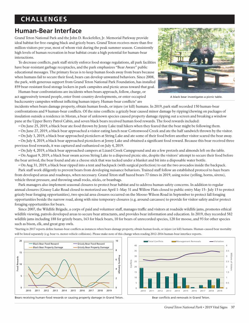
-
CHALLENGES
Human-Bear Interface Grand Teton National Park and the John D. Rockefeller, Jr. Memorial Parkway provide ideal habitat for free-ranging black and grizzly bears. Grand Teton receives more than fve million visitors per year, most of whom visit during the peak summer season. Consistently high levels of human recreation in bear habitat create a high potential for human-bear interactions.
To decrease conficts, park staf strictly enforce food storage regulations, all park facilities have bear-resistant garbage receptacles, and the park emphasizes “Bear Aware” public educational messages. The primary focus is to keep human foods away from bears because when humans fail to secure their food, bears can develop unwanted behaviors. Since 2008, the park, with generous support from Grand Teton National Park Foundation, has installed 859 bear-resistant food storage lockers in park campsites and picnic areas toward that goal.
Human-bear confrontations are incidents when bears approach, follow, charge, or act aggressively toward people, enter front-country developments, or enter occupied backcountry campsites without inficting human injury. Human-bear conficts* are incidents when bears damage property, obtain human foods, or injure (or kill) humans. In 2019, park staf recorded 150 human-bear confrontations and 9 human-bear conficts. Of the nine conficts: a grizzly bear caused minor damage by ripping/chewing on packages of insulation outside a residence in Moran, a bear of unknown species caused property damage ripping out a screen and breaking a window pane at the Upper Berry Patrol Cabin, and seven black bears received human food rewards. The food rewards included:
• On June 25, 2019, a black bear ate food thrown by Jenny Lake trail hikers when they feared that the bear might be following them. • On June 27, 2019, a black bear approached a visitor eating lunch near Cottonwood Creek and ate the half sandwich thrown by the visitor. • On July 3, 2019, a black bear approached picnickers at String Lake and ate some of their food before another visitor scared the bear away. • On July 4, 2019, a black bear approached picnickers at Jenny Lake and obtained a signifcant food reward. Because this bear received three
previous food rewards, it was captured and euthanized on July 4, 2019. • On July 4, 2019, a black bear approached campers at Lizard Creek Campground and ate a few pretzels and almonds left on the table. • On August 9, 2019, a black bear swam across String Lake to a dispersed picnic site, despite the visitors’ attempt to secure their food before
the bear arrived, the bear found and ate a cheese stick that was tucked under a blanket and bit into a disposable water bottle. • On Aug 31, 2019, a black bear ripped into a tent and backpack (with surgical perfection) to eat the two avocados inside the backpack. Park staf work diligently to prevent bears from developing nuisance behaviors. Trained staf follow an established protocol to haze bears
from developed areas and roadways, when necessary. Grand Teton staf hazed bears 77 times in 2019, using noise (yelling, horns, sirens), vehicle threat pressure, and throwing small rocks, sticks, or beanbags.
Park managers also implement seasonal closures to protect bear habitat and to address human safety concerns. In addition to regular annual closures (Grassy Lake Road closed to motorized use April 1–May 31 and Willow Flats closed to public entry May 15– July 15 to protect grizzly bear foraging opportunities), two special area closures occurred on the Moose-Wilson Road in September to protect fall foraging opportunities beside the narrow road, along with nine temporary closures (e.g. around carcasses) to provide for visitor safety and/or protect foraging opportunities for bears.
Since 2007, the Wildlife Brigade, a corps of paid and volunteer staf, manages trafc and visitors at roadside wildlife jams, promotes ethical wildlife viewing, patrols developed areas to secure bear attractants, and provides bear information and education. In 2019, they recorded 582 wildlife jams including 188 for grizzly bears, 163 for black bears, 10 for bears of unrecorded species, 128 for moose, and 93 for other species such as bison, elk, and great gray owls. *Starting in 2017 reports defne human-bear conficts as instances when bears damage property, obtain human foods, or injure (or kill) humans. Human-caused bear mortality
will be listed separately (e.g. bear vs. motor-vehicle collisions). Please make note of this change when reading 2012-2016 human-bear interface reports.
A black bear investigates a picnic table.
0
2
4
6
8
10
0
5
10
15
20
2010 2011 2012 2013 2014 2015 2016 2017 2018 2019
Prop
erty Dam
age
Foo
d R
ewar
ds
Black Bear Food Reward Grizzly Bear Food Reward
Black Bear Property Damage Grizzly Bear Property Damage
0
0.5
1
1.5
2
2.5
3
3.5
4
0
5
10
15
20
25
30
35
40
2010 2011 2012 2013 2014 2015 2016 2017 2018 2019
Millions of V
isitors
Conf
icts
Total Conficts Management Removals Visitation
Bears receiving human-food rewards or causing property damage in Grand Teton. Bear conficts and removals in Grand Teton.
Grand Teton National Park • 2019 Vital Signs 37

2019 CommonlyTreatedSpecies
CHALLENGES
Invasive Plants The survey and control of invasive nonnative plants remains a high priority for Grand Teton vegetation staf. Invasive plants alter habitats by displacing native vegetation communities, afecting wildlife distribution, and limiting foraging opportunities for ungulates, invertebrates, and other native grazers. During the 2019 feld season, vegetation staf, along with partners and contractors, actively surveyed 8,222 weed infested acres, specifcally treating 2,429 acres within the park for 30 invasive nonnative plant species.
Invasive plants have multiple origins. In addition to accidental introductions from Eurasia, early homesteaders planted nonnative cultivar and ornamental plant species prior to establishment of the park, and many of these species persist. Today, humans inadvertently transport weed seeds on their vehicles, clothing, and in construction materials. Wildlife, domestic stock, and livestock feed also transport weed seeds in the park. Areas particularly at risk to invasive plant infestations include disturbed areas along roads, levees, and pathways, as well as trails, utility corridors, and building sites. Formerly disturbed sites within the park such as homesteads, hayfelds, and gravel pits remain a management challenge.
Grand Teton biologists prioritize control eforts according to plant species, abundance, and site characteristics, based on threats posed to ecological processes and prospects for successful treatment. Some infestations can be eradicated if treated when an outbreak is still small and a seedbank not well established. Other species have become so common that containment of current infestations is now the primary goal. Invasive plants listed as federal, state, or county “noxious weeds” are particularly aggressive plants and legally deemed to be detrimental to agriculture, navigation on inland waterways, fsh and wildlife, and/ or public health. Park staf focus eforts on locating and using the best treatment practices to address listed noxious plant species. Examples of sites where biologists successfully managed noxious weeds in recent years include: Barker Meadow (multiple weed species), Moran Cemetery (Dalmatian toadfax), Bradley-Taggart Trailhead and meadow (yellow toadfax), and Kelly Hayfelds (musk thistle). In 2019, park vegetation crews surveyed some of the Kelly Hayfelds restoration projects for cheatgrass and found signifcantly less cheatgrass compared to surveys in 2016.
Management actions in 2019 included herbicide treatments by backpack sprayers and horse-, truck-, UTV-, and tractor-mounted spray equipment. Biologists carefully select herbicides to minimize impacts to non-targeted species and water sources. Park staf began using a new herbicide specifcally designed for treating cheatgrass with longer lasting results. Staf and volunteer groups also implemented mechanical treatments, hand pulling, and removal with shovels or cutting tools. Park staf invested the majority of their labor in disturbed portions of the sagebrush-steppe communities that dominate the lower elevations of the park. In 2019, vegetation crews worked on areas disturbed by placement of water lines at Moose and wireless internet lines in Moran. These areas needed immediate attention to promote native species growth and to keep invasive plants out. Additionally, invasive plant treatment is part of the Kelly Hayfelds restoration project, which aims to return nearly 4,500 acres of former agricultural land to native habitat and continues to be a large focus of program resources.
Backcountry weed surveys in 2019 included a post-fre invasive inventory and priority species treatment for the Berry, Owl, and Webb drainages. Front-country surveys identifed a new invasive species to the park, birdsfoot trefoil (Lotus Corniculatus) found in three locations near the Laurance S. Rockefeller Preserve. At present it is found in low numbers, with one large patch in the parking lot and vegetation crews are working to suppress it.
Partnerships with Teton County Weed and Pest District, the Northern Rockies Exotic Plant Management Team, the Jackson Hole Weed Management Association, and the Greater Yellowstone Coordinating Committee are very important to successful invasive plant management. Interagency collaborations with the Bridger-Teton National Forest and the National Elk Refuge are equally essential. In 2019, the invasive plant management program actively participated in numerous events aimed at noxious weed management and habitat improvement in the greater Jackson Hole and Grand Teton ecosystems (including the multi-agency Gros Ventre River Spray Days, Hunter Ranch and Stewart’s Draw treatments, and priority treatments on the Caribou-Targhee National Forest). Weed crews chop off nonnative thistle heads to stop them from going to seed.
Musk thistle 46%
Canada thistle 18%
Cheatgrass 18% Spotted
knapweed 6%
Houndestongue 5%
Other 7%
38 Vital Signs 2019• Grand Teton National Park

CHALLENGES
Kelly Warm Spring Kelly Warm Spring is a thermal feature that has a long history of aquarium dumping leading to the proliferation of nonnative species in the spring. Nonnatives persisted throughout the warm spring efuent and in 2012 biologists found goldfsh (Carassius auratus), native to east Asia, and tadpole madtoms (Notorus gyrinus), native in much of eastern North America, in Ditch Creek, some within 10 yards of the Snake River.
Park biologists also found American bullfrogs (Lithobates catebeianus), another species with a wide latitudinal native range, that were introduced for unknown reasons in the 1950s and continue to thrive in the thermal feature and its efuent. The bullfrog is implicated in declines of native amphibian populations throughout the world due to both direct and indirect factors. In Grand Teton National Park native amphibians are nearly wholly absent in the bullfrog’s occupied range with only a couple western toads being found on the periphery of bullfrog inhabited waters. An NPS study of fall movements and over wintering habitat found American bullfrogs made more upstream movements than downstream movements with their largest movements occurring before the frst cold snap of the season. The winter range was more widespread than managers had hoped leaving the species less vulnerable to mechanical removal eforts.
After several years of environmental analysis, park resource managers moved forward with a plan to restore Kelly Warm Spring to a more natural state. The plan included using rotenone, a chemical that is lethal to organisms with gills, to treat the nonnative
infested spring and its efuent. NPS staf with vital assistance from Wyoming Game and Fish personnel completed the treatment in August 2018. The treatment successfully reduced the quantity of invasive species in the spring but failed to remove all fshes present, a necessary frst step in restoring a native assemblage to the spring. Approximately 600–700 pounds of dead fsh were removed from the area, estimated to be more than half of the biomass created by the treatment. Rotenone tolerant and intolerant species survived the application. Bullfrog tadpoles experienced high mortality rates but were not completely eliminated from the system. Alternative treatment strategies are being considered for future eforts. Resource managers plan additional treatments to achieve complete restoration, but the control action was an important step in improving the condition of Kelly Warm Spring.
An elk herd grazes around the spring as they head north after wintering on the
National Elk Refuge.
Livestock Grazing Grand Teton National Park permits livestock grazing due to traditional land use that existed prior to the park’s establishment. When Grand Teton was expanded in 1950, the enabling legislation allowed ranches on inholdings to retain their grazing allotments indefnitely while another 26 ranches were granted grazing privileges for the lifetime of immediate family members and heirs. Collectively, these provisions allowed livestock grazing and trailing on about 69,000 acres (22% of the park). Over time, these grazing allotments were substantially reduced through attrition and the park’s acquisition of inholdings by purchase or donation.
In 2009, to address concerns about grazing impacts on riparian vegetation and to reduce impacts to grizzly bears and wolves, park managers moved the largest remaining cattle allotment from open range on split NPS/US Forest Service lands to the park’s fenced and irrigated Elk Ranch pasture which also predates the park’s establishment.
In 2019, four ranches used a total of approximately 5,000 acres within park boundaries for livestock grazing and trailing. These included two park inholdings with grazing permits: the Moosehead Ranch grazed 64 horses and the Pinto Ranch grazed 290 yearling steers; Triangle X Ranch, a concessioner operating a historic dude ranch within the park, grazed 120 horses; and Teton Valley Ranch, operating on an agricultural lease that dates back to
the 1940s, grazed approximately 34 longhorn steers. Grand Teton National Park maintained another 33 horses and mules to support backcountry operations in the park and the State of Wyoming owns a 640-acre inholding that is leased for cattle grazing.
Current livestock grazing in the park has been reduced by approximately 89% from historic grazing use. Park staf manage the remaining horse and cattle grazing with the goals of minimizing conficts between stock and park wildlife, maintaining sufcient irrigation while balancing park aquatic resources, and reducing the spread of invasive nonnative plant species.
Cowboys drive cattle along the road toward a grazing allotment in the park.
Grand Teton National Park • 2019 Vital Signs 39

CHALLENGES
Mountain Goats Mountain goats (Oreamnos americanus) are native to many rugged mountains of the northwest US, however not to the Greater Yellowstone Ecosystem. The nearest native mountain goat population occurs in the Lemhi Range of Idaho, approximately 125 miles northwest of Grand Teton National Park. From 1969 to 1971, the Idaho Department of Fish and Game released goats into the Snake River Range south of the park for the beneft of hunters. This transplanted population grew and some individuals dispersed to new areas. Observations of mountain goats in the Teton Range began in 1977, with the frst sighting in the park by 1979. Until 2008, mountain goat observations were sporadic and thought to represent a few transient individuals. Since then park biologists have documented adult female mountain goats (nannies) with young (kids) each year, indicating that a breeding population is now established in the park.
The Teton Range is also home to a native bighorn sheep population, a species of concern because of its small size, isolation from neighboring herds, low genetic diversity, and loss of historic winter range. Teton bighorns live year-round at high elevation where conditions are extreme, especially in the winter. As mountain goats and bighorn sheep share similar habitats and forage, the potential for competition and the risk of pathogen transmission between the species could pose additional threats to the already stressed sheep population.
Since 2014, park biologists have captured 15 mountain goats (12 nannies, 1 subadult billy, and 2 kids) to better understand goat distribution, numbers, survival, movements, and reproduction in the Tetons. Captured animals were sexed, aged, weighed, collared with a GPS radio collar, and sampled for pneumonia pathogens before being released. Relative to surrounding mountain goat herds, few pneumonia pathogens were found. This result is unexpected because the Snake River Range population, the likely source of mountain goats in the Tetons, carries all the pathogens known to cause pneumonia.
Wyoming Game and Fish Department (WGF) personnel counted a total of 88 mountain goats during an aerial survey of bighorn sheep in December 2018. Most of the mountain goats were observed in the park between Cascade and Leigh Canyons; although, several groups of nannies with kids were seen in Teton Canyon and lone goats were observed on Mount Hunt and in
A trail camera captures a picture of a nursing nanny and several kids. The
occurrence of twin kids in most established mountain goat populations is
unusual. In the Teton herd, twins are fairly common and park biologists even
observed a set of triplets. This indicates an expanding herd.
Moose Creek. Several groups of mountain goats, including some with kids, were also seen in Moran Canyon and on Eagle Rest Peak. A lone mountain goat was observed in Falcon Canyon; the furthest north observation. A total of 65 adults, 20 juveniles (kids), and 3 yearlings were observed. Assuming half of the adults were nannies, the ratio would be 62 kids per 100 nannies.
In 2017, park biologists initiated a genetics study in collaboration with several partners to confrm the source of Teton Range mountain goats. Biologists gathered genetic samples for analysis from three populations—Snake River Range (30 individuals), Teton Range (47), and the Northern Absaroka/ Beartooth Range (28) and examined how genetics were shared among the three populations. Preliminary results suggest that given the two potential source populations evaluated, the mountain goats in the Teton Range most likely originated from those in the Snake River Range.
The park released a fnal mountain goat management plan/ environmental assessment in October 2019. The park plans to begin plan implementation in winter 2019/2020. To reduce the numbers of mountain goats in the Teton Range outside the park, the WGF established a new hunt area and ofered 48 limited quota (any mountain goat) licenses that were not restricted to the once-in-a-lifetime provision. A total of 23 mountain goats were harvested; 14 males and 9 adult females.
Each spring mountain goats molt their thick shaggy winter coats.
40 Vital Signs 2019• Grand Teton National Park

CHALLENGES
Native Plant Restoration Native plant revegetation and ecological restoration return degraded or damaged habitats to functioning ecological systems. A primary goal of vegetation management in Grand Teton National Park and the John D. Rockefeller, Jr. Memorial Parkway is to protect the integrity of the native plant communities and the wildlife species that depend on them. Successful work to reestablish native plant communities must also include eforts to minimize the establishment of invasive, nonnative species. All revegetation and restoration work conducted in Grand Teton National Park is accomplished by conserving local topsoil and using plant materials that originate within park boundaries that are genetically adapted to local environmental conditions and natural communities. Research shows that using native plant materials adapted to the local environment translates into greater success of restoration for ecosystem function.
In 2019, the revegetation crew worked on 12 separate projects, seeding disturbed areas associated with park infrastructure improvements such as waterline replacements, building construction, and road repairs. Vegetation staf also provided expertise and support restoring 0.3 acres of wetland habitat which was previously flled in by infrastructure.
All revegetation and restoration areas are seeded with ecologically appropriate mixes consisting of native grass, forb, and shrub seed originating from materials hand collected within the park. Additional native seed is generated by seed increase, where locally hand-collected seed is grown and harvested in felds outside the park. In recent years, vegetation management staf has diversifed its seed sources and enhanced productivity by harvesting seed from felds planted within the park. In 2019, vegetation staf harvested approximately 500 pounds of native seed from a site within the Kelly Hayfelds restoration project, efciently
and sustainably contributing locally sourced native seed for future restoration projects.
Park vegetation crews continue long-term restoration of the 4,500-acre Kelly Hayfelds from nonnative pasture grass to native plant communities that provide important habitat supporting elk, bison, antelope, sage grouse, other birds, and pollinators. Techniques for restoration include herbicide applications to remove nonnative hay crop species and invasive plants, native seed collection and seeding, monitoring, and adaptive follow-up treatments. In 2019, the park’s restoration team partnered with researchers to evaluate the past ten years of project data and begin a multi-year assessment of the ecological condition and function of recovering restoration sites. These assessments will provide critical knowledge to inform future management actions in the Kelly Hayfelds restoration. Over the past eleven years, park vegetation staf initiated restoration on a total of 1,319 acres which are in various stages of recovery. Many of these sites show signs of providing functional habitat for wildlife.
Healthy sagebrush growth in a section of the Kelly Hayfelds restoration project.
2019 Revegetation and Restoration Accomplishments
Revegetation projects seeded 16.9 acres
Kelly Hayfelds restoration seeded 168 acres Native seed collection
Bulk material weight 28 species 500 lbs
Wetland restoration along Christian Creek.
Grand Teton National Park • 2019 Vital Signs 41
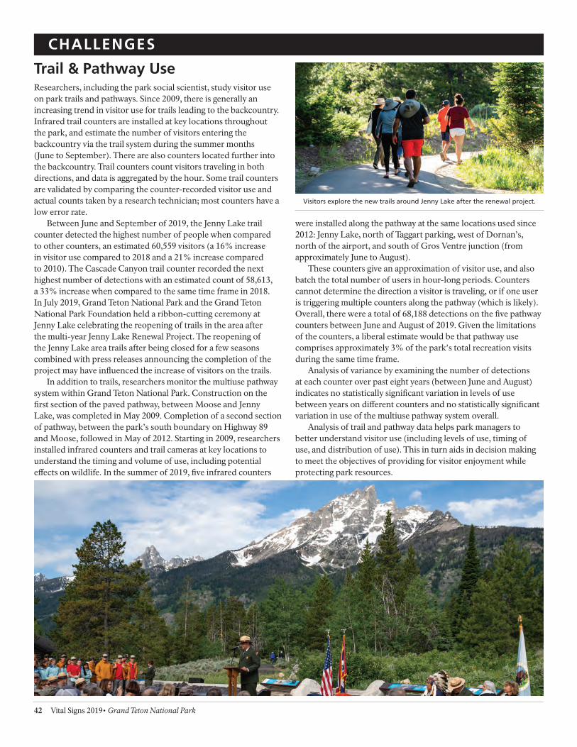
CHALLENGES
Trail & Pathway Use Researchers, including the park social scientist, study visitor use on park trails and pathways. Since 2009, there is generally an increasing trend in visitor use for trails leading to the backcountry. Infrared trail counters are installed at key locations throughout the park, and estimate the number of visitors entering the backcountry via the trail system during the summer months (June to September). There are also counters located further into the backcountry. Trail counters count visitors traveling in both directions, and data is aggregated by the hour. Some trail counters are validated by comparing the counter-recorded visitor use and actual counts taken by a research technician; most counters have a low error rate.
Between June and September of 2019, the Jenny Lake trail counter detected the highest number of people when compared to other counters, an estimated 60,559 visitors (a 16% increase in visitor use compared to 2018 and a 21% increase compared to 2010). The Cascade Canyon trail counter recorded the next highest number of detections with an estimated count of 58,613, a 33% increase when compared to the same time frame in 2018. In July 2019, Grand Teton National Park and the Grand Teton National Park Foundation held a ribbon-cutting ceremony at Jenny Lake celebrating the reopening of trails in the area after the multi-year Jenny Lake Renewal Project. The reopening of the Jenny Lake area trails after being closed for a few seasons combined with press releases announcing the completion of the project may have infuenced the increase of visitors on the trails.
In addition to trails, researchers monitor the multiuse pathway system within Grand Teton National Park. Construction on the frst section of the paved pathway, between Moose and Jenny Lake, was completed in May 2009. Completion of a second section of pathway, between the park’s south boundary on Highway 89 and Moose, followed in May of 2012. Starting in 2009, researchers installed infrared counters and trail cameras at key locations to understand the timing and volume of use, including potential efects on wildlife. In the summer of 2019, fve infrared counters
were installed along the pathway at the same locations used since 2012: Jenny Lake, north of Taggart parking, west of Dornan’s, north of the airport, and south of Gros Ventre junction (from approximately June to August).
These counters give an approximation of visitor use, and also batch the total number of users in hour-long periods. Counters cannot determine the direction a visitor is traveling, or if one user is triggering multiple counters along the pathway (which is likely). Overall, there were a total of 68,188 detections on the fve pathway counters between June and August of 2019. Given the limitations of the counters, a liberal estimate would be that pathway use comprises approximately 3% of the park’s total recreation visits during the same time frame.
Analysis of variance by examining the number of detections at each counter over past eight years (between June and August) indicates no statistically signifcant variation in levels of use between years on diferent counters and no statistically signifcant variation in use of the multiuse pathway system overall.
Analysis of trail and pathway data helps park managers to better understand visitor use (including levels of use, timing of use, and distribution of use). This in turn aids in decision making to meet the objectives of providing for visitor enjoyment while protecting park resources.
Visitors explore the new trails around Jenny Lake after the renewal project.
42 Vital Signs 2019• Grand Teton National Park

CHALLENGES
Visitor Use Use of Grand Teton National Park and the John D. Rockefeller, Jr. Memorial Parkway by visitors is both a primary reason for their establishment and a factor infuencing resource condition. Increases in visitation may afect natural and cultural resources, as well as the quality of visitor experiences. Some factors that may infuence visitation to parks include economic conditions, natural disasters, weather, and gasoline prices.
In 2019, the national parks had almost 500 million annual visits, collectively. More than 327 million of these visits were recorded as recreation visits, meaning that the visitor entered lands or water administered by the National Park Service to use the park (alternatively, examples of a non-recreation visit include commuters, employees of the NPS going to work, access to
inholdings, etc.). Fifty percent of the total recreation visits to NPS units occurred in 27 parks (only 7% of all NPS units). Compared to 2018, recreation visits increased by 2.9% service-wide in 2019.
Grand Teton National Park had more than fve million visits in 2019, a 1.8% decrease from last year’s visitation, and a 8% increase in visitation over the past fve years. More than 3.4 million of these visits were recreation visits (68% of all visits). Over half of visitation (52%) occurred between June and August. Although there are no day-use limits, lodging and campgrounds in the park have limited available space, and on most July and August nights, one or more forms of accommodation are full.
Num
ber
of V
isits
in M
illio
ns
6
5
4
3
2
1
0 1999 2001 2003 2005 2007 2009 2011 2013 2015 2017 2019
Recreation Visits Non-Recreation Visits Total Visits
Annual Grand Teton NP visitation 1999–2019.
Visitors orient themselves using a park map.
Grand Teton National Park • 2019 Vital Signs 43

- - - -- - - --
CHALLENGES
Wildlife-Vehicle Collisions Wildlife casualties from motor vehicle collisions on Grand Teton National Park and the John D. Rockefeller, Jr. Memorial Parkway roads are common occurrences. Since 1991, park staf record data on wildlife-vehicle collisions to help identify appropriate measures to lower the number of collisions and improve the safety of park roads for humans and wildlife.
In 2019, 161 collisions occurred involving 169 animals, a 10% increase from 2018. The long-term increase may refect, in part, greater eforts in recent years to document collisions, including those involving smaller bodied species. The trend in collisions involving ungulates, a group with consistent recording over the past two decades, is stable. This is noteworthy given the increase in total annual visitation since 2012 (28%) indicating that there are several factors (e.g., ungulate population size, timing of migrations, winter severity, etc.) that likely infuence the number of collisions. In 2019, collisions involved 60 ungulates, a 22% decrease from 2018. Trends within ungulate species remain stable except for moose and mule deer which had collision decreases of 40% and 39%, respectively. In 2019, 86% of incidents resulted in a confrmed animal death. In incidents where a carcass could not be located near the road, some animals may have died later from injuries sustained in the collision. The majority of collisions occurred during the snow-free months (138 from May–October) and peaked in August, the second highest month for visitation.
A total of 40 species (18 mammals and 22 birds) were involved in collisions in 2019. Large mammals accounted for 77 of the 169 animals involved. Ungulates comprised 35% of individuals involved, mid- to large-sized carnivores 10%, small mammals 27%, and birds 28%. Collisions involving birds and small mammals rarely cause property damage, are less conspicuous, and are under reported. There are likely signifcantly more birds and small mammals struck by vehicles, and it generally remains unknown how these mortalities infuence their population demographics.
When possible, park staf also record the time of day that
a wildlife-vehicle collision occurred. For the 31% of incidents with a known time of day, 100% of collisions involving bison and moose occurred at night, and 89% involving elk occurred under diminished light (twilight/night). More deer collisions with known times occurred during daylight hours (61%). This trend is usually detected in pronghorn, but in 2019 only 40% of pronghorn collisions with known times occurred during daylight.
Park staf documented the highest number of wildlife-vehicle collisions on US Hwy. 89/191/26 (38%), followed by the Teton Park Road (24%), North Park Road (21%), Moose-Wilson Road (5%), Gros Ventre-Antelope Flats loop (1%), and other roads (11%). On US Hwy. 89/191/26 most incidents occurred between Moose Junction and Snake River Overlook (30%) and Spread Creek to Moran Junction (16%). These two road segments continue to be among the deadliest for wildlife in the park. The majority (80%) of incidents with bison, moose, and elk occurred on US Hwy. 89/191/26. For deer, 45% of collisions occurred on US Hwy. 89/191/26, 36% on North Park Road, 14% on Teton Park Road, and 5% on other roadways. Pronghorn collisions were similar trend in 2019: 71.4% occurring on US Hwy. 89/191/26,
14.3% on Teton Park Road, and 14.3% on Gros Ventre-Kelly Loop Road.
The park implemented several mitigation measures in the last decade to address wildlife-vehicle collisions, including the permanent reduction in nighttime speed limit from 55 to 45 mph on US Hwy. 89/191/26; continued use of variable message signs at strategic locations to inform drivers of current wildlife activity near roadways; the installation of permanent digital speed readers at Moose Alley, Elk Ranch Flats, Snake River Hill, and Gros Ventre Junction; and painting wider road surface lines to delineate narrower travel lanes that indirectly encourage motorists to follow designated speed limits.
Bison 8
Moose 3
Elk 20
Deer 22
Pronghorn 7
Bear 3
Wolf 3
Coyote 11
Large Mammals involved in collisions, 2019
0
100000
200000
300000
400000
500000
600000
700000
800000
900000
1000000
0
5
10
15
20
25
30
35
40
45
50
Jan Feb Mar Apr May Jun Jul Aug Sep Oct Nov Dec
Num
ber of Park Visitors
Wild
life-
Veh
icle
Col
lisio
ns
Elk Deer Bison Moose Pronghorn
Bear Wolf Birds Other mammals Visitation
Animals involved in wildlife-vehicle collisions by month during 2019, Grand Teton NP and the JDR Parkway.
44 Vital Signs 2019• Grand Teton National Park

Research Permits Grand Teton National Park and the John D. Rockefeller, Jr. Memorial Parkway (JDR) use the National Park Service’s computerized Research Permit and Reporting System (RPRS) to manage research permits. Research has occurred within Grand Teton since the park’s creation; however, the online RPRS system provides a more complete record of permits from 2001–2019. Since the implementation of this system, the number of permits entered into the database has steadily increased. The number of fnalized permits fuctuates annually but generally is increasing with 2017 marking the high of 90 permits issued for research within Grand Teton and JDR.
Prospective researchers submit proposals to the park through RPRS. Park staf with subject matter expertise review proposals to determine if the study will contribute to science, aid in management decisions, and/or yield results that would beneft the ecosystem. In addition, park staf maintain communication with researchers through the course of their research to ensure that there is minimal impact on visitors and park resources (both natural and cultural). The Chief of Science and Resource Management approves permits for appropriate investigations as recommended by staf.
One of Grand Teton’s earliest partnerships for research was with the University of Wyoming in the 1940s. Since then institutions from across the country and world have conducted research in the park and parkway. Since 1990, a total of 1,296 permits have been issued. Currently the database lists 120 separate institutions that have operated within the boundaries of Grand Teton and JDR with a total of 403 permits granted among them. The University of Wyoming had the most permits with 47, followed closely by the US Geological Survey with 41 permits. While the National Park Service had 11 research permits, another major partner in the Greater Yellowstone Ecosystem, the Wyoming Game and Fish Department, held 13 permits.
The more detailed records since 2015 disclose that 76% of the permits issued during that period were for new research with the remainder issued for renewed permits. The average annual feld
season for permittees was 151 days (ranging from 2 days to 3 years, 7 months). The average study lasted 6.6 years (the USFS annual natural resources inventory is the longest running study at 107 years).
Since the inception of RPRS, the database records information on the various subjects that researchers study within the park and parkway. Animals remained the primary focus of research requests in 2019. The park issued 10 permits for research on birds, 7 for animal communities, 6 for invertebrates, and 8 for mammals, 3 for fsh, and 2 for reptiles/amphibians. Since 2001, Grand Teton fnalized 510 permits for animal studies (176 mammals, 130 birds, 101 invertebrates/insects, 38 fsh, 27 reptiles/amphibians, 33 animal communities and 5 others). Other leading topics for research included hydrology/water resources (88 permits), geology (82), vegetation (75), visitor use (26) and geography (25). The research permit database is available to the public online at https:// irma.nps.gov/rprs/IAR/Search.
Research by scientists working for the National Park Service and those working for other institutions aids in furthering the understanding of the unique Greater Yellowstone Ecosystem and its many components.
A biologist observes a sage-grouse lek during the spring breeding display.
Scientists take measurements to monitor changes of the Middle Teton Glacier.
Grand Teton National Park • 2019 Vital Signs 45
